Molly Samuel joined KQED as an intern in 2007, and since then has worked here as a reporter, producer, director and blogger. Before becoming KQED Science’s Multimedia Producer, she was a producer for Climate Watch. Molly has also reported for NPR, KALW and High Country News, and has produced audio stories for The Encyclopedia of Life and the Oakland Museum of California. She was a fellow with the Middlebury Fellowships in Environmental Journalism and a journalist-in-residence at the National Evolutionary Synthesis Center. Molly has a degree in Ancient Greek from Oberlin College and is a co-founder of the record label True Panther Sounds.
A new study recommends cutting soot and methane emissions to curb warming and improve health.
Methane can escape from mines, power plants, farms, and landfills.
Carbon dioxide is the primary driver of climate change, but it’s not the only one. Methane also contributes to warming. In fact, a single molecule of methane causes more warming than a single molecule of carbon dioxide does. But it doesn’t stay in the atmosphere as long, so a new study from NASA affirms what others have suggested for years: that cutting methane emissions would show quicker results than cutting CO2 emissions. The same goes for soot, also known as black carbon. Plus, cutting back on soot would put a damper on the respiratory diseases it causes, and capturing more methane, which is basically natural gas, would save money.
Droughts kill trees — but until now scientists didn’t know the root of the problem
Aspens live at high elevations in the Western United States, including in California’s White Mountains and Sierra Nevada.
Throughout the West, aspens are quaking for good reason.
About 17% of the aspen in the Colorado Rockies have died in the last decade. That’s about one in every six trees. The widespread die-off, called sudden aspen decline, began after a severe drought and heat wave. So people studying the trees knew that’s what triggered the deaths, but they didn’t know what exactly killed the trees.
William Anderegg, a grad student at Stanford, with help from a team of scientists there and at the University of Utah, has zeroed in on the culprit, and describes the work in a paper published this week. There were two working theories: failures in photosynthesis, which would mean less food for the tree; or damage to the roots, which would mean less water. Anderegg found it was the roots.
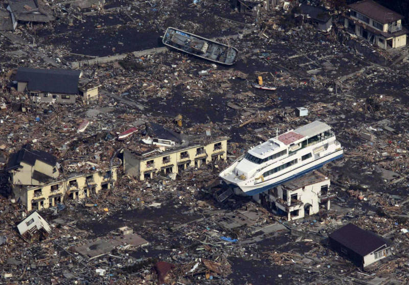
The tsunami that crossed the Pacific Ocean from Japan was actually two huge waves that combined
Researchers have long suspected that tsunamis sometimes merge to create a single more powerful wave, but the tsunami caused by the earthquake that rocked Japan earlier this year was the first time they actually saw it happen.
The tsunami traveled miles inland on the Japanese coast.
The biggest earthquake ever recorded was in 1960, in Chile. The 9.5 quake killed and injured thousands there, and triggered a deadly tsunami that hit Hawaii, the Philippines, and Japan.
“It was a mystery for a long time,” said Tony Song, a research scientist at NASA’s Jet Propulsion Laboratory, of the resulting tsunami that crossed the Pacific. “How it happened so far away,” and caused so much damage.
The explanation, it turned out, was that it was a merging tsunami. When the quake hit, a wave radiated out from the epicenter. But it didn’t form a neat circle, like when you drop a stone into a pond. Instead, underwater mountains and ridges broke the wave into segments that headed in different directions. Then that mountainous underwater topography guided some of those sections back together. They merged into a single double-size wave that could cross the ocean without losing much steam.
The explanation made sense, but Song and other researchers had never seen it actually happen until the tsunami in March.
“We knew waves could merge, but had never seen evidence before,” said Song. This animation from NASA shows it happening. The wave radiates out from the earthquake’s epicenter. Then the animation zooms in to show the waves, which have been broken up, merging.
Scientists at NASA and Ohio State University lucked into the find. Three satellites capable of measuring sea level changes down to a matter of centimeters happened to be in the area. When they passed over the tsunami, two of them measured one height for the wave. A third, the NASA-Centre National d’Etudes Spaciales Jason-1 satellite, measured a different height, twice what the other satellites saw. It was a merging tsunami. The wave front the satellites measured was the one heading east from the earthquake’s epicenter, not the one that ravaged the Japanese coast. But the discovery at least raises the question of whether or not the wave going in the other direction, the one that did hit Japan, was also a merging tsunami. Song says, unfortunately, he doesn’t have the data to say one way or the other.
“Specifically, our study is about the double power away from Japan, instead of toward Japan, though the same mechanism might work in both directions.”
Merging tsunamis occasionally hit Crescent City, California. According to Song, the topography of the ocean floor has the same effect when earthquakes near Alaska trigger tsunamis headed for California.
Now that he’s observed one of these waves in action, Song says scientists will be able to make better forecasts, predicting where tsunami waves are likely to merge, and where they’re likely to hit land.
A couple of other items you may have missed over the last few months about the tsunami:
Song and his colleagues presented their analysis at the San Francisco meeting of the American Geophysical Union this week (#AGU11).
UPDATED and CORRECTED: An earlier version of this post may have misled some readers by implying that actual satellite data confirmed the merger of two tsunami waves into the front that hit Japan. The data was observed for waves moving in the opposite direction.
Giant sequoias naturally grow only on the western slope of the Sierra Nevada.
When William Tweed talks about giant sequoias, he doesn’t beat around the bush.
“Sequoias capture human interest because they’re the perfect thing,” says the writer, historian, and former National Park Service ranger. “They’re the world’s largest trees. We humans like big stuff. They’re also exceedingly old, and they also charm us because they’re rare. We humans go chasing around for the big, the old, and the rare.”
He says while other parks have charismatic megafauna, like bears, or bison, or elk, Sequoia-Kings Canyon National Park and the other national parks in the Sierra Nevada have charismatic megaflora: the giant sequoia. Continue reading Can Giant Sequoias Survive the Future?→
Mountaintops can be good places to study the effects of climate change because there aren’t any things like factories or highways or garden weeds up there. In that way, they’re more like laboratories.
So, even though it involved a tough hike, about a dozen scientists gathered at the top of Freel Peak near South Lake Tahoe earlier this summer to count every single plant at the summit. It was for GLORIA, short for Global Observation Research Initiative in Alpine Environments, a project that sends botanists and plant ecologists to the world’s highest mountains to document the tiny, colorful plants that live on them.
Scientists gather on Freel Peak to take a census of the plants on the summit.
GLORIA surveys are repeated every five years, and this was the second survey on Freel Peak. By tracking the changes here, scientists can gain a better understanding of how alpine regions differ in their responses to climate change, and what the future may hold for lower elevations.
“Because of the nature of the alpine habitat, it is more sensitive to environmental changes,” explained GLORIA coordinator Colin Maher. “It’s kind of a beacon. It’s like a warning sign. We might not know for 20 years what’s happening, but it’s a place where change is more likely to happen and we can detect it.” Continue reading Scientists Look for Climate Trends in High Places→
The forests in the state provide water, habitat for animals, lumber and tourism dollars, and they sequester carbon. (Photo: Molly Samuel)
For decades the federal government has touted the nearly 200 million acres of national forests and grasslands under its control as a “land of many uses.” But one “use” that’s seldom discussed is as a huge repository for carbon.
But clearly it’s on the minds of officials and scientists as the Forest Service seeks comments on its proposed new planning rule. National Forests and Grasslands are managed individually, but the planning rule guides how those management plans are developed. This new one is replacing a Planning Rule from 1982. Continue reading California’s Giant Carbon Sponge→
Scientists come up with a way to handicap a key harbinger of spring
Photo: R.A. Howard from the USDA-NRCS PLANTS Database
Bud burst, when the buds on a tree begin to open up, marks the end of winter dormancy and the beginning of a tree’s growing season. Timing’s important: If a tree buds too early, it may be susceptible to a late frost. Too late, and it misses out on some or all of its growing season. As the climate warms, this delicate timing can go awry.
Scientists at the US Forest Service’s Pacific Northwest Research Station in Portland, Oregon, have developed a model to predict bud burst. They used Douglas firs in their experiments but also surveyed research on about 100 other species, so they expect to be able to adjust the model for other plants and trees.
Both cold and warm temperatures affect the timing, and different combinations yield different outcomes — not always intuitive. With plenty of hours of cold temperatures, trees need fewer warm hours to burst. So earlier spring warmth will drive bud burst earlier. If a tree isn’t exposed to enough cold, though, it needs more warmth to burst. So under the most dramatic climate change scenarios, warmer winters could actually mean a later bud burst.
Genes play a roll, too. The researchers experimented with Douglas firs from across Oregon, Washington, and California. Trees from colder or drier environments showed earlier burst. Trees descended from those lines could fare better in places where their warmer-and-wetter-adapted cousins live now.
The team, led by research forester Connie Harrington, hopes to use the model to predict how trees will respond under various climate projections. With that information, land managers can decide where and what to plant, and, if necessary, plan assisted migration strategies.
A report pinpoints critical areas in California for protecting critters
The North American pika like the protection and cool refuge of high-elevation talus slopes. (Photo: US Forest Service)
California is one of five places on earth with a Mediterranean climate. It has enough endemic plant species to be its own “floristic province.” It’s also what biologists refer to as a biodiversity hotspot. So it’s not surprising that a report by the Endangered Species Coalition includes three places either completely or partially within California in its list of ten of the most important locations to protect endangered species.
A plan to help homeowners afford solar panels and other energy-efficient appliances is in limbo. In 2008 California was the first state to pass legislation enabling PACE (Property Assessed Clean Energy) programs, which provide loans for property owners to buy expensive energy-saving devices. The Obama Administration has supported the plan, granting millions of dollars in stimulus funds for the programs. Cities and counties, once their states have given them the go-ahead, set up programs that issue bonds for the appliances. The homeowners then repay the loans through add-ons to their property taxes.
That’s the heart of the problem, according to letters sent by Fannie Mae and Freddie Mac to lenders in May. When homeowners default, usually tax assessments take priority over the mortgage when the debts are repaid. But the federal mortgage backers warn in their letters that “an energy-related lien may not be senior to any mortgage.” (from the Freddie Mac letter (PDF); the Fannie Mae letter (PDF) has slightly different wording). The news has thrown lenders into a state of confusion.
According to articles in Grist and a blog post in the New York Times, now cities (including San Francisco) are suspending their PACE programs, and solar installation companies are losing work–and laying off workers.
The first PACE bond in the country was issued in Berkeley, in January 2009. Since then San Francisco, Sonoma County, and Yucaipa, among other cities and counties in the state have begun PACE programs. San Diego and LA have plans in the works. But without more clarity from Fannie Mae and Freddie Mac on if they will back mortgages given to homeowners who have taken advantage of PACE, it’s unclear if the programs will continue.
Climate Watch intern Chris Penalosa contributed reporting on this blog post.
The IPCC’s Fifth Assessment will evaluate regions hit hardest by climate change to develop mitigation and adaptation strategies. Photo: Aerial View of the Arctic Ocean, Photo.com.
The Intergovernmental Panel on Climate Change (IPCC) has announced the contributors for its next Assessment Report. All 831 of them. Of those authors, proportionally more are women, more are from developing nations, and a pretty good number are from California.
The Fifth Assessment Report by the numbers:
1990 was the year the first IPCC Assessment Report was published. Since then, they’ve come out every five to sevenyears.
The report is divided into three Working Groups. Working Group I sums up the physical science, WGII is on impacts and adaptation, and WGIII gets into mitigation strategies.
831 scientists are contributing to the report. They were selected out of about 3,000 applicants.
30% of those scientists are from developing countries; 25% are women; and for 60%, this is their first time contributing to an IPCC report.
39 of those scientists are based in California at universities, NGOs, and government agencies. That’s out of 169 American contributors.
And an introduction to some of those Californians:
Stanford biology and environmental science professor Chris Field heads up Working Group II, as he did on the previous Assessment Report. In an email he said in this 5th edition, “there will be new chapters on parts of the world that were not considered before (especially the oceans) and on key processes (e.g. human security).”
Rebecca Shaw, the Nature Conservancy’s associate director of conservation and climate change programs in California, is a first-time contributor to the IPCC. She’s also on the Governor’s Task Force for Climate Change, and is leading a vulnerability assessment on the Golden State.
Peter Breweris the Senior Scientist at the Monterey Bay Aquarium Research Institute (MBARI) where he researches ocean chemistry. No stranger to the ocean, Brewer has gone on numerous deep sea expeditions and taken part in over 90 remotely operated dives for MBARI research. Brewer’s expertise was featured in previous IPPC reports where he was a lead author on carbon capture and storage. He will be the lead author on an open oceans chapter in this report.
Robert Cervero is a transportation and land-use policy professor at UC Berkeley. In addition to teaching at transit development, Cervero has authored numerous academic journal articles on the Bay Area’s transit systems. He’ll be the review editor for the IPCC’s chapter on human settlements, infrastructure and spatial planning.
Climate Watch intern Chris Penalosa mapped where California’s IPCC contributors are based. Click on the icons to find out more about them.
View IPCC AR5 Authors from California in a larger map
Update 7/8/10
Here’s a complete list of the California participants: