Electrical generation may be changing the climate but the reverse is also true
As temperatures rise, the power grid stands to become less efficient. Transmission lines could lose 7-8% of their peak carrying capacity by 2100.
Planners, policymakers and scientists are starting to look more closely at the crossroads of climate change and energy production in California.
For years the focus has been on how energy production affects the climate through emissions of greenhouse gases. Now the converse has come center stage: What happens to energy production in a changing climate? Some heavy-hitters in California climate and energy circles gathered at the California Energy Commission this week, to weigh the question. Some highlights: Continue reading Where Climate and Energy Intersect: The Flipside→
But communities that depend more on rain, less on the snowpack are looking good
In mid-January, much of the Sierra remained snowless.
Despite what felt like a late-season deluge, this will go down as a dry winter in California’s record books.
The season’s final survey of the Sierra snowpack by California water officials confirms that even heavy spring rains and fresh mountain snow as recently as last week didn’t make up for a late start to the rainy season and one of the driest Decembers on record. Today’s survey finds water content of the mountain snow at just 40% of the long-term average. That puts four out of the last five years on the dry side, though last year was a gullywhumper. Continue reading California Winds Up “Wet” Season on the Dry Side→
An executive order directs state agencies to cut carbon emissions, save water and energy
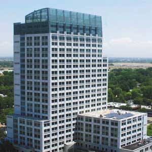
California Environmental Protection Agency headquarters in Sacramento. In 2003, the 25-story tower was given a “Platinum” rating by the U.S. Green Building Council in 2003.
The executive order stipulates that state agencies must reduce their greenhouse gas emissions by 20% using 2010 as a baseline, and half of all new and renovated buildings must be Net Zero Energy by 2020. The order, B-18-12, also continues a previous policy requiring state-owned buildings larger than 10,000 square feet to meet the guidelines of the U.S. Green Building Council’s “Silver” rating.
“This shows that the state is very focused on meeting very ambitious yet achievable goals,” said Evan Westrup, a spokesperson for the governor’s office.
According to a release from the governor’s office, the statewide initiative will also save one billion gallons of water and an estimated $45 million in tax dollars each year. Westrup did not have figures on projected job creation, but he pointed out that similar initiatives geared toward efficiency have created 1.5 million jobs across the state since 1978.
There was talk on Friday of this being a “record number” but Riley says the Weather Service doesn’t actually track that. It happens that a forecaster in Monterey added up the strikes from this event that showed up on NASA’s Lightning Detection Network. Riley says that figure includes only “ground strikes,” not the bolts that travel cloud-to-cloud. Continue reading Lightning, Twisters, Snow and Waterspouts (Oh My)→
As more water flows to the coast, California’s largest inland water body teeters on the brink
By Sam Harnett
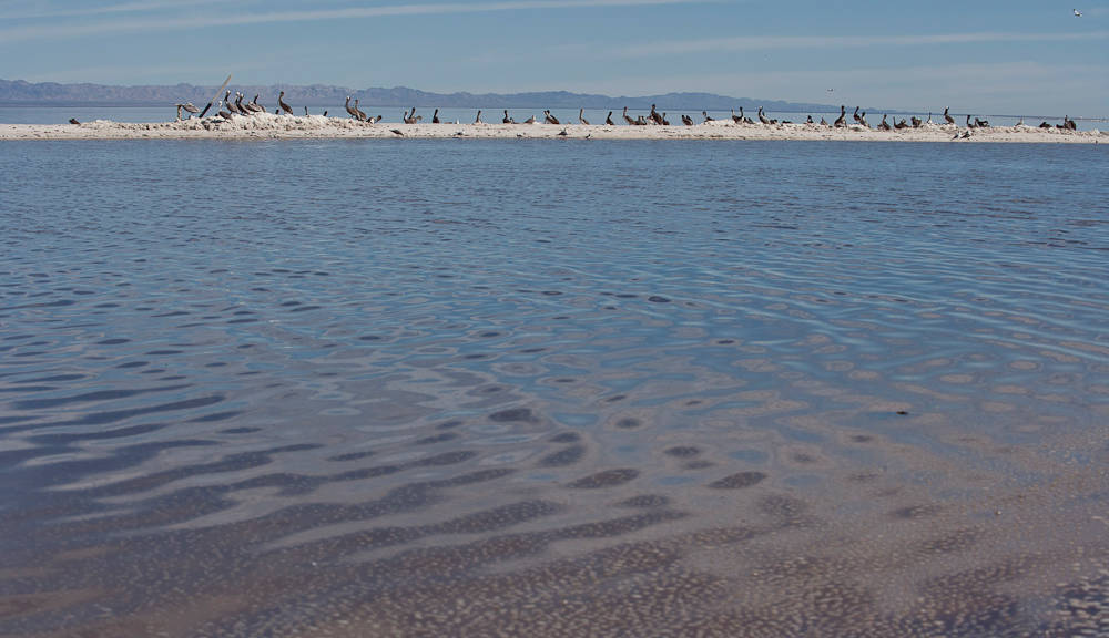
The Salton Sea, northeast of San Diego, is an important stop on the Pacific Flyway for migrating birds. Millions of birds stop there every year.” credit=”Gundi Vigfusson
Last month the California Supreme Court upheld a water transfer deal that sends billions of gallons of water a year from Imperial County farms to cities in San Diego County. The 2003 deal is the largest agriculture-to-urban water transfer in the history of the United States, and it will have major environmental and economic impacts on the region. One of the areas most dramatically affected will be California’s largest — and in many ways its most notorious — inland body of water: the Salton Sea.
The Salton Sea has a fraught history. It used to be part of the Colorado River Delta, but with the diversion of water the area has become desert. In 1905, a massive flood caused the formation of the current Sea, and during the following decades it became an iconic resort location, drawing fishermen and pleasure seekers from across the country. In the 1970s, the Sea fell from favor. Rising salinity killed all the sport fish, celebrities stopped coming, and the resort developments were abandoned. Today, the only water the Sea receives is agricultural run-off from nearby farms, and without that water, the Sea will disappear in a matter of years. Continue reading The Sorry State of the Salton Sea→
Thanks to last year’s wet winter, California’s reservoirs are still in good shape
In January of this year, snow was still sparse at high elevations in the Sierra Nevada.
Researchers from the Department of Water Resources conducted their April manual snow survey today. It’s the most important snow survey of the season, because it’s supposed to capture the Sierra snowpack at its peak. The DWR found that statewide, snow water content is 55% of average for this time of year.
Still, it could have been worse. The previous manual snow survey, which took place on February 28, measured snow water content at only 30% of normal for that date. So the rain in March did help.
“This was certainly a moderately good March at least,” Jeanine Jones, the Interstate Water Resources Manager at the DWR told me. “But the downside is that we are now getting outside of our peak precipitation window. On average about 75% of statewide precipitation comes between November and March.”
The geologic features of the Palos Verdes Peninsula make it a hotspot for landslides
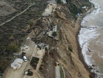
November's sea cliff failure took out 600+ feet of roadway and sidewalks.
The latest Palos Verdes Peninsula slide may calve, and the main slide mass is likely to keep “moving oceanward.” That’s according to a preliminary draft of a geotechnical study commissioned by the City of Los Angeles in early winter, but that’s the extent of the news for now. The same report says based on the studies completed to date, the risk of landslide movement behindlast November’s slide — landward into a nature preserve and beyond a new chain link fence — is low.
That’s just the latest from an area southwest of downtown L.A. that has been generating geological news for decades. According to a landslides map by the California Geological Survey, the PV Peninsula boasts 175 slides, 49 of them active.
Documents include details on depth and location of wells in California
A well on a farm in the Central Valley. Groundwater accounts for 30-to-40 percent of all water used in California.
[POST UPDATED, 4/3, 5:04pm]
It’s no secret that with several recent years of drought, California’s groundwater supplies have come under increasing strain. But Dennis O’Connor, a water consultant with the State Senate Natural Resources and Water committee, wants to rewrite an arcane piece of California water law that, for decades, has kept documents containing information on the state’s groundwater resources under wraps.
The documents O’Connor wants released to the public are called well completion reports, or “well logs” – technical documents filed by well drillers with the state. Under California water law, well logs are confidential, accessible only by individuals in state agencies or those who meet special criteria.
“These logs are rich sources of information. The data can help you connect the dots and create a three-dimensional picture of what’s going on underground,” O’Connor told me. Logs contain data on the depth, location and geology of the sites as well as engineering details such as the kind of casing used and the angle of drilling.
City planners are looking at ways to reconfigure the city’s western edge
One of the challenges for the Ocean Beach Master Plan is how to slow the erosion of Ocean Beach's sandy cliffs.
San Francisco’s Ocean Beach is eroding; that’s not up for debate. But planners are still figuring out the best way to handle the erosion that’s already happening, and how to prepare for sea level rise. And that’s going to take a lot of planning: Ocean Beach itself is part of the Golden Gate National Recreation Area, managed by the National Park Service, but there are also the nearby residential neighborhoods to consider; plus the Great Highway, a wastewater treatment plant, the parking lot at the beach, endangered species, surfers, dog walkers and the occasional hopeful sun bather.
The Ocean Beach Bulletin, a local news site and one of KQED’s News Associates, has been covering the development of the new plan for San Francisco’s coastline, called the Ocean Beach Master Plan, which will attempt to address erosion and rising sea levels, while balancing the myriad social and environmental needs.