Abbie Tingstad is a paleoclimatologist at UCLA. She specializes in reconstructing drought records in the western United States, and takes us along on some of her field research in this guest post:

By Abbie Tingstad
The site was so remote we needed a team of archaeologists and a couple of heavy-duty 4x4s to get us there.
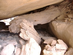
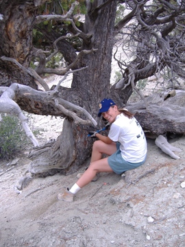
Deep within the rocky piñon-juniper cliffs of northwestern Colorado was a secret so well hidden I didn’t see it until I was physically inside, face-to-face with a series of hand prints made over a thousand years ago. This rock shelter was occupied during Medieval times by Fremont Indians, contemporaries of the Anasazi whose cultural center was further south in the Four Corners Region. The site had already been excavated, but our interest as dendroclimatologists was not in artifacts. We had come to take samples from the ancient piñon and juniper beams that once supported this structure for the valuable paleoclimate information contained within their annual growth rings.

Gathering Medieval climate information from tree rings, lake sediments, and other natural climate archives in the Western US is critically important for understanding the implications of increasing temperatures in this region, particularly when it comes to future water supply and demand.
Research has confirmed that temperatures rose in the Western U.S. from about A.D. 800-1300, which translated into a series of droughts. The most devastating of these occurred in the mid-11th and 12th Centuries, when dry conditions persisted for several decades and may have contributed to the collapse of the Anasazi and Fremont cultures.
Paleoclimate data from tree rings and other sources also suggest that the mechanism driving drought during the “Medieval Warm Period” was eastern Pacific Ocean cooling. Like a widespread, extended La Niña event, cool sea surface temperatures may have strengthened the persistent moisture-blocking system of high-pressure off the West coast, nudging storm tracks north.
While the Medieval period is an instructive analogue for the warming we are beginning to experience, it is an imperfect one. Two major factors separate the episode the Fremont and Anasazi experienced a thousand years ago from what we are just beginning to undergo today. First, Medieval warming appears to have been fostered by a combination of increased solar irradiance and decreased volcanic activity, rather than anthropogenic greenhouse gas emissions. Secondly, Medieval times were characterized mainly by summer warming, while winter and spring temperatures are expected to increase most dramatically in the future. These differences manifest themselves in many ways, but notable for the water-starved West are the implications for decreased winter snowpack and earlier spring river discharge.
The Medieval Warm Period may not offer a precise preview of our future, but it serves as a valuable warning about the tenuous balance of water supply and demand in California and the Western US, something the occupants of the Fremont rock shelter we visited were likely aware of.
Since the turn of the new Millennium, drought has been the norm rather than the exception in this region and the end is not in sight: As of May 1, 2009 surveys suggest that the Sierra Nevada snowpack is two-thirds of normal. What we can learn from Medieval times is not to expect “normally” moist conditions to return any time soon, and to plan accordingly.
4 thoughts on “Decoding California’s Drought History”
Comments are closed.

Craig,
Interesting article. It was my investigation into what caused the Anasazi to leave the SW that led to my interest in studying climate change. We lived in Hobrook Az for a year and visited the cliff dwellings many times with our children.
What did the tree rings say about the Little Ice Age and the Dalton Minimum? According to the Mission records, the cool early 1800 also saw periods of drought along California’s coastal mountains, one about 13 years long. The tree rings have also been used to show the river flow in the Sacramento watershed from about 903 to the present, including long periods of drought. More on this when I have more time. There are some really interesting tree ring links on the Internet.
Hi,
I’m not sure if you have seen the North American Drought Atlas website before:
http://www.ncdc.noaa.gov/paleo/pdsi.html
It is a gridded dataset where paleoclimate for each point has been interpolated from tree rings. You can make drought maps and view time series for any combination of gridded datapoints. If you click on some of these datapoints for CA and the Western U.S., you can see that there was relatively low variability during both the Maunder and Dalton Minima.
Droughts have always been features of climate in California and the Western U.S. largely because of the sensitivity of winter storm tracks to changes in sea surface temperatures and atmospheric pressure patterns, although some parts of the Colorado River Basin are also impacted by changes in North American Monsoon strength.
WONDERING IF ANYONE KNOWS OF A DROUGHT IN THE 1800’S THAT LEFT THE SACRAMENTO RIVER ABOVE RED BLUFF SO DRY THAT RANCHERS HAD TO DRIVE THEIR CATTLE TO RED BLUFF TO GET TO WATER? THANKS, JOY