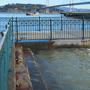
This week another round of extremely high tides will hit the California coast, providing a glimpse of what the state can expect as sea levels continue to rise. These “king tides” will roll in from February 16th through the 18th, with the highest swells expected on the morning of the 17th, between 7:30 and 9 a.m.
A consortium of environmental groups is again calling for help documenting these high tides. The San Francisco Bay National Estuarine Reserve (NERR), which is spearheading the local effort, has set up a Flickr site where members of public can share their photos. Organizers launched the site last month, in time for the king tides in January, and since then more than 80 photos have been uploaded by dozens of contributors.
“It’s exploded,” said Bobak Talebi, who is managing the Bay Area King Tides Photo Initiative for NERR. “It’s been great. We’ve been gaining interest from the general public and from new organizations. It’s more than we expected.”
Talebi said partnerships with a similar effort in San Diego and a new statewide effort will provide the building blocks to expand documentation of high tides.
Sara Aminzadeh of the California Coastkeeper Alliance says king tides are an important reminder of just how vulnerable many shoreline developments are to sea level rise and storm surges.
“Climate change and sea level rise are such huge issues and they are going to occur slowly, so they can be hard for people grasp,” she said, “but this project can really help people visualize what we’re facing as Californians.”
High tides this week are likely to be higher than they were for January’s king tides, said Talebi. At that time, the weather was calm. This week, rain and winds are expected, which will likely exacerbate high tides. A “Hazardous Weather Outlook” for the Bay Area from the National Weather Service says large swells arriving Wednesday will coincide with the king tides, producing breakers up to 15 feet and possible minor coastal flooding. Which, of course, is just the kind of scenario that could likely become more common as sea levels rise.
Aminzadeh is hoping that heightened public interest in the Photo Initiative specifically, and in sea level rise in general, will influence the state’s Ocean Protection Council (OPC) to make strong recommendations for sea level rise adaptation planning. The OPC is an inter-governmental body tasked with coordinating ocean-related state efforts. It’s scheduled to release its second draft resolution on sea level rise next week.
The Alliance, along with several other environmental groups including the Natural Resources Defense Council and the Sierra Club, are urging the OPC to adopt a resolution that not only sets projections for what sea level rise will look like, but also sets clear guidelines for how state agencies and municipal governments should deal with it, in accordance with principles from the 2009 California Climate Adaptation Strategy.
“We’re looking to them to take a leadership role on how agencies and communities can begin addressing sea level rise,” said Aminzadeh.
Sea levels have risen about eight inches in the last century, and the San Francisco Bay Conservation & Development Commission (BCDC) advises planners to prepare for a sea level rise of about 16 inches by mid-century and 55 inches by 2100.
