
The geologic features of the Palos Verdes Peninsula make it a hotspot for landslides

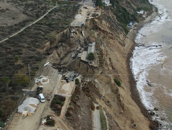
The latest Palos Verdes Peninsula slide may calve, and the main slide mass is likely to keep “moving oceanward.” That’s according to a preliminary draft of a geotechnical study commissioned by the City of Los Angeles in early winter, but that’s the extent of the news for now. The same report says based on the studies completed to date, the risk of landslide movement behind last November’s slide — landward into a nature preserve and beyond a new chain link fence — is low.
That’s just the latest from an area southwest of downtown L.A. that has been generating geological news for decades. According to a landslides map by the California Geological Survey, the PV Peninsula boasts 175 slides, 49 of them active.
Two studies, one published recently in Environmental Research Letters and another I reported on late last year by Scripps Institute of Oceanography and the U.S. Geological Survey, are predicting more frequent coastal flooding in California caused by rising sea levels and an increasing number of extreme Pacific storms that hit the coast.
[module align=”right” width=”half” type=”pull-quote”]Combine soft, saturated earth sitting on slippery clay with an incline tipped toward the ocean, and you get the formula for these landslides.[/module]
Both trends could impact the PV Peninsula: one from above and the other at the base, according to Lisa Collins, a lecturer in environmental studies at USC. “There’s a potential for increased storm activity and storms cause a lot of erosion. The cliffs of Palos Verdes are eroding anyway.” Up top, the threat is from precipitation. When the volcanic layers of the peninsula weather or degrade due to rain, explains Collins, they morph into two kinds of very slippery clay. The clay stops the water, but the layers of earth above it get saturated and heavy.
Factor in another element: the Peninsula is an “uplift.” When the Pacific tectonic plate slammed into the North American plate, the earth folded into vertical layers, just like the hood of a car might accordion in an accident. Combine soft and saturated earth sitting on slippery clay, with an incline tipped toward the ocean, and you get the formula for these landslides.
Collins uses tilted slabs of plywood and sand castles to teach her students about the Peninsula’s geology. “You can take a bucket and fill it with some damp sand and invert it and it will stay standing. But if you artificially make it rain… the mixture essentially turns liquid and flows again. They can’t keep that steep angle… and we see a lot of those angles on the coast of California.”
Take an audio trip to the PV peninsula on Monday with The California Report, and hear from residents and scientists about this oceanside geology lesson.