Nearly lost amid the three-ring circus of Copenhagen coverage is the annual gathering in San Francisco of the American Geophysical Union. We’re doing our best to staff selected sessions there. Climate Watch contributor Lauren Sommer was there for some grim new research on groundwater in the Central Valley.
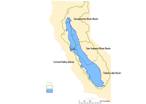
California’s Central Valley has lost nearly enough water in the past six years to fill Lake Mead, according to NASA scientists presenting at the American Geophysical Union Conference in San Francisco this week. Nearly two-thirds of that loss–20.3 cubic kilometers of water–is from groundwater depletion.
With the recent drought, groundwater has been an important water source for California’s Central Valley agriculture, but getting a picture of that water use hasn’t been easy. Water districts haven’t been required to report groundwater pumping in their areas. That’s something the recent Delta overhaul package of legislation now requires, but according to Jay Famiglietti of UC Irvine, the records to date aren’t very complete. Wells are sparse and the measurements have been sporadic.
The majority of the water loss since 2003 has been focused in the San Joaquin Basin at the southern end of the Central Valley, which is losing 3.5 cubic kilometers of water each year. The bulk of that loss is the result of groundwater depletion.
Famiglietti says this is due to a “triple threat” in California. First came the drought, then decreased water allocation and more groundwater pumping. Finally, with less surface water, the groundwater aquifers have a reduced opportunity to recharge. Famiglietti says it’s clear that California is using groundwater at an unsustainable rate, which “poses significant threats to food production in US and the California economy.”

This large-scale picture of California’s groundwater comes from NASA’s Grace project. Twin satellites orbiting the Earth detect changes in the gravitational field, caused by the movement of water. Those satellite measurements act like a“scale at the bottom of the ocean weighing how much water is in each of these spots,” according to NASA’s Michael Watkins. They also detect changes in snow, surface water and soil moisture.
The Grace project, though, is becoming a “senior citizen,” according to Watkins and is reaching the end of its technological life. He says quality of their water research, which has included other spots around the globe, speaks to the need for another generation of the project. Famiglietti says, though this data can’t replace ground measurements, he hopes it will be taken into account by state agencies faced with making the tough choices about California’s aquifers.
