April arrives with a lot more than showers
We saw a little bit of everything around California last week.

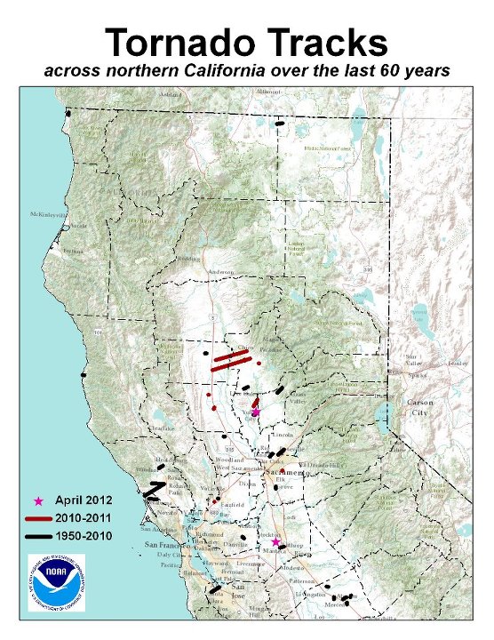
On Friday, a small tornado touched down in Yuba City, sideswiping a car dealership.
A freak April snow shut down a stretch of I-5. That made local papers on the East Coast.
Waterspouts were sighted off Orange County, and a thunderstorm over San Francisco Bay spawned an extraordinary 740 lightning strikes, according to Christine Riley, a forecaster with the National Weather Service in Monterey. Opportunistic photographers caught bolts connecting with iconic bridges and the Transamerica Pyramid.
There was talk on Friday of this being a “record number” but Riley says the Weather Service doesn’t actually track that. It happens that a forecaster in Monterey added up the strikes from this event that showed up on NASA’s Lightning Detection Network. Riley says that figure includes only “ground strikes,” not the bolts that travel cloud-to-cloud.
The storm also struck down some daily records for rainfall, which is typically tapering off by this time of year in California’s Mediterranean climate. Compared to much of the country, any thunderstorm is a relative rarity along the California coast, where the the cold Pacific surface temperatures usually prevent the kind of convection that builds thunderheads.
According to an overview from the San Francisco Marine Exchange:
Thunderstorms are relatively rare in the San Francisco Bay Area, but can sometimes develop within the frontal rain bands of intense winter storms. Thunderstorms can also occur in the cold and unstable airmass behind a cold front. Climatologically, thunderstorm chances peak during the late winter and are more common over the Central Valley and Delta compared to the San Francisco Bay. Thunderstorm activity often exacerbates hazardous weather conditions during winter storms by increasing wind speeds on a local scale and by producing dangerous lightning.
Tornadoes were also confirmed southwest of Stockton and in the Sierra Foothills, west of French Camp.

Meteorologically speaking, at least, calm has returned to the state and the week ahead looks downright dull by comparison.
One benefit from the storms: State water managers raised to 60% the volume of water that farmers on the State Water Project can plan on getting this summer, versus what they’ve requested. Likewise on Friday the federal Bureau of Reclamation raised its projected water allotment to customers on the huge Central Valley Project to 40% of requested deliveries.
But despite the spring surge, California’s “water year” is still likely to fall well short of normal totals for precipitation and the closely-watched Sierra snowpack.
