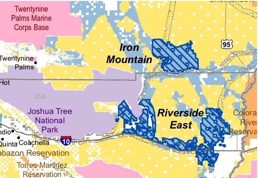
Somewhat overtaken by the other headlines of the week, dominated by celebrity obits and California’s financial meltdown, was the release by federal agencies of some new solar maps. They pinpoint federal lands in seven western states that present–in the government’s view–some of the best potential for building out utility-scale solar power production.
The four California locations (.pdf link) combine more than 350,000 acres in San Bernardino, Riverside and Imperial Counties. They supposedly represent the best combination of production potential, least conflict with other land uses and environmental concerns, and proximity to existing transmission lines or power plants. Areas were also mapped in neighboring Nevada and Arizona.
Update: Scott Streater has more on the controversy over planned renewable power sites, including California’s Iron Mountain site (see map, below), in a New York Times Greenwire post.

The maps appeared just as California’s main regulator of power companies issued an update on solar projects in the state. The California Public Utilities Commission reported that the rate of new solar installations nearly doubled last year, from 2007 levels.
The CPUC tally shows California with over 500 MW of solar photovoltaic (PV) connected to the electric grid at almost 50,000 customer sites. The report notes that all those electrons combined are equivalent to one large power plant. About half of the current total went in under the California Solar Initiative, which has reached 13% of it’s 10-year goal, with another 8% in pending applications.
Also this week, more than $300 million fell from the federal money tree for a hydrogen power project in southern California. Cash from the American Recovery and Reinvestment Act (better known as the federal stimulus plan) will flow to the Hydrogen Energy California (HECA) project in Bakersfield. The project is designed to provide power for 150,000 homes in the area, by converting oil to hydrogen.
A statement from the California Recovery Task Force (CRTF), a conduit for federal stimulus funds, describes the HECA project as “an Integrated Gasification Combined Cycle power plant that will take petroleum coke, biomas, coal or blends of each, combined with non-potable water to convert them into hydrogen and carbon dioxide (CO2). The hydrogen gas will be used to fuel a net 250-megawatt power station.”
Perhaps more significant are the plans for the carbon dioxide generated in burning the oil. The CRTF statement says that “The CO2 will be transported by pipeline to nearby oil reservoirs and injected for permanent storage which will enhance U.S. energy security and enable additional production from existing California oilfields.”
CRTF says the project will “avoid” emissions of more than two million tons of greenhouse gases per year.
