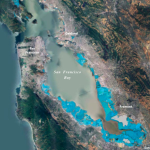
Taking global climate models and “downscaling” them for use at the local level is an ongoing challenge for scientists and for planners. But thanks to new climate projections from NASA, the Bay Area now has a sharper view of what may be in store.

NASA says two-thirds of its facilities are at risk from sea-level rise, including Ames Research Center, which sits at the southern edge of San Francisco Bay. So, it’s not exactly altruism that motivated the agency to deploy its own scientists to take a closer look at what climate change will really mean on the ground in places where it’s heavily invested.
“This is the first time we’re actually working with our scientists and taking the data that’s usually at hundreds of miles by hundreds of miles and bringing it down to the local level,” said Olga Dominguez, assistant administrator for NASA’s Office of Strategic Infrastructure.
Dominguez was at NASA Ames on Friday for a conference on climate change impacts in the South Bay.
NASA scientists used historic local temperature and precipitation data and sea level rise records from San Francisco to downscale global climate models to produce projections for the southwestern Bay Area, which includes Ames.
Their results indicate that by 2050:
- average temps could rise 2-4 degree F
- sea level could rise 6-9 inches
- precipitation could increase OR decrease up to 15%
- days per year above 90 degrees F could increase from 8 to 15
Next the agency is drawing up adaption plans for each facility.
Will Travis, executive director of the San Francisco Bay Conservation and Development Commission (BCDC), says both NASA’s science, and its ideas for solutions, are welcome.
“We have this rich resource at NASA, a great deal of wonderful science, and getting that applied at the local level is quite a challenge,” said Travis, who was a speaker at Friday’s conference.
“This conference is showing how NASA can be doing that at a facility level, and that information and techniques and those approaches are great models for other businesses and other communities in the Bay Area.”
There are detailed maps of projected sea level rise for the Bay Area at both the BCDC and the USGS websites.
3 thoughts on “NASA’s Closer Look at the Bay Area”
Comments are closed.

Yes, it is great that NASA is doing this, along with the great work that Dr; Hansen has done. It always brings up a question for me as to how local governments will deal with the infrastructure demands to adapt to a changing climate? If we continue to face deteriorating economic conditions, where till they get the revenues?
In a similar vein, what can be done with Land Use Planning that will keep us from having to spend so much money later? For example, does it really make sense for San Francisco to spend so much money on Treasure Island development when most of it has to be protected from sea level rise?
It is my observation that the climatologists have erred in their prediction, being too optimistic and that events are outpacing even some of their worst case scenarios.
Great that we are worrying about water rising, but what about the sky falling???? Is anyone looking up and at the NASA maps showing the gridlines of aerosol spraying in the sky? Who is investigating why we now have white haze sky, not blue??? Grid lines of chemical spray. See Newsweek article Feb7th, by Sharon Begley that shows the planes spraying and the unintended consequences… A Climate Cure’s Dark Side.
Thanks for this recap. I was there filming for my show Silicon Valley -Technology, Art, Green and Sustainability (SVTAGS.org) and parts of this event at NASA will be available soon. NASA also has a link for people to watch, but I don’t see it there yet:
http://www.nasa.gov/centers/ames/home/index.html