upper waypoint

Building Houses Near Transit Is Good; But What About Air Pollution?

Save ArticleSave Article
Failed to save article

Please try again

(Ordinary Grace: Flickr)

California has embarked on a landmark effort to reduce greenhouse gasses.  As part of that work, local jurisdictions are busy spotlighting zones for housing infill and transit-oriented development. Infill sounds good, right? Let's avoid further suburban sprawl and direct people to mass transit, reducing greenhouse gasses.

Not so fast.

Here's the problem: the state Air Resources Board has evaluated air pollution risk and identified swaths of urban areas that create public health hazards because of diesel truck traffic or other pollution.

Call it the irony of unintended consequences. The housing development areas overlap with the communities with high air pollution in too many places in the Bay Area. It looks like we're on a road to reduce greenhouse gases while increasing public health risks.

That's where a study today from the Pacific Institute is critically important. It has lots of colorful maps and detailed information that provide tools to cities and counties to consider when planning new housing.
Sponsored

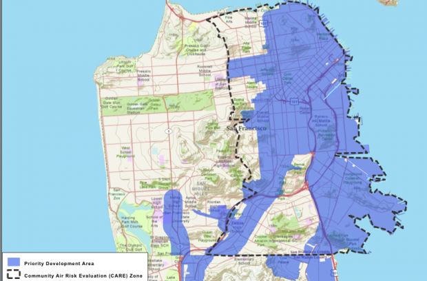
Here's a starting point in San Francisco County. The blue priority development area is almost completely encircled by an area the Air Resources Board says has health risk from toxic air pollution.

San Francisco map shows "Priority Development Area" located almost completely inside an area of concur to the state Air Resources Board. (Map: Pacific Institute)

Major highways run right through the bright blue area where local planners say more housing development would be good. Would you want to live next to a freeway?

But the Pacific Institute report looked at recommendations for a buffer zone around highways, especially those that carry pollution-spewing big rigs. By adding these buffer zones, public health concerns can be greatly reduced.

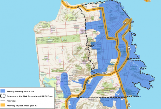
Here's another map, showing a 500 foot buffer zone:

San Francisco map showing 500 foot buffer zone around freeways. (Map: Pacific Institute)

By inserting these buffer zones around freeways and other so-called freight transit hazards, the Pacific Institute report says, 74% of the land in these locally identified priority development areas is far enough away from pollution hazards for new housing to be safe, from a public health perspective.

Catalina Garzon, program director of the Pacific Institute, is co-author of the study. "What we're hoping is that regional agencies that are currently developing a plan for meeting greenhouse gas requirements as part of state climate policy will include protections for health in decisions about siting land use in the region."

The Pacific Institute also has maps for Alameda County, East Contra Costa County, West Contra Costa County, San Mateo County, and Santa Clara County. [All maps are PDF].

lower waypoint
next waypoint