upper waypoint

Before and After: The Rain's Impact on Three California Reservoirs

Save ArticleSave Article
Failed to save article

Please try again

Folsom Lake on Oct. 26, 2015. Right: Folsom Lake on Jan. 14, 2017. (Images provided by Planet Labs)

Amazing the difference a little rain makes. Wait — a little? No — a lot.

Virtually all of California is enjoying its wettest winter in five years. In fact, current statistical reports on rainfall and the water content of the Sierra Nevada snowpack show that so far, we’re in the midst of one of the wettest California rainy seasons on record.

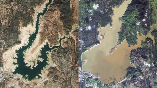
All the precipitation has transformed a state that suffered through five years of severe drought. One of the most visible effects: high levels of the state’s major reservoirs.

Below are comparative views of three of those massive storage facilities: Folsom Lake, on the American River about 25 miles northeast of downtown Sacramento; Shasta Lake, the state’s largest reservoir, just north of Redding; and San Luis Reservoir (bottom), near the town of Los Banos in the San Joaquin Valley.

We’ve chosen satellite images from San Francisco-based Planet Labs that illustrate the reservoirs near their drought low points and as they’ve appeared this month. Additional notes on each of the reservoirs below.

Sponsored

Instructions: Each image contains a slider bar (a gray vertical line with arrows on each side) in the center. Click on the center of the bar and drag it right or left to see views of each reservoir a) near its drought low point and b) after recent rains.


Folsom Lake is the state’s 11th-largest reservoir with a capacity just under 1 million acre-feet. The reservoir was filled for the first time in 1955. In late 2015, the drought reduced Folsom to its lowest level ever. In wet years, reservoir managers are often required to release water to maintain space for potential floodwaters. In fact, the volume of water in Folsom has dropped 40 percent over the past two weeks even as heavy runoff continues to cascade down the American River. See current Folsom Lake storage information.


Shasta Lake, California’s largest reservoir at 4.5 million acre-feet, captures the flows of three major Northern California rivers: the Sacramento, the McCloud and the Pit. The lake, behind Shasta Dam, was filled in the late 1940s. It reached its all-time low during the drought of 1976-77. Its lowest point during the recent drought was recorded late in 2014. See current Shasta Lake storage.


San Luis Reservoir, with a capacity of about 2 million acre-feet, is a joint state-federal facility built in the 1960s to help manage supplies from two sources: the State Water Project’s California Aqueduct and the federal Central Valley Project. It’s a key storage point for farms in the San Joaquin Valley and for urban water districts in Southern California. It reached its drought nadir in late 2015. See current San Luis Reservoir storage.

lower waypoint
next waypoint
From Tunnel Muck to Tidal Marsh, BART Extension Could Benefit the BayCalifornia's Second-Largest Reservoir Filled to CapacityCalifornia Regulators Approve Adding Fixed Charge of Up to $24 to Utility BillsMeet the Bug You Didn't Know You Were EatingElk Would Roam Free, Campers Would Not, Under Proposed Changes at Point Reyes National SeashoreFrom Storms to Sunscreen: Bay Area Weather Turnaround Is HereWorld's Largest Digital Camera Built in the Bay Area to Illuminate Mysteries of the UniverseHow an Ocean Exploration Video Game Out of Monterey Bay Contributes to ScienceEverything You Never Wanted to Know About Snail SexThis is NOT a Dandelion.