upper waypoint

El Niño Weakening, Stage Set for La Niña and Possible Dry Winter Next Year

Save ArticleSave Article
Failed to save article

Please try again

Storm clouds gather over San Francisco in mid-February, a month that otherwise offered little rain this year. (Craig Miller/KQED)

Federal climate scientists say the near-record El Niño conditions in the Pacific Ocean have peaked and are slowly waning.

Forecasters now say conditions are likely to flip to their opposite phase, known as La Niña by late summer or early fall, which could set the stage for another drier-than-normal winter and prolonged drought in California.

“We are reasonably confident that there will be a La Niña,” says Huug van den Dool, seasonal forecaster at NOAA’s Climate Prediction Center, “but we plead ignorance as to whether this is going to be a small, moderate, or strong La Niña.”

Just as the stronger El Niños tend to favor wetter winters in California, the mirror-image La Niña is sometimes a harbinger of drought. Strength is measured by how much ocean waters deviate from their normal temperatures. Warmer waters provide more moisture to brewing Pacific storms, while colder waters tend to dry things out.

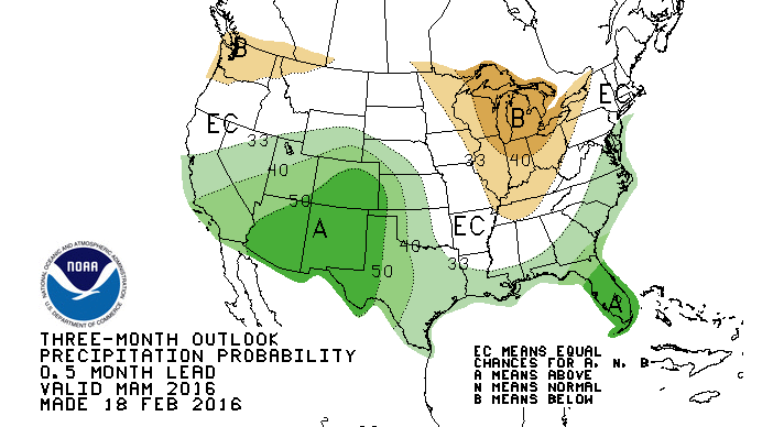
The shift is not likely to have major implications for what remains of this winter. California’s weather tends to lag the ocean conditions that influence it by as much as a couple of  months, so the possibility still lingers for a soggy spring.

NOAA's three-month outlook (which is notoriously iffy) pegs the odds for above-average precipitation at 73% for Southern California and 66% for the state's midsection (map numbers converted to actual percentages).
NOAA’s three-month outlook (which is notoriously iffy) pegs the odds for above-average precipitation at 73% for Southern California and 66% for the state’s midsection (map numbers converted to actual percentages). (NOAA)

The abnormally warm water along the equator that defines El Niño probably peaked in December, van den Dool told reporters in a Thursday conference call, but still has some steam left in the boiler, seen in the rapid upward movement of warm, moist air over the ocean.

Sponsored

Van den Dool points to sea surface temperatures that remain above normal, promoting “very strong convection” over the eastern and central Pacific. Convection is a key driver of storm activity.

Van den Dool says it’s too early to say with certainty whether the current El Niño (now about six months old) is the strongest on record.

“This is something that’s going to be debated, of course, for some time,” he predicts.

Using only the sea surface temperatures in one closely-watched zone of the Pacific, he says this one is “at least on par with 1997-98.”

Curiously, though this event has not packed nearly the precipitation punch as the “Godzilla” El Niño of 97-’98, when San Francisco doubled it’s normal rainfall. The complex reasons for that will be part of the ongoing scientific debate, but so far this winter, many California locations are still at or below their long-term averages for rainfall. San Francisco, Sacramento and San Jose remain below normal, as does Santa Rosa, a perennial Bay Area wet spot. Fresno, by contrast, has seen 40 percent more than its usual rainfall at this point in the season.

The Sierra snowpack, which typically provides about a third of the state’s water supply, was piling up pleasingly in January, but has now slipped slightly below seasonal norms.


lower waypoint
next waypoint
California’s Commercial Salmon Season Is Closed Again This YearAs California Seeks to Legalize Psychedelics for Therapy, Oregon Provides Key LessonsWatch Ferns Get FreakyIs It Time for an Essential California Energy Code to Get a Climate Edit?Ever Wake Up Frozen in the Middle of the Night, With a Shadowy Figure in the Room?Schizophrenia: What It's Like to Hear VoicesEverything You Never Wanted to Know About Snail SexThese Face Mites Really Grow on YouHoping for a 2024 'Super Bloom'? Where to See Wildflowers in the Bay AreaWhat to Know About California's New Groundwater Law