upper waypoint

Drought Myth-Busting: Why El Niño Is Never A Good Bet

Save ArticleSave Article
Failed to save article

Please try again

Listen:

Drought Myth-Busting: Why El Niño Is Never A Good Bet

Drought Myth-Busting: Why El Niño Is Never A Good Bet

The Russian River flooding from storms during the 1997-98 El Niño. (Dave Gatley/FEMA)

If, like many Californians, you’ve been on El Niño Watch, you’re no-doubt confused by now. It’s happening. It’s not happening. But whether it is or isn’t might matter less than you think.

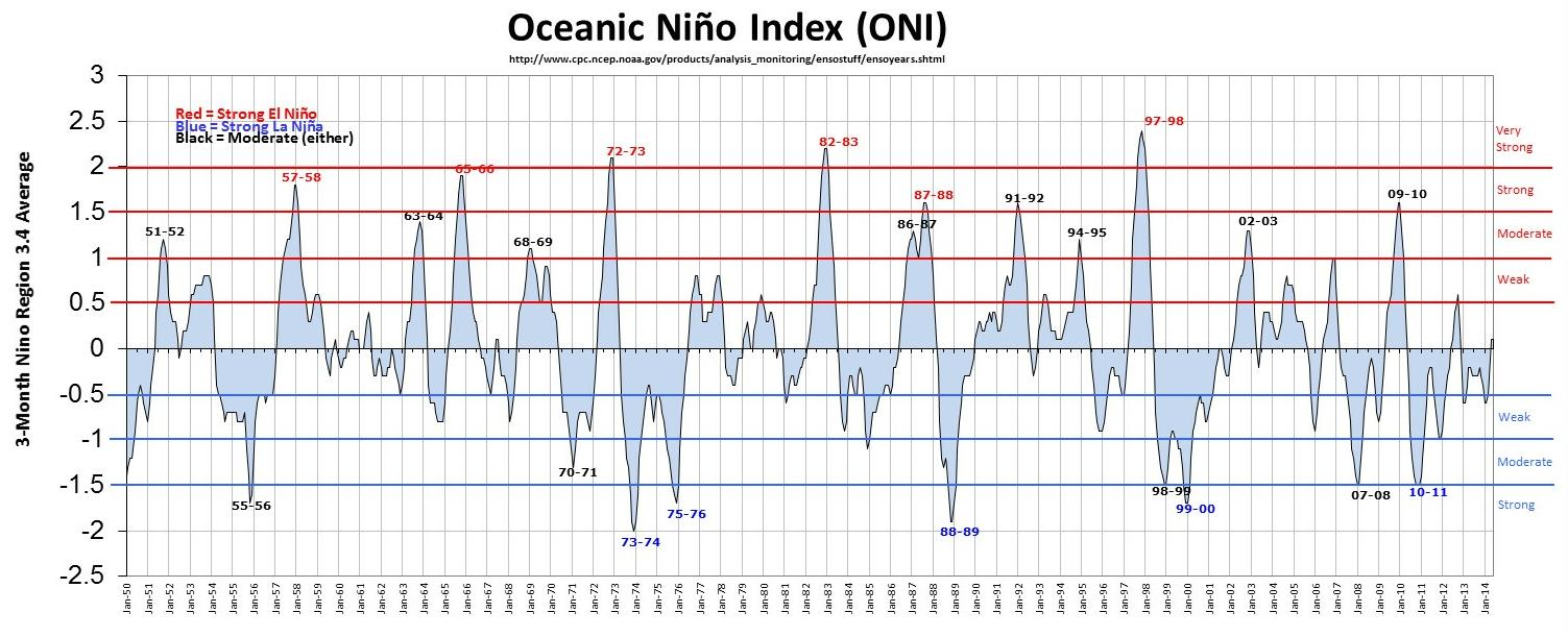
“Don’t count on El Niño for anything,” Jay Lund, a UC Davis hydrologist, admonished us at a July drought briefing in Washington, D.C. At the time, forecasters were already downsizing earlier projections for a strong El Niño this fall (latest update shows that it might be regrouping for a comeback). But Lund was making a larger point: He and others have plotted El Niño against actual California precipitation and found … a pretty murky relationship, overall.

“Don’t even look at the forecasts if you care about drought,” Lund advised.

That might seem like a strong statement given the reputation that the Pacific’s warm-water phase has for being a rainmaker, but records show that only the strongest El Niños have produced winters that were real super-soakers in Northern California — “strongest” meaning the times when ocean surface temperatures in the tropical Pacific spiked the highest above normal — and those events are rare.

“El Niños come in all sizes: small, medium, large,” says Bill Patzert, a climatologist and El Niño watcher at NASA’s Jet Propulsion Lab in Pasadena. “During puny El Niños — weak El Niños — we’ve had some of the driest winters in the 20th century.” Count among them 1976 and ’77, a drought that is still etched in the memories of many Californians.

Sponsored

At the opposite end of the scale was the winter of 1997-98 which brought roughly double the state’s normal precipitation, and triggered massive mudslides and flooding throughout California. That onslaught coincided with what Patzert calls the “Godzilla” El Niño. He says he thinks that year is when Californians began to form the assumption that El Niño equals rain.

“It was El Niño mania 24/7 that winter,” recalls Patzert. “The name — because of ’97-’98 — makes reporters and water managers salivate, but that belies the fact; there are only a few big El Niños in every century.”

The El Niño forecast for this winter is looking more gecko than Godzilla, experts say, with water only slightly warmer than normal. (For an in-depth explanation of how El Niños form and why this year’s has petered out, see Brad Plumer’s post for Vox.) Since the “Godzilla” winter 16 years ago, there really hasn’t been anything to match it.


The images above show warming (red) waters in the Pacific that indicate El Niño. Use the slider in the center to move back and forth between images from March and July, and note how much the warming has dissipated in recent months. (NASA/JPL)

A Wildcard in the Deck

One reason for the lull in strong El Niños is a wildcard in the deck, another cycle known as the Pacific Decadal Oscillation, or PDO. It’s like El Niño but farther north and much less capricious.

“The PDO is like a super-tanker,” says Patzert. “It’s very slow and it takes a long time and a lot of momentum to switch direction. Sometimes the negative PDO is what I call, ‘El Niño repellent.'” When the PDO is in its negative phase, it affects the high-altitude winds known as the jet stream. When that happens, the big winter storms tend to get detoured around California.

The PDO has been stuck in this mode for the last 15 years, though some see signs that it might be ready to make a big switch into its “positive” phase, which would encourage El Niño conditions. Patzert isn’t so sure. “I’m not too optimistic about a switch in the PDO,” he says.

Sixty years of El Nino fluctuations. Note the big spike that coincided with the storms of 1997-98. (NOAA/CPC)

Meteorologist Jan Null has put together an extensive “myth-busting” page for El Niño, which includes this visual history of the oscillation over the past six decades. Sixty years of El Niño fluctuations. Note the big spike that coincided with the storms of 1997-98 (click to enlarge). (NOAA/CPC)

Hope Springs Eternal

But just as El Niño doesn’t guarantee rain, the absence of one doesn’t necessarily mean no rain. Patzert says the stubborn ridge of high pressure that parked off the West Coast last winter and blocked incoming storms could give way this year for any number of reasons.

“If that ridge breaks down this winter, we could have one wet, cold storm after another making its way down the length of California — and that would certainly be sweet.”

Indeed. But the latest three-month outlook from NOAA’s Climate Prediction Center calls for drought conditions to “persist or intensify” throughout California, through November. The bottom line from Patzert: “Don’t cash in your 401(k) and invest in umbrellas.”

lower waypoint
next waypoint
Homeowners Insurance Market Stretched Even Thinner as 2 More Companies Leave CaliforniaAs California Seeks to Legalize Psychedelics for Therapy, Oregon Provides Key LessonsWatch Ferns Get FreakyCalifornia’s Commercial Salmon Season Is Closed Again This YearHoping for a 2024 'Super Bloom'? Where to See Wildflowers in the Bay AreaWhere to See Cherry Blossoms in the Bay Area This SpringInsurance In California Is Changing. Here's How It May Affect YouEverything You Never Wanted to Know About Snail SexThese Face Mites Really Grow on YouSchizophrenia: What It's Like to Hear Voices