upper waypoint

Interactive Map: How Sea Level Rise Could Swamp Coastal Communities

Save ArticleSave Article
Failed to save article

Please try again

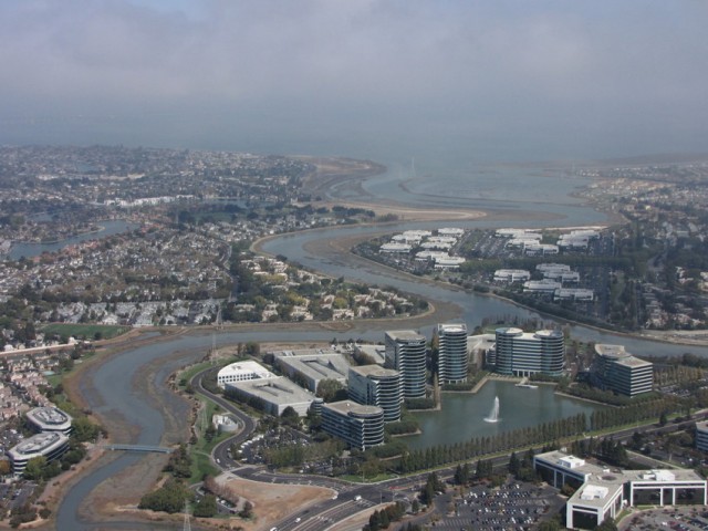
Oracle's headquarters in Redwood Shores is built on landfill in an area that was once marsh. (Molly Samuel/KQED with aerial support from LightHawk)
Oracle’s headquarters in Redwood Shores is built on landfill in an area that was once marsh. (Molly Samuel/KQED with aerial support from LightHawk)

Rising seas will likely lead to unprecedented flooding along parts of California’s coast within 20-60 years, according to new research by Climate Central.

Driven by climate change, global sea levels have already risen several inches over the past century.

To help people learn about flooding risks in their communities, Climate Central has released a new version of an online tool that explores flood risks by zip code.

Using an interactive map, Bay Area residents can zoom in on their region to find out if flooding will impact their homes as well as nearby schools, power plants, and hospitals. The “Surging Seas” website includes an interactive map, graphics, and other information to help people better understand the potential risks of sea level rise.

The online tool also highlights who will be affected by severe flooding. Ngoc Nguyen of New America Media, which collaborated on the interactive tool, says that low-income and communities of color will be most impacted by sea level rise. “We found that communities are responding, but there is a dangerous information gap about sea level rise and policies to address it among impacted ethnic communities,” says Nguyen.

Sponsored

In the map below, you can adjust the blue water level slider to see how rising water will affect coastal land. But don’t crank the slider up to 10 just yet. According to Dr. Ben Strauss of Climate Central, setting the water level to 3 feet will give a more realistic view of Bay Area flooding risks in the next few decades.  Zoom in on San Mateo County and you can see how it could be ground zero for flooding in the Bay Area.


Using projected sea level rise and historic storm data, Climate Central’s research found that floods would reach greater than 3 feet above the high tide line every year by 2060 at study sites from San Diego to Los Angeles, and by 2070 in San Francisco.

According to Strauss, the interactive map should not be taken as a specific prediction of what is to come, but rather as an indication of future flood risk.  Drawing on data from more than 10 federal agencies, Climate Central is creating tools for every coastal state in the U.S.

lower waypoint
next waypoint
Homeowners Insurance Market Stretched Even Thinner as 2 More Companies Leave CaliforniaAs California Seeks to Legalize Psychedelics for Therapy, Oregon Provides Key LessonsWatch Ferns Get FreakyCalifornia’s Commercial Salmon Season Is Closed Again This YearHoping for a 2024 'Super Bloom'? Where to See Wildflowers in the Bay AreaWhere to See Cherry Blossoms in the Bay Area This SpringInsurance In California Is Changing. Here's How It May Affect YouThese Face Mites Really Grow on YouLove Is an Albatross. Literally. Watch These Birds Do a Courtship DanceSchizophrenia: What It's Like to Hear Voices