upper waypoint

50 Years Ago, Alaskan Earthquake Was Key Event for Earth Science

Save ArticleSave Article
Failed to save article

Please try again

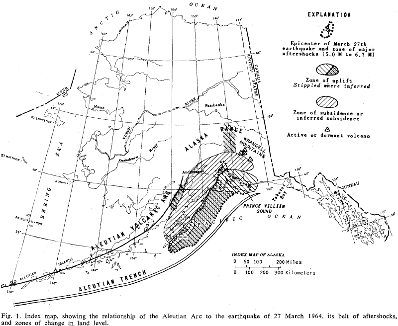
Alaska earthquake map
Figure 1 of Plafker’s Science paper, “Tectonic Deformation Associated with the 1964 Alaska Earthquake,” vol. 148, pp. 1675-1687. The quake is officially given a date of March 28 because it was 3:36 a.m. the next day in Universal Time. Click the image to see it full size. Paper reproduced by the IRIS SeismoArchives

Among many geologists of the boomer generation, the Alaska earthquake of March 27, 1964 is a touchstone of our formative years. Black-and-white images of ruin and upheaval from the then-new state of Alaska burst into our consciousness. News reached us of deadly “tidal waves” washing down the West Coast. But beyond rocking us kids toward geological careers, that earthquake was a key event in the 1960s revolution in earth science.

The quake, a magnitude 9.2, was the largest ever recorded in U.S. history. It lasted more than four minutes. The earthquake and the ensuing tsunami killed an estimated 131 people.

Geologist George Plafker of the U.S. Geological Survey was in Seattle the afternoon of the quake, attending a regional meeting of the Geological Society of America. He didn’t feel anything, but some colleagues had been up in Seattle’s Space Needle and felt the slow rocking typical of great earthquakes at great distances. His agency sent him to the scene immediately, along with fellow USGS geologists Art Grantz and the late Reuben Kachadoorian, and on Easter Sunday they set to work.

These three guys were picked because they knew the territory, not because they were earthquake specialists. The Alaskan Branch of the USGS was headquartered in Menlo Park with the rest of the western regional branch. Being in Seattle gave Plafker a day’s lead time in getting there. But the three scientists were what we would call old-school types, skilled in fieldwork and observation and thinking on their feet. They spent a week in Alaska, riding with emergency responders all over the enormous area of damage, then came home and quickly issued USGS Circular 491 while planning a summer field season of intensive work.

Circular 491 includes lots of photographs of damage, preliminary maps and eyewitness accounts. In the town of Homer, “Mr. Glen Sewell heard and saw a fracture, 12 to 18 inches wide, coming toward him from the southeast. The fracture passed between his legs, through a building, and continued on into Kachemak Bay.” Huge waves threw seafloor boulders 100 feet high onto the shore. The sea itself was damaged, as “vast numbers of red snappers, which normally inhabit waters deeper than 400 feet in Prince William Sound, were found floating on the surface.”
Sponsored

The most pervasive feature the geologists noted was also the most interesting to science: huge areas of land had been uplifted, and a comparable region had subsided. The signs were easy to recognize, and the summer season was largely spent measuring them. Rising shorelines killed the barnacles and other sea life on the rocks, leaving bands of dead white shells. Sinking shorelines killed the forests by drowning them in seawater. These contours of death were plain as day by summer.

Plafker published a long paper in the journal Science on June 25, 1965, laying out his findings. Reading it today, the paper today has an antique feel, like something that could have been written a century earlier. He presented maps showing areas of tectonic (large-scale) uplift and subsidence larger than anyone had documented before.

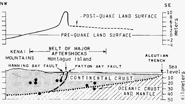
His paper showed unequivocally that the earthquake was not the kind that theoretical geologists were used to: not the vertical motions of “normal faults” or the sideways slippage of “strike-slip faults” like the well-known San Andreas fault. Instead, the quake had ruptured a large, nearly horizontal fault that extended from the surface of the seafloor in the Aleutian Trench downward beneath the coast of Alaska.

Fault profile
Plafker’s diagram of tectonic uplift across the area of the Good Friday earthquake. Portion of figure 6 of the 1965 Science paper

Today we recognize this as a subduction-related megathrust, due to motion of an underlying oceanic plate against an overlying continental plate. In 1965, we had no name for such a thing. He recognized the nature of the localized thrust faulting he had mapped on Montague Island, a place where conventional thinking predicted the opposite. Today we call it splay faulting.

Crucially, Plafker recognized that this kind of motion had been documented in previous Alaskan quakes, and that the rocks of coastal Alaska were themselves deformed in just the way to be expected after millions of years of earthquakes of this type. The facts Plafker brought out in this paper informed the debate that would boil over in the scientific ferment that produced plate tectonics in the next three years.

Plafker was a modest scientist, as he is today at age 85, and he ended his paper with a section clearly labeled “Speculation on Origin of the Earthquake.” But he was confident enough in his conclusions that he swatted down a competing explanation published in Science earlier that year by the prestigious seismologists Frank Press and David Jackson, calling it “an elegant analysis of the displacement by application of dislocation theory.” The barnacles on the rocks had told him something no theory could contradict.

See the USGS special page on the Alaska earthquake

lower waypoint
next waypoint
Homeowners Insurance Market Stretched Even Thinner as 2 More Companies Leave CaliforniaAs California Seeks to Legalize Psychedelics for Therapy, Oregon Provides Key LessonsWatch Ferns Get FreakyCalifornia’s Commercial Salmon Season Is Closed Again This YearSame-Sex Couples Face Higher Climate Change Risks, New UCLA Study ShowsHoping for a 2024 'Super Bloom'? Where to See Wildflowers in the Bay AreaInsurance In California Is Changing. Here's How It May Affect YouThese Face Mites Really Grow on YouWhere to See Cherry Blossoms in the Bay Area This SpringSchizophrenia: What It's Like to Hear Voices