upper waypoint

East Bay Building Demolition to Provide Rare Earthquake Insights

Save ArticleSave Article
Failed to save article

Please try again

Earthquake geologists will study the demolition of Warren Hall on the Cal State East Bay campus. (Photo: Cal State East Bay)

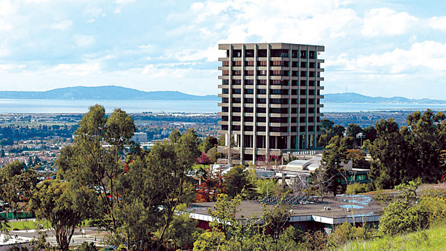
Scientists with the U.S. Geological Survey are looking for volunteers in the East Bay to help document a powerful seismic event in mid-August, when a 13-story building on the California State University, East Bay campus will come crashing down, making way for a new, seismically stable replacement.

The implosion of Warren Hall will mimic the energy of a 2.0-2.5 magnitude earthquake, giving geologists a unique chance to study what happens below the surface.

When USGS geophysicist Rufus Catchings got a phone call about the event months ago, he recalls not hesitating. “I said, ‘Oh yes! This is exactly what I’ve needed,” he said. “The fact that it’s so close to the Hayward Fault makes this a rare opportunity.”

To measure the seismic waves, USGS is looking for volunteers in Hayward and the East Bay to help deploy a network of seismographs. Over the next month, they’ll be knocking on doors around campus, asking local residents to host the seismic instruments in their yards. Volunteers can sign up online.

“The seismograph is about the size of a beer can,” Catchings said. “We’re trying to place about 600 of them.”

Sponsored

The data should reveal what the geologic layers around the Hayward Fault are made of, indicating how violently the area would shake during a major earthquake.

“You can largely see what’s at the surface, but many places, you go just a few feet below the surface and you have no idea what’s there,” Catchings said. “What’s down a few kilometers really affects the shaking.”

Geologists will also be looking for splays, or secondary faults, off the main fault. “A fault is not just one break in the ground,” he said. “It’s a zone of breaks and it’s difficult to tell just how wide that zone is.

The data could provide a clearer picture of the damage a major earthquake would do. There’s a 63 percent chance of a major quake in the Bay Area over the next 20 years.

Related Video

lower waypoint
next waypoint
From Tunnel Muck to Tidal Marsh, BART Extension Could Benefit the BayCalifornia's Second-Largest Reservoir Filled to CapacityCalifornia Regulators Approve Adding Fixed Charge of Up to $24 to Utility BillsElk Would Roam Free, Campers Would Not, Under Proposed Changes at Point Reyes National SeashoreMeet the Bug You Didn't Know You Were EatingFrom Storms to Sunscreen: Bay Area Weather Turnaround Is HereThe Never-ending Battle Over Martins Beach ExplainedEverything You Never Wanted to Know About Snail SexThese Face Mites Really Grow on YouEver Wake Up Frozen in the Middle of the Night, With a Shadowy Figure in the Room?