upper waypoint

Severe Bay Area Storm Brings Historic Winds, Regional Flooding and Power Outages

Save ArticleSave Article
Failed to save article

Please try again

A fallen tree on a city street.
A fallen tree closes Fillmore Street between Golden Gate Avenue and McAllister Street during a storm in San Francisco on Feb. 4, 2024. (Beth LaBerge/KQED)

Updated 12 p.m. Tuesday

At least three people in Northern California were killed in the massive storm that slammed the region on Sunday and Monday before moving farther south, officials said.

An 82-year-old man in Yuba City, north of Sacramento, was found crushed beneath a redwood tree in his yard on Monday, the California Governor’s Office of Emergency Services confirmed. Investigators said the man, identified as David Gomes, appeared to be using a ladder in an attempt to clear the damaged tree away from his home when it fell on him.

Also on Monday, a 45-year-old man in Boulder Creek, in the Santa Cruz mountains, was killed when a tree fell on his home, officials confirmed. The man, Robert Brainard III, was pronounced dead at the scene, the Santa Cruz Sentinel reported.

And on Sunday, Chad Ensey, a 41-year-old man in the Sacramento suburb of Carmichael, also died after a tree fell on him in his backyard, the San Francisco Chronicle reported.

Sponsored

The intense atmospheric river-fueled storm that pummeled the region with heavy rainfall and hurricane-force winds — nearing or topping 100 mph in a handful of mountainous Bay Area locations — left hundreds of thousands of homes and businesses without power on Sunday and into Monday. As of 10 a.m. Tuesday, more than 63,000 homes in the Bay Area — including upward of 27,000 in the North Bay — were still in the dark, according to PG&E.

With the storm expected to wreak even more havoc in already-saturated Southern California, Gov. Gavin Newsom on Saturday declared a state of emergency for Los Angeles, Orange, Riverside, San Bernardino, San Diego, San Luis Obispo, Santa Barbara and Ventura counties, which allows the state to mobilize the National Guard for emergency response if necessary. The Office of Emergency Services activated its operations center and positioned thousands of personnel and equipment in areas throughout the region most at risk.

Updated 7:50 p.m. Sunday

As a massive storm continues to roll over the region, the National Weather Service said thunderstorms, lightning and hail are still impacting the Bay Area Sunday evening, with power outages impacting more than 700,000 customers.

Scattered thunderstorms and showers will last through the night until most of the rain has passed by Monday morning.

“There still could be some residual flooding on the roadways with the soils being saturated,” said NWS meteorologist Sarah McCorkle. “We could still see some downed trees, but overall, things should calm down by tomorrow morning.”

According to the state Office of Emergency Services, in the last few hours, Santa Clara County has seen the number of customers in the dark more than quadruple, to nearly 109,000. Close to 80,000 customers are without power across the North Bay.

San Mateo power outages have more than tripled in that time frame to over 74,000.

“We’ve got hundreds of crews out there responding to these outages, and it’s all storm-related,” said Jeff Smith with PG&E. “You know there’s a lot of heavy winds, and winds can knock power lines together and sometimes cause trees and branches to get into power lines.”

High wind warnings and wind advisories remain in effect through Sunday at 10 p.m. as wind speeds diminish this evening except at higher peaks.

“The NWS Storm Prediction Center in northern Oklahoma, usually the place that issues severe thunderstorm and tornado watches, just highlighted this region as having at least a slight chance of generating tornadic thunderstorms in the next one to two hours,” UCLA climate scientist Daniel Swain said on Sunday, pointing out that the extreme rain and intense winds stretched from Santa Cruz to San Jose.

Meteorologists with the NWS Bay Area office explained there’s a 5% chance they’ll issue a tornado watch.

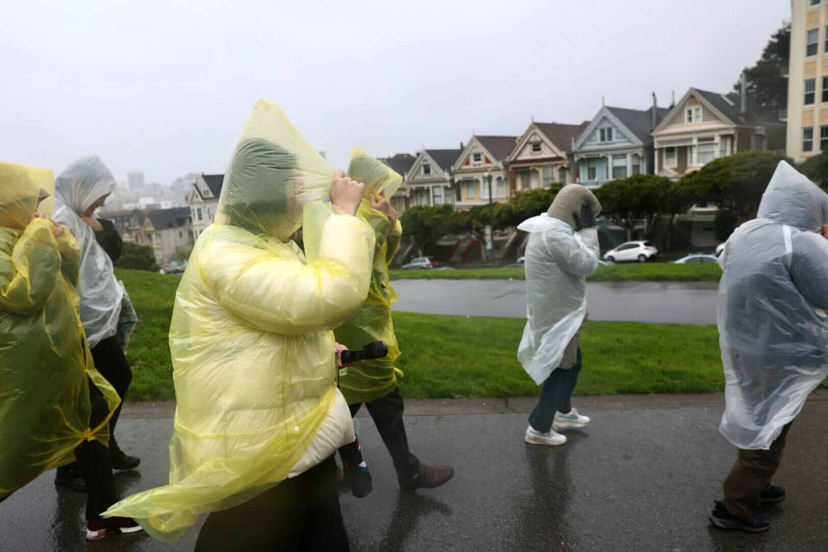
Water officials in the South Bay said the worst of today’s storms have passed — without flooding along the Guadalupe River in San Jose, which city officials thought could overflow. Water levels reached above seven feet around noon but have since declined. That’s short of the 9-and-a-half feet the National Weather Service defines as flood stage for the river.

Valley Water spokesman Matt Keller says that’s good news for nearby residents.

“You know, if the forecast would have delivered what it was, they would have seen flooding in that area,” he said. “But because, you know, Mother Nature could do what Mother Nature does, it’s as much as we like to forecast, it can still be unpredictable. And, we did not see the impacts that we were expecting.”

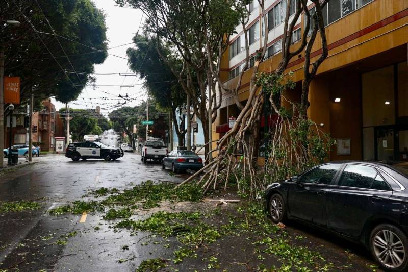
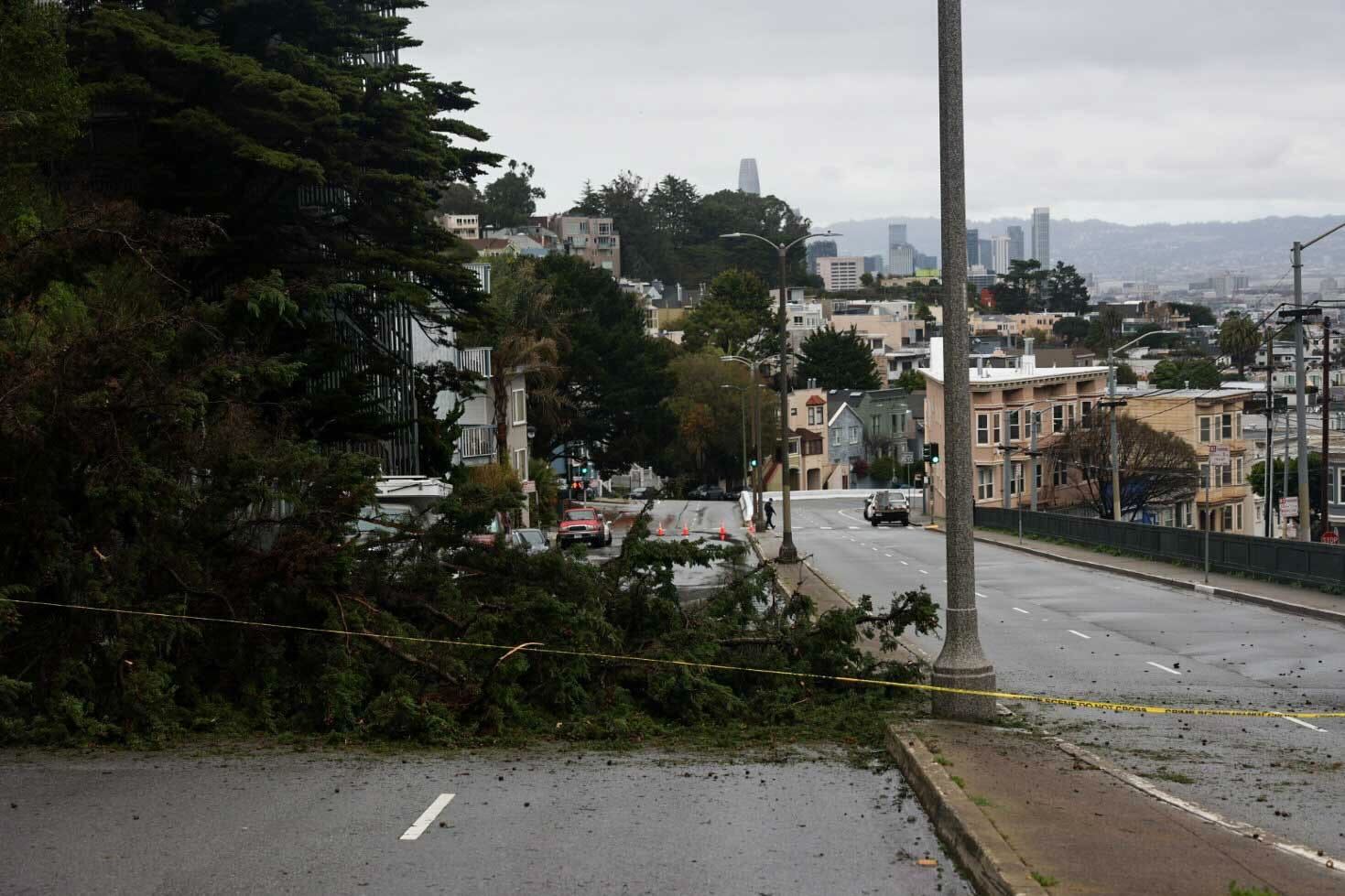
The city of San José remains under a wind advisory with gusts expected up to 60 miles per hour.

Updated 4:30 p.m. Sunday

A community center in San José will remain open today for unhoused residents seeking shelter from the wet weather. The Roosevelt Community Center on Santa Clara Street will accept walk-ins today — with space for 90 individuals.

On Saturday, the city ordered an evacuation for unhoused residents living along the banks of the Guadalupe River, which ultimately avoided flooding. San José Mayor Matt Mahan says city police broadcast a message over a loudspeaker warning people to leave the river banks.

“It’s the most efficient tool we have for letting homeless residents living along the waterways know that there’s a risk and that they need to relocate,” he said.

After Saturday’s evacuation order, more than 40 people stayed at the Roosevelt Community Center.

“Right now, it’s just the wind that I’m keeping an eye on because we could have more trees and power lines down and more power outages,” Mahan said.

In Oakland on Sunday, Eugene Jacobs, who has been unhoused since 2017, tied a tarp over his tent under the 980 overpass at Sycamore St. The Oakland native said he lives in a tent just a few hundred feet away.

“My whole front door and back door have been torn off,’ he said. “It’s been hard to deal with, but as long as you stay under this underpass right here when you’re homeless, you stay dry.”

While the Bay Area is still experiencing the lingering wind and rain, much of the effects have yet to hit Southern California, but Swain says that will change as the day continues with flash flood warnings from Santa Barbara south.

“If you’re in Los Angeles and San Diego, you’re still saying ‘what storm?’ because it is essentially raining lightly on the west side of LA with partly cloudy conditions or sunny conditions relatively warm, east and south of that, but just wait, it is coming,” he said.

Original story

The Bay Area is preparing for extreme weather conditions, flooding, massive waves, downed trees and power outages as an atmospheric river-boosted storm sweeps across the region. The National Weather Service expects the storm to last through Monday and could be stronger and more intense than any storm this year.

NWS meteorologists said Sunday up to three inches of rain could fall on the Santa Clara area, which could be the hardest hit this afternoon and evening. NWS expects up to five inches of rain on the coastal side of the Santa Cruz Mountains.

“The heavier rain is expected this afternoon when there’ll be heavier downpours and thunderstorms,” said NWS meteorologist Sarah McCorkle.

Several people wearing rain ponchos walk outside as the wind blows.
A group of tourists walk through Alamo Square Park during a storm in San Francisco on Feb. 4, 2024. (Beth LaBerge/KQED)

San José has issued a mandatory evacuation along four creeks — the Coyote, Los Gatos, Penitencia and Ross Creeks — and the Guadalupe River. The city has alerted unhoused residents that the waterways are likely to rise. The river forecast center with NWS now predicts the Guadalupe River will peak at 2 p.m. today above the flood stage.

“Please do not be anywhere near the waterway and be aware while driving or parked vehicles,” said San José Mayor Matt Mahan in a Saturday press conference.

Power outages and flight delays

More than 120,000 customers from Sonoma to Monterrey Counties are without power, according to the PowerOutage site, including residences from Rohnert Park, Tiburon, San Francisco, Pacifica, Newark, and San José.

The greatest concentration of power outages in the region is in the South Bay. Around 23,000 PG&E customers are without power in the San José, Cupertino and Sunnyvale areas. In the North Bay, there are around 12,000 PG&E customers without power. PG&E has hundreds of crews responding to storm-related outages across the Bay Area.

Bay Area airports are seeing a rise in delays and cancellations as heavy wind and rain move through the region. The San Francisco Chronicle reported San Francisco International Airport temporarily delayed landings this morning and rerouted two flights to Oakland airport.

Kaley Skantz, public information officer at Oakland International Airport, said the airport has had 18 departure delays and two cancellations.

“We do recommend checking flight status with your airline before coming to the airport just to ensure that you have the most recent information about your travel itinerary,” she said.

In San Jose, officials with Minetta International Airport said they had 57 delays and two cancellations so far today, which a spokesperson says is higher than normal, but not out of the ordinary for a stormy day.

Along the San Mateo coastline, waves crashing on the shore are 25 feet tall, according to San Mateo County Supervisor Ray Mueller.

“Right now, Highway 1 is completely closed south of Pescadero due to downed powerlines in roads,” he said.

A tree blocks part of a street in a city.
A tree blocks Market Street at 18th during a storm in San Francisco on Feb. 4, 2024. (Beth LaBerge/KQED)

Strong winds

The storm, lasting through Monday, is also expected to bring 30-80 miles per hour of winds across the region as well as nuisance flooding. Weather officials expect hurricane-force winds off the Monterey Coast.

“For the first time in their history, there’s a hurricane-force wind warning for the offshore waters of Monterey County and that does not mean that the storm itself is a true hurricane,” said UCLA climate scientist Daniel Swain. “In most places, the strongest winds haven’t occurred yet.”

Swain said the storm, with its tail reaching past Hawaii, is developing in place and the worst of the precipitation is yet to come. As the storm heads south, he said, water spouts or tornadoes are possible.

“It’s far from over yet and in some respects, the storm won’t peak until this afternoon or evening,” he said.

Potential flooding

Regarding flooding, Swain said he doesn’t think the flood risk will be widespread in the Bay Area.

“This is not an epic flood event for Northern California because it isn’t in the right position for the storm to see high rainfall totals, but it could be for Southern California,” he said.

After the storm sweeps over the Bay Area, Swain expects it to hit Southern California, where flash flooding could inundate the region and a few evacuation orders are already in place.

“This is just going to increasingly align across Southern California for the next day and does bring for flooding risk later on across Southern California,” he said.

As for the Sierra Nevada snowpack, Swan said this storm will likely give it a “kickstart” and could be the biggest snow event of the year so far.

Emergency services

According to San José’s official website, Roosevelt Community Center (901 East Santa Clara Street) will serve as an extended Overnight Warming Location (OWL). Walk-ins will be accepted at the OWL today and Monday, and pets are welcome. Additional information about Santa Clara County’s warming locations can be found here.

Sponsored

KQED’s Annelise Finney, Rachael Vasquez, Lakshmi Sarah and Beth LaBerge contributed reporting to this story.

lower waypoint
next waypoint
Atmospheric Rivers in California’s Ancient Past Exceeded Modern StormsWorld's Largest Digital Camera Built in the Bay Area to Illuminate Mysteries of the UniverseHow an Ocean Exploration Video Game Out of Monterey Bay Contributes to ScienceThis is NOT a Dandelion.NASA Prepares to Return to Venus for the First Time in DecadesEverything You Never Wanted to Know About Snail SexEver Wake Up Frozen in the Middle of the Night, With a Shadowy Figure in the Room?What Is the 'Green Flash' at Sunset — and How Can You See It?These Face Mites Really Grow on YouWhat Actually Makes Water Roll Off a Duck's Back?