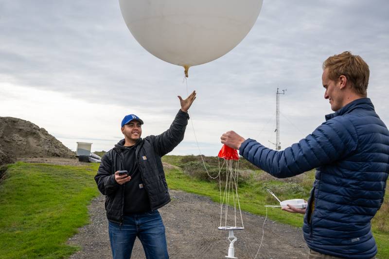
Adolfo Lopez Miranda (left) and Jacob Morgan, engineers with the Scripps Institution of Oceanography, release a weather balloon into an atmospheric river-fueled storm to help forecast precipitation levels and locations in the Bay Area at the UC Davis Coastal and Marine Sciences Institute's Bodega Marine Laboratory in Bodega Bay on Jan. 12, 2024. (Beth LaBerge/KQED)
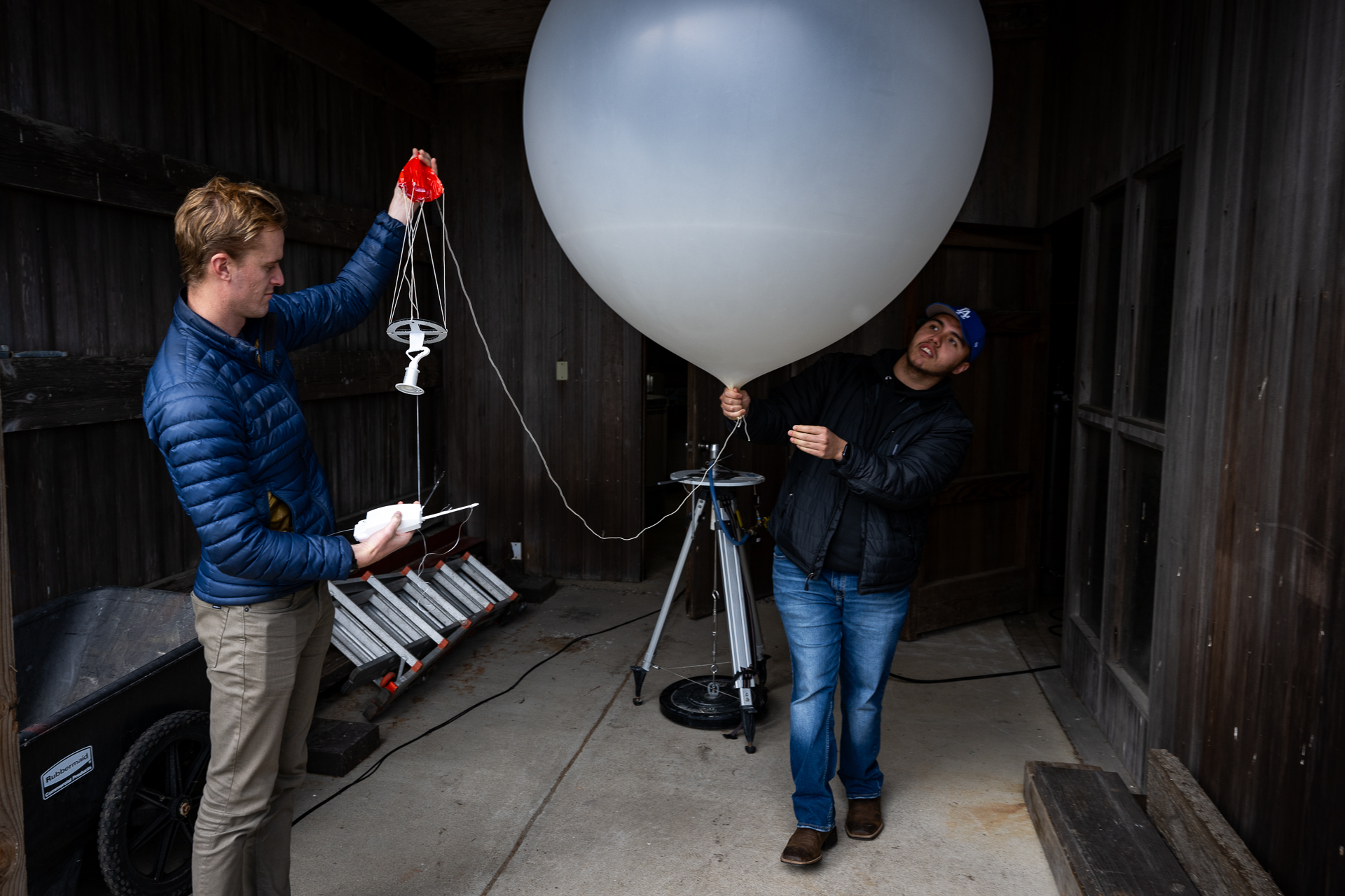
Just before the rays of dawn on Jan. 12 paraded over the cliffs that separate Bodega Bay from the expanse of the Pacific Ocean, Adolfo Lopez Miranda and Jacob Morgan inflated a shapeless giant silicone balloon with helium.
The duo worked inside a wooden gray shed.
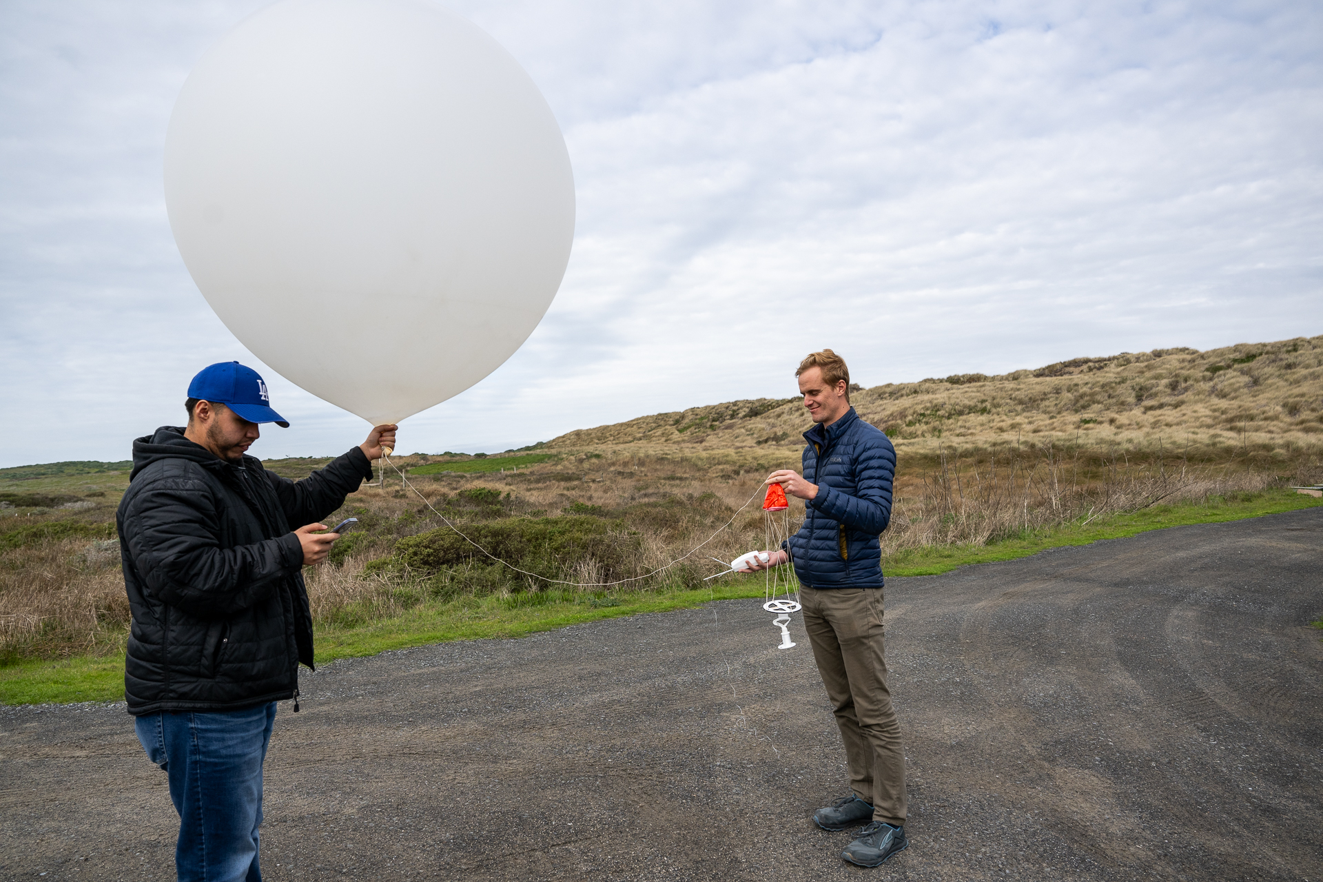
A few minutes before seven, the two men hiked to a nearby hilltop, carrying the now bulging balloon, around 3 feet long and wide.
They attached a tiny red parachute with a translucent cord, added an array of weather sensors, and released it like kids at a birthday party.
Jacob Morgan (left) and Adolfo Lopez Miranda inflate a weather balloon before launching it into an atmospheric river-fueled storm to help forecast precipitation levels and locations in the Bay Area at the UC Davis Coastal and Marine Sciences Institute’s Bodega Marine Laboratory in Bodega Bay on Jan. 12, 2024. (Beth LaBerge/KQED)
Lopez Miranda and Morgan, engineers with the Scripps Institution of Oceanography, are attempting to better understand these rivers in the sky, which can dump an onslaught of precipitation — several inches of rain in less than an hour — and trigger catastrophic flooding.
The duo flew up from San Diego to the UC Davis Coastal and Marine Sciences Institute’s Bodega Marine Laboratory for this storm. The weather balloon they launched directly into the atmospheric river will send back data on the storm’s course as it approaches the coast of California.
For each storm, the team launches a new balloon every few hours.
As the balloons float higher and higher into the atmosphere, they expand. Attached is a small white styrofoam radiosonde, which collects data — temperature, location, wind speed, wind direction, humidity and pressure — and transmits it to a computer in the wooden shack.
As the balloon ascends, the atmospheric pressure decreases, and the balloon eventually swells to the size of a school bus. “When it’s that big, the latex is stretched so thin that eventually it pops,” Morgan said.
Adolfo Lopez Miranda (left) and Jacob Morgan prepare to launch a weather balloon into an atmospheric river-fueled storm. (Beth LaBerge/KQED)
According to Morgan, the balloon he released on the morning of Jan. 12 burst around 15 miles into the atmosphere and parachuted down.
“Unfortunately, they might land in a tree or mountain,” Lopez Miranda said. “We know where they are, but sometimes they’re miles away from here where we don’t have access to.”
Related Stories
All the information the device collects is vital to tell forecasters how fast the storm is approaching, where it’s headed, how warm it will be, and how much rain the storm will likely drop. Within a few hours, the data is uploaded to the university’s database and made available to the National Weather Service to incorporate into real-time forecasting models.
“It’s really helpful for getting a better understanding of water availability in California and how we can better manage the water that we have and when we should expect to receive a big load of precipitation,” Morgan said.
As the balloons float into the stratosphere, airplanes equipped with similar sensors fly over the storm and survey it from above to understand how the storm is progressing from that perspective above the cloudy mass. The information researchers collect from above and within the storm allows cities, counties and emergency officials to know how to prepare in real time. The information also helps reservoir operators make more informed decisions about how much water to keep in them.
“This gives us a better idea of the weather and our decision-making with water-related things,” Lopez Miranda said. “I feel like we’re making better decisions now with all the information we’re getting, so you don’t feel like you’re gambling anymore.”
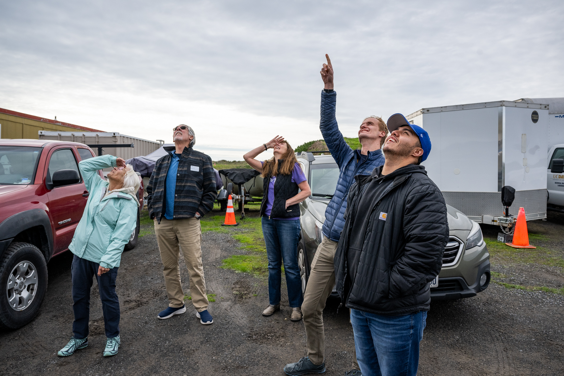
Jacob Morgan points upward at a weather balloon while Adolfo Lopez Miranda (right) and a group of docents look up to spot it in the clouds. (Beth LaBerge/KQED)
The Scripps balloon project has helped close the gap in knowledge of how a storm will progress, said Lopez-Miranda, who started as an intern with the group.
These real-time weather observations provide insights into the potential behavior of future storms made more intense by human-caused climate change, said Chad Hecht, a meteorologist at the Centre for Western Weather and Water Extremes at the University of California, San Diego’s Scripps Institution of Oceanography.
“There’s a lot of research that still needs to be done using this data, but what we are seeing is an exacerbation of that feast or famine hydroclimate in California,” he said.
Jacob Morgan, an engineer with the Scripps Institution of Oceanography, looks at a program that follows the location of the weather balloon launched into an atmospheric river-fueled storm. (Beth LaBerge/KQED)
“Our infrastructure is not designed for these big storms, and we’re never going to be able to design it to handle them,” said Kris May, founder of the Pathways Climate Institute, a San Francisco-based consulting firm behind the study. “We’re gonna see more areas that flood that have never flooded before.”
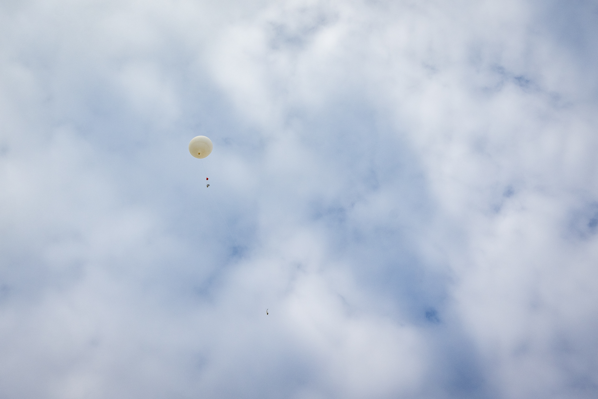
A weather balloon launched by Adolfo Lopez Miranda and Jacob Morgan heads toward an atmospheric river-fueled storm. (Beth LaBerge/KQED)
Hecht said data collected by these balloon launches and aircraft is only “scratching the surface” of the knowledge needed to understand future weather intensifying because of climate change. Still, in the immediate, the new precipitation information is helping forecasters better inform people and water managers how to prepare for storms.
“To optimize water operations, we need to have the best precipitation forecast as possible because we want to store as much water as possible, but we also don’t want to store too much that leads to flooding impacts,” he said. “We can better prepare, whether that’s going to be on the impactful or beneficial end.”
Sponsored
Sponsored
lower waypoint
Get the best of KQED’s science coverage in your inbox weekly.
To learn more about how we use your information, please read our privacy policy.
window.__IS_SSR__=true
window.__INITIAL_STATE__={"attachmentsReducer":{"audio_0":{"type":"attachments","id":"audio_0","imgSizes":{"kqedFullSize":{"file":"https://ww2.kqed.org/news/wp-content/themes/KQED-unified/img/audio_bgs/background0.jpg"}}},"audio_1":{"type":"attachments","id":"audio_1","imgSizes":{"kqedFullSize":{"file":"https://ww2.kqed.org/news/wp-content/themes/KQED-unified/img/audio_bgs/background1.jpg"}}},"audio_2":{"type":"attachments","id":"audio_2","imgSizes":{"kqedFullSize":{"file":"https://ww2.kqed.org/news/wp-content/themes/KQED-unified/img/audio_bgs/background2.jpg"}}},"audio_3":{"type":"attachments","id":"audio_3","imgSizes":{"kqedFullSize":{"file":"https://ww2.kqed.org/news/wp-content/themes/KQED-unified/img/audio_bgs/background3.jpg"}}},"audio_4":{"type":"attachments","id":"audio_4","imgSizes":{"kqedFullSize":{"file":"https://ww2.kqed.org/news/wp-content/themes/KQED-unified/img/audio_bgs/background4.jpg"}}},"placeholder":{"type":"attachments","id":"placeholder","imgSizes":{"thumbnail":{"file":"https://ww2.kqed.org/wp-content/uploads/sites/10/2018/01/GettyImages-896326950-160x96.jpg","width":160,"height":96,"mimeType":"image/jpeg"},"medium":{"file":"https://ww2.kqed.org/wp-content/uploads/sites/10/2018/01/GettyImages-896326950-800x478.jpg","width":800,"height":478,"mimeType":"image/jpeg"},"large":{"file":"https://ww2.kqed.org/wp-content/uploads/sites/10/2018/01/GettyImages-896326950-1020x610.jpg","width":1020,"height":610,"mimeType":"image/jpeg"},"fd-lrg":{"file":"https://ww2.kqed.org/wp-content/uploads/sites/10/2018/01/GettyImages-896326950-1920x1148.jpg","width":1920,"height":1148,"mimeType":"image/jpeg"},"fd-med":{"file":"https://ww2.kqed.org/wp-content/uploads/sites/10/2018/01/GettyImages-896326950-1180x705.jpg","width":1180,"height":705,"mimeType":"image/jpeg"},"fd-sm":{"file":"https://ww2.kqed.org/wp-content/uploads/sites/10/2018/01/GettyImages-896326950-960x574.jpg","width":960,"height":574,"mimeType":"image/jpeg"},"post-thumbnail":{"file":"https://ww2.kqed.org/wp-content/uploads/sites/10/2018/01/GettyImages-896326950-672x372.jpg","width":672,"height":372,"mimeType":"image/jpeg"},"twentyfourteen-full-width":{"file":"https://ww2.kqed.org/wp-content/uploads/sites/10/2018/01/GettyImages-896326950-1038x576.jpg","width":1038,"height":576,"mimeType":"image/jpeg"},"xxsmall":{"file":"https://ww2.kqed.org/wp-content/uploads/sites/10/2018/01/GettyImages-896326950-240x143.jpg","width":240,"height":143,"mimeType":"image/jpeg"},"xsmall":{"file":"https://ww2.kqed.org/wp-content/uploads/sites/10/2018/01/GettyImages-896326950-375x224.jpg","width":375,"height":224,"mimeType":"image/jpeg"},"small":{"file":"https://ww2.kqed.org/wp-content/uploads/sites/10/2018/01/GettyImages-896326950-520x311.jpg","width":520,"height":311,"mimeType":"image/jpeg"},"xlarge":{"file":"https://ww2.kqed.org/wp-content/uploads/sites/10/2018/01/GettyImages-896326950-1180x705.jpg","width":1180,"height":705,"mimeType":"image/jpeg"},"full-width":{"file":"https://ww2.kqed.org/wp-content/uploads/sites/10/2018/01/GettyImages-896326950-1920x1148.jpg","width":1920,"height":1148,"mimeType":"image/jpeg"},"guest-author-32":{"file":"https://ww2.kqed.org/wp-content/uploads/sites/10/2018/01/GettyImages-896326950-32x32.jpg","width":32,"height":32,"mimeType":"image/jpeg"},"guest-author-50":{"file":"https://ww2.kqed.org/wp-content/uploads/sites/10/2018/01/GettyImages-896326950-50x50.jpg","width":50,"height":50,"mimeType":"image/jpeg"},"guest-author-64":{"file":"https://ww2.kqed.org/wp-content/uploads/sites/10/2018/01/GettyImages-896326950-64x64.jpg","width":64,"height":64,"mimeType":"image/jpeg"},"guest-author-96":{"file":"https://ww2.kqed.org/wp-content/uploads/sites/10/2018/01/GettyImages-896326950-96x96.jpg","width":96,"height":96,"mimeType":"image/jpeg"},"guest-author-128":{"file":"https://ww2.kqed.org/wp-content/uploads/sites/10/2018/01/GettyImages-896326950-128x128.jpg","width":128,"height":128,"mimeType":"image/jpeg"},"detail":{"file":"https://ww2.kqed.org/wp-content/uploads/sites/10/2018/01/GettyImages-896326950-150x150.jpg","width":150,"height":150,"mimeType":"image/jpeg"},"kqedFullSize":{"file":"https://ww2.kqed.org/wp-content/uploads/sites/10/2018/01/GettyImages-896326950-e1514998105161.jpg","width":1920,"height":1148}}},"science_1992397":{"type":"attachments","id":"science_1992397","meta":{"index":"attachments_1591205162","site":"science","id":"1992397","found":true},"title":"240416-NONTRADITIONALFAMILIES-16-BL-KQED","publishDate":1713379443,"status":"inherit","parent":0,"modified":1714006306,"caption":"John Owens poses for a photo with his partners Emily Savage (left) and Alejandra Bravo Ducey at a celebration party at the East Bay Community Space in Oakland on April 16, 2024, after a bill prohibiting discrimination of nonmonogamous families passed in the Oakland City Council.","credit":"Beth LaBerge/KQED","altTag":null,"description":null,"imgSizes":{"medium":{"file":"https://cdn.kqed.org/wp-content/uploads/sites/35/2024/04/240416-NONTRADITIONALFAMILIES-16-BL-KQED-800x533.jpg","width":800,"height":533,"mimeType":"image/jpeg"},"large":{"file":"https://cdn.kqed.org/wp-content/uploads/sites/35/2024/04/240416-NONTRADITIONALFAMILIES-16-BL-KQED-1020x680.jpg","width":1020,"height":680,"mimeType":"image/jpeg"},"thumbnail":{"file":"https://cdn.kqed.org/wp-content/uploads/sites/35/2024/04/240416-NONTRADITIONALFAMILIES-16-BL-KQED-160x107.jpg","width":160,"height":107,"mimeType":"image/jpeg"},"medium_large":{"file":"https://cdn.kqed.org/wp-content/uploads/sites/35/2024/04/240416-NONTRADITIONALFAMILIES-16-BL-KQED-768x512.jpg","width":768,"height":512,"mimeType":"image/jpeg"},"1536x1536":{"file":"https://cdn.kqed.org/wp-content/uploads/sites/35/2024/04/240416-NONTRADITIONALFAMILIES-16-BL-KQED-1536x1024.jpg","width":1536,"height":1024,"mimeType":"image/jpeg"},"post-thumbnail":{"file":"https://cdn.kqed.org/wp-content/uploads/sites/35/2024/04/240416-NONTRADITIONALFAMILIES-16-BL-KQED-672x372.jpg","width":672,"height":372,"mimeType":"image/jpeg"},"twentyfourteen-full-width":{"file":"https://cdn.kqed.org/wp-content/uploads/sites/35/2024/04/240416-NONTRADITIONALFAMILIES-16-BL-KQED-1038x576.jpg","width":1038,"height":576,"mimeType":"image/jpeg"},"full-width":{"file":"https://cdn.kqed.org/wp-content/uploads/sites/35/2024/04/240416-NONTRADITIONALFAMILIES-16-BL-KQED-1920x1280.jpg","width":1920,"height":1280,"mimeType":"image/jpeg"},"kqedFullSize":{"file":"https://cdn.kqed.org/wp-content/uploads/sites/35/2024/04/240416-NONTRADITIONALFAMILIES-16-BL-KQED.jpg","width":2000,"height":1333}},"fetchFailed":false,"isLoading":false},"science_1992437":{"type":"attachments","id":"science_1992437","meta":{"index":"attachments_1591205162","site":"science","id":"1992437","found":true},"title":"CaliforniaStateParkDosRiosTract01","publishDate":1713892560,"status":"inherit","parent":1992433,"modified":1713895356,"caption":"The confluence of the San Joaquin River, left, and Tuolumne River, right, along the Dos Rios Ranch on Tuesday, Sept. 21, 2021, in Modesto, California.","credit":"Brian van der Brug/Los Angeles Times via Getty Images","altTag":null,"description":null,"imgSizes":{"medium":{"file":"https://cdn.kqed.org/wp-content/uploads/sites/35/2024/04/CaliforniaStateParkDosRiosTract01-800x533.jpg","width":800,"height":533,"mimeType":"image/jpeg"},"large":{"file":"https://cdn.kqed.org/wp-content/uploads/sites/35/2024/04/CaliforniaStateParkDosRiosTract01-1020x680.jpg","width":1020,"height":680,"mimeType":"image/jpeg"},"thumbnail":{"file":"https://cdn.kqed.org/wp-content/uploads/sites/35/2024/04/CaliforniaStateParkDosRiosTract01-160x107.jpg","width":160,"height":107,"mimeType":"image/jpeg"},"medium_large":{"file":"https://cdn.kqed.org/wp-content/uploads/sites/35/2024/04/CaliforniaStateParkDosRiosTract01-768x512.jpg","width":768,"height":512,"mimeType":"image/jpeg"},"1536x1536":{"file":"https://cdn.kqed.org/wp-content/uploads/sites/35/2024/04/CaliforniaStateParkDosRiosTract01-1536x1024.jpg","width":1536,"height":1024,"mimeType":"image/jpeg"},"post-thumbnail":{"file":"https://cdn.kqed.org/wp-content/uploads/sites/35/2024/04/CaliforniaStateParkDosRiosTract01-672x372.jpg","width":672,"height":372,"mimeType":"image/jpeg"},"twentyfourteen-full-width":{"file":"https://cdn.kqed.org/wp-content/uploads/sites/35/2024/04/CaliforniaStateParkDosRiosTract01-1038x576.jpg","width":1038,"height":576,"mimeType":"image/jpeg"},"kqedFullSize":{"file":"https://cdn.kqed.org/wp-content/uploads/sites/35/2024/04/CaliforniaStateParkDosRiosTract01.jpg","width":1920,"height":1280}},"fetchFailed":false,"isLoading":false},"science_1992446":{"type":"attachments","id":"science_1992446","meta":{"index":"attachments_1591205162","site":"science","id":"1992446","found":true},"title":"Green Flash in Half Moon Bay","publishDate":1713982553,"status":"inherit","parent":1992443,"modified":1713999244,"caption":"Green flash photographed in Half Moon Bay, California, on July 8, 2021","credit":"Jan Null","altTag":"An image of the bright sun setting on the horizon. Some distortion is seen with hints of orange and yellow. Hints of green are seen at the upper side of the sun. A silhouette of a bird is seen flying across the sun.","description":null,"imgSizes":{"thumbnail":{"file":"https://cdn.kqed.org/wp-content/uploads/sites/35/2024/04/green3_2-e1713982676559-160x95.jpg","width":160,"height":95,"mimeType":"image/jpeg"},"post-thumbnail":{"file":"https://cdn.kqed.org/wp-content/uploads/sites/35/2024/04/green3_2-600x372.jpg","width":600,"height":372,"mimeType":"image/jpeg"},"twentyfourteen-full-width":{"file":"https://cdn.kqed.org/wp-content/uploads/sites/35/2024/04/green3_2-600x576.jpg","width":600,"height":576,"mimeType":"image/jpeg"},"kqedFullSize":{"file":"https://cdn.kqed.org/wp-content/uploads/sites/35/2024/04/green3_2-e1713982676559.jpg","width":600,"height":355}},"fetchFailed":false,"isLoading":false},"science_1992476":{"type":"attachments","id":"science_1992476","meta":{"index":"attachments_1591205162","site":"science","id":"1992476","found":true},"title":"20240423_RITGER_CLIMATE WEEK DAY 2_72212-KQED","publishDate":1714067040,"status":"inherit","parent":0,"modified":1714077922,"caption":"California Secretary of Natural Resources Wade Crowfoot is interviewed by KQED reporter Danielle Venton for Climate One at the Commonwealth Club in San Francisco on April 23, 2024","credit":"Courtesy of Climate One/Commonwealth Club","altTag":"A man wearing a dark business suit sits next to a woman with a dark jacket with white designs on a stage.","description":null,"imgSizes":{"medium":{"file":"https://cdn.kqed.org/wp-content/uploads/sites/35/2024/04/20240423_RITGER_CLIMATE-WEEK-DAY-2_72212-KQED-800x533.jpg","width":800,"height":533,"mimeType":"image/jpeg"},"large":{"file":"https://cdn.kqed.org/wp-content/uploads/sites/35/2024/04/20240423_RITGER_CLIMATE-WEEK-DAY-2_72212-KQED-1020x680.jpg","width":1020,"height":680,"mimeType":"image/jpeg"},"thumbnail":{"file":"https://cdn.kqed.org/wp-content/uploads/sites/35/2024/04/20240423_RITGER_CLIMATE-WEEK-DAY-2_72212-KQED-160x107.jpg","width":160,"height":107,"mimeType":"image/jpeg"},"medium_large":{"file":"https://cdn.kqed.org/wp-content/uploads/sites/35/2024/04/20240423_RITGER_CLIMATE-WEEK-DAY-2_72212-KQED-768x512.jpg","width":768,"height":512,"mimeType":"image/jpeg"},"1536x1536":{"file":"https://cdn.kqed.org/wp-content/uploads/sites/35/2024/04/20240423_RITGER_CLIMATE-WEEK-DAY-2_72212-KQED-1536x1024.jpg","width":1536,"height":1024,"mimeType":"image/jpeg"},"post-thumbnail":{"file":"https://cdn.kqed.org/wp-content/uploads/sites/35/2024/04/20240423_RITGER_CLIMATE-WEEK-DAY-2_72212-KQED-672x372.jpg","width":672,"height":372,"mimeType":"image/jpeg"},"twentyfourteen-full-width":{"file":"https://cdn.kqed.org/wp-content/uploads/sites/35/2024/04/20240423_RITGER_CLIMATE-WEEK-DAY-2_72212-KQED-1038x576.jpg","width":1038,"height":576,"mimeType":"image/jpeg"},"full-width":{"file":"https://cdn.kqed.org/wp-content/uploads/sites/35/2024/04/20240423_RITGER_CLIMATE-WEEK-DAY-2_72212-KQED-1920x1280.jpg","width":1920,"height":1280,"mimeType":"image/jpeg"},"kqedFullSize":{"file":"https://cdn.kqed.org/wp-content/uploads/sites/35/2024/04/20240423_RITGER_CLIMATE-WEEK-DAY-2_72212-KQED.jpg","width":2000,"height":1333}},"fetchFailed":false,"isLoading":false},"science_1992422":{"type":"attachments","id":"science_1992422","meta":{"index":"attachments_1591205162","site":"science","id":"1992422","found":true},"title":"Supreme Court Gay Marriage","publishDate":1713553872,"status":"inherit","parent":0,"modified":1713553935,"caption":"Rainbow flags fly in front of San Francisco City Hall in San Francisco on June 26, 2013, shortly after a U.S. Supreme Court decision cleared the way for same-sex marriage in California. ","credit":"Noah Berger/AP Photo","altTag":null,"description":null,"imgSizes":{"medium":{"file":"https://cdn.kqed.org/wp-content/uploads/sites/35/2024/04/AP32683046366-KQED-800x545.jpg","width":800,"height":545,"mimeType":"image/jpeg"},"large":{"file":"https://cdn.kqed.org/wp-content/uploads/sites/35/2024/04/AP32683046366-KQED-1020x695.jpg","width":1020,"height":695,"mimeType":"image/jpeg"},"thumbnail":{"file":"https://cdn.kqed.org/wp-content/uploads/sites/35/2024/04/AP32683046366-KQED-160x109.jpg","width":160,"height":109,"mimeType":"image/jpeg"},"medium_large":{"file":"https://cdn.kqed.org/wp-content/uploads/sites/35/2024/04/AP32683046366-KQED-768x523.jpg","width":768,"height":523,"mimeType":"image/jpeg"},"1536x1536":{"file":"https://cdn.kqed.org/wp-content/uploads/sites/35/2024/04/AP32683046366-KQED-1536x1046.jpg","width":1536,"height":1046,"mimeType":"image/jpeg"},"post-thumbnail":{"file":"https://cdn.kqed.org/wp-content/uploads/sites/35/2024/04/AP32683046366-KQED-672x372.jpg","width":672,"height":372,"mimeType":"image/jpeg"},"twentyfourteen-full-width":{"file":"https://cdn.kqed.org/wp-content/uploads/sites/35/2024/04/AP32683046366-KQED-1038x576.jpg","width":1038,"height":576,"mimeType":"image/jpeg"},"full-width":{"file":"https://cdn.kqed.org/wp-content/uploads/sites/35/2024/04/AP32683046366-KQED-1920x1308.jpg","width":1920,"height":1308,"mimeType":"image/jpeg"},"kqedFullSize":{"file":"https://cdn.kqed.org/wp-content/uploads/sites/35/2024/04/AP32683046366-KQED.jpg","width":2000,"height":1362}},"fetchFailed":false,"isLoading":false},"science_1991798":{"type":"attachments","id":"science_1991798","meta":{"index":"attachments_1591205162","site":"science","id":"1991798","found":true},"title":"Wildflowers","publishDate":1709912473,"status":"inherit","parent":1991791,"modified":1709912514,"caption":"Wildflowers atop Mount Davidson, San Francisco","credit":"@TheRealWBTC via Twitter","altTag":null,"description":null,"imgSizes":{"medium":{"file":"https://cdn.kqed.org/wp-content/uploads/sites/35/2024/03/RS36031_Image-from-iOS-14-qut-800x600.jpg","width":800,"height":600,"mimeType":"image/jpeg"},"large":{"file":"https://cdn.kqed.org/wp-content/uploads/sites/35/2024/03/RS36031_Image-from-iOS-14-qut-1020x765.jpg","width":1020,"height":765,"mimeType":"image/jpeg"},"thumbnail":{"file":"https://cdn.kqed.org/wp-content/uploads/sites/35/2024/03/RS36031_Image-from-iOS-14-qut-160x120.jpg","width":160,"height":120,"mimeType":"image/jpeg"},"medium_large":{"file":"https://cdn.kqed.org/wp-content/uploads/sites/35/2024/03/RS36031_Image-from-iOS-14-qut-768x576.jpg","width":768,"height":576,"mimeType":"image/jpeg"},"1536x1536":{"file":"https://cdn.kqed.org/wp-content/uploads/sites/35/2024/03/RS36031_Image-from-iOS-14-qut-1536x1152.jpg","width":1536,"height":1152,"mimeType":"image/jpeg"},"post-thumbnail":{"file":"https://cdn.kqed.org/wp-content/uploads/sites/35/2024/03/RS36031_Image-from-iOS-14-qut-672x372.jpg","width":672,"height":372,"mimeType":"image/jpeg"},"twentyfourteen-full-width":{"file":"https://cdn.kqed.org/wp-content/uploads/sites/35/2024/03/RS36031_Image-from-iOS-14-qut-1038x576.jpg","width":1038,"height":576,"mimeType":"image/jpeg"},"kqedFullSize":{"file":"https://cdn.kqed.org/wp-content/uploads/sites/35/2024/03/RS36031_Image-from-iOS-14-qut.jpg","width":1920,"height":1440}},"fetchFailed":false,"isLoading":false},"science_1467862":{"type":"attachments","id":"science_1467862","meta":{"index":"attachments_1591205162","site":"science","id":"1467862","found":true},"title":"DL406 phead FINAL","publishDate":1489173635,"status":"inherit","parent":1446777,"modified":1489173635,"caption":null,"credit":null,"description":null,"imgSizes":{"thumbnail":{"file":"https://ww2.kqed.org/app/uploads/sites/35/2017/03/DL406-phead-FINAL-1-160x90.jpg","width":160,"height":90,"mimeType":"image/jpeg"},"medium":{"file":"https://ww2.kqed.org/app/uploads/sites/35/2017/03/DL406-phead-FINAL-1-800x450.jpg","width":800,"height":450,"mimeType":"image/jpeg"},"medium_large":{"file":"https://ww2.kqed.org/app/uploads/sites/35/2017/03/DL406-phead-FINAL-1-768x432.jpg","width":768,"height":432,"mimeType":"image/jpeg"},"large":{"file":"https://ww2.kqed.org/app/uploads/sites/35/2017/03/DL406-phead-FINAL-1-1020x574.jpg","width":1020,"height":574,"mimeType":"image/jpeg"},"fd-lrg":{"file":"https://ww2.kqed.org/app/uploads/sites/35/2017/03/DL406-phead-FINAL-1-1920x1080.jpg","width":1920,"height":1080,"mimeType":"image/jpeg"},"fd-med":{"file":"https://ww2.kqed.org/app/uploads/sites/35/2017/03/DL406-phead-FINAL-1-1180x664.jpg","width":1180,"height":664,"mimeType":"image/jpeg"},"fd-sm":{"file":"https://ww2.kqed.org/app/uploads/sites/35/2017/03/DL406-phead-FINAL-1-960x540.jpg","width":960,"height":540,"mimeType":"image/jpeg"},"post-thumbnail":{"file":"https://ww2.kqed.org/app/uploads/sites/35/2017/03/DL406-phead-FINAL-1-672x372.jpg","width":672,"height":372,"mimeType":"image/jpeg"},"twentyfourteen-full-width":{"file":"https://ww2.kqed.org/app/uploads/sites/35/2017/03/DL406-phead-FINAL-1-1038x576.jpg","width":1038,"height":576,"mimeType":"image/jpeg"},"xxsmall":{"file":"https://ww2.kqed.org/app/uploads/sites/35/2017/03/DL406-phead-FINAL-1-240x135.jpg","width":240,"height":135,"mimeType":"image/jpeg"},"xsmall":{"file":"https://ww2.kqed.org/app/uploads/sites/35/2017/03/DL406-phead-FINAL-1-375x211.jpg","width":375,"height":211,"mimeType":"image/jpeg"},"small":{"file":"https://ww2.kqed.org/app/uploads/sites/35/2017/03/DL406-phead-FINAL-1-520x293.jpg","width":520,"height":293,"mimeType":"image/jpeg"},"xlarge":{"file":"https://ww2.kqed.org/app/uploads/sites/35/2017/03/DL406-phead-FINAL-1-1180x664.jpg","width":1180,"height":664,"mimeType":"image/jpeg"},"full-width":{"file":"https://ww2.kqed.org/app/uploads/sites/35/2017/03/DL406-phead-FINAL-1-1920x1080.jpg","width":1920,"height":1080,"mimeType":"image/jpeg"},"guest-author-32":{"file":"https://ww2.kqed.org/app/uploads/sites/35/2017/03/DL406-phead-FINAL-1-32x32.jpg","width":32,"height":32,"mimeType":"image/jpeg"},"guest-author-50":{"file":"https://ww2.kqed.org/app/uploads/sites/35/2017/03/DL406-phead-FINAL-1-50x50.jpg","width":50,"height":50,"mimeType":"image/jpeg"},"guest-author-64":{"file":"https://ww2.kqed.org/app/uploads/sites/35/2017/03/DL406-phead-FINAL-1-64x64.jpg","width":64,"height":64,"mimeType":"image/jpeg"},"guest-author-96":{"file":"https://ww2.kqed.org/app/uploads/sites/35/2017/03/DL406-phead-FINAL-1-96x96.jpg","width":96,"height":96,"mimeType":"image/jpeg"},"guest-author-128":{"file":"https://ww2.kqed.org/app/uploads/sites/35/2017/03/DL406-phead-FINAL-1-128x128.jpg","width":128,"height":128,"mimeType":"image/jpeg"},"detail":{"file":"https://ww2.kqed.org/app/uploads/sites/35/2017/03/DL406-phead-FINAL-1-150x150.jpg","width":150,"height":150,"mimeType":"image/jpeg"},"kqedFullSize":{"file":"https://ww2.kqed.org/app/uploads/sites/35/2017/03/DL406-phead-FINAL-1.jpg","width":1920,"height":1080}},"fetchFailed":false,"isLoading":false},"science_1982755":{"type":"attachments","id":"science_1982755","meta":{"index":"attachments_1591205162","site":"science","id":"1982755","found":true},"title":"004_KQED_OBVelellaVelella_05182023","publishDate":1684525158,"status":"inherit","parent":0,"modified":1684526011,"caption":"Blue, translucent Velella velella washed ashore on Ocean Beach in San Francisco on May 18, 2023.","credit":"Beth LaBerge/KQED","altTag":"A closeup shot of the beach sand with a blue, translucent organism that kind of looks similar to a jellyfish resting ashore.","description":null,"imgSizes":{"medium":{"file":"https://ww2.kqed.org/app/uploads/sites/35/2023/05/004_KQED_OBVelellaVelella_05182023-800x533.jpg","width":800,"height":533,"mimeType":"image/jpeg"},"large":{"file":"https://ww2.kqed.org/app/uploads/sites/35/2023/05/004_KQED_OBVelellaVelella_05182023-1020x680.jpg","width":1020,"height":680,"mimeType":"image/jpeg"},"thumbnail":{"file":"https://ww2.kqed.org/app/uploads/sites/35/2023/05/004_KQED_OBVelellaVelella_05182023-160x107.jpg","width":160,"height":107,"mimeType":"image/jpeg"},"medium_large":{"file":"https://ww2.kqed.org/app/uploads/sites/35/2023/05/004_KQED_OBVelellaVelella_05182023-768x512.jpg","width":768,"height":512,"mimeType":"image/jpeg"},"1536x1536":{"file":"https://ww2.kqed.org/app/uploads/sites/35/2023/05/004_KQED_OBVelellaVelella_05182023-1536x1024.jpg","width":1536,"height":1024,"mimeType":"image/jpeg"},"post-thumbnail":{"file":"https://ww2.kqed.org/app/uploads/sites/35/2023/05/004_KQED_OBVelellaVelella_05182023-672x372.jpg","width":672,"height":372,"mimeType":"image/jpeg"},"twentyfourteen-full-width":{"file":"https://ww2.kqed.org/app/uploads/sites/35/2023/05/004_KQED_OBVelellaVelella_05182023-1038x576.jpg","width":1038,"height":576,"mimeType":"image/jpeg"},"kqedFullSize":{"file":"https://ww2.kqed.org/app/uploads/sites/35/2023/05/004_KQED_OBVelellaVelella_05182023.jpg","width":1920,"height":1280}},"fetchFailed":false,"isLoading":false},"science_1940725":{"type":"attachments","id":"science_1940725","meta":{"index":"attachments_1591205162","site":"science","id":"1940725","found":true},"title":"nighmare","publishDate":1556212098,"status":"inherit","parent":1940697,"modified":1556212483,"caption":"'The Nightmare,' by Henry Fuseli, 1781. ","credit":"Detroit Institute of Arts","description":null,"imgSizes":{"thumbnail":{"file":"https://ww2.kqed.org/app/uploads/sites/35/2029/04/nighmare-160x130.jpeg","width":160,"height":130,"mimeType":"image/jpeg"},"medium":{"file":"https://ww2.kqed.org/app/uploads/sites/35/2029/04/nighmare-800x648.jpeg","width":800,"height":648,"mimeType":"image/jpeg"},"medium_large":{"file":"https://ww2.kqed.org/app/uploads/sites/35/2029/04/nighmare-768x622.jpeg","width":768,"height":622,"mimeType":"image/jpeg"},"large":{"file":"https://ww2.kqed.org/app/uploads/sites/35/2029/04/nighmare-1020x826.jpeg","width":1020,"height":826,"mimeType":"image/jpeg"},"complete_open_graph":{"file":"https://ww2.kqed.org/app/uploads/sites/35/2029/04/nighmare-1200x972.jpeg","width":1200,"height":972,"mimeType":"image/jpeg"},"post-thumbnail":{"file":"https://ww2.kqed.org/app/uploads/sites/35/2029/04/nighmare-672x372.jpeg","width":672,"height":372,"mimeType":"image/jpeg"},"twentyfourteen-full-width":{"file":"https://ww2.kqed.org/app/uploads/sites/35/2029/04/nighmare-1038x576.jpeg","width":1038,"height":576,"mimeType":"image/jpeg"},"kqedFullSize":{"file":"https://ww2.kqed.org/app/uploads/sites/35/2029/04/nighmare.jpeg","width":1200,"height":972}},"fetchFailed":false,"isLoading":false},"science_12935":{"type":"attachments","id":"science_12935","meta":{"index":"attachments_1591205162","site":"science","id":"12935","found":true},"title":"pelicanrock_scale","publishDate":1389329283,"status":"inherit","parent":12909,"modified":1389329283,"caption":"Pelican Rock marks the northern end of Martins Beach. (Amy Standen/KQED)","credit":null,"description":"Pelican Rock marks the northern end of Martins Beach. (Amy Standen/KQED)","imgSizes":{"kqedFullSize":{"file":"https://ww2.kqed.org/app/uploads/sites/35/2014/01/pelicanrock_scale-e1389396164850.jpg","width":1280,"height":720}},"fetchFailed":false,"isLoading":false},"science_1991145":{"type":"attachments","id":"science_1991145","meta":{"index":"attachments_1591205162","site":"science","id":"1991145","found":true},"title":"240112-ARBalloons-24-BL","publishDate":1705530158,"status":"inherit","parent":1991123,"modified":1705536629,"caption":"Adolfo Lopez Miranda (left) and Jacob Morgan, engineers with the Scripps Institution of Oceanography, release a weather balloon into an atmospheric river-fueled storm to help forecast precipitation levels and locations in the Bay Area at the UC Davis Coastal and Marine Sciences Institute's Bodega Marine Laboratory in Bodega Bay on Jan. 12, 2024.","credit":"Beth LaBerge/KQED","altTag":"A person wearing a black jacket and blue LA Dodgers hat opens their hand to let go of a string on a large white balloon while another person in a blue jacket holds a red parachute attached to the balloon.","description":null,"imgSizes":{"medium":{"file":"https://cdn.kqed.org/wp-content/uploads/sites/35/2024/01/240112-ARBalloons-24-BL-800x533.jpg","width":800,"height":533,"mimeType":"image/jpeg"},"large":{"file":"https://cdn.kqed.org/wp-content/uploads/sites/35/2024/01/240112-ARBalloons-24-BL-1020x680.jpg","width":1020,"height":680,"mimeType":"image/jpeg"},"thumbnail":{"file":"https://cdn.kqed.org/wp-content/uploads/sites/35/2024/01/240112-ARBalloons-24-BL-160x107.jpg","width":160,"height":107,"mimeType":"image/jpeg"},"medium_large":{"file":"https://cdn.kqed.org/wp-content/uploads/sites/35/2024/01/240112-ARBalloons-24-BL-768x512.jpg","width":768,"height":512,"mimeType":"image/jpeg"},"1536x1536":{"file":"https://cdn.kqed.org/wp-content/uploads/sites/35/2024/01/240112-ARBalloons-24-BL-1536x1024.jpg","width":1536,"height":1024,"mimeType":"image/jpeg"},"post-thumbnail":{"file":"https://cdn.kqed.org/wp-content/uploads/sites/35/2024/01/240112-ARBalloons-24-BL-672x372.jpg","width":672,"height":372,"mimeType":"image/jpeg"},"twentyfourteen-full-width":{"file":"https://cdn.kqed.org/wp-content/uploads/sites/35/2024/01/240112-ARBalloons-24-BL-1038x576.jpg","width":1038,"height":576,"mimeType":"image/jpeg"},"kqedFullSize":{"file":"https://cdn.kqed.org/wp-content/uploads/sites/35/2024/01/240112-ARBalloons-24-BL.jpg","width":1920,"height":1280}},"fetchFailed":false,"isLoading":false}},"audioPlayerReducer":{"postId":"stream_live"},"authorsReducer":{"byline_science_1992433":{"type":"authors","id":"byline_science_1992433","meta":{"override":true},"slug":"byline_science_1992433","name":"Kristel Tjandra","isLoading":false},"byline_science_1940697":{"type":"authors","id":"byline_science_1940697","meta":{"override":true},"slug":"byline_science_1940697","name":"\u003cstrong>Nayeli Peña, Evelyn Mendoza and Yvette Villicaña\u003cbr>Richmond High School\u003c/strong>","isLoading":false},"kqedscience":{"type":"authors","id":"6387","meta":{"index":"authors_1591205172","id":"6387","found":true},"name":"KQED Science","firstName":"KQED","lastName":"Science","slug":"kqedscience","email":"kqedscience@gmail.com","display_author_email":false,"staff_mastheads":[],"title":null,"bio":"KQED Science brings you award-winning science and environment coverage from the Bay Area and beyond by the flagship Northern California PBS and NPR affiliate.","avatar":"https://secure.gravatar.com/avatar/5a295ff49cf82a8c0f30937d3f788b2f?s=600&d=blank&r=g","twitter":null,"facebook":null,"instagram":null,"linkedin":null,"sites":[{"site":"science","roles":["contributor"]},{"site":"quest","roles":["editor"]},{"site":"food","roles":["contributor"]}],"headData":{"title":"KQED Science | KQED","description":null,"ogImgSrc":"https://secure.gravatar.com/avatar/5a295ff49cf82a8c0f30937d3f788b2f?s=600&d=blank&r=g","twImgSrc":"https://secure.gravatar.com/avatar/5a295ff49cf82a8c0f30937d3f788b2f?s=600&d=blank&r=g"},"isLoading":false,"link":"/author/kqedscience"},"dventon":{"type":"authors","id":"11088","meta":{"index":"authors_1591205172","id":"11088","found":true},"name":"Danielle Venton","firstName":"Danielle","lastName":"Venton","slug":"dventon","email":"dventon@kqed.org","display_author_email":true,"staff_mastheads":["science"],"title":"Science reporter","bio":"Danielle Venton is a reporter for KQED Science. She covers wildfires, space and oceans (though she is prone to sea sickness).\r\n\r\nBefore joining KQED in 2015, Danielle was a staff reporter at KRCB in Sonoma County and a freelancer. She studied science communication at UC Santa Cruz and formerly worked at CERN in Geneva, Switzerland where she wrote about computing. She lives in Sonoma County and enjoys backpacking.","avatar":"https://secure.gravatar.com/avatar/ebaf11ee6cfb7bb40329a143d463829e?s=600&d=blank&r=g","twitter":"DanielleVenton","facebook":null,"instagram":null,"linkedin":null,"sites":[{"site":"arts","roles":["contributor"]},{"site":"news","roles":["editor"]},{"site":"futureofyou","roles":["editor"]},{"site":"science","roles":["editor"]}],"headData":{"title":"Danielle Venton | KQED","description":"Science reporter","ogImgSrc":"https://secure.gravatar.com/avatar/ebaf11ee6cfb7bb40329a143d463829e?s=600&d=blank&r=g","twImgSrc":"https://secure.gravatar.com/avatar/ebaf11ee6cfb7bb40329a143d463829e?s=600&d=blank&r=g"},"isLoading":false,"link":"/author/dventon"},"ekennerson":{"type":"authors","id":"11090","meta":{"index":"authors_1591205172","id":"11090","found":true},"name":"Elliott Kennerson","firstName":"Elliott","lastName":"Kennerson","slug":"ekennerson","email":"ekennerson@kqed.org","display_author_email":false,"staff_mastheads":[],"title":null,"bio":"Elliott Kennerson joined KQED Science as a Digital Media Producer in 2015. Before joining KQED, he produced the Kickstarter-funded series “Animal R&R” for KPBS in San Diego. Elliott received his M.F.A. training in wildlife documentary at Montana State in Bozeman and holds a B.A. from Yale in archaeology. In his former life as an actor, he was an associate artist with LightBox Theater Company in New York. Elliott is the recipient of a 2017 Regional Emmy for his work as a producer on “Deep Look.\"","avatar":"https://secure.gravatar.com/avatar/90ebfa58055409e54c8f8a4c120ecf91?s=600&d=blank&r=g","twitter":"edorank","facebook":null,"instagram":null,"linkedin":null,"sites":[{"site":"science","roles":["editor"]}],"headData":{"title":"Elliott Kennerson | KQED","description":null,"ogImgSrc":"https://secure.gravatar.com/avatar/90ebfa58055409e54c8f8a4c120ecf91?s=600&d=blank&r=g","twImgSrc":"https://secure.gravatar.com/avatar/90ebfa58055409e54c8f8a4c120ecf91?s=600&d=blank&r=g"},"isLoading":false,"link":"/author/ekennerson"},"lesleymcclurg":{"type":"authors","id":"11229","meta":{"index":"authors_1591205172","id":"11229","found":true},"name":"Lesley McClurg","firstName":"Lesley","lastName":"McClurg","slug":"lesleymcclurg","email":"lmcclurg@KQED.org","display_author_email":false,"staff_mastheads":["news","science"],"title":"KQED Health Correspondent","bio":"Lesley McClurg is a health correspondent and fill-in host. Her work is regularly rebroadcast on numerous NPR and PBS shows. She has won several regional Emmy awards, a regional and a national Edward R. Murrow award. The Association for Health Journalists awarded Lesley best beat coverage. The Society of Professional Journalists has recognized her reporting several times. The Society of Environmental Journalists spotlighted her ongoing coverage of California's historic drought. Before joining KQED in 2016, she covered food and sustainability for Capital Public Radio, the environment for Colorado Public Radio, and reported for both KUOW and KCTS9 in Seattle. When not hunched over her laptop Lesley enjoys skiing with her daughter, cycling with her partner or scheming their next globetrotting adventure. Before motherhood she relished dancing tango till sunrise. When on deadline she fuels herself almost exclusively on chocolate chips.\r\n\r\n ","avatar":"https://secure.gravatar.com/avatar/3fb78e873af3312f34d0bc1d60a07c7f?s=600&d=blank&r=g","twitter":"lesleywmcclurg","facebook":null,"instagram":null,"linkedin":null,"sites":[{"site":"arts","roles":["author"]},{"site":"news","roles":["editor"]},{"site":"futureofyou","roles":["editor"]},{"site":"stateofhealth","roles":["author"]},{"site":"science","roles":["editor"]},{"site":"forum","roles":["author"]}],"headData":{"title":"Lesley McClurg | KQED","description":"KQED Health Correspondent","ogImgSrc":"https://secure.gravatar.com/avatar/3fb78e873af3312f34d0bc1d60a07c7f?s=600&d=blank&r=g","twImgSrc":"https://secure.gravatar.com/avatar/3fb78e873af3312f34d0bc1d60a07c7f?s=600&d=blank&r=g"},"isLoading":false,"link":"/author/lesleymcclurg"},"smohamad":{"type":"authors","id":"11631","meta":{"index":"authors_1591205172","id":"11631","found":true},"name":"Sarah Mohamad","firstName":"Sarah","lastName":"Mohamad","slug":"smohamad","email":"smohamad@KQED.org","display_author_email":true,"staff_mastheads":[],"title":"Engagement Producer and Reporter, KQED Science","bio":"Sarah Mohamad is an engagement producer and reporter for KQED's digital engagement team. She leads social media, newsletter, and engagement efforts for KQED Science content. Prior to this role, she played a key role as project manager for NSF's \u003ca href=\"https://www.kqed.org/crackingthecode\">\u003cem>Cracking the Code: Influencing Millennial Science Engagement\u003c/em> \u003c/a>audience research. Prior to joining KQED Science, Sarah worked in a brand new role as Digital Marketing Strategist at WPSU Penn State.","avatar":"https://secure.gravatar.com/avatar/085f65bb82616965f87e3d12f8550931?s=600&d=blank&r=g","twitter":"sarahkmohamad","facebook":null,"instagram":null,"linkedin":null,"sites":[{"site":"arts","roles":["editor"]},{"site":"news","roles":["editor"]},{"site":"about","roles":["editor"]},{"site":"science","roles":["editor"]}],"headData":{"title":"Sarah Mohamad | KQED","description":"Engagement Producer and Reporter, KQED Science","ogImgSrc":"https://secure.gravatar.com/avatar/085f65bb82616965f87e3d12f8550931?s=600&d=blank&r=g","twImgSrc":"https://secure.gravatar.com/avatar/085f65bb82616965f87e3d12f8550931?s=600&d=blank&r=g"},"isLoading":false,"link":"/author/smohamad"},"eromero":{"type":"authors","id":"11746","meta":{"index":"authors_1591205172","id":"11746","found":true},"name":"Ezra David Romero","firstName":"Ezra David","lastName":"Romero","slug":"eromero","email":"eromero@kqed.org","display_author_email":true,"staff_mastheads":["news","science"],"title":"Climate Reporter","bio":"Ezra David Romero is a climate reporter for KQED News. He covers the absence and excess of water in the Bay Area — think sea level rise, flooding and drought. For nearly a decade he’s covered how warming temperatures are altering the lives of Californians. He’s reported on farmers worried their pistachio trees aren’t getting enough sleep, families desperate for water, scientists studying dying giant sequoias, and alongside firefighters containing wildfires. His work has appeared on local stations across California and nationally on public radio shows like Morning Edition, Here and Now, All Things Considered and Science Friday. ","avatar":"https://secure.gravatar.com/avatar/9c15bb8bab267e058708a9eeaeef16bf?s=600&d=blank&r=g","twitter":"ezraromero","facebook":null,"instagram":null,"linkedin":null,"sites":[{"site":"news","roles":["editor"]},{"site":"science","roles":["editor"]}],"headData":{"title":"Ezra David Romero | KQED","description":"Climate Reporter","ogImgSrc":"https://secure.gravatar.com/avatar/9c15bb8bab267e058708a9eeaeef16bf?s=600&d=blank&r=g","twImgSrc":"https://secure.gravatar.com/avatar/9c15bb8bab267e058708a9eeaeef16bf?s=600&d=blank&r=g"},"isLoading":false,"link":"/author/eromero"}},"breakingNewsReducer":{},"campaignFinanceReducer":{},"firebase":{"requesting":{},"requested":{},"timestamps":{},"data":{},"ordered":{},"auth":{"isLoaded":false,"isEmpty":true},"authError":null,"profile":{"isLoaded":false,"isEmpty":true},"listeners":{"byId":{},"allIds":[]},"isInitializing":false,"errors":[]},"navBarReducer":{"navBarId":"news","fullView":true,"showPlayer":false},"navMenuReducer":{"menus":[{"key":"menu1","items":[{"name":"News","link":"/","type":"title"},{"name":"Politics","link":"/politics"},{"name":"Science","link":"/science"},{"name":"Education","link":"/educationnews"},{"name":"Housing","link":"/housing"},{"name":"Immigration","link":"/immigration"},{"name":"Criminal Justice","link":"/criminaljustice"},{"name":"Silicon Valley","link":"/siliconvalley"},{"name":"Forum","link":"/forum"},{"name":"The California Report","link":"/californiareport"}]},{"key":"menu2","items":[{"name":"Arts & Culture","link":"/arts","type":"title"},{"name":"Critics’ Picks","link":"/thedolist"},{"name":"Cultural Commentary","link":"/artscommentary"},{"name":"Food & Drink","link":"/food"},{"name":"Bay Area Hip-Hop","link":"/bayareahiphop"},{"name":"Rebel Girls","link":"/rebelgirls"},{"name":"Arts Video","link":"/artsvideos"}]},{"key":"menu3","items":[{"name":"Podcasts","link":"/podcasts","type":"title"},{"name":"Bay Curious","link":"/podcasts/baycurious"},{"name":"Rightnowish","link":"/podcasts/rightnowish"},{"name":"The Bay","link":"/podcasts/thebay"},{"name":"On Our Watch","link":"/podcasts/onourwatch"},{"name":"Mindshift","link":"/podcasts/mindshift"},{"name":"Consider This","link":"/podcasts/considerthis"},{"name":"Political Breakdown","link":"/podcasts/politicalbreakdown"}]},{"key":"menu4","items":[{"name":"Live Radio","link":"/radio","type":"title"},{"name":"TV","link":"/tv","type":"title"},{"name":"Events","link":"/events","type":"title"},{"name":"For Educators","link":"/education","type":"title"},{"name":"Support KQED","link":"/support","type":"title"},{"name":"About","link":"/about","type":"title"},{"name":"Help Center","link":"https://kqed-helpcenter.kqed.org/s","type":"title"}]}]},"pagesReducer":{},"postsReducer":{"stream_live":{"type":"live","id":"stream_live","audioUrl":"https://streams.kqed.org/kqedradio","title":"Live Stream","excerpt":"Live Stream information currently unavailable.","link":"/radio","featImg":"","label":{"name":"KQED Live","link":"/"}},"stream_kqedNewscast":{"type":"posts","id":"stream_kqedNewscast","audioUrl":"https://www.kqed.org/.stream/anon/radio/RDnews/newscast.mp3?_=1","title":"KQED Newscast","featImg":"","label":{"name":"88.5 FM","link":"/"}},"science_1992460":{"type":"posts","id":"science_1992460","meta":{"index":"posts_1591205157","site":"science","id":"1992460","found":true},"guestAuthors":[],"slug":"bay-area-cities-push-to-legally-validate-polyamorous-families","title":"Bay Area Cities Push to Legally Validate Polyamorous Families","publishDate":1714075214,"format":"audio","headTitle":"Bay Area Cities Push to Legally Validate Polyamorous Families | KQED","labelTerm":{},"content":"\u003cp>John Owens pulled his brown shoulder-length hair back into a bun and tossed brightly colored T-shirts and books into crates and boxes. The 37-year-old artist and writer is moving for the fifth time in less than a decade. He said he feels uncomfortable in his current home, which Owens, who identifies as polyamorous, shares with one of his three romantic partners and two roommates.\u003c/p>\n\u003cp>Six months after moving into the duplex tucked off the 580 freeway in Oakland, the dishwasher, garbage disposal and driveway gate all needed repairs. Owens told his landlords that one of his romantic partners would be visiting the house and could meet the repair person. This was the first time he’d shared details about his love life. After that, Owens said, the interactions between the landlords “felt much stranger,” and it grew more awkward as time passed.\u003c/p>\n\u003cp>“The landlords are pretty judgy about polyamory,” Owens said. “At one point, they tried to ask us to leave, threatening an owner-occupied eviction thing. Then, they backtracked and said we could stay, but with a 10% rent increase.”\u003c/p>\n\u003cp>He said his polyamorous lifestyle alarmed the landlord or master tenant in his last four living situations. When he shared that he was polyamorous with a prospective landlord who lived onsite in an apartment building in Oakland a few years ago, the older woman became angry and disrespectful, telling him: “I don’t rent to sluts.” The landlord did not provide a rental application.\u003c/p>\n\u003cp>[ad fullwidth]\u003c/p>\n\u003cp>“That type of discrimination is pretty common,” Owens said. “It’s hard to even think about all the different times, different people that I’ve encountered in professional, medical, housing or institutional settings that have made it pretty clear that they’re not OK with the way I live my life.”\u003c/p>\n\u003cp>Research shows that \u003ca href=\"https://url.us.m.mimecastprotect.com/s/6E8_Cqx2JmsXW3ozsZT-YX?domain=journals.sagepub.com\">two-thirds of people engaged in consensual nonmonogamy report feeling stigmatized\u003c/a>, which inspires many people to hide that they are polyamorous because they fear \u003ca href=\"https://deepblue.lib.umich.edu/bitstream/handle/2027.42/102091/asap1286.pdf;jsessionid=85415879310B01D865F7EF9FB330883F?sequence=1\">negative perceptions\u003c/a>.\u003c/p>\n\u003cp>“Stigma and discrimination can show up in a range of domains: housing, employment, \u003ca href=\"https://pubmed.ncbi.nlm.nih.gov/30621924/\">health care\u003c/a> and immigration,” said Brett Chamberlin, founder and executive director of the Organization for Polyamory and Ethical Non-monogamy, a nonprofit advocacy group. “Courts have \u003ca href=\"https://casetext.com/case/vb-v-jeb\">revoked custody from parents\u003c/a> who have multiple partners.”\u003c/p>\n\u003cp>This month, the Oakland City Council passed new \u003ca href=\"https://oakland.legistar.com/LegislationDetail.aspx?ID=6515422&GUID=506A2AB9-4300-4716-92D1-CB6C0C5E5765&Options=&Search=\">legislation\u003c/a> formally recognizing polyamorous families, the first of its kind on the West Coast. It protects “diverse family structures” from discrimination in housing and at businesses and introduces a civil financial penalty for any rights violations by city services or facilities.\u003c/p>\n\u003cp>Janani Ramachandran, Oakland’s first LGBTQ councilwoman of color, sponsored the bill. Protections cover multi-partner families, step-families, single parents, multi-generational households and \u003ca href=\"https://lgbt.ucsf.edu/glossary-terms#:~:text=Asexuality%3A%20Generally%20characterized%20by%20not,deliberate%20abstention%20from%20sexual%20activity.\">asexual\u003c/a> relationships.\u003c/p>\n\u003cp>“There’s not a lot of really wonderful good news in the world,” Owens said. “And this is a really wonderful and unambiguously good thing that Oakland is doing.”\u003c/p>\n\u003cp>Berkeley lawmakers plan to vote on the same legislation on May 7.\u003c/p>\n\u003ch2>A growing movement\u003c/h2>\n\u003cp>Somerville and Cambridge in Massachusetts passed the\u003ca href=\"https://www.nytimes.com/2023/05/16/style/polyamory-somerville.html\"> first laws granting rights to nontraditional families\u003c/a>.\u003c/p>\n\u003cp>“This is a really exciting moment for the nonmonogamy movement because it helps validate and protect families and relationships that for a long time have existed in the shadows or at the margins of societies,” Chamberlin said.\u003c/p>\n\u003cfigure id=\"attachment_1992399\" class=\"wp-caption aligncenter\" style=\"max-width: 2000px\">\u003cimg loading=\"lazy\" decoding=\"async\" class=\"wp-image-1992399 size-full\" src=\"https://cdn.kqed.org/wp-content/uploads/sites/35/2024/04/240416-NONTRADITIONALFAMILIES-31-BL-KQED.jpg\" alt=\"\" width=\"2000\" height=\"1333\" srcset=\"https://cdn.kqed.org/wp-content/uploads/sites/35/2024/04/240416-NONTRADITIONALFAMILIES-31-BL-KQED.jpg 2000w, https://cdn.kqed.org/wp-content/uploads/sites/35/2024/04/240416-NONTRADITIONALFAMILIES-31-BL-KQED-800x533.jpg 800w, https://cdn.kqed.org/wp-content/uploads/sites/35/2024/04/240416-NONTRADITIONALFAMILIES-31-BL-KQED-1020x680.jpg 1020w, https://cdn.kqed.org/wp-content/uploads/sites/35/2024/04/240416-NONTRADITIONALFAMILIES-31-BL-KQED-160x107.jpg 160w, https://cdn.kqed.org/wp-content/uploads/sites/35/2024/04/240416-NONTRADITIONALFAMILIES-31-BL-KQED-768x512.jpg 768w, https://cdn.kqed.org/wp-content/uploads/sites/35/2024/04/240416-NONTRADITIONALFAMILIES-31-BL-KQED-1536x1024.jpg 1536w, https://cdn.kqed.org/wp-content/uploads/sites/35/2024/04/240416-NONTRADITIONALFAMILIES-31-BL-KQED-1920x1280.jpg 1920w\" sizes=\"(max-width: 2000px) 100vw, 2000px\">\u003cfigcaption class=\"wp-caption-text\">John Owens (center left) poses for a photo with two of his partners, Emily Savage and Alejandra Bravo (center), and their polycule at a celebration party at the East Bay Community Space in Oakland on April 16, 2024. \u003ccite>(Beth LaBerge/KQED)\u003c/cite>\u003c/figcaption>\u003c/figure>\n\u003cp>His group plans to push for protections at the state and eventually federal level. Chamberlin said people have a human right to pursue the relationship and family structure they desire.\u003c/p>\n\u003cp>“The nonmonogamous community has something really important to offer this world,” he said. “The way that we pursue relationships is an expression of our values. We put connection above consumption, and we put community and cooperation above competition.”\u003c/p>\n\u003ch2>The changing shape of families in America\u003c/h2>\n\u003cp>Owens has three long-term romantic partnerships. He and a married woman in her late 30s are in love. He lives with a woman in her early 30s with whom he collaborates professionally through artistic projects and sex-positive events. And then, about a year-and-a-half ago, he fell for a “delightfully fun” person in their 20s who identifies as nonbinary. They stay in touch throughout the day by texting funny political memes back and forth.\u003c/p>\n\u003cp>“When you’re able to have more than one long-term partner, you don’t need each person to be everything or fill every bucket for you,” Owens said.\u003c/p>\n\u003cfigure id=\"attachment_1992398\" class=\"wp-caption aligncenter\" style=\"max-width: 2000px\">\u003cimg loading=\"lazy\" decoding=\"async\" class=\"wp-image-1992398 size-full\" src=\"https://cdn.kqed.org/wp-content/uploads/sites/35/2024/04/240416-NONTRADITIONALFAMILIES-23-BL-KQED.jpg\" alt=\"\" width=\"2000\" height=\"1333\" srcset=\"https://cdn.kqed.org/wp-content/uploads/sites/35/2024/04/240416-NONTRADITIONALFAMILIES-23-BL-KQED.jpg 2000w, https://cdn.kqed.org/wp-content/uploads/sites/35/2024/04/240416-NONTRADITIONALFAMILIES-23-BL-KQED-800x533.jpg 800w, https://cdn.kqed.org/wp-content/uploads/sites/35/2024/04/240416-NONTRADITIONALFAMILIES-23-BL-KQED-1020x680.jpg 1020w, https://cdn.kqed.org/wp-content/uploads/sites/35/2024/04/240416-NONTRADITIONALFAMILIES-23-BL-KQED-160x107.jpg 160w, https://cdn.kqed.org/wp-content/uploads/sites/35/2024/04/240416-NONTRADITIONALFAMILIES-23-BL-KQED-768x512.jpg 768w, https://cdn.kqed.org/wp-content/uploads/sites/35/2024/04/240416-NONTRADITIONALFAMILIES-23-BL-KQED-1536x1024.jpg 1536w, https://cdn.kqed.org/wp-content/uploads/sites/35/2024/04/240416-NONTRADITIONALFAMILIES-23-BL-KQED-1920x1280.jpg 1920w\" sizes=\"(max-width: 2000px) 100vw, 2000px\">\u003cfigcaption class=\"wp-caption-text\">Lily Lamboy, co-founder of the Modern Family Institute, speaks during a celebration party at the East Bay Community Space in Oakland on April 16, 2024. \u003ccite>(Beth LaBerge/KQED)\u003c/cite>\u003c/figcaption>\u003c/figure>\n\u003cp>All of his partners also have other romantic and sexual partners. Owens described this larger network as his \u003ca href=\"https://www.polyamproud.com/post/learn-about-polyamory-what-is-a-polycule\">polycule\u003c/a>; he said everyone is practicing consensual nonmonogamy.\u003c/p>\n\u003cp>Owens grew up in Omaha, Nebraska. Even before high school, he began questioning the relationship models around him. His parents, both pastors in the protestant church, Disciples of Christ, instilled the idea that marriage is a lifelong commitment between one man and one woman. But, the idea of settling down with one person exclusively “never felt realistic.” In 2016, he moved to the West Coast in search of like-minded people in progressive circles.\u003c/p>\n\u003cp>Several years ago, he decided “to be fully open and out about being polyamorous with everyone and in every context.” This included a tricky conversation with his parents.\u003c/p>\n\u003cp>“I don’t know if they fully understood it,” Owens said. “But they are happy I’m living my life in an authentic way.”\u003c/p>\n\u003ch2>Religious pushback\u003c/h2>\n\u003cp>Some religious groups are openly critical. The California Family Council, a Christian faith-based organization, is vehemently opposed to any measure that affirms polyamorous relationships.\u003c/p>\n\u003cp>“The push by Oakland and Berkeley to formalize polyamorous families is cultural suicide,” said Greg Burt, vice president of CFC, in a \u003ca href=\"https://www.californiafamily.org/2024/02/two-ca-cities-push-to-formally-recognize-polyamory/\">statement\u003c/a>. “History and experience have shown children thrive best in nuclear father, mother and child families. A civilization that rejects this biblical model for family life is hell-bent on its own destruction.” Yet, the country may be trending away from the nuclear family.\u003c/p>\n\u003cp>\u003ca href=\"https://www.tandfonline.com/doi/abs/10.1080/0092623X.2016.1178675?journalCode=usmt20\">Research\u003c/a> shows that one in five single people in the U.S. have participated in some type of nonmonogamy. A \u003ca href=\"https://d3nkl3psvxxpe9.cloudfront.net/documents/Monogamy_NonMonogamy_Relationships_Toplines_crosstabs.pdf\">2023 poll conducted by YouGov\u003c/a>, an international analytics group, found that approximately a third of U.S. adults said that their ideal relationship is nonmonogamous to some degree.\u003c/p>\n\u003cp>Owens said the traditional model didn’t work for him. He had a daughter in his early 20s when he was living in Durham, North Carolina.\u003c/p>\n\u003cp>“It was hard,” he said. “I can’t imagine trying to parent in a one or two-parent household ever again. There’s no way. For the long arc of human history, children have been raised by the village in large groups of people. My dream scenario is some big polyamorous collective.”\u003c/p>\n\u003cp>[ad floatright]\u003c/p>\n","blocks":[],"excerpt":"Oakland voted to legitimize diverse family structures, and Berkeley is on tap to do the same. Advocates see the legal protections as a significant step to reduce stigma.","status":"publish","parent":0,"modified":1714152012,"stats":{"hasAudio":false,"hasVideo":false,"hasChartOrMap":false,"iframeSrcs":[],"hasGoogleForm":false,"hasGallery":false,"hasHearkenModule":false,"hasPolis":false,"paragraphCount":28,"wordCount":1236},"headData":{"title":"Bay Area Cities Push to Legally Validate Polyamorous Families | KQED","description":"Oakland voted to legitimize diverse family structures, and Berkeley is on tap to do the same. Advocates see the legal protections as a significant step to reduce stigma.","ogTitle":"","ogDescription":"","ogImgId":"","twTitle":"","twDescription":"","twImgId":"","schema":{"@context":"http://schema.org","@type":"Article","headline":"Bay Area Cities Push to Legally Validate Polyamorous Families","datePublished":"2024-04-25T20:00:14.000Z","dateModified":"2024-04-26T17:20:12.000Z","image":"https://cdn.kqed.org/wp-content/uploads/2020/02/KQED-OG-Image@1x.png"}},"source":"News","audioUrl":"https://traffic.omny.fm/d/clips/0af137ef-751e-4b19-a055-aaef00d2d578/ffca7e9f-6831-41c5-bcaf-aaef00f5a073/6e886ee1-d572-43d6-8eee-b15e011625f0/audio.mp3","sticky":false,"excludeFromSiteSearch":"Include","articleAge":"0","path":"/science/1992460/bay-area-cities-push-to-legally-validate-polyamorous-families","audioTrackLength":null,"parsedContent":[{"type":"contentString","content":"\u003cdiv class=\"post-body\">\u003cp>\u003cp>John Owens pulled his brown shoulder-length hair back into a bun and tossed brightly colored T-shirts and books into crates and boxes. The 37-year-old artist and writer is moving for the fifth time in less than a decade. He said he feels uncomfortable in his current home, which Owens, who identifies as polyamorous, shares with one of his three romantic partners and two roommates.\u003c/p>\n\u003cp>Six months after moving into the duplex tucked off the 580 freeway in Oakland, the dishwasher, garbage disposal and driveway gate all needed repairs. Owens told his landlords that one of his romantic partners would be visiting the house and could meet the repair person. This was the first time he’d shared details about his love life. After that, Owens said, the interactions between the landlords “felt much stranger,” and it grew more awkward as time passed.\u003c/p>\n\u003cp>“The landlords are pretty judgy about polyamory,” Owens said. “At one point, they tried to ask us to leave, threatening an owner-occupied eviction thing. Then, they backtracked and said we could stay, but with a 10% rent increase.”\u003c/p>\n\u003cp>He said his polyamorous lifestyle alarmed the landlord or master tenant in his last four living situations. When he shared that he was polyamorous with a prospective landlord who lived onsite in an apartment building in Oakland a few years ago, the older woman became angry and disrespectful, telling him: “I don’t rent to sluts.” The landlord did not provide a rental application.\u003c/p>\n\u003cp>\u003c/p>\u003c/div>","attributes":{"named":{},"numeric":[]}},{"type":"component","content":"","name":"ad","attributes":{"named":{"label":"fullwidth"},"numeric":["fullwidth"]}},{"type":"contentString","content":"\u003cdiv class=\"post-body\">\u003cp>\u003c/p>\n\u003cp>“That type of discrimination is pretty common,” Owens said. “It’s hard to even think about all the different times, different people that I’ve encountered in professional, medical, housing or institutional settings that have made it pretty clear that they’re not OK with the way I live my life.”\u003c/p>\n\u003cp>Research shows that \u003ca href=\"https://url.us.m.mimecastprotect.com/s/6E8_Cqx2JmsXW3ozsZT-YX?domain=journals.sagepub.com\">two-thirds of people engaged in consensual nonmonogamy report feeling stigmatized\u003c/a>, which inspires many people to hide that they are polyamorous because they fear \u003ca href=\"https://deepblue.lib.umich.edu/bitstream/handle/2027.42/102091/asap1286.pdf;jsessionid=85415879310B01D865F7EF9FB330883F?sequence=1\">negative perceptions\u003c/a>.\u003c/p>\n\u003cp>“Stigma and discrimination can show up in a range of domains: housing, employment, \u003ca href=\"https://pubmed.ncbi.nlm.nih.gov/30621924/\">health care\u003c/a> and immigration,” said Brett Chamberlin, founder and executive director of the Organization for Polyamory and Ethical Non-monogamy, a nonprofit advocacy group. “Courts have \u003ca href=\"https://casetext.com/case/vb-v-jeb\">revoked custody from parents\u003c/a> who have multiple partners.”\u003c/p>\n\u003cp>This month, the Oakland City Council passed new \u003ca href=\"https://oakland.legistar.com/LegislationDetail.aspx?ID=6515422&GUID=506A2AB9-4300-4716-92D1-CB6C0C5E5765&Options=&Search=\">legislation\u003c/a> formally recognizing polyamorous families, the first of its kind on the West Coast. It protects “diverse family structures” from discrimination in housing and at businesses and introduces a civil financial penalty for any rights violations by city services or facilities.\u003c/p>\n\u003cp>Janani Ramachandran, Oakland’s first LGBTQ councilwoman of color, sponsored the bill. Protections cover multi-partner families, step-families, single parents, multi-generational households and \u003ca href=\"https://lgbt.ucsf.edu/glossary-terms#:~:text=Asexuality%3A%20Generally%20characterized%20by%20not,deliberate%20abstention%20from%20sexual%20activity.\">asexual\u003c/a> relationships.\u003c/p>\n\u003cp>“There’s not a lot of really wonderful good news in the world,” Owens said. “And this is a really wonderful and unambiguously good thing that Oakland is doing.”\u003c/p>\n\u003cp>Berkeley lawmakers plan to vote on the same legislation on May 7.\u003c/p>\n\u003ch2>A growing movement\u003c/h2>\n\u003cp>Somerville and Cambridge in Massachusetts passed the\u003ca href=\"https://www.nytimes.com/2023/05/16/style/polyamory-somerville.html\"> first laws granting rights to nontraditional families\u003c/a>.\u003c/p>\n\u003cp>“This is a really exciting moment for the nonmonogamy movement because it helps validate and protect families and relationships that for a long time have existed in the shadows or at the margins of societies,” Chamberlin said.\u003c/p>\n\u003cfigure id=\"attachment_1992399\" class=\"wp-caption aligncenter\" style=\"max-width: 2000px\">\u003cimg loading=\"lazy\" decoding=\"async\" class=\"wp-image-1992399 size-full\" src=\"https://cdn.kqed.org/wp-content/uploads/sites/35/2024/04/240416-NONTRADITIONALFAMILIES-31-BL-KQED.jpg\" alt=\"\" width=\"2000\" height=\"1333\" srcset=\"https://cdn.kqed.org/wp-content/uploads/sites/35/2024/04/240416-NONTRADITIONALFAMILIES-31-BL-KQED.jpg 2000w, https://cdn.kqed.org/wp-content/uploads/sites/35/2024/04/240416-NONTRADITIONALFAMILIES-31-BL-KQED-800x533.jpg 800w, https://cdn.kqed.org/wp-content/uploads/sites/35/2024/04/240416-NONTRADITIONALFAMILIES-31-BL-KQED-1020x680.jpg 1020w, https://cdn.kqed.org/wp-content/uploads/sites/35/2024/04/240416-NONTRADITIONALFAMILIES-31-BL-KQED-160x107.jpg 160w, https://cdn.kqed.org/wp-content/uploads/sites/35/2024/04/240416-NONTRADITIONALFAMILIES-31-BL-KQED-768x512.jpg 768w, https://cdn.kqed.org/wp-content/uploads/sites/35/2024/04/240416-NONTRADITIONALFAMILIES-31-BL-KQED-1536x1024.jpg 1536w, https://cdn.kqed.org/wp-content/uploads/sites/35/2024/04/240416-NONTRADITIONALFAMILIES-31-BL-KQED-1920x1280.jpg 1920w\" sizes=\"(max-width: 2000px) 100vw, 2000px\">\u003cfigcaption class=\"wp-caption-text\">John Owens (center left) poses for a photo with two of his partners, Emily Savage and Alejandra Bravo (center), and their polycule at a celebration party at the East Bay Community Space in Oakland on April 16, 2024. \u003ccite>(Beth LaBerge/KQED)\u003c/cite>\u003c/figcaption>\u003c/figure>\n\u003cp>His group plans to push for protections at the state and eventually federal level. Chamberlin said people have a human right to pursue the relationship and family structure they desire.\u003c/p>\n\u003cp>“The nonmonogamous community has something really important to offer this world,” he said. “The way that we pursue relationships is an expression of our values. We put connection above consumption, and we put community and cooperation above competition.”\u003c/p>\n\u003ch2>The changing shape of families in America\u003c/h2>\n\u003cp>Owens has three long-term romantic partnerships. He and a married woman in her late 30s are in love. He lives with a woman in her early 30s with whom he collaborates professionally through artistic projects and sex-positive events. And then, about a year-and-a-half ago, he fell for a “delightfully fun” person in their 20s who identifies as nonbinary. They stay in touch throughout the day by texting funny political memes back and forth.\u003c/p>\n\u003cp>“When you’re able to have more than one long-term partner, you don’t need each person to be everything or fill every bucket for you,” Owens said.\u003c/p>\n\u003cfigure id=\"attachment_1992398\" class=\"wp-caption aligncenter\" style=\"max-width: 2000px\">\u003cimg loading=\"lazy\" decoding=\"async\" class=\"wp-image-1992398 size-full\" src=\"https://cdn.kqed.org/wp-content/uploads/sites/35/2024/04/240416-NONTRADITIONALFAMILIES-23-BL-KQED.jpg\" alt=\"\" width=\"2000\" height=\"1333\" srcset=\"https://cdn.kqed.org/wp-content/uploads/sites/35/2024/04/240416-NONTRADITIONALFAMILIES-23-BL-KQED.jpg 2000w, https://cdn.kqed.org/wp-content/uploads/sites/35/2024/04/240416-NONTRADITIONALFAMILIES-23-BL-KQED-800x533.jpg 800w, https://cdn.kqed.org/wp-content/uploads/sites/35/2024/04/240416-NONTRADITIONALFAMILIES-23-BL-KQED-1020x680.jpg 1020w, https://cdn.kqed.org/wp-content/uploads/sites/35/2024/04/240416-NONTRADITIONALFAMILIES-23-BL-KQED-160x107.jpg 160w, https://cdn.kqed.org/wp-content/uploads/sites/35/2024/04/240416-NONTRADITIONALFAMILIES-23-BL-KQED-768x512.jpg 768w, https://cdn.kqed.org/wp-content/uploads/sites/35/2024/04/240416-NONTRADITIONALFAMILIES-23-BL-KQED-1536x1024.jpg 1536w, https://cdn.kqed.org/wp-content/uploads/sites/35/2024/04/240416-NONTRADITIONALFAMILIES-23-BL-KQED-1920x1280.jpg 1920w\" sizes=\"(max-width: 2000px) 100vw, 2000px\">\u003cfigcaption class=\"wp-caption-text\">Lily Lamboy, co-founder of the Modern Family Institute, speaks during a celebration party at the East Bay Community Space in Oakland on April 16, 2024. \u003ccite>(Beth LaBerge/KQED)\u003c/cite>\u003c/figcaption>\u003c/figure>\n\u003cp>All of his partners also have other romantic and sexual partners. Owens described this larger network as his \u003ca href=\"https://www.polyamproud.com/post/learn-about-polyamory-what-is-a-polycule\">polycule\u003c/a>; he said everyone is practicing consensual nonmonogamy.\u003c/p>\n\u003cp>Owens grew up in Omaha, Nebraska. Even before high school, he began questioning the relationship models around him. His parents, both pastors in the protestant church, Disciples of Christ, instilled the idea that marriage is a lifelong commitment between one man and one woman. But, the idea of settling down with one person exclusively “never felt realistic.” In 2016, he moved to the West Coast in search of like-minded people in progressive circles.\u003c/p>\n\u003cp>Several years ago, he decided “to be fully open and out about being polyamorous with everyone and in every context.” This included a tricky conversation with his parents.\u003c/p>\n\u003cp>“I don’t know if they fully understood it,” Owens said. “But they are happy I’m living my life in an authentic way.”\u003c/p>\n\u003ch2>Religious pushback\u003c/h2>\n\u003cp>Some religious groups are openly critical. The California Family Council, a Christian faith-based organization, is vehemently opposed to any measure that affirms polyamorous relationships.\u003c/p>\n\u003cp>“The push by Oakland and Berkeley to formalize polyamorous families is cultural suicide,” said Greg Burt, vice president of CFC, in a \u003ca href=\"https://www.californiafamily.org/2024/02/two-ca-cities-push-to-formally-recognize-polyamory/\">statement\u003c/a>. “History and experience have shown children thrive best in nuclear father, mother and child families. A civilization that rejects this biblical model for family life is hell-bent on its own destruction.” Yet, the country may be trending away from the nuclear family.\u003c/p>\n\u003cp>\u003ca href=\"https://www.tandfonline.com/doi/abs/10.1080/0092623X.2016.1178675?journalCode=usmt20\">Research\u003c/a> shows that one in five single people in the U.S. have participated in some type of nonmonogamy. A \u003ca href=\"https://d3nkl3psvxxpe9.cloudfront.net/documents/Monogamy_NonMonogamy_Relationships_Toplines_crosstabs.pdf\">2023 poll conducted by YouGov\u003c/a>, an international analytics group, found that approximately a third of U.S. adults said that their ideal relationship is nonmonogamous to some degree.\u003c/p>\n\u003cp>Owens said the traditional model didn’t work for him. He had a daughter in his early 20s when he was living in Durham, North Carolina.\u003c/p>\n\u003cp>“It was hard,” he said. “I can’t imagine trying to parent in a one or two-parent household ever again. There’s no way. For the long arc of human history, children have been raised by the village in large groups of people. My dream scenario is some big polyamorous collective.”\u003c/p>\n\u003cp>\u003c/p>\u003c/div>","attributes":{"named":{},"numeric":[]}},{"type":"component","content":"","name":"ad","attributes":{"named":{"label":"floatright"},"numeric":["floatright"]}},{"type":"contentString","content":"\u003cdiv class=\"post-body\">\u003cp>\u003c/p>\n\u003c/div>\u003c/p>","attributes":{"named":{},"numeric":[]}}],"link":"/science/1992460/bay-area-cities-push-to-legally-validate-polyamorous-families","authors":["11229"],"categories":["science_39","science_40"],"tags":["science_1665","science_4417","science_5181","science_3779"],"featImg":"science_1992397","label":"source_science_1992460"},"science_1992433":{"type":"posts","id":"science_1992433","meta":{"index":"posts_1591205157","site":"science","id":"1992433","found":true},"guestAuthors":[],"slug":"californias-new-1600-acre-state-park-set-to-open-this-summer","title":"California’s New 1600-Acre State Park Set to Open This Summer","publishDate":1713895206,"format":"standard","headTitle":"California’s New 1600-Acre State Park Set to Open This Summer | KQED","labelTerm":{"site":"science"},"content":"\u003cp>Californians can soon enjoy a new state park at the heart of the Central Valley, the first in about a decade. The Dos Rios preserve, about 90 minutes east of San Francisco, is a lush floodplain filled with green grass, shrubs and native trees like cottonwood, willows and valley oaks.\u003c/p>\n\u003cp>Visitors can hike through miles of trail beginning June 12. The park is located eight miles east of Modesto near the convergence of the San Joaquin and Tuolumne rivers.\u003c/p>\n\u003cp>Until about a decade ago, Dos Rios was a dairy and cattle ranch owned by farmers who grew tomatoes and almonds. But year after year, floods swept through, damaging the crops. In 2012, the owners sold all 1,600 acres to \u003ca href=\"https://riverpartners.org/\">River Partners\u003c/a>, an environmental nonprofit dedicated to conservation.\u003c/p>\n\u003cp>[ad fullwidth]\u003c/p>\n\u003cp>Today, after more than a decade of restoration work, Dos Rios is a flourishing riparian forest. The area hosts many endangered and migratory wildlife, including brush rabbits, Chinook salmon and Swainson’s hawk.\u003c/p>\n\u003cp>River Partners donated Dos Rios last year to the California State Parks. In a \u003ca href=\"https://riverpartners.org/wp-content/uploads/2023/02/2022_Dos-Rios_Program.pdf\">statement, \u003c/a>the organization wrote, “California’s newest state park fulfills our vision of giving the publicly funded property back to Valley residents to enjoy and steward forever.”[aside postID=science_1991791 hero='https://cdn.kqed.org/wp-content/uploads/sites/35/2024/03/RS36031_Image-from-iOS-14-qut-1038x576.jpg']Gov. Gavin Newsom, who visited Dos Rios at an Earth Day celebration on Monday, said the new park plays an important role in the state’s commitment to meet its climate goals.\u003c/p>\n\u003cp>“Today, for the first time, we integrate the environmental conservation work that we do and put it in direct service to meeting our carbon goals,” said Wade Crowfoot, California’s Natural Resources Secretary, who was present at the celebration.\u003c/p>\n\u003cp>Dos Rios is California’s first park to open in over a decade. Newsom said the new park fills a big void in the vast San Joaquin Valley by offering residents, many of whom are low-income and communities of color, a unique nature preserve. Residents with a California Public Library pass can enjoy \u003ca href=\"https://www.library.ca.gov/grants/parks-pass/faq/\">free access\u003c/a> to select state parks.\u003c/p>\n\u003cp>The California State Parks will consult with the tribal communities for potential access to river activities like boating and swimming in the future.\u003c/p>\n\u003cp>\u003c/p>\n","blocks":[],"excerpt":"Nestled in the lush San Joaquin Valley landscape, California's latest addition to its state park roster, the Dos Rios preserve, will unveil its grand opening on June 12, marking the state's 281st park.","status":"publish","parent":0,"modified":1713896041,"stats":{"hasAudio":false,"hasVideo":false,"hasChartOrMap":false,"iframeSrcs":[],"hasGoogleForm":false,"hasGallery":false,"hasHearkenModule":false,"hasPolis":false,"paragraphCount":10,"wordCount":389},"headData":{"title":"California’s New 1600-Acre State Park Set to Open This Summer | KQED","description":"Nestled in the lush San Joaquin Valley landscape, California's latest addition to its state park roster, the Dos Rios preserve, will unveil its grand opening on June 12, marking the state's 281st park.","ogTitle":"","ogDescription":"","ogImgId":"","twTitle":"","twDescription":"","twImgId":"","schema":{"@context":"http://schema.org","@type":"Article","headline":"California’s New 1600-Acre State Park Set to Open This Summer","datePublished":"2024-04-23T18:00:06.000Z","dateModified":"2024-04-23T18:14:01.000Z","image":"https://cdn.kqed.org/wp-content/uploads/2020/02/KQED-OG-Image@1x.png"}},"sticky":false,"nprByline":"Kristel Tjandra","excludeFromSiteSearch":"Include","showOnAuthorArchivePages":"No","articleAge":"0","path":"/science/1992433/californias-new-1600-acre-state-park-set-to-open-this-summer","audioTrackLength":null,"parsedContent":[{"type":"contentString","content":"\u003cdiv class=\"post-body\">\u003cp>\u003cp>Californians can soon enjoy a new state park at the heart of the Central Valley, the first in about a decade. The Dos Rios preserve, about 90 minutes east of San Francisco, is a lush floodplain filled with green grass, shrubs and native trees like cottonwood, willows and valley oaks.\u003c/p>\n\u003cp>Visitors can hike through miles of trail beginning June 12. The park is located eight miles east of Modesto near the convergence of the San Joaquin and Tuolumne rivers.\u003c/p>\n\u003cp>Until about a decade ago, Dos Rios was a dairy and cattle ranch owned by farmers who grew tomatoes and almonds. But year after year, floods swept through, damaging the crops. In 2012, the owners sold all 1,600 acres to \u003ca href=\"https://riverpartners.org/\">River Partners\u003c/a>, an environmental nonprofit dedicated to conservation.\u003c/p>\n\u003cp>\u003c/p>\u003c/div>","attributes":{"named":{},"numeric":[]}},{"type":"component","content":"","name":"ad","attributes":{"named":{"label":"fullwidth"},"numeric":["fullwidth"]}},{"type":"contentString","content":"\u003cdiv class=\"post-body\">\u003cp>\u003c/p>\n\u003cp>Today, after more than a decade of restoration work, Dos Rios is a flourishing riparian forest. The area hosts many endangered and migratory wildlife, including brush rabbits, Chinook salmon and Swainson’s hawk.\u003c/p>\n\u003cp>River Partners donated Dos Rios last year to the California State Parks. In a \u003ca href=\"https://riverpartners.org/wp-content/uploads/2023/02/2022_Dos-Rios_Program.pdf\">statement, \u003c/a>the organization wrote, “California’s newest state park fulfills our vision of giving the publicly funded property back to Valley residents to enjoy and steward forever.”\u003c/p>\u003c/div>","attributes":{"named":{},"numeric":[]}},{"type":"component","content":"","name":"aside","attributes":{"named":{"postid":"science_1991791","hero":"https://cdn.kqed.org/wp-content/uploads/sites/35/2024/03/RS36031_Image-from-iOS-14-qut-1038x576.jpg","label":""},"numeric":[]}},{"type":"contentString","content":"\u003cdiv class=\"post-body\">\u003cp>Gov. Gavin Newsom, who visited Dos Rios at an Earth Day celebration on Monday, said the new park plays an important role in the state’s commitment to meet its climate goals.\u003c/p>\n\u003cp>“Today, for the first time, we integrate the environmental conservation work that we do and put it in direct service to meeting our carbon goals,” said Wade Crowfoot, California’s Natural Resources Secretary, who was present at the celebration.\u003c/p>\n\u003cp>Dos Rios is California’s first park to open in over a decade. Newsom said the new park fills a big void in the vast San Joaquin Valley by offering residents, many of whom are low-income and communities of color, a unique nature preserve. Residents with a California Public Library pass can enjoy \u003ca href=\"https://www.library.ca.gov/grants/parks-pass/faq/\">free access\u003c/a> to select state parks.\u003c/p>\n\u003cp>The California State Parks will consult with the tribal communities for potential access to river activities like boating and swimming in the future.\u003c/p>\n\u003cp>\u003c/p>\n\u003c/div>\u003c/p>","attributes":{"named":{},"numeric":[]}}],"link":"/science/1992433/californias-new-1600-acre-state-park-set-to-open-this-summer","authors":["byline_science_1992433"],"categories":["science_40","science_4450"],"tags":["science_5178","science_1942","science_4417","science_4414","science_4008","science_179"],"featImg":"science_1992437","label":"science"},"science_1992443":{"type":"posts","id":"science_1992443","meta":{"index":"posts_1591205157","site":"science","id":"1992443","found":true},"guestAuthors":[],"slug":"what-is-the-green-flash-at-sunset-and-how-can-you-see-it","title":"What Is the 'Green Flash' at Sunset — and How Can You See It?","publishDate":1714078819,"format":"standard","headTitle":"What Is the ‘Green Flash’ at Sunset — and How Can You See It? | KQED","labelTerm":{"site":"science"},"content":"\u003cp>Have you heard of “the green flash”?\u003c/p>\n\u003cp>This elusive optical effect that happens during a sunset is \u003ca href=\"https://www.tiktok.com/@themaxwellstravel/video/7202072555170057515\">the subject of debate online\u003c/a> — with some people claiming it doesn’t even exist. And if you have never seen it yourself, the idea of a startling burst of green suddenly appearing next to the setting sun \u003cem>could\u003c/em> sound far-fetched.\u003c/p>\n\u003cp>Luckily, Bay Area meteorologist and photographer Jan Null has been documenting his green flash sightings on social media. And he’s here to tell you: it is absolutely real.\u003c/p>\n\u003cul>\n\u003cli>\u003cstrong>Jump straight to: \u003ca href=\"#greenflash\">How can I see the green flash for myself?\u003c/a>\u003c/strong>\u003c/li>\n\u003c/ul>\n\u003ch2>What is the ‘green flash’?\u003c/h2>\n\u003cp>Like rainbows or mirages, a green flash during sunset is another example of an optical phenomenon that occurs regularly in our daily lives yet can seem magical when you witness one yourself.\u003c/p>\n\u003cp>Similar to how rainbows appear when sunlight is scattered through raindrops, green flashes during sunsets — and sometimes sunrises — happen when light passes through a thick layer of Earth’s atmosphere. As the sun’s light moves through, it gets bent or refracted, creating a stunning, colorful sight visible to the human eye.\u003c/p>\n\u003cp>This refraction, or bending of light, is what sometimes lets us see a green color around the sun.\u003c/p>\n\u003cp>The different temperatures in the atmosphere also play a role, according to Null, a meteorologist with Golden Gate Weather Services. And that is why you’re most likely to spot a green flash on the coast.\u003c/p>\n\u003cp>[ad fullwidth]\u003c/p>\n\u003cp>“Right over the ocean, there is cooler air, but sometimes there’s a layer of warm air above it,” Null said. “You have the sun setting, and it’s coming through these layers. It’s getting bent.”\u003c/p>\n\u003cp>When the sun is on the horizon, it passes through a very thick part of the atmosphere, explained Null, and is more likely to bend. In contrast, when the sun is directly above you at midday, it’s passing through a relatively shallow part of the atmosphere.\u003c/p>\n\u003cfigure id=\"attachment_1992444\" class=\"wp-caption alignnone\" style=\"max-width: 600px\">\u003cimg loading=\"lazy\" decoding=\"async\" class=\"size-full wp-image-1992444\" src=\"https://cdn.kqed.org/wp-content/uploads/sites/35/2024/04/fig3_2-1.jpg\" alt=\"The yellow sun is seen setting into the horizon. A background of dark orange surrounds the sun. On the upper most part of the sun, you can see a faint green color.\" width=\"600\" height=\"600\" srcset=\"https://cdn.kqed.org/wp-content/uploads/sites/35/2024/04/fig3_2-1.jpg 600w, https://cdn.kqed.org/wp-content/uploads/sites/35/2024/04/fig3_2-1-160x160.jpg 160w\" sizes=\"(max-width: 600px) 100vw, 600px\">\u003cfigcaption class=\"wp-caption-text\">A green flash photographed in Half Moon Bay, California, on Sept. 30, 2021. \u003ccite>(Jan Null)\u003c/cite>\u003c/figcaption>\u003c/figure>\n\u003cp>These different densities caused by warm and cool temperatures create what Null calls a “coastal inversion” when the wind blows from the land towards the sea, refracting the setting sun’s light.\u003c/p>\n\u003cp>But why is the flash green? As the sun disappears into the horizon, its lightwaves are bent by the atmosphere. \u003ca href=\"https://atoptics.co.uk/blog/inferior-mirage-green-flash-2/\">The green light becomes concentrated and separates from the other colors in the light spectrum\u003c/a>, creating that brilliant green flash.\u003c/p>\n\u003cp>Although they are quite rare, Null said that he’s even seen “blue flashes” during sunsets, which occur when there’s an even larger coastal inversion as sunlight passes through even thicker layers of the atmosphere.\u003c/p>\n\u003cfigure id=\"attachment_1992449\" class=\"wp-caption alignnone\" style=\"max-width: 800px\">\u003cimg loading=\"lazy\" decoding=\"async\" class=\"size-full wp-image-1992449\" src=\"https://cdn.kqed.org/wp-content/uploads/sites/35/2024/04/Green-Flash-ES-PM-credit-e1701873974192.jpg\" alt=\"\" width=\"800\" height=\"452\" srcset=\"https://cdn.kqed.org/wp-content/uploads/sites/35/2024/04/Green-Flash-ES-PM-credit-e1701873974192.jpg 800w, https://cdn.kqed.org/wp-content/uploads/sites/35/2024/04/Green-Flash-ES-PM-credit-e1701873974192-160x90.jpg 160w, https://cdn.kqed.org/wp-content/uploads/sites/35/2024/04/Green-Flash-ES-PM-credit-e1701873974192-768x434.jpg 768w\" sizes=\"(max-width: 800px) 100vw, 800px\">\u003cfigcaption class=\"wp-caption-text\">During a green flash, our atmosphere distorts light from the sun as it sets, and the green rays are what reaches our eyes. \u003ccite>(John Jardine Goss/ EarthSky/ Patrick Meyers)\u003c/cite>\u003c/figcaption>\u003c/figure>\n\u003ch2>\u003ca id=\"greenflash\">\u003c/a>How can I see the green flash for myself?\u003c/h2>\n\u003cp>To have a chance of seeing a green flash in the Bay Area, find a viewpoint near the coast, where the view of the sun setting isn’t being obstructed — and watch the sun as it starts disappearing into the horizon. Remember, because this optical phenomenon happens when sunlight moves through warm air on land towards the cooler air in the water, the places where green flashes are most commonly seen are on the coast.[aside postID=news_11979339 hero='https://cdn.kqed.org/wp-content/uploads/sites/10/2024/03/GettyImages-1244474782_qut-1020x680.jpg']\u003c/p>\n\u003cp>As for the best time to see a green flash, that will be on a relatively warm, clear day with a light offshore breeze that will help create those “coastal inversions,” Null said.\u003c/p>\n\u003cp>Null warned that the green flash will last just a few seconds, making it even harder to spot with the naked eye — especially given how our eyesight gets “so degraded” when looking in the direction of the sun.\u003c/p>\n\u003cp>But even though this can make it “really hard to discern much detail,” Null said this is what you’ll be looking for: “As the sun begins to set, you can see the light from the [the upper edge of the sun], sort of rippling. And it looks like a little bubble of light rises above it.”\u003c/p>\n\u003cblockquote class=\"twitter-tweet\" data-width=\"550\" data-dnt=\"true\">\n\u003cp lang=\"en\" dir=\"ltr\">A nice splash of Green Flash above a hazy Half Moon Bay sunset. 4/11/2024 \u003ca href=\"https://t.co/Uj55msQUob\">pic.twitter.com/Uj55msQUob\u003c/a>\u003c/p>\n\u003cp>— Jan Null (@ggweather) \u003ca href=\"https://twitter.com/ggweather/status/1778623696078606412?ref_src=twsrc%5Etfw\">April 12, 2024\u003c/a>\u003c/p>\u003c/blockquote>\n\u003cp>\u003cscript async src=\"https://platform.twitter.com/widgets.js\" charset=\"utf-8\">\u003c/script>\u003c/p>\n\u003cp>And what are your chances of actually spotting the flash? Null said that despite being a meteorologist for almost 50 years, he saw his first green flash only four years ago when he moved to Half Moon Bay.\u003c/p>\n\u003cp>“When we do optics classes in meteorology training, one of the things they talked about is the green flash,” Null said. “Meteorologists have always been looking for it.”\u003c/p>\n\u003cp>But for those lucky enough to wait patiently to see this fascinating sight, it’ll all be worth it, he said.\u003c/p>\n\u003cp>\u003c/p>\n","blocks":[],"excerpt":"The elusive green flash that happens during a sunset is the subject of debate online. Here's the science behind this optical phenomenon. ","status":"publish","parent":0,"modified":1714092801,"stats":{"hasAudio":false,"hasVideo":false,"hasChartOrMap":false,"iframeSrcs":[],"hasGoogleForm":false,"hasGallery":false,"hasHearkenModule":false,"hasPolis":false,"paragraphCount":23,"wordCount":869},"headData":{"title":"What Is the 'Green Flash' at Sunset — and How Can You See It? | KQED","description":"The elusive green flash that happens during a sunset is the subject of debate online. Here's the science behind this optical phenomenon. ","ogTitle":"","ogDescription":"","ogImgId":"","twTitle":"","twDescription":"","twImgId":"","schema":{"@context":"http://schema.org","@type":"Article","headline":"What Is the 'Green Flash' at Sunset — and How Can You See It?","datePublished":"2024-04-25T21:00:19.000Z","dateModified":"2024-04-26T00:53:21.000Z","image":"https://cdn.kqed.org/wp-content/uploads/2020/02/KQED-OG-Image@1x.png"}},"sticky":false,"excludeFromSiteSearch":"Include","articleAge":"0","path":"/science/1992443/what-is-the-green-flash-at-sunset-and-how-can-you-see-it","audioTrackLength":null,"parsedContent":[{"type":"contentString","content":"\u003cdiv class=\"post-body\">\u003cp>\u003cp>Have you heard of “the green flash”?\u003c/p>\n\u003cp>This elusive optical effect that happens during a sunset is \u003ca href=\"https://www.tiktok.com/@themaxwellstravel/video/7202072555170057515\">the subject of debate online\u003c/a> — with some people claiming it doesn’t even exist. And if you have never seen it yourself, the idea of a startling burst of green suddenly appearing next to the setting sun \u003cem>could\u003c/em> sound far-fetched.\u003c/p>\n\u003cp>Luckily, Bay Area meteorologist and photographer Jan Null has been documenting his green flash sightings on social media. And he’s here to tell you: it is absolutely real.\u003c/p>\n\u003cul>\n\u003cli>\u003cstrong>Jump straight to: \u003ca href=\"#greenflash\">How can I see the green flash for myself?\u003c/a>\u003c/strong>\u003c/li>\n\u003c/ul>\n\u003ch2>What is the ‘green flash’?\u003c/h2>\n\u003cp>Like rainbows or mirages, a green flash during sunset is another example of an optical phenomenon that occurs regularly in our daily lives yet can seem magical when you witness one yourself.\u003c/p>\n\u003cp>Similar to how rainbows appear when sunlight is scattered through raindrops, green flashes during sunsets — and sometimes sunrises — happen when light passes through a thick layer of Earth’s atmosphere. As the sun’s light moves through, it gets bent or refracted, creating a stunning, colorful sight visible to the human eye.\u003c/p>\n\u003cp>This refraction, or bending of light, is what sometimes lets us see a green color around the sun.\u003c/p>\n\u003cp>The different temperatures in the atmosphere also play a role, according to Null, a meteorologist with Golden Gate Weather Services. And that is why you’re most likely to spot a green flash on the coast.\u003c/p>\n\u003cp>\u003c/p>\u003c/div>","attributes":{"named":{},"numeric":[]}},{"type":"component","content":"","name":"ad","attributes":{"named":{"label":"fullwidth"},"numeric":["fullwidth"]}},{"type":"contentString","content":"\u003cdiv class=\"post-body\">\u003cp>\u003c/p>\n\u003cp>“Right over the ocean, there is cooler air, but sometimes there’s a layer of warm air above it,” Null said. “You have the sun setting, and it’s coming through these layers. It’s getting bent.”\u003c/p>\n\u003cp>When the sun is on the horizon, it passes through a very thick part of the atmosphere, explained Null, and is more likely to bend. In contrast, when the sun is directly above you at midday, it’s passing through a relatively shallow part of the atmosphere.\u003c/p>\n\u003cfigure id=\"attachment_1992444\" class=\"wp-caption alignnone\" style=\"max-width: 600px\">\u003cimg loading=\"lazy\" decoding=\"async\" class=\"size-full wp-image-1992444\" src=\"https://cdn.kqed.org/wp-content/uploads/sites/35/2024/04/fig3_2-1.jpg\" alt=\"The yellow sun is seen setting into the horizon. A background of dark orange surrounds the sun. On the upper most part of the sun, you can see a faint green color.\" width=\"600\" height=\"600\" srcset=\"https://cdn.kqed.org/wp-content/uploads/sites/35/2024/04/fig3_2-1.jpg 600w, https://cdn.kqed.org/wp-content/uploads/sites/35/2024/04/fig3_2-1-160x160.jpg 160w\" sizes=\"(max-width: 600px) 100vw, 600px\">\u003cfigcaption class=\"wp-caption-text\">A green flash photographed in Half Moon Bay, California, on Sept. 30, 2021. \u003ccite>(Jan Null)\u003c/cite>\u003c/figcaption>\u003c/figure>\n\u003cp>These different densities caused by warm and cool temperatures create what Null calls a “coastal inversion” when the wind blows from the land towards the sea, refracting the setting sun’s light.\u003c/p>\n\u003cp>But why is the flash green? As the sun disappears into the horizon, its lightwaves are bent by the atmosphere. \u003ca href=\"https://atoptics.co.uk/blog/inferior-mirage-green-flash-2/\">The green light becomes concentrated and separates from the other colors in the light spectrum\u003c/a>, creating that brilliant green flash.\u003c/p>\n\u003cp>Although they are quite rare, Null said that he’s even seen “blue flashes” during sunsets, which occur when there’s an even larger coastal inversion as sunlight passes through even thicker layers of the atmosphere.\u003c/p>\n\u003cfigure id=\"attachment_1992449\" class=\"wp-caption alignnone\" style=\"max-width: 800px\">\u003cimg loading=\"lazy\" decoding=\"async\" class=\"size-full wp-image-1992449\" src=\"https://cdn.kqed.org/wp-content/uploads/sites/35/2024/04/Green-Flash-ES-PM-credit-e1701873974192.jpg\" alt=\"\" width=\"800\" height=\"452\" srcset=\"https://cdn.kqed.org/wp-content/uploads/sites/35/2024/04/Green-Flash-ES-PM-credit-e1701873974192.jpg 800w, https://cdn.kqed.org/wp-content/uploads/sites/35/2024/04/Green-Flash-ES-PM-credit-e1701873974192-160x90.jpg 160w, https://cdn.kqed.org/wp-content/uploads/sites/35/2024/04/Green-Flash-ES-PM-credit-e1701873974192-768x434.jpg 768w\" sizes=\"(max-width: 800px) 100vw, 800px\">\u003cfigcaption class=\"wp-caption-text\">During a green flash, our atmosphere distorts light from the sun as it sets, and the green rays are what reaches our eyes. \u003ccite>(John Jardine Goss/ EarthSky/ Patrick Meyers)\u003c/cite>\u003c/figcaption>\u003c/figure>\n\u003ch2>\u003ca id=\"greenflash\">\u003c/a>How can I see the green flash for myself?\u003c/h2>\n\u003cp>To have a chance of seeing a green flash in the Bay Area, find a viewpoint near the coast, where the view of the sun setting isn’t being obstructed — and watch the sun as it starts disappearing into the horizon. Remember, because this optical phenomenon happens when sunlight moves through warm air on land towards the cooler air in the water, the places where green flashes are most commonly seen are on the coast.\u003c/p>\u003c/div>","attributes":{"named":{},"numeric":[]}},{"type":"component","content":"","name":"aside","attributes":{"named":{"postid":"news_11979339","hero":"https://cdn.kqed.org/wp-content/uploads/sites/10/2024/03/GettyImages-1244474782_qut-1020x680.jpg","label":""},"numeric":[]}},{"type":"contentString","content":"\u003cdiv class=\"post-body\">\u003cp>\u003c/p>\n\u003cp>As for the best time to see a green flash, that will be on a relatively warm, clear day with a light offshore breeze that will help create those “coastal inversions,” Null said.\u003c/p>\n\u003cp>Null warned that the green flash will last just a few seconds, making it even harder to spot with the naked eye — especially given how our eyesight gets “so degraded” when looking in the direction of the sun.\u003c/p>\n\u003cp>But even though this can make it “really hard to discern much detail,” Null said this is what you’ll be looking for: “As the sun begins to set, you can see the light from the [the upper edge of the sun], sort of rippling. And it looks like a little bubble of light rises above it.”\u003c/p>\n\u003cblockquote class=\"twitter-tweet\" data-width=\"550\" data-dnt=\"true\">\n\u003cp lang=\"en\" dir=\"ltr\">A nice splash of Green Flash above a hazy Half Moon Bay sunset. 4/11/2024 \u003ca href=\"https://t.co/Uj55msQUob\">pic.twitter.com/Uj55msQUob\u003c/a>\u003c/p>\n\u003cp>— Jan Null (@ggweather) \u003ca href=\"https://twitter.com/ggweather/status/1778623696078606412?ref_src=twsrc%5Etfw\">April 12, 2024\u003c/a>\u003c/p>\u003c/blockquote>\n\u003cp>\u003cscript async src=\"https://platform.twitter.com/widgets.js\" charset=\"utf-8\">\u003c/script>\u003c/p>\n\u003cp>And what are your chances of actually spotting the flash? Null said that despite being a meteorologist for almost 50 years, he saw his first green flash only four years ago when he moved to Half Moon Bay.\u003c/p>\n\u003cp>“When we do optics classes in meteorology training, one of the things they talked about is the green flash,” Null said. “Meteorologists have always been looking for it.”\u003c/p>\n\u003cp>But for those lucky enough to wait patiently to see this fascinating sight, it’ll all be worth it, he said.\u003c/p>\n\u003cp>\u003c/p>\n\u003c/div>\u003c/p>","attributes":{"named":{},"numeric":[]}}],"link":"/science/1992443/what-is-the-green-flash-at-sunset-and-how-can-you-see-it","authors":["11631"],"categories":["science_40","science_4450"],"tags":["science_4992","science_1602","science_4729","science_934","science_365"],"featImg":"science_1992446","label":"science"},"science_1992481":{"type":"posts","id":"science_1992481","meta":{"index":"posts_1591205157","site":"science","id":"1992481","found":true},"guestAuthors":[],"slug":"californias-plans-for-slowing-climate-change-through-nature-based-solutions","title":"California's Plans for Slowing Climate Change Through Nature-Based Solutions","publishDate":1714129240,"format":"aside","headTitle":"California’s Plans for Slowing Climate Change Through Nature-Based Solutions | KQED","labelTerm":{"site":"science"},"content":"\u003cp>https://www.youtube.com/watch?v=DgenXr7D950\u003c/p>\n\u003cp>As part of SF Climate Week, KQED’s Danielle Venton sat down with the California Secretary of Natural Resources, Wade Crowfoot, for Climate One at the Commonwealth Club.\u003c/p>\n\u003cp>They discussed wildfires, indigenous leadership, natural land and the State’s plans for slowing climate change.\u003c/p>\n\u003cp>“If I had one point to make,” said Crowfoot, “it’s the importance of nature in our efforts to combat climate change. We talk so much about energy, transportation, buildings, transitioning to 100% clean energy and reducing pollution. And that’s all critically important. But we can’t forget the natural carbon cycle.”\u003c/p>\n\u003cp>\u003cem>The following interview has been edited for clarity and length.\u003c/em>\u003c/p>\n\u003cp>[ad fullwidth]\u003c/p>\n\u003cp>\u003cb>Venton: Wildfires have been a huge source of carbon dioxide emissions in the state. In some years the second largest source of emissions after transportation. They threaten to wipe out some of the real progress the state has made in tamping down our greenhouse gas emissions. What are we going to do about that? \u003c/b>\u003c/p>\n\u003cp>[aside postID=\"news_11979516,mindshift_63636,science_1992415\" label=\"Related Stories\"]Crowfoot: Wildfire is a natural part of our ecology in California and across the American West. The big challenge is this unnatural, catastrophic level of wildfire that we’re experiencing in California. Before California was a state, when Native American communities were stewarding our lands, they had established a lot of low-level cultural fire on the landscape to manage this. California statehood comes on, and that practice is actually prohibited. There’s a misunderstanding of a lot of our natural resource professionals over almost a century that excluded fire from our landscapes. And then, when we add on climate change, that means hotter temperatures and less healthy forests. We have this epidemic of catastrophic wildfire risk.\u003c/p>\n\u003cp>Fundamentally, it’s about restoring health to our landscapes, whether it’s forests in northern California, the shrub chaparral in Southern California. It involves a couple of things. One is our firefighting agency, CalFire, is the most sophisticated in the world. We’re doing more to respond to fires and keep them small. And we’re doing more to take action up front, proactively. That’s where wildfire resilience comes in. Our governor and legislature have given $3 billion of funding over the last three years alone toward these projects, whether they’re fuel breaks around communities that allow wildfire firefighters to take a stand or whether they’re reducing their density of vegetation or reintroducing that prescribed fire. We have a target to hit a million acres of these projects with the federal government by 2025.\u003c/p>\n\u003cp>\u003cb>I want to ask you more about that in a bit, but this idea of forests being in largely an unhealthy state, can we change forests from being a carbon source to a carbon sink? \u003c/b>\u003c/p>\n\u003cp>We need to in California, and we need to across the world. Our landscapes, our plants, our soils, our oceans are part of our carbon cycle, and we know they are a critical solution to the climate change crisis. Ultimately, we need to shift our lands from becoming the source of emissions that they are and ultimately moving towards being the sink, removing that carbon dioxide and releasing oxygen.\u003c/p>\n\u003cp>\u003cb>Do you think we can get there once we work through the debt of unburned fire that we’ve seen in this state over the past 100 years?\u003c/b>\u003c/p>\n\u003cp>We can; it’s going to take time. The science is evolving in understanding carbon stocks in different landscapes, whether it’s a forest or a desert or a wetland. The expert in our state government called the California Air Resources Board, which sort of maintains the roadmap to achieve our climate goals, identifies that right now, our lands are a major source of emissions. For the first time in 2022, our road map was updated to achieve carbon neutrality. And our landscapes are variable, in other words, our landscapes are part of the roadmap to achieve carbon neutrality. So now we have a target at our agency that we’re working to achieve, to limit the amount of further carbon losses from our lands. And ultimately our goal is to help them be a sink.\u003c/p>\n\u003cp>\u003cb>Let’s talk about some news. California has set a goal to use more than half of its lands to help sequester carbon and fight climate change by 2045. Can you tell us more about that? And how does it fit in with the 30 by 30 goal?\u003c/b>\u003c/p>\n\u003cp>If I had one point to make here in this discussion, it’s the importance of nature in our efforts to combat climate change. We talk so much about energy, transportation, buildings, transitioning to 100% clean energy and reducing pollution. And that’s all critically important. But we can’t forget the natural carbon cycle. In fact, the Intergovernmental Panel on Climate Change, which are this collection of global scientists that advise the United Nations, identified that it’s nature-based solutions that are going to help us achieve a lot of the near-term progress we need to stabilize our climate.\u003c/p>\n\u003cp>In California, we’ve been focused on how do we set numeric goals to achieve what we want to on our lands as it relates to carbon. Gov. Newsom released over 80 specific targets, landscape by landscape. Think forests and farms, deserts and wetlands, coastal savanna, cities, with specific actions and a numeric target of the amount of acreage or the scale of these actions. Everything from the forest management that we talked about to restoring wetlands, to greening our cities, to introducing regenerative agricultural practices. These are all actions that are going to improve the health and resilience of our landscapes. And for the first time, they’re going to actually enroll our lands in California in this world-leading fight against climate change.\u003c/p>\n\u003cp>\u003cb>And how is the state going to make sure that that actually happens, that there’s policy to back up that goal? \u003c/b>\u003c/p>\n\u003cp>I was with the governor this morning with a group of leaders. And one point he made is that California sets among the most ambitious climate action goals in the world. And to date, we’ve met those targets. Think back to 2007. California was one of the first places in the world to set a state law to reduce carbon pollution; that was called Assembly Bill 32 or AB 32, and it required a certain pollution reduction by 2020. Well, California got there three years early. When I worked for Gov. Jerry Brown, we set a zero-emission vehicle target of 1.5 million vehicles by 2025, and we reached it last year, three years early.\u003c/p>\n\u003cp>So, we’re focused on setting ambitious goals and then meeting them. Now, as it relates to these nature-based solutions, a lot of work is already in place. Over $1 billion has already been spent in the last few years alone conserving our lands. I think over $100 million for a healthy soils program to incentivize farmers to put organic content into their soils. Same with urban greening, tens of millions of dollars to green schoolyards and city streets and vulnerable communities to extreme heat. There’s a lot of work that’s happening. But, like a lot of our goals in California and around the world, we have to accelerate our actions.\u003c/p>\n\u003cp>\u003cb>Let’s talk about 30 by 30. That was spurred by an executive order in 2020 establishing a goal of conserving 30% of California’s land by 2030. We’re only six years away. How are we progressing? \u003c/b>\u003c/p>\n\u003cp>I want to share the origins of 30 by 30. This is actually a global movement. And the legendary conservationist E.O. Wilson wrote a book called Half Earth. His contention is we have to conserve half the world in its natural form to maintain the life on Earth that we know. California was maybe the first one to actually adopt this as a 30 by 30 target, maybe on the way to 50%. Gov. Newsom did that in late 2020, four months later President Biden adopted 30 by 30 as the federal goal. Then, in late 2022, the UN organized the negotiations on biological diversity or biodiversity. And believe it or not, virtually every country in the world signed up to protect a third of the Earth. We were at about 23% of our lands protected or conserved before announcing the target. And over the last couple of years, we’ve added well over a thousand square miles to that. We’ll be announcing our annual update this summer with more progress.\u003c/p>\n\u003cp>\u003cb>Do we have a percentage for where we’re at right now? \u003c/b>\u003c/p>\n\u003cp>We are moving in at 25%. And I don’t want to scoop our annual report this summer and tell you.\u003c/p>\n\u003cp>\u003cb>I think many people are very excited about the idea of setting aside more lands. But how do you protect livelihoods while also protecting lands? I’m thinking of the agricultural industry. \u003c/b>\u003c/p>\n\u003cp>It’s a fair question. Historically, environmental protection has been set up against economic progress or prosperity. It’s been this false choice of economy or environment. And from our perspective, protecting our ecosystems doesn’t just make sense for the fish and wildlife. When we protect the ecosystems of the Sierra Nevada mountains, that’s a green infrastructure. Those headwaters are the beginning of our water system. We need to continue to grow in California. We need to build housing. We need to build that clean energy infrastructure. We need to modernize so much. We can do that while conserving land.\u003c/p>\n\u003cp>It needs to be planned and effectively. For example, we have a lot of focus on building housing where jobs and infrastructure already exist. Reducing sprawl that threatens some of those sensitive habitats. Lastly, I’ll say that one of the powerful aspects of 30 by 30 is that it is a voluntary, collaborative approach. So, it’s not forcibly taking, for example, farmland out of production. But within our pathways to 30 by 30 are other enhanced conservation measures. Things like putting compost on your soils or planting hedgerows for biodiversity. We actually have really strong partnerships with the agricultural community, the cattlemen, for example, because we know that productive working lands can actually deliver environmental benefits. And so we’re working to incentivize practices to do just that.\u003c/p>\n\u003cp>\u003cb>What is the state doing to bring indigenous people and native people to the table and empower them? \u003c/b>\u003c/p>\n\u003cp>That is probably among the most meaningful of the work that I get to do. Having this whole journey of reconciliation with our California tribes. You know, the first governor of California, in his inaugural address, put a financial bounty on the heads of native women and children, paying Californians to kill women and children. That is state-sanctioned genocide. And Gov. Newsom acknowledged that in the first few months of his first term, inviting tribal leaders to Sacramento and issuing a formal apology.\u003c/p>\n\u003cp>That was a powerful moment, probably the most powerful day of my career. But what we all recognized and the tribal leaders told us is, if that’s all you do, ultimately, it’s counterproductive. We have to lean in and follow through. So, in our agency, it looks like ancestral land return. It looks like binding co-management agreements for our resources. It looks like actually integrating traditional ecological knowledge into our scientific climate assessment. And we’re doing it. Our governor, our legislature, two years ago, allocated $100 million for ancestral land return. Some of California’s tribes that have been dispossessed of land are actually getting land back. So, I’ll always say I’m proud of our progress with a lot more work ahead in this area.\u003c/p>\n\u003cp>\u003cb>A lot of the people who I talk to, who really care about prescribed fire, say that prescribed fires aren’t going to get us to where we need to go in terms of the number of acres that need to be treated. And that we really need to start looking at allowing fires, when it’s safe and when it’s been prepared for, allowing fires that are doing ecological benefit on the land to continue to burn. What do you think about that? How is the state thinking about that? \u003c/b>\u003c/p>\n\u003cp>Managed fire, the idea if you have a fire in a remote area, rather than focusing your energy and putting it out, letting it burn, has been controversial in rural California because if you’re a small community and you’re worried about that fire, you’re very concerned that the firefighters are more interested in letting the fire do its thing than protecting your community. But I think we’ve made a lot of progress. We know that low-level intensity fire is healthy for landscapes, and that’s why we do prescribed fire. We know that some of the wildfires that are generated in California, many naturally occurring through lightning strikes, ultimately burn themselves out. I think that there’s a role for differentiating, low-level fire, from big catastrophic wildfire. We’ve only had one metric of fire, and that’s the acres burned. And we need different metrics.\u003c/p>\n\u003cp>If you drive up Route 50 to South Lake Tahoe and you see the burn scar of the Caldor fire. In some places, the fire burned fairly low severity. And there you see a lot of the understory cleared out. But the mature trees are still green and growing. And then, in other areas, you’ll see the whole place just looks like nuclear winter. So, we think that there is a role to get a lot more sophisticated about differentiating these fires and then ultimately getting to a point where you have low-level fire, whether that’s naturally occurring or prescribed on an annual basis.\u003c/p>\n\u003cp>\u003cb>My last question is tailored to my interests, but I think a lot of people care about it. Camping. It’s a way that many Californians enjoy this beautiful state, but it is so hard to get a reservation now. How are you thinking about this? And can we have more campgrounds? \u003c/b>\u003c/p>\n\u003cp>We have a demand supply imbalance in outdoor recreation. Part of why I came to California from the state of Michigan in my early 20s, was to be outside, to explore this incredible place. We definitely understand that to get a state park reservation; I used to set my alarm at 7 a.m. six months before and try to get that reservation. So yes, we’re working to build more, more campsites. We’re also working to improve the way that you can access those campsites. So, reduce or enable some reservations to actually stay open for longer so you don’t have to be like a professional camper, getting on the web at just the right moment.\u003c/p>\n\u003cp>[ad floatright]\u003c/p>\n\u003cp>We’re also implementing some legislation that enables more reservations that get canceled to be reused. Sometimes, you can show up in a state park, and you’re looking around, and like a third of the sites are actually unused because someone made the reservation and didn’t use it. We’re also engaging in some really interesting public-private partnerships with entities like Hipcamp, sort of the Airbnb for camping. Lastly, I’ll say we’re really focused on expanding access, particularly in those communities that don’t have outdoor access. Some communities don’t have enough parks or their parks aren’t safe. Others don’t feel welcome in our state and national parks. So, we’re working to change that through this initiative called Outdoors for All. So, you’ll see more investment in new parks, open space and, yes, campgrounds.\u003c/p>\n\n","blocks":[],"excerpt":"As part of SF Climate Week, KQED’s Danielle Venton sat down with the California Secretary of Natural Resources, Wade Crowfoot, for Climate One at the Commonwealth Club. ","status":"publish","parent":0,"modified":1714173704,"stats":{"hasAudio":false,"hasVideo":true,"hasChartOrMap":false,"iframeSrcs":[],"hasGoogleForm":false,"hasGallery":false,"hasHearkenModule":false,"hasPolis":false,"paragraphCount":35,"wordCount":2721},"headData":{"title":"California's Plans for Slowing Climate Change Through Nature-Based Solutions | KQED","description":"As part of SF Climate Week, KQED’s Danielle Venton sat down with the California Secretary of Natural Resources, Wade Crowfoot, for Climate One at the Commonwealth Club. ","ogTitle":"","ogDescription":"","ogImgId":"","twTitle":"","twDescription":"","twImgId":"","schema":{"@context":"http://schema.org","@type":"Article","headline":"California's Plans for Slowing Climate Change Through Nature-Based Solutions","datePublished":"2024-04-26T11:00:40.000Z","dateModified":"2024-04-26T23:21:44.000Z","image":"https://cdn.kqed.org/wp-content/uploads/2020/02/KQED-OG-Image@1x.png"}},"sticky":false,"excludeFromSiteSearch":"Include","articleAge":"0","path":"/science/1992481/californias-plans-for-slowing-climate-change-through-nature-based-solutions","audioTrackLength":null,"parsedContent":[{"type":"contentString","content":"\u003cdiv class=\"post-body\">\u003cp>\u003c/p>\u003cp>\u003cspan class='utils-parseShortcode-shortcodes-__youtubeShortcode__embedYoutube'>\n \u003cspan class='utils-parseShortcode-shortcodes-__youtubeShortcode__embedYoutubeInside'>\n \u003ciframe\n loading='lazy'\n class='utils-parseShortcode-shortcodes-__youtubeShortcode__youtubePlayer'\n type='text/html'\n src='//www.youtube.com/embed/DgenXr7D950'\n title='//www.youtube.com/embed/DgenXr7D950'\n allowfullscreen='true'\n style='border:0;'>\u003c/iframe>\n \u003c/span>\n \u003c/span>\u003c/p>\u003cp>\u003cp>As part of SF Climate Week, KQED’s Danielle Venton sat down with the California Secretary of Natural Resources, Wade Crowfoot, for Climate One at the Commonwealth Club.\u003c/p>\n\u003cp>They discussed wildfires, indigenous leadership, natural land and the State’s plans for slowing climate change.\u003c/p>\n\u003cp>“If I had one point to make,” said Crowfoot, “it’s the importance of nature in our efforts to combat climate change. We talk so much about energy, transportation, buildings, transitioning to 100% clean energy and reducing pollution. And that’s all critically important. But we can’t forget the natural carbon cycle.”\u003c/p>\n\u003cp>\u003cem>The following interview has been edited for clarity and length.\u003c/em>\u003c/p>\n\u003cp>\u003c/p>\u003c/div>","attributes":{"named":{},"numeric":[]}},{"type":"component","content":"","name":"ad","attributes":{"named":{"label":"fullwidth"},"numeric":["fullwidth"]}},{"type":"contentString","content":"\u003cdiv class=\"post-body\">\u003cp>\u003c/p>\n\u003cp>\u003cb>Venton: Wildfires have been a huge source of carbon dioxide emissions in the state. In some years the second largest source of emissions after transportation. They threaten to wipe out some of the real progress the state has made in tamping down our greenhouse gas emissions. What are we going to do about that? \u003c/b>\u003c/p>\n\u003cp>\u003c/p>\u003c/div>","attributes":{"named":{},"numeric":[]}},{"type":"component","content":"","name":"aside","attributes":{"named":{"postid":"news_11979516,mindshift_63636,science_1992415","label":"Related Stories "},"numeric":[]}},{"type":"contentString","content":"\u003cdiv class=\"post-body\">\u003cp>Crowfoot: Wildfire is a natural part of our ecology in California and across the American West. The big challenge is this unnatural, catastrophic level of wildfire that we’re experiencing in California. Before California was a state, when Native American communities were stewarding our lands, they had established a lot of low-level cultural fire on the landscape to manage this. California statehood comes on, and that practice is actually prohibited. There’s a misunderstanding of a lot of our natural resource professionals over almost a century that excluded fire from our landscapes. And then, when we add on climate change, that means hotter temperatures and less healthy forests. We have this epidemic of catastrophic wildfire risk.\u003c/p>\n\u003cp>Fundamentally, it’s about restoring health to our landscapes, whether it’s forests in northern California, the shrub chaparral in Southern California. It involves a couple of things. One is our firefighting agency, CalFire, is the most sophisticated in the world. We’re doing more to respond to fires and keep them small. And we’re doing more to take action up front, proactively. That’s where wildfire resilience comes in. Our governor and legislature have given $3 billion of funding over the last three years alone toward these projects, whether they’re fuel breaks around communities that allow wildfire firefighters to take a stand or whether they’re reducing their density of vegetation or reintroducing that prescribed fire. We have a target to hit a million acres of these projects with the federal government by 2025.\u003c/p>\n\u003cp>\u003cb>I want to ask you more about that in a bit, but this idea of forests being in largely an unhealthy state, can we change forests from being a carbon source to a carbon sink? \u003c/b>\u003c/p>\n\u003cp>We need to in California, and we need to across the world. Our landscapes, our plants, our soils, our oceans are part of our carbon cycle, and we know they are a critical solution to the climate change crisis. Ultimately, we need to shift our lands from becoming the source of emissions that they are and ultimately moving towards being the sink, removing that carbon dioxide and releasing oxygen.\u003c/p>\n\u003cp>\u003cb>Do you think we can get there once we work through the debt of unburned fire that we’ve seen in this state over the past 100 years?\u003c/b>\u003c/p>\n\u003cp>We can; it’s going to take time. The science is evolving in understanding carbon stocks in different landscapes, whether it’s a forest or a desert or a wetland. The expert in our state government called the California Air Resources Board, which sort of maintains the roadmap to achieve our climate goals, identifies that right now, our lands are a major source of emissions. For the first time in 2022, our road map was updated to achieve carbon neutrality. And our landscapes are variable, in other words, our landscapes are part of the roadmap to achieve carbon neutrality. So now we have a target at our agency that we’re working to achieve, to limit the amount of further carbon losses from our lands. And ultimately our goal is to help them be a sink.\u003c/p>\n\u003cp>\u003cb>Let’s talk about some news. California has set a goal to use more than half of its lands to help sequester carbon and fight climate change by 2045. Can you tell us more about that? And how does it fit in with the 30 by 30 goal?\u003c/b>\u003c/p>\n\u003cp>If I had one point to make here in this discussion, it’s the importance of nature in our efforts to combat climate change. We talk so much about energy, transportation, buildings, transitioning to 100% clean energy and reducing pollution. And that’s all critically important. But we can’t forget the natural carbon cycle. In fact, the Intergovernmental Panel on Climate Change, which are this collection of global scientists that advise the United Nations, identified that it’s nature-based solutions that are going to help us achieve a lot of the near-term progress we need to stabilize our climate.\u003c/p>\n\u003cp>In California, we’ve been focused on how do we set numeric goals to achieve what we want to on our lands as it relates to carbon. Gov. Newsom released over 80 specific targets, landscape by landscape. Think forests and farms, deserts and wetlands, coastal savanna, cities, with specific actions and a numeric target of the amount of acreage or the scale of these actions. Everything from the forest management that we talked about to restoring wetlands, to greening our cities, to introducing regenerative agricultural practices. These are all actions that are going to improve the health and resilience of our landscapes. And for the first time, they’re going to actually enroll our lands in California in this world-leading fight against climate change.\u003c/p>\n\u003cp>\u003cb>And how is the state going to make sure that that actually happens, that there’s policy to back up that goal? \u003c/b>\u003c/p>\n\u003cp>I was with the governor this morning with a group of leaders. And one point he made is that California sets among the most ambitious climate action goals in the world. And to date, we’ve met those targets. Think back to 2007. California was one of the first places in the world to set a state law to reduce carbon pollution; that was called Assembly Bill 32 or AB 32, and it required a certain pollution reduction by 2020. Well, California got there three years early. When I worked for Gov. Jerry Brown, we set a zero-emission vehicle target of 1.5 million vehicles by 2025, and we reached it last year, three years early.\u003c/p>\n\u003cp>So, we’re focused on setting ambitious goals and then meeting them. Now, as it relates to these nature-based solutions, a lot of work is already in place. Over $1 billion has already been spent in the last few years alone conserving our lands. I think over $100 million for a healthy soils program to incentivize farmers to put organic content into their soils. Same with urban greening, tens of millions of dollars to green schoolyards and city streets and vulnerable communities to extreme heat. There’s a lot of work that’s happening. But, like a lot of our goals in California and around the world, we have to accelerate our actions.\u003c/p>\n\u003cp>\u003cb>Let’s talk about 30 by 30. That was spurred by an executive order in 2020 establishing a goal of conserving 30% of California’s land by 2030. We’re only six years away. How are we progressing? \u003c/b>\u003c/p>\n\u003cp>I want to share the origins of 30 by 30. This is actually a global movement. And the legendary conservationist E.O. Wilson wrote a book called Half Earth. His contention is we have to conserve half the world in its natural form to maintain the life on Earth that we know. California was maybe the first one to actually adopt this as a 30 by 30 target, maybe on the way to 50%. Gov. Newsom did that in late 2020, four months later President Biden adopted 30 by 30 as the federal goal. Then, in late 2022, the UN organized the negotiations on biological diversity or biodiversity. And believe it or not, virtually every country in the world signed up to protect a third of the Earth. We were at about 23% of our lands protected or conserved before announcing the target. And over the last couple of years, we’ve added well over a thousand square miles to that. We’ll be announcing our annual update this summer with more progress.\u003c/p>\n\u003cp>\u003cb>Do we have a percentage for where we’re at right now? \u003c/b>\u003c/p>\n\u003cp>We are moving in at 25%. And I don’t want to scoop our annual report this summer and tell you.\u003c/p>\n\u003cp>\u003cb>I think many people are very excited about the idea of setting aside more lands. But how do you protect livelihoods while also protecting lands? I’m thinking of the agricultural industry. \u003c/b>\u003c/p>\n\u003cp>It’s a fair question. Historically, environmental protection has been set up against economic progress or prosperity. It’s been this false choice of economy or environment. And from our perspective, protecting our ecosystems doesn’t just make sense for the fish and wildlife. When we protect the ecosystems of the Sierra Nevada mountains, that’s a green infrastructure. Those headwaters are the beginning of our water system. We need to continue to grow in California. We need to build housing. We need to build that clean energy infrastructure. We need to modernize so much. We can do that while conserving land.\u003c/p>\n\u003cp>It needs to be planned and effectively. For example, we have a lot of focus on building housing where jobs and infrastructure already exist. Reducing sprawl that threatens some of those sensitive habitats. Lastly, I’ll say that one of the powerful aspects of 30 by 30 is that it is a voluntary, collaborative approach. So, it’s not forcibly taking, for example, farmland out of production. But within our pathways to 30 by 30 are other enhanced conservation measures. Things like putting compost on your soils or planting hedgerows for biodiversity. We actually have really strong partnerships with the agricultural community, the cattlemen, for example, because we know that productive working lands can actually deliver environmental benefits. And so we’re working to incentivize practices to do just that.\u003c/p>\n\u003cp>\u003cb>What is the state doing to bring indigenous people and native people to the table and empower them? \u003c/b>\u003c/p>\n\u003cp>That is probably among the most meaningful of the work that I get to do. Having this whole journey of reconciliation with our California tribes. You know, the first governor of California, in his inaugural address, put a financial bounty on the heads of native women and children, paying Californians to kill women and children. That is state-sanctioned genocide. And Gov. Newsom acknowledged that in the first few months of his first term, inviting tribal leaders to Sacramento and issuing a formal apology.\u003c/p>\n\u003cp>That was a powerful moment, probably the most powerful day of my career. But what we all recognized and the tribal leaders told us is, if that’s all you do, ultimately, it’s counterproductive. We have to lean in and follow through. So, in our agency, it looks like ancestral land return. It looks like binding co-management agreements for our resources. It looks like actually integrating traditional ecological knowledge into our scientific climate assessment. And we’re doing it. Our governor, our legislature, two years ago, allocated $100 million for ancestral land return. Some of California’s tribes that have been dispossessed of land are actually getting land back. So, I’ll always say I’m proud of our progress with a lot more work ahead in this area.\u003c/p>\n\u003cp>\u003cb>A lot of the people who I talk to, who really care about prescribed fire, say that prescribed fires aren’t going to get us to where we need to go in terms of the number of acres that need to be treated. And that we really need to start looking at allowing fires, when it’s safe and when it’s been prepared for, allowing fires that are doing ecological benefit on the land to continue to burn. What do you think about that? How is the state thinking about that? \u003c/b>\u003c/p>\n\u003cp>Managed fire, the idea if you have a fire in a remote area, rather than focusing your energy and putting it out, letting it burn, has been controversial in rural California because if you’re a small community and you’re worried about that fire, you’re very concerned that the firefighters are more interested in letting the fire do its thing than protecting your community. But I think we’ve made a lot of progress. We know that low-level intensity fire is healthy for landscapes, and that’s why we do prescribed fire. We know that some of the wildfires that are generated in California, many naturally occurring through lightning strikes, ultimately burn themselves out. I think that there’s a role for differentiating, low-level fire, from big catastrophic wildfire. We’ve only had one metric of fire, and that’s the acres burned. And we need different metrics.\u003c/p>\n\u003cp>If you drive up Route 50 to South Lake Tahoe and you see the burn scar of the Caldor fire. In some places, the fire burned fairly low severity. And there you see a lot of the understory cleared out. But the mature trees are still green and growing. And then, in other areas, you’ll see the whole place just looks like nuclear winter. So, we think that there is a role to get a lot more sophisticated about differentiating these fires and then ultimately getting to a point where you have low-level fire, whether that’s naturally occurring or prescribed on an annual basis.\u003c/p>\n\u003cp>\u003cb>My last question is tailored to my interests, but I think a lot of people care about it. Camping. It’s a way that many Californians enjoy this beautiful state, but it is so hard to get a reservation now. How are you thinking about this? And can we have more campgrounds? \u003c/b>\u003c/p>\n\u003cp>We have a demand supply imbalance in outdoor recreation. Part of why I came to California from the state of Michigan in my early 20s, was to be outside, to explore this incredible place. We definitely understand that to get a state park reservation; I used to set my alarm at 7 a.m. six months before and try to get that reservation. So yes, we’re working to build more, more campsites. We’re also working to improve the way that you can access those campsites. So, reduce or enable some reservations to actually stay open for longer so you don’t have to be like a professional camper, getting on the web at just the right moment.\u003c/p>\n\u003cp>\u003c/p>\u003c/div>","attributes":{"named":{},"numeric":[]}},{"type":"component","content":"","name":"ad","attributes":{"named":{"label":"floatright"},"numeric":["floatright"]}},{"type":"contentString","content":"\u003cdiv class=\"post-body\">\u003cp>\u003c/p>\n\u003cp>We’re also implementing some legislation that enables more reservations that get canceled to be reused. Sometimes, you can show up in a state park, and you’re looking around, and like a third of the sites are actually unused because someone made the reservation and didn’t use it. We’re also engaging in some really interesting public-private partnerships with entities like Hipcamp, sort of the Airbnb for camping. Lastly, I’ll say we’re really focused on expanding access, particularly in those communities that don’t have outdoor access. Some communities don’t have enough parks or their parks aren’t safe. Others don’t feel welcome in our state and national parks. So, we’re working to change that through this initiative called Outdoors for All. So, you’ll see more investment in new parks, open space and, yes, campgrounds.\u003c/p>\n\n\u003c/div>\u003c/p>","attributes":{"named":{},"numeric":[]}}],"link":"/science/1992481/californias-plans-for-slowing-climate-change-through-nature-based-solutions","authors":["11088"],"categories":["science_31","science_40"],"tags":["science_194","science_205","science_4417","science_4414","science_112"],"featImg":"science_1992476","label":"science"},"science_1992415":{"type":"posts","id":"science_1992415","meta":{"index":"posts_1591205157","site":"science","id":"1992415","found":true},"guestAuthors":[],"slug":"same-sex-couples-face-higher-climate-change-risks-new-ucla-study-shows","title":"Same-Sex Couples Face Higher Climate Change Risks, New UCLA Study Shows","publishDate":1713554494,"format":"standard","headTitle":"Same-Sex Couples Face Higher Climate Change Risks, New UCLA Study Shows | KQED","labelTerm":{"site":"science"},"content":"\u003cp>Same-sex couples have a significant risk of exposure to the adverse effects of climate change — wildfires, floods, smoke-filled skies, drought, etc. — compared to straight couples, according to\u003ca href=\"https://williamsinstitute.law.ucla.edu/publications/climate-change-risk-lgbt/?utm_source=newsletter&utm_medium=email&utm_content=Read%20the%20report&utm_campaign=Press%3A%20Climate%20Change\"> a new report by the Williams Institute at UCLA School of Law\u003c/a>.\u003c/p>\n\u003cp>“Our research cuts against the narratives that LGBT people often live in safe pockets of coastal cities where they have access to all the resources that they need,” said Ari Shaw, study co-author, senior fellow and director of International Programs at the Williams Institute.\u003c/p>\n\u003cp>LGBTQ same-sex couples who live together frequently reside in coastal areas, large cities and places with infrastructure ill-equipped for climate-related disasters. All of this makes queer couples more vulnerable to climate hazards, Shaw said.\u003c/p>\n\u003cp>The authors found that San Francisco County, behind the District of Columbia, has the second-highest proportion of same-sex couples in the country and a relatively high risk of national hazards complicating life.\u003c/p>\n\u003cp>“San Francisco ranks among the highest in terms of its risk exposure to the effects of climate change,” Shaw said. “The experience of folks living in parts of the city that are more prone to flooding and these sorts of natural disasters is borne out in the data as well.”\u003c/p>\n\u003cp>[ad fullwidth]\u003c/p>\n\u003cp>Knowing that LGBTQ people often live in concentrated urban areas like San Francisco is essential because Bay Area climate scientists recently found that human-caused climate change will cause atmospheric rivers to \u003ca href=\"https://www.sciencedirect.com/science/article/pii/S2212094722000275\">become 37% wetter by the end of the century\u003c/a>. These storms can cause significant flooding, and KQED reporting from 2023 found that \u003ca href=\"https://www.kqed.org/science/1983299/san-franciscos-aging-infrastructure-isnt-ready-for-its-wetter-future\">San Francisco’s infrastructure\u003c/a> isn’t prepared for future storms.\u003c/p>\n\u003cp>On New Year’s Eve 2002, parts of San Francisco’s Leather & LGBTQ Cultural District flooded during an atmospheric river that swamped the region. The nearest grocery store to the area, Rainbow Grocery, also flooded.\u003c/p>\n\u003ch2>‘Our findings probably understate the true impact’\u003c/h2>\n\u003cp>The researchers relied on a mix of U.S. Census data and climate risk assessment data from NASA and the Federal Emergency Management Agency.\u003c/p>\n\u003cp>Shaw said his team considered same-sex couples because the U.S. Census gathers information on cohabitating same-sex households but does not broadly collect sexual orientation or gender data.\u003c/p>\n\u003cfigure id=\"attachment_1991453\" class=\"wp-caption aligncenter\" style=\"max-width: 800px\">\u003cimg loading=\"lazy\" decoding=\"async\" class=\"size-medium wp-image-1991453\" src=\"https://cdn.kqed.org/wp-content/uploads/sites/35/2024/02/240214-COASTALCOMMISSION-22-BL-KQED-800x533.jpg\" alt=\"A view of a residential neighborhood with a sandy coastline on the other side of a road.\" width=\"800\" height=\"533\" srcset=\"https://cdn.kqed.org/wp-content/uploads/sites/35/2024/02/240214-COASTALCOMMISSION-22-BL-KQED-800x533.jpg 800w, https://cdn.kqed.org/wp-content/uploads/sites/35/2024/02/240214-COASTALCOMMISSION-22-BL-KQED-1020x680.jpg 1020w, https://cdn.kqed.org/wp-content/uploads/sites/35/2024/02/240214-COASTALCOMMISSION-22-BL-KQED-160x107.jpg 160w, https://cdn.kqed.org/wp-content/uploads/sites/35/2024/02/240214-COASTALCOMMISSION-22-BL-KQED-768x512.jpg 768w, https://cdn.kqed.org/wp-content/uploads/sites/35/2024/02/240214-COASTALCOMMISSION-22-BL-KQED-1536x1024.jpg 1536w, https://cdn.kqed.org/wp-content/uploads/sites/35/2024/02/240214-COASTALCOMMISSION-22-BL-KQED-1920x1280.jpg 1920w, https://cdn.kqed.org/wp-content/uploads/sites/35/2024/02/240214-COASTALCOMMISSION-22-BL-KQED.jpg 2000w\" sizes=\"(max-width: 800px) 100vw, 800px\">\u003cfigcaption class=\"wp-caption-text\">A sandy path leads from Ocean Beach to the Great Highway and the Sunset District in San Francisco on Feb. 14, 2024. \u003ccite>(Beth LaBerge/KQED)\u003c/cite>\u003c/figcaption>\u003c/figure>\n\u003cp>“This study helps to shine a light on what is likely a much larger and more complicated picture,” he said. “Our findings probably understate the true impact that climate change is having on LGBTQ people.”\u003c/p>\n\u003cp>The new research moves the needle in helping the nation understand who is at risk of climate disasters, UC Irvine sociology professor Michael Méndez said. He previously studied how \u003ca href=\"https://www.kqed.org/science/1978439/queer-communities-often-left-out-of-disaster-planning-research-shows\">queer communities are often left out\u003c/a> of disaster planning.\u003c/p>\n\u003cp>“The needle is moving slowly,” Méndez said. “These disasters are not happening in isolation. If an individual is feeling discrimination, or a lack of safety in their home and a disaster happens, they can feel even more vulnerable.”\u003c/p>\n\u003cp>But what Méndez said the study doesn’t reveal is who the same-sex couples are in terms of race, income and their positions in society.\u003c/p>\n\u003cp>“It could’ve gone a little further in terms of highlighting that, just because you’re LGBTQ and you’re in a geographic area that has a higher propensity for climate risks, does not necessarily make you socially vulnerable,” he said.\u003c/p>\n\u003cp>In February, Sen. Steve Padilla (D-San Diego) announced SB 990, which would establish best practices for state and local governments when addressing the needs of the LGBTQ community after a disaster.\u003c/p>\n\u003cp>“The values we have fought so hard to uphold cannot disappear at the first sight of trouble,” Padilla said in a press release.\u003c/p>\n\u003ch2>Solutions are possible\u003c/h2>\n\u003cp>The study authors recommend that policymakers, cities and providers ensure that disaster relief is accessible and given without discrimination based on sexual orientation, gender identity or gender expression.[aside postID=science_1992222 hero='https://cdn.kqed.org/wp-content/uploads/sites/35/2024/04/GettyImages-2092455726-1020x693.jpg']Solutions could include safe shelters, access to medication and financial aid for displaced LGBTQ people.\u003c/p>\n\u003cp>Because the study found that LGBTQ people often live in areas with poor infrastructure and lack resources to respond to climate change, the researchers suggest cities expand green spaces and enhance structural resilience.\u003c/p>\n\u003cp>“Policies should focus on mitigating discriminatory housing and urban development practices, making shelters safe spaces for LGBTQ people, and ensuring that relief aid reaches displaced LGBTQ individuals,” Shaw said.\u003c/p>\n\u003cp>Researchers also suggest that state and federal surveys, like the U.S. Census, need to include “measures of sexual orientation and gender identity to increase the scope and granularity of information available on LGBTQ people, including assessments of climate risk.”\u003c/p>\n\u003cp>\u003c/p>\n","blocks":[],"excerpt":"LGBTQ people in same-sex couples are at greater risk of exposure to the negative effects of climate change compared to straight couples, according to a new study.","status":"publish","parent":0,"modified":1713740355,"stats":{"hasAudio":false,"hasVideo":false,"hasChartOrMap":false,"iframeSrcs":[],"hasGoogleForm":false,"hasGallery":false,"hasHearkenModule":false,"hasPolis":false,"paragraphCount":22,"wordCount":835},"headData":{"title":"Same-Sex Couples Face Higher Climate Change Risks, New UCLA Study Shows | KQED","description":"LGBTQ people in same-sex couples are at greater risk of exposure to the negative effects of climate change compared to straight couples, according to a new study.","ogTitle":"","ogDescription":"","ogImgId":"","twTitle":"","twDescription":"","twImgId":"","schema":{"@context":"http://schema.org","@type":"Article","headline":"Same-Sex Couples Face Higher Climate Change Risks, New UCLA Study Shows","datePublished":"2024-04-19T19:21:34.000Z","dateModified":"2024-04-21T22:59:15.000Z","image":"https://cdn.kqed.org/wp-content/uploads/2020/02/KQED-OG-Image@1x.png"}},"sticky":false,"excludeFromSiteSearch":"Include","articleAge":"0","path":"/science/1992415/same-sex-couples-face-higher-climate-change-risks-new-ucla-study-shows","audioTrackLength":null,"parsedContent":[{"type":"contentString","content":"\u003cdiv class=\"post-body\">\u003cp>\u003cp>Same-sex couples have a significant risk of exposure to the adverse effects of climate change — wildfires, floods, smoke-filled skies, drought, etc. — compared to straight couples, according to\u003ca href=\"https://williamsinstitute.law.ucla.edu/publications/climate-change-risk-lgbt/?utm_source=newsletter&utm_medium=email&utm_content=Read%20the%20report&utm_campaign=Press%3A%20Climate%20Change\"> a new report by the Williams Institute at UCLA School of Law\u003c/a>.\u003c/p>\n\u003cp>“Our research cuts against the narratives that LGBT people often live in safe pockets of coastal cities where they have access to all the resources that they need,” said Ari Shaw, study co-author, senior fellow and director of International Programs at the Williams Institute.\u003c/p>\n\u003cp>LGBTQ same-sex couples who live together frequently reside in coastal areas, large cities and places with infrastructure ill-equipped for climate-related disasters. All of this makes queer couples more vulnerable to climate hazards, Shaw said.\u003c/p>\n\u003cp>The authors found that San Francisco County, behind the District of Columbia, has the second-highest proportion of same-sex couples in the country and a relatively high risk of national hazards complicating life.\u003c/p>\n\u003cp>“San Francisco ranks among the highest in terms of its risk exposure to the effects of climate change,” Shaw said. “The experience of folks living in parts of the city that are more prone to flooding and these sorts of natural disasters is borne out in the data as well.”\u003c/p>\n\u003cp>\u003c/p>\u003c/div>","attributes":{"named":{},"numeric":[]}},{"type":"component","content":"","name":"ad","attributes":{"named":{"label":"fullwidth"},"numeric":["fullwidth"]}},{"type":"contentString","content":"\u003cdiv class=\"post-body\">\u003cp>\u003c/p>\n\u003cp>Knowing that LGBTQ people often live in concentrated urban areas like San Francisco is essential because Bay Area climate scientists recently found that human-caused climate change will cause atmospheric rivers to \u003ca href=\"https://www.sciencedirect.com/science/article/pii/S2212094722000275\">become 37% wetter by the end of the century\u003c/a>. These storms can cause significant flooding, and KQED reporting from 2023 found that \u003ca href=\"https://www.kqed.org/science/1983299/san-franciscos-aging-infrastructure-isnt-ready-for-its-wetter-future\">San Francisco’s infrastructure\u003c/a> isn’t prepared for future storms.\u003c/p>\n\u003cp>On New Year’s Eve 2002, parts of San Francisco’s Leather & LGBTQ Cultural District flooded during an atmospheric river that swamped the region. The nearest grocery store to the area, Rainbow Grocery, also flooded.\u003c/p>\n\u003ch2>‘Our findings probably understate the true impact’\u003c/h2>\n\u003cp>The researchers relied on a mix of U.S. Census data and climate risk assessment data from NASA and the Federal Emergency Management Agency.\u003c/p>\n\u003cp>Shaw said his team considered same-sex couples because the U.S. Census gathers information on cohabitating same-sex households but does not broadly collect sexual orientation or gender data.\u003c/p>\n\u003cfigure id=\"attachment_1991453\" class=\"wp-caption aligncenter\" style=\"max-width: 800px\">\u003cimg loading=\"lazy\" decoding=\"async\" class=\"size-medium wp-image-1991453\" src=\"https://cdn.kqed.org/wp-content/uploads/sites/35/2024/02/240214-COASTALCOMMISSION-22-BL-KQED-800x533.jpg\" alt=\"A view of a residential neighborhood with a sandy coastline on the other side of a road.\" width=\"800\" height=\"533\" srcset=\"https://cdn.kqed.org/wp-content/uploads/sites/35/2024/02/240214-COASTALCOMMISSION-22-BL-KQED-800x533.jpg 800w, https://cdn.kqed.org/wp-content/uploads/sites/35/2024/02/240214-COASTALCOMMISSION-22-BL-KQED-1020x680.jpg 1020w, https://cdn.kqed.org/wp-content/uploads/sites/35/2024/02/240214-COASTALCOMMISSION-22-BL-KQED-160x107.jpg 160w, https://cdn.kqed.org/wp-content/uploads/sites/35/2024/02/240214-COASTALCOMMISSION-22-BL-KQED-768x512.jpg 768w, https://cdn.kqed.org/wp-content/uploads/sites/35/2024/02/240214-COASTALCOMMISSION-22-BL-KQED-1536x1024.jpg 1536w, https://cdn.kqed.org/wp-content/uploads/sites/35/2024/02/240214-COASTALCOMMISSION-22-BL-KQED-1920x1280.jpg 1920w, https://cdn.kqed.org/wp-content/uploads/sites/35/2024/02/240214-COASTALCOMMISSION-22-BL-KQED.jpg 2000w\" sizes=\"(max-width: 800px) 100vw, 800px\">\u003cfigcaption class=\"wp-caption-text\">A sandy path leads from Ocean Beach to the Great Highway and the Sunset District in San Francisco on Feb. 14, 2024. \u003ccite>(Beth LaBerge/KQED)\u003c/cite>\u003c/figcaption>\u003c/figure>\n\u003cp>“This study helps to shine a light on what is likely a much larger and more complicated picture,” he said. “Our findings probably understate the true impact that climate change is having on LGBTQ people.”\u003c/p>\n\u003cp>The new research moves the needle in helping the nation understand who is at risk of climate disasters, UC Irvine sociology professor Michael Méndez said. He previously studied how \u003ca href=\"https://www.kqed.org/science/1978439/queer-communities-often-left-out-of-disaster-planning-research-shows\">queer communities are often left out\u003c/a> of disaster planning.\u003c/p>\n\u003cp>“The needle is moving slowly,” Méndez said. “These disasters are not happening in isolation. If an individual is feeling discrimination, or a lack of safety in their home and a disaster happens, they can feel even more vulnerable.”\u003c/p>\n\u003cp>But what Méndez said the study doesn’t reveal is who the same-sex couples are in terms of race, income and their positions in society.\u003c/p>\n\u003cp>“It could’ve gone a little further in terms of highlighting that, just because you’re LGBTQ and you’re in a geographic area that has a higher propensity for climate risks, does not necessarily make you socially vulnerable,” he said.\u003c/p>\n\u003cp>In February, Sen. Steve Padilla (D-San Diego) announced SB 990, which would establish best practices for state and local governments when addressing the needs of the LGBTQ community after a disaster.\u003c/p>\n\u003cp>“The values we have fought so hard to uphold cannot disappear at the first sight of trouble,” Padilla said in a press release.\u003c/p>\n\u003ch2>Solutions are possible\u003c/h2>\n\u003cp>The study authors recommend that policymakers, cities and providers ensure that disaster relief is accessible and given without discrimination based on sexual orientation, gender identity or gender expression.\u003c/p>\u003c/div>","attributes":{"named":{},"numeric":[]}},{"type":"component","content":"","name":"aside","attributes":{"named":{"postid":"science_1992222","hero":"https://cdn.kqed.org/wp-content/uploads/sites/35/2024/04/GettyImages-2092455726-1020x693.jpg","label":""},"numeric":[]}},{"type":"contentString","content":"\u003cdiv class=\"post-body\">\u003cp>Solutions could include safe shelters, access to medication and financial aid for displaced LGBTQ people.\u003c/p>\n\u003cp>Because the study found that LGBTQ people often live in areas with poor infrastructure and lack resources to respond to climate change, the researchers suggest cities expand green spaces and enhance structural resilience.\u003c/p>\n\u003cp>“Policies should focus on mitigating discriminatory housing and urban development practices, making shelters safe spaces for LGBTQ people, and ensuring that relief aid reaches displaced LGBTQ individuals,” Shaw said.\u003c/p>\n\u003cp>Researchers also suggest that state and federal surveys, like the U.S. Census, need to include “measures of sexual orientation and gender identity to increase the scope and granularity of information available on LGBTQ people, including assessments of climate risk.”\u003c/p>\n\u003cp>\u003c/p>\n\u003c/div>\u003c/p>","attributes":{"named":{},"numeric":[]}}],"link":"/science/1992415/same-sex-couples-face-higher-climate-change-risks-new-ucla-study-shows","authors":["11746"],"categories":["science_40"],"tags":["science_194","science_603","science_4417","science_4414","science_5183"],"featImg":"science_1992422","label":"science"},"science_1991791":{"type":"posts","id":"science_1991791","meta":{"index":"posts_1591205157","site":"science","id":"1991791","found":true},"guestAuthors":[],"slug":"hoping-for-a-2024-super-bloom-where-to-see-wildflowers-in-the-bay-area","title":"Hoping for a 2024 'Super Bloom'? Where to See Wildflowers in the Bay Area","publishDate":1710154846,"format":"image","headTitle":"Hoping for a 2024 ‘Super Bloom’? Where to See Wildflowers in the Bay Area | KQED","labelTerm":{"site":"science"},"content":"\u003cp>Spring is almost here. And with over 8,000 species of plants in California — more than half of them native to the state — it’s going to be an exciting place to experience the burst of colors from thousands of species of wildflowers the region has to offer.\u003c/p>\n\u003cp>[aside postID='science_1981882,news_11733926,science_1982256' label='More guides from kqed']California’s biodiversity is thanks to our unique Mediterranean climate, geology, and geography. With a crescent of mountains, California is geographically isolated from the rest of North America.\u003c/p>\n\u003cp>“We have the Cascade Mountains up in the north, the Sierra running along the east, and the transverse range in the south. And then, of course, bound by the ocean on the west,” said Lewis Reed, rangeland ecologist and botanist at Midpeninsula Regional Open Space District.\u003c/p>\n\u003cp>This geographic isolation, Reed explained, essentially limits the dispersal of organisms and, more importantly, gene flow between related organisms.\u003c/p>\n\u003cp>“This means that over evolutionary history, we’ve ended up with a lot of unique things in California that are different than their ancestors elsewhere in North America,” Reed said, referring to the thousands of species of native plants in the state, including wildflowers.\u003c/p>\n\u003ch2>Will we get a 2024 ‘super bloom’?\u003c/h2>\n\u003cp>In 2023, nature lovers were thrilled by \u003ca href=\"https://www.sfchronicle.com/outdoors/article/california-super-blooms-satellite-images-17891517.php\">images of Southern California’s “super blooms” visible from space\u003c/a>. But “super bloom” is not actually a scientific term, as Cameron Barrows, conservation ecologist at the Center for Conservation Biology at UC Riverside, told KQED.\u003c/p>\n\u003cp>Instead, it’s used — mainly by the media — to describe incredible and uncommon bloom events, when many different species of wildflowers bloom at the same time. “There might be anywhere [between] 50 to 100 different species in bloom during a super bloom event,” Barrows said.\u003c/p>\n\u003cp>While it’s still too early to tell if the Bay Area will be blessed in 2024 with \u003ca href=\"https://www.kqed.org/science/1981882/where-to-see-wildflowers-near-you-in-the-bay-area-plus-the-science-behind-the-super-bloom\">the same amount of beautiful blooms we had in previous years\u003c/a>, the amount of rain and how that rain is distributed relative to temperatures are factors to consider when forecasting the intensity of wildflower blooms, Reed said.\u003c/p>\n\u003cfigure id=\"attachment_1984535\" class=\"wp-caption alignnone\" style=\"max-width: 1920px\">\u003cimg loading=\"lazy\" decoding=\"async\" class=\"size-full wp-image-1984535\" src=\"https://cdn.kqed.org/wp-content/uploads/sites/35/2023/10/04262023_ksuzuki_warmweather-103-qut.jpg\" alt=\"Purple wildflowers blossom.\" width=\"1920\" height=\"1277\" srcset=\"https://cdn.kqed.org/wp-content/uploads/sites/35/2023/10/04262023_ksuzuki_warmweather-103-qut.jpg 1920w, https://cdn.kqed.org/wp-content/uploads/sites/35/2023/10/04262023_ksuzuki_warmweather-103-qut-800x532.jpg 800w, https://cdn.kqed.org/wp-content/uploads/sites/35/2023/10/04262023_ksuzuki_warmweather-103-qut-1020x678.jpg 1020w, https://cdn.kqed.org/wp-content/uploads/sites/35/2023/10/04262023_ksuzuki_warmweather-103-qut-160x106.jpg 160w, https://cdn.kqed.org/wp-content/uploads/sites/35/2023/10/04262023_ksuzuki_warmweather-103-qut-768x511.jpg 768w, https://cdn.kqed.org/wp-content/uploads/sites/35/2023/10/04262023_ksuzuki_warmweather-103-qut-1536x1022.jpg 1536w\" sizes=\"(max-width: 1920px) 100vw, 1920px\">\u003cfigcaption class=\"wp-caption-text\">Stems of purple lupine blossom along Grizzly Peak Boulevard in Berkeley on April 26, 2023. \u003ccite>(Kori Suzuki/KQED)\u003c/cite>\u003c/figcaption>\u003c/figure>\n\u003cp>One way to look for signs of a big bloom is to go out early in the season once flowers start to germinate. \u003ca href=\"https://calscape.org/loc-California/Lupine%20(all)/vw-list/np-0\">Lupines,\u003c/a> a common wildflower in our region, for example, have very distinctive leaves that develop as the plant grows and are easy to recognize.\u003c/p>\n\u003cp>“If you learn your habitat of the areas that you’d like to explore and learn what to look for, you can get some hints well before those plants are going to bloom,” Reed said.\u003c/p>\n\u003cp>\u003ca href=\"https://www.openspace.org/stories/plants-not-seen-over-century-found-coastal-preserves\">Reed recently discovered a clustered tarweed (Deinandra fasciculata)\u003c/a> in the Peninsula — a yellow-flowered plant not seen in San Mateo County for over a century.\u003c/p>\n\u003cp>“It’s one of the neat things about living and working in our area,” Reed said. “There’s always discovery to be made. It’s never the same from year to year.”\u003c/p>\n\u003cp>[ad fullwidth]\u003c/p>\n\u003ch2>Where and when can you see blooms in the Bay Area?\u003c/h2>\n\u003cp>When you’re heading out to enjoy the sight of these wildflower blooms, remember to respect the environment by staying on marked paths. Avoid picking any flowers or trampling on them — even accidentally. And remember to pack out anything you pack in on the trail.\u003c/p>\n\u003cp>“We want to encourage folks to feel welcome, and to come out to the preserve to see this beautiful gift of biodiversity that we have,” said Ryan McCauley, public affairs specialist at Midpeninsula Regional Open Space District. “But we also really want to encourage folks to be respectful.“\u003c/p>\n\u003cp>McCauley also encouraged people to try to avoid visiting a bloom at peak times — like on the weekends. This way, you’ll be able to enjoy observing the different species of wildflowers without the large crowds, which could also raise the risk of accidentally stepping on the bright flowers.\u003c/p>\n\u003cfigure id=\"attachment_1981883\" class=\"wp-caption alignnone\" style=\"max-width: 2121px\">\u003cimg loading=\"lazy\" decoding=\"async\" class=\"size-full wp-image-1981883\" src=\"https://cdn.kqed.org/wp-content/uploads/sites/35/2023/03/GettyImages-1141101456.jpg\" alt=\"Yellow and white wildflower blooms seen in a meadow.\" width=\"2121\" height=\"1414\" srcset=\"https://cdn.kqed.org/wp-content/uploads/sites/35/2023/03/GettyImages-1141101456.jpg 2121w, https://cdn.kqed.org/wp-content/uploads/sites/35/2023/03/GettyImages-1141101456-800x533.jpg 800w, https://cdn.kqed.org/wp-content/uploads/sites/35/2023/03/GettyImages-1141101456-1020x680.jpg 1020w, https://cdn.kqed.org/wp-content/uploads/sites/35/2023/03/GettyImages-1141101456-160x107.jpg 160w, https://cdn.kqed.org/wp-content/uploads/sites/35/2023/03/GettyImages-1141101456-768x512.jpg 768w, https://cdn.kqed.org/wp-content/uploads/sites/35/2023/03/GettyImages-1141101456-1536x1024.jpg 1536w, https://cdn.kqed.org/wp-content/uploads/sites/35/2023/03/GettyImages-1141101456-2048x1365.jpg 2048w, https://cdn.kqed.org/wp-content/uploads/sites/35/2023/03/GettyImages-1141101456-1920x1280.jpg 1920w\" sizes=\"(max-width: 2121px) 100vw, 2121px\">\u003cfigcaption class=\"wp-caption-text\">California poppy (Eschscholzia californica) and various other wildflowers blooming in a meadow in San José. \u003ccite>(Sundry Photography/Getty Images)\u003c/cite>\u003c/figcaption>\u003c/figure>\n\u003cp>While out enjoying the wildflower blooms, Reed said visitors should slow down. “We’re sometimes really eager to get out and find the big showy, super bloom,” he said, but you’ll see there’s so much going on around us if you’re able to slow down and look closely. “I think almost anyone who does that will find it to be rewarding.”\u003c/p>\n\u003cp>Some parks require advanced booking for tickets, so be sure to visit the park’s website to get the most updated information. For safety purposes, stay informed about park closures and weather conditions. For those with allergies, don’t forget to bring medicine and take preventative measures before you leave home.\u003c/p>\n\u003cp>You can share your \u003ca href=\"https://www.inaturalist.org/\">sightings on the iNaturalist app\u003c/a>. This data will help experts in the field of \u003ca href=\"https://www.kqed.org/science/1981882/where-to-see-wildflowers-near-you-in-the-bay-area-plus-the-science-behind-the-super-bloom#phenology\">phenology\u003c/a> to track invasive species or animals in places where they weren’t seen before.\u003c/p>\n\u003cp>Some of the spots listed below will bloom during the spring and summer months, and the number of flowers that actually bloom will vary every year, depending on how much rain and dry weather we get. So, if you can’t make it out into nature soon, don’t worry: You’ve got time to spot some beautiful blooms over the next months.\u003c/p>\n\u003cp>\u003cstrong>Wildflower guided tours and events:\u003c/strong>\u003c/p>\n\u003cul>\n\u003cli>\u003ca href=\"https://www.ebparks.org/calendar/month?terms=wildflower\">Wildflower events at East Bay Regional Parks\u003c/a>\u003c/li>\n\u003cli>\u003ca href=\"https://www.parks.ca.gov/?page_id=30077\">Spring flower bloom updates by California State Parks\u003c/a>\u003c/li>\n\u003cli>\u003ca href=\"https://www.cnps-scv.org/events/wildflower-shows\">Wildflower shows at California Native Plant Society, Santa Clara Valley Chapter\u003c/a>\u003c/li>\n\u003c/ul>\n\u003cp>\u003cstrong>San Francisco:\u003c/strong>\u003c/p>\n\u003cul>\n\u003cli>\u003ca href=\"https://sfrecpark.org/facilities/facility/details/Bernal-Heights-Park-151\">Bernal Heights\u003c/a>\u003c/li>\n\u003cli>\u003ca href=\"https://sfrecpark.org/facilities/facility/details/coronaheightspark-328\">Corona Heights\u003c/a>\u003c/li>\n\u003cli>\u003ca href=\"https://sfrecpark.org/facilities/facility/details/Grandview-Park-Trail-400\">Grandview Park\u003c/a>\u003c/li>\n\u003cli>\u003ca href=\"https://www.sfparksalliance.org/our-parks/parks/tank-hill\">Tank Hill\u003c/a>\u003c/li>\n\u003cli>\u003ca href=\"https://sfrecpark.org/716/McLaren-Park\">McLaren Park\u003c/a>\u003c/li>\n\u003cli>\u003ca href=\"https://www.nps.gov/goga/planyourvisit/landsend.htm\">Land’s End\u003c/a>\u003c/li>\n\u003cli>\u003ca href=\"https://presidio.gov/explore/attractions/batteries-to-bluffs-trail\">Batteries to Bluff Trail in Presidio\u003c/a>\u003c/li>\n\u003cli>\u003ca href=\"https://sfrecpark.org/511/Glen-Canyon-Park\">Glen Canyon Park\u003c/a>\u003c/li>\n\u003cli>\u003ca href=\"https://sfrecpark.org/facilities/facility/details/Balboa-Natural-Area-325\">Balboa Natural Area\u003c/a>\u003c/li>\n\u003cli>\u003ca href=\"https://sfrecpark.org/facilities/facility/details/Mt-Davidson-Park-190\">Mount Davidson\u003c/a>\u003c/li>\n\u003c/ul>\n\u003cp>\u003cstrong>North Bay:\u003c/strong>\u003c/p>\n\u003cul>\n\u003cli>\u003ca href=\"https://www.nps.gov/pore/\">Point Reyes National Seashore\u003c/a>\u003c/li>\n\u003c/ul>\n\u003cp>\u003cstrong>East Bay:\u003c/strong>\u003c/p>\n\u003cul>\n\u003cli>\u003ca href=\"https://en.wikipedia.org/wiki/Berkeley_Hills\">Berkeley Hills\u003c/a>\u003c/li>\n\u003cli>\u003ca href=\"https://www.ebparks.org/parks/tilden\">Tilden Regional Park\u003c/a>\u003c/li>\n\u003cli>\u003ca href=\"https://www.ebparks.org/parks/coyote-hills\">Coyote Hills Regional Park\u003c/a>\u003c/li>\n\u003cli>\u003ca href=\"https://www.ebparks.org/parks/sunol\">Sunol Wilderness Regional Preserve\u003c/a>\u003c/li>\n\u003c/ul>\n\u003cp>\u003cstrong>South Bay:\u003c/strong>\u003c/p>\n\u003cul>\n\u003cli>\u003ca href=\"https://parks.sccgov.org/santa-clara-county-parks/santa-teresa-county-park\">Stile Ranch Trail at Santa Teresa County Park\u003c/a>\u003c/li>\n\u003cli>\u003ca href=\"https://parks.sccgov.org/santa-clara-county-parks/calero-county-park\">Calero County Park\u003c/a>\u003c/li>\n\u003cli>\u003ca href=\"https://parks.sccgov.org/santa-clara-county-parks/coyote-lake-harvey-bear-ranch-park\">Coyote Lake Harvey Bear County Park\u003c/a>\u003c/li>\n\u003cli>\u003ca href=\"https://parks.sccgov.org/santa-clara-county-parks/almaden-quicksilver-county-park\">Almaden Quicksilver County Park\u003c/a>\u003c/li>\n\u003cli>\u003ca href=\"https://parks.sccgov.org/santa-clara-county-parks/joseph-d-grant-county-park\">Joseph D. Grant County Park\u003c/a>\u003c/li>\n\u003cli>\u003ca href=\"https://parks.sccgov.org/santa-clara-county-parks/uvas-canyon-county-park\">Uvas Canyon County Park\u003c/a>\u003c/li>\n\u003cli>\u003ca href=\"http://parks.ca.gov/henrycoe/\">Henry W. Coe State Park\u003c/a>\u003c/li>\n\u003cli>\u003ca href=\"https://www.parks.ca.gov/?page_id=517\">Mount Hamilton\u003c/a>\u003c/li>\n\u003cli>\u003ca href=\"https://www.openspaceauthority.org/preserves/rancho.html\">Rancho Cañada del Oro Open Space Preserve\u003c/a>\u003c/li>\n\u003cli>\u003ca href=\"https://www.openspaceauthority.org/preserves/coyotevalley.html\">Coyote Valley Open Space Preserve\u003c/a>\u003c/li>\n\u003cli>\u003ca href=\"https://www.openspace.org/preserves/sierra-azul\">Mount Umunhum, Sierra Azul Preserve\u003c/a>\u003c/li>\n\u003cli>\u003ca href=\"https://www.openspace.org/preserves/st-josephs-hill\">Manzanita Trail, St. Joseph’s Hill Preserve\u003c/a>\u003c/li>\n\u003cli>\u003ca href=\"https://www.sanjoseca.gov/Home/Components/FacilityDirectory/FacilityDirectory/2088/2028\">Alum Rock Park\u003c/a>\u003c/li>\n\u003c/ul>\n\u003cp>\u003cstrong>Peninsula:\u003c/strong>\u003c/p>\n\u003cul>\n\u003cli>\u003ca href=\"https://www.nps.gov/goga/planyourvisit/moripoint.htm\">Mori Point, Pacifica\u003c/a>\u003c/li>\n\u003cli>\u003ca href=\"https://www.smcgov.org/parks/san-bruno-mountain-state-county-park\">San Bruno Mountain Park\u003c/a>\u003c/li>\n\u003cli>\u003ca href=\"https://www.smcgov.org/parks/edgewood-park-natural-preserve\">Edgewood Park and Natural Preserve\u003c/a>\u003c/li>\n\u003cli>\u003ca href=\"https://www.openspace.org/preserves/pulgas-ridge\">Pulgas Ridge Reserve\u003c/a>\u003c/li>\n\u003cli>\u003ca href=\"https://www.openspace.org/preserves/russian-ridge\">Russian Ridge Preserve\u003c/a>\u003c/li>\n\u003c/ul>\n\u003cp>\u003cstrong>Further from the Bay Area:\u003c/strong>\u003c/p>\n\u003cul>\n\u003cli>\u003ca href=\"https://www.nps.gov/pinn/\">Pinnacles National Park\u003c/a>\u003c/li>\n\u003c/ul>\n\u003cp>[ad floatright]\u003c/p>\n","blocks":[],"excerpt":"While it's too soon know if California will get a 'super bloom' this year, there are still many options for beautiful wildflower hikes near you in the Bay Area. Here's where to find them, and what causes these seasonal blooms.","status":"publish","parent":0,"modified":1710189648,"stats":{"hasAudio":false,"hasVideo":false,"hasChartOrMap":false,"iframeSrcs":[],"hasGoogleForm":false,"hasGallery":false,"hasHearkenModule":false,"hasPolis":false,"paragraphCount":28,"wordCount":1123},"headData":{"title":"Hoping for a 2024 'Super Bloom'? Where to See Wildflowers in the Bay Area | KQED","description":"While it's too soon know if California will get a 'super bloom' this year, there are still many options for beautiful wildflower hikes near you in the Bay Area. Here's where to find them, and what causes these seasonal blooms.","ogTitle":"","ogDescription":"","ogImgId":"","twTitle":"","twDescription":"","twImgId":"","schema":{"@context":"http://schema.org","@type":"Article","headline":"Hoping for a 2024 'Super Bloom'? Where to See Wildflowers in the Bay Area","datePublished":"2024-03-11T11:00:46.000Z","dateModified":"2024-03-11T20:40:48.000Z","image":"https://cdn.kqed.org/wp-content/uploads/2020/02/KQED-OG-Image@1x.png"}},"sticky":false,"excludeFromSiteSearch":"Include","articleAge":"0","path":"/science/1991791/hoping-for-a-2024-super-bloom-where-to-see-wildflowers-in-the-bay-area","audioTrackLength":null,"parsedContent":[{"type":"contentString","content":"\u003cdiv class=\"post-body\">\u003cp>\u003cp>Spring is almost here. And with over 8,000 species of plants in California — more than half of them native to the state — it’s going to be an exciting place to experience the burst of colors from thousands of species of wildflowers the region has to offer.\u003c/p>\n\u003cp>\u003c/p>\u003c/div>","attributes":{"named":{},"numeric":[]}},{"type":"component","content":"","name":"aside","attributes":{"named":{"postid":"science_1981882,news_11733926,science_1982256","label":"More guides from kqed "},"numeric":[]}},{"type":"contentString","content":"\u003cdiv class=\"post-body\">\u003cp>California’s biodiversity is thanks to our unique Mediterranean climate, geology, and geography. With a crescent of mountains, California is geographically isolated from the rest of North America.\u003c/p>\n\u003cp>“We have the Cascade Mountains up in the north, the Sierra running along the east, and the transverse range in the south. And then, of course, bound by the ocean on the west,” said Lewis Reed, rangeland ecologist and botanist at Midpeninsula Regional Open Space District.\u003c/p>\n\u003cp>This geographic isolation, Reed explained, essentially limits the dispersal of organisms and, more importantly, gene flow between related organisms.\u003c/p>\n\u003cp>“This means that over evolutionary history, we’ve ended up with a lot of unique things in California that are different than their ancestors elsewhere in North America,” Reed said, referring to the thousands of species of native plants in the state, including wildflowers.\u003c/p>\n\u003ch2>Will we get a 2024 ‘super bloom’?\u003c/h2>\n\u003cp>In 2023, nature lovers were thrilled by \u003ca href=\"https://www.sfchronicle.com/outdoors/article/california-super-blooms-satellite-images-17891517.php\">images of Southern California’s “super blooms” visible from space\u003c/a>. But “super bloom” is not actually a scientific term, as Cameron Barrows, conservation ecologist at the Center for Conservation Biology at UC Riverside, told KQED.\u003c/p>\n\u003cp>Instead, it’s used — mainly by the media — to describe incredible and uncommon bloom events, when many different species of wildflowers bloom at the same time. “There might be anywhere [between] 50 to 100 different species in bloom during a super bloom event,” Barrows said.\u003c/p>\n\u003cp>While it’s still too early to tell if the Bay Area will be blessed in 2024 with \u003ca href=\"https://www.kqed.org/science/1981882/where-to-see-wildflowers-near-you-in-the-bay-area-plus-the-science-behind-the-super-bloom\">the same amount of beautiful blooms we had in previous years\u003c/a>, the amount of rain and how that rain is distributed relative to temperatures are factors to consider when forecasting the intensity of wildflower blooms, Reed said.\u003c/p>\n\u003cfigure id=\"attachment_1984535\" class=\"wp-caption alignnone\" style=\"max-width: 1920px\">\u003cimg loading=\"lazy\" decoding=\"async\" class=\"size-full wp-image-1984535\" src=\"https://cdn.kqed.org/wp-content/uploads/sites/35/2023/10/04262023_ksuzuki_warmweather-103-qut.jpg\" alt=\"Purple wildflowers blossom.\" width=\"1920\" height=\"1277\" srcset=\"https://cdn.kqed.org/wp-content/uploads/sites/35/2023/10/04262023_ksuzuki_warmweather-103-qut.jpg 1920w, https://cdn.kqed.org/wp-content/uploads/sites/35/2023/10/04262023_ksuzuki_warmweather-103-qut-800x532.jpg 800w, https://cdn.kqed.org/wp-content/uploads/sites/35/2023/10/04262023_ksuzuki_warmweather-103-qut-1020x678.jpg 1020w, https://cdn.kqed.org/wp-content/uploads/sites/35/2023/10/04262023_ksuzuki_warmweather-103-qut-160x106.jpg 160w, https://cdn.kqed.org/wp-content/uploads/sites/35/2023/10/04262023_ksuzuki_warmweather-103-qut-768x511.jpg 768w, https://cdn.kqed.org/wp-content/uploads/sites/35/2023/10/04262023_ksuzuki_warmweather-103-qut-1536x1022.jpg 1536w\" sizes=\"(max-width: 1920px) 100vw, 1920px\">\u003cfigcaption class=\"wp-caption-text\">Stems of purple lupine blossom along Grizzly Peak Boulevard in Berkeley on April 26, 2023. \u003ccite>(Kori Suzuki/KQED)\u003c/cite>\u003c/figcaption>\u003c/figure>\n\u003cp>One way to look for signs of a big bloom is to go out early in the season once flowers start to germinate. \u003ca href=\"https://calscape.org/loc-California/Lupine%20(all)/vw-list/np-0\">Lupines,\u003c/a> a common wildflower in our region, for example, have very distinctive leaves that develop as the plant grows and are easy to recognize.\u003c/p>\n\u003cp>“If you learn your habitat of the areas that you’d like to explore and learn what to look for, you can get some hints well before those plants are going to bloom,” Reed said.\u003c/p>\n\u003cp>\u003ca href=\"https://www.openspace.org/stories/plants-not-seen-over-century-found-coastal-preserves\">Reed recently discovered a clustered tarweed (Deinandra fasciculata)\u003c/a> in the Peninsula — a yellow-flowered plant not seen in San Mateo County for over a century.\u003c/p>\n\u003cp>“It’s one of the neat things about living and working in our area,” Reed said. “There’s always discovery to be made. It’s never the same from year to year.”\u003c/p>\n\u003cp>\u003c/p>\u003c/div>","attributes":{"named":{},"numeric":[]}},{"type":"component","content":"","name":"ad","attributes":{"named":{"label":"fullwidth"},"numeric":["fullwidth"]}},{"type":"contentString","content":"\u003cdiv class=\"post-body\">\u003cp>\u003c/p>\n\u003ch2>Where and when can you see blooms in the Bay Area?\u003c/h2>\n\u003cp>When you’re heading out to enjoy the sight of these wildflower blooms, remember to respect the environment by staying on marked paths. Avoid picking any flowers or trampling on them — even accidentally. And remember to pack out anything you pack in on the trail.\u003c/p>\n\u003cp>“We want to encourage folks to feel welcome, and to come out to the preserve to see this beautiful gift of biodiversity that we have,” said Ryan McCauley, public affairs specialist at Midpeninsula Regional Open Space District. “But we also really want to encourage folks to be respectful.“\u003c/p>\n\u003cp>McCauley also encouraged people to try to avoid visiting a bloom at peak times — like on the weekends. This way, you’ll be able to enjoy observing the different species of wildflowers without the large crowds, which could also raise the risk of accidentally stepping on the bright flowers.\u003c/p>\n\u003cfigure id=\"attachment_1981883\" class=\"wp-caption alignnone\" style=\"max-width: 2121px\">\u003cimg loading=\"lazy\" decoding=\"async\" class=\"size-full wp-image-1981883\" src=\"https://cdn.kqed.org/wp-content/uploads/sites/35/2023/03/GettyImages-1141101456.jpg\" alt=\"Yellow and white wildflower blooms seen in a meadow.\" width=\"2121\" height=\"1414\" srcset=\"https://cdn.kqed.org/wp-content/uploads/sites/35/2023/03/GettyImages-1141101456.jpg 2121w, https://cdn.kqed.org/wp-content/uploads/sites/35/2023/03/GettyImages-1141101456-800x533.jpg 800w, https://cdn.kqed.org/wp-content/uploads/sites/35/2023/03/GettyImages-1141101456-1020x680.jpg 1020w, https://cdn.kqed.org/wp-content/uploads/sites/35/2023/03/GettyImages-1141101456-160x107.jpg 160w, https://cdn.kqed.org/wp-content/uploads/sites/35/2023/03/GettyImages-1141101456-768x512.jpg 768w, https://cdn.kqed.org/wp-content/uploads/sites/35/2023/03/GettyImages-1141101456-1536x1024.jpg 1536w, https://cdn.kqed.org/wp-content/uploads/sites/35/2023/03/GettyImages-1141101456-2048x1365.jpg 2048w, https://cdn.kqed.org/wp-content/uploads/sites/35/2023/03/GettyImages-1141101456-1920x1280.jpg 1920w\" sizes=\"(max-width: 2121px) 100vw, 2121px\">\u003cfigcaption class=\"wp-caption-text\">California poppy (Eschscholzia californica) and various other wildflowers blooming in a meadow in San José. \u003ccite>(Sundry Photography/Getty Images)\u003c/cite>\u003c/figcaption>\u003c/figure>\n\u003cp>While out enjoying the wildflower blooms, Reed said visitors should slow down. “We’re sometimes really eager to get out and find the big showy, super bloom,” he said, but you’ll see there’s so much going on around us if you’re able to slow down and look closely. “I think almost anyone who does that will find it to be rewarding.”\u003c/p>\n\u003cp>Some parks require advanced booking for tickets, so be sure to visit the park’s website to get the most updated information. For safety purposes, stay informed about park closures and weather conditions. For those with allergies, don’t forget to bring medicine and take preventative measures before you leave home.\u003c/p>\n\u003cp>You can share your \u003ca href=\"https://www.inaturalist.org/\">sightings on the iNaturalist app\u003c/a>. This data will help experts in the field of \u003ca href=\"https://www.kqed.org/science/1981882/where-to-see-wildflowers-near-you-in-the-bay-area-plus-the-science-behind-the-super-bloom#phenology\">phenology\u003c/a> to track invasive species or animals in places where they weren’t seen before.\u003c/p>\n\u003cp>Some of the spots listed below will bloom during the spring and summer months, and the number of flowers that actually bloom will vary every year, depending on how much rain and dry weather we get. So, if you can’t make it out into nature soon, don’t worry: You’ve got time to spot some beautiful blooms over the next months.\u003c/p>\n\u003cp>\u003cstrong>Wildflower guided tours and events:\u003c/strong>\u003c/p>\n\u003cul>\n\u003cli>\u003ca href=\"https://www.ebparks.org/calendar/month?terms=wildflower\">Wildflower events at East Bay Regional Parks\u003c/a>\u003c/li>\n\u003cli>\u003ca href=\"https://www.parks.ca.gov/?page_id=30077\">Spring flower bloom updates by California State Parks\u003c/a>\u003c/li>\n\u003cli>\u003ca href=\"https://www.cnps-scv.org/events/wildflower-shows\">Wildflower shows at California Native Plant Society, Santa Clara Valley Chapter\u003c/a>\u003c/li>\n\u003c/ul>\n\u003cp>\u003cstrong>San Francisco:\u003c/strong>\u003c/p>\n\u003cul>\n\u003cli>\u003ca href=\"https://sfrecpark.org/facilities/facility/details/Bernal-Heights-Park-151\">Bernal Heights\u003c/a>\u003c/li>\n\u003cli>\u003ca href=\"https://sfrecpark.org/facilities/facility/details/coronaheightspark-328\">Corona Heights\u003c/a>\u003c/li>\n\u003cli>\u003ca href=\"https://sfrecpark.org/facilities/facility/details/Grandview-Park-Trail-400\">Grandview Park\u003c/a>\u003c/li>\n\u003cli>\u003ca href=\"https://www.sfparksalliance.org/our-parks/parks/tank-hill\">Tank Hill\u003c/a>\u003c/li>\n\u003cli>\u003ca href=\"https://sfrecpark.org/716/McLaren-Park\">McLaren Park\u003c/a>\u003c/li>\n\u003cli>\u003ca href=\"https://www.nps.gov/goga/planyourvisit/landsend.htm\">Land’s End\u003c/a>\u003c/li>\n\u003cli>\u003ca href=\"https://presidio.gov/explore/attractions/batteries-to-bluffs-trail\">Batteries to Bluff Trail in Presidio\u003c/a>\u003c/li>\n\u003cli>\u003ca href=\"https://sfrecpark.org/511/Glen-Canyon-Park\">Glen Canyon Park\u003c/a>\u003c/li>\n\u003cli>\u003ca href=\"https://sfrecpark.org/facilities/facility/details/Balboa-Natural-Area-325\">Balboa Natural Area\u003c/a>\u003c/li>\n\u003cli>\u003ca href=\"https://sfrecpark.org/facilities/facility/details/Mt-Davidson-Park-190\">Mount Davidson\u003c/a>\u003c/li>\n\u003c/ul>\n\u003cp>\u003cstrong>North Bay:\u003c/strong>\u003c/p>\n\u003cul>\n\u003cli>\u003ca href=\"https://www.nps.gov/pore/\">Point Reyes National Seashore\u003c/a>\u003c/li>\n\u003c/ul>\n\u003cp>\u003cstrong>East Bay:\u003c/strong>\u003c/p>\n\u003cul>\n\u003cli>\u003ca href=\"https://en.wikipedia.org/wiki/Berkeley_Hills\">Berkeley Hills\u003c/a>\u003c/li>\n\u003cli>\u003ca href=\"https://www.ebparks.org/parks/tilden\">Tilden Regional Park\u003c/a>\u003c/li>\n\u003cli>\u003ca href=\"https://www.ebparks.org/parks/coyote-hills\">Coyote Hills Regional Park\u003c/a>\u003c/li>\n\u003cli>\u003ca href=\"https://www.ebparks.org/parks/sunol\">Sunol Wilderness Regional Preserve\u003c/a>\u003c/li>\n\u003c/ul>\n\u003cp>\u003cstrong>South Bay:\u003c/strong>\u003c/p>\n\u003cul>\n\u003cli>\u003ca href=\"https://parks.sccgov.org/santa-clara-county-parks/santa-teresa-county-park\">Stile Ranch Trail at Santa Teresa County Park\u003c/a>\u003c/li>\n\u003cli>\u003ca href=\"https://parks.sccgov.org/santa-clara-county-parks/calero-county-park\">Calero County Park\u003c/a>\u003c/li>\n\u003cli>\u003ca href=\"https://parks.sccgov.org/santa-clara-county-parks/coyote-lake-harvey-bear-ranch-park\">Coyote Lake Harvey Bear County Park\u003c/a>\u003c/li>\n\u003cli>\u003ca href=\"https://parks.sccgov.org/santa-clara-county-parks/almaden-quicksilver-county-park\">Almaden Quicksilver County Park\u003c/a>\u003c/li>\n\u003cli>\u003ca href=\"https://parks.sccgov.org/santa-clara-county-parks/joseph-d-grant-county-park\">Joseph D. Grant County Park\u003c/a>\u003c/li>\n\u003cli>\u003ca href=\"https://parks.sccgov.org/santa-clara-county-parks/uvas-canyon-county-park\">Uvas Canyon County Park\u003c/a>\u003c/li>\n\u003cli>\u003ca href=\"http://parks.ca.gov/henrycoe/\">Henry W. Coe State Park\u003c/a>\u003c/li>\n\u003cli>\u003ca href=\"https://www.parks.ca.gov/?page_id=517\">Mount Hamilton\u003c/a>\u003c/li>\n\u003cli>\u003ca href=\"https://www.openspaceauthority.org/preserves/rancho.html\">Rancho Cañada del Oro Open Space Preserve\u003c/a>\u003c/li>\n\u003cli>\u003ca href=\"https://www.openspaceauthority.org/preserves/coyotevalley.html\">Coyote Valley Open Space Preserve\u003c/a>\u003c/li>\n\u003cli>\u003ca href=\"https://www.openspace.org/preserves/sierra-azul\">Mount Umunhum, Sierra Azul Preserve\u003c/a>\u003c/li>\n\u003cli>\u003ca href=\"https://www.openspace.org/preserves/st-josephs-hill\">Manzanita Trail, St. Joseph’s Hill Preserve\u003c/a>\u003c/li>\n\u003cli>\u003ca href=\"https://www.sanjoseca.gov/Home/Components/FacilityDirectory/FacilityDirectory/2088/2028\">Alum Rock Park\u003c/a>\u003c/li>\n\u003c/ul>\n\u003cp>\u003cstrong>Peninsula:\u003c/strong>\u003c/p>\n\u003cul>\n\u003cli>\u003ca href=\"https://www.nps.gov/goga/planyourvisit/moripoint.htm\">Mori Point, Pacifica\u003c/a>\u003c/li>\n\u003cli>\u003ca href=\"https://www.smcgov.org/parks/san-bruno-mountain-state-county-park\">San Bruno Mountain Park\u003c/a>\u003c/li>\n\u003cli>\u003ca href=\"https://www.smcgov.org/parks/edgewood-park-natural-preserve\">Edgewood Park and Natural Preserve\u003c/a>\u003c/li>\n\u003cli>\u003ca href=\"https://www.openspace.org/preserves/pulgas-ridge\">Pulgas Ridge Reserve\u003c/a>\u003c/li>\n\u003cli>\u003ca href=\"https://www.openspace.org/preserves/russian-ridge\">Russian Ridge Preserve\u003c/a>\u003c/li>\n\u003c/ul>\n\u003cp>\u003cstrong>Further from the Bay Area:\u003c/strong>\u003c/p>\n\u003cul>\n\u003cli>\u003ca href=\"https://www.nps.gov/pinn/\">Pinnacles National Park\u003c/a>\u003c/li>\n\u003c/ul>\n\u003cp>\u003c/p>\u003c/div>","attributes":{"named":{},"numeric":[]}},{"type":"component","content":"","name":"ad","attributes":{"named":{"label":"floatright"},"numeric":["floatright"]}},{"type":"contentString","content":"\u003cdiv class=\"post-body\">\u003cp>\u003c/p>\n\u003c/div>\u003c/p>","attributes":{"named":{},"numeric":[]}}],"link":"/science/1991791/hoping-for-a-2024-super-bloom-where-to-see-wildflowers-in-the-bay-area","authors":["11631"],"categories":["science_40","science_4450"],"tags":["science_4992","science_4417","science_4414","science_179","science_3338","science_2371"],"featImg":"science_1991798","label":"science"},"science_1446777":{"type":"posts","id":"science_1446777","meta":{"index":"posts_1591205157","site":"science","id":"1446777","found":true},"guestAuthors":[],"slug":"everything-you-never-wanted-to-know-about-snail-sex","title":"Everything You Never Wanted to Know About Snail Sex","publishDate":1489496402,"format":"video","headTitle":"Everything You Never Wanted to Know About Snail Sex | KQED","labelTerm":{"term":1935,"site":"science"},"content":"\u003cp>[dl_subscribe]The recent heavy rains in California have been good for the drought. But it’s not just people who are celebrating.\u003c/p>\n\u003cp>Brown garden snails, which originated in the Mediterranean where the climate resembles much of California’s, thrive in moist places. If it’s too cold or too dry, they hunker down in their shells and wait for a wet spell.\u003c/p>\n\u003cp>After the rain, when everything’s nice and damp, like it is now, snails re-emerge. That’s when love is in the air. But the sex life of these common snails is anything but ordinary.\u003c/p>\n\u003cp>First, they’re hermaphrodites, fitted with both male and female reproductive plumbing, and can mate with any member of their species they want.\u003c/p>\n\u003cp>Sounds easy, but the battle of the sexes is alive and well in gastropods.\u003c/p>\n\u003cfigure id=\"attachment_1447017\" class=\"wp-caption aligncenter\" style=\"max-width: 800px\">\u003ca href=\"https://ww2.kqed.org/science/wp-content/uploads/sites/35/2017/03/DL406-two-snails-getting-close-CC.jpg\">\u003cimg loading=\"lazy\" decoding=\"async\" class=\"size-medium wp-image-1447017\" src=\"https://ww2.kqed.org/science/wp-content/uploads/sites/35/2017/03/DL406-two-snails-getting-close-CC-800x450.jpg\" alt=\"Snails find reproductive partners by following their slime trails.\" width=\"800\" height=\"450\" srcset=\"https://cdn.kqed.org/wp-content/uploads/sites/35/2017/03/DL406-two-snails-getting-close-CC-800x450.jpg 800w, https://cdn.kqed.org/wp-content/uploads/sites/35/2017/03/DL406-two-snails-getting-close-CC-160x90.jpg 160w, https://cdn.kqed.org/wp-content/uploads/sites/35/2017/03/DL406-two-snails-getting-close-CC-768x432.jpg 768w, https://cdn.kqed.org/wp-content/uploads/sites/35/2017/03/DL406-two-snails-getting-close-CC-1020x574.jpg 1020w, https://cdn.kqed.org/wp-content/uploads/sites/35/2017/03/DL406-two-snails-getting-close-CC-1920x1080.jpg 1920w, https://cdn.kqed.org/wp-content/uploads/sites/35/2017/03/DL406-two-snails-getting-close-CC-1180x664.jpg 1180w, https://cdn.kqed.org/wp-content/uploads/sites/35/2017/03/DL406-two-snails-getting-close-CC-960x540.jpg 960w, https://cdn.kqed.org/wp-content/uploads/sites/35/2017/03/DL406-two-snails-getting-close-CC-240x135.jpg 240w, https://cdn.kqed.org/wp-content/uploads/sites/35/2017/03/DL406-two-snails-getting-close-CC-375x211.jpg 375w, https://cdn.kqed.org/wp-content/uploads/sites/35/2017/03/DL406-two-snails-getting-close-CC-520x293.jpg 520w\" sizes=\"(max-width: 800px) 100vw, 800px\">\u003c/a>\u003cfigcaption class=\"wp-caption-text\">Snails find reproductive partners by following their slime trails. \u003ccite>(Elliott Kennerson / KQED)\u003c/cite>\u003c/figcaption>\u003c/figure>\n\u003cp>“The fundamental problem for snails, who are both male and female at the same time, is how you optimize both your male function and your female function,” said \u003ca href=\"https://www.researchgate.net/profile/Barry_Roth2/publications\" target=\"_blank\" rel=\"noopener\">Barry Roth, \u003c/a>a former collections manager at the \u003ca href=\"http://www.calacademy.org/?gclid=CM_Omev1utICFQmIfgodVAkI3g\" target=\"_blank\" rel=\"noopener\">California Academy of Sciences\u003c/a> who’s now an independent snail and slug consultant in San Francisco.\u003c/p>\n\u003cp>[ad fullwidth]\u003c/p>\n\u003cp>In nature, fatherhood is easier. It’s the quickest, cheapest way to pass on your genes. Motherhood requires a much greater investment of time, energy, and resources.\u003c/p>\n\u003cp>“Courtship is how they sort that out,” Roth said. “Who’s going to be male? Who’s going to be female? Or is it going to be shared?”\u003c/p>\n\u003cp>With garden snails, “courtship” is somewhat euphemistic. Their idea of foreplay is to stab each other with a tiny spike called a love dart.\u003c/p>\n\u003cp>Here’s the play-by-play. Snails find mates using taste and smell. By waving their upper tentacles in the air—smelling—and tapping their lower ones on the ground—tasting—they pick up on the gooey trails of potential partners.\u003c/p>\n\u003cp>Then they follow the slime.\u003c/p>\n\u003cp>(For a detailed look at the many uses of slime, checkout this episode of Deep Look, \u003ca href=\"https://www.youtube.com/watch?v=mHvCQSGanJg&list=PLdKlciEDdCQBpNSC7BIONruffF_ab4cqK\" target=\"_blank\" rel=\"noopener\">Banana Slugs: Secret of the Slime.\u003c/a>)\u003c/p>\n\u003cfigure id=\"attachment_1447013\" class=\"wp-caption aligncenter\" style=\"max-width: 720px\">\u003ca href=\"https://ww2.kqed.org/science/wp-content/uploads/sites/35/2017/03/DL406_snails_foreplay_720.gif\">\u003cimg loading=\"lazy\" decoding=\"async\" class=\"size-full wp-image-1447013\" src=\"https://ww2.kqed.org/science/wp-content/uploads/sites/35/2017/03/DL406_snails_foreplay_720.gif\" alt=\"Snails spend hours smelling and tasting a potential mate.\" width=\"720\" height=\"404\">\u003c/a>\u003cfigcaption class=\"wp-caption-text\">Snails spend hours smelling and tasting a potential mate. \u003ccite>(Elliott Kennerson / KQED)\u003c/cite>\u003c/figcaption>\u003c/figure>\n\u003cp>When snails meet, the tasting and smelling continue, this time with full-body contact, sometimes for hours. Call it heavy petting or extreme vetting, snails take the time to get to know their partners.\u003c/p>\n\u003cp>Everything in this courtship is wine and roses at first—then comes the love dart.\u003c/p>\n\u003cp>Technically called a gypsobelum, the love dart is a nail-clipping-sized needle that stays hidden in an internal sac until about half an hour before copulation begins, when the sac inverts and it’s fired, or stabbed, indiscriminately into the partner’s body.\u003c/p>\n\u003cp>“Being stabbed by the male dart makes you more of a female-oriented partner in that courtship,” said Roth.\u003c/p>\n\u003cfigure id=\"attachment_1447011\" class=\"wp-caption aligncenter\" style=\"max-width: 800px\">\u003ca href=\"https://ww2.kqed.org/science/wp-content/uploads/sites/35/2017/03/DL406-garden-snail-dart.jpg\">\u003cimg loading=\"lazy\" decoding=\"async\" class=\"size-medium wp-image-1447011\" src=\"https://ww2.kqed.org/science/wp-content/uploads/sites/35/2017/03/DL406-garden-snail-dart-800x450.jpg\" alt='Garden snails stab each other with \"love darts\" before copulation.' width=\"800\" height=\"450\" srcset=\"https://cdn.kqed.org/wp-content/uploads/sites/35/2017/03/DL406-garden-snail-dart-800x450.jpg 800w, https://cdn.kqed.org/wp-content/uploads/sites/35/2017/03/DL406-garden-snail-dart-160x90.jpg 160w, https://cdn.kqed.org/wp-content/uploads/sites/35/2017/03/DL406-garden-snail-dart-768x432.jpg 768w, https://cdn.kqed.org/wp-content/uploads/sites/35/2017/03/DL406-garden-snail-dart-1020x574.jpg 1020w, https://cdn.kqed.org/wp-content/uploads/sites/35/2017/03/DL406-garden-snail-dart-1920x1080.jpg 1920w, https://cdn.kqed.org/wp-content/uploads/sites/35/2017/03/DL406-garden-snail-dart-1180x664.jpg 1180w, https://cdn.kqed.org/wp-content/uploads/sites/35/2017/03/DL406-garden-snail-dart-960x540.jpg 960w, https://cdn.kqed.org/wp-content/uploads/sites/35/2017/03/DL406-garden-snail-dart-240x135.jpg 240w, https://cdn.kqed.org/wp-content/uploads/sites/35/2017/03/DL406-garden-snail-dart-375x211.jpg 375w, https://cdn.kqed.org/wp-content/uploads/sites/35/2017/03/DL406-garden-snail-dart-520x293.jpg 520w\" sizes=\"(max-width: 800px) 100vw, 800px\">\u003c/a>\u003cfigcaption class=\"wp-caption-text\">Garden snails stab each other with “love darts” before copulation. \u003ccite>(Koene & Schulenburg 2005 BMC Evol. Biol.)\u003c/cite>\u003c/figcaption>\u003c/figure>\n\u003cp>The love dart is the snails’ tool for maximizing their male side. It injects hormones to prevent the other snail’s body from killing newly introduced sperm once copulation begins.\u003c/p>\n\u003cp>When snails copulate, two penises enter two vaginal tracts. Both snails in a pairing transfer sperm, but whichever snail got in the best shot with the dart has a better chance of ultimately fertilizing eggs.\u003c/p>\n\u003cp>In some species, only one snail fires a love dart, but in others, like the garden snail, both do.\u003c/p>\n\u003cp>“The whole reproductive system is a quite a maze,” said \u003ca href=\"http://www.joriskoene.com/\" target=\"_blank\" rel=\"noopener\">Joris Koene,\u003c/a> a gastropod researcher at Vrije Universiteit in Amsterdam.\u003c/p>\n\u003cfigure id=\"attachment_1447014\" class=\"wp-caption aligncenter\" style=\"max-width: 800px\">\u003ca href=\"https://ww2.kqed.org/science/wp-content/uploads/sites/35/2017/03/DL406-snail-copulation-CC.jpg\">\u003cimg loading=\"lazy\" decoding=\"async\" class=\"size-medium wp-image-1447014\" src=\"https://ww2.kqed.org/science/wp-content/uploads/sites/35/2017/03/DL406-snail-copulation-CC-800x450.jpg\" alt=\"When snails copulate, two penises enter two vaginas, and they exchange sperm. \" width=\"800\" height=\"450\" srcset=\"https://cdn.kqed.org/wp-content/uploads/sites/35/2017/03/DL406-snail-copulation-CC-800x450.jpg 800w, https://cdn.kqed.org/wp-content/uploads/sites/35/2017/03/DL406-snail-copulation-CC-160x90.jpg 160w, https://cdn.kqed.org/wp-content/uploads/sites/35/2017/03/DL406-snail-copulation-CC-768x432.jpg 768w, https://cdn.kqed.org/wp-content/uploads/sites/35/2017/03/DL406-snail-copulation-CC-1020x574.jpg 1020w, https://cdn.kqed.org/wp-content/uploads/sites/35/2017/03/DL406-snail-copulation-CC-1920x1080.jpg 1920w, https://cdn.kqed.org/wp-content/uploads/sites/35/2017/03/DL406-snail-copulation-CC-1180x664.jpg 1180w, https://cdn.kqed.org/wp-content/uploads/sites/35/2017/03/DL406-snail-copulation-CC-960x540.jpg 960w, https://cdn.kqed.org/wp-content/uploads/sites/35/2017/03/DL406-snail-copulation-CC-240x135.jpg 240w, https://cdn.kqed.org/wp-content/uploads/sites/35/2017/03/DL406-snail-copulation-CC-375x211.jpg 375w, https://cdn.kqed.org/wp-content/uploads/sites/35/2017/03/DL406-snail-copulation-CC-520x293.jpg 520w\" sizes=\"(max-width: 800px) 100vw, 800px\">\u003c/a>\u003cfigcaption class=\"wp-caption-text\">When snails copulate, two penises enter two vaginas, and they exchange sperm. \u003ccite>(Elliott Kennerson / KQED)\u003c/cite>\u003c/figcaption>\u003c/figure>\n\u003cp>You can spot love darts sticking out of snails in mid-courtship, and even find them abandoned in slime puddles where mating has been happening.\u003c/p>\n\u003cp>Scale it up to human size and the love dart would be the equivalent of a 15-inch knife, according to Koene. Nonetheless, he’s only seen one snail die by dart.\u003c/p>\n\u003cp>\u003c/p>\n\u003cp>“It does make a pretty decent-sized hole in the body,” he said, “but in general, they are fine. They’re used to this, I guess.”\u003c/p>\n\u003cfigure id=\"attachment_1447072\" class=\"wp-caption aligncenter\" style=\"max-width: 800px\">\u003ca href=\"https://ww2.kqed.org/science/wp-content/uploads/sites/35/2017/03/DL406_snail-garden.jpg\">\u003cimg loading=\"lazy\" decoding=\"async\" class=\"size-medium wp-image-1447072\" src=\"https://ww2.kqed.org/science/wp-content/uploads/sites/35/2017/03/DL406_snail-garden-800x600.jpg\" alt=\"To film snails copulating, the Deep Look team built a tabletop snail love garden.\" width=\"800\" height=\"600\" srcset=\"https://cdn.kqed.org/wp-content/uploads/sites/35/2017/03/DL406_snail-garden-800x600.jpg 800w, https://cdn.kqed.org/wp-content/uploads/sites/35/2017/03/DL406_snail-garden-160x120.jpg 160w, https://cdn.kqed.org/wp-content/uploads/sites/35/2017/03/DL406_snail-garden-768x576.jpg 768w, https://cdn.kqed.org/wp-content/uploads/sites/35/2017/03/DL406_snail-garden-1020x765.jpg 1020w, https://cdn.kqed.org/wp-content/uploads/sites/35/2017/03/DL406_snail-garden-1920x1440.jpg 1920w, https://cdn.kqed.org/wp-content/uploads/sites/35/2017/03/DL406_snail-garden-1180x885.jpg 1180w, https://cdn.kqed.org/wp-content/uploads/sites/35/2017/03/DL406_snail-garden-960x720.jpg 960w, https://cdn.kqed.org/wp-content/uploads/sites/35/2017/03/DL406_snail-garden-240x180.jpg 240w, https://cdn.kqed.org/wp-content/uploads/sites/35/2017/03/DL406_snail-garden-375x281.jpg 375w, https://cdn.kqed.org/wp-content/uploads/sites/35/2017/03/DL406_snail-garden-520x390.jpg 520w\" sizes=\"(max-width: 800px) 100vw, 800px\">\u003c/a>\u003cfigcaption class=\"wp-caption-text\">To film snails copulating, the Deep Look team built a tabletop snail love garden. \u003ccite>(Jen Brady / KQED)\u003c/cite>\u003c/figcaption>\u003c/figure>\n\n","blocks":[],"excerpt":"Besides having both boy and girl parts, they stab each other with “love darts” as a kind of foreplay.","status":"publish","parent":0,"modified":1704928992,"stats":{"hasAudio":false,"hasVideo":false,"hasChartOrMap":false,"iframeSrcs":[],"hasGoogleForm":false,"hasGallery":false,"hasHearkenModule":false,"hasPolis":false,"paragraphCount":25,"wordCount":748},"headData":{"title":"Everything You Never Wanted to Know About Snail Sex | KQED","description":"Besides having both boy and girl parts, they stab each other with “love darts” as a kind of foreplay.","ogTitle":"","ogDescription":"","ogImgId":"","twTitle":"","twDescription":"","twImgId":"","schema":{"@context":"http://schema.org","@type":"Article","headline":"Everything You Never Wanted to Know About Snail Sex","datePublished":"2017-03-14T13:00:02.000Z","dateModified":"2024-01-10T23:23:12.000Z","image":"https://cdn.kqed.org/wp-content/uploads/2020/02/KQED-OG-Image@1x.png"}},"videoEmbed":"https://youtu.be/UOcLaI44TXA","sticky":false,"path":"/science/1446777/everything-you-never-wanted-to-know-about-snail-sex","audioTrackLength":null,"parsedContent":[{"type":"contentString","content":"\u003cdiv class=\"post-body\">\u003cp>\u003cp>\u003c/p>\u003c/div>","attributes":{"named":{},"numeric":[]}},{"type":"component","content":"","name":"dl_subscribe","attributes":{"named":{"label":""},"numeric":[]}},{"type":"contentString","content":"\u003cdiv class=\"post-body\">\u003cp>The recent heavy rains in California have been good for the drought. But it’s not just people who are celebrating.\u003c/p>\n\u003cp>Brown garden snails, which originated in the Mediterranean where the climate resembles much of California’s, thrive in moist places. If it’s too cold or too dry, they hunker down in their shells and wait for a wet spell.\u003c/p>\n\u003cp>After the rain, when everything’s nice and damp, like it is now, snails re-emerge. That’s when love is in the air. But the sex life of these common snails is anything but ordinary.\u003c/p>\n\u003cp>First, they’re hermaphrodites, fitted with both male and female reproductive plumbing, and can mate with any member of their species they want.\u003c/p>\n\u003cp>Sounds easy, but the battle of the sexes is alive and well in gastropods.\u003c/p>\n\u003cfigure id=\"attachment_1447017\" class=\"wp-caption aligncenter\" style=\"max-width: 800px\">\u003ca href=\"https://ww2.kqed.org/science/wp-content/uploads/sites/35/2017/03/DL406-two-snails-getting-close-CC.jpg\">\u003cimg loading=\"lazy\" decoding=\"async\" class=\"size-medium wp-image-1447017\" src=\"https://ww2.kqed.org/science/wp-content/uploads/sites/35/2017/03/DL406-two-snails-getting-close-CC-800x450.jpg\" alt=\"Snails find reproductive partners by following their slime trails.\" width=\"800\" height=\"450\" srcset=\"https://cdn.kqed.org/wp-content/uploads/sites/35/2017/03/DL406-two-snails-getting-close-CC-800x450.jpg 800w, https://cdn.kqed.org/wp-content/uploads/sites/35/2017/03/DL406-two-snails-getting-close-CC-160x90.jpg 160w, https://cdn.kqed.org/wp-content/uploads/sites/35/2017/03/DL406-two-snails-getting-close-CC-768x432.jpg 768w, https://cdn.kqed.org/wp-content/uploads/sites/35/2017/03/DL406-two-snails-getting-close-CC-1020x574.jpg 1020w, https://cdn.kqed.org/wp-content/uploads/sites/35/2017/03/DL406-two-snails-getting-close-CC-1920x1080.jpg 1920w, https://cdn.kqed.org/wp-content/uploads/sites/35/2017/03/DL406-two-snails-getting-close-CC-1180x664.jpg 1180w, https://cdn.kqed.org/wp-content/uploads/sites/35/2017/03/DL406-two-snails-getting-close-CC-960x540.jpg 960w, https://cdn.kqed.org/wp-content/uploads/sites/35/2017/03/DL406-two-snails-getting-close-CC-240x135.jpg 240w, https://cdn.kqed.org/wp-content/uploads/sites/35/2017/03/DL406-two-snails-getting-close-CC-375x211.jpg 375w, https://cdn.kqed.org/wp-content/uploads/sites/35/2017/03/DL406-two-snails-getting-close-CC-520x293.jpg 520w\" sizes=\"(max-width: 800px) 100vw, 800px\">\u003c/a>\u003cfigcaption class=\"wp-caption-text\">Snails find reproductive partners by following their slime trails. \u003ccite>(Elliott Kennerson / KQED)\u003c/cite>\u003c/figcaption>\u003c/figure>\n\u003cp>“The fundamental problem for snails, who are both male and female at the same time, is how you optimize both your male function and your female function,” said \u003ca href=\"https://www.researchgate.net/profile/Barry_Roth2/publications\" target=\"_blank\" rel=\"noopener\">Barry Roth, \u003c/a>a former collections manager at the \u003ca href=\"http://www.calacademy.org/?gclid=CM_Omev1utICFQmIfgodVAkI3g\" target=\"_blank\" rel=\"noopener\">California Academy of Sciences\u003c/a> who’s now an independent snail and slug consultant in San Francisco.\u003c/p>\n\u003cp>\u003c/p>\u003c/div>","attributes":{"named":{},"numeric":[]}},{"type":"component","content":"","name":"ad","attributes":{"named":{"label":"fullwidth"},"numeric":["fullwidth"]}},{"type":"contentString","content":"\u003cdiv class=\"post-body\">\u003cp>\u003c/p>\n\u003cp>In nature, fatherhood is easier. It’s the quickest, cheapest way to pass on your genes. Motherhood requires a much greater investment of time, energy, and resources.\u003c/p>\n\u003cp>“Courtship is how they sort that out,” Roth said. “Who’s going to be male? Who’s going to be female? Or is it going to be shared?”\u003c/p>\n\u003cp>With garden snails, “courtship” is somewhat euphemistic. Their idea of foreplay is to stab each other with a tiny spike called a love dart.\u003c/p>\n\u003cp>Here’s the play-by-play. Snails find mates using taste and smell. By waving their upper tentacles in the air—smelling—and tapping their lower ones on the ground—tasting—they pick up on the gooey trails of potential partners.\u003c/p>\n\u003cp>Then they follow the slime.\u003c/p>\n\u003cp>(For a detailed look at the many uses of slime, checkout this episode of Deep Look, \u003ca href=\"https://www.youtube.com/watch?v=mHvCQSGanJg&list=PLdKlciEDdCQBpNSC7BIONruffF_ab4cqK\" target=\"_blank\" rel=\"noopener\">Banana Slugs: Secret of the Slime.\u003c/a>)\u003c/p>\n\u003cfigure id=\"attachment_1447013\" class=\"wp-caption aligncenter\" style=\"max-width: 720px\">\u003ca href=\"https://ww2.kqed.org/science/wp-content/uploads/sites/35/2017/03/DL406_snails_foreplay_720.gif\">\u003cimg loading=\"lazy\" decoding=\"async\" class=\"size-full wp-image-1447013\" src=\"https://ww2.kqed.org/science/wp-content/uploads/sites/35/2017/03/DL406_snails_foreplay_720.gif\" alt=\"Snails spend hours smelling and tasting a potential mate.\" width=\"720\" height=\"404\">\u003c/a>\u003cfigcaption class=\"wp-caption-text\">Snails spend hours smelling and tasting a potential mate. \u003ccite>(Elliott Kennerson / KQED)\u003c/cite>\u003c/figcaption>\u003c/figure>\n\u003cp>When snails meet, the tasting and smelling continue, this time with full-body contact, sometimes for hours. Call it heavy petting or extreme vetting, snails take the time to get to know their partners.\u003c/p>\n\u003cp>Everything in this courtship is wine and roses at first—then comes the love dart.\u003c/p>\n\u003cp>Technically called a gypsobelum, the love dart is a nail-clipping-sized needle that stays hidden in an internal sac until about half an hour before copulation begins, when the sac inverts and it’s fired, or stabbed, indiscriminately into the partner’s body.\u003c/p>\n\u003cp>“Being stabbed by the male dart makes you more of a female-oriented partner in that courtship,” said Roth.\u003c/p>\n\u003cfigure id=\"attachment_1447011\" class=\"wp-caption aligncenter\" style=\"max-width: 800px\">\u003ca href=\"https://ww2.kqed.org/science/wp-content/uploads/sites/35/2017/03/DL406-garden-snail-dart.jpg\">\u003cimg loading=\"lazy\" decoding=\"async\" class=\"size-medium wp-image-1447011\" src=\"https://ww2.kqed.org/science/wp-content/uploads/sites/35/2017/03/DL406-garden-snail-dart-800x450.jpg\" alt='Garden snails stab each other with \"love darts\" before copulation.' width=\"800\" height=\"450\" srcset=\"https://cdn.kqed.org/wp-content/uploads/sites/35/2017/03/DL406-garden-snail-dart-800x450.jpg 800w, https://cdn.kqed.org/wp-content/uploads/sites/35/2017/03/DL406-garden-snail-dart-160x90.jpg 160w, https://cdn.kqed.org/wp-content/uploads/sites/35/2017/03/DL406-garden-snail-dart-768x432.jpg 768w, https://cdn.kqed.org/wp-content/uploads/sites/35/2017/03/DL406-garden-snail-dart-1020x574.jpg 1020w, https://cdn.kqed.org/wp-content/uploads/sites/35/2017/03/DL406-garden-snail-dart-1920x1080.jpg 1920w, https://cdn.kqed.org/wp-content/uploads/sites/35/2017/03/DL406-garden-snail-dart-1180x664.jpg 1180w, https://cdn.kqed.org/wp-content/uploads/sites/35/2017/03/DL406-garden-snail-dart-960x540.jpg 960w, https://cdn.kqed.org/wp-content/uploads/sites/35/2017/03/DL406-garden-snail-dart-240x135.jpg 240w, https://cdn.kqed.org/wp-content/uploads/sites/35/2017/03/DL406-garden-snail-dart-375x211.jpg 375w, https://cdn.kqed.org/wp-content/uploads/sites/35/2017/03/DL406-garden-snail-dart-520x293.jpg 520w\" sizes=\"(max-width: 800px) 100vw, 800px\">\u003c/a>\u003cfigcaption class=\"wp-caption-text\">Garden snails stab each other with “love darts” before copulation. \u003ccite>(Koene & Schulenburg 2005 BMC Evol. Biol.)\u003c/cite>\u003c/figcaption>\u003c/figure>\n\u003cp>The love dart is the snails’ tool for maximizing their male side. It injects hormones to prevent the other snail’s body from killing newly introduced sperm once copulation begins.\u003c/p>\n\u003cp>When snails copulate, two penises enter two vaginal tracts. Both snails in a pairing transfer sperm, but whichever snail got in the best shot with the dart has a better chance of ultimately fertilizing eggs.\u003c/p>\n\u003cp>In some species, only one snail fires a love dart, but in others, like the garden snail, both do.\u003c/p>\n\u003cp>“The whole reproductive system is a quite a maze,” said \u003ca href=\"http://www.joriskoene.com/\" target=\"_blank\" rel=\"noopener\">Joris Koene,\u003c/a> a gastropod researcher at Vrije Universiteit in Amsterdam.\u003c/p>\n\u003cfigure id=\"attachment_1447014\" class=\"wp-caption aligncenter\" style=\"max-width: 800px\">\u003ca href=\"https://ww2.kqed.org/science/wp-content/uploads/sites/35/2017/03/DL406-snail-copulation-CC.jpg\">\u003cimg loading=\"lazy\" decoding=\"async\" class=\"size-medium wp-image-1447014\" src=\"https://ww2.kqed.org/science/wp-content/uploads/sites/35/2017/03/DL406-snail-copulation-CC-800x450.jpg\" alt=\"When snails copulate, two penises enter two vaginas, and they exchange sperm. \" width=\"800\" height=\"450\" srcset=\"https://cdn.kqed.org/wp-content/uploads/sites/35/2017/03/DL406-snail-copulation-CC-800x450.jpg 800w, https://cdn.kqed.org/wp-content/uploads/sites/35/2017/03/DL406-snail-copulation-CC-160x90.jpg 160w, https://cdn.kqed.org/wp-content/uploads/sites/35/2017/03/DL406-snail-copulation-CC-768x432.jpg 768w, https://cdn.kqed.org/wp-content/uploads/sites/35/2017/03/DL406-snail-copulation-CC-1020x574.jpg 1020w, https://cdn.kqed.org/wp-content/uploads/sites/35/2017/03/DL406-snail-copulation-CC-1920x1080.jpg 1920w, https://cdn.kqed.org/wp-content/uploads/sites/35/2017/03/DL406-snail-copulation-CC-1180x664.jpg 1180w, https://cdn.kqed.org/wp-content/uploads/sites/35/2017/03/DL406-snail-copulation-CC-960x540.jpg 960w, https://cdn.kqed.org/wp-content/uploads/sites/35/2017/03/DL406-snail-copulation-CC-240x135.jpg 240w, https://cdn.kqed.org/wp-content/uploads/sites/35/2017/03/DL406-snail-copulation-CC-375x211.jpg 375w, https://cdn.kqed.org/wp-content/uploads/sites/35/2017/03/DL406-snail-copulation-CC-520x293.jpg 520w\" sizes=\"(max-width: 800px) 100vw, 800px\">\u003c/a>\u003cfigcaption class=\"wp-caption-text\">When snails copulate, two penises enter two vaginas, and they exchange sperm. \u003ccite>(Elliott Kennerson / KQED)\u003c/cite>\u003c/figcaption>\u003c/figure>\n\u003cp>You can spot love darts sticking out of snails in mid-courtship, and even find them abandoned in slime puddles where mating has been happening.\u003c/p>\n\u003cp>Scale it up to human size and the love dart would be the equivalent of a 15-inch knife, according to Koene. Nonetheless, he’s only seen one snail die by dart.\u003c/p>\n\u003cp>\u003c/p>\n\u003cp>“It does make a pretty decent-sized hole in the body,” he said, “but in general, they are fine. They’re used to this, I guess.”\u003c/p>\n\u003cfigure id=\"attachment_1447072\" class=\"wp-caption aligncenter\" style=\"max-width: 800px\">\u003ca href=\"https://ww2.kqed.org/science/wp-content/uploads/sites/35/2017/03/DL406_snail-garden.jpg\">\u003cimg loading=\"lazy\" decoding=\"async\" class=\"size-medium wp-image-1447072\" src=\"https://ww2.kqed.org/science/wp-content/uploads/sites/35/2017/03/DL406_snail-garden-800x600.jpg\" alt=\"To film snails copulating, the Deep Look team built a tabletop snail love garden.\" width=\"800\" height=\"600\" srcset=\"https://cdn.kqed.org/wp-content/uploads/sites/35/2017/03/DL406_snail-garden-800x600.jpg 800w, https://cdn.kqed.org/wp-content/uploads/sites/35/2017/03/DL406_snail-garden-160x120.jpg 160w, https://cdn.kqed.org/wp-content/uploads/sites/35/2017/03/DL406_snail-garden-768x576.jpg 768w, https://cdn.kqed.org/wp-content/uploads/sites/35/2017/03/DL406_snail-garden-1020x765.jpg 1020w, https://cdn.kqed.org/wp-content/uploads/sites/35/2017/03/DL406_snail-garden-1920x1440.jpg 1920w, https://cdn.kqed.org/wp-content/uploads/sites/35/2017/03/DL406_snail-garden-1180x885.jpg 1180w, https://cdn.kqed.org/wp-content/uploads/sites/35/2017/03/DL406_snail-garden-960x720.jpg 960w, https://cdn.kqed.org/wp-content/uploads/sites/35/2017/03/DL406_snail-garden-240x180.jpg 240w, https://cdn.kqed.org/wp-content/uploads/sites/35/2017/03/DL406_snail-garden-375x281.jpg 375w, https://cdn.kqed.org/wp-content/uploads/sites/35/2017/03/DL406_snail-garden-520x390.jpg 520w\" sizes=\"(max-width: 800px) 100vw, 800px\">\u003c/a>\u003cfigcaption class=\"wp-caption-text\">To film snails copulating, the Deep Look team built a tabletop snail love garden. \u003ccite>(Jen Brady / KQED)\u003c/cite>\u003c/figcaption>\u003c/figure>\n\n\u003c/div>\u003c/p>","attributes":{"named":{},"numeric":[]}}],"link":"/science/1446777/everything-you-never-wanted-to-know-about-snail-sex","authors":["11090"],"series":["science_1935"],"categories":["science_2874","science_30","science_35","science_40","science_86"],"tags":["science_179"],"featImg":"science_1467862","label":"science_1935"},"science_1982750":{"type":"posts","id":"science_1982750","meta":{"index":"posts_1591205157","site":"science","id":"1982750","found":true},"guestAuthors":[],"slug":"blue-jellyfish-like-creatures-ride-california-waves-a-climate-change-indicator","title":"Blue Jellyfish-Like Creatures Ride California Waves: A Climate Change Indicator?","publishDate":1684529976,"format":"standard","headTitle":"Blue Jellyfish-Like Creatures Ride California Waves: A Climate Change Indicator? | KQED","labelTerm":{"site":"science"},"content":"\u003cp>Surfers and beachgoers across the \u003ca href=\"https://www.kqed.org/news/tag/california-coast\">California coast\u003c/a> have recently been treated to a mesmerizing spectacle: countless blue jellyfish-like creatures riding waves and washing up on sandy beaches.\u003c/p>\n\u003cp>These captivating organisms, known as “by-the-wind sailors,” are Velella velella and they possess striking blue translucent bodies. They thrive in large numbers, primarily in the northern hemisphere.\u003c/p>\n\u003cp>“They have a little stiff sail that sticks up from their floats and they use these little sails to capture the wind,” said Chrissy Piotrowski, senior collections manager of invertebrate zoology at the California Academy of Sciences.\u003c/p>\n\u003cp>\u003cspan style=\"font-weight: 400\">[ad fullwidth]\u003c/span>\u003c/p>\n\u003cp>They are related to the fearsome Portuguese man o’ war, often mistakenly identified as jellyfish. Still, unlike their notorious cousins, Velella velella stings are relatively mild, according to Steven Haddock, a senior scientist at the Monterey Bay Aquarium Research Institute.\u003c/p>\n\u003cp>“From our human point of view, we think of them as invading our shorelines, but that doesn’t necessarily reflect the actual populations that are offshore,” he said.\u003c/p>\n\u003cfigure id=\"attachment_1982754\" class=\"wp-caption aligncenter\" style=\"max-width: 1920px\">\u003cimg loading=\"lazy\" decoding=\"async\" class=\"size-full wp-image-1982754\" src=\"https://ww2.kqed.org/app/uploads/sites/35/2023/05/003_KQED_OBVelellaVelella_05182023.jpg\" alt=\"A shot of a sandy beach with scattered seaweed and shells. Nearby, a blue, translucent organism similar to a jellyfish rests on the sand. Two people in the distance walk along the ocean.\" width=\"1920\" height=\"1280\" srcset=\"https://cdn.kqed.org/wp-content/uploads/sites/35/2023/05/003_KQED_OBVelellaVelella_05182023.jpg 1920w, https://cdn.kqed.org/wp-content/uploads/sites/35/2023/05/003_KQED_OBVelellaVelella_05182023-800x533.jpg 800w, https://cdn.kqed.org/wp-content/uploads/sites/35/2023/05/003_KQED_OBVelellaVelella_05182023-1020x680.jpg 1020w, https://cdn.kqed.org/wp-content/uploads/sites/35/2023/05/003_KQED_OBVelellaVelella_05182023-160x107.jpg 160w, https://cdn.kqed.org/wp-content/uploads/sites/35/2023/05/003_KQED_OBVelellaVelella_05182023-768x512.jpg 768w, https://cdn.kqed.org/wp-content/uploads/sites/35/2023/05/003_KQED_OBVelellaVelella_05182023-1536x1024.jpg 1536w\" sizes=\"(max-width: 1920px) 100vw, 1920px\">\u003cfigcaption class=\"wp-caption-text\">Blue, translucent Velella velella is seen washed ashore on Ocean Beach in San Francisco on May 18, 2023. \u003ccite>(Beth LaBerge/KQED)\u003c/cite>\u003c/figcaption>\u003c/figure>\n\u003cp>These ethereal beings resemble little sailboats and wash up on shore when ocean temperatures warm up and onshore wind events occur. The recent surge in the strandings of the see-through blue sea creatures could be a consequence of human-caused climate change.\u003c/p>\n\u003cp>“When we see them a lot, it’s sort of like they’re putting up a huge billboard that says, ‘Hey, pay attention, things are changing,’” said Julia K. Parrish, a marine biologist and a professor at the University of Washington, who examined the creatures in a 2021 study.\u003c/p>\n\u003cp>Her research utilized community science data, analyzed stranding reports and found a potential association between rising ocean temperatures and the frequency of these events. Although concrete proof is yet to emerge, the warming trend in sea surface temperatures with links to human-caused climate change could mean more sightings of these azure, disc-like creatures.\u003c/p>\n\u003cp>“A warmer ocean along the coastline means that those organisms that normally live around California are going to start to move north,” she said.\u003c/p>\n\u003cfigure id=\"attachment_1982760\" class=\"wp-caption aligncenter\" style=\"max-width: 2048px\">\u003cimg loading=\"lazy\" decoding=\"async\" class=\"size-full wp-image-1982760\" src=\"https://ww2.kqed.org/app/uploads/sites/35/2023/05/iStock-531994550.jpg\" alt=\"Dozens of light blue, translucent organisms comparable to jellyfish are washed ashore a sandy beach. Droplets of water and sand are sprinkled over the beings.\" width=\"2048\" height=\"1536\" srcset=\"https://cdn.kqed.org/wp-content/uploads/sites/35/2023/05/iStock-531994550.jpg 2048w, https://cdn.kqed.org/wp-content/uploads/sites/35/2023/05/iStock-531994550-800x600.jpg 800w, https://cdn.kqed.org/wp-content/uploads/sites/35/2023/05/iStock-531994550-1020x765.jpg 1020w, https://cdn.kqed.org/wp-content/uploads/sites/35/2023/05/iStock-531994550-160x120.jpg 160w, https://cdn.kqed.org/wp-content/uploads/sites/35/2023/05/iStock-531994550-768x576.jpg 768w, https://cdn.kqed.org/wp-content/uploads/sites/35/2023/05/iStock-531994550-1536x1152.jpg 1536w, https://cdn.kqed.org/wp-content/uploads/sites/35/2023/05/iStock-531994550-1920x1440.jpg 1920w\" sizes=\"(max-width: 2048px) 100vw, 2048px\">\u003cfigcaption class=\"wp-caption-text\">Stranded Velella velella on the Oregon Coast on June 13, 2016. \u003ccite>((jsseattle/iStock))\u003c/cite>\u003c/figcaption>\u003c/figure>\n\u003cp>She said one instance of a mass stranding isn’t enough to attach climate change as the reason behind the organism washing ashore. But when looking at an increase in strandings over the past two decades, Parrish said the case for the climate link is growing and more research is warranted to gain a greater understanding of the impact anthropogenic climate change has on the species.\u003c/p>\n\u003cp>\u003cspan style=\"font-weight: 400\">[pullquote size=\"medium\" align=\"right\" citation=\"Julia K. Parrish, marine biologist, professor University of Washington\"]‘When we see signals coming from the ocean to the coast, we should pay attention. The Velella velella is an early-warning bell that we may be seeing some shifts.’[/pullquote]\u003c/span>\u003c/p>\n\u003cp>“When we see signals coming from the ocean to the coast, we should pay attention,” she said. “The Velella velella is an early-warning bell that we may be seeing some shifts.”\u003c/p>\n\u003cp>Conditions for Velella velella strandings may increase over the next year. Brian Garcia, warning coordination meteorologist for the National Weather Service Bay Area and Monterey regions, said the current onshore wind events would likely become more robust.\u003c/p>\n\u003cp>“If you just pull back a little bit and blur your eyes, it’s been pretty much onshore for months,” he said. “We’ll see warm waters sticking around with us probably until next spring into next summer.”\u003c/p>\n\u003cp>\u003ci data-stringify-type=\"italic\">KQED’s Sarah Mohamad contributed to this story.\u003c/i>\u003c/p>\n\u003cp>\u003c/p>\n","blocks":[],"excerpt":"Mesmerizing blue creatures, known as \"by-the-wind sailors,\" ride waves along the California coast. Their presence hints at climate change's impact on marine ecosystems, urging us to pay attention to these subtle indicators of environmental shifts.","status":"publish","parent":0,"modified":1704846007,"stats":{"hasAudio":false,"hasVideo":false,"hasChartOrMap":false,"iframeSrcs":[],"hasGoogleForm":false,"hasGallery":false,"hasHearkenModule":false,"hasPolis":false,"paragraphCount":17,"wordCount":626},"headData":{"title":"Blue Jellyfish-Like Creatures Ride California Waves: A Climate Change Indicator? | KQED","description":"Mesmerizing blue creatures, known as "by-the-wind sailors," ride waves along the California coast. Their presence hints at climate change's impact on marine ecosystems, urging us to pay attention to these subtle indicators of environmental shifts.","ogTitle":"","ogDescription":"","ogImgId":"","twTitle":"","twDescription":"","twImgId":"","schema":{"@context":"http://schema.org","@type":"Article","headline":"Blue Jellyfish-Like Creatures Ride California Waves: A Climate Change Indicator?","datePublished":"2023-05-19T20:59:36.000Z","dateModified":"2024-01-10T00:20:07.000Z","image":"https://cdn.kqed.org/wp-content/uploads/2020/02/KQED-OG-Image@1x.png"}},"sticky":false,"excludeFromSiteSearch":"Include","articleAge":"0","path":"/science/1982750/blue-jellyfish-like-creatures-ride-california-waves-a-climate-change-indicator","audioTrackLength":null,"parsedContent":[{"type":"contentString","content":"\u003cdiv class=\"post-body\">\u003cp>\u003cp>Surfers and beachgoers across the \u003ca href=\"https://www.kqed.org/news/tag/california-coast\">California coast\u003c/a> have recently been treated to a mesmerizing spectacle: countless blue jellyfish-like creatures riding waves and washing up on sandy beaches.\u003c/p>\n\u003cp>These captivating organisms, known as “by-the-wind sailors,” are Velella velella and they possess striking blue translucent bodies. They thrive in large numbers, primarily in the northern hemisphere.\u003c/p>\n\u003cp>“They have a little stiff sail that sticks up from their floats and they use these little sails to capture the wind,” said Chrissy Piotrowski, senior collections manager of invertebrate zoology at the California Academy of Sciences.\u003c/p>\n\u003cp>\u003cspan style=\"font-weight: 400\">\u003c/p>\u003c/div>","attributes":{"named":{},"numeric":[]}},{"type":"component","content":"","name":"ad","attributes":{"named":{"label":"fullwidth"},"numeric":["fullwidth"]}},{"type":"contentString","content":"\u003cdiv class=\"post-body\">\u003cp>\u003c/span>\u003c/p>\n\u003cp>They are related to the fearsome Portuguese man o’ war, often mistakenly identified as jellyfish. Still, unlike their notorious cousins, Velella velella stings are relatively mild, according to Steven Haddock, a senior scientist at the Monterey Bay Aquarium Research Institute.\u003c/p>\n\u003cp>“From our human point of view, we think of them as invading our shorelines, but that doesn’t necessarily reflect the actual populations that are offshore,” he said.\u003c/p>\n\u003cfigure id=\"attachment_1982754\" class=\"wp-caption aligncenter\" style=\"max-width: 1920px\">\u003cimg loading=\"lazy\" decoding=\"async\" class=\"size-full wp-image-1982754\" src=\"https://ww2.kqed.org/app/uploads/sites/35/2023/05/003_KQED_OBVelellaVelella_05182023.jpg\" alt=\"A shot of a sandy beach with scattered seaweed and shells. Nearby, a blue, translucent organism similar to a jellyfish rests on the sand. Two people in the distance walk along the ocean.\" width=\"1920\" height=\"1280\" srcset=\"https://cdn.kqed.org/wp-content/uploads/sites/35/2023/05/003_KQED_OBVelellaVelella_05182023.jpg 1920w, https://cdn.kqed.org/wp-content/uploads/sites/35/2023/05/003_KQED_OBVelellaVelella_05182023-800x533.jpg 800w, https://cdn.kqed.org/wp-content/uploads/sites/35/2023/05/003_KQED_OBVelellaVelella_05182023-1020x680.jpg 1020w, https://cdn.kqed.org/wp-content/uploads/sites/35/2023/05/003_KQED_OBVelellaVelella_05182023-160x107.jpg 160w, https://cdn.kqed.org/wp-content/uploads/sites/35/2023/05/003_KQED_OBVelellaVelella_05182023-768x512.jpg 768w, https://cdn.kqed.org/wp-content/uploads/sites/35/2023/05/003_KQED_OBVelellaVelella_05182023-1536x1024.jpg 1536w\" sizes=\"(max-width: 1920px) 100vw, 1920px\">\u003cfigcaption class=\"wp-caption-text\">Blue, translucent Velella velella is seen washed ashore on Ocean Beach in San Francisco on May 18, 2023. \u003ccite>(Beth LaBerge/KQED)\u003c/cite>\u003c/figcaption>\u003c/figure>\n\u003cp>These ethereal beings resemble little sailboats and wash up on shore when ocean temperatures warm up and onshore wind events occur. The recent surge in the strandings of the see-through blue sea creatures could be a consequence of human-caused climate change.\u003c/p>\n\u003cp>“When we see them a lot, it’s sort of like they’re putting up a huge billboard that says, ‘Hey, pay attention, things are changing,’” said Julia K. Parrish, a marine biologist and a professor at the University of Washington, who examined the creatures in a 2021 study.\u003c/p>\n\u003cp>Her research utilized community science data, analyzed stranding reports and found a potential association between rising ocean temperatures and the frequency of these events. Although concrete proof is yet to emerge, the warming trend in sea surface temperatures with links to human-caused climate change could mean more sightings of these azure, disc-like creatures.\u003c/p>\n\u003cp>“A warmer ocean along the coastline means that those organisms that normally live around California are going to start to move north,” she said.\u003c/p>\n\u003cfigure id=\"attachment_1982760\" class=\"wp-caption aligncenter\" style=\"max-width: 2048px\">\u003cimg loading=\"lazy\" decoding=\"async\" class=\"size-full wp-image-1982760\" src=\"https://ww2.kqed.org/app/uploads/sites/35/2023/05/iStock-531994550.jpg\" alt=\"Dozens of light blue, translucent organisms comparable to jellyfish are washed ashore a sandy beach. Droplets of water and sand are sprinkled over the beings.\" width=\"2048\" height=\"1536\" srcset=\"https://cdn.kqed.org/wp-content/uploads/sites/35/2023/05/iStock-531994550.jpg 2048w, https://cdn.kqed.org/wp-content/uploads/sites/35/2023/05/iStock-531994550-800x600.jpg 800w, https://cdn.kqed.org/wp-content/uploads/sites/35/2023/05/iStock-531994550-1020x765.jpg 1020w, https://cdn.kqed.org/wp-content/uploads/sites/35/2023/05/iStock-531994550-160x120.jpg 160w, https://cdn.kqed.org/wp-content/uploads/sites/35/2023/05/iStock-531994550-768x576.jpg 768w, https://cdn.kqed.org/wp-content/uploads/sites/35/2023/05/iStock-531994550-1536x1152.jpg 1536w, https://cdn.kqed.org/wp-content/uploads/sites/35/2023/05/iStock-531994550-1920x1440.jpg 1920w\" sizes=\"(max-width: 2048px) 100vw, 2048px\">\u003cfigcaption class=\"wp-caption-text\">Stranded Velella velella on the Oregon Coast on June 13, 2016. \u003ccite>((jsseattle/iStock))\u003c/cite>\u003c/figcaption>\u003c/figure>\n\u003cp>She said one instance of a mass stranding isn’t enough to attach climate change as the reason behind the organism washing ashore. But when looking at an increase in strandings over the past two decades, Parrish said the case for the climate link is growing and more research is warranted to gain a greater understanding of the impact anthropogenic climate change has on the species.\u003c/p>\n\u003cp>\u003cspan style=\"font-weight: 400\">\u003c/p>\u003c/div>","attributes":{"named":{},"numeric":[]}},{"type":"component","content":"‘When we see signals coming from the ocean to the coast, we should pay attention. The Velella velella is an early-warning bell that we may be seeing some shifts.’","name":"pullquote","attributes":{"named":{"size":"medium","align":"right","citation":"Julia K. Parrish, marine biologist, professor University of Washington","label":""},"numeric":[]}},{"type":"contentString","content":"\u003cdiv class=\"post-body\">\u003cp>\u003c/span>\u003c/p>\n\u003cp>“When we see signals coming from the ocean to the coast, we should pay attention,” she said. “The Velella velella is an early-warning bell that we may be seeing some shifts.”\u003c/p>\n\u003cp>Conditions for Velella velella strandings may increase over the next year. Brian Garcia, warning coordination meteorologist for the National Weather Service Bay Area and Monterey regions, said the current onshore wind events would likely become more robust.\u003c/p>\n\u003cp>“If you just pull back a little bit and blur your eyes, it’s been pretty much onshore for months,” he said. “We’ll see warm waters sticking around with us probably until next spring into next summer.”\u003c/p>\n\u003cp>\u003ci data-stringify-type=\"italic\">KQED’s Sarah Mohamad contributed to this story.\u003c/i>\u003c/p>\n\u003cp>\u003c/p>\n\u003c/div>\u003c/p>","attributes":{"named":{},"numeric":[]}}],"link":"/science/1982750/blue-jellyfish-like-creatures-ride-california-waves-a-climate-change-indicator","authors":["11746"],"categories":["science_40","science_2873","science_4450"],"tags":["science_986","science_2455","science_194","science_2409","science_813","science_5183"],"featImg":"science_1982755","label":"science"},"science_1940697":{"type":"posts","id":"science_1940697","meta":{"index":"posts_1591205157","site":"science","id":"1940697","found":true},"guestAuthors":[],"slug":"ever-wake-up-frozen-in-the-middle-of-the-night-with-a-shadowy-figure-in-the-room-thats-sleep-paralysis","title":"Ever Wake Up Frozen in the Middle of the Night, With a Shadowy Figure in the Room?","publishDate":1556541014,"format":"audio","headTitle":"Ever Wake Up Frozen in the Middle of the Night, With a Shadowy Figure in the Room? | KQED","labelTerm":{},"content":"\u003cp>\u003cem>Editor’s note: The following story was produced by Richmond High School students for \u003ca href=\"https://ww2.kqed.org/education/2018/04/18/youth-takeover-of-kqed-news-starts-april-23/\" target=\"_blank\" rel=\"noopener\">\u003cspan style=\"font-weight: 400\">Youth Takeover\u003c/span>\u003c/a> week at KQED.\u003c/em>\u003c/p>\n\u003cp>Imagine you’re asleep and you suddenly open your eyes. You try to reposition yourself, but something’s wrong. Your body won’t move, and it’s as if something is holding you down. You hear scratching in the corner of the room, then see a pitch-black figure. You think it’s just your mind playing tricks, until the figure starts moving, slowly. It’s getting closer. You shut your eyes, but you can hear it shuffling toward you.\u003c/p>\n\u003cp>This is what sleep paralysis is like.\u003c/p>\n\u003cp>\u003cspan style=\"font-weight: 400\">Sleep paralysis usually occurs when you’re, well, asleep, says Allen Jenkins, a psychology teacher at Richmond High School.\u003c/span>\u003c/p>\n\u003cp>\u003cspan style=\"font-weight: 400\">“Your brain is telling you to go to sleep and to not move, because when you walk around in your sleep, that’s not good,” he said. “But some people have a problem with that not turning off. So when they wake up, they still can’t move.” \u003c/span>\u003c/p>\n\u003cp>[ad fullwidth]\u003c/p>\n\u003cp>\u003cspan style=\"font-weight: 400\">People undergoing sleep paralysis might also feel pressure on their chest, a sense of dread and difficulty taking a breath. Some people also report experiencing hallucinations, like a shadowy figure in the darkness. \u003c/span>\u003c/p>\n\u003cp>\u003cspan style=\"font-weight: 400\">Even if a person experiences stimulation that doesn’t come from their environment, it can still happen within their brain. \u003c/span>\u003c/p>\n\u003cp>\u003cspan style=\"font-weight: 400\">“Everything you experience is perception. Your processing in your brain can be overactive,” Jenkins said. \u003c/span>\u003cspan style=\"font-weight: 400\">“You can think of it like dreaming when you’re wide awake. It seems real to you, but it just doesn’t happen to be occurring.” \u003c/span>\u003c/p>\n\u003cp>\u003cspan style=\"font-weight: 400\">Leslie Saechao, a student at Richmond High School, has experienced sleep paralysis. “I felt like I saw something in the dark. It was like a figure,” she said.\u003c/span>\u003c/p>\n\u003cfigure id=\"attachment_1940747\" class=\"wp-caption alignright\" style=\"max-width: 756px\">\u003cimg loading=\"lazy\" decoding=\"async\" class=\"wp-image-1940747 size-full\" src=\"https://ww2.kqed.org/science/wp-content/uploads/sites/35/2029/04/sleep-paralysis.jpeg\" alt=\"\" width=\"756\" height=\"933\" srcset=\"https://cdn.kqed.org/wp-content/uploads/sites/35/2029/04/sleep-paralysis.jpeg 1512w, https://cdn.kqed.org/wp-content/uploads/sites/35/2029/04/sleep-paralysis-160x197.jpeg 160w, https://cdn.kqed.org/wp-content/uploads/sites/35/2029/04/sleep-paralysis-800x987.jpeg 800w, https://cdn.kqed.org/wp-content/uploads/sites/35/2029/04/sleep-paralysis-768x948.jpeg 768w, https://cdn.kqed.org/wp-content/uploads/sites/35/2029/04/sleep-paralysis-1020x1259.jpeg 1020w, https://cdn.kqed.org/wp-content/uploads/sites/35/2029/04/sleep-paralysis-972x1200.jpeg 972w\" sizes=\"(max-width: 756px) 100vw, 756px\">\u003cfigcaption class=\"wp-caption-text\">Nayeli Pena, Yvette Villicana and Evelyn Mendoza, Richmond High School students.\u003c/figcaption>\u003c/figure>\n\u003cp>Saechao recalls lying in bed awake past midnight, feeling “paralyzed,” and seeing a blurry figure.\u003c/p>\n\u003cp>The incident has made her “paranoid” about sleeping, so she covers her face at night.\u003c/p>\n\u003cp>“I sleep next to the wall so I won’t see anything,” she said.\u003c/p>\n\u003cp>Sleep paralysis can occur as you fall asleep or as you wake up. It goes away by itself after a few seconds or a few minutes. People who experience this are usually in their teens, 20s and 30s.\u003c/p>\n\u003cp>Researchers believe sleep paralysis happens when someone’s sleep cycle is disrupted, and especially when they’re in a dream state. This occurs in the rapid eye movement or REM stage of sleep, and can be caused by anxiety and stress.\u003c/p>\n\u003cp>Yvette Villicaña first experienced sleep paralysis when she was in middle school.\u003c/p>\n\u003cp>“It’s not as overwhelming for me as other people, because I don’t see shadowy figures,” she said. “I try to move, but sometimes I can’t. And after some time, it does go away. I used to think I was the only \u003cspan style=\"font-weight: 400\">one who experienced this.”\u003c/span>\u003c/p>\n\u003cp>\u003cspan style=\"font-weight: 400\"> After working on this story for KQED’s “\u003ca href=\"https://ww2.kqed.org/education/2018/04/18/youth-takeover-of-kqed-news-starts-april-23/\">Youth Takeover\u003c/a>,” Villicaña says it’s good to know she’s not alone, but it’s tough to realize other people have more traumatic experiences because of their hallucinations.\u003c/span>\u003c/p>\n\u003cp>Sleep paralysis is harmless by itself but can lead to insomnia or narcolepsy, a more serious condition that causes uncontrollable sleepiness during the day.\u003c/p>\n\u003cp>\u003c/p>\n\u003cp>\u003cspan style=\"font-weight: 400\">You can try to stop sleep paralysis by avoiding naps and not sleeping on your back, because it makes you feel vulnerable. Consult a mental health professional for stress or anxiety. And if it doesn’t go away, seek help from a sleep specialist. \u003c/span>\u003c/p>\n\n","blocks":[],"excerpt":"You wake up in the middle of the night and see a pitch-black figure. It must be your mind playing tricks. But then the figure starts moving toward you, and you feel frozen. What's going on, here? ","status":"publish","parent":0,"modified":1704848716,"stats":{"hasAudio":false,"hasVideo":false,"hasChartOrMap":false,"iframeSrcs":[],"hasGoogleForm":false,"hasGallery":false,"hasHearkenModule":false,"hasPolis":false,"paragraphCount":21,"wordCount":653},"headData":{"title":"Ever Wake Up Frozen in the Middle of the Night, With a Shadowy Figure in the Room? | KQED","description":"You wake up in the middle of the night and see a pitch-black figure. It must be your mind playing tricks. But then the figure starts moving toward you, and you feel frozen. What's going on, here? ","ogTitle":"","ogDescription":"","ogImgId":"","twTitle":"","twDescription":"","twImgId":"","schema":{"@context":"http://schema.org","@type":"Article","headline":"Ever Wake Up Frozen in the Middle of the Night, With a Shadowy Figure in the Room?","datePublished":"2019-04-29T12:30:14.000Z","dateModified":"2024-01-10T01:05:16.000Z","image":"https://cdn.kqed.org/wp-content/uploads/2020/02/KQED-OG-Image@1x.png"}},"source":"KQED Youth Takeover","audioUrl":"https://www.kqed.org/.stream/anon/radio/science/2019/04/YTOSleepParalysis.mp3","sticky":false,"nprByline":"\u003cstrong>Nayeli Peña, Evelyn Mendoza and Yvette Villicaña\u003cbr>Richmond High School\u003c/strong>","audioTrackLength":286,"path":"/science/1940697/ever-wake-up-frozen-in-the-middle-of-the-night-with-a-shadowy-figure-in-the-room-thats-sleep-paralysis","parsedContent":[{"type":"contentString","content":"\u003cdiv class=\"post-body\">\u003cp>\u003cp>\u003cem>Editor’s note: The following story was produced by Richmond High School students for \u003ca href=\"https://ww2.kqed.org/education/2018/04/18/youth-takeover-of-kqed-news-starts-april-23/\" target=\"_blank\" rel=\"noopener\">\u003cspan style=\"font-weight: 400\">Youth Takeover\u003c/span>\u003c/a> week at KQED.\u003c/em>\u003c/p>\n\u003cp>Imagine you’re asleep and you suddenly open your eyes. You try to reposition yourself, but something’s wrong. Your body won’t move, and it’s as if something is holding you down. You hear scratching in the corner of the room, then see a pitch-black figure. You think it’s just your mind playing tricks, until the figure starts moving, slowly. It’s getting closer. You shut your eyes, but you can hear it shuffling toward you.\u003c/p>\n\u003cp>This is what sleep paralysis is like.\u003c/p>\n\u003cp>\u003cspan style=\"font-weight: 400\">Sleep paralysis usually occurs when you’re, well, asleep, says Allen Jenkins, a psychology teacher at Richmond High School.\u003c/span>\u003c/p>\n\u003cp>\u003cspan style=\"font-weight: 400\">“Your brain is telling you to go to sleep and to not move, because when you walk around in your sleep, that’s not good,” he said. “But some people have a problem with that not turning off. So when they wake up, they still can’t move.” \u003c/span>\u003c/p>\n\u003cp>\u003c/p>\u003c/div>","attributes":{"named":{},"numeric":[]}},{"type":"component","content":"","name":"ad","attributes":{"named":{"label":"fullwidth"},"numeric":["fullwidth"]}},{"type":"contentString","content":"\u003cdiv class=\"post-body\">\u003cp>\u003c/p>\n\u003cp>\u003cspan style=\"font-weight: 400\">People undergoing sleep paralysis might also feel pressure on their chest, a sense of dread and difficulty taking a breath. Some people also report experiencing hallucinations, like a shadowy figure in the darkness. \u003c/span>\u003c/p>\n\u003cp>\u003cspan style=\"font-weight: 400\">Even if a person experiences stimulation that doesn’t come from their environment, it can still happen within their brain. \u003c/span>\u003c/p>\n\u003cp>\u003cspan style=\"font-weight: 400\">“Everything you experience is perception. Your processing in your brain can be overactive,” Jenkins said. \u003c/span>\u003cspan style=\"font-weight: 400\">“You can think of it like dreaming when you’re wide awake. It seems real to you, but it just doesn’t happen to be occurring.” \u003c/span>\u003c/p>\n\u003cp>\u003cspan style=\"font-weight: 400\">Leslie Saechao, a student at Richmond High School, has experienced sleep paralysis. “I felt like I saw something in the dark. It was like a figure,” she said.\u003c/span>\u003c/p>\n\u003cfigure id=\"attachment_1940747\" class=\"wp-caption alignright\" style=\"max-width: 756px\">\u003cimg loading=\"lazy\" decoding=\"async\" class=\"wp-image-1940747 size-full\" src=\"https://ww2.kqed.org/science/wp-content/uploads/sites/35/2029/04/sleep-paralysis.jpeg\" alt=\"\" width=\"756\" height=\"933\" srcset=\"https://cdn.kqed.org/wp-content/uploads/sites/35/2029/04/sleep-paralysis.jpeg 1512w, https://cdn.kqed.org/wp-content/uploads/sites/35/2029/04/sleep-paralysis-160x197.jpeg 160w, https://cdn.kqed.org/wp-content/uploads/sites/35/2029/04/sleep-paralysis-800x987.jpeg 800w, https://cdn.kqed.org/wp-content/uploads/sites/35/2029/04/sleep-paralysis-768x948.jpeg 768w, https://cdn.kqed.org/wp-content/uploads/sites/35/2029/04/sleep-paralysis-1020x1259.jpeg 1020w, https://cdn.kqed.org/wp-content/uploads/sites/35/2029/04/sleep-paralysis-972x1200.jpeg 972w\" sizes=\"(max-width: 756px) 100vw, 756px\">\u003cfigcaption class=\"wp-caption-text\">Nayeli Pena, Yvette Villicana and Evelyn Mendoza, Richmond High School students.\u003c/figcaption>\u003c/figure>\n\u003cp>Saechao recalls lying in bed awake past midnight, feeling “paralyzed,” and seeing a blurry figure.\u003c/p>\n\u003cp>The incident has made her “paranoid” about sleeping, so she covers her face at night.\u003c/p>\n\u003cp>“I sleep next to the wall so I won’t see anything,” she said.\u003c/p>\n\u003cp>Sleep paralysis can occur as you fall asleep or as you wake up. It goes away by itself after a few seconds or a few minutes. People who experience this are usually in their teens, 20s and 30s.\u003c/p>\n\u003cp>Researchers believe sleep paralysis happens when someone’s sleep cycle is disrupted, and especially when they’re in a dream state. This occurs in the rapid eye movement or REM stage of sleep, and can be caused by anxiety and stress.\u003c/p>\n\u003cp>Yvette Villicaña first experienced sleep paralysis when she was in middle school.\u003c/p>\n\u003cp>“It’s not as overwhelming for me as other people, because I don’t see shadowy figures,” she said. “I try to move, but sometimes I can’t. And after some time, it does go away. I used to think I was the only \u003cspan style=\"font-weight: 400\">one who experienced this.”\u003c/span>\u003c/p>\n\u003cp>\u003cspan style=\"font-weight: 400\"> After working on this story for KQED’s “\u003ca href=\"https://ww2.kqed.org/education/2018/04/18/youth-takeover-of-kqed-news-starts-april-23/\">Youth Takeover\u003c/a>,” Villicaña says it’s good to know she’s not alone, but it’s tough to realize other people have more traumatic experiences because of their hallucinations.\u003c/span>\u003c/p>\n\u003cp>Sleep paralysis is harmless by itself but can lead to insomnia or narcolepsy, a more serious condition that causes uncontrollable sleepiness during the day.\u003c/p>\n\u003cp>\u003c/p>\n\u003cp>\u003cspan style=\"font-weight: 400\">You can try to stop sleep paralysis by avoiding naps and not sleeping on your back, because it makes you feel vulnerable. Consult a mental health professional for stress or anxiety. And if it doesn’t go away, seek help from a sleep specialist. \u003c/span>\u003c/p>\n\n\u003c/div>\u003c/p>","attributes":{"named":{},"numeric":[]}}],"link":"/science/1940697/ever-wake-up-frozen-in-the-middle-of-the-night-with-a-shadowy-figure-in-the-room-thats-sleep-paralysis","authors":["byline_science_1940697"],"categories":["science_3890","science_40"],"tags":["science_3370","science_3833","science_3834"],"featImg":"science_1940725","label":"source_science_1940697"},"science_1955623":{"type":"posts","id":"science_1955623","meta":{"index":"posts_1591205157","site":"science","id":"1955623","found":true},"guestAuthors":[],"slug":"the-neverending-battle-over-martins-beach-explained","title":"The Never-ending Battle Over Martins Beach Explained","publishDate":1578902537,"format":"standard","headTitle":"The Never-ending Battle Over Martins Beach Explained | KQED","labelTerm":{},"content":"\u003cp>\u003cspan style=\"font-weight: 400\">The California Coastal Commission and the State Lands Commission continue their battle with Silicon Valley billionaire Vinod Khosla over public access to Martins Beach on the San Mateo County coast. For 100 years, Bay Area families have been going to this beach, seven miles south of Half Moon Bay, to fish, swim and picnic. The only way onto this scenic beach is a single road through private property. \u003c/span>\u003c/p>\n\u003cp>\u003cspan style=\"font-weight: 400\">After Khosla, co-founder of Sun Microsystems, bought the land surrounding Martins Beach in 2008, he restricted access to that road by displaying “No Trespassing” signs, charging parking fees, and locking its access gate. This newest lawsuit continues a 10-year conflict that could affect land-access rights throughout California. \u003c/span>\u003c/p>\n\u003cp>\u003cb>Paul Rogers\u003c/b>\u003cspan style=\"font-weight: 400\">, managing editor of KQED Science, has been covering the\u003c/span>\u003ca href=\"https://www.mercurynews.com/2020/01/06/martins-beach-california-sues-billionaire-vinod-khosla-over-public-access/\"> \u003cspan style=\"font-weight: 400\">story\u003c/span>\u003c/a>\u003cspan style=\"font-weight: 400\"> for the Mercury News, where he writes about the environment. He and KQED’s Brian Watt spoke about the latest developments and long history surrounding Martins Beach. \u003c/span>\u003c/p>\n\u003cp>\u003cb>What’s at the center of this newest lawsuit?\u003c/b>\u003c/p>\n\u003cp>\u003cspan style=\"font-weight: 400\">Under a legal doctrine in California called \u003ca href=\"https://www.google.com/search?source=hp&ei=SSEZXsfcJYT-9AOpy5mIBg&q=implied+dedication&oq=implied+dedication&gs_l=psy-ab.3..0l2j0i22i30l8.2317.4585..4815...0.0..0.120.1198.16j2......0....1..gws-wiz.......0i131j0i70i249j0i22i10i30.Koki5eX5LGg&ved=0ahUKEwiHpbahr_rmAhUEP30KHallBmEQ4dUDCAg&uact=5&safe=active&ssui=on\" target=\"_blank\" rel=\"noopener noreferrer\">implied dedication\u003c/a>, public use of a road for five years or more without restrictions establishes a permanent legal right to the road. Khosla argues that people never had that right because, for years before he bought the land surrounding the beach, its former owners charged a parking fee. \u003c/span>\u003c/p>\n\u003cp>[pullquote] This case represents a big clash between two rights: private property and free access to California’s coastline. [/pullquote]\u003c/p>\n\u003cp>\u003cspan style=\"font-weight: 400\">Last year in a separate lawsuit, a state appeals court agreed with Khosla. But the Coastal Commission is now arguing that the court didn’t consider all the evidence. For this new lawsuit, to demonstrate that people routinely used the access road without paying, the Coastal Commission has collected a century of photographs, journal entries, letters and the like from 230 families.\u003c/span>\u003c/p>\n\u003cp>[ad fullwidth]\u003c/p>\n\u003cp>\u003cb>This is just one beach. Why is \u003c/b>\u003cb>this\u003c/b>\u003cb> case such a big deal?\u003c/b>\u003c/p>\n\u003cp>\u003cspan style=\"font-weight: 400\">Environmental groups and beachgoers say that what happens at Martins Beach could set a precedent that would allow very wealthy people in other parts of California — Malibu for example — to block access to public lands. Khosla has argued that he’s sticking up for his private property rights. Just as people have no right to walk through a landowner’s backyard without permission, he contends that they have no right to use the road through his property. This case represents a big clash between two rights: private property and free access to California’s coastline. \u003c/span>\u003c/p>\n\u003cp>\u003cb>Didn’t Khosla already lose a case that went all the way up to the U.S. Supreme Court?\u003c/b>\u003c/p>\n\u003cp>\u003cspan style=\"font-weight: 400\">Two years ago, the nation’s highest court refused to hear an appeal of a case that Khosla lost in three lower courts in California. The landowner had argued that he did not need a permit to close the gate to the access road running through his property to the beach. But California’s coastal law is pretty clear. Property owners need permits from the Coastal Commission not only when they build houses near the beach, but also if they change public access to the beach. So Khosla lost that case. Since then, he has opened the gate most days and he allows people who pay a $10 parking fee to drive to the beach.\u003c/span>\u003c/p>\n\u003cp>\u003cb>How will the result of this latest lawsuit affect the fight over this beach?\u003c/b>\u003c/p>\n\u003cp>\u003cspan style=\"font-weight: 400\">It’s a really big juncture in this long-running battle because a win for Khosla would establish that there is no legal public right to use that road. Such a decision would make it easier for him to get a permit to close the gate from the Coastal Commission. \u003c/span>\u003c/p>\n\u003cp>\u003cspan style=\"font-weight: 400\">If the state wins, there’s almost no way that the Coastal Commission is going to grant that Khosla permit. Commissioners would argue that the public right to that road existed for decades. Additionally, the commission would probably prevent Khosla from charging the $10 parking fee. Potentially, it could fine him $20 million or more. \u003c/span>\u003c/p>\n\u003cp>\u003cspan style=\"font-weight: 400\">Even if California loses this case, the State Lands Commission could try to seize the road or access to it by eminent domain.\u003c/span>\u003c/p>\n\u003cp>\u003c/p>\n","blocks":[],"excerpt":"The conflict between the state of California and a Silicon Valley billionaire over a beach on the San Mateo County coast is at an important juncture. ","status":"publish","parent":0,"modified":1704847915,"stats":{"hasAudio":false,"hasVideo":false,"hasChartOrMap":false,"iframeSrcs":[],"hasGoogleForm":false,"hasGallery":false,"hasHearkenModule":false,"hasPolis":false,"paragraphCount":17,"wordCount":713},"headData":{"title":"The Never-ending Battle Over Martins Beach Explained | KQED","description":"The conflict between the state of California and a Silicon Valley billionaire over a beach on the San Mateo County coast is at an important juncture. ","ogTitle":"","ogDescription":"","ogImgId":"","twTitle":"","twDescription":"","twImgId":"","schema":{"@context":"http://schema.org","@type":"Article","headline":"The Never-ending Battle Over Martins Beach Explained","datePublished":"2020-01-13T08:02:17.000Z","dateModified":"2024-01-10T00:51:55.000Z","image":"https://cdn.kqed.org/wp-content/uploads/2020/02/KQED-OG-Image@1x.png"}},"source":"Land Use","sticky":false,"audioTrackLength":286,"path":"/science/1955623/the-neverending-battle-over-martins-beach-explained","audioUrl":"https://www.kqed.org/.stream/anon/radio/RDnews/2020/01/Rogers2wayMartinsBeach.mp3","audioDuration":286000,"parsedContent":[{"type":"contentString","content":"\u003cdiv class=\"post-body\">\u003cp>\u003cp>\u003cspan style=\"font-weight: 400\">The California Coastal Commission and the State Lands Commission continue their battle with Silicon Valley billionaire Vinod Khosla over public access to Martins Beach on the San Mateo County coast. For 100 years, Bay Area families have been going to this beach, seven miles south of Half Moon Bay, to fish, swim and picnic. The only way onto this scenic beach is a single road through private property. \u003c/span>\u003c/p>\n\u003cp>\u003cspan style=\"font-weight: 400\">After Khosla, co-founder of Sun Microsystems, bought the land surrounding Martins Beach in 2008, he restricted access to that road by displaying “No Trespassing” signs, charging parking fees, and locking its access gate. This newest lawsuit continues a 10-year conflict that could affect land-access rights throughout California. \u003c/span>\u003c/p>\n\u003cp>\u003cb>Paul Rogers\u003c/b>\u003cspan style=\"font-weight: 400\">, managing editor of KQED Science, has been covering the\u003c/span>\u003ca href=\"https://www.mercurynews.com/2020/01/06/martins-beach-california-sues-billionaire-vinod-khosla-over-public-access/\"> \u003cspan style=\"font-weight: 400\">story\u003c/span>\u003c/a>\u003cspan style=\"font-weight: 400\"> for the Mercury News, where he writes about the environment. He and KQED’s Brian Watt spoke about the latest developments and long history surrounding Martins Beach. \u003c/span>\u003c/p>\n\u003cp>\u003cb>What’s at the center of this newest lawsuit?\u003c/b>\u003c/p>\n\u003cp>\u003cspan style=\"font-weight: 400\">Under a legal doctrine in California called \u003ca href=\"https://www.google.com/search?source=hp&ei=SSEZXsfcJYT-9AOpy5mIBg&q=implied+dedication&oq=implied+dedication&gs_l=psy-ab.3..0l2j0i22i30l8.2317.4585..4815...0.0..0.120.1198.16j2......0....1..gws-wiz.......0i131j0i70i249j0i22i10i30.Koki5eX5LGg&ved=0ahUKEwiHpbahr_rmAhUEP30KHallBmEQ4dUDCAg&uact=5&safe=active&ssui=on\" target=\"_blank\" rel=\"noopener noreferrer\">implied dedication\u003c/a>, public use of a road for five years or more without restrictions establishes a permanent legal right to the road. Khosla argues that people never had that right because, for years before he bought the land surrounding the beach, its former owners charged a parking fee. \u003c/span>\u003c/p>\n\u003cp>\u003c/p>\u003c/div>","attributes":{"named":{},"numeric":[]}},{"type":"component","content":" This case represents a big clash between two rights: private property and free access to California’s coastline. ","name":"pullquote","attributes":{"named":{"label":""},"numeric":[]}},{"type":"contentString","content":"\u003cdiv class=\"post-body\">\u003cp>\u003c/p>\n\u003cp>\u003cspan style=\"font-weight: 400\">Last year in a separate lawsuit, a state appeals court agreed with Khosla. But the Coastal Commission is now arguing that the court didn’t consider all the evidence. For this new lawsuit, to demonstrate that people routinely used the access road without paying, the Coastal Commission has collected a century of photographs, journal entries, letters and the like from 230 families.\u003c/span>\u003c/p>\n\u003cp>\u003c/p>\u003c/div>","attributes":{"named":{},"numeric":[]}},{"type":"component","content":"","name":"ad","attributes":{"named":{"label":"fullwidth"},"numeric":["fullwidth"]}},{"type":"contentString","content":"\u003cdiv class=\"post-body\">\u003cp>\u003c/p>\n\u003cp>\u003cb>This is just one beach. Why is \u003c/b>\u003cb>this\u003c/b>\u003cb> case such a big deal?\u003c/b>\u003c/p>\n\u003cp>\u003cspan style=\"font-weight: 400\">Environmental groups and beachgoers say that what happens at Martins Beach could set a precedent that would allow very wealthy people in other parts of California — Malibu for example — to block access to public lands. Khosla has argued that he’s sticking up for his private property rights. Just as people have no right to walk through a landowner’s backyard without permission, he contends that they have no right to use the road through his property. This case represents a big clash between two rights: private property and free access to California’s coastline. \u003c/span>\u003c/p>\n\u003cp>\u003cb>Didn’t Khosla already lose a case that went all the way up to the U.S. Supreme Court?\u003c/b>\u003c/p>\n\u003cp>\u003cspan style=\"font-weight: 400\">Two years ago, the nation’s highest court refused to hear an appeal of a case that Khosla lost in three lower courts in California. The landowner had argued that he did not need a permit to close the gate to the access road running through his property to the beach. But California’s coastal law is pretty clear. Property owners need permits from the Coastal Commission not only when they build houses near the beach, but also if they change public access to the beach. So Khosla lost that case. Since then, he has opened the gate most days and he allows people who pay a $10 parking fee to drive to the beach.\u003c/span>\u003c/p>\n\u003cp>\u003cb>How will the result of this latest lawsuit affect the fight over this beach?\u003c/b>\u003c/p>\n\u003cp>\u003cspan style=\"font-weight: 400\">It’s a really big juncture in this long-running battle because a win for Khosla would establish that there is no legal public right to use that road. Such a decision would make it easier for him to get a permit to close the gate from the Coastal Commission. \u003c/span>\u003c/p>\n\u003cp>\u003cspan style=\"font-weight: 400\">If the state wins, there’s almost no way that the Coastal Commission is going to grant that Khosla permit. Commissioners would argue that the public right to that road existed for decades. Additionally, the commission would probably prevent Khosla from charging the $10 parking fee. Potentially, it could fine him $20 million or more. \u003c/span>\u003c/p>\n\u003cp>\u003cspan style=\"font-weight: 400\">Even if California loses this case, the State Lands Commission could try to seize the road or access to it by eminent domain.\u003c/span>\u003c/p>\n\u003cp>\u003c/p>\n\u003c/div>\u003c/p>","attributes":{"named":{},"numeric":[]}}],"link":"/science/1955623/the-neverending-battle-over-martins-beach-explained","authors":["6387"],"categories":["science_40","science_2873","science_3423"],"tags":["science_715","science_192","science_3370","science_1159","science_968"],"featImg":"science_12935","label":"source_science_1955623"},"science_1991123":{"type":"posts","id":"science_1991123","meta":{"index":"posts_1591205157","site":"science","id":"1991123","found":true},"guestAuthors":[],"slug":"how-giant-balloons-are-helping-california-prepare-for-intense-storms","title":"How Giant Balloons Are Helping California Prepare for Intense Storms","publishDate":1705608041,"format":"standard","headTitle":"How Giant Balloons Are Helping California Prepare for Intense Storms | KQED","labelTerm":{"site":"science"},"content":"\u003cp>Just before the rays of dawn on Jan. 12 paraded over the cliffs that separate Bodega Bay from the expanse of the Pacific Ocean, Adolfo Lopez Miranda and Jacob Morgan inflated a shapeless giant silicone balloon with helium.\u003c/p>\n\u003cp>The duo worked inside a wooden gray shed.\u003c/p>\n\u003cp>A few minutes before seven, the two men hiked to a nearby hilltop, carrying the now bulging balloon, around 3 feet long and wide.\u003c/p>\n\u003cp>They attached a tiny red parachute with a translucent cord, added an array of weather sensors, and released it like kids at a birthday party.\u003c/p>\n\u003cfigure id=\"attachment_1991143\" class=\"wp-caption alignnone\" style=\"max-width: 1920px\">\u003cimg loading=\"lazy\" decoding=\"async\" class=\"size-full wp-image-1991143\" src=\"https://cdn.kqed.org/wp-content/uploads/sites/35/2024/01/240112-ARBalloons-13-BL.jpg\" alt=\"A person wearing a blue jacket holds a red parachute on a string. A person in a black jacket and blue LA Dodgers hat holds a large white balloon attached to the parachute.\" width=\"1920\" height=\"1280\" srcset=\"https://cdn.kqed.org/wp-content/uploads/sites/35/2024/01/240112-ARBalloons-13-BL.jpg 1920w, https://cdn.kqed.org/wp-content/uploads/sites/35/2024/01/240112-ARBalloons-13-BL-800x533.jpg 800w, https://cdn.kqed.org/wp-content/uploads/sites/35/2024/01/240112-ARBalloons-13-BL-1020x680.jpg 1020w, https://cdn.kqed.org/wp-content/uploads/sites/35/2024/01/240112-ARBalloons-13-BL-160x107.jpg 160w, https://cdn.kqed.org/wp-content/uploads/sites/35/2024/01/240112-ARBalloons-13-BL-768x512.jpg 768w, https://cdn.kqed.org/wp-content/uploads/sites/35/2024/01/240112-ARBalloons-13-BL-1536x1024.jpg 1536w\" sizes=\"(max-width: 1920px) 100vw, 1920px\">\u003cfigcaption class=\"wp-caption-text\">Jacob Morgan (left) and Adolfo Lopez Miranda inflate a weather balloon before launching it into an atmospheric river-fueled storm to help forecast precipitation levels and locations in the Bay Area at the UC Davis Coastal and Marine Sciences Institute’s Bodega Marine Laboratory in Bodega Bay on Jan. 12, 2024. \u003ccite>(Beth LaBerge/KQED)\u003c/cite>\u003c/figcaption>\u003c/figure>\n\u003cp>They watched it lift over the dark ocean toward an incoming rainstorm forced over the Bay Area by \u003ca href=\"https://www.kqed.org/science/1935067/rivers-in-the-sky-what-you-need-to-know-about-atmospheric-river-storms\">an extended, narrow region in the sky transporting moisture called an atmospheric river\u003c/a>.\u003c/p>\n\u003cp>Lopez Miranda and Morgan, engineers with the Scripps Institution of Oceanography, are attempting to better understand these rivers in the sky, which can dump an onslaught of precipitation \u003cstrong>—\u003c/strong> several inches of rain in less than an hour \u003cstrong>— \u003c/strong>and trigger catastrophic flooding.\u003c/p>\n\u003cp>[pullquote align=\"right\" size=\"medium\" citation=\"Jacob Morgan, engineer, Scripps Institution of Oceanography\"]‘It’s really helpful for getting a better understanding of water availability in California and how we can better manage the water that we have and when we should expect to receive a big load of precipitation.’[/pullquote]The duo flew up from San Diego to the UC Davis Coastal and Marine Sciences Institute’s Bodega Marine Laboratory for this storm. The weather balloon they launched directly into the atmospheric river will send back data on the storm’s course as it approaches the coast of California.\u003c/p>\n\u003cp>In 2022, a family of atmospheric rivers dumped so much rain over California that \u003ca href=\"https://www.kqed.org/science/1984643/reluctant-retreat-one-familys-fight-against-climate-induced-flooding\">multiple levees crumbled from the weight and intensity of the water, destroying hundreds of homes and disrupting life for thousands of people\u003c/a>.\u003c/p>\n\u003cp>For each storm, the team launches a new balloon every few hours.\u003c/p>\n\u003cp>As the balloons float higher and higher into the atmosphere, they expand. Attached is a small white styrofoam radiosonde, which collects data — temperature, location, wind speed, wind direction, humidity and pressure — and transmits it to a computer in the wooden shack.\u003c/p>\n\u003cp>As the balloon ascends, the atmospheric pressure decreases, and the balloon eventually swells to the size of a school bus. “When it’s that big, the latex is stretched so thin that eventually it pops,” Morgan said.\u003c/p>\n\u003cfigure id=\"attachment_1991144\" class=\"wp-caption alignnone\" style=\"max-width: 1920px\">\u003cimg loading=\"lazy\" decoding=\"async\" class=\"size-full wp-image-1991144\" src=\"https://cdn.kqed.org/wp-content/uploads/sites/35/2024/01/240112-ARBalloons-18-BL.jpg\" alt=\"A person wearing a black jacket and blue LA Dodgers hat holds a large white balloon while another person holds a red parachute on the end of a string attached to the balloon.\" width=\"1920\" height=\"1280\" srcset=\"https://cdn.kqed.org/wp-content/uploads/sites/35/2024/01/240112-ARBalloons-18-BL.jpg 1920w, https://cdn.kqed.org/wp-content/uploads/sites/35/2024/01/240112-ARBalloons-18-BL-800x533.jpg 800w, https://cdn.kqed.org/wp-content/uploads/sites/35/2024/01/240112-ARBalloons-18-BL-1020x680.jpg 1020w, https://cdn.kqed.org/wp-content/uploads/sites/35/2024/01/240112-ARBalloons-18-BL-160x107.jpg 160w, https://cdn.kqed.org/wp-content/uploads/sites/35/2024/01/240112-ARBalloons-18-BL-768x512.jpg 768w, https://cdn.kqed.org/wp-content/uploads/sites/35/2024/01/240112-ARBalloons-18-BL-1536x1024.jpg 1536w\" sizes=\"(max-width: 1920px) 100vw, 1920px\">\u003cfigcaption class=\"wp-caption-text\">Adolfo Lopez Miranda (left) and Jacob Morgan prepare to launch a weather balloon into an atmospheric river-fueled storm. \u003ccite>(Beth LaBerge/KQED)\u003c/cite>\u003c/figcaption>\u003c/figure>\n\u003cp>According to Morgan, the balloon he released on the morning of Jan. 12 burst around 15 miles into the atmosphere and parachuted down.\u003c/p>\n\u003cp>“Unfortunately, they might land in a tree or mountain,” Lopez Miranda said. “We know where they are, but sometimes they’re miles away from here where we don’t have access to.”\u003c/p>\n\u003cp>[aside label=\"Related Stories\" postID=\"forum_2010101894135,science_1984737,science_19828220\"]All the information the device collects is vital to tell forecasters how fast the storm is approaching, where it’s headed, how warm it will be, and how much rain the storm will likely drop. Within a few hours, the data is uploaded to the university’s database and made available to the National Weather Service to incorporate into real-time forecasting models.\u003c/p>\n\u003cp>“It’s really helpful for getting a better understanding of water availability in California and how we can better manage the water that we have and when we should expect to receive a big load of precipitation,” Morgan said.\u003c/p>\n\u003cp>As the balloons float into the stratosphere, airplanes equipped with similar sensors fly over the storm and survey it from above to understand how the storm is progressing from that perspective above the cloudy mass. The information researchers collect from above and within the storm allows cities, counties and emergency officials to know how to prepare in real time. The information also helps reservoir operators make more informed decisions about how much water to keep in them.\u003c/p>\n\u003cp>“This gives us a better idea of the weather and our decision-making with water-related things,” Lopez Miranda said. “I feel like we’re making better decisions now with all the information we’re getting, so you don’t feel like you’re gambling anymore.”\u003c/p>\n\u003cfigure id=\"attachment_1991147\" class=\"wp-caption alignnone\" style=\"max-width: 1920px\">\u003cimg loading=\"lazy\" decoding=\"async\" class=\"size-full wp-image-1991147\" src=\"https://cdn.kqed.org/wp-content/uploads/sites/35/2024/01/240112-ARBalloons-30-BL.jpg\" alt=\"Five people look up toward an overcast sky with vehicles behind them.\" width=\"1920\" height=\"1280\" srcset=\"https://cdn.kqed.org/wp-content/uploads/sites/35/2024/01/240112-ARBalloons-30-BL.jpg 1920w, https://cdn.kqed.org/wp-content/uploads/sites/35/2024/01/240112-ARBalloons-30-BL-800x533.jpg 800w, https://cdn.kqed.org/wp-content/uploads/sites/35/2024/01/240112-ARBalloons-30-BL-1020x680.jpg 1020w, https://cdn.kqed.org/wp-content/uploads/sites/35/2024/01/240112-ARBalloons-30-BL-160x107.jpg 160w, https://cdn.kqed.org/wp-content/uploads/sites/35/2024/01/240112-ARBalloons-30-BL-768x512.jpg 768w, https://cdn.kqed.org/wp-content/uploads/sites/35/2024/01/240112-ARBalloons-30-BL-1536x1024.jpg 1536w\" sizes=\"(max-width: 1920px) 100vw, 1920px\">\u003cfigcaption class=\"wp-caption-text\">Jacob Morgan points upward at a weather balloon while Adolfo Lopez Miranda (right) and a group of docents look up to spot it in the clouds. \u003ccite>(Beth LaBerge/KQED)\u003c/cite>\u003c/figcaption>\u003c/figure>\n\u003cp>The Scripps balloon project has helped close the gap in knowledge of how a storm will progress, said Lopez-Miranda, who started as an intern with the group.\u003c/p>\n\u003cp>These real-time weather observations provide insights into the potential behavior of future storms made more intense by human-caused climate change, said Chad Hecht, a meteorologist at the Centre for Western Weather and Water Extremes at the University of California, San Diego’s Scripps Institution of Oceanography.\u003c/p>\n\u003cp>“There’s a lot of research that still needs to be done using this data, but what we are seeing is an exacerbation of that feast or famine hydroclimate in California,” he said.\u003c/p>\n\u003cfigure id=\"attachment_1991150\" class=\"wp-caption alignnone\" style=\"max-width: 1920px\">\u003cimg loading=\"lazy\" decoding=\"async\" class=\"size-full wp-image-1991150\" src=\"https://cdn.kqed.org/wp-content/uploads/sites/35/2024/01/240112-ARBalloons-38-BL.jpg\" alt=\"A person looks at a computer screen with green, red, and blue lines on a graph.\" width=\"1920\" height=\"1280\" srcset=\"https://cdn.kqed.org/wp-content/uploads/sites/35/2024/01/240112-ARBalloons-38-BL.jpg 1920w, https://cdn.kqed.org/wp-content/uploads/sites/35/2024/01/240112-ARBalloons-38-BL-800x533.jpg 800w, https://cdn.kqed.org/wp-content/uploads/sites/35/2024/01/240112-ARBalloons-38-BL-1020x680.jpg 1020w, https://cdn.kqed.org/wp-content/uploads/sites/35/2024/01/240112-ARBalloons-38-BL-160x107.jpg 160w, https://cdn.kqed.org/wp-content/uploads/sites/35/2024/01/240112-ARBalloons-38-BL-768x512.jpg 768w, https://cdn.kqed.org/wp-content/uploads/sites/35/2024/01/240112-ARBalloons-38-BL-1536x1024.jpg 1536w\" sizes=\"(max-width: 1920px) 100vw, 1920px\">\u003cfigcaption class=\"wp-caption-text\">Jacob Morgan, an engineer with the Scripps Institution of Oceanography, looks at a program that follows the location of the weather balloon launched into an atmospheric river-fueled storm. \u003ccite>(Beth LaBerge/KQED)\u003c/cite>\u003c/figcaption>\u003c/figure>\n\u003cp>With the pace of human-caused climate change speeding up, the frequency of storms could increase. A study from June 2022 by Bay Area scientists found that \u003ca href=\"https://www.kqed.org/science/1983299/san-franciscos-aging-infrastructure-isnt-ready-for-its-wetter-future\">these deluges from the sky could become up to 37% wetter by the end of the century\u003c/a>.\u003c/p>\n\u003cp>“Our infrastructure is not designed for these big storms, and we’re never going to be able to design it to handle them,” said Kris May, founder of the Pathways Climate Institute, a San Francisco-based consulting firm behind the study. “We’re gonna see more areas that flood that have never flooded before.”\u003c/p>\n\u003cfigure id=\"attachment_1991146\" class=\"wp-caption alignnone\" style=\"max-width: 1920px\">\u003cimg loading=\"lazy\" decoding=\"async\" class=\"size-full wp-image-1991146\" src=\"https://cdn.kqed.org/wp-content/uploads/sites/35/2024/01/240112-ARBalloons-27-BL.jpg\" alt=\"A white balloon with a string hanging from it floats in the sky with clouds behind it.\" width=\"1920\" height=\"1280\" srcset=\"https://cdn.kqed.org/wp-content/uploads/sites/35/2024/01/240112-ARBalloons-27-BL.jpg 1920w, https://cdn.kqed.org/wp-content/uploads/sites/35/2024/01/240112-ARBalloons-27-BL-800x533.jpg 800w, https://cdn.kqed.org/wp-content/uploads/sites/35/2024/01/240112-ARBalloons-27-BL-1020x680.jpg 1020w, https://cdn.kqed.org/wp-content/uploads/sites/35/2024/01/240112-ARBalloons-27-BL-160x107.jpg 160w, https://cdn.kqed.org/wp-content/uploads/sites/35/2024/01/240112-ARBalloons-27-BL-768x512.jpg 768w, https://cdn.kqed.org/wp-content/uploads/sites/35/2024/01/240112-ARBalloons-27-BL-1536x1024.jpg 1536w\" sizes=\"(max-width: 1920px) 100vw, 1920px\">\u003cfigcaption class=\"wp-caption-text\">A weather balloon launched by Adolfo Lopez Miranda and Jacob Morgan heads toward an atmospheric river-fueled storm. \u003ccite>(Beth LaBerge/KQED)\u003c/cite>\u003c/figcaption>\u003c/figure>\n\u003cp>Hecht said data collected by these balloon launches and aircraft is only “scratching the surface” of the knowledge needed to understand future weather intensifying because of climate change. Still, in the immediate, the new precipitation information is helping forecasters better inform people and water managers how to prepare for storms.\u003c/p>\n\u003cp>“To optimize water operations, we need to have the best precipitation forecast as possible because we want to store as much water as possible, but we also don’t want to store too much that leads to flooding impacts,” he said. “We can better prepare, whether that’s going to be on the impactful or beneficial end.”\u003c/p>\n\u003cp>[ad fullwidth]\u003c/p>\n\u003cp>[ad floatright]\u003c/p>\n","blocks":[],"excerpt":"California scientists launch weather balloons into atmospheric river-fueled storms to better forecast where they will hit the Bay Area and how hard. The information is all the more important as climate change increases their frequency and intensity.","status":"publish","parent":0,"modified":1705608525,"stats":{"hasAudio":false,"hasVideo":false,"hasChartOrMap":false,"iframeSrcs":[],"hasGoogleForm":false,"hasGallery":false,"hasHearkenModule":false,"hasPolis":false,"paragraphCount":26,"wordCount":1207},"headData":{"title":"How Giant Balloons Are Helping California Prepare for Intense Storms | KQED","description":"California scientists launch weather balloons into atmospheric river-fueled storms to better forecast where they will hit the Bay Area and how hard. The information is all the more important as climate change increases their frequency and intensity.","ogTitle":"","ogDescription":"","ogImgId":"","twTitle":"","twDescription":"","twImgId":"","schema":{"@context":"http://schema.org","@type":"Article","headline":"How Giant Balloons Are Helping California Prepare for Intense Storms","datePublished":"2024-01-18T20:00:41.000Z","dateModified":"2024-01-18T20:08:45.000Z","image":"https://cdn.kqed.org/wp-content/uploads/2020/02/KQED-OG-Image@1x.png"},"authorsData":[{"type":"authors","id":"11746","meta":{"index":"authors_1591205172","id":"11746","found":true},"name":"Ezra David Romero","firstName":"Ezra David","lastName":"Romero","slug":"eromero","email":"eromero@kqed.org","display_author_email":true,"staff_mastheads":["news","science"],"title":"Climate Reporter","bio":"Ezra David Romero is a climate reporter for KQED News. He covers the absence and excess of water in the Bay Area — think sea level rise, flooding and drought. For nearly a decade he’s covered how warming temperatures are altering the lives of Californians. He’s reported on farmers worried their pistachio trees aren’t getting enough sleep, families desperate for water, scientists studying dying giant sequoias, and alongside firefighters containing wildfires. His work has appeared on local stations across California and nationally on public radio shows like Morning Edition, Here and Now, All Things Considered and Science Friday. ","avatar":"https://secure.gravatar.com/avatar/9c15bb8bab267e058708a9eeaeef16bf?s=600&d=blank&r=g","twitter":"ezraromero","facebook":null,"instagram":null,"linkedin":null,"sites":[{"site":"news","roles":["editor"]},{"site":"science","roles":["editor"]}],"headData":{"title":"Ezra David Romero | KQED","description":"Climate Reporter","ogImgSrc":"https://secure.gravatar.com/avatar/9c15bb8bab267e058708a9eeaeef16bf?s=600&d=blank&r=g","twImgSrc":"https://secure.gravatar.com/avatar/9c15bb8bab267e058708a9eeaeef16bf?s=600&d=blank&r=g"},"isLoading":false,"link":"/author/eromero"}],"imageData":{"ogImageSize":{"file":"https://cdn.kqed.org/wp-content/uploads/sites/35/2024/01/240112-ARBalloons-24-BL-1020x680.jpg","width":1020,"height":680,"mimeType":"image/jpeg"},"twImageSize":{"file":"https://cdn.kqed.org/wp-content/uploads/sites/35/2024/01/240112-ARBalloons-24-BL-1020x680.jpg","width":1020,"height":680,"mimeType":"image/jpeg"},"twitterCard":"summary_large_image"},"tagData":{"tags":["atmospheric river","featured-news","featured-science","news","storms","weather","weather balloon"]}},"sticky":false,"excludeFromSiteSearch":"Include","articleAge":"0","path":"/science/1991123/how-giant-balloons-are-helping-california-prepare-for-intense-storms","audioTrackLength":null,"parsedContent":[{"type":"contentString","content":"\u003cdiv class=\"post-body\">\u003cp>\u003cp>Just before the rays of dawn on Jan. 12 paraded over the cliffs that separate Bodega Bay from the expanse of the Pacific Ocean, Adolfo Lopez Miranda and Jacob Morgan inflated a shapeless giant silicone balloon with helium.\u003c/p>\n\u003cp>The duo worked inside a wooden gray shed.\u003c/p>\n\u003cp>A few minutes before seven, the two men hiked to a nearby hilltop, carrying the now bulging balloon, around 3 feet long and wide.\u003c/p>\n\u003cp>They attached a tiny red parachute with a translucent cord, added an array of weather sensors, and released it like kids at a birthday party.\u003c/p>\n\u003cfigure id=\"attachment_1991143\" class=\"wp-caption alignnone\" style=\"max-width: 1920px\">\u003cimg loading=\"lazy\" decoding=\"async\" class=\"size-full wp-image-1991143\" src=\"https://cdn.kqed.org/wp-content/uploads/sites/35/2024/01/240112-ARBalloons-13-BL.jpg\" alt=\"A person wearing a blue jacket holds a red parachute on a string. A person in a black jacket and blue LA Dodgers hat holds a large white balloon attached to the parachute.\" width=\"1920\" height=\"1280\" srcset=\"https://cdn.kqed.org/wp-content/uploads/sites/35/2024/01/240112-ARBalloons-13-BL.jpg 1920w, https://cdn.kqed.org/wp-content/uploads/sites/35/2024/01/240112-ARBalloons-13-BL-800x533.jpg 800w, https://cdn.kqed.org/wp-content/uploads/sites/35/2024/01/240112-ARBalloons-13-BL-1020x680.jpg 1020w, https://cdn.kqed.org/wp-content/uploads/sites/35/2024/01/240112-ARBalloons-13-BL-160x107.jpg 160w, https://cdn.kqed.org/wp-content/uploads/sites/35/2024/01/240112-ARBalloons-13-BL-768x512.jpg 768w, https://cdn.kqed.org/wp-content/uploads/sites/35/2024/01/240112-ARBalloons-13-BL-1536x1024.jpg 1536w\" sizes=\"(max-width: 1920px) 100vw, 1920px\">\u003cfigcaption class=\"wp-caption-text\">Jacob Morgan (left) and Adolfo Lopez Miranda inflate a weather balloon before launching it into an atmospheric river-fueled storm to help forecast precipitation levels and locations in the Bay Area at the UC Davis Coastal and Marine Sciences Institute’s Bodega Marine Laboratory in Bodega Bay on Jan. 12, 2024. \u003ccite>(Beth LaBerge/KQED)\u003c/cite>\u003c/figcaption>\u003c/figure>\n\u003cp>They watched it lift over the dark ocean toward an incoming rainstorm forced over the Bay Area by \u003ca href=\"https://www.kqed.org/science/1935067/rivers-in-the-sky-what-you-need-to-know-about-atmospheric-river-storms\">an extended, narrow region in the sky transporting moisture called an atmospheric river\u003c/a>.\u003c/p>\n\u003cp>Lopez Miranda and Morgan, engineers with the Scripps Institution of Oceanography, are attempting to better understand these rivers in the sky, which can dump an onslaught of precipitation \u003cstrong>—\u003c/strong> several inches of rain in less than an hour \u003cstrong>— \u003c/strong>and trigger catastrophic flooding.\u003c/p>\n\u003cp>\u003c/p>\u003c/div>","attributes":{"named":{},"numeric":[]}},{"type":"component","content":"‘It’s really helpful for getting a better understanding of water availability in California and how we can better manage the water that we have and when we should expect to receive a big load of precipitation.’","name":"pullquote","attributes":{"named":{"align":"right","size":"medium","citation":"Jacob Morgan, engineer, Scripps Institution of Oceanography","label":""},"numeric":[]}},{"type":"contentString","content":"\u003cdiv class=\"post-body\">\u003cp>The duo flew up from San Diego to the UC Davis Coastal and Marine Sciences Institute’s Bodega Marine Laboratory for this storm. The weather balloon they launched directly into the atmospheric river will send back data on the storm’s course as it approaches the coast of California.\u003c/p>\n\u003cp>In 2022, a family of atmospheric rivers dumped so much rain over California that \u003ca href=\"https://www.kqed.org/science/1984643/reluctant-retreat-one-familys-fight-against-climate-induced-flooding\">multiple levees crumbled from the weight and intensity of the water, destroying hundreds of homes and disrupting life for thousands of people\u003c/a>.\u003c/p>\n\u003cp>For each storm, the team launches a new balloon every few hours.\u003c/p>\n\u003cp>As the balloons float higher and higher into the atmosphere, they expand. Attached is a small white styrofoam radiosonde, which collects data — temperature, location, wind speed, wind direction, humidity and pressure — and transmits it to a computer in the wooden shack.\u003c/p>\n\u003cp>As the balloon ascends, the atmospheric pressure decreases, and the balloon eventually swells to the size of a school bus. “When it’s that big, the latex is stretched so thin that eventually it pops,” Morgan said.\u003c/p>\n\u003cfigure id=\"attachment_1991144\" class=\"wp-caption alignnone\" style=\"max-width: 1920px\">\u003cimg loading=\"lazy\" decoding=\"async\" class=\"size-full wp-image-1991144\" src=\"https://cdn.kqed.org/wp-content/uploads/sites/35/2024/01/240112-ARBalloons-18-BL.jpg\" alt=\"A person wearing a black jacket and blue LA Dodgers hat holds a large white balloon while another person holds a red parachute on the end of a string attached to the balloon.\" width=\"1920\" height=\"1280\" srcset=\"https://cdn.kqed.org/wp-content/uploads/sites/35/2024/01/240112-ARBalloons-18-BL.jpg 1920w, https://cdn.kqed.org/wp-content/uploads/sites/35/2024/01/240112-ARBalloons-18-BL-800x533.jpg 800w, https://cdn.kqed.org/wp-content/uploads/sites/35/2024/01/240112-ARBalloons-18-BL-1020x680.jpg 1020w, https://cdn.kqed.org/wp-content/uploads/sites/35/2024/01/240112-ARBalloons-18-BL-160x107.jpg 160w, https://cdn.kqed.org/wp-content/uploads/sites/35/2024/01/240112-ARBalloons-18-BL-768x512.jpg 768w, https://cdn.kqed.org/wp-content/uploads/sites/35/2024/01/240112-ARBalloons-18-BL-1536x1024.jpg 1536w\" sizes=\"(max-width: 1920px) 100vw, 1920px\">\u003cfigcaption class=\"wp-caption-text\">Adolfo Lopez Miranda (left) and Jacob Morgan prepare to launch a weather balloon into an atmospheric river-fueled storm. \u003ccite>(Beth LaBerge/KQED)\u003c/cite>\u003c/figcaption>\u003c/figure>\n\u003cp>According to Morgan, the balloon he released on the morning of Jan. 12 burst around 15 miles into the atmosphere and parachuted down.\u003c/p>\n\u003cp>“Unfortunately, they might land in a tree or mountain,” Lopez Miranda said. “We know where they are, but sometimes they’re miles away from here where we don’t have access to.”\u003c/p>\n\u003cp>\u003c/p>\u003c/div>","attributes":{"named":{},"numeric":[]}},{"type":"component","content":"","name":"aside","attributes":{"named":{"label":"Related Stories ","postid":"forum_2010101894135,science_1984737,science_19828220"},"numeric":[]}},{"type":"contentString","content":"\u003cdiv class=\"post-body\">\u003cp>All the information the device collects is vital to tell forecasters how fast the storm is approaching, where it’s headed, how warm it will be, and how much rain the storm will likely drop. Within a few hours, the data is uploaded to the university’s database and made available to the National Weather Service to incorporate into real-time forecasting models.\u003c/p>\n\u003cp>“It’s really helpful for getting a better understanding of water availability in California and how we can better manage the water that we have and when we should expect to receive a big load of precipitation,” Morgan said.\u003c/p>\n\u003cp>As the balloons float into the stratosphere, airplanes equipped with similar sensors fly over the storm and survey it from above to understand how the storm is progressing from that perspective above the cloudy mass. The information researchers collect from above and within the storm allows cities, counties and emergency officials to know how to prepare in real time. The information also helps reservoir operators make more informed decisions about how much water to keep in them.\u003c/p>\n\u003cp>“This gives us a better idea of the weather and our decision-making with water-related things,” Lopez Miranda said. “I feel like we’re making better decisions now with all the information we’re getting, so you don’t feel like you’re gambling anymore.”\u003c/p>\n\u003cfigure id=\"attachment_1991147\" class=\"wp-caption alignnone\" style=\"max-width: 1920px\">\u003cimg loading=\"lazy\" decoding=\"async\" class=\"size-full wp-image-1991147\" src=\"https://cdn.kqed.org/wp-content/uploads/sites/35/2024/01/240112-ARBalloons-30-BL.jpg\" alt=\"Five people look up toward an overcast sky with vehicles behind them.\" width=\"1920\" height=\"1280\" srcset=\"https://cdn.kqed.org/wp-content/uploads/sites/35/2024/01/240112-ARBalloons-30-BL.jpg 1920w, https://cdn.kqed.org/wp-content/uploads/sites/35/2024/01/240112-ARBalloons-30-BL-800x533.jpg 800w, https://cdn.kqed.org/wp-content/uploads/sites/35/2024/01/240112-ARBalloons-30-BL-1020x680.jpg 1020w, https://cdn.kqed.org/wp-content/uploads/sites/35/2024/01/240112-ARBalloons-30-BL-160x107.jpg 160w, https://cdn.kqed.org/wp-content/uploads/sites/35/2024/01/240112-ARBalloons-30-BL-768x512.jpg 768w, https://cdn.kqed.org/wp-content/uploads/sites/35/2024/01/240112-ARBalloons-30-BL-1536x1024.jpg 1536w\" sizes=\"(max-width: 1920px) 100vw, 1920px\">\u003cfigcaption class=\"wp-caption-text\">Jacob Morgan points upward at a weather balloon while Adolfo Lopez Miranda (right) and a group of docents look up to spot it in the clouds. \u003ccite>(Beth LaBerge/KQED)\u003c/cite>\u003c/figcaption>\u003c/figure>\n\u003cp>The Scripps balloon project has helped close the gap in knowledge of how a storm will progress, said Lopez-Miranda, who started as an intern with the group.\u003c/p>\n\u003cp>These real-time weather observations provide insights into the potential behavior of future storms made more intense by human-caused climate change, said Chad Hecht, a meteorologist at the Centre for Western Weather and Water Extremes at the University of California, San Diego’s Scripps Institution of Oceanography.\u003c/p>\n\u003cp>“There’s a lot of research that still needs to be done using this data, but what we are seeing is an exacerbation of that feast or famine hydroclimate in California,” he said.\u003c/p>\n\u003cfigure id=\"attachment_1991150\" class=\"wp-caption alignnone\" style=\"max-width: 1920px\">\u003cimg loading=\"lazy\" decoding=\"async\" class=\"size-full wp-image-1991150\" src=\"https://cdn.kqed.org/wp-content/uploads/sites/35/2024/01/240112-ARBalloons-38-BL.jpg\" alt=\"A person looks at a computer screen with green, red, and blue lines on a graph.\" width=\"1920\" height=\"1280\" srcset=\"https://cdn.kqed.org/wp-content/uploads/sites/35/2024/01/240112-ARBalloons-38-BL.jpg 1920w, https://cdn.kqed.org/wp-content/uploads/sites/35/2024/01/240112-ARBalloons-38-BL-800x533.jpg 800w, https://cdn.kqed.org/wp-content/uploads/sites/35/2024/01/240112-ARBalloons-38-BL-1020x680.jpg 1020w, https://cdn.kqed.org/wp-content/uploads/sites/35/2024/01/240112-ARBalloons-38-BL-160x107.jpg 160w, https://cdn.kqed.org/wp-content/uploads/sites/35/2024/01/240112-ARBalloons-38-BL-768x512.jpg 768w, https://cdn.kqed.org/wp-content/uploads/sites/35/2024/01/240112-ARBalloons-38-BL-1536x1024.jpg 1536w\" sizes=\"(max-width: 1920px) 100vw, 1920px\">\u003cfigcaption class=\"wp-caption-text\">Jacob Morgan, an engineer with the Scripps Institution of Oceanography, looks at a program that follows the location of the weather balloon launched into an atmospheric river-fueled storm. \u003ccite>(Beth LaBerge/KQED)\u003c/cite>\u003c/figcaption>\u003c/figure>\n\u003cp>With the pace of human-caused climate change speeding up, the frequency of storms could increase. A study from June 2022 by Bay Area scientists found that \u003ca href=\"https://www.kqed.org/science/1983299/san-franciscos-aging-infrastructure-isnt-ready-for-its-wetter-future\">these deluges from the sky could become up to 37% wetter by the end of the century\u003c/a>.\u003c/p>\n\u003cp>“Our infrastructure is not designed for these big storms, and we’re never going to be able to design it to handle them,” said Kris May, founder of the Pathways Climate Institute, a San Francisco-based consulting firm behind the study. “We’re gonna see more areas that flood that have never flooded before.”\u003c/p>\n\u003cfigure id=\"attachment_1991146\" class=\"wp-caption alignnone\" style=\"max-width: 1920px\">\u003cimg loading=\"lazy\" decoding=\"async\" class=\"size-full wp-image-1991146\" src=\"https://cdn.kqed.org/wp-content/uploads/sites/35/2024/01/240112-ARBalloons-27-BL.jpg\" alt=\"A white balloon with a string hanging from it floats in the sky with clouds behind it.\" width=\"1920\" height=\"1280\" srcset=\"https://cdn.kqed.org/wp-content/uploads/sites/35/2024/01/240112-ARBalloons-27-BL.jpg 1920w, https://cdn.kqed.org/wp-content/uploads/sites/35/2024/01/240112-ARBalloons-27-BL-800x533.jpg 800w, https://cdn.kqed.org/wp-content/uploads/sites/35/2024/01/240112-ARBalloons-27-BL-1020x680.jpg 1020w, https://cdn.kqed.org/wp-content/uploads/sites/35/2024/01/240112-ARBalloons-27-BL-160x107.jpg 160w, https://cdn.kqed.org/wp-content/uploads/sites/35/2024/01/240112-ARBalloons-27-BL-768x512.jpg 768w, https://cdn.kqed.org/wp-content/uploads/sites/35/2024/01/240112-ARBalloons-27-BL-1536x1024.jpg 1536w\" sizes=\"(max-width: 1920px) 100vw, 1920px\">\u003cfigcaption class=\"wp-caption-text\">A weather balloon launched by Adolfo Lopez Miranda and Jacob Morgan heads toward an atmospheric river-fueled storm. \u003ccite>(Beth LaBerge/KQED)\u003c/cite>\u003c/figcaption>\u003c/figure>\n\u003cp>Hecht said data collected by these balloon launches and aircraft is only “scratching the surface” of the knowledge needed to understand future weather intensifying because of climate change. Still, in the immediate, the new precipitation information is helping forecasters better inform people and water managers how to prepare for storms.\u003c/p>\n\u003cp>“To optimize water operations, we need to have the best precipitation forecast as possible because we want to store as much water as possible, but we also don’t want to store too much that leads to flooding impacts,” he said. “We can better prepare, whether that’s going to be on the impactful or beneficial end.”\u003c/p>\n\u003cp>\u003c/p>\u003c/div>","attributes":{"named":{},"numeric":[]}},{"type":"component","content":"","name":"ad","attributes":{"named":{"label":"fullwidth"},"numeric":["fullwidth"]}},{"type":"contentString","content":"\u003cdiv class=\"post-body\">\u003cp>\u003c/p>\n\u003cp>\u003c/p>\u003c/div>","attributes":{"named":{},"numeric":[]}},{"type":"component","content":"","name":"ad","attributes":{"named":{"label":"floatright"},"numeric":["floatright"]}},{"type":"contentString","content":"\u003cdiv class=\"post-body\">\u003cp>\u003c/p>\n\u003c/div>\u003c/p>","attributes":{"named":{},"numeric":[]}}],"link":"/science/1991123/how-giant-balloons-are-helping-california-prepare-for-intense-storms","authors":["11746"],"categories":["science_31","science_40","science_4450","science_98"],"tags":["science_2227","science_4417","science_4414","science_813","science_2878","science_365","science_5205"],"featImg":"science_1991145","label":"science","isLoading":false,"hasAllInfo":true}},"programsReducer":{"possible":{"id":"possible","title":"Possible","info":"Possible is hosted by entrepreneur Reid Hoffman and writer Aria Finger. Together in Possible, Hoffman and Finger lead enlightening discussions about building a brighter collective future. The show features interviews with visionary guests like Trevor Noah, Sam Altman and Janette Sadik-Khan. Possible paints an optimistic portrait of the world we can create through science, policy, business, art and our shared humanity. It asks: What if everything goes right for once? How can we get there? Each episode also includes a short fiction story generated by advanced AI GPT-4, serving as a thought-provoking springboard to speculate how humanity could leverage technology for good.","airtime":"SUN 2pm","imageSrc":"https://cdn.kqed.org/wp-content/uploads/2024/04/Possible-Podcast-Tile-360x360-1.jpg","officialWebsiteLink":"https://www.possible.fm/","meta":{"site":"news","source":"Possible"},"link":"/radio/program/possible","subscribe":{"apple":"https://podcasts.apple.com/us/podcast/possible/id1677184070","spotify":"https://open.spotify.com/show/730YpdUSNlMyPQwNnyjp4k"}},"1a":{"id":"1a","title":"1A","info":"1A is home to the national conversation. 1A brings on great guests and frames the best debate in ways that make you think, share and engage.","airtime":"MON-THU 11pm-12am","imageSrc":"https://ww2.kqed.org/radio/wp-content/uploads/sites/50/2018/04/1a.jpg","officialWebsiteLink":"https://the1a.org/","meta":{"site":"news","source":"npr"},"link":"/radio/program/1a","subscribe":{"npr":"https://rpb3r.app.goo.gl/RBrW","apple":"https://itunes.apple.com/WebObjects/MZStore.woa/wa/viewPodcast?s=143441&mt=2&id=1188724250&at=11l79Y&ct=nprdirectory","tuneIn":"https://tunein.com/radio/1A-p947376/","rss":"https://feeds.npr.org/510316/podcast.xml"}},"all-things-considered":{"id":"all-things-considered","title":"All Things Considered","info":"Every weekday, \u003cem>All Things Considered\u003c/em> hosts Robert Siegel, Audie Cornish, Ari Shapiro, and Kelly McEvers present the program's trademark mix of news, interviews, commentaries, reviews, and offbeat features. Michel Martin hosts on the weekends.","airtime":"MON-FRI 1pm-2pm, 4:30pm-6:30pm\u003cbr />SAT-SUN 5pm-6pm","imageSrc":"https://cdn.kqed.org/wp-content/uploads/2024/04/All-Things-Considered-Podcast-Tile-360x360-1.jpg","officialWebsiteLink":"https://www.npr.org/programs/all-things-considered/","meta":{"site":"news","source":"npr"},"link":"/radio/program/all-things-considered"},"american-suburb-podcast":{"id":"american-suburb-podcast","title":"American Suburb: The Podcast","tagline":"The flip side of gentrification, told through one town","info":"Gentrification is changing cities across America, forcing people from neighborhoods they have long called home. Call them the displaced. Now those priced out of the Bay Area are looking for a better life in an unlikely place. American Suburb follows this migration to one California town along the Delta, 45 miles from San Francisco. But is this once sleepy suburb ready for them?","imageSrc":"https://cdn.kqed.org/wp-content/uploads/2024/04/American-Suburb-Podcast-Tile-703x703-1.jpg","officialWebsiteLink":"/news/series/american-suburb-podcast","meta":{"site":"news","source":"kqed","order":"13"},"link":"/news/series/american-suburb-podcast/","subscribe":{"npr":"https://rpb3r.app.goo.gl/RBrW","apple":"https://itunes.apple.com/WebObjects/MZStore.woa/wa/viewPodcast?mt=2&id=1287748328","tuneIn":"https://tunein.com/radio/American-Suburb-p1086805/","rss":"https://ww2.kqed.org/news/series/american-suburb-podcast/feed/podcast","google":"https://podcasts.google.com/feed/aHR0cHM6Ly9mZWVkcy5tZWdhcGhvbmUuZm0vS1FJTkMzMDExODgxNjA5"}},"baycurious":{"id":"baycurious","title":"Bay Curious","tagline":"Exploring the Bay Area, one question at a time","info":"KQED’s new podcast, Bay Curious, gets to the bottom of the mysteries — both profound and peculiar — that give the Bay Area its unique identity. And we’ll do it with your help! You ask the questions. You decide what Bay Curious investigates. And you join us on the journey to find the answers.","imageSrc":"https://cdn.kqed.org/wp-content/uploads/2024/04/Bay-Curious-Podcast-Tile-703x703-1.jpg","imageAlt":"\"KQED Bay Curious","officialWebsiteLink":"/news/series/baycurious","meta":{"site":"news","source":"kqed","order":"4"},"link":"/podcasts/baycurious","subscribe":{"apple":"https://podcasts.apple.com/us/podcast/bay-curious/id1172473406","npr":"https://www.npr.org/podcasts/500557090/bay-curious","rss":"https://ww2.kqed.org/news/category/bay-curious-podcast/feed/podcast","google":"https://podcasts.google.com/feed/aHR0cHM6Ly93dzIua3FlZC5vcmcvbmV3cy9jYXRlZ29yeS9iYXktY3VyaW91cy1wb2RjYXN0L2ZlZWQvcG9kY2FzdA","stitcher":"https://www.stitcher.com/podcast/kqed/bay-curious","spotify":"https://open.spotify.com/show/6O76IdmhixfijmhTZLIJ8k"}},"bbc-world-service":{"id":"bbc-world-service","title":"BBC World Service","info":"The day's top stories from BBC News compiled twice daily in the week, once at weekends.","airtime":"MON-FRI 9pm-10pm, TUE-FRI 1am-2am","imageSrc":"https://cdn.kqed.org/wp-content/uploads/2024/04/BBC-World-Service-Podcast-Tile-360x360-1.jpg","officialWebsiteLink":"https://www.bbc.co.uk/sounds/play/live:bbc_world_service","meta":{"site":"news","source":"BBC World Service"},"link":"/radio/program/bbc-world-service","subscribe":{"apple":"https://itunes.apple.com/us/podcast/global-news-podcast/id135067274?mt=2","tuneIn":"https://tunein.com/radio/BBC-World-Service-p455581/","rss":"https://podcasts.files.bbci.co.uk/p02nq0gn.rss"}},"code-switch-life-kit":{"id":"code-switch-life-kit","title":"Code Switch / Life Kit","info":"\u003cem>Code Switch\u003c/em>, which listeners will hear in the first part of the hour, has fearless and much-needed conversations about race. Hosted by journalists of color, the show tackles the subject of race head-on, exploring how it impacts every part of society — from politics and pop culture to history, sports and more.\u003cbr />\u003cbr />\u003cem>Life Kit\u003c/em>, which will be in the second part of the hour, guides you through spaces and feelings no one prepares you for — from finances to mental health, from workplace microaggressions to imposter syndrome, from relationships to parenting. The show features experts with real world experience and shares their knowledge. Because everyone needs a little help being human.\u003cbr />\u003cbr />\u003ca href=\"https://www.npr.org/podcasts/510312/codeswitch\">\u003cem>Code Switch\u003c/em> offical site and podcast\u003c/a>\u003cbr />\u003ca href=\"https://www.npr.org/lifekit\">\u003cem>Life Kit\u003c/em> offical site and podcast\u003c/a>\u003cbr />","airtime":"SUN 9pm-10pm","imageSrc":"https://cdn.kqed.org/wp-content/uploads/2024/04/Code-Switch-Life-Kit-Podcast-Tile-360x360-1.jpg","meta":{"site":"radio","source":"npr"},"link":"/radio/program/code-switch-life-kit","subscribe":{"apple":"https://podcasts.apple.com/podcast/1112190608?mt=2&at=11l79Y&ct=nprdirectory","google":"https://podcasts.google.com/feed/aHR0cHM6Ly93d3cubnByLm9yZy9yc3MvcG9kY2FzdC5waHA_aWQ9NTEwMzEy","spotify":"https://open.spotify.com/show/3bExJ9JQpkwNhoHvaIIuyV","rss":"https://feeds.npr.org/510312/podcast.xml"}},"commonwealth-club":{"id":"commonwealth-club","title":"Commonwealth Club of California Podcast","info":"The Commonwealth Club of California is the nation's oldest and largest public affairs forum. As a non-partisan forum, The Club brings to the public airwaves diverse viewpoints on important topics. The Club's weekly radio broadcast - the oldest in the U.S., dating back to 1924 - is carried across the nation on public radio stations and is now podcasting. Our website archive features audio of our recent programs, as well as selected speeches from our long and distinguished history. This podcast feed is usually updated twice a week and is always un-edited.","airtime":"THU 10pm, FRI 1am","imageSrc":"https://cdn.kqed.org/wp-content/uploads/2024/04/Commonwealth-Club-Podcast-Tile-360x360-1.jpg","officialWebsiteLink":"https://www.commonwealthclub.org/podcasts","meta":{"site":"news","source":"Commonwealth Club of California"},"link":"/radio/program/commonwealth-club","subscribe":{"apple":"https://itunes.apple.com/us/podcast/commonwealth-club-of-california-podcast/id976334034?mt=2","google":"https://podcasts.google.com/feed/aHR0cDovL3d3dy5jb21tb253ZWFsdGhjbHViLm9yZy9hdWRpby9wb2RjYXN0L3dlZWtseS54bWw","tuneIn":"https://tunein.com/radio/Commonwealth-Club-of-California-p1060/"}},"considerthis":{"id":"considerthis","title":"Consider This","tagline":"Make sense of the day","info":"Make sense of the day. Every weekday afternoon, Consider This helps you consider the major stories of the day in less than 15 minutes, featuring the reporting and storytelling resources of NPR. Plus, KQED’s Bianca Taylor brings you the local KQED news you need to know.","imageSrc":"https://cdn.kqed.org/wp-content/uploads/2024/04/Consider-This-Podcast-Tile-703x703-1.jpg","imageAlt":"Consider This from NPR and KQED","officialWebsiteLink":"/podcasts/considerthis","meta":{"site":"news","source":"kqed","order":"7"},"link":"/podcasts/considerthis","subscribe":{"apple":"https://podcasts.apple.com/podcast/id1503226625?mt=2&at=11l79Y&ct=nprdirectory","npr":"https://rpb3r.app.goo.gl/coronavirusdaily","google":"https://podcasts.google.com/feed/aHR0cHM6Ly9mZWVkcy5ucHIub3JnLzUxMDM1NS9wb2RjYXN0LnhtbA","spotify":"https://open.spotify.com/show/3Z6JdCS2d0eFEpXHKI6WqH"}},"forum":{"id":"forum","title":"Forum","tagline":"The conversation starts here","info":"KQED’s live call-in program discussing local, state, national and international issues, as well as in-depth interviews.","airtime":"MON-FRI 9am-11am, 10pm-11pm","imageSrc":"https://cdn.kqed.org/wp-content/uploads/2024/04/Forum-Podcast-Tile-703x703-1.jpg","imageAlt":"KQED Forum with Mina Kim and Alexis Madrigal","officialWebsiteLink":"/forum","meta":{"site":"news","source":"kqed","order":"8"},"link":"/forum","subscribe":{"apple":"https://podcasts.apple.com/us/podcast/kqeds-forum/id73329719","google":"https://podcasts.google.com/feed/aHR0cHM6Ly9mZWVkcy5tZWdhcGhvbmUuZm0vS1FJTkM5NTU3MzgxNjMz","npr":"https://www.npr.org/podcasts/432307980/forum","stitcher":"https://www.stitcher.com/podcast/kqedfm-kqeds-forum-podcast","rss":"https://feeds.megaphone.fm/KQINC9557381633"}},"freakonomics-radio":{"id":"freakonomics-radio","title":"Freakonomics Radio","info":"Freakonomics Radio is a one-hour award-winning podcast and public-radio project hosted by Stephen Dubner, with co-author Steve Levitt as a regular guest. It is produced in partnership with WNYC.","imageSrc":"https://ww2.kqed.org/news/wp-content/uploads/sites/10/2018/05/freakonomicsRadio.png","officialWebsiteLink":"http://freakonomics.com/","airtime":"SUN 1am-2am, SAT 3pm-4pm","meta":{"site":"radio","source":"WNYC"},"link":"/radio/program/freakonomics-radio","subscribe":{"npr":"https://rpb3r.app.goo.gl/4s8b","apple":"https://itunes.apple.com/us/podcast/freakonomics-radio/id354668519","tuneIn":"https://tunein.com/podcasts/WNYC-Podcasts/Freakonomics-Radio-p272293/","rss":"https://feeds.feedburner.com/freakonomicsradio"}},"fresh-air":{"id":"fresh-air","title":"Fresh Air","info":"Hosted by Terry Gross, \u003cem>Fresh Air from WHYY\u003c/em> is the Peabody Award-winning weekday magazine of contemporary arts and issues. One of public radio's most popular programs, Fresh Air features intimate conversations with today's biggest luminaries.","airtime":"MON-FRI 7pm-8pm","imageSrc":"https://cdn.kqed.org/wp-content/uploads/2024/04/Fresh-Air-Podcast-Tile-360x360-1.jpg","officialWebsiteLink":"https://www.npr.org/programs/fresh-air/","meta":{"site":"radio","source":"npr"},"link":"/radio/program/fresh-air","subscribe":{"npr":"https://rpb3r.app.goo.gl/4s8b","apple":"https://itunes.apple.com/WebObjects/MZStore.woa/wa/viewPodcast?s=143441&mt=2&id=214089682&at=11l79Y&ct=nprdirectory","tuneIn":"https://tunein.com/radio/Fresh-Air-p17/","rss":"https://feeds.npr.org/381444908/podcast.xml"}},"here-and-now":{"id":"here-and-now","title":"Here & Now","info":"A live production of NPR and WBUR Boston, in collaboration with stations across the country, Here & Now reflects the fluid world of news as it's happening in the middle of the day, with timely, in-depth news, interviews and conversation. Hosted by Robin Young, Jeremy Hobson and Tonya Mosley.","airtime":"MON-THU 11am-12pm","imageSrc":"https://cdn.kqed.org/wp-content/uploads/2024/04/Here-And-Now-Podcast-Tile-360x360-1.jpg","officialWebsiteLink":"http://www.wbur.org/hereandnow","meta":{"site":"news","source":"npr"},"link":"/radio/program/here-and-now","subsdcribe":{"apple":"https://itunes.apple.com/WebObjects/MZStore.woa/wa/viewPodcast?mt=2&id=426698661","tuneIn":"https://tunein.com/radio/Here--Now-p211/","rss":"https://feeds.npr.org/510051/podcast.xml"}},"how-i-built-this":{"id":"how-i-built-this","title":"How I Built This with Guy Raz","info":"Guy Raz dives into the stories behind some of the world's best known companies. How I Built This weaves a narrative journey about innovators, entrepreneurs and idealists—and the movements they built.","imageSrc":"https://ww2.kqed.org/news/wp-content/uploads/sites/10/2018/05/howIBuiltThis.png","officialWebsiteLink":"https://www.npr.org/podcasts/510313/how-i-built-this","airtime":"SUN 7:30pm-8pm","meta":{"site":"news","source":"npr"},"link":"/radio/program/how-i-built-this","subscribe":{"npr":"https://rpb3r.app.goo.gl/3zxy","apple":"https://itunes.apple.com/us/podcast/how-i-built-this-with-guy-raz/id1150510297?mt=2","tuneIn":"https://tunein.com/podcasts/Arts--Culture-Podcasts/How-I-Built-This-p910896/","rss":"https://feeds.npr.org/510313/podcast.xml"}},"inside-europe":{"id":"inside-europe","title":"Inside Europe","info":"Inside Europe, a one-hour weekly news magazine hosted by Helen Seeney and Keith Walker, explores the topical issues shaping the continent. No other part of the globe has experienced such dynamic political and social change in recent years.","airtime":"SAT 3am-4am","imageSrc":"https://cdn.kqed.org/wp-content/uploads/2024/04/Inside-Europe-Podcast-Tile-300x300-1.jpg","meta":{"site":"news","source":"Deutsche Welle"},"link":"/radio/program/inside-europe","subscribe":{"apple":"https://itunes.apple.com/us/podcast/inside-europe/id80106806?mt=2","tuneIn":"https://tunein.com/radio/Inside-Europe-p731/","rss":"https://partner.dw.com/xml/podcast_inside-europe"}},"latino-usa":{"id":"latino-usa","title":"Latino USA","airtime":"MON 1am-2am, SUN 6pm-7pm","info":"Latino USA, the radio journal of news and culture, is the only national, English-language radio program produced from a Latino perspective.","imageSrc":"https://ww2.kqed.org/radio/wp-content/uploads/sites/50/2018/04/latinoUsa.jpg","officialWebsiteLink":"http://latinousa.org/","meta":{"site":"news","source":"npr"},"link":"/radio/program/latino-usa","subscribe":{"npr":"https://rpb3r.app.goo.gl/xtTd","apple":"https://itunes.apple.com/WebObjects/MZStore.woa/wa/viewPodcast?s=143441&mt=2&id=79681317&at=11l79Y&ct=nprdirectory","tuneIn":"https://tunein.com/radio/Latino-USA-p621/","rss":"https://feeds.npr.org/510016/podcast.xml"}},"live-from-here-highlights":{"id":"live-from-here-highlights","title":"Live from Here Highlights","info":"Chris Thile steps to the mic as the host of Live from Here (formerly A Prairie Home Companion), a live public radio variety show. Download Chris’s Song of the Week plus other highlights from the broadcast. Produced by American Public Media.","airtime":"SAT 6pm-8pm, SUN 11am-1pm","imageSrc":"https://cdn.kqed.org/wp-content/uploads/2024/04/Live-From-Here-Podcast-Tile-360x360-1.jpg","officialWebsiteLink":"https://www.livefromhere.org/","meta":{"site":"arts","source":"american public media"},"link":"/radio/program/live-from-here-highlights","subscribe":{"apple":"https://itunes.apple.com/us/podcast/id1167173941","tuneIn":"https://tunein.com/radio/Live-from-Here-Highlights-p921744/","rss":"https://feeds.publicradio.org/public_feeds/a-prairie-home-companion-highlights/rss/rss"}},"marketplace":{"id":"marketplace","title":"Marketplace","info":"Our flagship program, helmed by Kai Ryssdal, examines what the day in money delivered, through stories, conversations, newsworthy numbers and more. Updated Monday through Friday at about 3:30 p.m. PT.","airtime":"MON-FRI 4pm-4:30pm, MON-WED 6:30pm-7pm","imageSrc":"https://cdn.kqed.org/wp-content/uploads/2024/04/Marketplace-Podcast-Tile-360x360-1.jpg","officialWebsiteLink":"https://www.marketplace.org/","meta":{"site":"news","source":"American Public Media"},"link":"/radio/program/marketplace","subscribe":{"apple":"https://itunes.apple.com/WebObjects/MZStore.woa/wa/viewPodcast?s=143441&mt=2&id=201853034&at=11l79Y&ct=nprdirectory","tuneIn":"https://tunein.com/radio/APM-Marketplace-p88/","rss":"https://feeds.publicradio.org/public_feeds/marketplace-pm/rss/rss"}},"mindshift":{"id":"mindshift","title":"MindShift","tagline":"A podcast about the future of learning and how we raise our kids","info":"The MindShift podcast explores the innovations in education that are shaping how kids learn. Hosts Ki Sung and Katrina Schwartz introduce listeners to educators, researchers, parents and students who are developing effective ways to improve how kids learn. We cover topics like how fed-up administrators are developing surprising tactics to deal with classroom disruptions; how listening to podcasts are helping kids develop reading skills; the consequences of overparenting; and why interdisciplinary learning can engage students on all ends of the traditional achievement spectrum. This podcast is part of the MindShift education site, a division of KQED News. KQED is an NPR/PBS member station based in San Francisco. You can also visit the MindShift website for episodes and supplemental blog posts or tweet us \u003ca href=\"https://twitter.com/MindShiftKQED\">@MindShiftKQED\u003c/a> or visit us at \u003ca href=\"/mindshift\">MindShift.KQED.org\u003c/a>","imageSrc":"https://cdn.kqed.org/wp-content/uploads/2024/04/Mindshift-Podcast-Tile-703x703-1.jpg","imageAlt":"KQED MindShift: How We Will Learn","officialWebsiteLink":"/mindshift/","meta":{"site":"news","source":"kqed","order":"2"},"link":"/podcasts/mindshift","subscribe":{"apple":"https://podcasts.apple.com/us/podcast/mindshift-podcast/id1078765985","google":"https://podcasts.google.com/feed/aHR0cHM6Ly9mZWVkcy5tZWdhcGhvbmUuZm0vS1FJTkM1NzY0NjAwNDI5","npr":"https://www.npr.org/podcasts/464615685/mind-shift-podcast","stitcher":"https://www.stitcher.com/podcast/kqed/stories-teachers-share","spotify":"https://open.spotify.com/show/0MxSpNYZKNprFLCl7eEtyx"}},"morning-edition":{"id":"morning-edition","title":"Morning Edition","info":"\u003cem>Morning Edition\u003c/em> takes listeners around the country and the world with multi-faceted stories and commentaries every weekday. Hosts Steve Inskeep, David Greene and Rachel Martin bring you the latest breaking news and features to prepare you for the day.","airtime":"MON-FRI 3am-9am","imageSrc":"https://cdn.kqed.org/wp-content/uploads/2024/04/Morning-Edition-Podcast-Tile-360x360-1.jpg","officialWebsiteLink":"https://www.npr.org/programs/morning-edition/","meta":{"site":"news","source":"npr"},"link":"/radio/program/morning-edition"},"onourwatch":{"id":"onourwatch","title":"On Our Watch","tagline":"Police secrets, unsealed","info":"For decades, the process for how police police themselves has been inconsistent – if not opaque. In some states, like California, these proceedings were completely hidden. After a new police transparency law unsealed scores of internal affairs files, our reporters set out to examine these cases and the shadow world of police discipline. On Our Watch brings listeners into the rooms where officers are questioned and witnesses are interrogated to find out who this system is really protecting. Is it the officers, or the public they've sworn to serve?","imageSrc":"https://cdn.kqed.org/wp-content/uploads/2024/04/On-Our-Watch-Podcast-Tile-703x703-1.jpg","imageAlt":"On Our Watch from NPR and KQED","officialWebsiteLink":"/podcasts/onourwatch","meta":{"site":"news","source":"kqed","order":"1"},"link":"/podcasts/onourwatch","subscribe":{"apple":"https://podcasts.apple.com/podcast/id1567098962","google":"https://podcasts.google.com/feed/aHR0cHM6Ly9mZWVkcy5ucHIub3JnLzUxMDM2MC9wb2RjYXN0LnhtbD9zYz1nb29nbGVwb2RjYXN0cw","npr":"https://rpb3r.app.goo.gl/onourwatch","spotify":"https://open.spotify.com/show/0OLWoyizopu6tY1XiuX70x","tuneIn":"https://tunein.com/radio/On-Our-Watch-p1436229/","stitcher":"https://www.stitcher.com/show/on-our-watch","rss":"https://feeds.npr.org/510360/podcast.xml"}},"on-the-media":{"id":"on-the-media","title":"On The Media","info":"Our weekly podcast explores how the media 'sausage' is made, casts an incisive eye on fluctuations in the marketplace of ideas, and examines threats to the freedom of information and expression in America and abroad. For one hour a week, the show tries to lift the veil from the process of \"making media,\" especially news media, because it's through that lens that we see the world and the world sees us","airtime":"SUN 2pm-3pm, MON 12am-1am","imageSrc":"https://ww2.kqed.org/radio/wp-content/uploads/sites/50/2018/04/onTheMedia.png","officialWebsiteLink":"https://www.wnycstudios.org/shows/otm","meta":{"site":"news","source":"wnyc"},"link":"/radio/program/on-the-media","subscribe":{"apple":"https://itunes.apple.com/us/podcast/on-the-media/id73330715?mt=2","tuneIn":"https://tunein.com/radio/On-the-Media-p69/","rss":"http://feeds.wnyc.org/onthemedia"}},"our-body-politic":{"id":"our-body-politic","title":"Our Body Politic","info":"Presented by KQED, KCRW and KPCC, and created and hosted by award-winning journalist Farai Chideya, Our Body Politic is unapologetically centered on reporting on not just how women of color experience the major political events of today, but how they’re impacting those very issues.","airtime":"SAT 6pm-7pm, SUN 1am-2am","imageSrc":"https://cdn.kqed.org/wp-content/uploads/2024/04/Our-Body-Politic-Podcast-Tile-360x360-1.jpg","officialWebsiteLink":"https://our-body-politic.simplecast.com/","meta":{"site":"news","source":"kcrw"},"link":"/radio/program/our-body-politic","subscribe":{"apple":"https://podcasts.apple.com/us/podcast/our-body-politic/id1533069868","google":"https://podcasts.google.com/feed/aHR0cHM6Ly9mZWVkcy5zaW1wbGVjYXN0LmNvbS9feGFQaHMxcw","spotify":"https://open.spotify.com/show/4ApAiLT1kV153TttWAmqmc","rss":"https://feeds.simplecast.com/_xaPhs1s","tuneIn":"https://tunein.com/podcasts/News--Politics-Podcasts/Our-Body-Politic-p1369211/"}},"pbs-newshour":{"id":"pbs-newshour","title":"PBS NewsHour","info":"Analysis, background reports and updates from the PBS NewsHour putting today's news in context.","airtime":"MON-FRI 3pm-4pm","imageSrc":"https://cdn.kqed.org/wp-content/uploads/2024/04/PBS-News-Hour-Podcast-Tile-360x360-1.jpg","officialWebsiteLink":"https://www.pbs.org/newshour/","meta":{"site":"news","source":"pbs"},"link":"/radio/program/pbs-newshour","subscribe":{"apple":"https://itunes.apple.com/us/podcast/pbs-newshour-full-show/id394432287?mt=2","tuneIn":"https://tunein.com/radio/PBS-NewsHour---Full-Show-p425698/","rss":"https://www.pbs.org/newshour/feeds/rss/podcasts/show"}},"perspectives":{"id":"perspectives","title":"Perspectives","tagline":"KQED's series of of daily listener commentaries since 1991","info":"KQED's series of of daily listener commentaries since 1991.","imageSrc":"https://cdn.kqed.org/wp-content/uploads/2024/04/Perspectives-Podcast-Tile-703x703-1.jpg","officialWebsiteLink":"/perspectives/","meta":{"site":"radio","source":"kqed","order":"15"},"link":"/perspectives","subscribe":{"apple":"https://podcasts.apple.com/us/podcast/id73801135","npr":"https://www.npr.org/podcasts/432309616/perspectives","rss":"https://ww2.kqed.org/perspectives/category/perspectives/feed/","google":"https://podcasts.google.com/feed/aHR0cHM6Ly93dzIua3FlZC5vcmcvcGVyc3BlY3RpdmVzL2NhdGVnb3J5L3BlcnNwZWN0aXZlcy9mZWVkLw"}},"planet-money":{"id":"planet-money","title":"Planet Money","info":"The economy explained. Imagine you could call up a friend and say, Meet me at the bar and tell me what's going on with the economy. Now imagine that's actually a fun evening.","airtime":"SUN 3pm-4pm","imageSrc":"https://ww2.kqed.org/radio/wp-content/uploads/sites/50/2018/04/planetmoney.jpg","officialWebsiteLink":"https://www.npr.org/sections/money/","meta":{"site":"news","source":"npr"},"link":"/radio/program/planet-money","subscribe":{"npr":"https://rpb3r.app.goo.gl/M4f5","apple":"https://itunes.apple.com/us/podcast/planet-money/id290783428?mt=2","tuneIn":"https://tunein.com/podcasts/Business--Economics-Podcasts/Planet-Money-p164680/","rss":"https://feeds.npr.org/510289/podcast.xml"}},"politicalbreakdown":{"id":"politicalbreakdown","title":"Political Breakdown","tagline":"Politics from a personal perspective","info":"Political Breakdown is a new series that explores the political intersection of California and the nation. Each week hosts Scott Shafer and Marisa Lagos are joined with a new special guest to unpack politics -- with personality — and offer an insider’s glimpse at how politics happens.","airtime":"THU 6:30pm-7pm","imageSrc":"https://cdn.kqed.org/wp-content/uploads/2024/04/Political-Breakdown-2024-Podcast-Tile-703x703-1.jpg","imageAlt":"KQED Political Breakdown","officialWebsiteLink":"/podcasts/politicalbreakdown","meta":{"site":"radio","source":"kqed","order":"11"},"link":"/podcasts/politicalbreakdown","subscribe":{"apple":"https://podcasts.apple.com/us/podcast/political-breakdown/id1327641087","google":"https://podcasts.google.com/feed/aHR0cHM6Ly9mZWVkcy5tZWdhcGhvbmUuZm0vS1FJTkM5Nzk2MzI2MTEx","npr":"https://www.npr.org/podcasts/572155894/political-breakdown","stitcher":"https://www.stitcher.com/podcast/kqed/political-breakdown","spotify":"https://open.spotify.com/show/07RVyIjIdk2WDuVehvBMoN","rss":"https://ww2.kqed.org/news/tag/political-breakdown/feed/podcast"}},"pri-the-world":{"id":"pri-the-world","title":"PRI's The World: Latest Edition","info":"Each weekday, host Marco Werman and his team of producers bring you the world's most interesting stories in an hour of radio that reminds us just how small our planet really is.","airtime":"MON-FRI 2pm-3pm","imageSrc":"https://cdn.kqed.org/wp-content/uploads/2024/04/The-World-Podcast-Tile-360x360-1.jpg","officialWebsiteLink":"https://www.pri.org/programs/the-world","meta":{"site":"news","source":"PRI"},"link":"/radio/program/pri-the-world","subscribe":{"apple":"https://itunes.apple.com/us/podcast/pris-the-world-latest-edition/id278196007?mt=2","tuneIn":"https://tunein.com/podcasts/News--Politics-Podcasts/PRIs-The-World-p24/","rss":"http://feeds.feedburner.com/pri/theworld"}},"radiolab":{"id":"radiolab","title":"Radiolab","info":"A two-time Peabody Award-winner, Radiolab is an investigation told through sounds and stories, and centered around one big idea. In the Radiolab world, information sounds like music and science and culture collide. Hosted by Jad Abumrad and Robert Krulwich, the show is designed for listeners who demand skepticism, but appreciate wonder. WNYC Studios is the producer of other leading podcasts including Freakonomics Radio, Death, Sex & Money, On the Media and many more.","airtime":"SUN 12am-1am, SAT 2pm-3pm","imageSrc":"https://ww2.kqed.org/radio/wp-content/uploads/sites/50/2018/04/radiolab1400.png","officialWebsiteLink":"https://www.wnycstudios.org/shows/radiolab/","meta":{"site":"science","source":"WNYC"},"link":"/radio/program/radiolab","subscribe":{"apple":"https://itunes.apple.com/us/podcast/radiolab/id152249110?mt=2","tuneIn":"https://tunein.com/radio/RadioLab-p68032/","rss":"https://feeds.wnyc.org/radiolab"}},"reveal":{"id":"reveal","title":"Reveal","info":"Created by The Center for Investigative Reporting and PRX, Reveal is public radios first one-hour weekly radio show and podcast dedicated to investigative reporting. Credible, fact based and without a partisan agenda, Reveal combines the power and artistry of driveway moment storytelling with data-rich reporting on critically important issues. The result is stories that inform and inspire, arming our listeners with information to right injustices, hold the powerful accountable and improve lives.Reveal is hosted by Al Letson and showcases the award-winning work of CIR and newsrooms large and small across the nation. In a radio and podcast market crowded with choices, Reveal focuses on important and often surprising stories that illuminate the world for our listeners.","airtime":"SAT 4pm-5pm","imageSrc":"https://ww2.kqed.org/radio/wp-content/uploads/sites/50/2018/04/reveal300px.png","officialWebsiteLink":"https://www.revealnews.org/episodes/","meta":{"site":"news","source":"npr"},"link":"/radio/program/reveal","subscribe":{"apple":"https://itunes.apple.com/us/podcast/reveal/id886009669","tuneIn":"https://tunein.com/radio/Reveal-p679597/","rss":"http://feeds.revealradio.org/revealpodcast"}},"says-you":{"id":"says-you","title":"Says You!","info":"Public radio's game show of bluff and bluster, words and whimsy. The warmest, wittiest cocktail party - it's spirited and civil, brainy and boisterous, peppered with musical interludes. Fast paced and playful, it's the most fun you can have with language without getting your mouth washed out with soap. Our motto: It's not important to know the answers, it's important to like the answers!","airtime":"SUN 4pm-5pm","imageSrc":"https://cdn.kqed.org/wp-content/uploads/2024/04/Says-You-Podcast-Tile-360x360-1.jpg","officialWebsiteLink":"http://www.saysyouradio.com/","meta":{"site":"comedy","source":"Pipit and Finch"},"link":"/radio/program/says-you","subscribe":{"apple":"https://itunes.apple.com/us/podcast/says-you!/id1050199826","tuneIn":"https://tunein.com/radio/Says-You-p480/","rss":"https://saysyou.libsyn.com/rss"}},"science-friday":{"id":"science-friday","title":"Science Friday","info":"Science Friday is a weekly science talk show, broadcast live over public radio stations nationwide. Each week, the show focuses on science topics that are in the news and tries to bring an educated, balanced discussion to bear on the scientific issues at hand. Panels of expert guests join host Ira Flatow, a veteran science journalist, to discuss science and to take questions from listeners during the call-in portion of the program.","airtime":"FRI 11am-1pm","imageSrc":"https://cdn.kqed.org/wp-content/uploads/2024/04/Science-Friday-Podcast-Tile-360x360-1.jpg","officialWebsiteLink":"https://www.wnycstudios.org/shows/science-friday","meta":{"site":"news","source":"npr"},"link":"/radio/program/science-friday","subscribe":{"apple":"https://itunes.apple.com/WebObjects/MZStore.woa/wa/viewPodcast?s=143441&mt=2&id=73329284&at=11l79Y&ct=nprdirectory","tuneIn":"https://tunein.com/radio/Science-Friday-p394/","rss":"http://feeds.wnyc.org/science-friday"}},"science-podcast":{"id":"science-podcast","title":"KQED Science News","tagline":"From the lab, to your ears","info":"KQED Science explores science and environment news, trends, and events from the Bay Area and beyond.","imageSrc":"https://cdn.kqed.org/wp-content/uploads/2024/04/Science-News-Podcast-Tile-703x703-1.jpg","officialWebsiteLink":"https://ww2.kqed.org/science/category/science-podcast/","meta":{"site":"science","source":"kqed","order":"17"},"link":"/science/category/science-podcast","subscribe":{"apple":"https://podcasts.apple.com/us/podcast/kqed-science-news/id214663465","google":"https://podcasts.google.com/feed/aHR0cDovL2Jsb2dzLmtxZWQub3JnL3NjaWVuY2UvZmVlZC8","stitcher":"https://www.stitcher.com/podcast/kqed-science-news","rss":"https://ww2.kqed.org/science/category/science-podcast/feed/podcast"}},"selected-shorts":{"id":"selected-shorts","title":"Selected Shorts","info":"Spellbinding short stories by established and emerging writers take on a new life when they are performed by stars of the stage and screen.","airtime":"SAT 8pm-9pm","imageSrc":"https://cdn.kqed.org/wp-content/uploads/2024/04/Selected-Shorts-Podcast-Tile-360x360-1.jpg","officialWebsiteLink":"https://www.pri.org/programs/selected-shorts","meta":{"site":"arts","source":"pri"},"link":"/radio/program/selected-shorts","subscribe":{"apple":"https://itunes.apple.com/WebObjects/MZStore.woa/wa/viewPodcast?s=143441&mt=2&id=253191824&at=11l79Y&ct=nprdirectory","tuneIn":"https://tunein.com/radio/Selected-Shorts-p31792/","rss":"https://feeds.megaphone.fm/selectedshorts"}},"snap-judgment":{"id":"snap-judgment","title":"Snap Judgment","info":"Snap Judgment (Storytelling, with a BEAT) mixes real stories with killer beats to produce cinematic, dramatic, kick-ass radio. Snap’s raw, musical brand of storytelling dares listeners to see the world through the eyes of another. WNYC studios is the producer of leading podcasts including Radiolab, Freakonomics Radio, Note To Self, Here’s The Thing With Alec Baldwin, and more.","airtime":"SAT 1pm-2pm, 9pm-10pm","imageSrc":"https://ww2.kqed.org/radio/wp-content/uploads/sites/50/2018/04/snapJudgement.jpg","officialWebsiteLink":"https://snapjudgment.org","meta":{"site":"arts","source":"WNYC"},"link":"/radio/program/snap-judgment","subscribe":{"apple":"https://itunes.apple.com/WebObjects/MZStore.woa/wa/viewPodcast?s=143441&mt=2&id=283657561&at=11l79Y&ct=nprdirectory","tuneIn":"https://tunein.com/radio/Snap-Judgment-p243817/","rss":"https://feeds.feedburner.com/snapjudgment-wnyc"}},"soldout":{"id":"soldout","title":"SOLD OUT: Rethinking Housing in America","tagline":"A new future for housing","info":"Sold Out: Rethinking Housing in America","imageSrc":"https://cdn.kqed.org/wp-content/uploads/2024/04/Sold-Out-Podcast-Tile-703x703-1.jpg","imageAlt":"KQED Sold Out: Rethinking Housing in America","officialWebsiteLink":"/podcasts/soldout","meta":{"site":"news","source":"kqed","order":3},"link":"/podcasts/soldout","subscribe":{"npr":"https://www.npr.org/podcasts/911586047/s-o-l-d-o-u-t-a-new-future-for-housing","apple":"https://podcasts.apple.com/us/podcast/introducing-sold-out-rethinking-housing-in-america/id1531354937","rss":"https://feeds.megaphone.fm/soldout","spotify":"https://open.spotify.com/show/38dTBSk2ISFoPiyYNoKn1X","stitcher":"https://www.stitcher.com/podcast/kqed/sold-out-rethinking-housing-in-america","tunein":"https://tunein.com/radio/SOLD-OUT-Rethinking-Housing-in-America-p1365871/","google":"https://podcasts.google.com/feed/aHR0cHM6Ly9mZWVkcy5tZWdhcGhvbmUuZm0vc29sZG91dA"}},"ted-radio-hour":{"id":"ted-radio-hour","title":"TED Radio Hour","info":"The TED Radio Hour is a journey through fascinating ideas, astonishing inventions, fresh approaches to old problems, and new ways to think and create.","airtime":"SUN 3pm-4pm, SAT 10pm-11pm","imageSrc":"https://ww2.kqed.org/radio/wp-content/uploads/sites/50/2018/04/tedRadioHour.jpg","officialWebsiteLink":"https://www.npr.org/programs/ted-radio-hour/?showDate=2018-06-22","meta":{"site":"news","source":"npr"},"link":"/radio/program/ted-radio-hour","subscribe":{"npr":"https://rpb3r.app.goo.gl/8vsS","apple":"https://itunes.apple.com/WebObjects/MZStore.woa/wa/viewPodcast?s=143441&mt=2&id=523121474&at=11l79Y&ct=nprdirectory","tuneIn":"https://tunein.com/radio/TED-Radio-Hour-p418021/","rss":"https://feeds.npr.org/510298/podcast.xml"}},"tech-nation":{"id":"tech-nation","title":"Tech Nation Radio Podcast","info":"Tech Nation is a weekly public radio program, hosted by Dr. Moira Gunn. Founded in 1993, it has grown from a simple interview show to a multi-faceted production, featuring conversations with noted technology and science leaders, and a weekly science and technology-related commentary.","airtime":"FRI 10pm","imageSrc":"https://cdn.kqed.org/wp-content/uploads/2024/04/Tech-Nation-Radio-Podcast-Tile-360x360-1.jpg","officialWebsiteLink":"http://technation.podomatic.com/","meta":{"site":"science","source":"Tech Nation Media"},"link":"/radio/program/tech-nation","subscribe":{"rss":"https://technation.podomatic.com/rss2.xml"}},"thebay":{"id":"thebay","title":"The Bay","tagline":"Local news to keep you rooted","info":"Host Devin Katayama walks you through the biggest story of the day with reporters and newsmakers.","imageSrc":"https://cdn.kqed.org/wp-content/uploads/2024/04/The-Bay-Podcast-Tile-703x703-1.jpg","imageAlt":"\"KQED The Bay","officialWebsiteLink":"/podcasts/thebay","meta":{"site":"radio","source":"kqed","order":"6"},"link":"/podcasts/thebay","subscribe":{"apple":"https://podcasts.apple.com/us/podcast/the-bay/id1350043452","google":"https://podcasts.google.com/feed/aHR0cHM6Ly9mZWVkcy5tZWdhcGhvbmUuZm0vS1FJTkM4MjU5Nzg2MzI3","npr":"https://www.npr.org/podcasts/586725995/the-bay","stitcher":"https://www.stitcher.com/podcast/kqed/the-bay","spotify":"https://open.spotify.com/show/4BIKBKIujizLHlIlBNaAqQ","rss":"https://feeds.megaphone.fm/KQINC8259786327"}},"californiareport":{"id":"californiareport","title":"The California Report","tagline":"California, day by day","info":"KQED’s statewide radio news program providing daily coverage of issues, trends and public policy decisions.","imageSrc":"https://cdn.kqed.org/wp-content/uploads/2024/04/The-California-Report-Podcast-Tile-703x703-1.jpg","imageAlt":"KQED The California Report","officialWebsiteLink":"/californiareport","meta":{"site":"news","source":"kqed","order":"9"},"link":"/californiareport","subscribe":{"apple":"https://podcasts.apple.com/us/podcast/kqeds-the-california-report/id79681292","google":"https://podcasts.google.com/feed/aHR0cHM6Ly9mZWVkcy5tZWdhcGhvbmUuZm0vS1FJTkM1MDAyODE4NTgz","npr":"https://www.npr.org/podcasts/432285393/the-california-report","stitcher":"https://www.stitcher.com/podcast/kqedfm-kqeds-the-california-report-podcast-8838","rss":"https://ww2.kqed.org/news/tag/tcram/feed/podcast"}},"californiareportmagazine":{"id":"californiareportmagazine","title":"The California Report Magazine","tagline":"Your state, your stories","info":"Every week, The California Report Magazine takes you on a road trip for the ears: to visit the places and meet the people who make California unique. The in-depth storytelling podcast from the California Report.","airtime":"FRI 4:30pm-5pm, 6:30pm-7pm, 11pm-11:30pm","imageSrc":"https://cdn.kqed.org/wp-content/uploads/2024/04/The-California-Report-Magazine-Podcast-Tile-703x703-1.jpg","officialWebsiteLink":"/californiareportmagazine","meta":{"site":"news","source":"kqed","order":"10"},"link":"/californiareportmagazine","subscribe":{"apple":"https://podcasts.apple.com/us/podcast/the-california-report-magazine/id1314750545","google":"https://podcasts.google.com/feed/aHR0cHM6Ly9mZWVkcy5tZWdhcGhvbmUuZm0vS1FJTkM3NjkwNjk1OTAz","npr":"https://www.npr.org/podcasts/564733126/the-california-report-magazine","stitcher":"https://www.stitcher.com/podcast/kqed/the-california-report-magazine","rss":"https://ww2.kqed.org/news/tag/tcrmag/feed/podcast"}},"theleap":{"id":"theleap","title":"The Leap","tagline":"What if you closed your eyes, and jumped?","info":"Stories about people making dramatic, risky changes, told by award-winning public radio reporter Judy Campbell.","imageSrc":"https://cdn.kqed.org/wp-content/uploads/2024/04/The-Leap-Podcast-Tile-703x703-1.jpg","imageAlt":"KQED The Leap","officialWebsiteLink":"/podcasts/theleap","meta":{"site":"news","source":"kqed","order":"14"},"link":"/podcasts/theleap","subscribe":{"apple":"https://podcasts.apple.com/us/podcast/the-leap/id1046668171","google":"https://podcasts.google.com/feed/aHR0cHM6Ly9mZWVkcy5tZWdhcGhvbmUuZm0vS1FJTkM0NTcwODQ2MjY2","npr":"https://www.npr.org/podcasts/447248267/the-leap","stitcher":"https://www.stitcher.com/podcast/kqed/the-leap","spotify":"https://open.spotify.com/show/3sSlVHHzU0ytLwuGs1SD1U","rss":"https://ww2.kqed.org/news/programs/the-leap/feed/podcast"}},"masters-of-scale":{"id":"masters-of-scale","title":"Masters of Scale","info":"Masters of Scale is an original podcast in which LinkedIn co-founder and Greylock Partner Reid Hoffman sets out to describe and prove theories that explain how great entrepreneurs take their companies from zero to a gazillion in ingenious fashion.","airtime":"Every other Wednesday June 12 through October 16 at 8pm (repeats Thursdays at 2am)","imageSrc":"https://cdn.kqed.org/wp-content/uploads/2024/04/Masters-of-Scale-Podcast-Tile-360x360-1.jpg","officialWebsiteLink":"https://mastersofscale.com/","meta":{"site":"radio","source":"WaitWhat"},"link":"/radio/program/masters-of-scale","subscribe":{"apple":"http://mastersofscale.app.link/","rss":"https://rss.art19.com/masters-of-scale"}},"the-moth-radio-hour":{"id":"the-moth-radio-hour","title":"The Moth Radio Hour","info":"Since its launch in 1997, The Moth has presented thousands of true stories, told live and without notes, to standing-room-only crowds worldwide. Moth storytellers stand alone, under a spotlight, with only a microphone and a roomful of strangers. The storyteller and the audience embark on a high-wire act of shared experience which is both terrifying and exhilarating. Since 2008, The Moth podcast has featured many of our favorite stories told live on Moth stages around the country. For information on all of our programs and live events, visit themoth.org.","airtime":"SAT 8pm-9pm and SUN 11am-12pm","imageSrc":"https://ww2.kqed.org/radio/wp-content/uploads/sites/50/2018/04/theMoth.jpg","officialWebsiteLink":"https://themoth.org/","meta":{"site":"arts","source":"prx"},"link":"/radio/program/the-moth-radio-hour","subscribe":{"apple":"https://itunes.apple.com/us/podcast/the-moth-podcast/id275699983?mt=2","tuneIn":"https://tunein.com/radio/The-Moth-p273888/","rss":"http://feeds.themoth.org/themothpodcast"}},"the-new-yorker-radio-hour":{"id":"the-new-yorker-radio-hour","title":"The New Yorker Radio Hour","info":"The New Yorker Radio Hour is a weekly program presented by the magazine's editor, David Remnick, and produced by WNYC Studios and The New Yorker. Each episode features a diverse mix of interviews, profiles, storytelling, and an occasional burst of humor inspired by the magazine, and shaped by its writers, artists, and editors. This isn't a radio version of a magazine, but something all its own, reflecting the rich possibilities of audio storytelling and conversation. Theme music for the show was composed and performed by Merrill Garbus of tUnE-YArDs.","airtime":"SAT 10am-11am","imageSrc":"https://cdn.kqed.org/wp-content/uploads/2024/04/The-New-Yorker-Podcast-Tile-360x360-1.jpg","officialWebsiteLink":"https://www.wnycstudios.org/shows/tnyradiohour","meta":{"site":"arts","source":"WNYC"},"link":"/radio/program/the-new-yorker-radio-hour","subscribe":{"apple":"https://itunes.apple.com/us/podcast/id1050430296","tuneIn":"https://tunein.com/podcasts/WNYC-Podcasts/New-Yorker-Radio-Hour-p803804/","rss":"https://feeds.feedburner.com/newyorkerradiohour"}},"the-takeaway":{"id":"the-takeaway","title":"The Takeaway","info":"The Takeaway is produced in partnership with its national audience. It delivers perspective and analysis to help us better understand the day’s news. Be a part of the American conversation on-air and online.","airtime":"MON-THU 12pm-1pm","imageSrc":"https://cdn.kqed.org/wp-content/uploads/2024/04/The-Takeaway-Podcast-Tile-360x360-1.jpg","officialWebsiteLink":"https://www.wnycstudios.org/shows/takeaway","meta":{"site":"news","source":"WNYC"},"link":"/radio/program/the-takeaway","subscribe":{"apple":"https://itunes.apple.com/us/podcast/the-takeaway/id363143310?mt=2","tuneIn":"http://tunein.com/radio/The-Takeaway-p150731/","rss":"https://feeds.feedburner.com/takeawaypodcast"}},"this-american-life":{"id":"this-american-life","title":"This American Life","info":"This American Life is a weekly public radio show, heard by 2.2 million people on more than 500 stations. Another 2.5 million people download the weekly podcast. It is hosted by Ira Glass, produced in collaboration with Chicago Public Media, delivered to stations by PRX The Public Radio Exchange, and has won all of the major broadcasting awards.","airtime":"SAT 12pm-1pm, 7pm-8pm","imageSrc":"https://ww2.kqed.org/radio/wp-content/uploads/sites/50/2018/04/thisAmericanLife.png","officialWebsiteLink":"https://www.thisamericanlife.org/","meta":{"site":"news","source":"wbez"},"link":"/radio/program/this-american-life","subscribe":{"apple":"https://itunes.apple.com/WebObjects/MZStore.woa/wa/viewPodcast?s=143441&mt=2&id=201671138&at=11l79Y&ct=nprdirectory","rss":"https://www.thisamericanlife.org/podcast/rss.xml"}},"truthbetold":{"id":"truthbetold","title":"Truth Be Told","tagline":"Advice by and for people of color","info":"We’re the friend you call after a long day, the one who gets it. Through wisdom from some of the greatest thinkers of our time, host Tonya Mosley explores what it means to grow and thrive as a Black person in America, while discovering new ways of being that serve as a portal to more love, more healing, and more joy.","airtime":"","imageSrc":"https://cdn.kqed.org/wp-content/uploads/2024/04/Truth-Be-Told-Podcast-Tile-360x360-1.jpg","imageAlt":"KQED Truth Be Told with Tonya Mosley","officialWebsiteLink":"https://www.kqed.ord/podcasts/truthbetold","meta":{"site":"news","source":"npr","order":"12"},"link":"/podcasts/truthbetold","subscribe":{"apple":"https://podcasts.apple.com/us/podcast/truth-be-told/id1462216572","google":"https://podcasts.google.com/feed/aHR0cHM6Ly93dzIua3FlZC5vcmcvbmV3cy9jYXRlZ29yeS90cnV0aC1iZS10b2xkLXBvZGNhc3QvZmVlZA","npr":"https://www.npr.org/podcasts/719210818/truth-be-told","stitcher":"https://www.stitcher.com/s?fid=398170&refid=stpr","spotify":"https://open.spotify.com/show/587DhwTBxke6uvfwDfaV5N"}},"wait-wait-dont-tell-me":{"id":"wait-wait-dont-tell-me","title":"Wait Wait... Don't Tell Me!","info":"Peter Sagal and Bill Kurtis host the weekly NPR News quiz show alongside some of the best and brightest news and entertainment personalities.","airtime":"SUN 10am-11am, SAT 11am-12pm, SAT 6pm-7pm","imageSrc":"https://cdn.kqed.org/wp-content/uploads/2024/04/Wait-Wait-Podcast-Tile-300x300-1.jpg","officialWebsiteLink":"https://www.npr.org/programs/wait-wait-dont-tell-me/","meta":{"site":"news","source":"npr"},"link":"/radio/program/wait-wait-dont-tell-me","subscribe":{"npr":"https://rpb3r.app.goo.gl/Xogv","apple":"https://itunes.apple.com/WebObjects/MZStore.woa/wa/viewPodcast?s=143441&mt=2&id=121493804&at=11l79Y&ct=nprdirectory","tuneIn":"https://tunein.com/radio/Wait-Wait-Dont-Tell-Me-p46/","rss":"https://feeds.npr.org/344098539/podcast.xml"}},"washington-week":{"id":"washington-week","title":"Washington Week","info":"For 50 years, Washington Week has been the most intelligent and up to date conversation about the most important news stories of the week. Washington Week is the longest-running news and public affairs program on PBS and features journalists -- not pundits -- lending insight and perspective to the week's important news stories.","airtime":"SAT 1:30am-2am","imageSrc":"https://ww2.kqed.org/radio/wp-content/uploads/sites/50/2018/04/washington-week.jpg","officialWebsiteLink":"http://www.pbs.org/weta/washingtonweek/","meta":{"site":"news","source":"pbs"},"link":"/radio/program/washington-week","subscribe":{"apple":"https://itunes.apple.com/us/podcast/washington-week-audio-pbs/id83324702?mt=2","tuneIn":"https://tunein.com/podcasts/Current-Affairs/Washington-Week-p693/","rss":"http://feeds.pbs.org/pbs/weta/washingtonweek-audio"}},"weekend-edition-saturday":{"id":"weekend-edition-saturday","title":"Weekend Edition Saturday","info":"Weekend Edition Saturday wraps up the week's news and offers a mix of analysis and features on a wide range of topics, including arts, sports, entertainment, and human interest stories. The two-hour program is hosted by NPR's Peabody Award-winning Scott Simon.","airtime":"SAT 5am-10am","imageSrc":"https://cdn.kqed.org/wp-content/uploads/2024/04/Weekend-Edition-Podcast-Tile-360x360-1.jpg","officialWebsiteLink":"https://www.npr.org/programs/weekend-edition-saturday/","meta":{"site":"news","source":"npr"},"link":"/radio/program/weekend-edition-saturday"},"weekend-edition-sunday":{"id":"weekend-edition-sunday","title":"Weekend Edition Sunday","info":"Weekend Edition Sunday features interviews with newsmakers, artists, scientists, politicians, musicians, writers, theologians and historians. The program has covered news events from Nelson Mandela's 1990 release from a South African prison to the capture of Saddam Hussein.","airtime":"SUN 5am-10am","imageSrc":"https://cdn.kqed.org/wp-content/uploads/2024/04/Weekend-Edition-Podcast-Tile-360x360-1.jpg","officialWebsiteLink":"https://www.npr.org/programs/weekend-edition-sunday/","meta":{"site":"news","source":"npr"},"link":"/radio/program/weekend-edition-sunday"},"world-affairs":{"id":"world-affairs","title":"World Affairs","info":"The world as we knew it is undergoing a rapid transformation…so what's next? Welcome to WorldAffairs, your guide to a changing world. We give you the context you need to navigate across borders and ideologies. Through sound-rich stories and in-depth interviews, we break down what it means to be a global citizen on a hot, crowded planet. Our hosts, Ray Suarez, Teresa Cotsirilos and Philip Yun help you make sense of an uncertain world, one story at a time.","airtime":"MON 10pm, TUE 1am, SAT 3am","imageSrc":"https://cdn.kqed.org/wp-content/uploads/2024/04/World-Affairs-Podcast-Tile-360x360-1.jpg ","officialWebsiteLink":"https://www.worldaffairs.org/","meta":{"site":"news","source":"World Affairs"},"link":"/radio/program/world-affairs","subscribe":{"apple":"https://itunes.apple.com/us/podcast/world-affairs/id101215657?mt=2","tuneIn":"https://tunein.com/radio/WorldAffairs-p1665/","rss":"https://worldaffairs.libsyn.com/rss"}},"on-shifting-ground":{"id":"on-shifting-ground","title":"On Shifting Ground with Ray Suarez","info":"Geopolitical turmoil. A warming planet. Authoritarians on the rise. We live in a chaotic world that’s rapidly shifting around us. “On Shifting Ground with Ray Suarez” explores international fault lines and how they impact us all. Each week, NPR veteran Ray Suarez hosts conversations with journalists, leaders and policy experts to help us read between the headlines – and give us hope for human resilience.","airtime":"MON 10pm, TUE 1am, SAT 3am","imageSrc":"https://ww2.kqed.org/app/uploads/2022/12/onshiftingground-600x600-1.png","officialWebsiteLink":"https://worldaffairs.org/radio-podcast/","meta":{"site":"news","source":"On Shifting Ground"},"link":"/radio/program/on-shifting-ground","subscribe":{"apple":"https://podcasts.apple.com/ie/podcast/on-shifting-ground/id101215657","rss":"https://feeds.libsyn.com/36668/rss"}},"hidden-brain":{"id":"hidden-brain","title":"Hidden Brain","info":"Shankar Vedantam uses science and storytelling to reveal the unconscious patterns that drive human behavior, shape our choices and direct our relationships.","imageSrc":"https://ww2.kqed.org/radio/wp-content/uploads/sites/50/2018/05/hiddenbrain.jpg","officialWebsiteLink":"https://www.npr.org/series/423302056/hidden-brain","airtime":"SUN 7pm-8pm","meta":{"site":"news","source":"NPR"},"link":"/radio/program/hidden-brain","subscribe":{"apple":"https://itunes.apple.com/us/podcast/hidden-brain/id1028908750?mt=2","tuneIn":"https://tunein.com/podcasts/Science-Podcasts/Hidden-Brain-p787503/","rss":"https://feeds.npr.org/510308/podcast.xml"}},"city-arts":{"id":"city-arts","title":"City Arts & Lectures","info":"A one-hour radio program to hear celebrated writers, artists and thinkers address contemporary ideas and values, often discussing the creative process. Please note: tapes or transcripts are not available","imageSrc":"https://ww2.kqed.org/radio/wp-content/uploads/sites/50/2018/05/cityartsandlecture-300x300.jpg","officialWebsiteLink":"https://www.cityarts.net/","airtime":"SUN 1pm-2pm, TUE 10pm, WED 1am","meta":{"site":"news","source":"City Arts & Lectures"},"link":"https://www.cityarts.net","subscribe":{"tuneIn":"https://tunein.com/radio/City-Arts-and-Lectures-p692/","rss":"https://www.cityarts.net/feed/"}},"white-lies":{"id":"white-lies","title":"White Lies","info":"In 1965, Rev. James Reeb was murdered in Selma, Alabama. Three men were tried and acquitted, but no one was ever held to account. Fifty years later, two journalists from Alabama return to the city where it happened, expose the lies that kept the murder from being solved and uncover a story about guilt and memory that says as much about America today as it does about the past.","imageSrc":"https://cdn.kqed.org/wp-content/uploads/2024/04/White-Lies-Podcast-Tile-360x360-1.jpg","officialWebsiteLink":"https://www.npr.org/podcasts/510343/white-lies","meta":{"site":"news","source":"npr"},"link":"/radio/program/white-lies","subscribe":{"npr":"https://rpb3r.app.goo.gl/whitelies","apple":"https://podcasts.apple.com/podcast/id1462650519?mt=2&at=11l79Y&ct=nprdirectory","google":"https://podcasts.google.com/feed/aHR0cHM6Ly9mZWVkcy5ucHIub3JnLzUxMDM0My9wb2RjYXN0LnhtbA","spotify":"https://open.spotify.com/show/12yZ2j8vxqhc0QZyRES3ft?si=LfWYEK6URA63hueKVxRLAw","rss":"https://feeds.npr.org/510343/podcast.xml"}},"rightnowish":{"id":"rightnowish","title":"Rightnowish","tagline":"Art is where you find it","info":"Rightnowish digs into life in the Bay Area right now… ish. Journalist Pendarvis Harshaw takes us to galleries painted on the sides of liquor stores in West Oakland. We'll dance in warehouses in the Bayview, make smoothies with kids in South Berkeley, and listen to classical music in a 1984 Cutlass Supreme in Richmond. Every week, Pen talks to movers and shakers about how the Bay Area shapes what they create, and how they shape the place we call home.","imageSrc":"https://cdn.kqed.org/wp-content/uploads/2024/04/Rightnowish-Podcast-Tile-500x500-1.jpg","imageAlt":"KQED Rightnowish with Pendarvis Harshaw","officialWebsiteLink":"/podcasts/rightnowish","meta":{"site":"arts","source":"kqed","order":"5"},"link":"/podcasts/rightnowish","subscribe":{"npr":"https://www.npr.org/podcasts/721590300/rightnowish","rss":"https://ww2.kqed.org/arts/programs/rightnowish/feed/podcast","apple":"https://podcasts.apple.com/us/podcast/rightnowish/id1482187648","stitcher":"https://www.stitcher.com/podcast/kqed/rightnowish","google":"https://podcasts.google.com/feed/aHR0cHM6Ly9mZWVkcy5tZWdhcGhvbmUuZm0vS1FJTkMxMjU5MTY3NDc4","spotify":"https://open.spotify.com/show/7kEJuafTzTVan7B78ttz1I"}},"jerrybrown":{"id":"jerrybrown","title":"The Political Mind of Jerry Brown","tagline":"Lessons from a lifetime in politics","info":"The Political Mind of Jerry Brown brings listeners the wisdom of the former Governor, Mayor, and presidential candidate. Scott Shafer interviewed Brown for more than 40 hours, covering the former governor's life and half-century in the political game – and Brown has some lessons he'd like to share. ","imageSrc":"https://cdn.kqed.org/wp-content/uploads/2024/04/The-Political-Mind-of-Jerry-Brown-Podcast-Tile-703x703-1.jpg","imageAlt":"KQED The Political Mind of Jerry Brown","officialWebsiteLink":"/podcasts/jerrybrown","meta":{"site":"news","source":"kqed","order":"16"},"link":"/podcasts/jerrybrown","subscribe":{"npr":"https://www.npr.org/podcasts/790253322/the-political-mind-of-jerry-brown","apple":"https://itunes.apple.com/us/podcast/id1492194549","rss":"https://ww2.kqed.org/news/series/jerrybrown/feed/podcast/","tuneIn":"http://tun.in/pjGcK","stitcher":"https://www.stitcher.com/podcast/kqed/the-political-mind-of-jerry-brown","spotify":"https://open.spotify.com/show/54C1dmuyFyKMFttY6X2j6r?si=K8SgRCoISNK6ZbjpXrX5-w","google":"https://podcasts.google.com/feed/aHR0cHM6Ly93dzIua3FlZC5vcmcvbmV3cy9zZXJpZXMvamVycnlicm93bi9mZWVkL3BvZGNhc3Qv"}},"the-splendid-table":{"id":"the-splendid-table","title":"The Splendid Table","info":"\u003cem>The Splendid Table\u003c/em> hosts our nation's conversations about cooking, sustainability and food culture.","imageSrc":"https://cdn.kqed.org/wp-content/uploads/2024/04/The-Splendid-Table-Podcast-Tile-360x360-1.jpg","officialWebsiteLink":"https://www.splendidtable.org/","airtime":"SUN 10-11 pm","meta":{"site":"radio","source":"npr"},"link":"/radio/program/the-splendid-table"}},"racesReducer":{"5921":{"id":"5921","type":"apRace","location":"State of California","raceName":"U.S. House of Representatives, District 7","raceDescription":"Top candidate wins seat.","raceType":"top2","totalVotes":158422,"precinctsReportPercentage":98.97,"eevp":99,"tabulationStatus":"Tabulation Paused","dateUpdated":"March 22, 2024","timeUpdated":"4:48 PM","source":"AP","candidates":[{"candidateName":"Doris Matsui","candidateIncumbent":true,"candidateParty":"D","voteCount":89456,"isWinner":true},{"candidateName":"Tom Silva","candidateIncumbent":false,"candidateParty":"R","voteCount":48920,"isWinner":true},{"candidateName":"David Mandel","candidateIncumbent":false,"candidateParty":"D","voteCount":20046,"isWinner":false}],"winnerDateTime":"2024-03-09T01:00:38.194Z"},"5922":{"id":"5922","type":"apRace","location":"State of California","raceName":"U.S. House of Representatives, District 8","raceDescription":"Top candidate wins seat.","raceType":"top2","totalVotes":0,"uncontested":true,"precinctsReportPercentage":0,"eevp":0,"tabulationStatus":"Tabulation Paused","dateUpdated":"March 22, 2024","timeUpdated":"4:20 PM","source":"AP","candidates":[{"candidateName":"Rudy Recile","candidateIncumbent":false,"candidateParty":"R","voteCount":0,"isWinner":true},{"candidateName":"John Garamendi","candidateIncumbent":true,"candidateParty":"D","voteCount":0,"isWinner":true}],"winnerDateTime":"2024-03-06T04:00:30.000Z"},"5924":{"id":"5924","type":"apRace","location":"State of California","raceName":"U.S. House of Representatives, District 10","raceDescription":"Top candidate wins seat.","raceType":"top2","totalVotes":185034,"precinctsReportPercentage":99.07,"eevp":99,"tabulationStatus":"Tabulation Paused","dateUpdated":"March 22, 2024","timeUpdated":"4:48 PM","source":"AP","candidates":[{"candidateName":"Mark DeSaulnier","candidateIncumbent":true,"candidateParty":"D","voteCount":121265,"isWinner":true},{"candidateName":"Katherine Piccinini","candidateIncumbent":false,"candidateParty":"R","voteCount":34883,"isWinner":true},{"candidateName":"Nolan Chen","candidateIncumbent":false,"candidateParty":"R","voteCount":19459,"isWinner":false},{"candidateName":"Joe Sweeney","candidateIncumbent":false,"candidateParty":"NPP","voteCount":7606,"isWinner":false},{"candidateName":"Mohamed Elsherbini","candidateIncumbent":false,"candidateParty":"NPP","voteCount":1821,"isWinner":false}],"winnerDateTime":"2024-03-09T01:02:32.415Z"},"5926":{"id":"5926","type":"apRace","location":"State of California","raceName":"U.S. House of Representatives, District 12","raceDescription":"Top candidate wins seat.","raceType":"top2","totalVotes":153801,"precinctsReportPercentage":98.88,"eevp":99,"tabulationStatus":"Tabulation Paused","dateUpdated":"March 20, 2024","timeUpdated":"4:41 PM","source":"AP","candidates":[{"candidateName":"Lateefah Simon","candidateIncumbent":false,"candidateParty":"D","voteCount":85905,"isWinner":true},{"candidateName":"Jennifer Tran","candidateIncumbent":false,"candidateParty":"D","voteCount":22964,"isWinner":true},{"candidateName":"Tony Daysog","candidateIncumbent":false,"candidateParty":"D","voteCount":17197,"isWinner":false},{"candidateName":"Stephen Slauson","candidateIncumbent":false,"candidateParty":"R","voteCount":9699,"isWinner":false},{"candidateName":"Glenn Kaplan","candidateIncumbent":false,"candidateParty":"D","voteCount":6785,"isWinner":false},{"candidateName":"Eric Wilson","candidateIncumbent":false,"candidateParty":"D","voteCount":4243,"isWinner":false},{"candidateName":"Abdur Sikder","candidateIncumbent":false,"candidateParty":"D","voteCount":2847,"isWinner":false},{"candidateName":"Ned Nuerge","candidateIncumbent":false,"candidateParty":"R","voteCount":2532,"isWinner":false},{"candidateName":"Andre Todd","candidateIncumbent":false,"candidateParty":"D","voteCount":1629,"isWinner":false}],"winnerDateTime":"2024-03-16T00:22:36.062Z"},"5928":{"id":"5928","type":"apRace","location":"State of California","raceName":"U.S. House of Representatives, District 14","raceDescription":"Top candidate wins seat.","raceType":"top2","totalVotes":125831,"precinctsReportPercentage":99.14,"eevp":99,"tabulationStatus":"Tabulation Paused","dateUpdated":"March 20, 2024","timeUpdated":"4:41 PM","source":"AP","candidates":[{"candidateName":"Eric Swalwell","candidateIncumbent":true,"candidateParty":"D","voteCount":83989,"isWinner":true},{"candidateName":"Vin Kruttiventi","candidateIncumbent":false,"candidateParty":"R","voteCount":22106,"isWinner":true},{"candidateName":"Alison Hayden","candidateIncumbent":false,"candidateParty":"R","voteCount":11928,"isWinner":false},{"candidateName":"Luis Reynoso","candidateIncumbent":false,"candidateParty":"R","voteCount":7808,"isWinner":false}],"winnerDateTime":"2024-03-12T00:51:36.366Z"},"5930":{"id":"5930","type":"apRace","location":"State of California","raceName":"U.S. House of Representatives, District 16","raceDescription":"Top candidate wins seat.","raceType":"top2","totalVotes":182135,"precinctsReportPercentage":98.91,"eevp":99,"tabulationStatus":"Tabulation Paused","dateUpdated":"April 3, 2024","timeUpdated":"3:04 PM","source":"AP","candidates":[{"candidateName":"Sam Liccardo","candidateIncumbent":false,"candidateParty":"D","voteCount":38489,"isWinner":true},{"candidateName":"Evan Low","candidateIncumbent":false,"candidateParty":"D","voteCount":30249,"isWinner":false},{"candidateName":"Joe Simitian","candidateIncumbent":false,"candidateParty":"D","voteCount":30249,"isWinner":false},{"candidateName":"Peter Ohtaki","candidateIncumbent":false,"candidateParty":"R","voteCount":23275,"isWinner":false},{"candidateName":"Peter Dixon","candidateIncumbent":false,"candidateParty":"D","voteCount":14673,"isWinner":false},{"candidateName":"Rishi Kumar","candidateIncumbent":false,"candidateParty":"D","voteCount":12377,"isWinner":false},{"candidateName":"Karl Ryan","candidateIncumbent":false,"candidateParty":"R","voteCount":11557,"isWinner":false},{"candidateName":"Julie Lythcott-Haims","candidateIncumbent":false,"candidateParty":"D","voteCount":11383,"isWinner":false},{"candidateName":"Ahmed Mostafa","candidateIncumbent":false,"candidateParty":"D","voteCount":5811,"isWinner":false},{"candidateName":"Greg Tanaka","candidateIncumbent":false,"candidateParty":"D","voteCount":2421,"isWinner":false},{"candidateName":"Joby Bernstein","candidateIncumbent":false,"candidateParty":"D","voteCount":1651,"isWinner":false}],"winnerDateTime":"2024-03-12T00:32:05.002Z"},"5931":{"id":"5931","type":"apRace","location":"State of California","raceName":"U.S. House of Representatives, District 17","raceDescription":"Top candidate wins seat.","raceType":"top2","totalVotes":117534,"precinctsReportPercentage":98.92,"eevp":99,"tabulationStatus":"Tabulation Paused","dateUpdated":"March 22, 2024","timeUpdated":"4:20 PM","source":"AP","candidates":[{"candidateName":"Ro Khanna","candidateIncumbent":true,"candidateParty":"D","voteCount":73941,"isWinner":true},{"candidateName":"Anita Chen","candidateIncumbent":false,"candidateParty":"R","voteCount":31539,"isWinner":true},{"candidateName":"Ritesh Tandon","candidateIncumbent":false,"candidateParty":"D","voteCount":5728,"isWinner":false},{"candidateName":"Mario Ramirez","candidateIncumbent":false,"candidateParty":"D","voteCount":4491,"isWinner":false},{"candidateName":"Joe Dehn","candidateIncumbent":false,"candidateParty":"Lib","voteCount":1835,"isWinner":false}],"winnerDateTime":"2024-03-08T01:50:53.956Z"},"5932":{"id":"5932","type":"apRace","location":"State of California","raceName":"U.S. House of Representatives, District 18","raceDescription":"Top candidate wins seat.","raceType":"top2","totalVotes":96302,"precinctsReportPercentage":98.93,"eevp":98.83,"tabulationStatus":"Tabulation Paused","dateUpdated":"March 25, 2024","timeUpdated":"5:47 AM","source":"AP","candidates":[{"candidateName":"Zoe Lofgren","candidateIncumbent":true,"candidateParty":"D","voteCount":49323,"isWinner":true},{"candidateName":"Peter Hernandez","candidateIncumbent":false,"candidateParty":"R","voteCount":31622,"isWinner":true},{"candidateName":"Charlene Nijmeh","candidateIncumbent":false,"candidateParty":"D","voteCount":10614,"isWinner":false},{"candidateName":"Lawrence Milan","candidateIncumbent":false,"candidateParty":"D","voteCount":2712,"isWinner":false},{"candidateName":"Luele Kifle","candidateIncumbent":false,"candidateParty":"D","voteCount":2031,"isWinner":false}],"winnerDateTime":"2024-03-12T00:26:02.706Z"},"5963":{"id":"5963","type":"apRace","location":"State of California","raceName":"State House, District 2","raceDescription":"Top candidate wins seat.","raceType":"top2","totalVotes":139085,"precinctsReportPercentage":98.62,"eevp":98.6,"tabulationStatus":"Tabulation Paused","dateUpdated":"March 22, 2024","timeUpdated":"4:20 PM","source":"AP","candidates":[{"candidateName":"Michael Greer","candidateIncumbent":false,"candidateParty":"R","voteCount":38079,"isWinner":true},{"candidateName":"Chris Rogers","candidateIncumbent":false,"candidateParty":"D","voteCount":27126,"isWinner":true},{"candidateName":"Rusty Hicks","candidateIncumbent":false,"candidateParty":"D","voteCount":25615,"isWinner":false},{"candidateName":"Ariel Kelley","candidateIncumbent":false,"candidateParty":"D","voteCount":19483,"isWinner":false},{"candidateName":"Frankie Myers","candidateIncumbent":false,"candidateParty":"D","voteCount":17694,"isWinner":false},{"candidateName":"Ted Williams","candidateIncumbent":false,"candidateParty":"D","voteCount":9550,"isWinner":false},{"candidateName":"Cynthia Click","candidateIncumbent":false,"candidateParty":"D","voteCount":1538,"isWinner":false}],"winnerDateTime":"2024-03-22T21:38:36.711Z"},"5972":{"id":"5972","type":"apRace","location":"State of California","raceName":"State House, District 11","raceDescription":"Top candidate wins seat.","raceType":"top2","totalVotes":99775,"precinctsReportPercentage":99,"eevp":99,"tabulationStatus":"Tabulation Paused","dateUpdated":"March 22, 2024","timeUpdated":"4:48 PM","source":"AP","candidates":[{"candidateName":"Lori Wilson","candidateIncumbent":true,"candidateParty":"D","voteCount":50085,"isWinner":true},{"candidateName":"Dave Ennis","candidateIncumbent":false,"candidateParty":"R","voteCount":26074,"isWinner":true},{"candidateName":"Wanda Wallis","candidateIncumbent":false,"candidateParty":"R","voteCount":14638,"isWinner":false},{"candidateName":"Jeffrey Flack","candidateIncumbent":false,"candidateParty":"D","voteCount":8978,"isWinner":false}],"winnerDateTime":"2024-03-08T02:01:24.524Z"},"5973":{"id":"5973","type":"apRace","location":"State of California","raceName":"State House, District 12","raceDescription":"Top candidate wins seat.","raceType":"top2","totalVotes":143532,"precinctsReportPercentage":99.19,"eevp":99,"tabulationStatus":"Tabulation Paused","dateUpdated":"March 22, 2024","timeUpdated":"4:38 PM","source":"AP","candidates":[{"candidateName":"Damon Connolly","candidateIncumbent":true,"candidateParty":"D","voteCount":111275,"isWinner":true},{"candidateName":"Andy Podshadley","candidateIncumbent":false,"candidateParty":"R","voteCount":17240,"isWinner":true},{"candidateName":"Eryn Cervantes","candidateIncumbent":false,"candidateParty":"R","voteCount":15017,"isWinner":false}],"winnerDateTime":"2024-03-21T00:25:32.262Z"},"5975":{"id":"5975","type":"apRace","location":"State of California","raceName":"State House, District 14","raceDescription":"Top candidate wins seat.","raceType":"top2","totalVotes":106997,"precinctsReportPercentage":99.06,"eevp":99,"tabulationStatus":"Tabulation Paused","dateUpdated":"March 22, 2024","timeUpdated":"4:48 PM","source":"AP","candidates":[{"candidateName":"Buffy Wicks","candidateIncumbent":true,"candidateParty":"D","voteCount":78678,"isWinner":true},{"candidateName":"Margot Smith","candidateIncumbent":false,"candidateParty":"D","voteCount":18251,"isWinner":true},{"candidateName":"Utkarsh Jain","candidateIncumbent":false,"candidateParty":"R","voteCount":10068,"isWinner":false}],"winnerDateTime":"2024-03-15T01:30:34.539Z"},"5976":{"id":"5976","type":"apRace","location":"State of California","raceName":"State House, District 15","raceDescription":"Top candidate wins seat.","raceType":"top2","totalVotes":97144,"precinctsReportPercentage":98.98,"eevp":99,"tabulationStatus":"Tabulation Paused","dateUpdated":"March 22, 2024","timeUpdated":"4:48 PM","source":"AP","candidates":[{"candidateName":"Sonia Ledo","candidateIncumbent":false,"candidateParty":"R","voteCount":30946,"isWinner":true},{"candidateName":"Anamarie Farias","candidateIncumbent":false,"candidateParty":"D","voteCount":29512,"isWinner":true},{"candidateName":"Monica Wilson","candidateIncumbent":false,"candidateParty":"D","voteCount":24775,"isWinner":false},{"candidateName":"Karen Mitchoff","candidateIncumbent":false,"candidateParty":"D","voteCount":11911,"isWinner":false}],"winnerDateTime":"2024-03-14T00:19:38.858Z"},"5977":{"id":"5977","type":"apRace","location":"State of California","raceName":"State House, District 16","raceDescription":"Top candidate wins seat.","raceType":"top2","totalVotes":0,"uncontested":true,"precinctsReportPercentage":0,"eevp":0,"tabulationStatus":"Tabulation Paused","dateUpdated":"March 22, 2024","timeUpdated":"4:20 PM","source":"AP","candidates":[{"candidateName":"Joseph Rubay","candidateIncumbent":false,"candidateParty":"R","voteCount":0,"isWinner":true},{"candidateName":"Rebecca Bauer-Kahan","candidateIncumbent":true,"candidateParty":"D","voteCount":0,"isWinner":true}],"winnerDateTime":"2024-03-06T04:00:30.000Z"},"5978":{"id":"5978","type":"apRace","location":"State of California","raceName":"State House, District 17","raceDescription":"Top candidate wins seat.","raceType":"top2","totalVotes":111003,"precinctsReportPercentage":98.99,"eevp":99,"tabulationStatus":"Tabulation Paused","dateUpdated":"March 22, 2024","timeUpdated":"8:25 AM","source":"AP","candidates":[{"candidateName":"Matt Haney","candidateIncumbent":true,"candidateParty":"D","voteCount":90915,"isWinner":true},{"candidateName":"Manuel Noris-Barrera","candidateIncumbent":false,"candidateParty":"R","voteCount":13843,"isWinner":true},{"candidateName":"Otto Duke","candidateIncumbent":false,"candidateParty":"D","voteCount":6245,"isWinner":false}],"winnerDateTime":"2024-03-12T00:36:19.697Z"},"5979":{"id":"5979","type":"apRace","location":"State of California","raceName":"State House, District 18","raceDescription":"Top candidate wins seat.","raceType":"top2","totalVotes":86008,"precinctsReportPercentage":99.1,"eevp":99,"tabulationStatus":"Tabulation Paused","dateUpdated":"March 20, 2024","timeUpdated":"4:41 PM","source":"AP","candidates":[{"candidateName":"Mia Bonta","candidateIncumbent":true,"candidateParty":"D","voteCount":73040,"isWinner":true},{"candidateName":"Andre Sandford","candidateIncumbent":false,"candidateParty":"AIP","voteCount":4575,"isWinner":false},{"candidateName":"Mindy Pechenuk","candidateIncumbent":false,"candidateParty":"R","voteCount":4389,"isWinner":false},{"candidateName":"Cheyenne Kenney","candidateIncumbent":false,"candidateParty":"R","voteCount":4004,"isWinner":false}],"winnerDateTime":"2024-03-06T08:03:23.729Z"},"5980":{"id":"5980","type":"apRace","location":"State of California","raceName":"State House, District 19","raceDescription":"Top candidate wins seat.","raceType":"top2","totalVotes":113959,"precinctsReportPercentage":98.8,"eevp":99,"tabulationStatus":"Tabulation Paused","dateUpdated":"March 22, 2024","timeUpdated":"4:20 PM","source":"AP","candidates":[{"candidateName":"Catherine Stefani","candidateIncumbent":false,"candidateParty":"D","voteCount":64960,"isWinner":true},{"candidateName":"David Lee","candidateIncumbent":false,"candidateParty":"D","voteCount":33035,"isWinner":true},{"candidateName":"Nadia Flamenco","candidateIncumbent":false,"candidateParty":"R","voteCount":8335,"isWinner":false},{"candidateName":"Arjun Sodhani","candidateIncumbent":false,"candidateParty":"R","voteCount":7629,"isWinner":false}],"winnerDateTime":"2024-03-11T23:50:23.109Z"},"5981":{"id":"5981","type":"apRace","location":"State of California","raceName":"State House, District 20","raceDescription":"Top candidate wins seat.","raceType":"top2","totalVotes":0,"uncontested":true,"precinctsReportPercentage":0,"eevp":0,"tabulationStatus":"Tabulation Paused","dateUpdated":"March 20, 2024","timeUpdated":"4:36 PM","source":"AP","candidates":[{"candidateName":"Liz Ortega","candidateIncumbent":true,"candidateParty":"D","voteCount":0,"isWinner":true}],"winnerDateTime":"2024-03-06T04:00:30.000Z"},"5982":{"id":"5982","type":"apRace","location":"State of California","raceName":"State House, District 21","raceDescription":"Top candidate wins seat.","raceType":"top2","totalVotes":0,"uncontested":true,"precinctsReportPercentage":0,"eevp":0,"tabulationStatus":"Tabulation Paused","dateUpdated":"March 22, 2024","timeUpdated":"4:20 PM","source":"AP","candidates":[{"candidateName":"Mark Gilham","candidateIncumbent":false,"candidateParty":"R","voteCount":0,"isWinner":true},{"candidateName":"Diane Papan","candidateIncumbent":true,"candidateParty":"D","voteCount":0,"isWinner":true}],"winnerDateTime":"2024-03-06T04:00:30.000Z"},"5984":{"id":"5984","type":"apRace","location":"State of California","raceName":"State House, District 23","raceDescription":"Top candidate wins seat.","raceType":"top2","totalVotes":116963,"precinctsReportPercentage":98.91,"eevp":99,"tabulationStatus":"Tabulation Paused","dateUpdated":"March 22, 2024","timeUpdated":"4:20 PM","source":"AP","candidates":[{"candidateName":"Marc Berman","candidateIncumbent":true,"candidateParty":"D","voteCount":67106,"isWinner":true},{"candidateName":"Lydia Kou","candidateIncumbent":false,"candidateParty":"D","voteCount":23699,"isWinner":true},{"candidateName":"Gus Mattammal","candidateIncumbent":false,"candidateParty":"R","voteCount":13277,"isWinner":false},{"candidateName":"Allan Marson","candidateIncumbent":false,"candidateParty":"R","voteCount":12881,"isWinner":false}],"winnerDateTime":"2024-03-12T01:13:06.280Z"},"5987":{"id":"5987","type":"apRace","location":"State of California","raceName":"State House, District 26","raceDescription":"Top candidate wins seat.","raceType":"top2","totalVotes":72753,"precinctsReportPercentage":99.19,"eevp":99,"tabulationStatus":"Tabulation Paused","dateUpdated":"March 22, 2024","timeUpdated":"4:20 PM","source":"AP","candidates":[{"candidateName":"Patrick Ahrens","candidateIncumbent":false,"candidateParty":"D","voteCount":25036,"isWinner":true},{"candidateName":"Tara Sreekrishnan","candidateIncumbent":false,"candidateParty":"D","voteCount":19600,"isWinner":true},{"candidateName":"Sophie Song","candidateIncumbent":false,"candidateParty":"R","voteCount":15954,"isWinner":false},{"candidateName":"Omar Din","candidateIncumbent":false,"candidateParty":"D","voteCount":8772,"isWinner":false},{"candidateName":"Bob Goodwyn","candidateIncumbent":false,"candidateParty":"Lib","voteCount":2170,"isWinner":false},{"candidateName":"Ashish Garg","candidateIncumbent":false,"candidateParty":"NPP","voteCount":1221,"isWinner":false}],"winnerDateTime":"2024-03-13T21:06:29.070Z"},"5989":{"id":"5989","type":"apRace","location":"State of California","raceName":"State House, District 28","raceDescription":"Top candidate wins seat.","raceType":"top2","totalVotes":0,"uncontested":true,"precinctsReportPercentage":0,"eevp":0,"tabulationStatus":"Tabulation Paused","dateUpdated":"March 22, 2024","timeUpdated":"5:10 PM","source":"AP","candidates":[{"candidateName":"Gail Pellerin","candidateIncumbent":true,"candidateParty":"D","voteCount":0,"isWinner":true},{"candidateName":"Liz Lawler","candidateIncumbent":false,"candidateParty":"R","voteCount":0,"isWinner":true}],"winnerDateTime":"2024-03-06T04:00:30.000Z"},"6010":{"id":"6010","type":"apRace","location":"State of California","raceName":"State House, District 49","raceDescription":"Top candidate wins seat.","raceType":"top2","totalVotes":0,"uncontested":true,"precinctsReportPercentage":0,"eevp":0,"tabulationStatus":"Tabulation Paused","dateUpdated":"March 22, 2024","timeUpdated":"4:36 PM","source":"AP","candidates":[{"candidateName":"Mike Fong","candidateIncumbent":true,"candidateParty":"D","voteCount":0,"isWinner":true},{"candidateName":"Long Liu","candidateIncumbent":false,"candidateParty":"R","voteCount":0,"isWinner":true}],"winnerDateTime":"2024-03-06T04:00:30.000Z"},"6018":{"id":"6018","type":"apRace","location":"State of California","raceName":"U.S. House of Representatives, District 2","raceDescription":"Top candidate wins seat.","raceType":"top2","totalVotes":229348,"precinctsReportPercentage":99.05,"eevp":99,"tabulationStatus":"Tabulation Paused","dateUpdated":"March 22, 2024","timeUpdated":"4:38 PM","source":"AP","candidates":[{"candidateName":"Jared Huffman","candidateIncumbent":true,"candidateParty":"D","voteCount":169005,"isWinner":true},{"candidateName":"Chris Coulombe","candidateIncumbent":false,"candidateParty":"R","voteCount":37372,"isWinner":true},{"candidateName":"Tief Gibbs","candidateIncumbent":false,"candidateParty":"R","voteCount":18437,"isWinner":false},{"candidateName":"Jolian Kangas","candidateIncumbent":false,"candidateParty":"NPP","voteCount":3166,"isWinner":false},{"candidateName":"Jason Brisendine","candidateIncumbent":false,"candidateParty":"NPP","voteCount":1368,"isWinner":false}],"winnerDateTime":"2024-03-12T00:46:10.103Z"},"6020":{"id":"6020","type":"apRace","location":"State of California","raceName":"U.S. House of Representatives, District 4","raceDescription":"Top candidate wins seat.","raceType":"top2","totalVotes":187640,"precinctsReportPercentage":96.32,"eevp":96.36,"tabulationStatus":"Tabulation Paused","dateUpdated":"March 22, 2024","timeUpdated":"4:20 PM","source":"AP","candidates":[{"candidateName":"Mike Thompson","candidateIncumbent":true,"candidateParty":"D","voteCount":118147,"isWinner":true},{"candidateName":"John Munn","candidateIncumbent":false,"candidateParty":"R","voteCount":56232,"isWinner":true},{"candidateName":"Andrew Engdahl","candidateIncumbent":false,"candidateParty":"D","voteCount":11202,"isWinner":false},{"candidateName":"Niket Patwardhan","candidateIncumbent":false,"candidateParty":"NPP","voteCount":2059,"isWinner":false}],"winnerDateTime":"2024-03-07T00:30:57.980Z"},"6025":{"id":"6025","type":"apRace","location":"State of California","raceName":"U.S. House of Representatives, District 9","raceDescription":"Top candidate wins seat.","raceType":"top2","totalVotes":121271,"precinctsReportPercentage":99.17,"eevp":99,"tabulationStatus":"Tabulation Paused","dateUpdated":"March 22, 2024","timeUpdated":"5:10 PM","source":"AP","candidates":[{"candidateName":"Josh Harder","candidateIncumbent":true,"candidateParty":"D","voteCount":60396,"isWinner":true},{"candidateName":"Kevin Lincoln","candidateIncumbent":false,"candidateParty":"R","voteCount":36346,"isWinner":true},{"candidateName":"John McBride","candidateIncumbent":false,"candidateParty":"R","voteCount":15525,"isWinner":false},{"candidateName":"Khalid Jafri","candidateIncumbent":false,"candidateParty":"R","voteCount":9004,"isWinner":false}],"winnerDateTime":"2024-03-12T00:49:44.113Z"},"6031":{"id":"6031","type":"apRace","location":"State of California","raceName":"U.S. House of Representatives, District 15","raceDescription":"Top candidate wins seat.","raceType":"top2","totalVotes":0,"uncontested":true,"precinctsReportPercentage":0,"eevp":0,"tabulationStatus":"Tabulation Paused","dateUpdated":"March 22, 2024","timeUpdated":"4:20 PM","source":"AP","candidates":[{"candidateName":"Anna Kramer","candidateIncumbent":false,"candidateParty":"R","voteCount":0,"isWinner":true},{"candidateName":"Kevin Mullin","candidateIncumbent":true,"candidateParty":"D","voteCount":0,"isWinner":true}],"winnerDateTime":"2024-03-06T04:00:30.000Z"},"6035":{"id":"6035","type":"apRace","location":"State of California","raceName":"U.S. House of Representatives, District 19","raceDescription":"Top candidate wins seat.","raceType":"top2","totalVotes":203670,"precinctsReportPercentage":99.11,"eevp":99,"tabulationStatus":"Tabulation Paused","dateUpdated":"March 25, 2024","timeUpdated":"5:47 AM","source":"AP","candidates":[{"candidateName":"Jimmy Panetta","candidateIncumbent":true,"candidateParty":"D","voteCount":132540,"isWinner":true},{"candidateName":"Jason Anderson","candidateIncumbent":false,"candidateParty":"R","voteCount":58120,"isWinner":true},{"candidateName":"Sean Dougherty","candidateIncumbent":false,"candidateParty":"Grn","voteCount":13010,"isWinner":false}],"winnerDateTime":"2024-03-07T00:23:46.779Z"},"6066":{"id":"6066","type":"apRace","location":"State of California","raceName":"State House, District 3","raceDescription":"Top candidate wins seat.","raceType":"top2","totalVotes":0,"uncontested":true,"precinctsReportPercentage":0,"eevp":0,"tabulationStatus":"Tabulation Paused","dateUpdated":"March 22, 2024","timeUpdated":"5:10 PM","source":"AP","candidates":[{"candidateName":"Jamie Gallagher","candidateIncumbent":true,"candidateParty":"R","voteCount":0,"isWinner":true},{"candidateName":"Aaron Draper","candidateIncumbent":false,"candidateParty":"D","voteCount":0,"isWinner":true}],"winnerDateTime":"2024-03-06T04:00:30.000Z"},"6067":{"id":"6067","type":"apRace","location":"State of California","raceName":"State House, District 4","raceDescription":"Top candidate wins seat.","raceType":"top2","totalVotes":0,"uncontested":true,"precinctsReportPercentage":0,"eevp":0,"tabulationStatus":"Tabulation Paused","dateUpdated":"March 22, 2024","timeUpdated":"4:20 PM","source":"AP","candidates":[{"candidateName":"Cecilia Aguiar-Curry","candidateIncumbent":true,"candidateParty":"D","voteCount":0,"isWinner":true}],"winnerDateTime":"2024-03-06T04:00:30.000Z"},"6087":{"id":"6087","type":"apRace","location":"State of California","raceName":"State House, District 24","raceDescription":"Top candidate wins seat.","raceType":"top2","totalVotes":66643,"precinctsReportPercentage":99.19,"eevp":99,"tabulationStatus":"Tabulation Paused","dateUpdated":"March 22, 2024","timeUpdated":"4:20 PM","source":"AP","candidates":[{"candidateName":"Alex Lee","candidateIncumbent":true,"candidateParty":"D","voteCount":45544,"isWinner":true},{"candidateName":"Bob Brunton","candidateIncumbent":false,"candidateParty":"R","voteCount":14951,"isWinner":true},{"candidateName":"Marti Souza","candidateIncumbent":false,"candidateParty":"R","voteCount":6148,"isWinner":false}],"winnerDateTime":"2024-03-14T23:23:49.770Z"},"6088":{"id":"6088","type":"apRace","location":"State of California","raceName":"State House, District 25","raceDescription":"Top candidate wins seat.","raceType":"top2","totalVotes":69560,"precinctsReportPercentage":99.31,"eevp":99,"tabulationStatus":"Tabulation Paused","dateUpdated":"March 22, 2024","timeUpdated":"4:20 PM","source":"AP","candidates":[{"candidateName":"Ash Kalra","candidateIncumbent":true,"candidateParty":"D","voteCount":35821,"isWinner":true},{"candidateName":"Ted Stroll","candidateIncumbent":false,"candidateParty":"R","voteCount":18255,"isWinner":true},{"candidateName":"Lan Ngo","candidateIncumbent":false,"candidateParty":"D","voteCount":15484,"isWinner":false}],"winnerDateTime":"2024-03-14T02:40:57.200Z"},"6092":{"id":"6092","type":"apRace","location":"State of California","raceName":"State House, District 29","raceDescription":"Top candidate wins seat.","raceType":"top2","totalVotes":0,"uncontested":true,"precinctsReportPercentage":0,"eevp":0,"tabulationStatus":"Tabulation Paused","dateUpdated":"March 25, 2024","timeUpdated":"5:47 AM","source":"AP","candidates":[{"candidateName":"Robert Rivas","candidateIncumbent":true,"candidateParty":"D","voteCount":0,"isWinner":true},{"candidateName":"J.W. Paine","candidateIncumbent":false,"candidateParty":"R","voteCount":0,"isWinner":true}],"winnerDateTime":"2024-03-06T04:00:30.000Z"},"6223":{"id":"6223","type":"apRace","location":"State of California","raceName":"U.S. House of Representatives, District 46","raceDescription":"Top candidate wins seat.","raceType":"top2","totalVotes":0,"uncontested":true,"precinctsReportPercentage":0,"eevp":0,"tabulationStatus":"Tabulation Paused","dateUpdated":"March 22, 2024","timeUpdated":"5:16 PM","source":"AP","candidates":[{"candidateName":"Lou Correa","candidateIncumbent":true,"candidateParty":"D","voteCount":0,"isWinner":true},{"candidateName":"David Pan","candidateIncumbent":false,"candidateParty":"R","voteCount":0,"isWinner":true}],"winnerDateTime":"2024-03-06T04:00:30.000Z"},"6530":{"id":"6530","type":"apRace","location":"State of California","raceName":"State Senate, District 3","raceDescription":"Top candidate wins seat.","raceType":"top2","totalVotes":222193,"precinctsReportPercentage":98.99,"eevp":99,"tabulationStatus":"Tabulation Paused","dateUpdated":"March 22, 2024","timeUpdated":"4:48 PM","source":"AP","candidates":[{"candidateName":"Thom Bogue","candidateIncumbent":false,"candidateParty":"R","voteCount":61776,"isWinner":true},{"candidateName":"Christopher Cabaldon","candidateIncumbent":false,"candidateParty":"D","voteCount":59041,"isWinner":true},{"candidateName":"Rozzana Verder-Aliga","candidateIncumbent":false,"candidateParty":"D","voteCount":45546,"isWinner":false},{"candidateName":"Jackie Elward","candidateIncumbent":false,"candidateParty":"D","voteCount":41127,"isWinner":false},{"candidateName":"Jimih Jones","candidateIncumbent":false,"candidateParty":"R","voteCount":14703,"isWinner":false}],"winnerDateTime":"2024-03-15T01:24:31.539Z"},"6531":{"id":"6531","type":"apRace","location":"State of California","raceName":"State Senate, District 5","raceDescription":"Top candidate wins seat.","raceType":"top2","totalVotes":171623,"precinctsReportPercentage":99.09,"eevp":99,"tabulationStatus":"Tabulation Paused","dateUpdated":"March 22, 2024","timeUpdated":"5:10 PM","source":"AP","candidates":[{"candidateName":"Jim Shoemaker","candidateIncumbent":false,"candidateParty":"R","voteCount":74935,"isWinner":true},{"candidateName":"Jerry McNerney","candidateIncumbent":false,"candidateParty":"D","voteCount":57040,"isWinner":true},{"candidateName":"Carlos Villapudua","candidateIncumbent":false,"candidateParty":"D","voteCount":39648,"isWinner":false}],"winnerDateTime":"2024-03-13T20:07:46.382Z"},"6532":{"id":"6532","type":"apRace","location":"State of California","raceName":"State Senate, District 7","raceDescription":"Top candidate wins seat.","raceType":"top2","totalVotes":192446,"precinctsReportPercentage":98.72,"eevp":98.78,"tabulationStatus":"Tabulation Paused","dateUpdated":"March 22, 2024","timeUpdated":"4:48 PM","source":"AP","candidates":[{"candidateName":"Jesse Arreguín","candidateIncumbent":false,"candidateParty":"D","voteCount":61837,"isWinner":true},{"candidateName":"Jovanka Beckles","candidateIncumbent":false,"candidateParty":"D","voteCount":34025,"isWinner":true},{"candidateName":"Dan Kalb","candidateIncumbent":false,"candidateParty":"D","voteCount":28842,"isWinner":false},{"candidateName":"Kathryn Lybarger","candidateIncumbent":false,"candidateParty":"D","voteCount":28041,"isWinner":false},{"candidateName":"Sandre Swanson","candidateIncumbent":false,"candidateParty":"D","voteCount":22862,"isWinner":false},{"candidateName":"Jeanne Solnordal","candidateIncumbent":false,"candidateParty":"R","voteCount":16839,"isWinner":false}],"winnerDateTime":"2024-03-16T00:58:11.533Z"},"6533":{"id":"6533","type":"apRace","location":"State of California","raceName":"State Senate, District 9","raceDescription":"Top candidate wins seat.","raceType":"top2","totalVotes":0,"uncontested":true,"precinctsReportPercentage":0,"eevp":0,"tabulationStatus":"Tabulation Paused","dateUpdated":"March 22, 2024","timeUpdated":"4:20 PM","source":"AP","candidates":[{"candidateName":"Tim Grayson","candidateIncumbent":false,"candidateParty":"D","voteCount":0,"isWinner":true},{"candidateName":"Marisol Rubio","candidateIncumbent":false,"candidateParty":"D","voteCount":0,"isWinner":true}],"winnerDateTime":"2024-03-06T04:00:30.000Z"},"6534":{"id":"6534","type":"apRace","location":"State of California","raceName":"State Senate, District 11","raceDescription":"Top candidate wins seat.","raceType":"top2","totalVotes":228260,"precinctsReportPercentage":99.09,"eevp":99,"tabulationStatus":"Tabulation Paused","dateUpdated":"March 22, 2024","timeUpdated":"4:20 PM","source":"AP","candidates":[{"candidateName":"Scott Wiener","candidateIncumbent":true,"candidateParty":"D","voteCount":166592,"isWinner":true},{"candidateName":"Yvette Corkrean","candidateIncumbent":false,"candidateParty":"R","voteCount":34438,"isWinner":true},{"candidateName":"Cynthia Cravens","candidateIncumbent":false,"candidateParty":"D","voteCount":18513,"isWinner":false},{"candidateName":"Jing Xiong","candidateIncumbent":false,"candidateParty":"NPP","voteCount":8717,"isWinner":false}],"winnerDateTime":"2024-03-12T02:01:51.597Z"},"6535":{"id":"6535","type":"apRace","location":"State of California","raceName":"State Senate, District 13","raceDescription":"Top candidate wins seat.","raceType":"top2","totalVotes":227191,"precinctsReportPercentage":98.88,"eevp":99,"tabulationStatus":"Tabulation Paused","dateUpdated":"March 22, 2024","timeUpdated":"4:20 PM","source":"AP","candidates":[{"candidateName":"Josh Becker","candidateIncumbent":true,"candidateParty":"D","voteCount":167127,"isWinner":true},{"candidateName":"Alexander Glew","candidateIncumbent":false,"candidateParty":"R","voteCount":42788,"isWinner":true},{"candidateName":"Christina Laskowski","candidateIncumbent":false,"candidateParty":"R","voteCount":17276,"isWinner":false}],"winnerDateTime":"2024-03-12T01:56:24.964Z"},"6536":{"id":"6536","type":"apRace","location":"State of California","raceName":"State Senate, District 15","raceDescription":"Top candidate wins seat.","raceType":"top2","totalVotes":180231,"precinctsReportPercentage":98.81,"eevp":98.95,"tabulationStatus":"Tabulation Paused","dateUpdated":"March 22, 2024","timeUpdated":"4:20 PM","source":"AP","candidates":[{"candidateName":"Dave Cortese","candidateIncumbent":true,"candidateParty":"D","voteCount":124440,"isWinner":true},{"candidateName":"Robert Howell","candidateIncumbent":false,"candidateParty":"R","voteCount":34173,"isWinner":true},{"candidateName":"Tony Loaiza","candidateIncumbent":false,"candidateParty":"R","voteCount":21618,"isWinner":false}],"winnerDateTime":"2024-03-13T01:15:45.365Z"},"6548":{"id":"6548","type":"apRace","location":"State of California","raceName":"State Senate, District 39","raceDescription":"Top candidate wins seat.","raceType":"top2","totalVotes":0,"uncontested":true,"precinctsReportPercentage":0,"eevp":0,"tabulationStatus":"Tabulation Paused","dateUpdated":"March 20, 2024","timeUpdated":"4:55 PM","source":"AP","candidates":[{"candidateName":"Akilah Weber","candidateIncumbent":false,"candidateParty":"D","voteCount":0,"isWinner":true},{"candidateName":"Bob Divine","candidateIncumbent":false,"candidateParty":"R","voteCount":0,"isWinner":true}],"winnerDateTime":"2024-03-06T04:00:30.000Z"},"6611":{"id":"6611","type":"apRace","location":"State of California","raceName":"U.S. House of Representatives, District 11","raceDescription":"Top candidate wins seat.","raceType":"top2","totalVotes":188732,"precinctsReportPercentage":98.89,"eevp":99,"tabulationStatus":"Tabulation Paused","dateUpdated":"March 22, 2024","timeUpdated":"8:25 AM","source":"AP","candidates":[{"candidateName":"Nancy Pelosi","candidateIncumbent":true,"candidateParty":"D","voteCount":138285,"isWinner":true},{"candidateName":"Bruce Lou","candidateIncumbent":false,"candidateParty":"R","voteCount":16285,"isWinner":true},{"candidateName":"Marjorie Mikels","candidateIncumbent":false,"candidateParty":"D","voteCount":9363,"isWinner":false},{"candidateName":"Bianca Von Krieg","candidateIncumbent":false,"candidateParty":"D","voteCount":7634,"isWinner":false},{"candidateName":"Jason Zeng","candidateIncumbent":false,"candidateParty":"R","voteCount":6607,"isWinner":false},{"candidateName":"Jason Boyce","candidateIncumbent":false,"candidateParty":"D","voteCount":4325,"isWinner":false},{"candidateName":"Larry Nichelson","candidateIncumbent":false,"candidateParty":"R","voteCount":3482,"isWinner":false},{"candidateName":"Eve Del Castello","candidateIncumbent":false,"candidateParty":"R","voteCount":2751,"isWinner":false}],"winnerDateTime":"2024-03-12T00:31:55.445Z"},"8589":{"id":"8589","type":"apRace","location":"State of California","raceName":"U.S. Senate, Class I","raceDescription":"Top candidate wins seat.","raceType":"top2","totalVotes":7276537,"precinctsReportPercentage":99,"eevp":99,"tabulationStatus":"Tabulation Paused","dateUpdated":"March 25, 2024","timeUpdated":"5:47 AM","source":"AP","candidates":[{"candidateName":"Adam Schiff","candidateIncumbent":false,"candidateParty":"D","voteCount":2299507,"isWinner":true},{"candidateName":"Steve Garvey","candidateIncumbent":false,"candidateParty":"R","voteCount":2292414,"isWinner":true},{"candidateName":"Katie Porter","candidateIncumbent":false,"candidateParty":"D","voteCount":1115606,"isWinner":false},{"candidateName":"Barbara Lee","candidateIncumbent":false,"candidateParty":"D","voteCount":714408,"isWinner":false},{"candidateName":"Eric Early","candidateIncumbent":false,"candidateParty":"R","voteCount":240723,"isWinner":false},{"candidateName":"James Bradley","candidateIncumbent":false,"candidateParty":"R","voteCount":98180,"isWinner":false},{"candidateName":"Christina Pascucci","candidateIncumbent":false,"candidateParty":"D","voteCount":61755,"isWinner":false},{"candidateName":"Sharleta Bassett","candidateIncumbent":false,"candidateParty":"R","voteCount":54422,"isWinner":false},{"candidateName":"Sarah Liew","candidateIncumbent":false,"candidateParty":"R","voteCount":38483,"isWinner":false},{"candidateName":"Laura Garza ","candidateIncumbent":false,"candidateParty":"NPP","voteCount":34320,"isWinner":false},{"candidateName":"Jonathan Reiss","candidateIncumbent":false,"candidateParty":"R","voteCount":34283,"isWinner":false},{"candidateName":"Sepi Gilani","candidateIncumbent":false,"candidateParty":"D","voteCount":34056,"isWinner":false},{"candidateName":"Gail Lightfoot","candidateIncumbent":false,"candidateParty":"Lib","voteCount":33046,"isWinner":false},{"candidateName":"Denice Gary-Pandol","candidateIncumbent":false,"candidateParty":"R","voteCount":25494,"isWinner":false},{"candidateName":"James Macauley","candidateIncumbent":false,"candidateParty":"R","voteCount":23168,"isWinner":false},{"candidateName":"Harmesh Kumar","candidateIncumbent":false,"candidateParty":"D","voteCount":21522,"isWinner":false},{"candidateName":"David Peterson","candidateIncumbent":false,"candidateParty":"D","voteCount":21076,"isWinner":false},{"candidateName":"Douglas Pierce","candidateIncumbent":false,"candidateParty":"D","voteCount":19371,"isWinner":false},{"candidateName":"Major Singh","candidateIncumbent":false,"candidateParty":"NPP","voteCount":16965,"isWinner":false},{"candidateName":"John Rose","candidateIncumbent":false,"candidateParty":"D","voteCount":14577,"isWinner":false},{"candidateName":"Perry Pound","candidateIncumbent":false,"candidateParty":"D","voteCount":14134,"isWinner":false},{"candidateName":"Raji Rab","candidateIncumbent":false,"candidateParty":"D","voteCount":13558,"isWinner":false},{"candidateName":"Mark Ruzon","candidateIncumbent":false,"candidateParty":"NPP","voteCount":13429,"isWinner":false},{"candidateName":"Forrest Jones","candidateIncumbent":false,"candidateParty":"AIP","voteCount":13027,"isWinner":false},{"candidateName":"Stefan Simchowitz","candidateIncumbent":false,"candidateParty":"R","voteCount":12717,"isWinner":false},{"candidateName":"Martin Veprauskas","candidateIncumbent":false,"candidateParty":"R","voteCount":9714,"isWinner":false},{"candidateName":"Don Grundmann","candidateIncumbent":false,"candidateParty":"NPP","voteCount":6582,"isWinner":false}],"winnerDateTime":"2024-03-06T05:01:46.589Z"},"8686":{"id":"8686","type":"apRace","location":"State of California","raceName":"President,","raceDescription":"Top candidate wins seat.","raceType":"top1","totalVotes":3589127,"precinctsReportPercentage":99,"eevp":99,"tabulationStatus":"Tabulation Paused","dateUpdated":"March 25, 2024","timeUpdated":"5:48 AM","source":"AP","candidates":[{"candidateName":"Joe Biden","candidateIncumbent":true,"candidateParty":"D","voteCount":3200188,"isWinner":true},{"candidateName":"Marianne Williamson","candidateIncumbent":false,"candidateParty":"D","voteCount":145690,"isWinner":false},{"candidateName":"Dean Phillips","candidateIncumbent":false,"candidateParty":"D","voteCount":99981,"isWinner":false},{"candidateName":"Armando Perez-Serrato","candidateIncumbent":false,"candidateParty":"D","voteCount":42925,"isWinner":false},{"candidateName":"Gabriel Cornejo","candidateIncumbent":false,"candidateParty":"D","voteCount":41261,"isWinner":false},{"candidateName":"President Boddie","candidateIncumbent":false,"candidateParty":"D","voteCount":25373,"isWinner":false},{"candidateName":"Stephen Lyons","candidateIncumbent":false,"candidateParty":"D","voteCount":21008,"isWinner":false},{"candidateName":"Eban Cambridge","candidateIncumbent":false,"candidateParty":"D","voteCount":12701,"isWinner":false}],"winnerDateTime":"2024-03-06T04:12:27.559Z"},"8688":{"id":"8688","type":"apRace","location":"State of California","raceName":"President,","raceDescription":"Top candidate wins seat.","raceType":"top1","totalVotes":2466569,"precinctsReportPercentage":99,"eevp":99,"tabulationStatus":"Tabulation Paused","dateUpdated":"March 25, 2024","timeUpdated":"5:47 AM","source":"AP","candidates":[{"candidateName":"Donald Trump","candidateIncumbent":false,"candidateParty":"R","voteCount":1953947,"isWinner":true},{"candidateName":"Nikki Haley","candidateIncumbent":false,"candidateParty":"R","voteCount":430792,"isWinner":false},{"candidateName":"Ron DeSantis","candidateIncumbent":false,"candidateParty":"R","voteCount":35581,"isWinner":false},{"candidateName":"Chris Christie","candidateIncumbent":false,"candidateParty":"R","voteCount":20164,"isWinner":false},{"candidateName":"Vivek Ramaswamy","candidateIncumbent":false,"candidateParty":"R","voteCount":11069,"isWinner":false},{"candidateName":"Rachel Swift","candidateIncumbent":false,"candidateParty":"R","voteCount":4231,"isWinner":false},{"candidateName":"David Stuckenberg","candidateIncumbent":false,"candidateParty":"R","voteCount":3895,"isWinner":false},{"candidateName":"Ryan Binkley","candidateIncumbent":false,"candidateParty":"R","voteCount":3563,"isWinner":false},{"candidateName":"Asa Hutchinson","candidateIncumbent":false,"candidateParty":"R","voteCount":3327,"isWinner":false}],"winnerDateTime":"2024-03-06T04:13:19.766Z"},"81993":{"id":"81993","type":"apRace","location":"State of California","raceName":"U.S. Senate, Class I Unexpired Term","raceDescription":"Top candidate wins seat.","raceType":"top2","totalVotes":7358837,"precinctsReportPercentage":99,"eevp":99,"tabulationStatus":"Tabulation Paused","dateUpdated":"March 25, 2024","timeUpdated":"5:47 AM","source":"AP","candidates":[{"candidateName":"Steve Garvey","candidateIncumbent":false,"candidateParty":"R","voteCount":2444940,"isWinner":true},{"candidateName":"Adam Schiff","candidateIncumbent":false,"candidateParty":"D","voteCount":2155146,"isWinner":true},{"candidateName":"Katie Porter","candidateIncumbent":false,"candidateParty":"D","voteCount":1269194,"isWinner":false},{"candidateName":"Barbara Lee","candidateIncumbent":false,"candidateParty":"D","voteCount":863278,"isWinner":false},{"candidateName":"Eric Early","candidateIncumbent":false,"candidateParty":"R","voteCount":448788,"isWinner":false},{"candidateName":"Christina Pascucci","candidateIncumbent":false,"candidateParty":"D","voteCount":109421,"isWinner":false},{"candidateName":"Sepi Gilani","candidateIncumbent":false,"candidateParty":"D","voteCount":68070,"isWinner":false}],"winnerDateTime":"2024-03-06T04:31:08.186Z"},"82014":{"id":"82014","type":"apRace","location":"State of California","raceName":"Proposition, 1 - Behavioral Health Services Program","raceDescription":"Top candidate wins seat.","raceType":"top1","totalVotes":7221972,"precinctsReportPercentage":99,"eevp":99,"tabulationStatus":"Tabulation Paused","dateUpdated":"March 25, 2024","timeUpdated":"5:47 AM","source":"AP","candidates":[{"candidateName":"Yes","candidateIncumbent":false,"candidateParty":null,"voteCount":3624998,"isWinner":true},{"candidateName":"No","candidateIncumbent":false,"candidateParty":null,"voteCount":3596974,"isWinner":false}],"winnerDateTime":"2024-03-21T00:11:06.265Z"},"timeLoaded":"April 27, 2024 10:41 PM","nationalRacesLoaded":true,"localRacesLoaded":true,"overrides":[{"id":"5921","raceName":"U.S. House of Representatives, District 7","raceDescription":"Top two candidates advance to general election.","raceReadTheStory":""},{"id":"5922","raceName":"U.S. House of Representatives, District 8","raceDescription":"Top two candidates advance to general election.","raceReadTheStory":""},{"id":"5924","raceName":"U.S. House of Representatives, District 10","raceDescription":"Top two candidates advance to general election.","raceReadTheStory":""},{"id":"5926","raceName":"U.S. House of Representatives, District 12","raceDescription":"Top two candidates advance to general election.","raceReadTheStory":"https://www.kqed.org/elections/results/alameda/congress-12th-district"},{"id":"5928","raceName":"U.S. House of Representatives, District 14","raceDescription":"Top two candidates advance to general election.","raceReadTheStory":""},{"id":"5930","raceName":"U.S. House of Representatives, District 16","raceDescription":"Top two candidates advance to general election.","raceReadTheStory":"https://www.kqed.org/elections/results/california/congress-16th-district"},{"id":"5931","raceName":"U.S. House of Representatives, District 17","raceDescription":"Top two candidates advance to general election.","raceReadTheStory":""},{"id":"5932","raceName":"U.S. House of Representatives, District 18","raceDescription":"Top two candidates advance to general election.","raceReadTheStory":""},{"id":"5963","raceName":"State Assembly, District 2","raceDescription":"Top two candidates advance to general election.","raceReadTheStory":""},{"id":"5972","raceName":"State Assembly, District 11","raceDescription":"Top two candidates advance to general election.","raceReadTheStory":""},{"id":"5973","raceName":"State Assembly, District 12","raceDescription":"Top two candidates advance to general election.","raceReadTheStory":""},{"id":"5975","raceName":"State Assembly, District 14","raceDescription":"Top two candidates advance to general election.","raceReadTheStory":""},{"id":"5976","raceName":"State Assembly, District 15","raceDescription":"Top two candidates advance to general election.","raceReadTheStory":"https://www.kqed.org/elections/results/contracosta/state-assembly"},{"id":"5977","raceName":"State Assembly, District 16","raceDescription":"Top two candidates advance to general election.","raceReadTheStory":""},{"id":"5978","raceName":"State Assembly, District 17","raceDescription":"Top two candidates advance to general election.","raceReadTheStory":""},{"id":"5979","raceName":"State Assembly, District 18","raceDescription":"Top two candidates advance to general election.","raceReadTheStory":""},{"id":"5980","raceName":"State Assembly, District 19","raceDescription":"Top two candidates advance to general election.","raceReadTheStory":""},{"id":"5981","raceName":"State Assembly, District 20","raceDescription":"Top two candidates advance to general election.","raceReadTheStory":""},{"id":"5982","raceName":"State Assembly, District 21","raceDescription":"Top two candidates advance to general election.","raceReadTheStory":""},{"id":"5984","raceName":"State Assembly, District 23","raceDescription":"Top two candidates advance to general election.","raceReadTheStory":"https://www.kqed.org/elections/results/california/state-assembly-23rd-district"},{"id":"5987","raceName":"State Assembly, District 26","raceDescription":"Top two candidates advance to general election.","raceReadTheStory":"https://www.kqed.org/elections/results/santaclara/state-assembly-26th-district"},{"id":"5989","raceName":"State Assembly, District 28","raceDescription":"Top two candidates advance to general election.","raceReadTheStory":""},{"id":"6010","raceName":"State Assembly, District 4","raceDescription":"Top two candidates advance to general election.","raceReadTheStory":""},{"id":"6018","raceName":"U.S. House of Representatives, District 2","raceDescription":"Top two candidates advance to general election.","raceReadTheStory":""},{"id":"6020","raceName":"U.S. House of Representatives, District 4","raceDescription":"Top two candidates advance to general election.","raceReadTheStory":""},{"id":"6025","raceName":"U.S. House of Representatives, District 9","raceDescription":"Top two candidates advance to general election.","raceReadTheStory":""},{"id":"6031","raceName":"U.S. House of Representatives, District 15","raceDescription":"Top two candidates advance to general election.","raceReadTheStory":""},{"id":"6035","raceName":"U.S. House of Representatives, District 19","raceDescription":"Top two candidates advance to general election.","raceReadTheStory":""},{"id":"6067","raceName":"State Assembly, District 4","raceDescription":"Top two candidates advance to general election.","raceReadTheStory":""},{"id":"6087","raceName":"State Assembly, District 24","raceDescription":"Top two candidates advance to general election.","raceReadTheStory":""},{"id":"6088","raceName":"State Assembly, District 25","raceDescription":"Top two candidates advance to general election.","raceReadTheStory":""},{"id":"6092","raceName":"State Assembly, District 29","raceDescription":"Top two candidates advance to general election.","raceReadTheStory":""},{"id":"6223","raceName":"U.S. House of Representatives, District 4","raceDescription":"Top two candidates advance to general election.","raceReadTheStory":""},{"id":"6530","raceName":"State Senate, District 3","raceDescription":"Top two candidates advance to general election.","raceReadTheStory":"https://www.kqed.org/elections/results/california/state-senate-3rd-district"},{"id":"6531","raceName":"State Senate, District 5","raceDescription":"Top two candidates advance to general election.","raceReadTheStory":""},{"id":"6532","raceName":"State Senate, District 7","raceDescription":"Top two candidates advance to general election.","raceReadTheStory":"https://www.kqed.org/elections/results/california/state-senate-7th-district"},{"id":"6533","raceName":"State Senate, District 9","raceDescription":"Top two candidates advance to general election.","raceReadTheStory":""},{"id":"6534","raceName":"State Senate, District 11","raceDescription":"Top two candidates advance to general election.","raceReadTheStory":""},{"id":"6535","raceName":"State Senate, District 13","raceDescription":"Top two candidates advance to general election.","raceReadTheStory":""},{"id":"6536","raceName":"State Senate, District 15","raceDescription":"Top two candidates advance to general election.","raceReadTheStory":""},{"id":"6611","raceName":"U.S. House of Representatives, District 11","raceDescription":"Top two candidates advance to general election.","raceReadTheStory":""},{"id":"8589","raceName":"U.S. Senate (Full Term)","raceDescription":"Top two candidates advance to general election.","raceReadTheStory":"https://www.kqed.org/elections/results/california/senator"},{"id":"8686","raceName":"California Democratic Presidential Primary","raceDescription":"Candidates are competing for 496 delegates.","raceReadTheStory":"https://www.kqed.org/elections/results/president/democrat"},{"id":"8688","raceName":"California Republican Presidential Primary","raceDescription":"Candidates are competing for 169 delegates.","raceReadTheStory":"https://kqed.org/elections/results/president/republican"},{"id":"81993","raceName":"U.S. Senate (Partial/Unexpired Term)","raceDescription":"Top two candidates advance to general election."},{"id":"82014","raceName":"Proposition 1","raceDescription":"Bond and mental health reforms. Passes with majority vote.","raceReadTheStory":"https://www.kqed.org/elections/results/california/proposition-1"}],"AlamedaJudge5":{"id":"AlamedaJudge5","type":"localRace","location":"Alameda","raceName":"Superior Court Judge, Office 5","raceDescription":"Top candidate wins seat.","raceReadTheStory":"","raceType":"top1","timeUpdated":"7:02 PM","dateUpdated":"April 1, 2024","totalVotes":200601,"candidates":[{"candidateName":"Terry Wiley","candidateIncumbent":true,"candidateParty":"","voteCount":200601}]},"AlamedaJudge12":{"id":"AlamedaJudge12","type":"localRace","location":"Alameda","raceName":"Superior Court Judge, Office 12","raceDescription":"Top candidate wins seat.","raceReadTheStory":"","raceType":"top1","timeUpdated":"7:02 PM","dateUpdated":"April 1, 2024","totalVotes":240853,"candidates":[{"candidateName":"Mark Fickes","candidateIncumbent":false,"candidateParty":"","voteCount":133009},{"candidateName":"Michael P. Johnson","candidateIncumbent":false,"candidateParty":"","voteCount":107844}]},"AlamedaBoard2":{"id":"AlamedaBoard2","type":"localRace","location":"Alameda","raceName":"Board of Education, Trustee Area 2","raceDescription":"Top candidate wins seat.","raceReadTheStory":"","raceType":"top1","timeUpdated":"7:02 PM","dateUpdated":"April 1, 2024","totalVotes":33580,"candidates":[{"candidateName":"John Lewis","candidateIncumbent":false,"candidateParty":"","voteCount":6943},{"candidateName":"Angela Normand","candidateIncumbent":true,"candidateParty":"","voteCount":26637}]},"AlamedaBoard5":{"id":"AlamedaBoard5","type":"localRace","location":"Alameda","raceName":"Board of Education, Trustee Area 5","raceDescription":"Top candidate wins seat.","raceReadTheStory":"","raceType":"top1","timeUpdated":"7:02 PM","dateUpdated":"April 1, 2024","totalVotes":26072,"candidates":[{"candidateName":"Guadalupe \"Lupe\" Angulo","candidateIncumbent":false,"candidateParty":"","voteCount":7521},{"candidateName":"Janevette Cole","candidateIncumbent":true,"candidateParty":"","voteCount":13338},{"candidateName":"Joe Orlando Ramos","candidateIncumbent":false,"candidateParty":"","voteCount":5213}]},"AlamedaBoard6":{"id":"AlamedaBoard6","type":"localRace","location":"Alameda","raceName":"Board of Education, Trustee Area 6","raceDescription":"Top candidate wins seat.","raceReadTheStory":"","raceType":"top1","timeUpdated":"7:02 PM","dateUpdated":"April 1, 2024","totalVotes":30864,"candidates":[{"candidateName":"John Guerrero","candidateIncumbent":false,"candidateParty":"","voteCount":9989},{"candidateName":"Eileen McDonald","candidateIncumbent":true,"candidateParty":"","voteCount":20875}]},"AlamedaSup1":{"id":"AlamedaSup1","type":"localRace","location":"Alameda","raceName":"Board of Supervisors, District 1","raceDescription":"Candidate with majority vote wins seat. If no candidate reaches majority, top two candidates advance to runoff in general election.","raceReadTheStory":"","raceType":"top1","timeUpdated":"7:02 PM","dateUpdated":"April 1, 2024","totalVotes":41038,"candidates":[{"candidateName":"David Haubert","candidateIncumbent":true,"candidateParty":"","voteCount":41038}]},"AlamedaSup2":{"id":"AlamedaSup2","type":"localRace","location":"Alameda","raceName":"Board of Supervisors, District 2","raceDescription":"Candidate with majority vote wins seat. If no candidate reaches majority, top two candidates advance to runoff in general election.","raceReadTheStory":"","raceType":"top2","timeUpdated":"7:02 PM","dateUpdated":"April 1, 2024","totalVotes":31034,"candidates":[{"candidateName":"Elisa Márquez","candidateIncumbent":true,"candidateParty":"","voteCount":31034}]},"AlamedaSup4":{"id":"AlamedaSup4","type":"localRace","location":"Alameda","raceName":"Board of Supervisors, District 4","raceDescription":"Candidate with majority vote wins seat. If no candidate reaches majority, top two candidates advance to runoff in general election.","raceReadTheStory":"https://www.kqed.org/elections/results/alameda/supervisor-4th-district","raceType":"top2","timeUpdated":"7:02 PM","dateUpdated":"April 1, 2024","totalVotes":57007,"candidates":[{"candidateName":"Jennifer Esteen","candidateIncumbent":false,"candidateParty":"","voteCount":22400},{"candidateName":"Nate Miley","candidateIncumbent":true,"candidateParty":"","voteCount":34607}]},"AlamedaSup5":{"id":"AlamedaSup5","type":"localRace","location":"Alameda","raceName":"Board of Supervisors, District 5","raceDescription":"Candidate with majority vote wins seat. If no candidate reaches majority, top two candidates advance to runoff in general election.","raceReadTheStory":"https://www.kqed.org/elections/results/alameda/supervisor-5th-district","raceType":"top2","timeUpdated":"7:02 PM","dateUpdated":"April 1, 2024","totalVotes":81059,"candidates":[{"candidateName":"Ben Bartlett","candidateIncumbent":false,"candidateParty":"","voteCount":13518},{"candidateName":"Nikki Fortunato Bas","candidateIncumbent":false,"candidateParty":"","voteCount":27597},{"candidateName":"John J. Bauters","candidateIncumbent":false,"candidateParty":"","voteCount":16783},{"candidateName":"Ken Berrick","candidateIncumbent":false,"candidateParty":"","voteCount":7520},{"candidateName":"Omar Farmer","candidateIncumbent":false,"candidateParty":"","voteCount":1240},{"candidateName":"Gregory Hodge","candidateIncumbent":false,"candidateParty":"","voteCount":3419},{"candidateName":"Chris Moore","candidateIncumbent":false,"candidateParty":"","voteCount":7428},{"candidateName":"Gerald Pechenuk","candidateIncumbent":false,"candidateParty":"","voteCount":305},{"candidateName":"Lorrel Plimier","candidateIncumbent":false,"candidateParty":"","voteCount":3249}]},"AlamedaBoard7":{"id":"AlamedaBoard7","type":"localRace","location":"Alameda","raceName":"Flood Control & Water Conservation District Director, Zone 7, Full Term","raceDescription":"Top three candidates win seat.","raceReadTheStory":"","raceType":"top3","timeUpdated":"7:02 PM","dateUpdated":"April 1, 2024","totalVotes":134340,"candidates":[{"candidateName":"Alan Burnham","candidateIncumbent":false,"candidateParty":"","voteCount":15723},{"candidateName":"Sandy Figuers","candidateIncumbent":false,"candidateParty":"","voteCount":22454},{"candidateName":"Laurene K. Green","candidateIncumbent":false,"candidateParty":"","voteCount":30343},{"candidateName":"Kathy Narum","candidateIncumbent":true,"candidateParty":"","voteCount":23833},{"candidateName":"Seema Badar","candidateIncumbent":false,"candidateParty":"","voteCount":7468},{"candidateName":"Catherine Brown","candidateIncumbent":false,"candidateParty":"","voteCount":34519}]},"AlamedaAuditor":{"id":"AlamedaAuditor","type":"localRace","location":"Alameda","raceName":"Oakland Auditor","raceDescription":"Top candidate wins seat.","raceReadTheStory":"","raceType":"top1","timeUpdated":"7:02 PM","dateUpdated":"April 1, 2024","totalVotes":59227,"candidates":[{"candidateName":"Michael Houston","candidateIncumbent":true,"candidateParty":"","voteCount":59227}]},"AlamedaMeasureA":{"id":"AlamedaMeasureA","type":"localRace","location":"Alameda","raceName":"Measure A","raceDescription":"Alameda County. Civil service. Passes with majority vote.","raceReadTheStory":"","raceType":"yesNo","timeUpdated":"7:02 PM","dateUpdated":"April 1, 2024","totalVotes":282335,"candidates":[{"candidateName":"Yes","candidateIncumbent":false,"candidateParty":"","voteCount":167903},{"candidateName":"No","candidateIncumbent":false,"candidateParty":"","voteCount":114432}]},"AlamedaMeasureB":{"id":"AlamedaMeasureB","type":"localRace","location":"Alameda","raceName":"Measure B","raceDescription":"Alameda County. Recall rules. Passes with majority vote.","raceReadTheStory":"https://www.kqed.org/elections/results/alameda/measure-b","raceType":"yesNo","timeUpdated":"7:02 PM","dateUpdated":"April 1, 2024","totalVotes":282683,"candidates":[{"candidateName":"Yes","candidateIncumbent":false,"candidateParty":"","voteCount":182200},{"candidateName":"No","candidateIncumbent":false,"candidateParty":"","voteCount":100483}]},"AlamedaMeasureD":{"id":"AlamedaMeasureD","type":"localRace","location":"Alameda","raceName":"Measure D","raceDescription":"Oakland. Appropriations limit. Passes with majority vote.","raceReadTheStory":"","raceType":"yesNo","timeUpdated":"7:02 PM","dateUpdated":"April 1, 2024","totalVotes":79797,"candidates":[{"candidateName":"Yes","candidateIncumbent":false,"candidateParty":"","voteCount":59852},{"candidateName":"No","candidateIncumbent":false,"candidateParty":"","voteCount":19945}]},"AlamedaMeasureE":{"id":"AlamedaMeasureE","type":"localRace","location":"Alameda","raceName":"Measure E","raceDescription":"Alameda Unified School District. Parcel tax. Passes with 2/3 vote.","raceReadTheStory":"","raceType":"yesNo","timeUpdated":"7:02 PM","dateUpdated":"April 1, 2024","totalVotes":22692,"candidates":[{"candidateName":"Yes","candidateIncumbent":false,"candidateParty":"","voteCount":17280},{"candidateName":"No","candidateIncumbent":false,"candidateParty":"","voteCount":5412}]},"AlamedaMeasureF":{"id":"AlamedaMeasureF","type":"localRace","location":"Alameda","raceName":"Measure F","raceDescription":"Piedmont. Parcel tax. Passes with 2/3 vote.","raceReadTheStory":"","raceType":"yesNo","timeUpdated":"7:02 PM","dateUpdated":"April 1, 2024","totalVotes":4855,"candidates":[{"candidateName":"Yes","candidateIncumbent":false,"candidateParty":"","voteCount":3673},{"candidateName":"No","candidateIncumbent":false,"candidateParty":"","voteCount":1182}]},"AlamedaMeasureG":{"id":"AlamedaMeasureG","type":"localRace","location":"Alameda","raceName":"Measure G","raceDescription":"Albany Unified School District. Parcel tax. Passes with 2/3 vote. ","raceReadTheStory":"","raceType":"yesNo","timeUpdated":"7:02 PM","dateUpdated":"April 1, 2024","totalVotes":5898,"candidates":[{"candidateName":"Yes","candidateIncumbent":false,"candidateParty":"","voteCount":4651},{"candidateName":"No","candidateIncumbent":false,"candidateParty":"","voteCount":1247}]},"AlamedaMeasureH":{"id":"AlamedaMeasureH","type":"localRace","location":"Alameda","raceName":"Measure H","raceDescription":"Berkeley Unified School District. Parcel tax. Passes with 2/3 vote.","raceReadTheStory":"","raceType":"yesNo","timeUpdated":"7:02 PM","dateUpdated":"April 1, 2024","totalVotes":33331,"candidates":[{"candidateName":"Yes","candidateIncumbent":false,"candidateParty":"","voteCount":29418},{"candidateName":"No","candidateIncumbent":false,"candidateParty":"","voteCount":3913}]},"AlamedaMeasureI":{"id":"AlamedaMeasureI","type":"localRace","location":"Alameda","raceName":"Measure I","raceDescription":"Hayward Unified School District. School bond. Passes with 55% vote.","raceReadTheStory":"","raceType":"yesNo","timeUpdated":"7:02 PM","dateUpdated":"April 1, 2024","totalVotes":21929,"candidates":[{"candidateName":"Yes","candidateIncumbent":false,"candidateParty":"","voteCount":14151},{"candidateName":"No","candidateIncumbent":false,"candidateParty":"","voteCount":7778}]},"AlamedaMeasureJ":{"id":"AlamedaMeasureJ","type":"localRace","location":"Alameda","raceName":"Measure J","raceDescription":"San Leandro Unified School District. School bond. Passes with 55% vote.","raceReadTheStory":"","raceType":"yesNo","timeUpdated":"7:02 PM","dateUpdated":"April 1, 2024","totalVotes":12338,"candidates":[{"candidateName":"Yes","candidateIncumbent":false,"candidateParty":"","voteCount":7784},{"candidateName":"No","candidateIncumbent":false,"candidateParty":"","voteCount":4554}]},"CCD2":{"id":"CCD2","type":"localRace","location":"Contra Costa","raceName":"Board of Supervisors, District 2","raceDescription":"Candidate with majority vote wins seat. If no candidate reaches majority, top two candidates advance to runoff in general election.","raceReadTheStory":"","raceType":"yesNo","timeUpdated":"6:45 PM","dateUpdated":"March 28, 2024","totalVotes":45776,"candidates":[{"candidateName":"Candace Andersen","candidateIncumbent":true,"candidateParty":"","voteCount":45776}]},"CCD3":{"id":"CCD3","type":"localRace","location":"Contra Costa","raceName":"Board of Supervisors, District 3","raceDescription":"Candidate with majority vote wins seat. If no candidate reaches majority, top two candidates advance to runoff in general election.","raceReadTheStory":"","raceType":"top1","timeUpdated":"6:45 PM","dateUpdated":"March 28, 2024","totalVotes":25120,"candidates":[{"candidateName":"Diane Burgis","candidateIncumbent":true,"candidateParty":"","voteCount":25120}]},"CCD5":{"id":"CCD5","type":"localRace","location":"Contra Costa","raceName":"Board of Supervisors, District 5","raceDescription":"Candidate with majority vote wins seat. If no candidate reaches majority, top two candidates advance to runoff in general election.","raceReadTheStory":"https://www.kqed.org/elections/results/contracosta/supervisor-5th-district","raceType":"top2","timeUpdated":"6:45 PM","dateUpdated":"March 28, 2024","totalVotes":37045,"candidates":[{"candidateName":"Mike Barbanica","candidateIncumbent":false,"candidateParty":"","voteCount":14338},{"candidateName":"Jelani Killings","candidateIncumbent":false,"candidateParty":"","voteCount":5683},{"candidateName":"Shanelle Scales-Preston","candidateIncumbent":false,"candidateParty":"","voteCount":12993},{"candidateName":"Iztaccuauhtli Hector Gonzalez","candidateIncumbent":false,"candidateParty":"","voteCount":4031}]},"CCMeasureA":{"id":"CCMeasureA","type":"localRace","location":"Contra Costa","raceName":"Measure A","raceDescription":"Martinez. Appoint City Clerk. Passes with a majority vote.","raceReadTheStory":"","raceType":"yesNo","timeUpdated":"6:45 PM","dateUpdated":"March 28, 2024","totalVotes":11513,"candidates":[{"candidateName":"Yes","candidateIncumbent":false,"candidateParty":"","voteCount":7554},{"candidateName":"No","candidateIncumbent":false,"candidateParty":"","voteCount":3959}]},"CCMeasureB":{"id":"CCMeasureB","type":"localRace","location":"Contra Costa","raceName":"Measure B","raceDescription":"Antioch Unified School District. School bond. Passes with 55% vote.","raceReadTheStory":"","raceType":"yesNo","timeUpdated":"6:45 PM","dateUpdated":"March 28, 2024","totalVotes":17971,"candidates":[{"candidateName":"Yes","candidateIncumbent":false,"candidateParty":"","voteCount":10397},{"candidateName":"No","candidateIncumbent":false,"candidateParty":"","voteCount":7574}]},"CCMeasureC":{"id":"CCMeasureC","type":"localRace","location":"Contra Costa","raceName":"Measure C","raceDescription":"Martinez Unified School District. Parcel tax. Passes with 2/3 vote.","raceReadTheStory":"","raceType":"yesNo","timeUpdated":"6:45 PM","dateUpdated":"March 28, 2024","totalVotes":9230,"candidates":[{"candidateName":"Yes","candidateIncumbent":false,"candidateParty":"","voteCount":6917},{"candidateName":"No","candidateIncumbent":false,"candidateParty":"","voteCount":2313}]},"CCMeasureD":{"id":"CCMeasureD","type":"localRace","location":"Contra Costa","raceName":"Measure D","raceDescription":"Moraga School District. School bond. Passes with 55% vote.","raceReadTheStory":"","raceType":"yesNo","timeUpdated":"6:45 PM","dateUpdated":"March 28, 2024","totalVotes":6007,"candidates":[{"candidateName":"Yes","candidateIncumbent":false,"candidateParty":"","voteCount":4052},{"candidateName":"No","candidateIncumbent":false,"candidateParty":"","voteCount":1955}]},"MarinD2":{"id":"MarinD2","type":"localRace","location":"Marin","raceName":"Board of Supervisors, District 2","raceDescription":"Candidate with majority vote wins seat. If no candidate reaches majority, top two candidates advance to runoff in general election.","raceReadTheStory":"https://www.kqed.org/elections/results/marin/supervisor-2nd-district","raceType":"top2","timeUpdated":"6:54 PM","dateUpdated":"March 27, 2024","totalVotes":18466,"candidates":[{"candidateName":"Brian Colbert","candidateIncumbent":false,"candidateParty":"","voteCount":7971},{"candidateName":"Heather McPhail Sridharan","candidateIncumbent":false,"candidateParty":"","voteCount":4851},{"candidateName":"Ryan O'Neil","candidateIncumbent":false,"candidateParty":"","voteCount":2647},{"candidateName":"Gabe Paulson","candidateIncumbent":false,"candidateParty":"","voteCount":2997}]},"MarinD3":{"id":"MarinD3","type":"localRace","location":"Marin","raceName":"Board of Supervisors, District 3","raceDescription":"Candidate with majority vote wins seat. If no candidate reaches majority, top two candidates advance to runoff in general election.","raceReadTheStory":"","raceType":"top1","timeUpdated":"6:54 PM","dateUpdated":"March 27, 2024","totalVotes":13274,"candidates":[{"candidateName":"Stephanie Moulton-Peters","candidateIncumbent":true,"candidateParty":"","voteCount":13274}]},"MarinD4":{"id":"MarinD4","type":"localRace","location":"Marin","raceName":"Board of Supervisors, District 4","raceDescription":"Candidate with majority vote wins seat. If no candidate reaches majority, top two candidates advance to runoff in general election.","raceReadTheStory":"","raceType":"top1","timeUpdated":"6:54 PM","dateUpdated":"March 27, 2024","totalVotes":12986,"candidates":[{"candidateName":"Dennis Rodoni","candidateIncumbent":true,"candidateParty":"","voteCount":10086},{"candidateName":"Francis Drouillard","candidateIncumbent":false,"candidateParty":"","voteCount":2900}]},"MarinLarkspurCC":{"id":"MarinLarkspurCC","type":"localRace","location":"Marin","raceName":"Larkspur City Council (Short Term)","raceDescription":"Top candidate wins seat.","raceReadTheStory":"","raceType":"top1","timeUpdated":"6:54 PM","dateUpdated":"March 27, 2024","totalVotes":4176,"candidates":[{"candidateName":"Stephanie Andre","candidateIncumbent":false,"candidateParty":"","voteCount":2514},{"candidateName":"Claire Paquette","candidateIncumbent":false,"candidateParty":"","voteCount":1008},{"candidateName":"Lana Scott","candidateIncumbent":false,"candidateParty":"","voteCount":654}]},"MarinRossCouncil":{"id":"MarinRossCouncil","type":"localRace","location":"Marin","raceName":"Ross Town Council","raceDescription":"Top three candidates win seat.","raceReadTheStory":"","raceType":"top3","timeUpdated":"6:54 PM","dateUpdated":"March 27, 2024","totalVotes":1740,"candidates":[{"candidateName":"Charles William \"Bill\" Kircher, Jr.","candidateIncumbent":false,"candidateParty":"","voteCount":536},{"candidateName":"Mathew Salter","candidateIncumbent":false,"candidateParty":"","voteCount":502},{"candidateName":"Shadi Aboukhater","candidateIncumbent":false,"candidateParty":"","voteCount":187},{"candidateName":"Teri Dowling","candidateIncumbent":false,"candidateParty":"","voteCount":515}]},"MarinMeasureA":{"id":"MarinMeasureA","type":"localRace","location":"Marin","raceName":"Measure A","raceDescription":"Tamalpais Union High School District. School bond. Passes with 55% vote.","raceReadTheStory":"","raceType":"yesNo","timeUpdated":"6:54 PM","dateUpdated":"March 27, 2024","totalVotes":45345,"candidates":[{"candidateName":"Yes","candidateIncumbent":false,"candidateParty":"","voteCount":24376},{"candidateName":"No","candidateIncumbent":false,"candidateParty":"","voteCount":20969}]},"MarinMeasureB":{"id":"MarinMeasureB","type":"localRace","location":"Marin","raceName":"Measure B","raceDescription":"Petaluma Joint Union High School District. Parcel tax. Passes with 2/3 vote.","raceReadTheStory":"","raceType":"yesNo","timeUpdated":"6:54 PM","dateUpdated":"March 27, 2024","totalVotes":132,"candidates":[{"candidateName":"Yes","candidateIncumbent":false,"candidateParty":"","voteCount":62},{"candidateName":"No","candidateIncumbent":false,"candidateParty":"","voteCount":70}]},"MarinMeasureC":{"id":"MarinMeasureC","type":"localRace","location":"Marin","raceName":"Measure C","raceDescription":"Belvedere. Appropriation limit. Passes with majority vote.","raceReadTheStory":"","raceType":"yesNo","timeUpdated":"6:54 PM","dateUpdated":"March 27, 2024","totalVotes":870,"candidates":[{"candidateName":"Yes","candidateIncumbent":false,"candidateParty":"","voteCount":679},{"candidateName":"No","candidateIncumbent":false,"candidateParty":"","voteCount":191}]},"MarinMeasureD":{"id":"MarinMeasureD","type":"localRace","location":"Marin","raceName":"Measure D","raceDescription":"Larkspur. Rent stabilization. Passes with majority vote.","raceReadTheStory":"https://www.kqed.org/elections/results/marin/measure-d","raceType":"yesNo","timeUpdated":"6:54 PM","dateUpdated":"March 27, 2024","totalVotes":4955,"candidates":[{"candidateName":"Yes","candidateIncumbent":false,"candidateParty":"","voteCount":2573},{"candidateName":"No","candidateIncumbent":false,"candidateParty":"","voteCount":2382}]},"MarinMeasureE":{"id":"MarinMeasureE","type":"localRace","location":"Marin","raceName":"Measure E","raceDescription":"Ross. Special tax. Passes with 2/3 vote.","raceReadTheStory":"https://www.kqed.org/elections/results/marin/measure-e","raceType":"yesNo","timeUpdated":"6:54 PM","dateUpdated":"March 27, 2024","totalVotes":874,"candidates":[{"candidateName":"Yes","candidateIncumbent":false,"candidateParty":"","voteCount":683},{"candidateName":"No","candidateIncumbent":false,"candidateParty":"","voteCount":191}]},"MarinMeasureF":{"id":"MarinMeasureF","type":"localRace","location":"Marin","raceName":"Measure F","raceDescription":"San Anselmo. Flood Control and Water Conservation District. Passes with majority vote.","raceReadTheStory":"","raceType":"yesNo","timeUpdated":"6:54 PM","dateUpdated":"March 27, 2024","totalVotes":5193,"candidates":[{"candidateName":"Yes","candidateIncumbent":false,"candidateParty":"","voteCount":3083},{"candidateName":"No","candidateIncumbent":false,"candidateParty":"","voteCount":2110}]},"MarinMeasureG":{"id":"MarinMeasureG","type":"localRace","location":"Marin","raceName":"Measure G","raceDescription":"Bel Marin Keys Community Services District. Special tax. Passes with 2/3 vote.","raceReadTheStory":"","raceType":"yesNo","timeUpdated":"6:54 PM","dateUpdated":"March 27, 2024","totalVotes":830,"candidates":[{"candidateName":"Yes","candidateIncumbent":false,"candidateParty":"","voteCount":661},{"candidateName":"No","candidateIncumbent":false,"candidateParty":"","voteCount":169}]},"MarinMeasureH":{"id":"MarinMeasureH","type":"localRace","location":"Marin","raceName":"Measure H","raceDescription":"Marinwood Community Services District. Appropriations limit, fire protection. Passes with a majority vote.","raceReadTheStory":"","raceType":"yesNo","timeUpdated":"6:54 PM","dateUpdated":"March 27, 2024","totalVotes":1738,"candidates":[{"candidateName":"Yes","candidateIncumbent":false,"candidateParty":"","voteCount":1369},{"candidateName":"No","candidateIncumbent":false,"candidateParty":"","voteCount":369}]},"MarinMeasureI":{"id":"MarinMeasureI","type":"localRace","location":"Marin","raceName":"Measure I","raceDescription":"Marinwood Community Services District. Appropriations limit, parks. Passes with a majority vote.","raceReadTheStory":"","raceType":"yesNo","timeUpdated":"6:54 PM","dateUpdated":"March 27, 2024","totalVotes":1735,"candidates":[{"candidateName":"Yes","candidateIncumbent":false,"candidateParty":"","voteCount":1336},{"candidateName":"No","candidateIncumbent":false,"candidateParty":"","voteCount":399}]},"NapaD2":{"id":"NapaD2","type":"localRace","location":"Napa","raceName":"Board of Supervisors, District 2","raceDescription":"Candidate with majority vote wins seat. If no candidate reaches majority, top two candidates advance to runoff in general election.","raceReadTheStory":"","raceType":"top1","timeUpdated":"6:50 PM","dateUpdated":"April 3, 2024","totalVotes":8351,"candidates":[{"candidateName":"Liz Alessio","candidateIncumbent":false,"candidateParty":"","voteCount":6340},{"candidateName":"Doris Gentry","candidateIncumbent":false,"candidateParty":"","voteCount":2011}]},"NapaD4":{"id":"NapaD4","type":"localRace","location":"Napa","raceName":"Board of Supervisors, District 4","raceDescription":"Candidate with majority vote wins seat. If no candidate reaches majority, top two candidates advance to runoff in general election.","raceReadTheStory":"https://www.kqed.org/elections/results/napa/supervisor-4th-district","raceType":"top1","timeUpdated":"6:50 PM","dateUpdated":"April 3, 2024","totalVotes":7306,"candidates":[{"candidateName":"Amber Manfree","candidateIncumbent":false,"candidateParty":"","voteCount":3913},{"candidateName":"Pete Mott","candidateIncumbent":false,"candidateParty":"","voteCount":3393}]},"NapaD5":{"id":"NapaD5","type":"localRace","location":"Napa","raceName":"Board of Supervisors, District 5","raceDescription":"Candidate with majority vote wins seat. If no candidate reaches majority, top two candidates advance to runoff in general election.","raceReadTheStory":"https://www.kqed.org/elections/results/napa/supervisor-5th-district","raceType":"top1","timeUpdated":"6:50 PM","dateUpdated":"April 3, 2024","totalVotes":5356,"candidates":[{"candidateName":"Mariam Aboudamous","candidateIncumbent":false,"candidateParty":"","voteCount":2379},{"candidateName":"Belia Ramos","candidateIncumbent":true,"candidateParty":"","voteCount":2977}]},"NapaMeasureD":{"id":"NapaMeasureD","type":"localRace","location":"Napa","raceName":"Measure D","raceDescription":"Howell Mountain Elementary School District. School bond. Passes with 55% vote.","raceReadTheStory":"","raceType":"yesNo","timeUpdated":"6:50 PM","dateUpdated":"April 3, 2024","totalVotes":741,"candidates":[{"candidateName":"Yes","candidateIncumbent":false,"candidateParty":"","voteCount":367},{"candidateName":"No","candidateIncumbent":false,"candidateParty":"","voteCount":374}]},"NapaMeasureU":{"id":"NapaMeasureU","type":"localRace","location":"Napa","raceName":"Measure U","raceDescription":"Lake Berryessa Resort Improvement District. Appropriations limit. Passes with majority vote. ","raceReadTheStory":"","raceType":"yesNo","timeUpdated":"6:50 PM","dateUpdated":"April 3, 2024","totalVotes":86,"candidates":[{"candidateName":"Yes","candidateIncumbent":false,"candidateParty":"","voteCount":63},{"candidateName":"No","candidateIncumbent":false,"candidateParty":"","voteCount":23}]},"NapaMeasureU1":{"id":"NapaMeasureU1","type":"localRace","location":"Napa","raceName":"Measure U","raceDescription":"Yountville. Appropriations limit. Passes with majority vote. ","raceReadTheStory":"","raceType":"yesNo","timeUpdated":"6:50 PM","dateUpdated":"April 3, 2024","totalVotes":925,"candidates":[{"candidateName":"Yes","candidateIncumbent":false,"candidateParty":"","voteCount":793},{"candidateName":"No","candidateIncumbent":false,"candidateParty":"","voteCount":132}]},"SFJudge1":{"id":"SFJudge1","type":"localRace","location":"San Francisco","raceName":"Superior Court Judge, Seat 1","raceDescription":"Candidate with majority vote wins seat. If no candidate reaches majority, top two candidates advance to runoff in general election.","raceReadTheStory":"https://www.kqed.org/elections/results/sanfrancisco/superior-court-seat-1","raceType":"top1","timeUpdated":"6:50 PM","dateUpdated":"March 21, 2024","totalVotes":202960,"candidates":[{"candidateName":"Michael Begert","candidateIncumbent":true,"candidateParty":"","voteCount":124943},{"candidateName":"Chip Zecher","candidateIncumbent":false,"candidateParty":"","voteCount":78017}]},"SFJudge13":{"id":"SFJudge13","type":"localRace","location":"San Francisco","raceName":"Superior Court Judge, Seat 13","raceDescription":"Candidate with majority vote wins seat. If no candidate reaches majority, top two candidates advance to runoff in general election.","raceReadTheStory":"https://www.kqed.org/elections/results/sanfrancisco/superior-court-seat-13","raceType":"top1","timeUpdated":"6:50 PM","dateUpdated":"March 21, 2024","totalVotes":202386,"candidates":[{"candidateName":"Jean Myungjin Roland","candidateIncumbent":false,"candidateParty":"","voteCount":90012},{"candidateName":"Patrick S. Thompson","candidateIncumbent":true,"candidateParty":"","voteCount":112374}]},"SFPropA":{"id":"SFPropA","type":"localRace","location":"San Francisco","raceName":"Proposition A","raceDescription":"Housing bond. Passes with 2/3 vote.","raceReadTheStory":"https://www.kqed.org/elections/results/sanfrancisco/proposition-a","raceType":"yesNo","timeUpdated":"6:50 PM","dateUpdated":"March 21, 2024","totalVotes":225187,"candidates":[{"candidateName":"Yes","candidateIncumbent":false,"candidateParty":"","voteCount":158497},{"candidateName":"No","candidateIncumbent":false,"candidateParty":"","voteCount":66690}]},"SFPropB":{"id":"SFPropB","type":"localRace","location":"San Francisco","raceName":"Proposition B","raceDescription":"Police staffing. Passes with majority vote.","raceReadTheStory":"","raceType":"yesNo","timeUpdated":"6:50 PM","dateUpdated":"March 21, 2024","totalVotes":222954,"candidates":[{"candidateName":"Yes","candidateIncumbent":false,"candidateParty":"","voteCount":61580},{"candidateName":"No","candidateIncumbent":false,"candidateParty":"","voteCount":161374}]},"SFPropC":{"id":"SFPropC","type":"localRace","location":"San Francisco","raceName":"Proposition C","raceDescription":"Transfer tax exemption. Passes with majority vote.","raceReadTheStory":"","raceType":"yesNo","timeUpdated":"6:50 PM","dateUpdated":"March 21, 2024","totalVotes":220349,"candidates":[{"candidateName":"Yes","candidateIncumbent":false,"candidateParty":"","voteCount":116311},{"candidateName":"No","candidateIncumbent":false,"candidateParty":"","voteCount":104038}]},"SFPropD":{"id":"SFPropD","type":"localRace","location":"San Francisco","raceName":"Proposition D","raceDescription":"Ethics laws. Passes with majority vote.","raceReadTheStory":"","raceType":"yesNo","timeUpdated":"6:50 PM","dateUpdated":"March 21, 2024","totalVotes":222615,"candidates":[{"candidateName":"Yes","candidateIncumbent":false,"candidateParty":"","voteCount":198584},{"candidateName":"No","candidateIncumbent":false,"candidateParty":"","voteCount":24031}]},"SFPropE":{"id":"SFPropE","type":"localRace","location":"San Francisco","raceName":"Proposition E","raceDescription":"Police policies. Passes with majority vote.","raceReadTheStory":"https://www.kqed.org/elections/results/sanfrancisco/proposition-e","raceType":"yesNo","timeUpdated":"6:50 PM","dateUpdated":"March 21, 2024","totalVotes":222817,"candidates":[{"candidateName":"Yes","candidateIncumbent":false,"candidateParty":"","voteCount":120529},{"candidateName":"No","candidateIncumbent":false,"candidateParty":"","voteCount":102288}]},"SFPropF":{"id":"SFPropF","type":"localRace","location":"San Francisco","raceName":"Proposition F","raceDescription":"Drug screening. Passes with majority vote.","raceReadTheStory":"https://www.kqed.org/elections/results/sanfrancisco/proposition-f","raceType":"yesNo","timeUpdated":"6:50 PM","dateUpdated":"March 21, 2024","totalVotes":224004,"candidates":[{"candidateName":"Yes","candidateIncumbent":false,"candidateParty":"","voteCount":130214},{"candidateName":"No","candidateIncumbent":false,"candidateParty":"","voteCount":93790}]},"SFPropG":{"id":"SFPropG","type":"localRace","location":"San Francisco","raceName":"Proposition G","raceDescription":"Eighth-grade algebra. Passes with majority vote.","raceReadTheStory":"","raceType":"yesNo","timeUpdated":"6:50 PM","dateUpdated":"March 21, 2024","totalVotes":222704,"candidates":[{"candidateName":"Yes","candidateIncumbent":false,"candidateParty":"","voteCount":182066},{"candidateName":"No","candidateIncumbent":false,"candidateParty":"","voteCount":40638}]},"SMJudge4":{"id":"SMJudge4","type":"localRace","location":"San Mateo","raceName":"Superior Court Judge, Office 4","raceDescription":"Candidate with majority vote wins seat. If no candidate reaches majority, top two candidates advance to runoff in general election.","raceReadTheStory":"","raceType":"top1","timeUpdated":"6:56 PM","dateUpdated":"April 4, 2024","totalVotes":108919,"candidates":[{"candidateName":"Sarah Burdick","candidateIncumbent":false,"candidateParty":"","voteCount":108919}]},"SMD1":{"id":"SMD1","type":"localRace","location":"San Mateo","raceName":"Board of Supervisors, District 1","raceDescription":"Candidate with majority vote wins seat. If no candidate reaches majority, top two candidates advance to runoff in general election.","raceReadTheStory":"https://www.kqed.org/elections/results/sanmateo/supervisor-1st-district","raceType":"top1","timeUpdated":"6:56 PM","dateUpdated":"April 4, 2024","totalVotes":29650,"candidates":[{"candidateName":"Jackie Speier","candidateIncumbent":false,"candidateParty":"","voteCount":20353},{"candidateName":"Ann Schneider","candidateIncumbent":false,"candidateParty":"","voteCount":9297}]},"SMD4":{"id":"SMD4","type":"localRace","location":"San Mateo","raceName":"Board of Supervisors, District 4","raceDescription":"Candidate with majority vote wins seat. If no candidate reaches majority, top two candidates advance to runoff in general election.","raceReadTheStory":"https://www.kqed.org/elections/results/sanmateo/supervisor-4th-district","raceType":"top2","timeUpdated":"6:56 PM","dateUpdated":"April 4, 2024","totalVotes":22725,"candidates":[{"candidateName":"Antonio Lopez","candidateIncumbent":false,"candidateParty":"","voteCount":5730},{"candidateName":"Lisa Gauthier","candidateIncumbent":false,"candidateParty":"","voteCount":10358},{"candidateName":"Celeste Brevard","candidateIncumbent":false,"candidateParty":"","voteCount":1268},{"candidateName":"Paul Bocanegra","candidateIncumbent":false,"candidateParty":"","voteCount":1909},{"candidateName":"Maggie Cornejo","candidateIncumbent":false,"candidateParty":"","voteCount":3460}]},"SMD5":{"id":"SMD5","type":"localRace","location":"San Mateo","raceName":"Board of Supervisors, District 5","raceDescription":"Candidate with majority vote wins seat. If no candidate reaches majority, top two candidates advance to runoff in general election.","raceReadTheStory":"","raceType":"top1","timeUpdated":"6:56 PM","dateUpdated":"April 4, 2024","totalVotes":19937,"candidates":[{"candidateName":"David Canepa","candidateIncumbent":true,"candidateParty":"","voteCount":19937}]},"SMMeasureB":{"id":"SMMeasureB","type":"localRace","location":"San Mateo","raceName":"Measure B","raceDescription":"County Service Area #1 (Highlands). Special tax. Passes with 2/3 vote.","raceReadTheStory":"","raceType":"yesNo","timeUpdated":"6:56 PM","dateUpdated":"April 4, 2024","totalVotes":1549,"candidates":[{"candidateName":"Yes","candidateIncumbent":false,"candidateParty":"","voteCount":1360},{"candidateName":"No","candidateIncumbent":false,"candidateParty":"","voteCount":189}]},"SMMeasureC":{"id":"SMMeasureC","type":"localRace","location":"San Mateo","raceName":"Measure C","raceDescription":"Jefferson Elementary School District. Parcel tax. Passes with 2/3 vote","raceReadTheStory":"","raceType":"yesNo","timeUpdated":"6:56 PM","dateUpdated":"April 4, 2024","totalVotes":12234,"candidates":[{"candidateName":"Yes","candidateIncumbent":false,"candidateParty":"","voteCount":8543},{"candidateName":"No","candidateIncumbent":false,"candidateParty":"","voteCount":3691}]},"SMMeasureE":{"id":"SMMeasureE","type":"localRace","location":"San Mateo","raceName":"Measure E","raceDescription":"Woodside Elementary School District. School bond. Passes with 55% vote.","raceReadTheStory":"","raceType":"yesNo","timeUpdated":"6:56 PM","dateUpdated":"April 4, 2024","totalVotes":1392,"candidates":[{"candidateName":"Yes","candidateIncumbent":false,"candidateParty":"","voteCount":910},{"candidateName":"No","candidateIncumbent":false,"candidateParty":"","voteCount":482}]},"SMMeasureG":{"id":"SMMeasureG","type":"localRace","location":"San Mateo","raceName":"Measure G","raceDescription":"Pacifica School District. School bond. Passes with 55% vote.","raceReadTheStory":"","raceType":"yesNo","timeUpdated":"6:56 PM","dateUpdated":"April 4, 2024","totalVotes":11548,"candidates":[{"candidateName":"Yes","candidateIncumbent":false,"candidateParty":"","voteCount":7067},{"candidateName":"No","candidateIncumbent":false,"candidateParty":"","voteCount":4481}]},"SMMeasureH":{"id":"SMMeasureH","type":"localRace","location":"San Mateo","raceName":"Measure H","raceDescription":"San Carlos School District. School bond. Passes with 55% vote.","raceReadTheStory":"","raceType":"yesNo","timeUpdated":"6:56 PM","dateUpdated":"April 4, 2024","totalVotes":9938,"candidates":[{"candidateName":"Yes","candidateIncumbent":false,"candidateParty":"","voteCount":6283},{"candidateName":"No","candidateIncumbent":false,"candidateParty":"","voteCount":3655}]},"SCJudge5":{"id":"SCJudge5","type":"localRace","location":"Santa Clara","raceName":"Superior Court Judge, Office 5","raceDescription":"Candidate with majority vote wins seat. If no candidate reaches majority, top two candidates advance to runoff in general election.","raceReadTheStory":"","raceType":"top1","timeUpdated":"7:05 PM","dateUpdated":"April 4, 2024","totalVotes":301953,"candidates":[{"candidateName":"Jay Boyarsky","candidateIncumbent":false,"candidateParty":"","voteCount":142549},{"candidateName":"Nicole M. Ford","candidateIncumbent":false,"candidateParty":"","voteCount":52147},{"candidateName":"Johnene Linda Stebbins","candidateIncumbent":false,"candidateParty":"","voteCount":107257}]},"SCD2":{"id":"SCD2","type":"localRace","location":"Santa Clara","raceName":"Board of Supervisors, District 2","raceDescription":"Candidate with majority vote wins seat. If no candidate reaches majority, top two candidates advance to runoff in general election.","raceReadTheStory":"https://www.kqed.org/elections/results/santaclara/supervisor-2nd-district","raceType":"top2","timeUpdated":"7:05 PM","dateUpdated":"April 4, 2024","totalVotes":44059,"candidates":[{"candidateName":"Corina Herrera-Loera","candidateIncumbent":false,"candidateParty":"","voteCount":10519},{"candidateName":"Jennifer Margaret Celaya","candidateIncumbent":false,"candidateParty":"","voteCount":2394},{"candidateName":"Madison Nguyen","candidateIncumbent":false,"candidateParty":"","voteCount":12794},{"candidateName":"Betty Duong","candidateIncumbent":false,"candidateParty":"","voteCount":14031},{"candidateName":"Nelson McElmurry","candidateIncumbent":false,"candidateParty":"","voteCount":4321}]},"SCD3":{"id":"SCD3","type":"localRace","location":"Santa Clara","raceName":"Board of Supervisors, District 3","raceDescription":"Candidate with majority vote wins seat. If no candidate reaches majority, top two candidates advance to runoff in general election.","raceReadTheStory":"","raceType":"top1","timeUpdated":"7:05 PM","dateUpdated":"April 4, 2024","totalVotes":42549,"candidates":[{"candidateName":"Otto Lee","candidateIncumbent":true,"candidateParty":"","voteCount":42549}]},"SCD5":{"id":"SCD5","type":"localRace","location":"Santa Clara","raceName":"Board of Supervisors, District 5","raceDescription":"Candidate with majority vote wins seat. If no candidate reaches majority, top two candidates advance to runoff in general election.","raceReadTheStory":"https://www.kqed.org/elections/results/santaclara/supervisor-5th-district","raceType":"top2","timeUpdated":"7:05 PM","dateUpdated":"April 4, 2024","totalVotes":88712,"candidates":[{"candidateName":"Margaret Abe-Koga","candidateIncumbent":false,"candidateParty":"","voteCount":37172},{"candidateName":"Sally J. Lieber","candidateIncumbent":false,"candidateParty":"","voteCount":21962},{"candidateName":"Barry Chang","candidateIncumbent":false,"candidateParty":"","voteCount":6164},{"candidateName":"Peter C. Fung","candidateIncumbent":false,"candidateParty":"","voteCount":17892},{"candidateName":"Sandy Sans","candidateIncumbent":false,"candidateParty":"","voteCount":5522}]},"SCSJMayor":{"id":"SCSJMayor","type":"localRace","location":"Santa Clara","raceName":"San José Mayor","raceDescription":"Candidate with majority vote wins seat. If no candidate reaches majority, top two candidates advance to runoff in general election.","raceReadTheStory":"","raceType":"top1","timeUpdated":"7:05 PM","dateUpdated":"April 4, 2024","totalVotes":167064,"candidates":[{"candidateName":"Matt Mahan","candidateIncumbent":true,"candidateParty":"","voteCount":144701},{"candidateName":"Tyrone Wade","candidateIncumbent":false,"candidateParty":"","voteCount":22363}]},"SCSJD2":{"id":"SCSJD2","type":"localRace","location":"Santa Clara","raceName":"San José City Council, District 2","raceDescription":"Candidate with majority vote wins seat. If no candidate reaches majority, top two candidates advance to runoff in general election.","raceReadTheStory":"","raceType":"top2","timeUpdated":"7:05 PM","dateUpdated":"April 4, 2024","totalVotes":14131,"candidates":[{"candidateName":"Joe Lopez","candidateIncumbent":false,"candidateParty":"","voteCount":4950},{"candidateName":"Pamela Campos","candidateIncumbent":false,"candidateParty":"","voteCount":3436},{"candidateName":"Vanessa Sandoval","candidateIncumbent":false,"candidateParty":"","voteCount":2719},{"candidateName":"Babu Prasad","candidateIncumbent":false,"candidateParty":"","voteCount":3026}]},"SCSJD4":{"id":"SCSJD4","type":"localRace","location":"Santa Clara","raceName":"San José City Council, District 4","raceDescription":"Candidate with majority vote wins seat. If no candidate reaches majority, top two candidates advance to runoff in general election.","raceReadTheStory":"","raceType":"top1","timeUpdated":"7:05 PM","dateUpdated":"April 4, 2024","totalVotes":14322,"candidates":[{"candidateName":"Kansen Chu","candidateIncumbent":false,"candidateParty":"","voteCount":5931},{"candidateName":"David Cohen","candidateIncumbent":true,"candidateParty":"","voteCount":8391}]},"SCSJD6":{"id":"SCSJD6","type":"localRace","location":"Santa Clara","raceName":"San José City Council, District 6","raceDescription":"Candidate with majority vote wins seat. If no candidate reaches majority, top two candidates advance to runoff in general election.","raceReadTheStory":"","raceType":"top2","timeUpdated":"7:05 PM","dateUpdated":"April 4, 2024","totalVotes":25108,"candidates":[{"candidateName":"David Cohen","candidateIncumbent":false,"candidateParty":"","voteCount":9875},{"candidateName":"Alex Shoor","candidateIncumbent":false,"candidateParty":"","voteCount":3850},{"candidateName":"Angelo \"A.J.\" Pasciuti","candidateIncumbent":false,"candidateParty":"","voteCount":2688},{"candidateName":"Michael Mulcahy","candidateIncumbent":false,"candidateParty":"","voteCount":8695}]},"SCSJD8":{"id":"SCSJD8","type":"localRace","location":"Santa Clara","raceName":"San José City Council, District 8","raceDescription":"Candidate with majority vote wins seat. If no candidate reaches majority, top two candidates advance to runoff in general election.","raceReadTheStory":"","raceType":"top2","timeUpdated":"7:05 PM","dateUpdated":"April 4, 2024","totalVotes":21462,"candidates":[{"candidateName":"Tam Truong","candidateIncumbent":false,"candidateParty":"","voteCount":6982},{"candidateName":"Domingo Candelas","candidateIncumbent":true,"candidateParty":"","voteCount":8466},{"candidateName":"Sukhdev Singh Bainiwal","candidateIncumbent":false,"candidateParty":"","voteCount":5513},{"candidateName":"Surinder Kaur Dhaliwal","candidateIncumbent":false,"candidateParty":"","voteCount":501}]},"SCSJD10":{"id":"SCSJD10","type":"localRace","location":"Santa Clara","raceName":"San José City Council, District 10","raceDescription":"Candidate with majority vote wins seat. If no candidate reaches majority, top two candidates advance to runoff in general election.","raceReadTheStory":"","raceType":"top2","timeUpdated":"7:05 PM","dateUpdated":"April 4, 2024","totalVotes":22799,"candidates":[{"candidateName":"George Casey","candidateIncumbent":false,"candidateParty":"","voteCount":8805},{"candidateName":"Arjun Batra","candidateIncumbent":true,"candidateParty":"","voteCount":8354},{"candidateName":"Lenka Wright","candidateIncumbent":false,"candidateParty":"","voteCount":5640}]},"SCMeasureA":{"id":"SCMeasureA","type":"localRace","location":"Santa Clara","raceName":"Measure A","raceDescription":"Santa Clara. Appointed city clerk. Passes with majority vote.","raceReadTheStory":"","raceType":"yesNo","timeUpdated":"7:05 PM","dateUpdated":"April 4, 2024","totalVotes":20315,"candidates":[{"candidateName":"Yes","candidateIncumbent":false,"candidateParty":"","voteCount":6580},{"candidateName":"No","candidateIncumbent":false,"candidateParty":"","voteCount":13735}]},"SCMeasureB":{"id":"SCMeasureB","type":"localRace","location":"Santa Clara","raceName":"Measure B","raceDescription":"Santa Clara. Appointed police chief. Passes with majority vote.","raceReadTheStory":"","raceType":"yesNo","timeUpdated":"7:05 PM","dateUpdated":"April 4, 2024","totalVotes":20567,"candidates":[{"candidateName":"Yes","candidateIncumbent":false,"candidateParty":"","voteCount":5680},{"candidateName":"No","candidateIncumbent":false,"candidateParty":"","voteCount":14887}]},"SCMeasureC":{"id":"SCMeasureC","type":"localRace","location":"Santa Clara","raceName":"Measure C","raceDescription":"Sunnyvale School District. School bond. Passes with 55% vote.","raceReadTheStory":"","raceType":"yesNo","timeUpdated":"7:05 PM","dateUpdated":"April 4, 2024","totalVotes":14656,"candidates":[{"candidateName":"Yes","candidateIncumbent":false,"candidateParty":"","voteCount":10261},{"candidateName":"No","candidateIncumbent":false,"candidateParty":"","voteCount":4395}]},"SolanoD15":{"id":"SolanoD15","type":"localRace","location":"Solano","raceName":"Superior Court Judge, Department 15","raceDescription":"Candidate with majority vote wins seat. If no candidate reaches majority, top two candidates advance to runoff in general election.","raceReadTheStory":"","raceType":"","timeUpdated":"7:08 PM","dateUpdated":"March 28, 2024","totalVotes":81709,"candidates":[{"candidateName":"Mike Thompson","candidateIncumbent":false,"candidateParty":"","voteCount":36844},{"candidateName":"Bryan J. Kim","candidateIncumbent":false,"candidateParty":"","voteCount":44865}]},"SolanoD1":{"id":"SolanoD1","type":"localRace","location":"Solano","raceName":"Board of Supervisors, District 1","raceDescription":"Candidate with majority vote wins seat. If no candidate reaches majority, top two candidates advance to runoff in general election.","raceReadTheStory":"https://www.kqed.org/elections/results/solano/supervisor-1st-district","raceType":"","timeUpdated":"7:08 PM","dateUpdated":"March 28, 2024","totalVotes":13786,"candidates":[{"candidateName":"Michael Wilson","candidateIncumbent":false,"candidateParty":"","voteCount":6401},{"candidateName":"Cassandra James","candidateIncumbent":false,"candidateParty":"","voteCount":7385}]},"SolanoD2":{"id":"SolanoD2","type":"localRace","location":"Solano","raceName":"Board of Supervisors, District 2","raceDescription":"Candidate with majority vote wins seat. If no candidate reaches majority, top two candidates advance to runoff in general election.","raceReadTheStory":"","raceType":"","timeUpdated":"7:08 PM","dateUpdated":"March 28, 2024","totalVotes":19903,"candidates":[{"candidateName":"Monica Brown","candidateIncumbent":true,"candidateParty":"","voteCount":10951},{"candidateName":"Nora Dizon","candidateIncumbent":false,"candidateParty":"","voteCount":3135},{"candidateName":"Rochelle Sherlock","candidateIncumbent":false,"candidateParty":"","voteCount":5817}]},"SolanoD5":{"id":"SolanoD5","type":"localRace","location":"Solano","raceName":"Board of Supervisors, District 5","raceDescription":"Candidate with majority vote wins seat. If no candidate reaches majority, top two candidates advance to runoff in general election.","raceReadTheStory":"","raceType":"","timeUpdated":"7:08 PM","dateUpdated":"March 28, 2024","totalVotes":17888,"candidates":[{"candidateName":"Mitch Mashburn","candidateIncumbent":true,"candidateParty":"","voteCount":11210},{"candidateName":"Chadwick J. Ledoux","candidateIncumbent":false,"candidateParty":"","voteCount":6678}]},"SolanoEducation":{"id":"SolanoEducation","type":"localRace","location":"Solano","raceName":"Sacramento County Board of Education","raceDescription":"Candidate with majority vote wins seat. If no candidate reaches majority, top two candidates advance to runoff in general election.","raceReadTheStory":"","raceType":"","timeUpdated":"7:08 PM","dateUpdated":"March 28, 2024","totalVotes":3650,"candidates":[{"candidateName":"Heather Davis","candidateIncumbent":true,"candidateParty":"","voteCount":2960},{"candidateName":"Shazleen Khan","candidateIncumbent":false,"candidateParty":"","voteCount":690}]},"SolanoMeasureA":{"id":"SolanoMeasureA","type":"localRace","location":"Solano","raceName":"Measure A","raceDescription":"Benicia. Hotel tax. Passes with majority vote.","raceReadTheStory":"https://www.kqed.org/elections/results/solano/measure-a","raceType":"yesNo","timeUpdated":"7:08 PM","dateUpdated":"March 28, 2024","totalVotes":10136,"candidates":[{"candidateName":"Yes","candidateIncumbent":false,"candidateParty":"","voteCount":7869},{"candidateName":"No","candidateIncumbent":false,"candidateParty":"","voteCount":2267}]},"SolanoMeasureB":{"id":"SolanoMeasureB","type":"localRace","location":"Solano","raceName":"Measure B","raceDescription":"Benicia. Sales tax. Passes with majority vote.","raceReadTheStory":"https://www.kqed.org/elections/results/solano/measure-b","raceType":"yesNo","timeUpdated":"7:08 PM","dateUpdated":"March 28, 2024","totalVotes":10164,"candidates":[{"candidateName":"Yes","candidateIncumbent":false,"candidateParty":"","voteCount":7335},{"candidateName":"No","candidateIncumbent":false,"candidateParty":"","voteCount":2829}]},"SolanoMeasureC":{"id":"SolanoMeasureC","type":"localRace","location":"Solano","raceName":"Measure C","raceDescription":"Benicia Unified School District. School bond. Passes with 55% vote.","raceReadTheStory":"","raceType":"yesNo","timeUpdated":"7:08 PM","dateUpdated":"March 28, 2024","totalVotes":10112,"candidates":[{"candidateName":"Yes","candidateIncumbent":false,"candidateParty":"","voteCount":6316},{"candidateName":"No","candidateIncumbent":false,"candidateParty":"","voteCount":3796}]},"SolanoMeasureN":{"id":"SolanoMeasureN","type":"localRace","location":"Solano","raceName":"Measure N","raceDescription":"Davis Joint Unified School District. Parcel tax. Passes with 2/3 vote.","raceReadTheStory":"","raceType":"yesNo","timeUpdated":"7:08 PM","dateUpdated":"March 28, 2024","totalVotes":15,"candidates":[{"candidateName":"Yes","candidateIncumbent":false,"candidateParty":"","voteCount":5},{"candidateName":"No","candidateIncumbent":false,"candidateParty":"","voteCount":10}]},"SonomaJudge3":{"id":"SonomaJudge3","type":"localRace","location":"Sonoma","raceName":"Superior Court Judge, Office 3","raceDescription":"Candidate with majority vote wins seat. If no candidate reaches majority, top two candidates advance to runoff in general election.","raceReadTheStory":"","raceType":"top1","timeUpdated":"6:51 PM","dateUpdated":"March 29, 2024","totalVotes":115405,"candidates":[{"candidateName":"Kristine M. Burk","candidateIncumbent":false,"candidateParty":"","voteCount":79498},{"candidateName":"Beki Berrey","candidateIncumbent":false,"candidateParty":"","voteCount":35907}]},"SonomaJudge4":{"id":"SonomaJudge4","type":"localRace","location":"Sonoma","raceName":"Superior Court Judge, Office 4","raceDescription":"Candidate with majority vote wins seat. If no candidate reaches majority, top two candidates advance to runoff in general election.","raceReadTheStory":"","raceType":"top1","timeUpdated":"6:51 PM","dateUpdated":"March 29, 2024","totalVotes":86789,"candidates":[{"candidateName":"Paul J. Lozada","candidateIncumbent":false,"candidateParty":"","voteCount":86789}]},"SonomaJudge6":{"id":"SonomaJudge6","type":"localRace","location":"Sonoma","raceName":"Superior Court Judge, Office 6","raceDescription":"Candidate with majority vote wins seat. If no candidate reaches majority, top two candidates advance to runoff in general election.","raceReadTheStory":"","raceType":"top1","timeUpdated":"6:51 PM","dateUpdated":"March 29, 2024","totalVotes":117990,"candidates":[{"candidateName":"Omar Figueroa","candidateIncumbent":false,"candidateParty":"","voteCount":42236},{"candidateName":"Kenneth English","candidateIncumbent":false,"candidateParty":"","voteCount":75754}]},"SonomaD1":{"id":"SonomaD1","type":"localRace","location":"Sonoma","raceName":"Board of Supervisors, District 1","raceDescription":"Candidate with majority vote wins seat. If no candidate reaches majority, top two candidates advance to runoff in general election.","raceReadTheStory":"","raceType":"top1","timeUpdated":"6:51 PM","dateUpdated":"March 29, 2024","totalVotes":30348,"candidates":[{"candidateName":"Rebecca Hermosillo","candidateIncumbent":false,"candidateParty":"","voteCount":23958},{"candidateName":"Jonathan Mathieu","candidateIncumbent":false,"candidateParty":"","voteCount":6390}]},"SonomaD3":{"id":"SonomaD3","type":"localRace","location":"Sonoma","raceName":"Board of Supervisors, District 3","raceDescription":"Candidate with majority vote wins seat. If no candidate reaches majority, top two candidates advance to runoff in general election.","raceReadTheStory":"https://www.kqed.org/elections/results/sonoma/supervisor-3rd-district","raceType":"top1","timeUpdated":"6:51 PM","dateUpdated":"March 29, 2024","totalVotes":16312,"candidates":[{"candidateName":"Chris Coursey","candidateIncumbent":true,"candidateParty":"","voteCount":11346},{"candidateName":"Omar Medina","candidateIncumbent":false,"candidateParty":"","voteCount":4966}]},"SonomaD5":{"id":"SonomaD5","type":"localRace","location":"Sonoma","raceName":"Board of Supervisors, District 5","raceDescription":"Candidate with majority vote wins seat. If no candidate reaches majority, top two candidates advance to runoff in general election.","raceReadTheStory":"","raceType":"top1","timeUpdated":"6:51 PM","dateUpdated":"March 29, 2024","totalVotes":23356,"candidates":[{"candidateName":"Lynda Hopkins","candidateIncumbent":true,"candidateParty":"","voteCount":23356}]},"SonomaMeasureA":{"id":"SonomaMeasureA","type":"localRace","location":"Sonoma","raceName":"Measure A","raceDescription":"Cotati-Rohnert Park Unified School District. Parcel tax. Passes with 2/3 vote.","raceReadTheStory":"","raceType":"yesNo","timeUpdated":"6:51 PM","dateUpdated":"March 29, 2024","totalVotes":13756,"candidates":[{"candidateName":"Yes","candidateIncumbent":false,"candidateParty":"","voteCount":10320},{"candidateName":"No","candidateIncumbent":false,"candidateParty":"","voteCount":3436}]},"SonomaMeasureB":{"id":"SonomaMeasureB","type":"localRace","location":"Sonoma","raceName":"Measure B","raceDescription":"Petaluma Joint Union High School District. Parcel tax. Passes with 2/3 vote.","raceReadTheStory":"","raceType":"yesNo","timeUpdated":"6:51 PM","dateUpdated":"March 29, 2024","totalVotes":24877,"candidates":[{"candidateName":"Yes","candidateIncumbent":false,"candidateParty":"","voteCount":15795},{"candidateName":"No","candidateIncumbent":false,"candidateParty":"","voteCount":9082}]},"SonomaMeasureC":{"id":"SonomaMeasureC","type":"localRace","location":"Sonoma","raceName":"Measure C","raceDescription":"Fort Ross School District. School bond. Passes with 55% vote.","raceReadTheStory":"","raceType":"yesNo","timeUpdated":"6:51 PM","dateUpdated":"March 29, 2024","totalVotes":286,"candidates":[{"candidateName":"Yes","candidateIncumbent":false,"candidateParty":"","voteCount":159},{"candidateName":"No","candidateIncumbent":false,"candidateParty":"","voteCount":127}]},"SonomaMeasureD":{"id":"SonomaMeasureD","type":"localRace","location":"Sonoma","raceName":"Measure D","raceDescription":"Harmony Union School District. School bond. Passes with 55% vote.","raceReadTheStory":"","raceType":"yesNo","timeUpdated":"6:51 PM","dateUpdated":"March 29, 2024","totalVotes":1925,"candidates":[{"candidateName":"Yes","candidateIncumbent":false,"candidateParty":"","voteCount":1089},{"candidateName":"No","candidateIncumbent":false,"candidateParty":"","voteCount":836}]},"SonomaMeasureE":{"id":"SonomaMeasureE","type":"localRace","location":"Sonoma","raceName":"Measure E","raceDescription":"Petaluma City (Elementary) School District. Parcel tax. Passes with 2/3 vote.","raceReadTheStory":"","raceType":"yesNo","timeUpdated":"6:51 PM","dateUpdated":"March 29, 2024","totalVotes":11133,"candidates":[{"candidateName":"Yes","candidateIncumbent":false,"candidateParty":"","voteCount":7622},{"candidateName":"No","candidateIncumbent":false,"candidateParty":"","voteCount":3511}]},"SonomaMeasureG":{"id":"SonomaMeasureG","type":"localRace","location":"Sonoma","raceName":"Measure G","raceDescription":"Rincon Valley Union School District. School bond. Passes with 55% vote.","raceReadTheStory":"","raceType":"yesNo","timeUpdated":"6:51 PM","dateUpdated":"March 29, 2024","totalVotes":14577,"candidates":[{"candidateName":"Yes","candidateIncumbent":false,"candidateParty":"","voteCount":8668},{"candidateName":"No","candidateIncumbent":false,"candidateParty":"","voteCount":5909}]},"SonomaMeasureH":{"id":"SonomaMeasureH","type":"localRace","location":"Sonoma","raceName":"Measure H","raceDescription":"Sonoma County. Sales tax. Passes with majority vote.","raceReadTheStory":"https://www.kqed.org/elections/results/sonoma/measure-h","raceType":"yesNo","timeUpdated":"6:51 PM","dateUpdated":"March 29, 2024","totalVotes":145261,"candidates":[{"candidateName":"Yes","candidateIncumbent":false,"candidateParty":"","voteCount":89646},{"candidateName":"No","candidateIncumbent":false,"candidateParty":"","voteCount":55615}]}},"radioSchedulesReducer":{},"listsReducer":{"trending/science,futureofyou":{"isFetching":false,"latestQuery":{"from":0,"postsToRender":10},"tag":null,"vitalsOnly":true,"totalRequested":10,"isLoading":false,"isLoadingMore":false,"total":10,"items":["science_1992460","science_1992433","science_1992443","science_1992481","science_1992415","science_1991791","science_1446777","science_1982750","science_1940697","science_1955623"]}},"recallGuideReducer":{"intros":{},"policy":{},"candidates":{}},"savedPostsReducer":{},"pfsSessionReducer":{},"siteSettingsReducer":{},"subscriptionsReducer":{},"termsReducer":{"about":{"name":"About","type":"terms","id":"about","slug":"about","link":"/about","taxonomy":"site"},"arts":{"name":"Arts & Culture","grouping":["arts","pop","trulyca"],"description":"KQED Arts provides daily in-depth coverage of the Bay Area's music, art, film, performing arts, literature and arts news, as well as cultural commentary and criticism.","type":"terms","id":"arts","slug":"arts","link":"/arts","taxonomy":"site"},"artschool":{"name":"Art School","parent":"arts","type":"terms","id":"artschool","slug":"artschool","link":"/artschool","taxonomy":"site"},"bayareabites":{"name":"KQED food","grouping":["food","bayareabites","checkplease"],"parent":"food","type":"terms","id":"bayareabites","slug":"bayareabites","link":"/food","taxonomy":"site"},"bayareahiphop":{"name":"Bay Area Hiphop","type":"terms","id":"bayareahiphop","slug":"bayareahiphop","link":"/bayareahiphop","taxonomy":"site"},"campaign21":{"name":"Campaign 21","type":"terms","id":"campaign21","slug":"campaign21","link":"/campaign21","taxonomy":"site"},"checkplease":{"name":"KQED food","grouping":["food","bayareabites","checkplease"],"parent":"food","type":"terms","id":"checkplease","slug":"checkplease","link":"/food","taxonomy":"site"},"education":{"name":"Education","grouping":["education"],"type":"terms","id":"education","slug":"education","link":"/education","taxonomy":"site"},"elections":{"name":"Elections","type":"terms","id":"elections","slug":"elections","link":"/elections","taxonomy":"site"},"events":{"name":"Events","type":"terms","id":"events","slug":"events","link":"/events","taxonomy":"site"},"event":{"name":"Event","alias":"events","type":"terms","id":"event","slug":"event","link":"/event","taxonomy":"site"},"filmschoolshorts":{"name":"Film School Shorts","type":"terms","id":"filmschoolshorts","slug":"filmschoolshorts","link":"/filmschoolshorts","taxonomy":"site"},"food":{"name":"KQED food","grouping":["food","bayareabites","checkplease"],"type":"terms","id":"food","slug":"food","link":"/food","taxonomy":"site"},"forum":{"name":"Forum","relatedContentQuery":"posts/forum?","parent":"news","type":"terms","id":"forum","slug":"forum","link":"/forum","taxonomy":"site"},"futureofyou":{"name":"Future of You","grouping":["science","futureofyou"],"parent":"science","type":"terms","id":"futureofyou","slug":"futureofyou","link":"/futureofyou","taxonomy":"site"},"jpepinheart":{"name":"KQED food","relatedContentQuery":"trending/food,bayareabites,checkplease","parent":"food","type":"terms","id":"jpepinheart","slug":"jpepinheart","link":"/food","taxonomy":"site"},"liveblog":{"name":"Live Blog","type":"terms","id":"liveblog","slug":"liveblog","link":"/liveblog","taxonomy":"site"},"livetv":{"name":"Live TV","parent":"tv","type":"terms","id":"livetv","slug":"livetv","link":"/livetv","taxonomy":"site"},"lowdown":{"name":"The Lowdown","relatedContentQuery":"posts/lowdown?","parent":"news","type":"terms","id":"lowdown","slug":"lowdown","link":"/lowdown","taxonomy":"site"},"mindshift":{"name":"Mindshift","parent":"news","description":"MindShift explores the future of education by highlighting the innovative – and sometimes counterintuitive – ways educators and parents are helping all children succeed.","type":"terms","id":"mindshift","slug":"mindshift","link":"/mindshift","taxonomy":"site"},"news":{"name":"News","grouping":["news","forum"],"type":"terms","id":"news","slug":"news","link":"/news","taxonomy":"site"},"perspectives":{"name":"Perspectives","parent":"radio","type":"terms","id":"perspectives","slug":"perspectives","link":"/perspectives","taxonomy":"site"},"podcasts":{"name":"Podcasts","type":"terms","id":"podcasts","slug":"podcasts","link":"/podcasts","taxonomy":"site"},"pop":{"name":"Pop","parent":"arts","type":"terms","id":"pop","slug":"pop","link":"/pop","taxonomy":"site"},"pressroom":{"name":"Pressroom","type":"terms","id":"pressroom","slug":"pressroom","link":"/pressroom","taxonomy":"site"},"quest":{"name":"Quest","parent":"science","type":"terms","id":"quest","slug":"quest","link":"/quest","taxonomy":"site"},"radio":{"name":"Radio","grouping":["forum","perspectives"],"description":"Listen to KQED Public Radio – home of Forum and The California Report – on 88.5 FM in San Francisco, 89.3 FM in Sacramento, 88.3 FM in Santa Rosa and 88.1 FM in Martinez.","type":"terms","id":"radio","slug":"radio","link":"/radio","taxonomy":"site"},"root":{"name":"KQED","image":"https://ww2.kqed.org/app/uploads/2020/02/KQED-OG-Image@1x.png","imageWidth":1200,"imageHeight":630,"headData":{"title":"KQED | News, Radio, Podcasts, TV | Public Media for Northern California","description":"KQED provides public radio, television, and independent reporting on issues that matter to the Bay Area. We’re the NPR and PBS member station for Northern California."},"type":"terms","id":"root","slug":"root","link":"/root","taxonomy":"site"},"science":{"name":"Science","grouping":["science","futureofyou"],"description":"KQED Science brings you award-winning science and environment coverage from the Bay Area and beyond.","type":"terms","id":"science","slug":"science","link":"/science","taxonomy":"site"},"stateofhealth":{"name":"State of Health","parent":"science","type":"terms","id":"stateofhealth","slug":"stateofhealth","link":"/stateofhealth","taxonomy":"site"},"support":{"name":"Support","type":"terms","id":"support","slug":"support","link":"/support","taxonomy":"site"},"thedolist":{"name":"The Do List","parent":"arts","type":"terms","id":"thedolist","slug":"thedolist","link":"/thedolist","taxonomy":"site"},"trulyca":{"name":"Truly CA","grouping":["arts","pop","trulyca"],"parent":"arts","type":"terms","id":"trulyca","slug":"trulyca","link":"/trulyca","taxonomy":"site"},"tv":{"name":"TV","type":"terms","id":"tv","slug":"tv","link":"/tv","taxonomy":"site"},"voterguide":{"name":"Voter Guide","parent":"elections","alias":"elections","type":"terms","id":"voterguide","slug":"voterguide","link":"/voterguide","taxonomy":"site"},"source_science_1992460":{"type":"terms","id":"source_science_1992460","meta":{"override":true},"name":"News","isLoading":false},"source_science_1940697":{"type":"terms","id":"source_science_1940697","meta":{"override":true},"name":"KQED Youth Takeover","isLoading":false},"source_science_1955623":{"type":"terms","id":"source_science_1955623","meta":{"override":true},"name":"Land Use","isLoading":false},"science_39":{"type":"terms","id":"science_39","meta":{"index":"terms_1591234321","site":"science","id":"39","found":true},"relationships":{},"included":{},"name":"Health","slug":"health","taxonomy":"category","description":null,"featImg":null,"headData":{"title":"Health Archives | KQED Science","description":null,"ogTitle":null,"ogDescription":null,"ogImgId":null,"twTitle":null,"twDescription":null,"twImgId":null},"ttid":41,"isLoading":false,"link":"/science/category/health"},"science_40":{"type":"terms","id":"science_40","meta":{"index":"terms_1591234321","site":"science","id":"40","found":true},"relationships":{},"included":{},"name":"News","slug":"news","taxonomy":"category","description":null,"featImg":null,"headData":{"title":"News Archives | KQED Science","description":null,"ogTitle":null,"ogDescription":null,"ogImgId":null,"twTitle":null,"twDescription":null,"twImgId":null},"ttid":42,"isLoading":false,"link":"/science/category/news"},"science_1665":{"type":"terms","id":"science_1665","meta":{"index":"terms_1591234321","site":"science","id":"1665","found":true},"relationships":{},"included":{},"name":"Berkeley","slug":"berkeley","taxonomy":"tag","description":null,"featImg":null,"headData":{"title":"Berkeley Archives | KQED Science","description":null,"ogTitle":null,"ogDescription":null,"ogImgId":null,"twTitle":null,"twDescription":null,"twImgId":null},"ttid":1674,"isLoading":false,"link":"/science/tag/berkeley"},"science_4417":{"type":"terms","id":"science_4417","meta":{"index":"terms_1591234321","site":"science","id":"4417","found":true},"relationships":{},"included":{},"name":"featured-news","slug":"featured-news","taxonomy":"tag","description":null,"featImg":null,"headData":{"title":"featured-news Archives | KQED Science","description":null,"ogTitle":null,"ogDescription":null,"ogImgId":null,"twTitle":null,"twDescription":null,"twImgId":null},"ttid":4417,"isLoading":false,"link":"/science/tag/featured-news"},"science_5181":{"type":"terms","id":"science_5181","meta":{"index":"terms_1591234321","site":"science","id":"5181","found":true},"relationships":{},"included":{},"name":"health","slug":"health","taxonomy":"tag","description":null,"featImg":null,"headData":{"title":"health Archives | KQED Science","description":null,"ogTitle":null,"ogDescription":null,"ogImgId":null,"twTitle":null,"twDescription":null,"twImgId":null},"ttid":5181,"isLoading":false,"link":"/science/tag/health"},"science_3779":{"type":"terms","id":"science_3779","meta":{"index":"terms_1591234321","site":"science","id":"3779","found":true},"relationships":{},"included":{},"name":"housing","slug":"housing","taxonomy":"tag","description":null,"featImg":null,"headData":{"title":"housing Archives | KQED Science","description":null,"ogTitle":null,"ogDescription":null,"ogImgId":null,"twTitle":null,"twDescription":null,"twImgId":null},"ttid":3779,"isLoading":false,"link":"/science/tag/housing"},"science_5221":{"type":"terms","id":"science_5221","meta":{"index":"terms_1591234321","site":"science","id":"5221","found":true},"relationships":{},"included":{},"name":"Berkeley","slug":"berkeley","taxonomy":"interest","description":null,"featImg":null,"headData":{"title":"Berkeley Archives | KQED Science","description":null,"ogTitle":null,"ogDescription":null,"ogImgId":null,"twTitle":null,"twDescription":null,"twImgId":null},"ttid":5221,"isLoading":false,"link":"/science/interest/berkeley"},"science_5220":{"type":"terms","id":"science_5220","meta":{"index":"terms_1591234321","site":"science","id":"5220","found":true},"relationships":{},"included":{},"name":"East Bay","slug":"east-bay","taxonomy":"interest","description":null,"featImg":null,"headData":{"title":"East Bay Archives | KQED Science","description":null,"ogTitle":null,"ogDescription":null,"ogImgId":null,"twTitle":null,"twDescription":null,"twImgId":null},"ttid":5220,"isLoading":false,"link":"/science/interest/east-bay"},"science_5218":{"type":"terms","id":"science_5218","meta":{"index":"terms_1591234321","site":"science","id":"5218","found":true},"relationships":{},"included":{},"name":"Housing","slug":"housing","taxonomy":"interest","description":null,"featImg":null,"headData":{"title":"Housing Archives | KQED Science","description":null,"ogTitle":null,"ogDescription":null,"ogImgId":null,"twTitle":null,"twDescription":null,"twImgId":null},"ttid":5218,"isLoading":false,"link":"/science/interest/housing"},"science_5212":{"type":"terms","id":"science_5212","meta":{"index":"terms_1591234321","site":"science","id":"5212","found":true},"relationships":{},"included":{},"name":"News","slug":"news","taxonomy":"interest","description":null,"featImg":null,"headData":{"title":"News Archives | KQED Science","description":null,"ogTitle":null,"ogDescription":null,"ogImgId":null,"twTitle":null,"twDescription":null,"twImgId":null},"ttid":5212,"isLoading":false,"link":"/science/interest/news"},"science_5209":{"type":"terms","id":"science_5209","meta":{"index":"terms_1591234321","site":"science","id":"5209","found":true},"relationships":{},"included":{},"name":"Oakland","slug":"oakland","taxonomy":"interest","description":null,"featImg":null,"headData":{"title":"Oakland Archives | KQED Science","description":null,"ogTitle":null,"ogDescription":null,"ogImgId":null,"twTitle":null,"twDescription":null,"twImgId":null},"ttid":5209,"isLoading":false,"link":"/science/interest/oakland"},"science_4450":{"type":"terms","id":"science_4450","meta":{"index":"terms_1591234321","site":"science","id":"4450","found":true},"relationships":{},"included":{},"name":"Science","slug":"science","taxonomy":"category","description":null,"featImg":null,"headData":{"title":"Science Archives | KQED Science","description":null,"ogTitle":null,"ogDescription":null,"ogImgId":null,"twTitle":null,"twDescription":null,"twImgId":null},"ttid":4450,"isLoading":false,"link":"/science/category/science"},"science_5178":{"type":"terms","id":"science_5178","meta":{"index":"terms_1591234321","site":"science","id":"5178","found":true},"relationships":{},"included":{},"name":"California","slug":"california","taxonomy":"tag","description":null,"featImg":null,"headData":{"title":"California Archives | KQED Science","description":null,"ogTitle":null,"ogDescription":null,"ogImgId":null,"twTitle":null,"twDescription":null,"twImgId":null},"ttid":5178,"isLoading":false,"link":"/science/tag/california"},"science_1942":{"type":"terms","id":"science_1942","meta":{"index":"terms_1591234321","site":"science","id":"1942","found":true},"relationships":{},"included":{},"name":"California State Parks","slug":"california-state-parks","taxonomy":"tag","description":null,"featImg":null,"headData":{"title":"California State Parks Archives | KQED Science","description":null,"ogTitle":null,"ogDescription":null,"ogImgId":null,"twTitle":null,"twDescription":null,"twImgId":null},"ttid":1953,"isLoading":false,"link":"/science/tag/california-state-parks"},"science_4414":{"type":"terms","id":"science_4414","meta":{"index":"terms_1591234321","site":"science","id":"4414","found":true},"relationships":{},"included":{},"name":"featured-science","slug":"featured-science","taxonomy":"tag","description":null,"featImg":null,"headData":{"title":"featured-science Archives | KQED Science","description":null,"ogTitle":null,"ogDescription":null,"ogImgId":null,"twTitle":null,"twDescription":null,"twImgId":null},"ttid":4414,"isLoading":false,"link":"/science/tag/featured-science"},"science_4008":{"type":"terms","id":"science_4008","meta":{"index":"terms_1591234321","site":"science","id":"4008","found":true},"relationships":{},"included":{},"name":"Gov. Gavin Newsom","slug":"gov-gavin-newsom","taxonomy":"tag","description":null,"featImg":null,"headData":{"title":"Gov. Gavin Newsom Archives | KQED Science","description":null,"ogTitle":null,"ogDescription":null,"ogImgId":null,"twTitle":null,"twDescription":null,"twImgId":null},"ttid":4008,"isLoading":false,"link":"/science/tag/gov-gavin-newsom"},"science_179":{"type":"terms","id":"science_179","meta":{"index":"terms_1591234321","site":"science","id":"179","found":true},"relationships":{},"included":{},"name":"nature","slug":"nature","taxonomy":"tag","description":null,"featImg":null,"headData":{"title":"nature Archives | KQED Science","description":null,"ogTitle":null,"ogDescription":null,"ogImgId":null,"twTitle":null,"twDescription":null,"twImgId":null},"ttid":183,"isLoading":false,"link":"/science/tag/nature"},"science_5217":{"type":"terms","id":"science_5217","meta":{"index":"terms_1591234321","site":"science","id":"5217","found":true},"relationships":{},"included":{},"name":"California","slug":"california","taxonomy":"interest","description":null,"featImg":null,"headData":{"title":"California Archives | KQED Science","description":null,"ogTitle":null,"ogDescription":null,"ogImgId":null,"twTitle":null,"twDescription":null,"twImgId":null},"ttid":5217,"isLoading":false,"link":"/science/interest/california"},"science_4992":{"type":"terms","id":"science_4992","meta":{"index":"terms_1591234321","site":"science","id":"4992","found":true},"relationships":{},"included":{},"name":"audience-news","slug":"audience-news","taxonomy":"tag","description":null,"featImg":null,"headData":{"title":"audience-news Archives | KQED Science","description":null,"ogTitle":null,"ogDescription":null,"ogImgId":null,"twTitle":null,"twDescription":null,"twImgId":null},"ttid":4992,"isLoading":false,"link":"/science/tag/audience-news"},"science_1602":{"type":"terms","id":"science_1602","meta":{"index":"terms_1591234321","site":"science","id":"1602","found":true},"relationships":{},"included":{},"name":"beach","slug":"beach","taxonomy":"tag","description":null,"featImg":null,"headData":{"title":"beach Archives | KQED Science","description":null,"ogTitle":null,"ogDescription":null,"ogImgId":null,"twTitle":null,"twDescription":null,"twImgId":null},"ttid":1611,"isLoading":false,"link":"/science/tag/beach"},"science_4729":{"type":"terms","id":"science_4729","meta":{"index":"terms_1591234321","site":"science","id":"4729","found":true},"relationships":{},"included":{},"name":"outdoors","slug":"outdoors","taxonomy":"tag","description":null,"featImg":null,"headData":{"title":"outdoors Archives | KQED Science","description":null,"ogTitle":null,"ogDescription":null,"ogImgId":null,"twTitle":null,"twDescription":null,"twImgId":null},"ttid":4729,"isLoading":false,"link":"/science/tag/outdoors"},"science_934":{"type":"terms","id":"science_934","meta":{"index":"terms_1591234321","site":"science","id":"934","found":true},"relationships":{},"included":{},"name":"sun","slug":"sun","taxonomy":"tag","description":null,"featImg":null,"headData":{"title":"sun Archives | KQED Science","description":null,"ogTitle":null,"ogDescription":null,"ogImgId":null,"twTitle":null,"twDescription":null,"twImgId":null},"ttid":941,"isLoading":false,"link":"/science/tag/sun"},"science_365":{"type":"terms","id":"science_365","meta":{"index":"terms_1591234321","site":"science","id":"365","found":true},"relationships":{},"included":{},"name":"weather","slug":"weather","taxonomy":"tag","description":null,"featImg":null,"headData":{"title":"weather Archives | KQED Science","description":null,"ogTitle":null,"ogDescription":null,"ogImgId":null,"twTitle":null,"twDescription":null,"twImgId":null},"ttid":371,"isLoading":false,"link":"/science/tag/weather"},"science_5229":{"type":"terms","id":"science_5229","meta":{"index":"terms_1591234321","site":"science","id":"5229","found":true},"relationships":{},"included":{},"name":"Climate","slug":"climate","taxonomy":"interest","description":null,"featImg":null,"headData":{"title":"Climate Archives | KQED Science","description":null,"ogTitle":null,"ogDescription":null,"ogImgId":null,"twTitle":null,"twDescription":null,"twImgId":null},"ttid":5229,"isLoading":false,"link":"/science/interest/climate"},"science_5216":{"type":"terms","id":"science_5216","meta":{"index":"terms_1591234321","site":"science","id":"5216","found":true},"relationships":{},"included":{},"name":"Science","slug":"science","taxonomy":"interest","description":null,"featImg":null,"headData":{"title":"Science Archives | KQED Science","description":null,"ogTitle":null,"ogDescription":null,"ogImgId":null,"twTitle":null,"twDescription":null,"twImgId":null},"ttid":5216,"isLoading":false,"link":"/science/interest/science"},"science_31":{"type":"terms","id":"science_31","meta":{"index":"terms_1591234321","site":"science","id":"31","found":true},"relationships":{},"included":{},"name":"Climate","slug":"climate","taxonomy":"category","description":null,"featImg":null,"headData":{"title":"Climate Archives | KQED Science","description":null,"ogTitle":null,"ogDescription":null,"ogImgId":null,"twTitle":null,"twDescription":null,"twImgId":null},"ttid":33,"isLoading":false,"link":"/science/category/climate"},"science_194":{"type":"terms","id":"science_194","meta":{"index":"terms_1591234321","site":"science","id":"194","found":true},"relationships":{},"included":{},"name":"climate change","slug":"climate-change","taxonomy":"tag","description":null,"featImg":null,"headData":{"title":"climate change Archives | KQED Science","description":null,"ogTitle":null,"ogDescription":null,"ogImgId":null,"twTitle":null,"twDescription":null,"twImgId":null},"ttid":198,"isLoading":false,"link":"/science/tag/climate-change"},"science_205":{"type":"terms","id":"science_205","meta":{"index":"terms_1591234321","site":"science","id":"205","found":true},"relationships":{},"included":{},"name":"conservation","slug":"conservation","taxonomy":"tag","description":null,"featImg":null,"headData":{"title":"conservation Archives | KQED Science","description":null,"ogTitle":null,"ogDescription":null,"ogImgId":null,"twTitle":null,"twDescription":null,"twImgId":null},"ttid":209,"isLoading":false,"link":"/science/tag/conservation"},"science_112":{"type":"terms","id":"science_112","meta":{"index":"terms_1591234321","site":"science","id":"112","found":true},"relationships":{},"included":{},"name":"fire","slug":"fire","taxonomy":"tag","description":null,"featImg":null,"headData":{"title":"fire Archives | KQED Science","description":null,"ogTitle":null,"ogDescription":null,"ogImgId":null,"twTitle":null,"twDescription":null,"twImgId":null},"ttid":116,"isLoading":false,"link":"/science/tag/fire"},"science_603":{"type":"terms","id":"science_603","meta":{"index":"terms_1591234321","site":"science","id":"603","found":true},"relationships":{},"included":{},"name":"climate change impacts","slug":"climate-change-impacts","taxonomy":"tag","description":null,"featImg":null,"headData":{"title":"climate change impacts Archives | KQED Science","description":null,"ogTitle":null,"ogDescription":null,"ogImgId":null,"twTitle":null,"twDescription":null,"twImgId":null},"ttid":609,"isLoading":false,"link":"/science/tag/climate-change-impacts"},"science_5183":{"type":"terms","id":"science_5183","meta":{"index":"terms_1591234321","site":"science","id":"5183","found":true},"relationships":{},"included":{},"name":"San Francisco","slug":"san-francisco","taxonomy":"tag","description":null,"featImg":null,"headData":{"title":"San Francisco Archives | KQED Science","description":null,"ogTitle":null,"ogDescription":null,"ogImgId":null,"twTitle":null,"twDescription":null,"twImgId":null},"ttid":5183,"isLoading":false,"link":"/science/tag/san-francisco"},"science_5208":{"type":"terms","id":"science_5208","meta":{"index":"terms_1591234321","site":"science","id":"5208","found":true},"relationships":{},"included":{},"name":"San Francisco","slug":"san-francisco","taxonomy":"interest","description":null,"featImg":null,"headData":{"title":"San Francisco Archives | KQED Science","description":null,"ogTitle":null,"ogDescription":null,"ogImgId":null,"twTitle":null,"twDescription":null,"twImgId":null},"ttid":5208,"isLoading":false,"link":"/science/interest/san-francisco"},"science_3338":{"type":"terms","id":"science_3338","meta":{"index":"terms_1591234321","site":"science","id":"3338","found":true},"relationships":{},"included":{},"name":"superbloom","slug":"superbloom","taxonomy":"tag","description":null,"featImg":null,"headData":{"title":"superbloom Archives | KQED Science","description":null,"ogTitle":null,"ogDescription":null,"ogImgId":null,"twTitle":null,"twDescription":null,"twImgId":null},"ttid":3338,"isLoading":false,"link":"/science/tag/superbloom"},"science_2371":{"type":"terms","id":"science_2371","meta":{"index":"terms_1591234321","site":"science","id":"2371","found":true},"relationships":{},"included":{},"name":"wildflowers","slug":"wildflowers","taxonomy":"tag","description":null,"featImg":null,"headData":{"title":"wildflowers Archives | KQED Science","description":null,"ogTitle":null,"ogDescription":null,"ogImgId":null,"twTitle":null,"twDescription":null,"twImgId":null},"ttid":2383,"isLoading":false,"link":"/science/tag/wildflowers"},"science_1935":{"type":"terms","id":"science_1935","meta":{"index":"terms_1591234321","site":"science","id":"1935","found":true},"relationships":{},"included":{},"name":"Deep Look","slug":"deep-look","taxonomy":"series","description":"[youtube https://www.youtube.com/watch?v=mpAc7SyETD4?rel=0&w=640&h=360]\r\n\r\n\u003cbr/>\r\n\r\n\u003ch2>About Deep Look\u003c/h2>\r\n\r\n[dl_subscribe]\r\n\r\n\u003cp>See the unseen at the very edge of our visible world. Get a new perspective on our place in the universe and meet extraordinary new friends. Explore big scientific mysteries by going incredibly small with Deep Look, a new ultra-HD (4K) short video series created by KQED San Francisco and presented by PBS Digital Studios.\u003c/p>\r\n\r\n\u003cp>Don't miss an episode! \u003ca href=\"http://goo.gl/8NwXqt\">SUBSCRIBE to Deep Look on YouTube.\u003c/a>\u003c/p>\r\n","featImg":null,"headData":{"title":"Deep Look Archives | KQED Science","description":"[youtube https://www.youtube.com/watch?v=mpAc7SyETD4?rel=0&w=640&h=360] About Deep Look [dl_subscribe] See the unseen at the very edge of our visible world. Get a new perspective on our place in the universe and meet extraordinary new friends. Explore big scientific mysteries by going incredibly small with Deep Look, a new ultra-HD (4K) short video series created by KQED San Francisco and presented by PBS Digital Studios. Don't miss an episode! SUBSCRIBE to Deep Look on YouTube.","ogTitle":null,"ogDescription":null,"ogImgId":null,"twTitle":null,"twDescription":null,"twImgId":null},"ttid":1946,"isLoading":false,"link":"/science/series/deep-look"},"science_2874":{"type":"terms","id":"science_2874","meta":{"index":"terms_1591234321","site":"science","id":"2874","found":true},"relationships":{},"included":{},"name":"Animals","slug":"animals","taxonomy":"category","description":null,"featImg":null,"headData":{"title":"Animals Archives | KQED Science","description":null,"ogTitle":null,"ogDescription":null,"ogImgId":null,"twTitle":null,"twDescription":null,"twImgId":null},"ttid":2874,"isLoading":false,"link":"/science/category/animals"},"science_30":{"type":"terms","id":"science_30","meta":{"index":"terms_1591234321","site":"science","id":"30","found":true},"relationships":{},"included":{},"name":"Biology","slug":"biology","taxonomy":"category","description":null,"featImg":null,"headData":{"title":"Biology Archives | KQED Science","description":null,"ogTitle":null,"ogDescription":null,"ogImgId":null,"twTitle":null,"twDescription":null,"twImgId":null},"ttid":32,"isLoading":false,"link":"/science/category/biology"},"science_35":{"type":"terms","id":"science_35","meta":{"index":"terms_1591234321","site":"science","id":"35","found":true},"relationships":{},"included":{},"name":"Environment","slug":"environment","taxonomy":"category","description":null,"featImg":null,"headData":{"title":"Environment Archives | KQED Science","description":null,"ogTitle":null,"ogDescription":null,"ogImgId":null,"twTitle":null,"twDescription":null,"twImgId":null},"ttid":37,"isLoading":false,"link":"/science/category/environment"},"science_86":{"type":"terms","id":"science_86","meta":{"index":"terms_1591234321","site":"science","id":"86","found":true},"relationships":{},"included":{},"name":"Video","slug":"video","taxonomy":"category","description":null,"featImg":null,"headData":{"title":"Video Archives | KQED Science","description":null,"ogTitle":null,"ogDescription":null,"ogImgId":null,"twTitle":null,"twDescription":null,"twImgId":null},"ttid":89,"isLoading":false,"link":"/science/category/video"},"science_2873":{"type":"terms","id":"science_2873","meta":{"index":"terms_1591234321","site":"science","id":"2873","found":true},"relationships":{},"included":{},"name":"Oceans","slug":"oceans","taxonomy":"category","description":null,"featImg":null,"headData":{"title":"Oceans Archives | KQED Science","description":null,"ogTitle":null,"ogDescription":null,"ogImgId":null,"twTitle":null,"twDescription":null,"twImgId":null},"ttid":2873,"isLoading":false,"link":"/science/category/oceans"},"science_986":{"type":"terms","id":"science_986","meta":{"index":"terms_1591234321","site":"science","id":"986","found":true},"relationships":{},"included":{},"name":"california academy of sciences","slug":"california-academy-of-sciences","taxonomy":"tag","description":null,"featImg":null,"headData":{"title":"california academy of sciences Archives | KQED Science","description":null,"ogTitle":null,"ogDescription":null,"ogImgId":null,"twTitle":null,"twDescription":null,"twImgId":null},"ttid":993,"isLoading":false,"link":"/science/tag/california-academy-of-sciences"},"science_2455":{"type":"terms","id":"science_2455","meta":{"index":"terms_1591234321","site":"science","id":"2455","found":true},"relationships":{},"included":{},"name":"California climate","slug":"california-climate","taxonomy":"tag","description":null,"featImg":null,"headData":{"title":"California climate Archives | KQED Science","description":null,"ogTitle":null,"ogDescription":null,"ogImgId":null,"twTitle":null,"twDescription":null,"twImgId":null},"ttid":2467,"isLoading":false,"link":"/science/tag/california-climate"},"science_2409":{"type":"terms","id":"science_2409","meta":{"index":"terms_1591234321","site":"science","id":"2409","found":true},"relationships":{},"included":{},"name":"marine biology","slug":"marine-biology","taxonomy":"tag","description":null,"featImg":null,"headData":{"title":"marine biology Archives | KQED Science","description":null,"ogTitle":null,"ogDescription":null,"ogImgId":null,"twTitle":null,"twDescription":null,"twImgId":null},"ttid":2421,"isLoading":false,"link":"/science/tag/marine-biology"},"science_813":{"type":"terms","id":"science_813","meta":{"index":"terms_1591234321","site":"science","id":"813","found":true},"relationships":{},"included":{},"name":"news","slug":"news-2","taxonomy":"tag","description":null,"featImg":null,"headData":{"title":"news Archives | KQED Science","description":null,"ogTitle":null,"ogDescription":null,"ogImgId":null,"twTitle":null,"twDescription":null,"twImgId":null},"ttid":820,"isLoading":false,"link":"/science/tag/news-2"},"science_3890":{"type":"terms","id":"science_3890","meta":{"index":"terms_1591234321","site":"science","id":"3890","found":true},"relationships":{},"included":{},"name":"Medical Science","slug":"medical-science","taxonomy":"category","description":null,"featImg":null,"headData":{"title":"Medical Science Archives | KQED Science","description":null,"ogTitle":null,"ogDescription":null,"ogImgId":null,"twTitle":null,"twDescription":null,"twImgId":null},"ttid":3890,"isLoading":false,"link":"/science/category/medical-science"},"science_3370":{"type":"terms","id":"science_3370","meta":{"index":"terms_1591234321","site":"science","id":"3370","found":true},"relationships":{},"included":{},"name":"featured","slug":"featured","taxonomy":"tag","description":null,"featImg":null,"headData":{"title":"featured Archives | KQED Science","description":null,"ogTitle":null,"ogDescription":null,"ogImgId":null,"twTitle":null,"twDescription":null,"twImgId":null},"ttid":3370,"isLoading":false,"link":"/science/tag/featured"},"science_3833":{"type":"terms","id":"science_3833","meta":{"index":"terms_1591234321","site":"science","id":"3833","found":true},"relationships":{},"included":{},"name":"FeatureRadio","slug":"featureradio","taxonomy":"tag","description":null,"featImg":null,"headData":{"title":"FeatureRadio Archives | KQED Science","description":null,"ogTitle":null,"ogDescription":null,"ogImgId":null,"twTitle":null,"twDescription":null,"twImgId":null},"ttid":3833,"isLoading":false,"link":"/science/tag/featureradio"},"science_3834":{"type":"terms","id":"science_3834","meta":{"index":"terms_1591234321","site":"science","id":"3834","found":true},"relationships":{},"included":{},"name":"Freelance","slug":"freelance","taxonomy":"tag","description":null,"featImg":null,"headData":{"title":"Freelance Archives | KQED Science","description":null,"ogTitle":null,"ogDescription":null,"ogImgId":null,"twTitle":null,"twDescription":null,"twImgId":null},"ttid":3834,"isLoading":false,"link":"/science/tag/freelance"},"science_3423":{"type":"terms","id":"science_3423","meta":{"index":"terms_1591234321","site":"science","id":"3423","found":true},"relationships":{},"included":{},"name":"Science Podcast","slug":"science-podcast","taxonomy":"category","description":null,"featImg":null,"headData":{"title":"Bay Area Science: Stories & Insights with KQED's Science Podcasts","description":"Our captivating podcasts take you on a journey through the Bay Area's vibrant scientific landscape. Discover groundbreaking research & hear expert insights.","ogTitle":null,"ogDescription":null,"ogImgId":null,"twTitle":null,"twDescription":null,"twImgId":null,"socialTitle":"Bay Area Science: Stories & Insights with KQED's Science Podcasts"},"ttid":3423,"isLoading":false,"link":"/science/category/science-podcast"},"science_715":{"type":"terms","id":"science_715","meta":{"index":"terms_1591234321","site":"science","id":"715","found":true},"relationships":{},"included":{},"name":"California Coastal Commission","slug":"california-coastal-commission","taxonomy":"tag","description":null,"featImg":null,"headData":{"title":"California Coastal Commission Archives | KQED Science","description":null,"ogTitle":null,"ogDescription":null,"ogImgId":null,"twTitle":null,"twDescription":null,"twImgId":null},"ttid":722,"isLoading":false,"link":"/science/tag/california-coastal-commission"},"science_192":{"type":"terms","id":"science_192","meta":{"index":"terms_1591234321","site":"science","id":"192","found":true},"relationships":{},"included":{},"name":"environment","slug":"environment-2","taxonomy":"tag","description":null,"featImg":null,"headData":{"title":"environment Archives | KQED Science","description":null,"ogTitle":null,"ogDescription":null,"ogImgId":null,"twTitle":null,"twDescription":null,"twImgId":null},"ttid":196,"isLoading":false,"link":"/science/tag/environment-2"},"science_1159":{"type":"terms","id":"science_1159","meta":{"index":"terms_1591234321","site":"science","id":"1159","found":true},"relationships":{},"included":{},"name":"martins beach","slug":"martins-beach","taxonomy":"tag","description":null,"featImg":null,"headData":{"title":"martins beach Archives | KQED Science","description":null,"ogTitle":null,"ogDescription":null,"ogImgId":null,"twTitle":null,"twDescription":null,"twImgId":null},"ttid":1168,"isLoading":false,"link":"/science/tag/martins-beach"},"science_968":{"type":"terms","id":"science_968","meta":{"index":"terms_1591234321","site":"science","id":"968","found":true},"relationships":{},"included":{},"name":"silicon valley","slug":"silicon-valley","taxonomy":"tag","description":null,"featImg":null,"headData":{"title":"silicon valley Archives | KQED Science","description":null,"ogTitle":null,"ogDescription":null,"ogImgId":null,"twTitle":null,"twDescription":null,"twImgId":null},"ttid":975,"isLoading":false,"link":"/science/tag/silicon-valley"},"science_98":{"type":"terms","id":"science_98","meta":{"index":"terms_1591234321","site":"science","id":"98","found":true},"relationships":{},"included":{},"name":"Water","slug":"water","taxonomy":"category","description":null,"featImg":null,"headData":{"title":"Water Archives | KQED Science","description":null,"ogTitle":null,"ogDescription":null,"ogImgId":null,"twTitle":null,"twDescription":null,"twImgId":null},"ttid":102,"isLoading":false,"link":"/science/category/water"},"science_2227":{"type":"terms","id":"science_2227","meta":{"index":"terms_1591234321","site":"science","id":"2227","found":true},"relationships":{},"included":{},"name":"atmospheric river","slug":"atmospheric-river","taxonomy":"tag","description":null,"featImg":null,"headData":{"title":"atmospheric river Archives | KQED Science","description":null,"ogTitle":null,"ogDescription":null,"ogImgId":null,"twTitle":null,"twDescription":null,"twImgId":null},"ttid":2239,"isLoading":false,"link":"/science/tag/atmospheric-river"},"science_2878":{"type":"terms","id":"science_2878","meta":{"index":"terms_1591234321","site":"science","id":"2878","found":true},"relationships":{},"included":{},"name":"storms","slug":"storms","taxonomy":"tag","description":null,"featImg":null,"headData":{"title":"storms Archives | KQED Science","description":null,"ogTitle":null,"ogDescription":null,"ogImgId":null,"twTitle":null,"twDescription":null,"twImgId":null},"ttid":2878,"isLoading":false,"link":"/science/tag/storms"},"science_5205":{"type":"terms","id":"science_5205","meta":{"index":"terms_1591234321","site":"science","id":"5205","found":true},"relationships":{},"included":{},"name":"weather balloon","slug":"weather-balloon","taxonomy":"tag","description":null,"featImg":null,"headData":{"title":"weather balloon Archives | KQED Science","description":null,"ogTitle":null,"ogDescription":null,"ogImgId":null,"twTitle":null,"twDescription":null,"twImgId":null},"ttid":5205,"isLoading":false,"link":"/science/tag/weather-balloon"}},"userAgentReducer":{"userAgent":"Mozilla/5.0 AppleWebKit/537.36 (KHTML, like Gecko; compatible; ClaudeBot/1.0; +claudebot@anthropic.com)","isBot":true},"userPermissionsReducer":{"wpLoggedIn":false},"localStorageReducer":{},"browserHistoryReducer":[],"eventsReducer":{},"fssReducer":{},"tvDailyScheduleReducer":{},"tvWeeklyScheduleReducer":{},"tvPrimetimeScheduleReducer":{},"tvMonthlyScheduleReducer":{},"userAccountReducer":{"routeTo":"","showDeleteConfirmModal":false,"user":{"userId":"","isFound":false,"firstName":"","lastName":"","phoneNumber":"","email":"","articles":[]}},"youthMediaReducer":{},"checkPleaseReducer":{"filterData":{},"restaurantData":[]},"reframeReducer":{"attendee":null},"location":{"pathname":"/science/1991123/how-giant-balloons-are-helping-california-prepare-for-intense-storms","previousPathname":"/"}}