upper waypoint

Scary Tsunamis

Save ArticleSave Article
Failed to save article

Please try again

Ten years ago this week, a massive earthquake in the Indian Ocean off Sumatra triggered a tsunami that killed more than 230,000 people in Indonesia, Sri Lanka, Thailand and other countries.

Six years later, another huge quake - with a magnitude 9.0, the fourth largest in the world since 1900 - erupted off the east coast of Japan. It caused another devastating tsunami that generated waves rising to more than 100 feet tall. Buildings and homes were toppled and hundreds of thousands of people were evacuated as the flooding water caused a meltdown at the Fukushima nuclear power plant.

More than 16,000 people died in that disaster. And the effects were felt as far away as California and Oregon, where surging waves caused an estimated $50 million in damage to six coastal California counties, including Santa Cruz, where docks were smashed and boats that were pried loose from their moorings were wrecked.
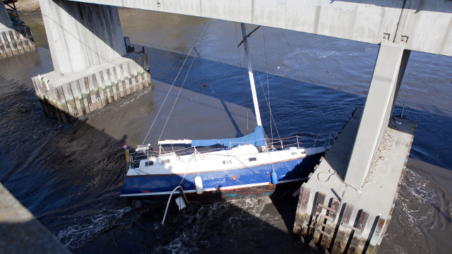
Just after a devastating tsunami struck the coast of Japan in March 2011, the tsunami waves struck the coast of California, where they damaged harbors, including the Santa Cruz harbor. Image courtesy Matt Corley

The two tragedies ratcheted up the pressure to shore up California’s tsunami preparedness and response efforts.  The California Geological Survey and the California Office of Emergency Services, along with federal assistance from FEMA and NOAA, began creating “playbooks” for California coastal communities, such as Alameda, that are vulnerable to tsunamis. The playbooks model the strength of the currents and the amount of flooding possible from mild, moderate and severe tsunamis, which would help coastal communities update evacuation plans and minimize the damage to harbors and boats.

In addition, there are now more than 6,000 tsunami hazard signs posted along the California coast help direct residents to higher ground in the event of this potentially deadly natural disaster.

Sponsored

Although it’s not possible to predict when the next big earthquake will erupt on the ocean floor and generate another massive tsunami, monitoring signs of tsunami activity in the ocean can yield precious minutes to alert residents to move to higher ground, scientists say.

“A tsunami will actually travel at hundreds of miles per hour,” said Tom Evans, a meteorologist and the Director of Operations at the National Weather Service in Honolulu.  “So a warning system in place is very necessary,” he added.

In fact, a real-time tsunami monitoring system already exists through the Deep-ocean Assessment and Reporting of Tsunamis (DART) program which is operated by NOAA. In all, 39 buoys that ring the Atlantic and Pacific Ocean measure signs of early tsunami waves and relay the measurements to warning centers in Hawaii and Alaska.

Although rare, massive tsunamis such as the ones that have struck  the coasts of Banda Aceh, Japan and Chile, could also strike the California coast.
Although rare, massive tsunamis such as the ones that have struck the coasts of Banda Aceh, Japan and Chile, could also strike the California coast.

But the system has been hampered by malfunctions and legislative inaction on bills that  would fund tsunami preparedness and outreach to vulnerable coastal communities. At the end of July 2014, 10 of the 39 DART buoy stations were “non-operational due to some sort of failure,” according to Michael Angove, the NOAA / National Weather Service Tsunami Program Manager. Maintenance work to fix the malfunctioning buoys would not begin until spring 2015, he said.

“Tsunamis do occur along the (California) coast here, in San Francisco, we’ve had them in the bay. So yes, they are a real threat,” said Evans. “Nature is very powerful. And we have to respect it,” he added.

This video story was originally produced by Christopher Bauer and updated by Sheraz Sadiq.

lower waypoint
next waypoint