upper waypoint

Side Trips from Interstate 5: Great Valley Rivers and Grasslands

Save ArticleSave Article
Failed to save article

Please try again

Springtime is my favorite time to see the floor of the Great Valley. If the weather is fine, the temperatures are moderate and the mountains on both sides of the valley—the Coast Range and the Sierra Nevada—are visible wherever you can get a clear view of the horizon. Such were conditions when I took this side trip from I-5, which leaves the freeway at the Patterson exit, in Stanislaus County, and returns to it at the Mercey Springs Road exit, in Merced County. Along the way it crosses two of the Valley's major rivers and the heart of its wetlands. Both ends are at the dramatic uplifted front of the Coast Range, exposing the thick section of sedimentary rocks that lie beneath that flat valley floor and record its history.

Here's the route along with the geology (made, as usual, with the help of the interactive state geologic map).

Route map and geologic map.
Great Valley Sequence rocks are upturned along the east edge of the Coast Range, increasing in age to the west: QPc, Quaternary-Pliocene continental sediment; E, Eocene marine rocks; Ep, Paleocene marine rocks; Ku, Cretaceous marine rocks. Qoa, aprons of old alluvium. The main valley floor is young alluvial sediment. The area east of Irwin is Ice Age sand from the Merced River. All photos by Andrew Alden

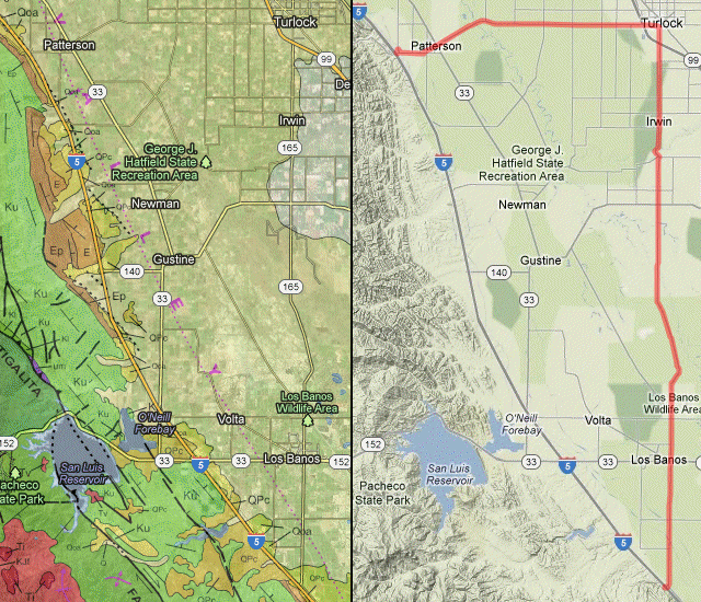
Drive through Patterson and get on Las Palmas Avenue. This may be the Valley's grandest allee of palm trees, although there's another one near Chowchilla you could see in another I-5 side trip. (Note to geologists: Turlock has an excellent brewpub if your trip calls for one.) Once out of town, you enter some of California's hardest-working farmland, based on excellent soils and abundant water.

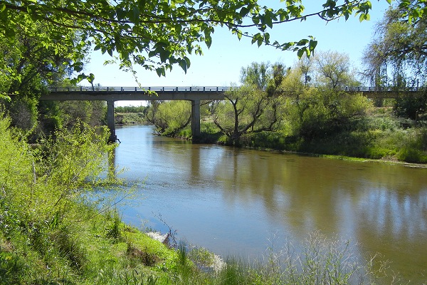
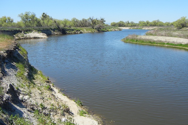
South of Turlock, keep an eye on the roadside and notice as the soil turns sandy. Just below the "165" mark, you cross the Merced River, which is responsible for all that sand, marked on the geologic map by the lighter patch. Here Hagaman County Park offers a good view of the river, which still flows at a good clip all this way from Yosemite Valley. Notice, too, the levee north of the river, which keeps the annual floods from spilling wide over the countryside.

mercedriver

Sponsored

South of State Route 140 at the edge of the sand unit, the road crosses the San Joaquin River and enters the moist bottomland of the San Joaquin Valley. From here almost all the way to Los Banos is widespread tule marsh. Water is harvested from here and pumped to the San Luis Reservoir to regulate flow in the canals that serve the farms. That little squiggle of roadway west of 165 is actually the levee paths in Great Valley Grasslands State Park, a six-mile walk through a patch of the habitat that once covered vast stretches of the Valley. The path takes you along the San Joaquin River itself, much quieter than the Merced.

SJriver

The grasslands include some vernal pools: shallow basins that fill with water in the winter and dry out slowly over the course of the spring, offering habitat for a great variety of plants and animals.

vernalpool

This winter was very dry, so the pools were not spectacular. As I walked I was reminded of William Brewer's description of this country exactly 150 years earlier: "We rode upward of thirty miles without any tree or bush—except once a single small willow was visible for two hours, but we passed nearly two miles from it; it was a mere speck. Hour after hour we plodded on. The road was good but a dead level—no hill or ridge ten feet high relieved the even surface—no house, no tree—one hour was but like the next—it was like the ocean, but it depressed the spirits more." But then I spotted a nice patch of goldfields and gave my camera a treat.

goldfields

In Los Banos, the Los Banos County Park just a few blocks west on route 152 has a museum, as well as bathrooms and shade.

hornito

"Los Baños" means "the baths," and it got its name from the clear pools in Los Banos Creek where it leaves the Coast Range, so refreshing to Father Arroyo in the Mission days that he made a point of returning regularly. Today everyone has bathtubs and it's hard to imagine being excited by such a thing. Father Arroyo's baths were soon erased as the creek was dammed, an early step in the immense and still incomplete project of harnessing and managing California's water. Los Banos Creek Reservoir is just west of the lowest I-5 symbol on the map.

The steep face of the Laguna Seca Hills, eastern rampart of the Coast Range, looms as route 165 approaches the freeway again. Along the road you may notice long piles of white rock.

diatomitepile

Pull over and take a look at some. It's diatomite, a styrofoam-light rock made exclusively of microscopic diatom shells.

diatomite

This material testifies to a long-lived, quiet brackish or alkaline lake that existed here millions of years ago. Different accidents of tectonics have turned the Valley, at various times in the geologic past, into a freshwater lake, an inland sea or a dry desert.

The quarry that yields this material is up in the Laguna Seca Hills just behind this view; you can see it in Google Earth.

lagunasecahills

The state geologic map shows that the Laguna Seca Hills expose an unusually complete and compact cross section of the Great Valley Sequence. If only we could access the rocks! But it's private land, and anyway here's the freeway again.

lower waypoint
next waypoint