upper waypoint

Side Trips from Interstate 5: Panoche and Tumey Hills

Save ArticleSave Article
Failed to save article

Please try again

The Panoche Hills provide a splendid overlook to the Great Valley on good days. Photos by Andrew Alden

The Panoche Hills provide a splendid overlook to the Great Valley on good days. Photos by Andrew Alden

Most people, it's probably fair to say, loathe Interstate 5 between Redding and Bakersfield. If all you want to do is get from point A to point B, I-5 enables that, but the road is so smooth and the route so straight that the typical driver resents the time spent on it, even at 80 mph and faster. Traffic can reach dangerous speeds, eyes get glazed, attention wavers, and tempers grow short.

As for me, I love the chance to enjoy I-5. I make it a full day's trip to get from the Bay Area to Southern California or the Shasta region, and that gives me a long enough leash to get off the freeway at least once during the day. So I'd like to share with you some of my favorite side trips, and they don't include Santa Nella.

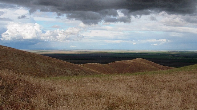
One that I've enjoyed several times goes past the Panoche and Tumey Hills, a big patch of wild land along the east side of the Coast Range managed by the Bureau of Land Management. It's a loop of backroad about halfway to Bakersfield, due west of Fresno. Its north end is Little Panoche Road and its south end is Panoche Road. It includes some dirt road and takes a good hour if you don't stop much. Its two notable landmarks are Mercey Hot Springs and the village of Panoche, in well-hidden Panoche Valley. I've never stopped at either place because it's the countryside that attracts me.

Let's have a look at the geologic map of the area, derived from the nice interactive state geologic map:

Significant map units: Ku, upper Cretaceous marine rocks; Ep, Paleocene marine rocks; E, Eocene marine rocks; QP, Pliocene-Pleistocene nonmarine rocks; Q, modern and recent sediment; Qoa, Quaternary river terraces; KJf, Franciscan complex; um, ultramafic rocks

The bulk of the hills consists of late Cretaceous mudstones, laid down in a shallow sea some 80 million years ago when the Sierra Nevada was a great chain of volcanoes like today's Cascade Range. This sea persisted past Cretaceous time into the succeeding Paleocene and Eocene epochs, perhaps 50 or 40 million years ago. There are rare plesiosaur and mosasaur fossils in the older section and lots of fossil wood throughout. But we don't have time to hunt fossils, although collecting for personal purposes is allowed.

Sponsored

Little Panoche Road runs up the valley of Little Panoche Creek, where at least two levels of stream terraces are visible that testify to different episodes of erosion. They in turn are undoubtedly related to the uplift history of these hills.

Looking across Little Panoche Creek to the north flank of the Panoche Hills.

The road turns south and runs through Little Panoche Valley, passing the low-key Mercey Hot Springs resort. The entrance to the BLM's Panoche Hills Recreation Area is here, too. At the head of the valley the road cuts through Glaucophane Ridge, an unexpected exposure of old Franciscan rocks, then goes straight south across the wide and gentle Panoche Valley and ends at Panoche Road. This pocket of farmland is one of Central California's hidden gems. The south side of the valley presents a striking set of terraces. These are mapped as river terraces but might be lake beds; I haven't looked into the literature. In either case they, too, attest to ancient episodes of accelerated erosion.

Buck Peak, in the Griswold Hills, and river terraces of the Panoche Valley.

Panoche Road west eventually gets you to Paicines, south of Hollister. The road east gets you back to I-5, but all of the crooked part is decent dirt. In wet weather, turn back here, or maybe go a little ways on the paved part and daydream about taking New Idria Road south to the remote ghost town of Idria. The eastern end of the valley has good views of the Panoche Hills from the south, but eventually the road crosses the creek without benefit of a bridge and then turns to dirt.

In fine weather, ford the stream and proceed across some splendid and scenic country.

At this point, you are in the Tumey Hills Recreation Area. These hills are lower and drier than the Panoches, and the rocks along the road are quite different. They are young sandstones and conglomerates formed as the Coast Range began to rise, just a few million years ago.

Watch the road as well as the rocks, but don't miss the landscape. All photos in this post were taken in late March.

When you reach I-5, you'll have a choice of eating places to get you ready to roll again. Maybe, like me, you prefer to think of it as the place where the iron dinosaur used to be. It was the creation of the late Carmon Neff of Chowchilla, and I don't know where it went.

lower waypoint
next waypoint