upper waypoint

Geological Outings Around the Bay: Natural Bridges

Save ArticleSave Article
Failed to save article

Please try again

The single remaining natural bridge at Natural Bridges State Beach is better described as a sea arch. Photos by Andrew Alden.

Natural Bridges State Beach is in Santa Cruz, just west of downtown. It's an easy outing and a nice spot, popular for its sheltered beach and butterfly trees. But the official park site says nothing about the rocks, so I must remedy that.

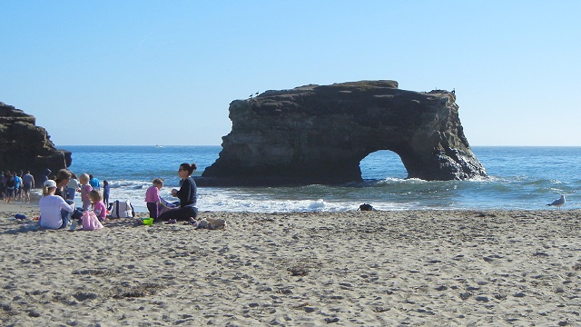
First of all, there's only one natural bridge at Natural Bridges, a sea arch next to a bedrock promontory.

The gap between these two landforms used to be a second arch, and beyond them was a third. People used to drive out on the arches and have picnics. This was around the same time that Yosemite conducted public bear feedings and dumped bonfires over the cliffs every summer evening. Now park systems take preservation more seriously, and the remaining arch is off limits. Even so, the sea will take it down some day, as it did the other two, but without human help this time.

Notice the flat surface of the surrounding land. All of this is the lowest of Santa Cruz's famous marine terraces, carved by the ocean waves some 80,000 years ago when the land lay lower and the sea level was steady. Since that time the sea has fluctuated and the land has risen. Several older terraces lie higher along the coast. The terraces are topped with a thin layer of beach sand and gravel. Today's seacliffs expose the older rock beneath. And with that, let's look at the geologic map of the area (from U.S. Geological Survey Open-File Report 97-489).

Sponsored

Unit Qcl is the lower terrace and Qcu is the higher terraces. Around Soquel Creek are wetland deposits (Qb) and river sediment or alluvium, shown by the lightest color. There are three units of proper rock; from left to right (and oldest to youngest) they're the Santa Margarita Sandstone (Tsm), the Santa Cruz Mudstone (Tsc) and the Purisima Formation (Tp). (We met the Purisima before at Fitzgerald Preserve, San Gregorio Beach and Point Año Nuevo.) Together they date from late Miocene to Pliocene time, about 10 million to 4 million years ago. The reason they crop out in this pattern is apparent in the photo above the map: the rock beds are tilted down to the east, which allowed erosion to expose the older rocks in the west. They got their tilt as this part of California was carried north along the San Andreas fault system.

These facts matter in understanding what you'll see as you approach the bluffs west of the arch and observe the remarkable speckled rock of the Santa Cruz Mudstone.

The underlying Santa Margarita Sandstone is full of organic matter. Beneath it, the Monterey Formation is even more so (it's the foremost of the Bay Area's petroleum source rocks). So for many thousands of years, natural gas and hydrocarbons have been rising through the Santa Cruz Mudstone, both before and after it turned from sediment to stone. They followed a set of millions of parallel cracks, or joints, made by the stresses of moving along the San Andreas fault. After that, chemically active water did the same, depositing iron minerals in the stone. You'll see that the iron mineralization is closely related to the jointing.

In at least two places, you'll find small faults displacing the Santa Cruz Mudstone. These are classified as normal faults, steep faults that drop one side relative to the other. They show nice examples of the upward-splaying pattern called flower structure, a sign that the faulting occurred near the ground surface.

These faults dropped the rocks down on the east side, reinforcing the eastward tilt of the bedding. About a half-mile east of the park, in the bluffs along West Cliff Drive, the top of the Santa Cruz Mudstone comes into view and we can see what all those rising hydrocarbons were doing: feeding a large seafloor ecosystem based on cold seeps. The UC Santa Cruz geology club visited the "toilet bowls" in 2003 and put up pictures, and a UCSC research team described them in detail in the journal Geology in 2001. Such things must exist today in similar places, like the seafloor off Santa Barbara and beneath the Gulf of Mexico.

lower waypoint
next waypoint