upper waypoint

Making Better Land

Save ArticleSave Article
Failed to save article

Please try again

A Gold Rush-era ship is excavated from a San Francisco construction site in 2005. Photo by Andrew Alden.

A Gold Rush-era ship is excavated from historical fill at a San Francisco construction site in 2005. Photo by Andrew Alden.

Humans have been making land for thousands of years. Lately we have gotten better at it, but nature has a head start of a few billion years, and we don't work with nature's infinite care.

On the largest scale, land grows because volcanoes and tectonic movements elevate rocks above sea level. The Bay Area has no volcanoes at present, and the basic framework of our terrain is tectonism organized around the San Andreas fault system. On the scale of human history, that's too slow to be relevant. For growing new land, erosion and deposition matter more to us.

New land grows naturally around the Bay as wetlands capture sediment washed in with the seawater. Unfortunately for builders, it's soft black mud and it's barely at sea level. And unfortunately for shippers, "bay mud" bars vessels from approaching the shore almost everywhere except around steep bodies of bedrock, like Yerba Buena and Alcatraz Islands. When Gold Rush settlers came here to stay, making bay mud into useful land—reclamation—was one of their chief concerns.

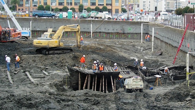
In San Francisco there were so many abandoned ships in the harbor that many were simply scuttled and buried in fill—dredged sand and mud from the Bay, mostly, along with waste rock and debris. We dig up the old ships occasionally while building around the Financial District.

More land was made elsewhere simply by diking off sections of the Bay, letting it dry out, and putting it to use growing crops or harvesting sea salt. (Today the salt ponds of the South Bay are carefully being restored to working wetland.) In San Mateo County, levees were built to create Brewer's Island around the turn of the last century. The dry bay mud served as hayfields and salt ponds until T. Jack Foster set out to turn Brewer's Island into a complete planned city. The creation of Foster City in the 1960s was overseen by geotechnical engineers, but the basic method was age-old: dredge, dump, drain.

Sponsored

The U.S. Geological Survey has mapped artificial land along with all the other geologic units around the Bay. The majority of this reclaimed land is in the central Bay, in San Francisco and Oakland.

Reclaimed land shows its weakness in earthquakes. In the 1906 quake it was widely noted that buildings placed on "made land" were prone to failure. Nonetheless the city's rubble was used for fill at the site of the 1915 Pan Pacific Exposition, which later became developed as the Marina district. In the 1989 Loma Prieta quake the Marina had the deadliest damage in the city. Likewise, the Cypress section of Interstate 880, in west Oakland, failed where it crossed old fill. In San Francisco the notorious Embarcadero Freeway, also built upon old fill, was torn down shortly after Loma Prieta, before it could fail. Our areas of fill, old and new, will continue to be tested by earthquakes while our reclamation practices continue to improve.

For geology enthusiasts, Oakland's reclaimed land has given us an unexpected treat, seen in the new Middle Harbor Park.

A replica seawall recycles rock from an early land reclamation project: the port of Oakland. Photo by Andrew Alden.

In the 1880s, early in the creation of Oakland's harbor, a pair of "training walls" was built to guide the tides into scouring the ship channel clean. The project required lots of large boulders, and every quarry along the Bay Area shoreline was recruited to supply the stones. When the old north training wall was demolished in 2001, some of the best rocks were set aside. These were made into a replica pier, nicely laid down in drystone masonry, that displays excellent specimens of Bay Area rock types.

lower waypoint
next waypoint