The Moraga Formation consists of lava flows, sedimentary rocks that were laid down between eruptions, and occasional beds of tuff—rock composed of volcanic ash. Rocks like this hand specimen show former gas bubbles, or vesicles. These are a sign that the lava was near the ground surface, allowing water vapor and carbon dioxide to come out of solution and propel eruptions. The Moraga formation is noteworthy for the amount of vesiculated lava it has.
Just south of the trailhead to Grizzly Peak, a rampart of lava stands up on the west side of the road. Enjoy the view.

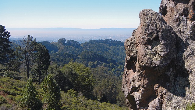
To the north, the Moraga Formation underlies most of Tilden Park all the way up to Inspiration Point. But let's turn around and really see it. This photo is a view south showing the next two localities, the Route 24 cut and behind it Sibley Volcanic Preserve.

Take Fish Ranch Road down to Route 24 and head east; make a u-turn at the Wilder Road exit and pull off on the Fish Ranch Road exit heading west. You may observe signs forbidding pedestrians. This is what you'll see across the highway. (Of course, when traffic is backed up from the Caldecott Tunnel you can admire these at leisure from your car.) The Moraga Formation consists of two packages, each consisting of five large lava flows, with a section of mostly sedimentary rocks between them. This is the lower set of flows; up is to the left.

If you turn your attention northward, you may see the basal contact of the Moraga Formation, where the first lava flows came down upon the coarse conglomerate beds of the Orinda Formation. The lavas are of basalt and andesite composition and are quite dark, but they may also be red where they flowed into water or over wet ground.


Locality 3 is Sibley Volcanic Regional Preserve, which you reach by going back up Fish Ranch Road and taking Grizzly Peak Boulevard the other direction. Sibley deserves its own separate article, so I will be brief today.
Besides rocks, Sibley has a lot of wonderful habitat and is interesting at all times of year for its plant and animal life. There are also several labyrinths to discover. And the views are fine in all directions. The only disadvantage is that the parking lot fills up on nice weekends.
But Sibley's great value to geologists is that it exposes a cross section of a volcano's guts, from its feeder dikes coming up through the underlying Orinda and Claremont formations to the remains of the central vent and a short-lived crater lake. These are things you won't see without a lot of legwork and educated eyes, but a history of quarry operations here has unveiled excellent exposures of features that even duffers can spot. One is the presence of amygdules, or mineral-filled vesicles. You'll find these throughout the Moraga, but they are most visible at Sibley. Collect them only with your camera, please.
The southern exposures of the Moraga are smaller and less well known, but you will surely have them to yourself. At locality 4, the dark lava crops out in a deep cleft along Valley View Drive.

Geologists have mapped the structure at this location as an anticline or arch, meaning that the whole volcanic section has been folded like a bedsheet being pushed up. The northern part of the Moraga, in contrast, is a syncline or downfold. All three previous localities are on the west side of that syncline, and its axis or center is at the Wilder Road exit on Route 24.
Locality 5 is where Canyon Road cuts across a narrow ridge of Moraga lava. The roadway itself is very narrow, and I can't recommend it. Nor are the rocks exposed there especially revealing.
But if you drive a little farther and park at the Valle Vista Staging Area, it's easy to walk back along the old railroad bed, which has been turned into the Lafayette/Moraga Regional Trail. This is a much more peaceful way to see the rocks, which also include conglomerate of the Orinda Formation.