The Salton Sea covers up the southern end of the San Andreas fault, and that's where our science story begins. A research team from Scripps Institution of Oceanography crisscrossed the drowned land in a small boat with a state-of-the-art CHIRP sonar system. They mapped a swarm of short faults running from the end of the San Andreas toward the end of the Imperial fault lying to the south—a tectonic configuration called a stepover. Here's the figure showing how it all fits together.
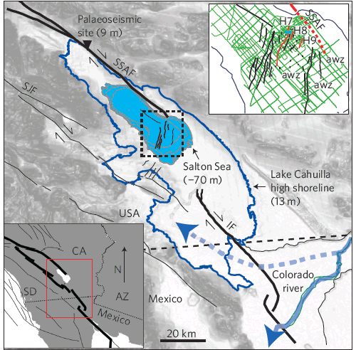
Tectonic setting of the Salton Trough and Salton Sea. SJF is San Jacinto fault, SSAF is southern San Andreas fault and IF is Imperial fault. Green grid is ship tracks in the dashed box; awz (acoustic wipeout zone) marks disturbed sediments. (Scripps)
From their sonar database the researchers extracted a decent record of recent ruptures on some of these stepover faults. My figure below shows, schematically, how the sediment record is built as downdrops on the fault combine with sediment being deposited on top.
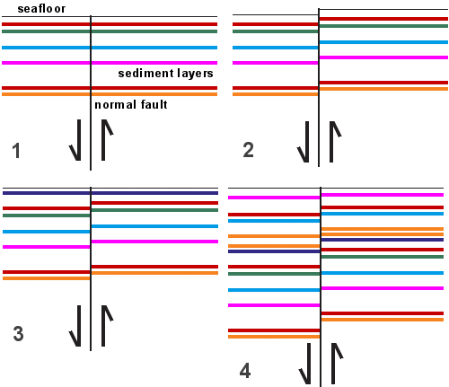
The researchers ran this process backward to reconstruct the history of faulting for a few thousand years into the past.
What made things interesting was how this record of stepover quakes meshed with records of lake floods and San Andreas mega-quakes. The correlation is imperfect, but intriguing: every time the lake was reborn in a flood, the stepover faults gave way, and half of the recent mega-quakes coincided with stepover quakes. To connect the dots further, the researchers said that "at least one of the last three dry-basin floods coincides with an earthquake on the SSAF (southern San Andreas fault)." In their cautious words, "We propose that loading by (Lake Cahuilla) may have induced failure on faults beneath the Salton Sea that, in turn, has the potential to trigger an earthquake rupture on the SSAF."
That's all ingenious science (seismic oceanography, in the desert!), but not news. To get news takes a press officer with a nose for a hook, and the hook is that the SSAF hasn't broken in some 300 years when we might (given the recent record) expect it to happen more often. Has our failure to let Lake Cahuilla be reborn held off triggering the next Big One? Well, has it??
That question is something for geologists to wave their arms about at meetings and parties, not hold out to the world as a sure thing. But between the paper, whose abstract is world-readable, and the press release from Scripps we can see the story begin to morph. It's a scattershot press release, meant to serve any news angle, that immediately confuses today's managed Salton Sea with wild prehistoric Lake Cahuilla. It includes a great hook, a quote about the "overdue" SSAF likening it to "a woman who is 15 months pregnant." The quote is only part of the background to the science, just a tangential part of the paper itself, but irresistible to the troutlike mind of the news reporter.
First out the chute on June 26 was the San Diego Union-Tribune's website, where Gary Robbins immediately removed all scientific uncertainty in his first sentence: "The Salton Sea east of San Diego is a deceptively dangerous backwater, hiding faults that repeatedly produce powerful earthquakes that jolt all of Southern California, says a new study by the Scripps Institution of Oceanography."
Later that day a Los Angeles TV station rewrote Robbins's story under the headline "Mega Quake Around the Corner?" with the lead sentence, "Man's interference with Colorado River floods that used to regularly flow to the Salton Sea may have 'stopped the clock' on a regular series of big earthquakes, setting the stage for a mega quake that could wreck Southern California, scientists said Sunday." The accidental flood of 1905 has become "interference" with regular flows to the Salton Sea, and the reasoning has turned upside-down: If we had let the Imperial Valley drown, Southern California's "Big One" might already have happened and been a few tenths of a magnitude unit smaller. How anyone wins under that scenario is not explained.
After a few days, more and better journalists weighed in. Some of them had actually studied the Nature paper (as I have). Many, including Discovery News's Tim Wall, apparently did not. USA Today's Dan Vergano did well. So did Chris Clarke on KCET's website. Charles Q. Choi did fresh reporting, as usual, for OurAmazingPlanet.com. Science News's Devin Powell wins my prize for his succinct, factual and well-written account. As you peruse the items collected by Google News under a search on "salton earthquake," look for those items that get the details right—specifically the fact that the Salton Sea arose by mismanagement, not on purpose.
The Bay Area has excellent media when it comes to our own earthquakes, with seasoned staff and good support from academic and government experts. But still—if scary news comes up, look around the science mediasphere and wait a few days before deciding what you think. Even better, track down the news at its source whenever you can. Learn who to trust.

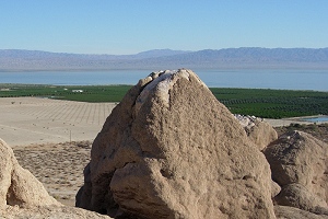 The carbonate crust called tufa coats a high boulder over the Salton Sea, testifying that the Colorado River fed mighty Lake Cahuilla there in the geologically recent past. Photo by Andrew Alden.