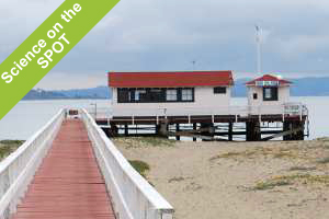
 Sittin' on the dock of the bay, watchin' the tides roll away. Walking along the shore of San Francisco Bay at Crissy Field in San Francisco, you might not take notice of the small building at the end of a short pier. But this little white shack with the red roof holds a lot of history and houses vitally important scientific instruments. “This is the front line of our data,” says Mary Jane Schramm of the National Oceanic and Atmospheric Administration. “This is the oldest continually operating tidal gauge in the Western Hemisphere. It’s been in continuous operation since 1854, so it’s weathered the great San Francisco earthquake and many other natural disasters that have put other tidal gauges out of commission.”
This is important because the bay and ocean currents flooding in and out of the Golden Gate are notoriously treacherous. The US Government realized early on the importance of San Francisco Bay and the need to better understand the movements of the water for navigation. Soon after California became a State, American surveyors were sent to San Francisco to study the water conditions of the great port. And the work has continued non-stop ever since. For over 150 years the San Francisco Tide Station, now operated by NOAA, has produced a continuous recording of water levels and other vital maritime information.
Today the tide station uses state of the art equipment to measure the water movement of San Francisco Bay. The water gauges are connected to the NOAA Physical Oceanographic Real-Time System (PORTS), and measure nearly real-time water levels, surface and sub-surface currents and other information such as winds, weather and climate data. This information is available to the public so sailors know the best times to cast off, make transits, load or unload cargo, or when to ride the tides in or out of the bay. According to a report written by Captain Albert E. Theberge, NOAA (Ret.), “This information is critically important considering that there is an average of 261 deep-draft vessels entering San Francisco Bay each month and there are approximately 85,000 registered pleasure boats using approximately 100 yacht clubs in the Bay system.”
“The historical record from the tide station at San Francisco transcends the maritime history of the San Francisco Bay,” according to Captain Theberge. “From the days when clipper ships relied upon tide predictions provided by the station to navigate the dynamic waters of the Golden Gate, to the modern day mariner that obtains real-time water levels so that the huge ship and crane barge operators can tell if they have enough depth in the channels and enough clearance under the bridges.”