
 Geologic map of Caldecott Tunnel area (credit: USGS ) Click here for a larger version.
If you use Highway 24 as part of your daily commute you are already familiar with the Caldecott Tunnel, which connects Orinda and Oakland — perhaps you are too familiar with the tunnel as you sit in the bottleneck traffic waiting to enter it. What you may not be familiar with, however, is the geology of the hills through which the tunnel was constructed. There are currently three separate tunnels, or bores, that make up Caldecott Tunnel. Construction for a fourth bore is now underway an is already yielding interesting geologic results. The Caldecott Fourth Bore Project website contains a wealth of information about the entire project — from funding to logistics to tunneling methods and more.
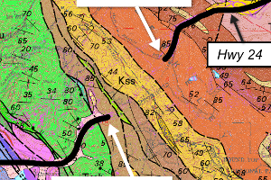
The process of excavating a tunnel produces a lot of rock and, in this case, it is sedimentary rock that is known to contain abundant fossils. The geologic map shown above depicts the distribution of distinct rock types and ages in this area. The part of the ridge that Caldecott Tunnel cuts through is made up three formations — each of which has their own color: The Orinda Formation is the orange unit at the east portal, the Claremont Chert in yellow, and an unnamed mudstone in brown at the west portal. The tectonic forces that created these hills also caused the layered sedimentary rocks to be tilted at high angles and, in many areas, the layers are standing up vertical. The rocks are older from east to west so, in this case, excavation of the tunnel from east to west is similar to drilling down into older layers.

Orinda Formation along Hwy 24 near east portal of Caldecott Tunnel (credit: Jeff Weiss, public information officer for Fourth Bore Project)
The rocks are lithified sediments that were deposited in the Miocene period, which ranged from 23 to 5 million years ago. The Orinda Formation (the orange unit by east portal in map above) is approximately 10 million years old and is known to contain abundant mammal and plant fossils in nearby areas. The Orinda Formation is characterized by a wide variety of sedimentary rocks including mudstone, sandstone, and conglomerate that were deposited in streams in creeks (see some photos of the rocks near the tunnel here.