upper waypoint

Google Mars

Save ArticleSave Article
Failed to save article

Please try again

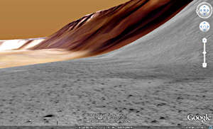
Google Mars view from the slopes of the Olympus Mons caldera. Credit: Google Earth

I was sitting at my computer the other day, quietly exploring minute details of the surface of planet Mars, when I realized once again that in my lifetime planetary exploration has gone from telescopic-view-only to robotic rovers poking microscopes close up at Martian geology!

Did I say quietly exploring the surface of Mars? Yes I did—and you can, too. First of all, if you're not familiar with Google Earth, please go and google Google Earth and get your free download today (this is NOT a sales pitch!). A modestly powered computer with a decent graphics card is all you need to probe every nook and cranny of planet Earth, sometimes to the detail of spotting people walking in the streets….

But there's a magic button on Google Earth (it looks like planet Saturn, for some reason) that instantly transports you to planet Mars—Google Mars, that is. It's a simple button click to explore Mars, Google Earth style.

This detailed digital Mars has been created with all of the data collected by the fleet of robots we've sent—from Viking to Mars Global Surveyor to Mars Odyssey to Mars Express to Mars Reconnaissance Orbiter (MRO), and of course Pathfinder, Phoenix, and the Mars Exploration Rovers, Spirit and Opportunity.

Sponsored

First on my itinerary was Olympus Mons, that extinct, Arizona-sized shield volcano that rises 15 miles above the average global terrain. Swooping into the San Francisco Bay-sized caldera, I got a sense of what it would be like to be there, standing on the caldera rim. There were even strips of super-high resolution imagery provided by MRO's HIRISE camera, allowing me to hover maybe a hundred feet above the ground and see rocks and piles of sand!

Next on the list had to be that other famous gargantuan feature, Valles Marineris, the "Grand Canyon of Mars" which, if it were moved to Earth, could stretch from Oakland, California to New York City—putting Grand Canyon National Park within a day's drive of anyone in the US…. Google Earth/Mars has a flight simulation mode that allows you to pilot an aircraft over and through (and into) the terrain.

Like a kid in a science supply shop (okay, that's the kind of kid I was), next I hopped on up to the landing site of NASA's Phoenix lander, on the wide flat plains near the Northern Polar Ice Cap. Yup, those plains are really flat. To my delight, I found that someone had inserted a panoramic picture taken by the orbiting MRO spacecraft when it captured Phoenix descending through the atmosphere.

Onward, planetary explorer…. I had to feel—not just see, but feel—what the landscapes that Spirit and Opportunity have been exploring for 5 years are like. On Spirit's side of the globe, Gusev Crater, I poked about the Columbia Hills, following in the tracks of the robot. Over at Opportunity's digs, I dropped into Victoria Crater, enveloping myself in "Street View"-style panoramas that almost set my feet down on Martian soil.

Okay, I could go on telling you about my adventures on Mars for days—but since you can do it yourself now, I'll let you go to it. Have fun, and send back a postcard! (Which, by the way, you can do from Google Mars….)

37.7631 -122.409

lower waypoint
next waypoint