 This past week I stopped into one of my favorite (indoor) places on the Estuary: the San Francisco Bay Model in Sausalito. Built by the Army Corps of Engineers in the 1950s, the model was used up until 2000 to simulate the effects of changes to the Estuary. It let engineers study the impacts of dredging, filling, and water diversions before projects were implemented in the real world. (Nowadays, high speed computers do the job.)
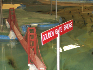
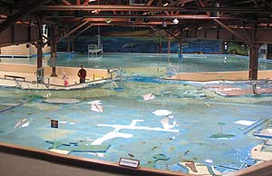
About the size of two football fields, it is one of the largest tidal hydraulic models in the world and a great place to get a giants' eye view of the Bay-Delta's workings. Each time I visit, as I stand on the Alameda shoreline and look out across that watery expanse to a tiny Golden Gate Bridge, I suppress a secret, fleeting urge to climb onto the model and go wading around this miniature landscape as if I were Godzilla.
I start my tour by turning left past the Oakland Airport, skirting around the South Bay, and walking up the Peninsula to the Golden Gate Bridge. As I stand in what would be San Francisco, the Central Bay is to my right. To my left, a large pool of water, a "Tide Hut," and a set of loud pumps (admittedly not quite as melodic as crashing waves), stand in for the ocean.
I circumnavigate the Pacific.
 Strolling north along the Marin shoreline, I find myself in my own neck of the woods and pass tributary creeks whose names I know: Corte Madera Creek, San Rafael Creek (my home watershed), Galinas Greek, Novato Creek. That is one of the coolest things about the model: In our daily lives we get to know the bits of the Bay we glimpse out our windows or pass on our commutes, but it is easy to forget that what we see is part of a vast estuary—the largest on the west coast of the Americas. The model lets us see how our "Bay bits" fit into the much larger whole.