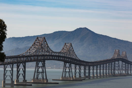
The first phase of the project involves the reopening of the "lost" lower-deck lane. Sometime before the end of April, and perhaps sooner, drivers will have access to a third eastbound bridge lane weekday afternoons from 2 p.m. to 7 p.m.
The lane restoration project was approved in 2015 and started in January 2017. It has involved significant -- and costly -- road and lane realignments on both ends of the bridge. For instance, accommodating a third lane on the Richmond end of the bridge required demolishing a massive retaining wall, excavating the adjacent hillside and building a new wall. Part of that work was necessary to build a second exit lane to Richmond Parkway, a busy connector to Interstate 80. The project has also required installation of new electric signs on the lower deck to alert drivers when the new lane is available.
The total for this part of the project: about $37 million. The cash comes from toll revenue administered by the Bay Area Toll Authority, which operates the region's seven state-owned spans.
The project's second phase is to put a bike-pedestrian lane in the upper deck's right lane. One rationale for the facility, beyond it being a new venue for cyclists and walkers to take in a spectacular view, is that it would close a key link in the Bay Trail. The planned 500-mile cycling and walking route around the bay has been in development since 1989.
The bike-pedestrian path would feature a movable barrier similar to the one used on the Golden Gate Bridge. BATA approved construction funding last month, and the path is expected to open in early 2019. The cost for this part of the project: $25 million, also from bridge tolls.
Both the eastbound and westbound lane initiatives were approved as four-year pilot projects undertaken in conjunction with Caltrans, the Contra Costa Transit Authority and the Transportation Authority of Marin.
The eastbound commute lane will be assessed for its effectiveness in easing the rotten afternoon traffic from Marin to Contra Costa. The westbound bike-pedestrian path will be watched closely for the amount of usage it gets.
Recently, officials in both Marin and Contra Costa have argued that because the westbound morning commute across the bridge is snarled, they want the restored upper-deck lane to be used for cars part of the time -- during rush hours, perhaps, or throughout the week, with bikes getting access during off-hours and/or on weekends.
However, both transportation officials and bike advocates say that allowing cars to use the new lane would be complicated by several factors -- some regulatory, some practical.
The regulatory: The bridge projects required environmental studies and signoff from the Bay Conservation and Development Commission; making it likely that mixed use on the upper-deck lane would require a new study and new approvals. The practical: Opening a third lane to westbound traffic would likely move the existing congestion a little way down the road, into San Rafael, because of: a) I-580's two-lane configuration as it heads up to U.S. 101, and b) the need to re-engineer or improve existing ramps and surface capacity west of the bridge.
However, after formal requests from Marin and Contra Costa officials, the toll authority and Metropolitan Transportation Commission have agreed to conduct a study on restoring vehicular traffic to a third upper-deck lane.