Utilities will have six months to make changes in the highest-risk areas, once those areas are determined by new maps that the commission is expected to approve later this winter.
Original post, Nov. 3, 2017:
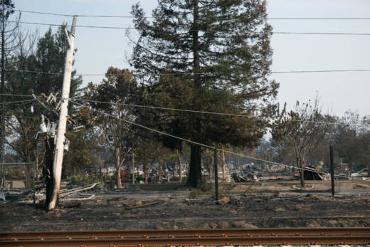
The risk from wildfires in California means everyone living here should be prepared for one. Some more than others.
That obviously depends on where you live. But who's in charge of telling us how risky any one place is?
Cal Fire and the California Public Utilities Commission have been working for years to make maps of the highest-risk areas in California. Those maps, once finished, could be used to hold utility companies such as Pacific Gas and Electric Co. to higher fire safety standards.
After last month's deadly Northern California wildfires, some state lawmakers are saying the process of making the maps is moving too slowly, putting people's lives at risk.
State Sen. John M. Moorlach, R-Costa Mesa, sent a letter to Gov. Jerry Brown this week asking him for details about what exactly the agencies have been doing.
“This mapping exercise has been going on for a decade, while over the last few years, dozens of lives and hundreds of thousands of acres have been lost in wildfires resulting from fires started by utility wires,” Moorlach wrote in the letter.
The effort to create this set of maps started about a decade ago after deadly wildfires burned through Southern California.
State investigators found some of those fires were ignited by overhead power lines and, to a lesser degree, by telecommunications equipment. After that, the CPUC adopted dozens of new regulations, some of which rely on maps to designate especially hazardous areas.
The CPUC decided in 2012 to create new maps specifically to highlight areas at higher risk from power lines and other utility equipment. A team of experts, including Cal Fire specialists, is working on the maps. One risk those maps aim to highlight is places with high wind speeds, which appear to be a factor in the rapid spread of the fires last month. Another is the types of vegetation in an area.
The CPUC published an early version of the maps last summer, and the commission expects that the final maps will be released this winter. If the final maps determine that power lines or other equipment are in hazardous areas, utilities could be held to higher safety standards.
Moorlach said the whole process is taking too long.
“We've got bureaucrats that are doing this and they're dragging their feet, and you've got utilities that know what the outcome is going to be and they're going to delay it as much as they can,” he told KQED.
Last year, the governor vetoed SB 1463, a bill Moorlach sponsored that would have required the CPUC and Cal Fire to prioritize the maps and to work more closely with local governments and fire departments to create the maps.
Brown wrote in his veto message that the agencies were already addressing Moorlach’s concerns, saying, “This deliberative process should continue and the issues this bill seeks to address should be raised in that forum.”
CPUC spokeswoman Terrie Prosper said Moorlach’s bill would have actually slowed down the work.
“SB 1463 would have prolonged the safety work already going on by requiring the participation of certain entities, which was unnecessary because Cal Fire was already a party to the proceeding, and local governments and fire departments could also participate,” she wrote in an email to KQED.
Cal Fire already has hazard maps and, based on those maps, people who live in high-risk zones face tougher construction standards. Those maps were spurred by previous legislation. Fire building codes apply only to “very high-hazard" areas within city boundaries. However, in areas where Cal Fire has jurisdiction, anything in “moderate-risk” and “high-risk" areas must meet its standards.
Danielle Venton contributed to this report.