The Thomas Fire raging in Ventura County grew to 143,000 acres Friday, even as authorities said they were finally getting a handle on the blaze. Evacuation orders were lifted for much of Ventura and Santa Paula on Friday afternoon.
The blaze prompted Gov. Jerry Brown to declare a state of emergency in Santa Barbara County. On Friday, the federal government approved the governor's request for direct assistance to support firefighting efforts as at least six major wildfires raked the Southern California region.
"California is grateful for the quick approval of our request and the ongoing efforts of local, state and federal emergency responders to protect communities across Southern California," Brown said in a written statement.
The Thomas Fire has spread to the county line, threatening homes and other structures as it burns along the 101 Freeway and into the back country west of Ojai. It has already over 400 structures, damaged 81 and threatens 15,000 more.
Officials said that 712,000 gallons of water have been dropped on the Thomas Fire, and 4,000 personnel will be battling the blaze by Saturday.
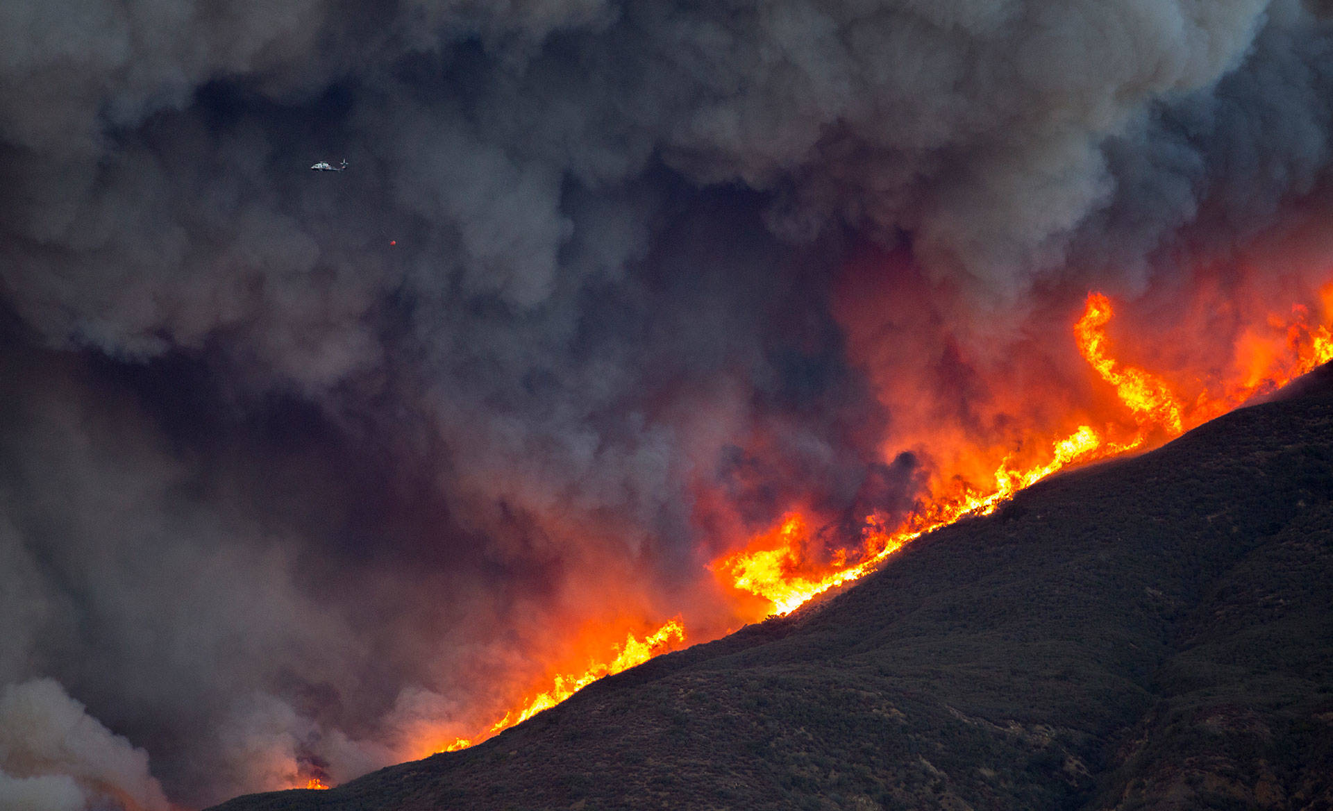
A 747 drops retardant over burning embers and small fires on a mountain near Fillmore on Dec. 8, 2017, on the eastern edge of the Thomas Fire. (FREDERIC J. BROWN/AFP/Getty Images)
The fire, which broke out Monday evening near Santa Paula and quickly spread all the way to the ocean, was only 10 percent contained on Friday. Expected containment remained unknown, and the cause was still under investigation, according to county officials.
Sponsored
On Friday afternoon, officials identified the only known victim of the Thomas Fire, 70 year-old Virginia Pesola. Her remains were found "at a vehicular crash site along the evacuation route," Ventura County Chief Medical Examiner Christopher Young said.
The cause of death was blunt force injuries, terminal smoke inhalation, and thermal injuries, Young said. Pesola's death is being investigated by the California Highway Patrol and Ventura County Sheriff's Department.
On Thursday, firefighters stopped the southern prong of the Thomas Fire from advancing along the coast, just east of the city of Carpinteria.
But later that evening officials placed the northeast part of Carpinteria under mandatory evacuations, even though the northern prong of the fire was still miles out of town.
That decision, said Santa Barbara County Fire Chief Eric Peterson, shows fire officials have learned lessons of a tough wildfire season.
"A lot of the tragic consequences of the Sonoma Fire were as a result of the time that it occurred — in the middle of the night — and the inability to get people out of those areas," Peterson said.
Peterson spoke at a jam-packed community meeting at Carpinteria High School. Some residents said they came because there was confusion about where exactly evacuations had been ordered — in part because of an erroneous emergency alert sent out and later corrected by fire officials.
It's not yet clear when residents of some Ventura neighborhoods hit hard by the Thomas Fire will be allowed to return to their homes.
But before the cleanup can begin, utility crews have a lot of work to do to repair the area’s infrastructure.
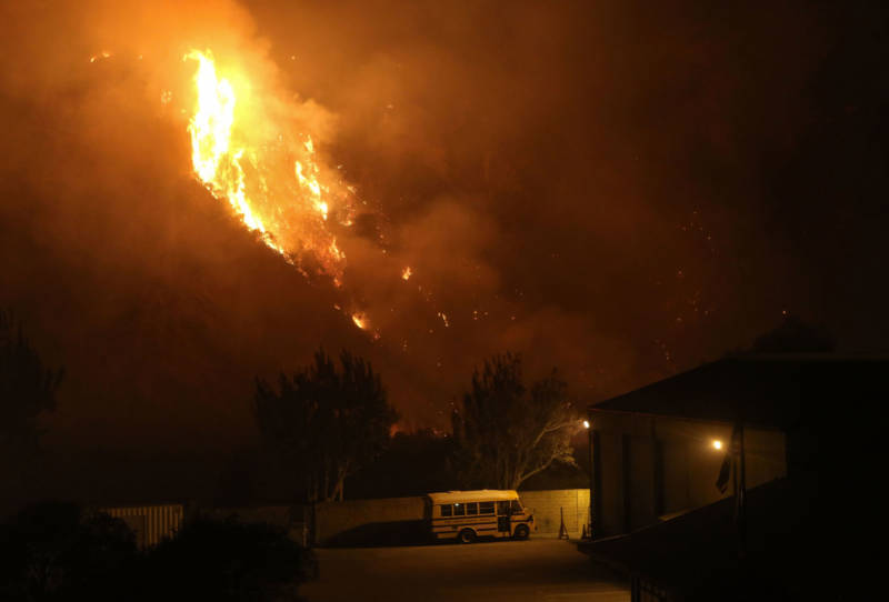
The Thomas Fire burns near a school bus on Dec. 7, 2017 in Ventura. (Mario Tama/Getty Images)
Ventura City Councilman Erik Nasarenko toured three charred, hillside neighborhoods on Tuesday: Ondulando, Skyline and Clear Point.
"This is one of the heaviest hit areas of Ventura," Nasarenko told KPCC on Thursday.
The fire has devastated homes in the neighborhood. It has also created a significant infrastructure challenge, Nasarenko said.
The extent of that challenge is part of the reason Nasarenko can't even estimate when the neighborhoods would re-open to residents.
On his tour, he saw crews from SoCal Edison repairing downed lines everywhere. Power in the neighborhoods was out, and that posed another problem: no power, no water.
"The water pumps that get the water back into the tanks require power," he said.
Many pumping stations are running on generators, Nasarenko said.
He also saw gas crews digging streets and trenches so they can cap gas lines as a precautionary measure.
A boil water advisory that was issued earlier in the week has been lifted for some areas, but not all. The areas that still need to boil tap water for drinking and cooking are bounded by the following streets:
North of Foothill Road
West of Ashwood Avenue
North of Telegraph Road
West of Mills Road
North of E. Main Street / Thompson Blvd
West of Sanjon Road
The city said it would send another update when tests confirmed water was safe to drink again.
In Santa Barbara County, evacuees were seeking refuge Friday morning at Jack's Bistro and Famous Bagels in downtown Carpinteria.
"We have not closed. We're staying open," manager Charla Marshall told KPCC's Take Two, adding that it has been a long week.
As a long-time resident of the area, Marshall was emotional as her team hustled to provide for all the locals.
"It was bittersweet. There were all these people that knew each other. They'd all had to be mandatory evacuated," Marshall said. "Some lost their homes. We had lots of dogs and cats and people hugging and crying. It was just an amazing day and we would never for a minute consider closing because we've been busy all week with these folks."
Marshall said for her it was nice to keep up with how everyone was doing, and it was important to offer something. She said they made a lot of coffee this week.
Still, she said, it's been hard.
"I have never seen anything like this in the 40 years I've been here. It's just really something else — throat's a little dry, eyes are a little sore. You know, it's been really heavy with the ash and the smoke, but we're fine. We're doing good."
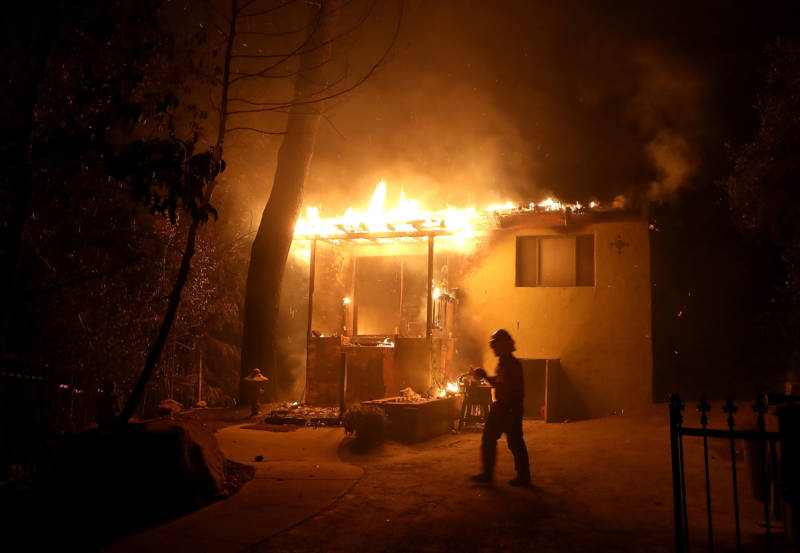
A home is consumed by the Thomas fire on Dec. 7, 2017 in Ojai. (Justin Sullivan/Getty Images)
Evacuations
87,043 people had been evacuated due to the Thomas Fire, according to the Ventura County Fire Department. Most of the mandatory evacuations were lifted on Friday afternoon. They remain in effect in Fillmore and areas to the west.
When authorities urge people in fire zones to leave their homes, many don't listen — even to mandatory evacuation orders.
"Roughly about 20 to 25 percent of those that we contact actually leave. This isn't the first time that fire has come to the area. So many want to stay in their homes and kind of ride it out," Ventura County Sheriff's spokesman Garo Kuredjian told KPCC.
Fire officials don't recommend waiting.
Below is a list of mandatory and voluntary evacuations provided by Santa Barbara and Ventura county officials, as well as information on where the evacuations have been lifted:
Mandatory:
Santa Paula - Boundary of Bridge Road north to Thomas Aquinas, Dickenson Ranch Road east to east of Santa Paula Creek
City of Ventura - North of Foothill Road from Wells Road to Poli Street
City of Ventura - North of W. Main Street and East of Hwy 33 (includes entire Ventura Avenue area)
Oak View - Boundary of Hwy 33 east to Creek Road, Creek Road north to Fairview Road
Meiners Oaks - North of E. El Roblar between Rice Road and Hwy 33
Entire Community of Casitas Springs - Evacuate to Ventura County Fairgrounds - 10 West Harbor Blvd., Ventura
Lake Casitas - North of Hwy 150 heading to Hwy 33 and south of Los Padres National Forest
City of Ojai and East Ojai Valley - City of Ojai east to Koenigstein Road, SR 150 north to north of Thacher Road
Ojai - Casitas Pass Road east to Rice Road, Baldwin Road to North of Matilija Canyon (Includes Burnham Road North to Baldwin Road)
Upper Ojai Valley - Hwy 150 from Dennison Grade east to Osborne Road and all residences north
Upper Ojai Valley (West) - Hwy 33 - Matilija Canyon
Unincorporated Ventura CountyArea- Residents and day visitors of Rose Valley
Ventura County North Coast Area - Boundary of Hwy 33 on the north to Casitas Vista Road, northwest to Hwy 150, Hwy 150 (Casitas Pass Road) west to US 101 and south on US 101 (including Pacific Coast Highway) to Emma Wood State Beach
Santa Paula unincorporated area, east of Santa Paula Creek, north of highway 126, west of Hall Road to Timber Canyon Road
Unincorporated area of Fillmore - The area of Hall Road to the west, Sespe Creek to the east, Fillmore City limits to the south, and Los Padres National Forest boundary to the north
Voluntary:
Ojai- Casitas Pass Road east to Highway 33, Spring Street to Loma Drive. (Includes Rice Road east to Loma Drive. Baldwin Road north to Besant Road)
Unincorporated area of Fillmore - Sespe Creek to the west, Burson Ranch to the east, Fillmore City limits to the south, and Los Padres National Forest boundary to the north.
Lifted:
City of Ventura - All mandatory and voluntary evacuation orders have been lifted in Ventura with the exception of the area North of W. Main St and East of SR-33 commonly known as “Ventura Avenue” and all neighborhoods North of Poli and Foothill Rd in the City of Ventura.
City of Santa Paula - All mandatory evacuation orders have been lifted in Santa Paula, for the areas North of SR-126 from the West end of the City of Santa Paula East to Willard Rd and North to Bridge Rd.
Unincorporated Areas Between Ventura and Santa Paula - All mandatory evacuation orders have been lifted North of Foothill Rd. from the City of Santa Paula to the City of Ventura.
Evacuation shelters:
City of Ventura - Ventura County Fairgrounds (Red Cross - includes an animal shelter for all types of animals), 10 W. Harbor Blvd., Ventura
City of Ojai - Nordhoff High School, 1401 Maricopa Highway, Ojai
City of Oxnard - Oxnard College Gymnasium, 4000 S. Rose Ave., Oxnard
City of Santa Paula - Santa Paula Community Center, 530 W. Main St., Santa Paula
UC Santa Barbara - Santa Barbara Multi Activity Center, includes an animal shelter for small animals preferably in crates, 516 Ocean Rd., Santa Barbara
Animal evacuations:
Authorities are asking the public to call (866) 387-8911 for help with animal evacuations. Large animals can be evacuated at Ventura County Fairgrounds, 10 W. Harbor Blvd., Ventura.
Firefighters battle the Thomas Fire as it burns past the 101 Freeway towards the Pacific Coast Highway in Ventura on Dec. 7, 2017. (KYLE GRILLOT/AFP/Getty Images)
Road Closures
Ventura County officials have announced the following hard road closures.
Ojai, Ojai Valley, and unincorporated areas:
East bound SR-150, from Reeves Rd in Ojai to Stonegate Rd in Santa Paula
SR 150 (Casitas Pass Road) between Highway 33 and the 101
SR 150 at Santa Ana Road
SR 33 NB from Maricopa Highway and Ojai Avenue to Matilija Canyon
Ventura Ave (Highway 150 / Highway 33) at the "Y"
Nye Road loop east of Highway 33 in Casitas Vistas
Grand Avenue - All North bound streets
Foothill Road from Aliso to North End
City of Ventura and unincorporated areas:
Foothill at High Point Drive
Foothill at LaFonda Court
Foothill at Skyline Road
Foothill at Colina Vista
Wells Road at Foothill Road
City of Fillmore and unincorporated areas:
Old Telegraph Road at C Street
Old Telegraph at Keith Road
Sycamore Road at SR 126
Hall Road at SR 126
Santa Paula unincorporated area:
Cummings Road at Foothill Road
Peck Road at Foothill Road
Olive Road at Foothill Road
Toland at SR 126
Timber Canyon at SR 126
Santa Barbara County:
Gobernador Canyon Road from Highway 150 to Highway 192
AMTRAK service has also been disrupted in Ventura County, with train tracks closed from Carpenteria to Faria Beach.
School Closures
The following districts are closed:
ACE Charter High School
Briggs Elementary School District
CAPE Charter School
Fillmore Unified School District
Hueneme Elementary School District
Mesa Union Elementary School District
Mupu Elementary School District
Ocean View Elementary School District
Ojai Unified School District
Our Lady of Assumption Catholic School
Oxnard Elementary School District
Oxnard Union High School District
Pleasant Valley School District
Rio Elementary School District
Santa Clara Elementary School District
Santa Paula Unified School District
Somis Union School District
Saint Anthony's School
Saint Bonaventure High School
Thomas Aquinas College
University Preparation Charter School
VCOE Career Education Center (Camarillo and Moorpark)
VCOE - operated school sites and classrooms
Ventura Charter School
Ventura College
Ventura Unified School District
Villanova Prep School (Closed through 12/15/17)
Vista Real Charter High School District
The following Schools are reopened as of 12/7/17
Conejo Valley Adult Education
Conejo Valley Unified School District
Moorpark College
Moorpark Unified School District
Oxnard College
Simi Valley Unified School District
CSU Channel Islands will return to normal class schedules on 12/8/17
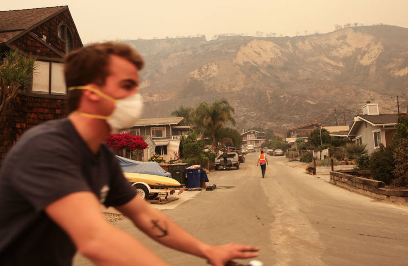
A man bicycles past bluffs burned in the Thomas Fire on Dec. 7, 2017 in La Conchita. (Mario Tama/Getty Images)
Air Quality
The fires raging across Southern California have sent plumes of thick smoke into the air and reduced air quality across the region.
"Our index has six levels, and the highest level is hazardous. Unfortunately, the Ojai Valley has been experiencing levels even higher than that — the levels are still off the charts," said Mallory Ham with Ventura's Air Pollution Control District.
That smoke contains particles that are small enough to burrow deep into human lungs.
The National Weather Service said shifting winds on Friday could drive the smoke back into coastal communities, from Ventura and Oxnard all the way to Santa Monica and into Los Angeles.
Authorities are urging people who live in the area to use extreme caution and avoid vigorous outdoor or indoor exertion.
People with respiratory or heart disease, the elderly, and children should stay inside.
Close all windows and doors and run your air conditioner, if you have one.
This post has been updated.
lower waypoint
Stay in touch. Sign up for our daily newsletter.
To learn more about how we use your information, please read our privacy policy.
window.__IS_SSR__=true
window.__INITIAL_STATE__={"attachmentsReducer":{"audio_0":{"type":"attachments","id":"audio_0","imgSizes":{"kqedFullSize":{"file":"https://ww2.kqed.org/news/wp-content/themes/KQED-unified/img/audio_bgs/background0.jpg"}}},"audio_1":{"type":"attachments","id":"audio_1","imgSizes":{"kqedFullSize":{"file":"https://ww2.kqed.org/news/wp-content/themes/KQED-unified/img/audio_bgs/background1.jpg"}}},"audio_2":{"type":"attachments","id":"audio_2","imgSizes":{"kqedFullSize":{"file":"https://ww2.kqed.org/news/wp-content/themes/KQED-unified/img/audio_bgs/background2.jpg"}}},"audio_3":{"type":"attachments","id":"audio_3","imgSizes":{"kqedFullSize":{"file":"https://ww2.kqed.org/news/wp-content/themes/KQED-unified/img/audio_bgs/background3.jpg"}}},"audio_4":{"type":"attachments","id":"audio_4","imgSizes":{"kqedFullSize":{"file":"https://ww2.kqed.org/news/wp-content/themes/KQED-unified/img/audio_bgs/background4.jpg"}}},"placeholder":{"type":"attachments","id":"placeholder","imgSizes":{"thumbnail":{"file":"https://ww2.kqed.org/wp-content/uploads/sites/10/2018/01/GettyImages-896326950-160x96.jpg","width":160,"height":96,"mimeType":"image/jpeg"},"medium":{"file":"https://ww2.kqed.org/wp-content/uploads/sites/10/2018/01/GettyImages-896326950-800x478.jpg","width":800,"height":478,"mimeType":"image/jpeg"},"large":{"file":"https://ww2.kqed.org/wp-content/uploads/sites/10/2018/01/GettyImages-896326950-1020x610.jpg","width":1020,"height":610,"mimeType":"image/jpeg"},"fd-lrg":{"file":"https://ww2.kqed.org/wp-content/uploads/sites/10/2018/01/GettyImages-896326950-1920x1148.jpg","width":1920,"height":1148,"mimeType":"image/jpeg"},"fd-med":{"file":"https://ww2.kqed.org/wp-content/uploads/sites/10/2018/01/GettyImages-896326950-1180x705.jpg","width":1180,"height":705,"mimeType":"image/jpeg"},"fd-sm":{"file":"https://ww2.kqed.org/wp-content/uploads/sites/10/2018/01/GettyImages-896326950-960x574.jpg","width":960,"height":574,"mimeType":"image/jpeg"},"post-thumbnail":{"file":"https://ww2.kqed.org/wp-content/uploads/sites/10/2018/01/GettyImages-896326950-672x372.jpg","width":672,"height":372,"mimeType":"image/jpeg"},"twentyfourteen-full-width":{"file":"https://ww2.kqed.org/wp-content/uploads/sites/10/2018/01/GettyImages-896326950-1038x576.jpg","width":1038,"height":576,"mimeType":"image/jpeg"},"xxsmall":{"file":"https://ww2.kqed.org/wp-content/uploads/sites/10/2018/01/GettyImages-896326950-240x143.jpg","width":240,"height":143,"mimeType":"image/jpeg"},"xsmall":{"file":"https://ww2.kqed.org/wp-content/uploads/sites/10/2018/01/GettyImages-896326950-375x224.jpg","width":375,"height":224,"mimeType":"image/jpeg"},"small":{"file":"https://ww2.kqed.org/wp-content/uploads/sites/10/2018/01/GettyImages-896326950-520x311.jpg","width":520,"height":311,"mimeType":"image/jpeg"},"xlarge":{"file":"https://ww2.kqed.org/wp-content/uploads/sites/10/2018/01/GettyImages-896326950-1180x705.jpg","width":1180,"height":705,"mimeType":"image/jpeg"},"full-width":{"file":"https://ww2.kqed.org/wp-content/uploads/sites/10/2018/01/GettyImages-896326950-1920x1148.jpg","width":1920,"height":1148,"mimeType":"image/jpeg"},"guest-author-32":{"file":"https://ww2.kqed.org/wp-content/uploads/sites/10/2018/01/GettyImages-896326950-32x32.jpg","width":32,"height":32,"mimeType":"image/jpeg"},"guest-author-50":{"file":"https://ww2.kqed.org/wp-content/uploads/sites/10/2018/01/GettyImages-896326950-50x50.jpg","width":50,"height":50,"mimeType":"image/jpeg"},"guest-author-64":{"file":"https://ww2.kqed.org/wp-content/uploads/sites/10/2018/01/GettyImages-896326950-64x64.jpg","width":64,"height":64,"mimeType":"image/jpeg"},"guest-author-96":{"file":"https://ww2.kqed.org/wp-content/uploads/sites/10/2018/01/GettyImages-896326950-96x96.jpg","width":96,"height":96,"mimeType":"image/jpeg"},"guest-author-128":{"file":"https://ww2.kqed.org/wp-content/uploads/sites/10/2018/01/GettyImages-896326950-128x128.jpg","width":128,"height":128,"mimeType":"image/jpeg"},"detail":{"file":"https://ww2.kqed.org/wp-content/uploads/sites/10/2018/01/GettyImages-896326950-150x150.jpg","width":150,"height":150,"mimeType":"image/jpeg"},"kqedFullSize":{"file":"https://ww2.kqed.org/wp-content/uploads/sites/10/2018/01/GettyImages-896326950-e1514998105161.jpg","width":1920,"height":1148}}},"news_11983781":{"type":"attachments","id":"news_11983781","meta":{"index":"attachments_1591205162","site":"news","id":"11983781","found":true},"title":"The Rev. Cecil Williams monitored the activity outside during the annual grocery bag giveaway for those in need at Glide Memorial Church in San Francisco, Calif. on Wednesday, Dec. 19, 2007. Each of the 6,000 bags contained either a turkey or a chicken, p","publishDate":1713836950,"status":"inherit","parent":11983768,"modified":1713893536,"caption":"Rev. Cecil Williams monitoring the annual grocery bag giveaway for those in need at Glide Memorial Church in San Francisco on Dec. 19, 2007.","credit":"Paul Chinn/The San Francisco Chronicle via Getty Images","altTag":"An older Black man walks outside Glide Memorial Methodist Church, where barricades are set up and people stand in line.","description":null,"imgSizes":{"medium":{"file":"https://cdn.kqed.org/wp-content/uploads/sites/10/2024/04/GettyImages-1408381483-800x551.jpg","width":800,"height":551,"mimeType":"image/jpeg"},"large":{"file":"https://cdn.kqed.org/wp-content/uploads/sites/10/2024/04/GettyImages-1408381483-1020x702.jpg","width":1020,"height":702,"mimeType":"image/jpeg"},"thumbnail":{"file":"https://cdn.kqed.org/wp-content/uploads/sites/10/2024/04/GettyImages-1408381483-160x110.jpg","width":160,"height":110,"mimeType":"image/jpeg"},"post-thumbnail":{"file":"https://cdn.kqed.org/wp-content/uploads/sites/10/2024/04/GettyImages-1408381483-672x372.jpg","width":672,"height":372,"mimeType":"image/jpeg"},"twentyfourteen-full-width":{"file":"https://cdn.kqed.org/wp-content/uploads/sites/10/2024/04/GettyImages-1408381483-1024x576.jpg","width":1024,"height":576,"mimeType":"image/jpeg"},"kqedFullSize":{"file":"https://cdn.kqed.org/wp-content/uploads/sites/10/2024/04/GettyImages-1408381483.jpg","width":1024,"height":705}},"fetchFailed":false,"isLoading":false},"news_11983401":{"type":"attachments","id":"news_11983401","meta":{"index":"attachments_1591205162","site":"news","id":"11983401","found":true},"title":"US-HEALTH-VIRUS-PRISON","publishDate":1713480720,"status":"inherit","parent":11983396,"modified":1713908390,"caption":"Incarcerated women sew protective masks at Las Colinas Women's Detention Facility in Santee, San Diego County, on April 22, 2020. ","credit":"Sandy Huffaker/AFP via Getty Images","altTag":"Incarcerated women in beige outfits work at sewing tables.","description":null,"imgSizes":{"medium":{"file":"https://cdn.kqed.org/wp-content/uploads/sites/10/2024/04/GettyImages-1210676401-800x534.jpg","width":800,"height":534,"mimeType":"image/jpeg"},"large":{"file":"https://cdn.kqed.org/wp-content/uploads/sites/10/2024/04/GettyImages-1210676401-1020x680.jpg","width":1020,"height":680,"mimeType":"image/jpeg"},"thumbnail":{"file":"https://cdn.kqed.org/wp-content/uploads/sites/10/2024/04/GettyImages-1210676401-160x107.jpg","width":160,"height":107,"mimeType":"image/jpeg"},"post-thumbnail":{"file":"https://cdn.kqed.org/wp-content/uploads/sites/10/2024/04/GettyImages-1210676401-672x372.jpg","width":672,"height":372,"mimeType":"image/jpeg"},"twentyfourteen-full-width":{"file":"https://cdn.kqed.org/wp-content/uploads/sites/10/2024/04/GettyImages-1210676401-1024x576.jpg","width":1024,"height":576,"mimeType":"image/jpeg"},"kqedFullSize":{"file":"https://cdn.kqed.org/wp-content/uploads/sites/10/2024/04/GettyImages-1210676401.jpg","width":1024,"height":683}},"fetchFailed":false,"isLoading":false},"news_11983711":{"type":"attachments","id":"news_11983711","meta":{"index":"attachments_1591205162","site":"news","id":"11983711","found":true},"title":"GettyImages-1253315032_qut (1)","publishDate":1713819066,"status":"inherit","parent":11983705,"modified":1713821059,"caption":"A view of San Quentin State Prison on June 29, 2020 in San Quentin.","credit":"Justin Sullivan / Getty Images","altTag":"A view of a sign that reads 'California State Prison San Quentin' next to a gate with a prison in the background.","description":null,"imgSizes":{"medium":{"file":"https://cdn.kqed.org/wp-content/uploads/sites/10/2024/04/GettyImages-1253315032_qut-1-800x533.jpg","width":800,"height":533,"mimeType":"image/jpeg"},"large":{"file":"https://cdn.kqed.org/wp-content/uploads/sites/10/2024/04/GettyImages-1253315032_qut-1-1020x680.jpg","width":1020,"height":680,"mimeType":"image/jpeg"},"thumbnail":{"file":"https://cdn.kqed.org/wp-content/uploads/sites/10/2024/04/GettyImages-1253315032_qut-1-160x107.jpg","width":160,"height":107,"mimeType":"image/jpeg"},"1536x1536":{"file":"https://cdn.kqed.org/wp-content/uploads/sites/10/2024/04/GettyImages-1253315032_qut-1-1536x1024.jpg","width":1536,"height":1024,"mimeType":"image/jpeg"},"post-thumbnail":{"file":"https://cdn.kqed.org/wp-content/uploads/sites/10/2024/04/GettyImages-1253315032_qut-1-672x372.jpg","width":672,"height":372,"mimeType":"image/jpeg"},"twentyfourteen-full-width":{"file":"https://cdn.kqed.org/wp-content/uploads/sites/10/2024/04/GettyImages-1253315032_qut-1-1038x576.jpg","width":1038,"height":576,"mimeType":"image/jpeg"},"kqedFullSize":{"file":"https://cdn.kqed.org/wp-content/uploads/sites/10/2024/04/GettyImages-1253315032_qut-1.jpg","width":1920,"height":1280}},"fetchFailed":false,"isLoading":false},"news_11982792":{"type":"attachments","id":"news_11982792","meta":{"index":"attachments_1591205162","site":"news","id":"11982792","found":true},"title":"240412-OAKAIRPORT-027-BL-KQED","publishDate":1712942276,"status":"inherit","parent":0,"modified":1712942294,"caption":"Passengers walk in to the Oakland International Airport in Oakland on April 12, 2024.","credit":"Beth LaBerge/KQED","altTag":null,"description":null,"imgSizes":{"medium":{"file":"https://cdn.kqed.org/wp-content/uploads/sites/10/2024/04/240412-OAKAIRPORT-027-BL-KQED-800x533.jpg","width":800,"height":533,"mimeType":"image/jpeg"},"large":{"file":"https://cdn.kqed.org/wp-content/uploads/sites/10/2024/04/240412-OAKAIRPORT-027-BL-KQED-1020x680.jpg","width":1020,"height":680,"mimeType":"image/jpeg"},"thumbnail":{"file":"https://cdn.kqed.org/wp-content/uploads/sites/10/2024/04/240412-OAKAIRPORT-027-BL-KQED-160x107.jpg","width":160,"height":107,"mimeType":"image/jpeg"},"1536x1536":{"file":"https://cdn.kqed.org/wp-content/uploads/sites/10/2024/04/240412-OAKAIRPORT-027-BL-KQED-1536x1024.jpg","width":1536,"height":1024,"mimeType":"image/jpeg"},"post-thumbnail":{"file":"https://cdn.kqed.org/wp-content/uploads/sites/10/2024/04/240412-OAKAIRPORT-027-BL-KQED-672x372.jpg","width":672,"height":372,"mimeType":"image/jpeg"},"twentyfourteen-full-width":{"file":"https://cdn.kqed.org/wp-content/uploads/sites/10/2024/04/240412-OAKAIRPORT-027-BL-KQED-1038x576.jpg","width":1038,"height":576,"mimeType":"image/jpeg"},"full-width":{"file":"https://cdn.kqed.org/wp-content/uploads/sites/10/2024/04/240412-OAKAIRPORT-027-BL-KQED-1920x1280.jpg","width":1920,"height":1280,"mimeType":"image/jpeg"},"kqedFullSize":{"file":"https://cdn.kqed.org/wp-content/uploads/sites/10/2024/04/240412-OAKAIRPORT-027-BL-KQED.jpg","width":2000,"height":1333}},"fetchFailed":false,"isLoading":false},"news_11983729":{"type":"attachments","id":"news_11983729","meta":{"index":"attachments_1591205162","site":"news","id":"11983729","found":true},"title":"240422-NursesAI-29-BL","publishDate":1713822684,"status":"inherit","parent":0,"modified":1713832954,"caption":"Claire Siegel rallies alongside fellow nurses from across California at Kaiser Permanente on Geary Boulevard in San Francisco on April 22, 2024, to advocate for patient safety in the face of artificial intelligence technology.","credit":"Beth LaBerge/KQED","altTag":"A woman with glasses holds a sign above her head that reads 'Patients are NOT algorithms' in front of a Kaiser Permanence building.","description":null,"imgSizes":{"medium":{"file":"https://cdn.kqed.org/wp-content/uploads/sites/10/2024/04/240422-NursesAI-29-BL-800x533.jpg","width":800,"height":533,"mimeType":"image/jpeg"},"large":{"file":"https://cdn.kqed.org/wp-content/uploads/sites/10/2024/04/240422-NursesAI-29-BL-1020x680.jpg","width":1020,"height":680,"mimeType":"image/jpeg"},"thumbnail":{"file":"https://cdn.kqed.org/wp-content/uploads/sites/10/2024/04/240422-NursesAI-29-BL-160x107.jpg","width":160,"height":107,"mimeType":"image/jpeg"},"1536x1536":{"file":"https://cdn.kqed.org/wp-content/uploads/sites/10/2024/04/240422-NursesAI-29-BL-1536x1024.jpg","width":1536,"height":1024,"mimeType":"image/jpeg"},"2048x2048":{"file":"https://cdn.kqed.org/wp-content/uploads/sites/10/2024/04/240422-NursesAI-29-BL-2048x1366.jpg","width":2048,"height":1366,"mimeType":"image/jpeg"},"post-thumbnail":{"file":"https://cdn.kqed.org/wp-content/uploads/sites/10/2024/04/240422-NursesAI-29-BL-672x372.jpg","width":672,"height":372,"mimeType":"image/jpeg"},"twentyfourteen-full-width":{"file":"https://cdn.kqed.org/wp-content/uploads/sites/10/2024/04/240422-NursesAI-29-BL-1038x576.jpg","width":1038,"height":576,"mimeType":"image/jpeg"},"full-width":{"file":"https://cdn.kqed.org/wp-content/uploads/sites/10/2024/04/240422-NursesAI-29-BL-1920x1280.jpg","width":1920,"height":1280,"mimeType":"image/jpeg"},"kqedFullSize":{"file":"https://cdn.kqed.org/wp-content/uploads/sites/10/2024/04/240422-NursesAI-29-BL-scaled.jpg","width":2560,"height":1707}},"fetchFailed":false,"isLoading":false},"news_11983678":{"type":"attachments","id":"news_11983678","meta":{"index":"attachments_1591205162","site":"news","id":"11983678","found":true},"title":"DCCC01","publishDate":1713812025,"status":"inherit","parent":11983671,"modified":1713816139,"caption":"State Sen. Scott Wiener swears in the new DCCC members at the April meeting of the Democratic County Central Committee.","credit":"Joe Fitzgerald Rodriguez/KQED","altTag":null,"description":null,"imgSizes":{"medium":{"file":"https://cdn.kqed.org/wp-content/uploads/sites/10/2024/04/DCCC01-800x533.jpg","width":800,"height":533,"mimeType":"image/jpeg"},"large":{"file":"https://cdn.kqed.org/wp-content/uploads/sites/10/2024/04/DCCC01-1020x680.jpg","width":1020,"height":680,"mimeType":"image/jpeg"},"thumbnail":{"file":"https://cdn.kqed.org/wp-content/uploads/sites/10/2024/04/DCCC01-160x107.jpg","width":160,"height":107,"mimeType":"image/jpeg"},"1536x1536":{"file":"https://cdn.kqed.org/wp-content/uploads/sites/10/2024/04/DCCC01-1536x1024.jpg","width":1536,"height":1024,"mimeType":"image/jpeg"},"post-thumbnail":{"file":"https://cdn.kqed.org/wp-content/uploads/sites/10/2024/04/DCCC01-672x372.jpg","width":672,"height":372,"mimeType":"image/jpeg"},"twentyfourteen-full-width":{"file":"https://cdn.kqed.org/wp-content/uploads/sites/10/2024/04/DCCC01-1038x576.jpg","width":1038,"height":576,"mimeType":"image/jpeg"},"kqedFullSize":{"file":"https://cdn.kqed.org/wp-content/uploads/sites/10/2024/04/DCCC01.jpg","width":1920,"height":1280}},"fetchFailed":false,"isLoading":false},"news_11983691":{"type":"attachments","id":"news_11983691","meta":{"index":"attachments_1591205162","site":"news","id":"11983691","found":true},"title":"IMG_7874","publishDate":1713814190,"status":"inherit","parent":0,"modified":1713823055,"caption":"Monique Harris (center left) and Patrice Strahan (center right) gather at the San Francisco Federal Building on April 22, 2024, to urge the U.S. Supreme Court to uphold rules prohibiting cities from fining or jailing unhoused people when viable shelter alternatives are not available. ","credit":"Kathryn Styer Martínez/KQED","altTag":"A Black woman in a wheelchair is among a group of protesters holding signs like 'Fight Poverty' and 'Homes not Sweeps.'","description":null,"imgSizes":{"medium":{"file":"https://cdn.kqed.org/wp-content/uploads/sites/10/2024/04/IMG_7874-800x533.jpeg","width":800,"height":533,"mimeType":"image/jpeg"},"large":{"file":"https://cdn.kqed.org/wp-content/uploads/sites/10/2024/04/IMG_7874-1020x680.jpeg","width":1020,"height":680,"mimeType":"image/jpeg"},"thumbnail":{"file":"https://cdn.kqed.org/wp-content/uploads/sites/10/2024/04/IMG_7874-160x107.jpeg","width":160,"height":107,"mimeType":"image/jpeg"},"1536x1536":{"file":"https://cdn.kqed.org/wp-content/uploads/sites/10/2024/04/IMG_7874-1536x1024.jpeg","width":1536,"height":1024,"mimeType":"image/jpeg"},"post-thumbnail":{"file":"https://cdn.kqed.org/wp-content/uploads/sites/10/2024/04/IMG_7874-672x372.jpeg","width":672,"height":372,"mimeType":"image/jpeg"},"twentyfourteen-full-width":{"file":"https://cdn.kqed.org/wp-content/uploads/sites/10/2024/04/IMG_7874-1038x576.jpeg","width":1038,"height":576,"mimeType":"image/jpeg"},"kqedFullSize":{"file":"https://cdn.kqed.org/wp-content/uploads/sites/10/2024/04/IMG_7874.jpeg","width":1824,"height":1216}},"fetchFailed":false,"isLoading":false},"forum_2010101905469":{"type":"attachments","id":"forum_2010101905469","meta":{"index":"attachments_1591205162","site":"forum","id":"2010101905469","found":true},"title":"GettyImages-2148008870 (1)","publishDate":1713804804,"status":"inherit","parent":2010101905468,"modified":1713804832,"caption":"Rev. Dr. William J. Barber, II speaks alongside demonstrators as they protest outside the US Supreme Court in support of the homeless as the Court hears the case of City of Grants Pass v. Johnson that could make it illegal to sleep outside, in Washington, DC, April 22, 2024.","credit":"SAUL LOEB/AFP via Getty Images","altTag":null,"description":null,"imgSizes":{"medium":{"file":"https://cdn.kqed.org/wp-content/uploads/sites/43/2024/04/GettyImages-2148008870-1-800x450.jpg","width":800,"height":450,"mimeType":"image/jpeg"},"large":{"file":"https://cdn.kqed.org/wp-content/uploads/sites/43/2024/04/GettyImages-2148008870-1-1020x574.jpg","width":1020,"height":574,"mimeType":"image/jpeg"},"thumbnail":{"file":"https://cdn.kqed.org/wp-content/uploads/sites/43/2024/04/GettyImages-2148008870-1-160x90.jpg","width":160,"height":90,"mimeType":"image/jpeg"},"medium_large":{"file":"https://cdn.kqed.org/wp-content/uploads/sites/43/2024/04/GettyImages-2148008870-1-768x432.jpg","width":768,"height":432,"mimeType":"image/jpeg"},"1536x1536":{"file":"https://cdn.kqed.org/wp-content/uploads/sites/43/2024/04/GettyImages-2148008870-1-1536x864.jpg","width":1536,"height":864,"mimeType":"image/jpeg"},"post-thumbnail":{"file":"https://cdn.kqed.org/wp-content/uploads/sites/43/2024/04/GettyImages-2148008870-1-672x372.jpg","width":672,"height":372,"mimeType":"image/jpeg"},"twentyfourteen-full-width":{"file":"https://cdn.kqed.org/wp-content/uploads/sites/43/2024/04/GettyImages-2148008870-1-1038x576.jpg","width":1038,"height":576,"mimeType":"image/jpeg"},"kqedFullSize":{"file":"https://cdn.kqed.org/wp-content/uploads/sites/43/2024/04/GettyImages-2148008870-1.jpg","width":1920,"height":1080}},"fetchFailed":false,"isLoading":false},"news_11983549":{"type":"attachments","id":"news_11983549","meta":{"index":"attachments_1591205162","site":"news","id":"11983549","found":true},"title":"TOPSHOT-INDIA-POLITICS-ELECTION","publishDate":1713569941,"status":"inherit","parent":11983481,"modified":1713571171,"caption":"College students spread awareness for first-generation voters during an election campaign ahead of India's upcoming national elections in Chennai, India, on March 19, 2024. ","credit":"R. Satish Babu/AFP via Getty Images","altTag":"An arm with an index finger points upward. Ink is on the fingertip, and the word \"vote\" is written on the back of the hand. Blurred faces painted with Indian flags are seen in the background.","description":null,"imgSizes":{"medium":{"file":"https://cdn.kqed.org/wp-content/uploads/sites/10/2024/04/GettyImages-2087343469-800x534.jpg","width":800,"height":534,"mimeType":"image/jpeg"},"large":{"file":"https://cdn.kqed.org/wp-content/uploads/sites/10/2024/04/GettyImages-2087343469-1020x680.jpg","width":1020,"height":680,"mimeType":"image/jpeg"},"thumbnail":{"file":"https://cdn.kqed.org/wp-content/uploads/sites/10/2024/04/GettyImages-2087343469-160x107.jpg","width":160,"height":107,"mimeType":"image/jpeg"},"post-thumbnail":{"file":"https://cdn.kqed.org/wp-content/uploads/sites/10/2024/04/GettyImages-2087343469-672x372.jpg","width":672,"height":372,"mimeType":"image/jpeg"},"twentyfourteen-full-width":{"file":"https://cdn.kqed.org/wp-content/uploads/sites/10/2024/04/GettyImages-2087343469-1024x576.jpg","width":1024,"height":576,"mimeType":"image/jpeg"},"kqedFullSize":{"file":"https://cdn.kqed.org/wp-content/uploads/sites/10/2024/04/GettyImages-2087343469.jpg","width":1024,"height":683}},"fetchFailed":false,"isLoading":false},"news_11983657":{"type":"attachments","id":"news_11983657","meta":{"index":"attachments_1591205162","site":"news","id":"11983657","found":true},"title":"Redwood Heights Elementary School","publishDate":1713804806,"status":"inherit","parent":11983654,"modified":1713813439,"caption":"First graders at Redwood Heights Elementary School in Oakland, California, Wednesday, June 4, 2014.","credit":"Alison Yin/EdSource","altTag":null,"description":null,"imgSizes":{"medium":{"file":"https://cdn.kqed.org/wp-content/uploads/sites/10/2024/04/EdSource01-800x533.jpg","width":800,"height":533,"mimeType":"image/jpeg"},"large":{"file":"https://cdn.kqed.org/wp-content/uploads/sites/10/2024/04/EdSource01-1020x680.jpg","width":1020,"height":680,"mimeType":"image/jpeg"},"thumbnail":{"file":"https://cdn.kqed.org/wp-content/uploads/sites/10/2024/04/EdSource01-160x107.jpg","width":160,"height":107,"mimeType":"image/jpeg"},"1536x1536":{"file":"https://cdn.kqed.org/wp-content/uploads/sites/10/2024/04/EdSource01-1536x1024.jpg","width":1536,"height":1024,"mimeType":"image/jpeg"},"post-thumbnail":{"file":"https://cdn.kqed.org/wp-content/uploads/sites/10/2024/04/EdSource01-672x372.jpg","width":672,"height":372,"mimeType":"image/jpeg"},"twentyfourteen-full-width":{"file":"https://cdn.kqed.org/wp-content/uploads/sites/10/2024/04/EdSource01-1038x576.jpg","width":1038,"height":576,"mimeType":"image/jpeg"},"kqedFullSize":{"file":"https://cdn.kqed.org/wp-content/uploads/sites/10/2024/04/EdSource01.jpg","width":1920,"height":1280}},"fetchFailed":false,"isLoading":false},"news_11635821":{"type":"attachments","id":"news_11635821","meta":{"index":"attachments_1591205162","site":"news","id":"11635821","found":true},"title":"ThomasFire","publishDate":1512764712,"status":"inherit","parent":11635816,"modified":1513378121,"caption":"A firefighting helicopter is dwarfed by smoke and flames during Thomas Fire on Dec. 7, 2017, near Fillmore.","credit":"David McNew/Getty Images","description":"A firefighting helicopter is dwarfed by smoke and flames during Thomas Fire on December 7, 2017 near Fillmore.","imgSizes":{"thumbnail":{"file":"https://ww2.kqed.org/app/uploads/sites/10/2017/12/ThomasFire-160x97.jpg","width":160,"height":97,"mimeType":"image/jpeg"},"medium":{"file":"https://ww2.kqed.org/app/uploads/sites/10/2017/12/ThomasFire-800x487.jpg","width":800,"height":487,"mimeType":"image/jpeg"},"large":{"file":"https://ww2.kqed.org/app/uploads/sites/10/2017/12/ThomasFire-1020x621.jpg","width":1020,"height":621,"mimeType":"image/jpeg"},"fd-lrg":{"file":"https://ww2.kqed.org/app/uploads/sites/10/2017/12/ThomasFire-1920x1168.jpg","width":1920,"height":1168,"mimeType":"image/jpeg"},"fd-med":{"file":"https://ww2.kqed.org/app/uploads/sites/10/2017/12/ThomasFire-1180x718.jpg","width":1180,"height":718,"mimeType":"image/jpeg"},"fd-sm":{"file":"https://ww2.kqed.org/app/uploads/sites/10/2017/12/ThomasFire-960x584.jpg","width":960,"height":584,"mimeType":"image/jpeg"},"post-thumbnail":{"file":"https://ww2.kqed.org/app/uploads/sites/10/2017/12/ThomasFire-672x372.jpg","width":672,"height":372,"mimeType":"image/jpeg"},"twentyfourteen-full-width":{"file":"https://ww2.kqed.org/app/uploads/sites/10/2017/12/ThomasFire-1038x576.jpg","width":1038,"height":576,"mimeType":"image/jpeg"},"xxsmall":{"file":"https://ww2.kqed.org/app/uploads/sites/10/2017/12/ThomasFire-240x146.jpg","width":240,"height":146,"mimeType":"image/jpeg"},"xsmall":{"file":"https://ww2.kqed.org/app/uploads/sites/10/2017/12/ThomasFire-375x228.jpg","width":375,"height":228,"mimeType":"image/jpeg"},"small":{"file":"https://ww2.kqed.org/app/uploads/sites/10/2017/12/ThomasFire-520x316.jpg","width":520,"height":316,"mimeType":"image/jpeg"},"xlarge":{"file":"https://ww2.kqed.org/app/uploads/sites/10/2017/12/ThomasFire-1180x718.jpg","width":1180,"height":718,"mimeType":"image/jpeg"},"full-width":{"file":"https://ww2.kqed.org/app/uploads/sites/10/2017/12/ThomasFire-1920x1168.jpg","width":1920,"height":1168,"mimeType":"image/jpeg"},"guest-author-32":{"file":"https://ww2.kqed.org/app/uploads/sites/10/2017/12/ThomasFire-32x32.jpg","width":32,"height":32,"mimeType":"image/jpeg"},"guest-author-50":{"file":"https://ww2.kqed.org/app/uploads/sites/10/2017/12/ThomasFire-50x50.jpg","width":50,"height":50,"mimeType":"image/jpeg"},"guest-author-64":{"file":"https://ww2.kqed.org/app/uploads/sites/10/2017/12/ThomasFire-64x64.jpg","width":64,"height":64,"mimeType":"image/jpeg"},"guest-author-96":{"file":"https://ww2.kqed.org/app/uploads/sites/10/2017/12/ThomasFire-96x96.jpg","width":96,"height":96,"mimeType":"image/jpeg"},"guest-author-128":{"file":"https://ww2.kqed.org/app/uploads/sites/10/2017/12/ThomasFire-128x128.jpg","width":128,"height":128,"mimeType":"image/jpeg"},"detail":{"file":"https://ww2.kqed.org/app/uploads/sites/10/2017/12/ThomasFire-150x150.jpg","width":150,"height":150,"mimeType":"image/jpeg"},"kqedFullSize":{"file":"https://ww2.kqed.org/app/uploads/sites/10/2017/12/ThomasFire.jpg","width":1920,"height":1168}},"fetchFailed":false,"isLoading":false}},"audioPlayerReducer":{"postId":"stream_live"},"authorsReducer":{"byline_news_11983481":{"type":"authors","id":"byline_news_11983481","meta":{"override":true},"slug":"byline_news_11983481","name":"Sheikh Saaliq\u003cbr>Associated Press","isLoading":false},"byline_news_11983654":{"type":"authors","id":"byline_news_11983654","meta":{"override":true},"slug":"byline_news_11983654","name":"John Fensterwald, EdSource","isLoading":false},"kqednewsstaffandwires":{"type":"authors","id":"237","meta":{"index":"authors_1591205172","id":"237","found":true},"name":"KQED News Staff and Wires","firstName":"KQED News Staff and Wires","lastName":null,"slug":"kqednewsstaffandwires","email":"onlinenewsstaff@kqed.org","display_author_email":false,"staff_mastheads":[],"title":null,"bio":null,"avatar":"https://secure.gravatar.com/avatar/72295af8ebbfbd19a4948f5271285664?s=600&d=blank&r=g","twitter":null,"facebook":null,"instagram":null,"linkedin":null,"sites":[{"site":"arts","roles":["contributor"]},{"site":"news","roles":["contributor"]},{"site":"lowdown","roles":["author"]},{"site":"stateofhealth","roles":["contributor"]},{"site":"food","roles":["author"]}],"headData":{"title":"KQED News Staff and Wires | KQED","description":null,"ogImgSrc":"https://secure.gravatar.com/avatar/72295af8ebbfbd19a4948f5271285664?s=600&d=blank&r=g","twImgSrc":"https://secure.gravatar.com/avatar/72295af8ebbfbd19a4948f5271285664?s=600&d=blank&r=g"},"isLoading":false,"link":"/author/kqednewsstaffandwires"},"minakim":{"type":"authors","id":"243","meta":{"index":"authors_1591205172","id":"243","found":true},"name":"Mina Kim","firstName":"Mina","lastName":"Kim","slug":"minakim","email":"mkim@kqed.org","display_author_email":false,"staff_mastheads":["news"],"title":"Host, Forum","bio":"Mina Kim is host of the 10 a.m. statewide hour of Forum; a live daily talk show for curious Californians on issues that matter to the state and nation, with a particular emphasis on race and equity.\r\n\r\nBefore joining the Forum team, Mina was KQED’s evening news anchor, and health reporter for The California Report. Her award-winning work has included natural disasters in Napa and gun violence in Oakland. Mina grew up in St. John’s, Newfoundland.","avatar":"https://secure.gravatar.com/avatar/145ce657a2d08cb86d93686beb958982?s=600&d=blank&r=g","twitter":"mkimreporter","facebook":null,"instagram":null,"linkedin":null,"sites":[{"site":"news","roles":["contributor"]},{"site":"stateofhealth","roles":["author"]},{"site":"forum","roles":["editor"]}],"headData":{"title":"Mina Kim | KQED","description":"Host, Forum","ogImgSrc":"https://secure.gravatar.com/avatar/145ce657a2d08cb86d93686beb958982?s=600&d=blank&r=g","twImgSrc":"https://secure.gravatar.com/avatar/145ce657a2d08cb86d93686beb958982?s=600&d=blank&r=g"},"isLoading":false,"link":"/author/minakim"},"ecruzguevarra":{"type":"authors","id":"8654","meta":{"index":"authors_1591205172","id":"8654","found":true},"name":"Ericka Cruz Guevarra","firstName":"Ericka","lastName":"Cruz Guevarra","slug":"ecruzguevarra","email":"ecruzguevarra@kqed.org","display_author_email":true,"staff_mastheads":["news"],"title":"Producer, The Bay Podcast","bio":"Ericka Cruz Guevarra is host of \u003ca href=\"https://www.kqed.org/podcasts/thebay\">\u003cem>The Bay\u003c/em>\u003c/a> podcast at KQED. Before host, she was the show’s producer. Her work in that capacity includes a three-part reported series on policing in Vallejo, which won a 2020 excellence in journalism award from the Society of Professional Journalists. Ericka has worked as a breaking news reporter at Oregon Public Broadcasting, helped produce the Code Switch podcast, and was KQED’s inaugural Raul Ramirez Diversity Fund intern. She’s also an alumna of NPR’s Next Generation Radio program. Send her an email if you have strong feelings about whether Fairfield and Suisun City are the Bay.","avatar":"https://secure.gravatar.com/avatar/25e5ab8d3d53fad2dcc7bb2b5c506b1a?s=600&d=blank&r=g","twitter":"NotoriousECG","facebook":null,"instagram":null,"linkedin":null,"sites":[{"site":"arts","roles":["subscriber"]},{"site":"news","roles":["editor"]},{"site":"futureofyou","roles":["subscriber"]},{"site":"stateofhealth","roles":["subscriber"]},{"site":"science","roles":["editor"]},{"site":"forum","roles":["subscriber"]}],"headData":{"title":"Ericka Cruz Guevarra | KQED","description":"Producer, The Bay Podcast","ogImgSrc":"https://secure.gravatar.com/avatar/25e5ab8d3d53fad2dcc7bb2b5c506b1a?s=600&d=blank&r=g","twImgSrc":"https://secure.gravatar.com/avatar/25e5ab8d3d53fad2dcc7bb2b5c506b1a?s=600&d=blank&r=g"},"isLoading":false,"link":"/author/ecruzguevarra"},"fjhabvala":{"type":"authors","id":"8659","meta":{"index":"authors_1591205172","id":"8659","found":true},"name":"Farida Jhabvala Romero","firstName":"Farida","lastName":"Jhabvala Romero","slug":"fjhabvala","email":"fjhabvala@kqed.org","display_author_email":true,"staff_mastheads":["news"],"title":"KQED Contributor","bio":"\u003cspan style=\"font-weight: 400;\">Farida Jhabvala Romero is a Labor Correspondent for KQED. She previously covered immigration. Farida was \u003ca href=\"https://www.ccnma.org/2022-most-influential-latina-journalists\">named\u003c/a> one of the 10 Most Influential Latina Journalists in California in 2022 by the California Chicano News Media Association. Her work has won awards from the Society of Professional Journalists (Northern California), as well as a national and regional Edward M. Murrow Award for the collaborative reporting projects “Dangerous Air” and “Graying California.” \u003c/span>\u003cspan style=\"font-weight: 400;\">Before joining KQED, Farida worked as a producer at Radio Bilingüe, a national public radio network. Farida earned her master’s degree in journalism from Stanford University.\u003c/span>","avatar":"https://secure.gravatar.com/avatar/c3ab27c5554b67b478f80971e515aa02?s=600&d=blank&r=g","twitter":"FaridaJhabvala","facebook":null,"instagram":null,"linkedin":"https://www.linkedin.com/in/faridajhabvala/","sites":[{"site":"news","roles":["editor"]},{"site":"stateofhealth","roles":["author"]}],"headData":{"title":"Farida Jhabvala Romero | KQED","description":"KQED Contributor","ogImgSrc":"https://secure.gravatar.com/avatar/c3ab27c5554b67b478f80971e515aa02?s=600&d=blank&r=g","twImgSrc":"https://secure.gravatar.com/avatar/c3ab27c5554b67b478f80971e515aa02?s=600&d=blank&r=g"},"isLoading":false,"link":"/author/fjhabvala"},"vrancano":{"type":"authors","id":"11276","meta":{"index":"authors_1591205172","id":"11276","found":true},"name":"Vanessa Rancaño","firstName":"Vanessa","lastName":"Rancaño","slug":"vrancano","email":"vrancano@kqed.org","display_author_email":false,"staff_mastheads":["news"],"title":"Reporter, Housing","bio":"Vanessa Rancaño reports on housing and homelessness for KQED. She’s also covered education for the station and reported from the Central Valley. Her work has aired across public radio, from flagship national news shows to longform narrative podcasts. Before taking up a mic, she worked as a freelance print journalist. She’s been recognized with a number of national and regional awards. Vanessa grew up in California's Central Valley. She's a former NPR Kroc Fellow, and a graduate of the UC Berkeley Graduate School of Journalism.","avatar":"https://secure.gravatar.com/avatar/f6c0fc5d391c78710bcfc723f0636ef6?s=600&d=blank&r=g","twitter":"vanessarancano","facebook":null,"instagram":null,"linkedin":null,"sites":[{"site":"arts","roles":["editor"]},{"site":"news","roles":["editor"]}],"headData":{"title":"Vanessa Rancaño | KQED","description":"Reporter, Housing","ogImgSrc":"https://secure.gravatar.com/avatar/f6c0fc5d391c78710bcfc723f0636ef6?s=600&d=blank&r=g","twImgSrc":"https://secure.gravatar.com/avatar/f6c0fc5d391c78710bcfc723f0636ef6?s=600&d=blank&r=g"},"isLoading":false,"link":"/author/vrancano"},"amontecillo":{"type":"authors","id":"11649","meta":{"index":"authors_1591205172","id":"11649","found":true},"name":"Alan Montecillo","firstName":"Alan","lastName":"Montecillo","slug":"amontecillo","email":"amontecillo@kqed.org","display_author_email":false,"staff_mastheads":["news"],"title":"KQED Contributor","bio":"Alan Montecillo is editor of \u003cem>\u003ca href=\"http://kqed.org/thebay\">The Bay\u003c/a>, \u003c/em>a local news and storytelling podcast from KQED. He's worked as a senior talk show producer for WILL in Champaign-Urbana, Illinois, and was the founding producer and editor of \u003cem>Racist Sandwich\u003c/em>, a podcast about food, race, class, and gender. He is a Filipino-American from Hong Kong and a graduate of Reed College in Portland, Oregon.","avatar":"https://secure.gravatar.com/avatar/d5e4e7a76481969ccba76f4e2b5ccabc?s=600&d=blank&r=g","twitter":"alanmontecillo","facebook":null,"instagram":null,"linkedin":null,"sites":[{"site":"","roles":["editor"]},{"site":"news","roles":["editor"]}],"headData":{"title":"Alan Montecillo | KQED","description":"KQED Contributor","ogImgSrc":"https://secure.gravatar.com/avatar/d5e4e7a76481969ccba76f4e2b5ccabc?s=600&d=blank&r=g","twImgSrc":"https://secure.gravatar.com/avatar/d5e4e7a76481969ccba76f4e2b5ccabc?s=600&d=blank&r=g"},"isLoading":false,"link":"/author/amontecillo"},"jrodriguez":{"type":"authors","id":"11690","meta":{"index":"authors_1591205172","id":"11690","found":true},"name":"Joe Fitzgerald Rodriguez","firstName":"Joe","lastName":"Fitzgerald Rodriguez","slug":"jrodriguez","email":"jrodriguez@kqed.org","display_author_email":true,"staff_mastheads":["news"],"title":"Reporter and Producer","bio":"Joe Fitzgerald Rodriguez is a reporter and digital producer for KQED covering politics. Joe most recently wrote for the \u003cem>San Francisco Examiner\u003c/em> as a political columnist covering The City. He was raised in San Francisco and has spent his reporting career in his beloved, foggy, city by the bay. Joe was 12-years-old when he conducted his first interview in journalism, grilling former San Francisco Mayor Willie Brown for the Marina Middle School newspaper, \u003cem>The Penguin Press, \u003c/em>and he continues to report on the San Francisco Bay Area to this day.","avatar":"https://secure.gravatar.com/avatar/2247beb0564c1e9c62228d5649d2edac?s=600&d=blank&r=g","twitter":"FitztheReporter","facebook":null,"instagram":"https://www.instagram.com/fitzthereporter/","linkedin":null,"sites":[{"site":"","roles":["editor"]},{"site":"arts","roles":["editor"]},{"site":"news","roles":["editor"]},{"site":"science","roles":["editor"]},{"site":"elections","roles":["editor"]},{"site":"liveblog","roles":["editor"]}],"headData":{"title":"Joe Fitzgerald Rodriguez | KQED","description":"Reporter and Producer","ogImgSrc":"https://secure.gravatar.com/avatar/2247beb0564c1e9c62228d5649d2edac?s=600&d=blank&r=g","twImgSrc":"https://secure.gravatar.com/avatar/2247beb0564c1e9c62228d5649d2edac?s=600&d=blank&r=g"},"isLoading":false,"link":"/author/jrodriguez"},"afinney":{"type":"authors","id":"11772","meta":{"index":"authors_1591205172","id":"11772","found":true},"name":"Annelise Finney","firstName":"Annelise","lastName":"Finney","slug":"afinney","email":"afinney@kqed.org","display_author_email":true,"staff_mastheads":["news"],"title":"Weekend Reporter","bio":"Annelise reports on reparations and daily news for the weekend desk. She is also the co-producer the Sunday Music Drop, a radio series featuring Bay Area musicians. She joined KQED in 2021 as a general assignment reporter and is an alumna of KALW's Audio Academy. She was born and raised in the East Bay and holds a B.A. in Urban Studies from Barnard College.","avatar":"https://secure.gravatar.com/avatar/5fded66cae47704cdfc5021cde0f3aa4?s=600&d=blank&r=g","twitter":"sharkfinney","facebook":null,"instagram":null,"linkedin":null,"sites":[{"site":"news","roles":["editor"]}],"headData":{"title":"Annelise Finney | KQED","description":"Weekend Reporter","ogImgSrc":"https://secure.gravatar.com/avatar/5fded66cae47704cdfc5021cde0f3aa4?s=600&d=blank&r=g","twImgSrc":"https://secure.gravatar.com/avatar/5fded66cae47704cdfc5021cde0f3aa4?s=600&d=blank&r=g"},"isLoading":false,"link":"/author/afinney"},"mesquinca":{"type":"authors","id":"11802","meta":{"index":"authors_1591205172","id":"11802","found":true},"name":"Maria Esquinca","firstName":"Maria","lastName":"Esquinca","slug":"mesquinca","email":"mesquinca@kqed.org","display_author_email":false,"staff_mastheads":[],"title":"Producer, The Bay","bio":"María Esquinca is a producer of The Bay. Before that, she was a New York Women’s Foundation IGNITE Fellow at Latino USA. She worked at Radio Bilingue where she covered the San Joaquin Valley. Maria has interned at WLRN, News 21, The New York Times Student Journalism Institute and at Crain’s Detroit Business as a Dow Jones News Fund Business Reporting Intern. She is an MFA graduate from the University of Miami. In 2017, she graduated from the Walter Cronkite School of Journalism and Mass Communication with a Master of Mass Communication. A fronteriza, she was born in Ciudad Juárez, Chihuahua, Mexico and grew up in El Paso, Texas.","avatar":"https://secure.gravatar.com/avatar/77cedba18aae91da775038ba06dcd8d0?s=600&d=blank&r=g","twitter":"@m_esquinca","facebook":null,"instagram":null,"linkedin":null,"sites":[{"site":"news","roles":["editor"]}],"headData":{"title":"Maria Esquinca | KQED","description":"Producer, The Bay","ogImgSrc":"https://secure.gravatar.com/avatar/77cedba18aae91da775038ba06dcd8d0?s=600&d=blank&r=g","twImgSrc":"https://secure.gravatar.com/avatar/77cedba18aae91da775038ba06dcd8d0?s=600&d=blank&r=g"},"isLoading":false,"link":"/author/mesquinca"},"sjohnson":{"type":"authors","id":"11840","meta":{"index":"authors_1591205172","id":"11840","found":true},"name":"Sydney Johnson","firstName":"Sydney","lastName":"Johnson","slug":"sjohnson","email":"sjohnson@kqed.org","display_author_email":false,"staff_mastheads":["news"],"title":"KQED Reporter","bio":"Sydney Johnson is a general assignment reporter at KQED. She previously reported on public health and city government at the San Francisco Examiner, and before that, she covered statewide education policy for EdSource. Her reporting has won multiple local, state and national awards. Sydney is a graduate of the University of California, Berkeley and lives in San Francisco.","avatar":"https://secure.gravatar.com/avatar/97855f2719b72ad6190b7c535fe642c8?s=600&d=blank&r=g","twitter":"sydneyfjohnson","facebook":null,"instagram":null,"linkedin":null,"sites":[{"site":"news","roles":["editor"]}],"headData":{"title":"Sydney Johnson | KQED","description":"KQED Reporter","ogImgSrc":"https://secure.gravatar.com/avatar/97855f2719b72ad6190b7c535fe642c8?s=600&d=blank&r=g","twImgSrc":"https://secure.gravatar.com/avatar/97855f2719b72ad6190b7c535fe642c8?s=600&d=blank&r=g"},"isLoading":false,"link":"/author/sjohnson"},"byline_news_11635816":{"type":"authors","id":"byline_news_11635816","meta":{"override":true},"slug":"byline_news_11635816","name":"\u003cstrong>\u003ca href=\"https://www.scpr.org/about/people/staff/kyle-stokes\">Kyle Stokes\u003c/a>\u003c/strong>","isLoading":false}},"breakingNewsReducer":{},"campaignFinanceReducer":{},"firebase":{"requesting":{},"requested":{},"timestamps":{},"data":{},"ordered":{},"auth":{"isLoaded":false,"isEmpty":true},"authError":null,"profile":{"isLoaded":false,"isEmpty":true},"listeners":{"byId":{},"allIds":[]},"isInitializing":false,"errors":[]},"navBarReducer":{"navBarId":"news","fullView":true,"showPlayer":false},"navMenuReducer":{"menus":[{"key":"menu1","items":[{"name":"News","link":"/","type":"title"},{"name":"Politics","link":"/politics"},{"name":"Science","link":"/science"},{"name":"Education","link":"/educationnews"},{"name":"Housing","link":"/housing"},{"name":"Immigration","link":"/immigration"},{"name":"Criminal Justice","link":"/criminaljustice"},{"name":"Silicon Valley","link":"/siliconvalley"},{"name":"Forum","link":"/forum"},{"name":"The California Report","link":"/californiareport"}]},{"key":"menu2","items":[{"name":"Arts & Culture","link":"/arts","type":"title"},{"name":"Critics’ Picks","link":"/thedolist"},{"name":"Cultural Commentary","link":"/artscommentary"},{"name":"Food & Drink","link":"/food"},{"name":"Bay Area Hip-Hop","link":"/bayareahiphop"},{"name":"Rebel Girls","link":"/rebelgirls"},{"name":"Arts Video","link":"/artsvideos"}]},{"key":"menu3","items":[{"name":"Podcasts","link":"/podcasts","type":"title"},{"name":"Bay Curious","link":"/podcasts/baycurious"},{"name":"Rightnowish","link":"/podcasts/rightnowish"},{"name":"The Bay","link":"/podcasts/thebay"},{"name":"On Our Watch","link":"/podcasts/onourwatch"},{"name":"Mindshift","link":"/podcasts/mindshift"},{"name":"Consider This","link":"/podcasts/considerthis"},{"name":"Political Breakdown","link":"/podcasts/politicalbreakdown"}]},{"key":"menu4","items":[{"name":"Live Radio","link":"/radio","type":"title"},{"name":"TV","link":"/tv","type":"title"},{"name":"Events","link":"/events","type":"title"},{"name":"For Educators","link":"/education","type":"title"},{"name":"Support KQED","link":"/support","type":"title"},{"name":"About","link":"/about","type":"title"},{"name":"Help Center","link":"https://kqed-helpcenter.kqed.org/s","type":"title"}]}]},"pagesReducer":{},"postsReducer":{"stream_live":{"type":"live","id":"stream_live","audioUrl":"https://streams.kqed.org/kqedradio","title":"Live Stream","excerpt":"Live Stream information currently unavailable.","link":"/radio","featImg":"","label":{"name":"KQED Live","link":"/"}},"stream_kqedNewscast":{"type":"posts","id":"stream_kqedNewscast","audioUrl":"https://www.kqed.org/.stream/anon/radio/RDnews/newscast.mp3?_=1","title":"KQED Newscast","featImg":"","label":{"name":"88.5 FM","link":"/"}},"news_11983768":{"type":"posts","id":"news_11983768","meta":{"index":"posts_1591205157","site":"news","id":"11983768","found":true},"guestAuthors":[],"slug":"cecil-williams-legendary-pastor-of-glide-church-dies-at-94","title":"Cecil Williams, Legendary Pastor of Glide Church, Dies at 94","publishDate":1713837137,"format":"standard","headTitle":"Cecil Williams, Legendary Pastor of Glide Church, Dies at 94 | KQED","labelTerm":{"site":"news"},"content":"\u003cp>Rev. Cecil Williams, the beloved social justice activist and longtime pastor of San Francisco’s Glide Memorial Church, died Monday at the age of 94.\u003c/p>\n\u003cp>Williams is best known for his stewardship of the Tenderloin neighborhood church that he became pastor of in 1963 and helped develop into a world-renowned congregation and social service nonprofit. As its leader, Williams built and oversaw multiple community outreach programs that have offered crucial support to hundreds of thousands of impoverished residents in the city over the last six decades.\u003c/p>\n\u003cp>\u003cspan style=\"font-weight: 400;\">Chief among those initiatives is the Free Meals Program. Launched in 1980, the program provides three free hot meals a day to anyone in need, dishing out hundreds of thousands of meals each year.\u003c/span>\u003c/p>\n\u003cp>Willliams also became known for his welcoming approach to the LGBT community and his unflinching support of civil rights.\u003c/p>\n\u003cp>“One very special thing about Cecil was that he met everyone where they were — literally and spiritually,” said Oakland resident Ernestine Nettles, who has volunteered at Glide for over 50 years, and first met Williams when she was a child. “If you couldn’t make it to the church to get a Thanksgiving meal, volunteers packed them up and brought them out to the streets, handing them out to everyone.”\u003c/p>\n\u003cp>[ad fullwidth]\u003c/p>\n\u003cp>Nettles noted that Williams “embodied the spirit of Christianity” in not passing judgment and loving people as they are. She said he treated everyone as equals, no matter their race, age, background, economic status, sexuality, past, or present.\u003c/p>\n\u003cp>“He is a true example of not only a Christian, but an American,” said Nettles, recalling how Williams championed a range of local and national social justice causes, and even once came to her Oakland high school to help her campaign to allow girls to wear pants. “He was a drum major for justice.”\u003c/p>\n\u003cp>[aside label=\"related coverage\" tag=\"cecil-williams\"]The grandson of a slave, Albert Cecil Williams was born Sept. 22, 1929, and raised in the segregated West Texas town of San Angelo. He was one of six children.\u003c/p>\n\u003cp>After moving to San Francisco, Williams helped revive Glide with Janice Mirikitani, who later became his wife. Mirikitani \u003ca href=\"https://www.kqed.org/news/11883109/janice-mirikitani-glide-co-founder-and-sf-poet-laureate-dies\">died in 2021\u003c/a>.\u003c/p>\n\u003cp>With the addition of a chorus and a band, Williams’ church soon began hosting spirited, celebratory Sunday services that attracted a diverse swath of parishioners.\u003c/p>\n\u003cp>Although he retired as the church’s pastor in 2000, he retained his roles as the Minister of Liberation and CEO of \u003ca href=\"https://www.glide.org/\">the GLIDE Foundation\u003c/a> — organization that now has a more than $20 million budget and thousands of members — until last year, when \u003ca href=\"https://www.sfchronicle.com/sf/article/rev-cecil-williams-glide-steps-down-17799046.php\">he officially stepped down\u003c/a>.\u003c/p>\n\u003cp>Randy Shaw, the director of the Tenderloin Housing Clinic, who wrote a book on the history of the neighborhood, said Williams’ leadership of the church was transformative. Many people, he said, don’t realize that when Williams was hired to lead Glide, the congregation was almost down to the single digits.\u003c/p>\n\u003cp>“He chose a remarkably unsurprising strategy to rebuild the congregation. He decided to be a fierce advocate for social justice and civil rights. And most controversial for the time, he became an outspoken advocate for lesbian and gay and transgender rights” at a time when San Francisco Police were arresting gay and lesbian people for being in bars, Shaw said.\u003c/p>\n\u003cp>In turning Glide into a major deliverer of social services, Williams became a prolific fundraiser and powerful booster, garnering the support of celebrities and major influencers, the likes of Oprah Winfrey, Bill Clinton, Bono and Warren Buffet.\u003c/p>\n\u003cp>“Cecil was able to make financial connections to donors that no one else in the Tenderloin, and maybe even in San Francisco, could make,” he said. “He was the fiery minister who was urging people to get involved in stuff and fighting for justice and not mincing words about things.”\u003c/p>\n\u003cp>In a statement, Mayor London Breed called Williams “the conscience of our San Francisco community.”\u003c/p>\n\u003cp>“He spoke out against injustice and he spoke for the marginalized,” she said. “He led with compassion and wisdom, always putting the people first and never relenting in his pursuit of justice and equality. His kindness brought people together and his vision changed our City and the world.”\u003c/p>\n\u003cp>Breed also noted how Williams championed the idea of supportive housing and “wraparound” services for those in need.\u003c/p>\n\u003cp>“As a young girl, I would never have dreamed I’d grow up to work with him,” she said. “We all benefited from his guidance, his support, and his moral compass. We would not be who we are as a city and a people without the legendary Cecil Williams.”\u003c/p>\n\u003cp>\u003c/p>\n\u003cp>\u003cem>This article includes reporting from KQED’s Alex Gonzalez, Matthew Green and Bay City News.\u003c/em>\u003c/p>\n\n","blocks":[],"excerpt":"Williams became pastor of Glide in 1963, where he helped build and oversee multiple community outreach programs and social service initiatives that have provided crucial support to hundreds of thousands of impoverished residents in the city over the last 6 decades.","status":"publish","parent":0,"modified":1713900349,"stats":{"hasAudio":false,"hasVideo":false,"hasChartOrMap":false,"iframeSrcs":[],"hasGoogleForm":false,"hasGallery":false,"hasHearkenModule":false,"hasPolis":false,"paragraphCount":22,"wordCount":818},"headData":{"title":"Cecil Williams, Legendary Pastor of Glide Church, Dies at 94 | KQED","description":"Williams became pastor of Glide in 1963, where he helped build and oversee multiple community outreach programs and social service initiatives that have provided crucial support to hundreds of thousands of impoverished residents in the city over the last 6 decades.","ogTitle":"","ogDescription":"","ogImgId":"","twTitle":"","twDescription":"","twImgId":"","schema":{"@context":"http://schema.org","@type":"NewsArticle","headline":"Cecil Williams, Legendary Pastor of Glide Church, Dies at 94","datePublished":"2024-04-23T01:52:17.000Z","dateModified":"2024-04-23T19:25:49.000Z","image":"https://cdn.kqed.org/wp-content/uploads/2020/02/KQED-OG-Image@1x.png","isAccessibleForFree":"Y","publisher":{"@type":"NewsMediaOrganization","@id":"https://www.kqed.org/#organization","name":"KQED","url":"https://www.kqed.org","logo":"https://cdn.kqed.org/wp-content/uploads/2020/02/KQED-OG-Image@1x.png"}}},"sticky":false,"excludeFromSiteSearch":"Include","articleAge":"0","path":"/news/11983768/cecil-williams-legendary-pastor-of-glide-church-dies-at-94","audioTrackLength":null,"parsedContent":[{"type":"contentString","content":"\u003cdiv class=\"post-body\">\u003cp>\u003cp>Rev. Cecil Williams, the beloved social justice activist and longtime pastor of San Francisco’s Glide Memorial Church, died Monday at the age of 94.\u003c/p>\n\u003cp>Williams is best known for his stewardship of the Tenderloin neighborhood church that he became pastor of in 1963 and helped develop into a world-renowned congregation and social service nonprofit. As its leader, Williams built and oversaw multiple community outreach programs that have offered crucial support to hundreds of thousands of impoverished residents in the city over the last six decades.\u003c/p>\n\u003cp>\u003cspan style=\"font-weight: 400;\">Chief among those initiatives is the Free Meals Program. Launched in 1980, the program provides three free hot meals a day to anyone in need, dishing out hundreds of thousands of meals each year.\u003c/span>\u003c/p>\n\u003cp>Willliams also became known for his welcoming approach to the LGBT community and his unflinching support of civil rights.\u003c/p>\n\u003cp>“One very special thing about Cecil was that he met everyone where they were — literally and spiritually,” said Oakland resident Ernestine Nettles, who has volunteered at Glide for over 50 years, and first met Williams when she was a child. “If you couldn’t make it to the church to get a Thanksgiving meal, volunteers packed them up and brought them out to the streets, handing them out to everyone.”\u003c/p>\n\u003cp>\u003c/p>\u003c/div>","attributes":{"named":{},"numeric":[]}},{"type":"component","content":"","name":"ad","attributes":{"named":{"label":"fullwidth"},"numeric":["fullwidth"]}},{"type":"contentString","content":"\u003cdiv class=\"post-body\">\u003cp>\u003c/p>\n\u003cp>Nettles noted that Williams “embodied the spirit of Christianity” in not passing judgment and loving people as they are. She said he treated everyone as equals, no matter their race, age, background, economic status, sexuality, past, or present.\u003c/p>\n\u003cp>“He is a true example of not only a Christian, but an American,” said Nettles, recalling how Williams championed a range of local and national social justice causes, and even once came to her Oakland high school to help her campaign to allow girls to wear pants. “He was a drum major for justice.”\u003c/p>\n\u003cp>\u003c/p>\u003c/div>","attributes":{"named":{},"numeric":[]}},{"type":"component","content":"","name":"aside","attributes":{"named":{"label":"related coverage ","tag":"cecil-williams"},"numeric":[]}},{"type":"contentString","content":"\u003cdiv class=\"post-body\">\u003cp>The grandson of a slave, Albert Cecil Williams was born Sept. 22, 1929, and raised in the segregated West Texas town of San Angelo. He was one of six children.\u003c/p>\n\u003cp>After moving to San Francisco, Williams helped revive Glide with Janice Mirikitani, who later became his wife. Mirikitani \u003ca href=\"https://www.kqed.org/news/11883109/janice-mirikitani-glide-co-founder-and-sf-poet-laureate-dies\">died in 2021\u003c/a>.\u003c/p>\n\u003cp>With the addition of a chorus and a band, Williams’ church soon began hosting spirited, celebratory Sunday services that attracted a diverse swath of parishioners.\u003c/p>\n\u003cp>Although he retired as the church’s pastor in 2000, he retained his roles as the Minister of Liberation and CEO of \u003ca href=\"https://www.glide.org/\">the GLIDE Foundation\u003c/a> — organization that now has a more than $20 million budget and thousands of members — until last year, when \u003ca href=\"https://www.sfchronicle.com/sf/article/rev-cecil-williams-glide-steps-down-17799046.php\">he officially stepped down\u003c/a>.\u003c/p>\n\u003cp>Randy Shaw, the director of the Tenderloin Housing Clinic, who wrote a book on the history of the neighborhood, said Williams’ leadership of the church was transformative. Many people, he said, don’t realize that when Williams was hired to lead Glide, the congregation was almost down to the single digits.\u003c/p>\n\u003cp>“He chose a remarkably unsurprising strategy to rebuild the congregation. He decided to be a fierce advocate for social justice and civil rights. And most controversial for the time, he became an outspoken advocate for lesbian and gay and transgender rights” at a time when San Francisco Police were arresting gay and lesbian people for being in bars, Shaw said.\u003c/p>\n\u003cp>In turning Glide into a major deliverer of social services, Williams became a prolific fundraiser and powerful booster, garnering the support of celebrities and major influencers, the likes of Oprah Winfrey, Bill Clinton, Bono and Warren Buffet.\u003c/p>\n\u003cp>“Cecil was able to make financial connections to donors that no one else in the Tenderloin, and maybe even in San Francisco, could make,” he said. “He was the fiery minister who was urging people to get involved in stuff and fighting for justice and not mincing words about things.”\u003c/p>\n\u003cp>In a statement, Mayor London Breed called Williams “the conscience of our San Francisco community.”\u003c/p>\n\u003cp>“He spoke out against injustice and he spoke for the marginalized,” she said. “He led with compassion and wisdom, always putting the people first and never relenting in his pursuit of justice and equality. His kindness brought people together and his vision changed our City and the world.”\u003c/p>\n\u003cp>Breed also noted how Williams championed the idea of supportive housing and “wraparound” services for those in need.\u003c/p>\n\u003cp>“As a young girl, I would never have dreamed I’d grow up to work with him,” she said. “We all benefited from his guidance, his support, and his moral compass. We would not be who we are as a city and a people without the legendary Cecil Williams.”\u003c/p>\n\u003cp>\u003c/p>\n\u003cp>\u003cem>This article includes reporting from KQED’s Alex Gonzalez, Matthew Green and Bay City News.\u003c/em>\u003c/p>\n\n\u003c/div>\u003c/p>","attributes":{"named":{},"numeric":[]}}],"link":"/news/11983768/cecil-williams-legendary-pastor-of-glide-church-dies-at-94","authors":["237"],"categories":["news_8"],"tags":["news_29728","news_33981","news_856","news_3181"],"featImg":"news_11983781","label":"news"},"news_11983846":{"type":"posts","id":"news_11983846","meta":{"index":"posts_1591205157","site":"news","id":"11983846","found":true},"guestAuthors":[],"slug":"state-prisons-offset-new-inmate-wage-hikes-by-cutting-hours-for-some-workers","title":"State Prisons Offset New Inmate Wage Hikes by Cutting Hours for Some Workers","publishDate":1713909559,"format":"standard","headTitle":"State Prisons Offset New Inmate Wage Hikes by Cutting Hours for Some Workers | KQED","labelTerm":{"site":"news"},"content":"\u003cp>California prison officials recently boosted wages for tens of thousands of incarcerated workers. Most, however, will still make less than $1 per hour, and many may not see an increase in total earnings because their hours will be cut.\u003c/p>\n\u003cp>Pay rates now generally range from $0.16 to $0.74 per hour, depending on skill levels, double the previous decades-old rate, according to \u003ca href=\"https://www.cdcr.ca.gov/regulations/wp-content/uploads/sites/171/2024/04/Inmate-Pay_Approval.pdf\">new regulations\u003c/a> that went into effect on April 16.\u003c/p>\n\u003cp>The increase is intended to incentivize incarcerated people to take jobs for their own rehabilitation, said the California Department of Corrections and Rehabilitation, which also eliminated all unpaid job assignments.\u003c/p>\n\u003cp>“New wages will also help workers meet restitution payments for crime victims and save more money in preparation for release,” Tessa Outhyse, a CDCR spokesperson, said in a statement. “In addition to a paycheck, work assignments build technical and social skills, instill accountability and responsibility, and prepare incarcerated people for careers after release.”\u003c/p>\n\u003cp>Nearly 39,000 incarcerated people have job assignments in state prisons, doing everything from construction and maintenance to custodial and food services.\u003c/p>\n\u003cp>[ad fullwidth]\u003c/p>\n\u003cp>About 1,200 incarcerated firefighters, who are on a separate pay scale, will also now make anywhere from $5.80 to $10.24 a day, a significant increase over the previous daily range of $2.90 to $5.13. Cal Fire also pays an additional $1 per hour for crews battling active fires.\u003c/p>\n\u003cp>[aside label=\"more on California prisons\" tag=\"cdcr\"]However, an overall pay increase may not materialize for many incarcerated workers. Outhyse confirmed that as CDCR boosts wages, it also plans to reduce up to three-quarters of its full-time job offerings to half-time — although it said it is “not conducting a wholesale reduction.”\u003c/p>\n\u003cp>“CDCR is exploring the introduction of some flexibility in this area to accommodate institution budget requirements as well as the possibility of increasing inmates’ flexibility to participate in rehabilitative program assignments,” the agency wrote in response to public comment concerns.\u003c/p>\n\u003cp>Prisoner rights advocates \u003ca href=\"https://www.kqed.org/news/11967728/california-prison-officials-aim-to-raise-hourly-minimum-wage-to-at-least-16-cents\">pushed for a much higher pay increase\u003c/a>, one closer to California’s minimum wage of $16 an hour, without reductions in full-time jobs.\u003c/p>\n\u003cp>Jacob Hutt, an attorney with the Prison Law Office, said the new wages are not setting up people in custody to succeed when released.\u003c/p>\n\u003cp>“By paying people a slave wage right now, they are all but ensuring that people are going to end up in poverty once they leave custody,” he said.\u003c/p>\n\u003cp>In addition, CDCR often \u003ca href=\"https://www.cdcr.ca.gov/family-resources/send-money/\">deducts up to 55%\u003c/a> of an incarcerated workers’ wages for administrative costs and restitution fees for crime victims, Hutt added, further reducing their net pay and ability to purchase canteen items.\u003c/p>\n\u003cp>\u003c/p>\n\u003cp>“Even when you don’t consider the fact that so many of these workers are actually not going to receive any pay increase because they’re being forced from full-time to half-time, the minimum pay raise is just so ridiculously low,” he said.\u003c/p>\n\n","blocks":[],"excerpt":"Starting this month, pay rates will now generally range from $0.16 to $0.74 per hour, double the previous decades-old rate. But many full-time jobs will be cut to half-time.","status":"publish","parent":0,"modified":1713910120,"stats":{"hasAudio":false,"hasVideo":false,"hasChartOrMap":false,"iframeSrcs":[],"hasGoogleForm":false,"hasGallery":false,"hasHearkenModule":false,"hasPolis":false,"paragraphCount":15,"wordCount":503},"headData":{"title":"State Prisons Offset New Inmate Wage Hikes by Cutting Hours for Some Workers | KQED","description":"Starting this month, pay rates will now generally range from $0.16 to $0.74 per hour, double the previous decades-old rate. But many full-time jobs will be cut to half-time.","ogTitle":"","ogDescription":"","ogImgId":"","twTitle":"","twDescription":"","twImgId":"","schema":{"@context":"http://schema.org","@type":"NewsArticle","headline":"State Prisons Offset New Inmate Wage Hikes by Cutting Hours for Some Workers","datePublished":"2024-04-23T21:59:19.000Z","dateModified":"2024-04-23T22:08:40.000Z","image":"https://cdn.kqed.org/wp-content/uploads/2020/02/KQED-OG-Image@1x.png","isAccessibleForFree":"Y","publisher":{"@type":"NewsMediaOrganization","@id":"https://www.kqed.org/#organization","name":"KQED","url":"https://www.kqed.org","logo":"https://cdn.kqed.org/wp-content/uploads/2020/02/KQED-OG-Image@1x.png"}}},"sticky":false,"WpOldSlug":"state-prisons-offset-new-inmate-wage-hikes-by-cutting-hours-for-workers","excludeFromSiteSearch":"Include","articleAge":"0","path":"/news/11983846/state-prisons-offset-new-inmate-wage-hikes-by-cutting-hours-for-some-workers","audioTrackLength":null,"parsedContent":[{"type":"contentString","content":"\u003cdiv class=\"post-body\">\u003cp>\u003cp>California prison officials recently boosted wages for tens of thousands of incarcerated workers. Most, however, will still make less than $1 per hour, and many may not see an increase in total earnings because their hours will be cut.\u003c/p>\n\u003cp>Pay rates now generally range from $0.16 to $0.74 per hour, depending on skill levels, double the previous decades-old rate, according to \u003ca href=\"https://www.cdcr.ca.gov/regulations/wp-content/uploads/sites/171/2024/04/Inmate-Pay_Approval.pdf\">new regulations\u003c/a> that went into effect on April 16.\u003c/p>\n\u003cp>The increase is intended to incentivize incarcerated people to take jobs for their own rehabilitation, said the California Department of Corrections and Rehabilitation, which also eliminated all unpaid job assignments.\u003c/p>\n\u003cp>“New wages will also help workers meet restitution payments for crime victims and save more money in preparation for release,” Tessa Outhyse, a CDCR spokesperson, said in a statement. “In addition to a paycheck, work assignments build technical and social skills, instill accountability and responsibility, and prepare incarcerated people for careers after release.”\u003c/p>\n\u003cp>Nearly 39,000 incarcerated people have job assignments in state prisons, doing everything from construction and maintenance to custodial and food services.\u003c/p>\n\u003cp>\u003c/p>\u003c/div>","attributes":{"named":{},"numeric":[]}},{"type":"component","content":"","name":"ad","attributes":{"named":{"label":"fullwidth"},"numeric":["fullwidth"]}},{"type":"contentString","content":"\u003cdiv class=\"post-body\">\u003cp>\u003c/p>\n\u003cp>About 1,200 incarcerated firefighters, who are on a separate pay scale, will also now make anywhere from $5.80 to $10.24 a day, a significant increase over the previous daily range of $2.90 to $5.13. Cal Fire also pays an additional $1 per hour for crews battling active fires.\u003c/p>\n\u003cp>\u003c/p>\u003c/div>","attributes":{"named":{},"numeric":[]}},{"type":"component","content":"","name":"aside","attributes":{"named":{"label":"more on California prisons ","tag":"cdcr"},"numeric":[]}},{"type":"contentString","content":"\u003cdiv class=\"post-body\">\u003cp>However, an overall pay increase may not materialize for many incarcerated workers. Outhyse confirmed that as CDCR boosts wages, it also plans to reduce up to three-quarters of its full-time job offerings to half-time — although it said it is “not conducting a wholesale reduction.”\u003c/p>\n\u003cp>“CDCR is exploring the introduction of some flexibility in this area to accommodate institution budget requirements as well as the possibility of increasing inmates’ flexibility to participate in rehabilitative program assignments,” the agency wrote in response to public comment concerns.\u003c/p>\n\u003cp>Prisoner rights advocates \u003ca href=\"https://www.kqed.org/news/11967728/california-prison-officials-aim-to-raise-hourly-minimum-wage-to-at-least-16-cents\">pushed for a much higher pay increase\u003c/a>, one closer to California’s minimum wage of $16 an hour, without reductions in full-time jobs.\u003c/p>\n\u003cp>Jacob Hutt, an attorney with the Prison Law Office, said the new wages are not setting up people in custody to succeed when released.\u003c/p>\n\u003cp>“By paying people a slave wage right now, they are all but ensuring that people are going to end up in poverty once they leave custody,” he said.\u003c/p>\n\u003cp>In addition, CDCR often \u003ca href=\"https://www.cdcr.ca.gov/family-resources/send-money/\">deducts up to 55%\u003c/a> of an incarcerated workers’ wages for administrative costs and restitution fees for crime victims, Hutt added, further reducing their net pay and ability to purchase canteen items.\u003c/p>\n\u003cp>\u003c/p>\n\u003cp>“Even when you don’t consider the fact that so many of these workers are actually not going to receive any pay increase because they’re being forced from full-time to half-time, the minimum pay raise is just so ridiculously low,” he said.\u003c/p>\n\n\u003c/div>\u003c/p>","attributes":{"named":{},"numeric":[]}}],"link":"/news/11983846/state-prisons-offset-new-inmate-wage-hikes-by-cutting-hours-for-some-workers","authors":["8659"],"categories":["news_8"],"tags":["news_26658","news_616","news_1629","news_17725","news_27626"],"featImg":"news_11983401","label":"news"},"news_11983705":{"type":"posts","id":"news_11983705","meta":{"index":"posts_1591205157","site":"news","id":"11983705","found":true},"guestAuthors":[],"slug":"allegations-of-prosecutorial-bias-spark-review-of-death-penalty-convictions-in-alameda-county","title":"Allegations of Prosecutorial Bias Spark Review of Death Penalty Convictions in Alameda County","publishDate":1713820161,"format":"standard","headTitle":"Allegations of Prosecutorial Bias Spark Review of Death Penalty Convictions in Alameda County | KQED","labelTerm":{"site":"news"},"content":"\u003cp>Alameda County District Attorney Pamela Price announced Monday that a federal judge has directed her office to review all death penalty convictions for signs of prosecutorial misconduct.\u003c/p>\n\u003cp>The directive from Judge Vince Chhabria of the U.S. District Court of Northern California comes after evidence indicating Alameda County prosecutors may have excluded Black and Jewish jurors was found in the case of Ernest Dykes, who sits on death row.\u003c/p>\n\u003cp>The discovery of notes highlighting the race and ethnicity of potential jurors in Dykes’ case has led to the latest allegation that prosecutors systematically prevented Black and Jewish residents from serving on death penalty juries in the 1980s and 1990s. The rejection was based on the belief that Black and Jewish jurors were more likely to oppose the death penalty.\u003c/p>\n\u003cp>“These notes — especially when considered in conjunction with evidence presented in other cases — constitutes strong evidence that, in prior decades, prosecutors from the [Alameda County District Attorney’s office] were engaged in a pattern of serious misconduct, automatically excluding Jewish and African American jurors in death penalty cases,” Judge Chhabria, who will oversee Alameda County’s review, wrote in a Monday court order.\u003c/p>\n\u003cp>The misconduct allegations in the county were the subject of a state Supreme Court hearing in 2005. State and federal law bars prosecutors from removing jurors based on race or ethnicity.\u003c/p>\n\u003cfigure id=\"attachment_11983717\" class=\"wp-caption aligncenter\" style=\"max-width: 600px\">\u003ca href=\"https://cdn.kqed.org/wp-content/uploads/sites/10/2024/04/image-4-1.png\">\u003cimg loading=\"lazy\" decoding=\"async\" class=\"size-full wp-image-11983717\" src=\"https://cdn.kqed.org/wp-content/uploads/sites/10/2024/04/image-4-1.png\" alt=\"A screenshot of a court document.\" width=\"600\" height=\"545\" srcset=\"https://cdn.kqed.org/wp-content/uploads/sites/10/2024/04/image-4-1.png 600w, https://cdn.kqed.org/wp-content/uploads/sites/10/2024/04/image-4-1-160x145.png 160w\" sizes=\"(max-width: 600px) 100vw, 600px\">\u003c/a>\u003cfigcaption class=\"wp-caption-text\">U.S. District Court Judge Vince Chhabria lifted his order barring the Alameda County District Attorney’s Office from disclosing records of alleged prosecutorial misconduct in death penalty cases on April 22. \u003ccite>(Courtesy of the U.S. District Court of Northern California)\u003c/cite>\u003c/figcaption>\u003c/figure>\n\u003cp>“Judge Chhabria is very much aware the District Court has reversed a number of convictions based on similar evidence,” Price said. “For too long, prosecutors have not been held to a high standard and have not had accountability.”\u003c/p>\n\u003cp>[ad fullwidth]\u003c/p>\n\u003cp>Dykes was convicted in 1995 for the murder of 9-year-old Lance Clark and the attempted murder of his grandmother, Bernice Clark, during a robbery at an East Oakland apartment complex. An appeal of his sentence is currently before Judge Chhabria.\u003c/p>\n\u003cp>According to data from the California Department of Corrections and Rehabilitation, there are currently 37 people on death row who were convicted in Alameda County, including Dykes. Price’s office told KQED it is reviewing 35 cases. The review could lead to resentencing or retrials.\u003c/p>\n\u003cfigure id=\"attachment_11983714\" class=\"wp-caption aligncenter\" style=\"max-width: 873px\">\u003ca href=\"https://cdn.kqed.org/wp-content/uploads/sites/10/2024/04/Screenshot-2024-04-22-at-1.55.58-PM-e1713819445665.png\">\u003cimg loading=\"lazy\" decoding=\"async\" class=\"wp-image-11983714 size-full\" src=\"https://cdn.kqed.org/wp-content/uploads/sites/10/2024/04/Screenshot-2024-04-22-at-1.55.58-PM-e1713820027956.png\" alt=\"A screenshot image of a handwritten note.\" width=\"873\" height=\"522\" srcset=\"https://cdn.kqed.org/wp-content/uploads/sites/10/2024/04/Screenshot-2024-04-22-at-1.55.58-PM-e1713820027956.png 873w, https://cdn.kqed.org/wp-content/uploads/sites/10/2024/04/Screenshot-2024-04-22-at-1.55.58-PM-e1713820027956-800x478.png 800w, https://cdn.kqed.org/wp-content/uploads/sites/10/2024/04/Screenshot-2024-04-22-at-1.55.58-PM-e1713820027956-160x96.png 160w\" sizes=\"(max-width: 873px) 100vw, 873px\">\u003c/a>\u003cfigcaption class=\"wp-caption-text\">The Alameda County District Attorney says the recently discovered 1995 prosecutor’s voir dire notes show a disdain for Black women and a belief they won’t vote for a death sentence. No Black women were selected as jurors in the 1995 trial. \u003ccite>(Courtesy of Alameda County District Attorney)\u003c/cite>\u003c/figcaption>\u003c/figure>\n\u003cp>Price said one of her deputies found handwritten notes about potential jurors while reviewing Dykes’ case file at the request of Judge Chhabria. Price’s office shared some of these notes with KQED.\u003c/p>\n\u003cp>In one example concerning a Black female juror, an unnamed prosecutor wrote, “Says race is no issue, but I don’t believe her.” Another note described a different Black female juror as “short, fat, troll,” and that she “seemed put out my Q’s about the D/P — tried to avoid giving direct answer [sic] a lot of ‘I don’t knows’ — don’t believe she could vote D/P.” The unnamed prosecutor, apparently, used “Q’s” as an abbreviation for questions and “D/P” for the death penalty.\u003c/p>\n\u003cfigure id=\"attachment_11983715\" class=\"wp-caption aligncenter\" style=\"max-width: 684px\">\u003ca href=\"https://cdn.kqed.org/wp-content/uploads/sites/10/2024/04/Screenshot-2024-04-22-at-1.56.13-PM.png\">\u003cimg loading=\"lazy\" decoding=\"async\" class=\"size-full wp-image-11983715\" src=\"https://cdn.kqed.org/wp-content/uploads/sites/10/2024/04/Screenshot-2024-04-22-at-1.56.13-PM.png\" alt=\"\" width=\"684\" height=\"510\" srcset=\"https://cdn.kqed.org/wp-content/uploads/sites/10/2024/04/Screenshot-2024-04-22-at-1.56.13-PM.png 684w, https://cdn.kqed.org/wp-content/uploads/sites/10/2024/04/Screenshot-2024-04-22-at-1.56.13-PM-160x119.png 160w\" sizes=\"(max-width: 684px) 100vw, 684px\">\u003c/a>\u003cfigcaption class=\"wp-caption-text\">A deputy district attorney in Alameda County found notes from a 1995 trial that show prosecutors highlighting a prospective juror’s Jewish identity. No Jewish jurors were selected to serve as jurors in the trial. \u003ccite>(Courtesy of Alameda County District Attorney)\u003c/cite>\u003c/figcaption>\u003c/figure>\n\u003cp>Other notes appear to document whether the author believed prospective jurors were Jewish, writing at the top of a juror questionnaire, “Jew? Yes.” In notes about another juror, “Banker. Jew?” is followed by “Nice guy — thoughtful but never a strong DP leader — Jewish background.”\u003c/p>\n\u003cp>Colton Carmine, a former deputy district attorney, was the lead prosecutor in Dykes’ trial. Carmine was assisted in jury selection by former Deputy District Attorney Morris Jacobson, now an Alameda County Superior Court judge. According to Price, it is not clear if the handwriting in the case file belongs to Carmine, Jacobson or someone else.\u003c/p>\n\u003cp>No Black or Jewish jurors heard Dykes’ case.\u003c/p>\n\u003cp>Carmine could not be reached for comment. Jacobson did not immediately respond to KQED’s request for comment.\u003c/p>\n\u003cp>“The notes appear to indicate a disdain for Black women,” Price said. “The fact that they were singled out in the way in which they are in the notes, and ways that other jurors were not, is very telling.”\u003c/p>\n\u003cp>Defense attorneys for Dykes, who is at the California Health Care Facility, a state prison for incarcerated patients with protracted medical needs, hope the review creates an opportunity to unearth and address a decadeslong problem.[aside postID=\"news_11980987,news_11983091\" label=\"Related Stories\"]\u003c/p>\n\u003cp>“This has been there for 20 years, and it keeps coming up in cases,” said Brian Pomerantz, who represents Dykes as well as two other people on death row after being convicted in Alameda County.\u003c/p>\n\u003cp>A review of 26 juries conducted by defense attorney Lawrence Gibbs, in conjunction with attorneys for Habeas Corpus Resource Center, found that in death penalty cases between 1984 and 1994, Alameda prosecutors removed every single juror who identified themselves as Jewish and nearly 90% of jurors with apparent Jewish surnames as long as they still had peremptory strikes available to them.\u003c/p>\n\u003cp>Evidence of systematic removal of Black female and Jewish jurors has led to at least three people convicted in Alameda County being resentenced and is at issue in at least three pending Alameda death penalty appeals, including Dykes’. The allegation was the focus of a \u003ca href=\"https://www.latimes.com/archives/la-xpm-2006-may-19-me-jewish19-story.html\">2005 state Supreme Court hearing\u003c/a> in which Carmine testified that prosecutors were trained to exclude Jewish jurors. The Supreme Court rejected misconduct claims.\u003c/p>\n\u003cp>“This should not be the legacy of this office,” Price told KQED. “The prosecutors who participated in this practice — if we determine that they did, in fact, have this practice — undermined the conviction integrity of every one of these cases, and now the victims, the witnesses, and the defendants have to bear the brunt of it.”\u003c/p>\n\u003cp>The review began a month ago. Price said her office has begun outreach to the survivors and victims of crimes that resulted in death penalty sentences. Her office also created a hotline for people with questions about the review.\u003c/p>\n\u003cp>“It’s outrageous. When you have this kind of misconduct, it impacts them first and foremost because they have been misled,” Price said. “We have to be mindful of the impact that this has on them, and address their needs as well as balancing the right of every defendant to a fair trial.”\u003c/p>\n\u003cp>In 2019, Gov. Gavin Newsom declared a moratorium on death sentences. Earlier this month, Santa Clara District Attorney Jeff Rosen announced he would \u003ca href=\"https://www.latimes.com/california/story/2024-04-04/santa-clara-county-da-death-penalty-cases\">resentence all 15 people with death row convictions in the county\u003c/a>.\u003c/p>\n\u003cp>In statewide referendums in 2012 and 2016, approximately 60% of Alameda County residents voted in favor of ending the state’s death penalty. The propositions failed.\u003c/p>\n\u003cp>Earlier this month, a group of legal advocates led by the Office of the State Public Defender \u003ca href=\"https://www.sfchronicle.com/politics/article/california-death-penalty-lawsuit-19392576.php\">asked the state Supreme Court\u003c/a> to “bar the prosecution, imposition and execution of death sentences” because the death penalty is disproportionately applied to people of color in California. According to \u003ca href=\"https://statecourtreport.org/sites/default/files/2024-04/california-state-public-defender-petition-for-stays-of-execution.pdf\">their court filings\u003c/a>, Black defendants are roughly nine times more likely to be sentenced to death than defendants of all other races, in part because of the exclusion of people of color from juries, they argued.\u003c/p>\n\u003cp>A \u003ca href=\"http://www.clrc.ca.gov/CRPC/Pub/Reports/CRPC_DPR.pdf\">2021 report\u003c/a> by the Committee on the Revision of the Penal Code found that between 2010-2020 Alameda juries sent three people to death row. All three are Black.\u003c/p>\n\u003cp>Price said her office plans to review each case separately. The review may be expanded to include other types of convictions.\u003c/p>\n\u003cp>“We will follow the string or the trail wherever it leads,” Price told KQED. “We will not cover this up.”\u003c/p>\n\u003cp>[ad floatright]\u003c/p>\n\u003cp>\u003ci>The Alameda County District Attorney created a hotline for victims and survivors impacted by death penalty cases. The office can be reached by phone at 510-208-9555 or by email at shawn.mitchell@acgov.org.\u003c/i>\u003c/p>\n\n","blocks":[],"excerpt":"The discovery of notes highlighting the race and ethnicity of potential jurors led to the latest allegation that prosecutors prevented Black and Jewish residents from serving on death penalty juries.","status":"publish","parent":0,"modified":1713900376,"stats":{"hasAudio":false,"hasVideo":false,"hasChartOrMap":false,"iframeSrcs":[],"hasGoogleForm":false,"hasGallery":false,"hasHearkenModule":false,"hasPolis":false,"paragraphCount":31,"wordCount":1447},"headData":{"title":"Allegations of Prosecutorial Bias Spark Review of Death Penalty Convictions in Alameda County | KQED","description":"The discovery of notes highlighting the race and ethnicity of potential jurors led to the latest allegation that prosecutors prevented Black and Jewish residents from serving on death penalty juries.","ogTitle":"","ogDescription":"","ogImgId":"","twTitle":"","twDescription":"","twImgId":"","schema":{"@context":"http://schema.org","@type":"NewsArticle","headline":"Allegations of Prosecutorial Bias Spark Review of Death Penalty Convictions in Alameda County","datePublished":"2024-04-22T21:09:21.000Z","dateModified":"2024-04-23T19:26:16.000Z","image":"https://cdn.kqed.org/wp-content/uploads/2020/02/KQED-OG-Image@1x.png","isAccessibleForFree":"Y","publisher":{"@type":"NewsMediaOrganization","@id":"https://www.kqed.org/#organization","name":"KQED","url":"https://www.kqed.org","logo":"https://cdn.kqed.org/wp-content/uploads/2020/02/KQED-OG-Image@1x.png"}}},"sticky":false,"excludeFromSiteSearch":"Include","articleAge":"0","path":"/news/11983705/allegations-of-prosecutorial-bias-spark-review-of-death-penalty-convictions-in-alameda-county","audioTrackLength":null,"parsedContent":[{"type":"contentString","content":"\u003cdiv class=\"post-body\">\u003cp>\u003cp>Alameda County District Attorney Pamela Price announced Monday that a federal judge has directed her office to review all death penalty convictions for signs of prosecutorial misconduct.\u003c/p>\n\u003cp>The directive from Judge Vince Chhabria of the U.S. District Court of Northern California comes after evidence indicating Alameda County prosecutors may have excluded Black and Jewish jurors was found in the case of Ernest Dykes, who sits on death row.\u003c/p>\n\u003cp>The discovery of notes highlighting the race and ethnicity of potential jurors in Dykes’ case has led to the latest allegation that prosecutors systematically prevented Black and Jewish residents from serving on death penalty juries in the 1980s and 1990s. The rejection was based on the belief that Black and Jewish jurors were more likely to oppose the death penalty.\u003c/p>\n\u003cp>“These notes — especially when considered in conjunction with evidence presented in other cases — constitutes strong evidence that, in prior decades, prosecutors from the [Alameda County District Attorney’s office] were engaged in a pattern of serious misconduct, automatically excluding Jewish and African American jurors in death penalty cases,” Judge Chhabria, who will oversee Alameda County’s review, wrote in a Monday court order.\u003c/p>\n\u003cp>The misconduct allegations in the county were the subject of a state Supreme Court hearing in 2005. State and federal law bars prosecutors from removing jurors based on race or ethnicity.\u003c/p>\n\u003cfigure id=\"attachment_11983717\" class=\"wp-caption aligncenter\" style=\"max-width: 600px\">\u003ca href=\"https://cdn.kqed.org/wp-content/uploads/sites/10/2024/04/image-4-1.png\">\u003cimg loading=\"lazy\" decoding=\"async\" class=\"size-full wp-image-11983717\" src=\"https://cdn.kqed.org/wp-content/uploads/sites/10/2024/04/image-4-1.png\" alt=\"A screenshot of a court document.\" width=\"600\" height=\"545\" srcset=\"https://cdn.kqed.org/wp-content/uploads/sites/10/2024/04/image-4-1.png 600w, https://cdn.kqed.org/wp-content/uploads/sites/10/2024/04/image-4-1-160x145.png 160w\" sizes=\"(max-width: 600px) 100vw, 600px\">\u003c/a>\u003cfigcaption class=\"wp-caption-text\">U.S. District Court Judge Vince Chhabria lifted his order barring the Alameda County District Attorney’s Office from disclosing records of alleged prosecutorial misconduct in death penalty cases on April 22. \u003ccite>(Courtesy of the U.S. District Court of Northern California)\u003c/cite>\u003c/figcaption>\u003c/figure>\n\u003cp>“Judge Chhabria is very much aware the District Court has reversed a number of convictions based on similar evidence,” Price said. “For too long, prosecutors have not been held to a high standard and have not had accountability.”\u003c/p>\n\u003cp>\u003c/p>\u003c/div>","attributes":{"named":{},"numeric":[]}},{"type":"component","content":"","name":"ad","attributes":{"named":{"label":"fullwidth"},"numeric":["fullwidth"]}},{"type":"contentString","content":"\u003cdiv class=\"post-body\">\u003cp>\u003c/p>\n\u003cp>Dykes was convicted in 1995 for the murder of 9-year-old Lance Clark and the attempted murder of his grandmother, Bernice Clark, during a robbery at an East Oakland apartment complex. An appeal of his sentence is currently before Judge Chhabria.\u003c/p>\n\u003cp>According to data from the California Department of Corrections and Rehabilitation, there are currently 37 people on death row who were convicted in Alameda County, including Dykes. Price’s office told KQED it is reviewing 35 cases. The review could lead to resentencing or retrials.\u003c/p>\n\u003cfigure id=\"attachment_11983714\" class=\"wp-caption aligncenter\" style=\"max-width: 873px\">\u003ca href=\"https://cdn.kqed.org/wp-content/uploads/sites/10/2024/04/Screenshot-2024-04-22-at-1.55.58-PM-e1713819445665.png\">\u003cimg loading=\"lazy\" decoding=\"async\" class=\"wp-image-11983714 size-full\" src=\"https://cdn.kqed.org/wp-content/uploads/sites/10/2024/04/Screenshot-2024-04-22-at-1.55.58-PM-e1713820027956.png\" alt=\"A screenshot image of a handwritten note.\" width=\"873\" height=\"522\" srcset=\"https://cdn.kqed.org/wp-content/uploads/sites/10/2024/04/Screenshot-2024-04-22-at-1.55.58-PM-e1713820027956.png 873w, https://cdn.kqed.org/wp-content/uploads/sites/10/2024/04/Screenshot-2024-04-22-at-1.55.58-PM-e1713820027956-800x478.png 800w, https://cdn.kqed.org/wp-content/uploads/sites/10/2024/04/Screenshot-2024-04-22-at-1.55.58-PM-e1713820027956-160x96.png 160w\" sizes=\"(max-width: 873px) 100vw, 873px\">\u003c/a>\u003cfigcaption class=\"wp-caption-text\">The Alameda County District Attorney says the recently discovered 1995 prosecutor’s voir dire notes show a disdain for Black women and a belief they won’t vote for a death sentence. No Black women were selected as jurors in the 1995 trial. \u003ccite>(Courtesy of Alameda County District Attorney)\u003c/cite>\u003c/figcaption>\u003c/figure>\n\u003cp>Price said one of her deputies found handwritten notes about potential jurors while reviewing Dykes’ case file at the request of Judge Chhabria. Price’s office shared some of these notes with KQED.\u003c/p>\n\u003cp>In one example concerning a Black female juror, an unnamed prosecutor wrote, “Says race is no issue, but I don’t believe her.” Another note described a different Black female juror as “short, fat, troll,” and that she “seemed put out my Q’s about the D/P — tried to avoid giving direct answer [sic] a lot of ‘I don’t knows’ — don’t believe she could vote D/P.” The unnamed prosecutor, apparently, used “Q’s” as an abbreviation for questions and “D/P” for the death penalty.\u003c/p>\n\u003cfigure id=\"attachment_11983715\" class=\"wp-caption aligncenter\" style=\"max-width: 684px\">\u003ca href=\"https://cdn.kqed.org/wp-content/uploads/sites/10/2024/04/Screenshot-2024-04-22-at-1.56.13-PM.png\">\u003cimg loading=\"lazy\" decoding=\"async\" class=\"size-full wp-image-11983715\" src=\"https://cdn.kqed.org/wp-content/uploads/sites/10/2024/04/Screenshot-2024-04-22-at-1.56.13-PM.png\" alt=\"\" width=\"684\" height=\"510\" srcset=\"https://cdn.kqed.org/wp-content/uploads/sites/10/2024/04/Screenshot-2024-04-22-at-1.56.13-PM.png 684w, https://cdn.kqed.org/wp-content/uploads/sites/10/2024/04/Screenshot-2024-04-22-at-1.56.13-PM-160x119.png 160w\" sizes=\"(max-width: 684px) 100vw, 684px\">\u003c/a>\u003cfigcaption class=\"wp-caption-text\">A deputy district attorney in Alameda County found notes from a 1995 trial that show prosecutors highlighting a prospective juror’s Jewish identity. No Jewish jurors were selected to serve as jurors in the trial. \u003ccite>(Courtesy of Alameda County District Attorney)\u003c/cite>\u003c/figcaption>\u003c/figure>\n\u003cp>Other notes appear to document whether the author believed prospective jurors were Jewish, writing at the top of a juror questionnaire, “Jew? Yes.” In notes about another juror, “Banker. Jew?” is followed by “Nice guy — thoughtful but never a strong DP leader — Jewish background.”\u003c/p>\n\u003cp>Colton Carmine, a former deputy district attorney, was the lead prosecutor in Dykes’ trial. Carmine was assisted in jury selection by former Deputy District Attorney Morris Jacobson, now an Alameda County Superior Court judge. According to Price, it is not clear if the handwriting in the case file belongs to Carmine, Jacobson or someone else.\u003c/p>\n\u003cp>No Black or Jewish jurors heard Dykes’ case.\u003c/p>\n\u003cp>Carmine could not be reached for comment. Jacobson did not immediately respond to KQED’s request for comment.\u003c/p>\n\u003cp>“The notes appear to indicate a disdain for Black women,” Price said. “The fact that they were singled out in the way in which they are in the notes, and ways that other jurors were not, is very telling.”\u003c/p>\n\u003cp>Defense attorneys for Dykes, who is at the California Health Care Facility, a state prison for incarcerated patients with protracted medical needs, hope the review creates an opportunity to unearth and address a decadeslong problem.\u003c/p>\u003c/div>","attributes":{"named":{},"numeric":[]}},{"type":"component","content":"","name":"aside","attributes":{"named":{"postid":"news_11980987,news_11983091","label":"Related Stories "},"numeric":[]}},{"type":"contentString","content":"\u003cdiv class=\"post-body\">\u003cp>\u003c/p>\n\u003cp>“This has been there for 20 years, and it keeps coming up in cases,” said Brian Pomerantz, who represents Dykes as well as two other people on death row after being convicted in Alameda County.\u003c/p>\n\u003cp>A review of 26 juries conducted by defense attorney Lawrence Gibbs, in conjunction with attorneys for Habeas Corpus Resource Center, found that in death penalty cases between 1984 and 1994, Alameda prosecutors removed every single juror who identified themselves as Jewish and nearly 90% of jurors with apparent Jewish surnames as long as they still had peremptory strikes available to them.\u003c/p>\n\u003cp>Evidence of systematic removal of Black female and Jewish jurors has led to at least three people convicted in Alameda County being resentenced and is at issue in at least three pending Alameda death penalty appeals, including Dykes’. The allegation was the focus of a \u003ca href=\"https://www.latimes.com/archives/la-xpm-2006-may-19-me-jewish19-story.html\">2005 state Supreme Court hearing\u003c/a> in which Carmine testified that prosecutors were trained to exclude Jewish jurors. The Supreme Court rejected misconduct claims.\u003c/p>\n\u003cp>“This should not be the legacy of this office,” Price told KQED. “The prosecutors who participated in this practice — if we determine that they did, in fact, have this practice — undermined the conviction integrity of every one of these cases, and now the victims, the witnesses, and the defendants have to bear the brunt of it.”\u003c/p>\n\u003cp>The review began a month ago. Price said her office has begun outreach to the survivors and victims of crimes that resulted in death penalty sentences. Her office also created a hotline for people with questions about the review.\u003c/p>\n\u003cp>“It’s outrageous. When you have this kind of misconduct, it impacts them first and foremost because they have been misled,” Price said. “We have to be mindful of the impact that this has on them, and address their needs as well as balancing the right of every defendant to a fair trial.”\u003c/p>\n\u003cp>In 2019, Gov. Gavin Newsom declared a moratorium on death sentences. Earlier this month, Santa Clara District Attorney Jeff Rosen announced he would \u003ca href=\"https://www.latimes.com/california/story/2024-04-04/santa-clara-county-da-death-penalty-cases\">resentence all 15 people with death row convictions in the county\u003c/a>.\u003c/p>\n\u003cp>In statewide referendums in 2012 and 2016, approximately 60% of Alameda County residents voted in favor of ending the state’s death penalty. The propositions failed.\u003c/p>\n\u003cp>Earlier this month, a group of legal advocates led by the Office of the State Public Defender \u003ca href=\"https://www.sfchronicle.com/politics/article/california-death-penalty-lawsuit-19392576.php\">asked the state Supreme Court\u003c/a> to “bar the prosecution, imposition and execution of death sentences” because the death penalty is disproportionately applied to people of color in California. According to \u003ca href=\"https://statecourtreport.org/sites/default/files/2024-04/california-state-public-defender-petition-for-stays-of-execution.pdf\">their court filings\u003c/a>, Black defendants are roughly nine times more likely to be sentenced to death than defendants of all other races, in part because of the exclusion of people of color from juries, they argued.\u003c/p>\n\u003cp>A \u003ca href=\"http://www.clrc.ca.gov/CRPC/Pub/Reports/CRPC_DPR.pdf\">2021 report\u003c/a> by the Committee on the Revision of the Penal Code found that between 2010-2020 Alameda juries sent three people to death row. All three are Black.\u003c/p>\n\u003cp>Price said her office plans to review each case separately. The review may be expanded to include other types of convictions.\u003c/p>\n\u003cp>“We will follow the string or the trail wherever it leads,” Price told KQED. “We will not cover this up.”\u003c/p>\n\u003cp>\u003c/p>\u003c/div>","attributes":{"named":{},"numeric":[]}},{"type":"component","content":"","name":"ad","attributes":{"named":{"label":"floatright"},"numeric":["floatright"]}},{"type":"contentString","content":"\u003cdiv class=\"post-body\">\u003cp>\u003c/p>\n\u003cp>\u003ci>The Alameda County District Attorney created a hotline for victims and survivors impacted by death penalty cases. The office can be reached by phone at 510-208-9555 or by email at shawn.mitchell@acgov.org.\u003c/i>\u003c/p>\n\n\u003c/div>\u003c/p>","attributes":{"named":{},"numeric":[]}}],"link":"/news/11983705/allegations-of-prosecutorial-bias-spark-review-of-death-penalty-convictions-in-alameda-county","authors":["11772"],"categories":["news_6188","news_8"],"tags":["news_21126","news_23318","news_18282","news_27626","news_20310","news_24461","news_25944"],"featImg":"news_11983711","label":"news"},"news_11983498":{"type":"posts","id":"news_11983498","meta":{"index":"posts_1591205157","site":"news","id":"11983498","found":true},"guestAuthors":[],"slug":"oak-name-change","title":"Why Renaming Oakland's Airport Is a Big Deal","publishDate":1713780047,"format":"audio","headTitle":"Why Renaming Oakland’s Airport Is a Big Deal | KQED","labelTerm":{},"content":"\u003cp class=\"p1\">\u003ca href=\"#episode-transcript\">\u003ci>View the full episode transcript.\u003c/i>\u003c/a>\u003c/p>\n\u003cp>\u003cspan style=\"font-weight: 400\">Oakland officials are moving ahead with a plan to rename the city’s airport \u003c/span>\u003cspan style=\"font-weight: 400\">to “San Francisco Bay Oakland International Airport.” \u003c/span>\u003c/p>\n\u003cp>\u003cspan style=\"font-weight: 400\">Residents, business groups, and airlines all have a lot to say about it, and San Francisco has also filed a lawsuit to try and stop the renaming from happening. The Oaklandside’s Eli Wolfe joins us to talk about why the name change feels existential. \u003c/span>\u003c/p>\n\u003cp>\u003ci>\u003cspan style=\"font-weight: 400\">Editor’s note: Oakland International Airport is a financial supporter of KQED. \u003c/span>\u003c/i>\u003c/p>\n\u003cdiv class=\"card card--enclosed grey\">\n\u003cp id=\"embed-code\" class=\"inconsolata\">\n\u003c!-- iframe plugin v.4.3 wordpress.org/plugins/iframe/ -->\u003cbr>\n\u003ciframe loading=\"lazy\" frameborder=\"0\" height=\"200\" scrolling=\"no\" src=\"https://playlist.megaphone.fm/?e=KQINC6241795424&light=true\" width=\"100%\" class=\"iframe-class\">\u003c/iframe>\n\u003c/p>\n\u003ch2 id=\"episode-transcript\">Episode Transcript\u003c/h2>\n\u003cp>\u003ci>This is a computer-generated transcript. While our team has reviewed it, there may be errors.\u003c/i>\u003c/p>\n\u003cp>\u003cstrong>Ericka Cruz Guevarra: \u003c/strong>I’m Ericka Cruz Guevarra, and welcome to the Bay. Local news to keep you rooted. Oakland plans to change Oakland International airports name to the San Francisco Bay Oakland International Airport. The Port of Oakland, which owns the airport, wants more travelers to see Oakland as a main travel hub when they come to the Bay.\u003c/p>\n\u003cp>\u003cstrong>Eli Wolfe: \u003c/strong>This isn’t just a rebrand. This is really trying to make a play to make Oakland more relevant, both in the Bay, but I mean around the world.\u003c/p>\n\u003cp>\u003cstrong>Ericka Cruz Guevarra: \u003c/strong>But there are a bunch of reasons why different groups are not down for this change. And last Thursday, San Francisco sued to try and stop the renaming from happening. Today, the Oakland side’s Eli Wolfe: explains why renaming o k is existential. Quick note before we start. The Port of Oakland is a financial supporter of KQED. Financial supporters have no input on new stories about them.\u003c/p>\n\u003cp>\u003cstrong>Eli Wolfe: \u003c/strong>So this discussion has been going on at least since last summer. The airport put out a survey to residents in the East Bay, basically trying to gauge their comfort level with a name change that would better reflect the airport’s proximity to the San Francisco Bay. But they didn’t really give much of a hint as to what the specific name would look like.\u003c/p>\n\u003cp>\u003cstrong>Eli Wolfe: \u003c/strong>That only really came out a couple weeks ago, when the port announced that it was going to be meeting to give preliminary approval to a new name change, with San Francisco at the head of the title to the San Francisco Bay Oakland International Airport. Unless something changes in the next couple of weeks, that is going to likely be the name for Oakland Airport going forward.\u003c/p>\n\u003cp>\u003cstrong>Ericka Cruz Guevarra: \u003c/strong>Well, why change the name at all? Like, what is the problem? The Port Commission is trying to solve by changing the name of the airport.\u003c/p>\n\u003cp>\u003cstrong>Eli Wolfe: \u003c/strong>So the problem basically boils down to this. The port claims that people just don’t know where Oakland is located. That people don’t realize that Oakland is very close to San Francisco, which is where a lot of fliers want to go. The port is tried for many years to play up Oakland’s proximity to San Francisco and the rest of the Bay and its marketing, but it hasn’t really worked out.\u003c/p>\n\u003cp>\u003cstrong>Eli Wolfe: \u003c/strong>And you can see that with the flights from 2008 to 2024, the port attracted 54 new direct flight routes, but lost 45. So the port officials basically say this is an indicator that when people are traveling to San Francisco, Oakland International just doesn’t really show up as an option for them. And so carriers have less incentive to fly into Oakland. The port ‘s executive director, Danny Wan, has actually called that the Achilles heel of the airport’s marketing strategy.\u003c/p>\n\u003cp>\u003cstrong>Danny Wan: \u003c/strong>As much as we’ve done, we brought these new destinations come to Oakland and yet we lose them because partly because of a lack of geographic identification. This is to accurately bring Oakland and okay to the forefront of where we are on the San Francisco Bay. Instead of being the background of the Bay area.\u003c/p>\n\u003cp>\u003cstrong>Eli Wolfe: \u003c/strong>The supporters mainly consist of obviously the Port Commission and the airport, but also the airlines that use Oakland are very enthusiastic about this. They think it’s going to allow them to do more business here. You also see a lot of support from East Bay tourism and business associations. They have every incentive to want more people to fly to Oakland, because those people are more likely to spend their dollars in Oakland and other cities in the East Bay.\u003c/p>\n\u003cp>\u003cstrong>Eli Wolfe: \u003c/strong>And obviously, the Port Commissioners themselves are very enthusiastic about this, and they claim that there’s widespread support among Oakland residents and East Bay residents. There were a couple surveys that the port released that found that most respondents that they talked to were comfortable with the idea of a name change.\u003c/p>\n\u003cp>\u003cstrong>Danny Wan: \u003c/strong>And so this is about being pro Oakland, bringing that necessary flights and people to Oakland as well as the East Bay Bay region.\u003c/p>\n\u003cp>\u003cstrong>Ericka Cruz Guevarra: \u003c/strong>Coming up, the arguments against the renaming and why the most vocal opponents are suing over it. Stay with us.\u003c/p>\n\u003cp>\u003cstrong>Ericka Cruz Guevarra: \u003c/strong>What about the opposition?\u003c/p>\n\u003cp>\u003cstrong>Eli Wolfe: \u003c/strong>There’s a few different groups. First off, San Francisco does not like this. Airport officials have said that this is going to confuse passengers, especially people who don’t read or speak English. They kind of have painted scenarios where people might fly into Oakland thinking that they are landing in San Francisco. And one of the other opponents of the name change is San Mateo County, which of course actually is the place where SFO is located.\u003c/p>\n\u003cp>\u003cstrong>Eli Wolfe: \u003c/strong>San Francisco tourism and business associations also really not big fans of this. There are also local communities that are not fans of this. The Oakland NAACP has come out against this, saying that, you know, this is erasure of Oakland’s history and culture. Local environmental groups are also not fans of this, because this will theoretically lead to more air travel to Oakland, which means more air pollution that will impact communities in East Oakland, especially, that have been disproportionately affected by air pollution and other environmental issues.\u003c/p>\n\u003cp>\u003cstrong>Eli Wolfe: \u003c/strong>There’s a coalition of about 75 environmental groups called Stop Oak Expansion. They are focused on the name change, partly because they don’t want to see more passengers coming into Oakland, but also because they feel like this sort of exposes that the airport is trying to justify a big expansion project that has been planned for a couple of years.\u003c/p>\n\u003cp>\u003cstrong>Ericka Cruz Guevarra: \u003c/strong>Going back to in San Francisco. Are they basically concerned that okay is trying to steal its thunder?\u003c/p>\n\u003cp>\u003cstrong>Eli Wolfe: \u003c/strong>Yeah. And the city of San Francisco is prepared to take some drastic steps here. They they actually sued the city. The city’s argument is basically that by putting San Francisco in Oakland Airport’s title, they are infringing on the trademark of San Francisco’s airport. They do cite, I think, one example in the suit of a case where the new name for Oakland Airport has already showed up for an international carrier.\u003c/p>\n\u003cp>\u003cstrong>Eli Wolfe: \u003c/strong>What they keep talking about is the idea that this is going to be misleading or confusing to people. But as you know, people have pointed out, I mean, there’s a lot of cities around the world that have multiple airports that have similar names. I think London has something like, I don’t know, 5 or 6 different airports that all start with London.\u003c/p>\n\u003cp>\u003cstrong>Eli Wolfe: \u003c/strong>So people question whether there’s actually really going to be confusion there. And I think that some folks believe that what’s actually happening is this will make Oakland potentially more competitive to San Francisco. So airport officials in San Francisco and business leaders, they have a real market incentive to not see this go through.\u003c/p>\n\u003cp>\u003cstrong>Ericka Cruz Guevarra: \u003c/strong>What responses have you heard from readers, especially in Oakland, about the name change?\u003c/p>\n\u003cp>\u003cstrong>Eli Wolfe: \u003c/strong>People are mixed on it. Some folks have taken kind of a practical stance, sort of like aligning with the port, saying this is necessary. They also were citing the fact that Oakland is facing a massive budget deficit this year again. They really want to see tourism dollars flow through the region so that the city can afford to pay for services that people rely on. But, you know, people also are upset about this. And harkening back to what I was mentioning earlier about what the Oakland NAACP has said.\u003c/p>\n\u003cp>\u003cstrong>Eli Wolfe: \u003c/strong>They see it as erasure of the city. Some folks. On Reddit, you saw that there were a number of folks who are not fans of this idea and were asking, why can’t you do something like a headline that says Oakland San Francisco Airport or Oakland Golden Gate International? Why not highlight something unique to Oakland that is eye catching, like call it E-40 international? I don’t know if that would ever really fly with the port, but people are bringing up interesting ideas.\u003c/p>\n\u003cp>\u003cstrong>Ericka Cruz Guevarra: \u003c/strong>How likely do you think the name change is actually going to go through?\u003c/p>\n\u003cp>\u003cstrong>Eli Wolfe: \u003c/strong>I think it’s likely the Port commissioners voted unanimously in approval of this. If you listen back to the, April 11th meeting where they granted preliminary approval, the commissioners were unanimous in their support, and they were incredibly enthusiastic about it. Almost all of them shared stories about how convenient it is to travel through Oakland Airport, and how much they hate having to fly through San Francisco Airport.\u003c/p>\n\u003cp>\u003cstrong>Eli Wolfe: \u003c/strong>They did allow this sort of several week period where they’re going to continue collecting feedback from members of the community, or at least receiving feedback if anyone wants to contact them. But I would say that the safe bet is that they are going to approve this name change, even with the pending lawsuit in front of them.\u003c/p>\n\u003cp>\u003cstrong>Ericka Cruz Guevarra: \u003c/strong>Yeah, I know you asked the Port of Oakland for comment on that lawsuit, and their response was pretty interesting. They they wrote to you in part, quote, we will vigorously defend our right to claim our spot on the San Francisco Bay. We are standing up for Oakland and our East Bay community. I mean, kind of dramatic, I got to say like a pretty strong response. I’m curious what you make of that.\u003c/p>\n\u003cp>\u003cstrong>Eli Wolfe: \u003c/strong>Yeah. I mean, I think that this is really for them. This is a big step for not just Oakland but the East Bay. I should note Oakland relies heavily on business travel and that hasn’t recovered since the pandemic. So they really need something to work out here where they will get more travel coming through here. This isn’t just a rebrand. This is really trying to make a play to make Oakland more relevant, both in the Bay.\u003c/p>\n\u003cp>\u003cstrong>Eli Wolfe: \u003c/strong>But I mean around the world. They are quite literally trying to put Oakland on the map in a way that makes it relevant to people, makes it attractive to people. So the stakes are really high here, even though this boils down to a name change, which I think some people think might feel a little silly.\u003c/p>\n\u003cp>\u003cstrong>Ericka Cruz Guevarra: \u003c/strong>Well, I thank you so much for chatting with us about this and for taking the time. I really appreciate it.\u003c/p>\n\u003cp>\u003cstrong>Eli Wolfe: \u003c/strong>Yeah. Thank you.\u003c/p>\n\u003cp>\u003cstrong>Ericka Cruz Guevarra: \u003c/strong>That was Eli Wolfe, City Hall reporter for the Oaklandside. This 18 minute conversation with Eli was cut down and edited by producer Maria Esquinca. I scored this episode and added all the tape. Our senior editor is Alan Montecillo. Music courtesy of Universal Production Music and First Call Music.\u003c/p>\n\u003cp>\u003cstrong>Ericka Cruz Guevarra: \u003c/strong>The Bay is a listener supported production of KQED Public Media in San Francisco. You can support our work by becoming a KQED Sustaining Member, which you can do by going to KQED.org/Donate. And I’m Ericka Cruz Guevarra. Thanks so much for listening. Talk to you next time.\u003c/p>\n\u003c/div>\n\u003cp>[ad fullwidth]\u003c/p>\u003cp>[ad floatright]\u003c/p>\n","blocks":[],"excerpt":"In this episode of The Bay, we talk about the controversial effort to rename Oakland's airport.","status":"publish","parent":0,"modified":1713905553,"stats":{"hasAudio":true,"hasVideo":false,"hasChartOrMap":false,"iframeSrcs":[],"hasGoogleForm":false,"hasGallery":false,"hasHearkenModule":false,"hasPolis":false,"paragraphCount":40,"wordCount":2071},"headData":{"title":"Why Renaming Oakland's Airport Is a Big Deal | KQED","description":"In this episode of The Bay, we talk about the controversial effort to rename Oakland's airport.","ogTitle":"","ogDescription":"","ogImgId":"","twTitle":"","twDescription":"","twImgId":"","schema":{"@context":"http://schema.org","@type":"NewsArticle","headline":"Why Renaming Oakland's Airport Is a Big Deal","datePublished":"2024-04-22T10:00:47.000Z","dateModified":"2024-04-23T20:52:33.000Z","image":"https://cdn.kqed.org/wp-content/uploads/2020/02/KQED-OG-Image@1x.png","isAccessibleForFree":"Y","publisher":{"@type":"NewsMediaOrganization","@id":"https://www.kqed.org/#organization","name":"KQED","url":"https://www.kqed.org","logo":"https://cdn.kqed.org/wp-content/uploads/2020/02/KQED-OG-Image@1x.png"}}},"source":"The Bay","audioUrl":"https://www.podtrac.com/pts/redirect.mp3/chrt.fm/track/G6C7C3/traffic.megaphone.fm/KQINC6241795424.mp3?updated=1713557365","sticky":false,"excludeFromSiteSearch":"Include","articleAge":"0","path":"/news/11983498/oak-name-change","audioTrackLength":null,"parsedContent":[{"type":"contentString","content":"\u003cdiv class=\"post-body\">\u003cp>\u003cp class=\"p1\">\u003ca href=\"#episode-transcript\">\u003ci>View the full episode transcript.\u003c/i>\u003c/a>\u003c/p>\n\u003cp>\u003cspan style=\"font-weight: 400\">Oakland officials are moving ahead with a plan to rename the city’s airport \u003c/span>\u003cspan style=\"font-weight: 400\">to “San Francisco Bay Oakland International Airport.” \u003c/span>\u003c/p>\n\u003cp>\u003cspan style=\"font-weight: 400\">Residents, business groups, and airlines all have a lot to say about it, and San Francisco has also filed a lawsuit to try and stop the renaming from happening. The Oaklandside’s Eli Wolfe joins us to talk about why the name change feels existential. \u003c/span>\u003c/p>\n\u003cp>\u003ci>\u003cspan style=\"font-weight: 400\">Editor’s note: Oakland International Airport is a financial supporter of KQED. \u003c/span>\u003c/i>\u003c/p>\n\u003cdiv class=\"card card--enclosed grey\">\n\u003cp id=\"embed-code\" class=\"inconsolata\">\n\u003c!-- iframe plugin v.4.3 wordpress.org/plugins/iframe/ -->\u003cbr>\n\u003ciframe loading=\"lazy\" frameborder=\"0\" height=\"200\" scrolling=\"no\" src=\"https://playlist.megaphone.fm/?e=KQINC6241795424&light=true\" width=\"100%\" class=\"iframe-class\">\u003c/iframe>\n\u003c/p>\n\u003ch2 id=\"episode-transcript\">Episode Transcript\u003c/h2>\n\u003cp>\u003ci>This is a computer-generated transcript. While our team has reviewed it, there may be errors.\u003c/i>\u003c/p>\n\u003cp>\u003cstrong>Ericka Cruz Guevarra: \u003c/strong>I’m Ericka Cruz Guevarra, and welcome to the Bay. Local news to keep you rooted. Oakland plans to change Oakland International airports name to the San Francisco Bay Oakland International Airport. The Port of Oakland, which owns the airport, wants more travelers to see Oakland as a main travel hub when they come to the Bay.\u003c/p>\n\u003cp>\u003cstrong>Eli Wolfe: \u003c/strong>This isn’t just a rebrand. This is really trying to make a play to make Oakland more relevant, both in the Bay, but I mean around the world.\u003c/p>\n\u003cp>\u003cstrong>Ericka Cruz Guevarra: \u003c/strong>But there are a bunch of reasons why different groups are not down for this change. And last Thursday, San Francisco sued to try and stop the renaming from happening. Today, the Oakland side’s Eli Wolfe: explains why renaming o k is existential. Quick note before we start. The Port of Oakland is a financial supporter of KQED. Financial supporters have no input on new stories about them.\u003c/p>\n\u003cp>\u003cstrong>Eli Wolfe: \u003c/strong>So this discussion has been going on at least since last summer. The airport put out a survey to residents in the East Bay, basically trying to gauge their comfort level with a name change that would better reflect the airport’s proximity to the San Francisco Bay. But they didn’t really give much of a hint as to what the specific name would look like.\u003c/p>\n\u003cp>\u003cstrong>Eli Wolfe: \u003c/strong>That only really came out a couple weeks ago, when the port announced that it was going to be meeting to give preliminary approval to a new name change, with San Francisco at the head of the title to the San Francisco Bay Oakland International Airport. Unless something changes in the next couple of weeks, that is going to likely be the name for Oakland Airport going forward.\u003c/p>\n\u003cp>\u003cstrong>Ericka Cruz Guevarra: \u003c/strong>Well, why change the name at all? Like, what is the problem? The Port Commission is trying to solve by changing the name of the airport.\u003c/p>\n\u003cp>\u003cstrong>Eli Wolfe: \u003c/strong>So the problem basically boils down to this. The port claims that people just don’t know where Oakland is located. That people don’t realize that Oakland is very close to San Francisco, which is where a lot of fliers want to go. The port is tried for many years to play up Oakland’s proximity to San Francisco and the rest of the Bay and its marketing, but it hasn’t really worked out.\u003c/p>\n\u003cp>\u003cstrong>Eli Wolfe: \u003c/strong>And you can see that with the flights from 2008 to 2024, the port attracted 54 new direct flight routes, but lost 45. So the port officials basically say this is an indicator that when people are traveling to San Francisco, Oakland International just doesn’t really show up as an option for them. And so carriers have less incentive to fly into Oakland. The port ‘s executive director, Danny Wan, has actually called that the Achilles heel of the airport’s marketing strategy.\u003c/p>\n\u003cp>\u003cstrong>Danny Wan: \u003c/strong>As much as we’ve done, we brought these new destinations come to Oakland and yet we lose them because partly because of a lack of geographic identification. This is to accurately bring Oakland and okay to the forefront of where we are on the San Francisco Bay. Instead of being the background of the Bay area.\u003c/p>\n\u003cp>\u003cstrong>Eli Wolfe: \u003c/strong>The supporters mainly consist of obviously the Port Commission and the airport, but also the airlines that use Oakland are very enthusiastic about this. They think it’s going to allow them to do more business here. You also see a lot of support from East Bay tourism and business associations. They have every incentive to want more people to fly to Oakland, because those people are more likely to spend their dollars in Oakland and other cities in the East Bay.\u003c/p>\n\u003cp>\u003cstrong>Eli Wolfe: \u003c/strong>And obviously, the Port Commissioners themselves are very enthusiastic about this, and they claim that there’s widespread support among Oakland residents and East Bay residents. There were a couple surveys that the port released that found that most respondents that they talked to were comfortable with the idea of a name change.\u003c/p>\n\u003cp>\u003cstrong>Danny Wan: \u003c/strong>And so this is about being pro Oakland, bringing that necessary flights and people to Oakland as well as the East Bay Bay region.\u003c/p>\n\u003cp>\u003cstrong>Ericka Cruz Guevarra: \u003c/strong>Coming up, the arguments against the renaming and why the most vocal opponents are suing over it. Stay with us.\u003c/p>\n\u003cp>\u003cstrong>Ericka Cruz Guevarra: \u003c/strong>What about the opposition?\u003c/p>\n\u003cp>\u003cstrong>Eli Wolfe: \u003c/strong>There’s a few different groups. First off, San Francisco does not like this. Airport officials have said that this is going to confuse passengers, especially people who don’t read or speak English. They kind of have painted scenarios where people might fly into Oakland thinking that they are landing in San Francisco. And one of the other opponents of the name change is San Mateo County, which of course actually is the place where SFO is located.\u003c/p>\n\u003cp>\u003cstrong>Eli Wolfe: \u003c/strong>San Francisco tourism and business associations also really not big fans of this. There are also local communities that are not fans of this. The Oakland NAACP has come out against this, saying that, you know, this is erasure of Oakland’s history and culture. Local environmental groups are also not fans of this, because this will theoretically lead to more air travel to Oakland, which means more air pollution that will impact communities in East Oakland, especially, that have been disproportionately affected by air pollution and other environmental issues.\u003c/p>\n\u003cp>\u003cstrong>Eli Wolfe: \u003c/strong>There’s a coalition of about 75 environmental groups called Stop Oak Expansion. They are focused on the name change, partly because they don’t want to see more passengers coming into Oakland, but also because they feel like this sort of exposes that the airport is trying to justify a big expansion project that has been planned for a couple of years.\u003c/p>\n\u003cp>\u003cstrong>Ericka Cruz Guevarra: \u003c/strong>Going back to in San Francisco. Are they basically concerned that okay is trying to steal its thunder?\u003c/p>\n\u003cp>\u003cstrong>Eli Wolfe: \u003c/strong>Yeah. And the city of San Francisco is prepared to take some drastic steps here. They they actually sued the city. The city’s argument is basically that by putting San Francisco in Oakland Airport’s title, they are infringing on the trademark of San Francisco’s airport. They do cite, I think, one example in the suit of a case where the new name for Oakland Airport has already showed up for an international carrier.\u003c/p>\n\u003cp>\u003cstrong>Eli Wolfe: \u003c/strong>What they keep talking about is the idea that this is going to be misleading or confusing to people. But as you know, people have pointed out, I mean, there’s a lot of cities around the world that have multiple airports that have similar names. I think London has something like, I don’t know, 5 or 6 different airports that all start with London.\u003c/p>\n\u003cp>\u003cstrong>Eli Wolfe: \u003c/strong>So people question whether there’s actually really going to be confusion there. And I think that some folks believe that what’s actually happening is this will make Oakland potentially more competitive to San Francisco. So airport officials in San Francisco and business leaders, they have a real market incentive to not see this go through.\u003c/p>\n\u003cp>\u003cstrong>Ericka Cruz Guevarra: \u003c/strong>What responses have you heard from readers, especially in Oakland, about the name change?\u003c/p>\n\u003cp>\u003cstrong>Eli Wolfe: \u003c/strong>People are mixed on it. Some folks have taken kind of a practical stance, sort of like aligning with the port, saying this is necessary. They also were citing the fact that Oakland is facing a massive budget deficit this year again. They really want to see tourism dollars flow through the region so that the city can afford to pay for services that people rely on. But, you know, people also are upset about this. And harkening back to what I was mentioning earlier about what the Oakland NAACP has said.\u003c/p>\n\u003cp>\u003cstrong>Eli Wolfe: \u003c/strong>They see it as erasure of the city. Some folks. On Reddit, you saw that there were a number of folks who are not fans of this idea and were asking, why can’t you do something like a headline that says Oakland San Francisco Airport or Oakland Golden Gate International? Why not highlight something unique to Oakland that is eye catching, like call it E-40 international? I don’t know if that would ever really fly with the port, but people are bringing up interesting ideas.\u003c/p>\n\u003cp>\u003cstrong>Ericka Cruz Guevarra: \u003c/strong>How likely do you think the name change is actually going to go through?\u003c/p>\n\u003cp>\u003cstrong>Eli Wolfe: \u003c/strong>I think it’s likely the Port commissioners voted unanimously in approval of this. If you listen back to the, April 11th meeting where they granted preliminary approval, the commissioners were unanimous in their support, and they were incredibly enthusiastic about it. Almost all of them shared stories about how convenient it is to travel through Oakland Airport, and how much they hate having to fly through San Francisco Airport.\u003c/p>\n\u003cp>\u003cstrong>Eli Wolfe: \u003c/strong>They did allow this sort of several week period where they’re going to continue collecting feedback from members of the community, or at least receiving feedback if anyone wants to contact them. But I would say that the safe bet is that they are going to approve this name change, even with the pending lawsuit in front of them.\u003c/p>\n\u003cp>\u003cstrong>Ericka Cruz Guevarra: \u003c/strong>Yeah, I know you asked the Port of Oakland for comment on that lawsuit, and their response was pretty interesting. They they wrote to you in part, quote, we will vigorously defend our right to claim our spot on the San Francisco Bay. We are standing up for Oakland and our East Bay community. I mean, kind of dramatic, I got to say like a pretty strong response. I’m curious what you make of that.\u003c/p>\n\u003cp>\u003cstrong>Eli Wolfe: \u003c/strong>Yeah. I mean, I think that this is really for them. This is a big step for not just Oakland but the East Bay. I should note Oakland relies heavily on business travel and that hasn’t recovered since the pandemic. So they really need something to work out here where they will get more travel coming through here. This isn’t just a rebrand. This is really trying to make a play to make Oakland more relevant, both in the Bay.\u003c/p>\n\u003cp>\u003cstrong>Eli Wolfe: \u003c/strong>But I mean around the world. They are quite literally trying to put Oakland on the map in a way that makes it relevant to people, makes it attractive to people. So the stakes are really high here, even though this boils down to a name change, which I think some people think might feel a little silly.\u003c/p>\n\u003cp>\u003cstrong>Ericka Cruz Guevarra: \u003c/strong>Well, I thank you so much for chatting with us about this and for taking the time. I really appreciate it.\u003c/p>\n\u003cp>\u003cstrong>Eli Wolfe: \u003c/strong>Yeah. Thank you.\u003c/p>\n\u003cp>\u003cstrong>Ericka Cruz Guevarra: \u003c/strong>That was Eli Wolfe, City Hall reporter for the Oaklandside. This 18 minute conversation with Eli was cut down and edited by producer Maria Esquinca. I scored this episode and added all the tape. Our senior editor is Alan Montecillo. Music courtesy of Universal Production Music and First Call Music.\u003c/p>\n\u003cp>\u003cstrong>Ericka Cruz Guevarra: \u003c/strong>The Bay is a listener supported production of KQED Public Media in San Francisco. You can support our work by becoming a KQED Sustaining Member, which you can do by going to KQED.org/Donate. And I’m Ericka Cruz Guevarra. Thanks so much for listening. Talk to you next time.\u003c/p>\n\u003c/div>\n\u003cp>\u003c/p>\u003c/div>","attributes":{"named":{},"numeric":[]}},{"type":"component","content":"","name":"ad","attributes":{"named":{"label":"fullwidth"},"numeric":["fullwidth"]}},{"type":"contentString","content":"\u003cdiv class=\"post-body\">\u003cp>\u003c/p>\u003cp>\u003c/p>\u003c/div>","attributes":{"named":{},"numeric":[]}},{"type":"component","content":"","name":"ad","attributes":{"named":{"label":"floatright"},"numeric":["floatright"]}},{"type":"contentString","content":"\u003cdiv class=\"post-body\">\u003cp>\u003c/p>\n\u003c/div>\u003c/p>","attributes":{"named":{},"numeric":[]}}],"link":"/news/11983498/oak-name-change","authors":["8654","11802","11649"],"categories":["news_8"],"tags":["news_33812","news_33915","news_22598"],"featImg":"news_11982792","label":"source_news_11983498"},"news_11983752":{"type":"posts","id":"news_11983752","meta":{"index":"posts_1591205157","site":"news","id":"11983752","found":true},"guestAuthors":[],"slug":"nurses-warn-patient-safety-at-risk-as-ai-use-spreads-in-health-care","title":"Nurses Warn Patient Safety at Risk as AI Use Spreads in Health Care","publishDate":1713832725,"format":"standard","headTitle":"Nurses Warn Patient Safety at Risk as AI Use Spreads in Health Care | KQED","labelTerm":{"site":"news"},"content":"\u003cp>As the use of artificial intelligence proliferates in the health care industry, Bay Area unionized nurses call for greater transparency and say in how the technologies are deployed to minimize risks to patients.\u003c/p>\n\u003cp>At a protest on Monday outside of Kaiser Permanente’s San Francisco Medical Center, many in the estimated crowd of about 200 members of the California Nurses Association held red signs that read “Patients are not algorithms” and “Trust nurses, not AI.”\u003c/p>\n\u003cp>“All health care corporations need to make sure that the technology is tested, it’s valid, and it’s not harmful to patients,” said Michelle Gutierrez Vo, a president at CNA, representing 24,000 nurses at Kaiser Permanente. “And before they deploy it, they need to sit down with nurses so that the nurses can review and make sure it’s congruent with patient safety.”\u003c/p>\n\u003cfigure id=\"attachment_11983730\" class=\"wp-caption aligncenter\" style=\"max-width: 2560px\">\u003ca href=\"https://cdn.kqed.org/wp-content/uploads/sites/10/2024/04/240422-NursesAI-33-BL-scaled.jpg\">\u003cimg loading=\"lazy\" decoding=\"async\" class=\"size-full wp-image-11983730\" src=\"https://cdn.kqed.org/wp-content/uploads/sites/10/2024/04/240422-NursesAI-33-BL-scaled.jpg\" alt=\"A woman wearing sun glasses and a red shirt holds a microphone in front of people while she stands behind a podium with a red sign in the background.\" width=\"2560\" height=\"1707\" srcset=\"https://cdn.kqed.org/wp-content/uploads/sites/10/2024/04/240422-NursesAI-33-BL-scaled.jpg 2560w, https://cdn.kqed.org/wp-content/uploads/sites/10/2024/04/240422-NursesAI-33-BL-800x533.jpg 800w, https://cdn.kqed.org/wp-content/uploads/sites/10/2024/04/240422-NursesAI-33-BL-1020x680.jpg 1020w, https://cdn.kqed.org/wp-content/uploads/sites/10/2024/04/240422-NursesAI-33-BL-160x107.jpg 160w, https://cdn.kqed.org/wp-content/uploads/sites/10/2024/04/240422-NursesAI-33-BL-1536x1024.jpg 1536w, https://cdn.kqed.org/wp-content/uploads/sites/10/2024/04/240422-NursesAI-33-BL-2048x1366.jpg 2048w, https://cdn.kqed.org/wp-content/uploads/sites/10/2024/04/240422-NursesAI-33-BL-1920x1280.jpg 1920w\" sizes=\"(max-width: 2560px) 100vw, 2560px\">\u003c/a>\u003cfigcaption class=\"wp-caption-text\">Michelle Gutierrez Vo, a registered nurse at Kaiser Permanente Medical Center in Fremont and a California Nurses Association president, speaks during a rally alongside fellow nurses from across California at Kaiser Permanente on Geary Blvd in San Francisco on April 22, 2024, to advocate for patient safety in the face of artificial intelligence technology. \u003ccite>(Beth LaBerge/KQED)\u003c/cite>\u003c/figcaption>\u003c/figure>\n\u003cp>Gutierrez Vo and other nurses worry that without proper oversight and accountability, health care employers will use AI to replace nurses and other medical professionals for profit, to the detriment of patient care. The nurses are calling for health care organizations to hit pause on the rollout of new AI technologies.\u003c/p>\n\u003cp>This comes as state and federal regulators race to catch up with the explosive growth of generative AI tools, which experts say also have great potential to improve health care delivery.\u003c/p>\n\u003cp>[ad fullwidth]\u003c/p>\n\u003cp>[aside postID=\"news_11976097,news_11980719,news_11982218\" label=\"Related Stories\"]Kaiser Permanente, one of the largest employers in San Francisco, Alameda and other Bay Area counties, has been an early adopter of AI. Company officials \u003ca href=\"https://about.kaiserpermanente.org/news/fostering-responsible-ai-in-health-care\">have said\u003c/a> they rigorously test the tools they use for safety, accuracy and equity.\u003c/p>\n\u003cp>“Our physicians and care teams are always at the center of decision-making with our patients,” a Kaiser Permanente statement said in response to a KQED request for comment. “We believe that AI may be able to help our physicians and employees and enhance our members’ experience. As an organization dedicated to inclusiveness and health equity, we ensure the results from AI tools are correct and unbiased; AI does not replace human assessment.”\u003c/p>\n\u003cp>One program in use at 21 Kaiser hospitals in Northern California is the Advance Alert Monitor, which analyzes electronic health data to notify a nursing team when a patient’s health is at risk of serious decline. The program saves about 500 lives per year, according to the company.\u003c/p>\n\u003cfigure id=\"attachment_11983733\" class=\"wp-caption aligncenter\" style=\"max-width: 2560px\">\u003ca href=\"https://cdn.kqed.org/wp-content/uploads/sites/10/2024/04/240422-NursesAI-02-BL-scaled.jpg\">\u003cimg loading=\"lazy\" decoding=\"async\" class=\"size-full wp-image-11983733\" src=\"https://cdn.kqed.org/wp-content/uploads/sites/10/2024/04/240422-NursesAI-02-BL-scaled.jpg\" alt='Many people dressed in scrubs hold red signs that say \"Trust Nurses Not AI\" in the street.' width=\"2560\" height=\"1707\" srcset=\"https://cdn.kqed.org/wp-content/uploads/sites/10/2024/04/240422-NursesAI-02-BL-scaled.jpg 2560w, https://cdn.kqed.org/wp-content/uploads/sites/10/2024/04/240422-NursesAI-02-BL-800x533.jpg 800w, https://cdn.kqed.org/wp-content/uploads/sites/10/2024/04/240422-NursesAI-02-BL-1020x680.jpg 1020w, https://cdn.kqed.org/wp-content/uploads/sites/10/2024/04/240422-NursesAI-02-BL-160x107.jpg 160w, https://cdn.kqed.org/wp-content/uploads/sites/10/2024/04/240422-NursesAI-02-BL-1536x1024.jpg 1536w, https://cdn.kqed.org/wp-content/uploads/sites/10/2024/04/240422-NursesAI-02-BL-2048x1366.jpg 2048w, https://cdn.kqed.org/wp-content/uploads/sites/10/2024/04/240422-NursesAI-02-BL-1920x1280.jpg 1920w\" sizes=\"(max-width: 2560px) 100vw, 2560px\">\u003c/a>\u003cfigcaption class=\"wp-caption-text\">Nurses from across California rally at Kaiser Permanente on Geary Blvd in San Francisco on April 22, 2024, to advocate for patient safety in the face of artificial intelligence technology. \u003ccite>(Beth LaBerge/KQED)\u003c/cite>\u003c/figcaption>\u003c/figure>\n\u003cp>But Gutierrez Vo said nurses have flagged problems with the tool, such as producing inaccurate alarms or failing to detect all patients whose health is quickly deteriorating.\u003c/p>\n\u003cp>“There’s just so much buzz right now that this is the future of health care. These health care corporations are using this as a shortcut, as a way to handle patient load. And we’re saying ‘No. You cannot do that without making sure these systems are safe,’” said Gutierrez Vo, a nurse with 25 years of experience at the company’s Fremont Adult Family Medicine clinic. “Our patients are not lab rats.”\u003c/p>\n\u003cp>The U.S. Food and Drug Administration has authorized some AI-generated services before they go to market, but mostly \u003ca href=\"https://www.politico.com/news/2023/10/28/ai-doctors-healthcare-regulation-00124051\">without the comprehensive data\u003c/a> required for new medicines. Last fall, President Joe Biden issued an \u003ca class=\"c-link\" href=\"https://www.whitehouse.gov/briefing-room/presidential-actions/2023/10/30/executive-order-on-the-safe-secure-and-trustworthy-development-and-use-of-artificial-intelligence/\" target=\"_blank\" rel=\"noopener noreferrer\" data-stringify-link=\"https://www.whitehouse.gov/briefing-room/presidential-actions/2023/10/30/executive-order-on-the-safe-secure-and-trustworthy-development-and-use-of-artificial-intelligence/\" data-sk=\"tooltip_parent\">executive order\u003c/a> on the safe use of AI, which includes a directive to develop policies for AI-enabled technologies in health services that promote “the welfare of patients and workers.”\u003c/p>\n\u003cp>“It’s very good to have open discussions because the technology is moving at such a fast pace, and everyone is at a different level of understanding of what it can do and [what] it is,” said Dr. Ashish Atreja, Chief Information and Digital Health Officer at UC Davis Health. “Many health systems and organizations do have guardrails in place, but perhaps they haven’t been shared that widely. That’s why there’s a knowledge gap.”\u003c/p>\n\u003cfigure id=\"attachment_11983727\" class=\"wp-caption aligncenter\" style=\"max-width: 2560px\">\u003ca href=\"https://cdn.kqed.org/wp-content/uploads/sites/10/2024/04/240422-NursesAI-19-BL-scaled.jpg\">\u003cimg loading=\"lazy\" decoding=\"async\" class=\"size-full wp-image-11983727\" src=\"https://cdn.kqed.org/wp-content/uploads/sites/10/2024/04/240422-NursesAI-19-BL-scaled.jpg\" alt=\"A woman wearing sun glasses and a red shirt stands in a crowd with red signs in the background.\" width=\"2560\" height=\"1707\" srcset=\"https://cdn.kqed.org/wp-content/uploads/sites/10/2024/04/240422-NursesAI-19-BL-scaled.jpg 2560w, https://cdn.kqed.org/wp-content/uploads/sites/10/2024/04/240422-NursesAI-19-BL-800x533.jpg 800w, https://cdn.kqed.org/wp-content/uploads/sites/10/2024/04/240422-NursesAI-19-BL-1020x680.jpg 1020w, https://cdn.kqed.org/wp-content/uploads/sites/10/2024/04/240422-NursesAI-19-BL-160x107.jpg 160w, https://cdn.kqed.org/wp-content/uploads/sites/10/2024/04/240422-NursesAI-19-BL-1536x1024.jpg 1536w, https://cdn.kqed.org/wp-content/uploads/sites/10/2024/04/240422-NursesAI-19-BL-2048x1366.jpg 2048w, https://cdn.kqed.org/wp-content/uploads/sites/10/2024/04/240422-NursesAI-19-BL-1920x1280.jpg 1920w\" sizes=\"(max-width: 2560px) 100vw, 2560px\">\u003c/a>\u003cfigcaption class=\"wp-caption-text\">Sandra Larkin listens to speakers alongside fellow nurses from across California during a rally at Kaiser Permanente on Geary Blvd in San Francisco on April 22, 2024, to advocate for patient safety in the face of artificial intelligence technology. \u003ccite>(Beth LaBerge/KQED)\u003c/cite>\u003c/figcaption>\u003c/figure>\n\u003cp>UC Davis Health is part of a \u003ca href=\"https://health.ucdavis.edu/news/headlines/uc-davis-health-and-leading-health-systems-launch-valid-ai/2023/10\">collaboration\u003c/a> with other health systems to implement generative and other types of AI with what Atreja referred to as “intentionality” to support their workforce and improve patient care.\u003c/p>\n\u003cp>“We have this mission that no patient, no clinician, no researcher, no employee gets left behind in getting advantage from the latest technologies,” Atreja said.\u003c/p>\n\u003cp>Dr. Robert Pearl, a lecturer at the Stanford Graduate Business School and a former CEO of The Permanente Medical Group (Kaiser Permanente), told KQED he agreed with the nurses’ concerns about the use of AI at their workplace.\u003c/p>\n\u003cp>“Generative AI is a threatening technology but also a positive one. What is the best for the patient? That has to be the number one concern,” said Pearl, author of “ChatGPT, MD: How AI-Empowered Patients & Doctors Can Take Back Control of American Medicine,” which he said he co-wrote with the AI system.\u003c/p>\n\u003cp>\u003c/p>\n\u003cp>“I’m optimistic about what it can do for patients,” he said. “I often tell people that generative AI is like the iPhone. It’s not going away.”\u003c/p>\n\n","blocks":[],"excerpt":"At a protest in San Francisco, nurses say health care employers must ensure the artificial intelligence tools they use do not harm patients.","status":"publish","parent":0,"modified":1713834971,"stats":{"hasAudio":false,"hasVideo":false,"hasChartOrMap":false,"iframeSrcs":[],"hasGoogleForm":false,"hasGallery":false,"hasHearkenModule":false,"hasPolis":false,"paragraphCount":19,"wordCount":1003},"headData":{"title":"Nurses Warn Patient Safety at Risk as AI Use Spreads in Health Care | KQED","description":"At a protest in San Francisco, nurses say health care employers must ensure the artificial intelligence tools they use do not harm patients.","ogTitle":"","ogDescription":"","ogImgId":"","twTitle":"","twDescription":"","twImgId":"","schema":{"@context":"http://schema.org","@type":"NewsArticle","headline":"Nurses Warn Patient Safety at Risk as AI Use Spreads in Health Care","datePublished":"2024-04-23T00:38:45.000Z","dateModified":"2024-04-23T01:16:11.000Z","image":"https://cdn.kqed.org/wp-content/uploads/2020/02/KQED-OG-Image@1x.png","isAccessibleForFree":"Y","publisher":{"@type":"NewsMediaOrganization","@id":"https://www.kqed.org/#organization","name":"KQED","url":"https://www.kqed.org","logo":"https://cdn.kqed.org/wp-content/uploads/2020/02/KQED-OG-Image@1x.png"}}},"sticky":false,"excludeFromSiteSearch":"Include","articleAge":"0","path":"/news/11983752/nurses-warn-patient-safety-at-risk-as-ai-use-spreads-in-health-care","audioTrackLength":null,"parsedContent":[{"type":"contentString","content":"\u003cdiv class=\"post-body\">\u003cp>\u003cp>As the use of artificial intelligence proliferates in the health care industry, Bay Area unionized nurses call for greater transparency and say in how the technologies are deployed to minimize risks to patients.\u003c/p>\n\u003cp>At a protest on Monday outside of Kaiser Permanente’s San Francisco Medical Center, many in the estimated crowd of about 200 members of the California Nurses Association held red signs that read “Patients are not algorithms” and “Trust nurses, not AI.”\u003c/p>\n\u003cp>“All health care corporations need to make sure that the technology is tested, it’s valid, and it’s not harmful to patients,” said Michelle Gutierrez Vo, a president at CNA, representing 24,000 nurses at Kaiser Permanente. “And before they deploy it, they need to sit down with nurses so that the nurses can review and make sure it’s congruent with patient safety.”\u003c/p>\n\u003cfigure id=\"attachment_11983730\" class=\"wp-caption aligncenter\" style=\"max-width: 2560px\">\u003ca href=\"https://cdn.kqed.org/wp-content/uploads/sites/10/2024/04/240422-NursesAI-33-BL-scaled.jpg\">\u003cimg loading=\"lazy\" decoding=\"async\" class=\"size-full wp-image-11983730\" src=\"https://cdn.kqed.org/wp-content/uploads/sites/10/2024/04/240422-NursesAI-33-BL-scaled.jpg\" alt=\"A woman wearing sun glasses and a red shirt holds a microphone in front of people while she stands behind a podium with a red sign in the background.\" width=\"2560\" height=\"1707\" srcset=\"https://cdn.kqed.org/wp-content/uploads/sites/10/2024/04/240422-NursesAI-33-BL-scaled.jpg 2560w, https://cdn.kqed.org/wp-content/uploads/sites/10/2024/04/240422-NursesAI-33-BL-800x533.jpg 800w, https://cdn.kqed.org/wp-content/uploads/sites/10/2024/04/240422-NursesAI-33-BL-1020x680.jpg 1020w, https://cdn.kqed.org/wp-content/uploads/sites/10/2024/04/240422-NursesAI-33-BL-160x107.jpg 160w, https://cdn.kqed.org/wp-content/uploads/sites/10/2024/04/240422-NursesAI-33-BL-1536x1024.jpg 1536w, https://cdn.kqed.org/wp-content/uploads/sites/10/2024/04/240422-NursesAI-33-BL-2048x1366.jpg 2048w, https://cdn.kqed.org/wp-content/uploads/sites/10/2024/04/240422-NursesAI-33-BL-1920x1280.jpg 1920w\" sizes=\"(max-width: 2560px) 100vw, 2560px\">\u003c/a>\u003cfigcaption class=\"wp-caption-text\">Michelle Gutierrez Vo, a registered nurse at Kaiser Permanente Medical Center in Fremont and a California Nurses Association president, speaks during a rally alongside fellow nurses from across California at Kaiser Permanente on Geary Blvd in San Francisco on April 22, 2024, to advocate for patient safety in the face of artificial intelligence technology. \u003ccite>(Beth LaBerge/KQED)\u003c/cite>\u003c/figcaption>\u003c/figure>\n\u003cp>Gutierrez Vo and other nurses worry that without proper oversight and accountability, health care employers will use AI to replace nurses and other medical professionals for profit, to the detriment of patient care. The nurses are calling for health care organizations to hit pause on the rollout of new AI technologies.\u003c/p>\n\u003cp>This comes as state and federal regulators race to catch up with the explosive growth of generative AI tools, which experts say also have great potential to improve health care delivery.\u003c/p>\n\u003cp>\u003c/p>\u003c/div>","attributes":{"named":{},"numeric":[]}},{"type":"component","content":"","name":"ad","attributes":{"named":{"label":"fullwidth"},"numeric":["fullwidth"]}},{"type":"contentString","content":"\u003cdiv class=\"post-body\">\u003cp>\u003c/p>\n\u003cp>\u003c/p>\u003c/div>","attributes":{"named":{},"numeric":[]}},{"type":"component","content":"","name":"aside","attributes":{"named":{"postid":"news_11976097,news_11980719,news_11982218","label":"Related Stories "},"numeric":[]}},{"type":"contentString","content":"\u003cdiv class=\"post-body\">\u003cp>Kaiser Permanente, one of the largest employers in San Francisco, Alameda and other Bay Area counties, has been an early adopter of AI. Company officials \u003ca href=\"https://about.kaiserpermanente.org/news/fostering-responsible-ai-in-health-care\">have said\u003c/a> they rigorously test the tools they use for safety, accuracy and equity.\u003c/p>\n\u003cp>“Our physicians and care teams are always at the center of decision-making with our patients,” a Kaiser Permanente statement said in response to a KQED request for comment. “We believe that AI may be able to help our physicians and employees and enhance our members’ experience. As an organization dedicated to inclusiveness and health equity, we ensure the results from AI tools are correct and unbiased; AI does not replace human assessment.”\u003c/p>\n\u003cp>One program in use at 21 Kaiser hospitals in Northern California is the Advance Alert Monitor, which analyzes electronic health data to notify a nursing team when a patient’s health is at risk of serious decline. The program saves about 500 lives per year, according to the company.\u003c/p>\n\u003cfigure id=\"attachment_11983733\" class=\"wp-caption aligncenter\" style=\"max-width: 2560px\">\u003ca href=\"https://cdn.kqed.org/wp-content/uploads/sites/10/2024/04/240422-NursesAI-02-BL-scaled.jpg\">\u003cimg loading=\"lazy\" decoding=\"async\" class=\"size-full wp-image-11983733\" src=\"https://cdn.kqed.org/wp-content/uploads/sites/10/2024/04/240422-NursesAI-02-BL-scaled.jpg\" alt='Many people dressed in scrubs hold red signs that say \"Trust Nurses Not AI\" in the street.' width=\"2560\" height=\"1707\" srcset=\"https://cdn.kqed.org/wp-content/uploads/sites/10/2024/04/240422-NursesAI-02-BL-scaled.jpg 2560w, https://cdn.kqed.org/wp-content/uploads/sites/10/2024/04/240422-NursesAI-02-BL-800x533.jpg 800w, https://cdn.kqed.org/wp-content/uploads/sites/10/2024/04/240422-NursesAI-02-BL-1020x680.jpg 1020w, https://cdn.kqed.org/wp-content/uploads/sites/10/2024/04/240422-NursesAI-02-BL-160x107.jpg 160w, https://cdn.kqed.org/wp-content/uploads/sites/10/2024/04/240422-NursesAI-02-BL-1536x1024.jpg 1536w, https://cdn.kqed.org/wp-content/uploads/sites/10/2024/04/240422-NursesAI-02-BL-2048x1366.jpg 2048w, https://cdn.kqed.org/wp-content/uploads/sites/10/2024/04/240422-NursesAI-02-BL-1920x1280.jpg 1920w\" sizes=\"(max-width: 2560px) 100vw, 2560px\">\u003c/a>\u003cfigcaption class=\"wp-caption-text\">Nurses from across California rally at Kaiser Permanente on Geary Blvd in San Francisco on April 22, 2024, to advocate for patient safety in the face of artificial intelligence technology. \u003ccite>(Beth LaBerge/KQED)\u003c/cite>\u003c/figcaption>\u003c/figure>\n\u003cp>But Gutierrez Vo said nurses have flagged problems with the tool, such as producing inaccurate alarms or failing to detect all patients whose health is quickly deteriorating.\u003c/p>\n\u003cp>“There’s just so much buzz right now that this is the future of health care. These health care corporations are using this as a shortcut, as a way to handle patient load. And we’re saying ‘No. You cannot do that without making sure these systems are safe,’” said Gutierrez Vo, a nurse with 25 years of experience at the company’s Fremont Adult Family Medicine clinic. “Our patients are not lab rats.”\u003c/p>\n\u003cp>The U.S. Food and Drug Administration has authorized some AI-generated services before they go to market, but mostly \u003ca href=\"https://www.politico.com/news/2023/10/28/ai-doctors-healthcare-regulation-00124051\">without the comprehensive data\u003c/a> required for new medicines. Last fall, President Joe Biden issued an \u003ca class=\"c-link\" href=\"https://www.whitehouse.gov/briefing-room/presidential-actions/2023/10/30/executive-order-on-the-safe-secure-and-trustworthy-development-and-use-of-artificial-intelligence/\" target=\"_blank\" rel=\"noopener noreferrer\" data-stringify-link=\"https://www.whitehouse.gov/briefing-room/presidential-actions/2023/10/30/executive-order-on-the-safe-secure-and-trustworthy-development-and-use-of-artificial-intelligence/\" data-sk=\"tooltip_parent\">executive order\u003c/a> on the safe use of AI, which includes a directive to develop policies for AI-enabled technologies in health services that promote “the welfare of patients and workers.”\u003c/p>\n\u003cp>“It’s very good to have open discussions because the technology is moving at such a fast pace, and everyone is at a different level of understanding of what it can do and [what] it is,” said Dr. Ashish Atreja, Chief Information and Digital Health Officer at UC Davis Health. “Many health systems and organizations do have guardrails in place, but perhaps they haven’t been shared that widely. That’s why there’s a knowledge gap.”\u003c/p>\n\u003cfigure id=\"attachment_11983727\" class=\"wp-caption aligncenter\" style=\"max-width: 2560px\">\u003ca href=\"https://cdn.kqed.org/wp-content/uploads/sites/10/2024/04/240422-NursesAI-19-BL-scaled.jpg\">\u003cimg loading=\"lazy\" decoding=\"async\" class=\"size-full wp-image-11983727\" src=\"https://cdn.kqed.org/wp-content/uploads/sites/10/2024/04/240422-NursesAI-19-BL-scaled.jpg\" alt=\"A woman wearing sun glasses and a red shirt stands in a crowd with red signs in the background.\" width=\"2560\" height=\"1707\" srcset=\"https://cdn.kqed.org/wp-content/uploads/sites/10/2024/04/240422-NursesAI-19-BL-scaled.jpg 2560w, https://cdn.kqed.org/wp-content/uploads/sites/10/2024/04/240422-NursesAI-19-BL-800x533.jpg 800w, https://cdn.kqed.org/wp-content/uploads/sites/10/2024/04/240422-NursesAI-19-BL-1020x680.jpg 1020w, https://cdn.kqed.org/wp-content/uploads/sites/10/2024/04/240422-NursesAI-19-BL-160x107.jpg 160w, https://cdn.kqed.org/wp-content/uploads/sites/10/2024/04/240422-NursesAI-19-BL-1536x1024.jpg 1536w, https://cdn.kqed.org/wp-content/uploads/sites/10/2024/04/240422-NursesAI-19-BL-2048x1366.jpg 2048w, https://cdn.kqed.org/wp-content/uploads/sites/10/2024/04/240422-NursesAI-19-BL-1920x1280.jpg 1920w\" sizes=\"(max-width: 2560px) 100vw, 2560px\">\u003c/a>\u003cfigcaption class=\"wp-caption-text\">Sandra Larkin listens to speakers alongside fellow nurses from across California during a rally at Kaiser Permanente on Geary Blvd in San Francisco on April 22, 2024, to advocate for patient safety in the face of artificial intelligence technology. \u003ccite>(Beth LaBerge/KQED)\u003c/cite>\u003c/figcaption>\u003c/figure>\n\u003cp>UC Davis Health is part of a \u003ca href=\"https://health.ucdavis.edu/news/headlines/uc-davis-health-and-leading-health-systems-launch-valid-ai/2023/10\">collaboration\u003c/a> with other health systems to implement generative and other types of AI with what Atreja referred to as “intentionality” to support their workforce and improve patient care.\u003c/p>\n\u003cp>“We have this mission that no patient, no clinician, no researcher, no employee gets left behind in getting advantage from the latest technologies,” Atreja said.\u003c/p>\n\u003cp>Dr. Robert Pearl, a lecturer at the Stanford Graduate Business School and a former CEO of The Permanente Medical Group (Kaiser Permanente), told KQED he agreed with the nurses’ concerns about the use of AI at their workplace.\u003c/p>\n\u003cp>“Generative AI is a threatening technology but also a positive one. What is the best for the patient? That has to be the number one concern,” said Pearl, author of “ChatGPT, MD: How AI-Empowered Patients & Doctors Can Take Back Control of American Medicine,” which he said he co-wrote with the AI system.\u003c/p>\n\u003cp>\u003c/p>\n\u003cp>“I’m optimistic about what it can do for patients,” he said. “I often tell people that generative AI is like the iPhone. It’s not going away.”\u003c/p>\n\n\u003c/div>\u003c/p>","attributes":{"named":{},"numeric":[]}}],"link":"/news/11983752/nurses-warn-patient-safety-at-risk-as-ai-use-spreads-in-health-care","authors":["8659"],"categories":["news_457","news_8","news_248"],"tags":["news_2114","news_28642","news_27626","news_18659","news_421","news_28963","news_30933"],"featImg":"news_11983729","label":"news"},"news_11983671":{"type":"posts","id":"news_11983671","meta":{"index":"posts_1591205157","site":"news","id":"11983671","found":true},"guestAuthors":[],"slug":"sf-democratic-partys-support-of-unlimited-housing-could-pressure-mayoral-candidates","title":"SF Democratic Party’s Support of Unlimited Housing Could Pressure Mayoral Candidates","publishDate":1713816005,"format":"standard","headTitle":"SF Democratic Party’s Support of Unlimited Housing Could Pressure Mayoral Candidates | KQED","labelTerm":{"site":"news"},"content":"\u003cp>The San Francisco Democratic Party put itself on record backing the building of unrestricted market-rate housing after a Friday night vote.\u003c/p>\n\u003cp>The new policy may push candidates running for mayor and the Board of Supervisors to modify their positions on housing if they want the backing of the Democratic County Central Committee or DCCC.\u003c/p>\n\u003cp>In most elections, the DCCC sends mailers to voters with its official stamp of approval for candidates, which can sway a segment of voters. The candidates appearing on party mailers this November will likely have pro-market rate housing views.\u003c/p>\n\u003cp>Mike Chen, a member of the DCCC and co-author of its housing policy, told KQED he hopes candidates heed the party’s new direction.\u003c/p>\n\u003cp>“There are many candidates who are still movable, who have issue priorities that are not necessarily housing,” Chen said. “This is a chance for candidates to take feedback from the party.”\u003c/p>\n\u003cp>[ad fullwidth]\u003c/p>\n\u003cp>\u003cstrong>Catch up fast: \u003c/strong>Most of the two dozen moderate Democrats who ran for the DCCC won in the March primary, flipping the board from its previous progressive majority.\u003c/p>\n\u003cp>The new housing policy embraces the platform of San Francisco YIMBY, an advocacy group that said building market-rate developments as quickly as possible will help bring down rental prices. Progressive Democrats said market-rate construction is akin to luxury housing that most people can’t afford.\u003c/p>\n\u003cp>Mayor London Breed is a vocal supporter of YIMBY policies. The DCCC’s new approach to housing may benefit her when she seeks the party’s endorsement.\u003c/p>\n\u003cfigure id=\"attachment_11983682\" class=\"wp-caption aligncenter\" style=\"max-width: 800px\">\u003cimg loading=\"lazy\" decoding=\"async\" class=\"size-medium wp-image-11983682\" src=\"https://cdn.kqed.org/wp-content/uploads/sites/10/2024/04/1000019369-800x602.jpg\" alt=\"\" width=\"800\" height=\"602\" srcset=\"https://cdn.kqed.org/wp-content/uploads/sites/10/2024/04/1000019369-800x602.jpg 800w, https://cdn.kqed.org/wp-content/uploads/sites/10/2024/04/1000019369-1020x768.jpg 1020w, https://cdn.kqed.org/wp-content/uploads/sites/10/2024/04/1000019369-160x120.jpg 160w, https://cdn.kqed.org/wp-content/uploads/sites/10/2024/04/1000019369-1536x1157.jpg 1536w, https://cdn.kqed.org/wp-content/uploads/sites/10/2024/04/1000019369-2048x1542.jpg 2048w, https://cdn.kqed.org/wp-content/uploads/sites/10/2024/04/1000019369-1920x1446.jpg 1920w\" sizes=\"(max-width: 800px) 100vw, 800px\">\u003cfigcaption class=\"wp-caption-text\">Democrats on the Democratic County Central Committee at their first meeting since the March primary on April 19. From left to right, Michael Lai, Cedric Akbar, Mike Chen, Lily Ho, Trevor Chandler, Matt Dorsey, Nancy Tung and Marjan Philhour. \u003ccite>(Joe Fitzgerald Rodriguez/KQED)\u003c/cite>\u003c/figcaption>\u003c/figure>\n\u003cp>\u003cstrong>Who loses out: \u003c/strong>Some DCCC members may now think twice before backing the mayoral candidacy of Mark Farrell, a former mayor and supervisor. Farrell rankled pro-housing Democrats last month when he said he doesn’t believe San Francisco “needs to upzone every neighborhood” in an \u003ca href=\"https://missionlocal.org/2024/03/mark-farrells-common-sense/?utm_campaign=SF+Standard+Power+Play&utm_content=p-text&utm_medium=email&utm_source=SF+Standard\">interview with Joe Eskenazi\u003c/a>, Mission Local’s managing editor and columnist, on stage at Manny’s. Upzoning is the process cities use to grant taller housing to be built in an area.\u003c/p>\n\u003cp>Other mayoral candidates, like Board of Supervisors President Aaron Peskin, who talks about protecting the character of neighborhoods from the construction of tall housing, and Supervisor Ahsha Safai, are unlikely to gain the party’s backing. Safaí lacks the allies on the board to gain an endorsement. It’s unclear if Daniel Lurie, a mayoral candidate and philanthropist, has enough DCCC allies for an endorsement.\u003c/p>\n\u003cp>\u003cstrong>The opposing view: \u003c/strong>A few progressives remain on the party board, including Peter Gallotta, who successfully got the moderate Democrats to write clauses supporting renters into the new housing policy. “I think it’s important that we reiterate and underscore that our party is also pro-tenant,” Gallotta said. “I do think we need to make sure we’re calling out our support for the protection of rent control in San Francisco, that we support preservation of our existing rent-controlled housing stock.”\u003c/p>\n\u003cp>\u003cstrong>What we’re watching: \u003c/strong>The meeting was the party’s first since moderates flipped the board. The moderates flexed their newfound power by pushing for several new policies. Besides the housing platform, board members voted to approve a resolution backing more police officers for public safety and new bylaws that limit the amount of public comment they’ll listen to in a meeting.\u003c/p>\n\u003cp>The public safety and housing policies have no actual teeth in changing San Francisco’s operations.[aside postID=news_11983000 hero='https://cdn.kqed.org/wp-content/uploads/sites/10/2024/04/GettyImages-623874284_qut-1020x705.jpg']The moderate Democrats also voted in Nancy Tung as the new party chair. Tung is a career prosecutor in the San Francisco District Attorney’s office who ran for DA in 2019 but lost to Chesa Boudin.\u003c/p>\n\u003cp>The party also passed a resolution backing the labor community. The policy statement angered Kim Tavaglione, the executive director of the San Francisco Labor Council, a powerful group that unites labor unions across the city.\u003c/p>\n\u003cp>Tavaglione said the policy lacks basic elements in the state Democratic Party platform, like endorsing specific training language for the building trades, a living wage recommendation and anti-charter school statements that public school teachers back.\u003c/p>\n\u003cp>“If they don’t appreciate labor’s voice, we don’t have to play with them,” Tavaglione said. “We’re happy to walk away.”\u003c/p>\n\u003cp>Tavaglione said she would recommend labor unions withhold resources from the DCCC, which would help progressive Democrats in the November election.\u003c/p>\n\u003cp>\u003c/p>\n","blocks":[],"excerpt":"The move could prompt mayoral and Board of Supervisors candidates to adjust their housing policies to align with the Democratic County Central Committee's stance for endorsement.","status":"publish","parent":0,"modified":1713816155,"stats":{"hasAudio":false,"hasVideo":false,"hasChartOrMap":false,"iframeSrcs":[],"hasGoogleForm":false,"hasGallery":false,"hasHearkenModule":false,"hasPolis":false,"paragraphCount":19,"wordCount":810},"headData":{"title":"SF Democratic Party’s Support of Unlimited Housing Could Pressure Mayoral Candidates | KQED","description":"The move could prompt mayoral and Board of Supervisors candidates to adjust their housing policies to align with the Democratic County Central Committee's stance for endorsement.","ogTitle":"","ogDescription":"","ogImgId":"","twTitle":"","twDescription":"","twImgId":"","schema":{"@context":"http://schema.org","@type":"NewsArticle","headline":"SF Democratic Party’s Support of Unlimited Housing Could Pressure Mayoral Candidates","datePublished":"2024-04-22T20:00:05.000Z","dateModified":"2024-04-22T20:02:35.000Z","image":"https://cdn.kqed.org/wp-content/uploads/2020/02/KQED-OG-Image@1x.png","isAccessibleForFree":"Y","publisher":{"@type":"NewsMediaOrganization","@id":"https://www.kqed.org/#organization","name":"KQED","url":"https://www.kqed.org","logo":"https://cdn.kqed.org/wp-content/uploads/2020/02/KQED-OG-Image@1x.png"}}},"sticky":false,"excludeFromSiteSearch":"Include","articleAge":"0","path":"/news/11983671/sf-democratic-partys-support-of-unlimited-housing-could-pressure-mayoral-candidates","audioTrackLength":null,"parsedContent":[{"type":"contentString","content":"\u003cdiv class=\"post-body\">\u003cp>\u003cp>The San Francisco Democratic Party put itself on record backing the building of unrestricted market-rate housing after a Friday night vote.\u003c/p>\n\u003cp>The new policy may push candidates running for mayor and the Board of Supervisors to modify their positions on housing if they want the backing of the Democratic County Central Committee or DCCC.\u003c/p>\n\u003cp>In most elections, the DCCC sends mailers to voters with its official stamp of approval for candidates, which can sway a segment of voters. The candidates appearing on party mailers this November will likely have pro-market rate housing views.\u003c/p>\n\u003cp>Mike Chen, a member of the DCCC and co-author of its housing policy, told KQED he hopes candidates heed the party’s new direction.\u003c/p>\n\u003cp>“There are many candidates who are still movable, who have issue priorities that are not necessarily housing,” Chen said. “This is a chance for candidates to take feedback from the party.”\u003c/p>\n\u003cp>\u003c/p>\u003c/div>","attributes":{"named":{},"numeric":[]}},{"type":"component","content":"","name":"ad","attributes":{"named":{"label":"fullwidth"},"numeric":["fullwidth"]}},{"type":"contentString","content":"\u003cdiv class=\"post-body\">\u003cp>\u003c/p>\n\u003cp>\u003cstrong>Catch up fast: \u003c/strong>Most of the two dozen moderate Democrats who ran for the DCCC won in the March primary, flipping the board from its previous progressive majority.\u003c/p>\n\u003cp>The new housing policy embraces the platform of San Francisco YIMBY, an advocacy group that said building market-rate developments as quickly as possible will help bring down rental prices. Progressive Democrats said market-rate construction is akin to luxury housing that most people can’t afford.\u003c/p>\n\u003cp>Mayor London Breed is a vocal supporter of YIMBY policies. The DCCC’s new approach to housing may benefit her when she seeks the party’s endorsement.\u003c/p>\n\u003cfigure id=\"attachment_11983682\" class=\"wp-caption aligncenter\" style=\"max-width: 800px\">\u003cimg loading=\"lazy\" decoding=\"async\" class=\"size-medium wp-image-11983682\" src=\"https://cdn.kqed.org/wp-content/uploads/sites/10/2024/04/1000019369-800x602.jpg\" alt=\"\" width=\"800\" height=\"602\" srcset=\"https://cdn.kqed.org/wp-content/uploads/sites/10/2024/04/1000019369-800x602.jpg 800w, https://cdn.kqed.org/wp-content/uploads/sites/10/2024/04/1000019369-1020x768.jpg 1020w, https://cdn.kqed.org/wp-content/uploads/sites/10/2024/04/1000019369-160x120.jpg 160w, https://cdn.kqed.org/wp-content/uploads/sites/10/2024/04/1000019369-1536x1157.jpg 1536w, https://cdn.kqed.org/wp-content/uploads/sites/10/2024/04/1000019369-2048x1542.jpg 2048w, https://cdn.kqed.org/wp-content/uploads/sites/10/2024/04/1000019369-1920x1446.jpg 1920w\" sizes=\"(max-width: 800px) 100vw, 800px\">\u003cfigcaption class=\"wp-caption-text\">Democrats on the Democratic County Central Committee at their first meeting since the March primary on April 19. From left to right, Michael Lai, Cedric Akbar, Mike Chen, Lily Ho, Trevor Chandler, Matt Dorsey, Nancy Tung and Marjan Philhour. \u003ccite>(Joe Fitzgerald Rodriguez/KQED)\u003c/cite>\u003c/figcaption>\u003c/figure>\n\u003cp>\u003cstrong>Who loses out: \u003c/strong>Some DCCC members may now think twice before backing the mayoral candidacy of Mark Farrell, a former mayor and supervisor. Farrell rankled pro-housing Democrats last month when he said he doesn’t believe San Francisco “needs to upzone every neighborhood” in an \u003ca href=\"https://missionlocal.org/2024/03/mark-farrells-common-sense/?utm_campaign=SF+Standard+Power+Play&utm_content=p-text&utm_medium=email&utm_source=SF+Standard\">interview with Joe Eskenazi\u003c/a>, Mission Local’s managing editor and columnist, on stage at Manny’s. Upzoning is the process cities use to grant taller housing to be built in an area.\u003c/p>\n\u003cp>Other mayoral candidates, like Board of Supervisors President Aaron Peskin, who talks about protecting the character of neighborhoods from the construction of tall housing, and Supervisor Ahsha Safai, are unlikely to gain the party’s backing. Safaí lacks the allies on the board to gain an endorsement. It’s unclear if Daniel Lurie, a mayoral candidate and philanthropist, has enough DCCC allies for an endorsement.\u003c/p>\n\u003cp>\u003cstrong>The opposing view: \u003c/strong>A few progressives remain on the party board, including Peter Gallotta, who successfully got the moderate Democrats to write clauses supporting renters into the new housing policy. “I think it’s important that we reiterate and underscore that our party is also pro-tenant,” Gallotta said. “I do think we need to make sure we’re calling out our support for the protection of rent control in San Francisco, that we support preservation of our existing rent-controlled housing stock.”\u003c/p>\n\u003cp>\u003cstrong>What we’re watching: \u003c/strong>The meeting was the party’s first since moderates flipped the board. The moderates flexed their newfound power by pushing for several new policies. Besides the housing platform, board members voted to approve a resolution backing more police officers for public safety and new bylaws that limit the amount of public comment they’ll listen to in a meeting.\u003c/p>\n\u003cp>The public safety and housing policies have no actual teeth in changing San Francisco’s operations.\u003c/p>\u003c/div>","attributes":{"named":{},"numeric":[]}},{"type":"component","content":"","name":"aside","attributes":{"named":{"postid":"news_11983000","hero":"https://cdn.kqed.org/wp-content/uploads/sites/10/2024/04/GettyImages-623874284_qut-1020x705.jpg","label":""},"numeric":[]}},{"type":"contentString","content":"\u003cdiv class=\"post-body\">\u003cp>The moderate Democrats also voted in Nancy Tung as the new party chair. Tung is a career prosecutor in the San Francisco District Attorney’s office who ran for DA in 2019 but lost to Chesa Boudin.\u003c/p>\n\u003cp>The party also passed a resolution backing the labor community. The policy statement angered Kim Tavaglione, the executive director of the San Francisco Labor Council, a powerful group that unites labor unions across the city.\u003c/p>\n\u003cp>Tavaglione said the policy lacks basic elements in the state Democratic Party platform, like endorsing specific training language for the building trades, a living wage recommendation and anti-charter school statements that public school teachers back.\u003c/p>\n\u003cp>“If they don’t appreciate labor’s voice, we don’t have to play with them,” Tavaglione said. “We’re happy to walk away.”\u003c/p>\n\u003cp>Tavaglione said she would recommend labor unions withhold resources from the DCCC, which would help progressive Democrats in the November election.\u003c/p>\n\u003cp>\u003c/p>\n\u003c/div>\u003c/p>","attributes":{"named":{},"numeric":[]}}],"link":"/news/11983671/sf-democratic-partys-support-of-unlimited-housing-could-pressure-mayoral-candidates","authors":["11690"],"categories":["news_6266","news_8","news_13"],"tags":["news_195","news_18538","news_20251","news_176","news_1775","news_6931","news_22439","news_17968","news_18536","news_38","news_33960"],"featImg":"news_11983678","label":"news"},"news_11983701":{"type":"posts","id":"news_11983701","meta":{"index":"posts_1591205157","site":"news","id":"11983701","found":true},"guestAuthors":[],"slug":"sweeps-kill-bay-area-homeless-advocates-weigh-in-on-pivotal-u-s-supreme-court-case","title":"‘Sweeps Kill’: Bay Area Homeless Advocates Weigh in on Pivotal US Supreme Court Case","publishDate":1713820578,"format":"standard","headTitle":"‘Sweeps Kill’: Bay Area Homeless Advocates Weigh in on Pivotal US Supreme Court Case | KQED","labelTerm":{"site":"news"},"content":"\u003cp>Around 100 people marched from San Francisco’s federal building to City Hall on Monday, urging the U.S. Supreme Court to uphold lower court rulings on how cities can respond to homelessness.\u003c/p>\n\u003cp>The action came as SCOTUS heard oral arguments in the \u003ca href=\"https://www.kqed.org/news/11983492/how-a-pivotal-case-on-homelessness-could-redefine-policies-in-california-and-the-nation\">City of Grants Pass, Oregon v. Gloria Johnson\u003c/a>. The decision — which is expected by the end of June — is likely to impact whether cities around the country can issue fines and jail people for camping on public property if there isn’t a viable shelter alternative available.\u003c/p>\n\u003cp>“We’re here to stop the illegal pushing and shoving of the homeless,” said LaMonte Ford, who is currently unhoused. “It really hurts to think that your existence is now against the law, so we are all here to assemble against that.”\u003c/p>\n\u003cp>[pullquote align=\"right\" size=\"medium\" citation=\"LaMonte Ford, an unhoused resident]‘We’re here to stop the illegal pushing and shoving of the homeless. It really hurts to think that your existence is now against the law, so we are all here to assemble against that.’[/pullquote]Ford previously lived at the Wood Street Commons, \u003ca href=\"https://www.kqed.org/news/11949327/the-end-of-wood-street-inside-the-struggle-for-stability-housing-on-the-margins-of-the-bay-area\">a large encampment in West Oakland\u003c/a> that the city cleared in 2023. He said the community sustained him for years while he could not afford rent.\u003c/p>\n\u003cp>“It felt like somebody was ripping my mother away from me,” Ford said of the encampment sweep.\u003c/p>\n\u003cp>“It’s all we have. We have to exist in some kind of way,” he added. “Sweeps kill.”\u003c/p>\n\u003cp>The High Court is specifically reviewing a lower court’s decision, upheld by the Ninth Circuit Court of Appeals, that bars cities across the Western United States from criminalizing people for sleeping outside if no viable shelter options are available. Doing so, the lower court ruled, would be considered cruel and unusual punishment, violating the Constitution’s Eighth Amendment.\u003c/p>\n\u003cp>Officials from across the political map, from Gov. Gavin Newsom to conservative state political leaders, joined in asking the Supreme Court to take up the case and clarify how much authority local leaders have to clear encampments.\u003c/p>\n\u003cfigure id=\"attachment_11983692\" class=\"wp-caption alignnone\" style=\"max-width: 1920px\">\u003ca href=\"https://cdn.kqed.org/wp-content/uploads/sites/10/2024/04/IMG_7875.jpeg\">\u003cimg loading=\"lazy\" decoding=\"async\" class=\"size-full wp-image-11983692\" src=\"https://cdn.kqed.org/wp-content/uploads/sites/10/2024/04/IMG_7875.jpeg\" alt=\"A woman wrapped in a head scarf and face mask speaks into a microphone.\" width=\"1920\" height=\"1280\" srcset=\"https://cdn.kqed.org/wp-content/uploads/sites/10/2024/04/IMG_7875.jpeg 1920w, https://cdn.kqed.org/wp-content/uploads/sites/10/2024/04/IMG_7875-800x533.jpeg 800w, https://cdn.kqed.org/wp-content/uploads/sites/10/2024/04/IMG_7875-1020x680.jpeg 1020w, https://cdn.kqed.org/wp-content/uploads/sites/10/2024/04/IMG_7875-160x107.jpeg 160w, https://cdn.kqed.org/wp-content/uploads/sites/10/2024/04/IMG_7875-1536x1024.jpeg 1536w\" sizes=\"(max-width: 1920px) 100vw, 1920px\">\u003c/a>\u003cfigcaption class=\"wp-caption-text\">Lisa Gray-Garcia speaks to a crowd outside the Federal Building in San Francisco on April 22, 2024, in support of the rights of unhoused people. \u003ccite>(Kathryn Styer Martínez/KQED)\u003c/cite>\u003c/figcaption>\u003c/figure>\n\u003cp>After over two and a half hours of argument, the court appeared divided along ideological lines, but the majority of justices indicated they consider local officials to be better equipped than the courts to take on these matters — a sign they may be leaning toward giving Grants Pass and other cities broader authority to regulate homelessness.\u003c/p>\n\u003cp>Still, the liberal justices were deeply skeptical of the constitutionality of the city’s policies, suggesting that it criminalized people for simply being unhoused.\u003c/p>\n\u003cp>“Where do we put them? If every city, every village, every town lacks compassion and passes a law identical to this — where are they supposed to sleep? Are they supposed to kill themselves not sleeping?” Justice Sonia Sotomayor asked the attorney representing the city of Grants Pass.\u003c/p>\n\u003cp>Advocates for the unhoused found reason to be optimistic, pointing out that conservative Justice Brett Kavanaugh’s questions indicated that he believes jailing people can’t solve homelessness.\u003c/p>\n\u003cp>“Every single time a court has heard this question, they’ve agreed that punishing people for sleeping outside when they have nowhere else to go is cruel and unusual,” said Jesse Rabinowitz, a spokesperson for the National Homelessness Law Center. “So, we remain hopeful that the Supreme Court will do the right thing and agree with all of the lower courts’ decisions and affirm that everybody, regardless of housing status, is protected by the Constitution.”\u003c/p>\n\u003cp>Groups like the American Psychiatric Association support that position. In a brief submitted to the court, the medical group wrote, “People with mental illness experiencing homelessness already face various barriers to accessing mental health treatment; incarceration exacerbates these barriers.”\u003c/p>\n\u003cp>However, opponents of the previous courts’ rulings argue that fines and short jail stints are a reasonable response when someone violates city laws by camping in public spaces.[aside label=\"related coverage\" tag=\"homelessness\"]“Those punishments are neither ‘cruel’ nor ‘unusual’ in any ordinary sense of those words,” attorneys for the city of Grants Pass wrote in a brief. “For centuries, fines and imprisonment have been the default methods of punishing criminal offenses.”\u003c/p>\n\u003cp>In California, Newsom and San Francisco Mayor London Breed have taken a more neutral position. They say that local governments shouldn’t criminalize people for being unhoused but also argue that the Ninth Circuit’s ruling goes too far, stymying cities’ ability to clear sidewalks, parks and other public spaces of tents and serious public health hazards.\u003c/p>\n\u003cp>“The courts have tied the hands of state & local government to confront homelessness,” Newsom \u003ca href=\"https://twitter.com/CAgovernor/status/1782403865322901922\">said on X, formerly Twitter, on Monday\u003c/a>. “The Supreme Court has an opportunity to strike a balance that allows officials to enforce reasonable limits on public camping while treating folks with compassion.”\u003c/p>\n\u003cp>In San Francisco, city workers must first offer shelter to unhoused people before clearing encampments. If someone is not at an encampment during a sweep, the city must “bag-and-tag” that person’s items to give them a chance to pick them up later.\u003c/p>\n\u003cp>The Coalition on Homelessness \u003ca href=\"https://www.kqed.org/news/11960279/where-things-stand-in-san-franciscos-legal-battle-over-street-encampments\">sued San Francisco in 2023\u003c/a> for failing to adhere to those rules. That case is still pending, but any further legal action is paused until the Supreme Court rules on the Grant Pass case.\u003c/p>\n\u003cp>“We gathered a mountain of evidence,” Jennifer Friedenbach, director of the Coalition on Homelessness, said at Monday’s march. “People are still having their property destroyed and forced to move when they don’t have a place to go.”\u003c/p>\n\u003cp>Attorney Nisha Kashyap of the Lawyers’ Committee of Civil Rights of the San Francisco Bay Area, who’s working on the case against San Francisco, said the litigation will go forward regardless of how the Supreme Court rules on Grants Pass.\u003c/p>\n\u003cp>“The case against the city of San Francisco is much broader than just the question before the U.S. Supreme Court today,” she said, noting that only one of the 13 claims in the suit involves the Eighth Amendment question.\u003c/p>\n\u003cp>In a statement, San Francisco City Attorney David Chiu took pains to differentiate the city’s approach to homelessness from that of Grants Pass.\u003c/p>\n\u003cfigure id=\"attachment_11983690\" class=\"wp-caption alignnone\" style=\"max-width: 1920px\">\u003ca href=\"https://cdn.kqed.org/wp-content/uploads/sites/10/2024/04/IMG_7873.jpeg\">\u003cimg loading=\"lazy\" decoding=\"async\" class=\"size-full wp-image-11983690\" src=\"https://cdn.kqed.org/wp-content/uploads/sites/10/2024/04/IMG_7873.jpeg\" alt=\"A crowd of people stand in front of a large federal building.\" width=\"1920\" height=\"1280\" srcset=\"https://cdn.kqed.org/wp-content/uploads/sites/10/2024/04/IMG_7873.jpeg 1920w, https://cdn.kqed.org/wp-content/uploads/sites/10/2024/04/IMG_7873-800x533.jpeg 800w, https://cdn.kqed.org/wp-content/uploads/sites/10/2024/04/IMG_7873-1020x680.jpeg 1020w, https://cdn.kqed.org/wp-content/uploads/sites/10/2024/04/IMG_7873-160x107.jpeg 160w, https://cdn.kqed.org/wp-content/uploads/sites/10/2024/04/IMG_7873-1536x1024.jpeg 1536w\" sizes=\"(max-width: 1920px) 100vw, 1920px\">\u003c/a>\u003cfigcaption class=\"wp-caption-text\">Demonstrators gather at the Federal Building in San Francisco on Monday in support of unhoused people. \u003ccite>(Kathryn Styer Martínez/KQED)\u003c/cite>\u003c/figcaption>\u003c/figure>\n\u003cp>“Unlike Grants Pass, San Francisco has invested billions of dollars in our compassionate approach to addressing homelessness, and our laws have reasonable time, place, and manner restrictions,” he said. “The justices asked a number of thoughtful questions today. The complexity of their questions underscore the difficult and numerous decisions our city workers have to make on the ground every day.”\u003c/p>\n\u003cp>Talya Husbands-Hankin, founder of the homeless advocacy organization, Love and Justice in the Streets, called Grants Pass “the most significant case on homelessness in over 40 years.”\u003c/p>\n\u003cp>“It’s very frightening, and it’s another level of taking away rights,” she said.\u003c/p>\n\u003cp>[ad fullwidth]\u003c/p>\n\u003cp>Advocates with her organization are working with about 25 unhoused people living in an encampment at Mosswood Park in Oakland, which the city plans to clear this week. She said that while the city offers shelter options, the offerings are inadequate and not a long-term solution to homelessness.\u003c/p>\n\u003cp>“The shelter that the city is currently offering is not something people can always accept. You can’t take your pets, and it’s short-term,” Husbands-Hankin said.\u003c/p>\n\u003cp>Meanwhile, in San Francisco — and across California — the number of unhoused people continues to outpace affordable housing inventory and shelter resources.\u003c/p>\n\u003cp>In 2022, the most recent citywide data available, San Francisco, \u003ca href=\"https://hsh.sfgov.org/wp-content/uploads/2022/08/PIT-Key-Findings-Briefing-Deck-web.pdf\">tallied nearly 4,400 people\u003c/a> without shelter. However, the city lacks enough affordable housing or temporary shelter options to accommodate those who need it. On Monday, 173 people were on the city’s \u003ca href=\"https://hsh.sfgov.org/services/how-to-get-services/accessing-temporary-shelter/adult-temporary-shelter/shelter-reservation-waitlist/\">online shelter reservation waitlist\u003c/a>.\u003c/p>\n\u003cp>“Many of us feel strongly that mere shelter referrals were inadequate, but it is what the courts ruled, and now even this Eighth Amendment protection is threatened,” said Paul Boden, executive director of the Western Regional Advocacy Project. “We should be talking about housing — not shelter — when it comes to addressing mass contemporary homelessness.”\u003c/p>\n\u003cp>[ad floatright]\u003c/p>\n","blocks":[],"excerpt":"The protest came as the High Court on Monday heard oral arguments in the City of Grants Pass, Oregon v. Gloria Johnson, a decision that could impact whether cities around the country can remove and punish people for camping on public property if viable shelter options are unavailable.","status":"publish","parent":0,"modified":1713825210,"stats":{"hasAudio":false,"hasVideo":false,"hasChartOrMap":false,"iframeSrcs":[],"hasGoogleForm":false,"hasGallery":false,"hasHearkenModule":false,"hasPolis":false,"paragraphCount":33,"wordCount":1467},"headData":{"title":"‘Sweeps Kill’: Bay Area Homeless Advocates Weigh in on Pivotal US Supreme Court Case | KQED","description":"The protest came as the High Court on Monday heard oral arguments in the City of Grants Pass, Oregon v. Gloria Johnson, a decision that could impact whether cities around the country can remove and punish people for camping on public property if viable shelter options are unavailable.","ogTitle":"","ogDescription":"","ogImgId":"","twTitle":"","twDescription":"","twImgId":"","schema":{"@context":"http://schema.org","@type":"NewsArticle","headline":"‘Sweeps Kill’: Bay Area Homeless Advocates Weigh in on Pivotal US Supreme Court Case","datePublished":"2024-04-22T21:16:18.000Z","dateModified":"2024-04-22T22:33:30.000Z","image":"https://cdn.kqed.org/wp-content/uploads/2020/02/KQED-OG-Image@1x.png","isAccessibleForFree":"Y","publisher":{"@type":"NewsMediaOrganization","@id":"https://www.kqed.org/#organization","name":"KQED","url":"https://www.kqed.org","logo":"https://cdn.kqed.org/wp-content/uploads/2020/02/KQED-OG-Image@1x.png"}}},"sticky":false,"excludeFromSiteSearch":"Include","articleAge":"0","path":"/news/11983701/sweeps-kill-bay-area-homeless-advocates-weigh-in-on-pivotal-u-s-supreme-court-case","audioTrackLength":null,"parsedContent":[{"type":"contentString","content":"\u003cdiv class=\"post-body\">\u003cp>\u003cp>Around 100 people marched from San Francisco’s federal building to City Hall on Monday, urging the U.S. Supreme Court to uphold lower court rulings on how cities can respond to homelessness.\u003c/p>\n\u003cp>The action came as SCOTUS heard oral arguments in the \u003ca href=\"https://www.kqed.org/news/11983492/how-a-pivotal-case-on-homelessness-could-redefine-policies-in-california-and-the-nation\">City of Grants Pass, Oregon v. Gloria Johnson\u003c/a>. The decision — which is expected by the end of June — is likely to impact whether cities around the country can issue fines and jail people for camping on public property if there isn’t a viable shelter alternative available.\u003c/p>\n\u003cp>“We’re here to stop the illegal pushing and shoving of the homeless,” said LaMonte Ford, who is currently unhoused. “It really hurts to think that your existence is now against the law, so we are all here to assemble against that.”\u003c/p>\n\u003cp>\u003c/p>\u003c/div>","attributes":{"named":{},"numeric":[]}},{"type":"component","content":"‘We’re here to stop the illegal pushing and shoving of the homeless. It really hurts to think that your existence is now against the law, so we are all here to assemble against that.’","name":"pullquote","attributes":{"named":{"align":"right","size":"medium","label":"citation=\"LaMonte Ford, an unhoused resident"},"numeric":["citation=\"LaMonte","Ford,","an","unhoused","resident"]}},{"type":"contentString","content":"\u003cdiv class=\"post-body\">\u003cp>Ford previously lived at the Wood Street Commons, \u003ca href=\"https://www.kqed.org/news/11949327/the-end-of-wood-street-inside-the-struggle-for-stability-housing-on-the-margins-of-the-bay-area\">a large encampment in West Oakland\u003c/a> that the city cleared in 2023. He said the community sustained him for years while he could not afford rent.\u003c/p>\n\u003cp>“It felt like somebody was ripping my mother away from me,” Ford said of the encampment sweep.\u003c/p>\n\u003cp>“It’s all we have. We have to exist in some kind of way,” he added. “Sweeps kill.”\u003c/p>\n\u003cp>The High Court is specifically reviewing a lower court’s decision, upheld by the Ninth Circuit Court of Appeals, that bars cities across the Western United States from criminalizing people for sleeping outside if no viable shelter options are available. Doing so, the lower court ruled, would be considered cruel and unusual punishment, violating the Constitution’s Eighth Amendment.\u003c/p>\n\u003cp>Officials from across the political map, from Gov. Gavin Newsom to conservative state political leaders, joined in asking the Supreme Court to take up the case and clarify how much authority local leaders have to clear encampments.\u003c/p>\n\u003cfigure id=\"attachment_11983692\" class=\"wp-caption alignnone\" style=\"max-width: 1920px\">\u003ca href=\"https://cdn.kqed.org/wp-content/uploads/sites/10/2024/04/IMG_7875.jpeg\">\u003cimg loading=\"lazy\" decoding=\"async\" class=\"size-full wp-image-11983692\" src=\"https://cdn.kqed.org/wp-content/uploads/sites/10/2024/04/IMG_7875.jpeg\" alt=\"A woman wrapped in a head scarf and face mask speaks into a microphone.\" width=\"1920\" height=\"1280\" srcset=\"https://cdn.kqed.org/wp-content/uploads/sites/10/2024/04/IMG_7875.jpeg 1920w, https://cdn.kqed.org/wp-content/uploads/sites/10/2024/04/IMG_7875-800x533.jpeg 800w, https://cdn.kqed.org/wp-content/uploads/sites/10/2024/04/IMG_7875-1020x680.jpeg 1020w, https://cdn.kqed.org/wp-content/uploads/sites/10/2024/04/IMG_7875-160x107.jpeg 160w, https://cdn.kqed.org/wp-content/uploads/sites/10/2024/04/IMG_7875-1536x1024.jpeg 1536w\" sizes=\"(max-width: 1920px) 100vw, 1920px\">\u003c/a>\u003cfigcaption class=\"wp-caption-text\">Lisa Gray-Garcia speaks to a crowd outside the Federal Building in San Francisco on April 22, 2024, in support of the rights of unhoused people. \u003ccite>(Kathryn Styer Martínez/KQED)\u003c/cite>\u003c/figcaption>\u003c/figure>\n\u003cp>After over two and a half hours of argument, the court appeared divided along ideological lines, but the majority of justices indicated they consider local officials to be better equipped than the courts to take on these matters — a sign they may be leaning toward giving Grants Pass and other cities broader authority to regulate homelessness.\u003c/p>\n\u003cp>Still, the liberal justices were deeply skeptical of the constitutionality of the city’s policies, suggesting that it criminalized people for simply being unhoused.\u003c/p>\n\u003cp>“Where do we put them? If every city, every village, every town lacks compassion and passes a law identical to this — where are they supposed to sleep? Are they supposed to kill themselves not sleeping?” Justice Sonia Sotomayor asked the attorney representing the city of Grants Pass.\u003c/p>\n\u003cp>Advocates for the unhoused found reason to be optimistic, pointing out that conservative Justice Brett Kavanaugh’s questions indicated that he believes jailing people can’t solve homelessness.\u003c/p>\n\u003cp>“Every single time a court has heard this question, they’ve agreed that punishing people for sleeping outside when they have nowhere else to go is cruel and unusual,” said Jesse Rabinowitz, a spokesperson for the National Homelessness Law Center. “So, we remain hopeful that the Supreme Court will do the right thing and agree with all of the lower courts’ decisions and affirm that everybody, regardless of housing status, is protected by the Constitution.”\u003c/p>\n\u003cp>Groups like the American Psychiatric Association support that position. In a brief submitted to the court, the medical group wrote, “People with mental illness experiencing homelessness already face various barriers to accessing mental health treatment; incarceration exacerbates these barriers.”\u003c/p>\n\u003cp>However, opponents of the previous courts’ rulings argue that fines and short jail stints are a reasonable response when someone violates city laws by camping in public spaces.\u003c/p>\u003c/div>","attributes":{"named":{},"numeric":[]}},{"type":"component","content":"","name":"aside","attributes":{"named":{"label":"related coverage ","tag":"homelessness"},"numeric":[]}},{"type":"contentString","content":"\u003cdiv class=\"post-body\">\u003cp>“Those punishments are neither ‘cruel’ nor ‘unusual’ in any ordinary sense of those words,” attorneys for the city of Grants Pass wrote in a brief. “For centuries, fines and imprisonment have been the default methods of punishing criminal offenses.”\u003c/p>\n\u003cp>In California, Newsom and San Francisco Mayor London Breed have taken a more neutral position. They say that local governments shouldn’t criminalize people for being unhoused but also argue that the Ninth Circuit’s ruling goes too far, stymying cities’ ability to clear sidewalks, parks and other public spaces of tents and serious public health hazards.\u003c/p>\n\u003cp>“The courts have tied the hands of state & local government to confront homelessness,” Newsom \u003ca href=\"https://twitter.com/CAgovernor/status/1782403865322901922\">said on X, formerly Twitter, on Monday\u003c/a>. “The Supreme Court has an opportunity to strike a balance that allows officials to enforce reasonable limits on public camping while treating folks with compassion.”\u003c/p>\n\u003cp>In San Francisco, city workers must first offer shelter to unhoused people before clearing encampments. If someone is not at an encampment during a sweep, the city must “bag-and-tag” that person’s items to give them a chance to pick them up later.\u003c/p>\n\u003cp>The Coalition on Homelessness \u003ca href=\"https://www.kqed.org/news/11960279/where-things-stand-in-san-franciscos-legal-battle-over-street-encampments\">sued San Francisco in 2023\u003c/a> for failing to adhere to those rules. That case is still pending, but any further legal action is paused until the Supreme Court rules on the Grant Pass case.\u003c/p>\n\u003cp>“We gathered a mountain of evidence,” Jennifer Friedenbach, director of the Coalition on Homelessness, said at Monday’s march. “People are still having their property destroyed and forced to move when they don’t have a place to go.”\u003c/p>\n\u003cp>Attorney Nisha Kashyap of the Lawyers’ Committee of Civil Rights of the San Francisco Bay Area, who’s working on the case against San Francisco, said the litigation will go forward regardless of how the Supreme Court rules on Grants Pass.\u003c/p>\n\u003cp>“The case against the city of San Francisco is much broader than just the question before the U.S. Supreme Court today,” she said, noting that only one of the 13 claims in the suit involves the Eighth Amendment question.\u003c/p>\n\u003cp>In a statement, San Francisco City Attorney David Chiu took pains to differentiate the city’s approach to homelessness from that of Grants Pass.\u003c/p>\n\u003cfigure id=\"attachment_11983690\" class=\"wp-caption alignnone\" style=\"max-width: 1920px\">\u003ca href=\"https://cdn.kqed.org/wp-content/uploads/sites/10/2024/04/IMG_7873.jpeg\">\u003cimg loading=\"lazy\" decoding=\"async\" class=\"size-full wp-image-11983690\" src=\"https://cdn.kqed.org/wp-content/uploads/sites/10/2024/04/IMG_7873.jpeg\" alt=\"A crowd of people stand in front of a large federal building.\" width=\"1920\" height=\"1280\" srcset=\"https://cdn.kqed.org/wp-content/uploads/sites/10/2024/04/IMG_7873.jpeg 1920w, https://cdn.kqed.org/wp-content/uploads/sites/10/2024/04/IMG_7873-800x533.jpeg 800w, https://cdn.kqed.org/wp-content/uploads/sites/10/2024/04/IMG_7873-1020x680.jpeg 1020w, https://cdn.kqed.org/wp-content/uploads/sites/10/2024/04/IMG_7873-160x107.jpeg 160w, https://cdn.kqed.org/wp-content/uploads/sites/10/2024/04/IMG_7873-1536x1024.jpeg 1536w\" sizes=\"(max-width: 1920px) 100vw, 1920px\">\u003c/a>\u003cfigcaption class=\"wp-caption-text\">Demonstrators gather at the Federal Building in San Francisco on Monday in support of unhoused people. \u003ccite>(Kathryn Styer Martínez/KQED)\u003c/cite>\u003c/figcaption>\u003c/figure>\n\u003cp>“Unlike Grants Pass, San Francisco has invested billions of dollars in our compassionate approach to addressing homelessness, and our laws have reasonable time, place, and manner restrictions,” he said. “The justices asked a number of thoughtful questions today. The complexity of their questions underscore the difficult and numerous decisions our city workers have to make on the ground every day.”\u003c/p>\n\u003cp>Talya Husbands-Hankin, founder of the homeless advocacy organization, Love and Justice in the Streets, called Grants Pass “the most significant case on homelessness in over 40 years.”\u003c/p>\n\u003cp>“It’s very frightening, and it’s another level of taking away rights,” she said.\u003c/p>\n\u003cp>\u003c/p>\u003c/div>","attributes":{"named":{},"numeric":[]}},{"type":"component","content":"","name":"ad","attributes":{"named":{"label":"fullwidth"},"numeric":["fullwidth"]}},{"type":"contentString","content":"\u003cdiv class=\"post-body\">\u003cp>\u003c/p>\n\u003cp>Advocates with her organization are working with about 25 unhoused people living in an encampment at Mosswood Park in Oakland, which the city plans to clear this week. She said that while the city offers shelter options, the offerings are inadequate and not a long-term solution to homelessness.\u003c/p>\n\u003cp>“The shelter that the city is currently offering is not something people can always accept. You can’t take your pets, and it’s short-term,” Husbands-Hankin said.\u003c/p>\n\u003cp>Meanwhile, in San Francisco — and across California — the number of unhoused people continues to outpace affordable housing inventory and shelter resources.\u003c/p>\n\u003cp>In 2022, the most recent citywide data available, San Francisco, \u003ca href=\"https://hsh.sfgov.org/wp-content/uploads/2022/08/PIT-Key-Findings-Briefing-Deck-web.pdf\">tallied nearly 4,400 people\u003c/a> without shelter. However, the city lacks enough affordable housing or temporary shelter options to accommodate those who need it. On Monday, 173 people were on the city’s \u003ca href=\"https://hsh.sfgov.org/services/how-to-get-services/accessing-temporary-shelter/adult-temporary-shelter/shelter-reservation-waitlist/\">online shelter reservation waitlist\u003c/a>.\u003c/p>\n\u003cp>“Many of us feel strongly that mere shelter referrals were inadequate, but it is what the courts ruled, and now even this Eighth Amendment protection is threatened,” said Paul Boden, executive director of the Western Regional Advocacy Project. “We should be talking about housing — not shelter — when it comes to addressing mass contemporary homelessness.”\u003c/p>\n\u003cp>\u003c/p>\u003c/div>","attributes":{"named":{},"numeric":[]}},{"type":"component","content":"","name":"ad","attributes":{"named":{"label":"floatright"},"numeric":["floatright"]}},{"type":"contentString","content":"\u003cdiv class=\"post-body\">\u003cp>\u003c/p>\n\u003c/div>\u003c/p>","attributes":{"named":{},"numeric":[]}}],"link":"/news/11983701/sweeps-kill-bay-area-homeless-advocates-weigh-in-on-pivotal-u-s-supreme-court-case","authors":["11840","11276"],"categories":["news_8"],"tags":["news_22903","news_4020","news_1775","news_201"],"featImg":"news_11983691","label":"news"},"forum_2010101905468":{"type":"posts","id":"forum_2010101905468","meta":{"index":"posts_1591205157","site":"forum","id":"2010101905468","found":true},"guestAuthors":[],"slug":"supreme-court-hears-oral-arguments-in-major-homelessness-case","title":"Supreme Court Hears Oral Arguments in Major Homelessness Case","publishDate":1713822744,"format":"audio","headTitle":"Supreme Court Hears Oral Arguments in Major Homelessness Case | KQED","labelTerm":{"site":"forum"},"content":"\u003cp>The Supreme Court heard arguments Monday in its biggest case on homelessness in decades. At issue is whether penalizing unhoused people for camping on public land violates the “cruel and unusual punishment” clause of the 8th Amendment — even if they refuse offers of shelter. The case, Grants Pass v. Johnson, could have massive implications for how California cities address homelessness. Nearly half of all unhoused Americans live in California, according to a report last year by the U.S. Department of Housing and Urban Affairs. We’ll discuss the arguments and how the Court might rule.\u003c/p>\n\u003cp>[ad fullwidth]\u003c/p>\u003cp>\u003c/p>\n","blocks":[],"excerpt":"The case, Grants Pass v. Johnson, could have massive implications for how California cities address homelessness. We’ll discuss the arguments and how the Court might rule.","status":"publish","parent":0,"modified":1713899130,"stats":{"hasAudio":false,"hasVideo":false,"hasChartOrMap":false,"iframeSrcs":[],"hasGoogleForm":false,"hasGallery":false,"hasHearkenModule":false,"hasPolis":false,"paragraphCount":3,"wordCount":102},"headData":{"title":"Supreme Court Hears Oral Arguments in Major Homelessness Case | KQED","description":"The case, Grants Pass v. Johnson, could have massive implications for how California cities address homelessness. We’ll discuss the arguments and how the Court might rule.","ogTitle":"","ogDescription":"","ogImgId":"","twTitle":"","twDescription":"","twImgId":"","schema":{"@context":"http://schema.org","@type":"Article","headline":"Supreme Court Hears Oral Arguments in Major Homelessness Case","datePublished":"2024-04-22T21:52:24.000Z","dateModified":"2024-04-23T19:05:30.000Z","image":"https://cdn.kqed.org/wp-content/uploads/2020/02/KQED-OG-Image@1x.png"}},"audioUrl":"https://www.podtrac.com/pts/redirect.mp3/pdst.fm/e/chrt.fm/track/G6C7C3/traffic.megaphone.fm/KQINC7629469114.mp3?updated=1713899385","airdate":1713891600,"forumGuests":[{"name":"Marisa Kendall","bio":"homelessness reporter, CalMatters"},{"name":"Meghan Ryan","bio":"professor of law, Southern Methodist University (SMU)"}],"sticky":false,"excludeFromSiteSearch":"Include","articleAge":"0","path":"/forum/2010101905468/supreme-court-hears-oral-arguments-in-major-homelessness-case","audioTrackLength":null,"parsedContent":[{"type":"contentString","content":"\u003cdiv class=\"post-body\">\u003cp>\u003cp>The Supreme Court heard arguments Monday in its biggest case on homelessness in decades. At issue is whether penalizing unhoused people for camping on public land violates the “cruel and unusual punishment” clause of the 8th Amendment — even if they refuse offers of shelter. The case, Grants Pass v. Johnson, could have massive implications for how California cities address homelessness. Nearly half of all unhoused Americans live in California, according to a report last year by the U.S. Department of Housing and Urban Affairs. We’ll discuss the arguments and how the Court might rule.\u003c/p>\n\u003cp>\u003c/p>\u003c/div>","attributes":{"named":{},"numeric":[]}},{"type":"component","content":"","name":"ad","attributes":{"named":{"label":"fullwidth"},"numeric":["fullwidth"]}},{"type":"contentString","content":"\u003cdiv class=\"post-body\">\u003cp>\u003c/p>\u003cp>\u003c/p>\n\u003c/div>\u003c/p>","attributes":{"named":{},"numeric":[]}}],"link":"/forum/2010101905468/supreme-court-hears-oral-arguments-in-major-homelessness-case","authors":["243"],"categories":["forum_165"],"featImg":"forum_2010101905469","label":"forum"},"news_11983481":{"type":"posts","id":"news_11983481","meta":{"index":"posts_1591205157","site":"news","id":"11983481","found":true},"guestAuthors":[],"slug":"bay-area-indians-prepare-for-indias-2024-general-election-heres-what-to-know","title":"Bay Area Indians Brace for India’s Pivotal 2024 Election: Here’s What to Know","publishDate":1713783602,"format":"standard","headTitle":"Bay Area Indians Brace for India’s Pivotal 2024 Election: Here’s What to Know | KQED","labelTerm":{"site":"news"},"content":"\u003cp>India — the largest democracy in the world — kicked off its election season on Friday, April 19. Voters will head to the polls during a period of 44 days, with results announced on June 4.\u003c/p>\n\u003cp>The ruling Bharatiya Janata Party (BJP), led by Prime Minister Narendra Modi, hopes to further cement its control of India’s Parliament, while the opposition seeks to interrupt the 10 consecutive years of BJP government.\u003c/p>\n\u003cp>Voters in India’s election comprise over 10% of the world’s population. And for Indians and Indian Americans in the Bay Area, talk of this election may have been looming in the background for quite some time. Perhaps the WhatsApp family group chats are getting busier with videos of angry TV pundits. Or maybe your auntie and uncle are trying to reel you into policy debates.\u003c/p>\n\u003cp>But how exactly does India’s election work, and what’s at stake? Keep reading to get up to speed on why this election is so important for India — and the unique role the diaspora plays.\u003c/p>\n\u003cp>\u003cstrong>Jump straight to:\u003c/strong>\u003c/p>\n\u003cul>\n\u003cli>\u003ca href=\"#A\">How does the election work?\u003c/a>\u003c/li>\n\u003cli>\u003ca href=\"#B\">What’s at stake? What issues are on the table?\u003c/a>\u003c/li>\n\u003cli>\u003ca href=\"#C\">How does the election impact Indian and Indian American communities in the U.S.?\u003c/a>\u003c/li>\n\u003cli>\u003ca href=\"#D\">I’m an Indian citizen living in the U.S. Can I vote outside of India?\u003c/a>\u003c/li>\n\u003c/ul>\n\u003ch2>\u003ca id=\"A\">\u003c/a>How does India’s 2024 election work?\u003c/h2>\n\u003cp>Unlike the United States, which for most of its recent history only gave voters one day to cast their ballots, India carries out its elections over several weeks to make voting more accessible to its large population.\u003c/p>\n\u003cp>This year’s general election period will last six weeks, starting on April 19, and \u003ca href=\"https://apnews.com/article/india-election-2024-explainer-41d7aa3131dc0c7e0df1ea4be6b6a4c7\">results will be announced on June 4\u003c/a>. The voters will elect 543 members for the lower house of Parliament for a five-year term.\u003c/p>\n\u003cp>The polls will be held in seven phases, and ballots will be cast at more than a million polling stations. Each phase will last a single day, with several constituencies across multiple states voting that day. \u003ca href=\"https://apnews.com/article/india-election-modi-bjp-democracy-8998fe6aba5fa26debc0f82c4e2ccf69\">The staggered polling\u003c/a> allows the government to deploy tens of thousands of troops to prevent violence and transport election officials and voting machines.\u003c/p>\n\u003cp>India has a first-past-the-post multiparty electoral system in which the candidate who receives the most votes wins. A party or coalition must breach the mark of 272 seats to secure a majority.\u003c/p>\n\u003ch2>Who is running in India’s 2024 election?\u003c/h2>\n\u003cp>Modi’s Bharatiya Janata Party and his main challenger, Rahul Gandhi of the Indian National Congress, represent Parliament’s two largest factions. Several other important regional parties are part of an opposition bloc.\u003c/p>\n\u003cp>\u003ca href=\"https://apnews.com/article/india-election-opposition-modi-kejriwal-396a85e3fc4e4ed43018436b690b0fe0\">Opposition parties,\u003c/a> which have been previously fractured, have \u003ca href=\"https://apnews.com/article/india-opposition-parties-election-unity-a365ab9e6af2b7b6c19aea304693f186\">united under a front called INDIA,\u003c/a> or Indian National Developmental Inclusive Alliance, in the hope of denying Modi a third straight election victory.\u003c/p>\n\u003cp>[ad fullwidth]\u003c/p>\n\u003cp>The alliance has \u003ca href=\"https://apnews.com/article/india-opposition-parties-election-unity-a365ab9e6af2b7b6c19aea304693f186\">fielded a single primary candidate\u003c/a> in most constituencies. But it has been roiled by ideological differences and personality clashes and has not yet decided on its candidate for prime minister.\u003c/p>\n\u003cp>\u003ca href=\"https://www.reuters.com/world/india/modi-could-sweep-indian-election-congress-may-hit-record-low-says-survey-2024-04-03/\">Most surveys suggest Modi is likely to win comfortably\u003c/a>, especially after he opened \u003ca href=\"https://apnews.com/article/india-modi-temple-hindu-muslims-ayodhya-election-12102e8dd13a677b15d8760b4252aa7a\">a Hindu temple in northern Ayodhya city\u003c/a> in January, which fulfilled his party’s \u003ca href=\"https://apnews.com/article/ayodhya-ram-mandir-temple-hindu-nationalists-modi-hinduism-e6765dd13edb57a1644e961471939c30\">long-held Hindu nationalist pledge\u003c/a>.\u003c/p>\n\u003cp>Another victory would cement Modi as one of the country’s most popular and important leaders. It would follow a thumping win in 2019 when the BJP clinched an absolute majority by sweeping 303 parliamentary seats. The Congress party managed only 52 seats.\u003c/p>\n\u003ch2>\u003ca id=\"B\">\u003c/a>What’s at stake for India?\u003c/h2>\n\u003cp>With over 1.4 billion people and close to 970 million voters, India’s general election pits \u003ca href=\"https://apnews.com/hub/narendra-modi\">Prime Minister Modi,\u003c/a> an avowed Hindu nationalist, against a broad INDIA coalition struggling to play catch-up.\u003c/p>\n\u003cp>The 73-year-old Modi first swept to power in 2014 on promises of economic development, presenting himself as an outsider cracking down on corruption. Since then, he has fused religion with politics in a formula that has attracted wide support from the country’s majority Hindu population.\u003c/p>\n\u003cp>India under Modi is a rising global power, but his rule has also been marked by \u003ca href=\"https://foreignpolicy.com/2024/04/19/modia-india-elections-unemployment/\">rising unemployment\u003c/a>, \u003ca href=\"https://www.cfr.org/backgrounder/india-muslims-marginalized-population-bjp-modi\">attacks by Hindu nationalists against minorities\u003c/a>, particularly Muslims, and a \u003ca href=\"https://www.hrw.org/news/2022/05/03/india-media-freedom-under-threat\">shrinking space for dissent and free media\u003c/a>.\u003c/p>\n\u003cp>In the Bay Area, many Indian residents feel the same concern. “It is a vote about the future of a concept called India itself,” said Shan Sankaran, an entrepreneur in Sunnyvale. Sankaran also shared his concern that India could become an autocracy with Modi at the helm.\u003c/p>\n\u003cp>Anuradha Bhasin, executive editor of the \u003cem>Kashmir Times\u003c/em> who is \u003ca href=\"https://jsk.stanford.edu/fellows/class-of-2023/anuradha-bhasin/\">currently a fellow at Stanford\u003c/a>, echoed some of his sentiments. “It’s a moment when India is at a crossroads.”\u003c/p>\n\u003cp>“These elections are very crucial. They will decide where India is headed,” she said.\u003c/p>\n\u003ch2>What are some of the big issues in this India election?\u003c/h2>\n\u003cp>For decades, India has clung doggedly to its democratic convictions, largely due to free elections, an independent judiciary, a thriving media, strong opposition and peaceful transition of power. Some of these credentials have slowly eroded under Modi’s 10-year rule, with the polls seen as a test of the country’s democratic values.\u003c/p>\n\u003cp>[aside label=\"Related Stories\" postID=\"forum_2010101905411,news_11979550,news_11981407\"]Many watchdogs have now categorized India as a “hybrid regime” that is neither a full democracy nor a full autocracy.\u003c/p>\n\u003cp>The polls will also test the limits of Modi, a populist leader whose rise has seen increasing attacks against religious minorities, mostly Muslims. Critics accuse him of using a Hindu-first platform, endangering the country’s secular roots.\u003c/p>\n\u003cp>Under Modi, \u003ca href=\"https://apnews.com/article/india-newsclick-press-freedom-media-raids-6c262667beca3badefb97f1904980138\">the media\u003c/a> — once viewed as vibrant and largely independent — have become more pliant and \u003ca href=\"https://apnews.com/article/india-press-freedom-newsclick-arrest-raid-3faa0830e9f3bcd4e75f1b7df404f432\">critical voices muzzled.\u003c/a> \u003ca href=\"https://apnews.com/article/kashmir-india-autonomy-supreme-court-status-d7e9b2c0cb0222e18de08d75c6b0ebc5\">Courts have largely bent to Modi’s will\u003c/a> and given favorable verdicts in crucial cases. Centralization of executive power has strained India’s federalism. And federal agencies have bogged down \u003ca href=\"https://apnews.com/article/india-new-delhi-arvind-kejriwal-jail-da600f0a1f98e7e35472d60854a81db9\">top opposition leaders\u003c/a> in corruption cases, which they deny.\u003c/p>\n\u003cp>Another key issue is \u003ca href=\"https://apnews.com/article/india-narendra-modi-independence-day-celebrations-economy-912cf92919f59fd338298d62ce158ba8\">India’s large economy,\u003c/a> which is among the \u003ca href=\"https://apnews.com/article/india-shortterm-budget-elections-5046223a2c87da2125ea18c3abf33ec9\">fastest-growing in the world.\u003c/a> It has helped India emerge as a global power and a counterweight to China. But even as India’s growth soars by some measures, the Modi government has struggled to generate enough jobs for young people and instead has relied on welfare programs like free food and housing to woo voters.\u003c/p>\n\u003cp>The U.N.’s latest Asia-Pacific Human Development Report lists India among the top countries with high income and wealth inequality.\u003c/p>\n\u003ch2>\u003ca id=\"C\">\u003c/a>How the country’s election might impact Indian communities in California\u003c/h2>\n\u003cp>In the Bay Area, Indian immigrants make up \u003ca href=\"https://www.mercurynews.com/2023/10/28/how-big-is-bay-area-boom-in-india-born-residents-together-theyd-rank-as-the-regions-fourth-largest-city/?clearUserState=true\">one out of every five residents in many South and East Bay neighborhoods\u003c/a>. In the region’s two biggest counties — Santa Clara and Alameda — those born in India are now the largest immigrant group. Not to mention, the Bay Area has become home to several Indians and Indian Americans in high places, like Alphabet’s Sundar Pichai, Adobe’s Shantanu Narayen, and, of course, Vice President Kamala Harris, who was born in Oakland. And the history of the Bay Area would be incomplete without the work of Indian and Indian American organizers — as evidenced by Berkeley’s \u003ca href=\"https://www.berkeleysouthasian.org/\">South Asian Radical Walking History Tour\u003c/a> and the city’s \u003ca href=\"https://www.kqed.org/news/11837958/berkeley-renames-downtown-street-kala-bagai-way-after-south-asian-immigrant-activist\">Kala Bagai Way\u003c/a>.\u003c/p>\n\u003cp>[aside postID=news_11913378 hero='https://ww2.kqed.org/app/uploads/sites/10/2022/05/image12-1020x679.jpg']Indians abroad wield a lot of economic power in India. Last year, Indians in the U.S. \u003ca href=\"https://economictimes.indiatimes.com/nri/invest/india-tops-global-remittance-charts-at-125-billion-in-2023/articleshow/106087493.cms\">sent $125 billion back to India in remittances (payments to family)\u003c/a> — roughly equivalent to 3.3% of the Indian GDP.\u003c/p>\n\u003cp>Bhasin, the \u003cem>Kashmir Times\u003c/em> editor at Stanford, said she has seen that divisive narratives in India have echoes in the Bay Area. “The Indian diaspora is as divided as Indians are in India,” she said.\u003c/p>\n\u003cp>“Their idea of India depends on the kind of sources of information they’re looking at,” she explained. If they are looking at mainstream media, their reading is different from those relying on non-mainstream digital media outlets, she said.\u003c/p>\n\u003cp>Deepthi Rao, who has been in the Bay Area for the last eight years, said she is a Modi fan. “I am a queer person of color,” she said. “The [BJP] have been, unrightfully, in my opinion, demonized as anti-LGBTQ.” She explained that in 2018, under the BJP government, Article 377 — a law that criminalized consensual homosexual acts — was abolished. In 2013, however, when the Indian National Congress party was in power, Article 377 was reinstated.\u003c/p>\n\u003cp>She would like to go back to India to vote, she said — but isn’t sure if she’ll be able to make it.\u003c/p>\n\u003ch2>\u003ca id=\"D\">\u003c/a>I’m an Indian national in the US. Can I still vote in the elections?\u003c/h2>\n\u003cp>Non-resident Indians in the U.S. for employment or education and are not citizens of any other country are \u003ca href=\"https://www.cgichicago.gov.in/page/nri-voter-enrollment-process/\">eligible to register as voters with the address in their Indian passport\u003c/a>.\u003c/p>\n\u003cp>However, they would be required to vote in person at their polling location in India — no mail-in, remote voting from outside that location is possible.\u003c/p>\n\u003cp>\u003cem>This article includes reporting from KQED’s Lakshmi Sarah. \u003c/em>\u003c/p>\n\u003cp>[ad floatright]\u003c/p>\n","blocks":[],"excerpt":"A look at what India’s general elections mean for Indians and Indian Americans in the Bay Area.","status":"publish","parent":0,"modified":1713730242,"stats":{"hasAudio":false,"hasVideo":false,"hasChartOrMap":false,"iframeSrcs":[],"hasGoogleForm":false,"hasGallery":false,"hasHearkenModule":false,"hasPolis":false,"paragraphCount":37,"wordCount":1582},"headData":{"title":"Bay Area Indians Brace for India’s Pivotal 2024 Election: Here’s What to Know | KQED","description":"A look at what India’s general elections mean for Indians and Indian Americans in the Bay Area.","ogTitle":"","ogDescription":"","ogImgId":"","twTitle":"","twDescription":"","twImgId":"","schema":{"@context":"http://schema.org","@type":"NewsArticle","headline":"Bay Area Indians Brace for India’s Pivotal 2024 Election: Here’s What to Know","datePublished":"2024-04-22T11:00:02.000Z","dateModified":"2024-04-21T20:10:42.000Z","image":"https://cdn.kqed.org/wp-content/uploads/2020/02/KQED-OG-Image@1x.png","isAccessibleForFree":"Y","publisher":{"@type":"NewsMediaOrganization","@id":"https://www.kqed.org/#organization","name":"KQED","url":"https://www.kqed.org","logo":"https://cdn.kqed.org/wp-content/uploads/2020/02/KQED-OG-Image@1x.png"}}},"sticky":false,"nprByline":"Sheikh Saaliq\u003cbr>Associated Press","excludeFromSiteSearch":"Include","showOnAuthorArchivePages":"No","articleAge":"0","path":"/news/11983481/bay-area-indians-prepare-for-indias-2024-general-election-heres-what-to-know","audioTrackLength":null,"parsedContent":[{"type":"contentString","content":"\u003cdiv class=\"post-body\">\u003cp>\u003cp>India — the largest democracy in the world — kicked off its election season on Friday, April 19. Voters will head to the polls during a period of 44 days, with results announced on June 4.\u003c/p>\n\u003cp>The ruling Bharatiya Janata Party (BJP), led by Prime Minister Narendra Modi, hopes to further cement its control of India’s Parliament, while the opposition seeks to interrupt the 10 consecutive years of BJP government.\u003c/p>\n\u003cp>Voters in India’s election comprise over 10% of the world’s population. And for Indians and Indian Americans in the Bay Area, talk of this election may have been looming in the background for quite some time. Perhaps the WhatsApp family group chats are getting busier with videos of angry TV pundits. Or maybe your auntie and uncle are trying to reel you into policy debates.\u003c/p>\n\u003cp>But how exactly does India’s election work, and what’s at stake? Keep reading to get up to speed on why this election is so important for India — and the unique role the diaspora plays.\u003c/p>\n\u003cp>\u003cstrong>Jump straight to:\u003c/strong>\u003c/p>\n\u003cul>\n\u003cli>\u003ca href=\"#A\">How does the election work?\u003c/a>\u003c/li>\n\u003cli>\u003ca href=\"#B\">What’s at stake? What issues are on the table?\u003c/a>\u003c/li>\n\u003cli>\u003ca href=\"#C\">How does the election impact Indian and Indian American communities in the U.S.?\u003c/a>\u003c/li>\n\u003cli>\u003ca href=\"#D\">I’m an Indian citizen living in the U.S. Can I vote outside of India?\u003c/a>\u003c/li>\n\u003c/ul>\n\u003ch2>\u003ca id=\"A\">\u003c/a>How does India’s 2024 election work?\u003c/h2>\n\u003cp>Unlike the United States, which for most of its recent history only gave voters one day to cast their ballots, India carries out its elections over several weeks to make voting more accessible to its large population.\u003c/p>\n\u003cp>This year’s general election period will last six weeks, starting on April 19, and \u003ca href=\"https://apnews.com/article/india-election-2024-explainer-41d7aa3131dc0c7e0df1ea4be6b6a4c7\">results will be announced on June 4\u003c/a>. The voters will elect 543 members for the lower house of Parliament for a five-year term.\u003c/p>\n\u003cp>The polls will be held in seven phases, and ballots will be cast at more than a million polling stations. Each phase will last a single day, with several constituencies across multiple states voting that day. \u003ca href=\"https://apnews.com/article/india-election-modi-bjp-democracy-8998fe6aba5fa26debc0f82c4e2ccf69\">The staggered polling\u003c/a> allows the government to deploy tens of thousands of troops to prevent violence and transport election officials and voting machines.\u003c/p>\n\u003cp>India has a first-past-the-post multiparty electoral system in which the candidate who receives the most votes wins. A party or coalition must breach the mark of 272 seats to secure a majority.\u003c/p>\n\u003ch2>Who is running in India’s 2024 election?\u003c/h2>\n\u003cp>Modi’s Bharatiya Janata Party and his main challenger, Rahul Gandhi of the Indian National Congress, represent Parliament’s two largest factions. Several other important regional parties are part of an opposition bloc.\u003c/p>\n\u003cp>\u003ca href=\"https://apnews.com/article/india-election-opposition-modi-kejriwal-396a85e3fc4e4ed43018436b690b0fe0\">Opposition parties,\u003c/a> which have been previously fractured, have \u003ca href=\"https://apnews.com/article/india-opposition-parties-election-unity-a365ab9e6af2b7b6c19aea304693f186\">united under a front called INDIA,\u003c/a> or Indian National Developmental Inclusive Alliance, in the hope of denying Modi a third straight election victory.\u003c/p>\n\u003cp>\u003c/p>\u003c/div>","attributes":{"named":{},"numeric":[]}},{"type":"component","content":"","name":"ad","attributes":{"named":{"label":"fullwidth"},"numeric":["fullwidth"]}},{"type":"contentString","content":"\u003cdiv class=\"post-body\">\u003cp>\u003c/p>\n\u003cp>The alliance has \u003ca href=\"https://apnews.com/article/india-opposition-parties-election-unity-a365ab9e6af2b7b6c19aea304693f186\">fielded a single primary candidate\u003c/a> in most constituencies. But it has been roiled by ideological differences and personality clashes and has not yet decided on its candidate for prime minister.\u003c/p>\n\u003cp>\u003ca href=\"https://www.reuters.com/world/india/modi-could-sweep-indian-election-congress-may-hit-record-low-says-survey-2024-04-03/\">Most surveys suggest Modi is likely to win comfortably\u003c/a>, especially after he opened \u003ca href=\"https://apnews.com/article/india-modi-temple-hindu-muslims-ayodhya-election-12102e8dd13a677b15d8760b4252aa7a\">a Hindu temple in northern Ayodhya city\u003c/a> in January, which fulfilled his party’s \u003ca href=\"https://apnews.com/article/ayodhya-ram-mandir-temple-hindu-nationalists-modi-hinduism-e6765dd13edb57a1644e961471939c30\">long-held Hindu nationalist pledge\u003c/a>.\u003c/p>\n\u003cp>Another victory would cement Modi as one of the country’s most popular and important leaders. It would follow a thumping win in 2019 when the BJP clinched an absolute majority by sweeping 303 parliamentary seats. The Congress party managed only 52 seats.\u003c/p>\n\u003ch2>\u003ca id=\"B\">\u003c/a>What’s at stake for India?\u003c/h2>\n\u003cp>With over 1.4 billion people and close to 970 million voters, India’s general election pits \u003ca href=\"https://apnews.com/hub/narendra-modi\">Prime Minister Modi,\u003c/a> an avowed Hindu nationalist, against a broad INDIA coalition struggling to play catch-up.\u003c/p>\n\u003cp>The 73-year-old Modi first swept to power in 2014 on promises of economic development, presenting himself as an outsider cracking down on corruption. Since then, he has fused religion with politics in a formula that has attracted wide support from the country’s majority Hindu population.\u003c/p>\n\u003cp>India under Modi is a rising global power, but his rule has also been marked by \u003ca href=\"https://foreignpolicy.com/2024/04/19/modia-india-elections-unemployment/\">rising unemployment\u003c/a>, \u003ca href=\"https://www.cfr.org/backgrounder/india-muslims-marginalized-population-bjp-modi\">attacks by Hindu nationalists against minorities\u003c/a>, particularly Muslims, and a \u003ca href=\"https://www.hrw.org/news/2022/05/03/india-media-freedom-under-threat\">shrinking space for dissent and free media\u003c/a>.\u003c/p>\n\u003cp>In the Bay Area, many Indian residents feel the same concern. “It is a vote about the future of a concept called India itself,” said Shan Sankaran, an entrepreneur in Sunnyvale. Sankaran also shared his concern that India could become an autocracy with Modi at the helm.\u003c/p>\n\u003cp>Anuradha Bhasin, executive editor of the \u003cem>Kashmir Times\u003c/em> who is \u003ca href=\"https://jsk.stanford.edu/fellows/class-of-2023/anuradha-bhasin/\">currently a fellow at Stanford\u003c/a>, echoed some of his sentiments. “It’s a moment when India is at a crossroads.”\u003c/p>\n\u003cp>“These elections are very crucial. They will decide where India is headed,” she said.\u003c/p>\n\u003ch2>What are some of the big issues in this India election?\u003c/h2>\n\u003cp>For decades, India has clung doggedly to its democratic convictions, largely due to free elections, an independent judiciary, a thriving media, strong opposition and peaceful transition of power. Some of these credentials have slowly eroded under Modi’s 10-year rule, with the polls seen as a test of the country’s democratic values.\u003c/p>\n\u003cp>\u003c/p>\u003c/div>","attributes":{"named":{},"numeric":[]}},{"type":"component","content":"","name":"aside","attributes":{"named":{"label":"Related Stories ","postid":"forum_2010101905411,news_11979550,news_11981407"},"numeric":[]}},{"type":"contentString","content":"\u003cdiv class=\"post-body\">\u003cp>Many watchdogs have now categorized India as a “hybrid regime” that is neither a full democracy nor a full autocracy.\u003c/p>\n\u003cp>The polls will also test the limits of Modi, a populist leader whose rise has seen increasing attacks against religious minorities, mostly Muslims. Critics accuse him of using a Hindu-first platform, endangering the country’s secular roots.\u003c/p>\n\u003cp>Under Modi, \u003ca href=\"https://apnews.com/article/india-newsclick-press-freedom-media-raids-6c262667beca3badefb97f1904980138\">the media\u003c/a> — once viewed as vibrant and largely independent — have become more pliant and \u003ca href=\"https://apnews.com/article/india-press-freedom-newsclick-arrest-raid-3faa0830e9f3bcd4e75f1b7df404f432\">critical voices muzzled.\u003c/a> \u003ca href=\"https://apnews.com/article/kashmir-india-autonomy-supreme-court-status-d7e9b2c0cb0222e18de08d75c6b0ebc5\">Courts have largely bent to Modi’s will\u003c/a> and given favorable verdicts in crucial cases. Centralization of executive power has strained India’s federalism. And federal agencies have bogged down \u003ca href=\"https://apnews.com/article/india-new-delhi-arvind-kejriwal-jail-da600f0a1f98e7e35472d60854a81db9\">top opposition leaders\u003c/a> in corruption cases, which they deny.\u003c/p>\n\u003cp>Another key issue is \u003ca href=\"https://apnews.com/article/india-narendra-modi-independence-day-celebrations-economy-912cf92919f59fd338298d62ce158ba8\">India’s large economy,\u003c/a> which is among the \u003ca href=\"https://apnews.com/article/india-shortterm-budget-elections-5046223a2c87da2125ea18c3abf33ec9\">fastest-growing in the world.\u003c/a> It has helped India emerge as a global power and a counterweight to China. But even as India’s growth soars by some measures, the Modi government has struggled to generate enough jobs for young people and instead has relied on welfare programs like free food and housing to woo voters.\u003c/p>\n\u003cp>The U.N.’s latest Asia-Pacific Human Development Report lists India among the top countries with high income and wealth inequality.\u003c/p>\n\u003ch2>\u003ca id=\"C\">\u003c/a>How the country’s election might impact Indian communities in California\u003c/h2>\n\u003cp>In the Bay Area, Indian immigrants make up \u003ca href=\"https://www.mercurynews.com/2023/10/28/how-big-is-bay-area-boom-in-india-born-residents-together-theyd-rank-as-the-regions-fourth-largest-city/?clearUserState=true\">one out of every five residents in many South and East Bay neighborhoods\u003c/a>. In the region’s two biggest counties — Santa Clara and Alameda — those born in India are now the largest immigrant group. Not to mention, the Bay Area has become home to several Indians and Indian Americans in high places, like Alphabet’s Sundar Pichai, Adobe’s Shantanu Narayen, and, of course, Vice President Kamala Harris, who was born in Oakland. And the history of the Bay Area would be incomplete without the work of Indian and Indian American organizers — as evidenced by Berkeley’s \u003ca href=\"https://www.berkeleysouthasian.org/\">South Asian Radical Walking History Tour\u003c/a> and the city’s \u003ca href=\"https://www.kqed.org/news/11837958/berkeley-renames-downtown-street-kala-bagai-way-after-south-asian-immigrant-activist\">Kala Bagai Way\u003c/a>.\u003c/p>\n\u003cp>\u003c/p>\u003c/div>","attributes":{"named":{},"numeric":[]}},{"type":"component","content":"","name":"aside","attributes":{"named":{"postid":"news_11913378","hero":"https://ww2.kqed.org/app/uploads/sites/10/2022/05/image12-1020x679.jpg","label":""},"numeric":[]}},{"type":"contentString","content":"\u003cdiv class=\"post-body\">\u003cp>Indians abroad wield a lot of economic power in India. Last year, Indians in the U.S. \u003ca href=\"https://economictimes.indiatimes.com/nri/invest/india-tops-global-remittance-charts-at-125-billion-in-2023/articleshow/106087493.cms\">sent $125 billion back to India in remittances (payments to family)\u003c/a> — roughly equivalent to 3.3% of the Indian GDP.\u003c/p>\n\u003cp>Bhasin, the \u003cem>Kashmir Times\u003c/em> editor at Stanford, said she has seen that divisive narratives in India have echoes in the Bay Area. “The Indian diaspora is as divided as Indians are in India,” she said.\u003c/p>\n\u003cp>“Their idea of India depends on the kind of sources of information they’re looking at,” she explained. If they are looking at mainstream media, their reading is different from those relying on non-mainstream digital media outlets, she said.\u003c/p>\n\u003cp>Deepthi Rao, who has been in the Bay Area for the last eight years, said she is a Modi fan. “I am a queer person of color,” she said. “The [BJP] have been, unrightfully, in my opinion, demonized as anti-LGBTQ.” She explained that in 2018, under the BJP government, Article 377 — a law that criminalized consensual homosexual acts — was abolished. In 2013, however, when the Indian National Congress party was in power, Article 377 was reinstated.\u003c/p>\n\u003cp>She would like to go back to India to vote, she said — but isn’t sure if she’ll be able to make it.\u003c/p>\n\u003ch2>\u003ca id=\"D\">\u003c/a>I’m an Indian national in the US. Can I still vote in the elections?\u003c/h2>\n\u003cp>Non-resident Indians in the U.S. for employment or education and are not citizens of any other country are \u003ca href=\"https://www.cgichicago.gov.in/page/nri-voter-enrollment-process/\">eligible to register as voters with the address in their Indian passport\u003c/a>.\u003c/p>\n\u003cp>However, they would be required to vote in person at their polling location in India — no mail-in, remote voting from outside that location is possible.\u003c/p>\n\u003cp>\u003cem>This article includes reporting from KQED’s Lakshmi Sarah. \u003c/em>\u003c/p>\n\u003cp>\u003c/p>\u003c/div>","attributes":{"named":{},"numeric":[]}},{"type":"component","content":"","name":"ad","attributes":{"named":{"label":"floatright"},"numeric":["floatright"]}},{"type":"contentString","content":"\u003cdiv class=\"post-body\">\u003cp>\u003c/p>\n\u003c/div>\u003c/p>","attributes":{"named":{},"numeric":[]}}],"link":"/news/11983481/bay-area-indians-prepare-for-indias-2024-general-election-heres-what-to-know","authors":["byline_news_11983481"],"categories":["news_8"],"tags":["news_27626","news_6284","news_33978"],"featImg":"news_11983549","label":"news"},"news_11983654":{"type":"posts","id":"news_11983654","meta":{"index":"posts_1591205157","site":"news","id":"11983654","found":true},"guestAuthors":[],"slug":"californias-future-educators-divided-on-how-to-teach-reading","title":"California’s Future Educators Divided on How to Teach Reading","publishDate":1713812452,"format":"standard","headTitle":"California’s Future Educators Divided on How to Teach Reading | KQED","labelTerm":{"term":33681,"site":"news"},"content":"\u003cp>Supporters of bolstering how teacher candidates in California are taught to teach reading cheered in 2021 when the Legislature \u003ca href=\"https://leginfo.legislature.ca.gov/faces/billTextClient.xhtml?bill_id=202120220SB488\">agreed and mandated change\u003c/a>.\u003c/p>\n\u003cp>They remained enthusiastic a year later when \u003ca href=\"https://edsource.org/2023/californias-plan-to-change-literacy-instruction-advances/692569\">the state Commission on Teacher Credentialing adopted new standards \u003c/a>emphasizing explicit instruction of fundamental skills, including phonics.\u003c/p>\n\u003cp>Now, advocates are charging that the Commission on Teacher Credentialing and its oversight body, the Committee on Accreditation, have failed their first test to stand behind those new standards. Instead, after a one-hour hearing Friday, the commission confirmed full accreditation to Mills College at Northeastern, which critics argue is ignoring critical new standards.\u003c/p>\n\u003cp>This approval will set a bad example for other programs facing a fall deadline to overhaul their literacy instruction and begin teaching the revised standards, critics said.\u003c/p>\n\u003cp>“Clearly, the commission is unwilling to uphold the state’s own curriculum framework and its guidance for new teacher prep programs, as outlined” in state law, said Yolie Flores, president and CEO of Families in Schools, a Los Angeles-based nonprofit that advocates for parents. “Given that, what chance is there that literacy instruction will ever change, and what chance is there that our children will be successful in learning to read?”\u003c/p>\n\u003cp>\u003cspan style=\"font-weight: 400\">[ad fullwidth] \u003c/span>\u003c/p>\n\u003cp>The answer may become clearer as other programs come up for review. However, the credential commission’s unanimous vote to reaffirm Mills College at Northeastern’s accreditation found support not only among the peer reviewers for the Committee on Accreditation but also from leaders of other teacher prep programs who submitted comments and testimony.\u003c/p>\n\u003cp>The hearing and the commission’s decision revealed ongoing disagreements over how California’s new literacy standards should be interpreted and implemented and raised the question of whether the Legislature’s intent in ordering a different approach to literacy instruction will be followed with fidelity.\u003c/p>\n\u003cp>The credentialing commission’s decision was in response to a complaint filed by Families in Schools and the nonprofits Decoding Dyslexia and California Reading Coalition. The organizations hoped that the commission would investigate the accreditation approval for Mills College at Northeastern or order that the program get technical help to bring it into compliance with the new standards.\u003c/p>\n\u003cp>“Commissioners, it is up to you to make sure the letter and intent of the law is followed. If you don’t do it, it won’t be done, and these terrible results won’t change,” testified Todd Collins of the California Reading Coalition, referring to the low reading proficiency rate of California third graders: 43% overall and less than a third for Black and Latino children.\u003c/p>\n\u003cp>Credentialing commissioners instead took a third option — referring the complaint to the Committee on Accreditation without comment.\u003c/p>\n\u003cp>Commissioners made clear they trusted the accreditation committee’s judgment and peer-review process, which relies on an evaluation by professors of teacher prep programs. Credentialing Commission Chair Marquita Grenot-Scheyer and others said they found no merit to the complaint.\u003c/p>\n\u003cp>“We have an established, coherent and effective process for program review and accreditation in the state of California,” said Grenot-Scheyer, a professor emeritus in the College of Education at California State University, Long Beach.[aside postID=news_11945189 hero='https://ww2.kqed.org/app/uploads/sites/10/2023/03/CMTeachers01-1020x680.jpg']Commissioner Ira Lit, a professor at the Stanford University Graduate School of Education, agreed, adding that he sees “no indication that attention to those frameworks, guidelines and standards of review were amiss in this particular case.”\u003c/p>\n\u003cp>The Legislature’s mandate in \u003ca href=\"https://leginfo.legislature.ca.gov/faces/billTextClient.xhtml?bill_id=202120220SB488\">Senate Bill 488\u003c/a> directed the commission to incorporate evidence-based methods of teaching foundational reading skills in its programs for multiple-subject credentials and reading specialists.\u003c/p>\n\u003cp>The literacy skills that teacher candidates would learn to teach include not only phonics, which correlates sounds with letters in the alphabet but also vocabulary, oral language, fluency, reading comprehension and writing. The commission appointed two dozen reading experts to recommend research-based literacy practices aligned to the state’s existing curriculum frameworks that all teacher preparation programs would adopt.\u003c/p>\n\u003cp>Collins, Flores and others praised the final package of teacher performance expectations, known as Standard 7 in the program requirements. They said it would meet the needs of all students, including English learners and students with dyslexia.\u003c/p>\n\u003cp>So did two members of the work group of experts who were skeptical of Mills College at Northeastern’s literacy instruction: Maryanne Wolf, a cognitive neuroscientist who directs the UCLA Center for Dyslexia, Diverse Learners, and Social Justice, and Sue Sears, a professor of special education at CSU Northridge.\u003c/p>\n\u003cp>They called Standard 7 “a rigorous and comprehensive set of requirements which reflect current reading research and practice.” After examining Mills College at Northeastern’s course syllabi, reading lists, and materials for literacy instruction, they said the program fell far short of the requirements.\u003c/p>\n\u003cp>In testimony and written comments, they said the school paid “lip service” to foundational skills and failed to document how prospective teachers would teach phonics explicitly and effectively. Among other flaws, the program didn’t mention the importance of screening for dyslexia and how to provide additional help for struggling and multilingual students, Wolf and Sears wrote.\u003c/p>\n\u003cp>Mills at Northeastern was formed from the merger of Mills College, a 170-year-old former women’s college in Oakland that closed in 2022, with Northeastern University in Boston.\u003c/p>\n\u003ch2>Structured versus balanced literacy\u003c/h2>\n\u003cp>In expressing confidence in a thorough accreditation review process while not commenting on the substance of the complaint, the credentialing commission dodged the underlying issue. The state had taken a stand in the debate over “structured literacy” versus “balanced literacy.” Standard 7 incorporates structured literacy. Taught under the banner of “science of reading,” it stresses evidence-proven reading strategies using, in the early grades, direct and sequential instruction of phonics and decodable texts.\u003c/p>\n\u003cp>Balanced literacy, an outgrowth of the once-popular “whole language” approach, downplays phonics, which it views as just one of several strategies in teaching reading. Other methods include “three-cueing,” the technique in which readers use pictures in a book, the first letter of a word and other contextual clues to determine words. It’s grounded in the belief that reading more books tied to the skill level of a child’s fluency and comprehension will make them better, more engaged readers.\u003c/p>\n\u003cp>Mills College at Northeastern stresses balanced literacy and three-cueing. Its reading assignments include multiple chapters by Fountas and Pinnell, the publisher most identified with balanced literacy.\u003c/p>\n\u003cp>Approving credential programs like Mills “to provide contradictory instructional practices, some of which are supported by research and others that have been debunked by cognitive scientists years ago, will only serve to create confusion for teaching credential candidates,” Decoding Dyslexia CA co-directors Lori DePole and Megan Potente wrote.\u003c/p>\n\u003cp>Matthew Burns, a University of Florida reading researcher who said he had studied the effectiveness of Fountas and Pinnell instructional programs and intervention strategies, was blunt. “The three-cueing system should have no place in public education and should not be part of any preservice training,” he wrote.\u003c/p>\n\u003ch2>In defense of Mills College\u003c/h2>\n\u003cp>Other leaders of teacher preparation programs and advocacy groups in California urged the credentialing commission to uphold the approval.\u003c/p>\n\u003cp>Stating that a comprehensive literacy curriculum includes background knowledge, multilingualism motivation and diverse text and assessments — not just phonics, Nancy Walker, a professor of literacy education at the University of La Verne, said, “By limiting our focus to the claims made by the popular press and media, we have underrepresented other pieces of reading pedagogy. The Mills College program represents the broad range of literacy as represented in the California literacy frameworks and standards.”[aside postID=news_11914203 hero='https://ww2.kqed.org/app/uploads/sites/10/2022/05/MillsCommencement-1020x608.jpg']Karen Escalante, an assistant professor of teacher education and foundations at CSU San Bernardino and president of the California Council on Teacher Education, warned that “efforts to pick and choose select elements of teacher preparation syllabi undermine the teaching profession and aim to deprofessionalize a professional workforce.”\u003c/p>\n\u003cp>Mimi Miller, a professor and literacy teacher educator at CSU Chico, said, “The complaint against Mills privileges one line of research over another. It has inaccurately cited research to confirm a set of beliefs about reading instruction.”\u003c/p>\n\u003cp>“The science of reading is not settled and will never be settled,” she added.\u003c/p>\n\u003cp>The California Teachers Association and Californians Together, which advocates for English and expanding multilingual education, also urged commissioners to uphold the accreditation approval.\u003c/p>\n\u003cp>“I call on the commission to not make any decisions that would restrict reading instruction in California,” said Manuel Buenrostro, director of policy at Californians Together.\u003c/p>\n\u003cp>Wolf used her two-minute comment to refute what opponents said regarding the state of research. “Of course, there is the unsettled, but there is far more of the settled neuroscience of reading,” she said.\u003c/p>\n\u003cp>Mills College at Northeastern “fails to meet the standards that you asked us to bring to every teacher so that every teacher could be prepared to teach every child,” she said.\u003c/p>\n\u003cp>“I am worrisomely seeing in California that there is becoming more loyalty to past methods that have been shown to be ineffective for our most struggling readers. We can never put loyalty to past methods over loyalty to our children.”\u003c/p>\n\u003ch2>SB 488 under attack\u003c/h2>\n\u003cp>Several commissioners indicated they, too, support a “balanced” approach to reading instruction tied to research. Others said the key to improved instruction is understanding socioeconomic and cultural differences among children.\u003c/p>\n\u003cp>“Culturally responsive teaching practices are what’s going to work to teach those children how to read,” said Commissioner Christopher Davis, pointing to his own experience as a Black child in Los Angeles who did not read an entire book until he was a high school junior. Davis, a middle school language arts teacher in the Berryessa Union School District in San Jose, said, “I want to encourage the public to stop using Black and brown children to prop up their misguided views of what’s happening in schools because I am one of those people.”\u003c/p>\n\u003cp>SB 488 requires all teacher candidates, starting in the spring of 2025, to take a performance assessment demonstrating they can effectively teach the new literacy instruction standards. The law also requires the Committee on Accreditation to visit all teacher prep programs in 2024–25 to verify they employ the new literacy strategies.[aside label='Related Coverage' tag='education']But a bill that would remove those provisions before they take effect is moving forward in the Legislature.\u003ca href=\"https://leginfo.legislature.ca.gov/faces/billTextClient.xhtml?bill_id=202320240SB1263\"> Senate Bill 1263\u003c/a>, sponsored by the California Teachers Association, would eliminate the California \u003ca href=\"https://www.ctcexams.nesinc.com/TestView.aspx?f=HTML_FRAG/CalTPA_TestPage.html\">Teaching Performance Assessment\u003c/a>, known as the CalTPA. And that would include the performance assessment in teaching reading now being developed. The bill, authored by Sen. Josh Newman (D-Fullerton), would also drop the on-site visits to verify that teacher prep programs are adhering to the literacy standards. The periodic general accreditation and re-accreditation process, like the one that Mills College passed, would be the sole accountability check that California’s new teachers know how to teach structured literacy and the science of reading.\u003c/p>\n\u003cp>Another bill, which would have extended the same training in structured literacy for new teachers to all elementary school teachers, also would have strengthened the credentialing commission’s literacy expertise. \u003ca href=\"https://leginfo.legislature.ca.gov/faces/billTextClient.xhtml?bill_id=202320240AB2222\">Assembly Bill 2222\u003c/a> would have required that at least one member of the Committee on Accreditation be an expert in the science of reading. And it would have funded several literacy experts for the commission staff.\u003c/p>\n\u003cp>The same adversaries that fought over Mills College at Northeastern battled over AB 2222. Decoding Dyslexia CA, Families in Schools and California Reading Coalition sponsored the bill. Opposition by CTA, Californians Together and the California Association of Bilingual Educators led Assembly Speaker Robert Rivas to pull the bill without a hearing.\u003c/p>\n\u003cp>Collins of the California Reading Coalition said he wasn’t surprised by the credentialing commission’s decision. The view of those involved in teacher preparation programs, which is not unique to California, is: “‘Let us professionals do our job. We are the ones who can arbitrate whether we’re doing a good job or not. No one else can do that,'” he said.\u003c/p>\n\u003cp>“To the extent that the credentialing commission defers to the process and defers to the people in the higher ed institutions, then change is going to come very, very slowly, if at all,” he said.\u003c/p>\n\u003cp>[ad floatright]\u003c/p>\n","blocks":[],"excerpt":"Critics question accreditation of a program they say won't adhere to new standards on structured literacy.","status":"publish","parent":0,"modified":1713815072,"stats":{"hasAudio":false,"hasVideo":false,"hasChartOrMap":false,"iframeSrcs":[],"hasGoogleForm":false,"hasGallery":false,"hasHearkenModule":false,"hasPolis":false,"paragraphCount":42,"wordCount":2152},"headData":{"title":"California’s Future Educators Divided on How to Teach Reading | KQED","description":"Critics question accreditation of a program they say won't adhere to new standards on structured literacy.","ogTitle":"","ogDescription":"","ogImgId":"","twTitle":"","twDescription":"","twImgId":"","schema":{"@context":"http://schema.org","@type":"NewsArticle","headline":"California’s Future Educators Divided on How to Teach Reading","datePublished":"2024-04-22T19:00:52.000Z","dateModified":"2024-04-22T19:44:32.000Z","image":"https://cdn.kqed.org/wp-content/uploads/2020/02/KQED-OG-Image@1x.png","isAccessibleForFree":"Y","publisher":{"@type":"NewsMediaOrganization","@id":"https://www.kqed.org/#organization","name":"KQED","url":"https://www.kqed.org","logo":"https://cdn.kqed.org/wp-content/uploads/2020/02/KQED-OG-Image@1x.png"}}},"sticky":false,"nprByline":"John Fensterwald, EdSource","excludeFromSiteSearch":"Include","showOnAuthorArchivePages":"No","articleAge":"0","path":"/news/11983654/californias-future-educators-divided-on-how-to-teach-reading","audioTrackLength":null,"parsedContent":[{"type":"contentString","content":"\u003cdiv class=\"post-body\">\u003cp>\u003cp>Supporters of bolstering how teacher candidates in California are taught to teach reading cheered in 2021 when the Legislature \u003ca href=\"https://leginfo.legislature.ca.gov/faces/billTextClient.xhtml?bill_id=202120220SB488\">agreed and mandated change\u003c/a>.\u003c/p>\n\u003cp>They remained enthusiastic a year later when \u003ca href=\"https://edsource.org/2023/californias-plan-to-change-literacy-instruction-advances/692569\">the state Commission on Teacher Credentialing adopted new standards \u003c/a>emphasizing explicit instruction of fundamental skills, including phonics.\u003c/p>\n\u003cp>Now, advocates are charging that the Commission on Teacher Credentialing and its oversight body, the Committee on Accreditation, have failed their first test to stand behind those new standards. Instead, after a one-hour hearing Friday, the commission confirmed full accreditation to Mills College at Northeastern, which critics argue is ignoring critical new standards.\u003c/p>\n\u003cp>This approval will set a bad example for other programs facing a fall deadline to overhaul their literacy instruction and begin teaching the revised standards, critics said.\u003c/p>\n\u003cp>“Clearly, the commission is unwilling to uphold the state’s own curriculum framework and its guidance for new teacher prep programs, as outlined” in state law, said Yolie Flores, president and CEO of Families in Schools, a Los Angeles-based nonprofit that advocates for parents. “Given that, what chance is there that literacy instruction will ever change, and what chance is there that our children will be successful in learning to read?”\u003c/p>\n\u003cp>\u003cspan style=\"font-weight: 400\">\u003c/p>\u003c/div>","attributes":{"named":{},"numeric":[]}},{"type":"component","content":"","name":"ad","attributes":{"named":{"label":"fullwidth"},"numeric":["fullwidth"]}},{"type":"contentString","content":"\u003cdiv class=\"post-body\">\u003cp> \u003c/span>\u003c/p>\n\u003cp>The answer may become clearer as other programs come up for review. However, the credential commission’s unanimous vote to reaffirm Mills College at Northeastern’s accreditation found support not only among the peer reviewers for the Committee on Accreditation but also from leaders of other teacher prep programs who submitted comments and testimony.\u003c/p>\n\u003cp>The hearing and the commission’s decision revealed ongoing disagreements over how California’s new literacy standards should be interpreted and implemented and raised the question of whether the Legislature’s intent in ordering a different approach to literacy instruction will be followed with fidelity.\u003c/p>\n\u003cp>The credentialing commission’s decision was in response to a complaint filed by Families in Schools and the nonprofits Decoding Dyslexia and California Reading Coalition. The organizations hoped that the commission would investigate the accreditation approval for Mills College at Northeastern or order that the program get technical help to bring it into compliance with the new standards.\u003c/p>\n\u003cp>“Commissioners, it is up to you to make sure the letter and intent of the law is followed. If you don’t do it, it won’t be done, and these terrible results won’t change,” testified Todd Collins of the California Reading Coalition, referring to the low reading proficiency rate of California third graders: 43% overall and less than a third for Black and Latino children.\u003c/p>\n\u003cp>Credentialing commissioners instead took a third option — referring the complaint to the Committee on Accreditation without comment.\u003c/p>\n\u003cp>Commissioners made clear they trusted the accreditation committee’s judgment and peer-review process, which relies on an evaluation by professors of teacher prep programs. Credentialing Commission Chair Marquita Grenot-Scheyer and others said they found no merit to the complaint.\u003c/p>\n\u003cp>“We have an established, coherent and effective process for program review and accreditation in the state of California,” said Grenot-Scheyer, a professor emeritus in the College of Education at California State University, Long Beach.\u003c/p>\u003c/div>","attributes":{"named":{},"numeric":[]}},{"type":"component","content":"","name":"aside","attributes":{"named":{"postid":"news_11945189","hero":"https://ww2.kqed.org/app/uploads/sites/10/2023/03/CMTeachers01-1020x680.jpg","label":""},"numeric":[]}},{"type":"contentString","content":"\u003cdiv class=\"post-body\">\u003cp>Commissioner Ira Lit, a professor at the Stanford University Graduate School of Education, agreed, adding that he sees “no indication that attention to those frameworks, guidelines and standards of review were amiss in this particular case.”\u003c/p>\n\u003cp>The Legislature’s mandate in \u003ca href=\"https://leginfo.legislature.ca.gov/faces/billTextClient.xhtml?bill_id=202120220SB488\">Senate Bill 488\u003c/a> directed the commission to incorporate evidence-based methods of teaching foundational reading skills in its programs for multiple-subject credentials and reading specialists.\u003c/p>\n\u003cp>The literacy skills that teacher candidates would learn to teach include not only phonics, which correlates sounds with letters in the alphabet but also vocabulary, oral language, fluency, reading comprehension and writing. The commission appointed two dozen reading experts to recommend research-based literacy practices aligned to the state’s existing curriculum frameworks that all teacher preparation programs would adopt.\u003c/p>\n\u003cp>Collins, Flores and others praised the final package of teacher performance expectations, known as Standard 7 in the program requirements. They said it would meet the needs of all students, including English learners and students with dyslexia.\u003c/p>\n\u003cp>So did two members of the work group of experts who were skeptical of Mills College at Northeastern’s literacy instruction: Maryanne Wolf, a cognitive neuroscientist who directs the UCLA Center for Dyslexia, Diverse Learners, and Social Justice, and Sue Sears, a professor of special education at CSU Northridge.\u003c/p>\n\u003cp>They called Standard 7 “a rigorous and comprehensive set of requirements which reflect current reading research and practice.” After examining Mills College at Northeastern’s course syllabi, reading lists, and materials for literacy instruction, they said the program fell far short of the requirements.\u003c/p>\n\u003cp>In testimony and written comments, they said the school paid “lip service” to foundational skills and failed to document how prospective teachers would teach phonics explicitly and effectively. Among other flaws, the program didn’t mention the importance of screening for dyslexia and how to provide additional help for struggling and multilingual students, Wolf and Sears wrote.\u003c/p>\n\u003cp>Mills at Northeastern was formed from the merger of Mills College, a 170-year-old former women’s college in Oakland that closed in 2022, with Northeastern University in Boston.\u003c/p>\n\u003ch2>Structured versus balanced literacy\u003c/h2>\n\u003cp>In expressing confidence in a thorough accreditation review process while not commenting on the substance of the complaint, the credentialing commission dodged the underlying issue. The state had taken a stand in the debate over “structured literacy” versus “balanced literacy.” Standard 7 incorporates structured literacy. Taught under the banner of “science of reading,” it stresses evidence-proven reading strategies using, in the early grades, direct and sequential instruction of phonics and decodable texts.\u003c/p>\n\u003cp>Balanced literacy, an outgrowth of the once-popular “whole language” approach, downplays phonics, which it views as just one of several strategies in teaching reading. Other methods include “three-cueing,” the technique in which readers use pictures in a book, the first letter of a word and other contextual clues to determine words. It’s grounded in the belief that reading more books tied to the skill level of a child’s fluency and comprehension will make them better, more engaged readers.\u003c/p>\n\u003cp>Mills College at Northeastern stresses balanced literacy and three-cueing. Its reading assignments include multiple chapters by Fountas and Pinnell, the publisher most identified with balanced literacy.\u003c/p>\n\u003cp>Approving credential programs like Mills “to provide contradictory instructional practices, some of which are supported by research and others that have been debunked by cognitive scientists years ago, will only serve to create confusion for teaching credential candidates,” Decoding Dyslexia CA co-directors Lori DePole and Megan Potente wrote.\u003c/p>\n\u003cp>Matthew Burns, a University of Florida reading researcher who said he had studied the effectiveness of Fountas and Pinnell instructional programs and intervention strategies, was blunt. “The three-cueing system should have no place in public education and should not be part of any preservice training,” he wrote.\u003c/p>\n\u003ch2>In defense of Mills College\u003c/h2>\n\u003cp>Other leaders of teacher preparation programs and advocacy groups in California urged the credentialing commission to uphold the approval.\u003c/p>\n\u003cp>Stating that a comprehensive literacy curriculum includes background knowledge, multilingualism motivation and diverse text and assessments — not just phonics, Nancy Walker, a professor of literacy education at the University of La Verne, said, “By limiting our focus to the claims made by the popular press and media, we have underrepresented other pieces of reading pedagogy. The Mills College program represents the broad range of literacy as represented in the California literacy frameworks and standards.”\u003c/p>\u003c/div>","attributes":{"named":{},"numeric":[]}},{"type":"component","content":"","name":"aside","attributes":{"named":{"postid":"news_11914203","hero":"https://ww2.kqed.org/app/uploads/sites/10/2022/05/MillsCommencement-1020x608.jpg","label":""},"numeric":[]}},{"type":"contentString","content":"\u003cdiv class=\"post-body\">\u003cp>Karen Escalante, an assistant professor of teacher education and foundations at CSU San Bernardino and president of the California Council on Teacher Education, warned that “efforts to pick and choose select elements of teacher preparation syllabi undermine the teaching profession and aim to deprofessionalize a professional workforce.”\u003c/p>\n\u003cp>Mimi Miller, a professor and literacy teacher educator at CSU Chico, said, “The complaint against Mills privileges one line of research over another. It has inaccurately cited research to confirm a set of beliefs about reading instruction.”\u003c/p>\n\u003cp>“The science of reading is not settled and will never be settled,” she added.\u003c/p>\n\u003cp>The California Teachers Association and Californians Together, which advocates for English and expanding multilingual education, also urged commissioners to uphold the accreditation approval.\u003c/p>\n\u003cp>“I call on the commission to not make any decisions that would restrict reading instruction in California,” said Manuel Buenrostro, director of policy at Californians Together.\u003c/p>\n\u003cp>Wolf used her two-minute comment to refute what opponents said regarding the state of research. “Of course, there is the unsettled, but there is far more of the settled neuroscience of reading,” she said.\u003c/p>\n\u003cp>Mills College at Northeastern “fails to meet the standards that you asked us to bring to every teacher so that every teacher could be prepared to teach every child,” she said.\u003c/p>\n\u003cp>“I am worrisomely seeing in California that there is becoming more loyalty to past methods that have been shown to be ineffective for our most struggling readers. We can never put loyalty to past methods over loyalty to our children.”\u003c/p>\n\u003ch2>SB 488 under attack\u003c/h2>\n\u003cp>Several commissioners indicated they, too, support a “balanced” approach to reading instruction tied to research. Others said the key to improved instruction is understanding socioeconomic and cultural differences among children.\u003c/p>\n\u003cp>“Culturally responsive teaching practices are what’s going to work to teach those children how to read,” said Commissioner Christopher Davis, pointing to his own experience as a Black child in Los Angeles who did not read an entire book until he was a high school junior. Davis, a middle school language arts teacher in the Berryessa Union School District in San Jose, said, “I want to encourage the public to stop using Black and brown children to prop up their misguided views of what’s happening in schools because I am one of those people.”\u003c/p>\n\u003cp>SB 488 requires all teacher candidates, starting in the spring of 2025, to take a performance assessment demonstrating they can effectively teach the new literacy instruction standards. The law also requires the Committee on Accreditation to visit all teacher prep programs in 2024–25 to verify they employ the new literacy strategies.\u003c/p>\u003c/div>","attributes":{"named":{},"numeric":[]}},{"type":"component","content":"","name":"aside","attributes":{"named":{"label":"Related Coverage ","tag":"education"},"numeric":[]}},{"type":"contentString","content":"\u003cdiv class=\"post-body\">\u003cp>But a bill that would remove those provisions before they take effect is moving forward in the Legislature.\u003ca href=\"https://leginfo.legislature.ca.gov/faces/billTextClient.xhtml?bill_id=202320240SB1263\"> Senate Bill 1263\u003c/a>, sponsored by the California Teachers Association, would eliminate the California \u003ca href=\"https://www.ctcexams.nesinc.com/TestView.aspx?f=HTML_FRAG/CalTPA_TestPage.html\">Teaching Performance Assessment\u003c/a>, known as the CalTPA. And that would include the performance assessment in teaching reading now being developed. The bill, authored by Sen. Josh Newman (D-Fullerton), would also drop the on-site visits to verify that teacher prep programs are adhering to the literacy standards. The periodic general accreditation and re-accreditation process, like the one that Mills College passed, would be the sole accountability check that California’s new teachers know how to teach structured literacy and the science of reading.\u003c/p>\n\u003cp>Another bill, which would have extended the same training in structured literacy for new teachers to all elementary school teachers, also would have strengthened the credentialing commission’s literacy expertise. \u003ca href=\"https://leginfo.legislature.ca.gov/faces/billTextClient.xhtml?bill_id=202320240AB2222\">Assembly Bill 2222\u003c/a> would have required that at least one member of the Committee on Accreditation be an expert in the science of reading. And it would have funded several literacy experts for the commission staff.\u003c/p>\n\u003cp>The same adversaries that fought over Mills College at Northeastern battled over AB 2222. Decoding Dyslexia CA, Families in Schools and California Reading Coalition sponsored the bill. Opposition by CTA, Californians Together and the California Association of Bilingual Educators led Assembly Speaker Robert Rivas to pull the bill without a hearing.\u003c/p>\n\u003cp>Collins of the California Reading Coalition said he wasn’t surprised by the credentialing commission’s decision. The view of those involved in teacher preparation programs, which is not unique to California, is: “‘Let us professionals do our job. We are the ones who can arbitrate whether we’re doing a good job or not. No one else can do that,'” he said.\u003c/p>\n\u003cp>“To the extent that the credentialing commission defers to the process and defers to the people in the higher ed institutions, then change is going to come very, very slowly, if at all,” he said.\u003c/p>\n\u003cp>\u003c/p>\u003c/div>","attributes":{"named":{},"numeric":[]}},{"type":"component","content":"","name":"ad","attributes":{"named":{"label":"floatright"},"numeric":["floatright"]}},{"type":"contentString","content":"\u003cdiv class=\"post-body\">\u003cp>\u003c/p>\n\u003c/div>\u003c/p>","attributes":{"named":{},"numeric":[]}}],"link":"/news/11983654/californias-future-educators-divided-on-how-to-teach-reading","authors":["byline_news_11983654"],"categories":["news_18540","news_8"],"tags":["news_18538","news_32580","news_20013","news_27626","news_18500"],"affiliates":["news_33681"],"featImg":"news_11983657","label":"news_33681"},"news_11635816":{"type":"posts","id":"news_11635816","meta":{"index":"posts_1591205157","site":"news","id":"11635816","found":true},"guestAuthors":[],"slug":"thomas-fire-grows-to-132000-acres-federal-government-grants-aid","title":"Thomas Fire Grows to 143,000 Acres, Some Evacuations Lifted","publishDate":1512767006,"format":"image","headTitle":"The California Report | KQED News","labelTerm":{},"content":"\u003cp>The Thomas Fire raging in Ventura County grew to 143,000 acres Friday, even as authorities said they were finally getting a handle on the blaze. Evacuation orders were lifted for much of Ventura and Santa Paula on Friday afternoon.\u003c/p>\n\u003cp>The blaze prompted Gov. Jerry Brown to declare a state of emergency in Santa Barbara County. On Friday, the federal government approved the governor's request for direct assistance to support firefighting efforts as at least six major wildfires raked the Southern California region.\u003c/p>\n\u003cp>\"California is grateful for the quick approval of our request and the ongoing efforts of local, state and federal emergency responders to protect communities across Southern California,\" Brown said in a written statement.\u003c/p>\n\u003cp>The Thomas Fire has spread to the county line, threatening homes and other structures as it burns along the 101 Freeway and into the back country west of Ojai. It has already over 400 structures, damaged 81 and threatens 15,000 more.\u003c/p>\n\u003cp>Officials said that 712,000 gallons of water have been dropped on the Thomas Fire, and 4,000 personnel will be battling the blaze by Saturday.\u003c/p>\n\u003cfigure id=\"attachment_11636013\" class=\"wp-caption aligncenter\" style=\"max-width: 800px\">\u003cimg src=\"https://ww2.kqed.org/news/wp-content/uploads/sites/10/2017/12/747Thomas-800x497.jpg\" alt=\"A 747 drops retardant over burning embers and small fires on a mountain near Fillmore on Dec. 8, 2017, on the eastern edge of the Thomas Fire.\" width=\"800\" height=\"497\" class=\"size-medium wp-image-11636013\" srcset=\"https://ww2.kqed.org/app/uploads/sites/10/2017/12/747Thomas-800x497.jpg 800w, https://ww2.kqed.org/app/uploads/sites/10/2017/12/747Thomas-160x99.jpg 160w, https://ww2.kqed.org/app/uploads/sites/10/2017/12/747Thomas-1020x633.jpg 1020w, https://ww2.kqed.org/app/uploads/sites/10/2017/12/747Thomas.jpg 1920w, https://ww2.kqed.org/app/uploads/sites/10/2017/12/747Thomas-1180x733.jpg 1180w, https://ww2.kqed.org/app/uploads/sites/10/2017/12/747Thomas-960x596.jpg 960w, https://ww2.kqed.org/app/uploads/sites/10/2017/12/747Thomas-240x149.jpg 240w, https://ww2.kqed.org/app/uploads/sites/10/2017/12/747Thomas-375x233.jpg 375w, https://ww2.kqed.org/app/uploads/sites/10/2017/12/747Thomas-520x323.jpg 520w\" sizes=\"(max-width: 800px) 100vw, 800px\">\u003cfigcaption class=\"wp-caption-text\">A 747 drops retardant over burning embers and small fires on a mountain near Fillmore on Dec. 8, 2017, on the eastern edge of the Thomas Fire. \u003ccite>(FREDERIC J. BROWN/AFP/Getty Images)\u003c/cite>\u003c/figcaption>\u003c/figure>\n\u003cp>The fire, which broke out Monday evening near Santa Paula and quickly spread all the way to the ocean, was only 10 percent contained on Friday. Expected containment remained unknown, and the cause was still under investigation, according to county officials.\u003c/p>\n\u003cp>[ad fullwidth]\u003c/p>\n\u003cp>On Friday afternoon, officials identified the only known victim of the Thomas Fire, 70 year-old Virginia Pesola. Her remains were found \"at a vehicular crash site along the evacuation route,\" Ventura County Chief Medical Examiner Christopher Young said.\u003c/p>\n\u003cp>The cause of death was blunt force injuries, terminal smoke inhalation, and thermal injuries, Young said. Pesola's death is being investigated by the California Highway Patrol and Ventura County Sheriff's Department.\u003c/p>\n\u003cp>\u003c!-- iframe plugin v.4.3 wordpress.org/plugins/iframe/ -->\u003cbr>\n\u003ciframe src=\"https://www.google.com/maps/d/embed?mid=1QT3h5ioycmbF0xoB6XPilRGeM5iSdkn7\" width=\"800\" height=\"480\" scrolling=\"yes\" class=\"iframe-class\" frameborder=\"0\">\u003c/iframe>\u003c/p>\n\u003cp>On Thursday, firefighters stopped the southern prong of the Thomas Fire from advancing along the coast, just east of the city of Carpinteria.\u003c/p>\n\u003cp>But later that evening officials placed the northeast part of Carpinteria under mandatory evacuations, even though the northern prong of the fire was still miles out of town.\u003c/p>\n\u003cp>That decision, said Santa Barbara County Fire Chief Eric Peterson, shows fire officials have learned lessons of a tough wildfire season.\u003c/p>\n\u003cp>[contextly_sidebar id=\"qpAG2UwsnMUG3RTJTK5yEceThELMoDvd\"]\u003c/p>\n\u003cp>\"A lot of the tragic consequences of the Sonoma Fire were as a result of the time that it occurred — in the middle of the night — and the inability to get people out of those areas,\" Peterson said.\u003c/p>\n\u003cp>Peterson spoke at a jam-packed community meeting at Carpinteria High School. Some residents said they came because there was confusion about where exactly evacuations had been ordered — in part because of an erroneous emergency alert sent out and later corrected by fire officials.\u003c/p>\n\u003cp>It's not yet clear when residents of some Ventura neighborhoods hit hard by the Thomas Fire will be allowed to return to their homes.\u003c/p>\n\u003cp>But before the cleanup can begin, utility crews have a lot of work to do to repair the area’s infrastructure.\u003c/p>\n\u003cfigure id=\"attachment_11635822\" class=\"wp-caption aligncenter\" style=\"max-width: 800px\">\u003cimg class=\"size-medium wp-image-11635822\" src=\"https://ww2.kqed.org/news/wp-content/uploads/sites/10/2017/12/ThomasFireBus-800x542.jpg\" alt=\"The Thomas Fire burns near a school bus on Dec. 7, 2017 in Ventura.\" width=\"800\" height=\"542\" srcset=\"https://ww2.kqed.org/app/uploads/sites/10/2017/12/ThomasFireBus-800x542.jpg 800w, https://ww2.kqed.org/app/uploads/sites/10/2017/12/ThomasFireBus-160x108.jpg 160w, https://ww2.kqed.org/app/uploads/sites/10/2017/12/ThomasFireBus-1020x691.jpg 1020w, https://ww2.kqed.org/app/uploads/sites/10/2017/12/ThomasFireBus.jpg 1920w, https://ww2.kqed.org/app/uploads/sites/10/2017/12/ThomasFireBus-1180x799.jpg 1180w, https://ww2.kqed.org/app/uploads/sites/10/2017/12/ThomasFireBus-960x650.jpg 960w, https://ww2.kqed.org/app/uploads/sites/10/2017/12/ThomasFireBus-240x163.jpg 240w, https://ww2.kqed.org/app/uploads/sites/10/2017/12/ThomasFireBus-375x254.jpg 375w, https://ww2.kqed.org/app/uploads/sites/10/2017/12/ThomasFireBus-520x352.jpg 520w\" sizes=\"(max-width: 800px) 100vw, 800px\">\u003cfigcaption class=\"wp-caption-text\">The Thomas Fire burns near a school bus on Dec. 7, 2017 in Ventura. \u003ccite>(Mario Tama/Getty Images)\u003c/cite>\u003c/figcaption>\u003c/figure>\n\u003cp>Ventura City Councilman Erik Nasarenko toured three charred, hillside neighborhoods on Tuesday: Ondulando, Skyline and Clear Point.\u003c/p>\n\u003cp>\"This is one of the heaviest hit areas of Ventura,\" Nasarenko told KPCC on Thursday.\u003c/p>\n\u003cp>The fire has devastated homes in the neighborhood. It has also created a significant infrastructure challenge, Nasarenko said.\u003c/p>\n\u003cp>The extent of that challenge is part of the reason Nasarenko can't even estimate when the neighborhoods would re-open to residents.\u003c/p>\n\u003cp>On his tour, he saw crews from SoCal Edison repairing downed lines everywhere. Power in the neighborhoods was out, and that posed another problem: no power, no water.\u003c/p>\n\u003cp>\"The water pumps that get the water back into the tanks require power,\" he said.\u003c/p>\n\u003cp>Many pumping stations are running on generators, Nasarenko said.\u003c/p>\n\u003cp>[contextly_sidebar id=\"EXszsO9Afkz7aiNyukT6NTxOB3EVWMnQ\"]\u003c/p>\n\u003cp>He also saw gas crews digging streets and trenches so they can cap gas lines as a precautionary measure.\u003c/p>\n\u003cp>A boil water advisory that was issued earlier in the week has been lifted for some areas, but not all. The areas that still need to boil tap water for drinking and cooking are bounded by the following streets:\u003c/p>\n\u003cul>\n\u003cli>North of Foothill Road\u003c/li>\n\u003cli>West of Ashwood Avenue\u003c/li>\n\u003cli>North of Telegraph Road\u003c/li>\n\u003cli>West of Mills Road\u003c/li>\n\u003cli>North of E. Main Street / Thompson Blvd\u003c/li>\n\u003cli>West of Sanjon Road\u003c/li>\n\u003c/ul>\n\u003cp>The city said it would send another update when tests confirmed water was safe to drink again.\u003c/p>\n\u003cp>In Santa Barbara County, evacuees were seeking refuge Friday morning at Jack's Bistro and Famous Bagels in downtown Carpinteria.\u003c/p>\n\u003cp>\"We have not closed. We're staying open,\" manager Charla Marshall told KPCC's Take Two, adding that it has been a long week.\u003c/p>\n\u003cp> \u003c/p>\n\u003cp>As a long-time resident of the area, Marshall was emotional as her team hustled to provide for all the locals.\u003c/p>\n\u003cp>\"It was bittersweet. There were all these people that knew each other. They'd all had to be mandatory evacuated,\" Marshall said. \"Some lost their homes. We had lots of dogs and cats and people hugging and crying. It was just an amazing day and we would never for a minute consider closing because we've been busy all week with these folks.\"\u003c/p>\n\u003cp>Marshall said for her it was nice to keep up with how everyone was doing, and it was important to offer something. She said they made a lot of coffee this week.\u003c/p>\n\u003cp>Still, she said, it's been hard.\u003c/p>\n\u003cp>\"I have never seen anything like this in the 40 years I've been here. It's just really something else — throat's a little dry, eyes are a little sore. You know, it's been really heavy with the ash and the smoke, but we're fine. We're doing good.\"\u003c/p>\n\u003cfigure id=\"attachment_11635833\" class=\"wp-caption aligncenter\" style=\"max-width: 800px\">\u003cimg class=\"size-medium wp-image-11635833\" src=\"https://ww2.kqed.org/news/wp-content/uploads/sites/10/2017/12/ThomasFireOjaiHome-800x553.jpg\" alt=\"A home is consumed by the Thomas fire on Dec. 7, 2017 in Ojai.\" width=\"800\" height=\"553\" srcset=\"https://ww2.kqed.org/app/uploads/sites/10/2017/12/ThomasFireOjaiHome-800x553.jpg 800w, https://ww2.kqed.org/app/uploads/sites/10/2017/12/ThomasFireOjaiHome-160x111.jpg 160w, https://ww2.kqed.org/app/uploads/sites/10/2017/12/ThomasFireOjaiHome-1020x704.jpg 1020w, https://ww2.kqed.org/app/uploads/sites/10/2017/12/ThomasFireOjaiHome.jpg 1920w, https://ww2.kqed.org/app/uploads/sites/10/2017/12/ThomasFireOjaiHome-1180x815.jpg 1180w, https://ww2.kqed.org/app/uploads/sites/10/2017/12/ThomasFireOjaiHome-960x663.jpg 960w, https://ww2.kqed.org/app/uploads/sites/10/2017/12/ThomasFireOjaiHome-240x166.jpg 240w, https://ww2.kqed.org/app/uploads/sites/10/2017/12/ThomasFireOjaiHome-375x259.jpg 375w, https://ww2.kqed.org/app/uploads/sites/10/2017/12/ThomasFireOjaiHome-520x359.jpg 520w\" sizes=\"(max-width: 800px) 100vw, 800px\">\u003cfigcaption class=\"wp-caption-text\">A home is consumed by the Thomas fire on Dec. 7, 2017 in Ojai. \u003ccite>(Justin Sullivan/Getty Images)\u003c/cite>\u003c/figcaption>\u003c/figure>\n\u003ch2>Evacuations\u003c/h2>\n\u003cp>87,043 people had been evacuated due to the Thomas Fire, according to the Ventura County Fire Department. Most of the mandatory evacuations were lifted on Friday afternoon. They remain in effect in Fillmore and areas to the west.\u003c/p>\n\u003cp>When authorities urge people in fire zones to leave their homes, many don't listen — even to mandatory evacuation orders.\u003c/p>\n\u003cp>\"Roughly about 20 to 25 percent of those that we contact actually leave. This isn't the first time that fire has come to the area. So many want to stay in their homes and kind of ride it out,\" Ventura County Sheriff's spokesman Garo Kuredjian told KPCC.\u003c/p>\n\u003cp>Fire officials don't recommend waiting.\u003c/p>\n\u003cp>Below is a list of mandatory and voluntary evacuations provided by Santa Barbara and Ventura county officials, as well as information on where the evacuations have been lifted:\u003c/p>\n\u003cp>\u003cstrong>Mandatory:\u003c/strong>\u003cstrong>\u003c/strong>\u003c/p>\n\u003cul>\n\u003cli>Santa Paula - Boundary of Bridge Road north to Thomas Aquinas, Dickenson Ranch Road east to east of Santa Paula Creek\u003c/li>\n\u003cli>City of Ventura - North of Foothill Road from Wells Road to Poli Street\u003c/li>\n\u003cli>City of Ventura - North of W. Main Street and East of Hwy 33 (includes entire Ventura Avenue area)\u003c/li>\n\u003cli>Oak View - Boundary of Hwy 33 east to Creek Road, Creek Road north to Fairview Road\u003c/li>\n\u003cli>Meiners Oaks - North of E. El Roblar between Rice Road and Hwy 33\u003c/li>\n\u003cli>Entire Community of Casitas Springs - Evacuate to Ventura County Fairgrounds - 10 West Harbor Blvd., Ventura\u003c/li>\n\u003cli>Lake Casitas - North of Hwy 150 heading to Hwy 33 and south of Los Padres National Forest\u003c/li>\n\u003cli>City of Ojai and East Ojai Valley - City of Ojai east to Koenigstein Road, SR 150 north to north of Thacher Road\u003c/li>\n\u003cli>Ojai - Casitas Pass Road east to Rice Road, Baldwin Road to North of Matilija Canyon (Includes Burnham Road North to Baldwin Road)\u003c/li>\n\u003cli>Upper Ojai Valley - Hwy 150 from Dennison Grade east to Osborne Road and all residences north\u003c/li>\n\u003cli>Upper Ojai Valley (West) - Hwy 33 - Matilija Canyon\u003c/li>\n\u003cli>Unincorporated Ventura CountyArea- Residents and day visitors of Rose Valley\u003c/li>\n\u003cli>Ventura County North Coast Area - Boundary of Hwy 33 on the north to Casitas Vista Road, northwest to Hwy 150, Hwy 150 (Casitas Pass Road) west to US 101 and south on US 101 (including Pacific Coast Highway) to Emma Wood State Beach\u003c/li>\n\u003cli>Santa Paula unincorporated area, east of Santa Paula Creek, north of highway 126, west of Hall Road to Timber Canyon Road\u003c/li>\n\u003cli>Unincorporated area of Fillmore - The area of Hall Road to the west, Sespe Creek to the east, Fillmore City limits to the south, and Los Padres National Forest boundary to the north\u003c/li>\n\u003c/ul>\n\u003cp>\u003cstrong>Voluntary:\u003c/strong>\u003c/p>\n\u003cul>\n\u003cli>Ojai- Casitas Pass Road east to Highway 33, Spring Street to Loma Drive. (Includes Rice Road east to Loma Drive. Baldwin Road north to Besant Road)\u003c/li>\n\u003cli>Unincorporated area of Fillmore - Sespe Creek to the west, Burson Ranch to the east, Fillmore City limits to the south, and Los Padres National Forest boundary to the north.\u003c/li>\n\u003c/ul>\n\u003cp>\u003cstrong>Lifted: \u003c/strong>\u003c/p>\n\u003cul>\n\u003cli>City of Ventura - All mandatory and voluntary evacuation orders have been lifted in Ventura with the exception of the area North of W. Main St and East of SR-33 commonly known as “Ventura Avenue” and all neighborhoods North of Poli and Foothill Rd in the City of Ventura.\u003c/li>\n\u003cli>City of Santa Paula - All mandatory evacuation orders have been lifted in Santa Paula, for the areas North of SR-126 from the West end of the City of Santa Paula East to Willard Rd and North to Bridge Rd.\u003c/li>\n\u003cli>Unincorporated Areas Between Ventura and Santa Paula - All mandatory evacuation orders have been lifted North of Foothill Rd. from the City of Santa Paula to the City of Ventura.\u003c/li>\n\u003c/ul>\n\u003cp>\u003cstrong>Evacuation shelters:\u003c/strong>\u003c/p>\n\u003cul>\n\u003cli>City of Ventura - Ventura County Fairgrounds (Red Cross - includes an animal shelter for all types of animals), 10 W. Harbor Blvd., Ventura\u003c/li>\n\u003cli>City of Ojai - Nordhoff High School, 1401 Maricopa Highway, Ojai\u003c/li>\n\u003cli>City of Oxnard - Oxnard College Gymnasium, 4000 S. Rose Ave., Oxnard\u003c/li>\n\u003cli>City of Santa Paula - Santa Paula Community Center, 530 W. Main St., Santa Paula\u003c/li>\n\u003cli>UC Santa Barbara - Santa Barbara Multi Activity Center, includes an animal shelter for small animals preferably in crates, 516 Ocean Rd., Santa Barbara\u003c/li>\n\u003c/ul>\n\u003cp>\u003cstrong>Animal evacuations:\u003c/strong>\u003c/p>\n\u003cp>Authorities are asking the public to call (866) 387-8911 for help with animal evacuations. Large animals can be evacuated at Ventura County Fairgrounds, 10 W. Harbor Blvd., Ventura.\u003c/p>\n\u003cfigure id=\"attachment_11635838\" class=\"wp-caption aligncenter\" style=\"max-width: 800px\">\u003cimg class=\"size-medium wp-image-11635838\" src=\"https://ww2.kqed.org/news/wp-content/uploads/sites/10/2017/12/RoadFlamesThomas-800x533.jpg\" alt=\"Firefighters battle the Thomas Fire as it burns past the 101 Freeway towards the Pacific Coast Highway in Ventura on Dec. 7, 2017.\" width=\"800\" height=\"533\" srcset=\"https://ww2.kqed.org/app/uploads/sites/10/2017/12/RoadFlamesThomas-800x533.jpg 800w, https://ww2.kqed.org/app/uploads/sites/10/2017/12/RoadFlamesThomas-160x107.jpg 160w, https://ww2.kqed.org/app/uploads/sites/10/2017/12/RoadFlamesThomas-1020x680.jpg 1020w, https://ww2.kqed.org/app/uploads/sites/10/2017/12/RoadFlamesThomas.jpg 1920w, https://ww2.kqed.org/app/uploads/sites/10/2017/12/RoadFlamesThomas-1180x787.jpg 1180w, https://ww2.kqed.org/app/uploads/sites/10/2017/12/RoadFlamesThomas-960x640.jpg 960w, https://ww2.kqed.org/app/uploads/sites/10/2017/12/RoadFlamesThomas-240x160.jpg 240w, https://ww2.kqed.org/app/uploads/sites/10/2017/12/RoadFlamesThomas-375x250.jpg 375w, https://ww2.kqed.org/app/uploads/sites/10/2017/12/RoadFlamesThomas-520x347.jpg 520w\" sizes=\"(max-width: 800px) 100vw, 800px\">\u003cfigcaption class=\"wp-caption-text\">Firefighters battle the Thomas Fire as it burns past the 101 Freeway towards the Pacific Coast Highway in Ventura on Dec. 7, 2017. \u003ccite>(KYLE GRILLOT/AFP/Getty Images)\u003c/cite>\u003c/figcaption>\u003c/figure>\n\u003ch2>Road Closures\u003c/h2>\n\u003cp>Ventura County officials have announced the following hard road closures.\u003c/p>\n\u003cp>\u003cstrong>Ojai, Ojai Valley, and unincorporated areas:\u003c/strong>\u003c/p>\n\u003cul>\n\u003cli>East bound SR-150, from Reeves Rd in Ojai to Stonegate Rd in Santa Paula\u003c/li>\n\u003cli>SR 150 (Casitas Pass Road) between Highway 33 and the 101\u003c/li>\n\u003cli>SR 150 at Santa Ana Road\u003c/li>\n\u003cli>SR 33 NB from Maricopa Highway and Ojai Avenue to Matilija Canyon\u003c/li>\n\u003cli>Ventura Ave (Highway 150 / Highway 33) at the \"Y\"\u003c/li>\n\u003cli>Nye Road loop east of Highway 33 in Casitas Vistas\u003c/li>\n\u003cli>Grand Avenue - All North bound streets\u003c/li>\n\u003cli>Foothill Road from Aliso to North End\u003c/li>\n\u003c/ul>\n\u003cp>\u003cstrong>City of Ventura and unincorporated areas:\u003c/strong>\u003c/p>\n\u003cul>\n\u003cli>Foothill at High Point Drive\u003c/li>\n\u003cli>Foothill at LaFonda Court\u003c/li>\n\u003cli>Foothill at Skyline Road\u003c/li>\n\u003cli>Foothill at Colina Vista\u003c/li>\n\u003cli>Wells Road at Foothill Road\u003c/li>\n\u003c/ul>\n\u003cp>\u003cstrong>City of Fillmore and unincorporated areas:\u003c/strong>\u003c/p>\n\u003cul>\n\u003cli>Old Telegraph Road at C Street\u003c/li>\n\u003cli>Old Telegraph at Keith Road\u003c/li>\n\u003cli>Sycamore Road at SR 126\u003c/li>\n\u003cli>Hall Road at SR 126\u003c/li>\n\u003c/ul>\n\u003cp>\u003cstrong>Santa Paula unincorporated area:\u003c/strong>\u003c/p>\n\u003cul>\n\u003cli>Cummings Road at Foothill Road\u003c/li>\n\u003cli>Peck Road at Foothill Road\u003c/li>\n\u003cli>Olive Road at Foothill Road\u003c/li>\n\u003cli>Toland at SR 126\u003c/li>\n\u003cli>Timber Canyon at SR 126\u003c/li>\n\u003c/ul>\n\u003cp>\u003cstrong>Santa Barbara County:\u003c/strong>\u003c/p>\n\u003cul>\n\u003cli>Gobernador Canyon Road from Highway 150 to Highway 192\u003c/li>\n\u003c/ul>\n\u003cp>AMTRAK service has also been disrupted in Ventura County, with train tracks closed from Carpenteria to Faria Beach.\u003c/p>\n\u003ch2>School Closures\u003c/h2>\n\u003cp>The following districts are closed:\u003c/p>\n\u003cul>\n\u003cli>ACE Charter High School\u003c/li>\n\u003cli>Briggs Elementary School District\u003c/li>\n\u003cli>CAPE Charter School\u003c/li>\n\u003cli>Fillmore Unified School District\u003c/li>\n\u003cli>Hueneme Elementary School District\u003c/li>\n\u003cli>Mesa Union Elementary School District\u003c/li>\n\u003cli>Mupu Elementary School District\u003c/li>\n\u003cli>Ocean View Elementary School District\u003c/li>\n\u003cli>Ojai Unified School District\u003c/li>\n\u003cli>Our Lady of Assumption Catholic School\u003c/li>\n\u003cli>Oxnard Elementary School District\u003c/li>\n\u003cli>Oxnard Union High School District\u003c/li>\n\u003cli>Pleasant Valley School District\u003c/li>\n\u003cli>Rio Elementary School District\u003c/li>\n\u003cli>Santa Clara Elementary School District\u003c/li>\n\u003cli>Santa Paula Unified School District\u003c/li>\n\u003cli>Somis Union School District\u003c/li>\n\u003cli>Saint Anthony's School\u003c/li>\n\u003cli>Saint Bonaventure High School\u003c/li>\n\u003cli>Thomas Aquinas College\u003c/li>\n\u003cli>University Preparation Charter School\u003c/li>\n\u003cli>VCOE Career Education Center (Camarillo and Moorpark)\u003c/li>\n\u003cli>VCOE - operated school sites and classrooms\u003c/li>\n\u003cli>Ventura Charter School\u003c/li>\n\u003cli>Ventura College\u003c/li>\n\u003cli>Ventura Unified School District\u003c/li>\n\u003cli>Villanova Prep School (Closed through 12/15/17)\u003c/li>\n\u003cli>Vista Real Charter High School District\u003c/li>\n\u003cli>The following Schools are reopened as of 12/7/17\u003c/li>\n\u003cli>Conejo Valley Adult Education\u003c/li>\n\u003cli>Conejo Valley Unified School District\u003c/li>\n\u003cli>Moorpark College\u003c/li>\n\u003cli>Moorpark Unified School District\u003c/li>\n\u003cli>Oxnard College\u003c/li>\n\u003cli>Simi Valley Unified School District\u003c/li>\n\u003cli>CSU Channel Islands will return to normal class schedules on 12/8/17\u003c/li>\n\u003c/ul>\n\u003cfigure id=\"attachment_11635826\" class=\"wp-caption aligncenter\" style=\"max-width: 800px\">\u003cimg class=\"size-medium wp-image-11635826\" src=\"https://ww2.kqed.org/news/wp-content/uploads/sites/10/2017/12/CyclingEval-800x522.jpg\" alt=\"A man bicycles past bluffs burned in the Thomas Fire on Dec. 7, 2017 in La Conchita.\" width=\"800\" height=\"522\" srcset=\"https://ww2.kqed.org/app/uploads/sites/10/2017/12/CyclingEval-800x522.jpg 800w, https://ww2.kqed.org/app/uploads/sites/10/2017/12/CyclingEval-160x104.jpg 160w, https://ww2.kqed.org/app/uploads/sites/10/2017/12/CyclingEval-1020x666.jpg 1020w, https://ww2.kqed.org/app/uploads/sites/10/2017/12/CyclingEval.jpg 1920w, https://ww2.kqed.org/app/uploads/sites/10/2017/12/CyclingEval-1180x770.jpg 1180w, https://ww2.kqed.org/app/uploads/sites/10/2017/12/CyclingEval-960x627.jpg 960w, https://ww2.kqed.org/app/uploads/sites/10/2017/12/CyclingEval-240x157.jpg 240w, https://ww2.kqed.org/app/uploads/sites/10/2017/12/CyclingEval-375x245.jpg 375w, https://ww2.kqed.org/app/uploads/sites/10/2017/12/CyclingEval-520x339.jpg 520w\" sizes=\"(max-width: 800px) 100vw, 800px\">\u003cfigcaption class=\"wp-caption-text\">A man bicycles past bluffs burned in the Thomas Fire on Dec. 7, 2017 in La Conchita. \u003ccite>(Mario Tama/Getty Images)\u003c/cite>\u003c/figcaption>\u003c/figure>\n\u003ch2>Air Quality\u003c/h2>\n\u003cp>The fires raging across Southern California have sent plumes of thick smoke into the air and reduced air quality across the region.\u003c/p>\n\u003cp>\"Our index has six levels, and the highest level is hazardous. Unfortunately, the Ojai Valley has been experiencing levels even higher than that — the levels are still off the charts,\" said Mallory Ham with Ventura's Air Pollution Control District.\u003c/p>\n\u003cp>That smoke contains particles that are small enough to burrow deep into human lungs.\u003c/p>\n\u003cp>The National Weather Service said shifting winds on Friday could drive the smoke back into coastal communities, from Ventura and Oxnard all the way to Santa Monica and into Los Angeles.\u003c/p>\n\u003cp>https://twitter.com/NWSLosAngeles/status/939187535686889473\u003c/p>\n\u003cp>Authorities are urging people who live in the area to use extreme caution and avoid vigorous outdoor or indoor exertion.\u003c/p>\n\u003cp>People with respiratory or heart disease, the elderly, and children should stay inside.\u003c/p>\n\u003cp>Close all windows and doors and run your air conditioner, if you have one.\u003c/p>\n\u003cp>[ad floatright]\u003c/p>\n\u003cp>\u003cem>This post has been updated.\u003c/em>\u003c/p>\n\n","blocks":[],"excerpt":"The massive blaze raging in Ventura County continued to grow on Friday, even as authorities said they were finally getting a handle on it. Evacuation orders were lifted for much of Ventura and Santa Paula on Friday afternoon.","status":"publish","parent":0,"modified":1512787328,"stats":{"hasAudio":false,"hasVideo":false,"hasChartOrMap":false,"iframeSrcs":[],"hasGoogleForm":false,"hasGallery":false,"hasHearkenModule":false,"hasPolis":false,"paragraphCount":64,"wordCount":2380},"headData":{"title":"Thomas Fire Grows to 143,000 Acres, Some Evacuations Lifted | KQED","description":"The massive blaze raging in Ventura County continued to grow on Friday, even as authorities said they were finally getting a handle on it. Evacuation orders were lifted for much of Ventura and Santa Paula on Friday afternoon.","ogTitle":"","ogDescription":"","ogImgId":"","twTitle":"","twDescription":"","twImgId":"","schema":{"@context":"http://schema.org","@type":"NewsArticle","headline":"Thomas Fire Grows to 143,000 Acres, Some Evacuations Lifted","datePublished":"2017-12-08T21:03:26.000Z","dateModified":"2017-12-09T02:42:08.000Z","image":"https://cdn.kqed.org/wp-content/uploads/2020/02/KQED-OG-Image@1x.png","isAccessibleForFree":"Y","publisher":{"@type":"NewsMediaOrganization","@id":"https://www.kqed.org/#organization","name":"KQED","url":"https://www.kqed.org","logo":"https://cdn.kqed.org/wp-content/uploads/2020/02/KQED-OG-Image@1x.png"}},"authorsData":[{"type":"authors","id":"byline_news_11635816","meta":{"override":true},"slug":"byline_news_11635816","name":"\u003cstrong>\u003ca href=\"https://www.scpr.org/about/people/staff/kyle-stokes\">Kyle Stokes\u003c/a>\u003c/strong>","isLoading":false}],"imageData":{"ogImageSize":{"file":"https://ww2.kqed.org/app/uploads/sites/10/2017/12/ThomasFire-1020x621.jpg","width":1020,"height":621,"mimeType":"image/jpeg"},"twImageSize":{"file":"https://ww2.kqed.org/app/uploads/sites/10/2017/12/ThomasFire-1020x621.jpg","width":1020,"height":621,"mimeType":"image/jpeg"},"twitterCard":"summary_large_image"},"tagData":{"tags":["featured","los angeles","tcr","the-california-report-featured","Thomas Fire","Ventura"]}},"disqusIdentifier":"11635816 https://ww2.kqed.org/news/?p=11635816","disqusUrl":"https://ww2.kqed.org/news/2017/12/08/thomas-fire-grows-to-132000-acres-federal-government-grants-aid/","disqusTitle":"Thomas Fire Grows to 143,000 Acres, Some Evacuations Lifted","source":"KPCC","sourceUrl":"https://www.scpr.org/","nprByline":"\u003cstrong>\u003ca href=\"https://www.scpr.org/about/people/staff/kyle-stokes\">Kyle Stokes\u003c/a>\u003c/strong>","path":"/news/11635816/thomas-fire-grows-to-132000-acres-federal-government-grants-aid","audioTrackLength":null,"parsedContent":[{"type":"contentString","content":"\u003cdiv class=\"post-body\">\u003cp>\u003cp>The Thomas Fire raging in Ventura County grew to 143,000 acres Friday, even as authorities said they were finally getting a handle on the blaze. Evacuation orders were lifted for much of Ventura and Santa Paula on Friday afternoon.\u003c/p>\n\u003cp>The blaze prompted Gov. Jerry Brown to declare a state of emergency in Santa Barbara County. On Friday, the federal government approved the governor's request for direct assistance to support firefighting efforts as at least six major wildfires raked the Southern California region.\u003c/p>\n\u003cp>\"California is grateful for the quick approval of our request and the ongoing efforts of local, state and federal emergency responders to protect communities across Southern California,\" Brown said in a written statement.\u003c/p>\n\u003cp>The Thomas Fire has spread to the county line, threatening homes and other structures as it burns along the 101 Freeway and into the back country west of Ojai. It has already over 400 structures, damaged 81 and threatens 15,000 more.\u003c/p>\n\u003cp>Officials said that 712,000 gallons of water have been dropped on the Thomas Fire, and 4,000 personnel will be battling the blaze by Saturday.\u003c/p>\n\u003cfigure id=\"attachment_11636013\" class=\"wp-caption aligncenter\" style=\"max-width: 800px\">\u003cimg src=\"https://ww2.kqed.org/news/wp-content/uploads/sites/10/2017/12/747Thomas-800x497.jpg\" alt=\"A 747 drops retardant over burning embers and small fires on a mountain near Fillmore on Dec. 8, 2017, on the eastern edge of the Thomas Fire.\" width=\"800\" height=\"497\" class=\"size-medium wp-image-11636013\" srcset=\"https://ww2.kqed.org/app/uploads/sites/10/2017/12/747Thomas-800x497.jpg 800w, https://ww2.kqed.org/app/uploads/sites/10/2017/12/747Thomas-160x99.jpg 160w, https://ww2.kqed.org/app/uploads/sites/10/2017/12/747Thomas-1020x633.jpg 1020w, https://ww2.kqed.org/app/uploads/sites/10/2017/12/747Thomas.jpg 1920w, https://ww2.kqed.org/app/uploads/sites/10/2017/12/747Thomas-1180x733.jpg 1180w, https://ww2.kqed.org/app/uploads/sites/10/2017/12/747Thomas-960x596.jpg 960w, https://ww2.kqed.org/app/uploads/sites/10/2017/12/747Thomas-240x149.jpg 240w, https://ww2.kqed.org/app/uploads/sites/10/2017/12/747Thomas-375x233.jpg 375w, https://ww2.kqed.org/app/uploads/sites/10/2017/12/747Thomas-520x323.jpg 520w\" sizes=\"(max-width: 800px) 100vw, 800px\">\u003cfigcaption class=\"wp-caption-text\">A 747 drops retardant over burning embers and small fires on a mountain near Fillmore on Dec. 8, 2017, on the eastern edge of the Thomas Fire. \u003ccite>(FREDERIC J. BROWN/AFP/Getty Images)\u003c/cite>\u003c/figcaption>\u003c/figure>\n\u003cp>The fire, which broke out Monday evening near Santa Paula and quickly spread all the way to the ocean, was only 10 percent contained on Friday. Expected containment remained unknown, and the cause was still under investigation, according to county officials.\u003c/p>\n\u003cp>\u003c/p>\u003c/div>","attributes":{"named":{},"numeric":[]}},{"type":"component","content":"","name":"ad","attributes":{"named":{"label":"fullwidth"},"numeric":["fullwidth"]}},{"type":"contentString","content":"\u003cdiv class=\"post-body\">\u003cp>\u003c/p>\n\u003cp>On Friday afternoon, officials identified the only known victim of the Thomas Fire, 70 year-old Virginia Pesola. Her remains were found \"at a vehicular crash site along the evacuation route,\" Ventura County Chief Medical Examiner Christopher Young said.\u003c/p>\n\u003cp>The cause of death was blunt force injuries, terminal smoke inhalation, and thermal injuries, Young said. Pesola's death is being investigated by the California Highway Patrol and Ventura County Sheriff's Department.\u003c/p>\n\u003cp>\u003c!-- iframe plugin v.4.3 wordpress.org/plugins/iframe/ -->\u003cbr>\n\u003ciframe src=\"https://www.google.com/maps/d/embed?mid=1QT3h5ioycmbF0xoB6XPilRGeM5iSdkn7\" width=\"800\" height=\"480\" scrolling=\"yes\" class=\"iframe-class\" frameborder=\"0\">\u003c/iframe>\u003c/p>\n\u003cp>On Thursday, firefighters stopped the southern prong of the Thomas Fire from advancing along the coast, just east of the city of Carpinteria.\u003c/p>\n\u003cp>But later that evening officials placed the northeast part of Carpinteria under mandatory evacuations, even though the northern prong of the fire was still miles out of town.\u003c/p>\n\u003cp>That decision, said Santa Barbara County Fire Chief Eric Peterson, shows fire officials have learned lessons of a tough wildfire season.\u003c/p>\n\u003cp>\u003c/p>\u003cp>\u003c/p>\u003cp>\u003c/p>\n\u003cp>\"A lot of the tragic consequences of the Sonoma Fire were as a result of the time that it occurred — in the middle of the night — and the inability to get people out of those areas,\" Peterson said.\u003c/p>\n\u003cp>Peterson spoke at a jam-packed community meeting at Carpinteria High School. Some residents said they came because there was confusion about where exactly evacuations had been ordered — in part because of an erroneous emergency alert sent out and later corrected by fire officials.\u003c/p>\n\u003cp>It's not yet clear when residents of some Ventura neighborhoods hit hard by the Thomas Fire will be allowed to return to their homes.\u003c/p>\n\u003cp>But before the cleanup can begin, utility crews have a lot of work to do to repair the area’s infrastructure.\u003c/p>\n\u003cfigure id=\"attachment_11635822\" class=\"wp-caption aligncenter\" style=\"max-width: 800px\">\u003cimg class=\"size-medium wp-image-11635822\" src=\"https://ww2.kqed.org/news/wp-content/uploads/sites/10/2017/12/ThomasFireBus-800x542.jpg\" alt=\"The Thomas Fire burns near a school bus on Dec. 7, 2017 in Ventura.\" width=\"800\" height=\"542\" srcset=\"https://ww2.kqed.org/app/uploads/sites/10/2017/12/ThomasFireBus-800x542.jpg 800w, https://ww2.kqed.org/app/uploads/sites/10/2017/12/ThomasFireBus-160x108.jpg 160w, https://ww2.kqed.org/app/uploads/sites/10/2017/12/ThomasFireBus-1020x691.jpg 1020w, https://ww2.kqed.org/app/uploads/sites/10/2017/12/ThomasFireBus.jpg 1920w, https://ww2.kqed.org/app/uploads/sites/10/2017/12/ThomasFireBus-1180x799.jpg 1180w, https://ww2.kqed.org/app/uploads/sites/10/2017/12/ThomasFireBus-960x650.jpg 960w, https://ww2.kqed.org/app/uploads/sites/10/2017/12/ThomasFireBus-240x163.jpg 240w, https://ww2.kqed.org/app/uploads/sites/10/2017/12/ThomasFireBus-375x254.jpg 375w, https://ww2.kqed.org/app/uploads/sites/10/2017/12/ThomasFireBus-520x352.jpg 520w\" sizes=\"(max-width: 800px) 100vw, 800px\">\u003cfigcaption class=\"wp-caption-text\">The Thomas Fire burns near a school bus on Dec. 7, 2017 in Ventura. \u003ccite>(Mario Tama/Getty Images)\u003c/cite>\u003c/figcaption>\u003c/figure>\n\u003cp>Ventura City Councilman Erik Nasarenko toured three charred, hillside neighborhoods on Tuesday: Ondulando, Skyline and Clear Point.\u003c/p>\n\u003cp>\"This is one of the heaviest hit areas of Ventura,\" Nasarenko told KPCC on Thursday.\u003c/p>\n\u003cp>The fire has devastated homes in the neighborhood. It has also created a significant infrastructure challenge, Nasarenko said.\u003c/p>\n\u003cp>The extent of that challenge is part of the reason Nasarenko can't even estimate when the neighborhoods would re-open to residents.\u003c/p>\n\u003cp>On his tour, he saw crews from SoCal Edison repairing downed lines everywhere. Power in the neighborhoods was out, and that posed another problem: no power, no water.\u003c/p>\n\u003cp>\"The water pumps that get the water back into the tanks require power,\" he said.\u003c/p>\n\u003cp>Many pumping stations are running on generators, Nasarenko said.\u003c/p>\n\u003cp>\u003c/p>\u003cp>\u003c/p>\u003cp>\u003c/p>\n\u003cp>He also saw gas crews digging streets and trenches so they can cap gas lines as a precautionary measure.\u003c/p>\n\u003cp>A boil water advisory that was issued earlier in the week has been lifted for some areas, but not all. The areas that still need to boil tap water for drinking and cooking are bounded by the following streets:\u003c/p>\n\u003cul>\n\u003cli>North of Foothill Road\u003c/li>\n\u003cli>West of Ashwood Avenue\u003c/li>\n\u003cli>North of Telegraph Road\u003c/li>\n\u003cli>West of Mills Road\u003c/li>\n\u003cli>North of E. Main Street / Thompson Blvd\u003c/li>\n\u003cli>West of Sanjon Road\u003c/li>\n\u003c/ul>\n\u003cp>The city said it would send another update when tests confirmed water was safe to drink again.\u003c/p>\n\u003cp>In Santa Barbara County, evacuees were seeking refuge Friday morning at Jack's Bistro and Famous Bagels in downtown Carpinteria.\u003c/p>\n\u003cp>\"We have not closed. We're staying open,\" manager Charla Marshall told KPCC's Take Two, adding that it has been a long week.\u003c/p>\n\u003cp> \u003c/p>\n\u003cp>As a long-time resident of the area, Marshall was emotional as her team hustled to provide for all the locals.\u003c/p>\n\u003cp>\"It was bittersweet. There were all these people that knew each other. They'd all had to be mandatory evacuated,\" Marshall said. \"Some lost their homes. We had lots of dogs and cats and people hugging and crying. It was just an amazing day and we would never for a minute consider closing because we've been busy all week with these folks.\"\u003c/p>\n\u003cp>Marshall said for her it was nice to keep up with how everyone was doing, and it was important to offer something. She said they made a lot of coffee this week.\u003c/p>\n\u003cp>Still, she said, it's been hard.\u003c/p>\n\u003cp>\"I have never seen anything like this in the 40 years I've been here. It's just really something else — throat's a little dry, eyes are a little sore. You know, it's been really heavy with the ash and the smoke, but we're fine. We're doing good.\"\u003c/p>\n\u003cfigure id=\"attachment_11635833\" class=\"wp-caption aligncenter\" style=\"max-width: 800px\">\u003cimg class=\"size-medium wp-image-11635833\" src=\"https://ww2.kqed.org/news/wp-content/uploads/sites/10/2017/12/ThomasFireOjaiHome-800x553.jpg\" alt=\"A home is consumed by the Thomas fire on Dec. 7, 2017 in Ojai.\" width=\"800\" height=\"553\" srcset=\"https://ww2.kqed.org/app/uploads/sites/10/2017/12/ThomasFireOjaiHome-800x553.jpg 800w, https://ww2.kqed.org/app/uploads/sites/10/2017/12/ThomasFireOjaiHome-160x111.jpg 160w, https://ww2.kqed.org/app/uploads/sites/10/2017/12/ThomasFireOjaiHome-1020x704.jpg 1020w, https://ww2.kqed.org/app/uploads/sites/10/2017/12/ThomasFireOjaiHome.jpg 1920w, https://ww2.kqed.org/app/uploads/sites/10/2017/12/ThomasFireOjaiHome-1180x815.jpg 1180w, https://ww2.kqed.org/app/uploads/sites/10/2017/12/ThomasFireOjaiHome-960x663.jpg 960w, https://ww2.kqed.org/app/uploads/sites/10/2017/12/ThomasFireOjaiHome-240x166.jpg 240w, https://ww2.kqed.org/app/uploads/sites/10/2017/12/ThomasFireOjaiHome-375x259.jpg 375w, https://ww2.kqed.org/app/uploads/sites/10/2017/12/ThomasFireOjaiHome-520x359.jpg 520w\" sizes=\"(max-width: 800px) 100vw, 800px\">\u003cfigcaption class=\"wp-caption-text\">A home is consumed by the Thomas fire on Dec. 7, 2017 in Ojai. \u003ccite>(Justin Sullivan/Getty Images)\u003c/cite>\u003c/figcaption>\u003c/figure>\n\u003ch2>Evacuations\u003c/h2>\n\u003cp>87,043 people had been evacuated due to the Thomas Fire, according to the Ventura County Fire Department. Most of the mandatory evacuations were lifted on Friday afternoon. They remain in effect in Fillmore and areas to the west.\u003c/p>\n\u003cp>When authorities urge people in fire zones to leave their homes, many don't listen — even to mandatory evacuation orders.\u003c/p>\n\u003cp>\"Roughly about 20 to 25 percent of those that we contact actually leave. This isn't the first time that fire has come to the area. So many want to stay in their homes and kind of ride it out,\" Ventura County Sheriff's spokesman Garo Kuredjian told KPCC.\u003c/p>\n\u003cp>Fire officials don't recommend waiting.\u003c/p>\n\u003cp>Below is a list of mandatory and voluntary evacuations provided by Santa Barbara and Ventura county officials, as well as information on where the evacuations have been lifted:\u003c/p>\n\u003cp>\u003cstrong>Mandatory:\u003c/strong>\u003cstrong>\u003c/strong>\u003c/p>\n\u003cul>\n\u003cli>Santa Paula - Boundary of Bridge Road north to Thomas Aquinas, Dickenson Ranch Road east to east of Santa Paula Creek\u003c/li>\n\u003cli>City of Ventura - North of Foothill Road from Wells Road to Poli Street\u003c/li>\n\u003cli>City of Ventura - North of W. Main Street and East of Hwy 33 (includes entire Ventura Avenue area)\u003c/li>\n\u003cli>Oak View - Boundary of Hwy 33 east to Creek Road, Creek Road north to Fairview Road\u003c/li>\n\u003cli>Meiners Oaks - North of E. El Roblar between Rice Road and Hwy 33\u003c/li>\n\u003cli>Entire Community of Casitas Springs - Evacuate to Ventura County Fairgrounds - 10 West Harbor Blvd., Ventura\u003c/li>\n\u003cli>Lake Casitas - North of Hwy 150 heading to Hwy 33 and south of Los Padres National Forest\u003c/li>\n\u003cli>City of Ojai and East Ojai Valley - City of Ojai east to Koenigstein Road, SR 150 north to north of Thacher Road\u003c/li>\n\u003cli>Ojai - Casitas Pass Road east to Rice Road, Baldwin Road to North of Matilija Canyon (Includes Burnham Road North to Baldwin Road)\u003c/li>\n\u003cli>Upper Ojai Valley - Hwy 150 from Dennison Grade east to Osborne Road and all residences north\u003c/li>\n\u003cli>Upper Ojai Valley (West) - Hwy 33 - Matilija Canyon\u003c/li>\n\u003cli>Unincorporated Ventura CountyArea- Residents and day visitors of Rose Valley\u003c/li>\n\u003cli>Ventura County North Coast Area - Boundary of Hwy 33 on the north to Casitas Vista Road, northwest to Hwy 150, Hwy 150 (Casitas Pass Road) west to US 101 and south on US 101 (including Pacific Coast Highway) to Emma Wood State Beach\u003c/li>\n\u003cli>Santa Paula unincorporated area, east of Santa Paula Creek, north of highway 126, west of Hall Road to Timber Canyon Road\u003c/li>\n\u003cli>Unincorporated area of Fillmore - The area of Hall Road to the west, Sespe Creek to the east, Fillmore City limits to the south, and Los Padres National Forest boundary to the north\u003c/li>\n\u003c/ul>\n\u003cp>\u003cstrong>Voluntary:\u003c/strong>\u003c/p>\n\u003cul>\n\u003cli>Ojai- Casitas Pass Road east to Highway 33, Spring Street to Loma Drive. (Includes Rice Road east to Loma Drive. Baldwin Road north to Besant Road)\u003c/li>\n\u003cli>Unincorporated area of Fillmore - Sespe Creek to the west, Burson Ranch to the east, Fillmore City limits to the south, and Los Padres National Forest boundary to the north.\u003c/li>\n\u003c/ul>\n\u003cp>\u003cstrong>Lifted: \u003c/strong>\u003c/p>\n\u003cul>\n\u003cli>City of Ventura - All mandatory and voluntary evacuation orders have been lifted in Ventura with the exception of the area North of W. Main St and East of SR-33 commonly known as “Ventura Avenue” and all neighborhoods North of Poli and Foothill Rd in the City of Ventura.\u003c/li>\n\u003cli>City of Santa Paula - All mandatory evacuation orders have been lifted in Santa Paula, for the areas North of SR-126 from the West end of the City of Santa Paula East to Willard Rd and North to Bridge Rd.\u003c/li>\n\u003cli>Unincorporated Areas Between Ventura and Santa Paula - All mandatory evacuation orders have been lifted North of Foothill Rd. from the City of Santa Paula to the City of Ventura.\u003c/li>\n\u003c/ul>\n\u003cp>\u003cstrong>Evacuation shelters:\u003c/strong>\u003c/p>\n\u003cul>\n\u003cli>City of Ventura - Ventura County Fairgrounds (Red Cross - includes an animal shelter for all types of animals), 10 W. Harbor Blvd., Ventura\u003c/li>\n\u003cli>City of Ojai - Nordhoff High School, 1401 Maricopa Highway, Ojai\u003c/li>\n\u003cli>City of Oxnard - Oxnard College Gymnasium, 4000 S. Rose Ave., Oxnard\u003c/li>\n\u003cli>City of Santa Paula - Santa Paula Community Center, 530 W. Main St., Santa Paula\u003c/li>\n\u003cli>UC Santa Barbara - Santa Barbara Multi Activity Center, includes an animal shelter for small animals preferably in crates, 516 Ocean Rd., Santa Barbara\u003c/li>\n\u003c/ul>\n\u003cp>\u003cstrong>Animal evacuations:\u003c/strong>\u003c/p>\n\u003cp>Authorities are asking the public to call (866) 387-8911 for help with animal evacuations. Large animals can be evacuated at Ventura County Fairgrounds, 10 W. Harbor Blvd., Ventura.\u003c/p>\n\u003cfigure id=\"attachment_11635838\" class=\"wp-caption aligncenter\" style=\"max-width: 800px\">\u003cimg class=\"size-medium wp-image-11635838\" src=\"https://ww2.kqed.org/news/wp-content/uploads/sites/10/2017/12/RoadFlamesThomas-800x533.jpg\" alt=\"Firefighters battle the Thomas Fire as it burns past the 101 Freeway towards the Pacific Coast Highway in Ventura on Dec. 7, 2017.\" width=\"800\" height=\"533\" srcset=\"https://ww2.kqed.org/app/uploads/sites/10/2017/12/RoadFlamesThomas-800x533.jpg 800w, https://ww2.kqed.org/app/uploads/sites/10/2017/12/RoadFlamesThomas-160x107.jpg 160w, https://ww2.kqed.org/app/uploads/sites/10/2017/12/RoadFlamesThomas-1020x680.jpg 1020w, https://ww2.kqed.org/app/uploads/sites/10/2017/12/RoadFlamesThomas.jpg 1920w, https://ww2.kqed.org/app/uploads/sites/10/2017/12/RoadFlamesThomas-1180x787.jpg 1180w, https://ww2.kqed.org/app/uploads/sites/10/2017/12/RoadFlamesThomas-960x640.jpg 960w, https://ww2.kqed.org/app/uploads/sites/10/2017/12/RoadFlamesThomas-240x160.jpg 240w, https://ww2.kqed.org/app/uploads/sites/10/2017/12/RoadFlamesThomas-375x250.jpg 375w, https://ww2.kqed.org/app/uploads/sites/10/2017/12/RoadFlamesThomas-520x347.jpg 520w\" sizes=\"(max-width: 800px) 100vw, 800px\">\u003cfigcaption class=\"wp-caption-text\">Firefighters battle the Thomas Fire as it burns past the 101 Freeway towards the Pacific Coast Highway in Ventura on Dec. 7, 2017. \u003ccite>(KYLE GRILLOT/AFP/Getty Images)\u003c/cite>\u003c/figcaption>\u003c/figure>\n\u003ch2>Road Closures\u003c/h2>\n\u003cp>Ventura County officials have announced the following hard road closures.\u003c/p>\n\u003cp>\u003cstrong>Ojai, Ojai Valley, and unincorporated areas:\u003c/strong>\u003c/p>\n\u003cul>\n\u003cli>East bound SR-150, from Reeves Rd in Ojai to Stonegate Rd in Santa Paula\u003c/li>\n\u003cli>SR 150 (Casitas Pass Road) between Highway 33 and the 101\u003c/li>\n\u003cli>SR 150 at Santa Ana Road\u003c/li>\n\u003cli>SR 33 NB from Maricopa Highway and Ojai Avenue to Matilija Canyon\u003c/li>\n\u003cli>Ventura Ave (Highway 150 / Highway 33) at the \"Y\"\u003c/li>\n\u003cli>Nye Road loop east of Highway 33 in Casitas Vistas\u003c/li>\n\u003cli>Grand Avenue - All North bound streets\u003c/li>\n\u003cli>Foothill Road from Aliso to North End\u003c/li>\n\u003c/ul>\n\u003cp>\u003cstrong>City of Ventura and unincorporated areas:\u003c/strong>\u003c/p>\n\u003cul>\n\u003cli>Foothill at High Point Drive\u003c/li>\n\u003cli>Foothill at LaFonda Court\u003c/li>\n\u003cli>Foothill at Skyline Road\u003c/li>\n\u003cli>Foothill at Colina Vista\u003c/li>\n\u003cli>Wells Road at Foothill Road\u003c/li>\n\u003c/ul>\n\u003cp>\u003cstrong>City of Fillmore and unincorporated areas:\u003c/strong>\u003c/p>\n\u003cul>\n\u003cli>Old Telegraph Road at C Street\u003c/li>\n\u003cli>Old Telegraph at Keith Road\u003c/li>\n\u003cli>Sycamore Road at SR 126\u003c/li>\n\u003cli>Hall Road at SR 126\u003c/li>\n\u003c/ul>\n\u003cp>\u003cstrong>Santa Paula unincorporated area:\u003c/strong>\u003c/p>\n\u003cul>\n\u003cli>Cummings Road at Foothill Road\u003c/li>\n\u003cli>Peck Road at Foothill Road\u003c/li>\n\u003cli>Olive Road at Foothill Road\u003c/li>\n\u003cli>Toland at SR 126\u003c/li>\n\u003cli>Timber Canyon at SR 126\u003c/li>\n\u003c/ul>\n\u003cp>\u003cstrong>Santa Barbara County:\u003c/strong>\u003c/p>\n\u003cul>\n\u003cli>Gobernador Canyon Road from Highway 150 to Highway 192\u003c/li>\n\u003c/ul>\n\u003cp>AMTRAK service has also been disrupted in Ventura County, with train tracks closed from Carpenteria to Faria Beach.\u003c/p>\n\u003ch2>School Closures\u003c/h2>\n\u003cp>The following districts are closed:\u003c/p>\n\u003cul>\n\u003cli>ACE Charter High School\u003c/li>\n\u003cli>Briggs Elementary School District\u003c/li>\n\u003cli>CAPE Charter School\u003c/li>\n\u003cli>Fillmore Unified School District\u003c/li>\n\u003cli>Hueneme Elementary School District\u003c/li>\n\u003cli>Mesa Union Elementary School District\u003c/li>\n\u003cli>Mupu Elementary School District\u003c/li>\n\u003cli>Ocean View Elementary School District\u003c/li>\n\u003cli>Ojai Unified School District\u003c/li>\n\u003cli>Our Lady of Assumption Catholic School\u003c/li>\n\u003cli>Oxnard Elementary School District\u003c/li>\n\u003cli>Oxnard Union High School District\u003c/li>\n\u003cli>Pleasant Valley School District\u003c/li>\n\u003cli>Rio Elementary School District\u003c/li>\n\u003cli>Santa Clara Elementary School District\u003c/li>\n\u003cli>Santa Paula Unified School District\u003c/li>\n\u003cli>Somis Union School District\u003c/li>\n\u003cli>Saint Anthony's School\u003c/li>\n\u003cli>Saint Bonaventure High School\u003c/li>\n\u003cli>Thomas Aquinas College\u003c/li>\n\u003cli>University Preparation Charter School\u003c/li>\n\u003cli>VCOE Career Education Center (Camarillo and Moorpark)\u003c/li>\n\u003cli>VCOE - operated school sites and classrooms\u003c/li>\n\u003cli>Ventura Charter School\u003c/li>\n\u003cli>Ventura College\u003c/li>\n\u003cli>Ventura Unified School District\u003c/li>\n\u003cli>Villanova Prep School (Closed through 12/15/17)\u003c/li>\n\u003cli>Vista Real Charter High School District\u003c/li>\n\u003cli>The following Schools are reopened as of 12/7/17\u003c/li>\n\u003cli>Conejo Valley Adult Education\u003c/li>\n\u003cli>Conejo Valley Unified School District\u003c/li>\n\u003cli>Moorpark College\u003c/li>\n\u003cli>Moorpark Unified School District\u003c/li>\n\u003cli>Oxnard College\u003c/li>\n\u003cli>Simi Valley Unified School District\u003c/li>\n\u003cli>CSU Channel Islands will return to normal class schedules on 12/8/17\u003c/li>\n\u003c/ul>\n\u003cfigure id=\"attachment_11635826\" class=\"wp-caption aligncenter\" style=\"max-width: 800px\">\u003cimg class=\"size-medium wp-image-11635826\" src=\"https://ww2.kqed.org/news/wp-content/uploads/sites/10/2017/12/CyclingEval-800x522.jpg\" alt=\"A man bicycles past bluffs burned in the Thomas Fire on Dec. 7, 2017 in La Conchita.\" width=\"800\" height=\"522\" srcset=\"https://ww2.kqed.org/app/uploads/sites/10/2017/12/CyclingEval-800x522.jpg 800w, https://ww2.kqed.org/app/uploads/sites/10/2017/12/CyclingEval-160x104.jpg 160w, https://ww2.kqed.org/app/uploads/sites/10/2017/12/CyclingEval-1020x666.jpg 1020w, https://ww2.kqed.org/app/uploads/sites/10/2017/12/CyclingEval.jpg 1920w, https://ww2.kqed.org/app/uploads/sites/10/2017/12/CyclingEval-1180x770.jpg 1180w, https://ww2.kqed.org/app/uploads/sites/10/2017/12/CyclingEval-960x627.jpg 960w, https://ww2.kqed.org/app/uploads/sites/10/2017/12/CyclingEval-240x157.jpg 240w, https://ww2.kqed.org/app/uploads/sites/10/2017/12/CyclingEval-375x245.jpg 375w, https://ww2.kqed.org/app/uploads/sites/10/2017/12/CyclingEval-520x339.jpg 520w\" sizes=\"(max-width: 800px) 100vw, 800px\">\u003cfigcaption class=\"wp-caption-text\">A man bicycles past bluffs burned in the Thomas Fire on Dec. 7, 2017 in La Conchita. \u003ccite>(Mario Tama/Getty Images)\u003c/cite>\u003c/figcaption>\u003c/figure>\n\u003ch2>Air Quality\u003c/h2>\n\u003cp>The fires raging across Southern California have sent plumes of thick smoke into the air and reduced air quality across the region.\u003c/p>\n\u003cp>\"Our index has six levels, and the highest level is hazardous. Unfortunately, the Ojai Valley has been experiencing levels even higher than that — the levels are still off the charts,\" said Mallory Ham with Ventura's Air Pollution Control District.\u003c/p>\n\u003cp>That smoke contains particles that are small enough to burrow deep into human lungs.\u003c/p>\n\u003cp>The National Weather Service said shifting winds on Friday could drive the smoke back into coastal communities, from Ventura and Oxnard all the way to Santa Monica and into Los Angeles.\u003c/p>\u003c/p>\u003c/div>","attributes":{"named":{},"numeric":[]}},{"type":"component","content":"","name":"singleTwitterStatus","attributes":{"named":{"id":"939187535686889473"},"numeric":[]}},{"type":"contentString","content":"\u003cdiv class=\"post-body\">\u003cp>\n\u003cp>Authorities are urging people who live in the area to use extreme caution and avoid vigorous outdoor or indoor exertion.\u003c/p>\n\u003cp>People with respiratory or heart disease, the elderly, and children should stay inside.\u003c/p>\n\u003cp>Close all windows and doors and run your air conditioner, if you have one.\u003c/p>\n\u003cp>\u003c/p>\u003c/div>","attributes":{"named":{},"numeric":[]}},{"type":"component","content":"","name":"ad","attributes":{"named":{"label":"floatright"},"numeric":["floatright"]}},{"type":"contentString","content":"\u003cdiv class=\"post-body\">\u003cp>\u003c/p>\n\u003cp>\u003cem>This post has been updated.\u003c/em>\u003c/p>\n\n\u003c/div>\u003c/p>","attributes":{"named":{},"numeric":[]}}],"link":"/news/11635816/thomas-fire-grows-to-132000-acres-federal-government-grants-aid","authors":["byline_news_11635816"],"programs":["news_6944","news_72"],"categories":["news_19906","news_8"],"tags":["news_19542","news_4","news_17286","news_17041","news_22132","news_22130"],"affiliates":["news_7055"],"featImg":"news_11635821","label":"source_news_11635816","isLoading":false,"hasAllInfo":true}},"programsReducer":{"possible":{"id":"possible","title":"Possible","info":"Possible is hosted by entrepreneur Reid Hoffman and writer Aria Finger. Together in Possible, Hoffman and Finger lead enlightening discussions about building a brighter collective future. The show features interviews with visionary guests like Trevor Noah, Sam Altman and Janette Sadik-Khan. Possible paints an optimistic portrait of the world we can create through science, policy, business, art and our shared humanity. It asks: What if everything goes right for once? How can we get there? Each episode also includes a short fiction story generated by advanced AI GPT-4, serving as a thought-provoking springboard to speculate how humanity could leverage technology for good.","airtime":"SUN 2pm","imageSrc":"https://cdn.kqed.org/wp-content/uploads/2024/04/Possible-Podcast-Tile-360x360-1.jpg","officialWebsiteLink":"https://www.possible.fm/","meta":{"site":"news","source":"Possible"},"link":"/radio/program/possible","subscribe":{"apple":"https://podcasts.apple.com/us/podcast/possible/id1677184070","spotify":"https://open.spotify.com/show/730YpdUSNlMyPQwNnyjp4k"}},"1a":{"id":"1a","title":"1A","info":"1A is home to the national conversation. 1A brings on great guests and frames the best debate in ways that make you think, share and engage.","airtime":"MON-THU 11pm-12am","imageSrc":"https://ww2.kqed.org/radio/wp-content/uploads/sites/50/2018/04/1a.jpg","officialWebsiteLink":"https://the1a.org/","meta":{"site":"news","source":"npr"},"link":"/radio/program/1a","subscribe":{"npr":"https://rpb3r.app.goo.gl/RBrW","apple":"https://itunes.apple.com/WebObjects/MZStore.woa/wa/viewPodcast?s=143441&mt=2&id=1188724250&at=11l79Y&ct=nprdirectory","tuneIn":"https://tunein.com/radio/1A-p947376/","rss":"https://feeds.npr.org/510316/podcast.xml"}},"all-things-considered":{"id":"all-things-considered","title":"All Things Considered","info":"Every weekday, \u003cem>All Things Considered\u003c/em> hosts Robert Siegel, Audie Cornish, Ari Shapiro, and Kelly McEvers present the program's trademark mix of news, interviews, commentaries, reviews, and offbeat features. Michel Martin hosts on the weekends.","airtime":"MON-FRI 1pm-2pm, 4:30pm-6:30pm\u003cbr />SAT-SUN 5pm-6pm","imageSrc":"https://cdn.kqed.org/wp-content/uploads/2024/04/All-Things-Considered-Podcast-Tile-360x360-1.jpg","officialWebsiteLink":"https://www.npr.org/programs/all-things-considered/","meta":{"site":"news","source":"npr"},"link":"/radio/program/all-things-considered"},"american-suburb-podcast":{"id":"american-suburb-podcast","title":"American Suburb: The Podcast","tagline":"The flip side of gentrification, told through one town","info":"Gentrification is changing cities across America, forcing people from neighborhoods they have long called home. Call them the displaced. Now those priced out of the Bay Area are looking for a better life in an unlikely place. American Suburb follows this migration to one California town along the Delta, 45 miles from San Francisco. But is this once sleepy suburb ready for them?","imageSrc":"https://cdn.kqed.org/wp-content/uploads/2024/04/American-Suburb-Podcast-Tile-703x703-1.jpg","officialWebsiteLink":"/news/series/american-suburb-podcast","meta":{"site":"news","source":"kqed","order":"13"},"link":"/news/series/american-suburb-podcast/","subscribe":{"npr":"https://rpb3r.app.goo.gl/RBrW","apple":"https://itunes.apple.com/WebObjects/MZStore.woa/wa/viewPodcast?mt=2&id=1287748328","tuneIn":"https://tunein.com/radio/American-Suburb-p1086805/","rss":"https://ww2.kqed.org/news/series/american-suburb-podcast/feed/podcast","google":"https://podcasts.google.com/feed/aHR0cHM6Ly9mZWVkcy5tZWdhcGhvbmUuZm0vS1FJTkMzMDExODgxNjA5"}},"baycurious":{"id":"baycurious","title":"Bay Curious","tagline":"Exploring the Bay Area, one question at a time","info":"KQED’s new podcast, Bay Curious, gets to the bottom of the mysteries — both profound and peculiar — that give the Bay Area its unique identity. And we’ll do it with your help! You ask the questions. You decide what Bay Curious investigates. And you join us on the journey to find the answers.","imageSrc":"https://cdn.kqed.org/wp-content/uploads/2024/04/Bay-Curious-Podcast-Tile-703x703-1.jpg","imageAlt":"\"KQED Bay Curious","officialWebsiteLink":"/news/series/baycurious","meta":{"site":"news","source":"kqed","order":"4"},"link":"/podcasts/baycurious","subscribe":{"apple":"https://podcasts.apple.com/us/podcast/bay-curious/id1172473406","npr":"https://www.npr.org/podcasts/500557090/bay-curious","rss":"https://ww2.kqed.org/news/category/bay-curious-podcast/feed/podcast","google":"https://podcasts.google.com/feed/aHR0cHM6Ly93dzIua3FlZC5vcmcvbmV3cy9jYXRlZ29yeS9iYXktY3VyaW91cy1wb2RjYXN0L2ZlZWQvcG9kY2FzdA","stitcher":"https://www.stitcher.com/podcast/kqed/bay-curious","spotify":"https://open.spotify.com/show/6O76IdmhixfijmhTZLIJ8k"}},"bbc-world-service":{"id":"bbc-world-service","title":"BBC World Service","info":"The day's top stories from BBC News compiled twice daily in the week, once at weekends.","airtime":"MON-FRI 9pm-10pm, TUE-FRI 1am-2am","imageSrc":"https://cdn.kqed.org/wp-content/uploads/2024/04/BBC-World-Service-Podcast-Tile-360x360-1.jpg","officialWebsiteLink":"https://www.bbc.co.uk/sounds/play/live:bbc_world_service","meta":{"site":"news","source":"BBC World Service"},"link":"/radio/program/bbc-world-service","subscribe":{"apple":"https://itunes.apple.com/us/podcast/global-news-podcast/id135067274?mt=2","tuneIn":"https://tunein.com/radio/BBC-World-Service-p455581/","rss":"https://podcasts.files.bbci.co.uk/p02nq0gn.rss"}},"code-switch-life-kit":{"id":"code-switch-life-kit","title":"Code Switch / Life Kit","info":"\u003cem>Code Switch\u003c/em>, which listeners will hear in the first part of the hour, has fearless and much-needed conversations about race. Hosted by journalists of color, the show tackles the subject of race head-on, exploring how it impacts every part of society — from politics and pop culture to history, sports and more.\u003cbr />\u003cbr />\u003cem>Life Kit\u003c/em>, which will be in the second part of the hour, guides you through spaces and feelings no one prepares you for — from finances to mental health, from workplace microaggressions to imposter syndrome, from relationships to parenting. The show features experts with real world experience and shares their knowledge. Because everyone needs a little help being human.\u003cbr />\u003cbr />\u003ca href=\"https://www.npr.org/podcasts/510312/codeswitch\">\u003cem>Code Switch\u003c/em> offical site and podcast\u003c/a>\u003cbr />\u003ca href=\"https://www.npr.org/lifekit\">\u003cem>Life Kit\u003c/em> offical site and podcast\u003c/a>\u003cbr />","airtime":"SUN 9pm-10pm","imageSrc":"https://cdn.kqed.org/wp-content/uploads/2024/04/Code-Switch-Life-Kit-Podcast-Tile-360x360-1.jpg","meta":{"site":"radio","source":"npr"},"link":"/radio/program/code-switch-life-kit","subscribe":{"apple":"https://podcasts.apple.com/podcast/1112190608?mt=2&at=11l79Y&ct=nprdirectory","google":"https://podcasts.google.com/feed/aHR0cHM6Ly93d3cubnByLm9yZy9yc3MvcG9kY2FzdC5waHA_aWQ9NTEwMzEy","spotify":"https://open.spotify.com/show/3bExJ9JQpkwNhoHvaIIuyV","rss":"https://feeds.npr.org/510312/podcast.xml"}},"commonwealth-club":{"id":"commonwealth-club","title":"Commonwealth Club of California Podcast","info":"The Commonwealth Club of California is the nation's oldest and largest public affairs forum. As a non-partisan forum, The Club brings to the public airwaves diverse viewpoints on important topics. The Club's weekly radio broadcast - the oldest in the U.S., dating back to 1924 - is carried across the nation on public radio stations and is now podcasting. Our website archive features audio of our recent programs, as well as selected speeches from our long and distinguished history. This podcast feed is usually updated twice a week and is always un-edited.","airtime":"THU 10pm, FRI 1am","imageSrc":"https://cdn.kqed.org/wp-content/uploads/2024/04/Commonwealth-Club-Podcast-Tile-360x360-1.jpg","officialWebsiteLink":"https://www.commonwealthclub.org/podcasts","meta":{"site":"news","source":"Commonwealth Club of California"},"link":"/radio/program/commonwealth-club","subscribe":{"apple":"https://itunes.apple.com/us/podcast/commonwealth-club-of-california-podcast/id976334034?mt=2","google":"https://podcasts.google.com/feed/aHR0cDovL3d3dy5jb21tb253ZWFsdGhjbHViLm9yZy9hdWRpby9wb2RjYXN0L3dlZWtseS54bWw","tuneIn":"https://tunein.com/radio/Commonwealth-Club-of-California-p1060/"}},"considerthis":{"id":"considerthis","title":"Consider This","tagline":"Make sense of the day","info":"Make sense of the day. Every weekday afternoon, Consider This helps you consider the major stories of the day in less than 15 minutes, featuring the reporting and storytelling resources of NPR. Plus, KQED’s Bianca Taylor brings you the local KQED news you need to know.","imageSrc":"https://cdn.kqed.org/wp-content/uploads/2024/04/Consider-This-Podcast-Tile-703x703-1.jpg","imageAlt":"Consider This from NPR and KQED","officialWebsiteLink":"/podcasts/considerthis","meta":{"site":"news","source":"kqed","order":"7"},"link":"/podcasts/considerthis","subscribe":{"apple":"https://podcasts.apple.com/podcast/id1503226625?mt=2&at=11l79Y&ct=nprdirectory","npr":"https://rpb3r.app.goo.gl/coronavirusdaily","google":"https://podcasts.google.com/feed/aHR0cHM6Ly9mZWVkcy5ucHIub3JnLzUxMDM1NS9wb2RjYXN0LnhtbA","spotify":"https://open.spotify.com/show/3Z6JdCS2d0eFEpXHKI6WqH"}},"forum":{"id":"forum","title":"Forum","tagline":"The conversation starts here","info":"KQED’s live call-in program discussing local, state, national and international issues, as well as in-depth interviews.","airtime":"MON-FRI 9am-11am, 10pm-11pm","imageSrc":"https://cdn.kqed.org/wp-content/uploads/2024/04/Forum-Podcast-Tile-703x703-1.jpg","imageAlt":"KQED Forum with Mina Kim and Alexis Madrigal","officialWebsiteLink":"/forum","meta":{"site":"news","source":"kqed","order":"8"},"link":"/forum","subscribe":{"apple":"https://podcasts.apple.com/us/podcast/kqeds-forum/id73329719","google":"https://podcasts.google.com/feed/aHR0cHM6Ly9mZWVkcy5tZWdhcGhvbmUuZm0vS1FJTkM5NTU3MzgxNjMz","npr":"https://www.npr.org/podcasts/432307980/forum","stitcher":"https://www.stitcher.com/podcast/kqedfm-kqeds-forum-podcast","rss":"https://feeds.megaphone.fm/KQINC9557381633"}},"freakonomics-radio":{"id":"freakonomics-radio","title":"Freakonomics Radio","info":"Freakonomics Radio is a one-hour award-winning podcast and public-radio project hosted by Stephen Dubner, with co-author Steve Levitt as a regular guest. It is produced in partnership with WNYC.","imageSrc":"https://ww2.kqed.org/news/wp-content/uploads/sites/10/2018/05/freakonomicsRadio.png","officialWebsiteLink":"http://freakonomics.com/","airtime":"SUN 1am-2am, SAT 3pm-4pm","meta":{"site":"radio","source":"WNYC"},"link":"/radio/program/freakonomics-radio","subscribe":{"npr":"https://rpb3r.app.goo.gl/4s8b","apple":"https://itunes.apple.com/us/podcast/freakonomics-radio/id354668519","tuneIn":"https://tunein.com/podcasts/WNYC-Podcasts/Freakonomics-Radio-p272293/","rss":"https://feeds.feedburner.com/freakonomicsradio"}},"fresh-air":{"id":"fresh-air","title":"Fresh Air","info":"Hosted by Terry Gross, \u003cem>Fresh Air from WHYY\u003c/em> is the Peabody Award-winning weekday magazine of contemporary arts and issues. One of public radio's most popular programs, Fresh Air features intimate conversations with today's biggest luminaries.","airtime":"MON-FRI 7pm-8pm","imageSrc":"https://cdn.kqed.org/wp-content/uploads/2024/04/Fresh-Air-Podcast-Tile-360x360-1.jpg","officialWebsiteLink":"https://www.npr.org/programs/fresh-air/","meta":{"site":"radio","source":"npr"},"link":"/radio/program/fresh-air","subscribe":{"npr":"https://rpb3r.app.goo.gl/4s8b","apple":"https://itunes.apple.com/WebObjects/MZStore.woa/wa/viewPodcast?s=143441&mt=2&id=214089682&at=11l79Y&ct=nprdirectory","tuneIn":"https://tunein.com/radio/Fresh-Air-p17/","rss":"https://feeds.npr.org/381444908/podcast.xml"}},"here-and-now":{"id":"here-and-now","title":"Here & Now","info":"A live production of NPR and WBUR Boston, in collaboration with stations across the country, Here & Now reflects the fluid world of news as it's happening in the middle of the day, with timely, in-depth news, interviews and conversation. Hosted by Robin Young, Jeremy Hobson and Tonya Mosley.","airtime":"MON-THU 11am-12pm","imageSrc":"https://cdn.kqed.org/wp-content/uploads/2024/04/Here-And-Now-Podcast-Tile-360x360-1.jpg","officialWebsiteLink":"http://www.wbur.org/hereandnow","meta":{"site":"news","source":"npr"},"link":"/radio/program/here-and-now","subsdcribe":{"apple":"https://itunes.apple.com/WebObjects/MZStore.woa/wa/viewPodcast?mt=2&id=426698661","tuneIn":"https://tunein.com/radio/Here--Now-p211/","rss":"https://feeds.npr.org/510051/podcast.xml"}},"how-i-built-this":{"id":"how-i-built-this","title":"How I Built This with Guy Raz","info":"Guy Raz dives into the stories behind some of the world's best known companies. How I Built This weaves a narrative journey about innovators, entrepreneurs and idealists—and the movements they built.","imageSrc":"https://ww2.kqed.org/news/wp-content/uploads/sites/10/2018/05/howIBuiltThis.png","officialWebsiteLink":"https://www.npr.org/podcasts/510313/how-i-built-this","airtime":"SUN 7:30pm-8pm","meta":{"site":"news","source":"npr"},"link":"/radio/program/how-i-built-this","subscribe":{"npr":"https://rpb3r.app.goo.gl/3zxy","apple":"https://itunes.apple.com/us/podcast/how-i-built-this-with-guy-raz/id1150510297?mt=2","tuneIn":"https://tunein.com/podcasts/Arts--Culture-Podcasts/How-I-Built-This-p910896/","rss":"https://feeds.npr.org/510313/podcast.xml"}},"inside-europe":{"id":"inside-europe","title":"Inside Europe","info":"Inside Europe, a one-hour weekly news magazine hosted by Helen Seeney and Keith Walker, explores the topical issues shaping the continent. No other part of the globe has experienced such dynamic political and social change in recent years.","airtime":"SAT 3am-4am","imageSrc":"https://cdn.kqed.org/wp-content/uploads/2024/04/Inside-Europe-Podcast-Tile-300x300-1.jpg","meta":{"site":"news","source":"Deutsche Welle"},"link":"/radio/program/inside-europe","subscribe":{"apple":"https://itunes.apple.com/us/podcast/inside-europe/id80106806?mt=2","tuneIn":"https://tunein.com/radio/Inside-Europe-p731/","rss":"https://partner.dw.com/xml/podcast_inside-europe"}},"latino-usa":{"id":"latino-usa","title":"Latino USA","airtime":"MON 1am-2am, SUN 6pm-7pm","info":"Latino USA, the radio journal of news and culture, is the only national, English-language radio program produced from a Latino perspective.","imageSrc":"https://ww2.kqed.org/radio/wp-content/uploads/sites/50/2018/04/latinoUsa.jpg","officialWebsiteLink":"http://latinousa.org/","meta":{"site":"news","source":"npr"},"link":"/radio/program/latino-usa","subscribe":{"npr":"https://rpb3r.app.goo.gl/xtTd","apple":"https://itunes.apple.com/WebObjects/MZStore.woa/wa/viewPodcast?s=143441&mt=2&id=79681317&at=11l79Y&ct=nprdirectory","tuneIn":"https://tunein.com/radio/Latino-USA-p621/","rss":"https://feeds.npr.org/510016/podcast.xml"}},"live-from-here-highlights":{"id":"live-from-here-highlights","title":"Live from Here Highlights","info":"Chris Thile steps to the mic as the host of Live from Here (formerly A Prairie Home Companion), a live public radio variety show. Download Chris’s Song of the Week plus other highlights from the broadcast. Produced by American Public Media.","airtime":"SAT 6pm-8pm, SUN 11am-1pm","imageSrc":"https://cdn.kqed.org/wp-content/uploads/2024/04/Live-From-Here-Podcast-Tile-360x360-1.jpg","officialWebsiteLink":"https://www.livefromhere.org/","meta":{"site":"arts","source":"american public media"},"link":"/radio/program/live-from-here-highlights","subscribe":{"apple":"https://itunes.apple.com/us/podcast/id1167173941","tuneIn":"https://tunein.com/radio/Live-from-Here-Highlights-p921744/","rss":"https://feeds.publicradio.org/public_feeds/a-prairie-home-companion-highlights/rss/rss"}},"marketplace":{"id":"marketplace","title":"Marketplace","info":"Our flagship program, helmed by Kai Ryssdal, examines what the day in money delivered, through stories, conversations, newsworthy numbers and more. Updated Monday through Friday at about 3:30 p.m. PT.","airtime":"MON-FRI 4pm-4:30pm, MON-WED 6:30pm-7pm","imageSrc":"https://cdn.kqed.org/wp-content/uploads/2024/04/Marketplace-Podcast-Tile-360x360-1.jpg","officialWebsiteLink":"https://www.marketplace.org/","meta":{"site":"news","source":"American Public Media"},"link":"/radio/program/marketplace","subscribe":{"apple":"https://itunes.apple.com/WebObjects/MZStore.woa/wa/viewPodcast?s=143441&mt=2&id=201853034&at=11l79Y&ct=nprdirectory","tuneIn":"https://tunein.com/radio/APM-Marketplace-p88/","rss":"https://feeds.publicradio.org/public_feeds/marketplace-pm/rss/rss"}},"mindshift":{"id":"mindshift","title":"MindShift","tagline":"A podcast about the future of learning and how we raise our kids","info":"The MindShift podcast explores the innovations in education that are shaping how kids learn. Hosts Ki Sung and Katrina Schwartz introduce listeners to educators, researchers, parents and students who are developing effective ways to improve how kids learn. We cover topics like how fed-up administrators are developing surprising tactics to deal with classroom disruptions; how listening to podcasts are helping kids develop reading skills; the consequences of overparenting; and why interdisciplinary learning can engage students on all ends of the traditional achievement spectrum. This podcast is part of the MindShift education site, a division of KQED News. KQED is an NPR/PBS member station based in San Francisco. You can also visit the MindShift website for episodes and supplemental blog posts or tweet us \u003ca href=\"https://twitter.com/MindShiftKQED\">@MindShiftKQED\u003c/a> or visit us at \u003ca href=\"/mindshift\">MindShift.KQED.org\u003c/a>","imageSrc":"https://cdn.kqed.org/wp-content/uploads/2024/04/Mindshift-Podcast-Tile-703x703-1.jpg","imageAlt":"KQED MindShift: How We Will Learn","officialWebsiteLink":"/mindshift/","meta":{"site":"news","source":"kqed","order":"2"},"link":"/podcasts/mindshift","subscribe":{"apple":"https://podcasts.apple.com/us/podcast/mindshift-podcast/id1078765985","google":"https://podcasts.google.com/feed/aHR0cHM6Ly9mZWVkcy5tZWdhcGhvbmUuZm0vS1FJTkM1NzY0NjAwNDI5","npr":"https://www.npr.org/podcasts/464615685/mind-shift-podcast","stitcher":"https://www.stitcher.com/podcast/kqed/stories-teachers-share","spotify":"https://open.spotify.com/show/0MxSpNYZKNprFLCl7eEtyx"}},"morning-edition":{"id":"morning-edition","title":"Morning Edition","info":"\u003cem>Morning Edition\u003c/em> takes listeners around the country and the world with multi-faceted stories and commentaries every weekday. Hosts Steve Inskeep, David Greene and Rachel Martin bring you the latest breaking news and features to prepare you for the day.","airtime":"MON-FRI 3am-9am","imageSrc":"https://cdn.kqed.org/wp-content/uploads/2024/04/Morning-Edition-Podcast-Tile-360x360-1.jpg","officialWebsiteLink":"https://www.npr.org/programs/morning-edition/","meta":{"site":"news","source":"npr"},"link":"/radio/program/morning-edition"},"onourwatch":{"id":"onourwatch","title":"On Our Watch","tagline":"Police secrets, unsealed","info":"For decades, the process for how police police themselves has been inconsistent – if not opaque. In some states, like California, these proceedings were completely hidden. After a new police transparency law unsealed scores of internal affairs files, our reporters set out to examine these cases and the shadow world of police discipline. On Our Watch brings listeners into the rooms where officers are questioned and witnesses are interrogated to find out who this system is really protecting. Is it the officers, or the public they've sworn to serve?","imageSrc":"https://cdn.kqed.org/wp-content/uploads/2024/04/On-Our-Watch-Podcast-Tile-703x703-1.jpg","imageAlt":"On Our Watch from NPR and KQED","officialWebsiteLink":"/podcasts/onourwatch","meta":{"site":"news","source":"kqed","order":"1"},"link":"/podcasts/onourwatch","subscribe":{"apple":"https://podcasts.apple.com/podcast/id1567098962","google":"https://podcasts.google.com/feed/aHR0cHM6Ly9mZWVkcy5ucHIub3JnLzUxMDM2MC9wb2RjYXN0LnhtbD9zYz1nb29nbGVwb2RjYXN0cw","npr":"https://rpb3r.app.goo.gl/onourwatch","spotify":"https://open.spotify.com/show/0OLWoyizopu6tY1XiuX70x","tuneIn":"https://tunein.com/radio/On-Our-Watch-p1436229/","stitcher":"https://www.stitcher.com/show/on-our-watch","rss":"https://feeds.npr.org/510360/podcast.xml"}},"on-the-media":{"id":"on-the-media","title":"On The Media","info":"Our weekly podcast explores how the media 'sausage' is made, casts an incisive eye on fluctuations in the marketplace of ideas, and examines threats to the freedom of information and expression in America and abroad. For one hour a week, the show tries to lift the veil from the process of \"making media,\" especially news media, because it's through that lens that we see the world and the world sees us","airtime":"SUN 2pm-3pm, MON 12am-1am","imageSrc":"https://ww2.kqed.org/radio/wp-content/uploads/sites/50/2018/04/onTheMedia.png","officialWebsiteLink":"https://www.wnycstudios.org/shows/otm","meta":{"site":"news","source":"wnyc"},"link":"/radio/program/on-the-media","subscribe":{"apple":"https://itunes.apple.com/us/podcast/on-the-media/id73330715?mt=2","tuneIn":"https://tunein.com/radio/On-the-Media-p69/","rss":"http://feeds.wnyc.org/onthemedia"}},"our-body-politic":{"id":"our-body-politic","title":"Our Body Politic","info":"Presented by KQED, KCRW and KPCC, and created and hosted by award-winning journalist Farai Chideya, Our Body Politic is unapologetically centered on reporting on not just how women of color experience the major political events of today, but how they’re impacting those very issues.","airtime":"SAT 6pm-7pm, SUN 1am-2am","imageSrc":"https://cdn.kqed.org/wp-content/uploads/2024/04/Our-Body-Politic-Podcast-Tile-360x360-1.jpg","officialWebsiteLink":"https://our-body-politic.simplecast.com/","meta":{"site":"news","source":"kcrw"},"link":"/radio/program/our-body-politic","subscribe":{"apple":"https://podcasts.apple.com/us/podcast/our-body-politic/id1533069868","google":"https://podcasts.google.com/feed/aHR0cHM6Ly9mZWVkcy5zaW1wbGVjYXN0LmNvbS9feGFQaHMxcw","spotify":"https://open.spotify.com/show/4ApAiLT1kV153TttWAmqmc","rss":"https://feeds.simplecast.com/_xaPhs1s","tuneIn":"https://tunein.com/podcasts/News--Politics-Podcasts/Our-Body-Politic-p1369211/"}},"pbs-newshour":{"id":"pbs-newshour","title":"PBS NewsHour","info":"Analysis, background reports and updates from the PBS NewsHour putting today's news in context.","airtime":"MON-FRI 3pm-4pm","imageSrc":"https://cdn.kqed.org/wp-content/uploads/2024/04/PBS-News-Hour-Podcast-Tile-360x360-1.jpg","officialWebsiteLink":"https://www.pbs.org/newshour/","meta":{"site":"news","source":"pbs"},"link":"/radio/program/pbs-newshour","subscribe":{"apple":"https://itunes.apple.com/us/podcast/pbs-newshour-full-show/id394432287?mt=2","tuneIn":"https://tunein.com/radio/PBS-NewsHour---Full-Show-p425698/","rss":"https://www.pbs.org/newshour/feeds/rss/podcasts/show"}},"perspectives":{"id":"perspectives","title":"Perspectives","tagline":"KQED's series of of daily listener commentaries since 1991","info":"KQED's series of of daily listener commentaries since 1991.","imageSrc":"https://cdn.kqed.org/wp-content/uploads/2024/04/Perspectives-Podcast-Tile-703x703-1.jpg","officialWebsiteLink":"/perspectives/","meta":{"site":"radio","source":"kqed","order":"15"},"link":"/perspectives","subscribe":{"apple":"https://podcasts.apple.com/us/podcast/id73801135","npr":"https://www.npr.org/podcasts/432309616/perspectives","rss":"https://ww2.kqed.org/perspectives/category/perspectives/feed/","google":"https://podcasts.google.com/feed/aHR0cHM6Ly93dzIua3FlZC5vcmcvcGVyc3BlY3RpdmVzL2NhdGVnb3J5L3BlcnNwZWN0aXZlcy9mZWVkLw"}},"planet-money":{"id":"planet-money","title":"Planet Money","info":"The economy explained. Imagine you could call up a friend and say, Meet me at the bar and tell me what's going on with the economy. Now imagine that's actually a fun evening.","airtime":"SUN 3pm-4pm","imageSrc":"https://ww2.kqed.org/radio/wp-content/uploads/sites/50/2018/04/planetmoney.jpg","officialWebsiteLink":"https://www.npr.org/sections/money/","meta":{"site":"news","source":"npr"},"link":"/radio/program/planet-money","subscribe":{"npr":"https://rpb3r.app.goo.gl/M4f5","apple":"https://itunes.apple.com/us/podcast/planet-money/id290783428?mt=2","tuneIn":"https://tunein.com/podcasts/Business--Economics-Podcasts/Planet-Money-p164680/","rss":"https://feeds.npr.org/510289/podcast.xml"}},"politicalbreakdown":{"id":"politicalbreakdown","title":"Political Breakdown","tagline":"Politics from a personal perspective","info":"Political Breakdown is a new series that explores the political intersection of California and the nation. Each week hosts Scott Shafer and Marisa Lagos are joined with a new special guest to unpack politics -- with personality — and offer an insider’s glimpse at how politics happens.","airtime":"THU 6:30pm-7pm","imageSrc":"https://cdn.kqed.org/wp-content/uploads/2024/04/Political-Breakdown-2024-Podcast-Tile-703x703-1.jpg","imageAlt":"KQED Political Breakdown","officialWebsiteLink":"/podcasts/politicalbreakdown","meta":{"site":"radio","source":"kqed","order":"11"},"link":"/podcasts/politicalbreakdown","subscribe":{"apple":"https://podcasts.apple.com/us/podcast/political-breakdown/id1327641087","google":"https://podcasts.google.com/feed/aHR0cHM6Ly9mZWVkcy5tZWdhcGhvbmUuZm0vS1FJTkM5Nzk2MzI2MTEx","npr":"https://www.npr.org/podcasts/572155894/political-breakdown","stitcher":"https://www.stitcher.com/podcast/kqed/political-breakdown","spotify":"https://open.spotify.com/show/07RVyIjIdk2WDuVehvBMoN","rss":"https://ww2.kqed.org/news/tag/political-breakdown/feed/podcast"}},"pri-the-world":{"id":"pri-the-world","title":"PRI's The World: Latest Edition","info":"Each weekday, host Marco Werman and his team of producers bring you the world's most interesting stories in an hour of radio that reminds us just how small our planet really is.","airtime":"MON-FRI 2pm-3pm","imageSrc":"https://cdn.kqed.org/wp-content/uploads/2024/04/The-World-Podcast-Tile-360x360-1.jpg","officialWebsiteLink":"https://www.pri.org/programs/the-world","meta":{"site":"news","source":"PRI"},"link":"/radio/program/pri-the-world","subscribe":{"apple":"https://itunes.apple.com/us/podcast/pris-the-world-latest-edition/id278196007?mt=2","tuneIn":"https://tunein.com/podcasts/News--Politics-Podcasts/PRIs-The-World-p24/","rss":"http://feeds.feedburner.com/pri/theworld"}},"radiolab":{"id":"radiolab","title":"Radiolab","info":"A two-time Peabody Award-winner, Radiolab is an investigation told through sounds and stories, and centered around one big idea. In the Radiolab world, information sounds like music and science and culture collide. Hosted by Jad Abumrad and Robert Krulwich, the show is designed for listeners who demand skepticism, but appreciate wonder. WNYC Studios is the producer of other leading podcasts including Freakonomics Radio, Death, Sex & Money, On the Media and many more.","airtime":"SUN 12am-1am, SAT 2pm-3pm","imageSrc":"https://ww2.kqed.org/radio/wp-content/uploads/sites/50/2018/04/radiolab1400.png","officialWebsiteLink":"https://www.wnycstudios.org/shows/radiolab/","meta":{"site":"science","source":"WNYC"},"link":"/radio/program/radiolab","subscribe":{"apple":"https://itunes.apple.com/us/podcast/radiolab/id152249110?mt=2","tuneIn":"https://tunein.com/radio/RadioLab-p68032/","rss":"https://feeds.wnyc.org/radiolab"}},"reveal":{"id":"reveal","title":"Reveal","info":"Created by The Center for Investigative Reporting and PRX, Reveal is public radios first one-hour weekly radio show and podcast dedicated to investigative reporting. Credible, fact based and without a partisan agenda, Reveal combines the power and artistry of driveway moment storytelling with data-rich reporting on critically important issues. The result is stories that inform and inspire, arming our listeners with information to right injustices, hold the powerful accountable and improve lives.Reveal is hosted by Al Letson and showcases the award-winning work of CIR and newsrooms large and small across the nation. In a radio and podcast market crowded with choices, Reveal focuses on important and often surprising stories that illuminate the world for our listeners.","airtime":"SAT 4pm-5pm","imageSrc":"https://ww2.kqed.org/radio/wp-content/uploads/sites/50/2018/04/reveal300px.png","officialWebsiteLink":"https://www.revealnews.org/episodes/","meta":{"site":"news","source":"npr"},"link":"/radio/program/reveal","subscribe":{"apple":"https://itunes.apple.com/us/podcast/reveal/id886009669","tuneIn":"https://tunein.com/radio/Reveal-p679597/","rss":"http://feeds.revealradio.org/revealpodcast"}},"says-you":{"id":"says-you","title":"Says You!","info":"Public radio's game show of bluff and bluster, words and whimsy. The warmest, wittiest cocktail party - it's spirited and civil, brainy and boisterous, peppered with musical interludes. Fast paced and playful, it's the most fun you can have with language without getting your mouth washed out with soap. Our motto: It's not important to know the answers, it's important to like the answers!","airtime":"SUN 4pm-5pm","imageSrc":"https://cdn.kqed.org/wp-content/uploads/2024/04/Says-You-Podcast-Tile-360x360-1.jpg","officialWebsiteLink":"http://www.saysyouradio.com/","meta":{"site":"comedy","source":"Pipit and Finch"},"link":"/radio/program/says-you","subscribe":{"apple":"https://itunes.apple.com/us/podcast/says-you!/id1050199826","tuneIn":"https://tunein.com/radio/Says-You-p480/","rss":"https://saysyou.libsyn.com/rss"}},"science-friday":{"id":"science-friday","title":"Science Friday","info":"Science Friday is a weekly science talk show, broadcast live over public radio stations nationwide. Each week, the show focuses on science topics that are in the news and tries to bring an educated, balanced discussion to bear on the scientific issues at hand. Panels of expert guests join host Ira Flatow, a veteran science journalist, to discuss science and to take questions from listeners during the call-in portion of the program.","airtime":"FRI 11am-1pm","imageSrc":"https://cdn.kqed.org/wp-content/uploads/2024/04/Science-Friday-Podcast-Tile-360x360-1.jpg","officialWebsiteLink":"https://www.wnycstudios.org/shows/science-friday","meta":{"site":"news","source":"npr"},"link":"/radio/program/science-friday","subscribe":{"apple":"https://itunes.apple.com/WebObjects/MZStore.woa/wa/viewPodcast?s=143441&mt=2&id=73329284&at=11l79Y&ct=nprdirectory","tuneIn":"https://tunein.com/radio/Science-Friday-p394/","rss":"http://feeds.wnyc.org/science-friday"}},"science-podcast":{"id":"science-podcast","title":"KQED Science News","tagline":"From the lab, to your ears","info":"KQED Science explores science and environment news, trends, and events from the Bay Area and beyond.","imageSrc":"https://cdn.kqed.org/wp-content/uploads/2024/04/Science-News-Podcast-Tile-703x703-1.jpg","officialWebsiteLink":"https://ww2.kqed.org/science/category/science-podcast/","meta":{"site":"science","source":"kqed","order":"17"},"link":"/science/category/science-podcast","subscribe":{"apple":"https://podcasts.apple.com/us/podcast/kqed-science-news/id214663465","google":"https://podcasts.google.com/feed/aHR0cDovL2Jsb2dzLmtxZWQub3JnL3NjaWVuY2UvZmVlZC8","stitcher":"https://www.stitcher.com/podcast/kqed-science-news","rss":"https://ww2.kqed.org/science/category/science-podcast/feed/podcast"}},"selected-shorts":{"id":"selected-shorts","title":"Selected Shorts","info":"Spellbinding short stories by established and emerging writers take on a new life when they are performed by stars of the stage and screen.","airtime":"SAT 8pm-9pm","imageSrc":"https://cdn.kqed.org/wp-content/uploads/2024/04/Selected-Shorts-Podcast-Tile-360x360-1.jpg","officialWebsiteLink":"https://www.pri.org/programs/selected-shorts","meta":{"site":"arts","source":"pri"},"link":"/radio/program/selected-shorts","subscribe":{"apple":"https://itunes.apple.com/WebObjects/MZStore.woa/wa/viewPodcast?s=143441&mt=2&id=253191824&at=11l79Y&ct=nprdirectory","tuneIn":"https://tunein.com/radio/Selected-Shorts-p31792/","rss":"https://feeds.megaphone.fm/selectedshorts"}},"snap-judgment":{"id":"snap-judgment","title":"Snap Judgment","info":"Snap Judgment (Storytelling, with a BEAT) mixes real stories with killer beats to produce cinematic, dramatic, kick-ass radio. Snap’s raw, musical brand of storytelling dares listeners to see the world through the eyes of another. WNYC studios is the producer of leading podcasts including Radiolab, Freakonomics Radio, Note To Self, Here’s The Thing With Alec Baldwin, and more.","airtime":"SAT 1pm-2pm, 9pm-10pm","imageSrc":"https://ww2.kqed.org/radio/wp-content/uploads/sites/50/2018/04/snapJudgement.jpg","officialWebsiteLink":"https://snapjudgment.org","meta":{"site":"arts","source":"WNYC"},"link":"/radio/program/snap-judgment","subscribe":{"apple":"https://itunes.apple.com/WebObjects/MZStore.woa/wa/viewPodcast?s=143441&mt=2&id=283657561&at=11l79Y&ct=nprdirectory","tuneIn":"https://tunein.com/radio/Snap-Judgment-p243817/","rss":"https://feeds.feedburner.com/snapjudgment-wnyc"}},"soldout":{"id":"soldout","title":"SOLD OUT: Rethinking Housing in America","tagline":"A new future for housing","info":"Sold Out: Rethinking Housing in America","imageSrc":"https://cdn.kqed.org/wp-content/uploads/2024/04/Sold-Out-Podcast-Tile-703x703-1.jpg","imageAlt":"KQED Sold Out: Rethinking Housing in America","officialWebsiteLink":"/podcasts/soldout","meta":{"site":"news","source":"kqed","order":3},"link":"/podcasts/soldout","subscribe":{"npr":"https://www.npr.org/podcasts/911586047/s-o-l-d-o-u-t-a-new-future-for-housing","apple":"https://podcasts.apple.com/us/podcast/introducing-sold-out-rethinking-housing-in-america/id1531354937","rss":"https://feeds.megaphone.fm/soldout","spotify":"https://open.spotify.com/show/38dTBSk2ISFoPiyYNoKn1X","stitcher":"https://www.stitcher.com/podcast/kqed/sold-out-rethinking-housing-in-america","tunein":"https://tunein.com/radio/SOLD-OUT-Rethinking-Housing-in-America-p1365871/","google":"https://podcasts.google.com/feed/aHR0cHM6Ly9mZWVkcy5tZWdhcGhvbmUuZm0vc29sZG91dA"}},"ted-radio-hour":{"id":"ted-radio-hour","title":"TED Radio Hour","info":"The TED Radio Hour is a journey through fascinating ideas, astonishing inventions, fresh approaches to old problems, and new ways to think and create.","airtime":"SUN 3pm-4pm, SAT 10pm-11pm","imageSrc":"https://ww2.kqed.org/radio/wp-content/uploads/sites/50/2018/04/tedRadioHour.jpg","officialWebsiteLink":"https://www.npr.org/programs/ted-radio-hour/?showDate=2018-06-22","meta":{"site":"news","source":"npr"},"link":"/radio/program/ted-radio-hour","subscribe":{"npr":"https://rpb3r.app.goo.gl/8vsS","apple":"https://itunes.apple.com/WebObjects/MZStore.woa/wa/viewPodcast?s=143441&mt=2&id=523121474&at=11l79Y&ct=nprdirectory","tuneIn":"https://tunein.com/radio/TED-Radio-Hour-p418021/","rss":"https://feeds.npr.org/510298/podcast.xml"}},"tech-nation":{"id":"tech-nation","title":"Tech Nation Radio Podcast","info":"Tech Nation is a weekly public radio program, hosted by Dr. Moira Gunn. Founded in 1993, it has grown from a simple interview show to a multi-faceted production, featuring conversations with noted technology and science leaders, and a weekly science and technology-related commentary.","airtime":"FRI 10pm","imageSrc":"https://cdn.kqed.org/wp-content/uploads/2024/04/Tech-Nation-Radio-Podcast-Tile-360x360-1.jpg","officialWebsiteLink":"http://technation.podomatic.com/","meta":{"site":"science","source":"Tech Nation Media"},"link":"/radio/program/tech-nation","subscribe":{"rss":"https://technation.podomatic.com/rss2.xml"}},"thebay":{"id":"thebay","title":"The Bay","tagline":"Local news to keep you rooted","info":"Host Devin Katayama walks you through the biggest story of the day with reporters and newsmakers.","imageSrc":"https://cdn.kqed.org/wp-content/uploads/2024/04/The-Bay-Podcast-Tile-703x703-1.jpg","imageAlt":"\"KQED The Bay","officialWebsiteLink":"/podcasts/thebay","meta":{"site":"radio","source":"kqed","order":"6"},"link":"/podcasts/thebay","subscribe":{"apple":"https://podcasts.apple.com/us/podcast/the-bay/id1350043452","google":"https://podcasts.google.com/feed/aHR0cHM6Ly9mZWVkcy5tZWdhcGhvbmUuZm0vS1FJTkM4MjU5Nzg2MzI3","npr":"https://www.npr.org/podcasts/586725995/the-bay","stitcher":"https://www.stitcher.com/podcast/kqed/the-bay","spotify":"https://open.spotify.com/show/4BIKBKIujizLHlIlBNaAqQ","rss":"https://feeds.megaphone.fm/KQINC8259786327"}},"californiareport":{"id":"californiareport","title":"The California Report","tagline":"California, day by day","info":"KQED’s statewide radio news program providing daily coverage of issues, trends and public policy decisions.","imageSrc":"https://cdn.kqed.org/wp-content/uploads/2024/04/The-California-Report-Podcast-Tile-703x703-1.jpg","imageAlt":"KQED The California Report","officialWebsiteLink":"/californiareport","meta":{"site":"news","source":"kqed","order":"9"},"link":"/californiareport","subscribe":{"apple":"https://podcasts.apple.com/us/podcast/kqeds-the-california-report/id79681292","google":"https://podcasts.google.com/feed/aHR0cHM6Ly9mZWVkcy5tZWdhcGhvbmUuZm0vS1FJTkM1MDAyODE4NTgz","npr":"https://www.npr.org/podcasts/432285393/the-california-report","stitcher":"https://www.stitcher.com/podcast/kqedfm-kqeds-the-california-report-podcast-8838","rss":"https://ww2.kqed.org/news/tag/tcram/feed/podcast"}},"californiareportmagazine":{"id":"californiareportmagazine","title":"The California Report Magazine","tagline":"Your state, your stories","info":"Every week, The California Report Magazine takes you on a road trip for the ears: to visit the places and meet the people who make California unique. The in-depth storytelling podcast from the California Report.","airtime":"FRI 4:30pm-5pm, 6:30pm-7pm, 11pm-11:30pm","imageSrc":"https://cdn.kqed.org/wp-content/uploads/2024/04/The-California-Report-Magazine-Podcast-Tile-703x703-1.jpg","officialWebsiteLink":"/californiareportmagazine","meta":{"site":"news","source":"kqed","order":"10"},"link":"/californiareportmagazine","subscribe":{"apple":"https://podcasts.apple.com/us/podcast/the-california-report-magazine/id1314750545","google":"https://podcasts.google.com/feed/aHR0cHM6Ly9mZWVkcy5tZWdhcGhvbmUuZm0vS1FJTkM3NjkwNjk1OTAz","npr":"https://www.npr.org/podcasts/564733126/the-california-report-magazine","stitcher":"https://www.stitcher.com/podcast/kqed/the-california-report-magazine","rss":"https://ww2.kqed.org/news/tag/tcrmag/feed/podcast"}},"theleap":{"id":"theleap","title":"The Leap","tagline":"What if you closed your eyes, and jumped?","info":"Stories about people making dramatic, risky changes, told by award-winning public radio reporter Judy Campbell.","imageSrc":"https://cdn.kqed.org/wp-content/uploads/2024/04/The-Leap-Podcast-Tile-703x703-1.jpg","imageAlt":"KQED The Leap","officialWebsiteLink":"/podcasts/theleap","meta":{"site":"news","source":"kqed","order":"14"},"link":"/podcasts/theleap","subscribe":{"apple":"https://podcasts.apple.com/us/podcast/the-leap/id1046668171","google":"https://podcasts.google.com/feed/aHR0cHM6Ly9mZWVkcy5tZWdhcGhvbmUuZm0vS1FJTkM0NTcwODQ2MjY2","npr":"https://www.npr.org/podcasts/447248267/the-leap","stitcher":"https://www.stitcher.com/podcast/kqed/the-leap","spotify":"https://open.spotify.com/show/3sSlVHHzU0ytLwuGs1SD1U","rss":"https://ww2.kqed.org/news/programs/the-leap/feed/podcast"}},"masters-of-scale":{"id":"masters-of-scale","title":"Masters of Scale","info":"Masters of Scale is an original podcast in which LinkedIn co-founder and Greylock Partner Reid Hoffman sets out to describe and prove theories that explain how great entrepreneurs take their companies from zero to a gazillion in ingenious fashion.","airtime":"Every other Wednesday June 12 through October 16 at 8pm (repeats Thursdays at 2am)","imageSrc":"https://cdn.kqed.org/wp-content/uploads/2024/04/Masters-of-Scale-Podcast-Tile-360x360-1.jpg","officialWebsiteLink":"https://mastersofscale.com/","meta":{"site":"radio","source":"WaitWhat"},"link":"/radio/program/masters-of-scale","subscribe":{"apple":"http://mastersofscale.app.link/","rss":"https://rss.art19.com/masters-of-scale"}},"the-moth-radio-hour":{"id":"the-moth-radio-hour","title":"The Moth Radio Hour","info":"Since its launch in 1997, The Moth has presented thousands of true stories, told live and without notes, to standing-room-only crowds worldwide. Moth storytellers stand alone, under a spotlight, with only a microphone and a roomful of strangers. The storyteller and the audience embark on a high-wire act of shared experience which is both terrifying and exhilarating. Since 2008, The Moth podcast has featured many of our favorite stories told live on Moth stages around the country. For information on all of our programs and live events, visit themoth.org.","airtime":"SAT 8pm-9pm and SUN 11am-12pm","imageSrc":"https://ww2.kqed.org/radio/wp-content/uploads/sites/50/2018/04/theMoth.jpg","officialWebsiteLink":"https://themoth.org/","meta":{"site":"arts","source":"prx"},"link":"/radio/program/the-moth-radio-hour","subscribe":{"apple":"https://itunes.apple.com/us/podcast/the-moth-podcast/id275699983?mt=2","tuneIn":"https://tunein.com/radio/The-Moth-p273888/","rss":"http://feeds.themoth.org/themothpodcast"}},"the-new-yorker-radio-hour":{"id":"the-new-yorker-radio-hour","title":"The New Yorker Radio Hour","info":"The New Yorker Radio Hour is a weekly program presented by the magazine's editor, David Remnick, and produced by WNYC Studios and The New Yorker. Each episode features a diverse mix of interviews, profiles, storytelling, and an occasional burst of humor inspired by the magazine, and shaped by its writers, artists, and editors. This isn't a radio version of a magazine, but something all its own, reflecting the rich possibilities of audio storytelling and conversation. Theme music for the show was composed and performed by Merrill Garbus of tUnE-YArDs.","airtime":"SAT 10am-11am","imageSrc":"https://cdn.kqed.org/wp-content/uploads/2024/04/The-New-Yorker-Podcast-Tile-360x360-1.jpg","officialWebsiteLink":"https://www.wnycstudios.org/shows/tnyradiohour","meta":{"site":"arts","source":"WNYC"},"link":"/radio/program/the-new-yorker-radio-hour","subscribe":{"apple":"https://itunes.apple.com/us/podcast/id1050430296","tuneIn":"https://tunein.com/podcasts/WNYC-Podcasts/New-Yorker-Radio-Hour-p803804/","rss":"https://feeds.feedburner.com/newyorkerradiohour"}},"the-takeaway":{"id":"the-takeaway","title":"The Takeaway","info":"The Takeaway is produced in partnership with its national audience. It delivers perspective and analysis to help us better understand the day’s news. Be a part of the American conversation on-air and online.","airtime":"MON-THU 12pm-1pm","imageSrc":"https://cdn.kqed.org/wp-content/uploads/2024/04/The-Takeaway-Podcast-Tile-360x360-1.jpg","officialWebsiteLink":"https://www.wnycstudios.org/shows/takeaway","meta":{"site":"news","source":"WNYC"},"link":"/radio/program/the-takeaway","subscribe":{"apple":"https://itunes.apple.com/us/podcast/the-takeaway/id363143310?mt=2","tuneIn":"http://tunein.com/radio/The-Takeaway-p150731/","rss":"https://feeds.feedburner.com/takeawaypodcast"}},"this-american-life":{"id":"this-american-life","title":"This American Life","info":"This American Life is a weekly public radio show, heard by 2.2 million people on more than 500 stations. Another 2.5 million people download the weekly podcast. It is hosted by Ira Glass, produced in collaboration with Chicago Public Media, delivered to stations by PRX The Public Radio Exchange, and has won all of the major broadcasting awards.","airtime":"SAT 12pm-1pm, 7pm-8pm","imageSrc":"https://ww2.kqed.org/radio/wp-content/uploads/sites/50/2018/04/thisAmericanLife.png","officialWebsiteLink":"https://www.thisamericanlife.org/","meta":{"site":"news","source":"wbez"},"link":"/radio/program/this-american-life","subscribe":{"apple":"https://itunes.apple.com/WebObjects/MZStore.woa/wa/viewPodcast?s=143441&mt=2&id=201671138&at=11l79Y&ct=nprdirectory","rss":"https://www.thisamericanlife.org/podcast/rss.xml"}},"truthbetold":{"id":"truthbetold","title":"Truth Be Told","tagline":"Advice by and for people of color","info":"We’re the friend you call after a long day, the one who gets it. Through wisdom from some of the greatest thinkers of our time, host Tonya Mosley explores what it means to grow and thrive as a Black person in America, while discovering new ways of being that serve as a portal to more love, more healing, and more joy.","airtime":"","imageSrc":"https://cdn.kqed.org/wp-content/uploads/2024/04/Truth-Be-Told-Podcast-Tile-360x360-1.jpg","imageAlt":"KQED Truth Be Told with Tonya Mosley","officialWebsiteLink":"https://www.kqed.ord/podcasts/truthbetold","meta":{"site":"news","source":"npr","order":"12"},"link":"/podcasts/truthbetold","subscribe":{"apple":"https://podcasts.apple.com/us/podcast/truth-be-told/id1462216572","google":"https://podcasts.google.com/feed/aHR0cHM6Ly93dzIua3FlZC5vcmcvbmV3cy9jYXRlZ29yeS90cnV0aC1iZS10b2xkLXBvZGNhc3QvZmVlZA","npr":"https://www.npr.org/podcasts/719210818/truth-be-told","stitcher":"https://www.stitcher.com/s?fid=398170&refid=stpr","spotify":"https://open.spotify.com/show/587DhwTBxke6uvfwDfaV5N"}},"wait-wait-dont-tell-me":{"id":"wait-wait-dont-tell-me","title":"Wait Wait... Don't Tell Me!","info":"Peter Sagal and Bill Kurtis host the weekly NPR News quiz show alongside some of the best and brightest news and entertainment personalities.","airtime":"SUN 10am-11am, SAT 11am-12pm, SAT 6pm-7pm","imageSrc":"https://cdn.kqed.org/wp-content/uploads/2024/04/Wait-Wait-Podcast-Tile-300x300-1.jpg","officialWebsiteLink":"https://www.npr.org/programs/wait-wait-dont-tell-me/","meta":{"site":"news","source":"npr"},"link":"/radio/program/wait-wait-dont-tell-me","subscribe":{"npr":"https://rpb3r.app.goo.gl/Xogv","apple":"https://itunes.apple.com/WebObjects/MZStore.woa/wa/viewPodcast?s=143441&mt=2&id=121493804&at=11l79Y&ct=nprdirectory","tuneIn":"https://tunein.com/radio/Wait-Wait-Dont-Tell-Me-p46/","rss":"https://feeds.npr.org/344098539/podcast.xml"}},"washington-week":{"id":"washington-week","title":"Washington Week","info":"For 50 years, Washington Week has been the most intelligent and up to date conversation about the most important news stories of the week. Washington Week is the longest-running news and public affairs program on PBS and features journalists -- not pundits -- lending insight and perspective to the week's important news stories.","airtime":"SAT 1:30am-2am","imageSrc":"https://ww2.kqed.org/radio/wp-content/uploads/sites/50/2018/04/washington-week.jpg","officialWebsiteLink":"http://www.pbs.org/weta/washingtonweek/","meta":{"site":"news","source":"pbs"},"link":"/radio/program/washington-week","subscribe":{"apple":"https://itunes.apple.com/us/podcast/washington-week-audio-pbs/id83324702?mt=2","tuneIn":"https://tunein.com/podcasts/Current-Affairs/Washington-Week-p693/","rss":"http://feeds.pbs.org/pbs/weta/washingtonweek-audio"}},"weekend-edition-saturday":{"id":"weekend-edition-saturday","title":"Weekend Edition Saturday","info":"Weekend Edition Saturday wraps up the week's news and offers a mix of analysis and features on a wide range of topics, including arts, sports, entertainment, and human interest stories. The two-hour program is hosted by NPR's Peabody Award-winning Scott Simon.","airtime":"SAT 5am-10am","imageSrc":"https://cdn.kqed.org/wp-content/uploads/2024/04/Weekend-Edition-Podcast-Tile-360x360-1.jpg","officialWebsiteLink":"https://www.npr.org/programs/weekend-edition-saturday/","meta":{"site":"news","source":"npr"},"link":"/radio/program/weekend-edition-saturday"},"weekend-edition-sunday":{"id":"weekend-edition-sunday","title":"Weekend Edition Sunday","info":"Weekend Edition Sunday features interviews with newsmakers, artists, scientists, politicians, musicians, writers, theologians and historians. The program has covered news events from Nelson Mandela's 1990 release from a South African prison to the capture of Saddam Hussein.","airtime":"SUN 5am-10am","imageSrc":"https://cdn.kqed.org/wp-content/uploads/2024/04/Weekend-Edition-Podcast-Tile-360x360-1.jpg","officialWebsiteLink":"https://www.npr.org/programs/weekend-edition-sunday/","meta":{"site":"news","source":"npr"},"link":"/radio/program/weekend-edition-sunday"},"world-affairs":{"id":"world-affairs","title":"World Affairs","info":"The world as we knew it is undergoing a rapid transformation…so what's next? Welcome to WorldAffairs, your guide to a changing world. We give you the context you need to navigate across borders and ideologies. Through sound-rich stories and in-depth interviews, we break down what it means to be a global citizen on a hot, crowded planet. Our hosts, Ray Suarez, Teresa Cotsirilos and Philip Yun help you make sense of an uncertain world, one story at a time.","airtime":"MON 10pm, TUE 1am, SAT 3am","imageSrc":"https://cdn.kqed.org/wp-content/uploads/2024/04/World-Affairs-Podcast-Tile-360x360-1.jpg ","officialWebsiteLink":"https://www.worldaffairs.org/","meta":{"site":"news","source":"World Affairs"},"link":"/radio/program/world-affairs","subscribe":{"apple":"https://itunes.apple.com/us/podcast/world-affairs/id101215657?mt=2","tuneIn":"https://tunein.com/radio/WorldAffairs-p1665/","rss":"https://worldaffairs.libsyn.com/rss"}},"on-shifting-ground":{"id":"on-shifting-ground","title":"On Shifting Ground with Ray Suarez","info":"Geopolitical turmoil. A warming planet. Authoritarians on the rise. We live in a chaotic world that’s rapidly shifting around us. “On Shifting Ground with Ray Suarez” explores international fault lines and how they impact us all. Each week, NPR veteran Ray Suarez hosts conversations with journalists, leaders and policy experts to help us read between the headlines – and give us hope for human resilience.","airtime":"MON 10pm, TUE 1am, SAT 3am","imageSrc":"https://ww2.kqed.org/app/uploads/2022/12/onshiftingground-600x600-1.png","officialWebsiteLink":"https://worldaffairs.org/radio-podcast/","meta":{"site":"news","source":"On Shifting Ground"},"link":"/radio/program/on-shifting-ground","subscribe":{"apple":"https://podcasts.apple.com/ie/podcast/on-shifting-ground/id101215657","rss":"https://feeds.libsyn.com/36668/rss"}},"hidden-brain":{"id":"hidden-brain","title":"Hidden Brain","info":"Shankar Vedantam uses science and storytelling to reveal the unconscious patterns that drive human behavior, shape our choices and direct our relationships.","imageSrc":"https://ww2.kqed.org/radio/wp-content/uploads/sites/50/2018/05/hiddenbrain.jpg","officialWebsiteLink":"https://www.npr.org/series/423302056/hidden-brain","airtime":"SUN 7pm-8pm","meta":{"site":"news","source":"NPR"},"link":"/radio/program/hidden-brain","subscribe":{"apple":"https://itunes.apple.com/us/podcast/hidden-brain/id1028908750?mt=2","tuneIn":"https://tunein.com/podcasts/Science-Podcasts/Hidden-Brain-p787503/","rss":"https://feeds.npr.org/510308/podcast.xml"}},"city-arts":{"id":"city-arts","title":"City Arts & Lectures","info":"A one-hour radio program to hear celebrated writers, artists and thinkers address contemporary ideas and values, often discussing the creative process. Please note: tapes or transcripts are not available","imageSrc":"https://ww2.kqed.org/radio/wp-content/uploads/sites/50/2018/05/cityartsandlecture-300x300.jpg","officialWebsiteLink":"https://www.cityarts.net/","airtime":"SUN 1pm-2pm, TUE 10pm, WED 1am","meta":{"site":"news","source":"City Arts & Lectures"},"link":"https://www.cityarts.net","subscribe":{"tuneIn":"https://tunein.com/radio/City-Arts-and-Lectures-p692/","rss":"https://www.cityarts.net/feed/"}},"white-lies":{"id":"white-lies","title":"White Lies","info":"In 1965, Rev. James Reeb was murdered in Selma, Alabama. Three men were tried and acquitted, but no one was ever held to account. Fifty years later, two journalists from Alabama return to the city where it happened, expose the lies that kept the murder from being solved and uncover a story about guilt and memory that says as much about America today as it does about the past.","imageSrc":"https://cdn.kqed.org/wp-content/uploads/2024/04/White-Lies-Podcast-Tile-360x360-1.jpg","officialWebsiteLink":"https://www.npr.org/podcasts/510343/white-lies","meta":{"site":"news","source":"npr"},"link":"/radio/program/white-lies","subscribe":{"npr":"https://rpb3r.app.goo.gl/whitelies","apple":"https://podcasts.apple.com/podcast/id1462650519?mt=2&at=11l79Y&ct=nprdirectory","google":"https://podcasts.google.com/feed/aHR0cHM6Ly9mZWVkcy5ucHIub3JnLzUxMDM0My9wb2RjYXN0LnhtbA","spotify":"https://open.spotify.com/show/12yZ2j8vxqhc0QZyRES3ft?si=LfWYEK6URA63hueKVxRLAw","rss":"https://feeds.npr.org/510343/podcast.xml"}},"rightnowish":{"id":"rightnowish","title":"Rightnowish","tagline":"Art is where you find it","info":"Rightnowish digs into life in the Bay Area right now… ish. Journalist Pendarvis Harshaw takes us to galleries painted on the sides of liquor stores in West Oakland. We'll dance in warehouses in the Bayview, make smoothies with kids in South Berkeley, and listen to classical music in a 1984 Cutlass Supreme in Richmond. Every week, Pen talks to movers and shakers about how the Bay Area shapes what they create, and how they shape the place we call home.","imageSrc":"https://cdn.kqed.org/wp-content/uploads/2024/04/Rightnowish-Podcast-Tile-500x500-1.jpg","imageAlt":"KQED Rightnowish with Pendarvis Harshaw","officialWebsiteLink":"/podcasts/rightnowish","meta":{"site":"arts","source":"kqed","order":"5"},"link":"/podcasts/rightnowish","subscribe":{"npr":"https://www.npr.org/podcasts/721590300/rightnowish","rss":"https://ww2.kqed.org/arts/programs/rightnowish/feed/podcast","apple":"https://podcasts.apple.com/us/podcast/rightnowish/id1482187648","stitcher":"https://www.stitcher.com/podcast/kqed/rightnowish","google":"https://podcasts.google.com/feed/aHR0cHM6Ly9mZWVkcy5tZWdhcGhvbmUuZm0vS1FJTkMxMjU5MTY3NDc4","spotify":"https://open.spotify.com/show/7kEJuafTzTVan7B78ttz1I"}},"jerrybrown":{"id":"jerrybrown","title":"The Political Mind of Jerry Brown","tagline":"Lessons from a lifetime in politics","info":"The Political Mind of Jerry Brown brings listeners the wisdom of the former Governor, Mayor, and presidential candidate. Scott Shafer interviewed Brown for more than 40 hours, covering the former governor's life and half-century in the political game – and Brown has some lessons he'd like to share. ","imageSrc":"https://cdn.kqed.org/wp-content/uploads/2024/04/The-Political-Mind-of-Jerry-Brown-Podcast-Tile-703x703-1.jpg","imageAlt":"KQED The Political Mind of Jerry Brown","officialWebsiteLink":"/podcasts/jerrybrown","meta":{"site":"news","source":"kqed","order":"16"},"link":"/podcasts/jerrybrown","subscribe":{"npr":"https://www.npr.org/podcasts/790253322/the-political-mind-of-jerry-brown","apple":"https://itunes.apple.com/us/podcast/id1492194549","rss":"https://ww2.kqed.org/news/series/jerrybrown/feed/podcast/","tuneIn":"http://tun.in/pjGcK","stitcher":"https://www.stitcher.com/podcast/kqed/the-political-mind-of-jerry-brown","spotify":"https://open.spotify.com/show/54C1dmuyFyKMFttY6X2j6r?si=K8SgRCoISNK6ZbjpXrX5-w","google":"https://podcasts.google.com/feed/aHR0cHM6Ly93dzIua3FlZC5vcmcvbmV3cy9zZXJpZXMvamVycnlicm93bi9mZWVkL3BvZGNhc3Qv"}},"the-splendid-table":{"id":"the-splendid-table","title":"The Splendid Table","info":"\u003cem>The Splendid Table\u003c/em> hosts our nation's conversations about cooking, sustainability and food culture.","imageSrc":"https://cdn.kqed.org/wp-content/uploads/2024/04/The-Splendid-Table-Podcast-Tile-360x360-1.jpg","officialWebsiteLink":"https://www.splendidtable.org/","airtime":"SUN 10-11 pm","meta":{"site":"radio","source":"npr"},"link":"/radio/program/the-splendid-table"}},"racesReducer":{"5921":{"id":"5921","type":"apRace","location":"State of California","raceName":"U.S. House of Representatives, District 7","raceDescription":"Top candidate wins seat.","raceType":"top2","totalVotes":158422,"precinctsReportPercentage":98.97,"eevp":99,"tabulationStatus":"Tabulation Paused","dateUpdated":"March 22, 2024","timeUpdated":"4:48 PM","source":"AP","candidates":[{"candidateName":"Doris Matsui","candidateIncumbent":true,"candidateParty":"D","voteCount":89456,"isWinner":true},{"candidateName":"Tom Silva","candidateIncumbent":false,"candidateParty":"R","voteCount":48920,"isWinner":true},{"candidateName":"David Mandel","candidateIncumbent":false,"candidateParty":"D","voteCount":20046,"isWinner":false}],"winnerDateTime":"2024-03-09T01:00:38.194Z"},"5922":{"id":"5922","type":"apRace","location":"State of California","raceName":"U.S. House of Representatives, District 8","raceDescription":"Top candidate wins seat.","raceType":"top2","totalVotes":0,"uncontested":true,"precinctsReportPercentage":0,"eevp":0,"tabulationStatus":"Tabulation Paused","dateUpdated":"March 22, 2024","timeUpdated":"4:20 PM","source":"AP","candidates":[{"candidateName":"Rudy Recile","candidateIncumbent":false,"candidateParty":"R","voteCount":0,"isWinner":true},{"candidateName":"John Garamendi","candidateIncumbent":true,"candidateParty":"D","voteCount":0,"isWinner":true}],"winnerDateTime":"2024-03-06T04:00:30.000Z"},"5924":{"id":"5924","type":"apRace","location":"State of California","raceName":"U.S. House of Representatives, District 10","raceDescription":"Top candidate wins seat.","raceType":"top2","totalVotes":185034,"precinctsReportPercentage":99.07,"eevp":99,"tabulationStatus":"Tabulation Paused","dateUpdated":"March 22, 2024","timeUpdated":"4:48 PM","source":"AP","candidates":[{"candidateName":"Mark DeSaulnier","candidateIncumbent":true,"candidateParty":"D","voteCount":121265,"isWinner":true},{"candidateName":"Katherine Piccinini","candidateIncumbent":false,"candidateParty":"R","voteCount":34883,"isWinner":true},{"candidateName":"Nolan Chen","candidateIncumbent":false,"candidateParty":"R","voteCount":19459,"isWinner":false},{"candidateName":"Joe Sweeney","candidateIncumbent":false,"candidateParty":"NPP","voteCount":7606,"isWinner":false},{"candidateName":"Mohamed Elsherbini","candidateIncumbent":false,"candidateParty":"NPP","voteCount":1821,"isWinner":false}],"winnerDateTime":"2024-03-09T01:02:32.415Z"},"5926":{"id":"5926","type":"apRace","location":"State of California","raceName":"U.S. House of Representatives, District 12","raceDescription":"Top candidate wins seat.","raceType":"top2","totalVotes":153801,"precinctsReportPercentage":98.88,"eevp":99,"tabulationStatus":"Tabulation Paused","dateUpdated":"March 20, 2024","timeUpdated":"4:41 PM","source":"AP","candidates":[{"candidateName":"Lateefah Simon","candidateIncumbent":false,"candidateParty":"D","voteCount":85905,"isWinner":true},{"candidateName":"Jennifer Tran","candidateIncumbent":false,"candidateParty":"D","voteCount":22964,"isWinner":true},{"candidateName":"Tony Daysog","candidateIncumbent":false,"candidateParty":"D","voteCount":17197,"isWinner":false},{"candidateName":"Stephen Slauson","candidateIncumbent":false,"candidateParty":"R","voteCount":9699,"isWinner":false},{"candidateName":"Glenn Kaplan","candidateIncumbent":false,"candidateParty":"D","voteCount":6785,"isWinner":false},{"candidateName":"Eric Wilson","candidateIncumbent":false,"candidateParty":"D","voteCount":4243,"isWinner":false},{"candidateName":"Abdur Sikder","candidateIncumbent":false,"candidateParty":"D","voteCount":2847,"isWinner":false},{"candidateName":"Ned Nuerge","candidateIncumbent":false,"candidateParty":"R","voteCount":2532,"isWinner":false},{"candidateName":"Andre Todd","candidateIncumbent":false,"candidateParty":"D","voteCount":1629,"isWinner":false}],"winnerDateTime":"2024-03-16T00:22:36.062Z"},"5928":{"id":"5928","type":"apRace","location":"State of California","raceName":"U.S. House of Representatives, District 14","raceDescription":"Top candidate wins seat.","raceType":"top2","totalVotes":125831,"precinctsReportPercentage":99.14,"eevp":99,"tabulationStatus":"Tabulation Paused","dateUpdated":"March 20, 2024","timeUpdated":"4:41 PM","source":"AP","candidates":[{"candidateName":"Eric Swalwell","candidateIncumbent":true,"candidateParty":"D","voteCount":83989,"isWinner":true},{"candidateName":"Vin Kruttiventi","candidateIncumbent":false,"candidateParty":"R","voteCount":22106,"isWinner":true},{"candidateName":"Alison Hayden","candidateIncumbent":false,"candidateParty":"R","voteCount":11928,"isWinner":false},{"candidateName":"Luis Reynoso","candidateIncumbent":false,"candidateParty":"R","voteCount":7808,"isWinner":false}],"winnerDateTime":"2024-03-12T00:51:36.366Z"},"5930":{"id":"5930","type":"apRace","location":"State of California","raceName":"U.S. House of Representatives, District 16","raceDescription":"Top candidate wins seat.","raceType":"top2","totalVotes":182135,"precinctsReportPercentage":98.91,"eevp":99,"tabulationStatus":"Tabulation Paused","dateUpdated":"April 3, 2024","timeUpdated":"3:04 PM","source":"AP","candidates":[{"candidateName":"Sam Liccardo","candidateIncumbent":false,"candidateParty":"D","voteCount":38489,"isWinner":true},{"candidateName":"Evan Low","candidateIncumbent":false,"candidateParty":"D","voteCount":30249,"isWinner":false},{"candidateName":"Joe Simitian","candidateIncumbent":false,"candidateParty":"D","voteCount":30249,"isWinner":false},{"candidateName":"Peter Ohtaki","candidateIncumbent":false,"candidateParty":"R","voteCount":23275,"isWinner":false},{"candidateName":"Peter Dixon","candidateIncumbent":false,"candidateParty":"D","voteCount":14673,"isWinner":false},{"candidateName":"Rishi Kumar","candidateIncumbent":false,"candidateParty":"D","voteCount":12377,"isWinner":false},{"candidateName":"Karl Ryan","candidateIncumbent":false,"candidateParty":"R","voteCount":11557,"isWinner":false},{"candidateName":"Julie Lythcott-Haims","candidateIncumbent":false,"candidateParty":"D","voteCount":11383,"isWinner":false},{"candidateName":"Ahmed Mostafa","candidateIncumbent":false,"candidateParty":"D","voteCount":5811,"isWinner":false},{"candidateName":"Greg Tanaka","candidateIncumbent":false,"candidateParty":"D","voteCount":2421,"isWinner":false},{"candidateName":"Joby Bernstein","candidateIncumbent":false,"candidateParty":"D","voteCount":1651,"isWinner":false}],"winnerDateTime":"2024-03-12T00:32:05.002Z"},"5931":{"id":"5931","type":"apRace","location":"State of California","raceName":"U.S. House of Representatives, District 17","raceDescription":"Top candidate wins seat.","raceType":"top2","totalVotes":117534,"precinctsReportPercentage":98.92,"eevp":99,"tabulationStatus":"Tabulation Paused","dateUpdated":"March 22, 2024","timeUpdated":"4:20 PM","source":"AP","candidates":[{"candidateName":"Ro Khanna","candidateIncumbent":true,"candidateParty":"D","voteCount":73941,"isWinner":true},{"candidateName":"Anita Chen","candidateIncumbent":false,"candidateParty":"R","voteCount":31539,"isWinner":true},{"candidateName":"Ritesh Tandon","candidateIncumbent":false,"candidateParty":"D","voteCount":5728,"isWinner":false},{"candidateName":"Mario Ramirez","candidateIncumbent":false,"candidateParty":"D","voteCount":4491,"isWinner":false},{"candidateName":"Joe Dehn","candidateIncumbent":false,"candidateParty":"Lib","voteCount":1835,"isWinner":false}],"winnerDateTime":"2024-03-08T01:50:53.956Z"},"5932":{"id":"5932","type":"apRace","location":"State of California","raceName":"U.S. House of Representatives, District 18","raceDescription":"Top candidate wins seat.","raceType":"top2","totalVotes":96302,"precinctsReportPercentage":98.93,"eevp":98.83,"tabulationStatus":"Tabulation Paused","dateUpdated":"March 25, 2024","timeUpdated":"5:47 AM","source":"AP","candidates":[{"candidateName":"Zoe Lofgren","candidateIncumbent":true,"candidateParty":"D","voteCount":49323,"isWinner":true},{"candidateName":"Peter Hernandez","candidateIncumbent":false,"candidateParty":"R","voteCount":31622,"isWinner":true},{"candidateName":"Charlene Nijmeh","candidateIncumbent":false,"candidateParty":"D","voteCount":10614,"isWinner":false},{"candidateName":"Lawrence Milan","candidateIncumbent":false,"candidateParty":"D","voteCount":2712,"isWinner":false},{"candidateName":"Luele Kifle","candidateIncumbent":false,"candidateParty":"D","voteCount":2031,"isWinner":false}],"winnerDateTime":"2024-03-12T00:26:02.706Z"},"5963":{"id":"5963","type":"apRace","location":"State of California","raceName":"State House, District 2","raceDescription":"Top candidate wins seat.","raceType":"top2","totalVotes":139085,"precinctsReportPercentage":98.62,"eevp":98.6,"tabulationStatus":"Tabulation Paused","dateUpdated":"March 22, 2024","timeUpdated":"4:20 PM","source":"AP","candidates":[{"candidateName":"Michael Greer","candidateIncumbent":false,"candidateParty":"R","voteCount":38079,"isWinner":true},{"candidateName":"Chris Rogers","candidateIncumbent":false,"candidateParty":"D","voteCount":27126,"isWinner":true},{"candidateName":"Rusty Hicks","candidateIncumbent":false,"candidateParty":"D","voteCount":25615,"isWinner":false},{"candidateName":"Ariel Kelley","candidateIncumbent":false,"candidateParty":"D","voteCount":19483,"isWinner":false},{"candidateName":"Frankie Myers","candidateIncumbent":false,"candidateParty":"D","voteCount":17694,"isWinner":false},{"candidateName":"Ted Williams","candidateIncumbent":false,"candidateParty":"D","voteCount":9550,"isWinner":false},{"candidateName":"Cynthia Click","candidateIncumbent":false,"candidateParty":"D","voteCount":1538,"isWinner":false}],"winnerDateTime":"2024-03-22T21:38:36.711Z"},"5972":{"id":"5972","type":"apRace","location":"State of California","raceName":"State House, District 11","raceDescription":"Top candidate wins seat.","raceType":"top2","totalVotes":99775,"precinctsReportPercentage":99,"eevp":99,"tabulationStatus":"Tabulation Paused","dateUpdated":"March 22, 2024","timeUpdated":"4:48 PM","source":"AP","candidates":[{"candidateName":"Lori Wilson","candidateIncumbent":true,"candidateParty":"D","voteCount":50085,"isWinner":true},{"candidateName":"Dave Ennis","candidateIncumbent":false,"candidateParty":"R","voteCount":26074,"isWinner":true},{"candidateName":"Wanda Wallis","candidateIncumbent":false,"candidateParty":"R","voteCount":14638,"isWinner":false},{"candidateName":"Jeffrey Flack","candidateIncumbent":false,"candidateParty":"D","voteCount":8978,"isWinner":false}],"winnerDateTime":"2024-03-08T02:01:24.524Z"},"5973":{"id":"5973","type":"apRace","location":"State of California","raceName":"State House, District 12","raceDescription":"Top candidate wins seat.","raceType":"top2","totalVotes":143532,"precinctsReportPercentage":99.19,"eevp":99,"tabulationStatus":"Tabulation Paused","dateUpdated":"March 22, 2024","timeUpdated":"4:38 PM","source":"AP","candidates":[{"candidateName":"Damon Connolly","candidateIncumbent":true,"candidateParty":"D","voteCount":111275,"isWinner":true},{"candidateName":"Andy Podshadley","candidateIncumbent":false,"candidateParty":"R","voteCount":17240,"isWinner":true},{"candidateName":"Eryn Cervantes","candidateIncumbent":false,"candidateParty":"R","voteCount":15017,"isWinner":false}],"winnerDateTime":"2024-03-21T00:25:32.262Z"},"5975":{"id":"5975","type":"apRace","location":"State of California","raceName":"State House, District 14","raceDescription":"Top candidate wins seat.","raceType":"top2","totalVotes":106997,"precinctsReportPercentage":99.06,"eevp":99,"tabulationStatus":"Tabulation Paused","dateUpdated":"March 22, 2024","timeUpdated":"4:48 PM","source":"AP","candidates":[{"candidateName":"Buffy Wicks","candidateIncumbent":true,"candidateParty":"D","voteCount":78678,"isWinner":true},{"candidateName":"Margot Smith","candidateIncumbent":false,"candidateParty":"D","voteCount":18251,"isWinner":true},{"candidateName":"Utkarsh Jain","candidateIncumbent":false,"candidateParty":"R","voteCount":10068,"isWinner":false}],"winnerDateTime":"2024-03-15T01:30:34.539Z"},"5976":{"id":"5976","type":"apRace","location":"State of California","raceName":"State House, District 15","raceDescription":"Top candidate wins seat.","raceType":"top2","totalVotes":97144,"precinctsReportPercentage":98.98,"eevp":99,"tabulationStatus":"Tabulation Paused","dateUpdated":"March 22, 2024","timeUpdated":"4:48 PM","source":"AP","candidates":[{"candidateName":"Sonia Ledo","candidateIncumbent":false,"candidateParty":"R","voteCount":30946,"isWinner":true},{"candidateName":"Anamarie Farias","candidateIncumbent":false,"candidateParty":"D","voteCount":29512,"isWinner":true},{"candidateName":"Monica Wilson","candidateIncumbent":false,"candidateParty":"D","voteCount":24775,"isWinner":false},{"candidateName":"Karen Mitchoff","candidateIncumbent":false,"candidateParty":"D","voteCount":11911,"isWinner":false}],"winnerDateTime":"2024-03-14T00:19:38.858Z"},"5977":{"id":"5977","type":"apRace","location":"State of California","raceName":"State House, District 16","raceDescription":"Top candidate wins seat.","raceType":"top2","totalVotes":0,"uncontested":true,"precinctsReportPercentage":0,"eevp":0,"tabulationStatus":"Tabulation Paused","dateUpdated":"March 22, 2024","timeUpdated":"4:20 PM","source":"AP","candidates":[{"candidateName":"Joseph Rubay","candidateIncumbent":false,"candidateParty":"R","voteCount":0,"isWinner":true},{"candidateName":"Rebecca Bauer-Kahan","candidateIncumbent":true,"candidateParty":"D","voteCount":0,"isWinner":true}],"winnerDateTime":"2024-03-06T04:00:30.000Z"},"5978":{"id":"5978","type":"apRace","location":"State of California","raceName":"State House, District 17","raceDescription":"Top candidate wins seat.","raceType":"top2","totalVotes":111003,"precinctsReportPercentage":98.99,"eevp":99,"tabulationStatus":"Tabulation Paused","dateUpdated":"March 22, 2024","timeUpdated":"8:25 AM","source":"AP","candidates":[{"candidateName":"Matt Haney","candidateIncumbent":true,"candidateParty":"D","voteCount":90915,"isWinner":true},{"candidateName":"Manuel Noris-Barrera","candidateIncumbent":false,"candidateParty":"R","voteCount":13843,"isWinner":true},{"candidateName":"Otto Duke","candidateIncumbent":false,"candidateParty":"D","voteCount":6245,"isWinner":false}],"winnerDateTime":"2024-03-12T00:36:19.697Z"},"5979":{"id":"5979","type":"apRace","location":"State of California","raceName":"State House, District 18","raceDescription":"Top candidate wins seat.","raceType":"top2","totalVotes":86008,"precinctsReportPercentage":99.1,"eevp":99,"tabulationStatus":"Tabulation Paused","dateUpdated":"March 20, 2024","timeUpdated":"4:41 PM","source":"AP","candidates":[{"candidateName":"Mia Bonta","candidateIncumbent":true,"candidateParty":"D","voteCount":73040,"isWinner":true},{"candidateName":"Andre Sandford","candidateIncumbent":false,"candidateParty":"AIP","voteCount":4575,"isWinner":false},{"candidateName":"Mindy Pechenuk","candidateIncumbent":false,"candidateParty":"R","voteCount":4389,"isWinner":false},{"candidateName":"Cheyenne Kenney","candidateIncumbent":false,"candidateParty":"R","voteCount":4004,"isWinner":false}],"winnerDateTime":"2024-03-06T08:03:23.729Z"},"5980":{"id":"5980","type":"apRace","location":"State of California","raceName":"State House, District 19","raceDescription":"Top candidate wins seat.","raceType":"top2","totalVotes":113959,"precinctsReportPercentage":98.8,"eevp":99,"tabulationStatus":"Tabulation Paused","dateUpdated":"March 22, 2024","timeUpdated":"4:20 PM","source":"AP","candidates":[{"candidateName":"Catherine Stefani","candidateIncumbent":false,"candidateParty":"D","voteCount":64960,"isWinner":true},{"candidateName":"David Lee","candidateIncumbent":false,"candidateParty":"D","voteCount":33035,"isWinner":true},{"candidateName":"Nadia Flamenco","candidateIncumbent":false,"candidateParty":"R","voteCount":8335,"isWinner":false},{"candidateName":"Arjun Sodhani","candidateIncumbent":false,"candidateParty":"R","voteCount":7629,"isWinner":false}],"winnerDateTime":"2024-03-11T23:50:23.109Z"},"5981":{"id":"5981","type":"apRace","location":"State of California","raceName":"State House, District 20","raceDescription":"Top candidate wins seat.","raceType":"top2","totalVotes":0,"uncontested":true,"precinctsReportPercentage":0,"eevp":0,"tabulationStatus":"Tabulation Paused","dateUpdated":"March 20, 2024","timeUpdated":"4:36 PM","source":"AP","candidates":[{"candidateName":"Liz Ortega","candidateIncumbent":true,"candidateParty":"D","voteCount":0,"isWinner":true}],"winnerDateTime":"2024-03-06T04:00:30.000Z"},"5982":{"id":"5982","type":"apRace","location":"State of California","raceName":"State House, District 21","raceDescription":"Top candidate wins seat.","raceType":"top2","totalVotes":0,"uncontested":true,"precinctsReportPercentage":0,"eevp":0,"tabulationStatus":"Tabulation Paused","dateUpdated":"March 22, 2024","timeUpdated":"4:20 PM","source":"AP","candidates":[{"candidateName":"Mark Gilham","candidateIncumbent":false,"candidateParty":"R","voteCount":0,"isWinner":true},{"candidateName":"Diane Papan","candidateIncumbent":true,"candidateParty":"D","voteCount":0,"isWinner":true}],"winnerDateTime":"2024-03-06T04:00:30.000Z"},"5984":{"id":"5984","type":"apRace","location":"State of California","raceName":"State House, District 23","raceDescription":"Top candidate wins seat.","raceType":"top2","totalVotes":116963,"precinctsReportPercentage":98.91,"eevp":99,"tabulationStatus":"Tabulation Paused","dateUpdated":"March 22, 2024","timeUpdated":"4:20 PM","source":"AP","candidates":[{"candidateName":"Marc Berman","candidateIncumbent":true,"candidateParty":"D","voteCount":67106,"isWinner":true},{"candidateName":"Lydia Kou","candidateIncumbent":false,"candidateParty":"D","voteCount":23699,"isWinner":true},{"candidateName":"Gus Mattammal","candidateIncumbent":false,"candidateParty":"R","voteCount":13277,"isWinner":false},{"candidateName":"Allan Marson","candidateIncumbent":false,"candidateParty":"R","voteCount":12881,"isWinner":false}],"winnerDateTime":"2024-03-12T01:13:06.280Z"},"5987":{"id":"5987","type":"apRace","location":"State of California","raceName":"State House, District 26","raceDescription":"Top candidate wins seat.","raceType":"top2","totalVotes":72753,"precinctsReportPercentage":99.19,"eevp":99,"tabulationStatus":"Tabulation Paused","dateUpdated":"March 22, 2024","timeUpdated":"4:20 PM","source":"AP","candidates":[{"candidateName":"Patrick Ahrens","candidateIncumbent":false,"candidateParty":"D","voteCount":25036,"isWinner":true},{"candidateName":"Tara Sreekrishnan","candidateIncumbent":false,"candidateParty":"D","voteCount":19600,"isWinner":true},{"candidateName":"Sophie Song","candidateIncumbent":false,"candidateParty":"R","voteCount":15954,"isWinner":false},{"candidateName":"Omar Din","candidateIncumbent":false,"candidateParty":"D","voteCount":8772,"isWinner":false},{"candidateName":"Bob Goodwyn","candidateIncumbent":false,"candidateParty":"Lib","voteCount":2170,"isWinner":false},{"candidateName":"Ashish Garg","candidateIncumbent":false,"candidateParty":"NPP","voteCount":1221,"isWinner":false}],"winnerDateTime":"2024-03-13T21:06:29.070Z"},"5989":{"id":"5989","type":"apRace","location":"State of California","raceName":"State House, District 28","raceDescription":"Top candidate wins seat.","raceType":"top2","totalVotes":0,"uncontested":true,"precinctsReportPercentage":0,"eevp":0,"tabulationStatus":"Tabulation Paused","dateUpdated":"March 22, 2024","timeUpdated":"5:10 PM","source":"AP","candidates":[{"candidateName":"Gail Pellerin","candidateIncumbent":true,"candidateParty":"D","voteCount":0,"isWinner":true},{"candidateName":"Liz Lawler","candidateIncumbent":false,"candidateParty":"R","voteCount":0,"isWinner":true}],"winnerDateTime":"2024-03-06T04:00:30.000Z"},"6010":{"id":"6010","type":"apRace","location":"State of California","raceName":"State House, District 49","raceDescription":"Top candidate wins seat.","raceType":"top2","totalVotes":0,"uncontested":true,"precinctsReportPercentage":0,"eevp":0,"tabulationStatus":"Tabulation Paused","dateUpdated":"March 22, 2024","timeUpdated":"4:36 PM","source":"AP","candidates":[{"candidateName":"Mike Fong","candidateIncumbent":true,"candidateParty":"D","voteCount":0,"isWinner":true},{"candidateName":"Long Liu","candidateIncumbent":false,"candidateParty":"R","voteCount":0,"isWinner":true}],"winnerDateTime":"2024-03-06T04:00:30.000Z"},"6018":{"id":"6018","type":"apRace","location":"State of California","raceName":"U.S. House of Representatives, District 2","raceDescription":"Top candidate wins seat.","raceType":"top2","totalVotes":229348,"precinctsReportPercentage":99.05,"eevp":99,"tabulationStatus":"Tabulation Paused","dateUpdated":"March 22, 2024","timeUpdated":"4:38 PM","source":"AP","candidates":[{"candidateName":"Jared Huffman","candidateIncumbent":true,"candidateParty":"D","voteCount":169005,"isWinner":true},{"candidateName":"Chris Coulombe","candidateIncumbent":false,"candidateParty":"R","voteCount":37372,"isWinner":true},{"candidateName":"Tief Gibbs","candidateIncumbent":false,"candidateParty":"R","voteCount":18437,"isWinner":false},{"candidateName":"Jolian Kangas","candidateIncumbent":false,"candidateParty":"NPP","voteCount":3166,"isWinner":false},{"candidateName":"Jason Brisendine","candidateIncumbent":false,"candidateParty":"NPP","voteCount":1368,"isWinner":false}],"winnerDateTime":"2024-03-12T00:46:10.103Z"},"6020":{"id":"6020","type":"apRace","location":"State of California","raceName":"U.S. House of Representatives, District 4","raceDescription":"Top candidate wins seat.","raceType":"top2","totalVotes":187640,"precinctsReportPercentage":96.32,"eevp":96.36,"tabulationStatus":"Tabulation Paused","dateUpdated":"March 22, 2024","timeUpdated":"4:20 PM","source":"AP","candidates":[{"candidateName":"Mike Thompson","candidateIncumbent":true,"candidateParty":"D","voteCount":118147,"isWinner":true},{"candidateName":"John Munn","candidateIncumbent":false,"candidateParty":"R","voteCount":56232,"isWinner":true},{"candidateName":"Andrew Engdahl","candidateIncumbent":false,"candidateParty":"D","voteCount":11202,"isWinner":false},{"candidateName":"Niket Patwardhan","candidateIncumbent":false,"candidateParty":"NPP","voteCount":2059,"isWinner":false}],"winnerDateTime":"2024-03-07T00:30:57.980Z"},"6025":{"id":"6025","type":"apRace","location":"State of California","raceName":"U.S. House of Representatives, District 9","raceDescription":"Top candidate wins seat.","raceType":"top2","totalVotes":121271,"precinctsReportPercentage":99.17,"eevp":99,"tabulationStatus":"Tabulation Paused","dateUpdated":"March 22, 2024","timeUpdated":"5:10 PM","source":"AP","candidates":[{"candidateName":"Josh Harder","candidateIncumbent":true,"candidateParty":"D","voteCount":60396,"isWinner":true},{"candidateName":"Kevin Lincoln","candidateIncumbent":false,"candidateParty":"R","voteCount":36346,"isWinner":true},{"candidateName":"John McBride","candidateIncumbent":false,"candidateParty":"R","voteCount":15525,"isWinner":false},{"candidateName":"Khalid Jafri","candidateIncumbent":false,"candidateParty":"R","voteCount":9004,"isWinner":false}],"winnerDateTime":"2024-03-12T00:49:44.113Z"},"6031":{"id":"6031","type":"apRace","location":"State of California","raceName":"U.S. House of Representatives, District 15","raceDescription":"Top candidate wins seat.","raceType":"top2","totalVotes":0,"uncontested":true,"precinctsReportPercentage":0,"eevp":0,"tabulationStatus":"Tabulation Paused","dateUpdated":"March 22, 2024","timeUpdated":"4:20 PM","source":"AP","candidates":[{"candidateName":"Anna Kramer","candidateIncumbent":false,"candidateParty":"R","voteCount":0,"isWinner":true},{"candidateName":"Kevin Mullin","candidateIncumbent":true,"candidateParty":"D","voteCount":0,"isWinner":true}],"winnerDateTime":"2024-03-06T04:00:30.000Z"},"6035":{"id":"6035","type":"apRace","location":"State of California","raceName":"U.S. House of Representatives, District 19","raceDescription":"Top candidate wins seat.","raceType":"top2","totalVotes":203670,"precinctsReportPercentage":99.11,"eevp":99,"tabulationStatus":"Tabulation Paused","dateUpdated":"March 25, 2024","timeUpdated":"5:47 AM","source":"AP","candidates":[{"candidateName":"Jimmy Panetta","candidateIncumbent":true,"candidateParty":"D","voteCount":132540,"isWinner":true},{"candidateName":"Jason Anderson","candidateIncumbent":false,"candidateParty":"R","voteCount":58120,"isWinner":true},{"candidateName":"Sean Dougherty","candidateIncumbent":false,"candidateParty":"Grn","voteCount":13010,"isWinner":false}],"winnerDateTime":"2024-03-07T00:23:46.779Z"},"6066":{"id":"6066","type":"apRace","location":"State of California","raceName":"State House, District 3","raceDescription":"Top candidate wins seat.","raceType":"top2","totalVotes":0,"uncontested":true,"precinctsReportPercentage":0,"eevp":0,"tabulationStatus":"Tabulation Paused","dateUpdated":"March 22, 2024","timeUpdated":"5:10 PM","source":"AP","candidates":[{"candidateName":"Jamie Gallagher","candidateIncumbent":true,"candidateParty":"R","voteCount":0,"isWinner":true},{"candidateName":"Aaron Draper","candidateIncumbent":false,"candidateParty":"D","voteCount":0,"isWinner":true}],"winnerDateTime":"2024-03-06T04:00:30.000Z"},"6067":{"id":"6067","type":"apRace","location":"State of California","raceName":"State House, District 4","raceDescription":"Top candidate wins seat.","raceType":"top2","totalVotes":0,"uncontested":true,"precinctsReportPercentage":0,"eevp":0,"tabulationStatus":"Tabulation Paused","dateUpdated":"March 22, 2024","timeUpdated":"4:20 PM","source":"AP","candidates":[{"candidateName":"Cecilia Aguiar-Curry","candidateIncumbent":true,"candidateParty":"D","voteCount":0,"isWinner":true}],"winnerDateTime":"2024-03-06T04:00:30.000Z"},"6087":{"id":"6087","type":"apRace","location":"State of California","raceName":"State House, District 24","raceDescription":"Top candidate wins seat.","raceType":"top2","totalVotes":66643,"precinctsReportPercentage":99.19,"eevp":99,"tabulationStatus":"Tabulation Paused","dateUpdated":"March 22, 2024","timeUpdated":"4:20 PM","source":"AP","candidates":[{"candidateName":"Alex Lee","candidateIncumbent":true,"candidateParty":"D","voteCount":45544,"isWinner":true},{"candidateName":"Bob Brunton","candidateIncumbent":false,"candidateParty":"R","voteCount":14951,"isWinner":true},{"candidateName":"Marti Souza","candidateIncumbent":false,"candidateParty":"R","voteCount":6148,"isWinner":false}],"winnerDateTime":"2024-03-14T23:23:49.770Z"},"6088":{"id":"6088","type":"apRace","location":"State of California","raceName":"State House, District 25","raceDescription":"Top candidate wins seat.","raceType":"top2","totalVotes":69560,"precinctsReportPercentage":99.31,"eevp":99,"tabulationStatus":"Tabulation Paused","dateUpdated":"March 22, 2024","timeUpdated":"4:20 PM","source":"AP","candidates":[{"candidateName":"Ash Kalra","candidateIncumbent":true,"candidateParty":"D","voteCount":35821,"isWinner":true},{"candidateName":"Ted Stroll","candidateIncumbent":false,"candidateParty":"R","voteCount":18255,"isWinner":true},{"candidateName":"Lan Ngo","candidateIncumbent":false,"candidateParty":"D","voteCount":15484,"isWinner":false}],"winnerDateTime":"2024-03-14T02:40:57.200Z"},"6092":{"id":"6092","type":"apRace","location":"State of California","raceName":"State House, District 29","raceDescription":"Top candidate wins seat.","raceType":"top2","totalVotes":0,"uncontested":true,"precinctsReportPercentage":0,"eevp":0,"tabulationStatus":"Tabulation Paused","dateUpdated":"March 25, 2024","timeUpdated":"5:47 AM","source":"AP","candidates":[{"candidateName":"Robert Rivas","candidateIncumbent":true,"candidateParty":"D","voteCount":0,"isWinner":true},{"candidateName":"J.W. Paine","candidateIncumbent":false,"candidateParty":"R","voteCount":0,"isWinner":true}],"winnerDateTime":"2024-03-06T04:00:30.000Z"},"6223":{"id":"6223","type":"apRace","location":"State of California","raceName":"U.S. House of Representatives, District 46","raceDescription":"Top candidate wins seat.","raceType":"top2","totalVotes":0,"uncontested":true,"precinctsReportPercentage":0,"eevp":0,"tabulationStatus":"Tabulation Paused","dateUpdated":"March 22, 2024","timeUpdated":"5:16 PM","source":"AP","candidates":[{"candidateName":"Lou Correa","candidateIncumbent":true,"candidateParty":"D","voteCount":0,"isWinner":true},{"candidateName":"David Pan","candidateIncumbent":false,"candidateParty":"R","voteCount":0,"isWinner":true}],"winnerDateTime":"2024-03-06T04:00:30.000Z"},"6530":{"id":"6530","type":"apRace","location":"State of California","raceName":"State Senate, District 3","raceDescription":"Top candidate wins seat.","raceType":"top2","totalVotes":222193,"precinctsReportPercentage":98.99,"eevp":99,"tabulationStatus":"Tabulation Paused","dateUpdated":"March 22, 2024","timeUpdated":"4:48 PM","source":"AP","candidates":[{"candidateName":"Thom Bogue","candidateIncumbent":false,"candidateParty":"R","voteCount":61776,"isWinner":true},{"candidateName":"Christopher Cabaldon","candidateIncumbent":false,"candidateParty":"D","voteCount":59041,"isWinner":true},{"candidateName":"Rozzana Verder-Aliga","candidateIncumbent":false,"candidateParty":"D","voteCount":45546,"isWinner":false},{"candidateName":"Jackie Elward","candidateIncumbent":false,"candidateParty":"D","voteCount":41127,"isWinner":false},{"candidateName":"Jimih Jones","candidateIncumbent":false,"candidateParty":"R","voteCount":14703,"isWinner":false}],"winnerDateTime":"2024-03-15T01:24:31.539Z"},"6531":{"id":"6531","type":"apRace","location":"State of California","raceName":"State Senate, District 5","raceDescription":"Top candidate wins seat.","raceType":"top2","totalVotes":171623,"precinctsReportPercentage":99.09,"eevp":99,"tabulationStatus":"Tabulation Paused","dateUpdated":"March 22, 2024","timeUpdated":"5:10 PM","source":"AP","candidates":[{"candidateName":"Jim Shoemaker","candidateIncumbent":false,"candidateParty":"R","voteCount":74935,"isWinner":true},{"candidateName":"Jerry McNerney","candidateIncumbent":false,"candidateParty":"D","voteCount":57040,"isWinner":true},{"candidateName":"Carlos Villapudua","candidateIncumbent":false,"candidateParty":"D","voteCount":39648,"isWinner":false}],"winnerDateTime":"2024-03-13T20:07:46.382Z"},"6532":{"id":"6532","type":"apRace","location":"State of California","raceName":"State Senate, District 7","raceDescription":"Top candidate wins seat.","raceType":"top2","totalVotes":192446,"precinctsReportPercentage":98.72,"eevp":98.78,"tabulationStatus":"Tabulation Paused","dateUpdated":"March 22, 2024","timeUpdated":"4:48 PM","source":"AP","candidates":[{"candidateName":"Jesse Arreguín","candidateIncumbent":false,"candidateParty":"D","voteCount":61837,"isWinner":true},{"candidateName":"Jovanka Beckles","candidateIncumbent":false,"candidateParty":"D","voteCount":34025,"isWinner":true},{"candidateName":"Dan Kalb","candidateIncumbent":false,"candidateParty":"D","voteCount":28842,"isWinner":false},{"candidateName":"Kathryn Lybarger","candidateIncumbent":false,"candidateParty":"D","voteCount":28041,"isWinner":false},{"candidateName":"Sandre Swanson","candidateIncumbent":false,"candidateParty":"D","voteCount":22862,"isWinner":false},{"candidateName":"Jeanne Solnordal","candidateIncumbent":false,"candidateParty":"R","voteCount":16839,"isWinner":false}],"winnerDateTime":"2024-03-16T00:58:11.533Z"},"6533":{"id":"6533","type":"apRace","location":"State of California","raceName":"State Senate, District 9","raceDescription":"Top candidate wins seat.","raceType":"top2","totalVotes":0,"uncontested":true,"precinctsReportPercentage":0,"eevp":0,"tabulationStatus":"Tabulation Paused","dateUpdated":"March 22, 2024","timeUpdated":"4:20 PM","source":"AP","candidates":[{"candidateName":"Tim Grayson","candidateIncumbent":false,"candidateParty":"D","voteCount":0,"isWinner":true},{"candidateName":"Marisol Rubio","candidateIncumbent":false,"candidateParty":"D","voteCount":0,"isWinner":true}],"winnerDateTime":"2024-03-06T04:00:30.000Z"},"6534":{"id":"6534","type":"apRace","location":"State of California","raceName":"State Senate, District 11","raceDescription":"Top candidate wins seat.","raceType":"top2","totalVotes":228260,"precinctsReportPercentage":99.09,"eevp":99,"tabulationStatus":"Tabulation Paused","dateUpdated":"March 22, 2024","timeUpdated":"4:20 PM","source":"AP","candidates":[{"candidateName":"Scott Wiener","candidateIncumbent":true,"candidateParty":"D","voteCount":166592,"isWinner":true},{"candidateName":"Yvette Corkrean","candidateIncumbent":false,"candidateParty":"R","voteCount":34438,"isWinner":true},{"candidateName":"Cynthia Cravens","candidateIncumbent":false,"candidateParty":"D","voteCount":18513,"isWinner":false},{"candidateName":"Jing Xiong","candidateIncumbent":false,"candidateParty":"NPP","voteCount":8717,"isWinner":false}],"winnerDateTime":"2024-03-12T02:01:51.597Z"},"6535":{"id":"6535","type":"apRace","location":"State of California","raceName":"State Senate, District 13","raceDescription":"Top candidate wins seat.","raceType":"top2","totalVotes":227191,"precinctsReportPercentage":98.88,"eevp":99,"tabulationStatus":"Tabulation Paused","dateUpdated":"March 22, 2024","timeUpdated":"4:20 PM","source":"AP","candidates":[{"candidateName":"Josh Becker","candidateIncumbent":true,"candidateParty":"D","voteCount":167127,"isWinner":true},{"candidateName":"Alexander Glew","candidateIncumbent":false,"candidateParty":"R","voteCount":42788,"isWinner":true},{"candidateName":"Christina Laskowski","candidateIncumbent":false,"candidateParty":"R","voteCount":17276,"isWinner":false}],"winnerDateTime":"2024-03-12T01:56:24.964Z"},"6536":{"id":"6536","type":"apRace","location":"State of California","raceName":"State Senate, District 15","raceDescription":"Top candidate wins seat.","raceType":"top2","totalVotes":180231,"precinctsReportPercentage":98.81,"eevp":98.95,"tabulationStatus":"Tabulation Paused","dateUpdated":"March 22, 2024","timeUpdated":"4:20 PM","source":"AP","candidates":[{"candidateName":"Dave Cortese","candidateIncumbent":true,"candidateParty":"D","voteCount":124440,"isWinner":true},{"candidateName":"Robert Howell","candidateIncumbent":false,"candidateParty":"R","voteCount":34173,"isWinner":true},{"candidateName":"Tony Loaiza","candidateIncumbent":false,"candidateParty":"R","voteCount":21618,"isWinner":false}],"winnerDateTime":"2024-03-13T01:15:45.365Z"},"6548":{"id":"6548","type":"apRace","location":"State of California","raceName":"State Senate, District 39","raceDescription":"Top candidate wins seat.","raceType":"top2","totalVotes":0,"uncontested":true,"precinctsReportPercentage":0,"eevp":0,"tabulationStatus":"Tabulation Paused","dateUpdated":"March 20, 2024","timeUpdated":"4:55 PM","source":"AP","candidates":[{"candidateName":"Akilah Weber","candidateIncumbent":false,"candidateParty":"D","voteCount":0,"isWinner":true},{"candidateName":"Bob Divine","candidateIncumbent":false,"candidateParty":"R","voteCount":0,"isWinner":true}],"winnerDateTime":"2024-03-06T04:00:30.000Z"},"6611":{"id":"6611","type":"apRace","location":"State of California","raceName":"U.S. House of Representatives, District 11","raceDescription":"Top candidate wins seat.","raceType":"top2","totalVotes":188732,"precinctsReportPercentage":98.89,"eevp":99,"tabulationStatus":"Tabulation Paused","dateUpdated":"March 22, 2024","timeUpdated":"8:25 AM","source":"AP","candidates":[{"candidateName":"Nancy Pelosi","candidateIncumbent":true,"candidateParty":"D","voteCount":138285,"isWinner":true},{"candidateName":"Bruce Lou","candidateIncumbent":false,"candidateParty":"R","voteCount":16285,"isWinner":true},{"candidateName":"Marjorie Mikels","candidateIncumbent":false,"candidateParty":"D","voteCount":9363,"isWinner":false},{"candidateName":"Bianca Von Krieg","candidateIncumbent":false,"candidateParty":"D","voteCount":7634,"isWinner":false},{"candidateName":"Jason Zeng","candidateIncumbent":false,"candidateParty":"R","voteCount":6607,"isWinner":false},{"candidateName":"Jason Boyce","candidateIncumbent":false,"candidateParty":"D","voteCount":4325,"isWinner":false},{"candidateName":"Larry Nichelson","candidateIncumbent":false,"candidateParty":"R","voteCount":3482,"isWinner":false},{"candidateName":"Eve Del Castello","candidateIncumbent":false,"candidateParty":"R","voteCount":2751,"isWinner":false}],"winnerDateTime":"2024-03-12T00:31:55.445Z"},"8589":{"id":"8589","type":"apRace","location":"State of California","raceName":"U.S. Senate, Class I","raceDescription":"Top candidate wins seat.","raceType":"top2","totalVotes":7276537,"precinctsReportPercentage":99,"eevp":99,"tabulationStatus":"Tabulation Paused","dateUpdated":"March 25, 2024","timeUpdated":"5:47 AM","source":"AP","candidates":[{"candidateName":"Adam Schiff","candidateIncumbent":false,"candidateParty":"D","voteCount":2299507,"isWinner":true},{"candidateName":"Steve Garvey","candidateIncumbent":false,"candidateParty":"R","voteCount":2292414,"isWinner":true},{"candidateName":"Katie Porter","candidateIncumbent":false,"candidateParty":"D","voteCount":1115606,"isWinner":false},{"candidateName":"Barbara Lee","candidateIncumbent":false,"candidateParty":"D","voteCount":714408,"isWinner":false},{"candidateName":"Eric Early","candidateIncumbent":false,"candidateParty":"R","voteCount":240723,"isWinner":false},{"candidateName":"James Bradley","candidateIncumbent":false,"candidateParty":"R","voteCount":98180,"isWinner":false},{"candidateName":"Christina Pascucci","candidateIncumbent":false,"candidateParty":"D","voteCount":61755,"isWinner":false},{"candidateName":"Sharleta Bassett","candidateIncumbent":false,"candidateParty":"R","voteCount":54422,"isWinner":false},{"candidateName":"Sarah Liew","candidateIncumbent":false,"candidateParty":"R","voteCount":38483,"isWinner":false},{"candidateName":"Laura Garza ","candidateIncumbent":false,"candidateParty":"NPP","voteCount":34320,"isWinner":false},{"candidateName":"Jonathan Reiss","candidateIncumbent":false,"candidateParty":"R","voteCount":34283,"isWinner":false},{"candidateName":"Sepi Gilani","candidateIncumbent":false,"candidateParty":"D","voteCount":34056,"isWinner":false},{"candidateName":"Gail Lightfoot","candidateIncumbent":false,"candidateParty":"Lib","voteCount":33046,"isWinner":false},{"candidateName":"Denice Gary-Pandol","candidateIncumbent":false,"candidateParty":"R","voteCount":25494,"isWinner":false},{"candidateName":"James Macauley","candidateIncumbent":false,"candidateParty":"R","voteCount":23168,"isWinner":false},{"candidateName":"Harmesh Kumar","candidateIncumbent":false,"candidateParty":"D","voteCount":21522,"isWinner":false},{"candidateName":"David Peterson","candidateIncumbent":false,"candidateParty":"D","voteCount":21076,"isWinner":false},{"candidateName":"Douglas Pierce","candidateIncumbent":false,"candidateParty":"D","voteCount":19371,"isWinner":false},{"candidateName":"Major Singh","candidateIncumbent":false,"candidateParty":"NPP","voteCount":16965,"isWinner":false},{"candidateName":"John Rose","candidateIncumbent":false,"candidateParty":"D","voteCount":14577,"isWinner":false},{"candidateName":"Perry Pound","candidateIncumbent":false,"candidateParty":"D","voteCount":14134,"isWinner":false},{"candidateName":"Raji Rab","candidateIncumbent":false,"candidateParty":"D","voteCount":13558,"isWinner":false},{"candidateName":"Mark Ruzon","candidateIncumbent":false,"candidateParty":"NPP","voteCount":13429,"isWinner":false},{"candidateName":"Forrest Jones","candidateIncumbent":false,"candidateParty":"AIP","voteCount":13027,"isWinner":false},{"candidateName":"Stefan Simchowitz","candidateIncumbent":false,"candidateParty":"R","voteCount":12717,"isWinner":false},{"candidateName":"Martin Veprauskas","candidateIncumbent":false,"candidateParty":"R","voteCount":9714,"isWinner":false},{"candidateName":"Don Grundmann","candidateIncumbent":false,"candidateParty":"NPP","voteCount":6582,"isWinner":false}],"winnerDateTime":"2024-03-06T05:01:46.589Z"},"8686":{"id":"8686","type":"apRace","location":"State of California","raceName":"President,","raceDescription":"Top candidate wins seat.","raceType":"top1","totalVotes":3589127,"precinctsReportPercentage":99,"eevp":99,"tabulationStatus":"Tabulation Paused","dateUpdated":"March 25, 2024","timeUpdated":"5:48 AM","source":"AP","candidates":[{"candidateName":"Joe Biden","candidateIncumbent":true,"candidateParty":"D","voteCount":3200188,"isWinner":true},{"candidateName":"Marianne Williamson","candidateIncumbent":false,"candidateParty":"D","voteCount":145690,"isWinner":false},{"candidateName":"Dean Phillips","candidateIncumbent":false,"candidateParty":"D","voteCount":99981,"isWinner":false},{"candidateName":"Armando Perez-Serrato","candidateIncumbent":false,"candidateParty":"D","voteCount":42925,"isWinner":false},{"candidateName":"Gabriel Cornejo","candidateIncumbent":false,"candidateParty":"D","voteCount":41261,"isWinner":false},{"candidateName":"President Boddie","candidateIncumbent":false,"candidateParty":"D","voteCount":25373,"isWinner":false},{"candidateName":"Stephen Lyons","candidateIncumbent":false,"candidateParty":"D","voteCount":21008,"isWinner":false},{"candidateName":"Eban Cambridge","candidateIncumbent":false,"candidateParty":"D","voteCount":12701,"isWinner":false}],"winnerDateTime":"2024-03-06T04:12:27.559Z"},"8688":{"id":"8688","type":"apRace","location":"State of California","raceName":"President,","raceDescription":"Top candidate wins seat.","raceType":"top1","totalVotes":2466569,"precinctsReportPercentage":99,"eevp":99,"tabulationStatus":"Tabulation Paused","dateUpdated":"March 25, 2024","timeUpdated":"5:47 AM","source":"AP","candidates":[{"candidateName":"Donald Trump","candidateIncumbent":false,"candidateParty":"R","voteCount":1953947,"isWinner":true},{"candidateName":"Nikki Haley","candidateIncumbent":false,"candidateParty":"R","voteCount":430792,"isWinner":false},{"candidateName":"Ron DeSantis","candidateIncumbent":false,"candidateParty":"R","voteCount":35581,"isWinner":false},{"candidateName":"Chris Christie","candidateIncumbent":false,"candidateParty":"R","voteCount":20164,"isWinner":false},{"candidateName":"Vivek Ramaswamy","candidateIncumbent":false,"candidateParty":"R","voteCount":11069,"isWinner":false},{"candidateName":"Rachel Swift","candidateIncumbent":false,"candidateParty":"R","voteCount":4231,"isWinner":false},{"candidateName":"David Stuckenberg","candidateIncumbent":false,"candidateParty":"R","voteCount":3895,"isWinner":false},{"candidateName":"Ryan Binkley","candidateIncumbent":false,"candidateParty":"R","voteCount":3563,"isWinner":false},{"candidateName":"Asa Hutchinson","candidateIncumbent":false,"candidateParty":"R","voteCount":3327,"isWinner":false}],"winnerDateTime":"2024-03-06T04:13:19.766Z"},"81993":{"id":"81993","type":"apRace","location":"State of California","raceName":"U.S. Senate, Class I Unexpired Term","raceDescription":"Top candidate wins seat.","raceType":"top2","totalVotes":7358837,"precinctsReportPercentage":99,"eevp":99,"tabulationStatus":"Tabulation Paused","dateUpdated":"March 25, 2024","timeUpdated":"5:47 AM","source":"AP","candidates":[{"candidateName":"Steve Garvey","candidateIncumbent":false,"candidateParty":"R","voteCount":2444940,"isWinner":true},{"candidateName":"Adam Schiff","candidateIncumbent":false,"candidateParty":"D","voteCount":2155146,"isWinner":true},{"candidateName":"Katie Porter","candidateIncumbent":false,"candidateParty":"D","voteCount":1269194,"isWinner":false},{"candidateName":"Barbara Lee","candidateIncumbent":false,"candidateParty":"D","voteCount":863278,"isWinner":false},{"candidateName":"Eric Early","candidateIncumbent":false,"candidateParty":"R","voteCount":448788,"isWinner":false},{"candidateName":"Christina Pascucci","candidateIncumbent":false,"candidateParty":"D","voteCount":109421,"isWinner":false},{"candidateName":"Sepi Gilani","candidateIncumbent":false,"candidateParty":"D","voteCount":68070,"isWinner":false}],"winnerDateTime":"2024-03-06T04:31:08.186Z"},"82014":{"id":"82014","type":"apRace","location":"State of California","raceName":"Proposition, 1 - Behavioral Health Services Program","raceDescription":"Top candidate wins seat.","raceType":"top1","totalVotes":7221972,"precinctsReportPercentage":99,"eevp":99,"tabulationStatus":"Tabulation Paused","dateUpdated":"March 25, 2024","timeUpdated":"5:47 AM","source":"AP","candidates":[{"candidateName":"Yes","candidateIncumbent":false,"candidateParty":null,"voteCount":3624998,"isWinner":true},{"candidateName":"No","candidateIncumbent":false,"candidateParty":null,"voteCount":3596974,"isWinner":false}],"winnerDateTime":"2024-03-21T00:11:06.265Z"},"timeLoaded":"April 24, 2024 2:44 AM","nationalRacesLoaded":true,"localRacesLoaded":true,"overrides":[{"id":"5921","raceName":"U.S. House of Representatives, District 7","raceDescription":"Top two candidates advance to general election.","raceReadTheStory":""},{"id":"5922","raceName":"U.S. House of Representatives, District 8","raceDescription":"Top two candidates advance to general election.","raceReadTheStory":""},{"id":"5924","raceName":"U.S. House of Representatives, District 10","raceDescription":"Top two candidates advance to general election.","raceReadTheStory":""},{"id":"5926","raceName":"U.S. House of Representatives, District 12","raceDescription":"Top two candidates advance to general election.","raceReadTheStory":"https://www.kqed.org/elections/results/alameda/congress-12th-district"},{"id":"5928","raceName":"U.S. House of Representatives, District 14","raceDescription":"Top two candidates advance to general election.","raceReadTheStory":""},{"id":"5930","raceName":"U.S. House of Representatives, District 16","raceDescription":"Top two candidates advance to general election.","raceReadTheStory":"https://www.kqed.org/elections/results/california/congress-16th-district"},{"id":"5931","raceName":"U.S. House of Representatives, District 17","raceDescription":"Top two candidates advance to general election.","raceReadTheStory":""},{"id":"5932","raceName":"U.S. House of Representatives, District 18","raceDescription":"Top two candidates advance to general election.","raceReadTheStory":""},{"id":"5963","raceName":"State Assembly, District 2","raceDescription":"Top two candidates advance to general election.","raceReadTheStory":""},{"id":"5972","raceName":"State Assembly, District 11","raceDescription":"Top two candidates advance to general election.","raceReadTheStory":""},{"id":"5973","raceName":"State Assembly, District 12","raceDescription":"Top two candidates advance to general election.","raceReadTheStory":""},{"id":"5975","raceName":"State Assembly, District 14","raceDescription":"Top two candidates advance to general election.","raceReadTheStory":""},{"id":"5976","raceName":"State Assembly, District 15","raceDescription":"Top two candidates advance to general election.","raceReadTheStory":"https://www.kqed.org/elections/results/contracosta/state-assembly"},{"id":"5977","raceName":"State Assembly, District 16","raceDescription":"Top two candidates advance to general election.","raceReadTheStory":""},{"id":"5978","raceName":"State Assembly, District 17","raceDescription":"Top two candidates advance to general election.","raceReadTheStory":""},{"id":"5979","raceName":"State Assembly, District 18","raceDescription":"Top two candidates advance to general election.","raceReadTheStory":""},{"id":"5980","raceName":"State Assembly, District 19","raceDescription":"Top two candidates advance to general election.","raceReadTheStory":""},{"id":"5981","raceName":"State Assembly, District 20","raceDescription":"Top two candidates advance to general election.","raceReadTheStory":""},{"id":"5982","raceName":"State Assembly, District 21","raceDescription":"Top two candidates advance to general election.","raceReadTheStory":""},{"id":"5984","raceName":"State Assembly, District 23","raceDescription":"Top two candidates advance to general election.","raceReadTheStory":"https://www.kqed.org/elections/results/california/state-assembly-23rd-district"},{"id":"5987","raceName":"State Assembly, District 26","raceDescription":"Top two candidates advance to general election.","raceReadTheStory":"https://www.kqed.org/elections/results/santaclara/state-assembly-26th-district"},{"id":"5989","raceName":"State Assembly, District 28","raceDescription":"Top two candidates advance to general election.","raceReadTheStory":""},{"id":"6010","raceName":"State Assembly, District 4","raceDescription":"Top two candidates advance to general election.","raceReadTheStory":""},{"id":"6018","raceName":"U.S. House of Representatives, District 2","raceDescription":"Top two candidates advance to general election.","raceReadTheStory":""},{"id":"6020","raceName":"U.S. House of Representatives, District 4","raceDescription":"Top two candidates advance to general election.","raceReadTheStory":""},{"id":"6025","raceName":"U.S. House of Representatives, District 9","raceDescription":"Top two candidates advance to general election.","raceReadTheStory":""},{"id":"6031","raceName":"U.S. House of Representatives, District 15","raceDescription":"Top two candidates advance to general election.","raceReadTheStory":""},{"id":"6035","raceName":"U.S. House of Representatives, District 19","raceDescription":"Top two candidates advance to general election.","raceReadTheStory":""},{"id":"6067","raceName":"State Assembly, District 4","raceDescription":"Top two candidates advance to general election.","raceReadTheStory":""},{"id":"6087","raceName":"State Assembly, District 24","raceDescription":"Top two candidates advance to general election.","raceReadTheStory":""},{"id":"6088","raceName":"State Assembly, District 25","raceDescription":"Top two candidates advance to general election.","raceReadTheStory":""},{"id":"6092","raceName":"State Assembly, District 29","raceDescription":"Top two candidates advance to general election.","raceReadTheStory":""},{"id":"6223","raceName":"U.S. House of Representatives, District 4","raceDescription":"Top two candidates advance to general election.","raceReadTheStory":""},{"id":"6530","raceName":"State Senate, District 3","raceDescription":"Top two candidates advance to general election.","raceReadTheStory":"https://www.kqed.org/elections/results/california/state-senate-3rd-district"},{"id":"6531","raceName":"State Senate, District 5","raceDescription":"Top two candidates advance to general election.","raceReadTheStory":""},{"id":"6532","raceName":"State Senate, District 7","raceDescription":"Top two candidates advance to general election.","raceReadTheStory":"https://www.kqed.org/elections/results/california/state-senate-7th-district"},{"id":"6533","raceName":"State Senate, District 9","raceDescription":"Top two candidates advance to general election.","raceReadTheStory":""},{"id":"6534","raceName":"State Senate, District 11","raceDescription":"Top two candidates advance to general election.","raceReadTheStory":""},{"id":"6535","raceName":"State Senate, District 13","raceDescription":"Top two candidates advance to general election.","raceReadTheStory":""},{"id":"6536","raceName":"State Senate, District 15","raceDescription":"Top two candidates advance to general election.","raceReadTheStory":""},{"id":"6611","raceName":"U.S. House of Representatives, District 11","raceDescription":"Top two candidates advance to general election.","raceReadTheStory":""},{"id":"8589","raceName":"U.S. Senate (Full Term)","raceDescription":"Top two candidates advance to general election.","raceReadTheStory":"https://www.kqed.org/elections/results/california/senator"},{"id":"8686","raceName":"California Democratic Presidential Primary","raceDescription":"Candidates are competing for 496 delegates.","raceReadTheStory":"https://www.kqed.org/elections/results/president/democrat"},{"id":"8688","raceName":"California Republican Presidential Primary","raceDescription":"Candidates are competing for 169 delegates.","raceReadTheStory":"https://kqed.org/elections/results/president/republican"},{"id":"81993","raceName":"U.S. Senate (Partial/Unexpired Term)","raceDescription":"Top two candidates advance to general election."},{"id":"82014","raceName":"Proposition 1","raceDescription":"Bond and mental health reforms. Passes with majority vote.","raceReadTheStory":"https://www.kqed.org/elections/results/california/proposition-1"}],"AlamedaJudge5":{"id":"AlamedaJudge5","type":"localRace","location":"Alameda","raceName":"Superior Court Judge, Office 5","raceDescription":"Top candidate wins seat.","raceReadTheStory":"","raceType":"top1","timeUpdated":"7:02 PM","dateUpdated":"April 1, 2024","totalVotes":200601,"candidates":[{"candidateName":"Terry Wiley","candidateIncumbent":true,"candidateParty":"","voteCount":200601}]},"AlamedaJudge12":{"id":"AlamedaJudge12","type":"localRace","location":"Alameda","raceName":"Superior Court Judge, Office 12","raceDescription":"Top candidate wins seat.","raceReadTheStory":"","raceType":"top1","timeUpdated":"7:02 PM","dateUpdated":"April 1, 2024","totalVotes":240853,"candidates":[{"candidateName":"Mark Fickes","candidateIncumbent":false,"candidateParty":"","voteCount":133009},{"candidateName":"Michael P. Johnson","candidateIncumbent":false,"candidateParty":"","voteCount":107844}]},"AlamedaBoard2":{"id":"AlamedaBoard2","type":"localRace","location":"Alameda","raceName":"Board of Education, Trustee Area 2","raceDescription":"Top candidate wins seat.","raceReadTheStory":"","raceType":"top1","timeUpdated":"7:02 PM","dateUpdated":"April 1, 2024","totalVotes":33580,"candidates":[{"candidateName":"John Lewis","candidateIncumbent":false,"candidateParty":"","voteCount":6943},{"candidateName":"Angela Normand","candidateIncumbent":true,"candidateParty":"","voteCount":26637}]},"AlamedaBoard5":{"id":"AlamedaBoard5","type":"localRace","location":"Alameda","raceName":"Board of Education, Trustee Area 5","raceDescription":"Top candidate wins seat.","raceReadTheStory":"","raceType":"top1","timeUpdated":"7:02 PM","dateUpdated":"April 1, 2024","totalVotes":26072,"candidates":[{"candidateName":"Guadalupe \"Lupe\" Angulo","candidateIncumbent":false,"candidateParty":"","voteCount":7521},{"candidateName":"Janevette Cole","candidateIncumbent":true,"candidateParty":"","voteCount":13338},{"candidateName":"Joe Orlando Ramos","candidateIncumbent":false,"candidateParty":"","voteCount":5213}]},"AlamedaBoard6":{"id":"AlamedaBoard6","type":"localRace","location":"Alameda","raceName":"Board of Education, Trustee Area 6","raceDescription":"Top candidate wins seat.","raceReadTheStory":"","raceType":"top1","timeUpdated":"7:02 PM","dateUpdated":"April 1, 2024","totalVotes":30864,"candidates":[{"candidateName":"John Guerrero","candidateIncumbent":false,"candidateParty":"","voteCount":9989},{"candidateName":"Eileen McDonald","candidateIncumbent":true,"candidateParty":"","voteCount":20875}]},"AlamedaSup1":{"id":"AlamedaSup1","type":"localRace","location":"Alameda","raceName":"Board of Supervisors, District 1","raceDescription":"Candidate with majority vote wins seat. If no candidate reaches majority, top two candidates advance to runoff in general election.","raceReadTheStory":"","raceType":"top1","timeUpdated":"7:02 PM","dateUpdated":"April 1, 2024","totalVotes":41038,"candidates":[{"candidateName":"David Haubert","candidateIncumbent":true,"candidateParty":"","voteCount":41038}]},"AlamedaSup2":{"id":"AlamedaSup2","type":"localRace","location":"Alameda","raceName":"Board of Supervisors, District 2","raceDescription":"Candidate with majority vote wins seat. If no candidate reaches majority, top two candidates advance to runoff in general election.","raceReadTheStory":"","raceType":"top2","timeUpdated":"7:02 PM","dateUpdated":"April 1, 2024","totalVotes":31034,"candidates":[{"candidateName":"Elisa Márquez","candidateIncumbent":true,"candidateParty":"","voteCount":31034}]},"AlamedaSup4":{"id":"AlamedaSup4","type":"localRace","location":"Alameda","raceName":"Board of Supervisors, District 4","raceDescription":"Candidate with majority vote wins seat. If no candidate reaches majority, top two candidates advance to runoff in general election.","raceReadTheStory":"https://www.kqed.org/elections/results/alameda/supervisor-4th-district","raceType":"top2","timeUpdated":"7:02 PM","dateUpdated":"April 1, 2024","totalVotes":57007,"candidates":[{"candidateName":"Jennifer Esteen","candidateIncumbent":false,"candidateParty":"","voteCount":22400},{"candidateName":"Nate Miley","candidateIncumbent":true,"candidateParty":"","voteCount":34607}]},"AlamedaSup5":{"id":"AlamedaSup5","type":"localRace","location":"Alameda","raceName":"Board of Supervisors, District 5","raceDescription":"Candidate with majority vote wins seat. If no candidate reaches majority, top two candidates advance to runoff in general election.","raceReadTheStory":"https://www.kqed.org/elections/results/alameda/supervisor-5th-district","raceType":"top2","timeUpdated":"7:02 PM","dateUpdated":"April 1, 2024","totalVotes":81059,"candidates":[{"candidateName":"Ben Bartlett","candidateIncumbent":false,"candidateParty":"","voteCount":13518},{"candidateName":"Nikki Fortunato Bas","candidateIncumbent":false,"candidateParty":"","voteCount":27597},{"candidateName":"John J. Bauters","candidateIncumbent":false,"candidateParty":"","voteCount":16783},{"candidateName":"Ken Berrick","candidateIncumbent":false,"candidateParty":"","voteCount":7520},{"candidateName":"Omar Farmer","candidateIncumbent":false,"candidateParty":"","voteCount":1240},{"candidateName":"Gregory Hodge","candidateIncumbent":false,"candidateParty":"","voteCount":3419},{"candidateName":"Chris Moore","candidateIncumbent":false,"candidateParty":"","voteCount":7428},{"candidateName":"Gerald Pechenuk","candidateIncumbent":false,"candidateParty":"","voteCount":305},{"candidateName":"Lorrel Plimier","candidateIncumbent":false,"candidateParty":"","voteCount":3249}]},"AlamedaBoard7":{"id":"AlamedaBoard7","type":"localRace","location":"Alameda","raceName":"Flood Control & Water Conservation District Director, Zone 7, Full Term","raceDescription":"Top three candidates win seat.","raceReadTheStory":"","raceType":"top3","timeUpdated":"7:02 PM","dateUpdated":"April 1, 2024","totalVotes":134340,"candidates":[{"candidateName":"Alan Burnham","candidateIncumbent":false,"candidateParty":"","voteCount":15723},{"candidateName":"Sandy Figuers","candidateIncumbent":false,"candidateParty":"","voteCount":22454},{"candidateName":"Laurene K. Green","candidateIncumbent":false,"candidateParty":"","voteCount":30343},{"candidateName":"Kathy Narum","candidateIncumbent":true,"candidateParty":"","voteCount":23833},{"candidateName":"Seema Badar","candidateIncumbent":false,"candidateParty":"","voteCount":7468},{"candidateName":"Catherine Brown","candidateIncumbent":false,"candidateParty":"","voteCount":34519}]},"AlamedaAuditor":{"id":"AlamedaAuditor","type":"localRace","location":"Alameda","raceName":"Oakland Auditor","raceDescription":"Top candidate wins seat.","raceReadTheStory":"","raceType":"top1","timeUpdated":"7:02 PM","dateUpdated":"April 1, 2024","totalVotes":59227,"candidates":[{"candidateName":"Michael Houston","candidateIncumbent":true,"candidateParty":"","voteCount":59227}]},"AlamedaMeasureA":{"id":"AlamedaMeasureA","type":"localRace","location":"Alameda","raceName":"Measure A","raceDescription":"Alameda County. Civil service. Passes with majority vote.","raceReadTheStory":"","raceType":"yesNo","timeUpdated":"7:02 PM","dateUpdated":"April 1, 2024","totalVotes":282335,"candidates":[{"candidateName":"Yes","candidateIncumbent":false,"candidateParty":"","voteCount":167903},{"candidateName":"No","candidateIncumbent":false,"candidateParty":"","voteCount":114432}]},"AlamedaMeasureB":{"id":"AlamedaMeasureB","type":"localRace","location":"Alameda","raceName":"Measure B","raceDescription":"Alameda County. Recall rules. Passes with majority vote.","raceReadTheStory":"https://www.kqed.org/elections/results/alameda/measure-b","raceType":"yesNo","timeUpdated":"7:02 PM","dateUpdated":"April 1, 2024","totalVotes":282683,"candidates":[{"candidateName":"Yes","candidateIncumbent":false,"candidateParty":"","voteCount":182200},{"candidateName":"No","candidateIncumbent":false,"candidateParty":"","voteCount":100483}]},"AlamedaMeasureD":{"id":"AlamedaMeasureD","type":"localRace","location":"Alameda","raceName":"Measure D","raceDescription":"Oakland. Appropriations limit. Passes with majority vote.","raceReadTheStory":"","raceType":"yesNo","timeUpdated":"7:02 PM","dateUpdated":"April 1, 2024","totalVotes":79797,"candidates":[{"candidateName":"Yes","candidateIncumbent":false,"candidateParty":"","voteCount":59852},{"candidateName":"No","candidateIncumbent":false,"candidateParty":"","voteCount":19945}]},"AlamedaMeasureE":{"id":"AlamedaMeasureE","type":"localRace","location":"Alameda","raceName":"Measure E","raceDescription":"Alameda Unified School District. Parcel tax. Passes with 2/3 vote.","raceReadTheStory":"","raceType":"yesNo","timeUpdated":"7:02 PM","dateUpdated":"April 1, 2024","totalVotes":22692,"candidates":[{"candidateName":"Yes","candidateIncumbent":false,"candidateParty":"","voteCount":17280},{"candidateName":"No","candidateIncumbent":false,"candidateParty":"","voteCount":5412}]},"AlamedaMeasureF":{"id":"AlamedaMeasureF","type":"localRace","location":"Alameda","raceName":"Measure F","raceDescription":"Piedmont. Parcel tax. Passes with 2/3 vote.","raceReadTheStory":"","raceType":"yesNo","timeUpdated":"7:02 PM","dateUpdated":"April 1, 2024","totalVotes":4855,"candidates":[{"candidateName":"Yes","candidateIncumbent":false,"candidateParty":"","voteCount":3673},{"candidateName":"No","candidateIncumbent":false,"candidateParty":"","voteCount":1182}]},"AlamedaMeasureG":{"id":"AlamedaMeasureG","type":"localRace","location":"Alameda","raceName":"Measure G","raceDescription":"Albany Unified School District. Parcel tax. Passes with 2/3 vote. ","raceReadTheStory":"","raceType":"yesNo","timeUpdated":"7:02 PM","dateUpdated":"April 1, 2024","totalVotes":5898,"candidates":[{"candidateName":"Yes","candidateIncumbent":false,"candidateParty":"","voteCount":4651},{"candidateName":"No","candidateIncumbent":false,"candidateParty":"","voteCount":1247}]},"AlamedaMeasureH":{"id":"AlamedaMeasureH","type":"localRace","location":"Alameda","raceName":"Measure H","raceDescription":"Berkeley Unified School District. Parcel tax. Passes with 2/3 vote.","raceReadTheStory":"","raceType":"yesNo","timeUpdated":"7:02 PM","dateUpdated":"April 1, 2024","totalVotes":33331,"candidates":[{"candidateName":"Yes","candidateIncumbent":false,"candidateParty":"","voteCount":29418},{"candidateName":"No","candidateIncumbent":false,"candidateParty":"","voteCount":3913}]},"AlamedaMeasureI":{"id":"AlamedaMeasureI","type":"localRace","location":"Alameda","raceName":"Measure I","raceDescription":"Hayward Unified School District. School bond. Passes with 55% vote.","raceReadTheStory":"","raceType":"yesNo","timeUpdated":"7:02 PM","dateUpdated":"April 1, 2024","totalVotes":21929,"candidates":[{"candidateName":"Yes","candidateIncumbent":false,"candidateParty":"","voteCount":14151},{"candidateName":"No","candidateIncumbent":false,"candidateParty":"","voteCount":7778}]},"AlamedaMeasureJ":{"id":"AlamedaMeasureJ","type":"localRace","location":"Alameda","raceName":"Measure J","raceDescription":"San Leandro Unified School District. School bond. Passes with 55% vote.","raceReadTheStory":"","raceType":"yesNo","timeUpdated":"7:02 PM","dateUpdated":"April 1, 2024","totalVotes":12338,"candidates":[{"candidateName":"Yes","candidateIncumbent":false,"candidateParty":"","voteCount":7784},{"candidateName":"No","candidateIncumbent":false,"candidateParty":"","voteCount":4554}]},"CCD2":{"id":"CCD2","type":"localRace","location":"Contra Costa","raceName":"Board of Supervisors, District 2","raceDescription":"Candidate with majority vote wins seat. If no candidate reaches majority, top two candidates advance to runoff in general election.","raceReadTheStory":"","raceType":"yesNo","timeUpdated":"6:45 PM","dateUpdated":"March 28, 2024","totalVotes":45776,"candidates":[{"candidateName":"Candace Andersen","candidateIncumbent":true,"candidateParty":"","voteCount":45776}]},"CCD3":{"id":"CCD3","type":"localRace","location":"Contra Costa","raceName":"Board of Supervisors, District 3","raceDescription":"Candidate with majority vote wins seat. If no candidate reaches majority, top two candidates advance to runoff in general election.","raceReadTheStory":"","raceType":"top1","timeUpdated":"6:45 PM","dateUpdated":"March 28, 2024","totalVotes":25120,"candidates":[{"candidateName":"Diane Burgis","candidateIncumbent":true,"candidateParty":"","voteCount":25120}]},"CCD5":{"id":"CCD5","type":"localRace","location":"Contra Costa","raceName":"Board of Supervisors, District 5","raceDescription":"Candidate with majority vote wins seat. If no candidate reaches majority, top two candidates advance to runoff in general election.","raceReadTheStory":"https://www.kqed.org/elections/results/contracosta/supervisor-5th-district","raceType":"top2","timeUpdated":"6:45 PM","dateUpdated":"March 28, 2024","totalVotes":37045,"candidates":[{"candidateName":"Mike Barbanica","candidateIncumbent":false,"candidateParty":"","voteCount":14338},{"candidateName":"Jelani Killings","candidateIncumbent":false,"candidateParty":"","voteCount":5683},{"candidateName":"Shanelle Scales-Preston","candidateIncumbent":false,"candidateParty":"","voteCount":12993},{"candidateName":"Iztaccuauhtli Hector Gonzalez","candidateIncumbent":false,"candidateParty":"","voteCount":4031}]},"CCMeasureA":{"id":"CCMeasureA","type":"localRace","location":"Contra Costa","raceName":"Measure A","raceDescription":"Martinez. Appoint City Clerk. Passes with a majority vote.","raceReadTheStory":"","raceType":"yesNo","timeUpdated":"6:45 PM","dateUpdated":"March 28, 2024","totalVotes":11513,"candidates":[{"candidateName":"Yes","candidateIncumbent":false,"candidateParty":"","voteCount":7554},{"candidateName":"No","candidateIncumbent":false,"candidateParty":"","voteCount":3959}]},"CCMeasureB":{"id":"CCMeasureB","type":"localRace","location":"Contra Costa","raceName":"Measure B","raceDescription":"Antioch Unified School District. School bond. Passes with 55% vote.","raceReadTheStory":"","raceType":"yesNo","timeUpdated":"6:45 PM","dateUpdated":"March 28, 2024","totalVotes":17971,"candidates":[{"candidateName":"Yes","candidateIncumbent":false,"candidateParty":"","voteCount":10397},{"candidateName":"No","candidateIncumbent":false,"candidateParty":"","voteCount":7574}]},"CCMeasureC":{"id":"CCMeasureC","type":"localRace","location":"Contra Costa","raceName":"Measure C","raceDescription":"Martinez Unified School District. Parcel tax. Passes with 2/3 vote.","raceReadTheStory":"","raceType":"yesNo","timeUpdated":"6:45 PM","dateUpdated":"March 28, 2024","totalVotes":9230,"candidates":[{"candidateName":"Yes","candidateIncumbent":false,"candidateParty":"","voteCount":6917},{"candidateName":"No","candidateIncumbent":false,"candidateParty":"","voteCount":2313}]},"CCMeasureD":{"id":"CCMeasureD","type":"localRace","location":"Contra Costa","raceName":"Measure D","raceDescription":"Moraga School District. School bond. Passes with 55% vote.","raceReadTheStory":"","raceType":"yesNo","timeUpdated":"6:45 PM","dateUpdated":"March 28, 2024","totalVotes":6007,"candidates":[{"candidateName":"Yes","candidateIncumbent":false,"candidateParty":"","voteCount":4052},{"candidateName":"No","candidateIncumbent":false,"candidateParty":"","voteCount":1955}]},"MarinD2":{"id":"MarinD2","type":"localRace","location":"Marin","raceName":"Board of Supervisors, District 2","raceDescription":"Candidate with majority vote wins seat. If no candidate reaches majority, top two candidates advance to runoff in general election.","raceReadTheStory":"https://www.kqed.org/elections/results/marin/supervisor-2nd-district","raceType":"top2","timeUpdated":"6:54 PM","dateUpdated":"March 27, 2024","totalVotes":18466,"candidates":[{"candidateName":"Brian Colbert","candidateIncumbent":false,"candidateParty":"","voteCount":7971},{"candidateName":"Heather McPhail Sridharan","candidateIncumbent":false,"candidateParty":"","voteCount":4851},{"candidateName":"Ryan O'Neil","candidateIncumbent":false,"candidateParty":"","voteCount":2647},{"candidateName":"Gabe Paulson","candidateIncumbent":false,"candidateParty":"","voteCount":2997}]},"MarinD3":{"id":"MarinD3","type":"localRace","location":"Marin","raceName":"Board of Supervisors, District 3","raceDescription":"Candidate with majority vote wins seat. If no candidate reaches majority, top two candidates advance to runoff in general election.","raceReadTheStory":"","raceType":"top1","timeUpdated":"6:54 PM","dateUpdated":"March 27, 2024","totalVotes":13274,"candidates":[{"candidateName":"Stephanie Moulton-Peters","candidateIncumbent":true,"candidateParty":"","voteCount":13274}]},"MarinD4":{"id":"MarinD4","type":"localRace","location":"Marin","raceName":"Board of Supervisors, District 4","raceDescription":"Candidate with majority vote wins seat. If no candidate reaches majority, top two candidates advance to runoff in general election.","raceReadTheStory":"","raceType":"top1","timeUpdated":"6:54 PM","dateUpdated":"March 27, 2024","totalVotes":12986,"candidates":[{"candidateName":"Dennis Rodoni","candidateIncumbent":true,"candidateParty":"","voteCount":10086},{"candidateName":"Francis Drouillard","candidateIncumbent":false,"candidateParty":"","voteCount":2900}]},"MarinLarkspurCC":{"id":"MarinLarkspurCC","type":"localRace","location":"Marin","raceName":"Larkspur City Council (Short Term)","raceDescription":"Top candidate wins seat.","raceReadTheStory":"","raceType":"top1","timeUpdated":"6:54 PM","dateUpdated":"March 27, 2024","totalVotes":4176,"candidates":[{"candidateName":"Stephanie Andre","candidateIncumbent":false,"candidateParty":"","voteCount":2514},{"candidateName":"Claire Paquette","candidateIncumbent":false,"candidateParty":"","voteCount":1008},{"candidateName":"Lana Scott","candidateIncumbent":false,"candidateParty":"","voteCount":654}]},"MarinRossCouncil":{"id":"MarinRossCouncil","type":"localRace","location":"Marin","raceName":"Ross Town Council","raceDescription":"Top three candidates win seat.","raceReadTheStory":"","raceType":"top3","timeUpdated":"6:54 PM","dateUpdated":"March 27, 2024","totalVotes":1740,"candidates":[{"candidateName":"Charles William \"Bill\" Kircher, Jr.","candidateIncumbent":false,"candidateParty":"","voteCount":536},{"candidateName":"Mathew Salter","candidateIncumbent":false,"candidateParty":"","voteCount":502},{"candidateName":"Shadi Aboukhater","candidateIncumbent":false,"candidateParty":"","voteCount":187},{"candidateName":"Teri Dowling","candidateIncumbent":false,"candidateParty":"","voteCount":515}]},"MarinMeasureA":{"id":"MarinMeasureA","type":"localRace","location":"Marin","raceName":"Measure A","raceDescription":"Tamalpais Union High School District. School bond. Passes with 55% vote.","raceReadTheStory":"","raceType":"yesNo","timeUpdated":"6:54 PM","dateUpdated":"March 27, 2024","totalVotes":45345,"candidates":[{"candidateName":"Yes","candidateIncumbent":false,"candidateParty":"","voteCount":24376},{"candidateName":"No","candidateIncumbent":false,"candidateParty":"","voteCount":20969}]},"MarinMeasureB":{"id":"MarinMeasureB","type":"localRace","location":"Marin","raceName":"Measure B","raceDescription":"Petaluma Joint Union High School District. Parcel tax. Passes with 2/3 vote.","raceReadTheStory":"","raceType":"yesNo","timeUpdated":"6:54 PM","dateUpdated":"March 27, 2024","totalVotes":132,"candidates":[{"candidateName":"Yes","candidateIncumbent":false,"candidateParty":"","voteCount":62},{"candidateName":"No","candidateIncumbent":false,"candidateParty":"","voteCount":70}]},"MarinMeasureC":{"id":"MarinMeasureC","type":"localRace","location":"Marin","raceName":"Measure C","raceDescription":"Belvedere. Appropriation limit. Passes with majority vote.","raceReadTheStory":"","raceType":"yesNo","timeUpdated":"6:54 PM","dateUpdated":"March 27, 2024","totalVotes":870,"candidates":[{"candidateName":"Yes","candidateIncumbent":false,"candidateParty":"","voteCount":679},{"candidateName":"No","candidateIncumbent":false,"candidateParty":"","voteCount":191}]},"MarinMeasureD":{"id":"MarinMeasureD","type":"localRace","location":"Marin","raceName":"Measure D","raceDescription":"Larkspur. Rent stabilization. Passes with majority vote.","raceReadTheStory":"https://www.kqed.org/elections/results/marin/measure-d","raceType":"yesNo","timeUpdated":"6:54 PM","dateUpdated":"March 27, 2024","totalVotes":4955,"candidates":[{"candidateName":"Yes","candidateIncumbent":false,"candidateParty":"","voteCount":2573},{"candidateName":"No","candidateIncumbent":false,"candidateParty":"","voteCount":2382}]},"MarinMeasureE":{"id":"MarinMeasureE","type":"localRace","location":"Marin","raceName":"Measure E","raceDescription":"Ross. Special tax. Passes with 2/3 vote.","raceReadTheStory":"https://www.kqed.org/elections/results/marin/measure-e","raceType":"yesNo","timeUpdated":"6:54 PM","dateUpdated":"March 27, 2024","totalVotes":874,"candidates":[{"candidateName":"Yes","candidateIncumbent":false,"candidateParty":"","voteCount":683},{"candidateName":"No","candidateIncumbent":false,"candidateParty":"","voteCount":191}]},"MarinMeasureF":{"id":"MarinMeasureF","type":"localRace","location":"Marin","raceName":"Measure F","raceDescription":"San Anselmo. Flood Control and Water Conservation District. Passes with majority vote.","raceReadTheStory":"","raceType":"yesNo","timeUpdated":"6:54 PM","dateUpdated":"March 27, 2024","totalVotes":5193,"candidates":[{"candidateName":"Yes","candidateIncumbent":false,"candidateParty":"","voteCount":3083},{"candidateName":"No","candidateIncumbent":false,"candidateParty":"","voteCount":2110}]},"MarinMeasureG":{"id":"MarinMeasureG","type":"localRace","location":"Marin","raceName":"Measure G","raceDescription":"Bel Marin Keys Community Services District. Special tax. Passes with 2/3 vote.","raceReadTheStory":"","raceType":"yesNo","timeUpdated":"6:54 PM","dateUpdated":"March 27, 2024","totalVotes":830,"candidates":[{"candidateName":"Yes","candidateIncumbent":false,"candidateParty":"","voteCount":661},{"candidateName":"No","candidateIncumbent":false,"candidateParty":"","voteCount":169}]},"MarinMeasureH":{"id":"MarinMeasureH","type":"localRace","location":"Marin","raceName":"Measure H","raceDescription":"Marinwood Community Services District. Appropriations limit, fire protection. Passes with a majority vote.","raceReadTheStory":"","raceType":"yesNo","timeUpdated":"6:54 PM","dateUpdated":"March 27, 2024","totalVotes":1738,"candidates":[{"candidateName":"Yes","candidateIncumbent":false,"candidateParty":"","voteCount":1369},{"candidateName":"No","candidateIncumbent":false,"candidateParty":"","voteCount":369}]},"MarinMeasureI":{"id":"MarinMeasureI","type":"localRace","location":"Marin","raceName":"Measure I","raceDescription":"Marinwood Community Services District. Appropriations limit, parks. Passes with a majority vote.","raceReadTheStory":"","raceType":"yesNo","timeUpdated":"6:54 PM","dateUpdated":"March 27, 2024","totalVotes":1735,"candidates":[{"candidateName":"Yes","candidateIncumbent":false,"candidateParty":"","voteCount":1336},{"candidateName":"No","candidateIncumbent":false,"candidateParty":"","voteCount":399}]},"NapaD2":{"id":"NapaD2","type":"localRace","location":"Napa","raceName":"Board of Supervisors, District 2","raceDescription":"Candidate with majority vote wins seat. If no candidate reaches majority, top two candidates advance to runoff in general election.","raceReadTheStory":"","raceType":"top1","timeUpdated":"6:50 PM","dateUpdated":"April 3, 2024","totalVotes":8351,"candidates":[{"candidateName":"Liz Alessio","candidateIncumbent":false,"candidateParty":"","voteCount":6340},{"candidateName":"Doris Gentry","candidateIncumbent":false,"candidateParty":"","voteCount":2011}]},"NapaD4":{"id":"NapaD4","type":"localRace","location":"Napa","raceName":"Board of Supervisors, District 4","raceDescription":"Candidate with majority vote wins seat. If no candidate reaches majority, top two candidates advance to runoff in general election.","raceReadTheStory":"https://www.kqed.org/elections/results/napa/supervisor-4th-district","raceType":"top1","timeUpdated":"6:50 PM","dateUpdated":"April 3, 2024","totalVotes":7306,"candidates":[{"candidateName":"Amber Manfree","candidateIncumbent":false,"candidateParty":"","voteCount":3913},{"candidateName":"Pete Mott","candidateIncumbent":false,"candidateParty":"","voteCount":3393}]},"NapaD5":{"id":"NapaD5","type":"localRace","location":"Napa","raceName":"Board of Supervisors, District 5","raceDescription":"Candidate with majority vote wins seat. If no candidate reaches majority, top two candidates advance to runoff in general election.","raceReadTheStory":"https://www.kqed.org/elections/results/napa/supervisor-5th-district","raceType":"top1","timeUpdated":"6:50 PM","dateUpdated":"April 3, 2024","totalVotes":5356,"candidates":[{"candidateName":"Mariam Aboudamous","candidateIncumbent":false,"candidateParty":"","voteCount":2379},{"candidateName":"Belia Ramos","candidateIncumbent":true,"candidateParty":"","voteCount":2977}]},"NapaMeasureD":{"id":"NapaMeasureD","type":"localRace","location":"Napa","raceName":"Measure D","raceDescription":"Howell Mountain Elementary School District. School bond. Passes with 55% vote.","raceReadTheStory":"","raceType":"yesNo","timeUpdated":"6:50 PM","dateUpdated":"April 3, 2024","totalVotes":741,"candidates":[{"candidateName":"Yes","candidateIncumbent":false,"candidateParty":"","voteCount":367},{"candidateName":"No","candidateIncumbent":false,"candidateParty":"","voteCount":374}]},"NapaMeasureU":{"id":"NapaMeasureU","type":"localRace","location":"Napa","raceName":"Measure U","raceDescription":"Lake Berryessa Resort Improvement District. Appropriations limit. Passes with majority vote. ","raceReadTheStory":"","raceType":"yesNo","timeUpdated":"6:50 PM","dateUpdated":"April 3, 2024","totalVotes":86,"candidates":[{"candidateName":"Yes","candidateIncumbent":false,"candidateParty":"","voteCount":63},{"candidateName":"No","candidateIncumbent":false,"candidateParty":"","voteCount":23}]},"NapaMeasureU1":{"id":"NapaMeasureU1","type":"localRace","location":"Napa","raceName":"Measure U","raceDescription":"Yountville. Appropriations limit. Passes with majority vote. ","raceReadTheStory":"","raceType":"yesNo","timeUpdated":"6:50 PM","dateUpdated":"April 3, 2024","totalVotes":925,"candidates":[{"candidateName":"Yes","candidateIncumbent":false,"candidateParty":"","voteCount":793},{"candidateName":"No","candidateIncumbent":false,"candidateParty":"","voteCount":132}]},"SFJudge1":{"id":"SFJudge1","type":"localRace","location":"San Francisco","raceName":"Superior Court Judge, Seat 1","raceDescription":"Candidate with majority vote wins seat. If no candidate reaches majority, top two candidates advance to runoff in general election.","raceReadTheStory":"https://www.kqed.org/elections/results/sanfrancisco/superior-court-seat-1","raceType":"top1","timeUpdated":"6:50 PM","dateUpdated":"March 21, 2024","totalVotes":202960,"candidates":[{"candidateName":"Michael Begert","candidateIncumbent":true,"candidateParty":"","voteCount":124943},{"candidateName":"Chip Zecher","candidateIncumbent":false,"candidateParty":"","voteCount":78017}]},"SFJudge13":{"id":"SFJudge13","type":"localRace","location":"San Francisco","raceName":"Superior Court Judge, Seat 13","raceDescription":"Candidate with majority vote wins seat. If no candidate reaches majority, top two candidates advance to runoff in general election.","raceReadTheStory":"https://www.kqed.org/elections/results/sanfrancisco/superior-court-seat-13","raceType":"top1","timeUpdated":"6:50 PM","dateUpdated":"March 21, 2024","totalVotes":202386,"candidates":[{"candidateName":"Jean Myungjin Roland","candidateIncumbent":false,"candidateParty":"","voteCount":90012},{"candidateName":"Patrick S. Thompson","candidateIncumbent":true,"candidateParty":"","voteCount":112374}]},"SFPropA":{"id":"SFPropA","type":"localRace","location":"San Francisco","raceName":"Proposition A","raceDescription":"Housing bond. Passes with 2/3 vote.","raceReadTheStory":"https://www.kqed.org/elections/results/sanfrancisco/proposition-a","raceType":"yesNo","timeUpdated":"6:50 PM","dateUpdated":"March 21, 2024","totalVotes":225187,"candidates":[{"candidateName":"Yes","candidateIncumbent":false,"candidateParty":"","voteCount":158497},{"candidateName":"No","candidateIncumbent":false,"candidateParty":"","voteCount":66690}]},"SFPropB":{"id":"SFPropB","type":"localRace","location":"San Francisco","raceName":"Proposition B","raceDescription":"Police staffing. Passes with majority vote.","raceReadTheStory":"","raceType":"yesNo","timeUpdated":"6:50 PM","dateUpdated":"March 21, 2024","totalVotes":222954,"candidates":[{"candidateName":"Yes","candidateIncumbent":false,"candidateParty":"","voteCount":61580},{"candidateName":"No","candidateIncumbent":false,"candidateParty":"","voteCount":161374}]},"SFPropC":{"id":"SFPropC","type":"localRace","location":"San Francisco","raceName":"Proposition C","raceDescription":"Transfer tax exemption. Passes with majority vote.","raceReadTheStory":"","raceType":"yesNo","timeUpdated":"6:50 PM","dateUpdated":"March 21, 2024","totalVotes":220349,"candidates":[{"candidateName":"Yes","candidateIncumbent":false,"candidateParty":"","voteCount":116311},{"candidateName":"No","candidateIncumbent":false,"candidateParty":"","voteCount":104038}]},"SFPropD":{"id":"SFPropD","type":"localRace","location":"San Francisco","raceName":"Proposition D","raceDescription":"Ethics laws. Passes with majority vote.","raceReadTheStory":"","raceType":"yesNo","timeUpdated":"6:50 PM","dateUpdated":"March 21, 2024","totalVotes":222615,"candidates":[{"candidateName":"Yes","candidateIncumbent":false,"candidateParty":"","voteCount":198584},{"candidateName":"No","candidateIncumbent":false,"candidateParty":"","voteCount":24031}]},"SFPropE":{"id":"SFPropE","type":"localRace","location":"San Francisco","raceName":"Proposition E","raceDescription":"Police policies. Passes with majority vote.","raceReadTheStory":"https://www.kqed.org/elections/results/sanfrancisco/proposition-e","raceType":"yesNo","timeUpdated":"6:50 PM","dateUpdated":"March 21, 2024","totalVotes":222817,"candidates":[{"candidateName":"Yes","candidateIncumbent":false,"candidateParty":"","voteCount":120529},{"candidateName":"No","candidateIncumbent":false,"candidateParty":"","voteCount":102288}]},"SFPropF":{"id":"SFPropF","type":"localRace","location":"San Francisco","raceName":"Proposition F","raceDescription":"Drug screening. Passes with majority vote.","raceReadTheStory":"https://www.kqed.org/elections/results/sanfrancisco/proposition-f","raceType":"yesNo","timeUpdated":"6:50 PM","dateUpdated":"March 21, 2024","totalVotes":224004,"candidates":[{"candidateName":"Yes","candidateIncumbent":false,"candidateParty":"","voteCount":130214},{"candidateName":"No","candidateIncumbent":false,"candidateParty":"","voteCount":93790}]},"SFPropG":{"id":"SFPropG","type":"localRace","location":"San Francisco","raceName":"Proposition G","raceDescription":"Eighth-grade algebra. Passes with majority vote.","raceReadTheStory":"","raceType":"yesNo","timeUpdated":"6:50 PM","dateUpdated":"March 21, 2024","totalVotes":222704,"candidates":[{"candidateName":"Yes","candidateIncumbent":false,"candidateParty":"","voteCount":182066},{"candidateName":"No","candidateIncumbent":false,"candidateParty":"","voteCount":40638}]},"SMJudge4":{"id":"SMJudge4","type":"localRace","location":"San Mateo","raceName":"Superior Court Judge, Office 4","raceDescription":"Candidate with majority vote wins seat. If no candidate reaches majority, top two candidates advance to runoff in general election.","raceReadTheStory":"","raceType":"top1","timeUpdated":"6:56 PM","dateUpdated":"April 4, 2024","totalVotes":108919,"candidates":[{"candidateName":"Sarah Burdick","candidateIncumbent":false,"candidateParty":"","voteCount":108919}]},"SMD1":{"id":"SMD1","type":"localRace","location":"San Mateo","raceName":"Board of Supervisors, District 1","raceDescription":"Candidate with majority vote wins seat. If no candidate reaches majority, top two candidates advance to runoff in general election.","raceReadTheStory":"https://www.kqed.org/elections/results/sanmateo/supervisor-1st-district","raceType":"top1","timeUpdated":"6:56 PM","dateUpdated":"April 4, 2024","totalVotes":29650,"candidates":[{"candidateName":"Jackie Speier","candidateIncumbent":false,"candidateParty":"","voteCount":20353},{"candidateName":"Ann Schneider","candidateIncumbent":false,"candidateParty":"","voteCount":9297}]},"SMD4":{"id":"SMD4","type":"localRace","location":"San Mateo","raceName":"Board of Supervisors, District 4","raceDescription":"Candidate with majority vote wins seat. If no candidate reaches majority, top two candidates advance to runoff in general election.","raceReadTheStory":"https://www.kqed.org/elections/results/sanmateo/supervisor-4th-district","raceType":"top2","timeUpdated":"6:56 PM","dateUpdated":"April 4, 2024","totalVotes":22725,"candidates":[{"candidateName":"Antonio Lopez","candidateIncumbent":false,"candidateParty":"","voteCount":5730},{"candidateName":"Lisa Gauthier","candidateIncumbent":false,"candidateParty":"","voteCount":10358},{"candidateName":"Celeste Brevard","candidateIncumbent":false,"candidateParty":"","voteCount":1268},{"candidateName":"Paul Bocanegra","candidateIncumbent":false,"candidateParty":"","voteCount":1909},{"candidateName":"Maggie Cornejo","candidateIncumbent":false,"candidateParty":"","voteCount":3460}]},"SMD5":{"id":"SMD5","type":"localRace","location":"San Mateo","raceName":"Board of Supervisors, District 5","raceDescription":"Candidate with majority vote wins seat. If no candidate reaches majority, top two candidates advance to runoff in general election.","raceReadTheStory":"","raceType":"top1","timeUpdated":"6:56 PM","dateUpdated":"April 4, 2024","totalVotes":19937,"candidates":[{"candidateName":"David Canepa","candidateIncumbent":true,"candidateParty":"","voteCount":19937}]},"SMMeasureB":{"id":"SMMeasureB","type":"localRace","location":"San Mateo","raceName":"Measure B","raceDescription":"County Service Area #1 (Highlands). Special tax. Passes with 2/3 vote.","raceReadTheStory":"","raceType":"yesNo","timeUpdated":"6:56 PM","dateUpdated":"April 4, 2024","totalVotes":1549,"candidates":[{"candidateName":"Yes","candidateIncumbent":false,"candidateParty":"","voteCount":1360},{"candidateName":"No","candidateIncumbent":false,"candidateParty":"","voteCount":189}]},"SMMeasureC":{"id":"SMMeasureC","type":"localRace","location":"San Mateo","raceName":"Measure C","raceDescription":"Jefferson Elementary School District. Parcel tax. Passes with 2/3 vote","raceReadTheStory":"","raceType":"yesNo","timeUpdated":"6:56 PM","dateUpdated":"April 4, 2024","totalVotes":12234,"candidates":[{"candidateName":"Yes","candidateIncumbent":false,"candidateParty":"","voteCount":8543},{"candidateName":"No","candidateIncumbent":false,"candidateParty":"","voteCount":3691}]},"SMMeasureE":{"id":"SMMeasureE","type":"localRace","location":"San Mateo","raceName":"Measure E","raceDescription":"Woodside Elementary School District. School bond. Passes with 55% vote.","raceReadTheStory":"","raceType":"yesNo","timeUpdated":"6:56 PM","dateUpdated":"April 4, 2024","totalVotes":1392,"candidates":[{"candidateName":"Yes","candidateIncumbent":false,"candidateParty":"","voteCount":910},{"candidateName":"No","candidateIncumbent":false,"candidateParty":"","voteCount":482}]},"SMMeasureG":{"id":"SMMeasureG","type":"localRace","location":"San Mateo","raceName":"Measure G","raceDescription":"Pacifica School District. School bond. Passes with 55% vote.","raceReadTheStory":"","raceType":"yesNo","timeUpdated":"6:56 PM","dateUpdated":"April 4, 2024","totalVotes":11548,"candidates":[{"candidateName":"Yes","candidateIncumbent":false,"candidateParty":"","voteCount":7067},{"candidateName":"No","candidateIncumbent":false,"candidateParty":"","voteCount":4481}]},"SMMeasureH":{"id":"SMMeasureH","type":"localRace","location":"San Mateo","raceName":"Measure H","raceDescription":"San Carlos School District. School bond. Passes with 55% vote.","raceReadTheStory":"","raceType":"yesNo","timeUpdated":"6:56 PM","dateUpdated":"April 4, 2024","totalVotes":9938,"candidates":[{"candidateName":"Yes","candidateIncumbent":false,"candidateParty":"","voteCount":6283},{"candidateName":"No","candidateIncumbent":false,"candidateParty":"","voteCount":3655}]},"SCJudge5":{"id":"SCJudge5","type":"localRace","location":"Santa Clara","raceName":"Superior Court Judge, Office 5","raceDescription":"Candidate with majority vote wins seat. If no candidate reaches majority, top two candidates advance to runoff in general election.","raceReadTheStory":"","raceType":"top1","timeUpdated":"7:05 PM","dateUpdated":"April 4, 2024","totalVotes":301953,"candidates":[{"candidateName":"Jay Boyarsky","candidateIncumbent":false,"candidateParty":"","voteCount":142549},{"candidateName":"Nicole M. Ford","candidateIncumbent":false,"candidateParty":"","voteCount":52147},{"candidateName":"Johnene Linda Stebbins","candidateIncumbent":false,"candidateParty":"","voteCount":107257}]},"SCD2":{"id":"SCD2","type":"localRace","location":"Santa Clara","raceName":"Board of Supervisors, District 2","raceDescription":"Candidate with majority vote wins seat. If no candidate reaches majority, top two candidates advance to runoff in general election.","raceReadTheStory":"https://www.kqed.org/elections/results/santaclara/supervisor-2nd-district","raceType":"top2","timeUpdated":"7:05 PM","dateUpdated":"April 4, 2024","totalVotes":44059,"candidates":[{"candidateName":"Corina Herrera-Loera","candidateIncumbent":false,"candidateParty":"","voteCount":10519},{"candidateName":"Jennifer Margaret Celaya","candidateIncumbent":false,"candidateParty":"","voteCount":2394},{"candidateName":"Madison Nguyen","candidateIncumbent":false,"candidateParty":"","voteCount":12794},{"candidateName":"Betty Duong","candidateIncumbent":false,"candidateParty":"","voteCount":14031},{"candidateName":"Nelson McElmurry","candidateIncumbent":false,"candidateParty":"","voteCount":4321}]},"SCD3":{"id":"SCD3","type":"localRace","location":"Santa Clara","raceName":"Board of Supervisors, District 3","raceDescription":"Candidate with majority vote wins seat. If no candidate reaches majority, top two candidates advance to runoff in general election.","raceReadTheStory":"","raceType":"top1","timeUpdated":"7:05 PM","dateUpdated":"April 4, 2024","totalVotes":42549,"candidates":[{"candidateName":"Otto Lee","candidateIncumbent":true,"candidateParty":"","voteCount":42549}]},"SCD5":{"id":"SCD5","type":"localRace","location":"Santa Clara","raceName":"Board of Supervisors, District 5","raceDescription":"Candidate with majority vote wins seat. If no candidate reaches majority, top two candidates advance to runoff in general election.","raceReadTheStory":"https://www.kqed.org/elections/results/santaclara/supervisor-5th-district","raceType":"top2","timeUpdated":"7:05 PM","dateUpdated":"April 4, 2024","totalVotes":88712,"candidates":[{"candidateName":"Margaret Abe-Koga","candidateIncumbent":false,"candidateParty":"","voteCount":37172},{"candidateName":"Sally J. Lieber","candidateIncumbent":false,"candidateParty":"","voteCount":21962},{"candidateName":"Barry Chang","candidateIncumbent":false,"candidateParty":"","voteCount":6164},{"candidateName":"Peter C. Fung","candidateIncumbent":false,"candidateParty":"","voteCount":17892},{"candidateName":"Sandy Sans","candidateIncumbent":false,"candidateParty":"","voteCount":5522}]},"SCSJMayor":{"id":"SCSJMayor","type":"localRace","location":"Santa Clara","raceName":"San José Mayor","raceDescription":"Candidate with majority vote wins seat. If no candidate reaches majority, top two candidates advance to runoff in general election.","raceReadTheStory":"","raceType":"top1","timeUpdated":"7:05 PM","dateUpdated":"April 4, 2024","totalVotes":167064,"candidates":[{"candidateName":"Matt Mahan","candidateIncumbent":true,"candidateParty":"","voteCount":144701},{"candidateName":"Tyrone Wade","candidateIncumbent":false,"candidateParty":"","voteCount":22363}]},"SCSJD2":{"id":"SCSJD2","type":"localRace","location":"Santa Clara","raceName":"San José City Council, District 2","raceDescription":"Candidate with majority vote wins seat. If no candidate reaches majority, top two candidates advance to runoff in general election.","raceReadTheStory":"","raceType":"top2","timeUpdated":"7:05 PM","dateUpdated":"April 4, 2024","totalVotes":14131,"candidates":[{"candidateName":"Joe Lopez","candidateIncumbent":false,"candidateParty":"","voteCount":4950},{"candidateName":"Pamela Campos","candidateIncumbent":false,"candidateParty":"","voteCount":3436},{"candidateName":"Vanessa Sandoval","candidateIncumbent":false,"candidateParty":"","voteCount":2719},{"candidateName":"Babu Prasad","candidateIncumbent":false,"candidateParty":"","voteCount":3026}]},"SCSJD4":{"id":"SCSJD4","type":"localRace","location":"Santa Clara","raceName":"San José City Council, District 4","raceDescription":"Candidate with majority vote wins seat. If no candidate reaches majority, top two candidates advance to runoff in general election.","raceReadTheStory":"","raceType":"top1","timeUpdated":"7:05 PM","dateUpdated":"April 4, 2024","totalVotes":14322,"candidates":[{"candidateName":"Kansen Chu","candidateIncumbent":false,"candidateParty":"","voteCount":5931},{"candidateName":"David Cohen","candidateIncumbent":true,"candidateParty":"","voteCount":8391}]},"SCSJD6":{"id":"SCSJD6","type":"localRace","location":"Santa Clara","raceName":"San José City Council, District 6","raceDescription":"Candidate with majority vote wins seat. If no candidate reaches majority, top two candidates advance to runoff in general election.","raceReadTheStory":"","raceType":"top2","timeUpdated":"7:05 PM","dateUpdated":"April 4, 2024","totalVotes":25108,"candidates":[{"candidateName":"David Cohen","candidateIncumbent":false,"candidateParty":"","voteCount":9875},{"candidateName":"Alex Shoor","candidateIncumbent":false,"candidateParty":"","voteCount":3850},{"candidateName":"Angelo \"A.J.\" Pasciuti","candidateIncumbent":false,"candidateParty":"","voteCount":2688},{"candidateName":"Michael Mulcahy","candidateIncumbent":false,"candidateParty":"","voteCount":8695}]},"SCSJD8":{"id":"SCSJD8","type":"localRace","location":"Santa Clara","raceName":"San José City Council, District 8","raceDescription":"Candidate with majority vote wins seat. If no candidate reaches majority, top two candidates advance to runoff in general election.","raceReadTheStory":"","raceType":"top2","timeUpdated":"7:05 PM","dateUpdated":"April 4, 2024","totalVotes":21462,"candidates":[{"candidateName":"Tam Truong","candidateIncumbent":false,"candidateParty":"","voteCount":6982},{"candidateName":"Domingo Candelas","candidateIncumbent":true,"candidateParty":"","voteCount":8466},{"candidateName":"Sukhdev Singh Bainiwal","candidateIncumbent":false,"candidateParty":"","voteCount":5513},{"candidateName":"Surinder Kaur Dhaliwal","candidateIncumbent":false,"candidateParty":"","voteCount":501}]},"SCSJD10":{"id":"SCSJD10","type":"localRace","location":"Santa Clara","raceName":"San José City Council, District 10","raceDescription":"Candidate with majority vote wins seat. If no candidate reaches majority, top two candidates advance to runoff in general election.","raceReadTheStory":"","raceType":"top2","timeUpdated":"7:05 PM","dateUpdated":"April 4, 2024","totalVotes":22799,"candidates":[{"candidateName":"George Casey","candidateIncumbent":false,"candidateParty":"","voteCount":8805},{"candidateName":"Arjun Batra","candidateIncumbent":true,"candidateParty":"","voteCount":8354},{"candidateName":"Lenka Wright","candidateIncumbent":false,"candidateParty":"","voteCount":5640}]},"SCMeasureA":{"id":"SCMeasureA","type":"localRace","location":"Santa Clara","raceName":"Measure A","raceDescription":"Santa Clara. Appointed city clerk. Passes with majority vote.","raceReadTheStory":"","raceType":"yesNo","timeUpdated":"7:05 PM","dateUpdated":"April 4, 2024","totalVotes":20315,"candidates":[{"candidateName":"Yes","candidateIncumbent":false,"candidateParty":"","voteCount":6580},{"candidateName":"No","candidateIncumbent":false,"candidateParty":"","voteCount":13735}]},"SCMeasureB":{"id":"SCMeasureB","type":"localRace","location":"Santa Clara","raceName":"Measure B","raceDescription":"Santa Clara. Appointed police chief. Passes with majority vote.","raceReadTheStory":"","raceType":"yesNo","timeUpdated":"7:05 PM","dateUpdated":"April 4, 2024","totalVotes":20567,"candidates":[{"candidateName":"Yes","candidateIncumbent":false,"candidateParty":"","voteCount":5680},{"candidateName":"No","candidateIncumbent":false,"candidateParty":"","voteCount":14887}]},"SCMeasureC":{"id":"SCMeasureC","type":"localRace","location":"Santa Clara","raceName":"Measure C","raceDescription":"Sunnyvale School District. School bond. Passes with 55% vote.","raceReadTheStory":"","raceType":"yesNo","timeUpdated":"7:05 PM","dateUpdated":"April 4, 2024","totalVotes":14656,"candidates":[{"candidateName":"Yes","candidateIncumbent":false,"candidateParty":"","voteCount":10261},{"candidateName":"No","candidateIncumbent":false,"candidateParty":"","voteCount":4395}]},"SolanoD15":{"id":"SolanoD15","type":"localRace","location":"Solano","raceName":"Superior Court Judge, Department 15","raceDescription":"Candidate with majority vote wins seat. If no candidate reaches majority, top two candidates advance to runoff in general election.","raceReadTheStory":"","raceType":"","timeUpdated":"7:08 PM","dateUpdated":"March 28, 2024","totalVotes":81709,"candidates":[{"candidateName":"Mike Thompson","candidateIncumbent":false,"candidateParty":"","voteCount":36844},{"candidateName":"Bryan J. Kim","candidateIncumbent":false,"candidateParty":"","voteCount":44865}]},"SolanoD1":{"id":"SolanoD1","type":"localRace","location":"Solano","raceName":"Board of Supervisors, District 1","raceDescription":"Candidate with majority vote wins seat. If no candidate reaches majority, top two candidates advance to runoff in general election.","raceReadTheStory":"https://www.kqed.org/elections/results/solano/supervisor-1st-district","raceType":"","timeUpdated":"7:08 PM","dateUpdated":"March 28, 2024","totalVotes":13786,"candidates":[{"candidateName":"Michael Wilson","candidateIncumbent":false,"candidateParty":"","voteCount":6401},{"candidateName":"Cassandra James","candidateIncumbent":false,"candidateParty":"","voteCount":7385}]},"SolanoD2":{"id":"SolanoD2","type":"localRace","location":"Solano","raceName":"Board of Supervisors, District 2","raceDescription":"Candidate with majority vote wins seat. If no candidate reaches majority, top two candidates advance to runoff in general election.","raceReadTheStory":"","raceType":"","timeUpdated":"7:08 PM","dateUpdated":"March 28, 2024","totalVotes":19903,"candidates":[{"candidateName":"Monica Brown","candidateIncumbent":true,"candidateParty":"","voteCount":10951},{"candidateName":"Nora Dizon","candidateIncumbent":false,"candidateParty":"","voteCount":3135},{"candidateName":"Rochelle Sherlock","candidateIncumbent":false,"candidateParty":"","voteCount":5817}]},"SolanoD5":{"id":"SolanoD5","type":"localRace","location":"Solano","raceName":"Board of Supervisors, District 5","raceDescription":"Candidate with majority vote wins seat. If no candidate reaches majority, top two candidates advance to runoff in general election.","raceReadTheStory":"","raceType":"","timeUpdated":"7:08 PM","dateUpdated":"March 28, 2024","totalVotes":17888,"candidates":[{"candidateName":"Mitch Mashburn","candidateIncumbent":true,"candidateParty":"","voteCount":11210},{"candidateName":"Chadwick J. Ledoux","candidateIncumbent":false,"candidateParty":"","voteCount":6678}]},"SolanoEducation":{"id":"SolanoEducation","type":"localRace","location":"Solano","raceName":"Sacramento County Board of Education","raceDescription":"Candidate with majority vote wins seat. If no candidate reaches majority, top two candidates advance to runoff in general election.","raceReadTheStory":"","raceType":"","timeUpdated":"7:08 PM","dateUpdated":"March 28, 2024","totalVotes":3650,"candidates":[{"candidateName":"Heather Davis","candidateIncumbent":true,"candidateParty":"","voteCount":2960},{"candidateName":"Shazleen Khan","candidateIncumbent":false,"candidateParty":"","voteCount":690}]},"SolanoMeasureA":{"id":"SolanoMeasureA","type":"localRace","location":"Solano","raceName":"Measure A","raceDescription":"Benicia. Hotel tax. Passes with majority vote.","raceReadTheStory":"https://www.kqed.org/elections/results/solano/measure-a","raceType":"yesNo","timeUpdated":"7:08 PM","dateUpdated":"March 28, 2024","totalVotes":10136,"candidates":[{"candidateName":"Yes","candidateIncumbent":false,"candidateParty":"","voteCount":7869},{"candidateName":"No","candidateIncumbent":false,"candidateParty":"","voteCount":2267}]},"SolanoMeasureB":{"id":"SolanoMeasureB","type":"localRace","location":"Solano","raceName":"Measure B","raceDescription":"Benicia. Sales tax. Passes with majority vote.","raceReadTheStory":"https://www.kqed.org/elections/results/solano/measure-b","raceType":"yesNo","timeUpdated":"7:08 PM","dateUpdated":"March 28, 2024","totalVotes":10164,"candidates":[{"candidateName":"Yes","candidateIncumbent":false,"candidateParty":"","voteCount":7335},{"candidateName":"No","candidateIncumbent":false,"candidateParty":"","voteCount":2829}]},"SolanoMeasureC":{"id":"SolanoMeasureC","type":"localRace","location":"Solano","raceName":"Measure C","raceDescription":"Benicia Unified School District. School bond. Passes with 55% vote.","raceReadTheStory":"","raceType":"yesNo","timeUpdated":"7:08 PM","dateUpdated":"March 28, 2024","totalVotes":10112,"candidates":[{"candidateName":"Yes","candidateIncumbent":false,"candidateParty":"","voteCount":6316},{"candidateName":"No","candidateIncumbent":false,"candidateParty":"","voteCount":3796}]},"SolanoMeasureN":{"id":"SolanoMeasureN","type":"localRace","location":"Solano","raceName":"Measure N","raceDescription":"Davis Joint Unified School District. Parcel tax. Passes with 2/3 vote.","raceReadTheStory":"","raceType":"yesNo","timeUpdated":"7:08 PM","dateUpdated":"March 28, 2024","totalVotes":15,"candidates":[{"candidateName":"Yes","candidateIncumbent":false,"candidateParty":"","voteCount":5},{"candidateName":"No","candidateIncumbent":false,"candidateParty":"","voteCount":10}]},"SonomaJudge3":{"id":"SonomaJudge3","type":"localRace","location":"Sonoma","raceName":"Superior Court Judge, Office 3","raceDescription":"Candidate with majority vote wins seat. If no candidate reaches majority, top two candidates advance to runoff in general election.","raceReadTheStory":"","raceType":"top1","timeUpdated":"6:51 PM","dateUpdated":"March 29, 2024","totalVotes":115405,"candidates":[{"candidateName":"Kristine M. Burk","candidateIncumbent":false,"candidateParty":"","voteCount":79498},{"candidateName":"Beki Berrey","candidateIncumbent":false,"candidateParty":"","voteCount":35907}]},"SonomaJudge4":{"id":"SonomaJudge4","type":"localRace","location":"Sonoma","raceName":"Superior Court Judge, Office 4","raceDescription":"Candidate with majority vote wins seat. If no candidate reaches majority, top two candidates advance to runoff in general election.","raceReadTheStory":"","raceType":"top1","timeUpdated":"6:51 PM","dateUpdated":"March 29, 2024","totalVotes":86789,"candidates":[{"candidateName":"Paul J. Lozada","candidateIncumbent":false,"candidateParty":"","voteCount":86789}]},"SonomaJudge6":{"id":"SonomaJudge6","type":"localRace","location":"Sonoma","raceName":"Superior Court Judge, Office 6","raceDescription":"Candidate with majority vote wins seat. If no candidate reaches majority, top two candidates advance to runoff in general election.","raceReadTheStory":"","raceType":"top1","timeUpdated":"6:51 PM","dateUpdated":"March 29, 2024","totalVotes":117990,"candidates":[{"candidateName":"Omar Figueroa","candidateIncumbent":false,"candidateParty":"","voteCount":42236},{"candidateName":"Kenneth English","candidateIncumbent":false,"candidateParty":"","voteCount":75754}]},"SonomaD1":{"id":"SonomaD1","type":"localRace","location":"Sonoma","raceName":"Board of Supervisors, District 1","raceDescription":"Candidate with majority vote wins seat. If no candidate reaches majority, top two candidates advance to runoff in general election.","raceReadTheStory":"","raceType":"top1","timeUpdated":"6:51 PM","dateUpdated":"March 29, 2024","totalVotes":30348,"candidates":[{"candidateName":"Rebecca Hermosillo","candidateIncumbent":false,"candidateParty":"","voteCount":23958},{"candidateName":"Jonathan Mathieu","candidateIncumbent":false,"candidateParty":"","voteCount":6390}]},"SonomaD3":{"id":"SonomaD3","type":"localRace","location":"Sonoma","raceName":"Board of Supervisors, District 3","raceDescription":"Candidate with majority vote wins seat. If no candidate reaches majority, top two candidates advance to runoff in general election.","raceReadTheStory":"https://www.kqed.org/elections/results/sonoma/supervisor-3rd-district","raceType":"top1","timeUpdated":"6:51 PM","dateUpdated":"March 29, 2024","totalVotes":16312,"candidates":[{"candidateName":"Chris Coursey","candidateIncumbent":true,"candidateParty":"","voteCount":11346},{"candidateName":"Omar Medina","candidateIncumbent":false,"candidateParty":"","voteCount":4966}]},"SonomaD5":{"id":"SonomaD5","type":"localRace","location":"Sonoma","raceName":"Board of Supervisors, District 5","raceDescription":"Candidate with majority vote wins seat. If no candidate reaches majority, top two candidates advance to runoff in general election.","raceReadTheStory":"","raceType":"top1","timeUpdated":"6:51 PM","dateUpdated":"March 29, 2024","totalVotes":23356,"candidates":[{"candidateName":"Lynda Hopkins","candidateIncumbent":true,"candidateParty":"","voteCount":23356}]},"SonomaMeasureA":{"id":"SonomaMeasureA","type":"localRace","location":"Sonoma","raceName":"Measure A","raceDescription":"Cotati-Rohnert Park Unified School District. Parcel tax. Passes with 2/3 vote.","raceReadTheStory":"","raceType":"yesNo","timeUpdated":"6:51 PM","dateUpdated":"March 29, 2024","totalVotes":13756,"candidates":[{"candidateName":"Yes","candidateIncumbent":false,"candidateParty":"","voteCount":10320},{"candidateName":"No","candidateIncumbent":false,"candidateParty":"","voteCount":3436}]},"SonomaMeasureB":{"id":"SonomaMeasureB","type":"localRace","location":"Sonoma","raceName":"Measure B","raceDescription":"Petaluma Joint Union High School District. Parcel tax. Passes with 2/3 vote.","raceReadTheStory":"","raceType":"yesNo","timeUpdated":"6:51 PM","dateUpdated":"March 29, 2024","totalVotes":24877,"candidates":[{"candidateName":"Yes","candidateIncumbent":false,"candidateParty":"","voteCount":15795},{"candidateName":"No","candidateIncumbent":false,"candidateParty":"","voteCount":9082}]},"SonomaMeasureC":{"id":"SonomaMeasureC","type":"localRace","location":"Sonoma","raceName":"Measure C","raceDescription":"Fort Ross School District. School bond. Passes with 55% vote.","raceReadTheStory":"","raceType":"yesNo","timeUpdated":"6:51 PM","dateUpdated":"March 29, 2024","totalVotes":286,"candidates":[{"candidateName":"Yes","candidateIncumbent":false,"candidateParty":"","voteCount":159},{"candidateName":"No","candidateIncumbent":false,"candidateParty":"","voteCount":127}]},"SonomaMeasureD":{"id":"SonomaMeasureD","type":"localRace","location":"Sonoma","raceName":"Measure D","raceDescription":"Harmony Union School District. School bond. Passes with 55% vote.","raceReadTheStory":"","raceType":"yesNo","timeUpdated":"6:51 PM","dateUpdated":"March 29, 2024","totalVotes":1925,"candidates":[{"candidateName":"Yes","candidateIncumbent":false,"candidateParty":"","voteCount":1089},{"candidateName":"No","candidateIncumbent":false,"candidateParty":"","voteCount":836}]},"SonomaMeasureE":{"id":"SonomaMeasureE","type":"localRace","location":"Sonoma","raceName":"Measure E","raceDescription":"Petaluma City (Elementary) School District. Parcel tax. Passes with 2/3 vote.","raceReadTheStory":"","raceType":"yesNo","timeUpdated":"6:51 PM","dateUpdated":"March 29, 2024","totalVotes":11133,"candidates":[{"candidateName":"Yes","candidateIncumbent":false,"candidateParty":"","voteCount":7622},{"candidateName":"No","candidateIncumbent":false,"candidateParty":"","voteCount":3511}]},"SonomaMeasureG":{"id":"SonomaMeasureG","type":"localRace","location":"Sonoma","raceName":"Measure G","raceDescription":"Rincon Valley Union School District. School bond. Passes with 55% vote.","raceReadTheStory":"","raceType":"yesNo","timeUpdated":"6:51 PM","dateUpdated":"March 29, 2024","totalVotes":14577,"candidates":[{"candidateName":"Yes","candidateIncumbent":false,"candidateParty":"","voteCount":8668},{"candidateName":"No","candidateIncumbent":false,"candidateParty":"","voteCount":5909}]},"SonomaMeasureH":{"id":"SonomaMeasureH","type":"localRace","location":"Sonoma","raceName":"Measure H","raceDescription":"Sonoma County. Sales tax. Passes with majority vote.","raceReadTheStory":"https://www.kqed.org/elections/results/sonoma/measure-h","raceType":"yesNo","timeUpdated":"6:51 PM","dateUpdated":"March 29, 2024","totalVotes":145261,"candidates":[{"candidateName":"Yes","candidateIncumbent":false,"candidateParty":"","voteCount":89646},{"candidateName":"No","candidateIncumbent":false,"candidateParty":"","voteCount":55615}]}},"radioSchedulesReducer":{},"listsReducer":{"trending/news,forum?daysPublished=2":{"isFetching":false,"latestQuery":{"from":0,"postsToRender":10},"tag":null,"vitalsOnly":true,"totalRequested":10,"isLoading":false,"isLoadingMore":false,"total":10,"items":["news_11983768","news_11983846","news_11983705","news_11983498","news_11983752","news_11983671","news_11983701","forum_2010101905468","news_11983481","news_11983654"]}},"recallGuideReducer":{"intros":{},"policy":{},"candidates":{}},"savedPostsReducer":{},"pfsSessionReducer":{},"siteSettingsReducer":{},"subscriptionsReducer":{},"termsReducer":{"about":{"name":"About","type":"terms","id":"about","slug":"about","link":"/about","taxonomy":"site"},"arts":{"name":"Arts & Culture","grouping":["arts","pop","trulyca"],"description":"KQED Arts provides daily in-depth coverage of the Bay Area's music, art, film, performing arts, literature and arts news, as well as cultural commentary and criticism.","type":"terms","id":"arts","slug":"arts","link":"/arts","taxonomy":"site"},"artschool":{"name":"Art School","parent":"arts","type":"terms","id":"artschool","slug":"artschool","link":"/artschool","taxonomy":"site"},"bayareabites":{"name":"KQED food","grouping":["food","bayareabites","checkplease"],"parent":"food","type":"terms","id":"bayareabites","slug":"bayareabites","link":"/food","taxonomy":"site"},"bayareahiphop":{"name":"Bay Area Hiphop","type":"terms","id":"bayareahiphop","slug":"bayareahiphop","link":"/bayareahiphop","taxonomy":"site"},"campaign21":{"name":"Campaign 21","type":"terms","id":"campaign21","slug":"campaign21","link":"/campaign21","taxonomy":"site"},"checkplease":{"name":"KQED food","grouping":["food","bayareabites","checkplease"],"parent":"food","type":"terms","id":"checkplease","slug":"checkplease","link":"/food","taxonomy":"site"},"education":{"name":"Education","grouping":["education"],"type":"terms","id":"education","slug":"education","link":"/education","taxonomy":"site"},"elections":{"name":"Elections","type":"terms","id":"elections","slug":"elections","link":"/elections","taxonomy":"site"},"events":{"name":"Events","type":"terms","id":"events","slug":"events","link":"/events","taxonomy":"site"},"event":{"name":"Event","alias":"events","type":"terms","id":"event","slug":"event","link":"/event","taxonomy":"site"},"filmschoolshorts":{"name":"Film School Shorts","type":"terms","id":"filmschoolshorts","slug":"filmschoolshorts","link":"/filmschoolshorts","taxonomy":"site"},"food":{"name":"KQED food","grouping":["food","bayareabites","checkplease"],"type":"terms","id":"food","slug":"food","link":"/food","taxonomy":"site"},"forum":{"name":"Forum","relatedContentQuery":"posts/forum?","parent":"news","type":"terms","id":"forum","slug":"forum","link":"/forum","taxonomy":"site"},"futureofyou":{"name":"Future of You","grouping":["science","futureofyou"],"parent":"science","type":"terms","id":"futureofyou","slug":"futureofyou","link":"/futureofyou","taxonomy":"site"},"jpepinheart":{"name":"KQED food","relatedContentQuery":"trending/food,bayareabites,checkplease","parent":"food","type":"terms","id":"jpepinheart","slug":"jpepinheart","link":"/food","taxonomy":"site"},"liveblog":{"name":"Live Blog","type":"terms","id":"liveblog","slug":"liveblog","link":"/liveblog","taxonomy":"site"},"livetv":{"name":"Live TV","parent":"tv","type":"terms","id":"livetv","slug":"livetv","link":"/livetv","taxonomy":"site"},"lowdown":{"name":"The Lowdown","relatedContentQuery":"posts/lowdown?","parent":"news","type":"terms","id":"lowdown","slug":"lowdown","link":"/lowdown","taxonomy":"site"},"mindshift":{"name":"Mindshift","parent":"news","description":"MindShift explores the future of education by highlighting the innovative – and sometimes counterintuitive – ways educators and parents are helping all children succeed.","type":"terms","id":"mindshift","slug":"mindshift","link":"/mindshift","taxonomy":"site"},"news":{"name":"News","grouping":["news","forum"],"type":"terms","id":"news","slug":"news","link":"/news","taxonomy":"site"},"perspectives":{"name":"Perspectives","parent":"radio","type":"terms","id":"perspectives","slug":"perspectives","link":"/perspectives","taxonomy":"site"},"podcasts":{"name":"Podcasts","type":"terms","id":"podcasts","slug":"podcasts","link":"/podcasts","taxonomy":"site"},"pop":{"name":"Pop","parent":"arts","type":"terms","id":"pop","slug":"pop","link":"/pop","taxonomy":"site"},"pressroom":{"name":"Pressroom","type":"terms","id":"pressroom","slug":"pressroom","link":"/pressroom","taxonomy":"site"},"quest":{"name":"Quest","parent":"science","type":"terms","id":"quest","slug":"quest","link":"/quest","taxonomy":"site"},"radio":{"name":"Radio","grouping":["forum","perspectives"],"description":"Listen to KQED Public Radio – home of Forum and The California Report – on 88.5 FM in San Francisco, 89.3 FM in Sacramento, 88.3 FM in Santa Rosa and 88.1 FM in Martinez.","type":"terms","id":"radio","slug":"radio","link":"/radio","taxonomy":"site"},"root":{"name":"KQED","image":"https://ww2.kqed.org/app/uploads/2020/02/KQED-OG-Image@1x.png","imageWidth":1200,"imageHeight":630,"headData":{"title":"KQED | News, Radio, Podcasts, TV | Public Media for Northern California","description":"KQED provides public radio, television, and independent reporting on issues that matter to the Bay Area. We’re the NPR and PBS member station for Northern California."},"type":"terms","id":"root","slug":"root","link":"/root","taxonomy":"site"},"science":{"name":"Science","grouping":["science","futureofyou"],"description":"KQED Science brings you award-winning science and environment coverage from the Bay Area and beyond.","type":"terms","id":"science","slug":"science","link":"/science","taxonomy":"site"},"stateofhealth":{"name":"State of Health","parent":"science","type":"terms","id":"stateofhealth","slug":"stateofhealth","link":"/stateofhealth","taxonomy":"site"},"support":{"name":"Support","type":"terms","id":"support","slug":"support","link":"/support","taxonomy":"site"},"thedolist":{"name":"The Do List","parent":"arts","type":"terms","id":"thedolist","slug":"thedolist","link":"/thedolist","taxonomy":"site"},"trulyca":{"name":"Truly CA","grouping":["arts","pop","trulyca"],"parent":"arts","type":"terms","id":"trulyca","slug":"trulyca","link":"/trulyca","taxonomy":"site"},"tv":{"name":"TV","type":"terms","id":"tv","slug":"tv","link":"/tv","taxonomy":"site"},"voterguide":{"name":"Voter Guide","parent":"elections","alias":"elections","type":"terms","id":"voterguide","slug":"voterguide","link":"/voterguide","taxonomy":"site"},"source_news_11983498":{"type":"terms","id":"source_news_11983498","meta":{"override":true},"name":"The Bay","isLoading":false},"news_8":{"type":"terms","id":"news_8","meta":{"index":"terms_1591234321","site":"news","id":"8","found":true},"relationships":{},"included":{},"name":"News","slug":"news","taxonomy":"category","description":null,"featImg":null,"headData":{"title":"News Archives | KQED News","description":null,"ogTitle":null,"ogDescription":null,"ogImgId":null,"twTitle":null,"twDescription":null,"twImgId":null},"ttid":8,"isLoading":false,"link":"/news/category/news"},"news_29728":{"type":"terms","id":"news_29728","meta":{"index":"terms_1591234321","site":"news","id":"29728","found":true},"relationships":{},"included":{},"name":"cecil williams","slug":"cecil-williams","taxonomy":"tag","description":null,"featImg":null,"headData":{"title":"cecil williams Archives | KQED News","description":null,"ogTitle":null,"ogDescription":null,"ogImgId":null,"twTitle":null,"twDescription":null,"twImgId":null},"ttid":29745,"isLoading":false,"link":"/news/tag/cecil-williams"},"news_33981":{"type":"terms","id":"news_33981","meta":{"index":"terms_1591234321","site":"news","id":"33981","found":true},"relationships":{},"included":{},"name":"glide memorial church","slug":"glide-memorial-church","taxonomy":"tag","description":null,"featImg":null,"headData":{"title":"glide memorial church Archives | KQED News","description":null,"ogTitle":null,"ogDescription":null,"ogImgId":null,"twTitle":null,"twDescription":null,"twImgId":null},"ttid":33998,"isLoading":false,"link":"/news/tag/glide-memorial-church"},"news_856":{"type":"terms","id":"news_856","meta":{"index":"terms_1591234321","site":"news","id":"856","found":true},"relationships":{},"included":{},"name":"Religion","slug":"religion","taxonomy":"tag","description":null,"featImg":null,"headData":{"title":"Religion Archives | KQED News","description":null,"ogTitle":null,"ogDescription":null,"ogImgId":null,"twTitle":null,"twDescription":null,"twImgId":null},"ttid":866,"isLoading":false,"link":"/news/tag/religion"},"news_3181":{"type":"terms","id":"news_3181","meta":{"index":"terms_1591234321","site":"news","id":"3181","found":true},"relationships":{},"included":{},"name":"Tenderloin","slug":"tenderloin","taxonomy":"tag","description":null,"featImg":null,"headData":{"title":"Tenderloin Archives | KQED News","description":null,"ogTitle":null,"ogDescription":null,"ogImgId":null,"twTitle":null,"twDescription":null,"twImgId":null},"ttid":3199,"isLoading":false,"link":"/news/tag/tenderloin"},"news_26658":{"type":"terms","id":"news_26658","meta":{"index":"terms_1591234321","site":"news","id":"26658","found":true},"relationships":{},"included":{},"name":"California Department of Correction and Rehabilitation","slug":"california-department-of-correction-and-rehabilitation","taxonomy":"tag","description":null,"featImg":null,"headData":{"title":"California Department of Correction and Rehabilitation Archives | KQED News","description":null,"ogTitle":null,"ogDescription":null,"ogImgId":null,"twTitle":null,"twDescription":null,"twImgId":null},"ttid":26675,"isLoading":false,"link":"/news/tag/california-department-of-correction-and-rehabilitation"},"news_616":{"type":"terms","id":"news_616","meta":{"index":"terms_1591234321","site":"news","id":"616","found":true},"relationships":{},"included":{},"name":"California prisons","slug":"california-prisons","taxonomy":"tag","description":null,"featImg":null,"headData":{"title":"California prisons Archives | KQED News","description":null,"ogTitle":null,"ogDescription":null,"ogImgId":null,"twTitle":null,"twDescription":null,"twImgId":null},"ttid":625,"isLoading":false,"link":"/news/tag/california-prisons"},"news_1629":{"type":"terms","id":"news_1629","meta":{"index":"terms_1591234321","site":"news","id":"1629","found":true},"relationships":{},"included":{},"name":"CDCR","slug":"cdcr","taxonomy":"tag","description":null,"featImg":null,"headData":{"title":"CDCR Archives | KQED News","description":null,"ogTitle":null,"ogDescription":null,"ogImgId":null,"twTitle":null,"twDescription":null,"twImgId":null},"ttid":1641,"isLoading":false,"link":"/news/tag/cdcr"},"news_17725":{"type":"terms","id":"news_17725","meta":{"index":"terms_1591234321","site":"news","id":"17725","found":true},"relationships":{},"included":{},"name":"criminal justice","slug":"criminal-justice","taxonomy":"tag","description":null,"featImg":null,"headData":{"title":"criminal justice Archives | KQED News","description":null,"ogTitle":null,"ogDescription":null,"ogImgId":null,"twTitle":null,"twDescription":null,"twImgId":null},"ttid":17759,"isLoading":false,"link":"/news/tag/criminal-justice"},"news_27626":{"type":"terms","id":"news_27626","meta":{"index":"terms_1591234321","site":"news","id":"27626","found":true},"relationships":{},"included":{},"name":"featured-news","slug":"featured-news","taxonomy":"tag","description":null,"featImg":null,"headData":{"title":"featured-news Archives | KQED News","description":null,"ogTitle":null,"ogDescription":null,"ogImgId":null,"twTitle":null,"twDescription":null,"twImgId":null},"ttid":27643,"isLoading":false,"link":"/news/tag/featured-news"},"news_33745":{"type":"terms","id":"news_33745","meta":{"index":"terms_1591234321","site":"news","id":"33745","found":true},"relationships":{},"included":{},"name":"Criminal Justice","slug":"criminal-justice","taxonomy":"interest","description":null,"featImg":null,"headData":{"title":"Criminal Justice Archives | KQED News","description":null,"ogTitle":null,"ogDescription":null,"ogImgId":null,"twTitle":null,"twDescription":null,"twImgId":null},"ttid":33762,"isLoading":false,"link":"/news/interest/criminal-justice"},"news_6188":{"type":"terms","id":"news_6188","meta":{"index":"terms_1591234321","site":"news","id":"6188","found":true},"relationships":{},"included":{},"name":"Law and Justice","slug":"law-and-justice","taxonomy":"category","description":null,"featImg":null,"headData":{"title":"Law and Justice Archives | KQED News","description":null,"ogTitle":null,"ogDescription":null,"ogImgId":null,"twTitle":null,"twDescription":null,"twImgId":null},"ttid":6212,"isLoading":false,"link":"/news/category/law-and-justice"},"news_21126":{"type":"terms","id":"news_21126","meta":{"index":"terms_1591234321","site":"news","id":"21126","found":true},"relationships":{},"included":{},"name":"African American","slug":"african-american","taxonomy":"tag","description":null,"featImg":null,"headData":{"title":"African American Archives | KQED News","description":null,"ogTitle":null,"ogDescription":null,"ogImgId":null,"twTitle":null,"twDescription":null,"twImgId":null},"ttid":21143,"isLoading":false,"link":"/news/tag/african-american"},"news_23318":{"type":"terms","id":"news_23318","meta":{"index":"terms_1591234321","site":"news","id":"23318","found":true},"relationships":{},"included":{},"name":"Alameda County District Attorney's Office","slug":"alameda-county-district-attorneys-office","taxonomy":"tag","description":null,"featImg":null,"headData":{"title":"Alameda County District Attorney's Office Archives | KQED News","description":null,"ogTitle":null,"ogDescription":null,"ogImgId":null,"twTitle":null,"twDescription":null,"twImgId":null},"ttid":23335,"isLoading":false,"link":"/news/tag/alameda-county-district-attorneys-office"},"news_18282":{"type":"terms","id":"news_18282","meta":{"index":"terms_1591234321","site":"news","id":"18282","found":true},"relationships":{},"included":{},"name":"death penalty","slug":"death-penalty","taxonomy":"tag","description":null,"featImg":null,"headData":{"title":"death penalty Archives | KQED News","description":null,"ogTitle":null,"ogDescription":null,"ogImgId":null,"twTitle":null,"twDescription":null,"twImgId":null},"ttid":18316,"isLoading":false,"link":"/news/tag/death-penalty"},"news_20310":{"type":"terms","id":"news_20310","meta":{"index":"terms_1591234321","site":"news","id":"20310","found":true},"relationships":{},"included":{},"name":"Jewish","slug":"jewish","taxonomy":"tag","description":null,"featImg":null,"headData":{"title":"Jewish Archives | KQED News","description":null,"ogTitle":null,"ogDescription":null,"ogImgId":null,"twTitle":null,"twDescription":null,"twImgId":null},"ttid":20327,"isLoading":false,"link":"/news/tag/jewish"},"news_24461":{"type":"terms","id":"news_24461","meta":{"index":"terms_1591234321","site":"news","id":"24461","found":true},"relationships":{},"included":{},"name":"pamela price","slug":"pamela-price","taxonomy":"tag","description":null,"featImg":null,"headData":{"title":"pamela price Archives | KQED News","description":null,"ogTitle":null,"ogDescription":null,"ogImgId":null,"twTitle":null,"twDescription":null,"twImgId":null},"ttid":24478,"isLoading":false,"link":"/news/tag/pamela-price"},"news_25944":{"type":"terms","id":"news_25944","meta":{"index":"terms_1591234321","site":"news","id":"25944","found":true},"relationships":{},"included":{},"name":"racial bias","slug":"racial-bias","taxonomy":"tag","description":null,"featImg":null,"headData":{"title":"racial bias Archives | KQED News","description":null,"ogTitle":null,"ogDescription":null,"ogImgId":null,"twTitle":null,"twDescription":null,"twImgId":null},"ttid":25961,"isLoading":false,"link":"/news/tag/racial-bias"},"news_33733":{"type":"terms","id":"news_33733","meta":{"index":"terms_1591234321","site":"news","id":"33733","found":true},"relationships":{},"included":{},"name":"News","slug":"news","taxonomy":"interest","description":null,"featImg":null,"headData":{"title":"News Archives | KQED News","description":null,"ogTitle":null,"ogDescription":null,"ogImgId":null,"twTitle":null,"twDescription":null,"twImgId":null},"ttid":33750,"isLoading":false,"link":"/news/interest/news"},"news_33812":{"type":"terms","id":"news_33812","meta":{"index":"terms_1591234321","site":"news","id":"33812","found":true},"relationships":{},"included":{},"name":"Interests","slug":"interests","taxonomy":"tag","description":null,"featImg":null,"headData":{"title":"Interests Archives | KQED News","description":null,"ogTitle":null,"ogDescription":null,"ogImgId":null,"twTitle":null,"twDescription":null,"twImgId":null},"ttid":33829,"isLoading":false,"link":"/news/tag/interests"},"news_33915":{"type":"terms","id":"news_33915","meta":{"index":"terms_1591234321","site":"news","id":"33915","found":true},"relationships":{},"included":{},"name":"Oakland Airport","slug":"oakland-airport","taxonomy":"tag","description":null,"featImg":null,"headData":{"title":"Oakland Airport Archives | KQED News","description":null,"ogTitle":null,"ogDescription":null,"ogImgId":null,"twTitle":null,"twDescription":null,"twImgId":null},"ttid":33932,"isLoading":false,"link":"/news/tag/oakland-airport"},"news_22598":{"type":"terms","id":"news_22598","meta":{"index":"terms_1591234321","site":"news","id":"22598","found":true},"relationships":{},"included":{},"name":"The Bay","slug":"the-bay","taxonomy":"tag","description":"\u003cimg class=\"alignnone size-medium wp-image-11638190\" src=\"https://ww2.kqed.org/news/wp-content/uploads/sites/10/2018/02/TheBay_1200x6301.png\" alt=\"\" />\r\n\u003cbr/>\r\n\r\nEvery good story starts local. So that’s where we start. \u003ci>The Bay\u003c/i> is storytelling for daily news. KQED host Devin Katayama talks with reporters to help us make sense of what’s happening in the Bay Area. One story. One conversation. One idea.\r\n\r\n\u003cstrong>Subscribe to The Bay:\u003c/strong>\r\n\r\n\u003ca href=\"https://itunes.apple.com/us/podcast/the-bay/id1350043452?mt=2\">\u003cimg src=\"https://ww2.kqed.org/news/wp-content/uploads/sites/10/2018/01/Listen_on_Apple_Podcasts_sRGB_US-e1515635079510.png\" />\u003c/a>","featImg":null,"headData":{"title":"The Bay Archives | KQED News","description":"Every good story starts local. So that’s where we start. The Bay is storytelling for daily news. KQED host Devin Katayama talks with reporters to help us make sense of what’s happening in the Bay Area. One story. One conversation. One idea. Subscribe to The Bay:","ogTitle":null,"ogDescription":null,"ogImgId":null,"twTitle":null,"twDescription":null,"twImgId":null},"ttid":22615,"isLoading":false,"link":"/news/tag/the-bay"},"news_457":{"type":"terms","id":"news_457","meta":{"index":"terms_1591234321","site":"news","id":"457","found":true},"relationships":{},"included":{},"name":"Health","slug":"health","taxonomy":"category","description":null,"featImg":null,"headData":{"title":"Health Archives | KQED News","description":null,"ogTitle":null,"ogDescription":null,"ogImgId":null,"twTitle":null,"twDescription":null,"twImgId":null},"ttid":16998,"isLoading":false,"link":"/news/category/health"},"news_248":{"type":"terms","id":"news_248","meta":{"index":"terms_1591234321","site":"news","id":"248","found":true},"relationships":{},"included":{},"name":"Technology","slug":"technology","taxonomy":"category","description":null,"featImg":null,"headData":{"title":"Technology Archives | KQED News","description":null,"ogTitle":null,"ogDescription":null,"ogImgId":null,"twTitle":null,"twDescription":null,"twImgId":null},"ttid":256,"isLoading":false,"link":"/news/category/technology"},"news_2114":{"type":"terms","id":"news_2114","meta":{"index":"terms_1591234321","site":"news","id":"2114","found":true},"relationships":{},"included":{},"name":"artificial intelligence","slug":"artificial-intelligence","taxonomy":"tag","description":null,"featImg":null,"headData":{"title":"artificial intelligence Archives | KQED News","description":null,"ogTitle":null,"ogDescription":null,"ogImgId":null,"twTitle":null,"twDescription":null,"twImgId":null},"ttid":2129,"isLoading":false,"link":"/news/tag/artificial-intelligence"},"news_28642":{"type":"terms","id":"news_28642","meta":{"index":"terms_1591234321","site":"news","id":"28642","found":true},"relationships":{},"included":{},"name":"california nurses association","slug":"california-nurses-association","taxonomy":"tag","description":null,"featImg":null,"headData":{"title":"california nurses association Archives | KQED News","description":null,"ogTitle":null,"ogDescription":null,"ogImgId":null,"twTitle":null,"twDescription":null,"twImgId":null},"ttid":28659,"isLoading":false,"link":"/news/tag/california-nurses-association"},"news_18659":{"type":"terms","id":"news_18659","meta":{"index":"terms_1591234321","site":"news","id":"18659","found":true},"relationships":{},"included":{},"name":"hospitals","slug":"hospitals","taxonomy":"tag","description":null,"featImg":null,"headData":{"title":"hospitals Archives | KQED News","description":null,"ogTitle":null,"ogDescription":null,"ogImgId":null,"twTitle":null,"twDescription":null,"twImgId":null},"ttid":18676,"isLoading":false,"link":"/news/tag/hospitals"},"news_421":{"type":"terms","id":"news_421","meta":{"index":"terms_1591234321","site":"news","id":"421","found":true},"relationships":{},"included":{},"name":"Kaiser Permanente","slug":"kaiser-permanente","taxonomy":"tag","description":null,"featImg":null,"headData":{"title":"Kaiser Permanente Archives | KQED News","description":null,"ogTitle":null,"ogDescription":null,"ogImgId":null,"twTitle":null,"twDescription":null,"twImgId":null},"ttid":430,"isLoading":false,"link":"/news/tag/kaiser-permanente"},"news_28963":{"type":"terms","id":"news_28963","meta":{"index":"terms_1591234321","site":"news","id":"28963","found":true},"relationships":{},"included":{},"name":"Nurses union","slug":"nurses-union","taxonomy":"tag","description":null,"featImg":null,"headData":{"title":"Nurses union Archives | KQED News","description":null,"ogTitle":null,"ogDescription":null,"ogImgId":null,"twTitle":null,"twDescription":null,"twImgId":null},"ttid":28980,"isLoading":false,"link":"/news/tag/nurses-union"},"news_30933":{"type":"terms","id":"news_30933","meta":{"index":"terms_1591234321","site":"news","id":"30933","found":true},"relationships":{},"included":{},"name":"transparency","slug":"transparency","taxonomy":"tag","description":null,"featImg":null,"headData":{"title":"transparency Archives | KQED News","description":null,"ogTitle":null,"ogDescription":null,"ogImgId":null,"twTitle":null,"twDescription":null,"twImgId":null},"ttid":30950,"isLoading":false,"link":"/news/tag/transparency"},"news_33747":{"type":"terms","id":"news_33747","meta":{"index":"terms_1591234321","site":"news","id":"33747","found":true},"relationships":{},"included":{},"name":"Health","slug":"health","taxonomy":"interest","description":null,"featImg":null,"headData":{"title":"Health Archives | KQED News","description":null,"ogTitle":null,"ogDescription":null,"ogImgId":null,"twTitle":null,"twDescription":null,"twImgId":null},"ttid":33764,"isLoading":false,"link":"/news/interest/health"},"news_33732":{"type":"terms","id":"news_33732","meta":{"index":"terms_1591234321","site":"news","id":"33732","found":true},"relationships":{},"included":{},"name":"Technology","slug":"technology","taxonomy":"interest","description":null,"featImg":null,"headData":{"title":"Technology Archives | KQED News","description":null,"ogTitle":null,"ogDescription":null,"ogImgId":null,"twTitle":null,"twDescription":null,"twImgId":null},"ttid":33749,"isLoading":false,"link":"/news/interest/technology"},"news_6266":{"type":"terms","id":"news_6266","meta":{"index":"terms_1591234321","site":"news","id":"6266","found":true},"relationships":{},"included":{},"name":"Housing","slug":"housing","taxonomy":"category","description":null,"featImg":null,"headData":{"title":"Housing Archives | KQED News","description":null,"ogTitle":null,"ogDescription":null,"ogImgId":null,"twTitle":null,"twDescription":null,"twImgId":null},"ttid":6290,"isLoading":false,"link":"/news/category/housing"},"news_13":{"type":"terms","id":"news_13","meta":{"index":"terms_1591234321","site":"news","id":"13","found":true},"relationships":{},"included":{},"name":"Politics and Government","slug":"politics-and-government","taxonomy":"category","description":null,"featImg":null,"headData":{"title":"Politics and Government Archives | KQED News","description":null,"ogTitle":null,"ogDescription":null,"ogImgId":null,"twTitle":null,"twDescription":null,"twImgId":null},"ttid":13,"isLoading":false,"link":"/news/category/politics-and-government"},"news_195":{"type":"terms","id":"news_195","meta":{"index":"terms_1591234321","site":"news","id":"195","found":true},"relationships":{},"included":{},"name":"Aaron Peskin","slug":"aaron-peskin","taxonomy":"tag","description":null,"featImg":null,"headData":{"title":"Aaron Peskin Archives | KQED News","description":null,"ogTitle":null,"ogDescription":null,"ogImgId":null,"twTitle":null,"twDescription":null,"twImgId":null},"ttid":203,"isLoading":false,"link":"/news/tag/aaron-peskin"},"news_18538":{"type":"terms","id":"news_18538","meta":{"index":"terms_1591234321","site":"news","id":"18538","found":true},"relationships":{},"included":{},"name":"California","slug":"california","taxonomy":"tag","description":null,"featImg":null,"headData":{"title":"California Archives | KQED News","description":null,"ogTitle":null,"ogDescription":null,"ogImgId":null,"twTitle":null,"twDescription":null,"twImgId":null},"ttid":31,"isLoading":false,"link":"/news/tag/california"},"news_20251":{"type":"terms","id":"news_20251","meta":{"index":"terms_1591234321","site":"news","id":"20251","found":true},"relationships":{},"included":{},"name":"California Democrats","slug":"california-democrats","taxonomy":"tag","description":null,"featImg":null,"headData":{"title":"California Democrats Archives | KQED News","description":null,"ogTitle":null,"ogDescription":null,"ogImgId":null,"twTitle":null,"twDescription":null,"twImgId":null},"ttid":20268,"isLoading":false,"link":"/news/tag/california-democrats"},"news_176":{"type":"terms","id":"news_176","meta":{"index":"terms_1591234321","site":"news","id":"176","found":true},"relationships":{},"included":{},"name":"Democrats","slug":"democrats","taxonomy":"tag","description":null,"featImg":null,"headData":{"title":"Democrats Archives | KQED News","description":null,"ogTitle":null,"ogDescription":null,"ogImgId":null,"twTitle":null,"twDescription":null,"twImgId":null},"ttid":183,"isLoading":false,"link":"/news/tag/democrats"},"news_1775":{"type":"terms","id":"news_1775","meta":{"index":"terms_1591234321","site":"news","id":"1775","found":true},"relationships":{},"included":{},"name":"housing","slug":"housing","taxonomy":"tag","description":null,"featImg":null,"headData":{"title":"housing Archives | KQED News","description":null,"ogTitle":null,"ogDescription":null,"ogImgId":null,"twTitle":null,"twDescription":null,"twImgId":null},"ttid":1790,"isLoading":false,"link":"/news/tag/housing"},"news_6931":{"type":"terms","id":"news_6931","meta":{"index":"terms_1591234321","site":"news","id":"6931","found":true},"relationships":{},"included":{},"name":"London Breed","slug":"london-breed","taxonomy":"tag","description":null,"featImg":null,"headData":{"title":"London Breed Archives | KQED News","description":null,"ogTitle":null,"ogDescription":null,"ogImgId":null,"twTitle":null,"twDescription":null,"twImgId":null},"ttid":6955,"isLoading":false,"link":"/news/tag/london-breed"},"news_22439":{"type":"terms","id":"news_22439","meta":{"index":"terms_1591234321","site":"news","id":"22439","found":true},"relationships":{},"included":{},"name":"Mark Farrell","slug":"mark-farrell","taxonomy":"tag","description":null,"featImg":null,"headData":{"title":"Mark Farrell Archives | KQED News","description":null,"ogTitle":null,"ogDescription":null,"ogImgId":null,"twTitle":null,"twDescription":null,"twImgId":null},"ttid":22456,"isLoading":false,"link":"/news/tag/mark-farrell"},"news_17968":{"type":"terms","id":"news_17968","meta":{"index":"terms_1591234321","site":"news","id":"17968","found":true},"relationships":{},"included":{},"name":"politics","slug":"politics","taxonomy":"tag","description":null,"featImg":null,"headData":{"title":"politics Archives | KQED News","description":null,"ogTitle":null,"ogDescription":null,"ogImgId":null,"twTitle":null,"twDescription":null,"twImgId":null},"ttid":18002,"isLoading":false,"link":"/news/tag/politics"},"news_18536":{"type":"terms","id":"news_18536","meta":{"index":"terms_1591234321","site":"news","id":"18536","found":true},"relationships":{},"included":{},"name":"Politics and Government","slug":"politics-and-government","taxonomy":"tag","description":null,"featImg":null,"headData":{"title":"Politics and Government Archives | KQED News","description":null,"ogTitle":null,"ogDescription":null,"ogImgId":null,"twTitle":null,"twDescription":null,"twImgId":null},"ttid":1769,"isLoading":false,"link":"/news/tag/politics-and-government"},"news_38":{"type":"terms","id":"news_38","meta":{"index":"terms_1591234321","site":"news","id":"38","found":true},"relationships":{},"included":{},"name":"San Francisco","slug":"san-francisco","taxonomy":"tag","description":null,"featImg":null,"headData":{"title":"San Francisco Archives | KQED News","description":null,"ogTitle":null,"ogDescription":null,"ogImgId":null,"twTitle":null,"twDescription":null,"twImgId":null},"ttid":58,"isLoading":false,"link":"/news/tag/san-francisco"},"news_33960":{"type":"terms","id":"news_33960","meta":{"index":"terms_1591234321","site":"news","id":"33960","found":true},"relationships":{},"included":{},"name":"san francisco mayoral race","slug":"san-francisco-mayoral-race","taxonomy":"tag","description":null,"featImg":null,"headData":{"title":"san francisco mayoral race Archives | KQED News","description":null,"ogTitle":null,"ogDescription":null,"ogImgId":null,"twTitle":null,"twDescription":null,"twImgId":null},"ttid":33977,"isLoading":false,"link":"/news/tag/san-francisco-mayoral-race"},"news_33734":{"type":"terms","id":"news_33734","meta":{"index":"terms_1591234321","site":"news","id":"33734","found":true},"relationships":{},"included":{},"name":"Local Politics","slug":"local-politics","taxonomy":"interest","description":null,"featImg":null,"headData":{"title":"Local Politics Archives | KQED News","description":null,"ogTitle":null,"ogDescription":null,"ogImgId":null,"twTitle":null,"twDescription":null,"twImgId":null},"ttid":33751,"isLoading":false,"link":"/news/interest/local-politics"},"news_33729":{"type":"terms","id":"news_33729","meta":{"index":"terms_1591234321","site":"news","id":"33729","found":true},"relationships":{},"included":{},"name":"San Francisco","slug":"san-francisco","taxonomy":"interest","description":null,"featImg":null,"headData":{"title":"San Francisco Archives | KQED News","description":null,"ogTitle":null,"ogDescription":null,"ogImgId":null,"twTitle":null,"twDescription":null,"twImgId":null},"ttid":33746,"isLoading":false,"link":"/news/interest/san-francisco"},"news_22903":{"type":"terms","id":"news_22903","meta":{"index":"terms_1591234321","site":"news","id":"22903","found":true},"relationships":{},"included":{},"name":"homeless crisis","slug":"homeless-crisis","taxonomy":"tag","description":null,"featImg":null,"headData":{"title":"homeless crisis Archives | KQED News","description":null,"ogTitle":null,"ogDescription":null,"ogImgId":null,"twTitle":null,"twDescription":null,"twImgId":null},"ttid":22920,"isLoading":false,"link":"/news/tag/homeless-crisis"},"news_4020":{"type":"terms","id":"news_4020","meta":{"index":"terms_1591234321","site":"news","id":"4020","found":true},"relationships":{},"included":{},"name":"homelessness","slug":"homelessness","taxonomy":"tag","description":null,"featImg":null,"headData":{"title":"homelessness Archives | KQED News","description":null,"ogTitle":null,"ogDescription":null,"ogImgId":null,"twTitle":null,"twDescription":null,"twImgId":null},"ttid":4039,"isLoading":false,"link":"/news/tag/homelessness"},"news_201":{"type":"terms","id":"news_201","meta":{"index":"terms_1591234321","site":"news","id":"201","found":true},"relationships":{},"included":{},"name":"SCOTUS","slug":"scotus","taxonomy":"tag","description":null,"featImg":null,"headData":{"title":"SCOTUS Archives | KQED News","description":null,"ogTitle":null,"ogDescription":null,"ogImgId":null,"twTitle":null,"twDescription":null,"twImgId":null},"ttid":209,"isLoading":false,"link":"/news/tag/scotus"},"forum_165":{"type":"terms","id":"forum_165","meta":{"index":"terms_1591234321","site":"forum","id":"165","found":true},"relationships":{},"included":{},"name":"Default","slug":"default","taxonomy":"category","description":null,"featImg":null,"headData":{"title":"Default Archives | KQED Forum","description":null,"ogTitle":null,"ogDescription":null,"ogImgId":null,"twTitle":null,"twDescription":null,"twImgId":null},"ttid":165,"isLoading":false,"link":"/forum/category/default"},"news_33978":{"type":"terms","id":"news_33978","meta":{"index":"terms_1591234321","site":"news","id":"33978","found":true},"relationships":{},"included":{},"name":"Indian Americans","slug":"indian-americans","taxonomy":"tag","description":null,"featImg":null,"headData":{"title":"Indian Americans Archives | KQED News","description":null,"ogTitle":null,"ogDescription":null,"ogImgId":null,"twTitle":null,"twDescription":null,"twImgId":null},"ttid":33995,"isLoading":false,"link":"/news/tag/indian-americans"},"news_18540":{"type":"terms","id":"news_18540","meta":{"index":"terms_1591234321","site":"news","id":"18540","found":true},"relationships":{},"included":{},"name":"Education","slug":"education","taxonomy":"category","description":null,"featImg":null,"headData":{"title":"Education Archives | KQED News","description":null,"ogTitle":null,"ogDescription":null,"ogImgId":null,"twTitle":null,"twDescription":null,"twImgId":null},"ttid":2595,"isLoading":false,"link":"/news/category/education"},"news_32580":{"type":"terms","id":"news_32580","meta":{"index":"terms_1591234321","site":"news","id":"32580","found":true},"relationships":{},"included":{},"name":"California teachers","slug":"california-teachers","taxonomy":"tag","description":null,"featImg":null,"headData":{"title":"California teachers Archives | KQED News","description":null,"ogTitle":null,"ogDescription":null,"ogImgId":null,"twTitle":null,"twDescription":null,"twImgId":null},"ttid":32597,"isLoading":false,"link":"/news/tag/california-teachers"},"news_20013":{"type":"terms","id":"news_20013","meta":{"index":"terms_1591234321","site":"news","id":"20013","found":true},"relationships":{},"included":{},"name":"education","slug":"education","taxonomy":"tag","description":null,"featImg":null,"headData":{"title":"education Archives | KQED News","description":null,"ogTitle":null,"ogDescription":null,"ogImgId":null,"twTitle":null,"twDescription":null,"twImgId":null},"ttid":20030,"isLoading":false,"link":"/news/tag/education"},"news_18500":{"type":"terms","id":"news_18500","meta":{"index":"terms_1591234321","site":"news","id":"18500","found":true},"relationships":{},"included":{},"name":"reading","slug":"reading","taxonomy":"tag","description":null,"featImg":null,"headData":{"title":"reading Archives | KQED News","description":null,"ogTitle":null,"ogDescription":null,"ogImgId":null,"twTitle":null,"twDescription":null,"twImgId":null},"ttid":18534,"isLoading":false,"link":"/news/tag/reading"},"news_33681":{"type":"terms","id":"news_33681","meta":{"index":"terms_1591234321","site":"news","id":"33681","found":true},"relationships":{},"included":{},"name":"EdSource","slug":"edsource","taxonomy":"affiliate","description":null,"featImg":null,"headData":{"title":"EdSource Archives | KQED News","description":null,"ogTitle":null,"ogDescription":null,"ogImgId":null,"twTitle":null,"twDescription":null,"twImgId":null},"ttid":33698,"isLoading":false,"link":"/news/affiliate/edsource"},"news_33746":{"type":"terms","id":"news_33746","meta":{"index":"terms_1591234321","site":"news","id":"33746","found":true},"relationships":{},"included":{},"name":"Education","slug":"education","taxonomy":"interest","description":null,"featImg":null,"headData":{"title":"Education Archives | KQED News","description":null,"ogTitle":null,"ogDescription":null,"ogImgId":null,"twTitle":null,"twDescription":null,"twImgId":null},"ttid":33763,"isLoading":false,"link":"/news/interest/education"},"source_news_11635816":{"type":"terms","id":"source_news_11635816","meta":{"override":true},"name":"KPCC","link":"https://www.scpr.org/","isLoading":false},"news_6944":{"type":"terms","id":"news_6944","meta":{"index":"terms_1591234321","site":"news","id":"6944","found":true},"relationships":{},"included":{},"name":"News Fix","slug":"news-fix","taxonomy":"program","description":null,"featImg":"https://ww2.kqed.org/app/uploads/sites/10/2014/10/News-Fix-Logo-Web-Banners-04.png","headData":{"title":"News Fix - Daily Dose of Bay Area News | KQED","description":"The News Fix is a daily news podcast from KQED that breaks down the latest headlines and provides in-depth analysis of the stories that matter to the Bay Area.","ogTitle":null,"ogDescription":null,"ogImgId":null,"twTitle":null,"twDescription":null,"twImgId":null},"ttid":6968,"isLoading":false,"link":"/news/program/news-fix"},"news_72":{"type":"terms","id":"news_72","meta":{"index":"terms_1591234321","site":"news","id":"72","found":true},"relationships":{},"included":{},"name":"The California Report","slug":"the-california-report","taxonomy":"program","description":null,"featImg":"https://ww2.kqed.org/app/uploads/sites/10/2014/10/TCR-2-Logo-Web-Banners-03.png","headData":{"title":"The California Report Archives | KQED News","description":null,"ogTitle":null,"ogDescription":null,"ogImgId":null,"twTitle":null,"twDescription":null,"twImgId":null},"ttid":6969,"isLoading":false,"link":"/news/program/the-california-report"},"news_19906":{"type":"terms","id":"news_19906","meta":{"index":"terms_1591234321","site":"news","id":"19906","found":true},"relationships":{},"included":{},"name":"Environment","slug":"environment","taxonomy":"category","description":null,"featImg":null,"headData":{"title":"Environment Archives | KQED News","description":null,"ogTitle":null,"ogDescription":null,"ogImgId":null,"twTitle":null,"twDescription":null,"twImgId":null},"ttid":19923,"isLoading":false,"link":"/news/category/environment"},"news_19542":{"type":"terms","id":"news_19542","meta":{"index":"terms_1591234321","site":"news","id":"19542","found":true},"relationships":{},"included":{},"name":"featured","slug":"featured","taxonomy":"tag","description":null,"featImg":null,"headData":{"title":"featured Archives | KQED News","description":null,"ogTitle":null,"ogDescription":null,"ogImgId":null,"twTitle":null,"twDescription":null,"twImgId":null},"ttid":19559,"isLoading":false,"link":"/news/tag/featured"},"news_4":{"type":"terms","id":"news_4","meta":{"index":"terms_1591234321","site":"news","id":"4","found":true},"relationships":{},"included":{},"name":"los angeles","slug":"los-angeles","taxonomy":"tag","description":null,"featImg":null,"headData":{"title":"los angeles Archives | KQED News","description":null,"ogTitle":null,"ogDescription":null,"ogImgId":null,"twTitle":null,"twDescription":null,"twImgId":null},"ttid":4,"isLoading":false,"link":"/news/tag/los-angeles"},"news_17286":{"type":"terms","id":"news_17286","meta":{"index":"terms_1591234321","site":"news","id":"17286","found":true},"relationships":{},"included":{},"name":"tcr","slug":"tcr","taxonomy":"tag","description":null,"featImg":null,"headData":{"title":"tcr Archives | KQED News","description":null,"ogTitle":null,"ogDescription":null,"ogImgId":null,"twTitle":null,"twDescription":null,"twImgId":null},"ttid":17318,"isLoading":false,"link":"/news/tag/tcr"},"news_17041":{"type":"terms","id":"news_17041","meta":{"index":"terms_1591234321","site":"news","id":"17041","found":true},"relationships":{},"included":{},"name":"the-california-report-featured","slug":"the-california-report-featured","taxonomy":"tag","description":null,"featImg":null,"headData":{"title":"the-california-report-featured Archives | KQED News","description":null,"ogTitle":null,"ogDescription":null,"ogImgId":null,"twTitle":null,"twDescription":null,"twImgId":null},"ttid":17067,"isLoading":false,"link":"/news/tag/the-california-report-featured"},"news_22132":{"type":"terms","id":"news_22132","meta":{"index":"terms_1591234321","site":"news","id":"22132","found":true},"relationships":{},"included":{},"name":"Thomas Fire","slug":"thomas-fire","taxonomy":"tag","description":null,"featImg":null,"headData":{"title":"Thomas Fire Archives | KQED News","description":null,"ogTitle":null,"ogDescription":null,"ogImgId":null,"twTitle":null,"twDescription":null,"twImgId":null},"ttid":22149,"isLoading":false,"link":"/news/tag/thomas-fire"},"news_22130":{"type":"terms","id":"news_22130","meta":{"index":"terms_1591234321","site":"news","id":"22130","found":true},"relationships":{},"included":{},"name":"Ventura","slug":"ventura","taxonomy":"tag","description":null,"featImg":null,"headData":{"title":"Ventura Archives | KQED News","description":null,"ogTitle":null,"ogDescription":null,"ogImgId":null,"twTitle":null,"twDescription":null,"twImgId":null},"ttid":22147,"isLoading":false,"link":"/news/tag/ventura"},"news_7055":{"type":"terms","id":"news_7055","meta":{"index":"terms_1591234321","site":"news","id":"7055","found":true},"relationships":{},"included":{},"name":"KPCC","slug":"kpcc","taxonomy":"affiliate","description":null,"featImg":null,"headData":{"title":"KPCC Archives | KQED Arts","description":null,"ogTitle":null,"ogDescription":null,"ogImgId":null,"twTitle":null,"twDescription":null,"twImgId":null},"ttid":7082,"isLoading":false,"link":"/news/affiliate/kpcc"}},"userAgentReducer":{"userAgent":"Mozilla/5.0 AppleWebKit/537.36 (KHTML, like Gecko; compatible; ClaudeBot/1.0; +claudebot@anthropic.com)","isBot":true},"userPermissionsReducer":{"wpLoggedIn":false},"localStorageReducer":{},"browserHistoryReducer":[],"eventsReducer":{},"fssReducer":{},"tvDailyScheduleReducer":{},"tvWeeklyScheduleReducer":{},"tvPrimetimeScheduleReducer":{},"tvMonthlyScheduleReducer":{},"userAccountReducer":{"routeTo":"","showDeleteConfirmModal":false,"user":{"userId":"","isFound":false,"firstName":"","lastName":"","phoneNumber":"","email":"","articles":[]}},"youthMediaReducer":{},"checkPleaseReducer":{"filterData":{},"restaurantData":[]},"reframeReducer":{"attendee":null},"location":{"pathname":"/news/11635816/thomas-fire-grows-to-132000-acres-federal-government-grants-aid","previousPathname":"/"}}