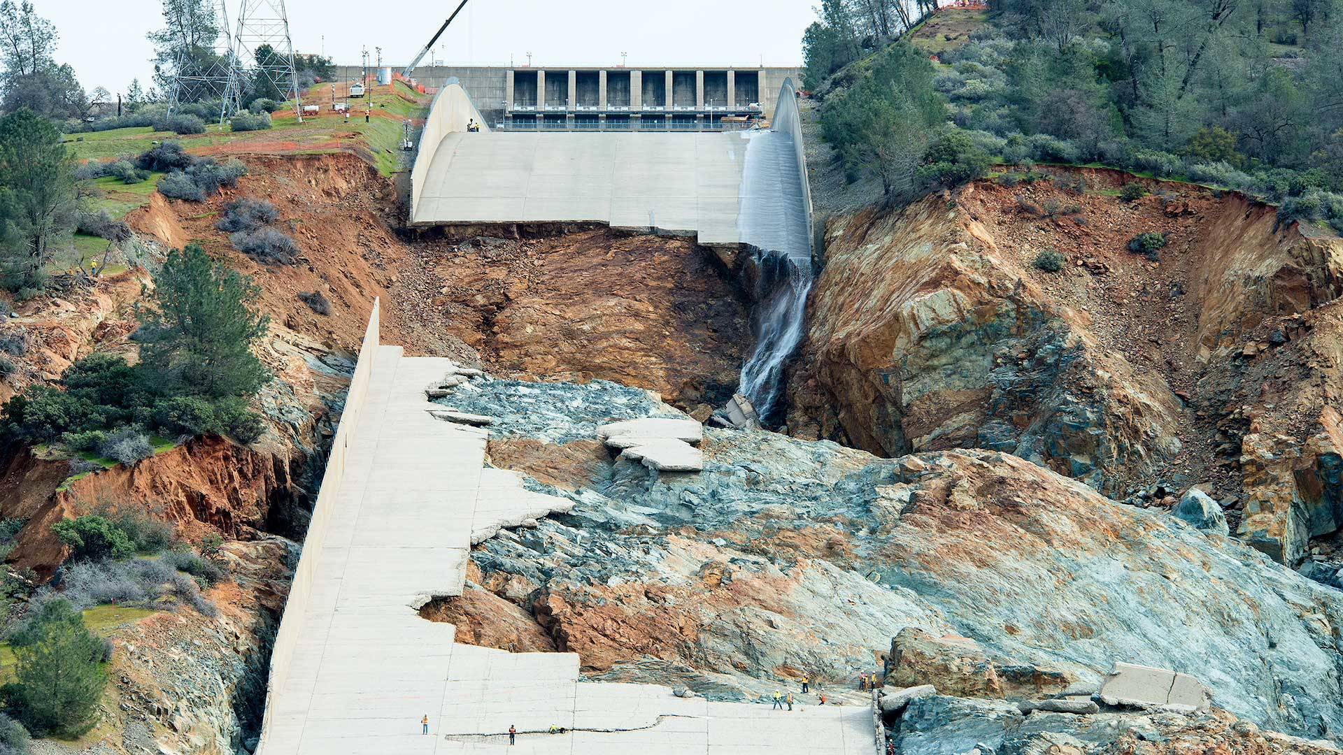
Ruins of the main spillway at Oroville Dam reveal badly eroded areas of rock beneath the concrete structure. A federal-state safety review in 2014 concluded that such erosion was highly unlikely because the rock under the spillway was "very competent." (California Department of Water Resources)
onsider a couple of scenarios for big trouble at Oroville Dam:
First: The facility's main concrete spillway suffers serious damage, resulting in erosion of the rock beneath it -- and potentially threatening the safety of the dam itself.
Second: Water fills Lake Oroville, the gigantic reservoir behind the dam, and begins surging down a steep unpaved hillside that's meant to serve as an emergency spillway. The slope suffers serious erosion, again potentially threatening the dam's safety.
These scenes will sound familiar to anyone who followed the crisis at Oroville, which began to unfold six months ago this week. In fact, you may think you watched them happen.
Sponsored
But these aren't descriptions of actual events. They're worst-case scenarios that a federal-state safety review considered more than two years before Oroville became a synonym for "near catastrophe." The review -- part of a process in which state, federal and independent experts study situations that could threaten a dam -- agreed the scenarios were so unlikely that they didn't merit further consideration.
That finding, apparently based on inaccurate or incomplete information from the California Department of Water Resources about the condition of the dam's spillways and the strength of the rock they were built on, has led some dam safety experts and DWR critics to question both the evidence the safety board reviewed and whether the review process itself is effective.
The study -- called a potential failure mode analysis, or PFMA -- was performed in 2014 as part of what's called a Part 12D safety review, a title that refers to a Federal Energy Regulatory Commission regulation that requires independent safety inspections for most large dams every five years.
The 2014 PFMA declined further study of 31 "candidate" possible failure modes, including the two that outlined possible spillway failures.
Although the details of the evidence analyzed for the spillway failure scenarios is not publicly available, Department of Water Resources documents KQED obtained under the California Public Records Act and other recently released records give a clear indication of why the experts decided to shelve them.
In dismissing the possibility that the main spillway might be lost, a PFMA summary said the 3,000-foot-long concrete chute "is in good condition and the underlying rock is very competent. ... It is seen as highly unlikely that the concrete lining will fail and highly unlikely that significant erosion of the rock will occur during one spilling event."
The summary noted the spillway chute had undergone "minor repairs" in 2009.
The experts declined further study of the emergency spillway scenario -- which contemplated an overflow as much as 25 times greater than the one that actually occurred in February -- because of "the rock between the Feather River and emergency spillway is very competent and resistant to erosion."
"Competent" rock refers to rock that is only lightly weathered and is structurally sound and resistant to erosion. But despite the declarations in the PFMA summary, the February near-disaster showed that extensive areas of the rock underlying the concrete spillway and the hillside serving as the emergency spillway were incompetent and highly erodible.
The PFMA's assumptions about the main spillway, too, are called into question by records that show DWR was well aware the chute's concrete surface was prone to chronic cracking and that water flowed through numerous flaws in the chute floor and undermined parts of the structure.
The records show the spillway underwent top-to-bottom repairs on at least three occasions, including:
1977, when it was less than a decade old.
1997, after record releases caused what DWR described as "distress throughout the length of the spillway" that required issuance of an emergency contract for repair.
2009, when what the PFMA summary describes as "minor repairs" involved repairing cracks, exposed rebar, eroded concrete, broken subsurface drains and voids that had opened under the chute's slab.
The four outside consultants hired to conduct the 2014 Part 12D safety review, including the PFMA process, did not respond to emailed requests for comment.
Department of Water Resources spokeswoman Erin Mellon said in an email Monday the evidence presented for the potential failure mode analysis included a site inspection and historical documents including past geologic studies of the area.
While not offering specifics about the data considered, Mellon said "the information gathered showed the spillway was in good condition and the rock beneath it was extremely competent."
Poor-Quality Rock
J. David Rogers, a professor of geologic engineering at the Missouri University of Science and Technology who has visited the Oroville facility since the February crisis, said he was startled by the description of the rock under the spillways as being sound.
"The principal issue with performance of the service and emergency spillways has been the poor quality of the underlying 'rock,' " Rogers said in an email. He characterized the material as "deeply weathered ... essentially with the consistency of stiff soil, not rock. The depth of weathering varies from 20 to 80 vertical feet, based on simple visual inspection."
Rogers said the review panel would not have had "any easy means" of determining the true character of the material underlying the spillways -- except perhaps for the appearance of "apparently competent" bedrock exposed at the top of the spillway adjacent to the massive control structure that houses a set of eight huge floodgates.
But the appearance of that apparently sound rock might have been misleading, Rogers said, because crews had to remove 70 feet of material to reach it. Most of the rest of the spillway, he said, was excavated no more than 20 or 25 feet deep.
That left masses of weaker material in place under the spillway. When the concrete chute breached during moderate flows in February, he said, "the rushing water was able to pluck crushed rock and soil" from beneath the spillway, ultimately destroying it.
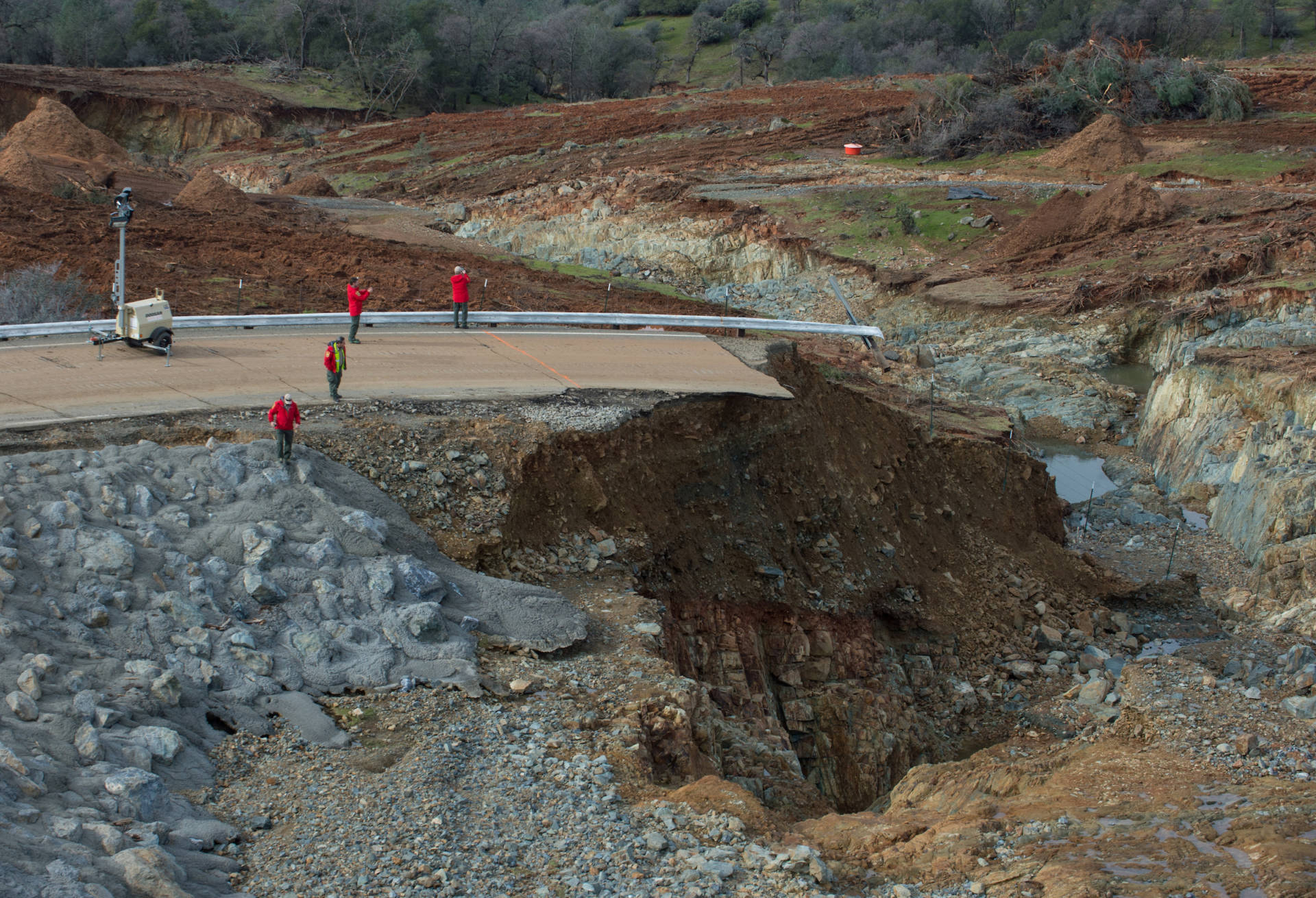
California Department of Water Resources crews inspect and evaluate the erosion in the Oroville Dam's emergency spillway on Feb. 13, the day after state officials ordered the immediate evacuation of residents downstream. DWR had concluded in earlier studies that just 1 to 4 feet of erosion would occur if water flowed down the emergency spillway. (Kelly M. Grow/California Department of Water Resources)
Emergency Spillway: Theory vs. Reality
The main spillway failure in February came just as a series of powerful, warm storms dumped heavy rain over the Feather River watershed, partially melting a thick blanket of snow that had fallen earlier in the season and triggering a surge of runoff into Lake Oroville. Dam managers responded by ramping up releases down the spillway to about 50,000 cubic feet per second, less than 20 percent of its design capacity and about one-third of its record flow rate in January 1997.
After a large hole appeared in the spillway on Feb. 7, DWR temporarily stopped releasing water down the chute, then resumed limited flows as large sections of the rock beneath the concrete structure rapidly eroded -- contrary to the confident assertions that the material was "very competent."
Meantime, the lake rose toward its rim. On Feb. 11, for the first time in the dam's history, water began pouring over a 1,700-foot-long weir adjacent to the concrete chute and down the hill designated as the dam's emergency spillway. Less than 30 hours later, on the afternoon of Feb. 12, uphill erosion of the type dismissed by the 2014 PFMA had scoured channels as much as 50 feet deep and appeared to be threatening the stability of the weir. The fear of a collapse, which would unleash a catastrophic flood down the Feather River, prompted the emergency evacuation of Oroville and other riverside communities.
That uncontrolled flow in February peaked at about 12,500 cubic feet per second, just a tiny fraction of the 350,000 cubic feet -- about 2.6 million gallons -- per second it was supposed to handle. (The regulated flow over Niagara Falls, by comparison, is 100,000 cfs during "tourist" hours.)
That theoretical maximum flow over Oroville's emergency weir represented what might happen in a worst-case flood scenario, when both spillways would have a single purpose: preventing water from flowing over the top of Oroville Dam, an event that could lead to the structure's collapse.
The Department of Water Resources and FERC had insisted for more than a decade prior to the February emergency -- and through three separate potential failure mode analyses -- that even under the duress of extremely high flows racing down the tree- and brush-covered slope, erosion would be limited to just 1 to 4 feet of surface material.
Erin Mellon, the DWR spokeswoman, on Monday repeated earlier department statements that it's up to an independent forensics team -- appointed in March at FERC's direction -- to analyze the causes of the spillway failure. She didn't respond to a question about why DWR's understanding of the conditions underlying the spillways was so different from actual conditions.
Federal Energy Regulatory Commission spokeswoman Celeste Miller said that a "panel of expert consultants" is reviewing the history and performance of the agency's safety program, including past potential failure analyses, for Oroville Dam.
A Need for Re-evaluation?
Martin McCann, an adjunct professor at Stanford’s College of Civil and Environmental Engineering and director of the college’s National Performance of Dams Program, says the Oroville episode shows a re-evaluation of the way potential failure mode analyses are done may be in order.
"In light of the two regulatory bodies and a responsible owner being involved in the PFMA process, we've got to ask ourselves, 'Are we getting it right?'" McCann said in an interview.
"This stuff is not easy -- it really is quite difficult," he said. "It takes expertise, it takes experience, it takes interpretation and evaluation on the part of experts, and that's very hard. Perhaps the process needs to be re-examined."
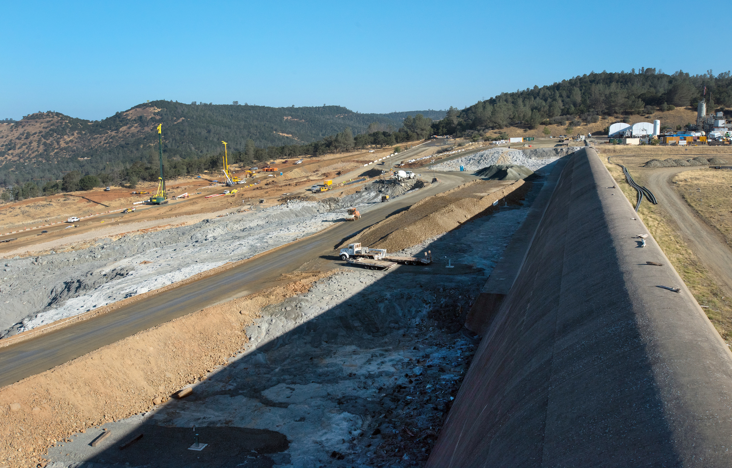
July construction activity below Oroville Dam's emergency weir. Crews are building a massive wall in the slope below the weir to prevent potentially dangerous erosion of the kind that appeared during an overflow in February. (Kelly M. Grow/California Department of Water Resources)
David Rogers, the Missouri geoengineering expert, said Oroville could shake up future safety dam reviews.
"Unexpected failures have a way of waking people up and providing a much needed 'reality check' for both the engineers and the politicians," Rogers said.
One of those who agrees is Assemblyman James Gallagher, who represents Oroville. He's proposed legislation, AB 1270, that would require more frequent and tougher dam safety inspections and subject them to periodic review by UC Berkeley's Center for Catastrophic Risk Management.
Gallagher said in an interview last week that the 2014 PFMA decision to decline further study of the possibility of spillway failures "goes to one of the fundamental issues" raised by the Oroville crisis.
"We have independent oversight," Gallagher said. "But the question is, are they asking the right questions? Do they have the right data to properly provide that oversight? ... When something catastrophic happens, do we have enough information and the right processes and procedures in place to handle those situations? And the answer right now is clearly, no, we don't."
This story has been updated to incorporate information from newly released documents on the 2014 Potential Failure Mode Analysis involving Oroville Dam's main and emergency spillways and to include a response from the Federal Energy Regulatory Commission. The story has also been edited to add links to some of the historical documents referenced in the text.
lower waypoint
Stay in touch. Sign up for our daily newsletter.
To learn more about how we use your information, please read our privacy policy.
window.__IS_SSR__=true
window.__INITIAL_STATE__={"attachmentsReducer":{"audio_0":{"type":"attachments","id":"audio_0","imgSizes":{"kqedFullSize":{"file":"https://ww2.kqed.org/news/wp-content/themes/KQED-unified/img/audio_bgs/background0.jpg"}}},"audio_1":{"type":"attachments","id":"audio_1","imgSizes":{"kqedFullSize":{"file":"https://ww2.kqed.org/news/wp-content/themes/KQED-unified/img/audio_bgs/background1.jpg"}}},"audio_2":{"type":"attachments","id":"audio_2","imgSizes":{"kqedFullSize":{"file":"https://ww2.kqed.org/news/wp-content/themes/KQED-unified/img/audio_bgs/background2.jpg"}}},"audio_3":{"type":"attachments","id":"audio_3","imgSizes":{"kqedFullSize":{"file":"https://ww2.kqed.org/news/wp-content/themes/KQED-unified/img/audio_bgs/background3.jpg"}}},"audio_4":{"type":"attachments","id":"audio_4","imgSizes":{"kqedFullSize":{"file":"https://ww2.kqed.org/news/wp-content/themes/KQED-unified/img/audio_bgs/background4.jpg"}}},"placeholder":{"type":"attachments","id":"placeholder","imgSizes":{"thumbnail":{"file":"https://ww2.kqed.org/wp-content/uploads/sites/10/2018/01/GettyImages-896326950-160x96.jpg","width":160,"height":96,"mimeType":"image/jpeg"},"medium":{"file":"https://ww2.kqed.org/wp-content/uploads/sites/10/2018/01/GettyImages-896326950-800x478.jpg","width":800,"height":478,"mimeType":"image/jpeg"},"large":{"file":"https://ww2.kqed.org/wp-content/uploads/sites/10/2018/01/GettyImages-896326950-1020x610.jpg","width":1020,"height":610,"mimeType":"image/jpeg"},"fd-lrg":{"file":"https://ww2.kqed.org/wp-content/uploads/sites/10/2018/01/GettyImages-896326950-1920x1148.jpg","width":1920,"height":1148,"mimeType":"image/jpeg"},"fd-med":{"file":"https://ww2.kqed.org/wp-content/uploads/sites/10/2018/01/GettyImages-896326950-1180x705.jpg","width":1180,"height":705,"mimeType":"image/jpeg"},"fd-sm":{"file":"https://ww2.kqed.org/wp-content/uploads/sites/10/2018/01/GettyImages-896326950-960x574.jpg","width":960,"height":574,"mimeType":"image/jpeg"},"post-thumbnail":{"file":"https://ww2.kqed.org/wp-content/uploads/sites/10/2018/01/GettyImages-896326950-672x372.jpg","width":672,"height":372,"mimeType":"image/jpeg"},"twentyfourteen-full-width":{"file":"https://ww2.kqed.org/wp-content/uploads/sites/10/2018/01/GettyImages-896326950-1038x576.jpg","width":1038,"height":576,"mimeType":"image/jpeg"},"xxsmall":{"file":"https://ww2.kqed.org/wp-content/uploads/sites/10/2018/01/GettyImages-896326950-240x143.jpg","width":240,"height":143,"mimeType":"image/jpeg"},"xsmall":{"file":"https://ww2.kqed.org/wp-content/uploads/sites/10/2018/01/GettyImages-896326950-375x224.jpg","width":375,"height":224,"mimeType":"image/jpeg"},"small":{"file":"https://ww2.kqed.org/wp-content/uploads/sites/10/2018/01/GettyImages-896326950-520x311.jpg","width":520,"height":311,"mimeType":"image/jpeg"},"xlarge":{"file":"https://ww2.kqed.org/wp-content/uploads/sites/10/2018/01/GettyImages-896326950-1180x705.jpg","width":1180,"height":705,"mimeType":"image/jpeg"},"full-width":{"file":"https://ww2.kqed.org/wp-content/uploads/sites/10/2018/01/GettyImages-896326950-1920x1148.jpg","width":1920,"height":1148,"mimeType":"image/jpeg"},"guest-author-32":{"file":"https://ww2.kqed.org/wp-content/uploads/sites/10/2018/01/GettyImages-896326950-32x32.jpg","width":32,"height":32,"mimeType":"image/jpeg"},"guest-author-50":{"file":"https://ww2.kqed.org/wp-content/uploads/sites/10/2018/01/GettyImages-896326950-50x50.jpg","width":50,"height":50,"mimeType":"image/jpeg"},"guest-author-64":{"file":"https://ww2.kqed.org/wp-content/uploads/sites/10/2018/01/GettyImages-896326950-64x64.jpg","width":64,"height":64,"mimeType":"image/jpeg"},"guest-author-96":{"file":"https://ww2.kqed.org/wp-content/uploads/sites/10/2018/01/GettyImages-896326950-96x96.jpg","width":96,"height":96,"mimeType":"image/jpeg"},"guest-author-128":{"file":"https://ww2.kqed.org/wp-content/uploads/sites/10/2018/01/GettyImages-896326950-128x128.jpg","width":128,"height":128,"mimeType":"image/jpeg"},"detail":{"file":"https://ww2.kqed.org/wp-content/uploads/sites/10/2018/01/GettyImages-896326950-150x150.jpg","width":150,"height":150,"mimeType":"image/jpeg"},"kqedFullSize":{"file":"https://ww2.kqed.org/wp-content/uploads/sites/10/2018/01/GettyImages-896326950-e1514998105161.jpg","width":1920,"height":1148}}},"news_11983626":{"type":"attachments","id":"news_11983626","meta":{"index":"attachments_1591205162","site":"news","id":"11983626","found":true},"title":"012324_Solar-Panels_LJ_CM_15 copy","publishDate":1713645479,"status":"inherit","parent":11983622,"modified":1713645523,"caption":"Ken Wells of O&M Solar Services in Los Angeles, outside a home with solar panels in Ladera Heights.\n","credit":"Lauren Justice for CalMatters","altTag":null,"description":null,"imgSizes":{"medium":{"file":"https://cdn.kqed.org/wp-content/uploads/sites/10/2024/04/012324_Solar-Panels_LJ_CM_15-copy-800x533.jpg","width":800,"height":533,"mimeType":"image/jpeg"},"large":{"file":"https://cdn.kqed.org/wp-content/uploads/sites/10/2024/04/012324_Solar-Panels_LJ_CM_15-copy-1020x680.jpg","width":1020,"height":680,"mimeType":"image/jpeg"},"thumbnail":{"file":"https://cdn.kqed.org/wp-content/uploads/sites/10/2024/04/012324_Solar-Panels_LJ_CM_15-copy-160x107.jpg","width":160,"height":107,"mimeType":"image/jpeg"},"1536x1536":{"file":"https://cdn.kqed.org/wp-content/uploads/sites/10/2024/04/012324_Solar-Panels_LJ_CM_15-copy-1536x1024.jpg","width":1536,"height":1024,"mimeType":"image/jpeg"},"post-thumbnail":{"file":"https://cdn.kqed.org/wp-content/uploads/sites/10/2024/04/012324_Solar-Panels_LJ_CM_15-copy-672x372.jpg","width":672,"height":372,"mimeType":"image/jpeg"},"twentyfourteen-full-width":{"file":"https://cdn.kqed.org/wp-content/uploads/sites/10/2024/04/012324_Solar-Panels_LJ_CM_15-copy-1038x576.jpg","width":1038,"height":576,"mimeType":"image/jpeg"},"full-width":{"file":"https://cdn.kqed.org/wp-content/uploads/sites/10/2024/04/012324_Solar-Panels_LJ_CM_15-copy-1920x1280.jpg","width":1920,"height":1280,"mimeType":"image/jpeg"},"kqedFullSize":{"file":"https://cdn.kqed.org/wp-content/uploads/sites/10/2024/04/012324_Solar-Panels_LJ_CM_15-copy.jpg","width":2000,"height":1333}},"fetchFailed":false,"isLoading":false},"news_11982792":{"type":"attachments","id":"news_11982792","meta":{"index":"attachments_1591205162","site":"news","id":"11982792","found":true},"title":"240412-OAKAIRPORT-027-BL-KQED","publishDate":1712942276,"status":"inherit","parent":0,"modified":1712942294,"caption":"Passengers walk in to the Oakland International Airport in Oakland on April 12, 2024.","credit":"Beth LaBerge/KQED","altTag":null,"description":null,"imgSizes":{"medium":{"file":"https://cdn.kqed.org/wp-content/uploads/sites/10/2024/04/240412-OAKAIRPORT-027-BL-KQED-800x533.jpg","width":800,"height":533,"mimeType":"image/jpeg"},"large":{"file":"https://cdn.kqed.org/wp-content/uploads/sites/10/2024/04/240412-OAKAIRPORT-027-BL-KQED-1020x680.jpg","width":1020,"height":680,"mimeType":"image/jpeg"},"thumbnail":{"file":"https://cdn.kqed.org/wp-content/uploads/sites/10/2024/04/240412-OAKAIRPORT-027-BL-KQED-160x107.jpg","width":160,"height":107,"mimeType":"image/jpeg"},"1536x1536":{"file":"https://cdn.kqed.org/wp-content/uploads/sites/10/2024/04/240412-OAKAIRPORT-027-BL-KQED-1536x1024.jpg","width":1536,"height":1024,"mimeType":"image/jpeg"},"post-thumbnail":{"file":"https://cdn.kqed.org/wp-content/uploads/sites/10/2024/04/240412-OAKAIRPORT-027-BL-KQED-672x372.jpg","width":672,"height":372,"mimeType":"image/jpeg"},"twentyfourteen-full-width":{"file":"https://cdn.kqed.org/wp-content/uploads/sites/10/2024/04/240412-OAKAIRPORT-027-BL-KQED-1038x576.jpg","width":1038,"height":576,"mimeType":"image/jpeg"},"full-width":{"file":"https://cdn.kqed.org/wp-content/uploads/sites/10/2024/04/240412-OAKAIRPORT-027-BL-KQED-1920x1280.jpg","width":1920,"height":1280,"mimeType":"image/jpeg"},"kqedFullSize":{"file":"https://cdn.kqed.org/wp-content/uploads/sites/10/2024/04/240412-OAKAIRPORT-027-BL-KQED.jpg","width":2000,"height":1333}},"fetchFailed":false,"isLoading":false},"news_11983711":{"type":"attachments","id":"news_11983711","meta":{"index":"attachments_1591205162","site":"news","id":"11983711","found":true},"title":"GettyImages-1253315032_qut (1)","publishDate":1713819066,"status":"inherit","parent":11983705,"modified":1713821059,"caption":"A view of San Quentin State Prison on June 29, 2020 in San Quentin.","credit":"Justin Sullivan / Getty Images","altTag":"A view of a sign that reads 'California State Prison San Quentin' next to a gate with a prison in the background.","description":null,"imgSizes":{"medium":{"file":"https://cdn.kqed.org/wp-content/uploads/sites/10/2024/04/GettyImages-1253315032_qut-1-800x533.jpg","width":800,"height":533,"mimeType":"image/jpeg"},"large":{"file":"https://cdn.kqed.org/wp-content/uploads/sites/10/2024/04/GettyImages-1253315032_qut-1-1020x680.jpg","width":1020,"height":680,"mimeType":"image/jpeg"},"thumbnail":{"file":"https://cdn.kqed.org/wp-content/uploads/sites/10/2024/04/GettyImages-1253315032_qut-1-160x107.jpg","width":160,"height":107,"mimeType":"image/jpeg"},"1536x1536":{"file":"https://cdn.kqed.org/wp-content/uploads/sites/10/2024/04/GettyImages-1253315032_qut-1-1536x1024.jpg","width":1536,"height":1024,"mimeType":"image/jpeg"},"post-thumbnail":{"file":"https://cdn.kqed.org/wp-content/uploads/sites/10/2024/04/GettyImages-1253315032_qut-1-672x372.jpg","width":672,"height":372,"mimeType":"image/jpeg"},"twentyfourteen-full-width":{"file":"https://cdn.kqed.org/wp-content/uploads/sites/10/2024/04/GettyImages-1253315032_qut-1-1038x576.jpg","width":1038,"height":576,"mimeType":"image/jpeg"},"kqedFullSize":{"file":"https://cdn.kqed.org/wp-content/uploads/sites/10/2024/04/GettyImages-1253315032_qut-1.jpg","width":1920,"height":1280}},"fetchFailed":false,"isLoading":false},"news_11983781":{"type":"attachments","id":"news_11983781","meta":{"index":"attachments_1591205162","site":"news","id":"11983781","found":true},"title":"The Rev. Cecil Williams monitored the activity outside during the annual grocery bag giveaway for those in need at Glide Memorial Church in San Francisco, Calif. on Wednesday, Dec. 19, 2007. Each of the 6,000 bags contained either a turkey or a chicken, p","publishDate":1713836950,"status":"inherit","parent":11983768,"modified":1713837195,"caption":"Rev. Cecil Williams monitoring the annual grocery bag giveaway for those in need at Glide Memorial Church in San Francisco, on Dec. 19, 2007.","credit":"Paul Chinn/The San Francisco Chronicle via Getty Images","altTag":"An older Black man walks outside Glide Memorial Methodist Church, where barricades are set up and people stand in line.","description":null,"imgSizes":{"medium":{"file":"https://cdn.kqed.org/wp-content/uploads/sites/10/2024/04/GettyImages-1408381483-800x551.jpg","width":800,"height":551,"mimeType":"image/jpeg"},"large":{"file":"https://cdn.kqed.org/wp-content/uploads/sites/10/2024/04/GettyImages-1408381483-1020x702.jpg","width":1020,"height":702,"mimeType":"image/jpeg"},"thumbnail":{"file":"https://cdn.kqed.org/wp-content/uploads/sites/10/2024/04/GettyImages-1408381483-160x110.jpg","width":160,"height":110,"mimeType":"image/jpeg"},"post-thumbnail":{"file":"https://cdn.kqed.org/wp-content/uploads/sites/10/2024/04/GettyImages-1408381483-672x372.jpg","width":672,"height":372,"mimeType":"image/jpeg"},"twentyfourteen-full-width":{"file":"https://cdn.kqed.org/wp-content/uploads/sites/10/2024/04/GettyImages-1408381483-1024x576.jpg","width":1024,"height":576,"mimeType":"image/jpeg"},"kqedFullSize":{"file":"https://cdn.kqed.org/wp-content/uploads/sites/10/2024/04/GettyImages-1408381483.jpg","width":1024,"height":705}},"fetchFailed":false,"isLoading":false},"news_11983678":{"type":"attachments","id":"news_11983678","meta":{"index":"attachments_1591205162","site":"news","id":"11983678","found":true},"title":"DCCC01","publishDate":1713812025,"status":"inherit","parent":11983671,"modified":1713816139,"caption":"State Sen. Scott Wiener swears in the new DCCC members at the April meeting of the Democratic County Central Committee.","credit":"Joe Fitzgerald Rodriguez/KQED","altTag":null,"description":null,"imgSizes":{"medium":{"file":"https://cdn.kqed.org/wp-content/uploads/sites/10/2024/04/DCCC01-800x533.jpg","width":800,"height":533,"mimeType":"image/jpeg"},"large":{"file":"https://cdn.kqed.org/wp-content/uploads/sites/10/2024/04/DCCC01-1020x680.jpg","width":1020,"height":680,"mimeType":"image/jpeg"},"thumbnail":{"file":"https://cdn.kqed.org/wp-content/uploads/sites/10/2024/04/DCCC01-160x107.jpg","width":160,"height":107,"mimeType":"image/jpeg"},"1536x1536":{"file":"https://cdn.kqed.org/wp-content/uploads/sites/10/2024/04/DCCC01-1536x1024.jpg","width":1536,"height":1024,"mimeType":"image/jpeg"},"post-thumbnail":{"file":"https://cdn.kqed.org/wp-content/uploads/sites/10/2024/04/DCCC01-672x372.jpg","width":672,"height":372,"mimeType":"image/jpeg"},"twentyfourteen-full-width":{"file":"https://cdn.kqed.org/wp-content/uploads/sites/10/2024/04/DCCC01-1038x576.jpg","width":1038,"height":576,"mimeType":"image/jpeg"},"kqedFullSize":{"file":"https://cdn.kqed.org/wp-content/uploads/sites/10/2024/04/DCCC01.jpg","width":1920,"height":1280}},"fetchFailed":false,"isLoading":false},"news_11983549":{"type":"attachments","id":"news_11983549","meta":{"index":"attachments_1591205162","site":"news","id":"11983549","found":true},"title":"TOPSHOT-INDIA-POLITICS-ELECTION","publishDate":1713569941,"status":"inherit","parent":11983481,"modified":1713571171,"caption":"College students spread awareness for first-generation voters during an election campaign ahead of India's upcoming national elections in Chennai, India, on March 19, 2024. ","credit":"R. Satish Babu/AFP via Getty Images","altTag":"An arm with an index finger points upward. Ink is on the fingertip, and the word \"vote\" is written on the back of the hand. Blurred faces painted with Indian flags are seen in the background.","description":null,"imgSizes":{"medium":{"file":"https://cdn.kqed.org/wp-content/uploads/sites/10/2024/04/GettyImages-2087343469-800x534.jpg","width":800,"height":534,"mimeType":"image/jpeg"},"large":{"file":"https://cdn.kqed.org/wp-content/uploads/sites/10/2024/04/GettyImages-2087343469-1020x680.jpg","width":1020,"height":680,"mimeType":"image/jpeg"},"thumbnail":{"file":"https://cdn.kqed.org/wp-content/uploads/sites/10/2024/04/GettyImages-2087343469-160x107.jpg","width":160,"height":107,"mimeType":"image/jpeg"},"post-thumbnail":{"file":"https://cdn.kqed.org/wp-content/uploads/sites/10/2024/04/GettyImages-2087343469-672x372.jpg","width":672,"height":372,"mimeType":"image/jpeg"},"twentyfourteen-full-width":{"file":"https://cdn.kqed.org/wp-content/uploads/sites/10/2024/04/GettyImages-2087343469-1024x576.jpg","width":1024,"height":576,"mimeType":"image/jpeg"},"kqedFullSize":{"file":"https://cdn.kqed.org/wp-content/uploads/sites/10/2024/04/GettyImages-2087343469.jpg","width":1024,"height":683}},"fetchFailed":false,"isLoading":false},"news_11983691":{"type":"attachments","id":"news_11983691","meta":{"index":"attachments_1591205162","site":"news","id":"11983691","found":true},"title":"IMG_7874","publishDate":1713814190,"status":"inherit","parent":0,"modified":1713823055,"caption":"Monique Harris (center left) and Patrice Strahan (center right) gather at the San Francisco Federal Building on April 22, 2024, to urge the U.S. Supreme Court to uphold rules prohibiting cities from fining or jailing unhoused people when viable shelter alternatives are not available. ","credit":"Kathryn Styer Martínez/KQED","altTag":"A Black woman in a wheelchair is among a group of protesters holding signs like 'Fight Poverty' and 'Homes not Sweeps.'","description":null,"imgSizes":{"medium":{"file":"https://cdn.kqed.org/wp-content/uploads/sites/10/2024/04/IMG_7874-800x533.jpeg","width":800,"height":533,"mimeType":"image/jpeg"},"large":{"file":"https://cdn.kqed.org/wp-content/uploads/sites/10/2024/04/IMG_7874-1020x680.jpeg","width":1020,"height":680,"mimeType":"image/jpeg"},"thumbnail":{"file":"https://cdn.kqed.org/wp-content/uploads/sites/10/2024/04/IMG_7874-160x107.jpeg","width":160,"height":107,"mimeType":"image/jpeg"},"1536x1536":{"file":"https://cdn.kqed.org/wp-content/uploads/sites/10/2024/04/IMG_7874-1536x1024.jpeg","width":1536,"height":1024,"mimeType":"image/jpeg"},"post-thumbnail":{"file":"https://cdn.kqed.org/wp-content/uploads/sites/10/2024/04/IMG_7874-672x372.jpeg","width":672,"height":372,"mimeType":"image/jpeg"},"twentyfourteen-full-width":{"file":"https://cdn.kqed.org/wp-content/uploads/sites/10/2024/04/IMG_7874-1038x576.jpeg","width":1038,"height":576,"mimeType":"image/jpeg"},"kqedFullSize":{"file":"https://cdn.kqed.org/wp-content/uploads/sites/10/2024/04/IMG_7874.jpeg","width":1824,"height":1216}},"fetchFailed":false,"isLoading":false},"news_11983729":{"type":"attachments","id":"news_11983729","meta":{"index":"attachments_1591205162","site":"news","id":"11983729","found":true},"title":"240422-NursesAI-29-BL","publishDate":1713822684,"status":"inherit","parent":0,"modified":1713832954,"caption":"Claire Siegel rallies alongside fellow nurses from across California at Kaiser Permanente on Geary Boulevard in San Francisco on April 22, 2024, to advocate for patient safety in the face of artificial intelligence technology.","credit":"Beth LaBerge/KQED","altTag":"A woman with glasses holds a sign above her head that reads 'Patients are NOT algorithms' in front of a Kaiser Permanence building.","description":null,"imgSizes":{"medium":{"file":"https://cdn.kqed.org/wp-content/uploads/sites/10/2024/04/240422-NursesAI-29-BL-800x533.jpg","width":800,"height":533,"mimeType":"image/jpeg"},"large":{"file":"https://cdn.kqed.org/wp-content/uploads/sites/10/2024/04/240422-NursesAI-29-BL-1020x680.jpg","width":1020,"height":680,"mimeType":"image/jpeg"},"thumbnail":{"file":"https://cdn.kqed.org/wp-content/uploads/sites/10/2024/04/240422-NursesAI-29-BL-160x107.jpg","width":160,"height":107,"mimeType":"image/jpeg"},"1536x1536":{"file":"https://cdn.kqed.org/wp-content/uploads/sites/10/2024/04/240422-NursesAI-29-BL-1536x1024.jpg","width":1536,"height":1024,"mimeType":"image/jpeg"},"2048x2048":{"file":"https://cdn.kqed.org/wp-content/uploads/sites/10/2024/04/240422-NursesAI-29-BL-2048x1366.jpg","width":2048,"height":1366,"mimeType":"image/jpeg"},"post-thumbnail":{"file":"https://cdn.kqed.org/wp-content/uploads/sites/10/2024/04/240422-NursesAI-29-BL-672x372.jpg","width":672,"height":372,"mimeType":"image/jpeg"},"twentyfourteen-full-width":{"file":"https://cdn.kqed.org/wp-content/uploads/sites/10/2024/04/240422-NursesAI-29-BL-1038x576.jpg","width":1038,"height":576,"mimeType":"image/jpeg"},"full-width":{"file":"https://cdn.kqed.org/wp-content/uploads/sites/10/2024/04/240422-NursesAI-29-BL-1920x1280.jpg","width":1920,"height":1280,"mimeType":"image/jpeg"},"kqedFullSize":{"file":"https://cdn.kqed.org/wp-content/uploads/sites/10/2024/04/240422-NursesAI-29-BL-scaled.jpg","width":2560,"height":1707}},"fetchFailed":false,"isLoading":false},"news_11983657":{"type":"attachments","id":"news_11983657","meta":{"index":"attachments_1591205162","site":"news","id":"11983657","found":true},"title":"Redwood Heights Elementary School","publishDate":1713804806,"status":"inherit","parent":11983654,"modified":1713813439,"caption":"First graders at Redwood Heights Elementary School in Oakland, California, Wednesday, June 4, 2014.","credit":"Alison Yin/EdSource","altTag":null,"description":null,"imgSizes":{"medium":{"file":"https://cdn.kqed.org/wp-content/uploads/sites/10/2024/04/EdSource01-800x533.jpg","width":800,"height":533,"mimeType":"image/jpeg"},"large":{"file":"https://cdn.kqed.org/wp-content/uploads/sites/10/2024/04/EdSource01-1020x680.jpg","width":1020,"height":680,"mimeType":"image/jpeg"},"thumbnail":{"file":"https://cdn.kqed.org/wp-content/uploads/sites/10/2024/04/EdSource01-160x107.jpg","width":160,"height":107,"mimeType":"image/jpeg"},"1536x1536":{"file":"https://cdn.kqed.org/wp-content/uploads/sites/10/2024/04/EdSource01-1536x1024.jpg","width":1536,"height":1024,"mimeType":"image/jpeg"},"post-thumbnail":{"file":"https://cdn.kqed.org/wp-content/uploads/sites/10/2024/04/EdSource01-672x372.jpg","width":672,"height":372,"mimeType":"image/jpeg"},"twentyfourteen-full-width":{"file":"https://cdn.kqed.org/wp-content/uploads/sites/10/2024/04/EdSource01-1038x576.jpg","width":1038,"height":576,"mimeType":"image/jpeg"},"kqedFullSize":{"file":"https://cdn.kqed.org/wp-content/uploads/sites/10/2024/04/EdSource01.jpg","width":1920,"height":1280}},"fetchFailed":false,"isLoading":false},"news_11813537":{"type":"attachments","id":"news_11813537","meta":{"index":"attachments_1591205162","site":"news","id":"11813537","found":true},"title":"earth-day-gettyimages-456798650","publishDate":1587533925,"status":"inherit","parent":11813529,"modified":1587534107,"caption":"Students with masks participate in a march on April 20, 1970, during the first Earth Day.","credit":"Santi Visalli/Getty Images","description":null,"imgSizes":{"thumbnail":{"file":"https://ww2.kqed.org/app/uploads/sites/10/2020/04/earth-day-gettyimages-456798650-e1587534173339-160x130.jpg","width":160,"height":130,"mimeType":"image/jpeg"},"medium":{"file":"https://ww2.kqed.org/app/uploads/sites/10/2020/04/earth-day-gettyimages-456798650-e1587534173339-800x648.jpg","width":800,"height":648,"mimeType":"image/jpeg"},"large":{"file":"https://ww2.kqed.org/app/uploads/sites/10/2020/04/earth-day-gettyimages-456798650-e1587534173339-1020x826.jpg","width":1020,"height":826,"mimeType":"image/jpeg"},"post-thumbnail":{"file":"https://ww2.kqed.org/app/uploads/sites/10/2020/04/earth-day-gettyimages-456798650-e1587534173339-672x372.jpg","width":672,"height":372,"mimeType":"image/jpeg"},"twentyfourteen-full-width":{"file":"https://ww2.kqed.org/app/uploads/sites/10/2020/04/earth-day-gettyimages-456798650-e1587534173339-1038x576.jpg","width":1038,"height":576,"mimeType":"image/jpeg"},"apple_news_ca_landscape_9_7":{"file":"https://ww2.kqed.org/app/uploads/sites/10/2020/04/earth-day-gettyimages-456798650-1200x1032.jpg","width":1200,"height":1032,"mimeType":"image/jpeg"},"apple_news_ca_landscape_5_5":{"file":"https://ww2.kqed.org/app/uploads/sites/10/2020/04/earth-day-gettyimages-456798650-e1587534173339-1044x783.jpg","width":1044,"height":783,"mimeType":"image/jpeg"},"apple_news_ca_landscape_4_7":{"file":"https://ww2.kqed.org/app/uploads/sites/10/2020/04/earth-day-gettyimages-456798650-e1587534173339-632x474.jpg","width":632,"height":474,"mimeType":"image/jpeg"},"apple_news_ca_landscape_4_0":{"file":"https://ww2.kqed.org/app/uploads/sites/10/2020/04/earth-day-gettyimages-456798650-e1587534173339-536x402.jpg","width":536,"height":402,"mimeType":"image/jpeg"},"apple_news_ca_portrait_12_9":{"file":"https://ww2.kqed.org/app/uploads/sites/10/2020/04/earth-day-gettyimages-456798650-e1587534173339-1122x972.jpg","width":1122,"height":972,"mimeType":"image/jpeg"},"apple_news_ca_portrait_9_7":{"file":"https://ww2.kqed.org/app/uploads/sites/10/2020/04/earth-day-gettyimages-456798650-e1587534173339-840x972.jpg","width":840,"height":972,"mimeType":"image/jpeg"},"apple_news_ca_portrait_5_5":{"file":"https://ww2.kqed.org/app/uploads/sites/10/2020/04/earth-day-gettyimages-456798650-e1587534173339-687x916.jpg","width":687,"height":916,"mimeType":"image/jpeg"},"apple_news_ca_portrait_4_7":{"file":"https://ww2.kqed.org/app/uploads/sites/10/2020/04/earth-day-gettyimages-456798650-e1587534173339-414x552.jpg","width":414,"height":552,"mimeType":"image/jpeg"},"apple_news_ca_portrait_4_0":{"file":"https://ww2.kqed.org/app/uploads/sites/10/2020/04/earth-day-gettyimages-456798650-e1587534173339-354x472.jpg","width":354,"height":472,"mimeType":"image/jpeg"},"apple_news_ca_square_9_7":{"file":"https://ww2.kqed.org/app/uploads/sites/10/2020/04/earth-day-gettyimages-456798650-e1587534173339-1104x972.jpg","width":1104,"height":972,"mimeType":"image/jpeg"},"apple_news_ca_square_5_5":{"file":"https://ww2.kqed.org/app/uploads/sites/10/2020/04/earth-day-gettyimages-456798650-e1587534173339-912x912.jpg","width":912,"height":912,"mimeType":"image/jpeg"},"apple_news_ca_square_4_7":{"file":"https://ww2.kqed.org/app/uploads/sites/10/2020/04/earth-day-gettyimages-456798650-e1587534173339-550x550.jpg","width":550,"height":550,"mimeType":"image/jpeg"},"apple_news_ca_square_4_0":{"file":"https://ww2.kqed.org/app/uploads/sites/10/2020/04/earth-day-gettyimages-456798650-e1587534173339-470x470.jpg","width":470,"height":470,"mimeType":"image/jpeg"},"kqedFullSize":{"file":"https://ww2.kqed.org/app/uploads/sites/10/2020/04/earth-day-gettyimages-456798650-e1587534173339.jpg","width":1200,"height":972}},"fetchFailed":false,"isLoading":false},"news_11397560":{"type":"attachments","id":"news_11397560","meta":{"index":"attachments_1591205162","site":"news","id":"11397560","found":true},"title":"Oroville Dam-Spillway","publishDate":1491612578,"status":"inherit","parent":11397536,"modified":1502235419,"caption":"Ruins of the main spillway at Oroville Dam reveal badly eroded areas of rock beneath the concrete structure. A federal-state safety review in 2014 concluded that such erosion was highly unlikely because the rock under the spillway was \"very competent.\" ","credit":"California Department of Water Resources","description":"Ruins of the main spillway at Oroville Dam reveal a blend of \"fresh\" (blue-gray) rock and \"weahered\" (reddish-brown) rock underneath.","imgSizes":{"thumbnail":{"file":"https://ww2.kqed.org/app/uploads/sites/10/2017/04/ORO_FI_06-1920x1080-160x90.jpg","width":160,"height":90,"mimeType":"image/jpeg"},"medium":{"file":"https://ww2.kqed.org/app/uploads/sites/10/2017/04/ORO_FI_06-1920x1080-800x450.jpg","width":800,"height":450,"mimeType":"image/jpeg"},"large":{"file":"https://ww2.kqed.org/app/uploads/sites/10/2017/04/ORO_FI_06-1920x1080-1020x574.jpg","width":1020,"height":574,"mimeType":"image/jpeg"},"fd-lrg":{"file":"https://ww2.kqed.org/app/uploads/sites/10/2017/04/ORO_FI_06-1920x1080-1920x1080.jpg","width":1920,"height":1080,"mimeType":"image/jpeg"},"fd-med":{"file":"https://ww2.kqed.org/app/uploads/sites/10/2017/04/ORO_FI_06-1920x1080-1180x664.jpg","width":1180,"height":664,"mimeType":"image/jpeg"},"fd-sm":{"file":"https://ww2.kqed.org/app/uploads/sites/10/2017/04/ORO_FI_06-1920x1080-960x540.jpg","width":960,"height":540,"mimeType":"image/jpeg"},"post-thumbnail":{"file":"https://ww2.kqed.org/app/uploads/sites/10/2017/04/ORO_FI_06-1920x1080-672x372.jpg","width":672,"height":372,"mimeType":"image/jpeg"},"twentyfourteen-full-width":{"file":"https://ww2.kqed.org/app/uploads/sites/10/2017/04/ORO_FI_06-1920x1080-1038x576.jpg","width":1038,"height":576,"mimeType":"image/jpeg"},"xxsmall":{"file":"https://ww2.kqed.org/app/uploads/sites/10/2017/04/ORO_FI_06-1920x1080-240x135.jpg","width":240,"height":135,"mimeType":"image/jpeg"},"xsmall":{"file":"https://ww2.kqed.org/app/uploads/sites/10/2017/04/ORO_FI_06-1920x1080-375x211.jpg","width":375,"height":211,"mimeType":"image/jpeg"},"small":{"file":"https://ww2.kqed.org/app/uploads/sites/10/2017/04/ORO_FI_06-1920x1080-520x293.jpg","width":520,"height":293,"mimeType":"image/jpeg"},"xlarge":{"file":"https://ww2.kqed.org/app/uploads/sites/10/2017/04/ORO_FI_06-1920x1080-1180x664.jpg","width":1180,"height":664,"mimeType":"image/jpeg"},"full-width":{"file":"https://ww2.kqed.org/app/uploads/sites/10/2017/04/ORO_FI_06-1920x1080-1920x1080.jpg","width":1920,"height":1080,"mimeType":"image/jpeg"},"guest-author-32":{"file":"https://ww2.kqed.org/app/uploads/sites/10/2017/04/ORO_FI_06-1920x1080-32x32.jpg","width":32,"height":32,"mimeType":"image/jpeg"},"guest-author-50":{"file":"https://ww2.kqed.org/app/uploads/sites/10/2017/04/ORO_FI_06-1920x1080-50x50.jpg","width":50,"height":50,"mimeType":"image/jpeg"},"guest-author-64":{"file":"https://ww2.kqed.org/app/uploads/sites/10/2017/04/ORO_FI_06-1920x1080-64x64.jpg","width":64,"height":64,"mimeType":"image/jpeg"},"guest-author-96":{"file":"https://ww2.kqed.org/app/uploads/sites/10/2017/04/ORO_FI_06-1920x1080-96x96.jpg","width":96,"height":96,"mimeType":"image/jpeg"},"guest-author-128":{"file":"https://ww2.kqed.org/app/uploads/sites/10/2017/04/ORO_FI_06-1920x1080-128x128.jpg","width":128,"height":128,"mimeType":"image/jpeg"},"detail":{"file":"https://ww2.kqed.org/app/uploads/sites/10/2017/04/ORO_FI_06-1920x1080-150x150.jpg","width":150,"height":150,"mimeType":"image/jpeg"},"kqedFullSize":{"file":"https://ww2.kqed.org/app/uploads/sites/10/2017/04/ORO_FI_06-1920x1080.jpg","width":1920,"height":1080}},"fetchFailed":false,"isLoading":false}},"audioPlayerReducer":{"postId":"stream_live"},"authorsReducer":{"byline_news_11983622":{"type":"authors","id":"byline_news_11983622","meta":{"override":true},"slug":"byline_news_11983622","name":"\u003ca href=\"https://calmatters.org/author/ben-christopher/\">Ben Christopher\u003c/a>","isLoading":false},"byline_news_11983481":{"type":"authors","id":"byline_news_11983481","meta":{"override":true},"slug":"byline_news_11983481","name":"Sheikh Saaliq\u003cbr>Associated Press","isLoading":false},"byline_news_11983654":{"type":"authors","id":"byline_news_11983654","meta":{"override":true},"slug":"byline_news_11983654","name":"John Fensterwald, EdSource","isLoading":false},"kqednewsstaffandwires":{"type":"authors","id":"237","meta":{"index":"authors_1591205172","id":"237","found":true},"name":"KQED News Staff and Wires","firstName":"KQED News Staff and Wires","lastName":null,"slug":"kqednewsstaffandwires","email":"onlinenewsstaff@kqed.org","display_author_email":false,"staff_mastheads":[],"title":null,"bio":null,"avatar":"https://secure.gravatar.com/avatar/72295af8ebbfbd19a4948f5271285664?s=600&d=blank&r=g","twitter":null,"facebook":null,"instagram":null,"linkedin":null,"sites":[{"site":"arts","roles":["contributor"]},{"site":"news","roles":["contributor"]},{"site":"lowdown","roles":["author"]},{"site":"stateofhealth","roles":["contributor"]},{"site":"food","roles":["author"]}],"headData":{"title":"KQED News Staff and Wires | KQED","description":null,"ogImgSrc":"https://secure.gravatar.com/avatar/72295af8ebbfbd19a4948f5271285664?s=600&d=blank&r=g","twImgSrc":"https://secure.gravatar.com/avatar/72295af8ebbfbd19a4948f5271285664?s=600&d=blank&r=g"},"isLoading":false,"link":"/author/kqednewsstaffandwires"},"matthewgreen":{"type":"authors","id":"1263","meta":{"index":"authors_1591205172","id":"1263","found":true},"name":"Matthew Green","firstName":"Matthew","lastName":"Green","slug":"matthewgreen","email":"mgreen@kqed.org","display_author_email":false,"staff_mastheads":["news"],"title":"KQED Contributor","bio":"Matthew Green is a digital media producer for KQED News. He previously produced \u003ca href=\"http://www.kqed.org/lowdown\">The Lowdown\u003c/a>, KQED’s multimedia news education blog. Matthew's written for numerous Bay Area publications, including the Oakland Tribune and San Francisco Chronicle. He also taught journalism classes at Fremont High School in East Oakland.\r\n\r\nEmail: mgreen@kqed.org; Twitter: @MGreenKQED","avatar":"https://secure.gravatar.com/avatar/3bf498d1267ca02c8494f33d8cfc575e?s=600&d=mm&r=g","twitter":"MGreenKQED","facebook":null,"instagram":null,"linkedin":null,"sites":[{"site":"news","roles":["administrator"]},{"site":"lowdown","roles":["administrator"]},{"site":"stateofhealth","roles":["author"]},{"site":"science","roles":["administrator"]},{"site":"education","roles":["editor"]},{"site":"quest","roles":["editor"]},{"site":"forum","roles":["administrator"]},{"site":"elections","roles":["editor"]},{"site":"liveblog","roles":["editor"]}],"headData":{"title":"Matthew Green | KQED","description":"KQED Contributor","ogImgSrc":"https://secure.gravatar.com/avatar/3bf498d1267ca02c8494f33d8cfc575e?s=600&d=mm&r=g","twImgSrc":"https://secure.gravatar.com/avatar/3bf498d1267ca02c8494f33d8cfc575e?s=600&d=mm&r=g"},"isLoading":false,"link":"/author/matthewgreen"},"ecruzguevarra":{"type":"authors","id":"8654","meta":{"index":"authors_1591205172","id":"8654","found":true},"name":"Ericka Cruz Guevarra","firstName":"Ericka","lastName":"Cruz Guevarra","slug":"ecruzguevarra","email":"ecruzguevarra@kqed.org","display_author_email":true,"staff_mastheads":["news"],"title":"Producer, The Bay Podcast","bio":"Ericka Cruz Guevarra is host of \u003ca href=\"https://www.kqed.org/podcasts/thebay\">\u003cem>The Bay\u003c/em>\u003c/a> podcast at KQED. Before host, she was the show’s producer. Her work in that capacity includes a three-part reported series on policing in Vallejo, which won a 2020 excellence in journalism award from the Society of Professional Journalists. Ericka has worked as a breaking news reporter at Oregon Public Broadcasting, helped produce the Code Switch podcast, and was KQED’s inaugural Raul Ramirez Diversity Fund intern. She’s also an alumna of NPR’s Next Generation Radio program. Send her an email if you have strong feelings about whether Fairfield and Suisun City are the Bay.","avatar":"https://secure.gravatar.com/avatar/25e5ab8d3d53fad2dcc7bb2b5c506b1a?s=600&d=blank&r=g","twitter":"NotoriousECG","facebook":null,"instagram":null,"linkedin":null,"sites":[{"site":"arts","roles":["subscriber"]},{"site":"news","roles":["editor"]},{"site":"futureofyou","roles":["subscriber"]},{"site":"stateofhealth","roles":["subscriber"]},{"site":"science","roles":["editor"]},{"site":"forum","roles":["subscriber"]}],"headData":{"title":"Ericka Cruz Guevarra | KQED","description":"Producer, The Bay Podcast","ogImgSrc":"https://secure.gravatar.com/avatar/25e5ab8d3d53fad2dcc7bb2b5c506b1a?s=600&d=blank&r=g","twImgSrc":"https://secure.gravatar.com/avatar/25e5ab8d3d53fad2dcc7bb2b5c506b1a?s=600&d=blank&r=g"},"isLoading":false,"link":"/author/ecruzguevarra"},"fjhabvala":{"type":"authors","id":"8659","meta":{"index":"authors_1591205172","id":"8659","found":true},"name":"Farida Jhabvala Romero","firstName":"Farida","lastName":"Jhabvala Romero","slug":"fjhabvala","email":"fjhabvala@kqed.org","display_author_email":true,"staff_mastheads":["news"],"title":"KQED Contributor","bio":"\u003cspan style=\"font-weight: 400;\">Farida Jhabvala Romero is a Labor Correspondent for KQED. She previously covered immigration. Farida was \u003ca href=\"https://www.ccnma.org/2022-most-influential-latina-journalists\">named\u003c/a> one of the 10 Most Influential Latina Journalists in California in 2022 by the California Chicano News Media Association. Her work has won awards from the Society of Professional Journalists (Northern California), as well as a national and regional Edward M. Murrow Award for the collaborative reporting projects “Dangerous Air” and “Graying California.” \u003c/span>\u003cspan style=\"font-weight: 400;\">Before joining KQED, Farida worked as a producer at Radio Bilingüe, a national public radio network. Farida earned her master’s degree in journalism from Stanford University.\u003c/span>","avatar":"https://secure.gravatar.com/avatar/c3ab27c5554b67b478f80971e515aa02?s=600&d=blank&r=g","twitter":"FaridaJhabvala","facebook":null,"instagram":null,"linkedin":"https://www.linkedin.com/in/faridajhabvala/","sites":[{"site":"news","roles":["editor"]},{"site":"stateofhealth","roles":["author"]}],"headData":{"title":"Farida Jhabvala Romero | KQED","description":"KQED Contributor","ogImgSrc":"https://secure.gravatar.com/avatar/c3ab27c5554b67b478f80971e515aa02?s=600&d=blank&r=g","twImgSrc":"https://secure.gravatar.com/avatar/c3ab27c5554b67b478f80971e515aa02?s=600&d=blank&r=g"},"isLoading":false,"link":"/author/fjhabvala"},"vrancano":{"type":"authors","id":"11276","meta":{"index":"authors_1591205172","id":"11276","found":true},"name":"Vanessa Rancaño","firstName":"Vanessa","lastName":"Rancaño","slug":"vrancano","email":"vrancano@kqed.org","display_author_email":false,"staff_mastheads":["news"],"title":"Reporter, Housing","bio":"Vanessa Rancaño reports on housing and homelessness for KQED. She’s also covered education for the station and reported from the Central Valley. Her work has aired across public radio, from flagship national news shows to longform narrative podcasts. Before taking up a mic, she worked as a freelance print journalist. She’s been recognized with a number of national and regional awards. Vanessa grew up in California's Central Valley. She's a former NPR Kroc Fellow, and a graduate of the UC Berkeley Graduate School of Journalism.","avatar":"https://secure.gravatar.com/avatar/f6c0fc5d391c78710bcfc723f0636ef6?s=600&d=blank&r=g","twitter":"vanessarancano","facebook":null,"instagram":null,"linkedin":null,"sites":[{"site":"arts","roles":["editor"]},{"site":"news","roles":["editor"]}],"headData":{"title":"Vanessa Rancaño | KQED","description":"Reporter, Housing","ogImgSrc":"https://secure.gravatar.com/avatar/f6c0fc5d391c78710bcfc723f0636ef6?s=600&d=blank&r=g","twImgSrc":"https://secure.gravatar.com/avatar/f6c0fc5d391c78710bcfc723f0636ef6?s=600&d=blank&r=g"},"isLoading":false,"link":"/author/vrancano"},"amontecillo":{"type":"authors","id":"11649","meta":{"index":"authors_1591205172","id":"11649","found":true},"name":"Alan Montecillo","firstName":"Alan","lastName":"Montecillo","slug":"amontecillo","email":"amontecillo@kqed.org","display_author_email":false,"staff_mastheads":["news"],"title":"KQED Contributor","bio":"Alan Montecillo is editor of \u003cem>\u003ca href=\"http://kqed.org/thebay\">The Bay\u003c/a>, \u003c/em>a local news and storytelling podcast from KQED. He's worked as a senior talk show producer for WILL in Champaign-Urbana, Illinois, and was the founding producer and editor of \u003cem>Racist Sandwich\u003c/em>, a podcast about food, race, class, and gender. He is a Filipino-American from Hong Kong and a graduate of Reed College in Portland, Oregon.","avatar":"https://secure.gravatar.com/avatar/d5e4e7a76481969ccba76f4e2b5ccabc?s=600&d=blank&r=g","twitter":"alanmontecillo","facebook":null,"instagram":null,"linkedin":null,"sites":[{"site":"","roles":["editor"]},{"site":"news","roles":["editor"]}],"headData":{"title":"Alan Montecillo | KQED","description":"KQED Contributor","ogImgSrc":"https://secure.gravatar.com/avatar/d5e4e7a76481969ccba76f4e2b5ccabc?s=600&d=blank&r=g","twImgSrc":"https://secure.gravatar.com/avatar/d5e4e7a76481969ccba76f4e2b5ccabc?s=600&d=blank&r=g"},"isLoading":false,"link":"/author/amontecillo"},"jrodriguez":{"type":"authors","id":"11690","meta":{"index":"authors_1591205172","id":"11690","found":true},"name":"Joe Fitzgerald Rodriguez","firstName":"Joe","lastName":"Fitzgerald Rodriguez","slug":"jrodriguez","email":"jrodriguez@kqed.org","display_author_email":true,"staff_mastheads":["news"],"title":"Reporter and Producer","bio":"Joe Fitzgerald Rodriguez is a reporter and digital producer for KQED covering politics. Joe most recently wrote for the \u003cem>San Francisco Examiner\u003c/em> as a political columnist covering The City. He was raised in San Francisco and has spent his reporting career in his beloved, foggy, city by the bay. Joe was 12-years-old when he conducted his first interview in journalism, grilling former San Francisco Mayor Willie Brown for the Marina Middle School newspaper, \u003cem>The Penguin Press, \u003c/em>and he continues to report on the San Francisco Bay Area to this day.","avatar":"https://secure.gravatar.com/avatar/2247beb0564c1e9c62228d5649d2edac?s=600&d=blank&r=g","twitter":"FitztheReporter","facebook":null,"instagram":"https://www.instagram.com/fitzthereporter/","linkedin":null,"sites":[{"site":"","roles":["editor"]},{"site":"arts","roles":["editor"]},{"site":"news","roles":["editor"]},{"site":"science","roles":["editor"]},{"site":"elections","roles":["editor"]},{"site":"liveblog","roles":["editor"]}],"headData":{"title":"Joe Fitzgerald Rodriguez | KQED","description":"Reporter and Producer","ogImgSrc":"https://secure.gravatar.com/avatar/2247beb0564c1e9c62228d5649d2edac?s=600&d=blank&r=g","twImgSrc":"https://secure.gravatar.com/avatar/2247beb0564c1e9c62228d5649d2edac?s=600&d=blank&r=g"},"isLoading":false,"link":"/author/jrodriguez"},"afinney":{"type":"authors","id":"11772","meta":{"index":"authors_1591205172","id":"11772","found":true},"name":"Annelise Finney","firstName":"Annelise","lastName":"Finney","slug":"afinney","email":"afinney@kqed.org","display_author_email":true,"staff_mastheads":["news"],"title":"Weekend Reporter","bio":"Annelise reports on reparations and daily news for the weekend desk. She is also the co-producer the Sunday Music Drop, a radio series featuring Bay Area musicians. She joined KQED in 2021 as a general assignment reporter and is an alumna of KALW's Audio Academy. She was born and raised in the East Bay and holds a B.A. in Urban Studies from Barnard College.","avatar":"https://secure.gravatar.com/avatar/5fded66cae47704cdfc5021cde0f3aa4?s=600&d=blank&r=g","twitter":"sharkfinney","facebook":null,"instagram":null,"linkedin":null,"sites":[{"site":"news","roles":["editor"]}],"headData":{"title":"Annelise Finney | KQED","description":"Weekend Reporter","ogImgSrc":"https://secure.gravatar.com/avatar/5fded66cae47704cdfc5021cde0f3aa4?s=600&d=blank&r=g","twImgSrc":"https://secure.gravatar.com/avatar/5fded66cae47704cdfc5021cde0f3aa4?s=600&d=blank&r=g"},"isLoading":false,"link":"/author/afinney"},"mesquinca":{"type":"authors","id":"11802","meta":{"index":"authors_1591205172","id":"11802","found":true},"name":"Maria Esquinca","firstName":"Maria","lastName":"Esquinca","slug":"mesquinca","email":"mesquinca@kqed.org","display_author_email":false,"staff_mastheads":[],"title":"Producer, The Bay","bio":"María Esquinca is a producer of The Bay. Before that, she was a New York Women’s Foundation IGNITE Fellow at Latino USA. She worked at Radio Bilingue where she covered the San Joaquin Valley. Maria has interned at WLRN, News 21, The New York Times Student Journalism Institute and at Crain’s Detroit Business as a Dow Jones News Fund Business Reporting Intern. She is an MFA graduate from the University of Miami. In 2017, she graduated from the Walter Cronkite School of Journalism and Mass Communication with a Master of Mass Communication. A fronteriza, she was born in Ciudad Juárez, Chihuahua, Mexico and grew up in El Paso, Texas.","avatar":"https://secure.gravatar.com/avatar/77cedba18aae91da775038ba06dcd8d0?s=600&d=blank&r=g","twitter":"@m_esquinca","facebook":null,"instagram":null,"linkedin":null,"sites":[{"site":"news","roles":["editor"]}],"headData":{"title":"Maria Esquinca | KQED","description":"Producer, The Bay","ogImgSrc":"https://secure.gravatar.com/avatar/77cedba18aae91da775038ba06dcd8d0?s=600&d=blank&r=g","twImgSrc":"https://secure.gravatar.com/avatar/77cedba18aae91da775038ba06dcd8d0?s=600&d=blank&r=g"},"isLoading":false,"link":"/author/mesquinca"},"sjohnson":{"type":"authors","id":"11840","meta":{"index":"authors_1591205172","id":"11840","found":true},"name":"Sydney Johnson","firstName":"Sydney","lastName":"Johnson","slug":"sjohnson","email":"sjohnson@kqed.org","display_author_email":false,"staff_mastheads":["news"],"title":"KQED Reporter","bio":"Sydney Johnson is a general assignment reporter at KQED. She previously reported on public health and city government at the San Francisco Examiner, and before that, she covered statewide education policy for EdSource. Her reporting has won multiple local, state and national awards. Sydney is a graduate of the University of California, Berkeley and lives in San Francisco.","avatar":"https://secure.gravatar.com/avatar/97855f2719b72ad6190b7c535fe642c8?s=600&d=blank&r=g","twitter":"sydneyfjohnson","facebook":null,"instagram":null,"linkedin":null,"sites":[{"site":"news","roles":["editor"]}],"headData":{"title":"Sydney Johnson | KQED","description":"KQED Reporter","ogImgSrc":"https://secure.gravatar.com/avatar/97855f2719b72ad6190b7c535fe642c8?s=600&d=blank&r=g","twImgSrc":"https://secure.gravatar.com/avatar/97855f2719b72ad6190b7c535fe642c8?s=600&d=blank&r=g"},"isLoading":false,"link":"/author/sjohnson"},"danbrekke":{"type":"authors","id":"222","meta":{"index":"authors_1591205172","id":"222","found":true},"name":"Dan Brekke","firstName":"Dan","lastName":"Brekke","slug":"danbrekke","email":"dbrekke@kqed.org","display_author_email":true,"staff_mastheads":["news","science"],"title":"KQED Editor and Reporter","bio":"Dan Brekke is a reporter and editor for KQED News, responsible for coverage of topics ranging from California water issues to the Bay Area's transportation challenges. In a newsroom career that began in Chicago in 1972, Dan has worked for \u003cem>The San Francisco Examiner,\u003c/em> Wired and TechTV and has been published in The New York Times, The New York Times Magazine, Business 2.0, Salon and elsewhere.\r\n\r\nSince joining KQED in 2007, Dan has reported, edited and produced both radio and online features and breaking news pieces. He has shared as both editor and reporter in four Society of Professional Journalists Norcal Excellence in Journalism awards and one Edward R. Murrow regional award. He was chosen for a spring 2017 residency at the Mesa Refuge to advance his research on California salmon.\r\n\r\nEmail Dan at: \u003ca href=\"mailto:dbrekke@kqed.org\">dbrekke@kqed.org\u003c/a>\r\n\r\n\u003cstrong>Twitter:\u003c/strong> \u003ca href=\"https://twitter.com/danbrekke\" rel=\"noopener noreferrer\">twitter.com/danbrekke\u003c/a>\r\n\u003cstrong>Facebook:\u003c/strong> \u003ca href=\"https://www.facebook.com/danbrekke\" rel=\"noopener noreferrer\">www.facebook.com/danbrekke\u003c/a>\r\n\u003cstrong>LinkedIn:\u003c/strong> \u003ca href=\"https://www.linkedin.com/in/danbrekke\" rel=\"noopener noreferrer\">www.linkedin.com/in/danbrekke\u003c/a>","avatar":"https://secure.gravatar.com/avatar/c8126230345efca3f7aa89b1a402be45?s=600&d=mm&r=g","twitter":"danbrekke","facebook":null,"instagram":"https://www.instagram.com/dan.brekke/","linkedin":"https://www.linkedin.com/in/danbrekke/","sites":[{"site":"news","roles":["administrator","create_posts"]},{"site":"stateofhealth","roles":["editor"]},{"site":"science","roles":["editor"]},{"site":"quest","roles":["contributor"]},{"site":"food","roles":["contributor"]},{"site":"forum","roles":["contributor"]},{"site":"liveblog","roles":["editor"]}],"headData":{"title":"Dan Brekke | KQED","description":"KQED Editor and Reporter","ogImgSrc":"https://secure.gravatar.com/avatar/c8126230345efca3f7aa89b1a402be45?s=600&d=mm&r=g","twImgSrc":"https://secure.gravatar.com/avatar/c8126230345efca3f7aa89b1a402be45?s=600&d=mm&r=g"},"isLoading":false,"link":"/author/danbrekke"}},"breakingNewsReducer":{},"campaignFinanceReducer":{},"firebase":{"requesting":{},"requested":{},"timestamps":{},"data":{},"ordered":{},"auth":{"isLoaded":false,"isEmpty":true},"authError":null,"profile":{"isLoaded":false,"isEmpty":true},"listeners":{"byId":{},"allIds":[]},"isInitializing":false,"errors":[]},"navBarReducer":{"navBarId":"news","fullView":true,"showPlayer":false},"navMenuReducer":{"menus":[{"key":"menu1","items":[{"name":"News","link":"/","type":"title"},{"name":"Politics","link":"/politics"},{"name":"Science","link":"/science"},{"name":"Education","link":"/educationnews"},{"name":"Housing","link":"/housing"},{"name":"Immigration","link":"/immigration"},{"name":"Criminal Justice","link":"/criminaljustice"},{"name":"Silicon Valley","link":"/siliconvalley"},{"name":"Forum","link":"/forum"},{"name":"The California Report","link":"/californiareport"}]},{"key":"menu2","items":[{"name":"Arts & Culture","link":"/arts","type":"title"},{"name":"Critics’ Picks","link":"/thedolist"},{"name":"Cultural Commentary","link":"/artscommentary"},{"name":"Food & Drink","link":"/food"},{"name":"Bay Area Hip-Hop","link":"/bayareahiphop"},{"name":"Rebel Girls","link":"/rebelgirls"},{"name":"Arts Video","link":"/artsvideos"}]},{"key":"menu3","items":[{"name":"Podcasts","link":"/podcasts","type":"title"},{"name":"Bay Curious","link":"/podcasts/baycurious"},{"name":"Rightnowish","link":"/podcasts/rightnowish"},{"name":"The Bay","link":"/podcasts/thebay"},{"name":"On Our Watch","link":"/podcasts/onourwatch"},{"name":"Mindshift","link":"/podcasts/mindshift"},{"name":"Consider This","link":"/podcasts/considerthis"},{"name":"Political Breakdown","link":"/podcasts/politicalbreakdown"}]},{"key":"menu4","items":[{"name":"Live Radio","link":"/radio","type":"title"},{"name":"TV","link":"/tv","type":"title"},{"name":"Events","link":"/events","type":"title"},{"name":"For Educators","link":"/education","type":"title"},{"name":"Support KQED","link":"/support","type":"title"},{"name":"About","link":"/about","type":"title"},{"name":"Help Center","link":"https://kqed-helpcenter.kqed.org/s","type":"title"}]}]},"pagesReducer":{},"postsReducer":{"stream_live":{"type":"live","id":"stream_live","audioUrl":"https://streams.kqed.org/kqedradio","title":"Live Stream","excerpt":"Live Stream information currently unavailable.","link":"/radio","featImg":"","label":{"name":"KQED Live","link":"/"}},"stream_kqedNewscast":{"type":"posts","id":"stream_kqedNewscast","audioUrl":"https://www.kqed.org/.stream/anon/radio/RDnews/newscast.mp3?_=1","title":"KQED Newscast","featImg":"","label":{"name":"88.5 FM","link":"/"}},"news_11983622":{"type":"posts","id":"news_11983622","meta":{"index":"posts_1591205157","site":"news","id":"11983622","found":true},"guestAuthors":[],"slug":"why-california-environmentalists-are-divided-over-plan-to-change-power-utility-rates","title":"Why California Environmentalists Are Divided Over Plan to Change Power Utility Rates","publishDate":1713697238,"format":"standard","headTitle":"Why California Environmentalists Are Divided Over Plan to Change Power Utility Rates | KQED","labelTerm":{"term":18481,"site":"news"},"content":"\u003cp>On May 9, the California Public Utilities Commission is scheduled to vote on whether to let the state’s largest power providers slap most customers with a new fixed charge. Think of it like paying for a subscription service, except instead of forking over a monthly fee to watch old \u003cem>Friends\u003c/em> episodes, this one lets you enjoy the comforts of 20th century living.\u003c/p>\n\u003cp>Also, according to the proposed rule, the utilities will be required to lower the rate we all pay for each unit of power we consume.\u003c/p>\n\u003cp>On average, electric bills won’t go up or down, but most households aren’t exactly average. Under the proposed change, people who use less electricity will pay a bit more as a result of the fee, while those who rack up large power bills will save thanks to the lower usage rates.\u003c/p>\n\u003cp>The basic idea isn’t novel, even if it’s \u003ca href=\"https://calmatters.org/california-divide/2023/07/electricity-bills/\">wildly controversial here in California\u003c/a>; Most utilities across the country already collect fixed charges. But this proposed regulation comes with a distinctly California twist: The fixed charges would vary by income, with higher earners paying a $24 fee and lower-income households paying either $6 or $12.\u003c/p>\n\u003cp>The proposed charges are significantly less steep than ones proposed by the utilities themselves last spring, which \u003ca href=\"https://calmatters.org/newsletters/whatmatters/2023/04/california-power-bills/\">topped out at $128 per month for the highest earners\u003c/a>. But with a \u003ca href=\"https://haas.berkeley.edu/wp-content/uploads/WP294.pdf\">national average of roughly $11 per month\u003c/a>, the $24 fee under consideration is still on the high end. Though most households will be compensated, at least partially, through lower rates, that sticker shock has engendered plenty of political outrage.\u003c/p>\n\u003cp>\u003c!-- iframe plugin v.4.3 wordpress.org/plugins/iframe/ -->\u003cbr>\n\u003ciframe loading=\"lazy\" src=\"https://flo.uri.sh/visualisation/17607599/embed?auto=1\" width=\"800\" height=\"600\" scrolling=\"yes\" class=\"iframe-class\" frameborder=\"0\">\u003c/iframe>\u003c/p>\n\u003cp>\u003ca href=\"https://calmatters.org/newsletters/whatmatters/2023/04/california-power-bills/\">Republicans don’t like it\u003c/a> because the income-varying nature of the charge smacks of a progressive income tax. Many Democrats have lambasted the idea, too, because the lower volumetric rates will water down the incentive to mind one’s electric usage. The utilities say they need some kind of fixed charge to help pay down wildfire and other rising fixed costs.\u003c/p>\n\u003cp>“Those who consume more electricity, such as a single family home with (a) pool, will receive a discount at the expense of a low electricity user, such as an apartment renter,” wrote Jacqui Irwin, an Assemblymember from Thousand Oaks, along with 21 of her fellow Democratic colleagues last fall.\u003c/p>\n\u003cp>Irwin is also the lead author of a \u003ca href=\"https://leginfo.legislature.ca.gov/faces/billTextClient.xhtml?bill_id=202320240AB1999\">bill that would put a tight lid on fixed charges\u003c/a>, capping them at $10 for most customers and $5 for those enrolled in the \u003ca href=\"https://www.cpuc.ca.gov/consumer-support/financial-assistance-savings-and-discounts/california-alternate-rates-for-energy\">state’s biggest energy assistance program\u003c/a>.\u003c/p>\n\u003cp>What makes the debate especially unusual is where some of the state’s most influential environmental interests have come down on the proposal. Namely, on both sides. The Natural Resources Defense Council is for it. Environment California is against it. The \u003ca href=\"https://www.sierraclub.org/press-releases/2024/03/california-public-utilities-commission-proposes-three-tiers-income-based\">Sierra Club called it a “mixed bag.”\u003c/a>\u003c/p>\n\u003cp>Once upon a time, environmental interests shared a united view about the best way to make use of the grid: The less the better.\u003c/p>\n\u003cp>Now, depending on which green activist you ask, the regulatory proposal is either a utility-backed break from the state’s long, eco-conscious tradition of encouraging energy conservation, or a necessary first step toward electrifying our homes and vehicles for the sake of the planet’s future.\u003c/p>\n\u003cp>“Ten years ago, even, the grid was mostly powered by fossil fuels,” said Mohit Chhabra, an analyst with the Natural Resources Defense Council, which backs the proposed change. “The question now, as the grid gets cleaner, is ‘When should you use more?’”\u003c/p>\n\u003cp>As the commission prepares for its vote early next month, the debate is the latest sign that the changing economics of electricity generation in California are beginning to upend the traditional politics of the grid as well.\u003c/p>\n\u003ch2>The case for a fixed charge\u003c/h2>\n\u003cp>The origin of the current debate dates back to at least 2021 when three UC Berkeley energy economists \u003ca href=\"https://www.next10.org/sites/default/files/2021-02/Next10-electricity-rates-v2.pdf\">published a report on what’s wrong with California’s electricity prices (PDF)\u003c/a>.\u003c/p>\n\u003cp>The report is heavy on jargon, but the gist is simple: Rates are just way too high.\u003c/p>\n\u003cp>Severin Borenstein, one of the report’s authors, said that isn’t a populist argument; it’s an economic and environmental one. Providing energy through the state’s \u003ca href=\"https://www.cbsnews.com/sacramento/news/california-major-advancements-renewable-energy-usage/\">increasingly solar- and wind-saturated electric grid\u003c/a> is not only cheaper, but vastly more environmentally friendly than getting an equivalent amount of energy by burning gasoline or methane.\u003c/p>\n\u003cp>But because California has \u003ca href=\"https://calmatters.org/california-divide/2024/02/utility-rate-hikes-california/\">some of the highest retail electric rates\u003c/a> in the country, “the cost of fueling my Prius at a gas station is about the cost of fueling a Tesla — and it shouldn’t be,” he said. “We are sending entirely the wrong price signals and it’s undermining decarbonisation.”\u003c/p>\n\u003cp>[ad fullwidth]\u003c/p>\n\u003cp>The reason for the gap between the price California households pay and the actual cost of producing the energy, Borenstein argues, is that many of the costs that large utilities face — costs that have nothing to do with actually producing electricity — are larded onto the rates we pay per kilowatt hour. Those costs include paying off wildfire-related lawsuits, investments intended to ward off future fires, rebates for lower-income customers, electric vehicle charging stations, payments to customers with rooftop solar panels and upkeep of the grid itself.\u003c/p>\n\u003cp>The best way to pay for many of these costs would be out of the state budget, Borenstein argues — a political nonstarter. The report suggested an alternative: Cut rates and make up the difference with a fixed charge on every electric bill. Better yet, for the sake of fairness, make the fixed-charge vary by household income — an income tax of sorts, but paid monthly to the utilities.\u003c/p>\n\u003cp>Customers would still be on the hook, the argument goes, but at least bills would do less to discourage Californians from buying electric cars and induction stoves.\u003c/p>\n\u003cp>The next year \u003ca href=\"https://ebudget.ca.gov/2022-23/pdf/Revised/BudgetSummary/ClimateChange.pdf\">Gov. Gavin Newsom’s revised budget proposal (PDF)\u003c/a> included language that would let the state’s utility regulator do just that. An income-graduated fixed charge, the budget document read, would “enable creation of better price signals that will enhance widespread electrification efforts.”\u003c/p>\n\u003cp>A month later, that measure was \u003ca href=\"https://leginfo.legislature.ca.gov/faces/billNavClient.xhtml?bill_id=202120220AB205\">tucked in a 21,000-word budget bill\u003c/a> with little public discussion. It wasn’t until late last year, after the public utility commission began soliciting feedback on the proposal it had been tasked by the Legislature to come up with, that legislators began sounding the alarm and introducing new legislation to reverse course.\u003c/p>\n\u003cp>Newsom’s office declined to comment on the current legislation. But in January, a spokesperson for the administration told reporters that the governor “looks forward to seeing a \u003ca href=\"https://www.kcra.com/article/california-backpedal-new-electricity-rates-income-based/46586910\">commission proposal that is consistent\u003c/a>” with the 2022 budget bill language\u003c/p>\n\u003ch2>Electrification vs. conservation\u003c/h2>\n\u003cp>It’s not a coincidence that utilities in eco-conscious, politically blue California are rare among the nation’s power providers in doing without fixed charges. Sticking high energy users, believed to be higher income households, with more of the bill has always appeared to align with the state’s economically progressive bent. Charging more per unit of electricity also promotes energy efficiency.\u003c/p>\n\u003cp>[pullquote align=\"right\" size=\"medium\" citation=\"Severin Borenstein, report author\"]‘We are sending entirely the wrong price signals and it’s undermining decarbonisation.’[/pullquote]Environmental advocates who oppose the change aren’t keen on lessening the current financial penalty for being an energy hog.\u003c/p>\n\u003cp>“It’s going to have this perverse impact of incentivizing wasting energy, encouraging people to buy the biggest car, the biggest house, leaving the lights on,” said Laura Deehan, state director of Environment California, at a digital press conference on Tuesday. The change would also further discourage the uptake of rooftop solar panels, she warned.\u003c/p>\n\u003cp>It’s already been a punishing few years for the rooftop solar industry in California. In 2022, the public utilities commission \u003ca href=\"https://calmatters.org/environment/climate-change/2024/01/california-solar-demand-plummets/\">cut the payment that panel owners\u003c/a> receive for the excess energy they pipe back onto the grid. By lowering the per-unit cost of electricity that panel owners forgo, this year’s change would further chip away at the benefit of going solar, while also sticking those households with an unavoidable monthly fee.\u003c/p>\n\u003cp>“High fixed charges pick winners and losers,” explained Bernadette Del Chiaro, executive director of the California Solar & Storage Association, in an email. “The winners are high energy users. The losers are low energy users. Adding solar and batteries to your home can also make you a low energy user. So, yes, we have a dog in the fight.”\u003c/p>\n\u003cp>“But the numbers of non-solar users impacted by this are much larger,” she said.\u003c/p>\n\u003cp>\u003c!-- iframe plugin v.4.3 wordpress.org/plugins/iframe/ -->\u003cbr>\n\u003ciframe loading=\"lazy\" src=\"https://flo.uri.sh/visualisation/17622062/embed?auto=1\" width=\"800\" height=\"500\" scrolling=\"yes\" class=\"iframe-class\" frameborder=\"0\">\u003c/iframe>\u003c/p>\n\u003ch2>Winners and losers\u003c/h2>\n\u003cp>Who those affected customers are is its own spirited debate. The biggest losers will be middle income households who just miss the cut-off for a discount and who currently have small energy bills. The biggest winners will be the biggest users.\u003c/p>\n\u003cp>“High usage customers tend to be wealthier people who can afford to pay these energy bills,“ said Josh Plaisted, founder of the engineering and regulator consulting firm Flagstaff Research, which conducted analysis of the proposed change for the Clean Coalition, a nonprofit that promotes policies that support rooftop solar, microgrids and other non-utility-based energy systems.\u003c/p>\n\u003cp>Under the fixed charge proposal, “a home with a backyard pool in Walnut Creek is rocking it,” he said.\u003c/p>\n\u003cp>Supporters counter that while higher income households do tend to use more energy, the \u003ca href=\"https://haas.berkeley.edu/wp-content/uploads/WP330.pdf\">relationship isn’t as consistent as one might think (PDF)\u003c/a>.\u003c/p>\n\u003cp>Of all the things that determine whether a house uses a lot of energy or a little, income isn’t as important as local climate, household size and the efficiency of the building, said Chhabra. Wealthier families are more likely to have better insulated homes, solar panels on their roofs and live in expensive coastal cities, all of which tend to result in lower electric bills.\u003c/p>\n\u003cp>“Once you start looking through the details, a generic assumption like that just doesn’t hold,” he said.\u003c/p>\n\u003cp>For now the debate may be more symbolic than meaningful. While the biggest winners and losers under the proposed policy stand to see their yearly utility spending change by a few hundred dollars, both supporters and opponents concede that most customers will fall somewhere in the middle. Many may not even notice the change. Meanwhile, the change won’t affect commercial or industrial customers at all.\u003c/p>\n\u003cp>[aside label=\"Related Stories\" postID=\"science_1992348,news_11981173,news_11970332\"]That’s not enough to break the bank for most, but nor is it likely to make the difference for a household weighing a gas versus an electric hot water heater. “Connecting the fixed charge with ‘this enables electrification’ just rings hollow,” said Plaisted.\u003c/p>\n\u003cp>The \u003ca href=\"https://docs.cpuc.ca.gov/PublishedDocs/Efile/G000/M528/K422/528422138.PDF\">CPUC estimates (PDF)\u003c/a> that a typical household that goes fully electric — swapping out its gas-powered space and water heaters, its oven and its dryer with grid-powered alternatives — would save between $12 and $19 per month on their electric bill as a result of the new rate change.\u003c/p>\n\u003cp>Chhabra argued that the effect that a reduced rate will have on conservation is also likely to be negligible. California’s electric prices are “still the highest in the country, save Hawaii, right?” he said. “So there’s still enough signal there.”\u003c/p>\n\u003cp>But as California continues its campaign to wean itself off fossil fuels, the divide among environmental advocates and other members of the Democratic coalition who shape state energy policy isn’t likely to go away anytime soon.\u003c/p>\n\u003cp>“We are trying to balance conservation, efficiency, electrification and fairness,” said Chhabra. “And you can’t give the best thing for everything all at once.”\u003c/p>\n\u003cp>[ad floatright]\u003c/p>\n","blocks":[],"excerpt":"The California Public Utilities Commission will consider a new proposal on May 9 that would change how Californians pay for electricity.","status":"publish","parent":0,"modified":1713708784,"stats":{"hasAudio":false,"hasVideo":false,"hasChartOrMap":true,"iframeSrcs":["https://flo.uri.sh/visualisation/17607599/embed","https://flo.uri.sh/visualisation/17622062/embed"],"hasGoogleForm":false,"hasGallery":false,"hasHearkenModule":false,"hasPolis":false,"paragraphCount":45,"wordCount":2040},"headData":{"title":"Why California Environmentalists Are Divided Over Plan to Change Power Utility Rates | KQED","description":"The California Public Utilities Commission will consider a new proposal on May 9 that would change how Californians pay for electricity.","ogTitle":"","ogDescription":"","ogImgId":"","twTitle":"","twDescription":"","twImgId":"","schema":{"@context":"http://schema.org","@type":"NewsArticle","headline":"Why California Environmentalists Are Divided Over Plan to Change Power Utility Rates","datePublished":"2024-04-21T11:00:38.000Z","dateModified":"2024-04-21T14:13:04.000Z","image":"https://cdn.kqed.org/wp-content/uploads/2020/02/KQED-OG-Image@1x.png","isAccessibleForFree":"Y","publisher":{"@type":"NewsMediaOrganization","@id":"https://www.kqed.org/#organization","name":"KQED","url":"https://www.kqed.org","logo":"https://cdn.kqed.org/wp-content/uploads/2020/02/KQED-OG-Image@1x.png"}}},"sticky":false,"nprByline":"\u003ca href=\"https://calmatters.org/author/ben-christopher/\">Ben Christopher\u003c/a>","excludeFromSiteSearch":"Include","showOnAuthorArchivePages":"No","articleAge":"0","path":"/news/11983622/why-california-environmentalists-are-divided-over-plan-to-change-power-utility-rates","audioTrackLength":null,"parsedContent":[{"type":"contentString","content":"\u003cdiv class=\"post-body\">\u003cp>\u003cp>On May 9, the California Public Utilities Commission is scheduled to vote on whether to let the state’s largest power providers slap most customers with a new fixed charge. Think of it like paying for a subscription service, except instead of forking over a monthly fee to watch old \u003cem>Friends\u003c/em> episodes, this one lets you enjoy the comforts of 20th century living.\u003c/p>\n\u003cp>Also, according to the proposed rule, the utilities will be required to lower the rate we all pay for each unit of power we consume.\u003c/p>\n\u003cp>On average, electric bills won’t go up or down, but most households aren’t exactly average. Under the proposed change, people who use less electricity will pay a bit more as a result of the fee, while those who rack up large power bills will save thanks to the lower usage rates.\u003c/p>\n\u003cp>The basic idea isn’t novel, even if it’s \u003ca href=\"https://calmatters.org/california-divide/2023/07/electricity-bills/\">wildly controversial here in California\u003c/a>; Most utilities across the country already collect fixed charges. But this proposed regulation comes with a distinctly California twist: The fixed charges would vary by income, with higher earners paying a $24 fee and lower-income households paying either $6 or $12.\u003c/p>\n\u003cp>The proposed charges are significantly less steep than ones proposed by the utilities themselves last spring, which \u003ca href=\"https://calmatters.org/newsletters/whatmatters/2023/04/california-power-bills/\">topped out at $128 per month for the highest earners\u003c/a>. But with a \u003ca href=\"https://haas.berkeley.edu/wp-content/uploads/WP294.pdf\">national average of roughly $11 per month\u003c/a>, the $24 fee under consideration is still on the high end. Though most households will be compensated, at least partially, through lower rates, that sticker shock has engendered plenty of political outrage.\u003c/p>\n\u003cp>\u003c!-- iframe plugin v.4.3 wordpress.org/plugins/iframe/ -->\u003cbr>\n\u003ciframe loading=\"lazy\" src=\"https://flo.uri.sh/visualisation/17607599/embed?auto=1\" width=\"800\" height=\"600\" scrolling=\"yes\" class=\"iframe-class\" frameborder=\"0\">\u003c/iframe>\u003c/p>\n\u003cp>\u003ca href=\"https://calmatters.org/newsletters/whatmatters/2023/04/california-power-bills/\">Republicans don’t like it\u003c/a> because the income-varying nature of the charge smacks of a progressive income tax. Many Democrats have lambasted the idea, too, because the lower volumetric rates will water down the incentive to mind one’s electric usage. The utilities say they need some kind of fixed charge to help pay down wildfire and other rising fixed costs.\u003c/p>\n\u003cp>“Those who consume more electricity, such as a single family home with (a) pool, will receive a discount at the expense of a low electricity user, such as an apartment renter,” wrote Jacqui Irwin, an Assemblymember from Thousand Oaks, along with 21 of her fellow Democratic colleagues last fall.\u003c/p>\n\u003cp>Irwin is also the lead author of a \u003ca href=\"https://leginfo.legislature.ca.gov/faces/billTextClient.xhtml?bill_id=202320240AB1999\">bill that would put a tight lid on fixed charges\u003c/a>, capping them at $10 for most customers and $5 for those enrolled in the \u003ca href=\"https://www.cpuc.ca.gov/consumer-support/financial-assistance-savings-and-discounts/california-alternate-rates-for-energy\">state’s biggest energy assistance program\u003c/a>.\u003c/p>\n\u003cp>What makes the debate especially unusual is where some of the state’s most influential environmental interests have come down on the proposal. Namely, on both sides. The Natural Resources Defense Council is for it. Environment California is against it. The \u003ca href=\"https://www.sierraclub.org/press-releases/2024/03/california-public-utilities-commission-proposes-three-tiers-income-based\">Sierra Club called it a “mixed bag.”\u003c/a>\u003c/p>\n\u003cp>Once upon a time, environmental interests shared a united view about the best way to make use of the grid: The less the better.\u003c/p>\n\u003cp>Now, depending on which green activist you ask, the regulatory proposal is either a utility-backed break from the state’s long, eco-conscious tradition of encouraging energy conservation, or a necessary first step toward electrifying our homes and vehicles for the sake of the planet’s future.\u003c/p>\n\u003cp>“Ten years ago, even, the grid was mostly powered by fossil fuels,” said Mohit Chhabra, an analyst with the Natural Resources Defense Council, which backs the proposed change. “The question now, as the grid gets cleaner, is ‘When should you use more?’”\u003c/p>\n\u003cp>As the commission prepares for its vote early next month, the debate is the latest sign that the changing economics of electricity generation in California are beginning to upend the traditional politics of the grid as well.\u003c/p>\n\u003ch2>The case for a fixed charge\u003c/h2>\n\u003cp>The origin of the current debate dates back to at least 2021 when three UC Berkeley energy economists \u003ca href=\"https://www.next10.org/sites/default/files/2021-02/Next10-electricity-rates-v2.pdf\">published a report on what’s wrong with California’s electricity prices (PDF)\u003c/a>.\u003c/p>\n\u003cp>The report is heavy on jargon, but the gist is simple: Rates are just way too high.\u003c/p>\n\u003cp>Severin Borenstein, one of the report’s authors, said that isn’t a populist argument; it’s an economic and environmental one. Providing energy through the state’s \u003ca href=\"https://www.cbsnews.com/sacramento/news/california-major-advancements-renewable-energy-usage/\">increasingly solar- and wind-saturated electric grid\u003c/a> is not only cheaper, but vastly more environmentally friendly than getting an equivalent amount of energy by burning gasoline or methane.\u003c/p>\n\u003cp>But because California has \u003ca href=\"https://calmatters.org/california-divide/2024/02/utility-rate-hikes-california/\">some of the highest retail electric rates\u003c/a> in the country, “the cost of fueling my Prius at a gas station is about the cost of fueling a Tesla — and it shouldn’t be,” he said. “We are sending entirely the wrong price signals and it’s undermining decarbonisation.”\u003c/p>\n\u003cp>\u003c/p>\u003c/div>","attributes":{"named":{},"numeric":[]}},{"type":"component","content":"","name":"ad","attributes":{"named":{"label":"fullwidth"},"numeric":["fullwidth"]}},{"type":"contentString","content":"\u003cdiv class=\"post-body\">\u003cp>\u003c/p>\n\u003cp>The reason for the gap between the price California households pay and the actual cost of producing the energy, Borenstein argues, is that many of the costs that large utilities face — costs that have nothing to do with actually producing electricity — are larded onto the rates we pay per kilowatt hour. Those costs include paying off wildfire-related lawsuits, investments intended to ward off future fires, rebates for lower-income customers, electric vehicle charging stations, payments to customers with rooftop solar panels and upkeep of the grid itself.\u003c/p>\n\u003cp>The best way to pay for many of these costs would be out of the state budget, Borenstein argues — a political nonstarter. The report suggested an alternative: Cut rates and make up the difference with a fixed charge on every electric bill. Better yet, for the sake of fairness, make the fixed-charge vary by household income — an income tax of sorts, but paid monthly to the utilities.\u003c/p>\n\u003cp>Customers would still be on the hook, the argument goes, but at least bills would do less to discourage Californians from buying electric cars and induction stoves.\u003c/p>\n\u003cp>The next year \u003ca href=\"https://ebudget.ca.gov/2022-23/pdf/Revised/BudgetSummary/ClimateChange.pdf\">Gov. Gavin Newsom’s revised budget proposal (PDF)\u003c/a> included language that would let the state’s utility regulator do just that. An income-graduated fixed charge, the budget document read, would “enable creation of better price signals that will enhance widespread electrification efforts.”\u003c/p>\n\u003cp>A month later, that measure was \u003ca href=\"https://leginfo.legislature.ca.gov/faces/billNavClient.xhtml?bill_id=202120220AB205\">tucked in a 21,000-word budget bill\u003c/a> with little public discussion. It wasn’t until late last year, after the public utility commission began soliciting feedback on the proposal it had been tasked by the Legislature to come up with, that legislators began sounding the alarm and introducing new legislation to reverse course.\u003c/p>\n\u003cp>Newsom’s office declined to comment on the current legislation. But in January, a spokesperson for the administration told reporters that the governor “looks forward to seeing a \u003ca href=\"https://www.kcra.com/article/california-backpedal-new-electricity-rates-income-based/46586910\">commission proposal that is consistent\u003c/a>” with the 2022 budget bill language\u003c/p>\n\u003ch2>Electrification vs. conservation\u003c/h2>\n\u003cp>It’s not a coincidence that utilities in eco-conscious, politically blue California are rare among the nation’s power providers in doing without fixed charges. Sticking high energy users, believed to be higher income households, with more of the bill has always appeared to align with the state’s economically progressive bent. Charging more per unit of electricity also promotes energy efficiency.\u003c/p>\n\u003cp>\u003c/p>\u003c/div>","attributes":{"named":{},"numeric":[]}},{"type":"component","content":"‘We are sending entirely the wrong price signals and it’s undermining decarbonisation.’","name":"pullquote","attributes":{"named":{"align":"right","size":"medium","citation":"Severin Borenstein, report author","label":""},"numeric":[]}},{"type":"contentString","content":"\u003cdiv class=\"post-body\">\u003cp>Environmental advocates who oppose the change aren’t keen on lessening the current financial penalty for being an energy hog.\u003c/p>\n\u003cp>“It’s going to have this perverse impact of incentivizing wasting energy, encouraging people to buy the biggest car, the biggest house, leaving the lights on,” said Laura Deehan, state director of Environment California, at a digital press conference on Tuesday. The change would also further discourage the uptake of rooftop solar panels, she warned.\u003c/p>\n\u003cp>It’s already been a punishing few years for the rooftop solar industry in California. In 2022, the public utilities commission \u003ca href=\"https://calmatters.org/environment/climate-change/2024/01/california-solar-demand-plummets/\">cut the payment that panel owners\u003c/a> receive for the excess energy they pipe back onto the grid. By lowering the per-unit cost of electricity that panel owners forgo, this year’s change would further chip away at the benefit of going solar, while also sticking those households with an unavoidable monthly fee.\u003c/p>\n\u003cp>“High fixed charges pick winners and losers,” explained Bernadette Del Chiaro, executive director of the California Solar & Storage Association, in an email. “The winners are high energy users. The losers are low energy users. Adding solar and batteries to your home can also make you a low energy user. So, yes, we have a dog in the fight.”\u003c/p>\n\u003cp>“But the numbers of non-solar users impacted by this are much larger,” she said.\u003c/p>\n\u003cp>\u003c!-- iframe plugin v.4.3 wordpress.org/plugins/iframe/ -->\u003cbr>\n\u003ciframe loading=\"lazy\" src=\"https://flo.uri.sh/visualisation/17622062/embed?auto=1\" width=\"800\" height=\"500\" scrolling=\"yes\" class=\"iframe-class\" frameborder=\"0\">\u003c/iframe>\u003c/p>\n\u003ch2>Winners and losers\u003c/h2>\n\u003cp>Who those affected customers are is its own spirited debate. The biggest losers will be middle income households who just miss the cut-off for a discount and who currently have small energy bills. The biggest winners will be the biggest users.\u003c/p>\n\u003cp>“High usage customers tend to be wealthier people who can afford to pay these energy bills,“ said Josh Plaisted, founder of the engineering and regulator consulting firm Flagstaff Research, which conducted analysis of the proposed change for the Clean Coalition, a nonprofit that promotes policies that support rooftop solar, microgrids and other non-utility-based energy systems.\u003c/p>\n\u003cp>Under the fixed charge proposal, “a home with a backyard pool in Walnut Creek is rocking it,” he said.\u003c/p>\n\u003cp>Supporters counter that while higher income households do tend to use more energy, the \u003ca href=\"https://haas.berkeley.edu/wp-content/uploads/WP330.pdf\">relationship isn’t as consistent as one might think (PDF)\u003c/a>.\u003c/p>\n\u003cp>Of all the things that determine whether a house uses a lot of energy or a little, income isn’t as important as local climate, household size and the efficiency of the building, said Chhabra. Wealthier families are more likely to have better insulated homes, solar panels on their roofs and live in expensive coastal cities, all of which tend to result in lower electric bills.\u003c/p>\n\u003cp>“Once you start looking through the details, a generic assumption like that just doesn’t hold,” he said.\u003c/p>\n\u003cp>For now the debate may be more symbolic than meaningful. While the biggest winners and losers under the proposed policy stand to see their yearly utility spending change by a few hundred dollars, both supporters and opponents concede that most customers will fall somewhere in the middle. Many may not even notice the change. Meanwhile, the change won’t affect commercial or industrial customers at all.\u003c/p>\n\u003cp>\u003c/p>\u003c/div>","attributes":{"named":{},"numeric":[]}},{"type":"component","content":"","name":"aside","attributes":{"named":{"label":"Related Stories ","postid":"science_1992348,news_11981173,news_11970332"},"numeric":[]}},{"type":"contentString","content":"\u003cdiv class=\"post-body\">\u003cp>That’s not enough to break the bank for most, but nor is it likely to make the difference for a household weighing a gas versus an electric hot water heater. “Connecting the fixed charge with ‘this enables electrification’ just rings hollow,” said Plaisted.\u003c/p>\n\u003cp>The \u003ca href=\"https://docs.cpuc.ca.gov/PublishedDocs/Efile/G000/M528/K422/528422138.PDF\">CPUC estimates (PDF)\u003c/a> that a typical household that goes fully electric — swapping out its gas-powered space and water heaters, its oven and its dryer with grid-powered alternatives — would save between $12 and $19 per month on their electric bill as a result of the new rate change.\u003c/p>\n\u003cp>Chhabra argued that the effect that a reduced rate will have on conservation is also likely to be negligible. California’s electric prices are “still the highest in the country, save Hawaii, right?” he said. “So there’s still enough signal there.”\u003c/p>\n\u003cp>But as California continues its campaign to wean itself off fossil fuels, the divide among environmental advocates and other members of the Democratic coalition who shape state energy policy isn’t likely to go away anytime soon.\u003c/p>\n\u003cp>“We are trying to balance conservation, efficiency, electrification and fairness,” said Chhabra. “And you can’t give the best thing for everything all at once.”\u003c/p>\n\u003cp>\u003c/p>\u003c/div>","attributes":{"named":{},"numeric":[]}},{"type":"component","content":"","name":"ad","attributes":{"named":{"label":"floatright"},"numeric":["floatright"]}},{"type":"contentString","content":"\u003cdiv class=\"post-body\">\u003cp>\u003c/p>\n\u003c/div>\u003c/p>","attributes":{"named":{},"numeric":[]}}],"link":"/news/11983622/why-california-environmentalists-are-divided-over-plan-to-change-power-utility-rates","authors":["byline_news_11983622"],"categories":["news_8"],"tags":["news_1066","news_20588","news_27626"],"affiliates":["news_18481"],"featImg":"news_11983626","label":"news_18481"},"news_11983498":{"type":"posts","id":"news_11983498","meta":{"index":"posts_1591205157","site":"news","id":"11983498","found":true},"guestAuthors":[],"slug":"oak-name-change","title":"Why Renaming Oakland's Airport Is a Big Deal","publishDate":1713780047,"format":"audio","headTitle":"Why Renaming Oakland’s Airport Is a Big Deal | KQED","labelTerm":{},"content":"\u003cp>\u003cem>A full transcript will be available 1–2 \u003cspan class=\"c-mrkdwn__highlight\">workdays\u003c/span> after the episode’s publication.\u003c/em>\u003c/p>\n\u003cp>\u003cspan style=\"font-weight: 400\">Oakland officials are moving ahead with a plan to rename the city’s airport \u003c/span>\u003cspan style=\"font-weight: 400\">to “San Francisco Bay Oakland International Airport.” \u003c/span>\u003c/p>\n\u003cp>\u003cspan style=\"font-weight: 400\">Residents, business groups, and airlines all have a lot to say about it, and San Francisco has also filed a lawsuit to try and stop the renaming from happening. The Oaklandside’s Eli Wolfe joins us to talk about why the name change feels existential. \u003c/span>\u003c/p>\n\u003cp>\u003ci>\u003cspan style=\"font-weight: 400\">Editor’s note: Oakland International Airport is a financial supporter of KQED. \u003c/span>\u003c/i>\u003c/p>\n\u003cdiv class=\"card card--enclosed grey\">\n\u003cp id=\"embed-code\" class=\"inconsolata\">\n\u003c!-- iframe plugin v.4.3 wordpress.org/plugins/iframe/ -->\u003cbr>\n\u003ciframe loading=\"lazy\" frameborder=\"0\" height=\"200\" scrolling=\"no\" src=\"https://playlist.megaphone.fm/?e=KQINC6241795424&light=true\" width=\"100%\" class=\"iframe-class\">\u003c/iframe>\n\u003c/p>\n\u003c/div>\n\u003cp>[ad fullwidth]\u003c/p>\u003cp>\u003c/p>\n","blocks":[],"excerpt":"In this episode of The Bay, we talk about the controversial effort to rename Oakland's airport.","status":"publish","parent":0,"modified":1713663760,"stats":{"hasAudio":true,"hasVideo":false,"hasChartOrMap":false,"iframeSrcs":[],"hasGoogleForm":false,"hasGallery":false,"hasHearkenModule":false,"hasPolis":false,"paragraphCount":6,"wordCount":105},"headData":{"title":"Why Renaming Oakland's Airport Is a Big Deal | KQED","description":"In this episode of The Bay, we talk about the controversial effort to rename Oakland's airport.","ogTitle":"","ogDescription":"","ogImgId":"","twTitle":"","twDescription":"","twImgId":"","schema":{"@context":"http://schema.org","@type":"NewsArticle","headline":"Why Renaming Oakland's Airport Is a Big Deal","datePublished":"2024-04-22T10:00:47.000Z","dateModified":"2024-04-21T01:42:40.000Z","image":"https://cdn.kqed.org/wp-content/uploads/2020/02/KQED-OG-Image@1x.png","isAccessibleForFree":"Y","publisher":{"@type":"NewsMediaOrganization","@id":"https://www.kqed.org/#organization","name":"KQED","url":"https://www.kqed.org","logo":"https://cdn.kqed.org/wp-content/uploads/2020/02/KQED-OG-Image@1x.png"}}},"source":"The Bay","audioUrl":"https://www.podtrac.com/pts/redirect.mp3/chrt.fm/track/G6C7C3/traffic.megaphone.fm/KQINC6241795424.mp3?updated=1713557365","sticky":false,"excludeFromSiteSearch":"Include","articleAge":"0","path":"/news/11983498/oak-name-change","audioTrackLength":null,"parsedContent":[{"type":"contentString","content":"\u003cdiv class=\"post-body\">\u003cp>\u003cp>\u003cem>A full transcript will be available 1–2 \u003cspan class=\"c-mrkdwn__highlight\">workdays\u003c/span> after the episode’s publication.\u003c/em>\u003c/p>\n\u003cp>\u003cspan style=\"font-weight: 400\">Oakland officials are moving ahead with a plan to rename the city’s airport \u003c/span>\u003cspan style=\"font-weight: 400\">to “San Francisco Bay Oakland International Airport.” \u003c/span>\u003c/p>\n\u003cp>\u003cspan style=\"font-weight: 400\">Residents, business groups, and airlines all have a lot to say about it, and San Francisco has also filed a lawsuit to try and stop the renaming from happening. The Oaklandside’s Eli Wolfe joins us to talk about why the name change feels existential. \u003c/span>\u003c/p>\n\u003cp>\u003ci>\u003cspan style=\"font-weight: 400\">Editor’s note: Oakland International Airport is a financial supporter of KQED. \u003c/span>\u003c/i>\u003c/p>\n\u003cdiv class=\"card card--enclosed grey\">\n\u003cp id=\"embed-code\" class=\"inconsolata\">\n\u003c!-- iframe plugin v.4.3 wordpress.org/plugins/iframe/ -->\u003cbr>\n\u003ciframe loading=\"lazy\" frameborder=\"0\" height=\"200\" scrolling=\"no\" src=\"https://playlist.megaphone.fm/?e=KQINC6241795424&light=true\" width=\"100%\" class=\"iframe-class\">\u003c/iframe>\n\u003c/p>\n\u003c/div>\n\u003cp>\u003c/p>\u003c/div>","attributes":{"named":{},"numeric":[]}},{"type":"component","content":"","name":"ad","attributes":{"named":{"label":"fullwidth"},"numeric":["fullwidth"]}},{"type":"contentString","content":"\u003cdiv class=\"post-body\">\u003cp>\u003c/p>\u003cp>\u003c/p>\n\u003c/div>\u003c/p>","attributes":{"named":{},"numeric":[]}}],"link":"/news/11983498/oak-name-change","authors":["8654","11802","11649"],"categories":["news_8"],"tags":["news_33812","news_33915","news_22598"],"featImg":"news_11982792","label":"source_news_11983498"},"news_11983705":{"type":"posts","id":"news_11983705","meta":{"index":"posts_1591205157","site":"news","id":"11983705","found":true},"guestAuthors":[],"slug":"allegations-of-prosecutorial-bias-spark-review-of-death-penalty-convictions-in-alameda-county","title":"Allegations of Prosecutorial Bias Spark Review of Death Penalty Convictions in Alameda County","publishDate":1713820161,"format":"standard","headTitle":"Allegations of Prosecutorial Bias Spark Review of Death Penalty Convictions in Alameda County | KQED","labelTerm":{"site":"news"},"content":"\u003cp>Alameda County District Attorney Pamela Price announced Monday that a federal judge has directed her office to review all death penalty convictions for signs of prosecutorial misconduct.\u003c/p>\n\u003cp>The directive from Judge Vince Chhabria of the U.S. District Court of Northern California comes after evidence indicating Alameda County prosecutors may have excluded Black and Jewish jurors was found in the case of Ernest Dykes, who sits on death row.\u003c/p>\n\u003cp>The discovery of notes highlighting the race and ethnicity of potential jurors in Dykes’ case has led to the latest allegation that prosecutors systematically prevented Black and Jewish residents from serving on death penalty juries in the 1980s and 1990s. The rejection was based on the belief that Black and Jewish jurors were more likely to oppose the death penalty.\u003c/p>\n\u003cp>“These notes — especially when considered in conjunction with evidence presented in other cases — constitutes strong evidence that, in prior decades, prosecutors from the [Alameda County District Attorney’s office] were engaged in a pattern of serious misconduct, automatically excluding Jewish and African American jurors in death penalty cases,” Judge Chhabria wrote in an Monday court order.\u003c/p>\n\u003cp>The misconduct allegations in the county were the subject of a state Supreme Court hearing in 2005. State and federal law bars prosecutors from removing jurors based on race or ethnicity.\u003c/p>\n\u003cfigure id=\"attachment_11983717\" class=\"wp-caption aligncenter\" style=\"max-width: 600px\">\u003ca href=\"https://cdn.kqed.org/wp-content/uploads/sites/10/2024/04/image-4-1.png\">\u003cimg loading=\"lazy\" decoding=\"async\" class=\"size-full wp-image-11983717\" src=\"https://cdn.kqed.org/wp-content/uploads/sites/10/2024/04/image-4-1.png\" alt=\"A screenshot of a court document.\" width=\"600\" height=\"545\" srcset=\"https://cdn.kqed.org/wp-content/uploads/sites/10/2024/04/image-4-1.png 600w, https://cdn.kqed.org/wp-content/uploads/sites/10/2024/04/image-4-1-160x145.png 160w\" sizes=\"(max-width: 600px) 100vw, 600px\">\u003c/a>\u003cfigcaption class=\"wp-caption-text\">U.S. District Court Judge Vince Chhabria lifted his order barring the Alameda County District Attorney’s Office from disclosing records of alleged prosecutorial misconduct in death penalty cases on April 22. \u003ccite>(Courtesy of the U.S. District Court of Northern California)\u003c/cite>\u003c/figcaption>\u003c/figure>\n\u003cp>“Judge Chhabria is very much aware the District Court has reversed a number of convictions based on similar evidence,” Price said. “For too long, prosecutors have not been held to a high standard and have not had accountability.”\u003c/p>\n\u003cp>[ad fullwidth]\u003c/p>\n\u003cp>Dykes was convicted in 1995 for the murder of 9-year-old Lance Clark and the attempted murder of his grandmother, Bernice Clark, during a robbery at an East Oakland apartment complex. An appeal of his sentence is currently before Judge Chhabria.\u003c/p>\n\u003cp>According to data from the California Department of Corrections and Rehabilitation, there are currently 37 people on death row who were convicted in Alameda County, including Dykes. Price’s office told KQED it is reviewing 35 cases. The review could lead to resentencing or retrials.\u003c/p>\n\u003cfigure id=\"attachment_11983714\" class=\"wp-caption aligncenter\" style=\"max-width: 873px\">\u003ca href=\"https://cdn.kqed.org/wp-content/uploads/sites/10/2024/04/Screenshot-2024-04-22-at-1.55.58-PM-e1713819445665.png\">\u003cimg loading=\"lazy\" decoding=\"async\" class=\"wp-image-11983714 size-full\" src=\"https://cdn.kqed.org/wp-content/uploads/sites/10/2024/04/Screenshot-2024-04-22-at-1.55.58-PM-e1713820027956.png\" alt=\"A screenshot image of a handwritten note.\" width=\"873\" height=\"522\" srcset=\"https://cdn.kqed.org/wp-content/uploads/sites/10/2024/04/Screenshot-2024-04-22-at-1.55.58-PM-e1713820027956.png 873w, https://cdn.kqed.org/wp-content/uploads/sites/10/2024/04/Screenshot-2024-04-22-at-1.55.58-PM-e1713820027956-800x478.png 800w, https://cdn.kqed.org/wp-content/uploads/sites/10/2024/04/Screenshot-2024-04-22-at-1.55.58-PM-e1713820027956-160x96.png 160w\" sizes=\"(max-width: 873px) 100vw, 873px\">\u003c/a>\u003cfigcaption class=\"wp-caption-text\">The Alameda County District Attorney says the recently discovered 1995 prosecutor’s voir dire notes show a disdain for Black women and a belief they won’t vote for a death sentence. No Black women were selected as jurors in the 1995 trial. \u003ccite>(Courtesy of Alameda County District Attorney)\u003c/cite>\u003c/figcaption>\u003c/figure>\n\u003cp>Price said one of her deputies found handwritten notes about potential jurors while reviewing Dykes’ case file at the request of Judge Chhabria. Price’s office shared some of these notes with KQED.\u003c/p>\n\u003cp>In one example concerning a Black female juror, an unnamed prosecutor wrote, “Says race is no issue, but I don’t believe her.” Another note described a different Black female juror as “short, fat, troll,” and that she “seemed put out my Q’s about the D/P — tried to avoid giving direct answer [sic] a lot of ‘I don’t knows’ — don’t believe she could vote D/P.” The unnamed prosecutor, apparently, used “Q’s” as an abbreviation for questions and “D/P” for the death penalty.\u003c/p>\n\u003cfigure id=\"attachment_11983715\" class=\"wp-caption aligncenter\" style=\"max-width: 684px\">\u003ca href=\"https://cdn.kqed.org/wp-content/uploads/sites/10/2024/04/Screenshot-2024-04-22-at-1.56.13-PM.png\">\u003cimg loading=\"lazy\" decoding=\"async\" class=\"size-full wp-image-11983715\" src=\"https://cdn.kqed.org/wp-content/uploads/sites/10/2024/04/Screenshot-2024-04-22-at-1.56.13-PM.png\" alt=\"\" width=\"684\" height=\"510\" srcset=\"https://cdn.kqed.org/wp-content/uploads/sites/10/2024/04/Screenshot-2024-04-22-at-1.56.13-PM.png 684w, https://cdn.kqed.org/wp-content/uploads/sites/10/2024/04/Screenshot-2024-04-22-at-1.56.13-PM-160x119.png 160w\" sizes=\"(max-width: 684px) 100vw, 684px\">\u003c/a>\u003cfigcaption class=\"wp-caption-text\">A deputy district attorney in Alameda County found notes from a 1995 trial that show prosecutors highlighting a prospective juror’s Jewish identity. No Jewish jurors were selected to serve as jurors in the trial. \u003ccite>(Courtesy of Alameda County District Attorney)\u003c/cite>\u003c/figcaption>\u003c/figure>\n\u003cp>Other notes appear to document whether the author believed prospective jurors were Jewish, writing at the top of a juror questionnaire, “Jew? Yes.” In notes about another juror, “Banker. Jew?” is followed by “Nice guy — thoughtful but never a strong DP leader — Jewish background.”\u003c/p>\n\u003cp>Colton Carmine, a former deputy district attorney, was the lead prosecutor in Dykes’ trial. Carmine was assisted in jury selection by former Deputy District Attorney Morris Jacobson, now an Alameda County Superior Court judge. According to Price, it is not clear who the handwriting in the case file belongs to Carmine, Jacobson or someone else.\u003c/p>\n\u003cp>No Black or Jewish jurors heard Dykes’ case.\u003c/p>\n\u003cp>“The notes appear to indicate a disdain for Black women,” Price said. “The fact that they were singled out in the way in which they are in the notes, and ways that other jurors were not, is very telling.”\u003c/p>\n\u003cp>Defense attorneys for Dykes, who is at the California Health Care Facility, a state prison for incarcerated patients with protracted medical needs, hope the review creates an opportunity to unearth and address a decadeslong problem.[aside postID=\"news_11980987,news_11983091\" label=\"Related Stories\"]\u003c/p>\n\u003cp>“This has been there for 20 years, and it keeps coming up in cases,” said Brian Pomerantz, who represents Dykes as well as two other people on death row after being convicted in Alameda County.\u003c/p>\n\u003cp>A review of 26 juries conducted by defense attorney Lawrence Gibbs, in conjunction with attorneys for Habeas Corpus Resource Center, found that in death penalty cases between 1984 and 1994, Alameda prosecutors removed every single juror who identified themselves as Jewish and nearly 90% of jurors with apparent Jewish surnames as long as they still had peremptory strikes available to them.\u003c/p>\n\u003cp>Evidence of systematic removal of Black female and Jewish jurors has led to at least three people convicted in Alameda County being resentenced and is at issue in at least three pending Alameda death penalty appeals, including Dykes’. The allegation was the focus of a \u003ca href=\"https://www.latimes.com/archives/la-xpm-2006-may-19-me-jewish19-story.html\">2005 state Supreme Court hearing\u003c/a> in which Carmine testified that prosecutors were trained to exclude Jewish jurors. The Supreme Court rejected misconduct claims.\u003c/p>\n\u003cp>“This should not be the legacy of this office,” Price told KQED. “The prosecutors who participated in this practice — if we determine that they did, in fact, have this practice — undermined the conviction integrity of every one of these cases, and now the victims, the witnesses, and the defendants have to bear the brunt of it.”\u003c/p>\n\u003cp>Price said her office has begun outreach to the survivors and victims of crimes that resulted in death penalty sentences. Her office also created a hotline for them to contact the office with questions about the review.\u003c/p>\n\u003cp>“It’s outrageous. When you have this kind of misconduct, it impacts them first and foremost because they have been misled,” Price said. “We have to be mindful of the impact that this has on them, and address their needs as well as balancing the right of every defendant to a fair trial.”\u003c/p>\n\u003cp>In 2019, Gov. Gavin Newsom declared a moratorium on death sentences. Earlier this month, Santa Clara District Attorney Jeff Rosen announced he would \u003ca href=\"https://www.latimes.com/california/story/2024-04-04/santa-clara-county-da-death-penalty-cases\">resentence all 15 people with death row convictions in the county\u003c/a>.\u003c/p>\n\u003cp>In statewide referendums in 2012 and 2016, approximately 60% of Alameda County residents voted in favor of ending the state’s death penalty. The propositions failed.\u003c/p>\n\u003cp>Earlier this month, a group of legal advocates led by the Office of the State Public Defender \u003ca href=\"https://www.sfchronicle.com/politics/article/california-death-penalty-lawsuit-19392576.php\">asked the state Supreme Court\u003c/a> to “bar the prosecution, imposition and execution of death sentences” because the death penalty is disproportionately applied to people of color in California. According to \u003ca href=\"https://statecourtreport.org/sites/default/files/2024-04/california-state-public-defender-petition-for-stays-of-execution.pdf\">their court filings\u003c/a>, Black defendants are roughly nine times more likely to be sentenced to death than defendants of all other races, in part because of the exclusion of people of color from juries, they argued.\u003c/p>\n\u003cp>A \u003ca href=\"http://www.clrc.ca.gov/CRPC/Pub/Reports/CRPC_DPR.pdf\">2021 report\u003c/a> by the Committee on the Revision of the Penal Code found that between 2010-2020 Alameda juries sent three people to death row. All three are Black.\u003c/p>\n\u003cp>Price said her office plans to review each case separately.\u003c/p>\n\u003cp>“We will follow the string or the trail wherever it leads,” Price told KQED. “We will not cover this up.”\u003c/p>\n\u003cp>[ad floatright]\u003c/p>\n\u003cp>\u003ci>The Alameda County District Attorney created a hotline for victims and survivors impacted by death penalty cases. The office can be reached by phone at 510-208-9555 or by email at shawn.mitchell@acgov.org.\u003c/i>\u003c/p>\n\n","blocks":[],"excerpt":"The discovery of notes highlighting the race and ethnicity of potential jurors led to the latest allegation that prosecutors prevented Black and Jewish residents from serving on death penalty juries.","status":"publish","parent":0,"modified":1713823771,"stats":{"hasAudio":false,"hasVideo":false,"hasChartOrMap":false,"iframeSrcs":[],"hasGoogleForm":false,"hasGallery":false,"hasHearkenModule":false,"hasPolis":false,"paragraphCount":30,"wordCount":1407},"headData":{"title":"Allegations of Prosecutorial Bias Spark Review of Death Penalty Convictions in Alameda County | KQED","description":"The discovery of notes highlighting the race and ethnicity of potential jurors led to the latest allegation that prosecutors prevented Black and Jewish residents from serving on death penalty juries.","ogTitle":"","ogDescription":"","ogImgId":"","twTitle":"","twDescription":"","twImgId":"","schema":{"@context":"http://schema.org","@type":"NewsArticle","headline":"Allegations of Prosecutorial Bias Spark Review of Death Penalty Convictions in Alameda County","datePublished":"2024-04-22T21:09:21.000Z","dateModified":"2024-04-22T22:09:31.000Z","image":"https://cdn.kqed.org/wp-content/uploads/2020/02/KQED-OG-Image@1x.png","isAccessibleForFree":"Y","publisher":{"@type":"NewsMediaOrganization","@id":"https://www.kqed.org/#organization","name":"KQED","url":"https://www.kqed.org","logo":"https://cdn.kqed.org/wp-content/uploads/2020/02/KQED-OG-Image@1x.png"}}},"sticky":false,"excludeFromSiteSearch":"Include","articleAge":"0","path":"/news/11983705/allegations-of-prosecutorial-bias-spark-review-of-death-penalty-convictions-in-alameda-county","audioTrackLength":null,"parsedContent":[{"type":"contentString","content":"\u003cdiv class=\"post-body\">\u003cp>\u003cp>Alameda County District Attorney Pamela Price announced Monday that a federal judge has directed her office to review all death penalty convictions for signs of prosecutorial misconduct.\u003c/p>\n\u003cp>The directive from Judge Vince Chhabria of the U.S. District Court of Northern California comes after evidence indicating Alameda County prosecutors may have excluded Black and Jewish jurors was found in the case of Ernest Dykes, who sits on death row.\u003c/p>\n\u003cp>The discovery of notes highlighting the race and ethnicity of potential jurors in Dykes’ case has led to the latest allegation that prosecutors systematically prevented Black and Jewish residents from serving on death penalty juries in the 1980s and 1990s. The rejection was based on the belief that Black and Jewish jurors were more likely to oppose the death penalty.\u003c/p>\n\u003cp>“These notes — especially when considered in conjunction with evidence presented in other cases — constitutes strong evidence that, in prior decades, prosecutors from the [Alameda County District Attorney’s office] were engaged in a pattern of serious misconduct, automatically excluding Jewish and African American jurors in death penalty cases,” Judge Chhabria wrote in an Monday court order.\u003c/p>\n\u003cp>The misconduct allegations in the county were the subject of a state Supreme Court hearing in 2005. State and federal law bars prosecutors from removing jurors based on race or ethnicity.\u003c/p>\n\u003cfigure id=\"attachment_11983717\" class=\"wp-caption aligncenter\" style=\"max-width: 600px\">\u003ca href=\"https://cdn.kqed.org/wp-content/uploads/sites/10/2024/04/image-4-1.png\">\u003cimg loading=\"lazy\" decoding=\"async\" class=\"size-full wp-image-11983717\" src=\"https://cdn.kqed.org/wp-content/uploads/sites/10/2024/04/image-4-1.png\" alt=\"A screenshot of a court document.\" width=\"600\" height=\"545\" srcset=\"https://cdn.kqed.org/wp-content/uploads/sites/10/2024/04/image-4-1.png 600w, https://cdn.kqed.org/wp-content/uploads/sites/10/2024/04/image-4-1-160x145.png 160w\" sizes=\"(max-width: 600px) 100vw, 600px\">\u003c/a>\u003cfigcaption class=\"wp-caption-text\">U.S. District Court Judge Vince Chhabria lifted his order barring the Alameda County District Attorney’s Office from disclosing records of alleged prosecutorial misconduct in death penalty cases on April 22. \u003ccite>(Courtesy of the U.S. District Court of Northern California)\u003c/cite>\u003c/figcaption>\u003c/figure>\n\u003cp>“Judge Chhabria is very much aware the District Court has reversed a number of convictions based on similar evidence,” Price said. “For too long, prosecutors have not been held to a high standard and have not had accountability.”\u003c/p>\n\u003cp>\u003c/p>\u003c/div>","attributes":{"named":{},"numeric":[]}},{"type":"component","content":"","name":"ad","attributes":{"named":{"label":"fullwidth"},"numeric":["fullwidth"]}},{"type":"contentString","content":"\u003cdiv class=\"post-body\">\u003cp>\u003c/p>\n\u003cp>Dykes was convicted in 1995 for the murder of 9-year-old Lance Clark and the attempted murder of his grandmother, Bernice Clark, during a robbery at an East Oakland apartment complex. An appeal of his sentence is currently before Judge Chhabria.\u003c/p>\n\u003cp>According to data from the California Department of Corrections and Rehabilitation, there are currently 37 people on death row who were convicted in Alameda County, including Dykes. Price’s office told KQED it is reviewing 35 cases. The review could lead to resentencing or retrials.\u003c/p>\n\u003cfigure id=\"attachment_11983714\" class=\"wp-caption aligncenter\" style=\"max-width: 873px\">\u003ca href=\"https://cdn.kqed.org/wp-content/uploads/sites/10/2024/04/Screenshot-2024-04-22-at-1.55.58-PM-e1713819445665.png\">\u003cimg loading=\"lazy\" decoding=\"async\" class=\"wp-image-11983714 size-full\" src=\"https://cdn.kqed.org/wp-content/uploads/sites/10/2024/04/Screenshot-2024-04-22-at-1.55.58-PM-e1713820027956.png\" alt=\"A screenshot image of a handwritten note.\" width=\"873\" height=\"522\" srcset=\"https://cdn.kqed.org/wp-content/uploads/sites/10/2024/04/Screenshot-2024-04-22-at-1.55.58-PM-e1713820027956.png 873w, https://cdn.kqed.org/wp-content/uploads/sites/10/2024/04/Screenshot-2024-04-22-at-1.55.58-PM-e1713820027956-800x478.png 800w, https://cdn.kqed.org/wp-content/uploads/sites/10/2024/04/Screenshot-2024-04-22-at-1.55.58-PM-e1713820027956-160x96.png 160w\" sizes=\"(max-width: 873px) 100vw, 873px\">\u003c/a>\u003cfigcaption class=\"wp-caption-text\">The Alameda County District Attorney says the recently discovered 1995 prosecutor’s voir dire notes show a disdain for Black women and a belief they won’t vote for a death sentence. No Black women were selected as jurors in the 1995 trial. \u003ccite>(Courtesy of Alameda County District Attorney)\u003c/cite>\u003c/figcaption>\u003c/figure>\n\u003cp>Price said one of her deputies found handwritten notes about potential jurors while reviewing Dykes’ case file at the request of Judge Chhabria. Price’s office shared some of these notes with KQED.\u003c/p>\n\u003cp>In one example concerning a Black female juror, an unnamed prosecutor wrote, “Says race is no issue, but I don’t believe her.” Another note described a different Black female juror as “short, fat, troll,” and that she “seemed put out my Q’s about the D/P — tried to avoid giving direct answer [sic] a lot of ‘I don’t knows’ — don’t believe she could vote D/P.” The unnamed prosecutor, apparently, used “Q’s” as an abbreviation for questions and “D/P” for the death penalty.\u003c/p>\n\u003cfigure id=\"attachment_11983715\" class=\"wp-caption aligncenter\" style=\"max-width: 684px\">\u003ca href=\"https://cdn.kqed.org/wp-content/uploads/sites/10/2024/04/Screenshot-2024-04-22-at-1.56.13-PM.png\">\u003cimg loading=\"lazy\" decoding=\"async\" class=\"size-full wp-image-11983715\" src=\"https://cdn.kqed.org/wp-content/uploads/sites/10/2024/04/Screenshot-2024-04-22-at-1.56.13-PM.png\" alt=\"\" width=\"684\" height=\"510\" srcset=\"https://cdn.kqed.org/wp-content/uploads/sites/10/2024/04/Screenshot-2024-04-22-at-1.56.13-PM.png 684w, https://cdn.kqed.org/wp-content/uploads/sites/10/2024/04/Screenshot-2024-04-22-at-1.56.13-PM-160x119.png 160w\" sizes=\"(max-width: 684px) 100vw, 684px\">\u003c/a>\u003cfigcaption class=\"wp-caption-text\">A deputy district attorney in Alameda County found notes from a 1995 trial that show prosecutors highlighting a prospective juror’s Jewish identity. No Jewish jurors were selected to serve as jurors in the trial. \u003ccite>(Courtesy of Alameda County District Attorney)\u003c/cite>\u003c/figcaption>\u003c/figure>\n\u003cp>Other notes appear to document whether the author believed prospective jurors were Jewish, writing at the top of a juror questionnaire, “Jew? Yes.” In notes about another juror, “Banker. Jew?” is followed by “Nice guy — thoughtful but never a strong DP leader — Jewish background.”\u003c/p>\n\u003cp>Colton Carmine, a former deputy district attorney, was the lead prosecutor in Dykes’ trial. Carmine was assisted in jury selection by former Deputy District Attorney Morris Jacobson, now an Alameda County Superior Court judge. According to Price, it is not clear who the handwriting in the case file belongs to Carmine, Jacobson or someone else.\u003c/p>\n\u003cp>No Black or Jewish jurors heard Dykes’ case.\u003c/p>\n\u003cp>“The notes appear to indicate a disdain for Black women,” Price said. “The fact that they were singled out in the way in which they are in the notes, and ways that other jurors were not, is very telling.”\u003c/p>\n\u003cp>Defense attorneys for Dykes, who is at the California Health Care Facility, a state prison for incarcerated patients with protracted medical needs, hope the review creates an opportunity to unearth and address a decadeslong problem.\u003c/p>\u003c/div>","attributes":{"named":{},"numeric":[]}},{"type":"component","content":"","name":"aside","attributes":{"named":{"postid":"news_11980987,news_11983091","label":"Related Stories "},"numeric":[]}},{"type":"contentString","content":"\u003cdiv class=\"post-body\">\u003cp>\u003c/p>\n\u003cp>“This has been there for 20 years, and it keeps coming up in cases,” said Brian Pomerantz, who represents Dykes as well as two other people on death row after being convicted in Alameda County.\u003c/p>\n\u003cp>A review of 26 juries conducted by defense attorney Lawrence Gibbs, in conjunction with attorneys for Habeas Corpus Resource Center, found that in death penalty cases between 1984 and 1994, Alameda prosecutors removed every single juror who identified themselves as Jewish and nearly 90% of jurors with apparent Jewish surnames as long as they still had peremptory strikes available to them.\u003c/p>\n\u003cp>Evidence of systematic removal of Black female and Jewish jurors has led to at least three people convicted in Alameda County being resentenced and is at issue in at least three pending Alameda death penalty appeals, including Dykes’. The allegation was the focus of a \u003ca href=\"https://www.latimes.com/archives/la-xpm-2006-may-19-me-jewish19-story.html\">2005 state Supreme Court hearing\u003c/a> in which Carmine testified that prosecutors were trained to exclude Jewish jurors. The Supreme Court rejected misconduct claims.\u003c/p>\n\u003cp>“This should not be the legacy of this office,” Price told KQED. “The prosecutors who participated in this practice — if we determine that they did, in fact, have this practice — undermined the conviction integrity of every one of these cases, and now the victims, the witnesses, and the defendants have to bear the brunt of it.”\u003c/p>\n\u003cp>Price said her office has begun outreach to the survivors and victims of crimes that resulted in death penalty sentences. Her office also created a hotline for them to contact the office with questions about the review.\u003c/p>\n\u003cp>“It’s outrageous. When you have this kind of misconduct, it impacts them first and foremost because they have been misled,” Price said. “We have to be mindful of the impact that this has on them, and address their needs as well as balancing the right of every defendant to a fair trial.”\u003c/p>\n\u003cp>In 2019, Gov. Gavin Newsom declared a moratorium on death sentences. Earlier this month, Santa Clara District Attorney Jeff Rosen announced he would \u003ca href=\"https://www.latimes.com/california/story/2024-04-04/santa-clara-county-da-death-penalty-cases\">resentence all 15 people with death row convictions in the county\u003c/a>.\u003c/p>\n\u003cp>In statewide referendums in 2012 and 2016, approximately 60% of Alameda County residents voted in favor of ending the state’s death penalty. The propositions failed.\u003c/p>\n\u003cp>Earlier this month, a group of legal advocates led by the Office of the State Public Defender \u003ca href=\"https://www.sfchronicle.com/politics/article/california-death-penalty-lawsuit-19392576.php\">asked the state Supreme Court\u003c/a> to “bar the prosecution, imposition and execution of death sentences” because the death penalty is disproportionately applied to people of color in California. According to \u003ca href=\"https://statecourtreport.org/sites/default/files/2024-04/california-state-public-defender-petition-for-stays-of-execution.pdf\">their court filings\u003c/a>, Black defendants are roughly nine times more likely to be sentenced to death than defendants of all other races, in part because of the exclusion of people of color from juries, they argued.\u003c/p>\n\u003cp>A \u003ca href=\"http://www.clrc.ca.gov/CRPC/Pub/Reports/CRPC_DPR.pdf\">2021 report\u003c/a> by the Committee on the Revision of the Penal Code found that between 2010-2020 Alameda juries sent three people to death row. All three are Black.\u003c/p>\n\u003cp>Price said her office plans to review each case separately.\u003c/p>\n\u003cp>“We will follow the string or the trail wherever it leads,” Price told KQED. “We will not cover this up.”\u003c/p>\n\u003cp>\u003c/p>\u003c/div>","attributes":{"named":{},"numeric":[]}},{"type":"component","content":"","name":"ad","attributes":{"named":{"label":"floatright"},"numeric":["floatright"]}},{"type":"contentString","content":"\u003cdiv class=\"post-body\">\u003cp>\u003c/p>\n\u003cp>\u003ci>The Alameda County District Attorney created a hotline for victims and survivors impacted by death penalty cases. The office can be reached by phone at 510-208-9555 or by email at shawn.mitchell@acgov.org.\u003c/i>\u003c/p>\n\n\u003c/div>\u003c/p>","attributes":{"named":{},"numeric":[]}}],"link":"/news/11983705/allegations-of-prosecutorial-bias-spark-review-of-death-penalty-convictions-in-alameda-county","authors":["11772"],"categories":["news_6188","news_8"],"tags":["news_21126","news_23318","news_18282","news_27626","news_20310","news_24461","news_25944"],"featImg":"news_11983711","label":"news"},"news_11983768":{"type":"posts","id":"news_11983768","meta":{"index":"posts_1591205157","site":"news","id":"11983768","found":true},"guestAuthors":[],"slug":"cecil-williams-legendary-pastor-of-glide-church-dies-at-94","title":"Cecil Williams, Legendary Pastor of Glide Church, Dies at 94","publishDate":1713837137,"format":"standard","headTitle":"Cecil Williams, Legendary Pastor of Glide Church, Dies at 94 | KQED","labelTerm":{"site":"news"},"content":"\u003cp>Rev. Cecil Williams, the beloved social justice activist and longtime pastor of San Francisco’s Glide Memorial Church, died Monday at the age of 94.\u003c/p>\n\u003cp>Williams is best known for his stewardship of the Tenderloin neighborhood church that he became pastor of in 1963 and helped develop into a world-renowned congregation and nonprofit service provider. As its leader, Williams built and oversaw multiple community outreach programs that over six decades have provided crucial support to hundreds of thousands of impoverished residents in the city.\u003c/p>\n\u003cp>He also became known for his welcoming approach to the LGBT community and his unflinching support of civil rights.\u003c/p>\n\u003cp>“One very special thing about Cecil was that he met everyone where they were — literally and spiritually,” said Oakland resident Ernestine Nettles, who has volunteered at Glide for over 50 years, and first met Williams when she was a child. “If you couldn’t make it to the church to get a Thanksgiving meal, volunteers packed them up and brought them out to the streets, handing them out to everyone.”\u003c/p>\n\u003cp>Nettles noted that Williams “embodied the spirit of Christianity” in not passing judgement and loving people as they are. She said he treated everyone as equals, no matter their race, age, background, economic status, sexuality, past, or present.\u003c/p>\n\u003cp>[ad fullwidth]\u003c/p>\n\u003cp>“He is a true example of not only a Christian, but an American,” said Nettles, recalling how Williams championed a range of local and national social justice causes, and even once came to her Oakland high school to help her campaign to allow girls to wear pants. “He was a drum major for justice.”\u003c/p>\n\u003cp>[aside label=\"related coverage\" tag=\"cecil-williams\"]The grandson of a slave, Albert Cecil Williams was born Sept. 22, 1929, and raised in the segregated West Texas town of San Angelo. He was one of six children.\u003c/p>\n\u003cp>After moving to San Francisco, Williams helped revive Glide in the early 1960s with late wife Janice Mirikitani, \u003ca href=\"https://www.kqed.org/news/11883109/janice-mirikitani-glide-co-founder-and-sf-poet-laureate-dies\">who died in 2021\u003c/a>.\u003c/p>\n\u003cp>Although he retired as the church’s pastor in 2000, he retained his roles as the Minister of Liberation and CEO of the GLIDE Foundation until last year, when \u003ca href=\"https://www.sfchronicle.com/sf/article/rev-cecil-williams-glide-steps-down-17799046.php\">he officially stepped down\u003c/a>.\u003c/p>\n\u003cp>Randy Shaw, the director of the Tenderloin Housing Clinic, who wrote a book on the history of the neighborhood, said Williams’ leadership of the church was transformative. Many people, he said, don’t realize that when Williams was hired to lead Glide, the congregation was almost down to the single digits.\u003c/p>\n\u003cp>“He chose a remarkably unsurprising strategy to rebuild the congregation. He decided to be a fierce advocate for social justice and civil rights. And most controversial for the time, he became an outspoken advocate for lesbian and gay and transgender rights” at a time when San Francisco Police were arresting gay and lesbian people for being in bars, Shaw said.\u003c/p>\n\u003cp>Williams also turned Glide into a massive deliverer of social services, and was a prolific fundraiser, Shaw added.\u003c/p>\n\u003cp>“Cecil was able to make financial connections to donors that no one else in the Tenderloin, and maybe even in San Francisco, could make,” he said. “He was the fiery minister who was urging people to get involved in stuff and fighting for justice and not mincing words about things.”\u003c/p>\n\u003cp>In a statement, Mayor London Breed called Williams “the conscience of our San Francisco community.”\u003c/p>\n\u003cp>“He spoke out against injustice and he spoke for the marginalized,” she said. “He led with compassion and wisdom, always putting the people first and never relenting in his pursuit of justice and equality. His kindness brought people together and his vision changed our City and the world.”\u003c/p>\n\u003cp>Breed also noted how Williams championed the idea of supportive housing and “wraparound” services for those in need.\u003c/p>\n\u003cp>“As a young girl, I would never have dreamed I’d grow up to work with him,” she said. “We all benefited from his guidance, his support, and his moral compass. We would not be who we are as a city and a people without the legendary Cecil Williams.”\u003c/p>\n\u003cp>\u003c/p>\n\u003cp>\u003cem>This article includes reporting from KQED’s Alex Gonzalez, Matthew Green and Bay City News.\u003c/em>\u003c/p>\n\n","blocks":[],"excerpt":"Williams became pastor of Glide in 1963, where he helped build and oversee multiple community outreach programs and social service initiatives that have provided crucial support to hundreds of thousands of impoverished residents in the city over the last 6 decades.","status":"publish","parent":0,"modified":1713848055,"stats":{"hasAudio":false,"hasVideo":false,"hasChartOrMap":false,"iframeSrcs":[],"hasGoogleForm":false,"hasGallery":false,"hasHearkenModule":false,"hasPolis":false,"paragraphCount":20,"wordCount":721},"headData":{"title":"Cecil Williams, Legendary Pastor of Glide Church, Dies at 94 | KQED","description":"Williams became pastor of Glide in 1963, where he helped build and oversee multiple community outreach programs and social service initiatives that have provided crucial support to hundreds of thousands of impoverished residents in the city over the last 6 decades.","ogTitle":"","ogDescription":"","ogImgId":"","twTitle":"","twDescription":"","twImgId":"","schema":{"@context":"http://schema.org","@type":"NewsArticle","headline":"Cecil Williams, Legendary Pastor of Glide Church, Dies at 94","datePublished":"2024-04-23T01:52:17.000Z","dateModified":"2024-04-23T04:54:15.000Z","image":"https://cdn.kqed.org/wp-content/uploads/2020/02/KQED-OG-Image@1x.png","isAccessibleForFree":"Y","publisher":{"@type":"NewsMediaOrganization","@id":"https://www.kqed.org/#organization","name":"KQED","url":"https://www.kqed.org","logo":"https://cdn.kqed.org/wp-content/uploads/2020/02/KQED-OG-Image@1x.png"}}},"sticky":false,"excludeFromSiteSearch":"Include","articleAge":"0","path":"/news/11983768/cecil-williams-legendary-pastor-of-glide-church-dies-at-94","audioTrackLength":null,"parsedContent":[{"type":"contentString","content":"\u003cdiv class=\"post-body\">\u003cp>\u003cp>Rev. Cecil Williams, the beloved social justice activist and longtime pastor of San Francisco’s Glide Memorial Church, died Monday at the age of 94.\u003c/p>\n\u003cp>Williams is best known for his stewardship of the Tenderloin neighborhood church that he became pastor of in 1963 and helped develop into a world-renowned congregation and nonprofit service provider. As its leader, Williams built and oversaw multiple community outreach programs that over six decades have provided crucial support to hundreds of thousands of impoverished residents in the city.\u003c/p>\n\u003cp>He also became known for his welcoming approach to the LGBT community and his unflinching support of civil rights.\u003c/p>\n\u003cp>“One very special thing about Cecil was that he met everyone where they were — literally and spiritually,” said Oakland resident Ernestine Nettles, who has volunteered at Glide for over 50 years, and first met Williams when she was a child. “If you couldn’t make it to the church to get a Thanksgiving meal, volunteers packed them up and brought them out to the streets, handing them out to everyone.”\u003c/p>\n\u003cp>Nettles noted that Williams “embodied the spirit of Christianity” in not passing judgement and loving people as they are. She said he treated everyone as equals, no matter their race, age, background, economic status, sexuality, past, or present.\u003c/p>\n\u003cp>\u003c/p>\u003c/div>","attributes":{"named":{},"numeric":[]}},{"type":"component","content":"","name":"ad","attributes":{"named":{"label":"fullwidth"},"numeric":["fullwidth"]}},{"type":"contentString","content":"\u003cdiv class=\"post-body\">\u003cp>\u003c/p>\n\u003cp>“He is a true example of not only a Christian, but an American,” said Nettles, recalling how Williams championed a range of local and national social justice causes, and even once came to her Oakland high school to help her campaign to allow girls to wear pants. “He was a drum major for justice.”\u003c/p>\n\u003cp>\u003c/p>\u003c/div>","attributes":{"named":{},"numeric":[]}},{"type":"component","content":"","name":"aside","attributes":{"named":{"label":"related coverage ","tag":"cecil-williams"},"numeric":[]}},{"type":"contentString","content":"\u003cdiv class=\"post-body\">\u003cp>The grandson of a slave, Albert Cecil Williams was born Sept. 22, 1929, and raised in the segregated West Texas town of San Angelo. He was one of six children.\u003c/p>\n\u003cp>After moving to San Francisco, Williams helped revive Glide in the early 1960s with late wife Janice Mirikitani, \u003ca href=\"https://www.kqed.org/news/11883109/janice-mirikitani-glide-co-founder-and-sf-poet-laureate-dies\">who died in 2021\u003c/a>.\u003c/p>\n\u003cp>Although he retired as the church’s pastor in 2000, he retained his roles as the Minister of Liberation and CEO of the GLIDE Foundation until last year, when \u003ca href=\"https://www.sfchronicle.com/sf/article/rev-cecil-williams-glide-steps-down-17799046.php\">he officially stepped down\u003c/a>.\u003c/p>\n\u003cp>Randy Shaw, the director of the Tenderloin Housing Clinic, who wrote a book on the history of the neighborhood, said Williams’ leadership of the church was transformative. Many people, he said, don’t realize that when Williams was hired to lead Glide, the congregation was almost down to the single digits.\u003c/p>\n\u003cp>“He chose a remarkably unsurprising strategy to rebuild the congregation. He decided to be a fierce advocate for social justice and civil rights. And most controversial for the time, he became an outspoken advocate for lesbian and gay and transgender rights” at a time when San Francisco Police were arresting gay and lesbian people for being in bars, Shaw said.\u003c/p>\n\u003cp>Williams also turned Glide into a massive deliverer of social services, and was a prolific fundraiser, Shaw added.\u003c/p>\n\u003cp>“Cecil was able to make financial connections to donors that no one else in the Tenderloin, and maybe even in San Francisco, could make,” he said. “He was the fiery minister who was urging people to get involved in stuff and fighting for justice and not mincing words about things.”\u003c/p>\n\u003cp>In a statement, Mayor London Breed called Williams “the conscience of our San Francisco community.”\u003c/p>\n\u003cp>“He spoke out against injustice and he spoke for the marginalized,” she said. “He led with compassion and wisdom, always putting the people first and never relenting in his pursuit of justice and equality. His kindness brought people together and his vision changed our City and the world.”\u003c/p>\n\u003cp>Breed also noted how Williams championed the idea of supportive housing and “wraparound” services for those in need.\u003c/p>\n\u003cp>“As a young girl, I would never have dreamed I’d grow up to work with him,” she said. “We all benefited from his guidance, his support, and his moral compass. We would not be who we are as a city and a people without the legendary Cecil Williams.”\u003c/p>\n\u003cp>\u003c/p>\n\u003cp>\u003cem>This article includes reporting from KQED’s Alex Gonzalez, Matthew Green and Bay City News.\u003c/em>\u003c/p>\n\n\u003c/div>\u003c/p>","attributes":{"named":{},"numeric":[]}}],"link":"/news/11983768/cecil-williams-legendary-pastor-of-glide-church-dies-at-94","authors":["237"],"categories":["news_8"],"tags":["news_29728","news_33981","news_856","news_3181"],"featImg":"news_11983781","label":"news"},"news_11983671":{"type":"posts","id":"news_11983671","meta":{"index":"posts_1591205157","site":"news","id":"11983671","found":true},"guestAuthors":[],"slug":"sf-democratic-partys-support-of-unlimited-housing-could-pressure-mayoral-candidates","title":"SF Democratic Party’s Support of Unlimited Housing Could Pressure Mayoral Candidates","publishDate":1713816005,"format":"standard","headTitle":"SF Democratic Party’s Support of Unlimited Housing Could Pressure Mayoral Candidates | KQED","labelTerm":{"site":"news"},"content":"\u003cp>The San Francisco Democratic Party put itself on record backing the building of unrestricted market-rate housing after a Friday night vote.\u003c/p>\n\u003cp>The new policy may push candidates running for mayor and the Board of Supervisors to modify their positions on housing if they want the backing of the Democratic County Central Committee or DCCC.\u003c/p>\n\u003cp>In most elections, the DCCC sends mailers to voters with its official stamp of approval for candidates, which can sway a segment of voters. The candidates appearing on party mailers this November will likely have pro-market rate housing views.\u003c/p>\n\u003cp>Mike Chen, a member of the DCCC and co-author of its housing policy, told KQED he hopes candidates heed the party’s new direction.\u003c/p>\n\u003cp>“There are many candidates who are still movable, who have issue priorities that are not necessarily housing,” Chen said. “This is a chance for candidates to take feedback from the party.”\u003c/p>\n\u003cp>[ad fullwidth]\u003c/p>\n\u003cp>\u003cstrong>Catch up fast: \u003c/strong>Most of the two dozen moderate Democrats who ran for the DCCC won in the March primary, flipping the board from its previous progressive majority.\u003c/p>\n\u003cp>The new housing policy embraces the platform of San Francisco YIMBY, an advocacy group that said building market-rate developments as quickly as possible will help bring down rental prices. Progressive Democrats said market-rate construction is akin to luxury housing that most people can’t afford.\u003c/p>\n\u003cp>Mayor London Breed is a vocal supporter of YIMBY policies. The DCCC’s new approach to housing may benefit her when she seeks the party’s endorsement.\u003c/p>\n\u003cfigure id=\"attachment_11983682\" class=\"wp-caption aligncenter\" style=\"max-width: 800px\">\u003cimg loading=\"lazy\" decoding=\"async\" class=\"size-medium wp-image-11983682\" src=\"https://cdn.kqed.org/wp-content/uploads/sites/10/2024/04/1000019369-800x602.jpg\" alt=\"\" width=\"800\" height=\"602\" srcset=\"https://cdn.kqed.org/wp-content/uploads/sites/10/2024/04/1000019369-800x602.jpg 800w, https://cdn.kqed.org/wp-content/uploads/sites/10/2024/04/1000019369-1020x768.jpg 1020w, https://cdn.kqed.org/wp-content/uploads/sites/10/2024/04/1000019369-160x120.jpg 160w, https://cdn.kqed.org/wp-content/uploads/sites/10/2024/04/1000019369-1536x1157.jpg 1536w, https://cdn.kqed.org/wp-content/uploads/sites/10/2024/04/1000019369-2048x1542.jpg 2048w, https://cdn.kqed.org/wp-content/uploads/sites/10/2024/04/1000019369-1920x1446.jpg 1920w\" sizes=\"(max-width: 800px) 100vw, 800px\">\u003cfigcaption class=\"wp-caption-text\">Democrats on the Democratic County Central Committee at their first meeting since the March primary on April 19. From left to right, Michael Lai, Cedric Akbar, Mike Chen, Lily Ho, Trevor Chandler, Matt Dorsey, Nancy Tung and Marjan Philhour. \u003ccite>(Joe Fitzgerald Rodriguez/KQED)\u003c/cite>\u003c/figcaption>\u003c/figure>\n\u003cp>\u003cstrong>Who loses out: \u003c/strong>Some DCCC members may now think twice before backing the mayoral candidacy of Mark Farrell, a former mayor and supervisor. Farrell rankled pro-housing Democrats last month when he said he doesn’t believe San Francisco “needs to upzone every neighborhood” in an \u003ca href=\"https://missionlocal.org/2024/03/mark-farrells-common-sense/?utm_campaign=SF+Standard+Power+Play&utm_content=p-text&utm_medium=email&utm_source=SF+Standard\">interview with Joe Eskenazi\u003c/a>, Mission Local’s managing editor and columnist, on stage at Manny’s. Upzoning is the process cities use to grant taller housing to be built in an area.\u003c/p>\n\u003cp>Other mayoral candidates, like Board of Supervisors President Aaron Peskin, who talks about protecting the character of neighborhoods from the construction of tall housing, and Supervisor Ahsha Safai, are unlikely to gain the party’s backing. Safaí lacks the allies on the board to gain an endorsement. It’s unclear if Daniel Lurie, a mayoral candidate and philanthropist, has enough DCCC allies for an endorsement.\u003c/p>\n\u003cp>\u003cstrong>The opposing view: \u003c/strong>A few progressives remain on the party board, including Peter Gallotta, who successfully got the moderate Democrats to write clauses supporting renters into the new housing policy. “I think it’s important that we reiterate and underscore that our party is also pro-tenant,” Gallotta said. “I do think we need to make sure we’re calling out our support for the protection of rent control in San Francisco, that we support preservation of our existing rent-controlled housing stock.”\u003c/p>\n\u003cp>\u003cstrong>What we’re watching: \u003c/strong>The meeting was the party’s first since moderates flipped the board. The moderates flexed their newfound power by pushing for several new policies. Besides the housing platform, board members voted to approve a resolution backing more police officers for public safety and new bylaws that limit the amount of public comment they’ll listen to in a meeting.\u003c/p>\n\u003cp>The public safety and housing policies have no actual teeth in changing San Francisco’s operations.[aside postID=news_11983000 hero='https://cdn.kqed.org/wp-content/uploads/sites/10/2024/04/GettyImages-623874284_qut-1020x705.jpg']The moderate Democrats also voted in Nancy Tung as the new party chair. Tung is a career prosecutor in the San Francisco District Attorney’s office who ran for DA in 2019 but lost to Chesa Boudin.\u003c/p>\n\u003cp>The party also passed a resolution backing the labor community. The policy statement angered Kim Tavaglione, the executive director of the San Francisco Labor Council, a powerful group that unites labor unions across the city.\u003c/p>\n\u003cp>Tavaglione said the policy lacks basic elements in the state Democratic Party platform, like endorsing specific training language for the building trades, a living wage recommendation and anti-charter school statements that public school teachers back.\u003c/p>\n\u003cp>“If they don’t appreciate labor’s voice, we don’t have to play with them,” Tavaglione said. “We’re happy to walk away.”\u003c/p>\n\u003cp>Tavaglione said she would recommend labor unions withhold resources from the DCCC, which would help progressive Democrats in the November election.\u003c/p>\n\u003cp>\u003c/p>\n","blocks":[],"excerpt":"The move could prompt mayoral and Board of Supervisors candidates to adjust their housing policies to align with the Democratic County Central Committee's stance for endorsement.","status":"publish","parent":0,"modified":1713816155,"stats":{"hasAudio":false,"hasVideo":false,"hasChartOrMap":false,"iframeSrcs":[],"hasGoogleForm":false,"hasGallery":false,"hasHearkenModule":false,"hasPolis":false,"paragraphCount":19,"wordCount":810},"headData":{"title":"SF Democratic Party’s Support of Unlimited Housing Could Pressure Mayoral Candidates | KQED","description":"The move could prompt mayoral and Board of Supervisors candidates to adjust their housing policies to align with the Democratic County Central Committee's stance for endorsement.","ogTitle":"","ogDescription":"","ogImgId":"","twTitle":"","twDescription":"","twImgId":"","schema":{"@context":"http://schema.org","@type":"NewsArticle","headline":"SF Democratic Party’s Support of Unlimited Housing Could Pressure Mayoral Candidates","datePublished":"2024-04-22T20:00:05.000Z","dateModified":"2024-04-22T20:02:35.000Z","image":"https://cdn.kqed.org/wp-content/uploads/2020/02/KQED-OG-Image@1x.png","isAccessibleForFree":"Y","publisher":{"@type":"NewsMediaOrganization","@id":"https://www.kqed.org/#organization","name":"KQED","url":"https://www.kqed.org","logo":"https://cdn.kqed.org/wp-content/uploads/2020/02/KQED-OG-Image@1x.png"}}},"sticky":false,"excludeFromSiteSearch":"Include","articleAge":"0","path":"/news/11983671/sf-democratic-partys-support-of-unlimited-housing-could-pressure-mayoral-candidates","audioTrackLength":null,"parsedContent":[{"type":"contentString","content":"\u003cdiv class=\"post-body\">\u003cp>\u003cp>The San Francisco Democratic Party put itself on record backing the building of unrestricted market-rate housing after a Friday night vote.\u003c/p>\n\u003cp>The new policy may push candidates running for mayor and the Board of Supervisors to modify their positions on housing if they want the backing of the Democratic County Central Committee or DCCC.\u003c/p>\n\u003cp>In most elections, the DCCC sends mailers to voters with its official stamp of approval for candidates, which can sway a segment of voters. The candidates appearing on party mailers this November will likely have pro-market rate housing views.\u003c/p>\n\u003cp>Mike Chen, a member of the DCCC and co-author of its housing policy, told KQED he hopes candidates heed the party’s new direction.\u003c/p>\n\u003cp>“There are many candidates who are still movable, who have issue priorities that are not necessarily housing,” Chen said. “This is a chance for candidates to take feedback from the party.”\u003c/p>\n\u003cp>\u003c/p>\u003c/div>","attributes":{"named":{},"numeric":[]}},{"type":"component","content":"","name":"ad","attributes":{"named":{"label":"fullwidth"},"numeric":["fullwidth"]}},{"type":"contentString","content":"\u003cdiv class=\"post-body\">\u003cp>\u003c/p>\n\u003cp>\u003cstrong>Catch up fast: \u003c/strong>Most of the two dozen moderate Democrats who ran for the DCCC won in the March primary, flipping the board from its previous progressive majority.\u003c/p>\n\u003cp>The new housing policy embraces the platform of San Francisco YIMBY, an advocacy group that said building market-rate developments as quickly as possible will help bring down rental prices. Progressive Democrats said market-rate construction is akin to luxury housing that most people can’t afford.\u003c/p>\n\u003cp>Mayor London Breed is a vocal supporter of YIMBY policies. The DCCC’s new approach to housing may benefit her when she seeks the party’s endorsement.\u003c/p>\n\u003cfigure id=\"attachment_11983682\" class=\"wp-caption aligncenter\" style=\"max-width: 800px\">\u003cimg loading=\"lazy\" decoding=\"async\" class=\"size-medium wp-image-11983682\" src=\"https://cdn.kqed.org/wp-content/uploads/sites/10/2024/04/1000019369-800x602.jpg\" alt=\"\" width=\"800\" height=\"602\" srcset=\"https://cdn.kqed.org/wp-content/uploads/sites/10/2024/04/1000019369-800x602.jpg 800w, https://cdn.kqed.org/wp-content/uploads/sites/10/2024/04/1000019369-1020x768.jpg 1020w, https://cdn.kqed.org/wp-content/uploads/sites/10/2024/04/1000019369-160x120.jpg 160w, https://cdn.kqed.org/wp-content/uploads/sites/10/2024/04/1000019369-1536x1157.jpg 1536w, https://cdn.kqed.org/wp-content/uploads/sites/10/2024/04/1000019369-2048x1542.jpg 2048w, https://cdn.kqed.org/wp-content/uploads/sites/10/2024/04/1000019369-1920x1446.jpg 1920w\" sizes=\"(max-width: 800px) 100vw, 800px\">\u003cfigcaption class=\"wp-caption-text\">Democrats on the Democratic County Central Committee at their first meeting since the March primary on April 19. From left to right, Michael Lai, Cedric Akbar, Mike Chen, Lily Ho, Trevor Chandler, Matt Dorsey, Nancy Tung and Marjan Philhour. \u003ccite>(Joe Fitzgerald Rodriguez/KQED)\u003c/cite>\u003c/figcaption>\u003c/figure>\n\u003cp>\u003cstrong>Who loses out: \u003c/strong>Some DCCC members may now think twice before backing the mayoral candidacy of Mark Farrell, a former mayor and supervisor. Farrell rankled pro-housing Democrats last month when he said he doesn’t believe San Francisco “needs to upzone every neighborhood” in an \u003ca href=\"https://missionlocal.org/2024/03/mark-farrells-common-sense/?utm_campaign=SF+Standard+Power+Play&utm_content=p-text&utm_medium=email&utm_source=SF+Standard\">interview with Joe Eskenazi\u003c/a>, Mission Local’s managing editor and columnist, on stage at Manny’s. Upzoning is the process cities use to grant taller housing to be built in an area.\u003c/p>\n\u003cp>Other mayoral candidates, like Board of Supervisors President Aaron Peskin, who talks about protecting the character of neighborhoods from the construction of tall housing, and Supervisor Ahsha Safai, are unlikely to gain the party’s backing. Safaí lacks the allies on the board to gain an endorsement. It’s unclear if Daniel Lurie, a mayoral candidate and philanthropist, has enough DCCC allies for an endorsement.\u003c/p>\n\u003cp>\u003cstrong>The opposing view: \u003c/strong>A few progressives remain on the party board, including Peter Gallotta, who successfully got the moderate Democrats to write clauses supporting renters into the new housing policy. “I think it’s important that we reiterate and underscore that our party is also pro-tenant,” Gallotta said. “I do think we need to make sure we’re calling out our support for the protection of rent control in San Francisco, that we support preservation of our existing rent-controlled housing stock.”\u003c/p>\n\u003cp>\u003cstrong>What we’re watching: \u003c/strong>The meeting was the party’s first since moderates flipped the board. The moderates flexed their newfound power by pushing for several new policies. Besides the housing platform, board members voted to approve a resolution backing more police officers for public safety and new bylaws that limit the amount of public comment they’ll listen to in a meeting.\u003c/p>\n\u003cp>The public safety and housing policies have no actual teeth in changing San Francisco’s operations.\u003c/p>\u003c/div>","attributes":{"named":{},"numeric":[]}},{"type":"component","content":"","name":"aside","attributes":{"named":{"postid":"news_11983000","hero":"https://cdn.kqed.org/wp-content/uploads/sites/10/2024/04/GettyImages-623874284_qut-1020x705.jpg","label":""},"numeric":[]}},{"type":"contentString","content":"\u003cdiv class=\"post-body\">\u003cp>The moderate Democrats also voted in Nancy Tung as the new party chair. Tung is a career prosecutor in the San Francisco District Attorney’s office who ran for DA in 2019 but lost to Chesa Boudin.\u003c/p>\n\u003cp>The party also passed a resolution backing the labor community. The policy statement angered Kim Tavaglione, the executive director of the San Francisco Labor Council, a powerful group that unites labor unions across the city.\u003c/p>\n\u003cp>Tavaglione said the policy lacks basic elements in the state Democratic Party platform, like endorsing specific training language for the building trades, a living wage recommendation and anti-charter school statements that public school teachers back.\u003c/p>\n\u003cp>“If they don’t appreciate labor’s voice, we don’t have to play with them,” Tavaglione said. “We’re happy to walk away.”\u003c/p>\n\u003cp>Tavaglione said she would recommend labor unions withhold resources from the DCCC, which would help progressive Democrats in the November election.\u003c/p>\n\u003cp>\u003c/p>\n\u003c/div>\u003c/p>","attributes":{"named":{},"numeric":[]}}],"link":"/news/11983671/sf-democratic-partys-support-of-unlimited-housing-could-pressure-mayoral-candidates","authors":["11690"],"categories":["news_6266","news_8","news_13"],"tags":["news_195","news_18538","news_20251","news_176","news_1775","news_6931","news_22439","news_17968","news_18536","news_38","news_33960"],"featImg":"news_11983678","label":"news"},"news_11983481":{"type":"posts","id":"news_11983481","meta":{"index":"posts_1591205157","site":"news","id":"11983481","found":true},"guestAuthors":[],"slug":"bay-area-indians-prepare-for-indias-2024-general-election-heres-what-to-know","title":"Bay Area Indians Brace for India’s Pivotal 2024 Election: Here’s What to Know","publishDate":1713783602,"format":"standard","headTitle":"Bay Area Indians Brace for India’s Pivotal 2024 Election: Here’s What to Know | KQED","labelTerm":{"site":"news"},"content":"\u003cp>India — the largest democracy in the world — kicked off its election season on Friday, April 19. Voters will head to the polls during a period of 44 days, with results announced on June 4.\u003c/p>\n\u003cp>The ruling Bharatiya Janata Party (BJP), led by Prime Minister Narendra Modi, hopes to further cement its control of India’s Parliament, while the opposition seeks to interrupt the 10 consecutive years of BJP government.\u003c/p>\n\u003cp>Voters in India’s election comprise over 10% of the world’s population. And for Indians and Indian Americans in the Bay Area, talk of this election may have been looming in the background for quite some time. Perhaps the WhatsApp family group chats are getting busier with videos of angry TV pundits. Or maybe your auntie and uncle are trying to reel you into policy debates.\u003c/p>\n\u003cp>But how exactly does India’s election work, and what’s at stake? Keep reading to get up to speed on why this election is so important for India — and the unique role the diaspora plays.\u003c/p>\n\u003cp>\u003cstrong>Jump straight to:\u003c/strong>\u003c/p>\n\u003cul>\n\u003cli>\u003ca href=\"#A\">How does the election work?\u003c/a>\u003c/li>\n\u003cli>\u003ca href=\"#B\">What’s at stake? What issues are on the table?\u003c/a>\u003c/li>\n\u003cli>\u003ca href=\"#C\">How does the election impact Indian and Indian American communities in the U.S.?\u003c/a>\u003c/li>\n\u003cli>\u003ca href=\"#D\">I’m an Indian citizen living in the U.S. Can I vote outside of India?\u003c/a>\u003c/li>\n\u003c/ul>\n\u003ch2>\u003ca id=\"A\">\u003c/a>How does India’s 2024 election work?\u003c/h2>\n\u003cp>Unlike the United States, which for most of its recent history only gave voters one day to cast their ballots, India carries out its elections over several weeks to make voting more accessible to its large population.\u003c/p>\n\u003cp>This year’s general election period will last six weeks, starting on April 19, and \u003ca href=\"https://apnews.com/article/india-election-2024-explainer-41d7aa3131dc0c7e0df1ea4be6b6a4c7\">results will be announced on June 4\u003c/a>. The voters will elect 543 members for the lower house of Parliament for a five-year term.\u003c/p>\n\u003cp>The polls will be held in seven phases, and ballots will be cast at more than a million polling stations. Each phase will last a single day, with several constituencies across multiple states voting that day. \u003ca href=\"https://apnews.com/article/india-election-modi-bjp-democracy-8998fe6aba5fa26debc0f82c4e2ccf69\">The staggered polling\u003c/a> allows the government to deploy tens of thousands of troops to prevent violence and transport election officials and voting machines.\u003c/p>\n\u003cp>India has a first-past-the-post multiparty electoral system in which the candidate who receives the most votes wins. A party or coalition must breach the mark of 272 seats to secure a majority.\u003c/p>\n\u003ch2>Who is running in India’s 2024 election?\u003c/h2>\n\u003cp>Modi’s Bharatiya Janata Party and his main challenger, Rahul Gandhi of the Indian National Congress, represent Parliament’s two largest factions. Several other important regional parties are part of an opposition bloc.\u003c/p>\n\u003cp>\u003ca href=\"https://apnews.com/article/india-election-opposition-modi-kejriwal-396a85e3fc4e4ed43018436b690b0fe0\">Opposition parties,\u003c/a> which have been previously fractured, have \u003ca href=\"https://apnews.com/article/india-opposition-parties-election-unity-a365ab9e6af2b7b6c19aea304693f186\">united under a front called INDIA,\u003c/a> or Indian National Developmental Inclusive Alliance, in the hope of denying Modi a third straight election victory.\u003c/p>\n\u003cp>[ad fullwidth]\u003c/p>\n\u003cp>The alliance has \u003ca href=\"https://apnews.com/article/india-opposition-parties-election-unity-a365ab9e6af2b7b6c19aea304693f186\">fielded a single primary candidate\u003c/a> in most constituencies. But it has been roiled by ideological differences and personality clashes and has not yet decided on its candidate for prime minister.\u003c/p>\n\u003cp>\u003ca href=\"https://www.reuters.com/world/india/modi-could-sweep-indian-election-congress-may-hit-record-low-says-survey-2024-04-03/\">Most surveys suggest Modi is likely to win comfortably\u003c/a>, especially after he opened \u003ca href=\"https://apnews.com/article/india-modi-temple-hindu-muslims-ayodhya-election-12102e8dd13a677b15d8760b4252aa7a\">a Hindu temple in northern Ayodhya city\u003c/a> in January, which fulfilled his party’s \u003ca href=\"https://apnews.com/article/ayodhya-ram-mandir-temple-hindu-nationalists-modi-hinduism-e6765dd13edb57a1644e961471939c30\">long-held Hindu nationalist pledge\u003c/a>.\u003c/p>\n\u003cp>Another victory would cement Modi as one of the country’s most popular and important leaders. It would follow a thumping win in 2019 when the BJP clinched an absolute majority by sweeping 303 parliamentary seats. The Congress party managed only 52 seats.\u003c/p>\n\u003ch2>\u003ca id=\"B\">\u003c/a>What’s at stake for India?\u003c/h2>\n\u003cp>With over 1.4 billion people and close to 970 million voters, India’s general election pits \u003ca href=\"https://apnews.com/hub/narendra-modi\">Prime Minister Modi,\u003c/a> an avowed Hindu nationalist, against a broad INDIA coalition struggling to play catch-up.\u003c/p>\n\u003cp>The 73-year-old Modi first swept to power in 2014 on promises of economic development, presenting himself as an outsider cracking down on corruption. Since then, he has fused religion with politics in a formula that has attracted wide support from the country’s majority Hindu population.\u003c/p>\n\u003cp>India under Modi is a rising global power, but his rule has also been marked by \u003ca href=\"https://foreignpolicy.com/2024/04/19/modia-india-elections-unemployment/\">rising unemployment\u003c/a>, \u003ca href=\"https://www.cfr.org/backgrounder/india-muslims-marginalized-population-bjp-modi\">attacks by Hindu nationalists against minorities\u003c/a>, particularly Muslims, and a \u003ca href=\"https://www.hrw.org/news/2022/05/03/india-media-freedom-under-threat\">shrinking space for dissent and free media\u003c/a>.\u003c/p>\n\u003cp>In the Bay Area, many Indian residents feel the same concern. “It is a vote about the future of a concept called India itself,” said Shan Sankaran, an entrepreneur in Sunnyvale. Sankaran also shared his concern that India could become an autocracy with Modi at the helm.\u003c/p>\n\u003cp>Anuradha Bhasin, executive editor of the \u003cem>Kashmir Times\u003c/em> who is \u003ca href=\"https://jsk.stanford.edu/fellows/class-of-2023/anuradha-bhasin/\">currently a fellow at Stanford\u003c/a>, echoed some of his sentiments. “It’s a moment when India is at a crossroads.”\u003c/p>\n\u003cp>“These elections are very crucial. They will decide where India is headed,” she said.\u003c/p>\n\u003ch2>What are some of the big issues in this India election?\u003c/h2>\n\u003cp>For decades, India has clung doggedly to its democratic convictions, largely due to free elections, an independent judiciary, a thriving media, strong opposition and peaceful transition of power. Some of these credentials have slowly eroded under Modi’s 10-year rule, with the polls seen as a test of the country’s democratic values.\u003c/p>\n\u003cp>[aside label=\"Related Stories\" postID=\"forum_2010101905411,news_11979550,news_11981407\"]Many watchdogs have now categorized India as a “hybrid regime” that is neither a full democracy nor a full autocracy.\u003c/p>\n\u003cp>The polls will also test the limits of Modi, a populist leader whose rise has seen increasing attacks against religious minorities, mostly Muslims. Critics accuse him of using a Hindu-first platform, endangering the country’s secular roots.\u003c/p>\n\u003cp>Under Modi, \u003ca href=\"https://apnews.com/article/india-newsclick-press-freedom-media-raids-6c262667beca3badefb97f1904980138\">the media\u003c/a> — once viewed as vibrant and largely independent — have become more pliant and \u003ca href=\"https://apnews.com/article/india-press-freedom-newsclick-arrest-raid-3faa0830e9f3bcd4e75f1b7df404f432\">critical voices muzzled.\u003c/a> \u003ca href=\"https://apnews.com/article/kashmir-india-autonomy-supreme-court-status-d7e9b2c0cb0222e18de08d75c6b0ebc5\">Courts have largely bent to Modi’s will\u003c/a> and given favorable verdicts in crucial cases. Centralization of executive power has strained India’s federalism. And federal agencies have bogged down \u003ca href=\"https://apnews.com/article/india-new-delhi-arvind-kejriwal-jail-da600f0a1f98e7e35472d60854a81db9\">top opposition leaders\u003c/a> in corruption cases, which they deny.\u003c/p>\n\u003cp>Another key issue is \u003ca href=\"https://apnews.com/article/india-narendra-modi-independence-day-celebrations-economy-912cf92919f59fd338298d62ce158ba8\">India’s large economy,\u003c/a> which is among the \u003ca href=\"https://apnews.com/article/india-shortterm-budget-elections-5046223a2c87da2125ea18c3abf33ec9\">fastest-growing in the world.\u003c/a> It has helped India emerge as a global power and a counterweight to China. But even as India’s growth soars by some measures, the Modi government has struggled to generate enough jobs for young people and instead has relied on welfare programs like free food and housing to woo voters.\u003c/p>\n\u003cp>The U.N.’s latest Asia-Pacific Human Development Report lists India among the top countries with high income and wealth inequality.\u003c/p>\n\u003ch2>\u003ca id=\"C\">\u003c/a>How the country’s election might impact Indian communities in California\u003c/h2>\n\u003cp>In the Bay Area, Indian immigrants make up \u003ca href=\"https://www.mercurynews.com/2023/10/28/how-big-is-bay-area-boom-in-india-born-residents-together-theyd-rank-as-the-regions-fourth-largest-city/?clearUserState=true\">one out of every five residents in many South and East Bay neighborhoods\u003c/a>. In the region’s two biggest counties — Santa Clara and Alameda — those born in India are now the largest immigrant group. Not to mention, the Bay Area has become home to several Indians and Indian Americans in high places, like Alphabet’s Sundar Pichai, Adobe’s Shantanu Narayen, and, of course, Vice President Kamala Harris, who was born in Oakland. And the history of the Bay Area would be incomplete without the work of Indian and Indian American organizers — as evidenced by Berkeley’s \u003ca href=\"https://www.berkeleysouthasian.org/\">South Asian Radical Walking History Tour\u003c/a> and the city’s \u003ca href=\"https://www.kqed.org/news/11837958/berkeley-renames-downtown-street-kala-bagai-way-after-south-asian-immigrant-activist\">Kala Bagai Way\u003c/a>.\u003c/p>\n\u003cp>[aside postID=news_11913378 hero='https://ww2.kqed.org/app/uploads/sites/10/2022/05/image12-1020x679.jpg']Indians abroad wield a lot of economic power in India. Last year, Indians in the U.S. \u003ca href=\"https://economictimes.indiatimes.com/nri/invest/india-tops-global-remittance-charts-at-125-billion-in-2023/articleshow/106087493.cms\">sent $125 billion back to India in remittances (payments to family)\u003c/a> — roughly equivalent to 3.3% of the Indian GDP.\u003c/p>\n\u003cp>Bhasin, the \u003cem>Kashmir Times\u003c/em> editor at Stanford, said she has seen that divisive narratives in India have echoes in the Bay Area. “The Indian diaspora is as divided as Indians are in India,” she said.\u003c/p>\n\u003cp>“Their idea of India depends on the kind of sources of information they’re looking at,” she explained. If they are looking at mainstream media, their reading is different from those relying on non-mainstream digital media outlets, she said.\u003c/p>\n\u003cp>Deepthi Rao, who has been in the Bay Area for the last eight years, said she is a Modi fan. “I am a queer person of color,” she said. “The [BJP] have been, unrightfully, in my opinion, demonized as anti-LGBTQ.” She explained that in 2018, under the BJP government, Article 377 — a law that criminalized consensual homosexual acts — was abolished. In 2013, however, when the Indian National Congress party was in power, Article 377 was reinstated.\u003c/p>\n\u003cp>She would like to go back to India to vote, she said — but isn’t sure if she’ll be able to make it.\u003c/p>\n\u003ch2>\u003ca id=\"D\">\u003c/a>I’m an Indian national in the US. Can I still vote in the elections?\u003c/h2>\n\u003cp>Non-resident Indians in the U.S. for employment or education and are not citizens of any other country are \u003ca href=\"https://www.cgichicago.gov.in/page/nri-voter-enrollment-process/\">eligible to register as voters with the address in their Indian passport\u003c/a>.\u003c/p>\n\u003cp>However, they would be required to vote in person at their polling location in India — no mail-in, remote voting from outside that location is possible.\u003c/p>\n\u003cp>\u003cem>This article includes reporting from KQED’s Lakshmi Sarah. \u003c/em>\u003c/p>\n\u003cp>[ad floatright]\u003c/p>\n","blocks":[],"excerpt":"A look at what India’s general elections mean for Indians and Indian Americans in the Bay Area.","status":"publish","parent":0,"modified":1713730242,"stats":{"hasAudio":false,"hasVideo":false,"hasChartOrMap":false,"iframeSrcs":[],"hasGoogleForm":false,"hasGallery":false,"hasHearkenModule":false,"hasPolis":false,"paragraphCount":37,"wordCount":1582},"headData":{"title":"Bay Area Indians Brace for India’s Pivotal 2024 Election: Here’s What to Know | KQED","description":"A look at what India’s general elections mean for Indians and Indian Americans in the Bay Area.","ogTitle":"","ogDescription":"","ogImgId":"","twTitle":"","twDescription":"","twImgId":"","schema":{"@context":"http://schema.org","@type":"NewsArticle","headline":"Bay Area Indians Brace for India’s Pivotal 2024 Election: Here’s What to Know","datePublished":"2024-04-22T11:00:02.000Z","dateModified":"2024-04-21T20:10:42.000Z","image":"https://cdn.kqed.org/wp-content/uploads/2020/02/KQED-OG-Image@1x.png","isAccessibleForFree":"Y","publisher":{"@type":"NewsMediaOrganization","@id":"https://www.kqed.org/#organization","name":"KQED","url":"https://www.kqed.org","logo":"https://cdn.kqed.org/wp-content/uploads/2020/02/KQED-OG-Image@1x.png"}}},"sticky":false,"nprByline":"Sheikh Saaliq\u003cbr>Associated Press","excludeFromSiteSearch":"Include","showOnAuthorArchivePages":"No","articleAge":"0","path":"/news/11983481/bay-area-indians-prepare-for-indias-2024-general-election-heres-what-to-know","audioTrackLength":null,"parsedContent":[{"type":"contentString","content":"\u003cdiv class=\"post-body\">\u003cp>\u003cp>India — the largest democracy in the world — kicked off its election season on Friday, April 19. Voters will head to the polls during a period of 44 days, with results announced on June 4.\u003c/p>\n\u003cp>The ruling Bharatiya Janata Party (BJP), led by Prime Minister Narendra Modi, hopes to further cement its control of India’s Parliament, while the opposition seeks to interrupt the 10 consecutive years of BJP government.\u003c/p>\n\u003cp>Voters in India’s election comprise over 10% of the world’s population. And for Indians and Indian Americans in the Bay Area, talk of this election may have been looming in the background for quite some time. Perhaps the WhatsApp family group chats are getting busier with videos of angry TV pundits. Or maybe your auntie and uncle are trying to reel you into policy debates.\u003c/p>\n\u003cp>But how exactly does India’s election work, and what’s at stake? Keep reading to get up to speed on why this election is so important for India — and the unique role the diaspora plays.\u003c/p>\n\u003cp>\u003cstrong>Jump straight to:\u003c/strong>\u003c/p>\n\u003cul>\n\u003cli>\u003ca href=\"#A\">How does the election work?\u003c/a>\u003c/li>\n\u003cli>\u003ca href=\"#B\">What’s at stake? What issues are on the table?\u003c/a>\u003c/li>\n\u003cli>\u003ca href=\"#C\">How does the election impact Indian and Indian American communities in the U.S.?\u003c/a>\u003c/li>\n\u003cli>\u003ca href=\"#D\">I’m an Indian citizen living in the U.S. Can I vote outside of India?\u003c/a>\u003c/li>\n\u003c/ul>\n\u003ch2>\u003ca id=\"A\">\u003c/a>How does India’s 2024 election work?\u003c/h2>\n\u003cp>Unlike the United States, which for most of its recent history only gave voters one day to cast their ballots, India carries out its elections over several weeks to make voting more accessible to its large population.\u003c/p>\n\u003cp>This year’s general election period will last six weeks, starting on April 19, and \u003ca href=\"https://apnews.com/article/india-election-2024-explainer-41d7aa3131dc0c7e0df1ea4be6b6a4c7\">results will be announced on June 4\u003c/a>. The voters will elect 543 members for the lower house of Parliament for a five-year term.\u003c/p>\n\u003cp>The polls will be held in seven phases, and ballots will be cast at more than a million polling stations. Each phase will last a single day, with several constituencies across multiple states voting that day. \u003ca href=\"https://apnews.com/article/india-election-modi-bjp-democracy-8998fe6aba5fa26debc0f82c4e2ccf69\">The staggered polling\u003c/a> allows the government to deploy tens of thousands of troops to prevent violence and transport election officials and voting machines.\u003c/p>\n\u003cp>India has a first-past-the-post multiparty electoral system in which the candidate who receives the most votes wins. A party or coalition must breach the mark of 272 seats to secure a majority.\u003c/p>\n\u003ch2>Who is running in India’s 2024 election?\u003c/h2>\n\u003cp>Modi’s Bharatiya Janata Party and his main challenger, Rahul Gandhi of the Indian National Congress, represent Parliament’s two largest factions. Several other important regional parties are part of an opposition bloc.\u003c/p>\n\u003cp>\u003ca href=\"https://apnews.com/article/india-election-opposition-modi-kejriwal-396a85e3fc4e4ed43018436b690b0fe0\">Opposition parties,\u003c/a> which have been previously fractured, have \u003ca href=\"https://apnews.com/article/india-opposition-parties-election-unity-a365ab9e6af2b7b6c19aea304693f186\">united under a front called INDIA,\u003c/a> or Indian National Developmental Inclusive Alliance, in the hope of denying Modi a third straight election victory.\u003c/p>\n\u003cp>\u003c/p>\u003c/div>","attributes":{"named":{},"numeric":[]}},{"type":"component","content":"","name":"ad","attributes":{"named":{"label":"fullwidth"},"numeric":["fullwidth"]}},{"type":"contentString","content":"\u003cdiv class=\"post-body\">\u003cp>\u003c/p>\n\u003cp>The alliance has \u003ca href=\"https://apnews.com/article/india-opposition-parties-election-unity-a365ab9e6af2b7b6c19aea304693f186\">fielded a single primary candidate\u003c/a> in most constituencies. But it has been roiled by ideological differences and personality clashes and has not yet decided on its candidate for prime minister.\u003c/p>\n\u003cp>\u003ca href=\"https://www.reuters.com/world/india/modi-could-sweep-indian-election-congress-may-hit-record-low-says-survey-2024-04-03/\">Most surveys suggest Modi is likely to win comfortably\u003c/a>, especially after he opened \u003ca href=\"https://apnews.com/article/india-modi-temple-hindu-muslims-ayodhya-election-12102e8dd13a677b15d8760b4252aa7a\">a Hindu temple in northern Ayodhya city\u003c/a> in January, which fulfilled his party’s \u003ca href=\"https://apnews.com/article/ayodhya-ram-mandir-temple-hindu-nationalists-modi-hinduism-e6765dd13edb57a1644e961471939c30\">long-held Hindu nationalist pledge\u003c/a>.\u003c/p>\n\u003cp>Another victory would cement Modi as one of the country’s most popular and important leaders. It would follow a thumping win in 2019 when the BJP clinched an absolute majority by sweeping 303 parliamentary seats. The Congress party managed only 52 seats.\u003c/p>\n\u003ch2>\u003ca id=\"B\">\u003c/a>What’s at stake for India?\u003c/h2>\n\u003cp>With over 1.4 billion people and close to 970 million voters, India’s general election pits \u003ca href=\"https://apnews.com/hub/narendra-modi\">Prime Minister Modi,\u003c/a> an avowed Hindu nationalist, against a broad INDIA coalition struggling to play catch-up.\u003c/p>\n\u003cp>The 73-year-old Modi first swept to power in 2014 on promises of economic development, presenting himself as an outsider cracking down on corruption. Since then, he has fused religion with politics in a formula that has attracted wide support from the country’s majority Hindu population.\u003c/p>\n\u003cp>India under Modi is a rising global power, but his rule has also been marked by \u003ca href=\"https://foreignpolicy.com/2024/04/19/modia-india-elections-unemployment/\">rising unemployment\u003c/a>, \u003ca href=\"https://www.cfr.org/backgrounder/india-muslims-marginalized-population-bjp-modi\">attacks by Hindu nationalists against minorities\u003c/a>, particularly Muslims, and a \u003ca href=\"https://www.hrw.org/news/2022/05/03/india-media-freedom-under-threat\">shrinking space for dissent and free media\u003c/a>.\u003c/p>\n\u003cp>In the Bay Area, many Indian residents feel the same concern. “It is a vote about the future of a concept called India itself,” said Shan Sankaran, an entrepreneur in Sunnyvale. Sankaran also shared his concern that India could become an autocracy with Modi at the helm.\u003c/p>\n\u003cp>Anuradha Bhasin, executive editor of the \u003cem>Kashmir Times\u003c/em> who is \u003ca href=\"https://jsk.stanford.edu/fellows/class-of-2023/anuradha-bhasin/\">currently a fellow at Stanford\u003c/a>, echoed some of his sentiments. “It’s a moment when India is at a crossroads.”\u003c/p>\n\u003cp>“These elections are very crucial. They will decide where India is headed,” she said.\u003c/p>\n\u003ch2>What are some of the big issues in this India election?\u003c/h2>\n\u003cp>For decades, India has clung doggedly to its democratic convictions, largely due to free elections, an independent judiciary, a thriving media, strong opposition and peaceful transition of power. Some of these credentials have slowly eroded under Modi’s 10-year rule, with the polls seen as a test of the country’s democratic values.\u003c/p>\n\u003cp>\u003c/p>\u003c/div>","attributes":{"named":{},"numeric":[]}},{"type":"component","content":"","name":"aside","attributes":{"named":{"label":"Related Stories ","postid":"forum_2010101905411,news_11979550,news_11981407"},"numeric":[]}},{"type":"contentString","content":"\u003cdiv class=\"post-body\">\u003cp>Many watchdogs have now categorized India as a “hybrid regime” that is neither a full democracy nor a full autocracy.\u003c/p>\n\u003cp>The polls will also test the limits of Modi, a populist leader whose rise has seen increasing attacks against religious minorities, mostly Muslims. Critics accuse him of using a Hindu-first platform, endangering the country’s secular roots.\u003c/p>\n\u003cp>Under Modi, \u003ca href=\"https://apnews.com/article/india-newsclick-press-freedom-media-raids-6c262667beca3badefb97f1904980138\">the media\u003c/a> — once viewed as vibrant and largely independent — have become more pliant and \u003ca href=\"https://apnews.com/article/india-press-freedom-newsclick-arrest-raid-3faa0830e9f3bcd4e75f1b7df404f432\">critical voices muzzled.\u003c/a> \u003ca href=\"https://apnews.com/article/kashmir-india-autonomy-supreme-court-status-d7e9b2c0cb0222e18de08d75c6b0ebc5\">Courts have largely bent to Modi’s will\u003c/a> and given favorable verdicts in crucial cases. Centralization of executive power has strained India’s federalism. And federal agencies have bogged down \u003ca href=\"https://apnews.com/article/india-new-delhi-arvind-kejriwal-jail-da600f0a1f98e7e35472d60854a81db9\">top opposition leaders\u003c/a> in corruption cases, which they deny.\u003c/p>\n\u003cp>Another key issue is \u003ca href=\"https://apnews.com/article/india-narendra-modi-independence-day-celebrations-economy-912cf92919f59fd338298d62ce158ba8\">India’s large economy,\u003c/a> which is among the \u003ca href=\"https://apnews.com/article/india-shortterm-budget-elections-5046223a2c87da2125ea18c3abf33ec9\">fastest-growing in the world.\u003c/a> It has helped India emerge as a global power and a counterweight to China. But even as India’s growth soars by some measures, the Modi government has struggled to generate enough jobs for young people and instead has relied on welfare programs like free food and housing to woo voters.\u003c/p>\n\u003cp>The U.N.’s latest Asia-Pacific Human Development Report lists India among the top countries with high income and wealth inequality.\u003c/p>\n\u003ch2>\u003ca id=\"C\">\u003c/a>How the country’s election might impact Indian communities in California\u003c/h2>\n\u003cp>In the Bay Area, Indian immigrants make up \u003ca href=\"https://www.mercurynews.com/2023/10/28/how-big-is-bay-area-boom-in-india-born-residents-together-theyd-rank-as-the-regions-fourth-largest-city/?clearUserState=true\">one out of every five residents in many South and East Bay neighborhoods\u003c/a>. In the region’s two biggest counties — Santa Clara and Alameda — those born in India are now the largest immigrant group. Not to mention, the Bay Area has become home to several Indians and Indian Americans in high places, like Alphabet’s Sundar Pichai, Adobe’s Shantanu Narayen, and, of course, Vice President Kamala Harris, who was born in Oakland. And the history of the Bay Area would be incomplete without the work of Indian and Indian American organizers — as evidenced by Berkeley’s \u003ca href=\"https://www.berkeleysouthasian.org/\">South Asian Radical Walking History Tour\u003c/a> and the city’s \u003ca href=\"https://www.kqed.org/news/11837958/berkeley-renames-downtown-street-kala-bagai-way-after-south-asian-immigrant-activist\">Kala Bagai Way\u003c/a>.\u003c/p>\n\u003cp>\u003c/p>\u003c/div>","attributes":{"named":{},"numeric":[]}},{"type":"component","content":"","name":"aside","attributes":{"named":{"postid":"news_11913378","hero":"https://ww2.kqed.org/app/uploads/sites/10/2022/05/image12-1020x679.jpg","label":""},"numeric":[]}},{"type":"contentString","content":"\u003cdiv class=\"post-body\">\u003cp>Indians abroad wield a lot of economic power in India. Last year, Indians in the U.S. \u003ca href=\"https://economictimes.indiatimes.com/nri/invest/india-tops-global-remittance-charts-at-125-billion-in-2023/articleshow/106087493.cms\">sent $125 billion back to India in remittances (payments to family)\u003c/a> — roughly equivalent to 3.3% of the Indian GDP.\u003c/p>\n\u003cp>Bhasin, the \u003cem>Kashmir Times\u003c/em> editor at Stanford, said she has seen that divisive narratives in India have echoes in the Bay Area. “The Indian diaspora is as divided as Indians are in India,” she said.\u003c/p>\n\u003cp>“Their idea of India depends on the kind of sources of information they’re looking at,” she explained. If they are looking at mainstream media, their reading is different from those relying on non-mainstream digital media outlets, she said.\u003c/p>\n\u003cp>Deepthi Rao, who has been in the Bay Area for the last eight years, said she is a Modi fan. “I am a queer person of color,” she said. “The [BJP] have been, unrightfully, in my opinion, demonized as anti-LGBTQ.” She explained that in 2018, under the BJP government, Article 377 — a law that criminalized consensual homosexual acts — was abolished. In 2013, however, when the Indian National Congress party was in power, Article 377 was reinstated.\u003c/p>\n\u003cp>She would like to go back to India to vote, she said — but isn’t sure if she’ll be able to make it.\u003c/p>\n\u003ch2>\u003ca id=\"D\">\u003c/a>I’m an Indian national in the US. Can I still vote in the elections?\u003c/h2>\n\u003cp>Non-resident Indians in the U.S. for employment or education and are not citizens of any other country are \u003ca href=\"https://www.cgichicago.gov.in/page/nri-voter-enrollment-process/\">eligible to register as voters with the address in their Indian passport\u003c/a>.\u003c/p>\n\u003cp>However, they would be required to vote in person at their polling location in India — no mail-in, remote voting from outside that location is possible.\u003c/p>\n\u003cp>\u003cem>This article includes reporting from KQED’s Lakshmi Sarah. \u003c/em>\u003c/p>\n\u003cp>\u003c/p>\u003c/div>","attributes":{"named":{},"numeric":[]}},{"type":"component","content":"","name":"ad","attributes":{"named":{"label":"floatright"},"numeric":["floatright"]}},{"type":"contentString","content":"\u003cdiv class=\"post-body\">\u003cp>\u003c/p>\n\u003c/div>\u003c/p>","attributes":{"named":{},"numeric":[]}}],"link":"/news/11983481/bay-area-indians-prepare-for-indias-2024-general-election-heres-what-to-know","authors":["byline_news_11983481"],"categories":["news_8"],"tags":["news_27626","news_6284","news_33978"],"featImg":"news_11983549","label":"news"},"news_11983701":{"type":"posts","id":"news_11983701","meta":{"index":"posts_1591205157","site":"news","id":"11983701","found":true},"guestAuthors":[],"slug":"sweeps-kill-bay-area-homeless-advocates-weigh-in-on-pivotal-u-s-supreme-court-case","title":"‘Sweeps Kill’: Bay Area Homeless Advocates Weigh in on Pivotal US Supreme Court Case","publishDate":1713820578,"format":"standard","headTitle":"‘Sweeps Kill’: Bay Area Homeless Advocates Weigh in on Pivotal US Supreme Court Case | KQED","labelTerm":{"site":"news"},"content":"\u003cp>Around 100 people marched from San Francisco’s federal building to City Hall on Monday, urging the U.S. Supreme Court to uphold lower court rulings on how cities can respond to homelessness.\u003c/p>\n\u003cp>The action came as SCOTUS heard oral arguments in the \u003ca href=\"https://www.kqed.org/news/11983492/how-a-pivotal-case-on-homelessness-could-redefine-policies-in-california-and-the-nation\">City of Grants Pass, Oregon v. Gloria Johnson\u003c/a>. The decision — which is expected by the end of June — is likely to impact whether cities around the country can issue fines and jail people for camping on public property if there isn’t a viable shelter alternative available.\u003c/p>\n\u003cp>“We’re here to stop the illegal pushing and shoving of the homeless,” said LaMonte Ford, who is currently unhoused. “It really hurts to think that your existence is now against the law, so we are all here to assemble against that.”\u003c/p>\n\u003cp>[pullquote align=\"right\" size=\"medium\" citation=\"LaMonte Ford, an unhoused resident]‘We’re here to stop the illegal pushing and shoving of the homeless. It really hurts to think that your existence is now against the law, so we are all here to assemble against that.’[/pullquote]Ford previously lived at the Wood Street Commons, \u003ca href=\"https://www.kqed.org/news/11949327/the-end-of-wood-street-inside-the-struggle-for-stability-housing-on-the-margins-of-the-bay-area\">a large encampment in West Oakland\u003c/a> that the city cleared in 2023. He said the community sustained him for years while he could not afford rent.\u003c/p>\n\u003cp>“It felt like somebody was ripping my mother away from me,” Ford said of the encampment sweep.\u003c/p>\n\u003cp>“It’s all we have. We have to exist in some kind of way,” he added. “Sweeps kill.”\u003c/p>\n\u003cp>The High Court is specifically reviewing a lower court’s decision, upheld by the Ninth Circuit Court of Appeals, that bars cities across the Western United States from criminalizing people for sleeping outside if no viable shelter options are available. Doing so, the lower court ruled, would be considered cruel and unusual punishment, violating the Constitution’s Eighth Amendment.\u003c/p>\n\u003cp>Officials from across the political map, from Gov. Gavin Newsom to conservative state political leaders, joined in asking the Supreme Court to take up the case and clarify how much authority local leaders have to clear encampments.\u003c/p>\n\u003cfigure id=\"attachment_11983692\" class=\"wp-caption alignnone\" style=\"max-width: 1920px\">\u003ca href=\"https://cdn.kqed.org/wp-content/uploads/sites/10/2024/04/IMG_7875.jpeg\">\u003cimg loading=\"lazy\" decoding=\"async\" class=\"size-full wp-image-11983692\" src=\"https://cdn.kqed.org/wp-content/uploads/sites/10/2024/04/IMG_7875.jpeg\" alt=\"A woman wrapped in a head scarf and face mask speaks into a microphone.\" width=\"1920\" height=\"1280\" srcset=\"https://cdn.kqed.org/wp-content/uploads/sites/10/2024/04/IMG_7875.jpeg 1920w, https://cdn.kqed.org/wp-content/uploads/sites/10/2024/04/IMG_7875-800x533.jpeg 800w, https://cdn.kqed.org/wp-content/uploads/sites/10/2024/04/IMG_7875-1020x680.jpeg 1020w, https://cdn.kqed.org/wp-content/uploads/sites/10/2024/04/IMG_7875-160x107.jpeg 160w, https://cdn.kqed.org/wp-content/uploads/sites/10/2024/04/IMG_7875-1536x1024.jpeg 1536w\" sizes=\"(max-width: 1920px) 100vw, 1920px\">\u003c/a>\u003cfigcaption class=\"wp-caption-text\">Lisa Gray-Garcia speaks to a crowd outside the Federal Building in San Francisco on April 22, 2024, in support of the rights of unhoused people. \u003ccite>(Kathryn Styer Martínez/KQED)\u003c/cite>\u003c/figcaption>\u003c/figure>\n\u003cp>After over two and a half hours of argument, the court appeared divided along ideological lines, but the majority of justices indicated they consider local officials to be better equipped than the courts to take on these matters — a sign they may be leaning toward giving Grants Pass and other cities broader authority to regulate homelessness.\u003c/p>\n\u003cp>Still, the liberal justices were deeply skeptical of the constitutionality of the city’s policies, suggesting that it criminalized people for simply being unhoused.\u003c/p>\n\u003cp>“Where do we put them? If every city, every village, every town lacks compassion and passes a law identical to this — where are they supposed to sleep? Are they supposed to kill themselves not sleeping?” Justice Sonia Sotomayor asked the attorney representing the city of Grants Pass.\u003c/p>\n\u003cp>Advocates for the unhoused found reason to be optimistic, pointing out that conservative Justice Brett Kavanaugh’s questions indicated that he believes jailing people can’t solve homelessness.\u003c/p>\n\u003cp>“Every single time a court has heard this question, they’ve agreed that punishing people for sleeping outside when they have nowhere else to go is cruel and unusual,” said Jesse Rabinowitz, a spokesperson for the National Homelessness Law Center. “So, we remain hopeful that the Supreme Court will do the right thing and agree with all of the lower courts’ decisions and affirm that everybody, regardless of housing status, is protected by the Constitution.”\u003c/p>\n\u003cp>Groups like the American Psychiatric Association support that position. In a brief submitted to the court, the medical group wrote, “People with mental illness experiencing homelessness already face various barriers to accessing mental health treatment; incarceration exacerbates these barriers.”\u003c/p>\n\u003cp>However, opponents of the previous courts’ rulings argue that fines and short jail stints are a reasonable response when someone violates city laws by camping in public spaces.[aside label=\"related coverage\" tag=\"homelessness\"]“Those punishments are neither ‘cruel’ nor ‘unusual’ in any ordinary sense of those words,” attorneys for the city of Grants Pass wrote in a brief. “For centuries, fines and imprisonment have been the default methods of punishing criminal offenses.”\u003c/p>\n\u003cp>In California, Newsom and San Francisco Mayor London Breed have taken a more neutral position. They say that local governments shouldn’t criminalize people for being unhoused but also argue that the Ninth Circuit’s ruling goes too far, stymying cities’ ability to clear sidewalks, parks and other public spaces of tents and serious public health hazards.\u003c/p>\n\u003cp>“The courts have tied the hands of state & local government to confront homelessness,” Newsom \u003ca href=\"https://twitter.com/CAgovernor/status/1782403865322901922\">said on X, formerly Twitter, on Monday\u003c/a>. “The Supreme Court has an opportunity to strike a balance that allows officials to enforce reasonable limits on public camping while treating folks with compassion.”\u003c/p>\n\u003cp>In San Francisco, city workers must first offer shelter to unhoused people before clearing encampments. If someone is not at an encampment during a sweep, the city must “bag-and-tag” that person’s items to give them a chance to pick them up later.\u003c/p>\n\u003cp>The Coalition on Homelessness \u003ca href=\"https://www.kqed.org/news/11960279/where-things-stand-in-san-franciscos-legal-battle-over-street-encampments\">sued San Francisco in 2023\u003c/a> for failing to adhere to those rules. That case is still pending, but any further legal action is paused until the Supreme Court rules on the Grant Pass case.\u003c/p>\n\u003cp>“We gathered a mountain of evidence,” Jennifer Friedenbach, director of the Coalition on Homelessness, said at Monday’s march. “People are still having their property destroyed and forced to move when they don’t have a place to go.”\u003c/p>\n\u003cp>Attorney Nisha Kashyap of the Lawyers’ Committee of Civil Rights of the San Francisco Bay Area, who’s working on the case against San Francisco, said the litigation will go forward regardless of how the Supreme Court rules on Grants Pass.\u003c/p>\n\u003cp>“The case against the city of San Francisco is much broader than just the question before the U.S. Supreme Court today,” she said, noting that only one of the 13 claims in the suit involves the Eighth Amendment question.\u003c/p>\n\u003cp>In a statement, San Francisco City Attorney David Chiu took pains to differentiate the city’s approach to homelessness from that of Grants Pass.\u003c/p>\n\u003cfigure id=\"attachment_11983690\" class=\"wp-caption alignnone\" style=\"max-width: 1920px\">\u003ca href=\"https://cdn.kqed.org/wp-content/uploads/sites/10/2024/04/IMG_7873.jpeg\">\u003cimg loading=\"lazy\" decoding=\"async\" class=\"size-full wp-image-11983690\" src=\"https://cdn.kqed.org/wp-content/uploads/sites/10/2024/04/IMG_7873.jpeg\" alt=\"A crowd of people stand in front of a large federal building.\" width=\"1920\" height=\"1280\" srcset=\"https://cdn.kqed.org/wp-content/uploads/sites/10/2024/04/IMG_7873.jpeg 1920w, https://cdn.kqed.org/wp-content/uploads/sites/10/2024/04/IMG_7873-800x533.jpeg 800w, https://cdn.kqed.org/wp-content/uploads/sites/10/2024/04/IMG_7873-1020x680.jpeg 1020w, https://cdn.kqed.org/wp-content/uploads/sites/10/2024/04/IMG_7873-160x107.jpeg 160w, https://cdn.kqed.org/wp-content/uploads/sites/10/2024/04/IMG_7873-1536x1024.jpeg 1536w\" sizes=\"(max-width: 1920px) 100vw, 1920px\">\u003c/a>\u003cfigcaption class=\"wp-caption-text\">Demonstrators gather at the Federal Building in San Francisco on Monday in support of unhoused people. \u003ccite>(Kathryn Styer Martínez/KQED)\u003c/cite>\u003c/figcaption>\u003c/figure>\n\u003cp>“Unlike Grants Pass, San Francisco has invested billions of dollars in our compassionate approach to addressing homelessness, and our laws have reasonable time, place, and manner restrictions,” he said. “The justices asked a number of thoughtful questions today. The complexity of their questions underscore the difficult and numerous decisions our city workers have to make on the ground every day.”\u003c/p>\n\u003cp>Talya Husbands-Hankin, founder of the homeless advocacy organization, Love and Justice in the Streets, called Grants Pass “the most significant case on homelessness in over 40 years.”\u003c/p>\n\u003cp>“It’s very frightening, and it’s another level of taking away rights,” she said.\u003c/p>\n\u003cp>[ad fullwidth]\u003c/p>\n\u003cp>Advocates with her organization are working with about 25 unhoused people living in an encampment at Mosswood Park in Oakland, which the city plans to clear this week. She said that while the city offers shelter options, the offerings are inadequate and not a long-term solution to homelessness.\u003c/p>\n\u003cp>“The shelter that the city is currently offering is not something people can always accept. You can’t take your pets, and it’s short-term,” Husbands-Hankin said.\u003c/p>\n\u003cp>Meanwhile, in San Francisco — and across California — the number of unhoused people continues to outpace affordable housing inventory and shelter resources.\u003c/p>\n\u003cp>In 2022, the most recent citywide data available, San Francisco, \u003ca href=\"https://hsh.sfgov.org/wp-content/uploads/2022/08/PIT-Key-Findings-Briefing-Deck-web.pdf\">tallied nearly 4,400 people\u003c/a> without shelter. However, the city lacks enough affordable housing or temporary shelter options to accommodate those who need it. On Monday, 173 people were on the city’s \u003ca href=\"https://hsh.sfgov.org/services/how-to-get-services/accessing-temporary-shelter/adult-temporary-shelter/shelter-reservation-waitlist/\">online shelter reservation waitlist\u003c/a>.\u003c/p>\n\u003cp>“Many of us feel strongly that mere shelter referrals were inadequate, but it is what the courts ruled, and now even this Eighth Amendment protection is threatened,” said Paul Boden, executive director of the Western Regional Advocacy Project. “We should be talking about housing — not shelter — when it comes to addressing mass contemporary homelessness.”\u003c/p>\n\u003cp>[ad floatright]\u003c/p>\n","blocks":[],"excerpt":"The protest came as the High Court on Monday heard oral arguments in the City of Grants Pass, Oregon v. Gloria Johnson, a decision that could impact whether cities around the country can remove and punish people for camping on public property if viable shelter options are unavailable.","status":"publish","parent":0,"modified":1713825210,"stats":{"hasAudio":false,"hasVideo":false,"hasChartOrMap":false,"iframeSrcs":[],"hasGoogleForm":false,"hasGallery":false,"hasHearkenModule":false,"hasPolis":false,"paragraphCount":33,"wordCount":1467},"headData":{"title":"‘Sweeps Kill’: Bay Area Homeless Advocates Weigh in on Pivotal US Supreme Court Case | KQED","description":"The protest came as the High Court on Monday heard oral arguments in the City of Grants Pass, Oregon v. Gloria Johnson, a decision that could impact whether cities around the country can remove and punish people for camping on public property if viable shelter options are unavailable.","ogTitle":"","ogDescription":"","ogImgId":"","twTitle":"","twDescription":"","twImgId":"","schema":{"@context":"http://schema.org","@type":"NewsArticle","headline":"‘Sweeps Kill’: Bay Area Homeless Advocates Weigh in on Pivotal US Supreme Court Case","datePublished":"2024-04-22T21:16:18.000Z","dateModified":"2024-04-22T22:33:30.000Z","image":"https://cdn.kqed.org/wp-content/uploads/2020/02/KQED-OG-Image@1x.png","isAccessibleForFree":"Y","publisher":{"@type":"NewsMediaOrganization","@id":"https://www.kqed.org/#organization","name":"KQED","url":"https://www.kqed.org","logo":"https://cdn.kqed.org/wp-content/uploads/2020/02/KQED-OG-Image@1x.png"}}},"sticky":false,"excludeFromSiteSearch":"Include","articleAge":"0","path":"/news/11983701/sweeps-kill-bay-area-homeless-advocates-weigh-in-on-pivotal-u-s-supreme-court-case","audioTrackLength":null,"parsedContent":[{"type":"contentString","content":"\u003cdiv class=\"post-body\">\u003cp>\u003cp>Around 100 people marched from San Francisco’s federal building to City Hall on Monday, urging the U.S. Supreme Court to uphold lower court rulings on how cities can respond to homelessness.\u003c/p>\n\u003cp>The action came as SCOTUS heard oral arguments in the \u003ca href=\"https://www.kqed.org/news/11983492/how-a-pivotal-case-on-homelessness-could-redefine-policies-in-california-and-the-nation\">City of Grants Pass, Oregon v. Gloria Johnson\u003c/a>. The decision — which is expected by the end of June — is likely to impact whether cities around the country can issue fines and jail people for camping on public property if there isn’t a viable shelter alternative available.\u003c/p>\n\u003cp>“We’re here to stop the illegal pushing and shoving of the homeless,” said LaMonte Ford, who is currently unhoused. “It really hurts to think that your existence is now against the law, so we are all here to assemble against that.”\u003c/p>\n\u003cp>\u003c/p>\u003c/div>","attributes":{"named":{},"numeric":[]}},{"type":"component","content":"‘We’re here to stop the illegal pushing and shoving of the homeless. It really hurts to think that your existence is now against the law, so we are all here to assemble against that.’","name":"pullquote","attributes":{"named":{"align":"right","size":"medium","label":"citation=\"LaMonte Ford, an unhoused resident"},"numeric":["citation=\"LaMonte","Ford,","an","unhoused","resident"]}},{"type":"contentString","content":"\u003cdiv class=\"post-body\">\u003cp>Ford previously lived at the Wood Street Commons, \u003ca href=\"https://www.kqed.org/news/11949327/the-end-of-wood-street-inside-the-struggle-for-stability-housing-on-the-margins-of-the-bay-area\">a large encampment in West Oakland\u003c/a> that the city cleared in 2023. He said the community sustained him for years while he could not afford rent.\u003c/p>\n\u003cp>“It felt like somebody was ripping my mother away from me,” Ford said of the encampment sweep.\u003c/p>\n\u003cp>“It’s all we have. We have to exist in some kind of way,” he added. “Sweeps kill.”\u003c/p>\n\u003cp>The High Court is specifically reviewing a lower court’s decision, upheld by the Ninth Circuit Court of Appeals, that bars cities across the Western United States from criminalizing people for sleeping outside if no viable shelter options are available. Doing so, the lower court ruled, would be considered cruel and unusual punishment, violating the Constitution’s Eighth Amendment.\u003c/p>\n\u003cp>Officials from across the political map, from Gov. Gavin Newsom to conservative state political leaders, joined in asking the Supreme Court to take up the case and clarify how much authority local leaders have to clear encampments.\u003c/p>\n\u003cfigure id=\"attachment_11983692\" class=\"wp-caption alignnone\" style=\"max-width: 1920px\">\u003ca href=\"https://cdn.kqed.org/wp-content/uploads/sites/10/2024/04/IMG_7875.jpeg\">\u003cimg loading=\"lazy\" decoding=\"async\" class=\"size-full wp-image-11983692\" src=\"https://cdn.kqed.org/wp-content/uploads/sites/10/2024/04/IMG_7875.jpeg\" alt=\"A woman wrapped in a head scarf and face mask speaks into a microphone.\" width=\"1920\" height=\"1280\" srcset=\"https://cdn.kqed.org/wp-content/uploads/sites/10/2024/04/IMG_7875.jpeg 1920w, https://cdn.kqed.org/wp-content/uploads/sites/10/2024/04/IMG_7875-800x533.jpeg 800w, https://cdn.kqed.org/wp-content/uploads/sites/10/2024/04/IMG_7875-1020x680.jpeg 1020w, https://cdn.kqed.org/wp-content/uploads/sites/10/2024/04/IMG_7875-160x107.jpeg 160w, https://cdn.kqed.org/wp-content/uploads/sites/10/2024/04/IMG_7875-1536x1024.jpeg 1536w\" sizes=\"(max-width: 1920px) 100vw, 1920px\">\u003c/a>\u003cfigcaption class=\"wp-caption-text\">Lisa Gray-Garcia speaks to a crowd outside the Federal Building in San Francisco on April 22, 2024, in support of the rights of unhoused people. \u003ccite>(Kathryn Styer Martínez/KQED)\u003c/cite>\u003c/figcaption>\u003c/figure>\n\u003cp>After over two and a half hours of argument, the court appeared divided along ideological lines, but the majority of justices indicated they consider local officials to be better equipped than the courts to take on these matters — a sign they may be leaning toward giving Grants Pass and other cities broader authority to regulate homelessness.\u003c/p>\n\u003cp>Still, the liberal justices were deeply skeptical of the constitutionality of the city’s policies, suggesting that it criminalized people for simply being unhoused.\u003c/p>\n\u003cp>“Where do we put them? If every city, every village, every town lacks compassion and passes a law identical to this — where are they supposed to sleep? Are they supposed to kill themselves not sleeping?” Justice Sonia Sotomayor asked the attorney representing the city of Grants Pass.\u003c/p>\n\u003cp>Advocates for the unhoused found reason to be optimistic, pointing out that conservative Justice Brett Kavanaugh’s questions indicated that he believes jailing people can’t solve homelessness.\u003c/p>\n\u003cp>“Every single time a court has heard this question, they’ve agreed that punishing people for sleeping outside when they have nowhere else to go is cruel and unusual,” said Jesse Rabinowitz, a spokesperson for the National Homelessness Law Center. “So, we remain hopeful that the Supreme Court will do the right thing and agree with all of the lower courts’ decisions and affirm that everybody, regardless of housing status, is protected by the Constitution.”\u003c/p>\n\u003cp>Groups like the American Psychiatric Association support that position. In a brief submitted to the court, the medical group wrote, “People with mental illness experiencing homelessness already face various barriers to accessing mental health treatment; incarceration exacerbates these barriers.”\u003c/p>\n\u003cp>However, opponents of the previous courts’ rulings argue that fines and short jail stints are a reasonable response when someone violates city laws by camping in public spaces.\u003c/p>\u003c/div>","attributes":{"named":{},"numeric":[]}},{"type":"component","content":"","name":"aside","attributes":{"named":{"label":"related coverage ","tag":"homelessness"},"numeric":[]}},{"type":"contentString","content":"\u003cdiv class=\"post-body\">\u003cp>“Those punishments are neither ‘cruel’ nor ‘unusual’ in any ordinary sense of those words,” attorneys for the city of Grants Pass wrote in a brief. “For centuries, fines and imprisonment have been the default methods of punishing criminal offenses.”\u003c/p>\n\u003cp>In California, Newsom and San Francisco Mayor London Breed have taken a more neutral position. They say that local governments shouldn’t criminalize people for being unhoused but also argue that the Ninth Circuit’s ruling goes too far, stymying cities’ ability to clear sidewalks, parks and other public spaces of tents and serious public health hazards.\u003c/p>\n\u003cp>“The courts have tied the hands of state & local government to confront homelessness,” Newsom \u003ca href=\"https://twitter.com/CAgovernor/status/1782403865322901922\">said on X, formerly Twitter, on Monday\u003c/a>. “The Supreme Court has an opportunity to strike a balance that allows officials to enforce reasonable limits on public camping while treating folks with compassion.”\u003c/p>\n\u003cp>In San Francisco, city workers must first offer shelter to unhoused people before clearing encampments. If someone is not at an encampment during a sweep, the city must “bag-and-tag” that person’s items to give them a chance to pick them up later.\u003c/p>\n\u003cp>The Coalition on Homelessness \u003ca href=\"https://www.kqed.org/news/11960279/where-things-stand-in-san-franciscos-legal-battle-over-street-encampments\">sued San Francisco in 2023\u003c/a> for failing to adhere to those rules. That case is still pending, but any further legal action is paused until the Supreme Court rules on the Grant Pass case.\u003c/p>\n\u003cp>“We gathered a mountain of evidence,” Jennifer Friedenbach, director of the Coalition on Homelessness, said at Monday’s march. “People are still having their property destroyed and forced to move when they don’t have a place to go.”\u003c/p>\n\u003cp>Attorney Nisha Kashyap of the Lawyers’ Committee of Civil Rights of the San Francisco Bay Area, who’s working on the case against San Francisco, said the litigation will go forward regardless of how the Supreme Court rules on Grants Pass.\u003c/p>\n\u003cp>“The case against the city of San Francisco is much broader than just the question before the U.S. Supreme Court today,” she said, noting that only one of the 13 claims in the suit involves the Eighth Amendment question.\u003c/p>\n\u003cp>In a statement, San Francisco City Attorney David Chiu took pains to differentiate the city’s approach to homelessness from that of Grants Pass.\u003c/p>\n\u003cfigure id=\"attachment_11983690\" class=\"wp-caption alignnone\" style=\"max-width: 1920px\">\u003ca href=\"https://cdn.kqed.org/wp-content/uploads/sites/10/2024/04/IMG_7873.jpeg\">\u003cimg loading=\"lazy\" decoding=\"async\" class=\"size-full wp-image-11983690\" src=\"https://cdn.kqed.org/wp-content/uploads/sites/10/2024/04/IMG_7873.jpeg\" alt=\"A crowd of people stand in front of a large federal building.\" width=\"1920\" height=\"1280\" srcset=\"https://cdn.kqed.org/wp-content/uploads/sites/10/2024/04/IMG_7873.jpeg 1920w, https://cdn.kqed.org/wp-content/uploads/sites/10/2024/04/IMG_7873-800x533.jpeg 800w, https://cdn.kqed.org/wp-content/uploads/sites/10/2024/04/IMG_7873-1020x680.jpeg 1020w, https://cdn.kqed.org/wp-content/uploads/sites/10/2024/04/IMG_7873-160x107.jpeg 160w, https://cdn.kqed.org/wp-content/uploads/sites/10/2024/04/IMG_7873-1536x1024.jpeg 1536w\" sizes=\"(max-width: 1920px) 100vw, 1920px\">\u003c/a>\u003cfigcaption class=\"wp-caption-text\">Demonstrators gather at the Federal Building in San Francisco on Monday in support of unhoused people. \u003ccite>(Kathryn Styer Martínez/KQED)\u003c/cite>\u003c/figcaption>\u003c/figure>\n\u003cp>“Unlike Grants Pass, San Francisco has invested billions of dollars in our compassionate approach to addressing homelessness, and our laws have reasonable time, place, and manner restrictions,” he said. “The justices asked a number of thoughtful questions today. The complexity of their questions underscore the difficult and numerous decisions our city workers have to make on the ground every day.”\u003c/p>\n\u003cp>Talya Husbands-Hankin, founder of the homeless advocacy organization, Love and Justice in the Streets, called Grants Pass “the most significant case on homelessness in over 40 years.”\u003c/p>\n\u003cp>“It’s very frightening, and it’s another level of taking away rights,” she said.\u003c/p>\n\u003cp>\u003c/p>\u003c/div>","attributes":{"named":{},"numeric":[]}},{"type":"component","content":"","name":"ad","attributes":{"named":{"label":"fullwidth"},"numeric":["fullwidth"]}},{"type":"contentString","content":"\u003cdiv class=\"post-body\">\u003cp>\u003c/p>\n\u003cp>Advocates with her organization are working with about 25 unhoused people living in an encampment at Mosswood Park in Oakland, which the city plans to clear this week. She said that while the city offers shelter options, the offerings are inadequate and not a long-term solution to homelessness.\u003c/p>\n\u003cp>“The shelter that the city is currently offering is not something people can always accept. You can’t take your pets, and it’s short-term,” Husbands-Hankin said.\u003c/p>\n\u003cp>Meanwhile, in San Francisco — and across California — the number of unhoused people continues to outpace affordable housing inventory and shelter resources.\u003c/p>\n\u003cp>In 2022, the most recent citywide data available, San Francisco, \u003ca href=\"https://hsh.sfgov.org/wp-content/uploads/2022/08/PIT-Key-Findings-Briefing-Deck-web.pdf\">tallied nearly 4,400 people\u003c/a> without shelter. However, the city lacks enough affordable housing or temporary shelter options to accommodate those who need it. On Monday, 173 people were on the city’s \u003ca href=\"https://hsh.sfgov.org/services/how-to-get-services/accessing-temporary-shelter/adult-temporary-shelter/shelter-reservation-waitlist/\">online shelter reservation waitlist\u003c/a>.\u003c/p>\n\u003cp>“Many of us feel strongly that mere shelter referrals were inadequate, but it is what the courts ruled, and now even this Eighth Amendment protection is threatened,” said Paul Boden, executive director of the Western Regional Advocacy Project. “We should be talking about housing — not shelter — when it comes to addressing mass contemporary homelessness.”\u003c/p>\n\u003cp>\u003c/p>\u003c/div>","attributes":{"named":{},"numeric":[]}},{"type":"component","content":"","name":"ad","attributes":{"named":{"label":"floatright"},"numeric":["floatright"]}},{"type":"contentString","content":"\u003cdiv class=\"post-body\">\u003cp>\u003c/p>\n\u003c/div>\u003c/p>","attributes":{"named":{},"numeric":[]}}],"link":"/news/11983701/sweeps-kill-bay-area-homeless-advocates-weigh-in-on-pivotal-u-s-supreme-court-case","authors":["11840","11276"],"categories":["news_8"],"tags":["news_22903","news_4020","news_1775","news_201"],"featImg":"news_11983691","label":"news"},"news_11983752":{"type":"posts","id":"news_11983752","meta":{"index":"posts_1591205157","site":"news","id":"11983752","found":true},"guestAuthors":[],"slug":"nurses-warn-patient-safety-at-risk-as-ai-use-spreads-in-health-care","title":"Nurses Warn Patient Safety at Risk as AI Use Spreads in Health Care","publishDate":1713832725,"format":"standard","headTitle":"Nurses Warn Patient Safety at Risk as AI Use Spreads in Health Care | KQED","labelTerm":{"site":"news"},"content":"\u003cp>As the use of artificial intelligence proliferates in the health care industry, Bay Area unionized nurses call for greater transparency and say in how the technologies are deployed to minimize risks to patients.\u003c/p>\n\u003cp>At a protest on Monday outside of Kaiser Permanente’s San Francisco Medical Center, many in the estimated crowd of about 200 members of the California Nurses Association held red signs that read “Patients are not algorithms” and “Trust nurses, not AI.”\u003c/p>\n\u003cp>“All health care corporations need to make sure that the technology is tested, it’s valid, and it’s not harmful to patients,” said Michelle Gutierrez Vo, a president at CNA, representing 24,000 nurses at Kaiser Permanente. “And before they deploy it, they need to sit down with nurses so that the nurses can review and make sure it’s congruent with patient safety.”\u003c/p>\n\u003cfigure id=\"attachment_11983730\" class=\"wp-caption aligncenter\" style=\"max-width: 2560px\">\u003ca href=\"https://cdn.kqed.org/wp-content/uploads/sites/10/2024/04/240422-NursesAI-33-BL-scaled.jpg\">\u003cimg loading=\"lazy\" decoding=\"async\" class=\"size-full wp-image-11983730\" src=\"https://cdn.kqed.org/wp-content/uploads/sites/10/2024/04/240422-NursesAI-33-BL-scaled.jpg\" alt=\"A woman wearing sun glasses and a red shirt holds a microphone in front of people while she stands behind a podium with a red sign in the background.\" width=\"2560\" height=\"1707\" srcset=\"https://cdn.kqed.org/wp-content/uploads/sites/10/2024/04/240422-NursesAI-33-BL-scaled.jpg 2560w, https://cdn.kqed.org/wp-content/uploads/sites/10/2024/04/240422-NursesAI-33-BL-800x533.jpg 800w, https://cdn.kqed.org/wp-content/uploads/sites/10/2024/04/240422-NursesAI-33-BL-1020x680.jpg 1020w, https://cdn.kqed.org/wp-content/uploads/sites/10/2024/04/240422-NursesAI-33-BL-160x107.jpg 160w, https://cdn.kqed.org/wp-content/uploads/sites/10/2024/04/240422-NursesAI-33-BL-1536x1024.jpg 1536w, https://cdn.kqed.org/wp-content/uploads/sites/10/2024/04/240422-NursesAI-33-BL-2048x1366.jpg 2048w, https://cdn.kqed.org/wp-content/uploads/sites/10/2024/04/240422-NursesAI-33-BL-1920x1280.jpg 1920w\" sizes=\"(max-width: 2560px) 100vw, 2560px\">\u003c/a>\u003cfigcaption class=\"wp-caption-text\">Michelle Gutierrez Vo, a registered nurse at Kaiser Permanente Medical Center in Fremont and a California Nurses Association president, speaks during a rally alongside fellow nurses from across California at Kaiser Permanente on Geary Blvd in San Francisco on April 22, 2024, to advocate for patient safety in the face of artificial intelligence technology. \u003ccite>(Beth LaBerge/KQED)\u003c/cite>\u003c/figcaption>\u003c/figure>\n\u003cp>Gutierrez Vo and other nurses worry that without proper oversight and accountability, health care employers will use AI to replace nurses and other medical professionals for profit, to the detriment of patient care. The nurses are calling for health care organizations to hit pause on the rollout of new AI technologies.\u003c/p>\n\u003cp>This comes as state and federal regulators race to catch up with the explosive growth of generative AI tools, which experts say also have great potential to improve health care delivery.\u003c/p>\n\u003cp>[ad fullwidth]\u003c/p>\n\u003cp>[aside postID=\"news_11976097,news_11980719,news_11982218\" label=\"Related Stories\"]Kaiser Permanente, one of the largest employers in San Francisco, Alameda and other Bay Area counties, has been an early adopter of AI. Company officials \u003ca href=\"https://about.kaiserpermanente.org/news/fostering-responsible-ai-in-health-care\">have said\u003c/a> they rigorously test the tools they use for safety, accuracy and equity.\u003c/p>\n\u003cp>“Our physicians and care teams are always at the center of decision-making with our patients,” a Kaiser Permanente statement said in response to a KQED request for comment. “We believe that AI may be able to help our physicians and employees and enhance our members’ experience. As an organization dedicated to inclusiveness and health equity, we ensure the results from AI tools are correct and unbiased; AI does not replace human assessment.”\u003c/p>\n\u003cp>One program in use at 21 Kaiser hospitals in Northern California is the Advance Alert Monitor, which analyzes electronic health data to notify a nursing team when a patient’s health is at risk of serious decline. The program saves about 500 lives per year, according to the company.\u003c/p>\n\u003cfigure id=\"attachment_11983733\" class=\"wp-caption aligncenter\" style=\"max-width: 2560px\">\u003ca href=\"https://cdn.kqed.org/wp-content/uploads/sites/10/2024/04/240422-NursesAI-02-BL-scaled.jpg\">\u003cimg loading=\"lazy\" decoding=\"async\" class=\"size-full wp-image-11983733\" src=\"https://cdn.kqed.org/wp-content/uploads/sites/10/2024/04/240422-NursesAI-02-BL-scaled.jpg\" alt='Many people dressed in scrubs hold red signs that say \"Trust Nurses Not AI\" in the street.' width=\"2560\" height=\"1707\" srcset=\"https://cdn.kqed.org/wp-content/uploads/sites/10/2024/04/240422-NursesAI-02-BL-scaled.jpg 2560w, https://cdn.kqed.org/wp-content/uploads/sites/10/2024/04/240422-NursesAI-02-BL-800x533.jpg 800w, https://cdn.kqed.org/wp-content/uploads/sites/10/2024/04/240422-NursesAI-02-BL-1020x680.jpg 1020w, https://cdn.kqed.org/wp-content/uploads/sites/10/2024/04/240422-NursesAI-02-BL-160x107.jpg 160w, https://cdn.kqed.org/wp-content/uploads/sites/10/2024/04/240422-NursesAI-02-BL-1536x1024.jpg 1536w, https://cdn.kqed.org/wp-content/uploads/sites/10/2024/04/240422-NursesAI-02-BL-2048x1366.jpg 2048w, https://cdn.kqed.org/wp-content/uploads/sites/10/2024/04/240422-NursesAI-02-BL-1920x1280.jpg 1920w\" sizes=\"(max-width: 2560px) 100vw, 2560px\">\u003c/a>\u003cfigcaption class=\"wp-caption-text\">Nurses from across California rally at Kaiser Permanente on Geary Blvd in San Francisco on April 22, 2024, to advocate for patient safety in the face of artificial intelligence technology. \u003ccite>(Beth LaBerge/KQED)\u003c/cite>\u003c/figcaption>\u003c/figure>\n\u003cp>But Gutierrez Vo said nurses have flagged problems with the tool, such as producing inaccurate alarms or failing to detect all patients whose health is quickly deteriorating.\u003c/p>\n\u003cp>“There’s just so much buzz right now that this is the future of health care. These health care corporations are using this as a shortcut, as a way to handle patient load. And we’re saying ‘No. You cannot do that without making sure these systems are safe,’” said Gutierrez Vo, a nurse with 25 years of experience at the company’s Fremont Adult Family Medicine clinic. “Our patients are not lab rats.”\u003c/p>\n\u003cp>The U.S. Food and Drug Administration has authorized some AI-generated services before they go to market, but mostly \u003ca href=\"https://www.politico.com/news/2023/10/28/ai-doctors-healthcare-regulation-00124051\">without the comprehensive data\u003c/a> required for new medicines. Last fall, President Joe Biden issued an \u003ca class=\"c-link\" href=\"https://www.whitehouse.gov/briefing-room/presidential-actions/2023/10/30/executive-order-on-the-safe-secure-and-trustworthy-development-and-use-of-artificial-intelligence/\" target=\"_blank\" rel=\"noopener noreferrer\" data-stringify-link=\"https://www.whitehouse.gov/briefing-room/presidential-actions/2023/10/30/executive-order-on-the-safe-secure-and-trustworthy-development-and-use-of-artificial-intelligence/\" data-sk=\"tooltip_parent\">executive order\u003c/a> on the safe use of AI, which includes a directive to develop policies for AI-enabled technologies in health services that promote “the welfare of patients and workers.”\u003c/p>\n\u003cp>“It’s very good to have open discussions because the technology is moving at such a fast pace, and everyone is at a different level of understanding of what it can do and [what] it is,” said Dr. Ashish Atreja, Chief Information and Digital Health Officer at UC Davis Health. “Many health systems and organizations do have guardrails in place, but perhaps they haven’t been shared that widely. That’s why there’s a knowledge gap.”\u003c/p>\n\u003cfigure id=\"attachment_11983727\" class=\"wp-caption aligncenter\" style=\"max-width: 2560px\">\u003ca href=\"https://cdn.kqed.org/wp-content/uploads/sites/10/2024/04/240422-NursesAI-19-BL-scaled.jpg\">\u003cimg loading=\"lazy\" decoding=\"async\" class=\"size-full wp-image-11983727\" src=\"https://cdn.kqed.org/wp-content/uploads/sites/10/2024/04/240422-NursesAI-19-BL-scaled.jpg\" alt=\"A woman wearing sun glasses and a red shirt stands in a crowd with red signs in the background.\" width=\"2560\" height=\"1707\" srcset=\"https://cdn.kqed.org/wp-content/uploads/sites/10/2024/04/240422-NursesAI-19-BL-scaled.jpg 2560w, https://cdn.kqed.org/wp-content/uploads/sites/10/2024/04/240422-NursesAI-19-BL-800x533.jpg 800w, https://cdn.kqed.org/wp-content/uploads/sites/10/2024/04/240422-NursesAI-19-BL-1020x680.jpg 1020w, https://cdn.kqed.org/wp-content/uploads/sites/10/2024/04/240422-NursesAI-19-BL-160x107.jpg 160w, https://cdn.kqed.org/wp-content/uploads/sites/10/2024/04/240422-NursesAI-19-BL-1536x1024.jpg 1536w, https://cdn.kqed.org/wp-content/uploads/sites/10/2024/04/240422-NursesAI-19-BL-2048x1366.jpg 2048w, https://cdn.kqed.org/wp-content/uploads/sites/10/2024/04/240422-NursesAI-19-BL-1920x1280.jpg 1920w\" sizes=\"(max-width: 2560px) 100vw, 2560px\">\u003c/a>\u003cfigcaption class=\"wp-caption-text\">Sandra Larkin listens to speakers alongside fellow nurses from across California during a rally at Kaiser Permanente on Geary Blvd in San Francisco on April 22, 2024, to advocate for patient safety in the face of artificial intelligence technology. \u003ccite>(Beth LaBerge/KQED)\u003c/cite>\u003c/figcaption>\u003c/figure>\n\u003cp>UC Davis Health is part of a \u003ca href=\"https://health.ucdavis.edu/news/headlines/uc-davis-health-and-leading-health-systems-launch-valid-ai/2023/10\">collaboration\u003c/a> with other health systems to implement generative and other types of AI with what Atreja referred to as “intentionality” to support their workforce and improve patient care.\u003c/p>\n\u003cp>“We have this mission that no patient, no clinician, no researcher, no employee gets left behind in getting advantage from the latest technologies,” Atreja said.\u003c/p>\n\u003cp>Dr. Robert Pearl, a lecturer at the Stanford Graduate Business School and a former CEO of The Permanente Medical Group (Kaiser Permanente), told KQED he agreed with the nurses’ concerns about the use of AI at their workplace.\u003c/p>\n\u003cp>“Generative AI is a threatening technology but also a positive one. What is the best for the patient? That has to be the number one concern,” said Pearl, author of “ChatGPT, MD: How AI-Empowered Patients & Doctors Can Take Back Control of American Medicine,” which he said he co-wrote with the AI system.\u003c/p>\n\u003cp>\u003c/p>\n\u003cp>“I’m optimistic about what it can do for patients,” he said. “I often tell people that generative AI is like the iPhone. It’s not going away.”\u003c/p>\n\n","blocks":[],"excerpt":"At a protest in San Francisco, nurses say health care employers must ensure the artificial intelligence tools they use do not harm patients.","status":"publish","parent":0,"modified":1713834971,"stats":{"hasAudio":false,"hasVideo":false,"hasChartOrMap":false,"iframeSrcs":[],"hasGoogleForm":false,"hasGallery":false,"hasHearkenModule":false,"hasPolis":false,"paragraphCount":19,"wordCount":1003},"headData":{"title":"Nurses Warn Patient Safety at Risk as AI Use Spreads in Health Care | KQED","description":"At a protest in San Francisco, nurses say health care employers must ensure the artificial intelligence tools they use do not harm patients.","ogTitle":"","ogDescription":"","ogImgId":"","twTitle":"","twDescription":"","twImgId":"","schema":{"@context":"http://schema.org","@type":"NewsArticle","headline":"Nurses Warn Patient Safety at Risk as AI Use Spreads in Health Care","datePublished":"2024-04-23T00:38:45.000Z","dateModified":"2024-04-23T01:16:11.000Z","image":"https://cdn.kqed.org/wp-content/uploads/2020/02/KQED-OG-Image@1x.png","isAccessibleForFree":"Y","publisher":{"@type":"NewsMediaOrganization","@id":"https://www.kqed.org/#organization","name":"KQED","url":"https://www.kqed.org","logo":"https://cdn.kqed.org/wp-content/uploads/2020/02/KQED-OG-Image@1x.png"}}},"sticky":false,"excludeFromSiteSearch":"Include","articleAge":"0","path":"/news/11983752/nurses-warn-patient-safety-at-risk-as-ai-use-spreads-in-health-care","audioTrackLength":null,"parsedContent":[{"type":"contentString","content":"\u003cdiv class=\"post-body\">\u003cp>\u003cp>As the use of artificial intelligence proliferates in the health care industry, Bay Area unionized nurses call for greater transparency and say in how the technologies are deployed to minimize risks to patients.\u003c/p>\n\u003cp>At a protest on Monday outside of Kaiser Permanente’s San Francisco Medical Center, many in the estimated crowd of about 200 members of the California Nurses Association held red signs that read “Patients are not algorithms” and “Trust nurses, not AI.”\u003c/p>\n\u003cp>“All health care corporations need to make sure that the technology is tested, it’s valid, and it’s not harmful to patients,” said Michelle Gutierrez Vo, a president at CNA, representing 24,000 nurses at Kaiser Permanente. “And before they deploy it, they need to sit down with nurses so that the nurses can review and make sure it’s congruent with patient safety.”\u003c/p>\n\u003cfigure id=\"attachment_11983730\" class=\"wp-caption aligncenter\" style=\"max-width: 2560px\">\u003ca href=\"https://cdn.kqed.org/wp-content/uploads/sites/10/2024/04/240422-NursesAI-33-BL-scaled.jpg\">\u003cimg loading=\"lazy\" decoding=\"async\" class=\"size-full wp-image-11983730\" src=\"https://cdn.kqed.org/wp-content/uploads/sites/10/2024/04/240422-NursesAI-33-BL-scaled.jpg\" alt=\"A woman wearing sun glasses and a red shirt holds a microphone in front of people while she stands behind a podium with a red sign in the background.\" width=\"2560\" height=\"1707\" srcset=\"https://cdn.kqed.org/wp-content/uploads/sites/10/2024/04/240422-NursesAI-33-BL-scaled.jpg 2560w, https://cdn.kqed.org/wp-content/uploads/sites/10/2024/04/240422-NursesAI-33-BL-800x533.jpg 800w, https://cdn.kqed.org/wp-content/uploads/sites/10/2024/04/240422-NursesAI-33-BL-1020x680.jpg 1020w, https://cdn.kqed.org/wp-content/uploads/sites/10/2024/04/240422-NursesAI-33-BL-160x107.jpg 160w, https://cdn.kqed.org/wp-content/uploads/sites/10/2024/04/240422-NursesAI-33-BL-1536x1024.jpg 1536w, https://cdn.kqed.org/wp-content/uploads/sites/10/2024/04/240422-NursesAI-33-BL-2048x1366.jpg 2048w, https://cdn.kqed.org/wp-content/uploads/sites/10/2024/04/240422-NursesAI-33-BL-1920x1280.jpg 1920w\" sizes=\"(max-width: 2560px) 100vw, 2560px\">\u003c/a>\u003cfigcaption class=\"wp-caption-text\">Michelle Gutierrez Vo, a registered nurse at Kaiser Permanente Medical Center in Fremont and a California Nurses Association president, speaks during a rally alongside fellow nurses from across California at Kaiser Permanente on Geary Blvd in San Francisco on April 22, 2024, to advocate for patient safety in the face of artificial intelligence technology. \u003ccite>(Beth LaBerge/KQED)\u003c/cite>\u003c/figcaption>\u003c/figure>\n\u003cp>Gutierrez Vo and other nurses worry that without proper oversight and accountability, health care employers will use AI to replace nurses and other medical professionals for profit, to the detriment of patient care. The nurses are calling for health care organizations to hit pause on the rollout of new AI technologies.\u003c/p>\n\u003cp>This comes as state and federal regulators race to catch up with the explosive growth of generative AI tools, which experts say also have great potential to improve health care delivery.\u003c/p>\n\u003cp>\u003c/p>\u003c/div>","attributes":{"named":{},"numeric":[]}},{"type":"component","content":"","name":"ad","attributes":{"named":{"label":"fullwidth"},"numeric":["fullwidth"]}},{"type":"contentString","content":"\u003cdiv class=\"post-body\">\u003cp>\u003c/p>\n\u003cp>\u003c/p>\u003c/div>","attributes":{"named":{},"numeric":[]}},{"type":"component","content":"","name":"aside","attributes":{"named":{"postid":"news_11976097,news_11980719,news_11982218","label":"Related Stories "},"numeric":[]}},{"type":"contentString","content":"\u003cdiv class=\"post-body\">\u003cp>Kaiser Permanente, one of the largest employers in San Francisco, Alameda and other Bay Area counties, has been an early adopter of AI. Company officials \u003ca href=\"https://about.kaiserpermanente.org/news/fostering-responsible-ai-in-health-care\">have said\u003c/a> they rigorously test the tools they use for safety, accuracy and equity.\u003c/p>\n\u003cp>“Our physicians and care teams are always at the center of decision-making with our patients,” a Kaiser Permanente statement said in response to a KQED request for comment. “We believe that AI may be able to help our physicians and employees and enhance our members’ experience. As an organization dedicated to inclusiveness and health equity, we ensure the results from AI tools are correct and unbiased; AI does not replace human assessment.”\u003c/p>\n\u003cp>One program in use at 21 Kaiser hospitals in Northern California is the Advance Alert Monitor, which analyzes electronic health data to notify a nursing team when a patient’s health is at risk of serious decline. The program saves about 500 lives per year, according to the company.\u003c/p>\n\u003cfigure id=\"attachment_11983733\" class=\"wp-caption aligncenter\" style=\"max-width: 2560px\">\u003ca href=\"https://cdn.kqed.org/wp-content/uploads/sites/10/2024/04/240422-NursesAI-02-BL-scaled.jpg\">\u003cimg loading=\"lazy\" decoding=\"async\" class=\"size-full wp-image-11983733\" src=\"https://cdn.kqed.org/wp-content/uploads/sites/10/2024/04/240422-NursesAI-02-BL-scaled.jpg\" alt='Many people dressed in scrubs hold red signs that say \"Trust Nurses Not AI\" in the street.' width=\"2560\" height=\"1707\" srcset=\"https://cdn.kqed.org/wp-content/uploads/sites/10/2024/04/240422-NursesAI-02-BL-scaled.jpg 2560w, https://cdn.kqed.org/wp-content/uploads/sites/10/2024/04/240422-NursesAI-02-BL-800x533.jpg 800w, https://cdn.kqed.org/wp-content/uploads/sites/10/2024/04/240422-NursesAI-02-BL-1020x680.jpg 1020w, https://cdn.kqed.org/wp-content/uploads/sites/10/2024/04/240422-NursesAI-02-BL-160x107.jpg 160w, https://cdn.kqed.org/wp-content/uploads/sites/10/2024/04/240422-NursesAI-02-BL-1536x1024.jpg 1536w, https://cdn.kqed.org/wp-content/uploads/sites/10/2024/04/240422-NursesAI-02-BL-2048x1366.jpg 2048w, https://cdn.kqed.org/wp-content/uploads/sites/10/2024/04/240422-NursesAI-02-BL-1920x1280.jpg 1920w\" sizes=\"(max-width: 2560px) 100vw, 2560px\">\u003c/a>\u003cfigcaption class=\"wp-caption-text\">Nurses from across California rally at Kaiser Permanente on Geary Blvd in San Francisco on April 22, 2024, to advocate for patient safety in the face of artificial intelligence technology. \u003ccite>(Beth LaBerge/KQED)\u003c/cite>\u003c/figcaption>\u003c/figure>\n\u003cp>But Gutierrez Vo said nurses have flagged problems with the tool, such as producing inaccurate alarms or failing to detect all patients whose health is quickly deteriorating.\u003c/p>\n\u003cp>“There’s just so much buzz right now that this is the future of health care. These health care corporations are using this as a shortcut, as a way to handle patient load. And we’re saying ‘No. You cannot do that without making sure these systems are safe,’” said Gutierrez Vo, a nurse with 25 years of experience at the company’s Fremont Adult Family Medicine clinic. “Our patients are not lab rats.”\u003c/p>\n\u003cp>The U.S. Food and Drug Administration has authorized some AI-generated services before they go to market, but mostly \u003ca href=\"https://www.politico.com/news/2023/10/28/ai-doctors-healthcare-regulation-00124051\">without the comprehensive data\u003c/a> required for new medicines. Last fall, President Joe Biden issued an \u003ca class=\"c-link\" href=\"https://www.whitehouse.gov/briefing-room/presidential-actions/2023/10/30/executive-order-on-the-safe-secure-and-trustworthy-development-and-use-of-artificial-intelligence/\" target=\"_blank\" rel=\"noopener noreferrer\" data-stringify-link=\"https://www.whitehouse.gov/briefing-room/presidential-actions/2023/10/30/executive-order-on-the-safe-secure-and-trustworthy-development-and-use-of-artificial-intelligence/\" data-sk=\"tooltip_parent\">executive order\u003c/a> on the safe use of AI, which includes a directive to develop policies for AI-enabled technologies in health services that promote “the welfare of patients and workers.”\u003c/p>\n\u003cp>“It’s very good to have open discussions because the technology is moving at such a fast pace, and everyone is at a different level of understanding of what it can do and [what] it is,” said Dr. Ashish Atreja, Chief Information and Digital Health Officer at UC Davis Health. “Many health systems and organizations do have guardrails in place, but perhaps they haven’t been shared that widely. That’s why there’s a knowledge gap.”\u003c/p>\n\u003cfigure id=\"attachment_11983727\" class=\"wp-caption aligncenter\" style=\"max-width: 2560px\">\u003ca href=\"https://cdn.kqed.org/wp-content/uploads/sites/10/2024/04/240422-NursesAI-19-BL-scaled.jpg\">\u003cimg loading=\"lazy\" decoding=\"async\" class=\"size-full wp-image-11983727\" src=\"https://cdn.kqed.org/wp-content/uploads/sites/10/2024/04/240422-NursesAI-19-BL-scaled.jpg\" alt=\"A woman wearing sun glasses and a red shirt stands in a crowd with red signs in the background.\" width=\"2560\" height=\"1707\" srcset=\"https://cdn.kqed.org/wp-content/uploads/sites/10/2024/04/240422-NursesAI-19-BL-scaled.jpg 2560w, https://cdn.kqed.org/wp-content/uploads/sites/10/2024/04/240422-NursesAI-19-BL-800x533.jpg 800w, https://cdn.kqed.org/wp-content/uploads/sites/10/2024/04/240422-NursesAI-19-BL-1020x680.jpg 1020w, https://cdn.kqed.org/wp-content/uploads/sites/10/2024/04/240422-NursesAI-19-BL-160x107.jpg 160w, https://cdn.kqed.org/wp-content/uploads/sites/10/2024/04/240422-NursesAI-19-BL-1536x1024.jpg 1536w, https://cdn.kqed.org/wp-content/uploads/sites/10/2024/04/240422-NursesAI-19-BL-2048x1366.jpg 2048w, https://cdn.kqed.org/wp-content/uploads/sites/10/2024/04/240422-NursesAI-19-BL-1920x1280.jpg 1920w\" sizes=\"(max-width: 2560px) 100vw, 2560px\">\u003c/a>\u003cfigcaption class=\"wp-caption-text\">Sandra Larkin listens to speakers alongside fellow nurses from across California during a rally at Kaiser Permanente on Geary Blvd in San Francisco on April 22, 2024, to advocate for patient safety in the face of artificial intelligence technology. \u003ccite>(Beth LaBerge/KQED)\u003c/cite>\u003c/figcaption>\u003c/figure>\n\u003cp>UC Davis Health is part of a \u003ca href=\"https://health.ucdavis.edu/news/headlines/uc-davis-health-and-leading-health-systems-launch-valid-ai/2023/10\">collaboration\u003c/a> with other health systems to implement generative and other types of AI with what Atreja referred to as “intentionality” to support their workforce and improve patient care.\u003c/p>\n\u003cp>“We have this mission that no patient, no clinician, no researcher, no employee gets left behind in getting advantage from the latest technologies,” Atreja said.\u003c/p>\n\u003cp>Dr. Robert Pearl, a lecturer at the Stanford Graduate Business School and a former CEO of The Permanente Medical Group (Kaiser Permanente), told KQED he agreed with the nurses’ concerns about the use of AI at their workplace.\u003c/p>\n\u003cp>“Generative AI is a threatening technology but also a positive one. What is the best for the patient? That has to be the number one concern,” said Pearl, author of “ChatGPT, MD: How AI-Empowered Patients & Doctors Can Take Back Control of American Medicine,” which he said he co-wrote with the AI system.\u003c/p>\n\u003cp>\u003c/p>\n\u003cp>“I’m optimistic about what it can do for patients,” he said. “I often tell people that generative AI is like the iPhone. It’s not going away.”\u003c/p>\n\n\u003c/div>\u003c/p>","attributes":{"named":{},"numeric":[]}}],"link":"/news/11983752/nurses-warn-patient-safety-at-risk-as-ai-use-spreads-in-health-care","authors":["8659"],"categories":["news_457","news_8","news_248"],"tags":["news_2114","news_28642","news_27626","news_18659","news_421","news_28963","news_30933"],"featImg":"news_11983729","label":"news"},"news_11983654":{"type":"posts","id":"news_11983654","meta":{"index":"posts_1591205157","site":"news","id":"11983654","found":true},"guestAuthors":[],"slug":"californias-future-educators-divided-on-how-to-teach-reading","title":"California’s Future Educators Divided on How to Teach Reading","publishDate":1713812452,"format":"standard","headTitle":"California’s Future Educators Divided on How to Teach Reading | KQED","labelTerm":{"term":33681,"site":"news"},"content":"\u003cp>Supporters of bolstering how teacher candidates in California are taught to teach reading cheered in 2021 when the Legislature \u003ca href=\"https://leginfo.legislature.ca.gov/faces/billTextClient.xhtml?bill_id=202120220SB488\">agreed and mandated change\u003c/a>.\u003c/p>\n\u003cp>They remained enthusiastic a year later when \u003ca href=\"https://edsource.org/2023/californias-plan-to-change-literacy-instruction-advances/692569\">the state Commission on Teacher Credentialing adopted new standards \u003c/a>emphasizing explicit instruction of fundamental skills, including phonics.\u003c/p>\n\u003cp>Now, advocates are charging that the Commission on Teacher Credentialing and its oversight body, the Committee on Accreditation, have failed their first test to stand behind those new standards. Instead, after a one-hour hearing Friday, the commission confirmed full accreditation to Mills College at Northeastern, which critics argue is ignoring critical new standards.\u003c/p>\n\u003cp>This approval will set a bad example for other programs facing a fall deadline to overhaul their literacy instruction and begin teaching the revised standards, critics said.\u003c/p>\n\u003cp>“Clearly, the commission is unwilling to uphold the state’s own curriculum framework and its guidance for new teacher prep programs, as outlined” in state law, said Yolie Flores, president and CEO of Families in Schools, a Los Angeles-based nonprofit that advocates for parents. “Given that, what chance is there that literacy instruction will ever change, and what chance is there that our children will be successful in learning to read?”\u003c/p>\n\u003cp>\u003cspan style=\"font-weight: 400\">[ad fullwidth] \u003c/span>\u003c/p>\n\u003cp>The answer may become clearer as other programs come up for review. However, the credential commission’s unanimous vote to reaffirm Mills College at Northeastern’s accreditation found support not only among the peer reviewers for the Committee on Accreditation but also from leaders of other teacher prep programs who submitted comments and testimony.\u003c/p>\n\u003cp>The hearing and the commission’s decision revealed ongoing disagreements over how California’s new literacy standards should be interpreted and implemented and raised the question of whether the Legislature’s intent in ordering a different approach to literacy instruction will be followed with fidelity.\u003c/p>\n\u003cp>The credentialing commission’s decision was in response to a complaint filed by Families in Schools and the nonprofits Decoding Dyslexia and California Reading Coalition. The organizations hoped that the commission would investigate the accreditation approval for Mills College at Northeastern or order that the program get technical help to bring it into compliance with the new standards.\u003c/p>\n\u003cp>“Commissioners, it is up to you to make sure the letter and intent of the law is followed. If you don’t do it, it won’t be done, and these terrible results won’t change,” testified Todd Collins of the California Reading Coalition, referring to the low reading proficiency rate of California third graders: 43% overall and less than a third for Black and Latino children.\u003c/p>\n\u003cp>Credentialing commissioners instead took a third option — referring the complaint to the Committee on Accreditation without comment.\u003c/p>\n\u003cp>Commissioners made clear they trusted the accreditation committee’s judgment and peer-review process, which relies on an evaluation by professors of teacher prep programs. Credentialing Commission Chair Marquita Grenot-Scheyer and others said they found no merit to the complaint.\u003c/p>\n\u003cp>“We have an established, coherent and effective process for program review and accreditation in the state of California,” said Grenot-Scheyer, a professor emeritus in the College of Education at California State University, Long Beach.[aside postID=news_11945189 hero='https://ww2.kqed.org/app/uploads/sites/10/2023/03/CMTeachers01-1020x680.jpg']Commissioner Ira Lit, a professor at the Stanford University Graduate School of Education, agreed, adding that he sees “no indication that attention to those frameworks, guidelines and standards of review were amiss in this particular case.”\u003c/p>\n\u003cp>The Legislature’s mandate in \u003ca href=\"https://leginfo.legislature.ca.gov/faces/billTextClient.xhtml?bill_id=202120220SB488\">Senate Bill 488\u003c/a> directed the commission to incorporate evidence-based methods of teaching foundational reading skills in its programs for multiple-subject credentials and reading specialists.\u003c/p>\n\u003cp>The literacy skills that teacher candidates would learn to teach include not only phonics, which correlates sounds with letters in the alphabet but also vocabulary, oral language, fluency, reading comprehension and writing. The commission appointed two dozen reading experts to recommend research-based literacy practices aligned to the state’s existing curriculum frameworks that all teacher preparation programs would adopt.\u003c/p>\n\u003cp>Collins, Flores and others praised the final package of teacher performance expectations, known as Standard 7 in the program requirements. They said it would meet the needs of all students, including English learners and students with dyslexia.\u003c/p>\n\u003cp>So did two members of the work group of experts who were skeptical of Mills College at Northeastern’s literacy instruction: Maryanne Wolf, a cognitive neuroscientist who directs the UCLA Center for Dyslexia, Diverse Learners, and Social Justice, and Sue Sears, a professor of special education at CSU Northridge.\u003c/p>\n\u003cp>They called Standard 7 “a rigorous and comprehensive set of requirements which reflect current reading research and practice.” After examining Mills College at Northeastern’s course syllabi, reading lists, and materials for literacy instruction, they said the program fell far short of the requirements.\u003c/p>\n\u003cp>In testimony and written comments, they said the school paid “lip service” to foundational skills and failed to document how prospective teachers would teach phonics explicitly and effectively. Among other flaws, the program didn’t mention the importance of screening for dyslexia and how to provide additional help for struggling and multilingual students, Wolf and Sears wrote.\u003c/p>\n\u003cp>Mills at Northeastern was formed from the merger of Mills College, a 170-year-old former women’s college in Oakland that closed in 2022, with Northeastern University in Boston.\u003c/p>\n\u003ch2>Structured versus balanced literacy\u003c/h2>\n\u003cp>In expressing confidence in a thorough accreditation review process while not commenting on the substance of the complaint, the credentialing commission dodged the underlying issue. The state had taken a stand in the debate over “structured literacy” versus “balanced literacy.” Standard 7 incorporates structured literacy. Taught under the banner of “science of reading,” it stresses evidence-proven reading strategies using, in the early grades, direct and sequential instruction of phonics and decodable texts.\u003c/p>\n\u003cp>Balanced literacy, an outgrowth of the once-popular “whole language” approach, downplays phonics, which it views as just one of several strategies in teaching reading. Other methods include “three-cueing,” the technique in which readers use pictures in a book, the first letter of a word and other contextual clues to determine words. It’s grounded in the belief that reading more books tied to the skill level of a child’s fluency and comprehension will make them better, more engaged readers.\u003c/p>\n\u003cp>Mills College at Northeastern stresses balanced literacy and three-cueing. Its reading assignments include multiple chapters by Fountas and Pinnell, the publisher most identified with balanced literacy.\u003c/p>\n\u003cp>Approving credential programs like Mills “to provide contradictory instructional practices, some of which are supported by research and others that have been debunked by cognitive scientists years ago, will only serve to create confusion for teaching credential candidates,” Decoding Dyslexia CA co-directors Lori DePole and Megan Potente wrote.\u003c/p>\n\u003cp>Matthew Burns, a University of Florida reading researcher who said he had studied the effectiveness of Fountas and Pinnell instructional programs and intervention strategies, was blunt. “The three-cueing system should have no place in public education and should not be part of any preservice training,” he wrote.\u003c/p>\n\u003ch2>In defense of Mills College\u003c/h2>\n\u003cp>Other leaders of teacher preparation programs and advocacy groups in California urged the credentialing commission to uphold the approval.\u003c/p>\n\u003cp>Stating that a comprehensive literacy curriculum includes background knowledge, multilingualism motivation and diverse text and assessments — not just phonics, Nancy Walker, a professor of literacy education at the University of La Verne, said, “By limiting our focus to the claims made by the popular press and media, we have underrepresented other pieces of reading pedagogy. The Mills College program represents the broad range of literacy as represented in the California literacy frameworks and standards.”[aside postID=news_11914203 hero='https://ww2.kqed.org/app/uploads/sites/10/2022/05/MillsCommencement-1020x608.jpg']Karen Escalante, an assistant professor of teacher education and foundations at CSU San Bernardino and president of the California Council on Teacher Education, warned that “efforts to pick and choose select elements of teacher preparation syllabi undermine the teaching profession and aim to deprofessionalize a professional workforce.”\u003c/p>\n\u003cp>Mimi Miller, a professor and literacy teacher educator at CSU Chico, said, “The complaint against Mills privileges one line of research over another. It has inaccurately cited research to confirm a set of beliefs about reading instruction.”\u003c/p>\n\u003cp>“The science of reading is not settled and will never be settled,” she added.\u003c/p>\n\u003cp>The California Teachers Association and Californians Together, which advocates for English and expanding multilingual education, also urged commissioners to uphold the accreditation approval.\u003c/p>\n\u003cp>“I call on the commission to not make any decisions that would restrict reading instruction in California,” said Manuel Buenrostro, director of policy at Californians Together.\u003c/p>\n\u003cp>Wolf used her two-minute comment to refute what opponents said regarding the state of research. “Of course, there is the unsettled, but there is far more of the settled neuroscience of reading,” she said.\u003c/p>\n\u003cp>Mills College at Northeastern “fails to meet the standards that you asked us to bring to every teacher so that every teacher could be prepared to teach every child,” she said.\u003c/p>\n\u003cp>“I am worrisomely seeing in California that there is becoming more loyalty to past methods that have been shown to be ineffective for our most struggling readers. We can never put loyalty to past methods over loyalty to our children.”\u003c/p>\n\u003ch2>SB 488 under attack\u003c/h2>\n\u003cp>Several commissioners indicated they, too, support a “balanced” approach to reading instruction tied to research. Others said the key to improved instruction is understanding socioeconomic and cultural differences among children.\u003c/p>\n\u003cp>“Culturally responsive teaching practices are what’s going to work to teach those children how to read,” said Commissioner Christopher Davis, pointing to his own experience as a Black child in Los Angeles who did not read an entire book until he was a high school junior. Davis, a middle school language arts teacher in the Berryessa Union School District in San Jose, said, “I want to encourage the public to stop using Black and brown children to prop up their misguided views of what’s happening in schools because I am one of those people.”\u003c/p>\n\u003cp>SB 488 requires all teacher candidates, starting in the spring of 2025, to take a performance assessment demonstrating they can effectively teach the new literacy instruction standards. The law also requires the Committee on Accreditation to visit all teacher prep programs in 2024–25 to verify they employ the new literacy strategies.[aside label='Related Coverage' tag='education']But a bill that would remove those provisions before they take effect is moving forward in the Legislature.\u003ca href=\"https://leginfo.legislature.ca.gov/faces/billTextClient.xhtml?bill_id=202320240SB1263\"> Senate Bill 1263\u003c/a>, sponsored by the California Teachers Association, would eliminate the California \u003ca href=\"https://www.ctcexams.nesinc.com/TestView.aspx?f=HTML_FRAG/CalTPA_TestPage.html\">Teaching Performance Assessment\u003c/a>, known as the CalTPA. And that would include the performance assessment in teaching reading now being developed. The bill, authored by Sen. Josh Newman (D-Fullerton), would also drop the on-site visits to verify that teacher prep programs are adhering to the literacy standards. The periodic general accreditation and re-accreditation process, like the one that Mills College passed, would be the sole accountability check that California’s new teachers know how to teach structured literacy and the science of reading.\u003c/p>\n\u003cp>Another bill, which would have extended the same training in structured literacy for new teachers to all elementary school teachers, also would have strengthened the credentialing commission’s literacy expertise. \u003ca href=\"https://leginfo.legislature.ca.gov/faces/billTextClient.xhtml?bill_id=202320240AB2222\">Assembly Bill 2222\u003c/a> would have required that at least one member of the Committee on Accreditation be an expert in the science of reading. And it would have funded several literacy experts for the commission staff.\u003c/p>\n\u003cp>The same adversaries that fought over Mills College at Northeastern battled over AB 2222. Decoding Dyslexia CA, Families in Schools and California Reading Coalition sponsored the bill. Opposition by CTA, Californians Together and the California Association of Bilingual Educators led Assembly Speaker Robert Rivas to pull the bill without a hearing.\u003c/p>\n\u003cp>Collins of the California Reading Coalition said he wasn’t surprised by the credentialing commission’s decision. The view of those involved in teacher preparation programs, which is not unique to California, is: “‘Let us professionals do our job. We are the ones who can arbitrate whether we’re doing a good job or not. No one else can do that,'” he said.\u003c/p>\n\u003cp>“To the extent that the credentialing commission defers to the process and defers to the people in the higher ed institutions, then change is going to come very, very slowly, if at all,” he said.\u003c/p>\n\u003cp>[ad floatright]\u003c/p>\n","blocks":[],"excerpt":"Critics question accreditation of a program they say won't adhere to new standards on structured literacy.","status":"publish","parent":0,"modified":1713815072,"stats":{"hasAudio":false,"hasVideo":false,"hasChartOrMap":false,"iframeSrcs":[],"hasGoogleForm":false,"hasGallery":false,"hasHearkenModule":false,"hasPolis":false,"paragraphCount":42,"wordCount":2152},"headData":{"title":"California’s Future Educators Divided on How to Teach Reading | KQED","description":"Critics question accreditation of a program they say won't adhere to new standards on structured literacy.","ogTitle":"","ogDescription":"","ogImgId":"","twTitle":"","twDescription":"","twImgId":"","schema":{"@context":"http://schema.org","@type":"NewsArticle","headline":"California’s Future Educators Divided on How to Teach Reading","datePublished":"2024-04-22T19:00:52.000Z","dateModified":"2024-04-22T19:44:32.000Z","image":"https://cdn.kqed.org/wp-content/uploads/2020/02/KQED-OG-Image@1x.png","isAccessibleForFree":"Y","publisher":{"@type":"NewsMediaOrganization","@id":"https://www.kqed.org/#organization","name":"KQED","url":"https://www.kqed.org","logo":"https://cdn.kqed.org/wp-content/uploads/2020/02/KQED-OG-Image@1x.png"}}},"sticky":false,"nprByline":"John Fensterwald, EdSource","excludeFromSiteSearch":"Include","showOnAuthorArchivePages":"No","articleAge":"0","path":"/news/11983654/californias-future-educators-divided-on-how-to-teach-reading","audioTrackLength":null,"parsedContent":[{"type":"contentString","content":"\u003cdiv class=\"post-body\">\u003cp>\u003cp>Supporters of bolstering how teacher candidates in California are taught to teach reading cheered in 2021 when the Legislature \u003ca href=\"https://leginfo.legislature.ca.gov/faces/billTextClient.xhtml?bill_id=202120220SB488\">agreed and mandated change\u003c/a>.\u003c/p>\n\u003cp>They remained enthusiastic a year later when \u003ca href=\"https://edsource.org/2023/californias-plan-to-change-literacy-instruction-advances/692569\">the state Commission on Teacher Credentialing adopted new standards \u003c/a>emphasizing explicit instruction of fundamental skills, including phonics.\u003c/p>\n\u003cp>Now, advocates are charging that the Commission on Teacher Credentialing and its oversight body, the Committee on Accreditation, have failed their first test to stand behind those new standards. Instead, after a one-hour hearing Friday, the commission confirmed full accreditation to Mills College at Northeastern, which critics argue is ignoring critical new standards.\u003c/p>\n\u003cp>This approval will set a bad example for other programs facing a fall deadline to overhaul their literacy instruction and begin teaching the revised standards, critics said.\u003c/p>\n\u003cp>“Clearly, the commission is unwilling to uphold the state’s own curriculum framework and its guidance for new teacher prep programs, as outlined” in state law, said Yolie Flores, president and CEO of Families in Schools, a Los Angeles-based nonprofit that advocates for parents. “Given that, what chance is there that literacy instruction will ever change, and what chance is there that our children will be successful in learning to read?”\u003c/p>\n\u003cp>\u003cspan style=\"font-weight: 400\">\u003c/p>\u003c/div>","attributes":{"named":{},"numeric":[]}},{"type":"component","content":"","name":"ad","attributes":{"named":{"label":"fullwidth"},"numeric":["fullwidth"]}},{"type":"contentString","content":"\u003cdiv class=\"post-body\">\u003cp> \u003c/span>\u003c/p>\n\u003cp>The answer may become clearer as other programs come up for review. However, the credential commission’s unanimous vote to reaffirm Mills College at Northeastern’s accreditation found support not only among the peer reviewers for the Committee on Accreditation but also from leaders of other teacher prep programs who submitted comments and testimony.\u003c/p>\n\u003cp>The hearing and the commission’s decision revealed ongoing disagreements over how California’s new literacy standards should be interpreted and implemented and raised the question of whether the Legislature’s intent in ordering a different approach to literacy instruction will be followed with fidelity.\u003c/p>\n\u003cp>The credentialing commission’s decision was in response to a complaint filed by Families in Schools and the nonprofits Decoding Dyslexia and California Reading Coalition. The organizations hoped that the commission would investigate the accreditation approval for Mills College at Northeastern or order that the program get technical help to bring it into compliance with the new standards.\u003c/p>\n\u003cp>“Commissioners, it is up to you to make sure the letter and intent of the law is followed. If you don’t do it, it won’t be done, and these terrible results won’t change,” testified Todd Collins of the California Reading Coalition, referring to the low reading proficiency rate of California third graders: 43% overall and less than a third for Black and Latino children.\u003c/p>\n\u003cp>Credentialing commissioners instead took a third option — referring the complaint to the Committee on Accreditation without comment.\u003c/p>\n\u003cp>Commissioners made clear they trusted the accreditation committee’s judgment and peer-review process, which relies on an evaluation by professors of teacher prep programs. Credentialing Commission Chair Marquita Grenot-Scheyer and others said they found no merit to the complaint.\u003c/p>\n\u003cp>“We have an established, coherent and effective process for program review and accreditation in the state of California,” said Grenot-Scheyer, a professor emeritus in the College of Education at California State University, Long Beach.\u003c/p>\u003c/div>","attributes":{"named":{},"numeric":[]}},{"type":"component","content":"","name":"aside","attributes":{"named":{"postid":"news_11945189","hero":"https://ww2.kqed.org/app/uploads/sites/10/2023/03/CMTeachers01-1020x680.jpg","label":""},"numeric":[]}},{"type":"contentString","content":"\u003cdiv class=\"post-body\">\u003cp>Commissioner Ira Lit, a professor at the Stanford University Graduate School of Education, agreed, adding that he sees “no indication that attention to those frameworks, guidelines and standards of review were amiss in this particular case.”\u003c/p>\n\u003cp>The Legislature’s mandate in \u003ca href=\"https://leginfo.legislature.ca.gov/faces/billTextClient.xhtml?bill_id=202120220SB488\">Senate Bill 488\u003c/a> directed the commission to incorporate evidence-based methods of teaching foundational reading skills in its programs for multiple-subject credentials and reading specialists.\u003c/p>\n\u003cp>The literacy skills that teacher candidates would learn to teach include not only phonics, which correlates sounds with letters in the alphabet but also vocabulary, oral language, fluency, reading comprehension and writing. The commission appointed two dozen reading experts to recommend research-based literacy practices aligned to the state’s existing curriculum frameworks that all teacher preparation programs would adopt.\u003c/p>\n\u003cp>Collins, Flores and others praised the final package of teacher performance expectations, known as Standard 7 in the program requirements. They said it would meet the needs of all students, including English learners and students with dyslexia.\u003c/p>\n\u003cp>So did two members of the work group of experts who were skeptical of Mills College at Northeastern’s literacy instruction: Maryanne Wolf, a cognitive neuroscientist who directs the UCLA Center for Dyslexia, Diverse Learners, and Social Justice, and Sue Sears, a professor of special education at CSU Northridge.\u003c/p>\n\u003cp>They called Standard 7 “a rigorous and comprehensive set of requirements which reflect current reading research and practice.” After examining Mills College at Northeastern’s course syllabi, reading lists, and materials for literacy instruction, they said the program fell far short of the requirements.\u003c/p>\n\u003cp>In testimony and written comments, they said the school paid “lip service” to foundational skills and failed to document how prospective teachers would teach phonics explicitly and effectively. Among other flaws, the program didn’t mention the importance of screening for dyslexia and how to provide additional help for struggling and multilingual students, Wolf and Sears wrote.\u003c/p>\n\u003cp>Mills at Northeastern was formed from the merger of Mills College, a 170-year-old former women’s college in Oakland that closed in 2022, with Northeastern University in Boston.\u003c/p>\n\u003ch2>Structured versus balanced literacy\u003c/h2>\n\u003cp>In expressing confidence in a thorough accreditation review process while not commenting on the substance of the complaint, the credentialing commission dodged the underlying issue. The state had taken a stand in the debate over “structured literacy” versus “balanced literacy.” Standard 7 incorporates structured literacy. Taught under the banner of “science of reading,” it stresses evidence-proven reading strategies using, in the early grades, direct and sequential instruction of phonics and decodable texts.\u003c/p>\n\u003cp>Balanced literacy, an outgrowth of the once-popular “whole language” approach, downplays phonics, which it views as just one of several strategies in teaching reading. Other methods include “three-cueing,” the technique in which readers use pictures in a book, the first letter of a word and other contextual clues to determine words. It’s grounded in the belief that reading more books tied to the skill level of a child’s fluency and comprehension will make them better, more engaged readers.\u003c/p>\n\u003cp>Mills College at Northeastern stresses balanced literacy and three-cueing. Its reading assignments include multiple chapters by Fountas and Pinnell, the publisher most identified with balanced literacy.\u003c/p>\n\u003cp>Approving credential programs like Mills “to provide contradictory instructional practices, some of which are supported by research and others that have been debunked by cognitive scientists years ago, will only serve to create confusion for teaching credential candidates,” Decoding Dyslexia CA co-directors Lori DePole and Megan Potente wrote.\u003c/p>\n\u003cp>Matthew Burns, a University of Florida reading researcher who said he had studied the effectiveness of Fountas and Pinnell instructional programs and intervention strategies, was blunt. “The three-cueing system should have no place in public education and should not be part of any preservice training,” he wrote.\u003c/p>\n\u003ch2>In defense of Mills College\u003c/h2>\n\u003cp>Other leaders of teacher preparation programs and advocacy groups in California urged the credentialing commission to uphold the approval.\u003c/p>\n\u003cp>Stating that a comprehensive literacy curriculum includes background knowledge, multilingualism motivation and diverse text and assessments — not just phonics, Nancy Walker, a professor of literacy education at the University of La Verne, said, “By limiting our focus to the claims made by the popular press and media, we have underrepresented other pieces of reading pedagogy. The Mills College program represents the broad range of literacy as represented in the California literacy frameworks and standards.”\u003c/p>\u003c/div>","attributes":{"named":{},"numeric":[]}},{"type":"component","content":"","name":"aside","attributes":{"named":{"postid":"news_11914203","hero":"https://ww2.kqed.org/app/uploads/sites/10/2022/05/MillsCommencement-1020x608.jpg","label":""},"numeric":[]}},{"type":"contentString","content":"\u003cdiv class=\"post-body\">\u003cp>Karen Escalante, an assistant professor of teacher education and foundations at CSU San Bernardino and president of the California Council on Teacher Education, warned that “efforts to pick and choose select elements of teacher preparation syllabi undermine the teaching profession and aim to deprofessionalize a professional workforce.”\u003c/p>\n\u003cp>Mimi Miller, a professor and literacy teacher educator at CSU Chico, said, “The complaint against Mills privileges one line of research over another. It has inaccurately cited research to confirm a set of beliefs about reading instruction.”\u003c/p>\n\u003cp>“The science of reading is not settled and will never be settled,” she added.\u003c/p>\n\u003cp>The California Teachers Association and Californians Together, which advocates for English and expanding multilingual education, also urged commissioners to uphold the accreditation approval.\u003c/p>\n\u003cp>“I call on the commission to not make any decisions that would restrict reading instruction in California,” said Manuel Buenrostro, director of policy at Californians Together.\u003c/p>\n\u003cp>Wolf used her two-minute comment to refute what opponents said regarding the state of research. “Of course, there is the unsettled, but there is far more of the settled neuroscience of reading,” she said.\u003c/p>\n\u003cp>Mills College at Northeastern “fails to meet the standards that you asked us to bring to every teacher so that every teacher could be prepared to teach every child,” she said.\u003c/p>\n\u003cp>“I am worrisomely seeing in California that there is becoming more loyalty to past methods that have been shown to be ineffective for our most struggling readers. We can never put loyalty to past methods over loyalty to our children.”\u003c/p>\n\u003ch2>SB 488 under attack\u003c/h2>\n\u003cp>Several commissioners indicated they, too, support a “balanced” approach to reading instruction tied to research. Others said the key to improved instruction is understanding socioeconomic and cultural differences among children.\u003c/p>\n\u003cp>“Culturally responsive teaching practices are what’s going to work to teach those children how to read,” said Commissioner Christopher Davis, pointing to his own experience as a Black child in Los Angeles who did not read an entire book until he was a high school junior. Davis, a middle school language arts teacher in the Berryessa Union School District in San Jose, said, “I want to encourage the public to stop using Black and brown children to prop up their misguided views of what’s happening in schools because I am one of those people.”\u003c/p>\n\u003cp>SB 488 requires all teacher candidates, starting in the spring of 2025, to take a performance assessment demonstrating they can effectively teach the new literacy instruction standards. The law also requires the Committee on Accreditation to visit all teacher prep programs in 2024–25 to verify they employ the new literacy strategies.\u003c/p>\u003c/div>","attributes":{"named":{},"numeric":[]}},{"type":"component","content":"","name":"aside","attributes":{"named":{"label":"Related Coverage ","tag":"education"},"numeric":[]}},{"type":"contentString","content":"\u003cdiv class=\"post-body\">\u003cp>But a bill that would remove those provisions before they take effect is moving forward in the Legislature.\u003ca href=\"https://leginfo.legislature.ca.gov/faces/billTextClient.xhtml?bill_id=202320240SB1263\"> Senate Bill 1263\u003c/a>, sponsored by the California Teachers Association, would eliminate the California \u003ca href=\"https://www.ctcexams.nesinc.com/TestView.aspx?f=HTML_FRAG/CalTPA_TestPage.html\">Teaching Performance Assessment\u003c/a>, known as the CalTPA. And that would include the performance assessment in teaching reading now being developed. The bill, authored by Sen. Josh Newman (D-Fullerton), would also drop the on-site visits to verify that teacher prep programs are adhering to the literacy standards. The periodic general accreditation and re-accreditation process, like the one that Mills College passed, would be the sole accountability check that California’s new teachers know how to teach structured literacy and the science of reading.\u003c/p>\n\u003cp>Another bill, which would have extended the same training in structured literacy for new teachers to all elementary school teachers, also would have strengthened the credentialing commission’s literacy expertise. \u003ca href=\"https://leginfo.legislature.ca.gov/faces/billTextClient.xhtml?bill_id=202320240AB2222\">Assembly Bill 2222\u003c/a> would have required that at least one member of the Committee on Accreditation be an expert in the science of reading. And it would have funded several literacy experts for the commission staff.\u003c/p>\n\u003cp>The same adversaries that fought over Mills College at Northeastern battled over AB 2222. Decoding Dyslexia CA, Families in Schools and California Reading Coalition sponsored the bill. Opposition by CTA, Californians Together and the California Association of Bilingual Educators led Assembly Speaker Robert Rivas to pull the bill without a hearing.\u003c/p>\n\u003cp>Collins of the California Reading Coalition said he wasn’t surprised by the credentialing commission’s decision. The view of those involved in teacher preparation programs, which is not unique to California, is: “‘Let us professionals do our job. We are the ones who can arbitrate whether we’re doing a good job or not. No one else can do that,'” he said.\u003c/p>\n\u003cp>“To the extent that the credentialing commission defers to the process and defers to the people in the higher ed institutions, then change is going to come very, very slowly, if at all,” he said.\u003c/p>\n\u003cp>\u003c/p>\u003c/div>","attributes":{"named":{},"numeric":[]}},{"type":"component","content":"","name":"ad","attributes":{"named":{"label":"floatright"},"numeric":["floatright"]}},{"type":"contentString","content":"\u003cdiv class=\"post-body\">\u003cp>\u003c/p>\n\u003c/div>\u003c/p>","attributes":{"named":{},"numeric":[]}}],"link":"/news/11983654/californias-future-educators-divided-on-how-to-teach-reading","authors":["byline_news_11983654"],"categories":["news_18540","news_8"],"tags":["news_18538","news_32580","news_20013","news_27626","news_18500"],"affiliates":["news_33681"],"featImg":"news_11983657","label":"news_33681"},"news_11813529":{"type":"posts","id":"news_11813529","meta":{"index":"posts_1591205157","site":"news","id":"11813529","found":true},"guestAuthors":[],"slug":"when-rivers-caught-fire-a-brief-history-of-earth-day","title":"When Rivers Caught Fire: A Brief History of Earth Day","publishDate":1713803437,"format":"standard","headTitle":"When Rivers Caught Fire: A Brief History of Earth Day | KQED","labelTerm":{"site":"news"},"content":"\u003cp>To start, a quick quiz:\u003c/p>\n\u003cp>1. Which labor group helped fund and organize the first Earth Day celebration?\u003c/p>\n\u003cp>2. Which president made the following statement?\u003c/p>\n\u003cp>\u003cem>“Restoring nature to its natural state is a cause beyond party and beyond factions … It is a cause of particular concern to young Americans, because they, more than we, will wreak the grim consequences of our failure to act on programs which are needed now if we are to prevent disaster later.”\u003c/em>\u003c/p>\n\u003cp>Keep reading for the answers!\u003c/p>\n\u003cp>Today, on the 54nd anniversary of Earth Day, our planet needs all the love it can get. From the increasingly severe impacts of climate change to rapid deforestation and species extinction, there is broad scientific consensus that we’re up against a mounting number of potentially catastrophic challenges.\u003c/p>\n\u003cp>[pullquote align=\"right\" size=\"medium\" citation=\"Former Sen. Gaylord Nelson, D-Wisconsin\"]‘If the people really understood that in the lifetime of their children, they’re going to have destroyed the quality of the air and the water all over the world and perhaps made the globe unlivable in a half century, they’d do something about it. But this is not well understood.’[/pullquote]The evidence notwithstanding, many of America’s strongest environmental protections have long been under attack, and took a particularly harsh beating over the past four years of the Trump administration, when efforts to dismantle regulations went into extreme overdrive — much of which President Biden is now trying to undo.\u003c/p>\n\u003cp>For what it’s worth, though, the environmental outlook in the late 1960s wasn’t too rosy either.\u003c/p>\n\u003cp>After decades of largely unregulated industrial and economic growth in the wake of World War II, the U.S. had managed to majorly muck up its air and water resources. Toxic effluent from factories frequently spilled into streams and rivers. Open spaces were used as dumping grounds. DDT and other synthetic chemicals contaminated natural habitats and water supplies. And air pollution from factories and belching cars left many industrial areas shrouded in thick blankets of smog.\u003c/p>\n\u003cp>Here’s a handful of the environmental catastrophes that happened within less than three years:\u003c/p>\n\u003cul>\n\u003cli>\u003cstrong>November 1966\u003c/strong>: In New York City, 168 people die of respiratory-related illnesses over a three-day period due primarily to horrendously poor air quality.\u003c/li>\n\u003cli>\u003cstrong>March 1967\u003c/strong>: Interior Department Secretary Stewart L. Udall announces the first official list of endangered wildlife species. Among the 78 species is the bald eagle, America’s national bird.\u003c/li>\n\u003cli>\u003cstrong>January 1969\u003c/strong>: A blowout at an offshore oil rig near Santa Barbara caused as much as \u003ca href=\"http://response.restoration.noaa.gov/about/media/45-years-after-santa-barbara-oil-spill-looking-historic-disaster-through-technology.html\">4.2 million gallons of crude oil to spill\u003c/a> into the Santa Barbara Channel and onto nearby beaches. It lasts for 10 straight days, becoming (at that point) the largest oil spill in American history. Today, it ranks only third, overtaken by the 1989 Exxon Valdez and 2010 Deepwater Horizon spills).\u003c/li>\n\u003cli>\u003cstrong>June 1969\u003c/strong>: A particularly fetid industrial stretch of the Cuyahoga River running through Cleveland bursts into flames (seriously) when oil-soaked debris in the water is ignited by sparks from a passing train.\u003c/li>\n\u003c/ul>\n\u003cp>https://youtu.be/nlHiaZFvcXA\u003c/p>\n\u003ch2>A movement begins\u003c/h2>\n\u003cp>As urban unrest and the anti-war movement ignited across the nation, environmental activism had yet to gain a strong foothold.\u003c/p>\n\u003cp>“If the people really understood that in the lifetime of their children, they’re going to have destroyed the quality of the air and the water all over the world and perhaps made the globe unlivable in a half century, they’d do something about it. But this is not well understood.”\u003c/p>\n\u003cp>That’s a quote from Sen. Gaylord Nelson, a Democrat from Wisconsin, who spearheaded a national day of awareness in the aftermath of these environmental disasters.\u003c/p>\n\u003cp>“If we could tap into the environmental concerns of the general public and infuse the student anti-war energy into the environmental cause, we could generate a demonstration that would force the issue onto the national political agenda.”\u003c/p>\n\u003cp>In late 1969, Nelson formed a bipartisan congressional steering committee and enlisted Denis Hayes, a 25-year-old Harvard Law School dropout, to coordinate the initiative. Influenced by anti-war campus activism, Hayes sought to organize environmental teach-ins throughout the country to occur simultaneously on April 22, 1970.\u003c/p>\n\u003cp>With a limited budget and no email or internet access, Hayes and a small group of organizers mailed out thousands of appeals, recruiting an army of young volunteers to organize local events in communities and campuses across the country.\u003c/p>\n\u003cp>On Nov. 30, 1969, the New York Times reported:\u003c/p>\n\u003cp>“Rising concern about the ‘environmental crisis’ is sweeping the nation’s campuses with an intensity that may be on its way to eclipsing student discontent over the war in Vietnam.”\u003c/p>\n\u003ch2>The big launch\u003c/h2>\n\u003cp>Interviewed in the recent PBS documentary “\u003ca href=\"http://www.pbs.org/wgbh/americanexperience/films/earthdays/player/\" target=\"_blank\" rel=\"noopener noreferrer\">Earth Days\u003c/a>,” Hayes recalled the sentiment:\u003c/p>\n\u003cp>“Lord knows what we thought we were doing. It was wild and exciting and out of control and the sort of thing that lets you know you’ve really got something big happening … What we were trying to do was create a brand-new public consciousness that would cause the rules of the game to change.”\u003c/p>\n\u003cp>In the end, an estimated 20 million people participated in that first Earth Day, a name coined by advertising guru \u003ca href=\"http://www.npr.org/2015/04/22/401540530/julian-koenig-well-known-adman-named-earth-day\" target=\"_blank\" rel=\"noopener noreferrer\">Julian Koenig\u003c/a> (father of Sarah Koenig of “Serial” podcast fame).\u003c/p>\n\u003cp>\u003ca href=\"http://graphics8.nytimes.com/packages/pdf/topics/earthday.pdf\">Read the New York Times article from April 22, 1970.\u003c/a>\u003c/p>\n\u003cp>https://youtu.be/WbwC281uzUs?list=PL3480E41AA956A42B\u003c/p>\n\u003cp>“It was a huge high adrenaline effort that in the end genuinely changed things,” Hayes said. “Before [that], there were people that opposed freeways, people that opposed clear-cutting, or people worried about pesticides, [but] they didn’t think of themselves as having anything in common. After Earth Day they were all part of an environmental movement.”\u003c/p>\n\u003cp>Hayes’ assertions were affirmed by several national polls showing a rapid rise in the public’s concern about air and water resources. In the \u003ca href=\"https://books.google.com/books?id=Xaw_LEGXnLgC&pg=PA152&lpg=PA152&dq=gallup+poll+1970+air+and+water&source=bl&ots=2VWCAqHwG0&sig=cHedWfHfSGwQged_dPXyHtrbjSg&hl=en&sa=X&ei=GEs1VfCRCJe3ogS7yoHIAQ&ved=0CEEQ6AEwBg#v=onepage&q=gallup%20poll%201970%20air%20and%20water&f=false\" target=\"_blank\" rel=\"noopener noreferrer\">Gallup Opinion Index\u003c/a>, the percentage of respondents who considered air and water pollution a top national problem rose from 17% in 1969 to 53% by 1970.\u003c/p>\n\u003cp>On Earth Day the following year, an independent group launched an anti-litter public service announcement, known as the “Crying Indian,” which featured a white actor in a headdress, rowing a birch bark canoe and shedding a tear when he sees garbage strewn everywhere. Despite the ad’s culturally questionable premise, it proved enormously popular and is still considered one of the most successful public service announcements in history.\u003c/p>\n\u003cp>https://youtu.be/9Dmtkxm9yQY\u003c/p>\n\u003ch2>Unexpected alliances\u003c/h2>\n\u003cp>That brings us back to the first question of the quiz. The group most supportive of the first Earth Day organizing effort — financially and otherwise — was none other than the United Auto Workers.\u003c/p>\n\u003cp>\u003ca href=\"http://ww2.kqed.org/lowdown/wp-content/uploads/sites/26/2012/05/UAW.jpg\">\u003cimg loading=\"lazy\" decoding=\"async\" class=\"size-medium wp-image-1888 alignright\" style=\"border: 0px none;\" title=\"UAW\" src=\"http://ww2.kqed.org/lowdown/wp-content/uploads/sites/26/2012/05/UAW-300x387.jpg\" alt=\"\" width=\"232\" height=\"300\">\u003c/a>A labor union not generally thought of for championing environmental causes, the UAW donated funds for the event and turned out volunteers across the country.\u003c/p>\n\u003cp>UAW President Walter Reuther pledged his union’s full support for Earth Day and for subsequent air quality legislation that the auto industry staunchly opposed.\u003c/p>\n\u003cp>“What good is a dollar an hour more in wages if your neighborhood is burning down?” he said. “What good is another week’s vacation if the lake you used to go to is polluted and you can’t swim in it and the kids can’t play in it?”\u003c/p>\n\u003cp>Sensing a political shift, General Motors president Edward Cole soon thereafter promised “pollution-free” cars by 1980. (That didn’t pan out so well.)\u003c/p>\n\u003ch2>Golden era of environmental regulation\u003c/h2>\n\u003cp>Remember the mystery quote?\u003c/p>\n\u003cp>That was said by President Richard Nixon during his 1970 State of the Union address.\u003c/p>\n\u003cp>Yes, that Nixon, the conservative Republican most commonly remembered for prolonging America’s involvement in Vietnam and resigning in disgrace over the Watergate scandal.\u003c/p>\n\u003cp>But Nixon also oversaw the most sweeping environmental regulations in the nation’s history.\u003c/p>\n\u003cp>Even before the first Earth Day, Congress passed the \u003ca href=\"http://ceq.hss.doe.gov/\">National Environmental Policy Act\u003c/a>, which among other things, required environmental impact statements for major new building projects and developments. Nixon signed it into law on Jan. 1, 1970.\u003c/p>\n\u003cp>Environmentalism had never been one of Nixon’s major political priorities, but his administration — like the UAW — recognized the shifting political tide, as public outcry and media attention to environmental issues increased. It also didn’t hurt that at the time both the House and Senate were controlled by Democrats.\u003c/p>\n\u003cp>[aside label=\"related coverage\" tag=\"earth-day\"]Within months, Nixon approved the creation of the \u003ca href=\"http://www.epa.gov/\">Environmental Protection Agency \u003c/a>(EPA) and the \u003ca href=\"http://www.noaa.gov/\">National Oceanic and Atmospheric Administration \u003c/a>(NOAA). Later that year, he signed an extension of the Clean Air Act, requiring the newly formed EPA to create and enforce air regulations, which among other things led to the installation of catalytic converters on all cars sold in the U.S.\u003c/p>\n\u003cp>By the end of 1972, Nixon signed the Clean Water Act, Pesticide Control Act (which banned DDT) and Marine Mammal Protection Act. A year later, he also signed the Endangered Species Act and the Safe Water Drinking Act.\u003c/p>\n\u003cp>Most of these bills were approved with bipartisan support in Congress, in some instances nearly unanimously.\u003c/p>\n\u003cp>In a televised speech in 1972, Nixon said:\u003c/p>\n\u003cp>“We are taking these actions not in some distant future, but now, because we know that it is now or never.”\u003c/p>\n\u003cp>Environmental conditions in the United States began to slowly improve. Which is not to say there wasn’t strong political opposition and major lingering problems, But for a time — stretching through the Ford and Carter administrations — the pursuit of environmentalism maintained a strong bipartisan support. In the last year of his presidency, Carter even installed solar panels on the roof of the White House to promote renewable energy initiatives.\u003c/p>\n\u003ch2>End of the green honeymoon\u003c/h2>\n\u003cp>The economic slowdown in the late 1970s swept in a tide of political change. In 1981, a year into his first term as president, Ronald Reagan appointed two aggressive defenders of industry to head the EPA and the Department of the Interior. As part of the “Reagan Revolution,” the administration moved rapidly to slash federal budgets, cutting the EPA’s funding by nearly half. Environmental enforcement was weakened considerably, as large swaths of public land were opened up for mining, drilling, grazing and other private uses. In a famous symbolic act, the solar panels on the White House roof were dismantled during his second term.\u003c/p>\n\u003cp>To be fair, a number of significant environmental policies were advanced during Reagan’s administration, including the Superfund program to clean up hazardous waste sites, creation of wilderness areas and the \u003ca href=\"http://www.epa.gov/ozone/intpol/\" target=\"_blank\" rel=\"noopener noreferrer\">Montreal Protocol\u003c/a>, an international agreement to protect the ozone layer by phasing out the production of substances responsible for its depletion, an effort that has been largely successful.\u003c/p>\n\u003cp>But the anti-regulatory sentiment established during Reagan’s presidency took root. Efforts to strengthen the nation’s environmental protection laws grew increasingly partisan, a trend that continues today. The stream of regulatory measures approved by Nixon four decades ago would have scant chance of passing today’s Congress.\u003c/p>\n\u003cp>[ad fullwidth]\u003c/p>\n\u003cp>Throughout his populist presidential campaign, President Trump repeatedly took aim at environmental regulations, promising to roll them back and attacking them as elitist, job-killing measures that showed just how out of touch politicians were with the true concerns of ordinary Americans.\u003c/p>\n\u003ch2>Benefit of tangible problems\u003c/h2>\n\u003cp>Organizers of the first Earth Day had a key advantage: They were tackling visible, tangible problems impacting people’s daily lives. Rivers and lakes were too polluted for kids to swim in; parks were strewn with trash; people were getting sick from foul air. The evidence was indisputable, and it made it a whole lot easier to draw clear connections between quality of life and the urgent need for strong environmental protections.\u003c/p>\n\u003cp>In contrast, many of today’s major environmental dangers, like climate change, which threaten to be even more catastrophic, remain pretty abstract to many Americans. Unless you’ve been a victim of some disaster directly related to climate change — say, your house has been destroyed because of wildfires or sea-level rise — it’s harder to connect the dots. And that makes it far more challenging to convey the sense of urgency necessary to mobilize the masses and pressure lawmakers to act. The abundance of scientific evidence showing that burning fossil fuels is the key driver of climate change, and the persistent warnings by scientists and activists of impending disaster if we continue along this course, have clearly not proven effective enough to push the kind of sweeping environmental policies enacted in the 1970s.\u003c/p>\n\u003cp>The United States, one of the world’s largest greenhouse gas emitters, refused to join the Kyoto Protocol, a 2005 international treaty approved by 180 nations requiring rapid cuts in emissions, and in 2010, Congress failed to pass comprehensive national climate change legislation.\u003c/p>\n\u003cp>The U.S. did, however, under the Obama administration, sign on to a \u003ca href=\"http://www.nytimes.com/2015/12/13/world/europe/climate-change-accord-paris.html\" target=\"_blank\" rel=\"noopener noreferrer\">landmark international climate accord in Paris in 2015\u003c/a>, in which it committed to dramatically reducing its carbon emissions over the next decade. And although President Trump succeeded in briefly \u003ca href=\"https://www.washingtonpost.com/climate-environment/2019/11/04/trump-makes-it-official-us-will-withdraw-paris-climate-accord/\">withdrawing\u003c/a> from the agreement, the U.S. \u003ca href=\"https://www.npr.org/2021/02/19/969387323/u-s-officially-rejoins-paris-agreement-on-climate-change\">officially rejoined it\u003c/a> in February under the Biden administration.\u003c/p>\n\u003cp>The new administration \u003ca href=\"https://www.npr.org/2021/02/02/963014373/how-fast-will-biden-need-to-move-on-climate-really-really-fast\">has consistently pledged\u003c/a> to make climate change one of its top priorities. And on this Earth Day, Biden \u003ca href=\"https://www.npr.org/2021/04/22/988051091/biden-makes-new-pledge-for-u-s-greenhouse-gas-emissions-a-50-cut\">opened a global summit\u003c/a> on climate change by announcing that the U.S. would aim to cut its greenhouse gas emissions in half — from 2005 levels — by the end of the decade.\u003c/p>\n\u003cp>But that portends fierce political battles ahead, and it’s very much unclear if the will exists among federal and state lawmakers to take meaningful action to meet that goal.\u003c/p>\n\u003cp>All of which begs the ominous question: What degree of disaster is necessary to spur a new era of sweeping environmental change in America?\u003c/p>\n\u003cp>[ad floatright]\u003c/p>\n","blocks":[],"excerpt":"How the first Earth Day, in 1970, led to some of America's most sweeping environmental reforms. ","status":"publish","parent":0,"modified":1713811275,"stats":{"hasAudio":false,"hasVideo":false,"hasChartOrMap":false,"iframeSrcs":[],"hasGoogleForm":false,"hasGallery":false,"hasHearkenModule":false,"hasPolis":false,"paragraphCount":55,"wordCount":2384},"headData":{"title":"When Rivers Caught Fire: A Brief History of Earth Day | KQED","description":"How the first Earth Day, in 1970, led to some of America's most sweeping environmental reforms. ","ogTitle":"","ogDescription":"","ogImgId":"","twTitle":"","twDescription":"","twImgId":"","schema":{"@context":"http://schema.org","@type":"NewsArticle","headline":"When Rivers Caught Fire: A Brief History of Earth Day","datePublished":"2024-04-22T16:30:37.000Z","dateModified":"2024-04-22T18:41:15.000Z","image":"https://cdn.kqed.org/wp-content/uploads/2020/02/KQED-OG-Image@1x.png","isAccessibleForFree":"Y","publisher":{"@type":"NewsMediaOrganization","@id":"https://www.kqed.org/#organization","name":"KQED","url":"https://www.kqed.org","logo":"https://cdn.kqed.org/wp-content/uploads/2020/02/KQED-OG-Image@1x.png"}}},"sticky":false,"excludeFromSiteSearch":"Include","articleAge":"0","path":"/news/11813529/when-rivers-caught-fire-a-brief-history-of-earth-day","audioTrackLength":null,"parsedContent":[{"type":"contentString","content":"\u003cdiv class=\"post-body\">\u003cp>\u003cp>To start, a quick quiz:\u003c/p>\n\u003cp>1. Which labor group helped fund and organize the first Earth Day celebration?\u003c/p>\n\u003cp>2. Which president made the following statement?\u003c/p>\n\u003cp>\u003cem>“Restoring nature to its natural state is a cause beyond party and beyond factions … It is a cause of particular concern to young Americans, because they, more than we, will wreak the grim consequences of our failure to act on programs which are needed now if we are to prevent disaster later.”\u003c/em>\u003c/p>\n\u003cp>Keep reading for the answers!\u003c/p>\n\u003cp>Today, on the 54nd anniversary of Earth Day, our planet needs all the love it can get. From the increasingly severe impacts of climate change to rapid deforestation and species extinction, there is broad scientific consensus that we’re up against a mounting number of potentially catastrophic challenges.\u003c/p>\n\u003cp>\u003c/p>\u003c/div>","attributes":{"named":{},"numeric":[]}},{"type":"component","content":"‘If the people really understood that in the lifetime of their children, they’re going to have destroyed the quality of the air and the water all over the world and perhaps made the globe unlivable in a half century, they’d do something about it. But this is not well understood.’","name":"pullquote","attributes":{"named":{"align":"right","size":"medium","citation":"Former Sen. Gaylord Nelson, D-Wisconsin","label":""},"numeric":[]}},{"type":"contentString","content":"\u003cdiv class=\"post-body\">\u003cp>The evidence notwithstanding, many of America’s strongest environmental protections have long been under attack, and took a particularly harsh beating over the past four years of the Trump administration, when efforts to dismantle regulations went into extreme overdrive — much of which President Biden is now trying to undo.\u003c/p>\n\u003cp>For what it’s worth, though, the environmental outlook in the late 1960s wasn’t too rosy either.\u003c/p>\n\u003cp>After decades of largely unregulated industrial and economic growth in the wake of World War II, the U.S. had managed to majorly muck up its air and water resources. Toxic effluent from factories frequently spilled into streams and rivers. Open spaces were used as dumping grounds. DDT and other synthetic chemicals contaminated natural habitats and water supplies. And air pollution from factories and belching cars left many industrial areas shrouded in thick blankets of smog.\u003c/p>\n\u003cp>Here’s a handful of the environmental catastrophes that happened within less than three years:\u003c/p>\n\u003cul>\n\u003cli>\u003cstrong>November 1966\u003c/strong>: In New York City, 168 people die of respiratory-related illnesses over a three-day period due primarily to horrendously poor air quality.\u003c/li>\n\u003cli>\u003cstrong>March 1967\u003c/strong>: Interior Department Secretary Stewart L. Udall announces the first official list of endangered wildlife species. Among the 78 species is the bald eagle, America’s national bird.\u003c/li>\n\u003cli>\u003cstrong>January 1969\u003c/strong>: A blowout at an offshore oil rig near Santa Barbara caused as much as \u003ca href=\"http://response.restoration.noaa.gov/about/media/45-years-after-santa-barbara-oil-spill-looking-historic-disaster-through-technology.html\">4.2 million gallons of crude oil to spill\u003c/a> into the Santa Barbara Channel and onto nearby beaches. It lasts for 10 straight days, becoming (at that point) the largest oil spill in American history. Today, it ranks only third, overtaken by the 1989 Exxon Valdez and 2010 Deepwater Horizon spills).\u003c/li>\n\u003cli>\u003cstrong>June 1969\u003c/strong>: A particularly fetid industrial stretch of the Cuyahoga River running through Cleveland bursts into flames (seriously) when oil-soaked debris in the water is ignited by sparks from a passing train.\u003c/li>\n\u003c/ul>\u003c/p>\u003cp>\u003cspan class='utils-parseShortcode-shortcodes-__youtubeShortcode__embedYoutube'>\n \u003cspan class='utils-parseShortcode-shortcodes-__youtubeShortcode__embedYoutubeInside'>\n \u003ciframe\n loading='lazy'\n class='utils-parseShortcode-shortcodes-__youtubeShortcode__youtubePlayer'\n type='text/html'\n src='//www.youtube.com/embed/nlHiaZFvcXA'\n title='//www.youtube.com/embed/nlHiaZFvcXA'\n allowfullscreen='true'\n style='border:0;'>\u003c/iframe>\n \u003c/span>\n \u003c/span>\u003c/p>\u003cp>\u003ch2>A movement begins\u003c/h2>\n\u003cp>As urban unrest and the anti-war movement ignited across the nation, environmental activism had yet to gain a strong foothold.\u003c/p>\n\u003cp>“If the people really understood that in the lifetime of their children, they’re going to have destroyed the quality of the air and the water all over the world and perhaps made the globe unlivable in a half century, they’d do something about it. But this is not well understood.”\u003c/p>\n\u003cp>That’s a quote from Sen. Gaylord Nelson, a Democrat from Wisconsin, who spearheaded a national day of awareness in the aftermath of these environmental disasters.\u003c/p>\n\u003cp>“If we could tap into the environmental concerns of the general public and infuse the student anti-war energy into the environmental cause, we could generate a demonstration that would force the issue onto the national political agenda.”\u003c/p>\n\u003cp>In late 1969, Nelson formed a bipartisan congressional steering committee and enlisted Denis Hayes, a 25-year-old Harvard Law School dropout, to coordinate the initiative. Influenced by anti-war campus activism, Hayes sought to organize environmental teach-ins throughout the country to occur simultaneously on April 22, 1970.\u003c/p>\n\u003cp>With a limited budget and no email or internet access, Hayes and a small group of organizers mailed out thousands of appeals, recruiting an army of young volunteers to organize local events in communities and campuses across the country.\u003c/p>\n\u003cp>On Nov. 30, 1969, the New York Times reported:\u003c/p>\n\u003cp>“Rising concern about the ‘environmental crisis’ is sweeping the nation’s campuses with an intensity that may be on its way to eclipsing student discontent over the war in Vietnam.”\u003c/p>\n\u003ch2>The big launch\u003c/h2>\n\u003cp>Interviewed in the recent PBS documentary “\u003ca href=\"http://www.pbs.org/wgbh/americanexperience/films/earthdays/player/\" target=\"_blank\" rel=\"noopener noreferrer\">Earth Days\u003c/a>,” Hayes recalled the sentiment:\u003c/p>\n\u003cp>“Lord knows what we thought we were doing. It was wild and exciting and out of control and the sort of thing that lets you know you’ve really got something big happening … What we were trying to do was create a brand-new public consciousness that would cause the rules of the game to change.”\u003c/p>\n\u003cp>In the end, an estimated 20 million people participated in that first Earth Day, a name coined by advertising guru \u003ca href=\"http://www.npr.org/2015/04/22/401540530/julian-koenig-well-known-adman-named-earth-day\" target=\"_blank\" rel=\"noopener noreferrer\">Julian Koenig\u003c/a> (father of Sarah Koenig of “Serial” podcast fame).\u003c/p>\n\u003cp>\u003ca href=\"http://graphics8.nytimes.com/packages/pdf/topics/earthday.pdf\">Read the New York Times article from April 22, 1970.\u003c/a>\u003c/p>\u003c/p>\u003cp>\u003cspan class='utils-parseShortcode-shortcodes-__youtubeShortcode__embedYoutube'>\n \u003cspan class='utils-parseShortcode-shortcodes-__youtubeShortcode__embedYoutubeInside'>\n \u003ciframe\n loading='lazy'\n class='utils-parseShortcode-shortcodes-__youtubeShortcode__youtubePlayer'\n type='text/html'\n src='//www.youtube.com/embed/WbwC281uzUs'\n title='//www.youtube.com/embed/WbwC281uzUs'\n allowfullscreen='true'\n style='border:0;'>\u003c/iframe>\n \u003c/span>\n \u003c/span>\u003c/p>\u003cp>\u003cp>“It was a huge high adrenaline effort that in the end genuinely changed things,” Hayes said. “Before [that], there were people that opposed freeways, people that opposed clear-cutting, or people worried about pesticides, [but] they didn’t think of themselves as having anything in common. After Earth Day they were all part of an environmental movement.”\u003c/p>\n\u003cp>Hayes’ assertions were affirmed by several national polls showing a rapid rise in the public’s concern about air and water resources. In the \u003ca href=\"https://books.google.com/books?id=Xaw_LEGXnLgC&pg=PA152&lpg=PA152&dq=gallup+poll+1970+air+and+water&source=bl&ots=2VWCAqHwG0&sig=cHedWfHfSGwQged_dPXyHtrbjSg&hl=en&sa=X&ei=GEs1VfCRCJe3ogS7yoHIAQ&ved=0CEEQ6AEwBg#v=onepage&q=gallup%20poll%201970%20air%20and%20water&f=false\" target=\"_blank\" rel=\"noopener noreferrer\">Gallup Opinion Index\u003c/a>, the percentage of respondents who considered air and water pollution a top national problem rose from 17% in 1969 to 53% by 1970.\u003c/p>\n\u003cp>On Earth Day the following year, an independent group launched an anti-litter public service announcement, known as the “Crying Indian,” which featured a white actor in a headdress, rowing a birch bark canoe and shedding a tear when he sees garbage strewn everywhere. Despite the ad’s culturally questionable premise, it proved enormously popular and is still considered one of the most successful public service announcements in history.\u003c/p>\u003c/p>\u003cp>\u003cspan class='utils-parseShortcode-shortcodes-__youtubeShortcode__embedYoutube'>\n \u003cspan class='utils-parseShortcode-shortcodes-__youtubeShortcode__embedYoutubeInside'>\n \u003ciframe\n loading='lazy'\n class='utils-parseShortcode-shortcodes-__youtubeShortcode__youtubePlayer'\n type='text/html'\n src='//www.youtube.com/embed/9Dmtkxm9yQY'\n title='//www.youtube.com/embed/9Dmtkxm9yQY'\n allowfullscreen='true'\n style='border:0;'>\u003c/iframe>\n \u003c/span>\n \u003c/span>\u003c/p>\u003cp>\u003ch2>Unexpected alliances\u003c/h2>\n\u003cp>That brings us back to the first question of the quiz. The group most supportive of the first Earth Day organizing effort — financially and otherwise — was none other than the United Auto Workers.\u003c/p>\n\u003cp>\u003ca href=\"http://ww2.kqed.org/lowdown/wp-content/uploads/sites/26/2012/05/UAW.jpg\">\u003cimg loading=\"lazy\" decoding=\"async\" class=\"size-medium wp-image-1888 alignright\" style=\"border: 0px none;\" title=\"UAW\" src=\"http://ww2.kqed.org/lowdown/wp-content/uploads/sites/26/2012/05/UAW-300x387.jpg\" alt=\"\" width=\"232\" height=\"300\">\u003c/a>A labor union not generally thought of for championing environmental causes, the UAW donated funds for the event and turned out volunteers across the country.\u003c/p>\n\u003cp>UAW President Walter Reuther pledged his union’s full support for Earth Day and for subsequent air quality legislation that the auto industry staunchly opposed.\u003c/p>\n\u003cp>“What good is a dollar an hour more in wages if your neighborhood is burning down?” he said. “What good is another week’s vacation if the lake you used to go to is polluted and you can’t swim in it and the kids can’t play in it?”\u003c/p>\n\u003cp>Sensing a political shift, General Motors president Edward Cole soon thereafter promised “pollution-free” cars by 1980. (That didn’t pan out so well.)\u003c/p>\n\u003ch2>Golden era of environmental regulation\u003c/h2>\n\u003cp>Remember the mystery quote?\u003c/p>\n\u003cp>That was said by President Richard Nixon during his 1970 State of the Union address.\u003c/p>\n\u003cp>Yes, that Nixon, the conservative Republican most commonly remembered for prolonging America’s involvement in Vietnam and resigning in disgrace over the Watergate scandal.\u003c/p>\n\u003cp>But Nixon also oversaw the most sweeping environmental regulations in the nation’s history.\u003c/p>\n\u003cp>Even before the first Earth Day, Congress passed the \u003ca href=\"http://ceq.hss.doe.gov/\">National Environmental Policy Act\u003c/a>, which among other things, required environmental impact statements for major new building projects and developments. Nixon signed it into law on Jan. 1, 1970.\u003c/p>\n\u003cp>Environmentalism had never been one of Nixon’s major political priorities, but his administration — like the UAW — recognized the shifting political tide, as public outcry and media attention to environmental issues increased. It also didn’t hurt that at the time both the House and Senate were controlled by Democrats.\u003c/p>\n\u003cp>\u003c/p>\u003c/div>","attributes":{"named":{},"numeric":[]}},{"type":"component","content":"","name":"aside","attributes":{"named":{"label":"related coverage ","tag":"earth-day"},"numeric":[]}},{"type":"contentString","content":"\u003cdiv class=\"post-body\">\u003cp>Within months, Nixon approved the creation of the \u003ca href=\"http://www.epa.gov/\">Environmental Protection Agency \u003c/a>(EPA) and the \u003ca href=\"http://www.noaa.gov/\">National Oceanic and Atmospheric Administration \u003c/a>(NOAA). Later that year, he signed an extension of the Clean Air Act, requiring the newly formed EPA to create and enforce air regulations, which among other things led to the installation of catalytic converters on all cars sold in the U.S.\u003c/p>\n\u003cp>By the end of 1972, Nixon signed the Clean Water Act, Pesticide Control Act (which banned DDT) and Marine Mammal Protection Act. A year later, he also signed the Endangered Species Act and the Safe Water Drinking Act.\u003c/p>\n\u003cp>Most of these bills were approved with bipartisan support in Congress, in some instances nearly unanimously.\u003c/p>\n\u003cp>In a televised speech in 1972, Nixon said:\u003c/p>\n\u003cp>“We are taking these actions not in some distant future, but now, because we know that it is now or never.”\u003c/p>\n\u003cp>Environmental conditions in the United States began to slowly improve. Which is not to say there wasn’t strong political opposition and major lingering problems, But for a time — stretching through the Ford and Carter administrations — the pursuit of environmentalism maintained a strong bipartisan support. In the last year of his presidency, Carter even installed solar panels on the roof of the White House to promote renewable energy initiatives.\u003c/p>\n\u003ch2>End of the green honeymoon\u003c/h2>\n\u003cp>The economic slowdown in the late 1970s swept in a tide of political change. In 1981, a year into his first term as president, Ronald Reagan appointed two aggressive defenders of industry to head the EPA and the Department of the Interior. As part of the “Reagan Revolution,” the administration moved rapidly to slash federal budgets, cutting the EPA’s funding by nearly half. Environmental enforcement was weakened considerably, as large swaths of public land were opened up for mining, drilling, grazing and other private uses. In a famous symbolic act, the solar panels on the White House roof were dismantled during his second term.\u003c/p>\n\u003cp>To be fair, a number of significant environmental policies were advanced during Reagan’s administration, including the Superfund program to clean up hazardous waste sites, creation of wilderness areas and the \u003ca href=\"http://www.epa.gov/ozone/intpol/\" target=\"_blank\" rel=\"noopener noreferrer\">Montreal Protocol\u003c/a>, an international agreement to protect the ozone layer by phasing out the production of substances responsible for its depletion, an effort that has been largely successful.\u003c/p>\n\u003cp>But the anti-regulatory sentiment established during Reagan’s presidency took root. Efforts to strengthen the nation’s environmental protection laws grew increasingly partisan, a trend that continues today. The stream of regulatory measures approved by Nixon four decades ago would have scant chance of passing today’s Congress.\u003c/p>\n\u003cp>\u003c/p>\u003c/div>","attributes":{"named":{},"numeric":[]}},{"type":"component","content":"","name":"ad","attributes":{"named":{"label":"fullwidth"},"numeric":["fullwidth"]}},{"type":"contentString","content":"\u003cdiv class=\"post-body\">\u003cp>\u003c/p>\n\u003cp>Throughout his populist presidential campaign, President Trump repeatedly took aim at environmental regulations, promising to roll them back and attacking them as elitist, job-killing measures that showed just how out of touch politicians were with the true concerns of ordinary Americans.\u003c/p>\n\u003ch2>Benefit of tangible problems\u003c/h2>\n\u003cp>Organizers of the first Earth Day had a key advantage: They were tackling visible, tangible problems impacting people’s daily lives. Rivers and lakes were too polluted for kids to swim in; parks were strewn with trash; people were getting sick from foul air. The evidence was indisputable, and it made it a whole lot easier to draw clear connections between quality of life and the urgent need for strong environmental protections.\u003c/p>\n\u003cp>In contrast, many of today’s major environmental dangers, like climate change, which threaten to be even more catastrophic, remain pretty abstract to many Americans. Unless you’ve been a victim of some disaster directly related to climate change — say, your house has been destroyed because of wildfires or sea-level rise — it’s harder to connect the dots. And that makes it far more challenging to convey the sense of urgency necessary to mobilize the masses and pressure lawmakers to act. The abundance of scientific evidence showing that burning fossil fuels is the key driver of climate change, and the persistent warnings by scientists and activists of impending disaster if we continue along this course, have clearly not proven effective enough to push the kind of sweeping environmental policies enacted in the 1970s.\u003c/p>\n\u003cp>The United States, one of the world’s largest greenhouse gas emitters, refused to join the Kyoto Protocol, a 2005 international treaty approved by 180 nations requiring rapid cuts in emissions, and in 2010, Congress failed to pass comprehensive national climate change legislation.\u003c/p>\n\u003cp>The U.S. did, however, under the Obama administration, sign on to a \u003ca href=\"http://www.nytimes.com/2015/12/13/world/europe/climate-change-accord-paris.html\" target=\"_blank\" rel=\"noopener noreferrer\">landmark international climate accord in Paris in 2015\u003c/a>, in which it committed to dramatically reducing its carbon emissions over the next decade. And although President Trump succeeded in briefly \u003ca href=\"https://www.washingtonpost.com/climate-environment/2019/11/04/trump-makes-it-official-us-will-withdraw-paris-climate-accord/\">withdrawing\u003c/a> from the agreement, the U.S. \u003ca href=\"https://www.npr.org/2021/02/19/969387323/u-s-officially-rejoins-paris-agreement-on-climate-change\">officially rejoined it\u003c/a> in February under the Biden administration.\u003c/p>\n\u003cp>The new administration \u003ca href=\"https://www.npr.org/2021/02/02/963014373/how-fast-will-biden-need-to-move-on-climate-really-really-fast\">has consistently pledged\u003c/a> to make climate change one of its top priorities. And on this Earth Day, Biden \u003ca href=\"https://www.npr.org/2021/04/22/988051091/biden-makes-new-pledge-for-u-s-greenhouse-gas-emissions-a-50-cut\">opened a global summit\u003c/a> on climate change by announcing that the U.S. would aim to cut its greenhouse gas emissions in half — from 2005 levels — by the end of the decade.\u003c/p>\n\u003cp>But that portends fierce political battles ahead, and it’s very much unclear if the will exists among federal and state lawmakers to take meaningful action to meet that goal.\u003c/p>\n\u003cp>All of which begs the ominous question: What degree of disaster is necessary to spur a new era of sweeping environmental change in America?\u003c/p>\n\u003cp>\u003c/p>\u003c/div>","attributes":{"named":{},"numeric":[]}},{"type":"component","content":"","name":"ad","attributes":{"named":{"label":"floatright"},"numeric":["floatright"]}},{"type":"contentString","content":"\u003cdiv class=\"post-body\">\u003cp>\u003c/p>\n\u003c/div>\u003c/p>","attributes":{"named":{},"numeric":[]}}],"link":"/news/11813529/when-rivers-caught-fire-a-brief-history-of-earth-day","authors":["1263"],"categories":["news_19906","news_8","news_356"],"tags":["news_255","news_21074","news_19367","news_2920"],"featImg":"news_11813537","label":"news"},"news_11608745":{"type":"posts","id":"news_11608745","meta":{"index":"posts_1591205157","site":"news","id":"11608745","found":true},"guestAuthors":[],"slug":"oroville-dam-spillway-ferc-safety-review-2014-ruled-out-spillway-failure","title":"Panel Weighed Oroville Spillway Failure in 2014 -- and Called It 'Highly Unlikely'","publishDate":1502294494,"format":"image","headTitle":"The California Report | KQED News","labelTerm":{"term":72,"site":"news"},"content":"\u003cp>\u003cem>Editor's note: This story has been \u003ca href=\"#updated\">updated\u003c/a>. \u003c/em>\u003c/p>\n\u003cp>[dropcap]C[/dropcap]onsider a couple of scenarios for big trouble at Oroville Dam:\u003c/p>\n\u003cp>First: The facility's main concrete spillway suffers serious damage, resulting in erosion of the rock beneath it -- and potentially threatening the safety of the dam itself.\u003c/p>\n\u003cp>Second: Water fills Lake Oroville, the gigantic reservoir behind the dam, and begins surging down a steep unpaved hillside that's meant to serve as an emergency spillway. The slope suffers serious erosion, again potentially threatening the dam's safety.\u003c/p>\n\u003cp>These scenes will sound familiar to anyone who followed the crisis at Oroville, which began to unfold six months ago this week. In fact, you may think you watched them happen.\u003c/p>\n\u003cp>[ad fullwidth]\u003c/p>\n\u003cp>[contextly_sidebar id=\"x3InW8qQEQ1k40k0oU0Hh1odHHJBgZJd\"]But these aren't descriptions of actual events. They're worst-case scenarios that a federal-state safety review considered more than two years before Oroville became a synonym for \"near catastrophe.\" The review -- part of a process in which state, federal and independent experts study situations that could threaten a dam -- agreed the scenarios were so unlikely that they didn't merit further consideration.\u003c/p>\n\u003cp>That finding, apparently based on inaccurate or incomplete information from the California Department of Water Resources about the condition of the dam's spillways and the strength of the rock they were built on, has led some dam safety experts and DWR critics to question both the evidence the safety board reviewed and whether the review process itself is effective.\u003c/p>\n\u003cp>The study -- called a \u003ca href=\"https://www.ferc.gov/industries/hydropower/safety/guidelines/dspmp/background/per-plan.asp\" target=\"_blank\" rel=\"noopener noreferrer\">potential failure mode analysis\u003c/a>, or PFMA -- was performed in 2014 as part of what's called a Part 12D safety review, a title that refers to a Federal Energy Regulatory Commission regulation that requires independent safety inspections for most large dams every five years.\u003c/p>\n\u003cp>The \u003ca href=\"http://www.water.ca.gov/oroville-spillway/pdf/ferc/2014%20Potential%20Failure%20Mode%20Analysis%20Workshop.pdf\" target=\"_blank\" rel=\"noopener noreferrer\">2014 PFMA\u003c/a> declined further study of 31 \"candidate\" possible failure modes, including the two that outlined possible spillway failures.\u003c/p>\n\u003caside class=\"pullquote alignright\">'Spillway chute is in good condition, and the underlying rock is very competent.'\u003ccite>2014 Oroville Dam safety review\u003c/cite>\u003c/aside>\n\u003cp>Although the details of the evidence analyzed for the spillway failure scenarios is not publicly available, Department of Water Resources documents KQED obtained under the California Public Records Act and other \u003ca href=\"http://www.water.ca.gov/oroville-spillway/ferc_report.cfm\" target=\"_blank\" rel=\"noopener noreferrer\">recently released records\u003c/a> give a clear indication of why the experts decided to shelve them.\u003c/p>\n\u003cp>In dismissing the possibility that the main spillway might be lost, \u003ca href=\"https://www.documentcloud.org/documents/3923829-2014-Potential-Failure-Mode-Analysis-Workshop.html#document/p1/a368139\" target=\"_blank\" rel=\"noopener noreferrer\">a PFMA summary\u003c/a> said the 3,000-foot-long concrete chute \"is in good condition and the underlying rock is very competent. ... It is seen as highly unlikely that the concrete lining will fail and highly unlikely that significant erosion of the rock will occur during one spilling event.\"\u003c/p>\n\u003cp>The summary noted the spillway chute had undergone \"minor repairs\" in 2009. \u003c/p>\n\u003cp>The experts declined further study of \u003ca href=\"https://www.documentcloud.org/documents/3923828-2014-Potential-Failure-Mode-Analysis-Workshop.html#document/p1/a368140\" target=\"_blank\" rel=\"noopener noreferrer\">the emergency spillway scenario\u003c/a> -- which contemplated an overflow as much as 25 times greater than the one that actually occurred in February -- because of \"the rock between the Feather River and emergency spillway is very competent and resistant to erosion.\"\u003c/p>\n\u003cp>\"Competent\" rock refers to rock that is only lightly weathered and is structurally sound and resistant to erosion. But despite the declarations in the PFMA summary, the February near-disaster showed that extensive areas of the rock underlying the concrete spillway and the hillside serving as the emergency spillway were \u003ca href=\"https://ww2.kqed.org/science/2017/04/07/how-incompetent-rock-led-to-the-oroville-dam-crisis/\" target=\"_blank\" rel=\"noopener noreferrer\">incompetent and highly erodible\u003c/a>.\u003c/p>\n\u003cp>The PFMA's assumptions about the main spillway, too, are called into question by records that show DWR was well aware the chute's concrete surface was prone to chronic cracking and that water flowed through numerous flaws in the chute floor and undermined parts of the structure.\u003c/p>\n\u003cp>The records show the spillway underwent top-to-bottom repairs on at least three occasions, including: \u003c/p>\n\u003cul>\n\u003cli>1977, when it was less than a decade old.\u003c/li>\n\u003cli>1997, after record releases caused what DWR described as \"distress throughout the length of the spillway\" that required issuance of an emergency contract for repair.\u003c/li>\n\u003cli>2009, when what the PFMA summary describes as \"minor repairs\" involved repairing cracks, exposed rebar, eroded concrete, broken subsurface drains and voids that had opened under the chute's slab.\u003c/li>\n\u003c/ul>\n\u003cp>The four outside consultants hired to conduct the 2014 Part 12D safety review, including the PFMA process, did not respond to emailed requests for comment.\u003c/p>\n\u003cp>Department of Water Resources spokeswoman Erin Mellon said in an email Monday the evidence presented for the potential failure mode analysis included a site inspection and historical documents including past geologic studies of the area.\u003c/p>\n\u003cp>While not offering specifics about the data considered, Mellon said \"the information gathered showed the spillway was in good condition and the rock beneath it was extremely competent.\"\u003c/p>\n\u003cp>\u003cstrong>Poor-Quality Rock\u003c/strong>\u003c/p>\n\u003cp>J. David Rogers, a professor of geologic engineering at the Missouri University of Science and Technology who has visited the Oroville facility since the February crisis, said he was startled by the description of the rock under the spillways as being sound.\u003c/p>\n\u003cp>\"The principal issue with performance of the service and emergency spillways has been the poor quality of the underlying 'rock,' \" Rogers said in an email. He characterized the material as \"deeply weathered ... essentially with the consistency of stiff soil, not rock. The depth of weathering varies from 20 to 80 vertical feet, based on simple visual inspection.\"\u003c/p>\n\u003caside class=\"pullquote alignleft\">'The principal issue with performance of the service and emergency spillways has been the poor quality of the underlying \"rock.\"'\u003ccite>J. David Rogers,\u003cbr>\nMissouri University of Science and Technology\u003c/cite>\u003c/aside>\n\u003cp>Rogers said the review panel would not have had \"any easy means\" of determining the true character of the material underlying the spillways -- except perhaps for the appearance of \"apparently competent\" bedrock exposed at the top of the spillway adjacent to the massive control structure that houses a set of eight huge floodgates.\u003c/p>\n\u003cp>But the appearance of that apparently sound rock might have been misleading, Rogers said, because crews had to remove 70 feet of material to reach it. Most of the rest of the spillway, he said, was excavated no more than 20 or 25 feet deep.\u003c/p>\n\u003cp>That left masses of weaker material in place under the spillway. When the concrete chute breached during moderate flows in February, he said, \"the rushing water was able to pluck crushed rock and soil\" from beneath the spillway, ultimately destroying it.\u003c/p>\n\u003cfigure id=\"attachment_11316407\" class=\"wp-caption aligncenter\" style=\"max-width: 800px\">\u003ca href=\"https://ww2.kqed.org/news/wp-content/uploads/sites/10/2017/02/KG_oro_spillway_damage-12011_02_13_2017-e1487088543262.jpg\">\u003cimg class=\"size-medium wp-image-11316407\" src=\"https://ww2.kqed.org/news/wp-content/uploads/sites/10/2017/02/KG_oro_spillway_damage-12011_02_13_2017-800x546.jpg\" alt=\"\" width=\"800\" height=\"546\">\u003c/a>\u003cfigcaption class=\"wp-caption-text\">California Department of Water Resources crews inspect and evaluate the erosion in the Oroville Dam's emergency spillway on Feb. 13, the day after state officials ordered the immediate evacuation of residents downstream. DWR had concluded in earlier studies that just 1 to 4 feet of erosion would occur if water flowed down the emergency spillway. \u003ccite>(Kelly M. Grow/California Department of Water Resources)\u003c/cite>\u003c/figcaption>\u003c/figure>\n\u003cp>\u003cstrong>Emergency Spillway: Theory vs. Reality\u003c/strong>\u003c/p>\n\u003cp>The main spillway failure in February came just as a series of powerful, warm storms dumped heavy rain over the Feather River watershed, partially melting a thick blanket of snow that had fallen earlier in the season and triggering a surge of runoff into Lake Oroville. Dam managers responded by ramping up releases down the spillway to about 50,000 cubic feet per second, less than 20 percent of its design capacity and about one-third of its record flow rate in January 1997.\u003c/p>\n\u003cp>After a large hole appeared in the spillway on Feb. 7, DWR temporarily stopped releasing water down the chute, then resumed limited flows as large sections of the rock beneath the concrete structure rapidly eroded -- contrary to the confident assertions that the material was \"very competent.\"\u003c/p>\n\u003cp>Meantime, the lake rose toward its rim. On Feb. 11, for the first time in the dam's history, water began pouring over a 1,700-foot-long weir adjacent to the concrete chute and down the hill designated as the dam's emergency spillway. Less than 30 hours later, on the afternoon of Feb. 12, uphill erosion of the type dismissed by the 2014 PFMA had scoured channels as much as 50 feet deep and appeared to be threatening the stability of the weir. The fear of a collapse, which would unleash a catastrophic flood down the Feather River, prompted the emergency evacuation of Oroville and other riverside communities.\u003c/p>\n\u003cp>That uncontrolled flow in February peaked at about 12,500 cubic feet per second, just a tiny fraction of the 350,000 cubic feet -- about 2.6 million gallons -- per second it was supposed to handle. (The regulated \u003ca href=\"http://www.lre.usace.army.mil/Missions/Great-Lakes-Information/Outflows/Discharge-Measurements/Niagara-River/\" target=\"_blank\" rel=\"noopener noreferrer\">flow over Niagara Falls\u003c/a>, by comparison, is 100,000 cfs during \"tourist\" hours.)\u003c/p>\n\u003cp>That theoretical maximum flow over Oroville's emergency weir represented what might happen in a worst-case flood scenario, when both spillways would have a single purpose: preventing water from flowing over the top of Oroville Dam, an event that could lead to the structure's collapse.\u003c/p>\n\u003cp>The Department of Water Resources and FERC had insisted for more than a decade prior to the February emergency -- and through three separate potential failure mode analyses -- that even under the duress of extremely high flows racing down the tree- and brush-covered slope, erosion would be limited to just 1 to 4 feet of surface material.\u003c/p>\n\u003cp>Erin Mellon, the DWR spokeswoman, on Monday repeated earlier department statements that it's up to an independent forensics team -- appointed in March at FERC's direction -- to analyze the causes of the spillway failure. She didn't respond to a question about why DWR's understanding of the conditions underlying the spillways was so different from actual conditions.\u003c/p>\n\u003cp>Federal Energy Regulatory Commission spokeswoman Celeste Miller said that a \"panel of expert consultants\" is reviewing the history and performance of the agency's safety program, including past potential failure analyses, for Oroville Dam. \u003c/p>\n\u003cp>\u003cstrong>A Need for Re-evaluation?\u003c/strong>\u003c/p>\n\u003cp>Martin McCann, an adjunct professor at Stanford’s College of Civil and Environmental Engineering and director of the college’s \u003ca href=\"http://npdp.stanford.edu/\" target=\"_blank\" rel=\"noopener noreferrer\">National Performance of Dams Program\u003c/a>, says the Oroville episode shows a re-evaluation of the way potential failure mode analyses are done may be in order. \u003c/p>\n\u003cp>\"In light of the two regulatory bodies and a responsible owner being involved in the PFMA process, we've got to ask ourselves, 'Are we getting it right?'\" McCann said in an interview. \u003c/p>\n\u003cp>\"This stuff is not easy -- it really is quite difficult,\" he said. \"It takes expertise, it takes experience, it takes interpretation and evaluation on the part of experts, and that's very hard. Perhaps the process needs to be re-examined.\"\u003c/p>\n\u003cfigure id=\"attachment_11610666\" class=\"wp-caption aligncenter\" style=\"max-width: 800px\">\u003ca href=\"https://ww2.kqed.org/news/wp-content/uploads/sites/10/2017/08/KG_oroville_4296_07_21_2017.jpg\">\u003cimg class=\"size-medium wp-image-11610666\" src=\"https://ww2.kqed.org/news/wp-content/uploads/sites/10/2017/08/KG_oroville_4296_07_21_2017-800x511.jpg\" alt=\"\" width=\"800\" height=\"511\" srcset=\"https://ww2.kqed.org/app/uploads/sites/10/2017/08/KG_oroville_4296_07_21_2017-800x511.jpg 800w, https://ww2.kqed.org/app/uploads/sites/10/2017/08/KG_oroville_4296_07_21_2017-160x102.jpg 160w, https://ww2.kqed.org/app/uploads/sites/10/2017/08/KG_oroville_4296_07_21_2017-1020x652.jpg 1020w, https://ww2.kqed.org/app/uploads/sites/10/2017/08/KG_oroville_4296_07_21_2017-1920x1226.jpg 1920w, https://ww2.kqed.org/app/uploads/sites/10/2017/08/KG_oroville_4296_07_21_2017-1180x754.jpg 1180w, https://ww2.kqed.org/app/uploads/sites/10/2017/08/KG_oroville_4296_07_21_2017-960x613.jpg 960w, https://ww2.kqed.org/app/uploads/sites/10/2017/08/KG_oroville_4296_07_21_2017-240x153.jpg 240w, https://ww2.kqed.org/app/uploads/sites/10/2017/08/KG_oroville_4296_07_21_2017-375x240.jpg 375w, https://ww2.kqed.org/app/uploads/sites/10/2017/08/KG_oroville_4296_07_21_2017-520x332.jpg 520w\" sizes=\"(max-width: 800px) 100vw, 800px\">\u003c/a>\u003cfigcaption class=\"wp-caption-text\">July construction activity below Oroville Dam's emergency weir. Crews are building a massive wall in the slope below the weir to prevent potentially dangerous erosion of the kind that appeared during an overflow in February. \u003ccite>(Kelly M. Grow/California Department of Water Resources)\u003c/cite>\u003c/figcaption>\u003c/figure>\n\u003cp>David Rogers, the Missouri geoengineering expert, said Oroville could shake up future safety dam reviews.\u003c/p>\n\u003cp>\"Unexpected failures have a way of waking people up and providing a much needed 'reality check' for both the engineers and the politicians,\" Rogers said.\u003c/p>\n\u003cp>One of those who agrees is Assemblyman James Gallagher, who represents Oroville. He's proposed legislation, \u003ca href=\"https://leginfo.legislature.ca.gov/faces/billTextClient.xhtml?bill_id=201720180AB1270\" target=\"_blank\" rel=\"noopener noreferrer\">AB 1270\u003c/a>, that would require more frequent and tougher dam safety inspections and subject them to periodic review by UC Berkeley's Center for Catastrophic Risk Management.\u003c/p>\n\u003cp>Gallagher said in an interview last week that the 2014 PFMA decision to decline further study of the possibility of spillway failures \"goes to one of the fundamental issues\" raised by the Oroville crisis.\u003c/p>\n\u003cp>\"We have independent oversight,\" Gallagher said. \"But the question is, are they asking the right questions? Do they have the right data to properly provide that oversight? ... When something catastrophic happens, do we have enough information and the right processes and procedures in place to handle those situations? And the answer right now is clearly, no, we don't.\"\u003c/p>\n\u003cp>\u003ca id=\"updated\">\u003c/a>\u003c/p>\n\u003cp>[ad floatright]\u003c/p>\n\u003cp>\u003cem>This story has been updated to incorporate information from newly released documents on the 2014 Potential Failure Mode Analysis involving Oroville Dam's main and emergency spillways and to include a response from the Federal Energy Regulatory Commission. The story has also been edited to add links to some of the historical documents referenced in the text.\u003c/em>\u003c/p>\n\n","blocks":[],"excerpt":"Federal-state safety review considered scenarios strikingly similar to actual February events, but said they were so unlikely to happen they didn't warrant further study. ","status":"publish","parent":0,"modified":1654992847,"stats":{"hasAudio":false,"hasVideo":false,"hasChartOrMap":false,"iframeSrcs":[],"hasGoogleForm":false,"hasGallery":false,"hasHearkenModule":false,"hasPolis":false,"paragraphCount":47,"wordCount":2004},"headData":{"title":"Panel Weighed Oroville Spillway Failure in 2014 -- and Called It 'Highly Unlikely' | KQED","description":"Federal-state safety review considered scenarios strikingly similar to actual February events, but said they were so unlikely to happen they didn't warrant further study. ","ogTitle":"","ogDescription":"","ogImgId":"","twTitle":"","twDescription":"","twImgId":"","schema":{"@context":"http://schema.org","@type":"NewsArticle","headline":"Panel Weighed Oroville Spillway Failure in 2014 -- and Called It 'Highly Unlikely'","datePublished":"2017-08-09T16:01:34.000Z","dateModified":"2022-06-12T00:14:07.000Z","image":"https://cdn.kqed.org/wp-content/uploads/2020/02/KQED-OG-Image@1x.png","isAccessibleForFree":"Y","publisher":{"@type":"NewsMediaOrganization","@id":"https://www.kqed.org/#organization","name":"KQED","url":"https://www.kqed.org","logo":"https://cdn.kqed.org/wp-content/uploads/2020/02/KQED-OG-Image@1x.png"}},"authorsData":[{"type":"authors","id":"222","meta":{"index":"authors_1591205172","id":"222","found":true},"name":"Dan Brekke","firstName":"Dan","lastName":"Brekke","slug":"danbrekke","email":"dbrekke@kqed.org","display_author_email":true,"staff_mastheads":["news","science"],"title":"KQED Editor and Reporter","bio":"Dan Brekke is a reporter and editor for KQED News, responsible for coverage of topics ranging from California water issues to the Bay Area's transportation challenges. In a newsroom career that began in Chicago in 1972, Dan has worked for \u003cem>The San Francisco Examiner,\u003c/em> Wired and TechTV and has been published in The New York Times, The New York Times Magazine, Business 2.0, Salon and elsewhere.\r\n\r\nSince joining KQED in 2007, Dan has reported, edited and produced both radio and online features and breaking news pieces. He has shared as both editor and reporter in four Society of Professional Journalists Norcal Excellence in Journalism awards and one Edward R. Murrow regional award. He was chosen for a spring 2017 residency at the Mesa Refuge to advance his research on California salmon.\r\n\r\nEmail Dan at: \u003ca href=\"mailto:dbrekke@kqed.org\">dbrekke@kqed.org\u003c/a>\r\n\r\n\u003cstrong>Twitter:\u003c/strong> \u003ca href=\"https://twitter.com/danbrekke\" rel=\"noopener noreferrer\">twitter.com/danbrekke\u003c/a>\r\n\u003cstrong>Facebook:\u003c/strong> \u003ca href=\"https://www.facebook.com/danbrekke\" rel=\"noopener noreferrer\">www.facebook.com/danbrekke\u003c/a>\r\n\u003cstrong>LinkedIn:\u003c/strong> \u003ca href=\"https://www.linkedin.com/in/danbrekke\" rel=\"noopener noreferrer\">www.linkedin.com/in/danbrekke\u003c/a>","avatar":"https://secure.gravatar.com/avatar/c8126230345efca3f7aa89b1a402be45?s=600&d=mm&r=g","twitter":"danbrekke","facebook":null,"instagram":"https://www.instagram.com/dan.brekke/","linkedin":"https://www.linkedin.com/in/danbrekke/","sites":[{"site":"news","roles":["administrator","create_posts"]},{"site":"stateofhealth","roles":["editor"]},{"site":"science","roles":["editor"]},{"site":"quest","roles":["contributor"]},{"site":"food","roles":["contributor"]},{"site":"forum","roles":["contributor"]},{"site":"liveblog","roles":["editor"]}],"headData":{"title":"Dan Brekke | KQED","description":"KQED Editor and Reporter","ogImgSrc":"https://secure.gravatar.com/avatar/c8126230345efca3f7aa89b1a402be45?s=600&d=mm&r=g","twImgSrc":"https://secure.gravatar.com/avatar/c8126230345efca3f7aa89b1a402be45?s=600&d=mm&r=g"},"isLoading":false,"link":"/author/danbrekke"}],"imageData":{"ogImageSize":{"file":"https://ww2.kqed.org/app/uploads/sites/10/2017/04/ORO_FI_06-1920x1080-1020x574.jpg","width":1020,"height":574,"mimeType":"image/jpeg"},"twImageSize":{"file":"https://ww2.kqed.org/app/uploads/sites/10/2017/04/ORO_FI_06-1920x1080-1020x574.jpg","width":1020,"height":574,"mimeType":"image/jpeg"},"twitterCard":"summary_large_image"},"tagData":{"tags":["featured","oroville","Oroville Dam","tcr","the-california-report-featured"]}},"disqusIdentifier":"11608745 https://ww2.kqed.org/news/?p=11608745","disqusUrl":"https://ww2.kqed.org/news/2017/08/09/oroville-dam-spillway-ferc-safety-review-2014-ruled-out-spillway-failure/","disqusTitle":"Panel Weighed Oroville Spillway Failure in 2014 -- and Called It 'Highly Unlikely'","excludeFromSiteSearch":"Include","path":"/news/11608745/oroville-dam-spillway-ferc-safety-review-2014-ruled-out-spillway-failure","audioTrackLength":null,"parsedContent":[{"type":"contentString","content":"\u003cdiv class=\"post-body\">\u003cp>\u003cp>\u003cem>Editor's note: This story has been \u003ca href=\"#updated\">updated\u003c/a>. \u003c/em>\u003c/p>\n\u003cp>\u003c/p>\u003cp>\u003cspan class=\"utils-parseShortcode-shortcodes-__dropcapShortcode__dropcap\">C\u003c/span>\u003c/p>\u003cp>onsider a couple of scenarios for big trouble at Oroville Dam:\u003c/p>\n\u003cp>First: The facility's main concrete spillway suffers serious damage, resulting in erosion of the rock beneath it -- and potentially threatening the safety of the dam itself.\u003c/p>\n\u003cp>Second: Water fills Lake Oroville, the gigantic reservoir behind the dam, and begins surging down a steep unpaved hillside that's meant to serve as an emergency spillway. The slope suffers serious erosion, again potentially threatening the dam's safety.\u003c/p>\n\u003cp>These scenes will sound familiar to anyone who followed the crisis at Oroville, which began to unfold six months ago this week. In fact, you may think you watched them happen.\u003c/p>\n\u003cp>\u003c/p>\u003c/div>","attributes":{"named":{},"numeric":[]}},{"type":"component","content":"","name":"ad","attributes":{"named":{"label":"fullwidth"},"numeric":["fullwidth"]}},{"type":"contentString","content":"\u003cdiv class=\"post-body\">\u003cp>\u003c/p>\n\u003cp>\u003c/p>\u003cp>\u003c/p>\u003cp>But these aren't descriptions of actual events. They're worst-case scenarios that a federal-state safety review considered more than two years before Oroville became a synonym for \"near catastrophe.\" The review -- part of a process in which state, federal and independent experts study situations that could threaten a dam -- agreed the scenarios were so unlikely that they didn't merit further consideration.\u003c/p>\n\u003cp>That finding, apparently based on inaccurate or incomplete information from the California Department of Water Resources about the condition of the dam's spillways and the strength of the rock they were built on, has led some dam safety experts and DWR critics to question both the evidence the safety board reviewed and whether the review process itself is effective.\u003c/p>\n\u003cp>The study -- called a \u003ca href=\"https://www.ferc.gov/industries/hydropower/safety/guidelines/dspmp/background/per-plan.asp\" target=\"_blank\" rel=\"noopener noreferrer\">potential failure mode analysis\u003c/a>, or PFMA -- was performed in 2014 as part of what's called a Part 12D safety review, a title that refers to a Federal Energy Regulatory Commission regulation that requires independent safety inspections for most large dams every five years.\u003c/p>\n\u003cp>The \u003ca href=\"http://www.water.ca.gov/oroville-spillway/pdf/ferc/2014%20Potential%20Failure%20Mode%20Analysis%20Workshop.pdf\" target=\"_blank\" rel=\"noopener noreferrer\">2014 PFMA\u003c/a> declined further study of 31 \"candidate\" possible failure modes, including the two that outlined possible spillway failures.\u003c/p>\n\u003caside class=\"pullquote alignright\">'Spillway chute is in good condition, and the underlying rock is very competent.'\u003ccite>2014 Oroville Dam safety review\u003c/cite>\u003c/aside>\n\u003cp>Although the details of the evidence analyzed for the spillway failure scenarios is not publicly available, Department of Water Resources documents KQED obtained under the California Public Records Act and other \u003ca href=\"http://www.water.ca.gov/oroville-spillway/ferc_report.cfm\" target=\"_blank\" rel=\"noopener noreferrer\">recently released records\u003c/a> give a clear indication of why the experts decided to shelve them.\u003c/p>\n\u003cp>In dismissing the possibility that the main spillway might be lost, \u003ca href=\"https://www.documentcloud.org/documents/3923829-2014-Potential-Failure-Mode-Analysis-Workshop.html#document/p1/a368139\" target=\"_blank\" rel=\"noopener noreferrer\">a PFMA summary\u003c/a> said the 3,000-foot-long concrete chute \"is in good condition and the underlying rock is very competent. ... It is seen as highly unlikely that the concrete lining will fail and highly unlikely that significant erosion of the rock will occur during one spilling event.\"\u003c/p>\n\u003cp>The summary noted the spillway chute had undergone \"minor repairs\" in 2009. \u003c/p>\n\u003cp>The experts declined further study of \u003ca href=\"https://www.documentcloud.org/documents/3923828-2014-Potential-Failure-Mode-Analysis-Workshop.html#document/p1/a368140\" target=\"_blank\" rel=\"noopener noreferrer\">the emergency spillway scenario\u003c/a> -- which contemplated an overflow as much as 25 times greater than the one that actually occurred in February -- because of \"the rock between the Feather River and emergency spillway is very competent and resistant to erosion.\"\u003c/p>\n\u003cp>\"Competent\" rock refers to rock that is only lightly weathered and is structurally sound and resistant to erosion. But despite the declarations in the PFMA summary, the February near-disaster showed that extensive areas of the rock underlying the concrete spillway and the hillside serving as the emergency spillway were \u003ca href=\"https://ww2.kqed.org/science/2017/04/07/how-incompetent-rock-led-to-the-oroville-dam-crisis/\" target=\"_blank\" rel=\"noopener noreferrer\">incompetent and highly erodible\u003c/a>.\u003c/p>\n\u003cp>The PFMA's assumptions about the main spillway, too, are called into question by records that show DWR was well aware the chute's concrete surface was prone to chronic cracking and that water flowed through numerous flaws in the chute floor and undermined parts of the structure.\u003c/p>\n\u003cp>The records show the spillway underwent top-to-bottom repairs on at least three occasions, including: \u003c/p>\n\u003cul>\n\u003cli>1977, when it was less than a decade old.\u003c/li>\n\u003cli>1997, after record releases caused what DWR described as \"distress throughout the length of the spillway\" that required issuance of an emergency contract for repair.\u003c/li>\n\u003cli>2009, when what the PFMA summary describes as \"minor repairs\" involved repairing cracks, exposed rebar, eroded concrete, broken subsurface drains and voids that had opened under the chute's slab.\u003c/li>\n\u003c/ul>\n\u003cp>The four outside consultants hired to conduct the 2014 Part 12D safety review, including the PFMA process, did not respond to emailed requests for comment.\u003c/p>\n\u003cp>Department of Water Resources spokeswoman Erin Mellon said in an email Monday the evidence presented for the potential failure mode analysis included a site inspection and historical documents including past geologic studies of the area.\u003c/p>\n\u003cp>While not offering specifics about the data considered, Mellon said \"the information gathered showed the spillway was in good condition and the rock beneath it was extremely competent.\"\u003c/p>\n\u003cp>\u003cstrong>Poor-Quality Rock\u003c/strong>\u003c/p>\n\u003cp>J. David Rogers, a professor of geologic engineering at the Missouri University of Science and Technology who has visited the Oroville facility since the February crisis, said he was startled by the description of the rock under the spillways as being sound.\u003c/p>\n\u003cp>\"The principal issue with performance of the service and emergency spillways has been the poor quality of the underlying 'rock,' \" Rogers said in an email. He characterized the material as \"deeply weathered ... essentially with the consistency of stiff soil, not rock. The depth of weathering varies from 20 to 80 vertical feet, based on simple visual inspection.\"\u003c/p>\n\u003caside class=\"pullquote alignleft\">'The principal issue with performance of the service and emergency spillways has been the poor quality of the underlying \"rock.\"'\u003ccite>J. David Rogers,\u003cbr>\nMissouri University of Science and Technology\u003c/cite>\u003c/aside>\n\u003cp>Rogers said the review panel would not have had \"any easy means\" of determining the true character of the material underlying the spillways -- except perhaps for the appearance of \"apparently competent\" bedrock exposed at the top of the spillway adjacent to the massive control structure that houses a set of eight huge floodgates.\u003c/p>\n\u003cp>But the appearance of that apparently sound rock might have been misleading, Rogers said, because crews had to remove 70 feet of material to reach it. Most of the rest of the spillway, he said, was excavated no more than 20 or 25 feet deep.\u003c/p>\n\u003cp>That left masses of weaker material in place under the spillway. When the concrete chute breached during moderate flows in February, he said, \"the rushing water was able to pluck crushed rock and soil\" from beneath the spillway, ultimately destroying it.\u003c/p>\n\u003cfigure id=\"attachment_11316407\" class=\"wp-caption aligncenter\" style=\"max-width: 800px\">\u003ca href=\"https://ww2.kqed.org/news/wp-content/uploads/sites/10/2017/02/KG_oro_spillway_damage-12011_02_13_2017-e1487088543262.jpg\">\u003cimg class=\"size-medium wp-image-11316407\" src=\"https://ww2.kqed.org/news/wp-content/uploads/sites/10/2017/02/KG_oro_spillway_damage-12011_02_13_2017-800x546.jpg\" alt=\"\" width=\"800\" height=\"546\">\u003c/a>\u003cfigcaption class=\"wp-caption-text\">California Department of Water Resources crews inspect and evaluate the erosion in the Oroville Dam's emergency spillway on Feb. 13, the day after state officials ordered the immediate evacuation of residents downstream. DWR had concluded in earlier studies that just 1 to 4 feet of erosion would occur if water flowed down the emergency spillway. \u003ccite>(Kelly M. Grow/California Department of Water Resources)\u003c/cite>\u003c/figcaption>\u003c/figure>\n\u003cp>\u003cstrong>Emergency Spillway: Theory vs. Reality\u003c/strong>\u003c/p>\n\u003cp>The main spillway failure in February came just as a series of powerful, warm storms dumped heavy rain over the Feather River watershed, partially melting a thick blanket of snow that had fallen earlier in the season and triggering a surge of runoff into Lake Oroville. Dam managers responded by ramping up releases down the spillway to about 50,000 cubic feet per second, less than 20 percent of its design capacity and about one-third of its record flow rate in January 1997.\u003c/p>\n\u003cp>After a large hole appeared in the spillway on Feb. 7, DWR temporarily stopped releasing water down the chute, then resumed limited flows as large sections of the rock beneath the concrete structure rapidly eroded -- contrary to the confident assertions that the material was \"very competent.\"\u003c/p>\n\u003cp>Meantime, the lake rose toward its rim. On Feb. 11, for the first time in the dam's history, water began pouring over a 1,700-foot-long weir adjacent to the concrete chute and down the hill designated as the dam's emergency spillway. Less than 30 hours later, on the afternoon of Feb. 12, uphill erosion of the type dismissed by the 2014 PFMA had scoured channels as much as 50 feet deep and appeared to be threatening the stability of the weir. The fear of a collapse, which would unleash a catastrophic flood down the Feather River, prompted the emergency evacuation of Oroville and other riverside communities.\u003c/p>\n\u003cp>That uncontrolled flow in February peaked at about 12,500 cubic feet per second, just a tiny fraction of the 350,000 cubic feet -- about 2.6 million gallons -- per second it was supposed to handle. (The regulated \u003ca href=\"http://www.lre.usace.army.mil/Missions/Great-Lakes-Information/Outflows/Discharge-Measurements/Niagara-River/\" target=\"_blank\" rel=\"noopener noreferrer\">flow over Niagara Falls\u003c/a>, by comparison, is 100,000 cfs during \"tourist\" hours.)\u003c/p>\n\u003cp>That theoretical maximum flow over Oroville's emergency weir represented what might happen in a worst-case flood scenario, when both spillways would have a single purpose: preventing water from flowing over the top of Oroville Dam, an event that could lead to the structure's collapse.\u003c/p>\n\u003cp>The Department of Water Resources and FERC had insisted for more than a decade prior to the February emergency -- and through three separate potential failure mode analyses -- that even under the duress of extremely high flows racing down the tree- and brush-covered slope, erosion would be limited to just 1 to 4 feet of surface material.\u003c/p>\n\u003cp>Erin Mellon, the DWR spokeswoman, on Monday repeated earlier department statements that it's up to an independent forensics team -- appointed in March at FERC's direction -- to analyze the causes of the spillway failure. She didn't respond to a question about why DWR's understanding of the conditions underlying the spillways was so different from actual conditions.\u003c/p>\n\u003cp>Federal Energy Regulatory Commission spokeswoman Celeste Miller said that a \"panel of expert consultants\" is reviewing the history and performance of the agency's safety program, including past potential failure analyses, for Oroville Dam. \u003c/p>\n\u003cp>\u003cstrong>A Need for Re-evaluation?\u003c/strong>\u003c/p>\n\u003cp>Martin McCann, an adjunct professor at Stanford’s College of Civil and Environmental Engineering and director of the college’s \u003ca href=\"http://npdp.stanford.edu/\" target=\"_blank\" rel=\"noopener noreferrer\">National Performance of Dams Program\u003c/a>, says the Oroville episode shows a re-evaluation of the way potential failure mode analyses are done may be in order. \u003c/p>\n\u003cp>\"In light of the two regulatory bodies and a responsible owner being involved in the PFMA process, we've got to ask ourselves, 'Are we getting it right?'\" McCann said in an interview. \u003c/p>\n\u003cp>\"This stuff is not easy -- it really is quite difficult,\" he said. \"It takes expertise, it takes experience, it takes interpretation and evaluation on the part of experts, and that's very hard. Perhaps the process needs to be re-examined.\"\u003c/p>\n\u003cfigure id=\"attachment_11610666\" class=\"wp-caption aligncenter\" style=\"max-width: 800px\">\u003ca href=\"https://ww2.kqed.org/news/wp-content/uploads/sites/10/2017/08/KG_oroville_4296_07_21_2017.jpg\">\u003cimg class=\"size-medium wp-image-11610666\" src=\"https://ww2.kqed.org/news/wp-content/uploads/sites/10/2017/08/KG_oroville_4296_07_21_2017-800x511.jpg\" alt=\"\" width=\"800\" height=\"511\" srcset=\"https://ww2.kqed.org/app/uploads/sites/10/2017/08/KG_oroville_4296_07_21_2017-800x511.jpg 800w, https://ww2.kqed.org/app/uploads/sites/10/2017/08/KG_oroville_4296_07_21_2017-160x102.jpg 160w, https://ww2.kqed.org/app/uploads/sites/10/2017/08/KG_oroville_4296_07_21_2017-1020x652.jpg 1020w, https://ww2.kqed.org/app/uploads/sites/10/2017/08/KG_oroville_4296_07_21_2017-1920x1226.jpg 1920w, https://ww2.kqed.org/app/uploads/sites/10/2017/08/KG_oroville_4296_07_21_2017-1180x754.jpg 1180w, https://ww2.kqed.org/app/uploads/sites/10/2017/08/KG_oroville_4296_07_21_2017-960x613.jpg 960w, https://ww2.kqed.org/app/uploads/sites/10/2017/08/KG_oroville_4296_07_21_2017-240x153.jpg 240w, https://ww2.kqed.org/app/uploads/sites/10/2017/08/KG_oroville_4296_07_21_2017-375x240.jpg 375w, https://ww2.kqed.org/app/uploads/sites/10/2017/08/KG_oroville_4296_07_21_2017-520x332.jpg 520w\" sizes=\"(max-width: 800px) 100vw, 800px\">\u003c/a>\u003cfigcaption class=\"wp-caption-text\">July construction activity below Oroville Dam's emergency weir. Crews are building a massive wall in the slope below the weir to prevent potentially dangerous erosion of the kind that appeared during an overflow in February. \u003ccite>(Kelly M. Grow/California Department of Water Resources)\u003c/cite>\u003c/figcaption>\u003c/figure>\n\u003cp>David Rogers, the Missouri geoengineering expert, said Oroville could shake up future safety dam reviews.\u003c/p>\n\u003cp>\"Unexpected failures have a way of waking people up and providing a much needed 'reality check' for both the engineers and the politicians,\" Rogers said.\u003c/p>\n\u003cp>One of those who agrees is Assemblyman James Gallagher, who represents Oroville. He's proposed legislation, \u003ca href=\"https://leginfo.legislature.ca.gov/faces/billTextClient.xhtml?bill_id=201720180AB1270\" target=\"_blank\" rel=\"noopener noreferrer\">AB 1270\u003c/a>, that would require more frequent and tougher dam safety inspections and subject them to periodic review by UC Berkeley's Center for Catastrophic Risk Management.\u003c/p>\n\u003cp>Gallagher said in an interview last week that the 2014 PFMA decision to decline further study of the possibility of spillway failures \"goes to one of the fundamental issues\" raised by the Oroville crisis.\u003c/p>\n\u003cp>\"We have independent oversight,\" Gallagher said. \"But the question is, are they asking the right questions? Do they have the right data to properly provide that oversight? ... When something catastrophic happens, do we have enough information and the right processes and procedures in place to handle those situations? And the answer right now is clearly, no, we don't.\"\u003c/p>\n\u003cp>\u003ca id=\"updated\">\u003c/a>\u003c/p>\n\u003cp>\u003c/p>\u003c/div>","attributes":{"named":{},"numeric":[]}},{"type":"component","content":"","name":"ad","attributes":{"named":{"label":"floatright"},"numeric":["floatright"]}},{"type":"contentString","content":"\u003cdiv class=\"post-body\">\u003cp>\u003c/p>\n\u003cp>\u003cem>This story has been updated to incorporate information from newly released documents on the 2014 Potential Failure Mode Analysis involving Oroville Dam's main and emergency spillways and to include a response from the Federal Energy Regulatory Commission. The story has also been edited to add links to some of the historical documents referenced in the text.\u003c/em>\u003c/p>\n\n\u003c/div>\u003c/p>","attributes":{"named":{},"numeric":[]}}],"link":"/news/11608745/oroville-dam-spillway-ferc-safety-review-2014-ruled-out-spillway-failure","authors":["222"],"programs":["news_6944","news_72"],"categories":["news_8","news_356"],"tags":["news_20699","news_19542","news_20536","news_20509","news_17286","news_17041"],"featImg":"news_11397560","label":"news_72","isLoading":false,"hasAllInfo":true}},"programsReducer":{"possible":{"id":"possible","title":"Possible","info":"Possible is hosted by entrepreneur Reid Hoffman and writer Aria Finger. Together in Possible, Hoffman and Finger lead enlightening discussions about building a brighter collective future. The show features interviews with visionary guests like Trevor Noah, Sam Altman and Janette Sadik-Khan. Possible paints an optimistic portrait of the world we can create through science, policy, business, art and our shared humanity. It asks: What if everything goes right for once? How can we get there? Each episode also includes a short fiction story generated by advanced AI GPT-4, serving as a thought-provoking springboard to speculate how humanity could leverage technology for good.","airtime":"SUN 2pm","imageSrc":"https://cdn.kqed.org/wp-content/uploads/2024/04/Possible-Podcast-Tile-360x360-1.jpg","officialWebsiteLink":"https://www.possible.fm/","meta":{"site":"news","source":"Possible"},"link":"/radio/program/possible","subscribe":{"apple":"https://podcasts.apple.com/us/podcast/possible/id1677184070","spotify":"https://open.spotify.com/show/730YpdUSNlMyPQwNnyjp4k"}},"1a":{"id":"1a","title":"1A","info":"1A is home to the national conversation. 1A brings on great guests and frames the best debate in ways that make you think, share and engage.","airtime":"MON-THU 11pm-12am","imageSrc":"https://ww2.kqed.org/radio/wp-content/uploads/sites/50/2018/04/1a.jpg","officialWebsiteLink":"https://the1a.org/","meta":{"site":"news","source":"npr"},"link":"/radio/program/1a","subscribe":{"npr":"https://rpb3r.app.goo.gl/RBrW","apple":"https://itunes.apple.com/WebObjects/MZStore.woa/wa/viewPodcast?s=143441&mt=2&id=1188724250&at=11l79Y&ct=nprdirectory","tuneIn":"https://tunein.com/radio/1A-p947376/","rss":"https://feeds.npr.org/510316/podcast.xml"}},"all-things-considered":{"id":"all-things-considered","title":"All Things Considered","info":"Every weekday, \u003cem>All Things Considered\u003c/em> hosts Robert Siegel, Audie Cornish, Ari Shapiro, and Kelly McEvers present the program's trademark mix of news, interviews, commentaries, reviews, and offbeat features. Michel Martin hosts on the weekends.","airtime":"MON-FRI 1pm-2pm, 4:30pm-6:30pm\u003cbr />SAT-SUN 5pm-6pm","imageSrc":"https://cdn.kqed.org/wp-content/uploads/2024/04/All-Things-Considered-Podcast-Tile-360x360-1.jpg","officialWebsiteLink":"https://www.npr.org/programs/all-things-considered/","meta":{"site":"news","source":"npr"},"link":"/radio/program/all-things-considered"},"american-suburb-podcast":{"id":"american-suburb-podcast","title":"American Suburb: The Podcast","tagline":"The flip side of gentrification, told through one town","info":"Gentrification is changing cities across America, forcing people from neighborhoods they have long called home. Call them the displaced. Now those priced out of the Bay Area are looking for a better life in an unlikely place. American Suburb follows this migration to one California town along the Delta, 45 miles from San Francisco. But is this once sleepy suburb ready for them?","imageSrc":"https://cdn.kqed.org/wp-content/uploads/2024/04/American-Suburb-Podcast-Tile-703x703-1.jpg","officialWebsiteLink":"/news/series/american-suburb-podcast","meta":{"site":"news","source":"kqed","order":"13"},"link":"/news/series/american-suburb-podcast/","subscribe":{"npr":"https://rpb3r.app.goo.gl/RBrW","apple":"https://itunes.apple.com/WebObjects/MZStore.woa/wa/viewPodcast?mt=2&id=1287748328","tuneIn":"https://tunein.com/radio/American-Suburb-p1086805/","rss":"https://ww2.kqed.org/news/series/american-suburb-podcast/feed/podcast","google":"https://podcasts.google.com/feed/aHR0cHM6Ly9mZWVkcy5tZWdhcGhvbmUuZm0vS1FJTkMzMDExODgxNjA5"}},"baycurious":{"id":"baycurious","title":"Bay Curious","tagline":"Exploring the Bay Area, one question at a time","info":"KQED’s new podcast, Bay Curious, gets to the bottom of the mysteries — both profound and peculiar — that give the Bay Area its unique identity. And we’ll do it with your help! You ask the questions. You decide what Bay Curious investigates. And you join us on the journey to find the answers.","imageSrc":"https://cdn.kqed.org/wp-content/uploads/2024/04/Bay-Curious-Podcast-Tile-703x703-1.jpg","imageAlt":"\"KQED Bay Curious","officialWebsiteLink":"/news/series/baycurious","meta":{"site":"news","source":"kqed","order":"4"},"link":"/podcasts/baycurious","subscribe":{"apple":"https://podcasts.apple.com/us/podcast/bay-curious/id1172473406","npr":"https://www.npr.org/podcasts/500557090/bay-curious","rss":"https://ww2.kqed.org/news/category/bay-curious-podcast/feed/podcast","google":"https://podcasts.google.com/feed/aHR0cHM6Ly93dzIua3FlZC5vcmcvbmV3cy9jYXRlZ29yeS9iYXktY3VyaW91cy1wb2RjYXN0L2ZlZWQvcG9kY2FzdA","stitcher":"https://www.stitcher.com/podcast/kqed/bay-curious","spotify":"https://open.spotify.com/show/6O76IdmhixfijmhTZLIJ8k"}},"bbc-world-service":{"id":"bbc-world-service","title":"BBC World Service","info":"The day's top stories from BBC News compiled twice daily in the week, once at weekends.","airtime":"MON-FRI 9pm-10pm, TUE-FRI 1am-2am","imageSrc":"https://cdn.kqed.org/wp-content/uploads/2024/04/BBC-World-Service-Podcast-Tile-360x360-1.jpg","officialWebsiteLink":"https://www.bbc.co.uk/sounds/play/live:bbc_world_service","meta":{"site":"news","source":"BBC World Service"},"link":"/radio/program/bbc-world-service","subscribe":{"apple":"https://itunes.apple.com/us/podcast/global-news-podcast/id135067274?mt=2","tuneIn":"https://tunein.com/radio/BBC-World-Service-p455581/","rss":"https://podcasts.files.bbci.co.uk/p02nq0gn.rss"}},"code-switch-life-kit":{"id":"code-switch-life-kit","title":"Code Switch / Life Kit","info":"\u003cem>Code Switch\u003c/em>, which listeners will hear in the first part of the hour, has fearless and much-needed conversations about race. Hosted by journalists of color, the show tackles the subject of race head-on, exploring how it impacts every part of society — from politics and pop culture to history, sports and more.\u003cbr />\u003cbr />\u003cem>Life Kit\u003c/em>, which will be in the second part of the hour, guides you through spaces and feelings no one prepares you for — from finances to mental health, from workplace microaggressions to imposter syndrome, from relationships to parenting. The show features experts with real world experience and shares their knowledge. Because everyone needs a little help being human.\u003cbr />\u003cbr />\u003ca href=\"https://www.npr.org/podcasts/510312/codeswitch\">\u003cem>Code Switch\u003c/em> offical site and podcast\u003c/a>\u003cbr />\u003ca href=\"https://www.npr.org/lifekit\">\u003cem>Life Kit\u003c/em> offical site and podcast\u003c/a>\u003cbr />","airtime":"SUN 9pm-10pm","imageSrc":"https://cdn.kqed.org/wp-content/uploads/2024/04/Code-Switch-Life-Kit-Podcast-Tile-360x360-1.jpg","meta":{"site":"radio","source":"npr"},"link":"/radio/program/code-switch-life-kit","subscribe":{"apple":"https://podcasts.apple.com/podcast/1112190608?mt=2&at=11l79Y&ct=nprdirectory","google":"https://podcasts.google.com/feed/aHR0cHM6Ly93d3cubnByLm9yZy9yc3MvcG9kY2FzdC5waHA_aWQ9NTEwMzEy","spotify":"https://open.spotify.com/show/3bExJ9JQpkwNhoHvaIIuyV","rss":"https://feeds.npr.org/510312/podcast.xml"}},"commonwealth-club":{"id":"commonwealth-club","title":"Commonwealth Club of California Podcast","info":"The Commonwealth Club of California is the nation's oldest and largest public affairs forum. As a non-partisan forum, The Club brings to the public airwaves diverse viewpoints on important topics. The Club's weekly radio broadcast - the oldest in the U.S., dating back to 1924 - is carried across the nation on public radio stations and is now podcasting. Our website archive features audio of our recent programs, as well as selected speeches from our long and distinguished history. This podcast feed is usually updated twice a week and is always un-edited.","airtime":"THU 10pm, FRI 1am","imageSrc":"https://cdn.kqed.org/wp-content/uploads/2024/04/Commonwealth-Club-Podcast-Tile-360x360-1.jpg","officialWebsiteLink":"https://www.commonwealthclub.org/podcasts","meta":{"site":"news","source":"Commonwealth Club of California"},"link":"/radio/program/commonwealth-club","subscribe":{"apple":"https://itunes.apple.com/us/podcast/commonwealth-club-of-california-podcast/id976334034?mt=2","google":"https://podcasts.google.com/feed/aHR0cDovL3d3dy5jb21tb253ZWFsdGhjbHViLm9yZy9hdWRpby9wb2RjYXN0L3dlZWtseS54bWw","tuneIn":"https://tunein.com/radio/Commonwealth-Club-of-California-p1060/"}},"considerthis":{"id":"considerthis","title":"Consider This","tagline":"Make sense of the day","info":"Make sense of the day. Every weekday afternoon, Consider This helps you consider the major stories of the day in less than 15 minutes, featuring the reporting and storytelling resources of NPR. Plus, KQED’s Bianca Taylor brings you the local KQED news you need to know.","imageSrc":"https://cdn.kqed.org/wp-content/uploads/2024/04/Consider-This-Podcast-Tile-703x703-1.jpg","imageAlt":"Consider This from NPR and KQED","officialWebsiteLink":"/podcasts/considerthis","meta":{"site":"news","source":"kqed","order":"7"},"link":"/podcasts/considerthis","subscribe":{"apple":"https://podcasts.apple.com/podcast/id1503226625?mt=2&at=11l79Y&ct=nprdirectory","npr":"https://rpb3r.app.goo.gl/coronavirusdaily","google":"https://podcasts.google.com/feed/aHR0cHM6Ly9mZWVkcy5ucHIub3JnLzUxMDM1NS9wb2RjYXN0LnhtbA","spotify":"https://open.spotify.com/show/3Z6JdCS2d0eFEpXHKI6WqH"}},"forum":{"id":"forum","title":"Forum","tagline":"The conversation starts here","info":"KQED’s live call-in program discussing local, state, national and international issues, as well as in-depth interviews.","airtime":"MON-FRI 9am-11am, 10pm-11pm","imageSrc":"https://cdn.kqed.org/wp-content/uploads/2024/04/Forum-Podcast-Tile-703x703-1.jpg","imageAlt":"KQED Forum with Mina Kim and Alexis Madrigal","officialWebsiteLink":"/forum","meta":{"site":"news","source":"kqed","order":"8"},"link":"/forum","subscribe":{"apple":"https://podcasts.apple.com/us/podcast/kqeds-forum/id73329719","google":"https://podcasts.google.com/feed/aHR0cHM6Ly9mZWVkcy5tZWdhcGhvbmUuZm0vS1FJTkM5NTU3MzgxNjMz","npr":"https://www.npr.org/podcasts/432307980/forum","stitcher":"https://www.stitcher.com/podcast/kqedfm-kqeds-forum-podcast","rss":"https://feeds.megaphone.fm/KQINC9557381633"}},"freakonomics-radio":{"id":"freakonomics-radio","title":"Freakonomics Radio","info":"Freakonomics Radio is a one-hour award-winning podcast and public-radio project hosted by Stephen Dubner, with co-author Steve Levitt as a regular guest. It is produced in partnership with WNYC.","imageSrc":"https://ww2.kqed.org/news/wp-content/uploads/sites/10/2018/05/freakonomicsRadio.png","officialWebsiteLink":"http://freakonomics.com/","airtime":"SUN 1am-2am, SAT 3pm-4pm","meta":{"site":"radio","source":"WNYC"},"link":"/radio/program/freakonomics-radio","subscribe":{"npr":"https://rpb3r.app.goo.gl/4s8b","apple":"https://itunes.apple.com/us/podcast/freakonomics-radio/id354668519","tuneIn":"https://tunein.com/podcasts/WNYC-Podcasts/Freakonomics-Radio-p272293/","rss":"https://feeds.feedburner.com/freakonomicsradio"}},"fresh-air":{"id":"fresh-air","title":"Fresh Air","info":"Hosted by Terry Gross, \u003cem>Fresh Air from WHYY\u003c/em> is the Peabody Award-winning weekday magazine of contemporary arts and issues. One of public radio's most popular programs, Fresh Air features intimate conversations with today's biggest luminaries.","airtime":"MON-FRI 7pm-8pm","imageSrc":"https://cdn.kqed.org/wp-content/uploads/2024/04/Fresh-Air-Podcast-Tile-360x360-1.jpg","officialWebsiteLink":"https://www.npr.org/programs/fresh-air/","meta":{"site":"radio","source":"npr"},"link":"/radio/program/fresh-air","subscribe":{"npr":"https://rpb3r.app.goo.gl/4s8b","apple":"https://itunes.apple.com/WebObjects/MZStore.woa/wa/viewPodcast?s=143441&mt=2&id=214089682&at=11l79Y&ct=nprdirectory","tuneIn":"https://tunein.com/radio/Fresh-Air-p17/","rss":"https://feeds.npr.org/381444908/podcast.xml"}},"here-and-now":{"id":"here-and-now","title":"Here & Now","info":"A live production of NPR and WBUR Boston, in collaboration with stations across the country, Here & Now reflects the fluid world of news as it's happening in the middle of the day, with timely, in-depth news, interviews and conversation. Hosted by Robin Young, Jeremy Hobson and Tonya Mosley.","airtime":"MON-THU 11am-12pm","imageSrc":"https://cdn.kqed.org/wp-content/uploads/2024/04/Here-And-Now-Podcast-Tile-360x360-1.jpg","officialWebsiteLink":"http://www.wbur.org/hereandnow","meta":{"site":"news","source":"npr"},"link":"/radio/program/here-and-now","subsdcribe":{"apple":"https://itunes.apple.com/WebObjects/MZStore.woa/wa/viewPodcast?mt=2&id=426698661","tuneIn":"https://tunein.com/radio/Here--Now-p211/","rss":"https://feeds.npr.org/510051/podcast.xml"}},"how-i-built-this":{"id":"how-i-built-this","title":"How I Built This with Guy Raz","info":"Guy Raz dives into the stories behind some of the world's best known companies. How I Built This weaves a narrative journey about innovators, entrepreneurs and idealists—and the movements they built.","imageSrc":"https://ww2.kqed.org/news/wp-content/uploads/sites/10/2018/05/howIBuiltThis.png","officialWebsiteLink":"https://www.npr.org/podcasts/510313/how-i-built-this","airtime":"SUN 7:30pm-8pm","meta":{"site":"news","source":"npr"},"link":"/radio/program/how-i-built-this","subscribe":{"npr":"https://rpb3r.app.goo.gl/3zxy","apple":"https://itunes.apple.com/us/podcast/how-i-built-this-with-guy-raz/id1150510297?mt=2","tuneIn":"https://tunein.com/podcasts/Arts--Culture-Podcasts/How-I-Built-This-p910896/","rss":"https://feeds.npr.org/510313/podcast.xml"}},"inside-europe":{"id":"inside-europe","title":"Inside Europe","info":"Inside Europe, a one-hour weekly news magazine hosted by Helen Seeney and Keith Walker, explores the topical issues shaping the continent. No other part of the globe has experienced such dynamic political and social change in recent years.","airtime":"SAT 3am-4am","imageSrc":"https://cdn.kqed.org/wp-content/uploads/2024/04/Inside-Europe-Podcast-Tile-300x300-1.jpg","meta":{"site":"news","source":"Deutsche Welle"},"link":"/radio/program/inside-europe","subscribe":{"apple":"https://itunes.apple.com/us/podcast/inside-europe/id80106806?mt=2","tuneIn":"https://tunein.com/radio/Inside-Europe-p731/","rss":"https://partner.dw.com/xml/podcast_inside-europe"}},"latino-usa":{"id":"latino-usa","title":"Latino USA","airtime":"MON 1am-2am, SUN 6pm-7pm","info":"Latino USA, the radio journal of news and culture, is the only national, English-language radio program produced from a Latino perspective.","imageSrc":"https://ww2.kqed.org/radio/wp-content/uploads/sites/50/2018/04/latinoUsa.jpg","officialWebsiteLink":"http://latinousa.org/","meta":{"site":"news","source":"npr"},"link":"/radio/program/latino-usa","subscribe":{"npr":"https://rpb3r.app.goo.gl/xtTd","apple":"https://itunes.apple.com/WebObjects/MZStore.woa/wa/viewPodcast?s=143441&mt=2&id=79681317&at=11l79Y&ct=nprdirectory","tuneIn":"https://tunein.com/radio/Latino-USA-p621/","rss":"https://feeds.npr.org/510016/podcast.xml"}},"live-from-here-highlights":{"id":"live-from-here-highlights","title":"Live from Here Highlights","info":"Chris Thile steps to the mic as the host of Live from Here (formerly A Prairie Home Companion), a live public radio variety show. Download Chris’s Song of the Week plus other highlights from the broadcast. Produced by American Public Media.","airtime":"SAT 6pm-8pm, SUN 11am-1pm","imageSrc":"https://cdn.kqed.org/wp-content/uploads/2024/04/Live-From-Here-Podcast-Tile-360x360-1.jpg","officialWebsiteLink":"https://www.livefromhere.org/","meta":{"site":"arts","source":"american public media"},"link":"/radio/program/live-from-here-highlights","subscribe":{"apple":"https://itunes.apple.com/us/podcast/id1167173941","tuneIn":"https://tunein.com/radio/Live-from-Here-Highlights-p921744/","rss":"https://feeds.publicradio.org/public_feeds/a-prairie-home-companion-highlights/rss/rss"}},"marketplace":{"id":"marketplace","title":"Marketplace","info":"Our flagship program, helmed by Kai Ryssdal, examines what the day in money delivered, through stories, conversations, newsworthy numbers and more. Updated Monday through Friday at about 3:30 p.m. PT.","airtime":"MON-FRI 4pm-4:30pm, MON-WED 6:30pm-7pm","imageSrc":"https://cdn.kqed.org/wp-content/uploads/2024/04/Marketplace-Podcast-Tile-360x360-1.jpg","officialWebsiteLink":"https://www.marketplace.org/","meta":{"site":"news","source":"American Public Media"},"link":"/radio/program/marketplace","subscribe":{"apple":"https://itunes.apple.com/WebObjects/MZStore.woa/wa/viewPodcast?s=143441&mt=2&id=201853034&at=11l79Y&ct=nprdirectory","tuneIn":"https://tunein.com/radio/APM-Marketplace-p88/","rss":"https://feeds.publicradio.org/public_feeds/marketplace-pm/rss/rss"}},"mindshift":{"id":"mindshift","title":"MindShift","tagline":"A podcast about the future of learning and how we raise our kids","info":"The MindShift podcast explores the innovations in education that are shaping how kids learn. Hosts Ki Sung and Katrina Schwartz introduce listeners to educators, researchers, parents and students who are developing effective ways to improve how kids learn. We cover topics like how fed-up administrators are developing surprising tactics to deal with classroom disruptions; how listening to podcasts are helping kids develop reading skills; the consequences of overparenting; and why interdisciplinary learning can engage students on all ends of the traditional achievement spectrum. This podcast is part of the MindShift education site, a division of KQED News. KQED is an NPR/PBS member station based in San Francisco. You can also visit the MindShift website for episodes and supplemental blog posts or tweet us \u003ca href=\"https://twitter.com/MindShiftKQED\">@MindShiftKQED\u003c/a> or visit us at \u003ca href=\"/mindshift\">MindShift.KQED.org\u003c/a>","imageSrc":"https://cdn.kqed.org/wp-content/uploads/2024/04/Mindshift-Podcast-Tile-703x703-1.jpg","imageAlt":"KQED MindShift: How We Will Learn","officialWebsiteLink":"/mindshift/","meta":{"site":"news","source":"kqed","order":"2"},"link":"/podcasts/mindshift","subscribe":{"apple":"https://podcasts.apple.com/us/podcast/mindshift-podcast/id1078765985","google":"https://podcasts.google.com/feed/aHR0cHM6Ly9mZWVkcy5tZWdhcGhvbmUuZm0vS1FJTkM1NzY0NjAwNDI5","npr":"https://www.npr.org/podcasts/464615685/mind-shift-podcast","stitcher":"https://www.stitcher.com/podcast/kqed/stories-teachers-share","spotify":"https://open.spotify.com/show/0MxSpNYZKNprFLCl7eEtyx"}},"morning-edition":{"id":"morning-edition","title":"Morning Edition","info":"\u003cem>Morning Edition\u003c/em> takes listeners around the country and the world with multi-faceted stories and commentaries every weekday. Hosts Steve Inskeep, David Greene and Rachel Martin bring you the latest breaking news and features to prepare you for the day.","airtime":"MON-FRI 3am-9am","imageSrc":"https://cdn.kqed.org/wp-content/uploads/2024/04/Morning-Edition-Podcast-Tile-360x360-1.jpg","officialWebsiteLink":"https://www.npr.org/programs/morning-edition/","meta":{"site":"news","source":"npr"},"link":"/radio/program/morning-edition"},"onourwatch":{"id":"onourwatch","title":"On Our Watch","tagline":"Police secrets, unsealed","info":"For decades, the process for how police police themselves has been inconsistent – if not opaque. In some states, like California, these proceedings were completely hidden. After a new police transparency law unsealed scores of internal affairs files, our reporters set out to examine these cases and the shadow world of police discipline. On Our Watch brings listeners into the rooms where officers are questioned and witnesses are interrogated to find out who this system is really protecting. Is it the officers, or the public they've sworn to serve?","imageSrc":"https://cdn.kqed.org/wp-content/uploads/2024/04/On-Our-Watch-Podcast-Tile-703x703-1.jpg","imageAlt":"On Our Watch from NPR and KQED","officialWebsiteLink":"/podcasts/onourwatch","meta":{"site":"news","source":"kqed","order":"1"},"link":"/podcasts/onourwatch","subscribe":{"apple":"https://podcasts.apple.com/podcast/id1567098962","google":"https://podcasts.google.com/feed/aHR0cHM6Ly9mZWVkcy5ucHIub3JnLzUxMDM2MC9wb2RjYXN0LnhtbD9zYz1nb29nbGVwb2RjYXN0cw","npr":"https://rpb3r.app.goo.gl/onourwatch","spotify":"https://open.spotify.com/show/0OLWoyizopu6tY1XiuX70x","tuneIn":"https://tunein.com/radio/On-Our-Watch-p1436229/","stitcher":"https://www.stitcher.com/show/on-our-watch","rss":"https://feeds.npr.org/510360/podcast.xml"}},"on-the-media":{"id":"on-the-media","title":"On The Media","info":"Our weekly podcast explores how the media 'sausage' is made, casts an incisive eye on fluctuations in the marketplace of ideas, and examines threats to the freedom of information and expression in America and abroad. For one hour a week, the show tries to lift the veil from the process of \"making media,\" especially news media, because it's through that lens that we see the world and the world sees us","airtime":"SUN 2pm-3pm, MON 12am-1am","imageSrc":"https://ww2.kqed.org/radio/wp-content/uploads/sites/50/2018/04/onTheMedia.png","officialWebsiteLink":"https://www.wnycstudios.org/shows/otm","meta":{"site":"news","source":"wnyc"},"link":"/radio/program/on-the-media","subscribe":{"apple":"https://itunes.apple.com/us/podcast/on-the-media/id73330715?mt=2","tuneIn":"https://tunein.com/radio/On-the-Media-p69/","rss":"http://feeds.wnyc.org/onthemedia"}},"our-body-politic":{"id":"our-body-politic","title":"Our Body Politic","info":"Presented by KQED, KCRW and KPCC, and created and hosted by award-winning journalist Farai Chideya, Our Body Politic is unapologetically centered on reporting on not just how women of color experience the major political events of today, but how they’re impacting those very issues.","airtime":"SAT 6pm-7pm, SUN 1am-2am","imageSrc":"https://cdn.kqed.org/wp-content/uploads/2024/04/Our-Body-Politic-Podcast-Tile-360x360-1.jpg","officialWebsiteLink":"https://our-body-politic.simplecast.com/","meta":{"site":"news","source":"kcrw"},"link":"/radio/program/our-body-politic","subscribe":{"apple":"https://podcasts.apple.com/us/podcast/our-body-politic/id1533069868","google":"https://podcasts.google.com/feed/aHR0cHM6Ly9mZWVkcy5zaW1wbGVjYXN0LmNvbS9feGFQaHMxcw","spotify":"https://open.spotify.com/show/4ApAiLT1kV153TttWAmqmc","rss":"https://feeds.simplecast.com/_xaPhs1s","tuneIn":"https://tunein.com/podcasts/News--Politics-Podcasts/Our-Body-Politic-p1369211/"}},"pbs-newshour":{"id":"pbs-newshour","title":"PBS NewsHour","info":"Analysis, background reports and updates from the PBS NewsHour putting today's news in context.","airtime":"MON-FRI 3pm-4pm","imageSrc":"https://cdn.kqed.org/wp-content/uploads/2024/04/PBS-News-Hour-Podcast-Tile-360x360-1.jpg","officialWebsiteLink":"https://www.pbs.org/newshour/","meta":{"site":"news","source":"pbs"},"link":"/radio/program/pbs-newshour","subscribe":{"apple":"https://itunes.apple.com/us/podcast/pbs-newshour-full-show/id394432287?mt=2","tuneIn":"https://tunein.com/radio/PBS-NewsHour---Full-Show-p425698/","rss":"https://www.pbs.org/newshour/feeds/rss/podcasts/show"}},"perspectives":{"id":"perspectives","title":"Perspectives","tagline":"KQED's series of of daily listener commentaries since 1991","info":"KQED's series of of daily listener commentaries since 1991.","imageSrc":"https://cdn.kqed.org/wp-content/uploads/2024/04/Perspectives-Podcast-Tile-703x703-1.jpg","officialWebsiteLink":"/perspectives/","meta":{"site":"radio","source":"kqed","order":"15"},"link":"/perspectives","subscribe":{"apple":"https://podcasts.apple.com/us/podcast/id73801135","npr":"https://www.npr.org/podcasts/432309616/perspectives","rss":"https://ww2.kqed.org/perspectives/category/perspectives/feed/","google":"https://podcasts.google.com/feed/aHR0cHM6Ly93dzIua3FlZC5vcmcvcGVyc3BlY3RpdmVzL2NhdGVnb3J5L3BlcnNwZWN0aXZlcy9mZWVkLw"}},"planet-money":{"id":"planet-money","title":"Planet Money","info":"The economy explained. Imagine you could call up a friend and say, Meet me at the bar and tell me what's going on with the economy. Now imagine that's actually a fun evening.","airtime":"SUN 3pm-4pm","imageSrc":"https://ww2.kqed.org/radio/wp-content/uploads/sites/50/2018/04/planetmoney.jpg","officialWebsiteLink":"https://www.npr.org/sections/money/","meta":{"site":"news","source":"npr"},"link":"/radio/program/planet-money","subscribe":{"npr":"https://rpb3r.app.goo.gl/M4f5","apple":"https://itunes.apple.com/us/podcast/planet-money/id290783428?mt=2","tuneIn":"https://tunein.com/podcasts/Business--Economics-Podcasts/Planet-Money-p164680/","rss":"https://feeds.npr.org/510289/podcast.xml"}},"politicalbreakdown":{"id":"politicalbreakdown","title":"Political Breakdown","tagline":"Politics from a personal perspective","info":"Political Breakdown is a new series that explores the political intersection of California and the nation. Each week hosts Scott Shafer and Marisa Lagos are joined with a new special guest to unpack politics -- with personality — and offer an insider’s glimpse at how politics happens.","airtime":"THU 6:30pm-7pm","imageSrc":"https://cdn.kqed.org/wp-content/uploads/2024/04/Political-Breakdown-2024-Podcast-Tile-703x703-1.jpg","imageAlt":"KQED Political Breakdown","officialWebsiteLink":"/podcasts/politicalbreakdown","meta":{"site":"radio","source":"kqed","order":"11"},"link":"/podcasts/politicalbreakdown","subscribe":{"apple":"https://podcasts.apple.com/us/podcast/political-breakdown/id1327641087","google":"https://podcasts.google.com/feed/aHR0cHM6Ly9mZWVkcy5tZWdhcGhvbmUuZm0vS1FJTkM5Nzk2MzI2MTEx","npr":"https://www.npr.org/podcasts/572155894/political-breakdown","stitcher":"https://www.stitcher.com/podcast/kqed/political-breakdown","spotify":"https://open.spotify.com/show/07RVyIjIdk2WDuVehvBMoN","rss":"https://ww2.kqed.org/news/tag/political-breakdown/feed/podcast"}},"pri-the-world":{"id":"pri-the-world","title":"PRI's The World: Latest Edition","info":"Each weekday, host Marco Werman and his team of producers bring you the world's most interesting stories in an hour of radio that reminds us just how small our planet really is.","airtime":"MON-FRI 2pm-3pm","imageSrc":"https://cdn.kqed.org/wp-content/uploads/2024/04/The-World-Podcast-Tile-360x360-1.jpg","officialWebsiteLink":"https://www.pri.org/programs/the-world","meta":{"site":"news","source":"PRI"},"link":"/radio/program/pri-the-world","subscribe":{"apple":"https://itunes.apple.com/us/podcast/pris-the-world-latest-edition/id278196007?mt=2","tuneIn":"https://tunein.com/podcasts/News--Politics-Podcasts/PRIs-The-World-p24/","rss":"http://feeds.feedburner.com/pri/theworld"}},"radiolab":{"id":"radiolab","title":"Radiolab","info":"A two-time Peabody Award-winner, Radiolab is an investigation told through sounds and stories, and centered around one big idea. In the Radiolab world, information sounds like music and science and culture collide. Hosted by Jad Abumrad and Robert Krulwich, the show is designed for listeners who demand skepticism, but appreciate wonder. WNYC Studios is the producer of other leading podcasts including Freakonomics Radio, Death, Sex & Money, On the Media and many more.","airtime":"SUN 12am-1am, SAT 2pm-3pm","imageSrc":"https://ww2.kqed.org/radio/wp-content/uploads/sites/50/2018/04/radiolab1400.png","officialWebsiteLink":"https://www.wnycstudios.org/shows/radiolab/","meta":{"site":"science","source":"WNYC"},"link":"/radio/program/radiolab","subscribe":{"apple":"https://itunes.apple.com/us/podcast/radiolab/id152249110?mt=2","tuneIn":"https://tunein.com/radio/RadioLab-p68032/","rss":"https://feeds.wnyc.org/radiolab"}},"reveal":{"id":"reveal","title":"Reveal","info":"Created by The Center for Investigative Reporting and PRX, Reveal is public radios first one-hour weekly radio show and podcast dedicated to investigative reporting. Credible, fact based and without a partisan agenda, Reveal combines the power and artistry of driveway moment storytelling with data-rich reporting on critically important issues. The result is stories that inform and inspire, arming our listeners with information to right injustices, hold the powerful accountable and improve lives.Reveal is hosted by Al Letson and showcases the award-winning work of CIR and newsrooms large and small across the nation. In a radio and podcast market crowded with choices, Reveal focuses on important and often surprising stories that illuminate the world for our listeners.","airtime":"SAT 4pm-5pm","imageSrc":"https://ww2.kqed.org/radio/wp-content/uploads/sites/50/2018/04/reveal300px.png","officialWebsiteLink":"https://www.revealnews.org/episodes/","meta":{"site":"news","source":"npr"},"link":"/radio/program/reveal","subscribe":{"apple":"https://itunes.apple.com/us/podcast/reveal/id886009669","tuneIn":"https://tunein.com/radio/Reveal-p679597/","rss":"http://feeds.revealradio.org/revealpodcast"}},"says-you":{"id":"says-you","title":"Says You!","info":"Public radio's game show of bluff and bluster, words and whimsy. The warmest, wittiest cocktail party - it's spirited and civil, brainy and boisterous, peppered with musical interludes. Fast paced and playful, it's the most fun you can have with language without getting your mouth washed out with soap. Our motto: It's not important to know the answers, it's important to like the answers!","airtime":"SUN 4pm-5pm","imageSrc":"https://cdn.kqed.org/wp-content/uploads/2024/04/Says-You-Podcast-Tile-360x360-1.jpg","officialWebsiteLink":"http://www.saysyouradio.com/","meta":{"site":"comedy","source":"Pipit and Finch"},"link":"/radio/program/says-you","subscribe":{"apple":"https://itunes.apple.com/us/podcast/says-you!/id1050199826","tuneIn":"https://tunein.com/radio/Says-You-p480/","rss":"https://saysyou.libsyn.com/rss"}},"science-friday":{"id":"science-friday","title":"Science Friday","info":"Science Friday is a weekly science talk show, broadcast live over public radio stations nationwide. Each week, the show focuses on science topics that are in the news and tries to bring an educated, balanced discussion to bear on the scientific issues at hand. Panels of expert guests join host Ira Flatow, a veteran science journalist, to discuss science and to take questions from listeners during the call-in portion of the program.","airtime":"FRI 11am-1pm","imageSrc":"https://cdn.kqed.org/wp-content/uploads/2024/04/Science-Friday-Podcast-Tile-360x360-1.jpg","officialWebsiteLink":"https://www.wnycstudios.org/shows/science-friday","meta":{"site":"news","source":"npr"},"link":"/radio/program/science-friday","subscribe":{"apple":"https://itunes.apple.com/WebObjects/MZStore.woa/wa/viewPodcast?s=143441&mt=2&id=73329284&at=11l79Y&ct=nprdirectory","tuneIn":"https://tunein.com/radio/Science-Friday-p394/","rss":"http://feeds.wnyc.org/science-friday"}},"science-podcast":{"id":"science-podcast","title":"KQED Science News","tagline":"From the lab, to your ears","info":"KQED Science explores science and environment news, trends, and events from the Bay Area and beyond.","imageSrc":"https://cdn.kqed.org/wp-content/uploads/2024/04/Science-News-Podcast-Tile-703x703-1.jpg","officialWebsiteLink":"https://ww2.kqed.org/science/category/science-podcast/","meta":{"site":"science","source":"kqed","order":"17"},"link":"/science/category/science-podcast","subscribe":{"apple":"https://podcasts.apple.com/us/podcast/kqed-science-news/id214663465","google":"https://podcasts.google.com/feed/aHR0cDovL2Jsb2dzLmtxZWQub3JnL3NjaWVuY2UvZmVlZC8","stitcher":"https://www.stitcher.com/podcast/kqed-science-news","rss":"https://ww2.kqed.org/science/category/science-podcast/feed/podcast"}},"selected-shorts":{"id":"selected-shorts","title":"Selected Shorts","info":"Spellbinding short stories by established and emerging writers take on a new life when they are performed by stars of the stage and screen.","airtime":"SAT 8pm-9pm","imageSrc":"https://cdn.kqed.org/wp-content/uploads/2024/04/Selected-Shorts-Podcast-Tile-360x360-1.jpg","officialWebsiteLink":"https://www.pri.org/programs/selected-shorts","meta":{"site":"arts","source":"pri"},"link":"/radio/program/selected-shorts","subscribe":{"apple":"https://itunes.apple.com/WebObjects/MZStore.woa/wa/viewPodcast?s=143441&mt=2&id=253191824&at=11l79Y&ct=nprdirectory","tuneIn":"https://tunein.com/radio/Selected-Shorts-p31792/","rss":"https://feeds.megaphone.fm/selectedshorts"}},"snap-judgment":{"id":"snap-judgment","title":"Snap Judgment","info":"Snap Judgment (Storytelling, with a BEAT) mixes real stories with killer beats to produce cinematic, dramatic, kick-ass radio. Snap’s raw, musical brand of storytelling dares listeners to see the world through the eyes of another. WNYC studios is the producer of leading podcasts including Radiolab, Freakonomics Radio, Note To Self, Here’s The Thing With Alec Baldwin, and more.","airtime":"SAT 1pm-2pm, 9pm-10pm","imageSrc":"https://ww2.kqed.org/radio/wp-content/uploads/sites/50/2018/04/snapJudgement.jpg","officialWebsiteLink":"https://snapjudgment.org","meta":{"site":"arts","source":"WNYC"},"link":"/radio/program/snap-judgment","subscribe":{"apple":"https://itunes.apple.com/WebObjects/MZStore.woa/wa/viewPodcast?s=143441&mt=2&id=283657561&at=11l79Y&ct=nprdirectory","tuneIn":"https://tunein.com/radio/Snap-Judgment-p243817/","rss":"https://feeds.feedburner.com/snapjudgment-wnyc"}},"soldout":{"id":"soldout","title":"SOLD OUT: Rethinking Housing in America","tagline":"A new future for housing","info":"Sold Out: Rethinking Housing in America","imageSrc":"https://cdn.kqed.org/wp-content/uploads/2024/04/Sold-Out-Podcast-Tile-703x703-1.jpg","imageAlt":"KQED Sold Out: Rethinking Housing in America","officialWebsiteLink":"/podcasts/soldout","meta":{"site":"news","source":"kqed","order":3},"link":"/podcasts/soldout","subscribe":{"npr":"https://www.npr.org/podcasts/911586047/s-o-l-d-o-u-t-a-new-future-for-housing","apple":"https://podcasts.apple.com/us/podcast/introducing-sold-out-rethinking-housing-in-america/id1531354937","rss":"https://feeds.megaphone.fm/soldout","spotify":"https://open.spotify.com/show/38dTBSk2ISFoPiyYNoKn1X","stitcher":"https://www.stitcher.com/podcast/kqed/sold-out-rethinking-housing-in-america","tunein":"https://tunein.com/radio/SOLD-OUT-Rethinking-Housing-in-America-p1365871/","google":"https://podcasts.google.com/feed/aHR0cHM6Ly9mZWVkcy5tZWdhcGhvbmUuZm0vc29sZG91dA"}},"ted-radio-hour":{"id":"ted-radio-hour","title":"TED Radio Hour","info":"The TED Radio Hour is a journey through fascinating ideas, astonishing inventions, fresh approaches to old problems, and new ways to think and create.","airtime":"SUN 3pm-4pm, SAT 10pm-11pm","imageSrc":"https://ww2.kqed.org/radio/wp-content/uploads/sites/50/2018/04/tedRadioHour.jpg","officialWebsiteLink":"https://www.npr.org/programs/ted-radio-hour/?showDate=2018-06-22","meta":{"site":"news","source":"npr"},"link":"/radio/program/ted-radio-hour","subscribe":{"npr":"https://rpb3r.app.goo.gl/8vsS","apple":"https://itunes.apple.com/WebObjects/MZStore.woa/wa/viewPodcast?s=143441&mt=2&id=523121474&at=11l79Y&ct=nprdirectory","tuneIn":"https://tunein.com/radio/TED-Radio-Hour-p418021/","rss":"https://feeds.npr.org/510298/podcast.xml"}},"tech-nation":{"id":"tech-nation","title":"Tech Nation Radio Podcast","info":"Tech Nation is a weekly public radio program, hosted by Dr. Moira Gunn. Founded in 1993, it has grown from a simple interview show to a multi-faceted production, featuring conversations with noted technology and science leaders, and a weekly science and technology-related commentary.","airtime":"FRI 10pm","imageSrc":"https://cdn.kqed.org/wp-content/uploads/2024/04/Tech-Nation-Radio-Podcast-Tile-360x360-1.jpg","officialWebsiteLink":"http://technation.podomatic.com/","meta":{"site":"science","source":"Tech Nation Media"},"link":"/radio/program/tech-nation","subscribe":{"rss":"https://technation.podomatic.com/rss2.xml"}},"thebay":{"id":"thebay","title":"The Bay","tagline":"Local news to keep you rooted","info":"Host Devin Katayama walks you through the biggest story of the day with reporters and newsmakers.","imageSrc":"https://cdn.kqed.org/wp-content/uploads/2024/04/The-Bay-Podcast-Tile-703x703-1.jpg","imageAlt":"\"KQED The Bay","officialWebsiteLink":"/podcasts/thebay","meta":{"site":"radio","source":"kqed","order":"6"},"link":"/podcasts/thebay","subscribe":{"apple":"https://podcasts.apple.com/us/podcast/the-bay/id1350043452","google":"https://podcasts.google.com/feed/aHR0cHM6Ly9mZWVkcy5tZWdhcGhvbmUuZm0vS1FJTkM4MjU5Nzg2MzI3","npr":"https://www.npr.org/podcasts/586725995/the-bay","stitcher":"https://www.stitcher.com/podcast/kqed/the-bay","spotify":"https://open.spotify.com/show/4BIKBKIujizLHlIlBNaAqQ","rss":"https://feeds.megaphone.fm/KQINC8259786327"}},"californiareport":{"id":"californiareport","title":"The California Report","tagline":"California, day by day","info":"KQED’s statewide radio news program providing daily coverage of issues, trends and public policy decisions.","imageSrc":"https://cdn.kqed.org/wp-content/uploads/2024/04/The-California-Report-Podcast-Tile-703x703-1.jpg","imageAlt":"KQED The California Report","officialWebsiteLink":"/californiareport","meta":{"site":"news","source":"kqed","order":"9"},"link":"/californiareport","subscribe":{"apple":"https://podcasts.apple.com/us/podcast/kqeds-the-california-report/id79681292","google":"https://podcasts.google.com/feed/aHR0cHM6Ly9mZWVkcy5tZWdhcGhvbmUuZm0vS1FJTkM1MDAyODE4NTgz","npr":"https://www.npr.org/podcasts/432285393/the-california-report","stitcher":"https://www.stitcher.com/podcast/kqedfm-kqeds-the-california-report-podcast-8838","rss":"https://ww2.kqed.org/news/tag/tcram/feed/podcast"}},"californiareportmagazine":{"id":"californiareportmagazine","title":"The California Report Magazine","tagline":"Your state, your stories","info":"Every week, The California Report Magazine takes you on a road trip for the ears: to visit the places and meet the people who make California unique. The in-depth storytelling podcast from the California Report.","airtime":"FRI 4:30pm-5pm, 6:30pm-7pm, 11pm-11:30pm","imageSrc":"https://cdn.kqed.org/wp-content/uploads/2024/04/The-California-Report-Magazine-Podcast-Tile-703x703-1.jpg","officialWebsiteLink":"/californiareportmagazine","meta":{"site":"news","source":"kqed","order":"10"},"link":"/californiareportmagazine","subscribe":{"apple":"https://podcasts.apple.com/us/podcast/the-california-report-magazine/id1314750545","google":"https://podcasts.google.com/feed/aHR0cHM6Ly9mZWVkcy5tZWdhcGhvbmUuZm0vS1FJTkM3NjkwNjk1OTAz","npr":"https://www.npr.org/podcasts/564733126/the-california-report-magazine","stitcher":"https://www.stitcher.com/podcast/kqed/the-california-report-magazine","rss":"https://ww2.kqed.org/news/tag/tcrmag/feed/podcast"}},"theleap":{"id":"theleap","title":"The Leap","tagline":"What if you closed your eyes, and jumped?","info":"Stories about people making dramatic, risky changes, told by award-winning public radio reporter Judy Campbell.","imageSrc":"https://cdn.kqed.org/wp-content/uploads/2024/04/The-Leap-Podcast-Tile-703x703-1.jpg","imageAlt":"KQED The Leap","officialWebsiteLink":"/podcasts/theleap","meta":{"site":"news","source":"kqed","order":"14"},"link":"/podcasts/theleap","subscribe":{"apple":"https://podcasts.apple.com/us/podcast/the-leap/id1046668171","google":"https://podcasts.google.com/feed/aHR0cHM6Ly9mZWVkcy5tZWdhcGhvbmUuZm0vS1FJTkM0NTcwODQ2MjY2","npr":"https://www.npr.org/podcasts/447248267/the-leap","stitcher":"https://www.stitcher.com/podcast/kqed/the-leap","spotify":"https://open.spotify.com/show/3sSlVHHzU0ytLwuGs1SD1U","rss":"https://ww2.kqed.org/news/programs/the-leap/feed/podcast"}},"masters-of-scale":{"id":"masters-of-scale","title":"Masters of Scale","info":"Masters of Scale is an original podcast in which LinkedIn co-founder and Greylock Partner Reid Hoffman sets out to describe and prove theories that explain how great entrepreneurs take their companies from zero to a gazillion in ingenious fashion.","airtime":"Every other Wednesday June 12 through October 16 at 8pm (repeats Thursdays at 2am)","imageSrc":"https://cdn.kqed.org/wp-content/uploads/2024/04/Masters-of-Scale-Podcast-Tile-360x360-1.jpg","officialWebsiteLink":"https://mastersofscale.com/","meta":{"site":"radio","source":"WaitWhat"},"link":"/radio/program/masters-of-scale","subscribe":{"apple":"http://mastersofscale.app.link/","rss":"https://rss.art19.com/masters-of-scale"}},"the-moth-radio-hour":{"id":"the-moth-radio-hour","title":"The Moth Radio Hour","info":"Since its launch in 1997, The Moth has presented thousands of true stories, told live and without notes, to standing-room-only crowds worldwide. Moth storytellers stand alone, under a spotlight, with only a microphone and a roomful of strangers. The storyteller and the audience embark on a high-wire act of shared experience which is both terrifying and exhilarating. Since 2008, The Moth podcast has featured many of our favorite stories told live on Moth stages around the country. For information on all of our programs and live events, visit themoth.org.","airtime":"SAT 8pm-9pm and SUN 11am-12pm","imageSrc":"https://ww2.kqed.org/radio/wp-content/uploads/sites/50/2018/04/theMoth.jpg","officialWebsiteLink":"https://themoth.org/","meta":{"site":"arts","source":"prx"},"link":"/radio/program/the-moth-radio-hour","subscribe":{"apple":"https://itunes.apple.com/us/podcast/the-moth-podcast/id275699983?mt=2","tuneIn":"https://tunein.com/radio/The-Moth-p273888/","rss":"http://feeds.themoth.org/themothpodcast"}},"the-new-yorker-radio-hour":{"id":"the-new-yorker-radio-hour","title":"The New Yorker Radio Hour","info":"The New Yorker Radio Hour is a weekly program presented by the magazine's editor, David Remnick, and produced by WNYC Studios and The New Yorker. Each episode features a diverse mix of interviews, profiles, storytelling, and an occasional burst of humor inspired by the magazine, and shaped by its writers, artists, and editors. This isn't a radio version of a magazine, but something all its own, reflecting the rich possibilities of audio storytelling and conversation. Theme music for the show was composed and performed by Merrill Garbus of tUnE-YArDs.","airtime":"SAT 10am-11am","imageSrc":"https://cdn.kqed.org/wp-content/uploads/2024/04/The-New-Yorker-Podcast-Tile-360x360-1.jpg","officialWebsiteLink":"https://www.wnycstudios.org/shows/tnyradiohour","meta":{"site":"arts","source":"WNYC"},"link":"/radio/program/the-new-yorker-radio-hour","subscribe":{"apple":"https://itunes.apple.com/us/podcast/id1050430296","tuneIn":"https://tunein.com/podcasts/WNYC-Podcasts/New-Yorker-Radio-Hour-p803804/","rss":"https://feeds.feedburner.com/newyorkerradiohour"}},"the-takeaway":{"id":"the-takeaway","title":"The Takeaway","info":"The Takeaway is produced in partnership with its national audience. It delivers perspective and analysis to help us better understand the day’s news. Be a part of the American conversation on-air and online.","airtime":"MON-THU 12pm-1pm","imageSrc":"https://cdn.kqed.org/wp-content/uploads/2024/04/The-Takeaway-Podcast-Tile-360x360-1.jpg","officialWebsiteLink":"https://www.wnycstudios.org/shows/takeaway","meta":{"site":"news","source":"WNYC"},"link":"/radio/program/the-takeaway","subscribe":{"apple":"https://itunes.apple.com/us/podcast/the-takeaway/id363143310?mt=2","tuneIn":"http://tunein.com/radio/The-Takeaway-p150731/","rss":"https://feeds.feedburner.com/takeawaypodcast"}},"this-american-life":{"id":"this-american-life","title":"This American Life","info":"This American Life is a weekly public radio show, heard by 2.2 million people on more than 500 stations. Another 2.5 million people download the weekly podcast. It is hosted by Ira Glass, produced in collaboration with Chicago Public Media, delivered to stations by PRX The Public Radio Exchange, and has won all of the major broadcasting awards.","airtime":"SAT 12pm-1pm, 7pm-8pm","imageSrc":"https://ww2.kqed.org/radio/wp-content/uploads/sites/50/2018/04/thisAmericanLife.png","officialWebsiteLink":"https://www.thisamericanlife.org/","meta":{"site":"news","source":"wbez"},"link":"/radio/program/this-american-life","subscribe":{"apple":"https://itunes.apple.com/WebObjects/MZStore.woa/wa/viewPodcast?s=143441&mt=2&id=201671138&at=11l79Y&ct=nprdirectory","rss":"https://www.thisamericanlife.org/podcast/rss.xml"}},"truthbetold":{"id":"truthbetold","title":"Truth Be Told","tagline":"Advice by and for people of color","info":"We’re the friend you call after a long day, the one who gets it. Through wisdom from some of the greatest thinkers of our time, host Tonya Mosley explores what it means to grow and thrive as a Black person in America, while discovering new ways of being that serve as a portal to more love, more healing, and more joy.","airtime":"","imageSrc":"https://cdn.kqed.org/wp-content/uploads/2024/04/Truth-Be-Told-Podcast-Tile-360x360-1.jpg","imageAlt":"KQED Truth Be Told with Tonya Mosley","officialWebsiteLink":"https://www.kqed.ord/podcasts/truthbetold","meta":{"site":"news","source":"npr","order":"12"},"link":"/podcasts/truthbetold","subscribe":{"apple":"https://podcasts.apple.com/us/podcast/truth-be-told/id1462216572","google":"https://podcasts.google.com/feed/aHR0cHM6Ly93dzIua3FlZC5vcmcvbmV3cy9jYXRlZ29yeS90cnV0aC1iZS10b2xkLXBvZGNhc3QvZmVlZA","npr":"https://www.npr.org/podcasts/719210818/truth-be-told","stitcher":"https://www.stitcher.com/s?fid=398170&refid=stpr","spotify":"https://open.spotify.com/show/587DhwTBxke6uvfwDfaV5N"}},"wait-wait-dont-tell-me":{"id":"wait-wait-dont-tell-me","title":"Wait Wait... Don't Tell Me!","info":"Peter Sagal and Bill Kurtis host the weekly NPR News quiz show alongside some of the best and brightest news and entertainment personalities.","airtime":"SUN 10am-11am, SAT 11am-12pm, SAT 6pm-7pm","imageSrc":"https://cdn.kqed.org/wp-content/uploads/2024/04/Wait-Wait-Podcast-Tile-300x300-1.jpg","officialWebsiteLink":"https://www.npr.org/programs/wait-wait-dont-tell-me/","meta":{"site":"news","source":"npr"},"link":"/radio/program/wait-wait-dont-tell-me","subscribe":{"npr":"https://rpb3r.app.goo.gl/Xogv","apple":"https://itunes.apple.com/WebObjects/MZStore.woa/wa/viewPodcast?s=143441&mt=2&id=121493804&at=11l79Y&ct=nprdirectory","tuneIn":"https://tunein.com/radio/Wait-Wait-Dont-Tell-Me-p46/","rss":"https://feeds.npr.org/344098539/podcast.xml"}},"washington-week":{"id":"washington-week","title":"Washington Week","info":"For 50 years, Washington Week has been the most intelligent and up to date conversation about the most important news stories of the week. Washington Week is the longest-running news and public affairs program on PBS and features journalists -- not pundits -- lending insight and perspective to the week's important news stories.","airtime":"SAT 1:30am-2am","imageSrc":"https://ww2.kqed.org/radio/wp-content/uploads/sites/50/2018/04/washington-week.jpg","officialWebsiteLink":"http://www.pbs.org/weta/washingtonweek/","meta":{"site":"news","source":"pbs"},"link":"/radio/program/washington-week","subscribe":{"apple":"https://itunes.apple.com/us/podcast/washington-week-audio-pbs/id83324702?mt=2","tuneIn":"https://tunein.com/podcasts/Current-Affairs/Washington-Week-p693/","rss":"http://feeds.pbs.org/pbs/weta/washingtonweek-audio"}},"weekend-edition-saturday":{"id":"weekend-edition-saturday","title":"Weekend Edition Saturday","info":"Weekend Edition Saturday wraps up the week's news and offers a mix of analysis and features on a wide range of topics, including arts, sports, entertainment, and human interest stories. The two-hour program is hosted by NPR's Peabody Award-winning Scott Simon.","airtime":"SAT 5am-10am","imageSrc":"https://cdn.kqed.org/wp-content/uploads/2024/04/Weekend-Edition-Podcast-Tile-360x360-1.jpg","officialWebsiteLink":"https://www.npr.org/programs/weekend-edition-saturday/","meta":{"site":"news","source":"npr"},"link":"/radio/program/weekend-edition-saturday"},"weekend-edition-sunday":{"id":"weekend-edition-sunday","title":"Weekend Edition Sunday","info":"Weekend Edition Sunday features interviews with newsmakers, artists, scientists, politicians, musicians, writers, theologians and historians. The program has covered news events from Nelson Mandela's 1990 release from a South African prison to the capture of Saddam Hussein.","airtime":"SUN 5am-10am","imageSrc":"https://cdn.kqed.org/wp-content/uploads/2024/04/Weekend-Edition-Podcast-Tile-360x360-1.jpg","officialWebsiteLink":"https://www.npr.org/programs/weekend-edition-sunday/","meta":{"site":"news","source":"npr"},"link":"/radio/program/weekend-edition-sunday"},"world-affairs":{"id":"world-affairs","title":"World Affairs","info":"The world as we knew it is undergoing a rapid transformation…so what's next? Welcome to WorldAffairs, your guide to a changing world. We give you the context you need to navigate across borders and ideologies. Through sound-rich stories and in-depth interviews, we break down what it means to be a global citizen on a hot, crowded planet. Our hosts, Ray Suarez, Teresa Cotsirilos and Philip Yun help you make sense of an uncertain world, one story at a time.","airtime":"MON 10pm, TUE 1am, SAT 3am","imageSrc":"https://cdn.kqed.org/wp-content/uploads/2024/04/World-Affairs-Podcast-Tile-360x360-1.jpg ","officialWebsiteLink":"https://www.worldaffairs.org/","meta":{"site":"news","source":"World Affairs"},"link":"/radio/program/world-affairs","subscribe":{"apple":"https://itunes.apple.com/us/podcast/world-affairs/id101215657?mt=2","tuneIn":"https://tunein.com/radio/WorldAffairs-p1665/","rss":"https://worldaffairs.libsyn.com/rss"}},"on-shifting-ground":{"id":"on-shifting-ground","title":"On Shifting Ground with Ray Suarez","info":"Geopolitical turmoil. A warming planet. Authoritarians on the rise. We live in a chaotic world that’s rapidly shifting around us. “On Shifting Ground with Ray Suarez” explores international fault lines and how they impact us all. Each week, NPR veteran Ray Suarez hosts conversations with journalists, leaders and policy experts to help us read between the headlines – and give us hope for human resilience.","airtime":"MON 10pm, TUE 1am, SAT 3am","imageSrc":"https://ww2.kqed.org/app/uploads/2022/12/onshiftingground-600x600-1.png","officialWebsiteLink":"https://worldaffairs.org/radio-podcast/","meta":{"site":"news","source":"On Shifting Ground"},"link":"/radio/program/on-shifting-ground","subscribe":{"apple":"https://podcasts.apple.com/ie/podcast/on-shifting-ground/id101215657","rss":"https://feeds.libsyn.com/36668/rss"}},"hidden-brain":{"id":"hidden-brain","title":"Hidden Brain","info":"Shankar Vedantam uses science and storytelling to reveal the unconscious patterns that drive human behavior, shape our choices and direct our relationships.","imageSrc":"https://ww2.kqed.org/radio/wp-content/uploads/sites/50/2018/05/hiddenbrain.jpg","officialWebsiteLink":"https://www.npr.org/series/423302056/hidden-brain","airtime":"SUN 7pm-8pm","meta":{"site":"news","source":"NPR"},"link":"/radio/program/hidden-brain","subscribe":{"apple":"https://itunes.apple.com/us/podcast/hidden-brain/id1028908750?mt=2","tuneIn":"https://tunein.com/podcasts/Science-Podcasts/Hidden-Brain-p787503/","rss":"https://feeds.npr.org/510308/podcast.xml"}},"city-arts":{"id":"city-arts","title":"City Arts & Lectures","info":"A one-hour radio program to hear celebrated writers, artists and thinkers address contemporary ideas and values, often discussing the creative process. Please note: tapes or transcripts are not available","imageSrc":"https://ww2.kqed.org/radio/wp-content/uploads/sites/50/2018/05/cityartsandlecture-300x300.jpg","officialWebsiteLink":"https://www.cityarts.net/","airtime":"SUN 1pm-2pm, TUE 10pm, WED 1am","meta":{"site":"news","source":"City Arts & Lectures"},"link":"https://www.cityarts.net","subscribe":{"tuneIn":"https://tunein.com/radio/City-Arts-and-Lectures-p692/","rss":"https://www.cityarts.net/feed/"}},"white-lies":{"id":"white-lies","title":"White Lies","info":"In 1965, Rev. James Reeb was murdered in Selma, Alabama. Three men were tried and acquitted, but no one was ever held to account. Fifty years later, two journalists from Alabama return to the city where it happened, expose the lies that kept the murder from being solved and uncover a story about guilt and memory that says as much about America today as it does about the past.","imageSrc":"https://cdn.kqed.org/wp-content/uploads/2024/04/White-Lies-Podcast-Tile-360x360-1.jpg","officialWebsiteLink":"https://www.npr.org/podcasts/510343/white-lies","meta":{"site":"news","source":"npr"},"link":"/radio/program/white-lies","subscribe":{"npr":"https://rpb3r.app.goo.gl/whitelies","apple":"https://podcasts.apple.com/podcast/id1462650519?mt=2&at=11l79Y&ct=nprdirectory","google":"https://podcasts.google.com/feed/aHR0cHM6Ly9mZWVkcy5ucHIub3JnLzUxMDM0My9wb2RjYXN0LnhtbA","spotify":"https://open.spotify.com/show/12yZ2j8vxqhc0QZyRES3ft?si=LfWYEK6URA63hueKVxRLAw","rss":"https://feeds.npr.org/510343/podcast.xml"}},"rightnowish":{"id":"rightnowish","title":"Rightnowish","tagline":"Art is where you find it","info":"Rightnowish digs into life in the Bay Area right now… ish. Journalist Pendarvis Harshaw takes us to galleries painted on the sides of liquor stores in West Oakland. We'll dance in warehouses in the Bayview, make smoothies with kids in South Berkeley, and listen to classical music in a 1984 Cutlass Supreme in Richmond. Every week, Pen talks to movers and shakers about how the Bay Area shapes what they create, and how they shape the place we call home.","imageSrc":"https://cdn.kqed.org/wp-content/uploads/2024/04/Rightnowish-Podcast-Tile-500x500-1.jpg","imageAlt":"KQED Rightnowish with Pendarvis Harshaw","officialWebsiteLink":"/podcasts/rightnowish","meta":{"site":"arts","source":"kqed","order":"5"},"link":"/podcasts/rightnowish","subscribe":{"npr":"https://www.npr.org/podcasts/721590300/rightnowish","rss":"https://ww2.kqed.org/arts/programs/rightnowish/feed/podcast","apple":"https://podcasts.apple.com/us/podcast/rightnowish/id1482187648","stitcher":"https://www.stitcher.com/podcast/kqed/rightnowish","google":"https://podcasts.google.com/feed/aHR0cHM6Ly9mZWVkcy5tZWdhcGhvbmUuZm0vS1FJTkMxMjU5MTY3NDc4","spotify":"https://open.spotify.com/show/7kEJuafTzTVan7B78ttz1I"}},"jerrybrown":{"id":"jerrybrown","title":"The Political Mind of Jerry Brown","tagline":"Lessons from a lifetime in politics","info":"The Political Mind of Jerry Brown brings listeners the wisdom of the former Governor, Mayor, and presidential candidate. Scott Shafer interviewed Brown for more than 40 hours, covering the former governor's life and half-century in the political game – and Brown has some lessons he'd like to share. ","imageSrc":"https://cdn.kqed.org/wp-content/uploads/2024/04/The-Political-Mind-of-Jerry-Brown-Podcast-Tile-703x703-1.jpg","imageAlt":"KQED The Political Mind of Jerry Brown","officialWebsiteLink":"/podcasts/jerrybrown","meta":{"site":"news","source":"kqed","order":"16"},"link":"/podcasts/jerrybrown","subscribe":{"npr":"https://www.npr.org/podcasts/790253322/the-political-mind-of-jerry-brown","apple":"https://itunes.apple.com/us/podcast/id1492194549","rss":"https://ww2.kqed.org/news/series/jerrybrown/feed/podcast/","tuneIn":"http://tun.in/pjGcK","stitcher":"https://www.stitcher.com/podcast/kqed/the-political-mind-of-jerry-brown","spotify":"https://open.spotify.com/show/54C1dmuyFyKMFttY6X2j6r?si=K8SgRCoISNK6ZbjpXrX5-w","google":"https://podcasts.google.com/feed/aHR0cHM6Ly93dzIua3FlZC5vcmcvbmV3cy9zZXJpZXMvamVycnlicm93bi9mZWVkL3BvZGNhc3Qv"}},"the-splendid-table":{"id":"the-splendid-table","title":"The Splendid Table","info":"\u003cem>The Splendid Table\u003c/em> hosts our nation's conversations about cooking, sustainability and food culture.","imageSrc":"https://cdn.kqed.org/wp-content/uploads/2024/04/The-Splendid-Table-Podcast-Tile-360x360-1.jpg","officialWebsiteLink":"https://www.splendidtable.org/","airtime":"SUN 10-11 pm","meta":{"site":"radio","source":"npr"},"link":"/radio/program/the-splendid-table"}},"racesReducer":{"5921":{"id":"5921","type":"apRace","location":"State of California","raceName":"U.S. House of Representatives, District 7","raceDescription":"Top candidate wins seat.","raceType":"top2","totalVotes":158422,"precinctsReportPercentage":98.97,"eevp":99,"tabulationStatus":"Tabulation Paused","dateUpdated":"March 22, 2024","timeUpdated":"4:48 PM","source":"AP","candidates":[{"candidateName":"Doris Matsui","candidateIncumbent":true,"candidateParty":"D","voteCount":89456,"isWinner":true},{"candidateName":"Tom Silva","candidateIncumbent":false,"candidateParty":"R","voteCount":48920,"isWinner":true},{"candidateName":"David Mandel","candidateIncumbent":false,"candidateParty":"D","voteCount":20046,"isWinner":false}],"winnerDateTime":"2024-03-09T01:00:38.194Z"},"5922":{"id":"5922","type":"apRace","location":"State of California","raceName":"U.S. House of Representatives, District 8","raceDescription":"Top candidate wins seat.","raceType":"top2","totalVotes":0,"uncontested":true,"precinctsReportPercentage":0,"eevp":0,"tabulationStatus":"Tabulation Paused","dateUpdated":"March 22, 2024","timeUpdated":"4:20 PM","source":"AP","candidates":[{"candidateName":"Rudy Recile","candidateIncumbent":false,"candidateParty":"R","voteCount":0,"isWinner":true},{"candidateName":"John Garamendi","candidateIncumbent":true,"candidateParty":"D","voteCount":0,"isWinner":true}],"winnerDateTime":"2024-03-06T04:00:30.000Z"},"5924":{"id":"5924","type":"apRace","location":"State of California","raceName":"U.S. House of Representatives, District 10","raceDescription":"Top candidate wins seat.","raceType":"top2","totalVotes":185034,"precinctsReportPercentage":99.07,"eevp":99,"tabulationStatus":"Tabulation Paused","dateUpdated":"March 22, 2024","timeUpdated":"4:48 PM","source":"AP","candidates":[{"candidateName":"Mark DeSaulnier","candidateIncumbent":true,"candidateParty":"D","voteCount":121265,"isWinner":true},{"candidateName":"Katherine Piccinini","candidateIncumbent":false,"candidateParty":"R","voteCount":34883,"isWinner":true},{"candidateName":"Nolan Chen","candidateIncumbent":false,"candidateParty":"R","voteCount":19459,"isWinner":false},{"candidateName":"Joe Sweeney","candidateIncumbent":false,"candidateParty":"NPP","voteCount":7606,"isWinner":false},{"candidateName":"Mohamed Elsherbini","candidateIncumbent":false,"candidateParty":"NPP","voteCount":1821,"isWinner":false}],"winnerDateTime":"2024-03-09T01:02:32.415Z"},"5926":{"id":"5926","type":"apRace","location":"State of California","raceName":"U.S. House of Representatives, District 12","raceDescription":"Top candidate wins seat.","raceType":"top2","totalVotes":153801,"precinctsReportPercentage":98.88,"eevp":99,"tabulationStatus":"Tabulation Paused","dateUpdated":"March 20, 2024","timeUpdated":"4:41 PM","source":"AP","candidates":[{"candidateName":"Lateefah Simon","candidateIncumbent":false,"candidateParty":"D","voteCount":85905,"isWinner":true},{"candidateName":"Jennifer Tran","candidateIncumbent":false,"candidateParty":"D","voteCount":22964,"isWinner":true},{"candidateName":"Tony Daysog","candidateIncumbent":false,"candidateParty":"D","voteCount":17197,"isWinner":false},{"candidateName":"Stephen Slauson","candidateIncumbent":false,"candidateParty":"R","voteCount":9699,"isWinner":false},{"candidateName":"Glenn Kaplan","candidateIncumbent":false,"candidateParty":"D","voteCount":6785,"isWinner":false},{"candidateName":"Eric Wilson","candidateIncumbent":false,"candidateParty":"D","voteCount":4243,"isWinner":false},{"candidateName":"Abdur Sikder","candidateIncumbent":false,"candidateParty":"D","voteCount":2847,"isWinner":false},{"candidateName":"Ned Nuerge","candidateIncumbent":false,"candidateParty":"R","voteCount":2532,"isWinner":false},{"candidateName":"Andre Todd","candidateIncumbent":false,"candidateParty":"D","voteCount":1629,"isWinner":false}],"winnerDateTime":"2024-03-16T00:22:36.062Z"},"5928":{"id":"5928","type":"apRace","location":"State of California","raceName":"U.S. House of Representatives, District 14","raceDescription":"Top candidate wins seat.","raceType":"top2","totalVotes":125831,"precinctsReportPercentage":99.14,"eevp":99,"tabulationStatus":"Tabulation Paused","dateUpdated":"March 20, 2024","timeUpdated":"4:41 PM","source":"AP","candidates":[{"candidateName":"Eric Swalwell","candidateIncumbent":true,"candidateParty":"D","voteCount":83989,"isWinner":true},{"candidateName":"Vin Kruttiventi","candidateIncumbent":false,"candidateParty":"R","voteCount":22106,"isWinner":true},{"candidateName":"Alison Hayden","candidateIncumbent":false,"candidateParty":"R","voteCount":11928,"isWinner":false},{"candidateName":"Luis Reynoso","candidateIncumbent":false,"candidateParty":"R","voteCount":7808,"isWinner":false}],"winnerDateTime":"2024-03-12T00:51:36.366Z"},"5930":{"id":"5930","type":"apRace","location":"State of California","raceName":"U.S. House of Representatives, District 16","raceDescription":"Top candidate wins seat.","raceType":"top2","totalVotes":182135,"precinctsReportPercentage":98.91,"eevp":99,"tabulationStatus":"Tabulation Paused","dateUpdated":"April 3, 2024","timeUpdated":"3:04 PM","source":"AP","candidates":[{"candidateName":"Sam Liccardo","candidateIncumbent":false,"candidateParty":"D","voteCount":38489,"isWinner":true},{"candidateName":"Evan Low","candidateIncumbent":false,"candidateParty":"D","voteCount":30249,"isWinner":false},{"candidateName":"Joe Simitian","candidateIncumbent":false,"candidateParty":"D","voteCount":30249,"isWinner":false},{"candidateName":"Peter Ohtaki","candidateIncumbent":false,"candidateParty":"R","voteCount":23275,"isWinner":false},{"candidateName":"Peter Dixon","candidateIncumbent":false,"candidateParty":"D","voteCount":14673,"isWinner":false},{"candidateName":"Rishi Kumar","candidateIncumbent":false,"candidateParty":"D","voteCount":12377,"isWinner":false},{"candidateName":"Karl Ryan","candidateIncumbent":false,"candidateParty":"R","voteCount":11557,"isWinner":false},{"candidateName":"Julie Lythcott-Haims","candidateIncumbent":false,"candidateParty":"D","voteCount":11383,"isWinner":false},{"candidateName":"Ahmed Mostafa","candidateIncumbent":false,"candidateParty":"D","voteCount":5811,"isWinner":false},{"candidateName":"Greg Tanaka","candidateIncumbent":false,"candidateParty":"D","voteCount":2421,"isWinner":false},{"candidateName":"Joby Bernstein","candidateIncumbent":false,"candidateParty":"D","voteCount":1651,"isWinner":false}],"winnerDateTime":"2024-03-12T00:32:05.002Z"},"5931":{"id":"5931","type":"apRace","location":"State of California","raceName":"U.S. House of Representatives, District 17","raceDescription":"Top candidate wins seat.","raceType":"top2","totalVotes":117534,"precinctsReportPercentage":98.92,"eevp":99,"tabulationStatus":"Tabulation Paused","dateUpdated":"March 22, 2024","timeUpdated":"4:20 PM","source":"AP","candidates":[{"candidateName":"Ro Khanna","candidateIncumbent":true,"candidateParty":"D","voteCount":73941,"isWinner":true},{"candidateName":"Anita Chen","candidateIncumbent":false,"candidateParty":"R","voteCount":31539,"isWinner":true},{"candidateName":"Ritesh Tandon","candidateIncumbent":false,"candidateParty":"D","voteCount":5728,"isWinner":false},{"candidateName":"Mario Ramirez","candidateIncumbent":false,"candidateParty":"D","voteCount":4491,"isWinner":false},{"candidateName":"Joe Dehn","candidateIncumbent":false,"candidateParty":"Lib","voteCount":1835,"isWinner":false}],"winnerDateTime":"2024-03-08T01:50:53.956Z"},"5932":{"id":"5932","type":"apRace","location":"State of California","raceName":"U.S. House of Representatives, District 18","raceDescription":"Top candidate wins seat.","raceType":"top2","totalVotes":96302,"precinctsReportPercentage":98.93,"eevp":98.83,"tabulationStatus":"Tabulation Paused","dateUpdated":"March 25, 2024","timeUpdated":"5:47 AM","source":"AP","candidates":[{"candidateName":"Zoe Lofgren","candidateIncumbent":true,"candidateParty":"D","voteCount":49323,"isWinner":true},{"candidateName":"Peter Hernandez","candidateIncumbent":false,"candidateParty":"R","voteCount":31622,"isWinner":true},{"candidateName":"Charlene Nijmeh","candidateIncumbent":false,"candidateParty":"D","voteCount":10614,"isWinner":false},{"candidateName":"Lawrence Milan","candidateIncumbent":false,"candidateParty":"D","voteCount":2712,"isWinner":false},{"candidateName":"Luele Kifle","candidateIncumbent":false,"candidateParty":"D","voteCount":2031,"isWinner":false}],"winnerDateTime":"2024-03-12T00:26:02.706Z"},"5963":{"id":"5963","type":"apRace","location":"State of California","raceName":"State House, District 2","raceDescription":"Top candidate wins seat.","raceType":"top2","totalVotes":139085,"precinctsReportPercentage":98.62,"eevp":98.6,"tabulationStatus":"Tabulation Paused","dateUpdated":"March 22, 2024","timeUpdated":"4:20 PM","source":"AP","candidates":[{"candidateName":"Michael Greer","candidateIncumbent":false,"candidateParty":"R","voteCount":38079,"isWinner":true},{"candidateName":"Chris Rogers","candidateIncumbent":false,"candidateParty":"D","voteCount":27126,"isWinner":true},{"candidateName":"Rusty Hicks","candidateIncumbent":false,"candidateParty":"D","voteCount":25615,"isWinner":false},{"candidateName":"Ariel Kelley","candidateIncumbent":false,"candidateParty":"D","voteCount":19483,"isWinner":false},{"candidateName":"Frankie Myers","candidateIncumbent":false,"candidateParty":"D","voteCount":17694,"isWinner":false},{"candidateName":"Ted Williams","candidateIncumbent":false,"candidateParty":"D","voteCount":9550,"isWinner":false},{"candidateName":"Cynthia Click","candidateIncumbent":false,"candidateParty":"D","voteCount":1538,"isWinner":false}],"winnerDateTime":"2024-03-22T21:38:36.711Z"},"5972":{"id":"5972","type":"apRace","location":"State of California","raceName":"State House, District 11","raceDescription":"Top candidate wins seat.","raceType":"top2","totalVotes":99775,"precinctsReportPercentage":99,"eevp":99,"tabulationStatus":"Tabulation Paused","dateUpdated":"March 22, 2024","timeUpdated":"4:48 PM","source":"AP","candidates":[{"candidateName":"Lori Wilson","candidateIncumbent":true,"candidateParty":"D","voteCount":50085,"isWinner":true},{"candidateName":"Dave Ennis","candidateIncumbent":false,"candidateParty":"R","voteCount":26074,"isWinner":true},{"candidateName":"Wanda Wallis","candidateIncumbent":false,"candidateParty":"R","voteCount":14638,"isWinner":false},{"candidateName":"Jeffrey Flack","candidateIncumbent":false,"candidateParty":"D","voteCount":8978,"isWinner":false}],"winnerDateTime":"2024-03-08T02:01:24.524Z"},"5973":{"id":"5973","type":"apRace","location":"State of California","raceName":"State House, District 12","raceDescription":"Top candidate wins seat.","raceType":"top2","totalVotes":143532,"precinctsReportPercentage":99.19,"eevp":99,"tabulationStatus":"Tabulation Paused","dateUpdated":"March 22, 2024","timeUpdated":"4:38 PM","source":"AP","candidates":[{"candidateName":"Damon Connolly","candidateIncumbent":true,"candidateParty":"D","voteCount":111275,"isWinner":true},{"candidateName":"Andy Podshadley","candidateIncumbent":false,"candidateParty":"R","voteCount":17240,"isWinner":true},{"candidateName":"Eryn Cervantes","candidateIncumbent":false,"candidateParty":"R","voteCount":15017,"isWinner":false}],"winnerDateTime":"2024-03-21T00:25:32.262Z"},"5975":{"id":"5975","type":"apRace","location":"State of California","raceName":"State House, District 14","raceDescription":"Top candidate wins seat.","raceType":"top2","totalVotes":106997,"precinctsReportPercentage":99.06,"eevp":99,"tabulationStatus":"Tabulation Paused","dateUpdated":"March 22, 2024","timeUpdated":"4:48 PM","source":"AP","candidates":[{"candidateName":"Buffy Wicks","candidateIncumbent":true,"candidateParty":"D","voteCount":78678,"isWinner":true},{"candidateName":"Margot Smith","candidateIncumbent":false,"candidateParty":"D","voteCount":18251,"isWinner":true},{"candidateName":"Utkarsh Jain","candidateIncumbent":false,"candidateParty":"R","voteCount":10068,"isWinner":false}],"winnerDateTime":"2024-03-15T01:30:34.539Z"},"5976":{"id":"5976","type":"apRace","location":"State of California","raceName":"State House, District 15","raceDescription":"Top candidate wins seat.","raceType":"top2","totalVotes":97144,"precinctsReportPercentage":98.98,"eevp":99,"tabulationStatus":"Tabulation Paused","dateUpdated":"March 22, 2024","timeUpdated":"4:48 PM","source":"AP","candidates":[{"candidateName":"Sonia Ledo","candidateIncumbent":false,"candidateParty":"R","voteCount":30946,"isWinner":true},{"candidateName":"Anamarie Farias","candidateIncumbent":false,"candidateParty":"D","voteCount":29512,"isWinner":true},{"candidateName":"Monica Wilson","candidateIncumbent":false,"candidateParty":"D","voteCount":24775,"isWinner":false},{"candidateName":"Karen Mitchoff","candidateIncumbent":false,"candidateParty":"D","voteCount":11911,"isWinner":false}],"winnerDateTime":"2024-03-14T00:19:38.858Z"},"5977":{"id":"5977","type":"apRace","location":"State of California","raceName":"State House, District 16","raceDescription":"Top candidate wins seat.","raceType":"top2","totalVotes":0,"uncontested":true,"precinctsReportPercentage":0,"eevp":0,"tabulationStatus":"Tabulation Paused","dateUpdated":"March 22, 2024","timeUpdated":"4:20 PM","source":"AP","candidates":[{"candidateName":"Joseph Rubay","candidateIncumbent":false,"candidateParty":"R","voteCount":0,"isWinner":true},{"candidateName":"Rebecca Bauer-Kahan","candidateIncumbent":true,"candidateParty":"D","voteCount":0,"isWinner":true}],"winnerDateTime":"2024-03-06T04:00:30.000Z"},"5978":{"id":"5978","type":"apRace","location":"State of California","raceName":"State House, District 17","raceDescription":"Top candidate wins seat.","raceType":"top2","totalVotes":111003,"precinctsReportPercentage":98.99,"eevp":99,"tabulationStatus":"Tabulation Paused","dateUpdated":"March 22, 2024","timeUpdated":"8:25 AM","source":"AP","candidates":[{"candidateName":"Matt Haney","candidateIncumbent":true,"candidateParty":"D","voteCount":90915,"isWinner":true},{"candidateName":"Manuel Noris-Barrera","candidateIncumbent":false,"candidateParty":"R","voteCount":13843,"isWinner":true},{"candidateName":"Otto Duke","candidateIncumbent":false,"candidateParty":"D","voteCount":6245,"isWinner":false}],"winnerDateTime":"2024-03-12T00:36:19.697Z"},"5979":{"id":"5979","type":"apRace","location":"State of California","raceName":"State House, District 18","raceDescription":"Top candidate wins seat.","raceType":"top2","totalVotes":86008,"precinctsReportPercentage":99.1,"eevp":99,"tabulationStatus":"Tabulation Paused","dateUpdated":"March 20, 2024","timeUpdated":"4:41 PM","source":"AP","candidates":[{"candidateName":"Mia Bonta","candidateIncumbent":true,"candidateParty":"D","voteCount":73040,"isWinner":true},{"candidateName":"Andre Sandford","candidateIncumbent":false,"candidateParty":"AIP","voteCount":4575,"isWinner":false},{"candidateName":"Mindy Pechenuk","candidateIncumbent":false,"candidateParty":"R","voteCount":4389,"isWinner":false},{"candidateName":"Cheyenne Kenney","candidateIncumbent":false,"candidateParty":"R","voteCount":4004,"isWinner":false}],"winnerDateTime":"2024-03-06T08:03:23.729Z"},"5980":{"id":"5980","type":"apRace","location":"State of California","raceName":"State House, District 19","raceDescription":"Top candidate wins seat.","raceType":"top2","totalVotes":113959,"precinctsReportPercentage":98.8,"eevp":99,"tabulationStatus":"Tabulation Paused","dateUpdated":"March 22, 2024","timeUpdated":"4:20 PM","source":"AP","candidates":[{"candidateName":"Catherine Stefani","candidateIncumbent":false,"candidateParty":"D","voteCount":64960,"isWinner":true},{"candidateName":"David Lee","candidateIncumbent":false,"candidateParty":"D","voteCount":33035,"isWinner":true},{"candidateName":"Nadia Flamenco","candidateIncumbent":false,"candidateParty":"R","voteCount":8335,"isWinner":false},{"candidateName":"Arjun Sodhani","candidateIncumbent":false,"candidateParty":"R","voteCount":7629,"isWinner":false}],"winnerDateTime":"2024-03-11T23:50:23.109Z"},"5981":{"id":"5981","type":"apRace","location":"State of California","raceName":"State House, District 20","raceDescription":"Top candidate wins seat.","raceType":"top2","totalVotes":0,"uncontested":true,"precinctsReportPercentage":0,"eevp":0,"tabulationStatus":"Tabulation Paused","dateUpdated":"March 20, 2024","timeUpdated":"4:36 PM","source":"AP","candidates":[{"candidateName":"Liz Ortega","candidateIncumbent":true,"candidateParty":"D","voteCount":0,"isWinner":true}],"winnerDateTime":"2024-03-06T04:00:30.000Z"},"5982":{"id":"5982","type":"apRace","location":"State of California","raceName":"State House, District 21","raceDescription":"Top candidate wins seat.","raceType":"top2","totalVotes":0,"uncontested":true,"precinctsReportPercentage":0,"eevp":0,"tabulationStatus":"Tabulation Paused","dateUpdated":"March 22, 2024","timeUpdated":"4:20 PM","source":"AP","candidates":[{"candidateName":"Mark Gilham","candidateIncumbent":false,"candidateParty":"R","voteCount":0,"isWinner":true},{"candidateName":"Diane Papan","candidateIncumbent":true,"candidateParty":"D","voteCount":0,"isWinner":true}],"winnerDateTime":"2024-03-06T04:00:30.000Z"},"5984":{"id":"5984","type":"apRace","location":"State of California","raceName":"State House, District 23","raceDescription":"Top candidate wins seat.","raceType":"top2","totalVotes":116963,"precinctsReportPercentage":98.91,"eevp":99,"tabulationStatus":"Tabulation Paused","dateUpdated":"March 22, 2024","timeUpdated":"4:20 PM","source":"AP","candidates":[{"candidateName":"Marc Berman","candidateIncumbent":true,"candidateParty":"D","voteCount":67106,"isWinner":true},{"candidateName":"Lydia Kou","candidateIncumbent":false,"candidateParty":"D","voteCount":23699,"isWinner":true},{"candidateName":"Gus Mattammal","candidateIncumbent":false,"candidateParty":"R","voteCount":13277,"isWinner":false},{"candidateName":"Allan Marson","candidateIncumbent":false,"candidateParty":"R","voteCount":12881,"isWinner":false}],"winnerDateTime":"2024-03-12T01:13:06.280Z"},"5987":{"id":"5987","type":"apRace","location":"State of California","raceName":"State House, District 26","raceDescription":"Top candidate wins seat.","raceType":"top2","totalVotes":72753,"precinctsReportPercentage":99.19,"eevp":99,"tabulationStatus":"Tabulation Paused","dateUpdated":"March 22, 2024","timeUpdated":"4:20 PM","source":"AP","candidates":[{"candidateName":"Patrick Ahrens","candidateIncumbent":false,"candidateParty":"D","voteCount":25036,"isWinner":true},{"candidateName":"Tara Sreekrishnan","candidateIncumbent":false,"candidateParty":"D","voteCount":19600,"isWinner":true},{"candidateName":"Sophie Song","candidateIncumbent":false,"candidateParty":"R","voteCount":15954,"isWinner":false},{"candidateName":"Omar Din","candidateIncumbent":false,"candidateParty":"D","voteCount":8772,"isWinner":false},{"candidateName":"Bob Goodwyn","candidateIncumbent":false,"candidateParty":"Lib","voteCount":2170,"isWinner":false},{"candidateName":"Ashish Garg","candidateIncumbent":false,"candidateParty":"NPP","voteCount":1221,"isWinner":false}],"winnerDateTime":"2024-03-13T21:06:29.070Z"},"5989":{"id":"5989","type":"apRace","location":"State of California","raceName":"State House, District 28","raceDescription":"Top candidate wins seat.","raceType":"top2","totalVotes":0,"uncontested":true,"precinctsReportPercentage":0,"eevp":0,"tabulationStatus":"Tabulation Paused","dateUpdated":"March 22, 2024","timeUpdated":"5:10 PM","source":"AP","candidates":[{"candidateName":"Gail Pellerin","candidateIncumbent":true,"candidateParty":"D","voteCount":0,"isWinner":true},{"candidateName":"Liz Lawler","candidateIncumbent":false,"candidateParty":"R","voteCount":0,"isWinner":true}],"winnerDateTime":"2024-03-06T04:00:30.000Z"},"6010":{"id":"6010","type":"apRace","location":"State of California","raceName":"State House, District 49","raceDescription":"Top candidate wins seat.","raceType":"top2","totalVotes":0,"uncontested":true,"precinctsReportPercentage":0,"eevp":0,"tabulationStatus":"Tabulation Paused","dateUpdated":"March 22, 2024","timeUpdated":"4:36 PM","source":"AP","candidates":[{"candidateName":"Mike Fong","candidateIncumbent":true,"candidateParty":"D","voteCount":0,"isWinner":true},{"candidateName":"Long Liu","candidateIncumbent":false,"candidateParty":"R","voteCount":0,"isWinner":true}],"winnerDateTime":"2024-03-06T04:00:30.000Z"},"6018":{"id":"6018","type":"apRace","location":"State of California","raceName":"U.S. House of Representatives, District 2","raceDescription":"Top candidate wins seat.","raceType":"top2","totalVotes":229348,"precinctsReportPercentage":99.05,"eevp":99,"tabulationStatus":"Tabulation Paused","dateUpdated":"March 22, 2024","timeUpdated":"4:38 PM","source":"AP","candidates":[{"candidateName":"Jared Huffman","candidateIncumbent":true,"candidateParty":"D","voteCount":169005,"isWinner":true},{"candidateName":"Chris Coulombe","candidateIncumbent":false,"candidateParty":"R","voteCount":37372,"isWinner":true},{"candidateName":"Tief Gibbs","candidateIncumbent":false,"candidateParty":"R","voteCount":18437,"isWinner":false},{"candidateName":"Jolian Kangas","candidateIncumbent":false,"candidateParty":"NPP","voteCount":3166,"isWinner":false},{"candidateName":"Jason Brisendine","candidateIncumbent":false,"candidateParty":"NPP","voteCount":1368,"isWinner":false}],"winnerDateTime":"2024-03-12T00:46:10.103Z"},"6020":{"id":"6020","type":"apRace","location":"State of California","raceName":"U.S. House of Representatives, District 4","raceDescription":"Top candidate wins seat.","raceType":"top2","totalVotes":187640,"precinctsReportPercentage":96.32,"eevp":96.36,"tabulationStatus":"Tabulation Paused","dateUpdated":"March 22, 2024","timeUpdated":"4:20 PM","source":"AP","candidates":[{"candidateName":"Mike Thompson","candidateIncumbent":true,"candidateParty":"D","voteCount":118147,"isWinner":true},{"candidateName":"John Munn","candidateIncumbent":false,"candidateParty":"R","voteCount":56232,"isWinner":true},{"candidateName":"Andrew Engdahl","candidateIncumbent":false,"candidateParty":"D","voteCount":11202,"isWinner":false},{"candidateName":"Niket Patwardhan","candidateIncumbent":false,"candidateParty":"NPP","voteCount":2059,"isWinner":false}],"winnerDateTime":"2024-03-07T00:30:57.980Z"},"6025":{"id":"6025","type":"apRace","location":"State of California","raceName":"U.S. House of Representatives, District 9","raceDescription":"Top candidate wins seat.","raceType":"top2","totalVotes":121271,"precinctsReportPercentage":99.17,"eevp":99,"tabulationStatus":"Tabulation Paused","dateUpdated":"March 22, 2024","timeUpdated":"5:10 PM","source":"AP","candidates":[{"candidateName":"Josh Harder","candidateIncumbent":true,"candidateParty":"D","voteCount":60396,"isWinner":true},{"candidateName":"Kevin Lincoln","candidateIncumbent":false,"candidateParty":"R","voteCount":36346,"isWinner":true},{"candidateName":"John McBride","candidateIncumbent":false,"candidateParty":"R","voteCount":15525,"isWinner":false},{"candidateName":"Khalid Jafri","candidateIncumbent":false,"candidateParty":"R","voteCount":9004,"isWinner":false}],"winnerDateTime":"2024-03-12T00:49:44.113Z"},"6031":{"id":"6031","type":"apRace","location":"State of California","raceName":"U.S. House of Representatives, District 15","raceDescription":"Top candidate wins seat.","raceType":"top2","totalVotes":0,"uncontested":true,"precinctsReportPercentage":0,"eevp":0,"tabulationStatus":"Tabulation Paused","dateUpdated":"March 22, 2024","timeUpdated":"4:20 PM","source":"AP","candidates":[{"candidateName":"Anna Kramer","candidateIncumbent":false,"candidateParty":"R","voteCount":0,"isWinner":true},{"candidateName":"Kevin Mullin","candidateIncumbent":true,"candidateParty":"D","voteCount":0,"isWinner":true}],"winnerDateTime":"2024-03-06T04:00:30.000Z"},"6035":{"id":"6035","type":"apRace","location":"State of California","raceName":"U.S. House of Representatives, District 19","raceDescription":"Top candidate wins seat.","raceType":"top2","totalVotes":203670,"precinctsReportPercentage":99.11,"eevp":99,"tabulationStatus":"Tabulation Paused","dateUpdated":"March 25, 2024","timeUpdated":"5:47 AM","source":"AP","candidates":[{"candidateName":"Jimmy Panetta","candidateIncumbent":true,"candidateParty":"D","voteCount":132540,"isWinner":true},{"candidateName":"Jason Anderson","candidateIncumbent":false,"candidateParty":"R","voteCount":58120,"isWinner":true},{"candidateName":"Sean Dougherty","candidateIncumbent":false,"candidateParty":"Grn","voteCount":13010,"isWinner":false}],"winnerDateTime":"2024-03-07T00:23:46.779Z"},"6066":{"id":"6066","type":"apRace","location":"State of California","raceName":"State House, District 3","raceDescription":"Top candidate wins seat.","raceType":"top2","totalVotes":0,"uncontested":true,"precinctsReportPercentage":0,"eevp":0,"tabulationStatus":"Tabulation Paused","dateUpdated":"March 22, 2024","timeUpdated":"5:10 PM","source":"AP","candidates":[{"candidateName":"Jamie Gallagher","candidateIncumbent":true,"candidateParty":"R","voteCount":0,"isWinner":true},{"candidateName":"Aaron Draper","candidateIncumbent":false,"candidateParty":"D","voteCount":0,"isWinner":true}],"winnerDateTime":"2024-03-06T04:00:30.000Z"},"6067":{"id":"6067","type":"apRace","location":"State of California","raceName":"State House, District 4","raceDescription":"Top candidate wins seat.","raceType":"top2","totalVotes":0,"uncontested":true,"precinctsReportPercentage":0,"eevp":0,"tabulationStatus":"Tabulation Paused","dateUpdated":"March 22, 2024","timeUpdated":"4:20 PM","source":"AP","candidates":[{"candidateName":"Cecilia Aguiar-Curry","candidateIncumbent":true,"candidateParty":"D","voteCount":0,"isWinner":true}],"winnerDateTime":"2024-03-06T04:00:30.000Z"},"6087":{"id":"6087","type":"apRace","location":"State of California","raceName":"State House, District 24","raceDescription":"Top candidate wins seat.","raceType":"top2","totalVotes":66643,"precinctsReportPercentage":99.19,"eevp":99,"tabulationStatus":"Tabulation Paused","dateUpdated":"March 22, 2024","timeUpdated":"4:20 PM","source":"AP","candidates":[{"candidateName":"Alex Lee","candidateIncumbent":true,"candidateParty":"D","voteCount":45544,"isWinner":true},{"candidateName":"Bob Brunton","candidateIncumbent":false,"candidateParty":"R","voteCount":14951,"isWinner":true},{"candidateName":"Marti Souza","candidateIncumbent":false,"candidateParty":"R","voteCount":6148,"isWinner":false}],"winnerDateTime":"2024-03-14T23:23:49.770Z"},"6088":{"id":"6088","type":"apRace","location":"State of California","raceName":"State House, District 25","raceDescription":"Top candidate wins seat.","raceType":"top2","totalVotes":69560,"precinctsReportPercentage":99.31,"eevp":99,"tabulationStatus":"Tabulation Paused","dateUpdated":"March 22, 2024","timeUpdated":"4:20 PM","source":"AP","candidates":[{"candidateName":"Ash Kalra","candidateIncumbent":true,"candidateParty":"D","voteCount":35821,"isWinner":true},{"candidateName":"Ted Stroll","candidateIncumbent":false,"candidateParty":"R","voteCount":18255,"isWinner":true},{"candidateName":"Lan Ngo","candidateIncumbent":false,"candidateParty":"D","voteCount":15484,"isWinner":false}],"winnerDateTime":"2024-03-14T02:40:57.200Z"},"6092":{"id":"6092","type":"apRace","location":"State of California","raceName":"State House, District 29","raceDescription":"Top candidate wins seat.","raceType":"top2","totalVotes":0,"uncontested":true,"precinctsReportPercentage":0,"eevp":0,"tabulationStatus":"Tabulation Paused","dateUpdated":"March 25, 2024","timeUpdated":"5:47 AM","source":"AP","candidates":[{"candidateName":"Robert Rivas","candidateIncumbent":true,"candidateParty":"D","voteCount":0,"isWinner":true},{"candidateName":"J.W. Paine","candidateIncumbent":false,"candidateParty":"R","voteCount":0,"isWinner":true}],"winnerDateTime":"2024-03-06T04:00:30.000Z"},"6223":{"id":"6223","type":"apRace","location":"State of California","raceName":"U.S. House of Representatives, District 46","raceDescription":"Top candidate wins seat.","raceType":"top2","totalVotes":0,"uncontested":true,"precinctsReportPercentage":0,"eevp":0,"tabulationStatus":"Tabulation Paused","dateUpdated":"March 22, 2024","timeUpdated":"5:16 PM","source":"AP","candidates":[{"candidateName":"Lou Correa","candidateIncumbent":true,"candidateParty":"D","voteCount":0,"isWinner":true},{"candidateName":"David Pan","candidateIncumbent":false,"candidateParty":"R","voteCount":0,"isWinner":true}],"winnerDateTime":"2024-03-06T04:00:30.000Z"},"6530":{"id":"6530","type":"apRace","location":"State of California","raceName":"State Senate, District 3","raceDescription":"Top candidate wins seat.","raceType":"top2","totalVotes":222193,"precinctsReportPercentage":98.99,"eevp":99,"tabulationStatus":"Tabulation Paused","dateUpdated":"March 22, 2024","timeUpdated":"4:48 PM","source":"AP","candidates":[{"candidateName":"Thom Bogue","candidateIncumbent":false,"candidateParty":"R","voteCount":61776,"isWinner":true},{"candidateName":"Christopher Cabaldon","candidateIncumbent":false,"candidateParty":"D","voteCount":59041,"isWinner":true},{"candidateName":"Rozzana Verder-Aliga","candidateIncumbent":false,"candidateParty":"D","voteCount":45546,"isWinner":false},{"candidateName":"Jackie Elward","candidateIncumbent":false,"candidateParty":"D","voteCount":41127,"isWinner":false},{"candidateName":"Jimih Jones","candidateIncumbent":false,"candidateParty":"R","voteCount":14703,"isWinner":false}],"winnerDateTime":"2024-03-15T01:24:31.539Z"},"6531":{"id":"6531","type":"apRace","location":"State of California","raceName":"State Senate, District 5","raceDescription":"Top candidate wins seat.","raceType":"top2","totalVotes":171623,"precinctsReportPercentage":99.09,"eevp":99,"tabulationStatus":"Tabulation Paused","dateUpdated":"March 22, 2024","timeUpdated":"5:10 PM","source":"AP","candidates":[{"candidateName":"Jim Shoemaker","candidateIncumbent":false,"candidateParty":"R","voteCount":74935,"isWinner":true},{"candidateName":"Jerry McNerney","candidateIncumbent":false,"candidateParty":"D","voteCount":57040,"isWinner":true},{"candidateName":"Carlos Villapudua","candidateIncumbent":false,"candidateParty":"D","voteCount":39648,"isWinner":false}],"winnerDateTime":"2024-03-13T20:07:46.382Z"},"6532":{"id":"6532","type":"apRace","location":"State of California","raceName":"State Senate, District 7","raceDescription":"Top candidate wins seat.","raceType":"top2","totalVotes":192446,"precinctsReportPercentage":98.72,"eevp":98.78,"tabulationStatus":"Tabulation Paused","dateUpdated":"March 22, 2024","timeUpdated":"4:48 PM","source":"AP","candidates":[{"candidateName":"Jesse Arreguín","candidateIncumbent":false,"candidateParty":"D","voteCount":61837,"isWinner":true},{"candidateName":"Jovanka Beckles","candidateIncumbent":false,"candidateParty":"D","voteCount":34025,"isWinner":true},{"candidateName":"Dan Kalb","candidateIncumbent":false,"candidateParty":"D","voteCount":28842,"isWinner":false},{"candidateName":"Kathryn Lybarger","candidateIncumbent":false,"candidateParty":"D","voteCount":28041,"isWinner":false},{"candidateName":"Sandre Swanson","candidateIncumbent":false,"candidateParty":"D","voteCount":22862,"isWinner":false},{"candidateName":"Jeanne Solnordal","candidateIncumbent":false,"candidateParty":"R","voteCount":16839,"isWinner":false}],"winnerDateTime":"2024-03-16T00:58:11.533Z"},"6533":{"id":"6533","type":"apRace","location":"State of California","raceName":"State Senate, District 9","raceDescription":"Top candidate wins seat.","raceType":"top2","totalVotes":0,"uncontested":true,"precinctsReportPercentage":0,"eevp":0,"tabulationStatus":"Tabulation Paused","dateUpdated":"March 22, 2024","timeUpdated":"4:20 PM","source":"AP","candidates":[{"candidateName":"Tim Grayson","candidateIncumbent":false,"candidateParty":"D","voteCount":0,"isWinner":true},{"candidateName":"Marisol Rubio","candidateIncumbent":false,"candidateParty":"D","voteCount":0,"isWinner":true}],"winnerDateTime":"2024-03-06T04:00:30.000Z"},"6534":{"id":"6534","type":"apRace","location":"State of California","raceName":"State Senate, District 11","raceDescription":"Top candidate wins seat.","raceType":"top2","totalVotes":228260,"precinctsReportPercentage":99.09,"eevp":99,"tabulationStatus":"Tabulation Paused","dateUpdated":"March 22, 2024","timeUpdated":"4:20 PM","source":"AP","candidates":[{"candidateName":"Scott Wiener","candidateIncumbent":true,"candidateParty":"D","voteCount":166592,"isWinner":true},{"candidateName":"Yvette Corkrean","candidateIncumbent":false,"candidateParty":"R","voteCount":34438,"isWinner":true},{"candidateName":"Cynthia Cravens","candidateIncumbent":false,"candidateParty":"D","voteCount":18513,"isWinner":false},{"candidateName":"Jing Xiong","candidateIncumbent":false,"candidateParty":"NPP","voteCount":8717,"isWinner":false}],"winnerDateTime":"2024-03-12T02:01:51.597Z"},"6535":{"id":"6535","type":"apRace","location":"State of California","raceName":"State Senate, District 13","raceDescription":"Top candidate wins seat.","raceType":"top2","totalVotes":227191,"precinctsReportPercentage":98.88,"eevp":99,"tabulationStatus":"Tabulation Paused","dateUpdated":"March 22, 2024","timeUpdated":"4:20 PM","source":"AP","candidates":[{"candidateName":"Josh Becker","candidateIncumbent":true,"candidateParty":"D","voteCount":167127,"isWinner":true},{"candidateName":"Alexander Glew","candidateIncumbent":false,"candidateParty":"R","voteCount":42788,"isWinner":true},{"candidateName":"Christina Laskowski","candidateIncumbent":false,"candidateParty":"R","voteCount":17276,"isWinner":false}],"winnerDateTime":"2024-03-12T01:56:24.964Z"},"6536":{"id":"6536","type":"apRace","location":"State of California","raceName":"State Senate, District 15","raceDescription":"Top candidate wins seat.","raceType":"top2","totalVotes":180231,"precinctsReportPercentage":98.81,"eevp":98.95,"tabulationStatus":"Tabulation Paused","dateUpdated":"March 22, 2024","timeUpdated":"4:20 PM","source":"AP","candidates":[{"candidateName":"Dave Cortese","candidateIncumbent":true,"candidateParty":"D","voteCount":124440,"isWinner":true},{"candidateName":"Robert Howell","candidateIncumbent":false,"candidateParty":"R","voteCount":34173,"isWinner":true},{"candidateName":"Tony Loaiza","candidateIncumbent":false,"candidateParty":"R","voteCount":21618,"isWinner":false}],"winnerDateTime":"2024-03-13T01:15:45.365Z"},"6548":{"id":"6548","type":"apRace","location":"State of California","raceName":"State Senate, District 39","raceDescription":"Top candidate wins seat.","raceType":"top2","totalVotes":0,"uncontested":true,"precinctsReportPercentage":0,"eevp":0,"tabulationStatus":"Tabulation Paused","dateUpdated":"March 20, 2024","timeUpdated":"4:55 PM","source":"AP","candidates":[{"candidateName":"Akilah Weber","candidateIncumbent":false,"candidateParty":"D","voteCount":0,"isWinner":true},{"candidateName":"Bob Divine","candidateIncumbent":false,"candidateParty":"R","voteCount":0,"isWinner":true}],"winnerDateTime":"2024-03-06T04:00:30.000Z"},"6611":{"id":"6611","type":"apRace","location":"State of California","raceName":"U.S. House of Representatives, District 11","raceDescription":"Top candidate wins seat.","raceType":"top2","totalVotes":188732,"precinctsReportPercentage":98.89,"eevp":99,"tabulationStatus":"Tabulation Paused","dateUpdated":"March 22, 2024","timeUpdated":"8:25 AM","source":"AP","candidates":[{"candidateName":"Nancy Pelosi","candidateIncumbent":true,"candidateParty":"D","voteCount":138285,"isWinner":true},{"candidateName":"Bruce Lou","candidateIncumbent":false,"candidateParty":"R","voteCount":16285,"isWinner":true},{"candidateName":"Marjorie Mikels","candidateIncumbent":false,"candidateParty":"D","voteCount":9363,"isWinner":false},{"candidateName":"Bianca Von Krieg","candidateIncumbent":false,"candidateParty":"D","voteCount":7634,"isWinner":false},{"candidateName":"Jason Zeng","candidateIncumbent":false,"candidateParty":"R","voteCount":6607,"isWinner":false},{"candidateName":"Jason Boyce","candidateIncumbent":false,"candidateParty":"D","voteCount":4325,"isWinner":false},{"candidateName":"Larry Nichelson","candidateIncumbent":false,"candidateParty":"R","voteCount":3482,"isWinner":false},{"candidateName":"Eve Del Castello","candidateIncumbent":false,"candidateParty":"R","voteCount":2751,"isWinner":false}],"winnerDateTime":"2024-03-12T00:31:55.445Z"},"8589":{"id":"8589","type":"apRace","location":"State of California","raceName":"U.S. Senate, Class I","raceDescription":"Top candidate wins seat.","raceType":"top2","totalVotes":7276537,"precinctsReportPercentage":99,"eevp":99,"tabulationStatus":"Tabulation Paused","dateUpdated":"March 25, 2024","timeUpdated":"5:47 AM","source":"AP","candidates":[{"candidateName":"Adam Schiff","candidateIncumbent":false,"candidateParty":"D","voteCount":2299507,"isWinner":true},{"candidateName":"Steve Garvey","candidateIncumbent":false,"candidateParty":"R","voteCount":2292414,"isWinner":true},{"candidateName":"Katie Porter","candidateIncumbent":false,"candidateParty":"D","voteCount":1115606,"isWinner":false},{"candidateName":"Barbara Lee","candidateIncumbent":false,"candidateParty":"D","voteCount":714408,"isWinner":false},{"candidateName":"Eric Early","candidateIncumbent":false,"candidateParty":"R","voteCount":240723,"isWinner":false},{"candidateName":"James Bradley","candidateIncumbent":false,"candidateParty":"R","voteCount":98180,"isWinner":false},{"candidateName":"Christina Pascucci","candidateIncumbent":false,"candidateParty":"D","voteCount":61755,"isWinner":false},{"candidateName":"Sharleta Bassett","candidateIncumbent":false,"candidateParty":"R","voteCount":54422,"isWinner":false},{"candidateName":"Sarah Liew","candidateIncumbent":false,"candidateParty":"R","voteCount":38483,"isWinner":false},{"candidateName":"Laura Garza ","candidateIncumbent":false,"candidateParty":"NPP","voteCount":34320,"isWinner":false},{"candidateName":"Jonathan Reiss","candidateIncumbent":false,"candidateParty":"R","voteCount":34283,"isWinner":false},{"candidateName":"Sepi Gilani","candidateIncumbent":false,"candidateParty":"D","voteCount":34056,"isWinner":false},{"candidateName":"Gail Lightfoot","candidateIncumbent":false,"candidateParty":"Lib","voteCount":33046,"isWinner":false},{"candidateName":"Denice Gary-Pandol","candidateIncumbent":false,"candidateParty":"R","voteCount":25494,"isWinner":false},{"candidateName":"James Macauley","candidateIncumbent":false,"candidateParty":"R","voteCount":23168,"isWinner":false},{"candidateName":"Harmesh Kumar","candidateIncumbent":false,"candidateParty":"D","voteCount":21522,"isWinner":false},{"candidateName":"David Peterson","candidateIncumbent":false,"candidateParty":"D","voteCount":21076,"isWinner":false},{"candidateName":"Douglas Pierce","candidateIncumbent":false,"candidateParty":"D","voteCount":19371,"isWinner":false},{"candidateName":"Major Singh","candidateIncumbent":false,"candidateParty":"NPP","voteCount":16965,"isWinner":false},{"candidateName":"John Rose","candidateIncumbent":false,"candidateParty":"D","voteCount":14577,"isWinner":false},{"candidateName":"Perry Pound","candidateIncumbent":false,"candidateParty":"D","voteCount":14134,"isWinner":false},{"candidateName":"Raji Rab","candidateIncumbent":false,"candidateParty":"D","voteCount":13558,"isWinner":false},{"candidateName":"Mark Ruzon","candidateIncumbent":false,"candidateParty":"NPP","voteCount":13429,"isWinner":false},{"candidateName":"Forrest Jones","candidateIncumbent":false,"candidateParty":"AIP","voteCount":13027,"isWinner":false},{"candidateName":"Stefan Simchowitz","candidateIncumbent":false,"candidateParty":"R","voteCount":12717,"isWinner":false},{"candidateName":"Martin Veprauskas","candidateIncumbent":false,"candidateParty":"R","voteCount":9714,"isWinner":false},{"candidateName":"Don Grundmann","candidateIncumbent":false,"candidateParty":"NPP","voteCount":6582,"isWinner":false}],"winnerDateTime":"2024-03-06T05:01:46.589Z"},"8686":{"id":"8686","type":"apRace","location":"State of California","raceName":"President,","raceDescription":"Top candidate wins seat.","raceType":"top1","totalVotes":3589127,"precinctsReportPercentage":99,"eevp":99,"tabulationStatus":"Tabulation Paused","dateUpdated":"March 25, 2024","timeUpdated":"5:48 AM","source":"AP","candidates":[{"candidateName":"Joe Biden","candidateIncumbent":true,"candidateParty":"D","voteCount":3200188,"isWinner":true},{"candidateName":"Marianne Williamson","candidateIncumbent":false,"candidateParty":"D","voteCount":145690,"isWinner":false},{"candidateName":"Dean Phillips","candidateIncumbent":false,"candidateParty":"D","voteCount":99981,"isWinner":false},{"candidateName":"Armando Perez-Serrato","candidateIncumbent":false,"candidateParty":"D","voteCount":42925,"isWinner":false},{"candidateName":"Gabriel Cornejo","candidateIncumbent":false,"candidateParty":"D","voteCount":41261,"isWinner":false},{"candidateName":"President Boddie","candidateIncumbent":false,"candidateParty":"D","voteCount":25373,"isWinner":false},{"candidateName":"Stephen Lyons","candidateIncumbent":false,"candidateParty":"D","voteCount":21008,"isWinner":false},{"candidateName":"Eban Cambridge","candidateIncumbent":false,"candidateParty":"D","voteCount":12701,"isWinner":false}],"winnerDateTime":"2024-03-06T04:12:27.559Z"},"8688":{"id":"8688","type":"apRace","location":"State of California","raceName":"President,","raceDescription":"Top candidate wins seat.","raceType":"top1","totalVotes":2466569,"precinctsReportPercentage":99,"eevp":99,"tabulationStatus":"Tabulation Paused","dateUpdated":"March 25, 2024","timeUpdated":"5:47 AM","source":"AP","candidates":[{"candidateName":"Donald Trump","candidateIncumbent":false,"candidateParty":"R","voteCount":1953947,"isWinner":true},{"candidateName":"Nikki Haley","candidateIncumbent":false,"candidateParty":"R","voteCount":430792,"isWinner":false},{"candidateName":"Ron DeSantis","candidateIncumbent":false,"candidateParty":"R","voteCount":35581,"isWinner":false},{"candidateName":"Chris Christie","candidateIncumbent":false,"candidateParty":"R","voteCount":20164,"isWinner":false},{"candidateName":"Vivek Ramaswamy","candidateIncumbent":false,"candidateParty":"R","voteCount":11069,"isWinner":false},{"candidateName":"Rachel Swift","candidateIncumbent":false,"candidateParty":"R","voteCount":4231,"isWinner":false},{"candidateName":"David Stuckenberg","candidateIncumbent":false,"candidateParty":"R","voteCount":3895,"isWinner":false},{"candidateName":"Ryan Binkley","candidateIncumbent":false,"candidateParty":"R","voteCount":3563,"isWinner":false},{"candidateName":"Asa Hutchinson","candidateIncumbent":false,"candidateParty":"R","voteCount":3327,"isWinner":false}],"winnerDateTime":"2024-03-06T04:13:19.766Z"},"81993":{"id":"81993","type":"apRace","location":"State of California","raceName":"U.S. Senate, Class I Unexpired Term","raceDescription":"Top candidate wins seat.","raceType":"top2","totalVotes":7358837,"precinctsReportPercentage":99,"eevp":99,"tabulationStatus":"Tabulation Paused","dateUpdated":"March 25, 2024","timeUpdated":"5:47 AM","source":"AP","candidates":[{"candidateName":"Steve Garvey","candidateIncumbent":false,"candidateParty":"R","voteCount":2444940,"isWinner":true},{"candidateName":"Adam Schiff","candidateIncumbent":false,"candidateParty":"D","voteCount":2155146,"isWinner":true},{"candidateName":"Katie Porter","candidateIncumbent":false,"candidateParty":"D","voteCount":1269194,"isWinner":false},{"candidateName":"Barbara Lee","candidateIncumbent":false,"candidateParty":"D","voteCount":863278,"isWinner":false},{"candidateName":"Eric Early","candidateIncumbent":false,"candidateParty":"R","voteCount":448788,"isWinner":false},{"candidateName":"Christina Pascucci","candidateIncumbent":false,"candidateParty":"D","voteCount":109421,"isWinner":false},{"candidateName":"Sepi Gilani","candidateIncumbent":false,"candidateParty":"D","voteCount":68070,"isWinner":false}],"winnerDateTime":"2024-03-06T04:31:08.186Z"},"82014":{"id":"82014","type":"apRace","location":"State of California","raceName":"Proposition, 1 - Behavioral Health Services Program","raceDescription":"Top candidate wins seat.","raceType":"top1","totalVotes":7221972,"precinctsReportPercentage":99,"eevp":99,"tabulationStatus":"Tabulation Paused","dateUpdated":"March 25, 2024","timeUpdated":"5:47 AM","source":"AP","candidates":[{"candidateName":"Yes","candidateIncumbent":false,"candidateParty":null,"voteCount":3624998,"isWinner":true},{"candidateName":"No","candidateIncumbent":false,"candidateParty":null,"voteCount":3596974,"isWinner":false}],"winnerDateTime":"2024-03-21T00:11:06.265Z"},"timeLoaded":"April 23, 2024 1:58 AM","nationalRacesLoaded":true,"localRacesLoaded":true,"overrides":[{"id":"5921","raceName":"U.S. House of Representatives, District 7","raceDescription":"Top two candidates advance to general election.","raceReadTheStory":""},{"id":"5922","raceName":"U.S. House of Representatives, District 8","raceDescription":"Top two candidates advance to general election.","raceReadTheStory":""},{"id":"5924","raceName":"U.S. House of Representatives, District 10","raceDescription":"Top two candidates advance to general election.","raceReadTheStory":""},{"id":"5926","raceName":"U.S. House of Representatives, District 12","raceDescription":"Top two candidates advance to general election.","raceReadTheStory":"https://www.kqed.org/elections/results/alameda/congress-12th-district"},{"id":"5928","raceName":"U.S. House of Representatives, District 14","raceDescription":"Top two candidates advance to general election.","raceReadTheStory":""},{"id":"5930","raceName":"U.S. House of Representatives, District 16","raceDescription":"Top two candidates advance to general election.","raceReadTheStory":"https://www.kqed.org/elections/results/california/congress-16th-district"},{"id":"5931","raceName":"U.S. House of Representatives, District 17","raceDescription":"Top two candidates advance to general election.","raceReadTheStory":""},{"id":"5932","raceName":"U.S. House of Representatives, District 18","raceDescription":"Top two candidates advance to general election.","raceReadTheStory":""},{"id":"5963","raceName":"State Assembly, District 2","raceDescription":"Top two candidates advance to general election.","raceReadTheStory":""},{"id":"5972","raceName":"State Assembly, District 11","raceDescription":"Top two candidates advance to general election.","raceReadTheStory":""},{"id":"5973","raceName":"State Assembly, District 12","raceDescription":"Top two candidates advance to general election.","raceReadTheStory":""},{"id":"5975","raceName":"State Assembly, District 14","raceDescription":"Top two candidates advance to general election.","raceReadTheStory":""},{"id":"5976","raceName":"State Assembly, District 15","raceDescription":"Top two candidates advance to general election.","raceReadTheStory":"https://www.kqed.org/elections/results/contracosta/state-assembly"},{"id":"5977","raceName":"State Assembly, District 16","raceDescription":"Top two candidates advance to general election.","raceReadTheStory":""},{"id":"5978","raceName":"State Assembly, District 17","raceDescription":"Top two candidates advance to general election.","raceReadTheStory":""},{"id":"5979","raceName":"State Assembly, District 18","raceDescription":"Top two candidates advance to general election.","raceReadTheStory":""},{"id":"5980","raceName":"State Assembly, District 19","raceDescription":"Top two candidates advance to general election.","raceReadTheStory":""},{"id":"5981","raceName":"State Assembly, District 20","raceDescription":"Top two candidates advance to general election.","raceReadTheStory":""},{"id":"5982","raceName":"State Assembly, District 21","raceDescription":"Top two candidates advance to general election.","raceReadTheStory":""},{"id":"5984","raceName":"State Assembly, District 23","raceDescription":"Top two candidates advance to general election.","raceReadTheStory":"https://www.kqed.org/elections/results/california/state-assembly-23rd-district"},{"id":"5987","raceName":"State Assembly, District 26","raceDescription":"Top two candidates advance to general election.","raceReadTheStory":"https://www.kqed.org/elections/results/santaclara/state-assembly-26th-district"},{"id":"5989","raceName":"State Assembly, District 28","raceDescription":"Top two candidates advance to general election.","raceReadTheStory":""},{"id":"6010","raceName":"State Assembly, District 4","raceDescription":"Top two candidates advance to general election.","raceReadTheStory":""},{"id":"6018","raceName":"U.S. House of Representatives, District 2","raceDescription":"Top two candidates advance to general election.","raceReadTheStory":""},{"id":"6020","raceName":"U.S. House of Representatives, District 4","raceDescription":"Top two candidates advance to general election.","raceReadTheStory":""},{"id":"6025","raceName":"U.S. House of Representatives, District 9","raceDescription":"Top two candidates advance to general election.","raceReadTheStory":""},{"id":"6031","raceName":"U.S. House of Representatives, District 15","raceDescription":"Top two candidates advance to general election.","raceReadTheStory":""},{"id":"6035","raceName":"U.S. House of Representatives, District 19","raceDescription":"Top two candidates advance to general election.","raceReadTheStory":""},{"id":"6067","raceName":"State Assembly, District 4","raceDescription":"Top two candidates advance to general election.","raceReadTheStory":""},{"id":"6087","raceName":"State Assembly, District 24","raceDescription":"Top two candidates advance to general election.","raceReadTheStory":""},{"id":"6088","raceName":"State Assembly, District 25","raceDescription":"Top two candidates advance to general election.","raceReadTheStory":""},{"id":"6092","raceName":"State Assembly, District 29","raceDescription":"Top two candidates advance to general election.","raceReadTheStory":""},{"id":"6223","raceName":"U.S. House of Representatives, District 4","raceDescription":"Top two candidates advance to general election.","raceReadTheStory":""},{"id":"6530","raceName":"State Senate, District 3","raceDescription":"Top two candidates advance to general election.","raceReadTheStory":"https://www.kqed.org/elections/results/california/state-senate-3rd-district"},{"id":"6531","raceName":"State Senate, District 5","raceDescription":"Top two candidates advance to general election.","raceReadTheStory":""},{"id":"6532","raceName":"State Senate, District 7","raceDescription":"Top two candidates advance to general election.","raceReadTheStory":"https://www.kqed.org/elections/results/california/state-senate-7th-district"},{"id":"6533","raceName":"State Senate, District 9","raceDescription":"Top two candidates advance to general election.","raceReadTheStory":""},{"id":"6534","raceName":"State Senate, District 11","raceDescription":"Top two candidates advance to general election.","raceReadTheStory":""},{"id":"6535","raceName":"State Senate, District 13","raceDescription":"Top two candidates advance to general election.","raceReadTheStory":""},{"id":"6536","raceName":"State Senate, District 15","raceDescription":"Top two candidates advance to general election.","raceReadTheStory":""},{"id":"6611","raceName":"U.S. House of Representatives, District 11","raceDescription":"Top two candidates advance to general election.","raceReadTheStory":""},{"id":"8589","raceName":"U.S. Senate (Full Term)","raceDescription":"Top two candidates advance to general election.","raceReadTheStory":"https://www.kqed.org/elections/results/california/senator"},{"id":"8686","raceName":"California Democratic Presidential Primary","raceDescription":"Candidates are competing for 496 delegates.","raceReadTheStory":"https://www.kqed.org/elections/results/president/democrat"},{"id":"8688","raceName":"California Republican Presidential Primary","raceDescription":"Candidates are competing for 169 delegates.","raceReadTheStory":"https://kqed.org/elections/results/president/republican"},{"id":"81993","raceName":"U.S. Senate (Partial/Unexpired Term)","raceDescription":"Top two candidates advance to general election."},{"id":"82014","raceName":"Proposition 1","raceDescription":"Bond and mental health reforms. Passes with majority vote.","raceReadTheStory":"https://www.kqed.org/elections/results/california/proposition-1"}],"AlamedaJudge5":{"id":"AlamedaJudge5","type":"localRace","location":"Alameda","raceName":"Superior Court Judge, Office 5","raceDescription":"Top candidate wins seat.","raceReadTheStory":"","raceType":"top1","timeUpdated":"7:02 PM","dateUpdated":"April 1, 2024","totalVotes":200601,"candidates":[{"candidateName":"Terry Wiley","candidateIncumbent":true,"candidateParty":"","voteCount":200601}]},"AlamedaJudge12":{"id":"AlamedaJudge12","type":"localRace","location":"Alameda","raceName":"Superior Court Judge, Office 12","raceDescription":"Top candidate wins seat.","raceReadTheStory":"","raceType":"top1","timeUpdated":"7:02 PM","dateUpdated":"April 1, 2024","totalVotes":240853,"candidates":[{"candidateName":"Mark Fickes","candidateIncumbent":false,"candidateParty":"","voteCount":133009},{"candidateName":"Michael P. Johnson","candidateIncumbent":false,"candidateParty":"","voteCount":107844}]},"AlamedaBoard2":{"id":"AlamedaBoard2","type":"localRace","location":"Alameda","raceName":"Board of Education, Trustee Area 2","raceDescription":"Top candidate wins seat.","raceReadTheStory":"","raceType":"top1","timeUpdated":"7:02 PM","dateUpdated":"April 1, 2024","totalVotes":33580,"candidates":[{"candidateName":"John Lewis","candidateIncumbent":false,"candidateParty":"","voteCount":6943},{"candidateName":"Angela Normand","candidateIncumbent":true,"candidateParty":"","voteCount":26637}]},"AlamedaBoard5":{"id":"AlamedaBoard5","type":"localRace","location":"Alameda","raceName":"Board of Education, Trustee Area 5","raceDescription":"Top candidate wins seat.","raceReadTheStory":"","raceType":"top1","timeUpdated":"7:02 PM","dateUpdated":"April 1, 2024","totalVotes":26072,"candidates":[{"candidateName":"Guadalupe \"Lupe\" Angulo","candidateIncumbent":false,"candidateParty":"","voteCount":7521},{"candidateName":"Janevette Cole","candidateIncumbent":true,"candidateParty":"","voteCount":13338},{"candidateName":"Joe Orlando Ramos","candidateIncumbent":false,"candidateParty":"","voteCount":5213}]},"AlamedaBoard6":{"id":"AlamedaBoard6","type":"localRace","location":"Alameda","raceName":"Board of Education, Trustee Area 6","raceDescription":"Top candidate wins seat.","raceReadTheStory":"","raceType":"top1","timeUpdated":"7:02 PM","dateUpdated":"April 1, 2024","totalVotes":30864,"candidates":[{"candidateName":"John Guerrero","candidateIncumbent":false,"candidateParty":"","voteCount":9989},{"candidateName":"Eileen McDonald","candidateIncumbent":true,"candidateParty":"","voteCount":20875}]},"AlamedaSup1":{"id":"AlamedaSup1","type":"localRace","location":"Alameda","raceName":"Board of Supervisors, District 1","raceDescription":"Candidate with majority vote wins seat. If no candidate reaches majority, top two candidates advance to runoff in general election.","raceReadTheStory":"","raceType":"top1","timeUpdated":"7:02 PM","dateUpdated":"April 1, 2024","totalVotes":41038,"candidates":[{"candidateName":"David Haubert","candidateIncumbent":true,"candidateParty":"","voteCount":41038}]},"AlamedaSup2":{"id":"AlamedaSup2","type":"localRace","location":"Alameda","raceName":"Board of Supervisors, District 2","raceDescription":"Candidate with majority vote wins seat. If no candidate reaches majority, top two candidates advance to runoff in general election.","raceReadTheStory":"","raceType":"top2","timeUpdated":"7:02 PM","dateUpdated":"April 1, 2024","totalVotes":31034,"candidates":[{"candidateName":"Elisa Márquez","candidateIncumbent":true,"candidateParty":"","voteCount":31034}]},"AlamedaSup4":{"id":"AlamedaSup4","type":"localRace","location":"Alameda","raceName":"Board of Supervisors, District 4","raceDescription":"Candidate with majority vote wins seat. If no candidate reaches majority, top two candidates advance to runoff in general election.","raceReadTheStory":"https://www.kqed.org/elections/results/alameda/supervisor-4th-district","raceType":"top2","timeUpdated":"7:02 PM","dateUpdated":"April 1, 2024","totalVotes":57007,"candidates":[{"candidateName":"Jennifer Esteen","candidateIncumbent":false,"candidateParty":"","voteCount":22400},{"candidateName":"Nate Miley","candidateIncumbent":true,"candidateParty":"","voteCount":34607}]},"AlamedaSup5":{"id":"AlamedaSup5","type":"localRace","location":"Alameda","raceName":"Board of Supervisors, District 5","raceDescription":"Candidate with majority vote wins seat. If no candidate reaches majority, top two candidates advance to runoff in general election.","raceReadTheStory":"https://www.kqed.org/elections/results/alameda/supervisor-5th-district","raceType":"top2","timeUpdated":"7:02 PM","dateUpdated":"April 1, 2024","totalVotes":81059,"candidates":[{"candidateName":"Ben Bartlett","candidateIncumbent":false,"candidateParty":"","voteCount":13518},{"candidateName":"Nikki Fortunato Bas","candidateIncumbent":false,"candidateParty":"","voteCount":27597},{"candidateName":"John J. Bauters","candidateIncumbent":false,"candidateParty":"","voteCount":16783},{"candidateName":"Ken Berrick","candidateIncumbent":false,"candidateParty":"","voteCount":7520},{"candidateName":"Omar Farmer","candidateIncumbent":false,"candidateParty":"","voteCount":1240},{"candidateName":"Gregory Hodge","candidateIncumbent":false,"candidateParty":"","voteCount":3419},{"candidateName":"Chris Moore","candidateIncumbent":false,"candidateParty":"","voteCount":7428},{"candidateName":"Gerald Pechenuk","candidateIncumbent":false,"candidateParty":"","voteCount":305},{"candidateName":"Lorrel Plimier","candidateIncumbent":false,"candidateParty":"","voteCount":3249}]},"AlamedaBoard7":{"id":"AlamedaBoard7","type":"localRace","location":"Alameda","raceName":"Flood Control & Water Conservation District Director, Zone 7, Full Term","raceDescription":"Top three candidates win seat.","raceReadTheStory":"","raceType":"top3","timeUpdated":"7:02 PM","dateUpdated":"April 1, 2024","totalVotes":134340,"candidates":[{"candidateName":"Alan Burnham","candidateIncumbent":false,"candidateParty":"","voteCount":15723},{"candidateName":"Sandy Figuers","candidateIncumbent":false,"candidateParty":"","voteCount":22454},{"candidateName":"Laurene K. Green","candidateIncumbent":false,"candidateParty":"","voteCount":30343},{"candidateName":"Kathy Narum","candidateIncumbent":true,"candidateParty":"","voteCount":23833},{"candidateName":"Seema Badar","candidateIncumbent":false,"candidateParty":"","voteCount":7468},{"candidateName":"Catherine Brown","candidateIncumbent":false,"candidateParty":"","voteCount":34519}]},"AlamedaAuditor":{"id":"AlamedaAuditor","type":"localRace","location":"Alameda","raceName":"Oakland Auditor","raceDescription":"Top candidate wins seat.","raceReadTheStory":"","raceType":"top1","timeUpdated":"7:02 PM","dateUpdated":"April 1, 2024","totalVotes":59227,"candidates":[{"candidateName":"Michael Houston","candidateIncumbent":true,"candidateParty":"","voteCount":59227}]},"AlamedaMeasureA":{"id":"AlamedaMeasureA","type":"localRace","location":"Alameda","raceName":"Measure A","raceDescription":"Alameda County. Civil service. Passes with majority vote.","raceReadTheStory":"","raceType":"yesNo","timeUpdated":"7:02 PM","dateUpdated":"April 1, 2024","totalVotes":282335,"candidates":[{"candidateName":"Yes","candidateIncumbent":false,"candidateParty":"","voteCount":167903},{"candidateName":"No","candidateIncumbent":false,"candidateParty":"","voteCount":114432}]},"AlamedaMeasureB":{"id":"AlamedaMeasureB","type":"localRace","location":"Alameda","raceName":"Measure B","raceDescription":"Alameda County. Recall rules. Passes with majority vote.","raceReadTheStory":"https://www.kqed.org/elections/results/alameda/measure-b","raceType":"yesNo","timeUpdated":"7:02 PM","dateUpdated":"April 1, 2024","totalVotes":282683,"candidates":[{"candidateName":"Yes","candidateIncumbent":false,"candidateParty":"","voteCount":182200},{"candidateName":"No","candidateIncumbent":false,"candidateParty":"","voteCount":100483}]},"AlamedaMeasureD":{"id":"AlamedaMeasureD","type":"localRace","location":"Alameda","raceName":"Measure D","raceDescription":"Oakland. Appropriations limit. Passes with majority vote.","raceReadTheStory":"","raceType":"yesNo","timeUpdated":"7:02 PM","dateUpdated":"April 1, 2024","totalVotes":79797,"candidates":[{"candidateName":"Yes","candidateIncumbent":false,"candidateParty":"","voteCount":59852},{"candidateName":"No","candidateIncumbent":false,"candidateParty":"","voteCount":19945}]},"AlamedaMeasureE":{"id":"AlamedaMeasureE","type":"localRace","location":"Alameda","raceName":"Measure E","raceDescription":"Alameda Unified School District. Parcel tax. Passes with 2/3 vote.","raceReadTheStory":"","raceType":"yesNo","timeUpdated":"7:02 PM","dateUpdated":"April 1, 2024","totalVotes":22692,"candidates":[{"candidateName":"Yes","candidateIncumbent":false,"candidateParty":"","voteCount":17280},{"candidateName":"No","candidateIncumbent":false,"candidateParty":"","voteCount":5412}]},"AlamedaMeasureF":{"id":"AlamedaMeasureF","type":"localRace","location":"Alameda","raceName":"Measure F","raceDescription":"Piedmont. Parcel tax. Passes with 2/3 vote.","raceReadTheStory":"","raceType":"yesNo","timeUpdated":"7:02 PM","dateUpdated":"April 1, 2024","totalVotes":4855,"candidates":[{"candidateName":"Yes","candidateIncumbent":false,"candidateParty":"","voteCount":3673},{"candidateName":"No","candidateIncumbent":false,"candidateParty":"","voteCount":1182}]},"AlamedaMeasureG":{"id":"AlamedaMeasureG","type":"localRace","location":"Alameda","raceName":"Measure G","raceDescription":"Albany Unified School District. Parcel tax. Passes with 2/3 vote. ","raceReadTheStory":"","raceType":"yesNo","timeUpdated":"7:02 PM","dateUpdated":"April 1, 2024","totalVotes":5898,"candidates":[{"candidateName":"Yes","candidateIncumbent":false,"candidateParty":"","voteCount":4651},{"candidateName":"No","candidateIncumbent":false,"candidateParty":"","voteCount":1247}]},"AlamedaMeasureH":{"id":"AlamedaMeasureH","type":"localRace","location":"Alameda","raceName":"Measure H","raceDescription":"Berkeley Unified School District. Parcel tax. Passes with 2/3 vote.","raceReadTheStory":"","raceType":"yesNo","timeUpdated":"7:02 PM","dateUpdated":"April 1, 2024","totalVotes":33331,"candidates":[{"candidateName":"Yes","candidateIncumbent":false,"candidateParty":"","voteCount":29418},{"candidateName":"No","candidateIncumbent":false,"candidateParty":"","voteCount":3913}]},"AlamedaMeasureI":{"id":"AlamedaMeasureI","type":"localRace","location":"Alameda","raceName":"Measure I","raceDescription":"Hayward Unified School District. School bond. Passes with 55% vote.","raceReadTheStory":"","raceType":"yesNo","timeUpdated":"7:02 PM","dateUpdated":"April 1, 2024","totalVotes":21929,"candidates":[{"candidateName":"Yes","candidateIncumbent":false,"candidateParty":"","voteCount":14151},{"candidateName":"No","candidateIncumbent":false,"candidateParty":"","voteCount":7778}]},"AlamedaMeasureJ":{"id":"AlamedaMeasureJ","type":"localRace","location":"Alameda","raceName":"Measure J","raceDescription":"San Leandro Unified School District. School bond. Passes with 55% vote.","raceReadTheStory":"","raceType":"yesNo","timeUpdated":"7:02 PM","dateUpdated":"April 1, 2024","totalVotes":12338,"candidates":[{"candidateName":"Yes","candidateIncumbent":false,"candidateParty":"","voteCount":7784},{"candidateName":"No","candidateIncumbent":false,"candidateParty":"","voteCount":4554}]},"CCD2":{"id":"CCD2","type":"localRace","location":"Contra Costa","raceName":"Board of Supervisors, District 2","raceDescription":"Candidate with majority vote wins seat. If no candidate reaches majority, top two candidates advance to runoff in general election.","raceReadTheStory":"","raceType":"yesNo","timeUpdated":"6:45 PM","dateUpdated":"March 28, 2024","totalVotes":45776,"candidates":[{"candidateName":"Candace Andersen","candidateIncumbent":true,"candidateParty":"","voteCount":45776}]},"CCD3":{"id":"CCD3","type":"localRace","location":"Contra Costa","raceName":"Board of Supervisors, District 3","raceDescription":"Candidate with majority vote wins seat. If no candidate reaches majority, top two candidates advance to runoff in general election.","raceReadTheStory":"","raceType":"top1","timeUpdated":"6:45 PM","dateUpdated":"March 28, 2024","totalVotes":25120,"candidates":[{"candidateName":"Diane Burgis","candidateIncumbent":true,"candidateParty":"","voteCount":25120}]},"CCD5":{"id":"CCD5","type":"localRace","location":"Contra Costa","raceName":"Board of Supervisors, District 5","raceDescription":"Candidate with majority vote wins seat. If no candidate reaches majority, top two candidates advance to runoff in general election.","raceReadTheStory":"https://www.kqed.org/elections/results/contracosta/supervisor-5th-district","raceType":"top2","timeUpdated":"6:45 PM","dateUpdated":"March 28, 2024","totalVotes":37045,"candidates":[{"candidateName":"Mike Barbanica","candidateIncumbent":false,"candidateParty":"","voteCount":14338},{"candidateName":"Jelani Killings","candidateIncumbent":false,"candidateParty":"","voteCount":5683},{"candidateName":"Shanelle Scales-Preston","candidateIncumbent":false,"candidateParty":"","voteCount":12993},{"candidateName":"Iztaccuauhtli Hector Gonzalez","candidateIncumbent":false,"candidateParty":"","voteCount":4031}]},"CCMeasureA":{"id":"CCMeasureA","type":"localRace","location":"Contra Costa","raceName":"Measure A","raceDescription":"Martinez. Appoint City Clerk. Passes with a majority vote.","raceReadTheStory":"","raceType":"yesNo","timeUpdated":"6:45 PM","dateUpdated":"March 28, 2024","totalVotes":11513,"candidates":[{"candidateName":"Yes","candidateIncumbent":false,"candidateParty":"","voteCount":7554},{"candidateName":"No","candidateIncumbent":false,"candidateParty":"","voteCount":3959}]},"CCMeasureB":{"id":"CCMeasureB","type":"localRace","location":"Contra Costa","raceName":"Measure B","raceDescription":"Antioch Unified School District. School bond. Passes with 55% vote.","raceReadTheStory":"","raceType":"yesNo","timeUpdated":"6:45 PM","dateUpdated":"March 28, 2024","totalVotes":17971,"candidates":[{"candidateName":"Yes","candidateIncumbent":false,"candidateParty":"","voteCount":10397},{"candidateName":"No","candidateIncumbent":false,"candidateParty":"","voteCount":7574}]},"CCMeasureC":{"id":"CCMeasureC","type":"localRace","location":"Contra Costa","raceName":"Measure C","raceDescription":"Martinez Unified School District. Parcel tax. Passes with 2/3 vote.","raceReadTheStory":"","raceType":"yesNo","timeUpdated":"6:45 PM","dateUpdated":"March 28, 2024","totalVotes":9230,"candidates":[{"candidateName":"Yes","candidateIncumbent":false,"candidateParty":"","voteCount":6917},{"candidateName":"No","candidateIncumbent":false,"candidateParty":"","voteCount":2313}]},"CCMeasureD":{"id":"CCMeasureD","type":"localRace","location":"Contra Costa","raceName":"Measure D","raceDescription":"Moraga School District. School bond. Passes with 55% vote.","raceReadTheStory":"","raceType":"yesNo","timeUpdated":"6:45 PM","dateUpdated":"March 28, 2024","totalVotes":6007,"candidates":[{"candidateName":"Yes","candidateIncumbent":false,"candidateParty":"","voteCount":4052},{"candidateName":"No","candidateIncumbent":false,"candidateParty":"","voteCount":1955}]},"MarinD2":{"id":"MarinD2","type":"localRace","location":"Marin","raceName":"Board of Supervisors, District 2","raceDescription":"Candidate with majority vote wins seat. If no candidate reaches majority, top two candidates advance to runoff in general election.","raceReadTheStory":"https://www.kqed.org/elections/results/marin/supervisor-2nd-district","raceType":"top2","timeUpdated":"6:54 PM","dateUpdated":"March 27, 2024","totalVotes":18466,"candidates":[{"candidateName":"Brian Colbert","candidateIncumbent":false,"candidateParty":"","voteCount":7971},{"candidateName":"Heather McPhail Sridharan","candidateIncumbent":false,"candidateParty":"","voteCount":4851},{"candidateName":"Ryan O'Neil","candidateIncumbent":false,"candidateParty":"","voteCount":2647},{"candidateName":"Gabe Paulson","candidateIncumbent":false,"candidateParty":"","voteCount":2997}]},"MarinD3":{"id":"MarinD3","type":"localRace","location":"Marin","raceName":"Board of Supervisors, District 3","raceDescription":"Candidate with majority vote wins seat. If no candidate reaches majority, top two candidates advance to runoff in general election.","raceReadTheStory":"","raceType":"top1","timeUpdated":"6:54 PM","dateUpdated":"March 27, 2024","totalVotes":13274,"candidates":[{"candidateName":"Stephanie Moulton-Peters","candidateIncumbent":true,"candidateParty":"","voteCount":13274}]},"MarinD4":{"id":"MarinD4","type":"localRace","location":"Marin","raceName":"Board of Supervisors, District 4","raceDescription":"Candidate with majority vote wins seat. If no candidate reaches majority, top two candidates advance to runoff in general election.","raceReadTheStory":"","raceType":"top1","timeUpdated":"6:54 PM","dateUpdated":"March 27, 2024","totalVotes":12986,"candidates":[{"candidateName":"Dennis Rodoni","candidateIncumbent":true,"candidateParty":"","voteCount":10086},{"candidateName":"Francis Drouillard","candidateIncumbent":false,"candidateParty":"","voteCount":2900}]},"MarinLarkspurCC":{"id":"MarinLarkspurCC","type":"localRace","location":"Marin","raceName":"Larkspur City Council (Short Term)","raceDescription":"Top candidate wins seat.","raceReadTheStory":"","raceType":"top1","timeUpdated":"6:54 PM","dateUpdated":"March 27, 2024","totalVotes":4176,"candidates":[{"candidateName":"Stephanie Andre","candidateIncumbent":false,"candidateParty":"","voteCount":2514},{"candidateName":"Claire Paquette","candidateIncumbent":false,"candidateParty":"","voteCount":1008},{"candidateName":"Lana Scott","candidateIncumbent":false,"candidateParty":"","voteCount":654}]},"MarinRossCouncil":{"id":"MarinRossCouncil","type":"localRace","location":"Marin","raceName":"Ross Town Council","raceDescription":"Top three candidates win seat.","raceReadTheStory":"","raceType":"top3","timeUpdated":"6:54 PM","dateUpdated":"March 27, 2024","totalVotes":1740,"candidates":[{"candidateName":"Charles William \"Bill\" Kircher, Jr.","candidateIncumbent":false,"candidateParty":"","voteCount":536},{"candidateName":"Mathew Salter","candidateIncumbent":false,"candidateParty":"","voteCount":502},{"candidateName":"Shadi Aboukhater","candidateIncumbent":false,"candidateParty":"","voteCount":187},{"candidateName":"Teri Dowling","candidateIncumbent":false,"candidateParty":"","voteCount":515}]},"MarinMeasureA":{"id":"MarinMeasureA","type":"localRace","location":"Marin","raceName":"Measure A","raceDescription":"Tamalpais Union High School District. School bond. Passes with 55% vote.","raceReadTheStory":"","raceType":"yesNo","timeUpdated":"6:54 PM","dateUpdated":"March 27, 2024","totalVotes":45345,"candidates":[{"candidateName":"Yes","candidateIncumbent":false,"candidateParty":"","voteCount":24376},{"candidateName":"No","candidateIncumbent":false,"candidateParty":"","voteCount":20969}]},"MarinMeasureB":{"id":"MarinMeasureB","type":"localRace","location":"Marin","raceName":"Measure B","raceDescription":"Petaluma Joint Union High School District. Parcel tax. Passes with 2/3 vote.","raceReadTheStory":"","raceType":"yesNo","timeUpdated":"6:54 PM","dateUpdated":"March 27, 2024","totalVotes":132,"candidates":[{"candidateName":"Yes","candidateIncumbent":false,"candidateParty":"","voteCount":62},{"candidateName":"No","candidateIncumbent":false,"candidateParty":"","voteCount":70}]},"MarinMeasureC":{"id":"MarinMeasureC","type":"localRace","location":"Marin","raceName":"Measure C","raceDescription":"Belvedere. Appropriation limit. Passes with majority vote.","raceReadTheStory":"","raceType":"yesNo","timeUpdated":"6:54 PM","dateUpdated":"March 27, 2024","totalVotes":870,"candidates":[{"candidateName":"Yes","candidateIncumbent":false,"candidateParty":"","voteCount":679},{"candidateName":"No","candidateIncumbent":false,"candidateParty":"","voteCount":191}]},"MarinMeasureD":{"id":"MarinMeasureD","type":"localRace","location":"Marin","raceName":"Measure D","raceDescription":"Larkspur. Rent stabilization. Passes with majority vote.","raceReadTheStory":"https://www.kqed.org/elections/results/marin/measure-d","raceType":"yesNo","timeUpdated":"6:54 PM","dateUpdated":"March 27, 2024","totalVotes":4955,"candidates":[{"candidateName":"Yes","candidateIncumbent":false,"candidateParty":"","voteCount":2573},{"candidateName":"No","candidateIncumbent":false,"candidateParty":"","voteCount":2382}]},"MarinMeasureE":{"id":"MarinMeasureE","type":"localRace","location":"Marin","raceName":"Measure E","raceDescription":"Ross. Special tax. Passes with 2/3 vote.","raceReadTheStory":"https://www.kqed.org/elections/results/marin/measure-e","raceType":"yesNo","timeUpdated":"6:54 PM","dateUpdated":"March 27, 2024","totalVotes":874,"candidates":[{"candidateName":"Yes","candidateIncumbent":false,"candidateParty":"","voteCount":683},{"candidateName":"No","candidateIncumbent":false,"candidateParty":"","voteCount":191}]},"MarinMeasureF":{"id":"MarinMeasureF","type":"localRace","location":"Marin","raceName":"Measure F","raceDescription":"San Anselmo. Flood Control and Water Conservation District. Passes with majority vote.","raceReadTheStory":"","raceType":"yesNo","timeUpdated":"6:54 PM","dateUpdated":"March 27, 2024","totalVotes":5193,"candidates":[{"candidateName":"Yes","candidateIncumbent":false,"candidateParty":"","voteCount":3083},{"candidateName":"No","candidateIncumbent":false,"candidateParty":"","voteCount":2110}]},"MarinMeasureG":{"id":"MarinMeasureG","type":"localRace","location":"Marin","raceName":"Measure G","raceDescription":"Bel Marin Keys Community Services District. Special tax. Passes with 2/3 vote.","raceReadTheStory":"","raceType":"yesNo","timeUpdated":"6:54 PM","dateUpdated":"March 27, 2024","totalVotes":830,"candidates":[{"candidateName":"Yes","candidateIncumbent":false,"candidateParty":"","voteCount":661},{"candidateName":"No","candidateIncumbent":false,"candidateParty":"","voteCount":169}]},"MarinMeasureH":{"id":"MarinMeasureH","type":"localRace","location":"Marin","raceName":"Measure H","raceDescription":"Marinwood Community Services District. Appropriations limit, fire protection. Passes with a majority vote.","raceReadTheStory":"","raceType":"yesNo","timeUpdated":"6:54 PM","dateUpdated":"March 27, 2024","totalVotes":1738,"candidates":[{"candidateName":"Yes","candidateIncumbent":false,"candidateParty":"","voteCount":1369},{"candidateName":"No","candidateIncumbent":false,"candidateParty":"","voteCount":369}]},"MarinMeasureI":{"id":"MarinMeasureI","type":"localRace","location":"Marin","raceName":"Measure I","raceDescription":"Marinwood Community Services District. Appropriations limit, parks. Passes with a majority vote.","raceReadTheStory":"","raceType":"yesNo","timeUpdated":"6:54 PM","dateUpdated":"March 27, 2024","totalVotes":1735,"candidates":[{"candidateName":"Yes","candidateIncumbent":false,"candidateParty":"","voteCount":1336},{"candidateName":"No","candidateIncumbent":false,"candidateParty":"","voteCount":399}]},"NapaD2":{"id":"NapaD2","type":"localRace","location":"Napa","raceName":"Board of Supervisors, District 2","raceDescription":"Candidate with majority vote wins seat. If no candidate reaches majority, top two candidates advance to runoff in general election.","raceReadTheStory":"","raceType":"top1","timeUpdated":"6:50 PM","dateUpdated":"April 3, 2024","totalVotes":8351,"candidates":[{"candidateName":"Liz Alessio","candidateIncumbent":false,"candidateParty":"","voteCount":6340},{"candidateName":"Doris Gentry","candidateIncumbent":false,"candidateParty":"","voteCount":2011}]},"NapaD4":{"id":"NapaD4","type":"localRace","location":"Napa","raceName":"Board of Supervisors, District 4","raceDescription":"Candidate with majority vote wins seat. If no candidate reaches majority, top two candidates advance to runoff in general election.","raceReadTheStory":"https://www.kqed.org/elections/results/napa/supervisor-4th-district","raceType":"top1","timeUpdated":"6:50 PM","dateUpdated":"April 3, 2024","totalVotes":7306,"candidates":[{"candidateName":"Amber Manfree","candidateIncumbent":false,"candidateParty":"","voteCount":3913},{"candidateName":"Pete Mott","candidateIncumbent":false,"candidateParty":"","voteCount":3393}]},"NapaD5":{"id":"NapaD5","type":"localRace","location":"Napa","raceName":"Board of Supervisors, District 5","raceDescription":"Candidate with majority vote wins seat. If no candidate reaches majority, top two candidates advance to runoff in general election.","raceReadTheStory":"https://www.kqed.org/elections/results/napa/supervisor-5th-district","raceType":"top1","timeUpdated":"6:50 PM","dateUpdated":"April 3, 2024","totalVotes":5356,"candidates":[{"candidateName":"Mariam Aboudamous","candidateIncumbent":false,"candidateParty":"","voteCount":2379},{"candidateName":"Belia Ramos","candidateIncumbent":true,"candidateParty":"","voteCount":2977}]},"NapaMeasureD":{"id":"NapaMeasureD","type":"localRace","location":"Napa","raceName":"Measure D","raceDescription":"Howell Mountain Elementary School District. School bond. Passes with 55% vote.","raceReadTheStory":"","raceType":"yesNo","timeUpdated":"6:50 PM","dateUpdated":"April 3, 2024","totalVotes":741,"candidates":[{"candidateName":"Yes","candidateIncumbent":false,"candidateParty":"","voteCount":367},{"candidateName":"No","candidateIncumbent":false,"candidateParty":"","voteCount":374}]},"NapaMeasureU":{"id":"NapaMeasureU","type":"localRace","location":"Napa","raceName":"Measure U","raceDescription":"Lake Berryessa Resort Improvement District. Appropriations limit. Passes with majority vote. ","raceReadTheStory":"","raceType":"yesNo","timeUpdated":"6:50 PM","dateUpdated":"April 3, 2024","totalVotes":86,"candidates":[{"candidateName":"Yes","candidateIncumbent":false,"candidateParty":"","voteCount":63},{"candidateName":"No","candidateIncumbent":false,"candidateParty":"","voteCount":23}]},"NapaMeasureU1":{"id":"NapaMeasureU1","type":"localRace","location":"Napa","raceName":"Measure U","raceDescription":"Yountville. Appropriations limit. Passes with majority vote. ","raceReadTheStory":"","raceType":"yesNo","timeUpdated":"6:50 PM","dateUpdated":"April 3, 2024","totalVotes":925,"candidates":[{"candidateName":"Yes","candidateIncumbent":false,"candidateParty":"","voteCount":793},{"candidateName":"No","candidateIncumbent":false,"candidateParty":"","voteCount":132}]},"SFJudge1":{"id":"SFJudge1","type":"localRace","location":"San Francisco","raceName":"Superior Court Judge, Seat 1","raceDescription":"Candidate with majority vote wins seat. If no candidate reaches majority, top two candidates advance to runoff in general election.","raceReadTheStory":"https://www.kqed.org/elections/results/sanfrancisco/superior-court-seat-1","raceType":"top1","timeUpdated":"6:50 PM","dateUpdated":"March 21, 2024","totalVotes":202960,"candidates":[{"candidateName":"Michael Begert","candidateIncumbent":true,"candidateParty":"","voteCount":124943},{"candidateName":"Chip Zecher","candidateIncumbent":false,"candidateParty":"","voteCount":78017}]},"SFJudge13":{"id":"SFJudge13","type":"localRace","location":"San Francisco","raceName":"Superior Court Judge, Seat 13","raceDescription":"Candidate with majority vote wins seat. If no candidate reaches majority, top two candidates advance to runoff in general election.","raceReadTheStory":"https://www.kqed.org/elections/results/sanfrancisco/superior-court-seat-13","raceType":"top1","timeUpdated":"6:50 PM","dateUpdated":"March 21, 2024","totalVotes":202386,"candidates":[{"candidateName":"Jean Myungjin Roland","candidateIncumbent":false,"candidateParty":"","voteCount":90012},{"candidateName":"Patrick S. Thompson","candidateIncumbent":true,"candidateParty":"","voteCount":112374}]},"SFPropA":{"id":"SFPropA","type":"localRace","location":"San Francisco","raceName":"Proposition A","raceDescription":"Housing bond. Passes with 2/3 vote.","raceReadTheStory":"https://www.kqed.org/elections/results/sanfrancisco/proposition-a","raceType":"yesNo","timeUpdated":"6:50 PM","dateUpdated":"March 21, 2024","totalVotes":225187,"candidates":[{"candidateName":"Yes","candidateIncumbent":false,"candidateParty":"","voteCount":158497},{"candidateName":"No","candidateIncumbent":false,"candidateParty":"","voteCount":66690}]},"SFPropB":{"id":"SFPropB","type":"localRace","location":"San Francisco","raceName":"Proposition B","raceDescription":"Police staffing. Passes with majority vote.","raceReadTheStory":"","raceType":"yesNo","timeUpdated":"6:50 PM","dateUpdated":"March 21, 2024","totalVotes":222954,"candidates":[{"candidateName":"Yes","candidateIncumbent":false,"candidateParty":"","voteCount":61580},{"candidateName":"No","candidateIncumbent":false,"candidateParty":"","voteCount":161374}]},"SFPropC":{"id":"SFPropC","type":"localRace","location":"San Francisco","raceName":"Proposition C","raceDescription":"Transfer tax exemption. Passes with majority vote.","raceReadTheStory":"","raceType":"yesNo","timeUpdated":"6:50 PM","dateUpdated":"March 21, 2024","totalVotes":220349,"candidates":[{"candidateName":"Yes","candidateIncumbent":false,"candidateParty":"","voteCount":116311},{"candidateName":"No","candidateIncumbent":false,"candidateParty":"","voteCount":104038}]},"SFPropD":{"id":"SFPropD","type":"localRace","location":"San Francisco","raceName":"Proposition D","raceDescription":"Ethics laws. Passes with majority vote.","raceReadTheStory":"","raceType":"yesNo","timeUpdated":"6:50 PM","dateUpdated":"March 21, 2024","totalVotes":222615,"candidates":[{"candidateName":"Yes","candidateIncumbent":false,"candidateParty":"","voteCount":198584},{"candidateName":"No","candidateIncumbent":false,"candidateParty":"","voteCount":24031}]},"SFPropE":{"id":"SFPropE","type":"localRace","location":"San Francisco","raceName":"Proposition E","raceDescription":"Police policies. Passes with majority vote.","raceReadTheStory":"https://www.kqed.org/elections/results/sanfrancisco/proposition-e","raceType":"yesNo","timeUpdated":"6:50 PM","dateUpdated":"March 21, 2024","totalVotes":222817,"candidates":[{"candidateName":"Yes","candidateIncumbent":false,"candidateParty":"","voteCount":120529},{"candidateName":"No","candidateIncumbent":false,"candidateParty":"","voteCount":102288}]},"SFPropF":{"id":"SFPropF","type":"localRace","location":"San Francisco","raceName":"Proposition F","raceDescription":"Drug screening. Passes with majority vote.","raceReadTheStory":"https://www.kqed.org/elections/results/sanfrancisco/proposition-f","raceType":"yesNo","timeUpdated":"6:50 PM","dateUpdated":"March 21, 2024","totalVotes":224004,"candidates":[{"candidateName":"Yes","candidateIncumbent":false,"candidateParty":"","voteCount":130214},{"candidateName":"No","candidateIncumbent":false,"candidateParty":"","voteCount":93790}]},"SFPropG":{"id":"SFPropG","type":"localRace","location":"San Francisco","raceName":"Proposition G","raceDescription":"Eighth-grade algebra. Passes with majority vote.","raceReadTheStory":"","raceType":"yesNo","timeUpdated":"6:50 PM","dateUpdated":"March 21, 2024","totalVotes":222704,"candidates":[{"candidateName":"Yes","candidateIncumbent":false,"candidateParty":"","voteCount":182066},{"candidateName":"No","candidateIncumbent":false,"candidateParty":"","voteCount":40638}]},"SMJudge4":{"id":"SMJudge4","type":"localRace","location":"San Mateo","raceName":"Superior Court Judge, Office 4","raceDescription":"Candidate with majority vote wins seat. If no candidate reaches majority, top two candidates advance to runoff in general election.","raceReadTheStory":"","raceType":"top1","timeUpdated":"6:56 PM","dateUpdated":"April 4, 2024","totalVotes":108919,"candidates":[{"candidateName":"Sarah Burdick","candidateIncumbent":false,"candidateParty":"","voteCount":108919}]},"SMD1":{"id":"SMD1","type":"localRace","location":"San Mateo","raceName":"Board of Supervisors, District 1","raceDescription":"Candidate with majority vote wins seat. If no candidate reaches majority, top two candidates advance to runoff in general election.","raceReadTheStory":"https://www.kqed.org/elections/results/sanmateo/supervisor-1st-district","raceType":"top1","timeUpdated":"6:56 PM","dateUpdated":"April 4, 2024","totalVotes":29650,"candidates":[{"candidateName":"Jackie Speier","candidateIncumbent":false,"candidateParty":"","voteCount":20353},{"candidateName":"Ann Schneider","candidateIncumbent":false,"candidateParty":"","voteCount":9297}]},"SMD4":{"id":"SMD4","type":"localRace","location":"San Mateo","raceName":"Board of Supervisors, District 4","raceDescription":"Candidate with majority vote wins seat. If no candidate reaches majority, top two candidates advance to runoff in general election.","raceReadTheStory":"https://www.kqed.org/elections/results/sanmateo/supervisor-4th-district","raceType":"top2","timeUpdated":"6:56 PM","dateUpdated":"April 4, 2024","totalVotes":22725,"candidates":[{"candidateName":"Antonio Lopez","candidateIncumbent":false,"candidateParty":"","voteCount":5730},{"candidateName":"Lisa Gauthier","candidateIncumbent":false,"candidateParty":"","voteCount":10358},{"candidateName":"Celeste Brevard","candidateIncumbent":false,"candidateParty":"","voteCount":1268},{"candidateName":"Paul Bocanegra","candidateIncumbent":false,"candidateParty":"","voteCount":1909},{"candidateName":"Maggie Cornejo","candidateIncumbent":false,"candidateParty":"","voteCount":3460}]},"SMD5":{"id":"SMD5","type":"localRace","location":"San Mateo","raceName":"Board of Supervisors, District 5","raceDescription":"Candidate with majority vote wins seat. If no candidate reaches majority, top two candidates advance to runoff in general election.","raceReadTheStory":"","raceType":"top1","timeUpdated":"6:56 PM","dateUpdated":"April 4, 2024","totalVotes":19937,"candidates":[{"candidateName":"David Canepa","candidateIncumbent":true,"candidateParty":"","voteCount":19937}]},"SMMeasureB":{"id":"SMMeasureB","type":"localRace","location":"San Mateo","raceName":"Measure B","raceDescription":"County Service Area #1 (Highlands). Special tax. Passes with 2/3 vote.","raceReadTheStory":"","raceType":"yesNo","timeUpdated":"6:56 PM","dateUpdated":"April 4, 2024","totalVotes":1549,"candidates":[{"candidateName":"Yes","candidateIncumbent":false,"candidateParty":"","voteCount":1360},{"candidateName":"No","candidateIncumbent":false,"candidateParty":"","voteCount":189}]},"SMMeasureC":{"id":"SMMeasureC","type":"localRace","location":"San Mateo","raceName":"Measure C","raceDescription":"Jefferson Elementary School District. Parcel tax. Passes with 2/3 vote","raceReadTheStory":"","raceType":"yesNo","timeUpdated":"6:56 PM","dateUpdated":"April 4, 2024","totalVotes":12234,"candidates":[{"candidateName":"Yes","candidateIncumbent":false,"candidateParty":"","voteCount":8543},{"candidateName":"No","candidateIncumbent":false,"candidateParty":"","voteCount":3691}]},"SMMeasureE":{"id":"SMMeasureE","type":"localRace","location":"San Mateo","raceName":"Measure E","raceDescription":"Woodside Elementary School District. School bond. Passes with 55% vote.","raceReadTheStory":"","raceType":"yesNo","timeUpdated":"6:56 PM","dateUpdated":"April 4, 2024","totalVotes":1392,"candidates":[{"candidateName":"Yes","candidateIncumbent":false,"candidateParty":"","voteCount":910},{"candidateName":"No","candidateIncumbent":false,"candidateParty":"","voteCount":482}]},"SMMeasureG":{"id":"SMMeasureG","type":"localRace","location":"San Mateo","raceName":"Measure G","raceDescription":"Pacifica School District. School bond. Passes with 55% vote.","raceReadTheStory":"","raceType":"yesNo","timeUpdated":"6:56 PM","dateUpdated":"April 4, 2024","totalVotes":11548,"candidates":[{"candidateName":"Yes","candidateIncumbent":false,"candidateParty":"","voteCount":7067},{"candidateName":"No","candidateIncumbent":false,"candidateParty":"","voteCount":4481}]},"SMMeasureH":{"id":"SMMeasureH","type":"localRace","location":"San Mateo","raceName":"Measure H","raceDescription":"San Carlos School District. School bond. Passes with 55% vote.","raceReadTheStory":"","raceType":"yesNo","timeUpdated":"6:56 PM","dateUpdated":"April 4, 2024","totalVotes":9938,"candidates":[{"candidateName":"Yes","candidateIncumbent":false,"candidateParty":"","voteCount":6283},{"candidateName":"No","candidateIncumbent":false,"candidateParty":"","voteCount":3655}]},"SCJudge5":{"id":"SCJudge5","type":"localRace","location":"Santa Clara","raceName":"Superior Court Judge, Office 5","raceDescription":"Candidate with majority vote wins seat. If no candidate reaches majority, top two candidates advance to runoff in general election.","raceReadTheStory":"","raceType":"top1","timeUpdated":"7:05 PM","dateUpdated":"April 4, 2024","totalVotes":301953,"candidates":[{"candidateName":"Jay Boyarsky","candidateIncumbent":false,"candidateParty":"","voteCount":142549},{"candidateName":"Nicole M. Ford","candidateIncumbent":false,"candidateParty":"","voteCount":52147},{"candidateName":"Johnene Linda Stebbins","candidateIncumbent":false,"candidateParty":"","voteCount":107257}]},"SCD2":{"id":"SCD2","type":"localRace","location":"Santa Clara","raceName":"Board of Supervisors, District 2","raceDescription":"Candidate with majority vote wins seat. If no candidate reaches majority, top two candidates advance to runoff in general election.","raceReadTheStory":"https://www.kqed.org/elections/results/santaclara/supervisor-2nd-district","raceType":"top2","timeUpdated":"7:05 PM","dateUpdated":"April 4, 2024","totalVotes":44059,"candidates":[{"candidateName":"Corina Herrera-Loera","candidateIncumbent":false,"candidateParty":"","voteCount":10519},{"candidateName":"Jennifer Margaret Celaya","candidateIncumbent":false,"candidateParty":"","voteCount":2394},{"candidateName":"Madison Nguyen","candidateIncumbent":false,"candidateParty":"","voteCount":12794},{"candidateName":"Betty Duong","candidateIncumbent":false,"candidateParty":"","voteCount":14031},{"candidateName":"Nelson McElmurry","candidateIncumbent":false,"candidateParty":"","voteCount":4321}]},"SCD3":{"id":"SCD3","type":"localRace","location":"Santa Clara","raceName":"Board of Supervisors, District 3","raceDescription":"Candidate with majority vote wins seat. If no candidate reaches majority, top two candidates advance to runoff in general election.","raceReadTheStory":"","raceType":"top1","timeUpdated":"7:05 PM","dateUpdated":"April 4, 2024","totalVotes":42549,"candidates":[{"candidateName":"Otto Lee","candidateIncumbent":true,"candidateParty":"","voteCount":42549}]},"SCD5":{"id":"SCD5","type":"localRace","location":"Santa Clara","raceName":"Board of Supervisors, District 5","raceDescription":"Candidate with majority vote wins seat. If no candidate reaches majority, top two candidates advance to runoff in general election.","raceReadTheStory":"https://www.kqed.org/elections/results/santaclara/supervisor-5th-district","raceType":"top2","timeUpdated":"7:05 PM","dateUpdated":"April 4, 2024","totalVotes":88712,"candidates":[{"candidateName":"Margaret Abe-Koga","candidateIncumbent":false,"candidateParty":"","voteCount":37172},{"candidateName":"Sally J. Lieber","candidateIncumbent":false,"candidateParty":"","voteCount":21962},{"candidateName":"Barry Chang","candidateIncumbent":false,"candidateParty":"","voteCount":6164},{"candidateName":"Peter C. Fung","candidateIncumbent":false,"candidateParty":"","voteCount":17892},{"candidateName":"Sandy Sans","candidateIncumbent":false,"candidateParty":"","voteCount":5522}]},"SCSJMayor":{"id":"SCSJMayor","type":"localRace","location":"Santa Clara","raceName":"San José Mayor","raceDescription":"Candidate with majority vote wins seat. If no candidate reaches majority, top two candidates advance to runoff in general election.","raceReadTheStory":"","raceType":"top1","timeUpdated":"7:05 PM","dateUpdated":"April 4, 2024","totalVotes":167064,"candidates":[{"candidateName":"Matt Mahan","candidateIncumbent":true,"candidateParty":"","voteCount":144701},{"candidateName":"Tyrone Wade","candidateIncumbent":false,"candidateParty":"","voteCount":22363}]},"SCSJD2":{"id":"SCSJD2","type":"localRace","location":"Santa Clara","raceName":"San José City Council, District 2","raceDescription":"Candidate with majority vote wins seat. If no candidate reaches majority, top two candidates advance to runoff in general election.","raceReadTheStory":"","raceType":"top2","timeUpdated":"7:05 PM","dateUpdated":"April 4, 2024","totalVotes":14131,"candidates":[{"candidateName":"Joe Lopez","candidateIncumbent":false,"candidateParty":"","voteCount":4950},{"candidateName":"Pamela Campos","candidateIncumbent":false,"candidateParty":"","voteCount":3436},{"candidateName":"Vanessa Sandoval","candidateIncumbent":false,"candidateParty":"","voteCount":2719},{"candidateName":"Babu Prasad","candidateIncumbent":false,"candidateParty":"","voteCount":3026}]},"SCSJD4":{"id":"SCSJD4","type":"localRace","location":"Santa Clara","raceName":"San José City Council, District 4","raceDescription":"Candidate with majority vote wins seat. If no candidate reaches majority, top two candidates advance to runoff in general election.","raceReadTheStory":"","raceType":"top1","timeUpdated":"7:05 PM","dateUpdated":"April 4, 2024","totalVotes":14322,"candidates":[{"candidateName":"Kansen Chu","candidateIncumbent":false,"candidateParty":"","voteCount":5931},{"candidateName":"David Cohen","candidateIncumbent":true,"candidateParty":"","voteCount":8391}]},"SCSJD6":{"id":"SCSJD6","type":"localRace","location":"Santa Clara","raceName":"San José City Council, District 6","raceDescription":"Candidate with majority vote wins seat. If no candidate reaches majority, top two candidates advance to runoff in general election.","raceReadTheStory":"","raceType":"top2","timeUpdated":"7:05 PM","dateUpdated":"April 4, 2024","totalVotes":25108,"candidates":[{"candidateName":"David Cohen","candidateIncumbent":false,"candidateParty":"","voteCount":9875},{"candidateName":"Alex Shoor","candidateIncumbent":false,"candidateParty":"","voteCount":3850},{"candidateName":"Angelo \"A.J.\" Pasciuti","candidateIncumbent":false,"candidateParty":"","voteCount":2688},{"candidateName":"Michael Mulcahy","candidateIncumbent":false,"candidateParty":"","voteCount":8695}]},"SCSJD8":{"id":"SCSJD8","type":"localRace","location":"Santa Clara","raceName":"San José City Council, District 8","raceDescription":"Candidate with majority vote wins seat. If no candidate reaches majority, top two candidates advance to runoff in general election.","raceReadTheStory":"","raceType":"top2","timeUpdated":"7:05 PM","dateUpdated":"April 4, 2024","totalVotes":21462,"candidates":[{"candidateName":"Tam Truong","candidateIncumbent":false,"candidateParty":"","voteCount":6982},{"candidateName":"Domingo Candelas","candidateIncumbent":true,"candidateParty":"","voteCount":8466},{"candidateName":"Sukhdev Singh Bainiwal","candidateIncumbent":false,"candidateParty":"","voteCount":5513},{"candidateName":"Surinder Kaur Dhaliwal","candidateIncumbent":false,"candidateParty":"","voteCount":501}]},"SCSJD10":{"id":"SCSJD10","type":"localRace","location":"Santa Clara","raceName":"San José City Council, District 10","raceDescription":"Candidate with majority vote wins seat. If no candidate reaches majority, top two candidates advance to runoff in general election.","raceReadTheStory":"","raceType":"top2","timeUpdated":"7:05 PM","dateUpdated":"April 4, 2024","totalVotes":22799,"candidates":[{"candidateName":"George Casey","candidateIncumbent":false,"candidateParty":"","voteCount":8805},{"candidateName":"Arjun Batra","candidateIncumbent":true,"candidateParty":"","voteCount":8354},{"candidateName":"Lenka Wright","candidateIncumbent":false,"candidateParty":"","voteCount":5640}]},"SCMeasureA":{"id":"SCMeasureA","type":"localRace","location":"Santa Clara","raceName":"Measure A","raceDescription":"Santa Clara. Appointed city clerk. Passes with majority vote.","raceReadTheStory":"","raceType":"yesNo","timeUpdated":"7:05 PM","dateUpdated":"April 4, 2024","totalVotes":20315,"candidates":[{"candidateName":"Yes","candidateIncumbent":false,"candidateParty":"","voteCount":6580},{"candidateName":"No","candidateIncumbent":false,"candidateParty":"","voteCount":13735}]},"SCMeasureB":{"id":"SCMeasureB","type":"localRace","location":"Santa Clara","raceName":"Measure B","raceDescription":"Santa Clara. Appointed police chief. Passes with majority vote.","raceReadTheStory":"","raceType":"yesNo","timeUpdated":"7:05 PM","dateUpdated":"April 4, 2024","totalVotes":20567,"candidates":[{"candidateName":"Yes","candidateIncumbent":false,"candidateParty":"","voteCount":5680},{"candidateName":"No","candidateIncumbent":false,"candidateParty":"","voteCount":14887}]},"SCMeasureC":{"id":"SCMeasureC","type":"localRace","location":"Santa Clara","raceName":"Measure C","raceDescription":"Sunnyvale School District. School bond. Passes with 55% vote.","raceReadTheStory":"","raceType":"yesNo","timeUpdated":"7:05 PM","dateUpdated":"April 4, 2024","totalVotes":14656,"candidates":[{"candidateName":"Yes","candidateIncumbent":false,"candidateParty":"","voteCount":10261},{"candidateName":"No","candidateIncumbent":false,"candidateParty":"","voteCount":4395}]},"SolanoD15":{"id":"SolanoD15","type":"localRace","location":"Solano","raceName":"Superior Court Judge, Department 15","raceDescription":"Candidate with majority vote wins seat. If no candidate reaches majority, top two candidates advance to runoff in general election.","raceReadTheStory":"","raceType":"","timeUpdated":"7:08 PM","dateUpdated":"March 28, 2024","totalVotes":81709,"candidates":[{"candidateName":"Mike Thompson","candidateIncumbent":false,"candidateParty":"","voteCount":36844},{"candidateName":"Bryan J. Kim","candidateIncumbent":false,"candidateParty":"","voteCount":44865}]},"SolanoD1":{"id":"SolanoD1","type":"localRace","location":"Solano","raceName":"Board of Supervisors, District 1","raceDescription":"Candidate with majority vote wins seat. If no candidate reaches majority, top two candidates advance to runoff in general election.","raceReadTheStory":"https://www.kqed.org/elections/results/solano/supervisor-1st-district","raceType":"","timeUpdated":"7:08 PM","dateUpdated":"March 28, 2024","totalVotes":13786,"candidates":[{"candidateName":"Michael Wilson","candidateIncumbent":false,"candidateParty":"","voteCount":6401},{"candidateName":"Cassandra James","candidateIncumbent":false,"candidateParty":"","voteCount":7385}]},"SolanoD2":{"id":"SolanoD2","type":"localRace","location":"Solano","raceName":"Board of Supervisors, District 2","raceDescription":"Candidate with majority vote wins seat. If no candidate reaches majority, top two candidates advance to runoff in general election.","raceReadTheStory":"","raceType":"","timeUpdated":"7:08 PM","dateUpdated":"March 28, 2024","totalVotes":19903,"candidates":[{"candidateName":"Monica Brown","candidateIncumbent":true,"candidateParty":"","voteCount":10951},{"candidateName":"Nora Dizon","candidateIncumbent":false,"candidateParty":"","voteCount":3135},{"candidateName":"Rochelle Sherlock","candidateIncumbent":false,"candidateParty":"","voteCount":5817}]},"SolanoD5":{"id":"SolanoD5","type":"localRace","location":"Solano","raceName":"Board of Supervisors, District 5","raceDescription":"Candidate with majority vote wins seat. If no candidate reaches majority, top two candidates advance to runoff in general election.","raceReadTheStory":"","raceType":"","timeUpdated":"7:08 PM","dateUpdated":"March 28, 2024","totalVotes":17888,"candidates":[{"candidateName":"Mitch Mashburn","candidateIncumbent":true,"candidateParty":"","voteCount":11210},{"candidateName":"Chadwick J. Ledoux","candidateIncumbent":false,"candidateParty":"","voteCount":6678}]},"SolanoEducation":{"id":"SolanoEducation","type":"localRace","location":"Solano","raceName":"Sacramento County Board of Education","raceDescription":"Candidate with majority vote wins seat. If no candidate reaches majority, top two candidates advance to runoff in general election.","raceReadTheStory":"","raceType":"","timeUpdated":"7:08 PM","dateUpdated":"March 28, 2024","totalVotes":3650,"candidates":[{"candidateName":"Heather Davis","candidateIncumbent":true,"candidateParty":"","voteCount":2960},{"candidateName":"Shazleen Khan","candidateIncumbent":false,"candidateParty":"","voteCount":690}]},"SolanoMeasureA":{"id":"SolanoMeasureA","type":"localRace","location":"Solano","raceName":"Measure A","raceDescription":"Benicia. Hotel tax. Passes with majority vote.","raceReadTheStory":"https://www.kqed.org/elections/results/solano/measure-a","raceType":"yesNo","timeUpdated":"7:08 PM","dateUpdated":"March 28, 2024","totalVotes":10136,"candidates":[{"candidateName":"Yes","candidateIncumbent":false,"candidateParty":"","voteCount":7869},{"candidateName":"No","candidateIncumbent":false,"candidateParty":"","voteCount":2267}]},"SolanoMeasureB":{"id":"SolanoMeasureB","type":"localRace","location":"Solano","raceName":"Measure B","raceDescription":"Benicia. Sales tax. Passes with majority vote.","raceReadTheStory":"https://www.kqed.org/elections/results/solano/measure-b","raceType":"yesNo","timeUpdated":"7:08 PM","dateUpdated":"March 28, 2024","totalVotes":10164,"candidates":[{"candidateName":"Yes","candidateIncumbent":false,"candidateParty":"","voteCount":7335},{"candidateName":"No","candidateIncumbent":false,"candidateParty":"","voteCount":2829}]},"SolanoMeasureC":{"id":"SolanoMeasureC","type":"localRace","location":"Solano","raceName":"Measure C","raceDescription":"Benicia Unified School District. School bond. Passes with 55% vote.","raceReadTheStory":"","raceType":"yesNo","timeUpdated":"7:08 PM","dateUpdated":"March 28, 2024","totalVotes":10112,"candidates":[{"candidateName":"Yes","candidateIncumbent":false,"candidateParty":"","voteCount":6316},{"candidateName":"No","candidateIncumbent":false,"candidateParty":"","voteCount":3796}]},"SolanoMeasureN":{"id":"SolanoMeasureN","type":"localRace","location":"Solano","raceName":"Measure N","raceDescription":"Davis Joint Unified School District. Parcel tax. Passes with 2/3 vote.","raceReadTheStory":"","raceType":"yesNo","timeUpdated":"7:08 PM","dateUpdated":"March 28, 2024","totalVotes":15,"candidates":[{"candidateName":"Yes","candidateIncumbent":false,"candidateParty":"","voteCount":5},{"candidateName":"No","candidateIncumbent":false,"candidateParty":"","voteCount":10}]},"SonomaJudge3":{"id":"SonomaJudge3","type":"localRace","location":"Sonoma","raceName":"Superior Court Judge, Office 3","raceDescription":"Candidate with majority vote wins seat. If no candidate reaches majority, top two candidates advance to runoff in general election.","raceReadTheStory":"","raceType":"top1","timeUpdated":"6:51 PM","dateUpdated":"March 29, 2024","totalVotes":115405,"candidates":[{"candidateName":"Kristine M. Burk","candidateIncumbent":false,"candidateParty":"","voteCount":79498},{"candidateName":"Beki Berrey","candidateIncumbent":false,"candidateParty":"","voteCount":35907}]},"SonomaJudge4":{"id":"SonomaJudge4","type":"localRace","location":"Sonoma","raceName":"Superior Court Judge, Office 4","raceDescription":"Candidate with majority vote wins seat. If no candidate reaches majority, top two candidates advance to runoff in general election.","raceReadTheStory":"","raceType":"top1","timeUpdated":"6:51 PM","dateUpdated":"March 29, 2024","totalVotes":86789,"candidates":[{"candidateName":"Paul J. Lozada","candidateIncumbent":false,"candidateParty":"","voteCount":86789}]},"SonomaJudge6":{"id":"SonomaJudge6","type":"localRace","location":"Sonoma","raceName":"Superior Court Judge, Office 6","raceDescription":"Candidate with majority vote wins seat. If no candidate reaches majority, top two candidates advance to runoff in general election.","raceReadTheStory":"","raceType":"top1","timeUpdated":"6:51 PM","dateUpdated":"March 29, 2024","totalVotes":117990,"candidates":[{"candidateName":"Omar Figueroa","candidateIncumbent":false,"candidateParty":"","voteCount":42236},{"candidateName":"Kenneth English","candidateIncumbent":false,"candidateParty":"","voteCount":75754}]},"SonomaD1":{"id":"SonomaD1","type":"localRace","location":"Sonoma","raceName":"Board of Supervisors, District 1","raceDescription":"Candidate with majority vote wins seat. If no candidate reaches majority, top two candidates advance to runoff in general election.","raceReadTheStory":"","raceType":"top1","timeUpdated":"6:51 PM","dateUpdated":"March 29, 2024","totalVotes":30348,"candidates":[{"candidateName":"Rebecca Hermosillo","candidateIncumbent":false,"candidateParty":"","voteCount":23958},{"candidateName":"Jonathan Mathieu","candidateIncumbent":false,"candidateParty":"","voteCount":6390}]},"SonomaD3":{"id":"SonomaD3","type":"localRace","location":"Sonoma","raceName":"Board of Supervisors, District 3","raceDescription":"Candidate with majority vote wins seat. If no candidate reaches majority, top two candidates advance to runoff in general election.","raceReadTheStory":"https://www.kqed.org/elections/results/sonoma/supervisor-3rd-district","raceType":"top1","timeUpdated":"6:51 PM","dateUpdated":"March 29, 2024","totalVotes":16312,"candidates":[{"candidateName":"Chris Coursey","candidateIncumbent":true,"candidateParty":"","voteCount":11346},{"candidateName":"Omar Medina","candidateIncumbent":false,"candidateParty":"","voteCount":4966}]},"SonomaD5":{"id":"SonomaD5","type":"localRace","location":"Sonoma","raceName":"Board of Supervisors, District 5","raceDescription":"Candidate with majority vote wins seat. If no candidate reaches majority, top two candidates advance to runoff in general election.","raceReadTheStory":"","raceType":"top1","timeUpdated":"6:51 PM","dateUpdated":"March 29, 2024","totalVotes":23356,"candidates":[{"candidateName":"Lynda Hopkins","candidateIncumbent":true,"candidateParty":"","voteCount":23356}]},"SonomaMeasureA":{"id":"SonomaMeasureA","type":"localRace","location":"Sonoma","raceName":"Measure A","raceDescription":"Cotati-Rohnert Park Unified School District. Parcel tax. Passes with 2/3 vote.","raceReadTheStory":"","raceType":"yesNo","timeUpdated":"6:51 PM","dateUpdated":"March 29, 2024","totalVotes":13756,"candidates":[{"candidateName":"Yes","candidateIncumbent":false,"candidateParty":"","voteCount":10320},{"candidateName":"No","candidateIncumbent":false,"candidateParty":"","voteCount":3436}]},"SonomaMeasureB":{"id":"SonomaMeasureB","type":"localRace","location":"Sonoma","raceName":"Measure B","raceDescription":"Petaluma Joint Union High School District. Parcel tax. Passes with 2/3 vote.","raceReadTheStory":"","raceType":"yesNo","timeUpdated":"6:51 PM","dateUpdated":"March 29, 2024","totalVotes":24877,"candidates":[{"candidateName":"Yes","candidateIncumbent":false,"candidateParty":"","voteCount":15795},{"candidateName":"No","candidateIncumbent":false,"candidateParty":"","voteCount":9082}]},"SonomaMeasureC":{"id":"SonomaMeasureC","type":"localRace","location":"Sonoma","raceName":"Measure C","raceDescription":"Fort Ross School District. School bond. Passes with 55% vote.","raceReadTheStory":"","raceType":"yesNo","timeUpdated":"6:51 PM","dateUpdated":"March 29, 2024","totalVotes":286,"candidates":[{"candidateName":"Yes","candidateIncumbent":false,"candidateParty":"","voteCount":159},{"candidateName":"No","candidateIncumbent":false,"candidateParty":"","voteCount":127}]},"SonomaMeasureD":{"id":"SonomaMeasureD","type":"localRace","location":"Sonoma","raceName":"Measure D","raceDescription":"Harmony Union School District. School bond. Passes with 55% vote.","raceReadTheStory":"","raceType":"yesNo","timeUpdated":"6:51 PM","dateUpdated":"March 29, 2024","totalVotes":1925,"candidates":[{"candidateName":"Yes","candidateIncumbent":false,"candidateParty":"","voteCount":1089},{"candidateName":"No","candidateIncumbent":false,"candidateParty":"","voteCount":836}]},"SonomaMeasureE":{"id":"SonomaMeasureE","type":"localRace","location":"Sonoma","raceName":"Measure E","raceDescription":"Petaluma City (Elementary) School District. Parcel tax. Passes with 2/3 vote.","raceReadTheStory":"","raceType":"yesNo","timeUpdated":"6:51 PM","dateUpdated":"March 29, 2024","totalVotes":11133,"candidates":[{"candidateName":"Yes","candidateIncumbent":false,"candidateParty":"","voteCount":7622},{"candidateName":"No","candidateIncumbent":false,"candidateParty":"","voteCount":3511}]},"SonomaMeasureG":{"id":"SonomaMeasureG","type":"localRace","location":"Sonoma","raceName":"Measure G","raceDescription":"Rincon Valley Union School District. School bond. Passes with 55% vote.","raceReadTheStory":"","raceType":"yesNo","timeUpdated":"6:51 PM","dateUpdated":"March 29, 2024","totalVotes":14577,"candidates":[{"candidateName":"Yes","candidateIncumbent":false,"candidateParty":"","voteCount":8668},{"candidateName":"No","candidateIncumbent":false,"candidateParty":"","voteCount":5909}]},"SonomaMeasureH":{"id":"SonomaMeasureH","type":"localRace","location":"Sonoma","raceName":"Measure H","raceDescription":"Sonoma County. Sales tax. Passes with majority vote.","raceReadTheStory":"https://www.kqed.org/elections/results/sonoma/measure-h","raceType":"yesNo","timeUpdated":"6:51 PM","dateUpdated":"March 29, 2024","totalVotes":145261,"candidates":[{"candidateName":"Yes","candidateIncumbent":false,"candidateParty":"","voteCount":89646},{"candidateName":"No","candidateIncumbent":false,"candidateParty":"","voteCount":55615}]}},"radioSchedulesReducer":{},"listsReducer":{"trending/news,forum?daysPublished=2":{"isFetching":false,"latestQuery":{"from":0,"postsToRender":10},"tag":null,"vitalsOnly":true,"totalRequested":10,"isLoading":false,"isLoadingMore":false,"total":10,"items":["news_11983622","news_11983498","news_11983705","news_11983768","news_11983671","news_11983481","news_11983701","news_11983752","news_11983654","news_11813529"]}},"recallGuideReducer":{"intros":{},"policy":{},"candidates":{}},"savedPostsReducer":{},"pfsSessionReducer":{},"siteSettingsReducer":{},"subscriptionsReducer":{},"termsReducer":{"about":{"name":"About","type":"terms","id":"about","slug":"about","link":"/about","taxonomy":"site"},"arts":{"name":"Arts & Culture","grouping":["arts","pop","trulyca"],"description":"KQED Arts provides daily in-depth coverage of the Bay Area's music, art, film, performing arts, literature and arts news, as well as cultural commentary and criticism.","type":"terms","id":"arts","slug":"arts","link":"/arts","taxonomy":"site"},"artschool":{"name":"Art School","parent":"arts","type":"terms","id":"artschool","slug":"artschool","link":"/artschool","taxonomy":"site"},"bayareabites":{"name":"KQED food","grouping":["food","bayareabites","checkplease"],"parent":"food","type":"terms","id":"bayareabites","slug":"bayareabites","link":"/food","taxonomy":"site"},"bayareahiphop":{"name":"Bay Area Hiphop","type":"terms","id":"bayareahiphop","slug":"bayareahiphop","link":"/bayareahiphop","taxonomy":"site"},"campaign21":{"name":"Campaign 21","type":"terms","id":"campaign21","slug":"campaign21","link":"/campaign21","taxonomy":"site"},"checkplease":{"name":"KQED food","grouping":["food","bayareabites","checkplease"],"parent":"food","type":"terms","id":"checkplease","slug":"checkplease","link":"/food","taxonomy":"site"},"education":{"name":"Education","grouping":["education"],"type":"terms","id":"education","slug":"education","link":"/education","taxonomy":"site"},"elections":{"name":"Elections","type":"terms","id":"elections","slug":"elections","link":"/elections","taxonomy":"site"},"events":{"name":"Events","type":"terms","id":"events","slug":"events","link":"/events","taxonomy":"site"},"event":{"name":"Event","alias":"events","type":"terms","id":"event","slug":"event","link":"/event","taxonomy":"site"},"filmschoolshorts":{"name":"Film School Shorts","type":"terms","id":"filmschoolshorts","slug":"filmschoolshorts","link":"/filmschoolshorts","taxonomy":"site"},"food":{"name":"KQED food","grouping":["food","bayareabites","checkplease"],"type":"terms","id":"food","slug":"food","link":"/food","taxonomy":"site"},"forum":{"name":"Forum","relatedContentQuery":"posts/forum?","parent":"news","type":"terms","id":"forum","slug":"forum","link":"/forum","taxonomy":"site"},"futureofyou":{"name":"Future of You","grouping":["science","futureofyou"],"parent":"science","type":"terms","id":"futureofyou","slug":"futureofyou","link":"/futureofyou","taxonomy":"site"},"jpepinheart":{"name":"KQED food","relatedContentQuery":"trending/food,bayareabites,checkplease","parent":"food","type":"terms","id":"jpepinheart","slug":"jpepinheart","link":"/food","taxonomy":"site"},"liveblog":{"name":"Live Blog","type":"terms","id":"liveblog","slug":"liveblog","link":"/liveblog","taxonomy":"site"},"livetv":{"name":"Live TV","parent":"tv","type":"terms","id":"livetv","slug":"livetv","link":"/livetv","taxonomy":"site"},"lowdown":{"name":"The Lowdown","relatedContentQuery":"posts/lowdown?","parent":"news","type":"terms","id":"lowdown","slug":"lowdown","link":"/lowdown","taxonomy":"site"},"mindshift":{"name":"Mindshift","parent":"news","description":"MindShift explores the future of education by highlighting the innovative – and sometimes counterintuitive – ways educators and parents are helping all children succeed.","type":"terms","id":"mindshift","slug":"mindshift","link":"/mindshift","taxonomy":"site"},"news":{"name":"News","grouping":["news","forum"],"type":"terms","id":"news","slug":"news","link":"/news","taxonomy":"site"},"perspectives":{"name":"Perspectives","parent":"radio","type":"terms","id":"perspectives","slug":"perspectives","link":"/perspectives","taxonomy":"site"},"podcasts":{"name":"Podcasts","type":"terms","id":"podcasts","slug":"podcasts","link":"/podcasts","taxonomy":"site"},"pop":{"name":"Pop","parent":"arts","type":"terms","id":"pop","slug":"pop","link":"/pop","taxonomy":"site"},"pressroom":{"name":"Pressroom","type":"terms","id":"pressroom","slug":"pressroom","link":"/pressroom","taxonomy":"site"},"quest":{"name":"Quest","parent":"science","type":"terms","id":"quest","slug":"quest","link":"/quest","taxonomy":"site"},"radio":{"name":"Radio","grouping":["forum","perspectives"],"description":"Listen to KQED Public Radio – home of Forum and The California Report – on 88.5 FM in San Francisco, 89.3 FM in Sacramento, 88.3 FM in Santa Rosa and 88.1 FM in Martinez.","type":"terms","id":"radio","slug":"radio","link":"/radio","taxonomy":"site"},"root":{"name":"KQED","image":"https://ww2.kqed.org/app/uploads/2020/02/KQED-OG-Image@1x.png","imageWidth":1200,"imageHeight":630,"headData":{"title":"KQED | News, Radio, Podcasts, TV | Public Media for Northern California","description":"KQED provides public radio, television, and independent reporting on issues that matter to the Bay Area. We’re the NPR and PBS member station for Northern California."},"type":"terms","id":"root","slug":"root","link":"/root","taxonomy":"site"},"science":{"name":"Science","grouping":["science","futureofyou"],"description":"KQED Science brings you award-winning science and environment coverage from the Bay Area and beyond.","type":"terms","id":"science","slug":"science","link":"/science","taxonomy":"site"},"stateofhealth":{"name":"State of Health","parent":"science","type":"terms","id":"stateofhealth","slug":"stateofhealth","link":"/stateofhealth","taxonomy":"site"},"support":{"name":"Support","type":"terms","id":"support","slug":"support","link":"/support","taxonomy":"site"},"thedolist":{"name":"The Do List","parent":"arts","type":"terms","id":"thedolist","slug":"thedolist","link":"/thedolist","taxonomy":"site"},"trulyca":{"name":"Truly CA","grouping":["arts","pop","trulyca"],"parent":"arts","type":"terms","id":"trulyca","slug":"trulyca","link":"/trulyca","taxonomy":"site"},"tv":{"name":"TV","type":"terms","id":"tv","slug":"tv","link":"/tv","taxonomy":"site"},"voterguide":{"name":"Voter Guide","parent":"elections","alias":"elections","type":"terms","id":"voterguide","slug":"voterguide","link":"/voterguide","taxonomy":"site"},"source_news_11983498":{"type":"terms","id":"source_news_11983498","meta":{"override":true},"name":"The Bay","isLoading":false},"news_8":{"type":"terms","id":"news_8","meta":{"index":"terms_1591234321","site":"news","id":"8","found":true},"relationships":{},"included":{},"name":"News","slug":"news","taxonomy":"category","description":null,"featImg":null,"headData":{"title":"News Archives | KQED News","description":null,"ogTitle":null,"ogDescription":null,"ogImgId":null,"twTitle":null,"twDescription":null,"twImgId":null},"ttid":8,"isLoading":false,"link":"/news/category/news"},"news_1066":{"type":"terms","id":"news_1066","meta":{"index":"terms_1591234321","site":"news","id":"1066","found":true},"relationships":{},"included":{},"name":"California Public Utilities Commission","slug":"california-public-utilities-commission","taxonomy":"tag","description":null,"featImg":null,"headData":{"title":"California Public Utilities Commission Archives | KQED News","description":null,"ogTitle":null,"ogDescription":null,"ogImgId":null,"twTitle":null,"twDescription":null,"twImgId":null},"ttid":1077,"isLoading":false,"link":"/news/tag/california-public-utilities-commission"},"news_20588":{"type":"terms","id":"news_20588","meta":{"index":"terms_1591234321","site":"news","id":"20588","found":true},"relationships":{},"included":{},"name":"electricity","slug":"electricity","taxonomy":"tag","description":null,"featImg":null,"headData":{"title":"electricity Archives | KQED News","description":null,"ogTitle":null,"ogDescription":null,"ogImgId":null,"twTitle":null,"twDescription":null,"twImgId":null},"ttid":20605,"isLoading":false,"link":"/news/tag/electricity"},"news_27626":{"type":"terms","id":"news_27626","meta":{"index":"terms_1591234321","site":"news","id":"27626","found":true},"relationships":{},"included":{},"name":"featured-news","slug":"featured-news","taxonomy":"tag","description":null,"featImg":null,"headData":{"title":"featured-news Archives | KQED News","description":null,"ogTitle":null,"ogDescription":null,"ogImgId":null,"twTitle":null,"twDescription":null,"twImgId":null},"ttid":27643,"isLoading":false,"link":"/news/tag/featured-news"},"news_18481":{"type":"terms","id":"news_18481","meta":{"index":"terms_1591234321","site":"news","id":"18481","found":true},"relationships":{},"included":{},"name":"CALmatters","slug":"calmatters","taxonomy":"affiliate","description":null,"featImg":null,"headData":{"title":"CALmatters Archives | KQED Arts","description":null,"ogTitle":null,"ogDescription":null,"ogImgId":null,"twTitle":null,"twDescription":null,"twImgId":null},"ttid":18515,"isLoading":false,"link":"/news/affiliate/calmatters"},"news_33738":{"type":"terms","id":"news_33738","meta":{"index":"terms_1591234321","site":"news","id":"33738","found":true},"relationships":{},"included":{},"name":"California","slug":"california","taxonomy":"interest","description":null,"featImg":null,"headData":{"title":"California Archives | KQED News","description":null,"ogTitle":null,"ogDescription":null,"ogImgId":null,"twTitle":null,"twDescription":null,"twImgId":null},"ttid":33755,"isLoading":false,"link":"/news/interest/california"},"news_33733":{"type":"terms","id":"news_33733","meta":{"index":"terms_1591234321","site":"news","id":"33733","found":true},"relationships":{},"included":{},"name":"News","slug":"news","taxonomy":"interest","description":null,"featImg":null,"headData":{"title":"News Archives | KQED News","description":null,"ogTitle":null,"ogDescription":null,"ogImgId":null,"twTitle":null,"twDescription":null,"twImgId":null},"ttid":33750,"isLoading":false,"link":"/news/interest/news"},"news_33812":{"type":"terms","id":"news_33812","meta":{"index":"terms_1591234321","site":"news","id":"33812","found":true},"relationships":{},"included":{},"name":"Interests","slug":"interests","taxonomy":"tag","description":null,"featImg":null,"headData":{"title":"Interests Archives | KQED News","description":null,"ogTitle":null,"ogDescription":null,"ogImgId":null,"twTitle":null,"twDescription":null,"twImgId":null},"ttid":33829,"isLoading":false,"link":"/news/tag/interests"},"news_33915":{"type":"terms","id":"news_33915","meta":{"index":"terms_1591234321","site":"news","id":"33915","found":true},"relationships":{},"included":{},"name":"Oakland Airport","slug":"oakland-airport","taxonomy":"tag","description":null,"featImg":null,"headData":{"title":"Oakland Airport Archives | KQED News","description":null,"ogTitle":null,"ogDescription":null,"ogImgId":null,"twTitle":null,"twDescription":null,"twImgId":null},"ttid":33932,"isLoading":false,"link":"/news/tag/oakland-airport"},"news_22598":{"type":"terms","id":"news_22598","meta":{"index":"terms_1591234321","site":"news","id":"22598","found":true},"relationships":{},"included":{},"name":"The Bay","slug":"the-bay","taxonomy":"tag","description":"\u003cimg class=\"alignnone size-medium wp-image-11638190\" src=\"https://ww2.kqed.org/news/wp-content/uploads/sites/10/2018/02/TheBay_1200x6301.png\" alt=\"\" />\r\n\u003cbr/>\r\n\r\nEvery good story starts local. So that’s where we start. \u003ci>The Bay\u003c/i> is storytelling for daily news. KQED host Devin Katayama talks with reporters to help us make sense of what’s happening in the Bay Area. One story. One conversation. One idea.\r\n\r\n\u003cstrong>Subscribe to The Bay:\u003c/strong>\r\n\r\n\u003ca href=\"https://itunes.apple.com/us/podcast/the-bay/id1350043452?mt=2\">\u003cimg src=\"https://ww2.kqed.org/news/wp-content/uploads/sites/10/2018/01/Listen_on_Apple_Podcasts_sRGB_US-e1515635079510.png\" />\u003c/a>","featImg":null,"headData":{"title":"The Bay Archives | KQED News","description":"Every good story starts local. So that’s where we start. The Bay is storytelling for daily news. KQED host Devin Katayama talks with reporters to help us make sense of what’s happening in the Bay Area. One story. One conversation. One idea. Subscribe to The Bay:","ogTitle":null,"ogDescription":null,"ogImgId":null,"twTitle":null,"twDescription":null,"twImgId":null},"ttid":22615,"isLoading":false,"link":"/news/tag/the-bay"},"news_6188":{"type":"terms","id":"news_6188","meta":{"index":"terms_1591234321","site":"news","id":"6188","found":true},"relationships":{},"included":{},"name":"Law and Justice","slug":"law-and-justice","taxonomy":"category","description":null,"featImg":null,"headData":{"title":"Law and Justice Archives | KQED News","description":null,"ogTitle":null,"ogDescription":null,"ogImgId":null,"twTitle":null,"twDescription":null,"twImgId":null},"ttid":6212,"isLoading":false,"link":"/news/category/law-and-justice"},"news_21126":{"type":"terms","id":"news_21126","meta":{"index":"terms_1591234321","site":"news","id":"21126","found":true},"relationships":{},"included":{},"name":"African American","slug":"african-american","taxonomy":"tag","description":null,"featImg":null,"headData":{"title":"African American Archives | KQED News","description":null,"ogTitle":null,"ogDescription":null,"ogImgId":null,"twTitle":null,"twDescription":null,"twImgId":null},"ttid":21143,"isLoading":false,"link":"/news/tag/african-american"},"news_23318":{"type":"terms","id":"news_23318","meta":{"index":"terms_1591234321","site":"news","id":"23318","found":true},"relationships":{},"included":{},"name":"Alameda County District Attorney's Office","slug":"alameda-county-district-attorneys-office","taxonomy":"tag","description":null,"featImg":null,"headData":{"title":"Alameda County District Attorney's Office Archives | KQED News","description":null,"ogTitle":null,"ogDescription":null,"ogImgId":null,"twTitle":null,"twDescription":null,"twImgId":null},"ttid":23335,"isLoading":false,"link":"/news/tag/alameda-county-district-attorneys-office"},"news_18282":{"type":"terms","id":"news_18282","meta":{"index":"terms_1591234321","site":"news","id":"18282","found":true},"relationships":{},"included":{},"name":"death penalty","slug":"death-penalty","taxonomy":"tag","description":null,"featImg":null,"headData":{"title":"death penalty Archives | KQED News","description":null,"ogTitle":null,"ogDescription":null,"ogImgId":null,"twTitle":null,"twDescription":null,"twImgId":null},"ttid":18316,"isLoading":false,"link":"/news/tag/death-penalty"},"news_20310":{"type":"terms","id":"news_20310","meta":{"index":"terms_1591234321","site":"news","id":"20310","found":true},"relationships":{},"included":{},"name":"Jewish","slug":"jewish","taxonomy":"tag","description":null,"featImg":null,"headData":{"title":"Jewish Archives | KQED News","description":null,"ogTitle":null,"ogDescription":null,"ogImgId":null,"twTitle":null,"twDescription":null,"twImgId":null},"ttid":20327,"isLoading":false,"link":"/news/tag/jewish"},"news_24461":{"type":"terms","id":"news_24461","meta":{"index":"terms_1591234321","site":"news","id":"24461","found":true},"relationships":{},"included":{},"name":"pamela price","slug":"pamela-price","taxonomy":"tag","description":null,"featImg":null,"headData":{"title":"pamela price Archives | KQED News","description":null,"ogTitle":null,"ogDescription":null,"ogImgId":null,"twTitle":null,"twDescription":null,"twImgId":null},"ttid":24478,"isLoading":false,"link":"/news/tag/pamela-price"},"news_25944":{"type":"terms","id":"news_25944","meta":{"index":"terms_1591234321","site":"news","id":"25944","found":true},"relationships":{},"included":{},"name":"racial bias","slug":"racial-bias","taxonomy":"tag","description":null,"featImg":null,"headData":{"title":"racial bias Archives | KQED News","description":null,"ogTitle":null,"ogDescription":null,"ogImgId":null,"twTitle":null,"twDescription":null,"twImgId":null},"ttid":25961,"isLoading":false,"link":"/news/tag/racial-bias"},"news_33745":{"type":"terms","id":"news_33745","meta":{"index":"terms_1591234321","site":"news","id":"33745","found":true},"relationships":{},"included":{},"name":"Criminal Justice","slug":"criminal-justice","taxonomy":"interest","description":null,"featImg":null,"headData":{"title":"Criminal Justice Archives | KQED News","description":null,"ogTitle":null,"ogDescription":null,"ogImgId":null,"twTitle":null,"twDescription":null,"twImgId":null},"ttid":33762,"isLoading":false,"link":"/news/interest/criminal-justice"},"news_29728":{"type":"terms","id":"news_29728","meta":{"index":"terms_1591234321","site":"news","id":"29728","found":true},"relationships":{},"included":{},"name":"cecil williams","slug":"cecil-williams","taxonomy":"tag","description":null,"featImg":null,"headData":{"title":"cecil williams Archives | KQED News","description":null,"ogTitle":null,"ogDescription":null,"ogImgId":null,"twTitle":null,"twDescription":null,"twImgId":null},"ttid":29745,"isLoading":false,"link":"/news/tag/cecil-williams"},"news_33981":{"type":"terms","id":"news_33981","meta":{"index":"terms_1591234321","site":"news","id":"33981","found":true},"relationships":{},"included":{},"name":"glide memorial church","slug":"glide-memorial-church","taxonomy":"tag","description":null,"featImg":null,"headData":{"title":"glide memorial church Archives | KQED News","description":null,"ogTitle":null,"ogDescription":null,"ogImgId":null,"twTitle":null,"twDescription":null,"twImgId":null},"ttid":33998,"isLoading":false,"link":"/news/tag/glide-memorial-church"},"news_856":{"type":"terms","id":"news_856","meta":{"index":"terms_1591234321","site":"news","id":"856","found":true},"relationships":{},"included":{},"name":"Religion","slug":"religion","taxonomy":"tag","description":null,"featImg":null,"headData":{"title":"Religion Archives | KQED News","description":null,"ogTitle":null,"ogDescription":null,"ogImgId":null,"twTitle":null,"twDescription":null,"twImgId":null},"ttid":866,"isLoading":false,"link":"/news/tag/religion"},"news_3181":{"type":"terms","id":"news_3181","meta":{"index":"terms_1591234321","site":"news","id":"3181","found":true},"relationships":{},"included":{},"name":"Tenderloin","slug":"tenderloin","taxonomy":"tag","description":null,"featImg":null,"headData":{"title":"Tenderloin Archives | KQED News","description":null,"ogTitle":null,"ogDescription":null,"ogImgId":null,"twTitle":null,"twDescription":null,"twImgId":null},"ttid":3199,"isLoading":false,"link":"/news/tag/tenderloin"},"news_6266":{"type":"terms","id":"news_6266","meta":{"index":"terms_1591234321","site":"news","id":"6266","found":true},"relationships":{},"included":{},"name":"Housing","slug":"housing","taxonomy":"category","description":null,"featImg":null,"headData":{"title":"Housing Archives | KQED News","description":null,"ogTitle":null,"ogDescription":null,"ogImgId":null,"twTitle":null,"twDescription":null,"twImgId":null},"ttid":6290,"isLoading":false,"link":"/news/category/housing"},"news_13":{"type":"terms","id":"news_13","meta":{"index":"terms_1591234321","site":"news","id":"13","found":true},"relationships":{},"included":{},"name":"Politics and Government","slug":"politics-and-government","taxonomy":"category","description":null,"featImg":null,"headData":{"title":"Politics and Government Archives | KQED News","description":null,"ogTitle":null,"ogDescription":null,"ogImgId":null,"twTitle":null,"twDescription":null,"twImgId":null},"ttid":13,"isLoading":false,"link":"/news/category/politics-and-government"},"news_195":{"type":"terms","id":"news_195","meta":{"index":"terms_1591234321","site":"news","id":"195","found":true},"relationships":{},"included":{},"name":"Aaron Peskin","slug":"aaron-peskin","taxonomy":"tag","description":null,"featImg":null,"headData":{"title":"Aaron Peskin Archives | KQED News","description":null,"ogTitle":null,"ogDescription":null,"ogImgId":null,"twTitle":null,"twDescription":null,"twImgId":null},"ttid":203,"isLoading":false,"link":"/news/tag/aaron-peskin"},"news_18538":{"type":"terms","id":"news_18538","meta":{"index":"terms_1591234321","site":"news","id":"18538","found":true},"relationships":{},"included":{},"name":"California","slug":"california","taxonomy":"tag","description":null,"featImg":null,"headData":{"title":"California Archives | KQED News","description":null,"ogTitle":null,"ogDescription":null,"ogImgId":null,"twTitle":null,"twDescription":null,"twImgId":null},"ttid":31,"isLoading":false,"link":"/news/tag/california"},"news_20251":{"type":"terms","id":"news_20251","meta":{"index":"terms_1591234321","site":"news","id":"20251","found":true},"relationships":{},"included":{},"name":"California Democrats","slug":"california-democrats","taxonomy":"tag","description":null,"featImg":null,"headData":{"title":"California Democrats Archives | KQED News","description":null,"ogTitle":null,"ogDescription":null,"ogImgId":null,"twTitle":null,"twDescription":null,"twImgId":null},"ttid":20268,"isLoading":false,"link":"/news/tag/california-democrats"},"news_176":{"type":"terms","id":"news_176","meta":{"index":"terms_1591234321","site":"news","id":"176","found":true},"relationships":{},"included":{},"name":"Democrats","slug":"democrats","taxonomy":"tag","description":null,"featImg":null,"headData":{"title":"Democrats Archives | KQED News","description":null,"ogTitle":null,"ogDescription":null,"ogImgId":null,"twTitle":null,"twDescription":null,"twImgId":null},"ttid":183,"isLoading":false,"link":"/news/tag/democrats"},"news_1775":{"type":"terms","id":"news_1775","meta":{"index":"terms_1591234321","site":"news","id":"1775","found":true},"relationships":{},"included":{},"name":"housing","slug":"housing","taxonomy":"tag","description":null,"featImg":null,"headData":{"title":"housing Archives | KQED News","description":null,"ogTitle":null,"ogDescription":null,"ogImgId":null,"twTitle":null,"twDescription":null,"twImgId":null},"ttid":1790,"isLoading":false,"link":"/news/tag/housing"},"news_6931":{"type":"terms","id":"news_6931","meta":{"index":"terms_1591234321","site":"news","id":"6931","found":true},"relationships":{},"included":{},"name":"London Breed","slug":"london-breed","taxonomy":"tag","description":null,"featImg":null,"headData":{"title":"London Breed Archives | KQED News","description":null,"ogTitle":null,"ogDescription":null,"ogImgId":null,"twTitle":null,"twDescription":null,"twImgId":null},"ttid":6955,"isLoading":false,"link":"/news/tag/london-breed"},"news_22439":{"type":"terms","id":"news_22439","meta":{"index":"terms_1591234321","site":"news","id":"22439","found":true},"relationships":{},"included":{},"name":"Mark Farrell","slug":"mark-farrell","taxonomy":"tag","description":null,"featImg":null,"headData":{"title":"Mark Farrell Archives | KQED News","description":null,"ogTitle":null,"ogDescription":null,"ogImgId":null,"twTitle":null,"twDescription":null,"twImgId":null},"ttid":22456,"isLoading":false,"link":"/news/tag/mark-farrell"},"news_17968":{"type":"terms","id":"news_17968","meta":{"index":"terms_1591234321","site":"news","id":"17968","found":true},"relationships":{},"included":{},"name":"politics","slug":"politics","taxonomy":"tag","description":null,"featImg":null,"headData":{"title":"politics Archives | KQED News","description":null,"ogTitle":null,"ogDescription":null,"ogImgId":null,"twTitle":null,"twDescription":null,"twImgId":null},"ttid":18002,"isLoading":false,"link":"/news/tag/politics"},"news_18536":{"type":"terms","id":"news_18536","meta":{"index":"terms_1591234321","site":"news","id":"18536","found":true},"relationships":{},"included":{},"name":"Politics and Government","slug":"politics-and-government","taxonomy":"tag","description":null,"featImg":null,"headData":{"title":"Politics and Government Archives | KQED News","description":null,"ogTitle":null,"ogDescription":null,"ogImgId":null,"twTitle":null,"twDescription":null,"twImgId":null},"ttid":1769,"isLoading":false,"link":"/news/tag/politics-and-government"},"news_38":{"type":"terms","id":"news_38","meta":{"index":"terms_1591234321","site":"news","id":"38","found":true},"relationships":{},"included":{},"name":"San Francisco","slug":"san-francisco","taxonomy":"tag","description":null,"featImg":null,"headData":{"title":"San Francisco Archives | KQED News","description":null,"ogTitle":null,"ogDescription":null,"ogImgId":null,"twTitle":null,"twDescription":null,"twImgId":null},"ttid":58,"isLoading":false,"link":"/news/tag/san-francisco"},"news_33960":{"type":"terms","id":"news_33960","meta":{"index":"terms_1591234321","site":"news","id":"33960","found":true},"relationships":{},"included":{},"name":"san francisco mayoral race","slug":"san-francisco-mayoral-race","taxonomy":"tag","description":null,"featImg":null,"headData":{"title":"san francisco mayoral race Archives | KQED News","description":null,"ogTitle":null,"ogDescription":null,"ogImgId":null,"twTitle":null,"twDescription":null,"twImgId":null},"ttid":33977,"isLoading":false,"link":"/news/tag/san-francisco-mayoral-race"},"news_33734":{"type":"terms","id":"news_33734","meta":{"index":"terms_1591234321","site":"news","id":"33734","found":true},"relationships":{},"included":{},"name":"Local Politics","slug":"local-politics","taxonomy":"interest","description":null,"featImg":null,"headData":{"title":"Local Politics Archives | KQED News","description":null,"ogTitle":null,"ogDescription":null,"ogImgId":null,"twTitle":null,"twDescription":null,"twImgId":null},"ttid":33751,"isLoading":false,"link":"/news/interest/local-politics"},"news_33729":{"type":"terms","id":"news_33729","meta":{"index":"terms_1591234321","site":"news","id":"33729","found":true},"relationships":{},"included":{},"name":"San Francisco","slug":"san-francisco","taxonomy":"interest","description":null,"featImg":null,"headData":{"title":"San Francisco Archives | KQED News","description":null,"ogTitle":null,"ogDescription":null,"ogImgId":null,"twTitle":null,"twDescription":null,"twImgId":null},"ttid":33746,"isLoading":false,"link":"/news/interest/san-francisco"},"news_6284":{"type":"terms","id":"news_6284","meta":{"index":"terms_1591234321","site":"news","id":"6284","found":true},"relationships":{},"included":{},"name":"India Elections","slug":"india-elections","taxonomy":"tag","description":null,"featImg":null,"headData":{"title":"India Elections Archives | KQED News","description":null,"ogTitle":null,"ogDescription":null,"ogImgId":null,"twTitle":null,"twDescription":null,"twImgId":null},"ttid":6308,"isLoading":false,"link":"/news/tag/india-elections"},"news_33978":{"type":"terms","id":"news_33978","meta":{"index":"terms_1591234321","site":"news","id":"33978","found":true},"relationships":{},"included":{},"name":"Indian Americans","slug":"indian-americans","taxonomy":"tag","description":null,"featImg":null,"headData":{"title":"Indian Americans Archives | KQED News","description":null,"ogTitle":null,"ogDescription":null,"ogImgId":null,"twTitle":null,"twDescription":null,"twImgId":null},"ttid":33995,"isLoading":false,"link":"/news/tag/indian-americans"},"news_22903":{"type":"terms","id":"news_22903","meta":{"index":"terms_1591234321","site":"news","id":"22903","found":true},"relationships":{},"included":{},"name":"homeless crisis","slug":"homeless-crisis","taxonomy":"tag","description":null,"featImg":null,"headData":{"title":"homeless crisis Archives | KQED News","description":null,"ogTitle":null,"ogDescription":null,"ogImgId":null,"twTitle":null,"twDescription":null,"twImgId":null},"ttid":22920,"isLoading":false,"link":"/news/tag/homeless-crisis"},"news_4020":{"type":"terms","id":"news_4020","meta":{"index":"terms_1591234321","site":"news","id":"4020","found":true},"relationships":{},"included":{},"name":"homelessness","slug":"homelessness","taxonomy":"tag","description":null,"featImg":null,"headData":{"title":"homelessness Archives | KQED News","description":null,"ogTitle":null,"ogDescription":null,"ogImgId":null,"twTitle":null,"twDescription":null,"twImgId":null},"ttid":4039,"isLoading":false,"link":"/news/tag/homelessness"},"news_201":{"type":"terms","id":"news_201","meta":{"index":"terms_1591234321","site":"news","id":"201","found":true},"relationships":{},"included":{},"name":"SCOTUS","slug":"scotus","taxonomy":"tag","description":null,"featImg":null,"headData":{"title":"SCOTUS Archives | KQED News","description":null,"ogTitle":null,"ogDescription":null,"ogImgId":null,"twTitle":null,"twDescription":null,"twImgId":null},"ttid":209,"isLoading":false,"link":"/news/tag/scotus"},"news_457":{"type":"terms","id":"news_457","meta":{"index":"terms_1591234321","site":"news","id":"457","found":true},"relationships":{},"included":{},"name":"Health","slug":"health","taxonomy":"category","description":null,"featImg":null,"headData":{"title":"Health Archives | KQED News","description":null,"ogTitle":null,"ogDescription":null,"ogImgId":null,"twTitle":null,"twDescription":null,"twImgId":null},"ttid":16998,"isLoading":false,"link":"/news/category/health"},"news_248":{"type":"terms","id":"news_248","meta":{"index":"terms_1591234321","site":"news","id":"248","found":true},"relationships":{},"included":{},"name":"Technology","slug":"technology","taxonomy":"category","description":null,"featImg":null,"headData":{"title":"Technology Archives | KQED News","description":null,"ogTitle":null,"ogDescription":null,"ogImgId":null,"twTitle":null,"twDescription":null,"twImgId":null},"ttid":256,"isLoading":false,"link":"/news/category/technology"},"news_2114":{"type":"terms","id":"news_2114","meta":{"index":"terms_1591234321","site":"news","id":"2114","found":true},"relationships":{},"included":{},"name":"artificial intelligence","slug":"artificial-intelligence","taxonomy":"tag","description":null,"featImg":null,"headData":{"title":"artificial intelligence Archives | KQED News","description":null,"ogTitle":null,"ogDescription":null,"ogImgId":null,"twTitle":null,"twDescription":null,"twImgId":null},"ttid":2129,"isLoading":false,"link":"/news/tag/artificial-intelligence"},"news_28642":{"type":"terms","id":"news_28642","meta":{"index":"terms_1591234321","site":"news","id":"28642","found":true},"relationships":{},"included":{},"name":"california nurses association","slug":"california-nurses-association","taxonomy":"tag","description":null,"featImg":null,"headData":{"title":"california nurses association Archives | KQED News","description":null,"ogTitle":null,"ogDescription":null,"ogImgId":null,"twTitle":null,"twDescription":null,"twImgId":null},"ttid":28659,"isLoading":false,"link":"/news/tag/california-nurses-association"},"news_18659":{"type":"terms","id":"news_18659","meta":{"index":"terms_1591234321","site":"news","id":"18659","found":true},"relationships":{},"included":{},"name":"hospitals","slug":"hospitals","taxonomy":"tag","description":null,"featImg":null,"headData":{"title":"hospitals Archives | KQED News","description":null,"ogTitle":null,"ogDescription":null,"ogImgId":null,"twTitle":null,"twDescription":null,"twImgId":null},"ttid":18676,"isLoading":false,"link":"/news/tag/hospitals"},"news_421":{"type":"terms","id":"news_421","meta":{"index":"terms_1591234321","site":"news","id":"421","found":true},"relationships":{},"included":{},"name":"Kaiser Permanente","slug":"kaiser-permanente","taxonomy":"tag","description":null,"featImg":null,"headData":{"title":"Kaiser Permanente Archives | KQED News","description":null,"ogTitle":null,"ogDescription":null,"ogImgId":null,"twTitle":null,"twDescription":null,"twImgId":null},"ttid":430,"isLoading":false,"link":"/news/tag/kaiser-permanente"},"news_28963":{"type":"terms","id":"news_28963","meta":{"index":"terms_1591234321","site":"news","id":"28963","found":true},"relationships":{},"included":{},"name":"Nurses union","slug":"nurses-union","taxonomy":"tag","description":null,"featImg":null,"headData":{"title":"Nurses union Archives | KQED News","description":null,"ogTitle":null,"ogDescription":null,"ogImgId":null,"twTitle":null,"twDescription":null,"twImgId":null},"ttid":28980,"isLoading":false,"link":"/news/tag/nurses-union"},"news_30933":{"type":"terms","id":"news_30933","meta":{"index":"terms_1591234321","site":"news","id":"30933","found":true},"relationships":{},"included":{},"name":"transparency","slug":"transparency","taxonomy":"tag","description":null,"featImg":null,"headData":{"title":"transparency Archives | KQED News","description":null,"ogTitle":null,"ogDescription":null,"ogImgId":null,"twTitle":null,"twDescription":null,"twImgId":null},"ttid":30950,"isLoading":false,"link":"/news/tag/transparency"},"news_33747":{"type":"terms","id":"news_33747","meta":{"index":"terms_1591234321","site":"news","id":"33747","found":true},"relationships":{},"included":{},"name":"Health","slug":"health","taxonomy":"interest","description":null,"featImg":null,"headData":{"title":"Health Archives | KQED News","description":null,"ogTitle":null,"ogDescription":null,"ogImgId":null,"twTitle":null,"twDescription":null,"twImgId":null},"ttid":33764,"isLoading":false,"link":"/news/interest/health"},"news_33732":{"type":"terms","id":"news_33732","meta":{"index":"terms_1591234321","site":"news","id":"33732","found":true},"relationships":{},"included":{},"name":"Technology","slug":"technology","taxonomy":"interest","description":null,"featImg":null,"headData":{"title":"Technology Archives | KQED News","description":null,"ogTitle":null,"ogDescription":null,"ogImgId":null,"twTitle":null,"twDescription":null,"twImgId":null},"ttid":33749,"isLoading":false,"link":"/news/interest/technology"},"news_18540":{"type":"terms","id":"news_18540","meta":{"index":"terms_1591234321","site":"news","id":"18540","found":true},"relationships":{},"included":{},"name":"Education","slug":"education","taxonomy":"category","description":null,"featImg":null,"headData":{"title":"Education Archives | KQED News","description":null,"ogTitle":null,"ogDescription":null,"ogImgId":null,"twTitle":null,"twDescription":null,"twImgId":null},"ttid":2595,"isLoading":false,"link":"/news/category/education"},"news_32580":{"type":"terms","id":"news_32580","meta":{"index":"terms_1591234321","site":"news","id":"32580","found":true},"relationships":{},"included":{},"name":"California teachers","slug":"california-teachers","taxonomy":"tag","description":null,"featImg":null,"headData":{"title":"California teachers Archives | KQED News","description":null,"ogTitle":null,"ogDescription":null,"ogImgId":null,"twTitle":null,"twDescription":null,"twImgId":null},"ttid":32597,"isLoading":false,"link":"/news/tag/california-teachers"},"news_20013":{"type":"terms","id":"news_20013","meta":{"index":"terms_1591234321","site":"news","id":"20013","found":true},"relationships":{},"included":{},"name":"education","slug":"education","taxonomy":"tag","description":null,"featImg":null,"headData":{"title":"education Archives | KQED News","description":null,"ogTitle":null,"ogDescription":null,"ogImgId":null,"twTitle":null,"twDescription":null,"twImgId":null},"ttid":20030,"isLoading":false,"link":"/news/tag/education"},"news_18500":{"type":"terms","id":"news_18500","meta":{"index":"terms_1591234321","site":"news","id":"18500","found":true},"relationships":{},"included":{},"name":"reading","slug":"reading","taxonomy":"tag","description":null,"featImg":null,"headData":{"title":"reading Archives | KQED News","description":null,"ogTitle":null,"ogDescription":null,"ogImgId":null,"twTitle":null,"twDescription":null,"twImgId":null},"ttid":18534,"isLoading":false,"link":"/news/tag/reading"},"news_33681":{"type":"terms","id":"news_33681","meta":{"index":"terms_1591234321","site":"news","id":"33681","found":true},"relationships":{},"included":{},"name":"EdSource","slug":"edsource","taxonomy":"affiliate","description":null,"featImg":null,"headData":{"title":"EdSource Archives | KQED News","description":null,"ogTitle":null,"ogDescription":null,"ogImgId":null,"twTitle":null,"twDescription":null,"twImgId":null},"ttid":33698,"isLoading":false,"link":"/news/affiliate/edsource"},"news_33746":{"type":"terms","id":"news_33746","meta":{"index":"terms_1591234321","site":"news","id":"33746","found":true},"relationships":{},"included":{},"name":"Education","slug":"education","taxonomy":"interest","description":null,"featImg":null,"headData":{"title":"Education Archives | KQED News","description":null,"ogTitle":null,"ogDescription":null,"ogImgId":null,"twTitle":null,"twDescription":null,"twImgId":null},"ttid":33763,"isLoading":false,"link":"/news/interest/education"},"news_19906":{"type":"terms","id":"news_19906","meta":{"index":"terms_1591234321","site":"news","id":"19906","found":true},"relationships":{},"included":{},"name":"Environment","slug":"environment","taxonomy":"category","description":null,"featImg":null,"headData":{"title":"Environment Archives | KQED News","description":null,"ogTitle":null,"ogDescription":null,"ogImgId":null,"twTitle":null,"twDescription":null,"twImgId":null},"ttid":19923,"isLoading":false,"link":"/news/category/environment"},"news_356":{"type":"terms","id":"news_356","meta":{"index":"terms_1591234321","site":"news","id":"356","found":true},"relationships":{},"included":{},"name":"Science","slug":"science","taxonomy":"category","description":null,"featImg":null,"headData":{"title":"Science Archives | KQED News","description":null,"ogTitle":null,"ogDescription":null,"ogImgId":null,"twTitle":null,"twDescription":null,"twImgId":null},"ttid":364,"isLoading":false,"link":"/news/category/science"},"news_255":{"type":"terms","id":"news_255","meta":{"index":"terms_1591234321","site":"news","id":"255","found":true},"relationships":{},"included":{},"name":"climate change","slug":"climate-change","taxonomy":"tag","description":null,"featImg":null,"headData":{"title":"climate change Archives | KQED News","description":null,"ogTitle":null,"ogDescription":null,"ogImgId":null,"twTitle":null,"twDescription":null,"twImgId":null},"ttid":263,"isLoading":false,"link":"/news/tag/climate-change"},"news_21074":{"type":"terms","id":"news_21074","meta":{"index":"terms_1591234321","site":"news","id":"21074","found":true},"relationships":{},"included":{},"name":"Conservation","slug":"conservation","taxonomy":"tag","description":null,"featImg":null,"headData":{"title":"Conservation Archives | KQED News","description":null,"ogTitle":null,"ogDescription":null,"ogImgId":null,"twTitle":null,"twDescription":null,"twImgId":null},"ttid":21091,"isLoading":false,"link":"/news/tag/conservation"},"news_19367":{"type":"terms","id":"news_19367","meta":{"index":"terms_1591234321","site":"news","id":"19367","found":true},"relationships":{},"included":{},"name":"Earth Day","slug":"earth-day","taxonomy":"tag","description":null,"featImg":null,"headData":{"title":"Earth Day Archives | KQED News","description":null,"ogTitle":null,"ogDescription":null,"ogImgId":null,"twTitle":null,"twDescription":null,"twImgId":null},"ttid":19384,"isLoading":false,"link":"/news/tag/earth-day"},"news_2920":{"type":"terms","id":"news_2920","meta":{"index":"terms_1591234321","site":"news","id":"2920","found":true},"relationships":{},"included":{},"name":"pollution","slug":"pollution","taxonomy":"tag","description":null,"featImg":null,"headData":{"title":"pollution Archives | KQED News","description":null,"ogTitle":null,"ogDescription":null,"ogImgId":null,"twTitle":null,"twDescription":null,"twImgId":null},"ttid":2938,"isLoading":false,"link":"/news/tag/pollution"},"news_6944":{"type":"terms","id":"news_6944","meta":{"index":"terms_1591234321","site":"news","id":"6944","found":true},"relationships":{},"included":{},"name":"News Fix","slug":"news-fix","taxonomy":"program","description":null,"featImg":"https://ww2.kqed.org/app/uploads/sites/10/2014/10/News-Fix-Logo-Web-Banners-04.png","headData":{"title":"News Fix - Daily Dose of Bay Area News | KQED","description":"The News Fix is a daily news podcast from KQED that breaks down the latest headlines and provides in-depth analysis of the stories that matter to the Bay Area.","ogTitle":null,"ogDescription":null,"ogImgId":null,"twTitle":null,"twDescription":null,"twImgId":null},"ttid":6968,"isLoading":false,"link":"/news/program/news-fix"},"news_72":{"type":"terms","id":"news_72","meta":{"index":"terms_1591234321","site":"news","id":"72","found":true},"relationships":{},"included":{},"name":"The California Report","slug":"the-california-report","taxonomy":"program","description":null,"featImg":"https://ww2.kqed.org/app/uploads/sites/10/2014/10/TCR-2-Logo-Web-Banners-03.png","headData":{"title":"The California Report Archives | KQED News","description":null,"ogTitle":null,"ogDescription":null,"ogImgId":null,"twTitle":null,"twDescription":null,"twImgId":null},"ttid":6969,"isLoading":false,"link":"/news/program/the-california-report"},"news_19542":{"type":"terms","id":"news_19542","meta":{"index":"terms_1591234321","site":"news","id":"19542","found":true},"relationships":{},"included":{},"name":"featured","slug":"featured","taxonomy":"tag","description":null,"featImg":null,"headData":{"title":"featured Archives | KQED News","description":null,"ogTitle":null,"ogDescription":null,"ogImgId":null,"twTitle":null,"twDescription":null,"twImgId":null},"ttid":19559,"isLoading":false,"link":"/news/tag/featured"},"news_20536":{"type":"terms","id":"news_20536","meta":{"index":"terms_1591234321","site":"news","id":"20536","found":true},"relationships":{},"included":{},"name":"oroville","slug":"oroville","taxonomy":"tag","description":null,"featImg":null,"headData":{"title":"oroville Archives | KQED News","description":null,"ogTitle":null,"ogDescription":null,"ogImgId":null,"twTitle":null,"twDescription":null,"twImgId":null},"ttid":20553,"isLoading":false,"link":"/news/tag/oroville"},"news_20509":{"type":"terms","id":"news_20509","meta":{"index":"terms_1591234321","site":"news","id":"20509","found":true},"relationships":{},"included":{},"name":"Oroville Dam","slug":"oroville-dam","taxonomy":"tag","description":null,"featImg":null,"headData":{"title":"Oroville Dam Archives | KQED News","description":null,"ogTitle":null,"ogDescription":null,"ogImgId":null,"twTitle":null,"twDescription":null,"twImgId":null},"ttid":20526,"isLoading":false,"link":"/news/tag/oroville-dam"},"news_17286":{"type":"terms","id":"news_17286","meta":{"index":"terms_1591234321","site":"news","id":"17286","found":true},"relationships":{},"included":{},"name":"tcr","slug":"tcr","taxonomy":"tag","description":null,"featImg":null,"headData":{"title":"tcr Archives | KQED News","description":null,"ogTitle":null,"ogDescription":null,"ogImgId":null,"twTitle":null,"twDescription":null,"twImgId":null},"ttid":17318,"isLoading":false,"link":"/news/tag/tcr"},"news_17041":{"type":"terms","id":"news_17041","meta":{"index":"terms_1591234321","site":"news","id":"17041","found":true},"relationships":{},"included":{},"name":"the-california-report-featured","slug":"the-california-report-featured","taxonomy":"tag","description":null,"featImg":null,"headData":{"title":"the-california-report-featured Archives | KQED News","description":null,"ogTitle":null,"ogDescription":null,"ogImgId":null,"twTitle":null,"twDescription":null,"twImgId":null},"ttid":17067,"isLoading":false,"link":"/news/tag/the-california-report-featured"}},"userAgentReducer":{"userAgent":"Mozilla/5.0 AppleWebKit/537.36 (KHTML, like Gecko; compatible; ClaudeBot/1.0; +claudebot@anthropic.com)","isBot":true},"userPermissionsReducer":{"wpLoggedIn":false},"localStorageReducer":{},"browserHistoryReducer":[],"eventsReducer":{},"fssReducer":{},"tvDailyScheduleReducer":{},"tvWeeklyScheduleReducer":{},"tvPrimetimeScheduleReducer":{},"tvMonthlyScheduleReducer":{},"userAccountReducer":{"routeTo":"","showDeleteConfirmModal":false,"user":{"userId":"","isFound":false,"firstName":"","lastName":"","phoneNumber":"","email":"","articles":[]}},"youthMediaReducer":{},"checkPleaseReducer":{"filterData":{},"restaurantData":[]},"reframeReducer":{"attendee":null},"location":{"pathname":"/news/11608745/oroville-dam-spillway-ferc-safety-review-2014-ruled-out-spillway-failure","previousPathname":"/"}}