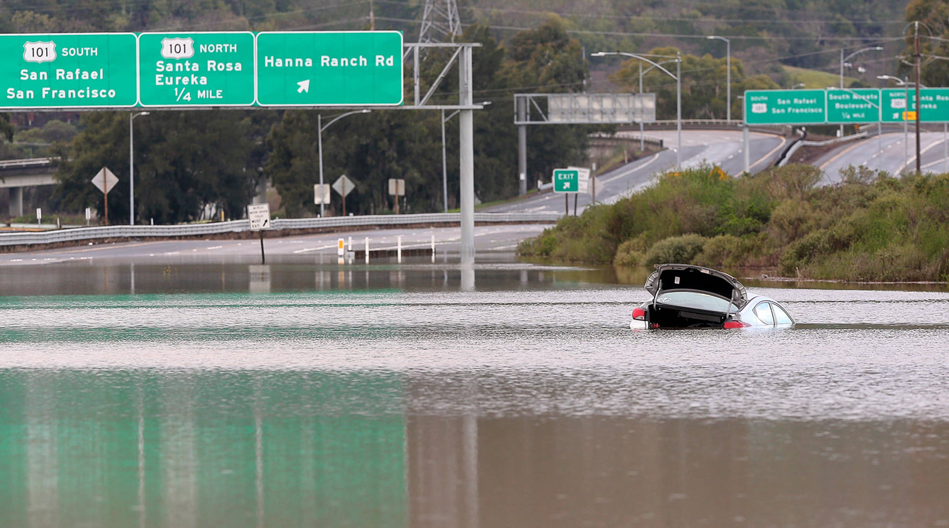
Portions of Highway 37 flood on a regular basis, and the important commuter road is increasingly vulnerable to rising seas. Officials are considering an array of options, including raising the road surface by several feet and protecting it with levees. (Christopher Chung/The Press Democrat)
or Will Travis, it began 12 years ago, with an eye-opening article in the New Yorker magazine about rising seas and the widespread flooding and dislocation that would bring. As the executive director of the San Francisco Bay Conservation and Development Commission, the region’s coastal management agency, he needed to know more.
Travis directed his staff to research the issue. In 2007 they handed him a report that foretold catastrophe. The agency produced maps with colorful, frightening flood projections and shared it with local policymakers. Trillions of dollars in public and private infrastructure were at risk, Travis told them. The time to prepare was now.
Yet the region’s elected officials and Silicon Valley’s cluster of high-tech firms were deaf to the urgency of his message. No one was planning for higher seas. Their problems were more immediate.
“What I heard a lot was, ‘I’m trying to get my kid into a good college, my wife wants me to lose weight, the car transmission is making a funny noise and you want me to worry about sea level rise?’ ” Travis said. “ ‘Yeah, I’ll get to that when I prepare my earthquake supplies.’ ”
He crafted a policy response for his region anyway. In 2011, after four years of scientific analysis, intense bickering, and legal fights, the commission issued what Travis described as the nation’s first enforceable requirement that all shoreline development address the problem of rising seas.
Sponsored
Today, with the breadth and scale of the problem known, the entire state is grappling with how to respond. Every agency and most municipalities are busily crafting plans and prioritizing projects, totaling up what will ultimately be hundreds of billions of dollars in costs to build barriers, restore wetlands and -- somehow -- raise or relocate roads, bridges, railroads and power plants away from the onrushing Pacific.
Global climate change is warming oceans and melting glaciers, raising seas higher and threatening the people and things that crowd California’s 1,200-mile coastline. Beaches are shrinking and bluffs are being pulverized. And the water’s rise, which had been somewhat steady in the past 100 years, is now accelerating alarmingly, 30 to 40 times faster than in the last century.
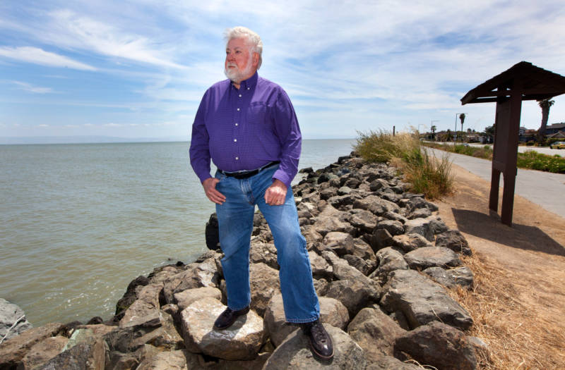
Will Travis was one of the first Bay Area officials to take the threat of sea-level rise seriously. When he was executive director of the Bay Conservation and Development Commission, Travis crafted the first enforceable regulations requiring developers to take rising seas into account. (Penni Gladstone/CALmatters)
In as few as three decades, scientists say, some areas that are now dry will be permanently under water. Other places, miles from the ocean, will flood more regularly and more deeply, as warmer waters spawn more intense storms and the already swollen sea pushes farther onshore, unimpeded.
This winter’s lashing storms that took out parts of Highway 1 are an example of collateral damage: Rising seas are making flood-related events worse because there’s more water available to do damage. Flooding along roads is more frequent and lingers longer. Erosion from more powerful waves works away at bridge footings, undermining spans that are critical to transportation corridors, which themselves are strung along the California coast.
A report by the Ocean Protection Council, the state agency that coordinates the government’s coastal programs, was released in April with the most dire projections yet: The Pacific could rise as much as 10 feet in California in the next 80 years, covering up 800 feet of existing beach and taking out anything in its path.
Preparing for this eventuality has been declared a top priority in California. By calling for extensive scientific studies and projections, the state has thrown its full power behind the problem. But its power is not absolute. Even though the effects of rising water will be felt comprehensively, bridging public and private property and interests, some of the state’s jurisdiction stops at local borders.
State planning began in 2008 with an executive order from then-Gov. Arnold Schwarzenegger. That was followed by Gov. Jerry Brown’s 2010 requirement that state agencies include an adaptation strategy in all planning and permitting documents. Most are still refining those plans.
The beleaguered Department of Transportation has inventoried its holdings, identified which highways will be moved back from the coast and which low-lying roads must be elevated. Highway 1, the meandering, coast-hugging byway famed more for windshield tourism than modern transportation, has been clawed at by erosion and appears often on the state’s flood maps. A section of the roadway at Gleason’s Beach in Sonoma County will be pushed back from the shore some 400 feet. Approvals for the project are expected next year.
Similar ground-level planning is under way in other agencies. The parks department, for instance, is considering relocating parking lots and restrooms away from the beach up and down the state -- although in some areas there is no room to move facilities, even if the agency could afford to do it.
The Coastal Commission has assisted California’s 15 coastal counties in preparing vulnerability assessments, which identify structures to be moved and areas where it’s too dangerous to build. The commission, which approves permits for all development along the coast, has denied the siting of a wastewater treatment plant in Morro Bay and has deemed a power plant in Oxnard to be in harm’s way.
But despite such efforts, some say officials need to be much more nimble.
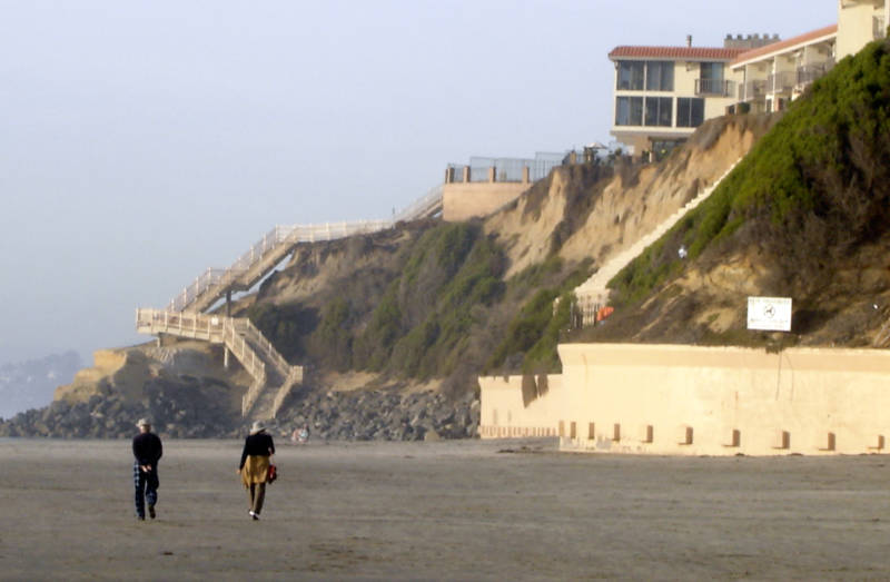
Property owners in Solana Beach have been involved in a protracted legal battle with the city for the right to construct sea walls and shore up fragile beach bluffs that underlay their homes. Such so-called 'armoring' redirects wave action elsewhere, causing unintended harm. (Wikimedia Commons)
The public cost of armoring the coast with sea walls and breakwaters -- not always the right response but sometimes the best short-term option -- of lifting up highways and defending airports, railways and power plants surely will be staggering. No one knows what it is. The exhaustive scientific analyses commissioned by the state don’t address cost.
State Sen. Bob Wieckowski, a Democrat from Fremont who chairs the Senate’s Environmental Quality Committee, would not hazard a guess at the overall cost of shoring up state-owned infrastructure.
“That would be a scary number,” he said.
For all the state’s studies, the precise details for responding to sea rise are mostly local decisions involving zoning, building codes and engineering projects with crippling costs attached.
In Sonoma County, Highway 37, built on a base of mud, flooded on 27 days last winter and has already sunk more than two feet, according to Sonoma County Supervisor David Rabbitt. He said that the state’s transportation agency, Caltrans, told local officials that it could get to the problem in 2088.
Four affected counties, unable to wait 71 years, are considering a number of options, including putting the critical commuter highway atop a 6-foot levee. The price tag for the 20-mile project is as much as $4 billion, and no one knows who will pay for it.
Foster City, on San Francisco Bay, reckons it will take more than $90 million to shore up its eight miles of rock levees that protect neighborhoods from encroaching water.
The city of Goleta, just north of Santa Barbara, compiled this list two years ago: an estimated $7.9 million to $63.2 million to cap or recap oil wells in flood-risk areas, flood damage expected on private and public property estimated at $14 million by the end of the century, $500,000 to add four to six inches of asphalt to local roads to elevate them above the water for the next decade.
Driving across the soaring Dumbarton Bridge into Menlo Park at the south end of San Francisco Bay, Travis -- who is now a consultant -- is a grim tour guide. Where most would find serenity in the shimmering necklace of the California coastline, Travis sees an inventory of potential calamity for the state’s bridges, levees, homes and sewage plants. He points to a neat grid of commercial salt ponds that create a colorful mosaic of water behind long lines of levees. Colorful yes, but the marshes that could swell with seawater are held back only by flimsy earthen berms.
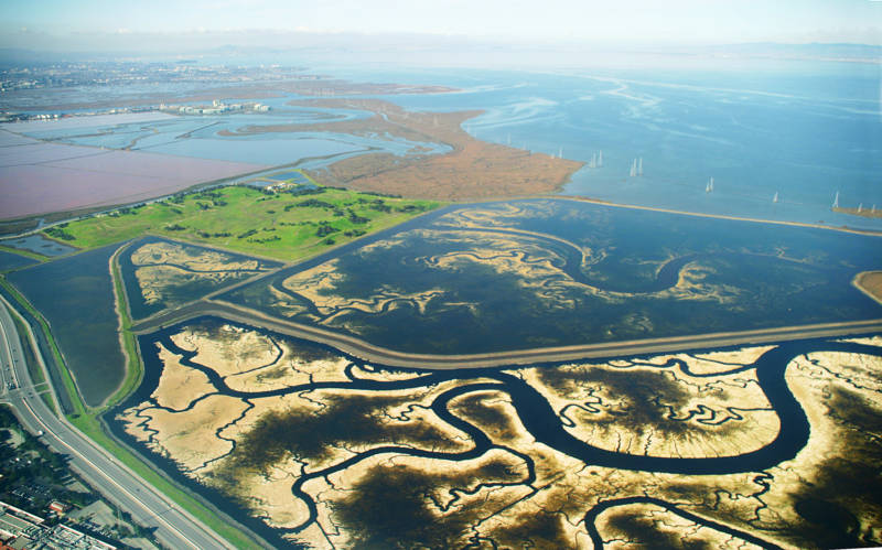
The vast network of commercial salt ponds and degraded marshes in the southern end of the San Francisco Bay are the focus of an intensive restoration effort that encompasses tens of thousands of acres. The wetlands will help protect low-lying communities from flooding by slowing storm surges and absorbing rising seas. (Jitze Couperus/CALmatters)
There is much at stake here, where the soggy, low-lying coast is the most heavily developed in the state. The density of people, and public and private assets, coupled with the region’s vulnerable geography, put the Bay Area at the top of the state’s triage list.
This is the gateway to Silicon Valley, formerly known as Valley of Heart’s Delight -- a reference to once-sprawling fruit orchards -- now home to Tesla, Apple, eBay, Facebook, Google and Hewlett Packard. State officials are keenly aware that its critical economic driver is in the path of eventual disaster.
Adaptation projects in this region show how nature is being harnessed to hold back Pacific waters. The Bay begins with a deficit, having lost more than 80 percent of its marshes in the last 200 years, each new development gouging out some natural protection. Multiple efforts are underway to reclaim those wetlands, restoring vegetation that absorbs floodwater and slows storm surges.
Voters in nine Bay Area counties last year approved a parcel tax to raise a half-billion dollars in the next 20 years, with plans to restore tidal marshes along the bay and creeks.
More sobering for the public is the question of how to protect the international airports in San Francisco and Oakland. San Francisco airport, which, like Oakland’s, juts like a finger into the bay, has crumbling cement along its eight miles of sea wall. SFO officials are developing a $60 million shoreline protection project. At both airports, efforts will focus on buttressing and expanding existing walls and barriers.
The sea wall that rims the waterfront Embarcadero office park and promenade of shops requires a multi-billion-dollar upgrade. The Port of San Francisco is soliciting improvement proposals and has set aside $40 million for the project. The venerable rock pile is a critical bulwark: Behind it sits nearly $40 billion in commercial development.
As if those numbers aren’t staggering enough, Travis’s back-of-the-envelope calculation for protecting just the San Francisco Bay with a simple levee -- not accounting for any relocating, rebuilding or constructing more sophisticated defensive measures: As much as $100 billion. His bleak coda: The cost of doing nothing and paying to clean up the mess is four times that figure.
This is an abridged version of the full story, which is available at calmatters.org. CALmatters is a nonprofit, nonpartisan media venture explaining California policies and politics.
lower waypoint
Stay in touch. Sign up for our daily newsletter.
To learn more about how we use your information, please read our privacy policy.
window.__IS_SSR__=true
window.__INITIAL_STATE__={"attachmentsReducer":{"audio_0":{"type":"attachments","id":"audio_0","imgSizes":{"kqedFullSize":{"file":"https://ww2.kqed.org/news/wp-content/themes/KQED-unified/img/audio_bgs/background0.jpg"}}},"audio_1":{"type":"attachments","id":"audio_1","imgSizes":{"kqedFullSize":{"file":"https://ww2.kqed.org/news/wp-content/themes/KQED-unified/img/audio_bgs/background1.jpg"}}},"audio_2":{"type":"attachments","id":"audio_2","imgSizes":{"kqedFullSize":{"file":"https://ww2.kqed.org/news/wp-content/themes/KQED-unified/img/audio_bgs/background2.jpg"}}},"audio_3":{"type":"attachments","id":"audio_3","imgSizes":{"kqedFullSize":{"file":"https://ww2.kqed.org/news/wp-content/themes/KQED-unified/img/audio_bgs/background3.jpg"}}},"audio_4":{"type":"attachments","id":"audio_4","imgSizes":{"kqedFullSize":{"file":"https://ww2.kqed.org/news/wp-content/themes/KQED-unified/img/audio_bgs/background4.jpg"}}},"placeholder":{"type":"attachments","id":"placeholder","imgSizes":{"thumbnail":{"file":"https://ww2.kqed.org/wp-content/uploads/sites/10/2018/01/GettyImages-896326950-160x96.jpg","width":160,"height":96,"mimeType":"image/jpeg"},"medium":{"file":"https://ww2.kqed.org/wp-content/uploads/sites/10/2018/01/GettyImages-896326950-800x478.jpg","width":800,"height":478,"mimeType":"image/jpeg"},"large":{"file":"https://ww2.kqed.org/wp-content/uploads/sites/10/2018/01/GettyImages-896326950-1020x610.jpg","width":1020,"height":610,"mimeType":"image/jpeg"},"fd-lrg":{"file":"https://ww2.kqed.org/wp-content/uploads/sites/10/2018/01/GettyImages-896326950-1920x1148.jpg","width":1920,"height":1148,"mimeType":"image/jpeg"},"fd-med":{"file":"https://ww2.kqed.org/wp-content/uploads/sites/10/2018/01/GettyImages-896326950-1180x705.jpg","width":1180,"height":705,"mimeType":"image/jpeg"},"fd-sm":{"file":"https://ww2.kqed.org/wp-content/uploads/sites/10/2018/01/GettyImages-896326950-960x574.jpg","width":960,"height":574,"mimeType":"image/jpeg"},"post-thumbnail":{"file":"https://ww2.kqed.org/wp-content/uploads/sites/10/2018/01/GettyImages-896326950-672x372.jpg","width":672,"height":372,"mimeType":"image/jpeg"},"twentyfourteen-full-width":{"file":"https://ww2.kqed.org/wp-content/uploads/sites/10/2018/01/GettyImages-896326950-1038x576.jpg","width":1038,"height":576,"mimeType":"image/jpeg"},"xxsmall":{"file":"https://ww2.kqed.org/wp-content/uploads/sites/10/2018/01/GettyImages-896326950-240x143.jpg","width":240,"height":143,"mimeType":"image/jpeg"},"xsmall":{"file":"https://ww2.kqed.org/wp-content/uploads/sites/10/2018/01/GettyImages-896326950-375x224.jpg","width":375,"height":224,"mimeType":"image/jpeg"},"small":{"file":"https://ww2.kqed.org/wp-content/uploads/sites/10/2018/01/GettyImages-896326950-520x311.jpg","width":520,"height":311,"mimeType":"image/jpeg"},"xlarge":{"file":"https://ww2.kqed.org/wp-content/uploads/sites/10/2018/01/GettyImages-896326950-1180x705.jpg","width":1180,"height":705,"mimeType":"image/jpeg"},"full-width":{"file":"https://ww2.kqed.org/wp-content/uploads/sites/10/2018/01/GettyImages-896326950-1920x1148.jpg","width":1920,"height":1148,"mimeType":"image/jpeg"},"guest-author-32":{"file":"https://ww2.kqed.org/wp-content/uploads/sites/10/2018/01/GettyImages-896326950-32x32.jpg","width":32,"height":32,"mimeType":"image/jpeg"},"guest-author-50":{"file":"https://ww2.kqed.org/wp-content/uploads/sites/10/2018/01/GettyImages-896326950-50x50.jpg","width":50,"height":50,"mimeType":"image/jpeg"},"guest-author-64":{"file":"https://ww2.kqed.org/wp-content/uploads/sites/10/2018/01/GettyImages-896326950-64x64.jpg","width":64,"height":64,"mimeType":"image/jpeg"},"guest-author-96":{"file":"https://ww2.kqed.org/wp-content/uploads/sites/10/2018/01/GettyImages-896326950-96x96.jpg","width":96,"height":96,"mimeType":"image/jpeg"},"guest-author-128":{"file":"https://ww2.kqed.org/wp-content/uploads/sites/10/2018/01/GettyImages-896326950-128x128.jpg","width":128,"height":128,"mimeType":"image/jpeg"},"detail":{"file":"https://ww2.kqed.org/wp-content/uploads/sites/10/2018/01/GettyImages-896326950-150x150.jpg","width":150,"height":150,"mimeType":"image/jpeg"},"kqedFullSize":{"file":"https://ww2.kqed.org/wp-content/uploads/sites/10/2018/01/GettyImages-896326950-e1514998105161.jpg","width":1920,"height":1148}}},"news_11984069":{"type":"attachments","id":"news_11984069","meta":{"index":"attachments_1591205162","site":"news","id":"11984069","found":true},"title":"Single family homes in Alameda on Jan. 12, 2023.","publishDate":1714077079,"status":"inherit","parent":11984016,"modified":1714077110,"caption":"Single family homes in Alameda on Jan. 12, 2023.","credit":"Beth LaBerge/KQED","altTag":"Single family houses in a suburban neighborhood.","description":null,"imgSizes":{"medium":{"file":"https://cdn.kqed.org/wp-content/uploads/sites/10/2024/04/016_KQED_AlamedaAffordableHousing_01122023_qut-800x533.jpg","width":800,"height":533,"mimeType":"image/jpeg"},"large":{"file":"https://cdn.kqed.org/wp-content/uploads/sites/10/2024/04/016_KQED_AlamedaAffordableHousing_01122023_qut-1020x680.jpg","width":1020,"height":680,"mimeType":"image/jpeg"},"thumbnail":{"file":"https://cdn.kqed.org/wp-content/uploads/sites/10/2024/04/016_KQED_AlamedaAffordableHousing_01122023_qut-160x107.jpg","width":160,"height":107,"mimeType":"image/jpeg"},"1536x1536":{"file":"https://cdn.kqed.org/wp-content/uploads/sites/10/2024/04/016_KQED_AlamedaAffordableHousing_01122023_qut-1536x1024.jpg","width":1536,"height":1024,"mimeType":"image/jpeg"},"post-thumbnail":{"file":"https://cdn.kqed.org/wp-content/uploads/sites/10/2024/04/016_KQED_AlamedaAffordableHousing_01122023_qut-672x372.jpg","width":672,"height":372,"mimeType":"image/jpeg"},"twentyfourteen-full-width":{"file":"https://cdn.kqed.org/wp-content/uploads/sites/10/2024/04/016_KQED_AlamedaAffordableHousing_01122023_qut-1038x576.jpg","width":1038,"height":576,"mimeType":"image/jpeg"},"kqedFullSize":{"file":"https://cdn.kqed.org/wp-content/uploads/sites/10/2024/04/016_KQED_AlamedaAffordableHousing_01122023_qut.jpg","width":1920,"height":1280}},"fetchFailed":false,"isLoading":false},"news_11983865":{"type":"attachments","id":"news_11983865","meta":{"index":"attachments_1591205162","site":"news","id":"11983865","found":true},"title":"AlamedaCanal","publishDate":1713908769,"status":"inherit","parent":11983858,"modified":1713908865,"caption":"This waterway separating Oakland from Alameda Island is a part of daily life for residents of the area, but it didn't always exist.","credit":"Pauline Bartolone/KQED","altTag":"View across a narrow waterway at a white drawbridge in the distance. Houses can be seen on the other side of the water.","description":null,"imgSizes":{"medium":{"file":"https://cdn.kqed.org/wp-content/uploads/sites/10/2024/04/AlamedaCanal-800x450.jpg","width":800,"height":450,"mimeType":"image/jpeg"},"large":{"file":"https://cdn.kqed.org/wp-content/uploads/sites/10/2024/04/AlamedaCanal-1020x574.jpg","width":1020,"height":574,"mimeType":"image/jpeg"},"thumbnail":{"file":"https://cdn.kqed.org/wp-content/uploads/sites/10/2024/04/AlamedaCanal-160x90.jpg","width":160,"height":90,"mimeType":"image/jpeg"},"1536x1536":{"file":"https://cdn.kqed.org/wp-content/uploads/sites/10/2024/04/AlamedaCanal-1536x864.jpg","width":1536,"height":864,"mimeType":"image/jpeg"},"post-thumbnail":{"file":"https://cdn.kqed.org/wp-content/uploads/sites/10/2024/04/AlamedaCanal-672x372.jpg","width":672,"height":372,"mimeType":"image/jpeg"},"twentyfourteen-full-width":{"file":"https://cdn.kqed.org/wp-content/uploads/sites/10/2024/04/AlamedaCanal-1038x576.jpg","width":1038,"height":576,"mimeType":"image/jpeg"},"kqedFullSize":{"file":"https://cdn.kqed.org/wp-content/uploads/sites/10/2024/04/AlamedaCanal.jpg","width":1920,"height":1080}},"fetchFailed":false,"isLoading":false},"news_11976223":{"type":"attachments","id":"news_11976223","meta":{"index":"attachments_1591205162","site":"news","id":"11976223","found":true},"title":"Pending Home Sales Fall To Record Low","publishDate":1708116716,"status":"inherit","parent":11976218,"modified":1708127585,"caption":"A 'sale pending' sign is posted in front of a home in San Anselmo, Marin County. ","credit":"Justin Sullivan/Getty Images","altTag":"A 'sale pending' sign in front of a house.","description":null,"imgSizes":{"medium":{"file":"https://cdn.kqed.org/wp-content/uploads/sites/10/2024/02/GettyImages-1823257059-800x566.jpg","width":800,"height":566,"mimeType":"image/jpeg"},"large":{"file":"https://cdn.kqed.org/wp-content/uploads/sites/10/2024/02/GettyImages-1823257059-1020x722.jpg","width":1020,"height":722,"mimeType":"image/jpeg"},"thumbnail":{"file":"https://cdn.kqed.org/wp-content/uploads/sites/10/2024/02/GettyImages-1823257059-160x113.jpg","width":160,"height":113,"mimeType":"image/jpeg"},"1536x1536":{"file":"https://cdn.kqed.org/wp-content/uploads/sites/10/2024/02/GettyImages-1823257059-1536x1087.jpg","width":1536,"height":1087,"mimeType":"image/jpeg"},"2048x2048":{"file":"https://cdn.kqed.org/wp-content/uploads/sites/10/2024/02/GettyImages-1823257059-2048x1449.jpg","width":2048,"height":1449,"mimeType":"image/jpeg"},"post-thumbnail":{"file":"https://cdn.kqed.org/wp-content/uploads/sites/10/2024/02/GettyImages-1823257059-672x372.jpg","width":672,"height":372,"mimeType":"image/jpeg"},"twentyfourteen-full-width":{"file":"https://cdn.kqed.org/wp-content/uploads/sites/10/2024/02/GettyImages-1823257059-1038x576.jpg","width":1038,"height":576,"mimeType":"image/jpeg"},"full-width":{"file":"https://cdn.kqed.org/wp-content/uploads/sites/10/2024/02/GettyImages-1823257059-1920x1359.jpg","width":1920,"height":1359,"mimeType":"image/jpeg"},"kqedFullSize":{"file":"https://cdn.kqed.org/wp-content/uploads/sites/10/2024/02/GettyImages-1823257059-scaled.jpg","width":2560,"height":1812}},"fetchFailed":false,"isLoading":false},"news_11983945":{"type":"attachments","id":"news_11983945","meta":{"index":"attachments_1591205162","site":"news","id":"11983945","found":true},"title":"2024_01-Fresno White","publishDate":1713989284,"status":"inherit","parent":0,"modified":1713989441,"caption":"A 2024 rendering of the high-speed rail station in Fresno. Four stations in the Central Valley will be the first to be constructed. Trains are slated to start running in 2030.","credit":"Courtesy California High-Speed Rail Authority","altTag":null,"description":null,"imgSizes":{"medium":{"file":"https://cdn.kqed.org/wp-content/uploads/sites/10/2024/04/2024_01-Fresno-White-800x367.jpg","width":800,"height":367,"mimeType":"image/jpeg"},"large":{"file":"https://cdn.kqed.org/wp-content/uploads/sites/10/2024/04/2024_01-Fresno-White-1020x468.jpg","width":1020,"height":468,"mimeType":"image/jpeg"},"thumbnail":{"file":"https://cdn.kqed.org/wp-content/uploads/sites/10/2024/04/2024_01-Fresno-White-160x73.jpg","width":160,"height":73,"mimeType":"image/jpeg"},"1536x1536":{"file":"https://cdn.kqed.org/wp-content/uploads/sites/10/2024/04/2024_01-Fresno-White-1536x704.jpg","width":1536,"height":704,"mimeType":"image/jpeg"},"2048x2048":{"file":"https://cdn.kqed.org/wp-content/uploads/sites/10/2024/04/2024_01-Fresno-White-2048x939.jpg","width":2048,"height":939,"mimeType":"image/jpeg"},"post-thumbnail":{"file":"https://cdn.kqed.org/wp-content/uploads/sites/10/2024/04/2024_01-Fresno-White-672x372.jpg","width":672,"height":372,"mimeType":"image/jpeg"},"twentyfourteen-full-width":{"file":"https://cdn.kqed.org/wp-content/uploads/sites/10/2024/04/2024_01-Fresno-White-1038x576.jpg","width":1038,"height":576,"mimeType":"image/jpeg"},"full-width":{"file":"https://cdn.kqed.org/wp-content/uploads/sites/10/2024/04/2024_01-Fresno-White-1920x880.jpg","width":1920,"height":880,"mimeType":"image/jpeg"},"kqedFullSize":{"file":"https://cdn.kqed.org/wp-content/uploads/sites/10/2024/04/2024_01-Fresno-White-scaled.jpg","width":2560,"height":1174}},"fetchFailed":false,"isLoading":false},"news_11983879":{"type":"attachments","id":"news_11983879","meta":{"index":"attachments_1591205162","site":"news","id":"11983879","found":true},"title":"396A627F-A2C7-4B76-AD60-16A17608D8DD_1_105_c","publishDate":1713968250,"status":"inherit","parent":11983878,"modified":1713968416,"caption":"Morgan Doisaki outside his business, Central Fish Company in Fresno's Chinatown neighborhood.","credit":"Madi Bolanos/The California Report","altTag":"fresno chinatown","description":null,"imgSizes":{"medium":{"file":"https://cdn.kqed.org/wp-content/uploads/sites/10/2024/04/396A627F-A2C7-4B76-AD60-16A17608D8DD_1_105_c-800x601.jpeg","width":800,"height":601,"mimeType":"image/jpeg"},"large":{"file":"https://cdn.kqed.org/wp-content/uploads/sites/10/2024/04/396A627F-A2C7-4B76-AD60-16A17608D8DD_1_105_c-1020x766.jpeg","width":1020,"height":766,"mimeType":"image/jpeg"},"thumbnail":{"file":"https://cdn.kqed.org/wp-content/uploads/sites/10/2024/04/396A627F-A2C7-4B76-AD60-16A17608D8DD_1_105_c-160x120.jpeg","width":160,"height":120,"mimeType":"image/jpeg"},"post-thumbnail":{"file":"https://cdn.kqed.org/wp-content/uploads/sites/10/2024/04/396A627F-A2C7-4B76-AD60-16A17608D8DD_1_105_c-672x372.jpeg","width":672,"height":372,"mimeType":"image/jpeg"},"twentyfourteen-full-width":{"file":"https://cdn.kqed.org/wp-content/uploads/sites/10/2024/04/396A627F-A2C7-4B76-AD60-16A17608D8DD_1_105_c-1024x576.jpeg","width":1024,"height":576,"mimeType":"image/jpeg"},"kqedFullSize":{"file":"https://cdn.kqed.org/wp-content/uploads/sites/10/2024/04/396A627F-A2C7-4B76-AD60-16A17608D8DD_1_105_c.jpeg","width":1024,"height":769}},"fetchFailed":false,"isLoading":false},"forum_2010101905489":{"type":"attachments","id":"forum_2010101905489","meta":{"index":"attachments_1591205162","site":"forum","id":"2010101905489","found":true},"title":"1920 x 1080 forum web page (11)","publishDate":1713913660,"status":"inherit","parent":2010101905488,"modified":1713993592,"caption":"Rainn Wilson's new book is \"Soul Boom.\"","credit":"Kwaku Alston for Peacock TV","altTag":null,"description":null,"imgSizes":{"medium":{"file":"https://cdn.kqed.org/wp-content/uploads/sites/43/2024/04/1920-x-1080-forum-web-page-11-800x450.png","width":800,"height":450,"mimeType":"image/png"},"large":{"file":"https://cdn.kqed.org/wp-content/uploads/sites/43/2024/04/1920-x-1080-forum-web-page-11-1020x574.png","width":1020,"height":574,"mimeType":"image/png"},"thumbnail":{"file":"https://cdn.kqed.org/wp-content/uploads/sites/43/2024/04/1920-x-1080-forum-web-page-11-160x90.png","width":160,"height":90,"mimeType":"image/png"},"medium_large":{"file":"https://cdn.kqed.org/wp-content/uploads/sites/43/2024/04/1920-x-1080-forum-web-page-11-768x432.png","width":768,"height":432,"mimeType":"image/png"},"1536x1536":{"file":"https://cdn.kqed.org/wp-content/uploads/sites/43/2024/04/1920-x-1080-forum-web-page-11-1536x864.png","width":1536,"height":864,"mimeType":"image/png"},"post-thumbnail":{"file":"https://cdn.kqed.org/wp-content/uploads/sites/43/2024/04/1920-x-1080-forum-web-page-11-672x372.png","width":672,"height":372,"mimeType":"image/png"},"twentyfourteen-full-width":{"file":"https://cdn.kqed.org/wp-content/uploads/sites/43/2024/04/1920-x-1080-forum-web-page-11-1038x576.png","width":1038,"height":576,"mimeType":"image/png"},"kqedFullSize":{"file":"https://cdn.kqed.org/wp-content/uploads/sites/43/2024/04/1920-x-1080-forum-web-page-11.png","width":1920,"height":1080}},"fetchFailed":false,"isLoading":false},"news_11983996":{"type":"attachments","id":"news_11983996","meta":{"index":"attachments_1591205162","site":"news","id":"11983996","found":true},"title":"tax revolt","publishDate":1714053726,"status":"inherit","parent":11983995,"modified":1714053836,"caption":"Demonstration during Howard Jarvis speech in Long Island, 1978.","credit":"Bernard Gotfryd/Newsweek via Library of Congress Archives","altTag":"tax revolt","description":null,"imgSizes":{"medium":{"file":"https://cdn.kqed.org/wp-content/uploads/sites/10/2024/04/tax-revolt-800x543.jpg","width":800,"height":543,"mimeType":"image/jpeg"},"large":{"file":"https://cdn.kqed.org/wp-content/uploads/sites/10/2024/04/tax-revolt-1020x692.jpg","width":1020,"height":692,"mimeType":"image/jpeg"},"thumbnail":{"file":"https://cdn.kqed.org/wp-content/uploads/sites/10/2024/04/tax-revolt-160x109.jpg","width":160,"height":109,"mimeType":"image/jpeg"},"post-thumbnail":{"file":"https://cdn.kqed.org/wp-content/uploads/sites/10/2024/04/tax-revolt-672x372.jpg","width":672,"height":372,"mimeType":"image/jpeg"},"twentyfourteen-full-width":{"file":"https://cdn.kqed.org/wp-content/uploads/sites/10/2024/04/tax-revolt-1024x576.jpg","width":1024,"height":576,"mimeType":"image/jpeg"},"kqedFullSize":{"file":"https://cdn.kqed.org/wp-content/uploads/sites/10/2024/04/tax-revolt.jpg","width":1024,"height":695}},"fetchFailed":false,"isLoading":false},"news_11983856":{"type":"attachments","id":"news_11983856","meta":{"index":"attachments_1591205162","site":"news","id":"11983856","found":true},"title":"042321_School_Broadband_AW_CM_07","publishDate":1713907768,"status":"inherit","parent":11983850,"modified":1713907871,"caption":"Mario Ramirez Garcia, 10, works on schoolwork at home on April 23, 2021. ","credit":"Anne Wernikoff/CalMatters","altTag":"An image is seen from a mirror as a child sits down and looks at a laptop.","description":null,"imgSizes":{"medium":{"file":"https://cdn.kqed.org/wp-content/uploads/sites/10/2024/04/042321_School_Broadband_AW_CM_07-800x533.jpg","width":800,"height":533,"mimeType":"image/jpeg"},"large":{"file":"https://cdn.kqed.org/wp-content/uploads/sites/10/2024/04/042321_School_Broadband_AW_CM_07-1020x680.jpg","width":1020,"height":680,"mimeType":"image/jpeg"},"thumbnail":{"file":"https://cdn.kqed.org/wp-content/uploads/sites/10/2024/04/042321_School_Broadband_AW_CM_07-160x107.jpg","width":160,"height":107,"mimeType":"image/jpeg"},"1536x1536":{"file":"https://cdn.kqed.org/wp-content/uploads/sites/10/2024/04/042321_School_Broadband_AW_CM_07-1536x1024.jpg","width":1536,"height":1024,"mimeType":"image/jpeg"},"post-thumbnail":{"file":"https://cdn.kqed.org/wp-content/uploads/sites/10/2024/04/042321_School_Broadband_AW_CM_07-672x372.jpg","width":672,"height":372,"mimeType":"image/jpeg"},"twentyfourteen-full-width":{"file":"https://cdn.kqed.org/wp-content/uploads/sites/10/2024/04/042321_School_Broadband_AW_CM_07-1038x576.jpg","width":1038,"height":576,"mimeType":"image/jpeg"},"full-width":{"file":"https://cdn.kqed.org/wp-content/uploads/sites/10/2024/04/042321_School_Broadband_AW_CM_07-1920x1280.jpg","width":1920,"height":1280,"mimeType":"image/jpeg"},"kqedFullSize":{"file":"https://cdn.kqed.org/wp-content/uploads/sites/10/2024/04/042321_School_Broadband_AW_CM_07.jpg","width":2000,"height":1333}},"fetchFailed":false,"isLoading":false},"forum_2010101905523":{"type":"attachments","id":"forum_2010101905523","meta":{"index":"attachments_1591205162","site":"forum","id":"2010101905523","found":true},"title":"1920 x 1080 template (17)","publishDate":1714073446,"status":"inherit","parent":2010101905521,"modified":1714073525,"caption":"Sarah McCammon's new book is \"The Exvangelicals: Loving, Living, and Leaving the White Evangelical Church.\"","credit":"Kara Frame","altTag":null,"description":null,"imgSizes":{"medium":{"file":"https://cdn.kqed.org/wp-content/uploads/sites/43/2024/04/1920-x-1080-template-17-800x450.png","width":800,"height":450,"mimeType":"image/png"},"large":{"file":"https://cdn.kqed.org/wp-content/uploads/sites/43/2024/04/1920-x-1080-template-17-1020x574.png","width":1020,"height":574,"mimeType":"image/png"},"thumbnail":{"file":"https://cdn.kqed.org/wp-content/uploads/sites/43/2024/04/1920-x-1080-template-17-160x90.png","width":160,"height":90,"mimeType":"image/png"},"medium_large":{"file":"https://cdn.kqed.org/wp-content/uploads/sites/43/2024/04/1920-x-1080-template-17-768x432.png","width":768,"height":432,"mimeType":"image/png"},"1536x1536":{"file":"https://cdn.kqed.org/wp-content/uploads/sites/43/2024/04/1920-x-1080-template-17-1536x864.png","width":1536,"height":864,"mimeType":"image/png"},"post-thumbnail":{"file":"https://cdn.kqed.org/wp-content/uploads/sites/43/2024/04/1920-x-1080-template-17-672x372.png","width":672,"height":372,"mimeType":"image/png"},"twentyfourteen-full-width":{"file":"https://cdn.kqed.org/wp-content/uploads/sites/43/2024/04/1920-x-1080-template-17-1038x576.png","width":1038,"height":576,"mimeType":"image/png"},"kqedFullSize":{"file":"https://cdn.kqed.org/wp-content/uploads/sites/43/2024/04/1920-x-1080-template-17.png","width":1920,"height":1080}},"fetchFailed":false,"isLoading":false},"news_11983401":{"type":"attachments","id":"news_11983401","meta":{"index":"attachments_1591205162","site":"news","id":"11983401","found":true},"title":"US-HEALTH-VIRUS-PRISON","publishDate":1713480720,"status":"inherit","parent":11983396,"modified":1713908390,"caption":"Incarcerated women sew protective masks at Las Colinas Women's Detention Facility in Santee, San Diego County, on April 22, 2020. ","credit":"Sandy Huffaker/AFP via Getty Images","altTag":"Incarcerated women in beige outfits work at sewing tables.","description":null,"imgSizes":{"medium":{"file":"https://cdn.kqed.org/wp-content/uploads/sites/10/2024/04/GettyImages-1210676401-800x534.jpg","width":800,"height":534,"mimeType":"image/jpeg"},"large":{"file":"https://cdn.kqed.org/wp-content/uploads/sites/10/2024/04/GettyImages-1210676401-1020x680.jpg","width":1020,"height":680,"mimeType":"image/jpeg"},"thumbnail":{"file":"https://cdn.kqed.org/wp-content/uploads/sites/10/2024/04/GettyImages-1210676401-160x107.jpg","width":160,"height":107,"mimeType":"image/jpeg"},"post-thumbnail":{"file":"https://cdn.kqed.org/wp-content/uploads/sites/10/2024/04/GettyImages-1210676401-672x372.jpg","width":672,"height":372,"mimeType":"image/jpeg"},"twentyfourteen-full-width":{"file":"https://cdn.kqed.org/wp-content/uploads/sites/10/2024/04/GettyImages-1210676401-1024x576.jpg","width":1024,"height":576,"mimeType":"image/jpeg"},"kqedFullSize":{"file":"https://cdn.kqed.org/wp-content/uploads/sites/10/2024/04/GettyImages-1210676401.jpg","width":1024,"height":683}},"fetchFailed":false,"isLoading":false},"news_11541305":{"type":"attachments","id":"news_11541305","meta":{"index":"attachments_1591205162","site":"news","id":"11541305","found":true},"title":"Hwy37FloodCar","publishDate":1498863937,"status":"inherit","parent":11541193,"modified":1498863999,"caption":"Portions of Highway 37 flood on a regular basis, and the important commuter road is increasingly vulnerable to rising seas. Officials are considering an array of options, including raising the road surface by several feet and protecting it with levees.","credit":"Christopher Chung/The Press Democrat","description":"Portions of Highway 37 flood on a regular basis, and the important commuter road is increasingly vulnerable to rising seas. Officials are considering an array of options, including raising the road surface by several feet and protecting it with levees.","imgSizes":{"thumbnail":{"file":"https://ww2.kqed.org/app/uploads/sites/10/2017/06/Hwy37FloodCar-160x89.jpg","width":160,"height":89,"mimeType":"image/jpeg"},"medium":{"file":"https://ww2.kqed.org/app/uploads/sites/10/2017/06/Hwy37FloodCar-800x445.jpg","width":800,"height":445,"mimeType":"image/jpeg"},"large":{"file":"https://ww2.kqed.org/app/uploads/sites/10/2017/06/Hwy37FloodCar-1020x567.jpg","width":1020,"height":567,"mimeType":"image/jpeg"},"fd-lrg":{"file":"https://ww2.kqed.org/app/uploads/sites/10/2017/06/Hwy37FloodCar-1920x1068.jpg","width":1920,"height":1068,"mimeType":"image/jpeg"},"fd-med":{"file":"https://ww2.kqed.org/app/uploads/sites/10/2017/06/Hwy37FloodCar-1180x656.jpg","width":1180,"height":656,"mimeType":"image/jpeg"},"fd-sm":{"file":"https://ww2.kqed.org/app/uploads/sites/10/2017/06/Hwy37FloodCar-960x534.jpg","width":960,"height":534,"mimeType":"image/jpeg"},"post-thumbnail":{"file":"https://ww2.kqed.org/app/uploads/sites/10/2017/06/Hwy37FloodCar-672x372.jpg","width":672,"height":372,"mimeType":"image/jpeg"},"twentyfourteen-full-width":{"file":"https://ww2.kqed.org/app/uploads/sites/10/2017/06/Hwy37FloodCar-1038x576.jpg","width":1038,"height":576,"mimeType":"image/jpeg"},"xxsmall":{"file":"https://ww2.kqed.org/app/uploads/sites/10/2017/06/Hwy37FloodCar-240x134.jpg","width":240,"height":134,"mimeType":"image/jpeg"},"xsmall":{"file":"https://ww2.kqed.org/app/uploads/sites/10/2017/06/Hwy37FloodCar-375x209.jpg","width":375,"height":209,"mimeType":"image/jpeg"},"small":{"file":"https://ww2.kqed.org/app/uploads/sites/10/2017/06/Hwy37FloodCar-520x289.jpg","width":520,"height":289,"mimeType":"image/jpeg"},"xlarge":{"file":"https://ww2.kqed.org/app/uploads/sites/10/2017/06/Hwy37FloodCar-1180x656.jpg","width":1180,"height":656,"mimeType":"image/jpeg"},"full-width":{"file":"https://ww2.kqed.org/app/uploads/sites/10/2017/06/Hwy37FloodCar-1920x1068.jpg","width":1920,"height":1068,"mimeType":"image/jpeg"},"guest-author-32":{"file":"https://ww2.kqed.org/app/uploads/sites/10/2017/06/Hwy37FloodCar-32x32.jpg","width":32,"height":32,"mimeType":"image/jpeg"},"guest-author-50":{"file":"https://ww2.kqed.org/app/uploads/sites/10/2017/06/Hwy37FloodCar-50x50.jpg","width":50,"height":50,"mimeType":"image/jpeg"},"guest-author-64":{"file":"https://ww2.kqed.org/app/uploads/sites/10/2017/06/Hwy37FloodCar-64x64.jpg","width":64,"height":64,"mimeType":"image/jpeg"},"guest-author-96":{"file":"https://ww2.kqed.org/app/uploads/sites/10/2017/06/Hwy37FloodCar-96x96.jpg","width":96,"height":96,"mimeType":"image/jpeg"},"guest-author-128":{"file":"https://ww2.kqed.org/app/uploads/sites/10/2017/06/Hwy37FloodCar-128x128.jpg","width":128,"height":128,"mimeType":"image/jpeg"},"detail":{"file":"https://ww2.kqed.org/app/uploads/sites/10/2017/06/Hwy37FloodCar-150x150.jpg","width":150,"height":150,"mimeType":"image/jpeg"},"kqedFullSize":{"file":"https://ww2.kqed.org/app/uploads/sites/10/2017/06/Hwy37FloodCar.jpg","width":1920,"height":1068}},"fetchFailed":false,"isLoading":false}},"audioPlayerReducer":{"postId":"stream_live"},"authorsReducer":{"byline_news_11983850":{"type":"authors","id":"byline_news_11983850","meta":{"override":true},"slug":"byline_news_11983850","name":"Lynn La\u003cbr>CalMatters\u003c/br>","isLoading":false},"kqed":{"type":"authors","id":"236","meta":{"index":"authors_1591205172","id":"236","found":true},"name":"KQED News Staff","firstName":"KQED News Staff","lastName":null,"slug":"kqed","email":"faq@kqed.org","display_author_email":false,"staff_mastheads":[],"title":null,"bio":null,"avatar":"https://secure.gravatar.com/avatar/ef0e801a68c4c54afa9180db14084167?s=600&d=blank&r=g","twitter":null,"facebook":null,"instagram":null,"linkedin":null,"sites":[{"site":"arts","roles":["contributor"]},{"site":"news","roles":["editor"]},{"site":"futureofyou","roles":["author"]}],"headData":{"title":"KQED News Staff | KQED","description":null,"ogImgSrc":"https://secure.gravatar.com/avatar/ef0e801a68c4c54afa9180db14084167?s=600&d=blank&r=g","twImgSrc":"https://secure.gravatar.com/avatar/ef0e801a68c4c54afa9180db14084167?s=600&d=blank&r=g"},"isLoading":false,"link":"/author/kqed"},"minakim":{"type":"authors","id":"243","meta":{"index":"authors_1591205172","id":"243","found":true},"name":"Mina Kim","firstName":"Mina","lastName":"Kim","slug":"minakim","email":"mkim@kqed.org","display_author_email":false,"staff_mastheads":["news"],"title":"Host, Forum","bio":"Mina Kim is host of the 10 a.m. statewide hour of Forum; a live daily talk show for curious Californians on issues that matter to the state and nation, with a particular emphasis on race and equity.\r\n\r\nBefore joining the Forum team, Mina was KQED’s evening news anchor, and health reporter for The California Report. Her award-winning work has included natural disasters in Napa and gun violence in Oakland. Mina grew up in St. John’s, Newfoundland.","avatar":"https://secure.gravatar.com/avatar/145ce657a2d08cb86d93686beb958982?s=600&d=blank&r=g","twitter":"mkimreporter","facebook":null,"instagram":null,"linkedin":null,"sites":[{"site":"news","roles":["contributor"]},{"site":"stateofhealth","roles":["author"]},{"site":"forum","roles":["editor"]}],"headData":{"title":"Mina Kim | KQED","description":"Host, Forum","ogImgSrc":"https://secure.gravatar.com/avatar/145ce657a2d08cb86d93686beb958982?s=600&d=blank&r=g","twImgSrc":"https://secure.gravatar.com/avatar/145ce657a2d08cb86d93686beb958982?s=600&d=blank&r=g"},"isLoading":false,"link":"/author/minakim"},"fjhabvala":{"type":"authors","id":"8659","meta":{"index":"authors_1591205172","id":"8659","found":true},"name":"Farida Jhabvala Romero","firstName":"Farida","lastName":"Jhabvala Romero","slug":"fjhabvala","email":"fjhabvala@kqed.org","display_author_email":true,"staff_mastheads":["news"],"title":"KQED Contributor","bio":"\u003cspan style=\"font-weight: 400;\">Farida Jhabvala Romero is a Labor Correspondent for KQED. She previously covered immigration. Farida was \u003ca href=\"https://www.ccnma.org/2022-most-influential-latina-journalists\">named\u003c/a> one of the 10 Most Influential Latina Journalists in California in 2022 by the California Chicano News Media Association. Her work has won awards from the Society of Professional Journalists (Northern California), as well as a national and regional Edward M. Murrow Award for the collaborative reporting projects “Dangerous Air” and “Graying California.” \u003c/span>\u003cspan style=\"font-weight: 400;\">Before joining KQED, Farida worked as a producer at Radio Bilingüe, a national public radio network. Farida earned her master’s degree in journalism from Stanford University.\u003c/span>","avatar":"https://secure.gravatar.com/avatar/c3ab27c5554b67b478f80971e515aa02?s=600&d=blank&r=g","twitter":"FaridaJhabvala","facebook":null,"instagram":null,"linkedin":"https://www.linkedin.com/in/faridajhabvala/","sites":[{"site":"news","roles":["editor"]},{"site":"stateofhealth","roles":["author"]}],"headData":{"title":"Farida Jhabvala Romero | KQED","description":"KQED Contributor","ogImgSrc":"https://secure.gravatar.com/avatar/c3ab27c5554b67b478f80971e515aa02?s=600&d=blank&r=g","twImgSrc":"https://secure.gravatar.com/avatar/c3ab27c5554b67b478f80971e515aa02?s=600&d=blank&r=g"},"isLoading":false,"link":"/author/fjhabvala"},"ebaldassari":{"type":"authors","id":"11652","meta":{"index":"authors_1591205172","id":"11652","found":true},"name":"Erin Baldassari","firstName":"Erin","lastName":"Baldassari","slug":"ebaldassari","email":"ebaldassari@KQED.org","display_author_email":true,"staff_mastheads":["news"],"title":"Staff Writer","bio":"Erin Baldassari covers housing for KQED. She's a former print journalist and most recently worked as the transportation reporter for the \u003cem>Mercury News\u003c/em> and \u003cem>East Bay Times. \u003c/em>There, she focused on how the Bay Area’s housing shortage has changed the way people move around the region. She also served on the \u003cem>East Bay Times\u003c/em>’ 2017 Pulitzer Prize-winning team for coverage of the Ghost Ship Fire in Oakland. Prior to that, Erin worked as a breaking news and general assignment reporter for a variety of outlets in the Bay Area and the greater Boston area. A Tufts University alumna, Erin grew up in the foothills of the Sierra Nevada mountains and in Sonoma County. She is a life-long KQED listener.","avatar":"https://secure.gravatar.com/avatar/660ce35d088ca54ad606d7e941abc652?s=600&d=blank&r=g","twitter":"e_baldi","facebook":null,"instagram":null,"linkedin":null,"sites":[{"site":"news","roles":["author","edit_others_posts"]},{"site":"science","roles":["editor"]}],"headData":{"title":"Erin Baldassari | KQED","description":"Staff Writer","ogImgSrc":"https://secure.gravatar.com/avatar/660ce35d088ca54ad606d7e941abc652?s=600&d=blank&r=g","twImgSrc":"https://secure.gravatar.com/avatar/660ce35d088ca54ad606d7e941abc652?s=600&d=blank&r=g"},"isLoading":false,"link":"/author/ebaldassari"},"gwon":{"type":"authors","id":"11685","meta":{"index":"authors_1591205172","id":"11685","found":true},"name":"Grace Won","firstName":"Grace","lastName":"Won","slug":"gwon","email":"gwon@kqed.org","display_author_email":true,"staff_mastheads":["news"],"title":"On-call Producer, Forum","bio":"Grace Won has been an on-call producer on \u003cem>Forum\u003c/em> since 2019. Prior to joining KQED, Grace was a litigator, and worked on a variety of \u003cem>pro bono\u003c/em> prisoner cases, including one that resulted in overturning a client's death penalty sentence on constitutional grounds. She holds a law degree from Georgetown University Law Center, an M.A. in English from University College London and a B.A. in American history and East Asian studies from Harvard University.","avatar":"https://secure.gravatar.com/avatar/113ac0c706cbb5be09e7a787bc02a33d?s=600&d=blank&r=g","twitter":null,"facebook":null,"instagram":null,"linkedin":null,"sites":[{"site":"forum","roles":["editor"]}],"headData":{"title":"Grace Won | KQED","description":"On-call Producer, Forum","ogImgSrc":"https://secure.gravatar.com/avatar/113ac0c706cbb5be09e7a787bc02a33d?s=600&d=blank&r=g","twImgSrc":"https://secure.gravatar.com/avatar/113ac0c706cbb5be09e7a787bc02a33d?s=600&d=blank&r=g"},"isLoading":false,"link":"/author/gwon"},"pbartolone":{"type":"authors","id":"11879","meta":{"index":"authors_1591205172","id":"11879","found":true},"name":"Pauline Bartolone","firstName":"Pauline","lastName":"Bartolone","slug":"pbartolone","email":"pbartolone@kqed.org","display_author_email":false,"staff_mastheads":[],"title":"KQED Contributor","bio":"Pauline Bartolone has been a journalist for two decades, specializing in longform audio storytelling. Before editing and producing for podcasts like Bay Curious, she was a health care journalist for public radio and print outlets such as CalMatters and Kaiser Health News. Her reporting has won several regional Edward R. Murrow awards, national recognition from the Society of Professional Journalists and a first-place prize from the Association of Health Care Journalists.\r\n\r\nPauline’s work has aired frequently on National Public Radio, and bylines have appeared in The Los Angeles Times, CNN.com, Washingtonpost.com, USA Today and Scientific American.\r\n\r\nPauline has lived in Northern California for 20 years. Her other passions are crafts (now done in collaboration with her daughter) and the Brazilian martial art of capoeira.","avatar":"https://secure.gravatar.com/avatar/95001c30374b0d3878007af9cf1e120a?s=600&d=blank&r=g","twitter":"pbartolone","facebook":null,"instagram":null,"linkedin":null,"sites":[{"site":"news","roles":["editor"]},{"site":"podcasts","roles":["subscriber"]}],"headData":{"title":"Pauline Bartolone | KQED","description":"KQED Contributor","ogImgSrc":"https://secure.gravatar.com/avatar/95001c30374b0d3878007af9cf1e120a?s=600&d=blank&r=g","twImgSrc":"https://secure.gravatar.com/avatar/95001c30374b0d3878007af9cf1e120a?s=600&d=blank&r=g"},"isLoading":false,"link":"/author/pbartolone"},"mbolanos":{"type":"authors","id":"11895","meta":{"index":"authors_1591205172","id":"11895","found":true},"name":"Madi Bolaños","firstName":"Madi","lastName":"Bolaños","slug":"mbolanos","email":"mbolanos@kqed.org","display_author_email":false,"staff_mastheads":[],"title":"KQED Contributor","bio":null,"avatar":"https://secure.gravatar.com/avatar/e6df5601c1f2d951e46a3fb42764330f?s=600&d=blank&r=g","twitter":null,"facebook":null,"instagram":null,"linkedin":null,"sites":[{"site":"news","roles":["author"]}],"headData":{"title":"Madi Bolaños | KQED","description":"KQED Contributor","ogImgSrc":"https://secure.gravatar.com/avatar/e6df5601c1f2d951e46a3fb42764330f?s=600&d=blank&r=g","twImgSrc":"https://secure.gravatar.com/avatar/e6df5601c1f2d951e46a3fb42764330f?s=600&d=blank&r=g"},"isLoading":false,"link":"/author/mbolanos"},"byline_news_11541193":{"type":"authors","id":"byline_news_11541193","meta":{"override":true},"slug":"byline_news_11541193","name":"\u003cstrong>\u003ca href=\"https://calmatters.org/articles/author/julie-cart/\">Julie Cart\u003c/a>\u003c/strong>","isLoading":false}},"breakingNewsReducer":{},"campaignFinanceReducer":{},"firebase":{"requesting":{},"requested":{},"timestamps":{},"data":{},"ordered":{},"auth":{"isLoaded":false,"isEmpty":true},"authError":null,"profile":{"isLoaded":false,"isEmpty":true},"listeners":{"byId":{},"allIds":[]},"isInitializing":false,"errors":[]},"navBarReducer":{"navBarId":"news","fullView":true,"showPlayer":false},"navMenuReducer":{"menus":[{"key":"menu1","items":[{"name":"News","link":"/","type":"title"},{"name":"Politics","link":"/politics"},{"name":"Science","link":"/science"},{"name":"Education","link":"/educationnews"},{"name":"Housing","link":"/housing"},{"name":"Immigration","link":"/immigration"},{"name":"Criminal Justice","link":"/criminaljustice"},{"name":"Silicon Valley","link":"/siliconvalley"},{"name":"Forum","link":"/forum"},{"name":"The California Report","link":"/californiareport"}]},{"key":"menu2","items":[{"name":"Arts & Culture","link":"/arts","type":"title"},{"name":"Critics’ Picks","link":"/thedolist"},{"name":"Cultural Commentary","link":"/artscommentary"},{"name":"Food & Drink","link":"/food"},{"name":"Bay Area Hip-Hop","link":"/bayareahiphop"},{"name":"Rebel Girls","link":"/rebelgirls"},{"name":"Arts Video","link":"/artsvideos"}]},{"key":"menu3","items":[{"name":"Podcasts","link":"/podcasts","type":"title"},{"name":"Bay Curious","link":"/podcasts/baycurious"},{"name":"Rightnowish","link":"/podcasts/rightnowish"},{"name":"The Bay","link":"/podcasts/thebay"},{"name":"On Our Watch","link":"/podcasts/onourwatch"},{"name":"Mindshift","link":"/podcasts/mindshift"},{"name":"Consider This","link":"/podcasts/considerthis"},{"name":"Political Breakdown","link":"/podcasts/politicalbreakdown"}]},{"key":"menu4","items":[{"name":"Live Radio","link":"/radio","type":"title"},{"name":"TV","link":"/tv","type":"title"},{"name":"Events","link":"/events","type":"title"},{"name":"For Educators","link":"/education","type":"title"},{"name":"Support KQED","link":"/support","type":"title"},{"name":"About","link":"/about","type":"title"},{"name":"Help Center","link":"https://kqed-helpcenter.kqed.org/s","type":"title"}]}]},"pagesReducer":{},"postsReducer":{"stream_live":{"type":"live","id":"stream_live","audioUrl":"https://streams.kqed.org/kqedradio","title":"Live Stream","excerpt":"Live Stream information currently unavailable.","link":"/radio","featImg":"","label":{"name":"KQED Live","link":"/"}},"stream_kqedNewscast":{"type":"posts","id":"stream_kqedNewscast","audioUrl":"https://www.kqed.org/.stream/anon/radio/RDnews/newscast.mp3?_=1","title":"KQED Newscast","featImg":"","label":{"name":"88.5 FM","link":"/"}},"news_11984016":{"type":"posts","id":"news_11984016","meta":{"index":"posts_1591205157","site":"news","id":"11984016","found":true},"guestAuthors":[],"slug":"judge-rules-california-split-lot-housing-law-unconstitutional","title":"California Law Letting Property Owners Split Lots to Build New Homes Is 'Unconstitutional,' Judge Rules","publishDate":1714079477,"format":"standard","headTitle":"California Law Letting Property Owners Split Lots to Build New Homes Is ‘Unconstitutional,’ Judge Rules | KQED","labelTerm":{"site":"news"},"content":"\u003cp>A \u003ca href=\"https://www.kqed.org/news/11860308/why-just-allowing-fourplexes-wont-solve-californias-housing-affordability-crisis\">controversial 2021 law\u003c/a> that allows property owners in California to split their lots and build up to two new homes is unconstitutional, a Los Angeles Superior Court judge ruled this week.\u003c/p>\n\u003cp>The ruling striking down \u003ca href=\"https://focus.senate.ca.gov/sb9\">Senate Bill 9\u003c/a> only applies to the five Southern California charter cities that were parties to the case: Redondo Beach, Whittier, Carson, Del Mar and Torrance. However, if the case is appealed, the appellate court’s ruling will apply to \u003ca href=\"https://www.cacities.org/UploadedFiles/LeagueInternet/6b/6bbb4ee3-88f9-4d8f-93ad-0075a7b486c4.pdf\">charter cities\u003c/a> statewide, including San Francisco, Oakland and San José.\u003c/p>\n\u003cp>The decision, issued on Monday, is a blow to key state leaders, who \u003ca href=\"https://www.gov.ca.gov/2021/09/16/governor-newsom-signs-historic-legislation-to-boost-californias-housing-supply-and-fight-the-housing-crisis/\">hailed the law\u003c/a> as a way to \u003ca href=\"https://www.kqed.org/news/11840548/the-racist-history-of-single-family-home-zoning\">open single-family neighborhoods\u003c/a> to desperately needed housing.\u003c/p>\n\u003cp>And it’s an endorsement of an opposing idea: that suburban neighborhoods should be reserved for single-family homes, said Chris Elmendorf, a law professor at UC Davis.\u003c/p>\n\u003cp>“It’s an indication of unease or discomfort with housing laws that are trying to transform single-family-home neighborhoods,” he said.\u003c/p>\n\u003cp>[ad fullwidth]\u003c/p>\n\u003cp>A spokesperson for state Attorney General Rob Bonta, the named defendant in the case, said his office is reviewing the case and would “consider all options in defense of SB 9.” The office of Gov. Gavin Newsom, a supporter of the law, did not respond to a request for comment.\u003c/p>\n\u003cp>Pam Lee, an attorney with Aleshire & Wynder, who represented the plaintiffs in the case, said the ruling came as a surprise.\u003c/p>\n\u003cp>“We knew that the stakes were high, but we also knew that it was an uphill battle,” Lee said. “So many of the [housing] laws that have been challenged — in particular, cases against charter cities — have just not been met with a favorable fate.”[aside label=\"more housing coverage\" tag=\"affordable-housing\"]Charter cities have special privileges under the state Constitution, Lee said, including the right to enact their own laws. When the state Legislature wants its laws to apply to those charter cities, Lee said lawmakers have to demonstrate the law addresses a statewide concern.\u003c/p>\n\u003cp>In his decision, Judge Curtis Kin said the Legislature didn’t do that in this case. Specifically, SB 9 says its purpose is to “ensure access to affordable housing.” Lee and her colleagues argued that “affordable housing” means something very specific: below-market-rate, deed-restricted housing.\u003c/p>\n\u003cp>Since the law doesn’t specifically require property owners to develop that kind of housing, the law is unconstitutional, Kin ruled.\u003c/p>\n\u003cp>Elmendorf called that interpretation “kind of silly.”\u003c/p>\n\u003cp>By allowing property owners to split their lots and build up to two homes on each new one, the law promotes the construction of homes that are smaller and therefore relatively more affordable, he said.\u003c/p>\n\u003cp>“The Legislature is not a house full of idiots,” Elmendorf said, adding the law itself clearly states the Legislature’s intent.\u003c/p>\n\u003cp>In a statement, state Sen. Toni Atkins (D-San Diego), who authored SB 9, called the judge’s ruling “sadly misguided” and vowed to “remedy any loopholes biased city governments might utilize” to block new housing.\u003c/p>\n\u003cp>“The assertion by NIMBY city governments that SB 9 is only about subsidized housing is a stretch at best,” said Atkins, who recently stepped down as Senate President Pro Tempore. “The goal of SB 9 has always been to increase equity and accessibility in our neighborhoods while growing our housing supply and production across the state.”\u003c/p>\n\u003cp>Since it went into effect in 2022, however, the law has produced little in the way of new lots or housing. A \u003ca href=\"https://www.kqed.org/news/11980785/these-california-companies-want-to-buy-your-backyard-and-build-a-house\">KQED survey\u003c/a> of 16 cities of varying sizes found that between 2022 and 2023, the cities collectively approved 75 lot-split applications and 112 applications for new units under the law. That’s compared to more than 8,800 accessory dwelling units, or in-law apartments, the cities permitted during the same time frame.\u003c/p>\n\u003cp>Developers have generally supported the bill but have criticized anti-speculation provisions in the law that require a property owner requesting a lot split to agree to live in the house for at least three years. They have also argued that fees and other barriers cities have imposed have prevented the law from working as intended.\u003c/p>\n\u003cp>Atkins authored a second bill, SB 450, to address some of those issues, but it is currently on hold.\u003c/p>\n\u003cp>Elmendorf said the Legislature’s unwillingness to address those issues demonstrates a certain unease with the law’s intent to open single-family neighborhoods to more housing — even among lawmakers who voted to approve it.\u003c/p>\n\u003cp>“That unease is reflected in SB 9 itself,” he said. “SB 9 is written with loopholes.”\u003c/p>\n\u003cp>The state could easily fix those loopholes, Elmendorf said, just as it can easily remedy the error Kin identified in his ruling. How swiftly it does so will demonstrate how serious lawmakers are about dismantling barriers to housing in single-family neighborhoods.\u003c/p>\n\u003cp>“I think it’s worth watching the legislative response to this case,” he said.\u003c/p>\n\u003cp>\u003c/p>\n\u003cp>Doing so will better answer the question underlying SB 9, Elmendorf added. “Do we really want these traditional single-family home neighborhoods to be transformed into something that’s a little bit different?”\u003c/p>\n\n","blocks":[],"excerpt":"A Los Angeles Superior Court judge this week struck down SB 9, a 2021 California law allowing property owners to split their lots and build up to two new homes.","status":"publish","parent":0,"modified":1714083996,"stats":{"hasAudio":false,"hasVideo":false,"hasChartOrMap":false,"iframeSrcs":[],"hasGoogleForm":false,"hasGallery":false,"hasHearkenModule":false,"hasPolis":false,"paragraphCount":25,"wordCount":896},"headData":{"title":"California Law Letting Property Owners Split Lots to Build New Homes Is 'Unconstitutional,' Judge Rules | KQED","description":"A Los Angeles Superior Court judge this week struck down SB 9, a 2021 California law allowing property owners to split their lots and build up to two new homes.","ogTitle":"","ogDescription":"","ogImgId":"","twTitle":"","twDescription":"","twImgId":"","schema":{"@context":"http://schema.org","@type":"NewsArticle","headline":"California Law Letting Property Owners Split Lots to Build New Homes Is 'Unconstitutional,' Judge Rules","datePublished":"2024-04-25T21:11:17.000Z","dateModified":"2024-04-25T22:26:36.000Z","image":"https://cdn.kqed.org/wp-content/uploads/2020/02/KQED-OG-Image@1x.png","isAccessibleForFree":"Y","publisher":{"@type":"NewsMediaOrganization","@id":"https://www.kqed.org/#organization","name":"KQED","url":"https://www.kqed.org","logo":"https://cdn.kqed.org/wp-content/uploads/2020/02/KQED-OG-Image@1x.png"}}},"sticky":false,"excludeFromSiteSearch":"Include","articleAge":"0","path":"/news/11984016/judge-rules-california-split-lot-housing-law-unconstitutional","audioTrackLength":null,"parsedContent":[{"type":"contentString","content":"\u003cdiv class=\"post-body\">\u003cp>\u003cp>A \u003ca href=\"https://www.kqed.org/news/11860308/why-just-allowing-fourplexes-wont-solve-californias-housing-affordability-crisis\">controversial 2021 law\u003c/a> that allows property owners in California to split their lots and build up to two new homes is unconstitutional, a Los Angeles Superior Court judge ruled this week.\u003c/p>\n\u003cp>The ruling striking down \u003ca href=\"https://focus.senate.ca.gov/sb9\">Senate Bill 9\u003c/a> only applies to the five Southern California charter cities that were parties to the case: Redondo Beach, Whittier, Carson, Del Mar and Torrance. However, if the case is appealed, the appellate court’s ruling will apply to \u003ca href=\"https://www.cacities.org/UploadedFiles/LeagueInternet/6b/6bbb4ee3-88f9-4d8f-93ad-0075a7b486c4.pdf\">charter cities\u003c/a> statewide, including San Francisco, Oakland and San José.\u003c/p>\n\u003cp>The decision, issued on Monday, is a blow to key state leaders, who \u003ca href=\"https://www.gov.ca.gov/2021/09/16/governor-newsom-signs-historic-legislation-to-boost-californias-housing-supply-and-fight-the-housing-crisis/\">hailed the law\u003c/a> as a way to \u003ca href=\"https://www.kqed.org/news/11840548/the-racist-history-of-single-family-home-zoning\">open single-family neighborhoods\u003c/a> to desperately needed housing.\u003c/p>\n\u003cp>And it’s an endorsement of an opposing idea: that suburban neighborhoods should be reserved for single-family homes, said Chris Elmendorf, a law professor at UC Davis.\u003c/p>\n\u003cp>“It’s an indication of unease or discomfort with housing laws that are trying to transform single-family-home neighborhoods,” he said.\u003c/p>\n\u003cp>\u003c/p>\u003c/div>","attributes":{"named":{},"numeric":[]}},{"type":"component","content":"","name":"ad","attributes":{"named":{"label":"fullwidth"},"numeric":["fullwidth"]}},{"type":"contentString","content":"\u003cdiv class=\"post-body\">\u003cp>\u003c/p>\n\u003cp>A spokesperson for state Attorney General Rob Bonta, the named defendant in the case, said his office is reviewing the case and would “consider all options in defense of SB 9.” The office of Gov. Gavin Newsom, a supporter of the law, did not respond to a request for comment.\u003c/p>\n\u003cp>Pam Lee, an attorney with Aleshire & Wynder, who represented the plaintiffs in the case, said the ruling came as a surprise.\u003c/p>\n\u003cp>“We knew that the stakes were high, but we also knew that it was an uphill battle,” Lee said. “So many of the [housing] laws that have been challenged — in particular, cases against charter cities — have just not been met with a favorable fate.”\u003c/p>\u003c/div>","attributes":{"named":{},"numeric":[]}},{"type":"component","content":"","name":"aside","attributes":{"named":{"label":"more housing coverage ","tag":"affordable-housing"},"numeric":[]}},{"type":"contentString","content":"\u003cdiv class=\"post-body\">\u003cp>Charter cities have special privileges under the state Constitution, Lee said, including the right to enact their own laws. When the state Legislature wants its laws to apply to those charter cities, Lee said lawmakers have to demonstrate the law addresses a statewide concern.\u003c/p>\n\u003cp>In his decision, Judge Curtis Kin said the Legislature didn’t do that in this case. Specifically, SB 9 says its purpose is to “ensure access to affordable housing.” Lee and her colleagues argued that “affordable housing” means something very specific: below-market-rate, deed-restricted housing.\u003c/p>\n\u003cp>Since the law doesn’t specifically require property owners to develop that kind of housing, the law is unconstitutional, Kin ruled.\u003c/p>\n\u003cp>Elmendorf called that interpretation “kind of silly.”\u003c/p>\n\u003cp>By allowing property owners to split their lots and build up to two homes on each new one, the law promotes the construction of homes that are smaller and therefore relatively more affordable, he said.\u003c/p>\n\u003cp>“The Legislature is not a house full of idiots,” Elmendorf said, adding the law itself clearly states the Legislature’s intent.\u003c/p>\n\u003cp>In a statement, state Sen. Toni Atkins (D-San Diego), who authored SB 9, called the judge’s ruling “sadly misguided” and vowed to “remedy any loopholes biased city governments might utilize” to block new housing.\u003c/p>\n\u003cp>“The assertion by NIMBY city governments that SB 9 is only about subsidized housing is a stretch at best,” said Atkins, who recently stepped down as Senate President Pro Tempore. “The goal of SB 9 has always been to increase equity and accessibility in our neighborhoods while growing our housing supply and production across the state.”\u003c/p>\n\u003cp>Since it went into effect in 2022, however, the law has produced little in the way of new lots or housing. A \u003ca href=\"https://www.kqed.org/news/11980785/these-california-companies-want-to-buy-your-backyard-and-build-a-house\">KQED survey\u003c/a> of 16 cities of varying sizes found that between 2022 and 2023, the cities collectively approved 75 lot-split applications and 112 applications for new units under the law. That’s compared to more than 8,800 accessory dwelling units, or in-law apartments, the cities permitted during the same time frame.\u003c/p>\n\u003cp>Developers have generally supported the bill but have criticized anti-speculation provisions in the law that require a property owner requesting a lot split to agree to live in the house for at least three years. They have also argued that fees and other barriers cities have imposed have prevented the law from working as intended.\u003c/p>\n\u003cp>Atkins authored a second bill, SB 450, to address some of those issues, but it is currently on hold.\u003c/p>\n\u003cp>Elmendorf said the Legislature’s unwillingness to address those issues demonstrates a certain unease with the law’s intent to open single-family neighborhoods to more housing — even among lawmakers who voted to approve it.\u003c/p>\n\u003cp>“That unease is reflected in SB 9 itself,” he said. “SB 9 is written with loopholes.”\u003c/p>\n\u003cp>The state could easily fix those loopholes, Elmendorf said, just as it can easily remedy the error Kin identified in his ruling. How swiftly it does so will demonstrate how serious lawmakers are about dismantling barriers to housing in single-family neighborhoods.\u003c/p>\n\u003cp>“I think it’s worth watching the legislative response to this case,” he said.\u003c/p>\n\u003cp>\u003c/p>\n\u003cp>Doing so will better answer the question underlying SB 9, Elmendorf added. “Do we really want these traditional single-family home neighborhoods to be transformed into something that’s a little bit different?”\u003c/p>\n\n\u003c/div>\u003c/p>","attributes":{"named":{},"numeric":[]}}],"link":"/news/11984016/judge-rules-california-split-lot-housing-law-unconstitutional","authors":["11652"],"categories":["news_8"],"tags":["news_3921","news_24805","news_1775","news_22804"],"featImg":"news_11984069","label":"news"},"news_11983858":{"type":"posts","id":"news_11983858","meta":{"index":"posts_1591205157","site":"news","id":"11983858","found":true},"guestAuthors":[],"slug":"alameda-the-island-that-almost-wasnt","title":"Alameda: The Island That Almost Wasn’t","publishDate":1714039234,"format":"image","headTitle":"Alameda: The Island That Almost Wasn’t | KQED","labelTerm":{},"content":"\u003cp>\u003ca href=\"#episode-transcript\">View the full episode transcript.\u003c/a>\u003c/p>\n\u003cp>The city of Alameda has all the sure signs of an island. To get there, you have to use a bridge, a tunnel or a boat. Locals talk about going “on and off island.” And residents, like Nate Puckett, wear Alameda-themed T-shirts that say “Islander.”\u003c/p>\n\u003cp>“I don’t leave the island for, like, weeks,” says Puckett, who lives, works and raises two kids in the Bay Area city.\u003c/p>\n\u003cp>But recently, Puckett’s sense of place was thrown off-kilter. He was enjoying an ice cream at a favorite local spot — Tucker’s — when he looked up at a historical map on the wall. It showed Alameda connected to the mainland. That must be wrong, he thought; Alameda is an island.\u003c/p>\n\u003cp>[baycuriouspodcastinfo]\u003c/p>\n\u003cp>But the map was not wrong — it was just old. In fact, Alameda is not a natural island. And it almost never became an island at all.\u003c/p>\n\u003cp>[ad fullwidth]\u003c/p>\n\u003cp>“It kind of felt like we’ve been living a lie,” Puckett says.\u003c/p>\n\u003cp>Puckett asked Bay Curious to find out more about Alameda’s island origin story. The project took nearly 30 years to complete and had enough twists and turns to make anyone dizzy.\u003c/p>\n\u003ch2>\u003cb>When it all began\u003c/b>\u003c/h2>\n\u003cfigure id=\"attachment_11983868\" class=\"wp-caption aligncenter\" style=\"max-width: 999px\">\u003ca href=\"https://oaklandlibrary.org/ohc/\">\u003cimg loading=\"lazy\" decoding=\"async\" class=\"wp-image-11983868 size-full\" src=\"https://cdn.kqed.org/wp-content/uploads/sites/10/2024/04/Alameda1877-tweaked.jpg\" alt=\"An old map shows what is now Alameda Island as connected to the mainland.\" width=\"999\" height=\"752\" srcset=\"https://cdn.kqed.org/wp-content/uploads/sites/10/2024/04/Alameda1877-tweaked.jpg 999w, https://cdn.kqed.org/wp-content/uploads/sites/10/2024/04/Alameda1877-tweaked-800x602.jpg 800w, https://cdn.kqed.org/wp-content/uploads/sites/10/2024/04/Alameda1877-tweaked-160x120.jpg 160w\" sizes=\"(max-width: 999px) 100vw, 999px\">\u003c/a>\u003cfigcaption class=\"wp-caption-text\">A map of Alameda from 1877 shows it as a connected peninsula, not an island. \u003ccite>(Oakland Public Library, Oakland History Center)\u003c/cite>\u003c/figcaption>\u003c/figure>\n\u003cp>In the 1870s, Alameda was a big peninsula that jutted out from what is now Oakland’s Fruitvale neighborhood like an outstretched arm.\u003c/p>\n\u003cp>Back then, things were pretty quiet in that part of the East Bay (it wasn’t Oakland until later). The marshy region was not very populated; the landscape was mostly wide open fields and the estates of a few wealthy families.\u003c/p>\n\u003cp>But Oakland’s inner harbor was nearby, and it was quickly becoming a bustling center for maritime commerce. Once the Gold Rush started, more and more ships arrived, bringing in all sorts of goods. And Oakland itself was growing.\u003c/p>\n\u003cp>But navigation to the budding port was tricky. Boats had to traverse a wild waterway that hadn’t seen much development yet. Sediment on the harbor’s bottom would shift with the tides, causing sandbars to move in unpredictable patterns that caused problems for navigation.\u003c/p>\n\u003cp>“[The sandbars] were there on Monday, Wednesday and Friday, [and then] they’d be over here on Tuesday and Thursday,” Alameda historian Dennis Evanosky says. “It impeded the shipping traffic.”\u003c/p>\n\u003cfigure id=\"attachment_11983870\" class=\"wp-caption aligncenter\" style=\"max-width: 1920px\">\u003cimg loading=\"lazy\" decoding=\"async\" class=\"size-full wp-image-11983870\" src=\"https://cdn.kqed.org/wp-content/uploads/sites/10/2024/04/Evanosky-Puckett.jpg\" alt=\"Older man in blue sweater stands next to a younger one in brown.\" width=\"1920\" height=\"1276\" srcset=\"https://cdn.kqed.org/wp-content/uploads/sites/10/2024/04/Evanosky-Puckett.jpg 1920w, https://cdn.kqed.org/wp-content/uploads/sites/10/2024/04/Evanosky-Puckett-800x532.jpg 800w, https://cdn.kqed.org/wp-content/uploads/sites/10/2024/04/Evanosky-Puckett-1020x678.jpg 1020w, https://cdn.kqed.org/wp-content/uploads/sites/10/2024/04/Evanosky-Puckett-160x106.jpg 160w, https://cdn.kqed.org/wp-content/uploads/sites/10/2024/04/Evanosky-Puckett-1536x1021.jpg 1536w\" sizes=\"(max-width: 1920px) 100vw, 1920px\">\u003cfigcaption class=\"wp-caption-text\">Dennis Evanosky (left) with Nate Puckett next to the Alameda canal. The Park Street bridge looms in the background. \u003ccite>(Pauline Bartolone/KQED)\u003c/cite>\u003c/figcaption>\u003c/figure>\n\u003cp>Oakland was never going to become the shipping destination it wanted to be if the waterways remained so unpredictable and the port so difficult to reach. And Oakland had big development ambitions, says Richard Walker, a \u003ca href=\"https://geography.berkeley.edu/professor-emeritus-richard-walker\">professor emeritus in geography at UC Berkeley\u003c/a> and author of several books about California history.\u003c/p>\n\u003cp>“The sense of competition with San Francisco [was] intense,” Walker says.\u003c/p>\n\u003cp>In the late 1800s, Oakland was coming into its own politically and economically, developing its own banks, businesses and shipping companies.\u003c/p>\n\u003cp>“That grows and grows so that Oakland, by the early 20th century, is really thumbing its nose at San Francisco,” Walker says.\u003c/p>\n\u003cp>In response to local lobbying, Congressmen worked to bring in millions of federal dollars to pay the Army Corps of Engineers to improve the harbor.\u003c/p>\n\u003cp>Since shifting sandbars on the bottom was the biggest problem, \u003ca href=\"https://tile.loc.gov/storage-services/master/pnp/habshaer/ca/ca2600/ca2606/data/ca2606data.pdf\">the initial plan\u003c/a> was to cut through the marshy area of the Alameda peninsula, where it was connected to the mainland, to create a canal. Engineers thought if they built a dam at one end, they could release powerful torrents of water through the canal to flush out built-up sediment in the harbor. That would clear the way for bigger ships to come and go more easily.\u003c/p>\n\u003cp>The project got the green light in the early 1870s, but over the next three decades, it hit roadblock after roadblock.\u003c/p>\n\u003ch2>\u003cb>Resistance to the project\u003c/b>\u003c/h2>\n\u003cp>\u003ca href=\"https://alamedamuseum.org/wp-content/uploads/2019/03/AMQ_MAR_2019.pdf\">Eleven families owned land where the government wanted to dredge the canal\u003c/a>. Oakland officials offered families $40,000 at the time, more than $1.2 million today. But one person refused — \u003ca href=\"https://www.cohenbrayhouse.org/about-6\">A.A. Cohen, a railroad industry baron and attorney\u003c/a> who owned an estate with a 70-room mansion.\u003c/p>\n\u003cp>“They were screwing with his kingdom,” says Patty Donald, Cohen’s great-great-granddaughter and manager of the\u003ca href=\"https://www.cohenbrayhouse.org/history\"> Cohen Bray house\u003c/a>, a historic Victorian building in Oakland’s Fruitvale neighborhood. The Cohen family challenged the canal project more than once.\u003c/p>\n\u003cp>“He was one of the most powerful people in Alameda at that time because he had bought a failing rail system,” Donald says. “He built it up in two years and created another one.”\u003c/p>\n\u003cp>However, the canal project progressed despite Cohen’s legal challenge, and by 1889 the excavation was underway.\u003c/p>\n\u003ch2>\u003cb>The setbacks pile up\u003c/b>\u003c/h2>\n\u003cp>Quickly, the canal project suffered another setback — flooding. The winter of 1889 was one of the wettest on record. More than 45 inches of rain fell that year.\u003c/p>\n\u003cp>“Disaster struck on a stormy night in January when Sausal Creek overflowed its banks at Fruitvale Avenue and flooded the ditch and equipment,” \u003ca href=\"https://alamedamuseum.org/wp-content/uploads/2019/03/AMQ_MAR_2019.pdf\">wrote historian Woody Minor in the Alameda Museum newslette\u003c/a>r. “It took two months to pump out the water.”\u003c/p>\n\u003cp>Next, the project’s proponents had to deal with public opinion and perhaps the very first complaints from Alamedans about commuting.\u003c/p>\n\u003cp>“People complain, ‘Well if you’re gonna have this canal here, how are we going to get home?’” Evanosky says.\u003c/p>\n\u003cp>The dredged canal cut across one of the main thoroughfares, leading to the Alameda peninsula, disrupting traffic \u003ca href=\"https://alamedamuseum.org/wp-content/uploads/2019/03/AMQ_MAR_2019.pdf\">for two years\u003c/a>. The Park Street bridge opened in 1891, and Alameda’s two other bridges, at High Street and Fruitvale Avenue, were built the following decade.\u003c/p>\n\u003cp>If legal battles, payouts and flooding weren’t enough, there was an economic depression in the 1890s. Funding for the canal project dried up. And then, the project’s long-time champion at the Army Corp of Engineers, \u003ca href=\"https://www.spn.usace.army.mil/Portals/68/docs/History/Engineers%20at%20the%20Golden%20Gate.pdf?ver=2019-10-24-161149-027\">Major George Mendell\u003c/a>, retired.\u003c/p>\n\u003cp>However, the nail in the coffin for the dam/canal combo plan came from \u003ca href=\"https://alamedamuseum.org/wp-content/uploads/2019/03/AMQ_MAR_2019.pdf\">new research suggesting that dredging deeper in Oakland’s harbor would be more effective for boat passage\u003c/a> than this idea of flushing sediment away using a dam.\u003c/p>\n\u003cp>While government officials debated the next steps, a partially dug, unfinished giant trench was left.\u003c/p>\n\u003ch2>\u003cb>‘Fetid water awash with dead fish’\u003c/b>\u003c/h2>\n\u003cp>At this point, 20 years after the project began, raw sewage in the area’s waterways had become a real problem. In the late 1800s, people in Oakland and Alameda started installing residential sewer systems, and the waste flowed right into Lake Merritt and the Oakland Harbor. The unfinished canal became a cesspool.\u003c/p>\n\u003cp>“Fetid water awash with dead fish lapped against the dam and seeped into the ditch, emitting a pervasive stench,” \u003ca href=\"https://alamedamuseum.org/wp-content/uploads/2019/03/AMQ_MAR_2019.pdf\">wrote Minor in his history of the island\u003c/a>.\u003c/p>\n\u003cp>Alameda’s health officer at the time, Dr. John T. McClean, became the biggest crusader for completing the canal. In a letter to Washington, published by the Oakland Enquirer in 1897, McLean argued that the stench from the incomplete trench had not only become offensive, but the foul water was killing fish and crabs and posed a health hazard. Better water circulation through the canal would help flush away foul substances, he argued.\u003c/p>\n\u003cp>So, government officials soon found the money to put a massive steam shovel to work ripping through the marsh between Alameda and modern-day Oakland. They finished dredging the canal in 1902, nearly 30 years after the plan was first hatched. Alameda was officially an island.\u003c/p>\n\u003cp>There was no dam. … but residents celebrated anyway — through days of fireworks, carnival acts and a procession of two hundred lighted boats.\u003c/p>\n\u003ch2>\u003cb>A failed idea? \u003c/b>\u003c/h2>\n\u003cp>The scale and ambition of the Alameda Island project don’t impress geographer Richard Walker. In the grand scheme of things, he says, the project was actually pretty small. There are very few parts of the San Francisco Bay that humans haven’t somehow altered.\u003c/p>\n\u003cp>“This is California,” Walker says. “California [is] one of the most monumentally re-engineered landscapes on Earth.”\u003c/p>\n\u003cp>More than a century after the project was completed, the water in the neatly engineered tidal canal that separates Alameda from Oakland is relatively still, looking like a moat around a castle. People mostly use it for recreation now.\u003c/p>\n\u003cp>Nate Puckett says it doesn’t bother him that Alameda isn’t naturally an island. Residents here still bond over bridge and tunnel delays and over a beer at Alameda Island Brewing Company.\u003c/p>\n\u003cp>[baycuriousquestion]\u003c/p>\n\u003ch2 id=\"episode-transcript\">Episode Transcript\u003c/h2>\n\u003cp>\u003cb>\u003cbr>\nOlivia Allen-Price: \u003c/b>One of the best parts about a deep and long-running friendship is you can poke a little fun at each other for your quirks. Like how you’re a diehard fan for a chronically losing sports team or how you put ketchup on everything – gross. For Nate Puckett, his friends rib him about how he never leaves the city of Alameda.\u003c/p>\n\u003cp>\u003cb>Nate Puckett:\u003c/b> So I work here, I live here, my kids go to school here. I have a 4-year-old and a 6-year-old. So I don’t leave the island for like weeks. And people make fun of me for that.\u003c/p>\n\u003cp>\u003cb>Olivia Allen-Price: \u003c/b>Alameda is an island, in case you didn’t know, and that fact is pretty wrapped up in the identity of some people who live there.\u003c/p>\n\u003cp>\u003cb>Nate Puckett:\u003c/b> I have a T-shirt that says Islander. That’s, like, Alameda themed. There’s Alameda Island Brewing. Like, you talk about whether, you know, you’re on the island or not on the island.\u003c/p>\n\u003cp>\u003cb>Olivia Allen-Price: \u003c/b>But recently, Nate’s sense of place was thrown off-kilter. He was eating ice cream at a local spot – Tuckers. He glanced up at a historical map hanging on the wall. And there, he saw something that shook him to the core. Alameda was connected to what is now mainland Oakland.\u003c/p>\n\u003cp>\u003cb>Nate Puckett:\u003c/b> It kind of felt like we’ve been all living a lie. It kind of felt like, no, that’s wrong. Alameda is an island.\u003c/p>\n\u003cp>\u003cb>Olivia Allen-Price: \u003c/b>But no. The map was not wrong. It was just \u003ci>old\u003c/i>. Alameda is not a natural island. And it almost never became an island at all.\u003c/p>\n\u003cp>\u003ci>Bay Curious theme music starts\u003c/i>\u003c/p>\n\u003cp>\u003cb>Olivia Allen-Price: \u003c/b>On this episode of Bay Curious, we’re going to find out how and \u003ci>why \u003c/i>Alameda was sliced off the mainland. It’s a story with enough twists and turns to make your head spin. I’m Olivia Allen Price. We’ll dive in just after this.\u003c/p>\n\u003cp>\u003ci>Sponsor break\u003c/i>\u003c/p>\n\u003cp>\u003cb>Olivia Allen-Price: \u003c/b>Making Alameda into an island took nearly 30 years. And in the end, the original idea for the massive excavation, didn’t quite pan out as planned. KQED Producer Pauline Bartolone tells us all about the bumpy journey.\u003c/p>\n\u003cp>\u003cb>Pauline Bartolone: \u003c/b>Flooding, legal battles, an economic slump and raw sewage. They’re all part of Alameda’s island origin story.\u003c/p>\n\u003cp>\u003ci>Music starts\u003c/i>\u003c/p>\n\u003cp>It all starts back in the 1870s, Alameda was a big peninsula, jutting out like an outstretched arm from what is now Oakland’s Fruitvale neighborhood.\u003c/p>\n\u003cp>Back then, things were pretty quiet where Alameda connected with the mainland. Not many people lived in this marshy region. Think open fields and maybe just a few estates of wealthy families.\u003c/p>\n\u003cp>Just to the west was a waterway, the Oakland harbor, that opened up to the San Francisco Bay. And it was becoming a bustling center for maritime commerce. More and more ships were arriving since the Gold Rush, bringing all sorts of goods. But navigation in this waterway was tricky. Sediment on its floor would shift — a lot! — causing all sorts of problems for boats.\u003c/p>\n\u003cp>\u003ci>Music ends. We hear the sounds of street traffic and outside noises.\u003c/i>\u003c/p>\n\u003cp>\u003cb>Dennis Evanosky:\u003c/b> The trouble is, there were sandbars. And there were all kinds of impediments.\u003c/p>\n\u003cp>\u003cb>Pauline Bartolone: \u003c/b>Alameda historian Dennis Evanosky took me and our question-asker, Nate Puckett, on a tour along Alameda’s waterfront. He says around what is now the Port of Oakland, the waterway was wild and untouched, with sandbars that would ebb and flow with the tide.\u003c/p>\n\u003cp>\u003cb>Dennis Evanosky:\u003c/b> They were there on Monday, Wednesday and Friday, then they’d be over here on Tuesday and Thursday, this place else.\u003c/p>\n\u003cp>\u003cb>Nate Puckett:\u003c/b> Oh, yeah, haha.\u003c/p>\n\u003cp>\u003cb>Dennis Evanosky:\u003c/b> And it impeded the shipping traffic!\u003c/p>\n\u003cp>\u003cb>Pauline Bartolone: \u003c/b>The unpredictable nature of the waterway didn’t work for the shipping industry, which wanted to get more boats into the port. Oakland had big development ambitions, says Richard Walker, a professor emeritus in geography at UC Berkeley.\u003c/p>\n\u003cp>\u003cb>Richard Walker: \u003c/b>Then, the sense of competition with San Francisco is intense, even though there’s a lot of San Francisco investment in Oakland. But you start to create Oakland having its own capitalist class, its own leadership who have banks in Oakland, have businesses, you know, have shipping companies, and they actually have a local interest. And that grows and grows so that Oakland, you know, by the early 20th century, is really thumbing its nose at San Francisco.\u003c/p>\n\u003cp>\u003cb>Pauline Bartolone: \u003c/b>Local Congressmen made deals to bring in millions of federal dollars to improve the harbor. Evanosky says the big idea was to dredge a canal all the way across the north side of Alameda, turning the peninsula into an island.\u003c/p>\n\u003cp>\u003ci>We hear sounds of traffic near the canal\u003c/i>\u003c/p>\n\u003cp>\u003cb>Dennis Evanosky:\u003c/b> They planned to build this tidal canal as a scouring channel. What they planned to do was build a dam.\u003c/p>\n\u003cp>\u003cb>Pauline Bartolone:\u003c/b> The dam would be built on the far east side of Alameda. And then during ebb tide, when the water is naturally flowing out to the Bay.\u003c/p>\n\u003cp>\u003cb>Dennis Evanosky:\u003c/b> They are going to open that dam, and we’re going to have the water to, I say, “whoosh” through the scouring channel here.\u003c/p>\n\u003cp>\u003cb>Pauline Bartolone:\u003c/b> Engineers thought this would harness the natural power of tides to flush sediment out of the Oakland estuary and toward the Bay, learning the passage for boats coming in and out of the narrow waterway.\u003c/p>\n\u003cp>\u003cb>Dennis Evanosky:\u003c/b> And these aren’t necessarily big, huge ships. These could be smaller ships, but they need a place to navigate and turn around.\u003c/p>\n\u003cp>\u003cb>Pauline Bartolone:\u003c/b> So, that was the plan. … in the beginning. The project got the green light in the early 1870s but had a slow start. And over the next three decades, it hit roadblock after roadblock. Early on, the government had to buy out 11 families who would lose part of their estates to the canal. They were offered $40,000 at the time, what is more than $1.2 million today. But one family refused.\u003c/p>\n\u003cp>\u003cb>Patty Donald:\u003c/b> They were screwing with his kingdom. If you put it that way.\u003c/p>\n\u003cp>\u003cb>Pauline Bartolone: \u003c/b>Patty Donald is the great-great-granddaughter of A.A. Cohen, a railroad industry baron and attorney who owned an estate with a 70-room mansion on Alameda. A.A. Cohen’s family challenged the canal project more than once.\u003c/p>\n\u003cp>\u003cb>Patty Donald:\u003c/b> He was one of the most powerful people in Alameda at that time because he had started, he had bought a failing rail system in 1876, I think.\u003c/p>\n\u003cp>\u003cb>Pauline Bartolone: \u003c/b>He sued to stop the canal project and lost. And it went forward.\u003c/p>\n\u003cp>\u003ci>Music starts\u003c/i>\u003ci>\u003cbr>\n\u003c/i>\u003cb>\u003cbr>\n\u003c/b>\u003cb>Pauline Bartolone: \u003c/b>By 1889, the excavation was underway. But quickly suffered another setback. A deluge, literally. The winter that started in 1889 was one of the wettest on record. More than 45 inches of rain fell that year. That’s according to a history written by Woody Minor of the Alameda Museum.\u003c/p>\n\u003cp>\u003ci>Sound effect of typewriter under voice-over\u003c/i>\u003c/p>\n\u003cp>\u003cb>\u003ci>Voice actor reading:\u003c/i>\u003c/b> Disaster struck on a stormy night in January when Sausal Creek overflowed its banks at Fruitvale Avenue and flooded the ditch and equipment. It took two months to pump out the water.\u003c/p>\n\u003cp>\u003cb>Pauline Bartolone: \u003c/b>Then, they had to deal with public opinion. And perhaps the very first complaints from Alameda residents about commuting.\u003c/p>\n\u003cp>\u003cb>Dennis Evanosky:\u003c/b> They are digging this canal. And there’s a problem. People complain, well, if you’re gonna have this canal here, how are we going to get home?\u003c/p>\n\u003cp>\u003cb>Pauline Bartolone: \u003c/b>The canal dredging was disrupting traffic to one of Alameda’s main entrances, Evanosky says. So, the Park Street Bridge was built first, and then two other bridges came.. in the decade that followed.\u003c/p>\n\u003cp>\u003ci>Music starts\u003c/i>\u003c/p>\n\u003cp>\u003cb>Pauline Bartolone: \u003c/b>As if legal battles, payouts and flooding weren’t enough, the canal project suffered more roadblocks in the 1890s. According to the Alameda Museum’s Woody Minor, funding dried up during an economic depression. Then, the project’s long-time champion at the Army Corps of Engineers retired.\u003c/p>\n\u003cp>And then — this one’s big — new research suggested that dredging deeper in Oakland’s harbor would be more effective for boat passage than this idea of flushing sediment out using a dam. While government officials debated next steps, a partially dug unfinished canal was left. A big giant trench.\u003c/p>\n\u003cp>\u003cb>Dennis Evanosky:\u003c/b> So they had to stop. And this is all done, and they had to stop.\u003c/p>\n\u003cp>\u003cb>Pauline Bartolone: \u003c/b>Now, this is where the raw sewage comes into the picture. Right around this time, people in Oakland and Alameda started installing residential sewer systems. And the waste was flowing right into Lake Merritt and the Oakland Harbor. By the Alameda Museum’s account, the waterway became a cesspool.\u003c/p>\n\u003cp>\u003ci>Sound effect of typewriter under voice-over\u003c/i>\u003c/p>\n\u003cp>\u003cb>Voice Actor:\u003c/b> Fetid water awash with dead fish lapped against the dam and seeped into the ditch, emitting a pervasive stench.\u003c/p>\n\u003cp>\u003cb>Pauline Bartolone: \u003c/b>Alameda’s health officer became the biggest crusader for completing the canal. In 1897, he argued that the stench from the incomplete trench had not only become offensive, but the foul water was killing fish and crabs and posing a health hazard.\u003c/p>\n\u003cp>So government officials soon found the money to put a massive steam shovel to work and finish that canal excavation once and for good.\u003c/p>\n\u003cp>\u003ci>Sound of a big machine starting up\u003c/i>\u003c/p>\n\u003cp>\u003cb>Pauline Bartolone: \u003c/b>In case you’re wondering if, during this era, anyone ever chimed in about the ecological impacts of ripping through this marshy area?\u003c/p>\n\u003cp>\u003cb>Richard Walker:\u003c/b> No, no, no, no, no, it’s nothing like that.\u003c/p>\n\u003cp>\u003cb>Pauline Bartolone: \u003c/b>Richard Walker says there wasn’t really an environmental movement at this time. Maybe an oysterman was concerned about declining catches.\u003c/p>\n\u003cp>\u003cb>Richard Walker:\u003c/b> The conservationists at that time would be, I think, entirely obsessed with creating the first state parks. Saving the redwoods. They’re worried about mine debris in the Central Valley.\u003c/p>\n\u003cp>\u003cb>Pauline Bartolone: \u003c/b>By 1902, the dredging was done. And 30 years after the plan was first hatched, the canal filled with water. Alameda was officially an island.\u003c/p>\n\u003cp>Residents in the city of Alameda were ready to celebrate.\u003c/p>\n\u003cp>\u003ci>Sounds of a marching band, crowd noise and fireworks\u003c/i>\u003c/p>\n\u003cp>\u003cb>Pauline Bartolone: \u003c/b>In September of 1902, there were days of fireworks, parades, brass bands, carnival acts, fancy diving and a procession of two hundred lighted boats.\u003c/p>\n\u003cp>Things were different from what was originally envisioned, of course. For one, there was no dam to help flush water out of the estuary.\u003c/p>\n\u003cp>\u003cb>Dennis Evanosky:\u003c/b> In my view, they didn’t build the dam because they were just tired of this whole thing, and a lot of people didn’t think the dam was going to work anyway.\u003c/p>\n\u003cp>\u003cb>Pauline Bartolone: \u003c/b>Now, more than a century later, as I walk along the canal with Alameda historian Dennis Evanosky near the Park Street Bridge, the canal water is relatively still. A few boats are docked, but none sail by. This neatly engineered waterway looks like a moat around a castle. It’s mostly used for recreation now.\u003c/p>\n\u003cp>\u003cb>Nate Puckett:\u003c/b> This wasn’t natural. It looks very not natural.\u003c/p>\n\u003cp>\u003cb>Dennis Evanosky:\u003c/b> Right? Right? Right, right.\u003c/p>\n\u003cp>\u003cb>Pauline Bartolone: \u003c/b>Our question asker, Nate Puckett, has been walking with us, listening to Evanosky this whole time. He looks slightly unsettled.\u003c/p>\n\u003cp>\u003cb>Nate Puckett:\u003c/b> So it sounds like the reason it’s an island was a failed idea.\u003c/p>\n\u003cp>\u003cb>Dennis Evanosky:\u003c/b> Yeah, exactly. Yeah. I would say, “The island city, sort of.”\u003c/p>\n\u003cp>\u003cb>Nate Puckett:\u003c/b> Yeah, yeah, the island city by accident.\u003c/p>\n\u003cp>\u003cb>Dennis Evanosky:\u003c/b> Right, right. Right.\u003c/p>\n\u003cp>\u003cb>Pauline Bartolone: \u003c/b>Nate clarified later that he found Alameda’s island origin story “surprising.”\u003c/p>\n\u003cp>\u003cb>Nate Puckett:\u003c/b> You kind of always assume big projects like this are for a very clear and thought-out purpose. And to find that it was kind of an accident or the plan changed so many times is definitely surprising. Especially just, you know, because Alameda is so into being an island.\u003c/p>\n\u003cp>\u003cb>Pauline Bartolone: \u003c/b>The fact that Alameda isn’t naturally an island doesn’t bother Nate Puckett too much now. After all, it’s been that way for a while, and residents here still bond over bridge and tunnel delays. And over a beer at Alameda Island Brewing Co.\u003cbr>\n\u003cb>\u003cbr>\n\u003c/b>\u003ci>Island-themed music starts\u003c/i>\u003c/p>\n\u003cp>\u003cb>Olivia Allen-Price: \u003c/b>That story was produced by Pauline Bartolone.\u003c/p>\n\u003cp>Big shout out and thanks to Liam O’Donoghue of the \u003ca href=\"https://eastbayyesterday.com/\">East Bay Yesterday podcast \u003c/a>and UC Davis geographer Javier Arbona for their help on this story. Facts in this story came from Woody Minor of the Alameda Museum and historical documents from the Army Corp of Engineers and the National Park Service.\u003c/p>\n\u003cp>There’s still time to vote in our April voting round. Here are your choices:\u003c/p>\n\u003cp>\u003cb>Voice 1:\u003c/b> I was recently at the Morcom Rose Garden in Oakland and saw three different official Oakland signs that read, “No glitter.” I would love to know what happened at the rose garden to warrant so many signs.\u003c/p>\n\u003cp>\u003cb>Voice 2:\u003c/b> Yesterday, I walked with a fellow science teacher on the Great Hwy. We commented on the blackish sand, made of iron filings. Where does the iron come from?\u003c/p>\n\u003cp>\u003cb>Voice 3:\u003c/b> Who are the de Youngs? I think they have some crazy stories!\u003c/p>\n\u003cp>\u003cb>Olivia Allen-Price: \u003c/b>Vote for which question you think we should tackle next at baycurious.org. While you’re there, sign up for our monthly newsletter, ask your own question or get lost listening through the Bay Curious archive.\u003c/p>\n\u003cp>Bay Curious is made in San Francisco at member-supported KQED.\u003c/p>\n\u003cp>\u003cb>Olivia Allen-Price: \u003c/b>Our show is made by:\u003c/p>\n\u003cp>\u003cb>Katrina Schwartz: \u003c/b>Katrina Schwartz\u003c/p>\n\u003cp>\u003cb>Christopher Beale: \u003c/b>Christopher Beale\u003c/p>\n\u003cp>\u003cb>Katherine Monahan:\u003c/b> Katherine Monahan\u003c/p>\n\u003cp>\u003cb>Olivia Allen-Price: \u003c/b>and me, Olivia Allen Price. Additional support from:\u003cbr>\n\u003cb>Jen Chien: \u003c/b>Jen Chien\u003c/p>\n\u003cp>\u003cb>Katie Springer: \u003c/b>Katie Springer\u003c/p>\n\u003cp>\u003cb>Cesar Saldana: \u003c/b>Cesar Saldana\u003c/p>\n\u003cp>\u003cb>Maha Sanad: \u003c/b>Maha Sanad\u003c/p>\n\u003cp>\u003cb>Holly Kernan:\u003c/b> Holly Kernan\u003c/p>\n\u003cp>\u003cb>Crowd:\u003c/b> And the whole KQED family.\u003c/p>\n\u003cp>[ad floatright]\u003c/p>\n\u003cp>\u003cb>Olivia Allen-Price: \u003c/b>I’m Olivia Allen-Price. We’ll be back next week.\u003c/p>\n\n","blocks":[],"excerpt":"Alameda residents fully own their island identity, but many don't know that it used to be connected to mainland Oakland.","status":"publish","parent":0,"modified":1714062860,"stats":{"hasAudio":false,"hasVideo":false,"hasChartOrMap":false,"iframeSrcs":[],"hasGoogleForm":false,"hasGallery":false,"hasHearkenModule":true,"hasPolis":false,"paragraphCount":136,"wordCount":3910},"headData":{"title":"Alameda: The Island That Almost Wasn’t | KQED","description":"Alameda residents fully own their island identity, but many don't know that it used to be connected to mainland Oakland.","ogTitle":"","ogDescription":"","ogImgId":"","twTitle":"","twDescription":"","twImgId":"","schema":{"@context":"http://schema.org","@type":"NewsArticle","headline":"Alameda: The Island That Almost Wasn’t","datePublished":"2024-04-25T10:00:34.000Z","dateModified":"2024-04-25T16:34:20.000Z","image":"https://cdn.kqed.org/wp-content/uploads/2020/02/KQED-OG-Image@1x.png","isAccessibleForFree":"Y","publisher":{"@type":"NewsMediaOrganization","@id":"https://www.kqed.org/#organization","name":"KQED","url":"https://www.kqed.org","logo":"https://cdn.kqed.org/wp-content/uploads/2020/02/KQED-OG-Image@1x.png"}}},"source":"Bay Curious","sourceUrl":"https://www.kqed.org/podcasts/baycurious/","audioUrl":"https://dcs.megaphone.fm/KQINC3081122282.mp3?key=fc075dc0e32f001c439745b9697d7766&request_event_id=3ff129a1-c582-463c-8902-bc37d989ad55","sticky":false,"excludeFromSiteSearch":"Include","articleAge":"0","path":"/news/11983858/alameda-the-island-that-almost-wasnt","audioTrackLength":null,"parsedContent":[{"type":"contentString","content":"\u003cdiv class=\"post-body\">\u003cp>\u003cp>\u003ca href=\"#episode-transcript\">View the full episode transcript.\u003c/a>\u003c/p>\n\u003cp>The city of Alameda has all the sure signs of an island. To get there, you have to use a bridge, a tunnel or a boat. Locals talk about going “on and off island.” And residents, like Nate Puckett, wear Alameda-themed T-shirts that say “Islander.”\u003c/p>\n\u003cp>“I don’t leave the island for, like, weeks,” says Puckett, who lives, works and raises two kids in the Bay Area city.\u003c/p>\n\u003cp>But recently, Puckett’s sense of place was thrown off-kilter. He was enjoying an ice cream at a favorite local spot — Tucker’s — when he looked up at a historical map on the wall. It showed Alameda connected to the mainland. That must be wrong, he thought; Alameda is an island.\u003c/p>\n\u003cp>\u003c/p>\u003cp>\u003caside class=\"alignleft utils-parseShortcode-shortcodes-__bayCuriousPodcastShortcode__bayCurious\">\u003cimg src=https://cdn.kqed.org/wp-content/uploads/2023/02/bayCuriousLogo.png alt=\"Bay Curious Podcast\" />\n \u003ca href=\"/news/series/baycurious\">Bay Curious\u003c/a> is a podcast that answers your questions about the Bay Area.\n Subscribe on \u003ca href=\"https://itunes.apple.com/us/podcast/bay-curious/id1172473406\" target=\"_blank\" rel=\"noopener noreferrer\">Apple Podcasts\u003c/a>,\n \u003ca href=\"http://www.npr.org/podcasts/500557090/bay-curious\" target=\"_blank\" rel=\"noopener noreferrer\">NPR One\u003c/a> or your favorite podcast platform.\u003c/aside>\u003c/p>\u003cp>\u003c/p>\n\u003cp>But the map was not wrong — it was just old. In fact, Alameda is not a natural island. And it almost never became an island at all.\u003c/p>\n\u003cp>\u003c/p>\u003c/div>","attributes":{"named":{},"numeric":[]}},{"type":"component","content":"","name":"ad","attributes":{"named":{"label":"fullwidth"},"numeric":["fullwidth"]}},{"type":"contentString","content":"\u003cdiv class=\"post-body\">\u003cp>\u003c/p>\n\u003cp>“It kind of felt like we’ve been living a lie,” Puckett says.\u003c/p>\n\u003cp>Puckett asked Bay Curious to find out more about Alameda’s island origin story. The project took nearly 30 years to complete and had enough twists and turns to make anyone dizzy.\u003c/p>\n\u003ch2>\u003cb>When it all began\u003c/b>\u003c/h2>\n\u003cfigure id=\"attachment_11983868\" class=\"wp-caption aligncenter\" style=\"max-width: 999px\">\u003ca href=\"https://oaklandlibrary.org/ohc/\">\u003cimg loading=\"lazy\" decoding=\"async\" class=\"wp-image-11983868 size-full\" src=\"https://cdn.kqed.org/wp-content/uploads/sites/10/2024/04/Alameda1877-tweaked.jpg\" alt=\"An old map shows what is now Alameda Island as connected to the mainland.\" width=\"999\" height=\"752\" srcset=\"https://cdn.kqed.org/wp-content/uploads/sites/10/2024/04/Alameda1877-tweaked.jpg 999w, https://cdn.kqed.org/wp-content/uploads/sites/10/2024/04/Alameda1877-tweaked-800x602.jpg 800w, https://cdn.kqed.org/wp-content/uploads/sites/10/2024/04/Alameda1877-tweaked-160x120.jpg 160w\" sizes=\"(max-width: 999px) 100vw, 999px\">\u003c/a>\u003cfigcaption class=\"wp-caption-text\">A map of Alameda from 1877 shows it as a connected peninsula, not an island. \u003ccite>(Oakland Public Library, Oakland History Center)\u003c/cite>\u003c/figcaption>\u003c/figure>\n\u003cp>In the 1870s, Alameda was a big peninsula that jutted out from what is now Oakland’s Fruitvale neighborhood like an outstretched arm.\u003c/p>\n\u003cp>Back then, things were pretty quiet in that part of the East Bay (it wasn’t Oakland until later). The marshy region was not very populated; the landscape was mostly wide open fields and the estates of a few wealthy families.\u003c/p>\n\u003cp>But Oakland’s inner harbor was nearby, and it was quickly becoming a bustling center for maritime commerce. Once the Gold Rush started, more and more ships arrived, bringing in all sorts of goods. And Oakland itself was growing.\u003c/p>\n\u003cp>But navigation to the budding port was tricky. Boats had to traverse a wild waterway that hadn’t seen much development yet. Sediment on the harbor’s bottom would shift with the tides, causing sandbars to move in unpredictable patterns that caused problems for navigation.\u003c/p>\n\u003cp>“[The sandbars] were there on Monday, Wednesday and Friday, [and then] they’d be over here on Tuesday and Thursday,” Alameda historian Dennis Evanosky says. “It impeded the shipping traffic.”\u003c/p>\n\u003cfigure id=\"attachment_11983870\" class=\"wp-caption aligncenter\" style=\"max-width: 1920px\">\u003cimg loading=\"lazy\" decoding=\"async\" class=\"size-full wp-image-11983870\" src=\"https://cdn.kqed.org/wp-content/uploads/sites/10/2024/04/Evanosky-Puckett.jpg\" alt=\"Older man in blue sweater stands next to a younger one in brown.\" width=\"1920\" height=\"1276\" srcset=\"https://cdn.kqed.org/wp-content/uploads/sites/10/2024/04/Evanosky-Puckett.jpg 1920w, https://cdn.kqed.org/wp-content/uploads/sites/10/2024/04/Evanosky-Puckett-800x532.jpg 800w, https://cdn.kqed.org/wp-content/uploads/sites/10/2024/04/Evanosky-Puckett-1020x678.jpg 1020w, https://cdn.kqed.org/wp-content/uploads/sites/10/2024/04/Evanosky-Puckett-160x106.jpg 160w, https://cdn.kqed.org/wp-content/uploads/sites/10/2024/04/Evanosky-Puckett-1536x1021.jpg 1536w\" sizes=\"(max-width: 1920px) 100vw, 1920px\">\u003cfigcaption class=\"wp-caption-text\">Dennis Evanosky (left) with Nate Puckett next to the Alameda canal. The Park Street bridge looms in the background. \u003ccite>(Pauline Bartolone/KQED)\u003c/cite>\u003c/figcaption>\u003c/figure>\n\u003cp>Oakland was never going to become the shipping destination it wanted to be if the waterways remained so unpredictable and the port so difficult to reach. And Oakland had big development ambitions, says Richard Walker, a \u003ca href=\"https://geography.berkeley.edu/professor-emeritus-richard-walker\">professor emeritus in geography at UC Berkeley\u003c/a> and author of several books about California history.\u003c/p>\n\u003cp>“The sense of competition with San Francisco [was] intense,” Walker says.\u003c/p>\n\u003cp>In the late 1800s, Oakland was coming into its own politically and economically, developing its own banks, businesses and shipping companies.\u003c/p>\n\u003cp>“That grows and grows so that Oakland, by the early 20th century, is really thumbing its nose at San Francisco,” Walker says.\u003c/p>\n\u003cp>In response to local lobbying, Congressmen worked to bring in millions of federal dollars to pay the Army Corps of Engineers to improve the harbor.\u003c/p>\n\u003cp>Since shifting sandbars on the bottom was the biggest problem, \u003ca href=\"https://tile.loc.gov/storage-services/master/pnp/habshaer/ca/ca2600/ca2606/data/ca2606data.pdf\">the initial plan\u003c/a> was to cut through the marshy area of the Alameda peninsula, where it was connected to the mainland, to create a canal. Engineers thought if they built a dam at one end, they could release powerful torrents of water through the canal to flush out built-up sediment in the harbor. That would clear the way for bigger ships to come and go more easily.\u003c/p>\n\u003cp>The project got the green light in the early 1870s, but over the next three decades, it hit roadblock after roadblock.\u003c/p>\n\u003ch2>\u003cb>Resistance to the project\u003c/b>\u003c/h2>\n\u003cp>\u003ca href=\"https://alamedamuseum.org/wp-content/uploads/2019/03/AMQ_MAR_2019.pdf\">Eleven families owned land where the government wanted to dredge the canal\u003c/a>. Oakland officials offered families $40,000 at the time, more than $1.2 million today. But one person refused — \u003ca href=\"https://www.cohenbrayhouse.org/about-6\">A.A. Cohen, a railroad industry baron and attorney\u003c/a> who owned an estate with a 70-room mansion.\u003c/p>\n\u003cp>“They were screwing with his kingdom,” says Patty Donald, Cohen’s great-great-granddaughter and manager of the\u003ca href=\"https://www.cohenbrayhouse.org/history\"> Cohen Bray house\u003c/a>, a historic Victorian building in Oakland’s Fruitvale neighborhood. The Cohen family challenged the canal project more than once.\u003c/p>\n\u003cp>“He was one of the most powerful people in Alameda at that time because he had bought a failing rail system,” Donald says. “He built it up in two years and created another one.”\u003c/p>\n\u003cp>However, the canal project progressed despite Cohen’s legal challenge, and by 1889 the excavation was underway.\u003c/p>\n\u003ch2>\u003cb>The setbacks pile up\u003c/b>\u003c/h2>\n\u003cp>Quickly, the canal project suffered another setback — flooding. The winter of 1889 was one of the wettest on record. More than 45 inches of rain fell that year.\u003c/p>\n\u003cp>“Disaster struck on a stormy night in January when Sausal Creek overflowed its banks at Fruitvale Avenue and flooded the ditch and equipment,” \u003ca href=\"https://alamedamuseum.org/wp-content/uploads/2019/03/AMQ_MAR_2019.pdf\">wrote historian Woody Minor in the Alameda Museum newslette\u003c/a>r. “It took two months to pump out the water.”\u003c/p>\n\u003cp>Next, the project’s proponents had to deal with public opinion and perhaps the very first complaints from Alamedans about commuting.\u003c/p>\n\u003cp>“People complain, ‘Well if you’re gonna have this canal here, how are we going to get home?’” Evanosky says.\u003c/p>\n\u003cp>The dredged canal cut across one of the main thoroughfares, leading to the Alameda peninsula, disrupting traffic \u003ca href=\"https://alamedamuseum.org/wp-content/uploads/2019/03/AMQ_MAR_2019.pdf\">for two years\u003c/a>. The Park Street bridge opened in 1891, and Alameda’s two other bridges, at High Street and Fruitvale Avenue, were built the following decade.\u003c/p>\n\u003cp>If legal battles, payouts and flooding weren’t enough, there was an economic depression in the 1890s. Funding for the canal project dried up. And then, the project’s long-time champion at the Army Corp of Engineers, \u003ca href=\"https://www.spn.usace.army.mil/Portals/68/docs/History/Engineers%20at%20the%20Golden%20Gate.pdf?ver=2019-10-24-161149-027\">Major George Mendell\u003c/a>, retired.\u003c/p>\n\u003cp>However, the nail in the coffin for the dam/canal combo plan came from \u003ca href=\"https://alamedamuseum.org/wp-content/uploads/2019/03/AMQ_MAR_2019.pdf\">new research suggesting that dredging deeper in Oakland’s harbor would be more effective for boat passage\u003c/a> than this idea of flushing sediment away using a dam.\u003c/p>\n\u003cp>While government officials debated the next steps, a partially dug, unfinished giant trench was left.\u003c/p>\n\u003ch2>\u003cb>‘Fetid water awash with dead fish’\u003c/b>\u003c/h2>\n\u003cp>At this point, 20 years after the project began, raw sewage in the area’s waterways had become a real problem. In the late 1800s, people in Oakland and Alameda started installing residential sewer systems, and the waste flowed right into Lake Merritt and the Oakland Harbor. The unfinished canal became a cesspool.\u003c/p>\n\u003cp>“Fetid water awash with dead fish lapped against the dam and seeped into the ditch, emitting a pervasive stench,” \u003ca href=\"https://alamedamuseum.org/wp-content/uploads/2019/03/AMQ_MAR_2019.pdf\">wrote Minor in his history of the island\u003c/a>.\u003c/p>\n\u003cp>Alameda’s health officer at the time, Dr. John T. McClean, became the biggest crusader for completing the canal. In a letter to Washington, published by the Oakland Enquirer in 1897, McLean argued that the stench from the incomplete trench had not only become offensive, but the foul water was killing fish and crabs and posed a health hazard. Better water circulation through the canal would help flush away foul substances, he argued.\u003c/p>\n\u003cp>So, government officials soon found the money to put a massive steam shovel to work ripping through the marsh between Alameda and modern-day Oakland. They finished dredging the canal in 1902, nearly 30 years after the plan was first hatched. Alameda was officially an island.\u003c/p>\n\u003cp>There was no dam. … but residents celebrated anyway — through days of fireworks, carnival acts and a procession of two hundred lighted boats.\u003c/p>\n\u003ch2>\u003cb>A failed idea? \u003c/b>\u003c/h2>\n\u003cp>The scale and ambition of the Alameda Island project don’t impress geographer Richard Walker. In the grand scheme of things, he says, the project was actually pretty small. There are very few parts of the San Francisco Bay that humans haven’t somehow altered.\u003c/p>\n\u003cp>“This is California,” Walker says. “California [is] one of the most monumentally re-engineered landscapes on Earth.”\u003c/p>\n\u003cp>More than a century after the project was completed, the water in the neatly engineered tidal canal that separates Alameda from Oakland is relatively still, looking like a moat around a castle. People mostly use it for recreation now.\u003c/p>\n\u003cp>Nate Puckett says it doesn’t bother him that Alameda isn’t naturally an island. Residents here still bond over bridge and tunnel delays and over a beer at Alameda Island Brewing Company.\u003c/p>\n\u003cp>\u003c/p>\u003c/div>","attributes":{"named":{},"numeric":[]}},{"type":"component","content":"","name":"baycuriousquestion","attributes":{"named":{"label":""},"numeric":[]}},{"type":"contentString","content":"\u003cdiv class=\"post-body\">\u003cp>\u003c/p>\n\u003ch2 id=\"episode-transcript\">Episode Transcript\u003c/h2>\n\u003cp>\u003cb>\u003cbr>\nOlivia Allen-Price: \u003c/b>One of the best parts about a deep and long-running friendship is you can poke a little fun at each other for your quirks. Like how you’re a diehard fan for a chronically losing sports team or how you put ketchup on everything – gross. For Nate Puckett, his friends rib him about how he never leaves the city of Alameda.\u003c/p>\n\u003cp>\u003cb>Nate Puckett:\u003c/b> So I work here, I live here, my kids go to school here. I have a 4-year-old and a 6-year-old. So I don’t leave the island for like weeks. And people make fun of me for that.\u003c/p>\n\u003cp>\u003cb>Olivia Allen-Price: \u003c/b>Alameda is an island, in case you didn’t know, and that fact is pretty wrapped up in the identity of some people who live there.\u003c/p>\n\u003cp>\u003cb>Nate Puckett:\u003c/b> I have a T-shirt that says Islander. That’s, like, Alameda themed. There’s Alameda Island Brewing. Like, you talk about whether, you know, you’re on the island or not on the island.\u003c/p>\n\u003cp>\u003cb>Olivia Allen-Price: \u003c/b>But recently, Nate’s sense of place was thrown off-kilter. He was eating ice cream at a local spot – Tuckers. He glanced up at a historical map hanging on the wall. And there, he saw something that shook him to the core. Alameda was connected to what is now mainland Oakland.\u003c/p>\n\u003cp>\u003cb>Nate Puckett:\u003c/b> It kind of felt like we’ve been all living a lie. It kind of felt like, no, that’s wrong. Alameda is an island.\u003c/p>\n\u003cp>\u003cb>Olivia Allen-Price: \u003c/b>But no. The map was not wrong. It was just \u003ci>old\u003c/i>. Alameda is not a natural island. And it almost never became an island at all.\u003c/p>\n\u003cp>\u003ci>Bay Curious theme music starts\u003c/i>\u003c/p>\n\u003cp>\u003cb>Olivia Allen-Price: \u003c/b>On this episode of Bay Curious, we’re going to find out how and \u003ci>why \u003c/i>Alameda was sliced off the mainland. It’s a story with enough twists and turns to make your head spin. I’m Olivia Allen Price. We’ll dive in just after this.\u003c/p>\n\u003cp>\u003ci>Sponsor break\u003c/i>\u003c/p>\n\u003cp>\u003cb>Olivia Allen-Price: \u003c/b>Making Alameda into an island took nearly 30 years. And in the end, the original idea for the massive excavation, didn’t quite pan out as planned. KQED Producer Pauline Bartolone tells us all about the bumpy journey.\u003c/p>\n\u003cp>\u003cb>Pauline Bartolone: \u003c/b>Flooding, legal battles, an economic slump and raw sewage. They’re all part of Alameda’s island origin story.\u003c/p>\n\u003cp>\u003ci>Music starts\u003c/i>\u003c/p>\n\u003cp>It all starts back in the 1870s, Alameda was a big peninsula, jutting out like an outstretched arm from what is now Oakland’s Fruitvale neighborhood.\u003c/p>\n\u003cp>Back then, things were pretty quiet where Alameda connected with the mainland. Not many people lived in this marshy region. Think open fields and maybe just a few estates of wealthy families.\u003c/p>\n\u003cp>Just to the west was a waterway, the Oakland harbor, that opened up to the San Francisco Bay. And it was becoming a bustling center for maritime commerce. More and more ships were arriving since the Gold Rush, bringing all sorts of goods. But navigation in this waterway was tricky. Sediment on its floor would shift — a lot! — causing all sorts of problems for boats.\u003c/p>\n\u003cp>\u003ci>Music ends. We hear the sounds of street traffic and outside noises.\u003c/i>\u003c/p>\n\u003cp>\u003cb>Dennis Evanosky:\u003c/b> The trouble is, there were sandbars. And there were all kinds of impediments.\u003c/p>\n\u003cp>\u003cb>Pauline Bartolone: \u003c/b>Alameda historian Dennis Evanosky took me and our question-asker, Nate Puckett, on a tour along Alameda’s waterfront. He says around what is now the Port of Oakland, the waterway was wild and untouched, with sandbars that would ebb and flow with the tide.\u003c/p>\n\u003cp>\u003cb>Dennis Evanosky:\u003c/b> They were there on Monday, Wednesday and Friday, then they’d be over here on Tuesday and Thursday, this place else.\u003c/p>\n\u003cp>\u003cb>Nate Puckett:\u003c/b> Oh, yeah, haha.\u003c/p>\n\u003cp>\u003cb>Dennis Evanosky:\u003c/b> And it impeded the shipping traffic!\u003c/p>\n\u003cp>\u003cb>Pauline Bartolone: \u003c/b>The unpredictable nature of the waterway didn’t work for the shipping industry, which wanted to get more boats into the port. Oakland had big development ambitions, says Richard Walker, a professor emeritus in geography at UC Berkeley.\u003c/p>\n\u003cp>\u003cb>Richard Walker: \u003c/b>Then, the sense of competition with San Francisco is intense, even though there’s a lot of San Francisco investment in Oakland. But you start to create Oakland having its own capitalist class, its own leadership who have banks in Oakland, have businesses, you know, have shipping companies, and they actually have a local interest. And that grows and grows so that Oakland, you know, by the early 20th century, is really thumbing its nose at San Francisco.\u003c/p>\n\u003cp>\u003cb>Pauline Bartolone: \u003c/b>Local Congressmen made deals to bring in millions of federal dollars to improve the harbor. Evanosky says the big idea was to dredge a canal all the way across the north side of Alameda, turning the peninsula into an island.\u003c/p>\n\u003cp>\u003ci>We hear sounds of traffic near the canal\u003c/i>\u003c/p>\n\u003cp>\u003cb>Dennis Evanosky:\u003c/b> They planned to build this tidal canal as a scouring channel. What they planned to do was build a dam.\u003c/p>\n\u003cp>\u003cb>Pauline Bartolone:\u003c/b> The dam would be built on the far east side of Alameda. And then during ebb tide, when the water is naturally flowing out to the Bay.\u003c/p>\n\u003cp>\u003cb>Dennis Evanosky:\u003c/b> They are going to open that dam, and we’re going to have the water to, I say, “whoosh” through the scouring channel here.\u003c/p>\n\u003cp>\u003cb>Pauline Bartolone:\u003c/b> Engineers thought this would harness the natural power of tides to flush sediment out of the Oakland estuary and toward the Bay, learning the passage for boats coming in and out of the narrow waterway.\u003c/p>\n\u003cp>\u003cb>Dennis Evanosky:\u003c/b> And these aren’t necessarily big, huge ships. These could be smaller ships, but they need a place to navigate and turn around.\u003c/p>\n\u003cp>\u003cb>Pauline Bartolone:\u003c/b> So, that was the plan. … in the beginning. The project got the green light in the early 1870s but had a slow start. And over the next three decades, it hit roadblock after roadblock. Early on, the government had to buy out 11 families who would lose part of their estates to the canal. They were offered $40,000 at the time, what is more than $1.2 million today. But one family refused.\u003c/p>\n\u003cp>\u003cb>Patty Donald:\u003c/b> They were screwing with his kingdom. If you put it that way.\u003c/p>\n\u003cp>\u003cb>Pauline Bartolone: \u003c/b>Patty Donald is the great-great-granddaughter of A.A. Cohen, a railroad industry baron and attorney who owned an estate with a 70-room mansion on Alameda. A.A. Cohen’s family challenged the canal project more than once.\u003c/p>\n\u003cp>\u003cb>Patty Donald:\u003c/b> He was one of the most powerful people in Alameda at that time because he had started, he had bought a failing rail system in 1876, I think.\u003c/p>\n\u003cp>\u003cb>Pauline Bartolone: \u003c/b>He sued to stop the canal project and lost. And it went forward.\u003c/p>\n\u003cp>\u003ci>Music starts\u003c/i>\u003ci>\u003cbr>\n\u003c/i>\u003cb>\u003cbr>\n\u003c/b>\u003cb>Pauline Bartolone: \u003c/b>By 1889, the excavation was underway. But quickly suffered another setback. A deluge, literally. The winter that started in 1889 was one of the wettest on record. More than 45 inches of rain fell that year. That’s according to a history written by Woody Minor of the Alameda Museum.\u003c/p>\n\u003cp>\u003ci>Sound effect of typewriter under voice-over\u003c/i>\u003c/p>\n\u003cp>\u003cb>\u003ci>Voice actor reading:\u003c/i>\u003c/b> Disaster struck on a stormy night in January when Sausal Creek overflowed its banks at Fruitvale Avenue and flooded the ditch and equipment. It took two months to pump out the water.\u003c/p>\n\u003cp>\u003cb>Pauline Bartolone: \u003c/b>Then, they had to deal with public opinion. And perhaps the very first complaints from Alameda residents about commuting.\u003c/p>\n\u003cp>\u003cb>Dennis Evanosky:\u003c/b> They are digging this canal. And there’s a problem. People complain, well, if you’re gonna have this canal here, how are we going to get home?\u003c/p>\n\u003cp>\u003cb>Pauline Bartolone: \u003c/b>The canal dredging was disrupting traffic to one of Alameda’s main entrances, Evanosky says. So, the Park Street Bridge was built first, and then two other bridges came.. in the decade that followed.\u003c/p>\n\u003cp>\u003ci>Music starts\u003c/i>\u003c/p>\n\u003cp>\u003cb>Pauline Bartolone: \u003c/b>As if legal battles, payouts and flooding weren’t enough, the canal project suffered more roadblocks in the 1890s. According to the Alameda Museum’s Woody Minor, funding dried up during an economic depression. Then, the project’s long-time champion at the Army Corps of Engineers retired.\u003c/p>\n\u003cp>And then — this one’s big — new research suggested that dredging deeper in Oakland’s harbor would be more effective for boat passage than this idea of flushing sediment out using a dam. While government officials debated next steps, a partially dug unfinished canal was left. A big giant trench.\u003c/p>\n\u003cp>\u003cb>Dennis Evanosky:\u003c/b> So they had to stop. And this is all done, and they had to stop.\u003c/p>\n\u003cp>\u003cb>Pauline Bartolone: \u003c/b>Now, this is where the raw sewage comes into the picture. Right around this time, people in Oakland and Alameda started installing residential sewer systems. And the waste was flowing right into Lake Merritt and the Oakland Harbor. By the Alameda Museum’s account, the waterway became a cesspool.\u003c/p>\n\u003cp>\u003ci>Sound effect of typewriter under voice-over\u003c/i>\u003c/p>\n\u003cp>\u003cb>Voice Actor:\u003c/b> Fetid water awash with dead fish lapped against the dam and seeped into the ditch, emitting a pervasive stench.\u003c/p>\n\u003cp>\u003cb>Pauline Bartolone: \u003c/b>Alameda’s health officer became the biggest crusader for completing the canal. In 1897, he argued that the stench from the incomplete trench had not only become offensive, but the foul water was killing fish and crabs and posing a health hazard.\u003c/p>\n\u003cp>So government officials soon found the money to put a massive steam shovel to work and finish that canal excavation once and for good.\u003c/p>\n\u003cp>\u003ci>Sound of a big machine starting up\u003c/i>\u003c/p>\n\u003cp>\u003cb>Pauline Bartolone: \u003c/b>In case you’re wondering if, during this era, anyone ever chimed in about the ecological impacts of ripping through this marshy area?\u003c/p>\n\u003cp>\u003cb>Richard Walker:\u003c/b> No, no, no, no, no, it’s nothing like that.\u003c/p>\n\u003cp>\u003cb>Pauline Bartolone: \u003c/b>Richard Walker says there wasn’t really an environmental movement at this time. Maybe an oysterman was concerned about declining catches.\u003c/p>\n\u003cp>\u003cb>Richard Walker:\u003c/b> The conservationists at that time would be, I think, entirely obsessed with creating the first state parks. Saving the redwoods. They’re worried about mine debris in the Central Valley.\u003c/p>\n\u003cp>\u003cb>Pauline Bartolone: \u003c/b>By 1902, the dredging was done. And 30 years after the plan was first hatched, the canal filled with water. Alameda was officially an island.\u003c/p>\n\u003cp>Residents in the city of Alameda were ready to celebrate.\u003c/p>\n\u003cp>\u003ci>Sounds of a marching band, crowd noise and fireworks\u003c/i>\u003c/p>\n\u003cp>\u003cb>Pauline Bartolone: \u003c/b>In September of 1902, there were days of fireworks, parades, brass bands, carnival acts, fancy diving and a procession of two hundred lighted boats.\u003c/p>\n\u003cp>Things were different from what was originally envisioned, of course. For one, there was no dam to help flush water out of the estuary.\u003c/p>\n\u003cp>\u003cb>Dennis Evanosky:\u003c/b> In my view, they didn’t build the dam because they were just tired of this whole thing, and a lot of people didn’t think the dam was going to work anyway.\u003c/p>\n\u003cp>\u003cb>Pauline Bartolone: \u003c/b>Now, more than a century later, as I walk along the canal with Alameda historian Dennis Evanosky near the Park Street Bridge, the canal water is relatively still. A few boats are docked, but none sail by. This neatly engineered waterway looks like a moat around a castle. It’s mostly used for recreation now.\u003c/p>\n\u003cp>\u003cb>Nate Puckett:\u003c/b> This wasn’t natural. It looks very not natural.\u003c/p>\n\u003cp>\u003cb>Dennis Evanosky:\u003c/b> Right? Right? Right, right.\u003c/p>\n\u003cp>\u003cb>Pauline Bartolone: \u003c/b>Our question asker, Nate Puckett, has been walking with us, listening to Evanosky this whole time. He looks slightly unsettled.\u003c/p>\n\u003cp>\u003cb>Nate Puckett:\u003c/b> So it sounds like the reason it’s an island was a failed idea.\u003c/p>\n\u003cp>\u003cb>Dennis Evanosky:\u003c/b> Yeah, exactly. Yeah. I would say, “The island city, sort of.”\u003c/p>\n\u003cp>\u003cb>Nate Puckett:\u003c/b> Yeah, yeah, the island city by accident.\u003c/p>\n\u003cp>\u003cb>Dennis Evanosky:\u003c/b> Right, right. Right.\u003c/p>\n\u003cp>\u003cb>Pauline Bartolone: \u003c/b>Nate clarified later that he found Alameda’s island origin story “surprising.”\u003c/p>\n\u003cp>\u003cb>Nate Puckett:\u003c/b> You kind of always assume big projects like this are for a very clear and thought-out purpose. And to find that it was kind of an accident or the plan changed so many times is definitely surprising. Especially just, you know, because Alameda is so into being an island.\u003c/p>\n\u003cp>\u003cb>Pauline Bartolone: \u003c/b>The fact that Alameda isn’t naturally an island doesn’t bother Nate Puckett too much now. After all, it’s been that way for a while, and residents here still bond over bridge and tunnel delays. And over a beer at Alameda Island Brewing Co.\u003cbr>\n\u003cb>\u003cbr>\n\u003c/b>\u003ci>Island-themed music starts\u003c/i>\u003c/p>\n\u003cp>\u003cb>Olivia Allen-Price: \u003c/b>That story was produced by Pauline Bartolone.\u003c/p>\n\u003cp>Big shout out and thanks to Liam O’Donoghue of the \u003ca href=\"https://eastbayyesterday.com/\">East Bay Yesterday podcast \u003c/a>and UC Davis geographer Javier Arbona for their help on this story. Facts in this story came from Woody Minor of the Alameda Museum and historical documents from the Army Corp of Engineers and the National Park Service.\u003c/p>\n\u003cp>There’s still time to vote in our April voting round. Here are your choices:\u003c/p>\n\u003cp>\u003cb>Voice 1:\u003c/b> I was recently at the Morcom Rose Garden in Oakland and saw three different official Oakland signs that read, “No glitter.” I would love to know what happened at the rose garden to warrant so many signs.\u003c/p>\n\u003cp>\u003cb>Voice 2:\u003c/b> Yesterday, I walked with a fellow science teacher on the Great Hwy. We commented on the blackish sand, made of iron filings. Where does the iron come from?\u003c/p>\n\u003cp>\u003cb>Voice 3:\u003c/b> Who are the de Youngs? I think they have some crazy stories!\u003c/p>\n\u003cp>\u003cb>Olivia Allen-Price: \u003c/b>Vote for which question you think we should tackle next at baycurious.org. While you’re there, sign up for our monthly newsletter, ask your own question or get lost listening through the Bay Curious archive.\u003c/p>\n\u003cp>Bay Curious is made in San Francisco at member-supported KQED.\u003c/p>\n\u003cp>\u003cb>Olivia Allen-Price: \u003c/b>Our show is made by:\u003c/p>\n\u003cp>\u003cb>Katrina Schwartz: \u003c/b>Katrina Schwartz\u003c/p>\n\u003cp>\u003cb>Christopher Beale: \u003c/b>Christopher Beale\u003c/p>\n\u003cp>\u003cb>Katherine Monahan:\u003c/b> Katherine Monahan\u003c/p>\n\u003cp>\u003cb>Olivia Allen-Price: \u003c/b>and me, Olivia Allen Price. Additional support from:\u003cbr>\n\u003cb>Jen Chien: \u003c/b>Jen Chien\u003c/p>\n\u003cp>\u003cb>Katie Springer: \u003c/b>Katie Springer\u003c/p>\n\u003cp>\u003cb>Cesar Saldana: \u003c/b>Cesar Saldana\u003c/p>\n\u003cp>\u003cb>Maha Sanad: \u003c/b>Maha Sanad\u003c/p>\n\u003cp>\u003cb>Holly Kernan:\u003c/b> Holly Kernan\u003c/p>\n\u003cp>\u003cb>Crowd:\u003c/b> And the whole KQED family.\u003c/p>\n\u003cp>\u003c/p>\u003c/div>","attributes":{"named":{},"numeric":[]}},{"type":"component","content":"","name":"ad","attributes":{"named":{"label":"floatright"},"numeric":["floatright"]}},{"type":"contentString","content":"\u003cdiv class=\"post-body\">\u003cp>\u003c/p>\n\u003cp>\u003cb>Olivia Allen-Price: \u003c/b>I’m Olivia Allen-Price. We’ll be back next week.\u003c/p>\n\n\u003c/div>\u003c/p>","attributes":{"named":{},"numeric":[]}}],"link":"/news/11983858/alameda-the-island-that-almost-wasnt","authors":["11879"],"programs":["news_33523"],"series":["news_17986"],"categories":["news_31795","news_28250","news_8"],"tags":["news_3631","news_32459","news_28262","news_22761"],"featImg":"news_11983865","label":"source_news_11983858"},"news_11976218":{"type":"posts","id":"news_11976218","meta":{"index":"posts_1591205157","site":"news","id":"11976218","found":true},"guestAuthors":[],"slug":"california-will-help-fund-the-down-payment-for-your-first-house-heres-how-to-apply","title":"Just Days Left to Apply for California Program That Helps Pay for Your First House","publishDate":1714071347,"format":"standard","headTitle":"Just Days Left to Apply for California Program That Helps Pay for Your First House | KQED","labelTerm":{"site":"news"},"content":"\u003cp>\u003ca href=\"https://www.kqed.org/news/11981458/ayuda-a-comprar-su-primera-casa-california-2023\">\u003cem>Leer en español\u003c/em>\u003c/a>\u003c/p>\n\u003cp>When it rolled out last year, the California Dream for All program — a loan application for first-time home buyers — exhausted its approximately $300 million of funding within 11 days.\u003c/p>\n\u003cp>That prompted some changes this year for when the down payment assistance program opened again to California residents on April 3. The state has about $250 million on the table, which is expected to assist between 1,600–2,000 new applicants, said Eric Johnson, a spokesperson for the California Housing Finance Agency (CalHFA).\u003c/p>\n\u003cp>\u003ca href=\"https://www.calhfa.ca.gov/dream/\">The program — officially called the California Dream for All Shared Appreciation Loan\u003c/a> — is designed to have the state step into the role of a parent or grandparent in assisting their offspring buy a home.\u003c/p>\n\u003cp>“The program is designed to help those who may not have had the benefit of generational wealth in buying their first home,” Johnson said.\u003c/p>\n\u003cp>If you’re hoping to \u003ca href=\"https://www.calhfa.ca.gov/dream/\">apply for the California Dream for All program\u003c/a> in 2024, keep reading to see who is eligible, how the program has changed this year, and what you need to do. But hurry: \u003ca href=\"https://www.calhfa.ca.gov/dream/\">Applications for the program\u003c/a> officially close at 5 p.m. Pacific Time on Monday, April 29.\u003c/p>\n\u003cp>\u003cstrong>Jump straight to:\u003c/strong>\u003c/p>\n\u003cul>\n\u003cli>\u003cstrong>\u003ca href=\"#californiadream\">How does the California Dream for All program work?\u003c/a>\u003c/strong>\u003c/li>\n\u003cli>\u003cstrong>\u003ca href=\"#eligible\">Who is eligible to apply in 2024?\u003c/a>\u003c/strong>\u003c/li>\n\u003c/ul>\n\u003ch2>Who got the money in 2023?\u003c/h2>\n\u003cp>While wildly popular, the California Dream for All program didn’t have the geographic reach its designers had hoped for — nor did it reach its intended demographic target, said Adam Briones, the CEO of California Community Builders, a nonprofit housing research and advocacy organization.\u003c/p>\n\u003cp>Briones and his team did the research that helped design the program to close the racial homeownership gap in the state. In California, nearly 37% of Black households own their homes compared to 63% of white households, \u003ca href=\"https://www.ppic.org/blog/californias-housing-divide/\">according to the Public Policy Institute of California\u003c/a>.\u003c/p>\n\u003cp>“The original hope of the program had been that \u003ca href=\"https://www.kqed.org/news/11952984/reparations-commentary\">formerly redlined communities\u003c/a>, low-wealth communities … [would] be disproportionately supported by this program,” Briones said, “because they’ve been disproportionately held back by inequalities, both in terms of public policy and the way that our economic system works.”\u003c/p>\n\u003cp>[pullquote size=\"medium\" align=\"right\" citation=\"Eric Johnson, California Housing Finance Agency\"]‘The program is designed to help those who may not have had the benefit of generational wealth in buying their first home.’[/pullquote]“And we didn’t see that.”\u003c/p>\n\u003cp>The first round of California Dream For All funding helped nearly 2,200 new homeowners purchase homes. But of those, only 3% of the grantees were Black, \u003ca href=\"https://www.calhfa.ca.gov/dream/images/dfa-phase-I-outcomes.png\">according to CalHFA\u003c/a>. That’s compared to 35% of white recipients, 33% Latino and 19% Asian American and Pacific Islander.\u003c/p>\n\u003cp>Nor were the California Dream for All funds distributed equally on a geographic basis, Briones said. A disproportionate share went to Sacramento residents, he said.\u003c/p>\n\u003cp>“A lot of that had to do with informal knowledge access and understanding of a large program that was going to be rolled out,” Briones said. But he cautioned, “If Californians throughout the state don’t benefit from the program, it’s going to be really hard to \u003ca href=\"https://www.kqed.org/news/11917267/california-legislators-propose-helping-people-buy-homes-in-exchange-for-partial-ownership\">make the argument to voters that they should continue investing in these types of things\u003c/a>.”\u003c/p>\n\u003cp>This time around, changes to the 2024 California Dream for All program are meant to address those disparities, Johnson said. Here’s what you need to know to apply.\u003c/p>\n\u003ch2>\u003ca id=\"californiadream\">\u003c/a>What is the California Dream For All program, and how does it work?\u003c/h2>\n\u003cp>Under the California Dream For All program, the state will put down up to 20% of the cost of the home, or up to $150,000.\u003c/p>\n\u003cp>That money does have to be repaid, just not right away. It gets repaid — without interest — when you sell the home.\u003c/p>\n\u003cp>However, there’s a catch. You also have to pay back 20% of any appreciation on the home’s value (which is why the program is called a Shared Appreciation Loan). So, if you buy a $600,000 home and then sell it 10 years later for $700,000, you would have to pay back the initial $120,000 down payment, along with an additional $20,000.\u003c/p>\n\u003cp>[aside postID=news_11917267,news_11946353 label='California Dream for All']In December, the median price of homes in California was nearly $820,000, \u003ca href=\"https://www.car.org/en/marketdata/data/countysalesactivity\">according to the California Association of Realtors\u003c/a>.\u003c/p>\n\u003cp>“Basically, in return for an investment from the state into your down payment, when you sell the home, you should share that appreciation with the state,” Briones said, adding that the money homebuyers repay will go toward funding future California Dream for All loans.\u003c/p>\n\u003cp>“As an organization working to close the racial wealth gap we thought that trade-off is fair, to ensure that we can support families now and in the future.”\u003c/p>\n\u003cp>Applicants can \u003ca href=\"https://www.calhfa.ca.gov/dream/\">apply for the California Dream for All program before it closes at 5 p.m. on Monday, April 29 at calhfa.ca.gov/dream\u003c/a>.\u003c/p>\n\u003cp>[ad fullwidth]\u003c/p>\n\u003ch2>\u003c/h2>\n\u003ch2>\u003ca id=\"eligible\">\u003c/a>Who is eligible to apply for California Dream for All?\u003c/h2>\n\u003cp>“Who’s eligible” is where some of the program’s changes this year come into play.\u003c/p>\n\u003cp>Like last year, California Dream for All applicants must be California residents — who are either citizens, permanent residents or \u003ca href=\"https://uscode.house.gov/view.xhtml?req=(title:8%20section:1641%20edition:prelim)\">otherwise defined as a “Qualified Alien”\u003c/a> — and first-time home buyers.\u003c/p>\n\u003cp>But unlike last year, at least one person on the application must also be a first-generation home buyer — meaning their parents do not currently own a home in the United States. Applicants who have ever been in foster care also qualify.\u003c/p>\n\u003cp>Briones said he was skeptical at first about this requirement that applicants be first-generation home buyers. But, given how quickly the money flew out the door last year, he’s now in favor of the idea.\u003c/p>\n\u003cp>“I do think that this is probably a needed additional step to make sure that this program truly is targeted to people that really do need the funds,” he said.\u003c/p>\n\u003cp>Last year, residents making up to 150% of the area’s median income could apply. But this year, that threshold has been reduced to 120% of the area median income. Those income limits now range from $287,000 in Santa Clara County to $132,000 in some of the more rural or agricultural parts of the state, such as Humboldt and Fresno counties. \u003ca href=\"https://www.calhfa.ca.gov/homeownership/limits/income/income-cadfa.pdf\">Check out the full list of county income limits here (PDF)\u003c/a>.\u003c/p>\n\u003cp>Johnson said that CalHFA (California Housing Finance Agency) relies on \u003ca href=\"https://ami-lookup-tool.fanniemae.com/\">the income the lender uses to qualify the homebuyers\u003c/a>. So, if, for example, a married couple applies, then the lender uses their combined income. If a single person applies to the program, the lender only uses one income.\u003c/p>\n\u003cp>Applicants must also have a credit score of 680 and a debt-to-income ratio of no more than 45%. \u003ca href=\"https://www.calhfa.ca.gov/homeownership/programs/loans-cadfa.pdf\">Read the full list of eligibility requirements for California Dream for All (PDF)\u003c/a>.\u003c/p>\n\u003ch2>I think I qualify for the California Dream for All program. What’s next?\u003c/h2>\n\u003cp>Don’t start picking out your dream home just yet. Johnson said the first thing to do is to find \u003ca href=\"https://www.calhfa.ca.gov/homebuyer/lenders.htm\">a CalHFA-approved lender\u003c/a> who is offering the California Dream for All program and can get you pre-approved. This is because you’ll need that \u003ca href=\"https://www.calhfa.ca.gov/homeownership/forms/pre-approval-letter-cadfa.pdf\">pre-approval letter (PDF)\u003c/a> from them to register for the program in April.\u003c/p>\n\u003cp>“Figure out how much home you can qualify for,” Johnson said. “Then work with a loan officer to make sure your application is ready.”\u003c/p>\n\u003cp>The \u003ca href=\"https://www.calhfa.ca.gov/dream/\" target=\"_blank\" rel=\"noopener\">online California Dream for All application \u003c/a>portal will open at 8 a.m. on April 3 and will remain open until 5 p.m. on April 29.\u003c/p>\n\u003cp>After that, you’ll need to take a five- to six-hour home-buyer education course and a second one-hour course about how a shared appreciation mortgage works. You can register at \u003ca href=\"https://www.calhfadreamforall.com/\">calhfadreamforall.com\u003c/a>, and the classes are online and free.\u003c/p>\n\u003cp>If you do end up getting selected for a loan under the program, then you have 90 days to find that dream house, enter into a contract to purchase a home and have the lender reserve the loan through CalHFA’s Mortgage Access System.\u003c/p>\n\u003cp>If you aren’t quite ready to talk to a loan officer yet, Johnson said you can also \u003ca href=\"https://www.hud.gov/states/california/homeownership/hsgcounseling\">talk to a free HUD-approved housing counselor\u003c/a>, who can dig into your finances and figure out what you need to do to get ready to buy a home.\u003c/p>\n\u003ch2>What happens after I apply for California Dream for All?\u003c/h2>\n\u003cp>This is another way the 2024 application differs from last year’s: Unlike 2023’s first round of funding, when loans were given on a first-come, first-served basis, this year, there will be a lottery.\u003c/p>\n\u003cp>This means you don’t need to worry about getting your application in right when the program opens up. Johnson confirmed that you will have until the end of April to submit.\u003c/p>\n\u003cp>[pullquote size=\"medium\" align=\"right\"]How to apply\u003c/p>\n\u003cul>\n\u003cli>Find \u003ca href=\"https://www.calhfa.ca.gov/homebuyer/lenders.htm\">an approved loan officer\u003c/a> or talk with \u003ca href=\"https://www.hud.gov/states/california/homeownership/hsgcounseling\">a HUD-approved housing counselor\u003c/a>\u003c/li>\n\u003cli>Get a pre-approval letter\u003c/li>\n\u003cli>Register before \u003ca href=\"https://www.calhfa.ca.gov/dream/\">the program lottery deadline on April 29\u003c/a>\u003c/li>\n\u003c/ul>\n\u003cp>[/pullquote]After that, Johnson said CalHFA has separated the state into nine geographic zones. The number of applicants selected for the California Dream for All loans will be based on the number of households in each zone. “We really wanted to make sure these funds were distributed equitably,” he said.\u003c/p>\n\u003cp>“Some people didn’t have time to get their paperwork together [last year],” Johnson said. “We wanted to make sure we had done everything we possibly could and for people to get their finances in order, to make sure they could be successful this year.”\u003c/p>\n\u003cp>Johnson said it’s OK if the applicant makes an honest mistake or there’s an error on the application: They won’t be rejected outright. CalHFA will work with the applicant to correct any mistakes.\u003c/p>\n\u003cp>“We have a very robust customer service platform in place,” he said. “We help people get through the process.”\u003c/p>\n\u003cp>But he also said starting early to prepare for the application process is important. So, if you haven’t already, \u003ca href=\"https://www.calhfa.ca.gov/homebuyer/lenders.htm\">find a loan officer\u003c/a> who can help assist you.\u003c/p>\n\u003cp>And, if it doesn’t happen this year, Johnson said you might also qualify for some of the state’s other home-buyer-assistance programs.\u003c/p>\n\u003chr>\n\u003ch2>\u003ca id=\"tellus\">\u003c/a>Tell us: What else do you need information about?\u003c/h2>\n\u003cp>At KQED News, we know that it can sometimes be hard to track down the answers to navigate life in the Bay Area in 2024. We’ve published \u003ca href=\"https://www.kqed.org/news/tag/coronavirus-resources-and-explainers\">clear, helpful explainers and guides about issues like COVID-19\u003c/a>, \u003ca href=\"https://www.kqed.org/news/11936674/how-to-prepare-for-this-weeks-atmospheric-river-storm-sandbags-emergency-kits-and-more\">how to cope with intense winter weather\u003c/a>, and \u003ca href=\"https://www.kqed.org/news/11821950/how-to-safely-attend-a-protest-in-the-bay-area\">how to exercise your right to protest safely\u003c/a>.\u003c/p>\n\u003cp>So tell us: What do you need to know more about? Tell us, and you could see your question answered online or on social media. What you submit will make our reporting stronger and help us decide what to cover here on our site and on KQED Public Radio, too.\u003c/p>\n\u003cp>[hearken id=\"10483\" src=\"https://modules.wearehearken.com/kqed/embed/10483.js\"]\u003c/p>\n\u003cp>\u003cem>The original version of this story published on Feb. 19, 2024.\u003c/em>\u003c/p>\n\u003cp>[ad floatright]\u003c/p>\n","blocks":[],"excerpt":"Applications for the state’s high-demand loan program for first-time home buyers will close on Monday, April 29 at 5 p.m.","status":"publish","parent":0,"modified":1714071452,"stats":{"hasAudio":false,"hasVideo":false,"hasChartOrMap":false,"iframeSrcs":[],"hasGoogleForm":false,"hasGallery":false,"hasHearkenModule":true,"hasPolis":false,"paragraphCount":51,"wordCount":1939},"headData":{"title":"Just Days Left to Apply for California Program That Helps Pay for Your First House | KQED","description":"Applications for the state’s high-demand loan program for first-time home buyers will close on Monday, April 29 at 5 p.m.","ogTitle":"","ogDescription":"","ogImgId":"","twTitle":"","twDescription":"","twImgId":"","schema":{"@context":"http://schema.org","@type":"NewsArticle","headline":"Just Days Left to Apply for California Program That Helps Pay for Your First House","datePublished":"2024-04-25T18:55:47.000Z","dateModified":"2024-04-25T18:57:32.000Z","image":"https://cdn.kqed.org/wp-content/uploads/2020/02/KQED-OG-Image@1x.png","isAccessibleForFree":"Y","publisher":{"@type":"NewsMediaOrganization","@id":"https://www.kqed.org/#organization","name":"KQED","url":"https://www.kqed.org","logo":"https://cdn.kqed.org/wp-content/uploads/2020/02/KQED-OG-Image@1x.png"}}},"sticky":false,"excludeFromSiteSearch":"Include","articleAge":"0","path":"/news/11976218/california-will-help-fund-the-down-payment-for-your-first-house-heres-how-to-apply","audioTrackLength":null,"parsedContent":[{"type":"contentString","content":"\u003cdiv class=\"post-body\">\u003cp>\u003cp>\u003ca href=\"https://www.kqed.org/news/11981458/ayuda-a-comprar-su-primera-casa-california-2023\">\u003cem>Leer en español\u003c/em>\u003c/a>\u003c/p>\n\u003cp>When it rolled out last year, the California Dream for All program — a loan application for first-time home buyers — exhausted its approximately $300 million of funding within 11 days.\u003c/p>\n\u003cp>That prompted some changes this year for when the down payment assistance program opened again to California residents on April 3. The state has about $250 million on the table, which is expected to assist between 1,600–2,000 new applicants, said Eric Johnson, a spokesperson for the California Housing Finance Agency (CalHFA).\u003c/p>\n\u003cp>\u003ca href=\"https://www.calhfa.ca.gov/dream/\">The program — officially called the California Dream for All Shared Appreciation Loan\u003c/a> — is designed to have the state step into the role of a parent or grandparent in assisting their offspring buy a home.\u003c/p>\n\u003cp>“The program is designed to help those who may not have had the benefit of generational wealth in buying their first home,” Johnson said.\u003c/p>\n\u003cp>If you’re hoping to \u003ca href=\"https://www.calhfa.ca.gov/dream/\">apply for the California Dream for All program\u003c/a> in 2024, keep reading to see who is eligible, how the program has changed this year, and what you need to do. But hurry: \u003ca href=\"https://www.calhfa.ca.gov/dream/\">Applications for the program\u003c/a> officially close at 5 p.m. Pacific Time on Monday, April 29.\u003c/p>\n\u003cp>\u003cstrong>Jump straight to:\u003c/strong>\u003c/p>\n\u003cul>\n\u003cli>\u003cstrong>\u003ca href=\"#californiadream\">How does the California Dream for All program work?\u003c/a>\u003c/strong>\u003c/li>\n\u003cli>\u003cstrong>\u003ca href=\"#eligible\">Who is eligible to apply in 2024?\u003c/a>\u003c/strong>\u003c/li>\n\u003c/ul>\n\u003ch2>Who got the money in 2023?\u003c/h2>\n\u003cp>While wildly popular, the California Dream for All program didn’t have the geographic reach its designers had hoped for — nor did it reach its intended demographic target, said Adam Briones, the CEO of California Community Builders, a nonprofit housing research and advocacy organization.\u003c/p>\n\u003cp>Briones and his team did the research that helped design the program to close the racial homeownership gap in the state. In California, nearly 37% of Black households own their homes compared to 63% of white households, \u003ca href=\"https://www.ppic.org/blog/californias-housing-divide/\">according to the Public Policy Institute of California\u003c/a>.\u003c/p>\n\u003cp>“The original hope of the program had been that \u003ca href=\"https://www.kqed.org/news/11952984/reparations-commentary\">formerly redlined communities\u003c/a>, low-wealth communities … [would] be disproportionately supported by this program,” Briones said, “because they’ve been disproportionately held back by inequalities, both in terms of public policy and the way that our economic system works.”\u003c/p>\n\u003cp>\u003c/p>\u003c/div>","attributes":{"named":{},"numeric":[]}},{"type":"component","content":"‘The program is designed to help those who may not have had the benefit of generational wealth in buying their first home.’","name":"pullquote","attributes":{"named":{"size":"medium","align":"right","citation":"Eric Johnson, California Housing Finance Agency","label":""},"numeric":[]}},{"type":"contentString","content":"\u003cdiv class=\"post-body\">\u003cp>“And we didn’t see that.”\u003c/p>\n\u003cp>The first round of California Dream For All funding helped nearly 2,200 new homeowners purchase homes. But of those, only 3% of the grantees were Black, \u003ca href=\"https://www.calhfa.ca.gov/dream/images/dfa-phase-I-outcomes.png\">according to CalHFA\u003c/a>. That’s compared to 35% of white recipients, 33% Latino and 19% Asian American and Pacific Islander.\u003c/p>\n\u003cp>Nor were the California Dream for All funds distributed equally on a geographic basis, Briones said. A disproportionate share went to Sacramento residents, he said.\u003c/p>\n\u003cp>“A lot of that had to do with informal knowledge access and understanding of a large program that was going to be rolled out,” Briones said. But he cautioned, “If Californians throughout the state don’t benefit from the program, it’s going to be really hard to \u003ca href=\"https://www.kqed.org/news/11917267/california-legislators-propose-helping-people-buy-homes-in-exchange-for-partial-ownership\">make the argument to voters that they should continue investing in these types of things\u003c/a>.”\u003c/p>\n\u003cp>This time around, changes to the 2024 California Dream for All program are meant to address those disparities, Johnson said. Here’s what you need to know to apply.\u003c/p>\n\u003ch2>\u003ca id=\"californiadream\">\u003c/a>What is the California Dream For All program, and how does it work?\u003c/h2>\n\u003cp>Under the California Dream For All program, the state will put down up to 20% of the cost of the home, or up to $150,000.\u003c/p>\n\u003cp>That money does have to be repaid, just not right away. It gets repaid — without interest — when you sell the home.\u003c/p>\n\u003cp>However, there’s a catch. You also have to pay back 20% of any appreciation on the home’s value (which is why the program is called a Shared Appreciation Loan). So, if you buy a $600,000 home and then sell it 10 years later for $700,000, you would have to pay back the initial $120,000 down payment, along with an additional $20,000.\u003c/p>\n\u003cp>\u003c/p>\u003c/div>","attributes":{"named":{},"numeric":[]}},{"type":"component","content":"","name":"aside","attributes":{"named":{"postid":"news_11917267,news_11946353","label":"California Dream for All "},"numeric":[]}},{"type":"contentString","content":"\u003cdiv class=\"post-body\">\u003cp>In December, the median price of homes in California was nearly $820,000, \u003ca href=\"https://www.car.org/en/marketdata/data/countysalesactivity\">according to the California Association of Realtors\u003c/a>.\u003c/p>\n\u003cp>“Basically, in return for an investment from the state into your down payment, when you sell the home, you should share that appreciation with the state,” Briones said, adding that the money homebuyers repay will go toward funding future California Dream for All loans.\u003c/p>\n\u003cp>“As an organization working to close the racial wealth gap we thought that trade-off is fair, to ensure that we can support families now and in the future.”\u003c/p>\n\u003cp>Applicants can \u003ca href=\"https://www.calhfa.ca.gov/dream/\">apply for the California Dream for All program before it closes at 5 p.m. on Monday, April 29 at calhfa.ca.gov/dream\u003c/a>.\u003c/p>\n\u003cp>\u003c/p>\u003c/div>","attributes":{"named":{},"numeric":[]}},{"type":"component","content":"","name":"ad","attributes":{"named":{"label":"fullwidth"},"numeric":["fullwidth"]}},{"type":"contentString","content":"\u003cdiv class=\"post-body\">\u003cp>\u003c/p>\n\u003ch2>\u003c/h2>\n\u003ch2>\u003ca id=\"eligible\">\u003c/a>Who is eligible to apply for California Dream for All?\u003c/h2>\n\u003cp>“Who’s eligible” is where some of the program’s changes this year come into play.\u003c/p>\n\u003cp>Like last year, California Dream for All applicants must be California residents — who are either citizens, permanent residents or \u003ca href=\"https://uscode.house.gov/view.xhtml?req=(title:8%20section:1641%20edition:prelim)\">otherwise defined as a “Qualified Alien”\u003c/a> — and first-time home buyers.\u003c/p>\n\u003cp>But unlike last year, at least one person on the application must also be a first-generation home buyer — meaning their parents do not currently own a home in the United States. Applicants who have ever been in foster care also qualify.\u003c/p>\n\u003cp>Briones said he was skeptical at first about this requirement that applicants be first-generation home buyers. But, given how quickly the money flew out the door last year, he’s now in favor of the idea.\u003c/p>\n\u003cp>“I do think that this is probably a needed additional step to make sure that this program truly is targeted to people that really do need the funds,” he said.\u003c/p>\n\u003cp>Last year, residents making up to 150% of the area’s median income could apply. But this year, that threshold has been reduced to 120% of the area median income. Those income limits now range from $287,000 in Santa Clara County to $132,000 in some of the more rural or agricultural parts of the state, such as Humboldt and Fresno counties. \u003ca href=\"https://www.calhfa.ca.gov/homeownership/limits/income/income-cadfa.pdf\">Check out the full list of county income limits here (PDF)\u003c/a>.\u003c/p>\n\u003cp>Johnson said that CalHFA (California Housing Finance Agency) relies on \u003ca href=\"https://ami-lookup-tool.fanniemae.com/\">the income the lender uses to qualify the homebuyers\u003c/a>. So, if, for example, a married couple applies, then the lender uses their combined income. If a single person applies to the program, the lender only uses one income.\u003c/p>\n\u003cp>Applicants must also have a credit score of 680 and a debt-to-income ratio of no more than 45%. \u003ca href=\"https://www.calhfa.ca.gov/homeownership/programs/loans-cadfa.pdf\">Read the full list of eligibility requirements for California Dream for All (PDF)\u003c/a>.\u003c/p>\n\u003ch2>I think I qualify for the California Dream for All program. What’s next?\u003c/h2>\n\u003cp>Don’t start picking out your dream home just yet. Johnson said the first thing to do is to find \u003ca href=\"https://www.calhfa.ca.gov/homebuyer/lenders.htm\">a CalHFA-approved lender\u003c/a> who is offering the California Dream for All program and can get you pre-approved. This is because you’ll need that \u003ca href=\"https://www.calhfa.ca.gov/homeownership/forms/pre-approval-letter-cadfa.pdf\">pre-approval letter (PDF)\u003c/a> from them to register for the program in April.\u003c/p>\n\u003cp>“Figure out how much home you can qualify for,” Johnson said. “Then work with a loan officer to make sure your application is ready.”\u003c/p>\n\u003cp>The \u003ca href=\"https://www.calhfa.ca.gov/dream/\" target=\"_blank\" rel=\"noopener\">online California Dream for All application \u003c/a>portal will open at 8 a.m. on April 3 and will remain open until 5 p.m. on April 29.\u003c/p>\n\u003cp>After that, you’ll need to take a five- to six-hour home-buyer education course and a second one-hour course about how a shared appreciation mortgage works. You can register at \u003ca href=\"https://www.calhfadreamforall.com/\">calhfadreamforall.com\u003c/a>, and the classes are online and free.\u003c/p>\n\u003cp>If you do end up getting selected for a loan under the program, then you have 90 days to find that dream house, enter into a contract to purchase a home and have the lender reserve the loan through CalHFA’s Mortgage Access System.\u003c/p>\n\u003cp>If you aren’t quite ready to talk to a loan officer yet, Johnson said you can also \u003ca href=\"https://www.hud.gov/states/california/homeownership/hsgcounseling\">talk to a free HUD-approved housing counselor\u003c/a>, who can dig into your finances and figure out what you need to do to get ready to buy a home.\u003c/p>\n\u003ch2>What happens after I apply for California Dream for All?\u003c/h2>\n\u003cp>This is another way the 2024 application differs from last year’s: Unlike 2023’s first round of funding, when loans were given on a first-come, first-served basis, this year, there will be a lottery.\u003c/p>\n\u003cp>This means you don’t need to worry about getting your application in right when the program opens up. Johnson confirmed that you will have until the end of April to submit.\u003c/p>\n\u003cp>\u003c/p>\u003c/div>","attributes":{"named":{},"numeric":[]}},{"type":"component","content":"How to apply\u003c/p>\n\u003cul>\n\u003cli>Find \u003ca href=\"https://www.calhfa.ca.gov/homebuyer/lenders.htm\">an approved loan officer\u003c/a> or talk with \u003ca href=\"https://www.hud.gov/states/california/homeownership/hsgcounseling\">a HUD-approved housing counselor\u003c/a>\u003c/li>\n\u003cli>Get a pre-approval letter\u003c/li>\n\u003cli>Register before \u003ca href=\"https://www.calhfa.ca.gov/dream/\">the program lottery deadline on April 29\u003c/a>\u003c/li>\n\u003c/ul>\n\u003cp>","name":"pullquote","attributes":{"named":{"size":"medium","align":"right","label":""},"numeric":[]}},{"type":"contentString","content":"\u003cdiv class=\"post-body\">\u003cp>After that, Johnson said CalHFA has separated the state into nine geographic zones. The number of applicants selected for the California Dream for All loans will be based on the number of households in each zone. “We really wanted to make sure these funds were distributed equitably,” he said.\u003c/p>\n\u003cp>“Some people didn’t have time to get their paperwork together [last year],” Johnson said. “We wanted to make sure we had done everything we possibly could and for people to get their finances in order, to make sure they could be successful this year.”\u003c/p>\n\u003cp>Johnson said it’s OK if the applicant makes an honest mistake or there’s an error on the application: They won’t be rejected outright. CalHFA will work with the applicant to correct any mistakes.\u003c/p>\n\u003cp>“We have a very robust customer service platform in place,” he said. “We help people get through the process.”\u003c/p>\n\u003cp>But he also said starting early to prepare for the application process is important. So, if you haven’t already, \u003ca href=\"https://www.calhfa.ca.gov/homebuyer/lenders.htm\">find a loan officer\u003c/a> who can help assist you.\u003c/p>\n\u003cp>And, if it doesn’t happen this year, Johnson said you might also qualify for some of the state’s other home-buyer-assistance programs.\u003c/p>\n\u003chr>\n\u003ch2>\u003ca id=\"tellus\">\u003c/a>Tell us: What else do you need information about?\u003c/h2>\n\u003cp>At KQED News, we know that it can sometimes be hard to track down the answers to navigate life in the Bay Area in 2024. We’ve published \u003ca href=\"https://www.kqed.org/news/tag/coronavirus-resources-and-explainers\">clear, helpful explainers and guides about issues like COVID-19\u003c/a>, \u003ca href=\"https://www.kqed.org/news/11936674/how-to-prepare-for-this-weeks-atmospheric-river-storm-sandbags-emergency-kits-and-more\">how to cope with intense winter weather\u003c/a>, and \u003ca href=\"https://www.kqed.org/news/11821950/how-to-safely-attend-a-protest-in-the-bay-area\">how to exercise your right to protest safely\u003c/a>.\u003c/p>\n\u003cp>So tell us: What do you need to know more about? Tell us, and you could see your question answered online or on social media. What you submit will make our reporting stronger and help us decide what to cover here on our site and on KQED Public Radio, too.\u003c/p>\n\u003cp>\u003c/p>\u003c/div>","attributes":{"named":{},"numeric":[]}},{"type":"component","content":"","name":"hearken","attributes":{"named":{"id":"10483","src":"https://modules.wearehearken.com/kqed/embed/10483.js","label":""},"numeric":[]}},{"type":"contentString","content":"\u003cdiv class=\"post-body\">\u003cp>\u003c/p>\n\u003cp>\u003cem>The original version of this story published on Feb. 19, 2024.\u003c/em>\u003c/p>\n\u003cp>\u003c/p>\u003c/div>","attributes":{"named":{},"numeric":[]}},{"type":"component","content":"","name":"ad","attributes":{"named":{"label":"floatright"},"numeric":["floatright"]}},{"type":"contentString","content":"\u003cdiv class=\"post-body\">\u003cp>\u003c/p>\n\u003c/div>\u003c/p>","attributes":{"named":{},"numeric":[]}}],"link":"/news/11976218/california-will-help-fund-the-down-payment-for-your-first-house-heres-how-to-apply","authors":["11652"],"categories":["news_6266","news_8"],"tags":["news_32707","news_27626","news_31235","news_1775"],"featImg":"news_11976223","label":"news"},"news_11983907":{"type":"posts","id":"news_11983907","meta":{"index":"posts_1591205157","site":"news","id":"11983907","found":true},"guestAuthors":[],"slug":"in-fresnos-chinatown-high-speed-rail-sparks-hope-and-debate-within-residents","title":"In Fresno’s Chinatown, High-Speed Rail Sparks Hope and Debate Within Residents","publishDate":1714042842,"format":"image","headTitle":"In Fresno’s Chinatown, High-Speed Rail Sparks Hope and Debate Within Residents | KQED","labelTerm":{"term":72,"site":"news"},"content":"\u003cp>On a recent weekday in Fresno’s Chinatown, a steady stream of customers flow into the Central Fish Company. The Japanese grocery store doubles as a modest restaurant, where owner Morgan Doizaki serves up catfish nuggets and fish and chips.\u003c/p>\n\u003cp>This business is bustling, but around the shop, there’s not a lot of activity.\u003c/p>\n\u003cp>“When my great uncle opened the store, this was the downtown for communities of color,” Doizaki said. “Then, it became a ghost town.”\u003c/p>\n\u003cp>That’s because, in the 1960s, Fresno’s Chinatown was hit hard by \u003ca href=\"https://www.urbandisplacement.org/wp-content/uploads/2022/03/Fresno.pdf\">urban renewal\u003c/a>. A major highway cut through the once-vibrant neighborhood, resulting in demolished buildings and shuttered stores.\u003c/p>\n\u003cp>Now, the California High-Speed Rail Authority promises to bring economic prosperity back to this area by constructing a new station — one of the first to be built along the line.\u003c/p>\n\u003cp>[ad fullwidth]\u003c/p>\n\u003cp>But while some Chinatown residents said this station will be a boon to the local economy, others worry it will be a catalyst for gentrification, ultimately pushing out the very people and businesses the new station aims to benefit.\u003c/p>\n\u003cp>Margaret Cederoth, the director of planning and sustainability at the California High-Speed Rail Authority, said that after decades of segregation, she hopes the new station — with entrances on both the Chinatown and downtown sides of the tracks — will be a bridge to reknit the two neighborhoods.\u003c/p>\n\u003cp>“It’s actually a fantastic opportunity for reconnecting downtown and Chinatown,” Cederoth said.\u003c/p>\n\u003cfigure id=\"attachment_11983935\" class=\"wp-caption aligncenter\" style=\"max-width: 800px\">\u003cimg loading=\"lazy\" decoding=\"async\" class=\"size-medium wp-image-11983935\" src=\"https://cdn.kqed.org/wp-content/uploads/sites/10/2024/04/2024_01-Fresno-Crossing-Path-800x533.jpg\" alt=\"\" width=\"800\" height=\"533\" srcset=\"https://cdn.kqed.org/wp-content/uploads/sites/10/2024/04/2024_01-Fresno-Crossing-Path-800x533.jpg 800w, https://cdn.kqed.org/wp-content/uploads/sites/10/2024/04/2024_01-Fresno-Crossing-Path-1020x680.jpg 1020w, https://cdn.kqed.org/wp-content/uploads/sites/10/2024/04/2024_01-Fresno-Crossing-Path-160x107.jpg 160w, https://cdn.kqed.org/wp-content/uploads/sites/10/2024/04/2024_01-Fresno-Crossing-Path-1536x1024.jpg 1536w, https://cdn.kqed.org/wp-content/uploads/sites/10/2024/04/2024_01-Fresno-Crossing-Path.jpg 1920w\" sizes=\"(max-width: 800px) 100vw, 800px\">\u003cfigcaption class=\"wp-caption-text\">A 2024 rendering of the high-speed rail station in Fresno. \u003ccite>(Courtesy California High-Speed Rail Authority)\u003c/cite>\u003c/figcaption>\u003c/figure>\n\u003cp>To jumpstart economic activity, the authority secured a \u003ca href=\"https://hsr.ca.gov/wp-content/uploads/2023/08/RAISE-2023-Factsheet-Revised-A11Y.pdf\">$20 million grant\u003c/a> from the federal government to build a plaza in front of the new station that will host food trucks and street vendors.\u003c/p>\n\u003cp>The plaza, which will sit on the downtown side of the tracks, is slated to open in 2026, a full four years before trains are expected to start running. On the Chinatown side, the authority plans to build an electric vehicle charging station for residents. The funding will also help restore the historic train depot, which will be incorporated into the new station’s design and is believed to be one of Fresno’s oldest buildings, according to the High-Speed Rail Authority.\u003c/p>\n\u003cp>“[Fresno] was a city that was really born out of the railway, and having that historic station next to the future high-speed rail station creates this real chemistry between old and new,” Cederoth said. “We want these to be places that are enjoyed by the public, even in advance of high-speed rail service.”\u003c/p>\n\u003ch2>The history of Fresno’s Chinatown\u003c/h2>\n\u003cp>Chinese immigrants were among the first to settle in Fresno after they helped build the transcontinental railroad in the 1860s. When white landlords in the city agreed not to sell or lease homes east of the railroad to Chinese residents, they were forced to relocate to the west side of the tracks, where Chinatown is now, separating downtown Fresno from Chinese residents.\u003c/p>\n\u003cp>These residents created a bustling neighborhood filled with shops, restaurants and civic organizations. But, Jan Minami, director of the Chinatown Fresno Foundation Project, said it was also a locus of illicit activity, which took place inside a warren of underground tunnels.\u003c/p>\n\u003cp>“At one point, Chinatown was a red light district,” Minami said. “Many of the underground tunnels and basements were created to escape the heat, but they were also used to essentially hide gambling and prostitution.”\u003c/p>\n\u003cp>Chinese immigrants continued to move to the neighborhood and began working at nearby farms, picking figs, grapes, cotton and wheat.\u003c/p>\n\u003cp>Then, in the 1880s, the Chinese Exclusion Act diminished the Chinese workforce. Japanese immigrants, including Doizaki’s family, moved in with many replacing Chinese workers in the region.\u003c/p>\n\u003cfigure id=\"attachment_11983937\" class=\"wp-caption aligncenter\" style=\"max-width: 800px\">\u003cimg loading=\"lazy\" decoding=\"async\" class=\"size-medium wp-image-11983937\" src=\"https://cdn.kqed.org/wp-content/uploads/sites/10/2024/04/8A450199-F2F2-4509-AAE8-C6ED1F7A34D1_1_105_c_qut-800x601.jpg\" alt=\"\" width=\"800\" height=\"601\" srcset=\"https://cdn.kqed.org/wp-content/uploads/sites/10/2024/04/8A450199-F2F2-4509-AAE8-C6ED1F7A34D1_1_105_c_qut-800x601.jpg 800w, https://cdn.kqed.org/wp-content/uploads/sites/10/2024/04/8A450199-F2F2-4509-AAE8-C6ED1F7A34D1_1_105_c_qut-1020x766.jpg 1020w, https://cdn.kqed.org/wp-content/uploads/sites/10/2024/04/8A450199-F2F2-4509-AAE8-C6ED1F7A34D1_1_105_c_qut-160x120.jpg 160w, https://cdn.kqed.org/wp-content/uploads/sites/10/2024/04/8A450199-F2F2-4509-AAE8-C6ED1F7A34D1_1_105_c_qut.jpg 1024w\" sizes=\"(max-width: 800px) 100vw, 800px\">\u003cfigcaption class=\"wp-caption-text\">Morgan Doizaki stands outside his family business, Central Fish Company, in Fresno’s Chinatown on March 26, 2024. Doizaki’s family has run the shop since 1950. \u003ccite>(Courtesy Morgan Doizaki)\u003c/cite>\u003c/figcaption>\u003c/figure>\n\u003cp>Doizaki’s great-grandpa first moved from Japan to Fowler, a small rural town south of Fresno, in 1898. He and his family relocated to Fresno’s Chinatown years later and began creating a life there — until World War II when Japanese immigrants were forced into internment camps.\u003c/p>\n\u003cp>Doizaki’s family was one of the few that was able to rebuild and maintain a business in the area. Over time, Fresno’s Chinatown would become home to 11 different cultures.\u003c/p>\n\u003cp>“We’ve had our ups and downs, but we’re starting to see improvements,” Doizaki said of his neighborhood. ” High-speed rail definitely has helped put a lot of focus into Chinatown.”\u003c/p>\n\u003ch2>Chinatown revitalization\u003c/h2>\n\u003cp>The High-Speed Rail Authority estimates it will spend more than \u003ca href=\"https://hsr.ca.gov/2023/06/28/news-release-high-speed-rail-authority-receives-20-million-from-federal-government-to-revitalize-historic-fresno-train-depot/#:~:text=NEWS%20RELEASE%3A%E2%80%8B%20High%2DSpeed,Revitalize%20Historic%20Fresno%20Train%20Depot&text=FRESNO%2C%20Calif.\">$33 million\u003c/a> on the plaza and other early work near the new station — an investment that’s also prompting city officials to get in on the revitalization effort.\u003c/p>\n\u003cp>Fresno City Council members recently approved a $10 million contract, with funding from the \u003ca href=\"https://sgc.ca.gov/grant-programs/tcc/\">Transforming Climate Communities Program\u003c/a>, to construct median islands with greenery and new sidewalks, as well as install street lights with Chinese lanterns to honor the neighborhood’s culture.\u003c/p>\n\u003cfigure id=\"attachment_11983940\" class=\"wp-caption aligncenter\" style=\"max-width: 800px\">\u003cimg loading=\"lazy\" decoding=\"async\" class=\"size-medium wp-image-11983940\" src=\"https://cdn.kqed.org/wp-content/uploads/sites/10/2024/04/2024_01-Fresno-800x533.jpg\" alt=\"\" width=\"800\" height=\"533\" srcset=\"https://cdn.kqed.org/wp-content/uploads/sites/10/2024/04/2024_01-Fresno-800x533.jpg 800w, https://cdn.kqed.org/wp-content/uploads/sites/10/2024/04/2024_01-Fresno-1020x680.jpg 1020w, https://cdn.kqed.org/wp-content/uploads/sites/10/2024/04/2024_01-Fresno-160x107.jpg 160w, https://cdn.kqed.org/wp-content/uploads/sites/10/2024/04/2024_01-Fresno-1536x1024.jpg 1536w, https://cdn.kqed.org/wp-content/uploads/sites/10/2024/04/2024_01-Fresno.jpg 1920w\" sizes=\"(max-width: 800px) 100vw, 800px\">\u003cfigcaption class=\"wp-caption-text\">A 2024 rendering of the high-speed rail station in Fresno. \u003ccite>(Courtesy California High-Speed Rail Authority)\u003c/cite>\u003c/figcaption>\u003c/figure>\n\u003cp>In the last year, the city has opened an apartment building with \u003ca href=\"https://fresnohousing.org/properties/the-monarch-chinatown/\">57 affordable units\u003c/a> just three blocks from the Chinatown station. Councilmember Miguel Arias, who represents the district, said the city has also acquired old motels and historic buildings that will eventually be converted into market-rate and affordable housing.\u003c/p>\n\u003cp>“We have a responsibility to these communities to not allow the next modern transit system to continue that historical redlining because the freeway system, the train system fundamentally killed Chinatown,” Arias said. “Our goal is to have about half a dozen housing projects be opened or in the final stages of construction by 2026.” [aside label='Related Coverage' tag='central-valley']But housing advocates said building more is just one piece of a much larger puzzle. Marisa Moraza, a campaign director with Power California, said the city needs to ensure that all this new development does not price out tenants and business owners.\u003c/p>\n\u003cp>For that, she’s advocating for the city to impose a rent cap, increase tenant protections and institute a new oversight board to oversee these efforts.\u003c/p>\n\u003cp>The state’s Department of Housing and Community Development has mandated that Fresno build nearly \u003ca href=\"https://fresnocog.wpenginepowered.com/wp-content/uploads/2022/11/FCOG_RHNP_Public_Review_Final_November_2022_Compiled.pdf\">37,000 new homes and apartments\u003c/a> by 2031 as part of California’s broader goal to construct \u003ca href=\"https://statewide-housing-plan-cahcd.hub.arcgis.com/\">2.5 million homes\u003c/a> in that time. And in a \u003ca href=\"https://drive.google.com/file/d/1eZOB6B6RPRgSnWfKu27p8iYwbPij2vaU/view?usp=sharing\">letter to the city\u003c/a> (PDF), the department recommended it listen and incorporate comments from community groups, such as Power California, as it plans for its share of that new housing.\u003c/p>\n\u003cp>“We want to continue to see the city of Fresno grow,” Moraza said. “However, we want to ensure that we are not increasing displacement in downtown and in southwest Fresno as well.”\u003c/p>\n\u003cp>For Doizaki, whose family business has been in Chinatown since 1950, he hopes the city and businesses can work together to provide enough housing for residents with a healthy range of incomes and backgrounds.\u003c/p>\n\u003cp>“Some of the plans that I’m seeing right now is to fill Chinatown with affordable housing. That’s not how you build a thriving community,” he said. “It’s 2024; we should be able to foresee that this is not how you treat a cultural minority district that was born through racism.”\u003c/p>\n\u003cp>[ad floatright]\u003c/p>\n","blocks":[],"excerpt":"California High-Speed Rail Authorities are promising to revitalize Fresno’s Chinatown years before the first trains leave the station, intending to spur economic growth for the struggling neighborhood.","status":"publish","parent":0,"modified":1714003621,"stats":{"hasAudio":false,"hasVideo":false,"hasChartOrMap":false,"iframeSrcs":[],"hasGoogleForm":false,"hasGallery":false,"hasHearkenModule":false,"hasPolis":false,"paragraphCount":30,"wordCount":1296},"headData":{"title":"In Fresno’s Chinatown, High-Speed Rail Sparks Hope and Debate Within Residents | KQED","description":"California High-Speed Rail Authorities are promising to revitalize Fresno’s Chinatown years before the first trains leave the station, intending to spur economic growth for the struggling neighborhood.","ogTitle":"","ogDescription":"","ogImgId":"","twTitle":"","twDescription":"","twImgId":"","schema":{"@context":"http://schema.org","@type":"NewsArticle","headline":"In Fresno’s Chinatown, High-Speed Rail Sparks Hope and Debate Within Residents","datePublished":"2024-04-25T11:00:42.000Z","dateModified":"2024-04-25T00:07:01.000Z","image":"https://cdn.kqed.org/wp-content/uploads/2020/02/KQED-OG-Image@1x.png","isAccessibleForFree":"Y","publisher":{"@type":"NewsMediaOrganization","@id":"https://www.kqed.org/#organization","name":"KQED","url":"https://www.kqed.org","logo":"https://cdn.kqed.org/wp-content/uploads/2020/02/KQED-OG-Image@1x.png"}}},"audioUrl":"https://traffic.omny.fm/d/clips/0af137ef-751e-4b19-a055-aaef00d2d578/ffca7e9f-6831-41c5-bcaf-aaef00f5a073/5fe27eaf-26a1-4ef5-bdf2-b15c00f545df/audio.mp3","sticky":false,"excludeFromSiteSearch":"Include","articleAge":"0","path":"/news/11983907/in-fresnos-chinatown-high-speed-rail-sparks-hope-and-debate-within-residents","audioTrackLength":null,"parsedContent":[{"type":"contentString","content":"\u003cdiv class=\"post-body\">\u003cp>\u003cp>On a recent weekday in Fresno’s Chinatown, a steady stream of customers flow into the Central Fish Company. The Japanese grocery store doubles as a modest restaurant, where owner Morgan Doizaki serves up catfish nuggets and fish and chips.\u003c/p>\n\u003cp>This business is bustling, but around the shop, there’s not a lot of activity.\u003c/p>\n\u003cp>“When my great uncle opened the store, this was the downtown for communities of color,” Doizaki said. “Then, it became a ghost town.”\u003c/p>\n\u003cp>That’s because, in the 1960s, Fresno’s Chinatown was hit hard by \u003ca href=\"https://www.urbandisplacement.org/wp-content/uploads/2022/03/Fresno.pdf\">urban renewal\u003c/a>. A major highway cut through the once-vibrant neighborhood, resulting in demolished buildings and shuttered stores.\u003c/p>\n\u003cp>Now, the California High-Speed Rail Authority promises to bring economic prosperity back to this area by constructing a new station — one of the first to be built along the line.\u003c/p>\n\u003cp>\u003c/p>\u003c/div>","attributes":{"named":{},"numeric":[]}},{"type":"component","content":"","name":"ad","attributes":{"named":{"label":"fullwidth"},"numeric":["fullwidth"]}},{"type":"contentString","content":"\u003cdiv class=\"post-body\">\u003cp>\u003c/p>\n\u003cp>But while some Chinatown residents said this station will be a boon to the local economy, others worry it will be a catalyst for gentrification, ultimately pushing out the very people and businesses the new station aims to benefit.\u003c/p>\n\u003cp>Margaret Cederoth, the director of planning and sustainability at the California High-Speed Rail Authority, said that after decades of segregation, she hopes the new station — with entrances on both the Chinatown and downtown sides of the tracks — will be a bridge to reknit the two neighborhoods.\u003c/p>\n\u003cp>“It’s actually a fantastic opportunity for reconnecting downtown and Chinatown,” Cederoth said.\u003c/p>\n\u003cfigure id=\"attachment_11983935\" class=\"wp-caption aligncenter\" style=\"max-width: 800px\">\u003cimg loading=\"lazy\" decoding=\"async\" class=\"size-medium wp-image-11983935\" src=\"https://cdn.kqed.org/wp-content/uploads/sites/10/2024/04/2024_01-Fresno-Crossing-Path-800x533.jpg\" alt=\"\" width=\"800\" height=\"533\" srcset=\"https://cdn.kqed.org/wp-content/uploads/sites/10/2024/04/2024_01-Fresno-Crossing-Path-800x533.jpg 800w, https://cdn.kqed.org/wp-content/uploads/sites/10/2024/04/2024_01-Fresno-Crossing-Path-1020x680.jpg 1020w, https://cdn.kqed.org/wp-content/uploads/sites/10/2024/04/2024_01-Fresno-Crossing-Path-160x107.jpg 160w, https://cdn.kqed.org/wp-content/uploads/sites/10/2024/04/2024_01-Fresno-Crossing-Path-1536x1024.jpg 1536w, https://cdn.kqed.org/wp-content/uploads/sites/10/2024/04/2024_01-Fresno-Crossing-Path.jpg 1920w\" sizes=\"(max-width: 800px) 100vw, 800px\">\u003cfigcaption class=\"wp-caption-text\">A 2024 rendering of the high-speed rail station in Fresno. \u003ccite>(Courtesy California High-Speed Rail Authority)\u003c/cite>\u003c/figcaption>\u003c/figure>\n\u003cp>To jumpstart economic activity, the authority secured a \u003ca href=\"https://hsr.ca.gov/wp-content/uploads/2023/08/RAISE-2023-Factsheet-Revised-A11Y.pdf\">$20 million grant\u003c/a> from the federal government to build a plaza in front of the new station that will host food trucks and street vendors.\u003c/p>\n\u003cp>The plaza, which will sit on the downtown side of the tracks, is slated to open in 2026, a full four years before trains are expected to start running. On the Chinatown side, the authority plans to build an electric vehicle charging station for residents. The funding will also help restore the historic train depot, which will be incorporated into the new station’s design and is believed to be one of Fresno’s oldest buildings, according to the High-Speed Rail Authority.\u003c/p>\n\u003cp>“[Fresno] was a city that was really born out of the railway, and having that historic station next to the future high-speed rail station creates this real chemistry between old and new,” Cederoth said. “We want these to be places that are enjoyed by the public, even in advance of high-speed rail service.”\u003c/p>\n\u003ch2>The history of Fresno’s Chinatown\u003c/h2>\n\u003cp>Chinese immigrants were among the first to settle in Fresno after they helped build the transcontinental railroad in the 1860s. When white landlords in the city agreed not to sell or lease homes east of the railroad to Chinese residents, they were forced to relocate to the west side of the tracks, where Chinatown is now, separating downtown Fresno from Chinese residents.\u003c/p>\n\u003cp>These residents created a bustling neighborhood filled with shops, restaurants and civic organizations. But, Jan Minami, director of the Chinatown Fresno Foundation Project, said it was also a locus of illicit activity, which took place inside a warren of underground tunnels.\u003c/p>\n\u003cp>“At one point, Chinatown was a red light district,” Minami said. “Many of the underground tunnels and basements were created to escape the heat, but they were also used to essentially hide gambling and prostitution.”\u003c/p>\n\u003cp>Chinese immigrants continued to move to the neighborhood and began working at nearby farms, picking figs, grapes, cotton and wheat.\u003c/p>\n\u003cp>Then, in the 1880s, the Chinese Exclusion Act diminished the Chinese workforce. Japanese immigrants, including Doizaki’s family, moved in with many replacing Chinese workers in the region.\u003c/p>\n\u003cfigure id=\"attachment_11983937\" class=\"wp-caption aligncenter\" style=\"max-width: 800px\">\u003cimg loading=\"lazy\" decoding=\"async\" class=\"size-medium wp-image-11983937\" src=\"https://cdn.kqed.org/wp-content/uploads/sites/10/2024/04/8A450199-F2F2-4509-AAE8-C6ED1F7A34D1_1_105_c_qut-800x601.jpg\" alt=\"\" width=\"800\" height=\"601\" srcset=\"https://cdn.kqed.org/wp-content/uploads/sites/10/2024/04/8A450199-F2F2-4509-AAE8-C6ED1F7A34D1_1_105_c_qut-800x601.jpg 800w, https://cdn.kqed.org/wp-content/uploads/sites/10/2024/04/8A450199-F2F2-4509-AAE8-C6ED1F7A34D1_1_105_c_qut-1020x766.jpg 1020w, https://cdn.kqed.org/wp-content/uploads/sites/10/2024/04/8A450199-F2F2-4509-AAE8-C6ED1F7A34D1_1_105_c_qut-160x120.jpg 160w, https://cdn.kqed.org/wp-content/uploads/sites/10/2024/04/8A450199-F2F2-4509-AAE8-C6ED1F7A34D1_1_105_c_qut.jpg 1024w\" sizes=\"(max-width: 800px) 100vw, 800px\">\u003cfigcaption class=\"wp-caption-text\">Morgan Doizaki stands outside his family business, Central Fish Company, in Fresno’s Chinatown on March 26, 2024. Doizaki’s family has run the shop since 1950. \u003ccite>(Courtesy Morgan Doizaki)\u003c/cite>\u003c/figcaption>\u003c/figure>\n\u003cp>Doizaki’s great-grandpa first moved from Japan to Fowler, a small rural town south of Fresno, in 1898. He and his family relocated to Fresno’s Chinatown years later and began creating a life there — until World War II when Japanese immigrants were forced into internment camps.\u003c/p>\n\u003cp>Doizaki’s family was one of the few that was able to rebuild and maintain a business in the area. Over time, Fresno’s Chinatown would become home to 11 different cultures.\u003c/p>\n\u003cp>“We’ve had our ups and downs, but we’re starting to see improvements,” Doizaki said of his neighborhood. ” High-speed rail definitely has helped put a lot of focus into Chinatown.”\u003c/p>\n\u003ch2>Chinatown revitalization\u003c/h2>\n\u003cp>The High-Speed Rail Authority estimates it will spend more than \u003ca href=\"https://hsr.ca.gov/2023/06/28/news-release-high-speed-rail-authority-receives-20-million-from-federal-government-to-revitalize-historic-fresno-train-depot/#:~:text=NEWS%20RELEASE%3A%E2%80%8B%20High%2DSpeed,Revitalize%20Historic%20Fresno%20Train%20Depot&text=FRESNO%2C%20Calif.\">$33 million\u003c/a> on the plaza and other early work near the new station — an investment that’s also prompting city officials to get in on the revitalization effort.\u003c/p>\n\u003cp>Fresno City Council members recently approved a $10 million contract, with funding from the \u003ca href=\"https://sgc.ca.gov/grant-programs/tcc/\">Transforming Climate Communities Program\u003c/a>, to construct median islands with greenery and new sidewalks, as well as install street lights with Chinese lanterns to honor the neighborhood’s culture.\u003c/p>\n\u003cfigure id=\"attachment_11983940\" class=\"wp-caption aligncenter\" style=\"max-width: 800px\">\u003cimg loading=\"lazy\" decoding=\"async\" class=\"size-medium wp-image-11983940\" src=\"https://cdn.kqed.org/wp-content/uploads/sites/10/2024/04/2024_01-Fresno-800x533.jpg\" alt=\"\" width=\"800\" height=\"533\" srcset=\"https://cdn.kqed.org/wp-content/uploads/sites/10/2024/04/2024_01-Fresno-800x533.jpg 800w, https://cdn.kqed.org/wp-content/uploads/sites/10/2024/04/2024_01-Fresno-1020x680.jpg 1020w, https://cdn.kqed.org/wp-content/uploads/sites/10/2024/04/2024_01-Fresno-160x107.jpg 160w, https://cdn.kqed.org/wp-content/uploads/sites/10/2024/04/2024_01-Fresno-1536x1024.jpg 1536w, https://cdn.kqed.org/wp-content/uploads/sites/10/2024/04/2024_01-Fresno.jpg 1920w\" sizes=\"(max-width: 800px) 100vw, 800px\">\u003cfigcaption class=\"wp-caption-text\">A 2024 rendering of the high-speed rail station in Fresno. \u003ccite>(Courtesy California High-Speed Rail Authority)\u003c/cite>\u003c/figcaption>\u003c/figure>\n\u003cp>In the last year, the city has opened an apartment building with \u003ca href=\"https://fresnohousing.org/properties/the-monarch-chinatown/\">57 affordable units\u003c/a> just three blocks from the Chinatown station. Councilmember Miguel Arias, who represents the district, said the city has also acquired old motels and historic buildings that will eventually be converted into market-rate and affordable housing.\u003c/p>\n\u003cp>“We have a responsibility to these communities to not allow the next modern transit system to continue that historical redlining because the freeway system, the train system fundamentally killed Chinatown,” Arias said. “Our goal is to have about half a dozen housing projects be opened or in the final stages of construction by 2026.” \u003c/p>\u003c/div>","attributes":{"named":{},"numeric":[]}},{"type":"component","content":"","name":"aside","attributes":{"named":{"label":"Related Coverage ","tag":"central-valley"},"numeric":[]}},{"type":"contentString","content":"\u003cdiv class=\"post-body\">\u003cp>But housing advocates said building more is just one piece of a much larger puzzle. Marisa Moraza, a campaign director with Power California, said the city needs to ensure that all this new development does not price out tenants and business owners.\u003c/p>\n\u003cp>For that, she’s advocating for the city to impose a rent cap, increase tenant protections and institute a new oversight board to oversee these efforts.\u003c/p>\n\u003cp>The state’s Department of Housing and Community Development has mandated that Fresno build nearly \u003ca href=\"https://fresnocog.wpenginepowered.com/wp-content/uploads/2022/11/FCOG_RHNP_Public_Review_Final_November_2022_Compiled.pdf\">37,000 new homes and apartments\u003c/a> by 2031 as part of California’s broader goal to construct \u003ca href=\"https://statewide-housing-plan-cahcd.hub.arcgis.com/\">2.5 million homes\u003c/a> in that time. And in a \u003ca href=\"https://drive.google.com/file/d/1eZOB6B6RPRgSnWfKu27p8iYwbPij2vaU/view?usp=sharing\">letter to the city\u003c/a> (PDF), the department recommended it listen and incorporate comments from community groups, such as Power California, as it plans for its share of that new housing.\u003c/p>\n\u003cp>“We want to continue to see the city of Fresno grow,” Moraza said. “However, we want to ensure that we are not increasing displacement in downtown and in southwest Fresno as well.”\u003c/p>\n\u003cp>For Doizaki, whose family business has been in Chinatown since 1950, he hopes the city and businesses can work together to provide enough housing for residents with a healthy range of incomes and backgrounds.\u003c/p>\n\u003cp>“Some of the plans that I’m seeing right now is to fill Chinatown with affordable housing. That’s not how you build a thriving community,” he said. “It’s 2024; we should be able to foresee that this is not how you treat a cultural minority district that was born through racism.”\u003c/p>\n\u003cp>\u003c/p>\u003c/div>","attributes":{"named":{},"numeric":[]}},{"type":"component","content":"","name":"ad","attributes":{"named":{"label":"floatright"},"numeric":["floatright"]}},{"type":"contentString","content":"\u003cdiv class=\"post-body\">\u003cp>\u003c/p>\n\u003c/div>\u003c/p>","attributes":{"named":{},"numeric":[]}}],"link":"/news/11983907/in-fresnos-chinatown-high-speed-rail-sparks-hope-and-debate-within-residents","authors":["11895"],"programs":["news_72"],"categories":["news_1169","news_8"],"tags":["news_307","news_20290","news_311","news_23152","news_27626","news_37","news_309","news_1775","news_20202","news_20517"],"featImg":"news_11983945","label":"news_72"},"news_11983878":{"type":"posts","id":"news_11983878","meta":{"index":"posts_1591205157","site":"news","id":"11983878","found":true},"guestAuthors":[],"slug":"fresnos-chinatown-neighborhood-to-see-big-changes-from-high-speed-rail","title":"Fresno's Chinatown Neighborhood To See Big Changes From High Speed Rail","publishDate":1713969364,"format":"audio","headTitle":"Fresno’s Chinatown Neighborhood To See Big Changes From High Speed Rail | KQED","labelTerm":{},"content":"\u003ch2>\u003cstrong>High Speed Rail Offers Hope, Concerns For One Fresno Neighborhood\u003c/strong>\u003c/h2>\n\u003cp>\u003cspan style=\"font-weight: 400\">For many Californians, the idea of High Speed Rail becoming a reality, is well just an idea. But in Fresno, where one of the first stations will be built, some residents see the rail system as a lifeline.\u003c/span>\u003cbr>\n\u003cem>Reporter: Madi Bolanos, The California Report\u003c/em>\u003c/p>\n\u003ch2>\u003cstrong>Protests Over War In Gaza Grow At College Campuses\u003c/strong>\u003c/h2>\n\u003cp>Cal Poly Humboldt has shut down its campus, after students occupied a building on campus. And a protest encampment continues to grow at UC Berkeley, as students voice their concerns about the war in Gaza, and universities investing in companies that benefit Israel.\u003c/p>\n\u003cp>[ad fullwidth]\u003c/p>\u003cp>\u003c/p>\n","blocks":[],"excerpt":null,"status":"publish","parent":0,"modified":1713969364,"stats":{"hasAudio":false,"hasVideo":false,"hasChartOrMap":false,"iframeSrcs":[],"hasGoogleForm":false,"hasGallery":false,"hasHearkenModule":false,"hasPolis":false,"paragraphCount":4,"wordCount":109},"headData":{"title":"Fresno's Chinatown Neighborhood To See Big Changes From High Speed Rail | KQED","description":"High Speed Rail Offers Hope, Concerns For One Fresno Neighborhood For many Californians, the idea of High Speed Rail becoming a reality, is well just an idea. But in Fresno, where one of the first stations will be built, some residents see the rail system as a lifeline. Reporter: Madi Bolanos, The California Report Protests Over War In Gaza Grow At College Campuses Cal Poly Humboldt has shut down its campus, after students occupied a building on campus. And a protest encampment continues to grow at UC Berkeley, as students voice their concerns about the war in Gaza, and universities","ogTitle":"","ogDescription":"","ogImgId":"","twTitle":"","twDescription":"","twImgId":"","schema":{"@context":"http://schema.org","@type":"NewsArticle","headline":"Fresno's Chinatown Neighborhood To See Big Changes From High Speed Rail","datePublished":"2024-04-24T14:36:04.000Z","dateModified":"2024-04-24T14:36:04.000Z","image":"https://cdn.kqed.org/wp-content/uploads/2020/02/KQED-OG-Image@1x.png","isAccessibleForFree":"Y","publisher":{"@type":"NewsMediaOrganization","@id":"https://www.kqed.org/#organization","name":"KQED","url":"https://www.kqed.org","logo":"https://cdn.kqed.org/wp-content/uploads/2020/02/KQED-OG-Image@1x.png"}}},"source":"Morning Report","sourceUrl":"https://www.kqed.org/news/tag/tcrarchive/","audioUrl":"https://www.podtrac.com/pts/redirect.mp3/chrt.fm/track/G6C7C3/traffic.megaphone.fm/KQINC6905300993.mp3?updated=1713969415","sticky":false,"excludeFromSiteSearch":"Include","articleAge":"0","path":"/news/11983878/fresnos-chinatown-neighborhood-to-see-big-changes-from-high-speed-rail","audioTrackLength":null,"parsedContent":[{"type":"contentString","content":"\u003cdiv class=\"post-body\">\u003cp>\u003ch2>\u003cstrong>High Speed Rail Offers Hope, Concerns For One Fresno Neighborhood\u003c/strong>\u003c/h2>\n\u003cp>\u003cspan style=\"font-weight: 400\">For many Californians, the idea of High Speed Rail becoming a reality, is well just an idea. But in Fresno, where one of the first stations will be built, some residents see the rail system as a lifeline.\u003c/span>\u003cbr>\n\u003cem>Reporter: Madi Bolanos, The California Report\u003c/em>\u003c/p>\n\u003ch2>\u003cstrong>Protests Over War In Gaza Grow At College Campuses\u003c/strong>\u003c/h2>\n\u003cp>Cal Poly Humboldt has shut down its campus, after students occupied a building on campus. And a protest encampment continues to grow at UC Berkeley, as students voice their concerns about the war in Gaza, and universities investing in companies that benefit Israel.\u003c/p>\n\u003cp>\u003c/p>\u003c/div>","attributes":{"named":{},"numeric":[]}},{"type":"component","content":"","name":"ad","attributes":{"named":{"label":"fullwidth"},"numeric":["fullwidth"]}},{"type":"contentString","content":"\u003cdiv class=\"post-body\">\u003cp>\u003c/p>\u003cp>\u003c/p>\n\u003c/div>\u003c/p>","attributes":{"named":{},"numeric":[]}}],"link":"/news/11983878/fresnos-chinatown-neighborhood-to-see-big-changes-from-high-speed-rail","authors":["236"],"programs":["news_72"],"categories":["news_21291"],"tags":["news_21998","news_21268"],"featImg":"news_11983879","label":"source_news_11983878"},"forum_2010101905488":{"type":"posts","id":"forum_2010101905488","meta":{"index":"posts_1591205157","site":"forum","id":"2010101905488","found":true},"guestAuthors":[],"slug":"rainn-wilson-from-the-office-on-why-we-need-a-spiritual-revolution","title":"Rainn Wilson from ‘The Office’ on Why We Need a Spiritual Revolution","publishDate":1713993655,"format":"audio","headTitle":"Rainn Wilson from ‘The Office’ on Why We Need a Spiritual Revolution | KQED","labelTerm":{"site":"forum"},"content":"\u003cp>You’d be forgiven for associating Rainn Wilson primarily with Dwight Schrute, the overbearing, mansplaining geek on “The Office.” And in his bestselling book “Soul Boom” the three-time Emmy Award-nominated actor acknowledges the connection: “Why is the beet-farming, paper-selling, tangentially Amish man-baby with the giant forehead and short-sleeved mustard shirts writing about the meaning of life?” But then again, why wouldn’t he be curious? Wilson joins us to talk about his own journey with faith, why big philosophical questions make life worth living and why we need what he calls a “spiritual revolution.” And we’ll also hear why he thinks “The Office” is such a cultural mainstay, informing TV mockumentary trends, cringe humor and Gen Z artists like Billie Eilish.\u003c/p>\n\u003cp>[ad fullwidth]\u003c/p>\u003cp>\u003c/p>\n","blocks":[],"excerpt":null,"status":"publish","parent":0,"modified":1714079986,"stats":{"hasAudio":false,"hasVideo":false,"hasChartOrMap":false,"iframeSrcs":[],"hasGoogleForm":false,"hasGallery":false,"hasHearkenModule":false,"hasPolis":false,"paragraphCount":3,"wordCount":143},"headData":{"title":"Rainn Wilson from ‘The Office’ on Why We Need a Spiritual Revolution | KQED","description":"You’d be forgiven for associating Rainn Wilson primarily with Dwight Schrute, the overbearing, mansplaining geek on “The Office.” And in his bestselling book “Soul Boom” the three-time Emmy Award-nominated actor acknowledges the connection: “Why is the beet-farming, paper-selling, tangentially Amish man-baby with the giant forehead and short-sleeved mustard shirts writing about the meaning of life?” But then again, why wouldn’t he be curious? Wilson joins us to talk about his own journey with faith, why big philosophical questions make life worth living and why we need what he calls a “spiritual revolution.” And we’ll also hear why he thinks “The","ogTitle":"","ogDescription":"","ogImgId":"","twTitle":"","twDescription":"","twImgId":"","schema":{"@context":"http://schema.org","@type":"Article","headline":"Rainn Wilson from ‘The Office’ on Why We Need a Spiritual Revolution","datePublished":"2024-04-24T21:20:55.000Z","dateModified":"2024-04-25T21:19:46.000Z","image":"https://cdn.kqed.org/wp-content/uploads/2020/02/KQED-OG-Image@1x.png"}},"audioUrl":"https://www.podtrac.com/pts/redirect.mp3/pdst.fm/e/chrt.fm/track/G6C7C3/traffic.megaphone.fm/KQINC2486412883.mp3?updated=1714078871","airdate":1714064400,"forumGuests":[{"name":"Rainn Wilson","bio":"actor who played Dwight Schrute on the TV show, \"The Office.\" His most recent book is \"Soul Boom: Why We Need a Spiritual Revolution.\""}],"sticky":false,"excludeFromSiteSearch":"Include","articleAge":"0","path":"/forum/2010101905488/rainn-wilson-from-the-office-on-why-we-need-a-spiritual-revolution","audioTrackLength":null,"parsedContent":[{"type":"contentString","content":"\u003cdiv class=\"post-body\">\u003cp>\u003cp>You’d be forgiven for associating Rainn Wilson primarily with Dwight Schrute, the overbearing, mansplaining geek on “The Office.” And in his bestselling book “Soul Boom” the three-time Emmy Award-nominated actor acknowledges the connection: “Why is the beet-farming, paper-selling, tangentially Amish man-baby with the giant forehead and short-sleeved mustard shirts writing about the meaning of life?” But then again, why wouldn’t he be curious? Wilson joins us to talk about his own journey with faith, why big philosophical questions make life worth living and why we need what he calls a “spiritual revolution.” And we’ll also hear why he thinks “The Office” is such a cultural mainstay, informing TV mockumentary trends, cringe humor and Gen Z artists like Billie Eilish.\u003c/p>\n\u003cp>\u003c/p>\u003c/div>","attributes":{"named":{},"numeric":[]}},{"type":"component","content":"","name":"ad","attributes":{"named":{"label":"fullwidth"},"numeric":["fullwidth"]}},{"type":"contentString","content":"\u003cdiv class=\"post-body\">\u003cp>\u003c/p>\u003cp>\u003c/p>\n\u003c/div>\u003c/p>","attributes":{"named":{},"numeric":[]}}],"link":"/forum/2010101905488/rainn-wilson-from-the-office-on-why-we-need-a-spiritual-revolution","authors":["243"],"categories":["forum_165"],"featImg":"forum_2010101905489","label":"forum"},"news_11983995":{"type":"posts","id":"news_11983995","meta":{"index":"posts_1591205157","site":"news","id":"11983995","found":true},"guestAuthors":[],"slug":"is-california-headed-for-another-tax-revolt","title":"Is California Headed For Another Tax Revolt?","publishDate":1714054687,"format":"audio","headTitle":"Is California Headed For Another Tax Revolt? | KQED","labelTerm":{},"content":"\u003ch2>\u003cstrong>Tax Fight A Battle In Sacramento\u003c/strong>\u003c/h2>\n\u003cp>\u003cspan style=\"font-weight: 400\">Battle lines are being drawn in what could be a huge fight over taxes in California this November. Those fights are playing out on the ballot and in court. The state could be headed for another “tax revolt” like the one that ushered in Proposition 13.\u003c/span>\u003cbr>\n\u003cem>\u003cspan style=\"font-weight: 400\">Reporter: Nicole Nixon, CapRadio\u003c/span>\u003c/em>\u003c/p>\n\u003ch2>\u003cstrong>Bill Would Give Striking Workers Unemployment Benefits\u003c/strong>\u003c/h2>\n\u003cp>\u003cspan style=\"font-weight: 400\">California lawmakers have reintroduced a bill that would make workers on strike for more than two weeks eligible for unemployment insurance benefits. \u003c/span>\u003cbr>\n\u003cem>\u003cspan style=\"font-weight: 400\">Reporter: Farida Jhabvala Romero, KQED \u003c/span>\u003c/em>\u003c/p>\n\u003cp>[ad fullwidth]\u003c/p>\u003cp>\u003c/p>\n","blocks":[],"excerpt":null,"status":"publish","parent":0,"modified":1714054687,"stats":{"hasAudio":false,"hasVideo":false,"hasChartOrMap":false,"iframeSrcs":[],"hasGoogleForm":false,"hasGallery":false,"hasHearkenModule":false,"hasPolis":false,"paragraphCount":4,"wordCount":97},"headData":{"title":"Is California Headed For Another Tax Revolt? | KQED","description":"Tax Fight A Battle In Sacramento Battle lines are being drawn in what could be a huge fight over taxes in California this November. Those fights are playing out on the ballot and in court. The state could be headed for another “tax revolt” like the one that ushered in Proposition 13. Reporter: Nicole Nixon, CapRadio Bill Would Give Striking Workers Unemployment Benefits California lawmakers have reintroduced a bill that would make workers on strike for more than two weeks eligible for unemployment insurance benefits. Reporter: Farida Jhabvala Romero, KQED ","ogTitle":"","ogDescription":"","ogImgId":"","twTitle":"","twDescription":"","twImgId":"","schema":{"@context":"http://schema.org","@type":"NewsArticle","headline":"Is California Headed For Another Tax Revolt?","datePublished":"2024-04-25T14:18:07.000Z","dateModified":"2024-04-25T14:18:07.000Z","image":"https://cdn.kqed.org/wp-content/uploads/2020/02/KQED-OG-Image@1x.png","isAccessibleForFree":"Y","publisher":{"@type":"NewsMediaOrganization","@id":"https://www.kqed.org/#organization","name":"KQED","url":"https://www.kqed.org","logo":"https://cdn.kqed.org/wp-content/uploads/2020/02/KQED-OG-Image@1x.png"}}},"source":"Morning Report","sourceUrl":"https://www.kqed.org/news/tag/tcrarchive/","audioUrl":"https://www.podtrac.com/pts/redirect.mp3/chrt.fm/track/G6C7C3/traffic.megaphone.fm/KQINC7738356060.mp3?updated=1714054753","sticky":false,"excludeFromSiteSearch":"Include","articleAge":"0","path":"/news/11983995/is-california-headed-for-another-tax-revolt","audioTrackLength":null,"parsedContent":[{"type":"contentString","content":"\u003cdiv class=\"post-body\">\u003cp>\u003ch2>\u003cstrong>Tax Fight A Battle In Sacramento\u003c/strong>\u003c/h2>\n\u003cp>\u003cspan style=\"font-weight: 400\">Battle lines are being drawn in what could be a huge fight over taxes in California this November. Those fights are playing out on the ballot and in court. The state could be headed for another “tax revolt” like the one that ushered in Proposition 13.\u003c/span>\u003cbr>\n\u003cem>\u003cspan style=\"font-weight: 400\">Reporter: Nicole Nixon, CapRadio\u003c/span>\u003c/em>\u003c/p>\n\u003ch2>\u003cstrong>Bill Would Give Striking Workers Unemployment Benefits\u003c/strong>\u003c/h2>\n\u003cp>\u003cspan style=\"font-weight: 400\">California lawmakers have reintroduced a bill that would make workers on strike for more than two weeks eligible for unemployment insurance benefits. \u003c/span>\u003cbr>\n\u003cem>\u003cspan style=\"font-weight: 400\">Reporter: Farida Jhabvala Romero, KQED \u003c/span>\u003c/em>\u003c/p>\n\u003cp>\u003c/p>\u003c/div>","attributes":{"named":{},"numeric":[]}},{"type":"component","content":"","name":"ad","attributes":{"named":{"label":"fullwidth"},"numeric":["fullwidth"]}},{"type":"contentString","content":"\u003cdiv class=\"post-body\">\u003cp>\u003c/p>\u003cp>\u003c/p>\n\u003c/div>\u003c/p>","attributes":{"named":{},"numeric":[]}}],"link":"/news/11983995/is-california-headed-for-another-tax-revolt","authors":["236"],"programs":["news_72"],"categories":["news_21291"],"tags":["news_21998","news_21268"],"featImg":"news_11983996","label":"source_news_11983995"},"news_11983850":{"type":"posts","id":"news_11983850","meta":{"index":"posts_1591205157","site":"news","id":"11983850","found":true},"guestAuthors":[],"slug":"will-less-homework-stress-make-california-students-happier","title":"Will Less Homework Stress Make California Students Happier?","publishDate":1713956456,"format":"standard","headTitle":"Will Less Homework Stress Make California Students Happier? | KQED","labelTerm":{"term":18481,"site":"news"},"content":"\u003cp>Some bills before California’s Legislature don’t come from passionate policy advocates or powerful interest groups.\u003c/p>\n\u003cp>Sometimes, the inspiration comes from a family car ride.\u003c/p>\n\u003cp>While campaigning two years ago, Assemblymember \u003ca href=\"https://digitaldemocracy.calmatters.org/legislators/pilar-schiavo-5510\">Pilar Schiavo\u003c/a>’s daughter, then 9, asked from the backseat what her mother could do if she won.\u003c/p>\n\u003cp>Schiavo answered that she’d be able to make laws. Then, her daughter Sofia asked if she could make a law banning homework.\u003c/p>\n\u003cp>“It was a kind of a joke,” the Santa Clarita Valley Democrat said in an interview, “though I’m sure she’d be happy if homework were banned.”\u003c/p>\n\u003cp>[ad fullwidth]\u003c/p>\n\u003cp>Still, the conversation got Schiavo thinking, she said. And while \u003ca href=\"https://digitaldemocracy.calmatters.org/bills/ca_202320240ab2999?slug=CA_202320240AB2999\">Assembly Bill 2999\u003c/a> — which faces its first big test on Wednesday — is far from a ban on homework, it would require school districts, county offices of education and charter schools to develop guidelines for K–12 students. It would urge schools to be more intentional about “good” or meaningful homework.\u003c/p>\n\u003cp>Among other things, the guidelines should consider students’ physical health, how long assignments take, and how effective they are. However, the bill’s main concern is mental health and when homework adds stress to students’ daily lives.\u003c/p>\n\u003cp>Homework’s impact on happiness is partly why Schiavo brought up the proposal last month during \u003ca href=\"https://calmatters.org/politics/capitol/2024/03/happiness-california-legislature/\">the first meeting of the Legislature’s select committee on happiness\u003c/a>, led by former Assembly Speaker \u003ca href=\"https://digitaldemocracy.calmatters.org/legislators/anthony-rendon-120?_gl=1*186p1dm*_ga*MTM0NTExODk4NS4xNjkwMzA5NjYy*_ga_5TKXNLE5NK*MTcxMzg1MzY3OS45MzYuMS4xNzEzODU2ODUzLjU4LjAuMA..*_ga_GNY4L81DZE*MTcxMzg1Njg1MS4xMDAzLjAuMTcxMzg1Njg1MS4wLjAuMA..\">Anthony Rendon\u003c/a>.\u003c/p>\n\u003cp>[aside postID=\"mindshift_62400,mindshift_63052\" label=\"Related Stories\"]“This feeling of loneliness and disconnection — I know when my kid is not feeling connected,” Schiavo, a member of the happiness committee, told CalMatters. “It’s when she’s alone in her room (doing homework), not playing with her cousin, not having dinner with her family.”\u003c/p>\n\u003cp>The bill analysis cites a survey of 15,000 California high schoolers from Challenge Success, a nonprofit affiliated with the Stanford Graduate School of Education. It found that 45% said homework was a major source of stress and that 52% considered most assignments to be busywork.\u003c/p>\n\u003cp>The \u003ca href=\"https://challengesuccess.org/wp-content/uploads/2021/04/Challenge-Success-Homework-White-Paper-2020.pdf\">organization also reported in 2020\u003c/a> that students with higher workloads reported “symptoms of exhaustion and lower rates of sleep” but that spending more time on homework did not necessarily lead to higher test scores.\u003c/p>\n\u003cp>Homework’s potential to also widen inequities is why Casey Cuny supports the measure. Cuny, an English and mythology teacher at Valencia High School and \u003ca href=\"https://www.cde.ca.gov/nr/ne/yr23/yr23rel81.asp\">2024’s California Teacher of the Year\u003c/a>, said language barriers, unreliable home internet, family responsibilities or other outside factors may contribute to a student falling behind on homework.\u003c/p>\n\u003cp>“I never want a kid’s grade to be low because they have divorced parents, and their book was at their dad’s house when they were spending the weekend at mom’s house,” said Cuny, who plans to attend a press conference Wednesday to promote the bill.\u003c/p>\n\u003cp>In addition, as technology makes it easier for students to cheat — using artificial technology or chat threads to lift answers, for example — Schiavo said that the educators she has spoken to indicate they’re moving towards more in-class assignments.\u003c/p>\n\u003cp>Cuny agrees that an emphasis on classwork does help to rein in cheating and allows him to give students immediate feedback. “I feel that I should teach them what I need to teach them when I’m with them in the room,” he said.\u003c/p>\n\u003cfigure id=\"attachment_11983855\" class=\"wp-caption aligncenter\" style=\"max-width: 2000px\">\u003ca href=\"https://cdn.kqed.org/wp-content/uploads/sites/10/2024/04/031224-Happiness-Committee-FG-CM-2-.jpg\">\u003cimg loading=\"lazy\" decoding=\"async\" class=\"size-full wp-image-11983855\" src=\"https://cdn.kqed.org/wp-content/uploads/sites/10/2024/04/031224-Happiness-Committee-FG-CM-2-.jpg\" alt=\"A woman sits at a table facing a woman and man seated at a larger table with microphones attached.\" width=\"2000\" height=\"1333\" srcset=\"https://cdn.kqed.org/wp-content/uploads/sites/10/2024/04/031224-Happiness-Committee-FG-CM-2-.jpg 2000w, https://cdn.kqed.org/wp-content/uploads/sites/10/2024/04/031224-Happiness-Committee-FG-CM-2--800x533.jpg 800w, https://cdn.kqed.org/wp-content/uploads/sites/10/2024/04/031224-Happiness-Committee-FG-CM-2--1020x680.jpg 1020w, https://cdn.kqed.org/wp-content/uploads/sites/10/2024/04/031224-Happiness-Committee-FG-CM-2--160x107.jpg 160w, https://cdn.kqed.org/wp-content/uploads/sites/10/2024/04/031224-Happiness-Committee-FG-CM-2--1536x1024.jpg 1536w, https://cdn.kqed.org/wp-content/uploads/sites/10/2024/04/031224-Happiness-Committee-FG-CM-2--1920x1280.jpg 1920w\" sizes=\"(max-width: 2000px) 100vw, 2000px\">\u003c/a>\u003cfigcaption class=\"wp-caption-text\">Members of the Select Committee On Happiness And Public Policy Outcomes listen to speakers during an informational hearing at the California Capitol in Sacramento on March 12, 2024. \u003ccite>(Fred Greaves/CalMatters)\u003c/cite>\u003c/figcaption>\u003c/figure>\n\u003cp>The bill said the local homework policies should have input from teachers, parents, school counselors, social workers and students; be distributed at the beginning of every school year; and be reevaluated every five years.\u003c/p>\n\u003cp>The Assembly Committee on Education is expected to hear the bill Wednesday. Schiavo said she has received bipartisan support, and so far, no official opposition or support has been listed in the bill analysis.\u003c/p>\n\u003cp>But she acknowledges that, if passed, the measure’s provision for parental input may lead to disagreements given the recent \u003ca href=\"https://calmatters.org/newsletter/culture-wars-california-schools/\">culture war disputes\u003c/a> between Democratic officials and parental rights groups backed by some Republican lawmakers. “I’m sure there will be lively (school) board meetings,” Schiavo said.\u003c/p>\n\u003cp>Nevertheless, she hopes the proposal will overhaul the discussion around homework and mental health. The bill is especially pertinent now that the state is also poised to \u003ca href=\"https://calmatters.org/health/mental-health/2023/06/mental-health-funding-2/\">cut spending on mental health services for children\u003c/a> with the passage of \u003ca href=\"https://calmatters.org/california-voter-guide-2024/prop-1-mental-health/\">Proposition 1\u003c/a>.\u003c/p>\n\u003cp>Schiavo said the mother of a student with attention-deficit/hyperactivity disorder told her that the child’s struggle to finish homework had raised issues inside the house, as well as with the school’s principal and teachers.\u003c/p>\n\u003cp>\u003c/p>\n\u003cp>“And I’m just like, it’s sixth grade!” Schaivo said. “What’s going on?”\u003c/p>\n\n","blocks":[],"excerpt":"A bill from a member of the Legislature’s happiness committee would require schools to develop homework policies that consider the mental and physical strain on students.","status":"publish","parent":0,"modified":1713912168,"stats":{"hasAudio":false,"hasVideo":false,"hasChartOrMap":false,"iframeSrcs":[],"hasGoogleForm":false,"hasGallery":false,"hasHearkenModule":false,"hasPolis":false,"paragraphCount":23,"wordCount":848},"headData":{"title":"Will Less Homework Stress Make California Students Happier? | KQED","description":"A bill from a member of the Legislature’s happiness committee would require schools to develop homework policies that consider the mental and physical strain on students.","ogTitle":"","ogDescription":"","ogImgId":"","twTitle":"","twDescription":"","twImgId":"","schema":{"@context":"http://schema.org","@type":"NewsArticle","headline":"Will Less Homework Stress Make California Students Happier?","datePublished":"2024-04-24T11:00:56.000Z","dateModified":"2024-04-23T22:42:48.000Z","image":"https://cdn.kqed.org/wp-content/uploads/2020/02/KQED-OG-Image@1x.png","isAccessibleForFree":"Y","publisher":{"@type":"NewsMediaOrganization","@id":"https://www.kqed.org/#organization","name":"KQED","url":"https://www.kqed.org","logo":"https://cdn.kqed.org/wp-content/uploads/2020/02/KQED-OG-Image@1x.png"}}},"sticky":false,"nprByline":"Lynn La\u003cbr>CalMatters\u003c/br>","excludeFromSiteSearch":"Include","showOnAuthorArchivePages":"No","articleAge":"0","path":"/news/11983850/will-less-homework-stress-make-california-students-happier","audioTrackLength":null,"parsedContent":[{"type":"contentString","content":"\u003cdiv class=\"post-body\">\u003cp>\u003cp>Some bills before California’s Legislature don’t come from passionate policy advocates or powerful interest groups.\u003c/p>\n\u003cp>Sometimes, the inspiration comes from a family car ride.\u003c/p>\n\u003cp>While campaigning two years ago, Assemblymember \u003ca href=\"https://digitaldemocracy.calmatters.org/legislators/pilar-schiavo-5510\">Pilar Schiavo\u003c/a>’s daughter, then 9, asked from the backseat what her mother could do if she won.\u003c/p>\n\u003cp>Schiavo answered that she’d be able to make laws. Then, her daughter Sofia asked if she could make a law banning homework.\u003c/p>\n\u003cp>“It was a kind of a joke,” the Santa Clarita Valley Democrat said in an interview, “though I’m sure she’d be happy if homework were banned.”\u003c/p>\n\u003cp>\u003c/p>\u003c/div>","attributes":{"named":{},"numeric":[]}},{"type":"component","content":"","name":"ad","attributes":{"named":{"label":"fullwidth"},"numeric":["fullwidth"]}},{"type":"contentString","content":"\u003cdiv class=\"post-body\">\u003cp>\u003c/p>\n\u003cp>Still, the conversation got Schiavo thinking, she said. And while \u003ca href=\"https://digitaldemocracy.calmatters.org/bills/ca_202320240ab2999?slug=CA_202320240AB2999\">Assembly Bill 2999\u003c/a> — which faces its first big test on Wednesday — is far from a ban on homework, it would require school districts, county offices of education and charter schools to develop guidelines for K–12 students. It would urge schools to be more intentional about “good” or meaningful homework.\u003c/p>\n\u003cp>Among other things, the guidelines should consider students’ physical health, how long assignments take, and how effective they are. However, the bill’s main concern is mental health and when homework adds stress to students’ daily lives.\u003c/p>\n\u003cp>Homework’s impact on happiness is partly why Schiavo brought up the proposal last month during \u003ca href=\"https://calmatters.org/politics/capitol/2024/03/happiness-california-legislature/\">the first meeting of the Legislature’s select committee on happiness\u003c/a>, led by former Assembly Speaker \u003ca href=\"https://digitaldemocracy.calmatters.org/legislators/anthony-rendon-120?_gl=1*186p1dm*_ga*MTM0NTExODk4NS4xNjkwMzA5NjYy*_ga_5TKXNLE5NK*MTcxMzg1MzY3OS45MzYuMS4xNzEzODU2ODUzLjU4LjAuMA..*_ga_GNY4L81DZE*MTcxMzg1Njg1MS4xMDAzLjAuMTcxMzg1Njg1MS4wLjAuMA..\">Anthony Rendon\u003c/a>.\u003c/p>\n\u003cp>\u003c/p>\u003c/div>","attributes":{"named":{},"numeric":[]}},{"type":"component","content":"","name":"aside","attributes":{"named":{"postid":"mindshift_62400,mindshift_63052","label":"Related Stories "},"numeric":[]}},{"type":"contentString","content":"\u003cdiv class=\"post-body\">\u003cp>“This feeling of loneliness and disconnection — I know when my kid is not feeling connected,” Schiavo, a member of the happiness committee, told CalMatters. “It’s when she’s alone in her room (doing homework), not playing with her cousin, not having dinner with her family.”\u003c/p>\n\u003cp>The bill analysis cites a survey of 15,000 California high schoolers from Challenge Success, a nonprofit affiliated with the Stanford Graduate School of Education. It found that 45% said homework was a major source of stress and that 52% considered most assignments to be busywork.\u003c/p>\n\u003cp>The \u003ca href=\"https://challengesuccess.org/wp-content/uploads/2021/04/Challenge-Success-Homework-White-Paper-2020.pdf\">organization also reported in 2020\u003c/a> that students with higher workloads reported “symptoms of exhaustion and lower rates of sleep” but that spending more time on homework did not necessarily lead to higher test scores.\u003c/p>\n\u003cp>Homework’s potential to also widen inequities is why Casey Cuny supports the measure. Cuny, an English and mythology teacher at Valencia High School and \u003ca href=\"https://www.cde.ca.gov/nr/ne/yr23/yr23rel81.asp\">2024’s California Teacher of the Year\u003c/a>, said language barriers, unreliable home internet, family responsibilities or other outside factors may contribute to a student falling behind on homework.\u003c/p>\n\u003cp>“I never want a kid’s grade to be low because they have divorced parents, and their book was at their dad’s house when they were spending the weekend at mom’s house,” said Cuny, who plans to attend a press conference Wednesday to promote the bill.\u003c/p>\n\u003cp>In addition, as technology makes it easier for students to cheat — using artificial technology or chat threads to lift answers, for example — Schiavo said that the educators she has spoken to indicate they’re moving towards more in-class assignments.\u003c/p>\n\u003cp>Cuny agrees that an emphasis on classwork does help to rein in cheating and allows him to give students immediate feedback. “I feel that I should teach them what I need to teach them when I’m with them in the room,” he said.\u003c/p>\n\u003cfigure id=\"attachment_11983855\" class=\"wp-caption aligncenter\" style=\"max-width: 2000px\">\u003ca href=\"https://cdn.kqed.org/wp-content/uploads/sites/10/2024/04/031224-Happiness-Committee-FG-CM-2-.jpg\">\u003cimg loading=\"lazy\" decoding=\"async\" class=\"size-full wp-image-11983855\" src=\"https://cdn.kqed.org/wp-content/uploads/sites/10/2024/04/031224-Happiness-Committee-FG-CM-2-.jpg\" alt=\"A woman sits at a table facing a woman and man seated at a larger table with microphones attached.\" width=\"2000\" height=\"1333\" srcset=\"https://cdn.kqed.org/wp-content/uploads/sites/10/2024/04/031224-Happiness-Committee-FG-CM-2-.jpg 2000w, https://cdn.kqed.org/wp-content/uploads/sites/10/2024/04/031224-Happiness-Committee-FG-CM-2--800x533.jpg 800w, https://cdn.kqed.org/wp-content/uploads/sites/10/2024/04/031224-Happiness-Committee-FG-CM-2--1020x680.jpg 1020w, https://cdn.kqed.org/wp-content/uploads/sites/10/2024/04/031224-Happiness-Committee-FG-CM-2--160x107.jpg 160w, https://cdn.kqed.org/wp-content/uploads/sites/10/2024/04/031224-Happiness-Committee-FG-CM-2--1536x1024.jpg 1536w, https://cdn.kqed.org/wp-content/uploads/sites/10/2024/04/031224-Happiness-Committee-FG-CM-2--1920x1280.jpg 1920w\" sizes=\"(max-width: 2000px) 100vw, 2000px\">\u003c/a>\u003cfigcaption class=\"wp-caption-text\">Members of the Select Committee On Happiness And Public Policy Outcomes listen to speakers during an informational hearing at the California Capitol in Sacramento on March 12, 2024. \u003ccite>(Fred Greaves/CalMatters)\u003c/cite>\u003c/figcaption>\u003c/figure>\n\u003cp>The bill said the local homework policies should have input from teachers, parents, school counselors, social workers and students; be distributed at the beginning of every school year; and be reevaluated every five years.\u003c/p>\n\u003cp>The Assembly Committee on Education is expected to hear the bill Wednesday. Schiavo said she has received bipartisan support, and so far, no official opposition or support has been listed in the bill analysis.\u003c/p>\n\u003cp>But she acknowledges that, if passed, the measure’s provision for parental input may lead to disagreements given the recent \u003ca href=\"https://calmatters.org/newsletter/culture-wars-california-schools/\">culture war disputes\u003c/a> between Democratic officials and parental rights groups backed by some Republican lawmakers. “I’m sure there will be lively (school) board meetings,” Schiavo said.\u003c/p>\n\u003cp>Nevertheless, she hopes the proposal will overhaul the discussion around homework and mental health. The bill is especially pertinent now that the state is also poised to \u003ca href=\"https://calmatters.org/health/mental-health/2023/06/mental-health-funding-2/\">cut spending on mental health services for children\u003c/a> with the passage of \u003ca href=\"https://calmatters.org/california-voter-guide-2024/prop-1-mental-health/\">Proposition 1\u003c/a>.\u003c/p>\n\u003cp>Schiavo said the mother of a student with attention-deficit/hyperactivity disorder told her that the child’s struggle to finish homework had raised issues inside the house, as well as with the school’s principal and teachers.\u003c/p>\n\u003cp>\u003c/p>\n\u003cp>“And I’m just like, it’s sixth grade!” Schaivo said. “What’s going on?”\u003c/p>\n\n\u003c/div>\u003c/p>","attributes":{"named":{},"numeric":[]}}],"link":"/news/11983850/will-less-homework-stress-make-california-students-happier","authors":["byline_news_11983850"],"categories":["news_18540","news_8"],"tags":["news_32580","news_27626","news_28683","news_2998","news_3457","news_6387"],"affiliates":["news_18481"],"featImg":"news_11983856","label":"news_18481"},"forum_2010101905521":{"type":"posts","id":"forum_2010101905521","meta":{"index":"posts_1591205157","site":"forum","id":"2010101905521","found":true},"guestAuthors":[],"slug":"nprs-sarah-mccammon-on-leaving-the-evangelical-church","title":"NPR's Sarah McCammon on Leaving the Evangelical Church","publishDate":1714073701,"format":"audio","headTitle":"NPR’s Sarah McCammon on Leaving the Evangelical Church | KQED","labelTerm":{"site":"forum"},"content":"\u003cp>While covering Trump’s 2016 campaign, NPR political correspondent Sarah McCammon understood the white evangelical movement behind his political rise, because she grew up in that world. McCammon left the church troubled by the misogyny, homophobia and racism she witnessed. That experience is at the center of her book “The Exvangelicals: Loving, Living, and Leaving the White Evangelical Church.” We speak to McCammon and hear from you: Have you left organized religion? Why?\u003c/p>\n\u003cp>[ad fullwidth]\u003c/p>\u003cp>\u003c/p>\n","blocks":[],"excerpt":"We speak to McCammon and hear from you: Have you left organized religion? Why?","status":"publish","parent":0,"modified":1714073768,"stats":{"hasAudio":false,"hasVideo":false,"hasChartOrMap":false,"iframeSrcs":[],"hasGoogleForm":false,"hasGallery":false,"hasHearkenModule":false,"hasPolis":false,"paragraphCount":3,"wordCount":78},"headData":{"title":"NPR's Sarah McCammon on Leaving the Evangelical Church | KQED","description":"We speak to McCammon and hear from you: Have you left organized religion? Why?","ogTitle":"","ogDescription":"","ogImgId":"","twTitle":"","twDescription":"","twImgId":"","schema":{"@context":"http://schema.org","@type":"Article","headline":"NPR's Sarah McCammon on Leaving the Evangelical Church","datePublished":"2024-04-25T19:35:01.000Z","dateModified":"2024-04-25T19:36:08.000Z","image":"https://cdn.kqed.org/wp-content/uploads/2020/02/KQED-OG-Image@1x.png"}},"airdate":1714150800,"forumGuests":[{"name":"Sarah McCammon","bio":"National Political Correspondent, NPR; co-host, NPR Politics Podcast; author, \"The Exvangelicals: Loving, Living, and Leaving the White Evangelical Church\""}],"sticky":false,"excludeFromSiteSearch":"Include","articleAge":"0","path":"/forum/2010101905521/nprs-sarah-mccammon-on-leaving-the-evangelical-church","audioTrackLength":null,"parsedContent":[{"type":"contentString","content":"\u003cdiv class=\"post-body\">\u003cp>\u003cp>While covering Trump’s 2016 campaign, NPR political correspondent Sarah McCammon understood the white evangelical movement behind his political rise, because she grew up in that world. McCammon left the church troubled by the misogyny, homophobia and racism she witnessed. That experience is at the center of her book “The Exvangelicals: Loving, Living, and Leaving the White Evangelical Church.” We speak to McCammon and hear from you: Have you left organized religion? Why?\u003c/p>\n\u003cp>\u003c/p>\u003c/div>","attributes":{"named":{},"numeric":[]}},{"type":"component","content":"","name":"ad","attributes":{"named":{"label":"fullwidth"},"numeric":["fullwidth"]}},{"type":"contentString","content":"\u003cdiv class=\"post-body\">\u003cp>\u003c/p>\u003cp>\u003c/p>\n\u003c/div>\u003c/p>","attributes":{"named":{},"numeric":[]}}],"link":"/forum/2010101905521/nprs-sarah-mccammon-on-leaving-the-evangelical-church","authors":["11685"],"categories":["forum_165"],"featImg":"forum_2010101905523","label":"forum"},"news_11983846":{"type":"posts","id":"news_11983846","meta":{"index":"posts_1591205157","site":"news","id":"11983846","found":true},"guestAuthors":[],"slug":"state-prisons-offset-new-inmate-wage-hikes-by-cutting-hours-for-some-workers","title":"State Prisons Offset New Inmate Wage Hikes by Cutting Hours for Some Workers","publishDate":1713909559,"format":"standard","headTitle":"State Prisons Offset New Inmate Wage Hikes by Cutting Hours for Some Workers | KQED","labelTerm":{"site":"news"},"content":"\u003cp>California prison officials recently boosted wages for tens of thousands of incarcerated workers. Most, however, will still make less than $1 per hour, and many may not see an increase in total earnings because their hours will be cut.\u003c/p>\n\u003cp>Pay rates now generally range from $0.16 to $0.74 per hour, depending on skill levels, double the previous decades-old rate, according to \u003ca href=\"https://www.cdcr.ca.gov/regulations/wp-content/uploads/sites/171/2024/04/Inmate-Pay_Approval.pdf\">new regulations\u003c/a> that went into effect on April 16.\u003c/p>\n\u003cp>The increase is intended to incentivize incarcerated people to take jobs for their own rehabilitation, said the California Department of Corrections and Rehabilitation, which also eliminated all unpaid job assignments.\u003c/p>\n\u003cp>“New wages will also help workers meet restitution payments for crime victims and save more money in preparation for release,” Tessa Outhyse, a CDCR spokesperson, said in a statement. “In addition to a paycheck, work assignments build technical and social skills, instill accountability and responsibility, and prepare incarcerated people for careers after release.”\u003c/p>\n\u003cp>Nearly 39,000 incarcerated people have job assignments in state prisons, doing everything from construction and maintenance to custodial and food services.\u003c/p>\n\u003cp>[ad fullwidth]\u003c/p>\n\u003cp>About 1,200 incarcerated firefighters, who are on a separate pay scale, will also now make anywhere from $5.80 to $10.24 a day, a significant increase over the previous daily range of $2.90 to $5.13. Cal Fire also pays an additional $1 per hour for crews battling active fires.\u003c/p>\n\u003cp>[aside label=\"more on California prisons\" tag=\"cdcr\"]However, an overall pay increase may not materialize for many incarcerated workers. Outhyse confirmed that as CDCR boosts wages, it also plans to reduce up to three-quarters of its full-time job offerings to half-time — although it said it is “not conducting a wholesale reduction.”\u003c/p>\n\u003cp>“CDCR is exploring the introduction of some flexibility in this area to accommodate institution budget requirements as well as the possibility of increasing inmates’ flexibility to participate in rehabilitative program assignments,” the agency wrote in response to public comment concerns.\u003c/p>\n\u003cp>Prisoner rights advocates \u003ca href=\"https://www.kqed.org/news/11967728/california-prison-officials-aim-to-raise-hourly-minimum-wage-to-at-least-16-cents\">pushed for a much higher pay increase\u003c/a>, one closer to California’s minimum wage of $16 an hour, without reductions in full-time jobs.\u003c/p>\n\u003cp>Jacob Hutt, an attorney with the Prison Law Office, said the new wages are not setting up people in custody to succeed when released.\u003c/p>\n\u003cp>“By paying people a slave wage right now, they are all but ensuring that people are going to end up in poverty once they leave custody,” he said.\u003c/p>\n\u003cp>In addition, CDCR often \u003ca href=\"https://www.cdcr.ca.gov/family-resources/send-money/\">deducts up to 55%\u003c/a> of an incarcerated workers’ wages for administrative costs and restitution fees for crime victims, Hutt added, further reducing their net pay and ability to purchase canteen items.\u003c/p>\n\u003cp>\u003c/p>\n\u003cp>“Even when you don’t consider the fact that so many of these workers are actually not going to receive any pay increase because they’re being forced from full-time to half-time, the minimum pay raise is just so ridiculously low,” he said.\u003c/p>\n\n","blocks":[],"excerpt":"Starting this month, pay rates will now generally range from $0.16 to $0.74 per hour, double the previous decades-old rate. But many full-time jobs will be cut to half-time.","status":"publish","parent":0,"modified":1713910120,"stats":{"hasAudio":false,"hasVideo":false,"hasChartOrMap":false,"iframeSrcs":[],"hasGoogleForm":false,"hasGallery":false,"hasHearkenModule":false,"hasPolis":false,"paragraphCount":15,"wordCount":503},"headData":{"title":"State Prisons Offset New Inmate Wage Hikes by Cutting Hours for Some Workers | KQED","description":"Starting this month, pay rates will now generally range from $0.16 to $0.74 per hour, double the previous decades-old rate. But many full-time jobs will be cut to half-time.","ogTitle":"","ogDescription":"","ogImgId":"","twTitle":"","twDescription":"","twImgId":"","schema":{"@context":"http://schema.org","@type":"NewsArticle","headline":"State Prisons Offset New Inmate Wage Hikes by Cutting Hours for Some Workers","datePublished":"2024-04-23T21:59:19.000Z","dateModified":"2024-04-23T22:08:40.000Z","image":"https://cdn.kqed.org/wp-content/uploads/2020/02/KQED-OG-Image@1x.png","isAccessibleForFree":"Y","publisher":{"@type":"NewsMediaOrganization","@id":"https://www.kqed.org/#organization","name":"KQED","url":"https://www.kqed.org","logo":"https://cdn.kqed.org/wp-content/uploads/2020/02/KQED-OG-Image@1x.png"}}},"sticky":false,"WpOldSlug":"state-prisons-offset-new-inmate-wage-hikes-by-cutting-hours-for-workers","excludeFromSiteSearch":"Include","articleAge":"0","path":"/news/11983846/state-prisons-offset-new-inmate-wage-hikes-by-cutting-hours-for-some-workers","audioTrackLength":null,"parsedContent":[{"type":"contentString","content":"\u003cdiv class=\"post-body\">\u003cp>\u003cp>California prison officials recently boosted wages for tens of thousands of incarcerated workers. Most, however, will still make less than $1 per hour, and many may not see an increase in total earnings because their hours will be cut.\u003c/p>\n\u003cp>Pay rates now generally range from $0.16 to $0.74 per hour, depending on skill levels, double the previous decades-old rate, according to \u003ca href=\"https://www.cdcr.ca.gov/regulations/wp-content/uploads/sites/171/2024/04/Inmate-Pay_Approval.pdf\">new regulations\u003c/a> that went into effect on April 16.\u003c/p>\n\u003cp>The increase is intended to incentivize incarcerated people to take jobs for their own rehabilitation, said the California Department of Corrections and Rehabilitation, which also eliminated all unpaid job assignments.\u003c/p>\n\u003cp>“New wages will also help workers meet restitution payments for crime victims and save more money in preparation for release,” Tessa Outhyse, a CDCR spokesperson, said in a statement. “In addition to a paycheck, work assignments build technical and social skills, instill accountability and responsibility, and prepare incarcerated people for careers after release.”\u003c/p>\n\u003cp>Nearly 39,000 incarcerated people have job assignments in state prisons, doing everything from construction and maintenance to custodial and food services.\u003c/p>\n\u003cp>\u003c/p>\u003c/div>","attributes":{"named":{},"numeric":[]}},{"type":"component","content":"","name":"ad","attributes":{"named":{"label":"fullwidth"},"numeric":["fullwidth"]}},{"type":"contentString","content":"\u003cdiv class=\"post-body\">\u003cp>\u003c/p>\n\u003cp>About 1,200 incarcerated firefighters, who are on a separate pay scale, will also now make anywhere from $5.80 to $10.24 a day, a significant increase over the previous daily range of $2.90 to $5.13. Cal Fire also pays an additional $1 per hour for crews battling active fires.\u003c/p>\n\u003cp>\u003c/p>\u003c/div>","attributes":{"named":{},"numeric":[]}},{"type":"component","content":"","name":"aside","attributes":{"named":{"label":"more on California prisons ","tag":"cdcr"},"numeric":[]}},{"type":"contentString","content":"\u003cdiv class=\"post-body\">\u003cp>However, an overall pay increase may not materialize for many incarcerated workers. Outhyse confirmed that as CDCR boosts wages, it also plans to reduce up to three-quarters of its full-time job offerings to half-time — although it said it is “not conducting a wholesale reduction.”\u003c/p>\n\u003cp>“CDCR is exploring the introduction of some flexibility in this area to accommodate institution budget requirements as well as the possibility of increasing inmates’ flexibility to participate in rehabilitative program assignments,” the agency wrote in response to public comment concerns.\u003c/p>\n\u003cp>Prisoner rights advocates \u003ca href=\"https://www.kqed.org/news/11967728/california-prison-officials-aim-to-raise-hourly-minimum-wage-to-at-least-16-cents\">pushed for a much higher pay increase\u003c/a>, one closer to California’s minimum wage of $16 an hour, without reductions in full-time jobs.\u003c/p>\n\u003cp>Jacob Hutt, an attorney with the Prison Law Office, said the new wages are not setting up people in custody to succeed when released.\u003c/p>\n\u003cp>“By paying people a slave wage right now, they are all but ensuring that people are going to end up in poverty once they leave custody,” he said.\u003c/p>\n\u003cp>In addition, CDCR often \u003ca href=\"https://www.cdcr.ca.gov/family-resources/send-money/\">deducts up to 55%\u003c/a> of an incarcerated workers’ wages for administrative costs and restitution fees for crime victims, Hutt added, further reducing their net pay and ability to purchase canteen items.\u003c/p>\n\u003cp>\u003c/p>\n\u003cp>“Even when you don’t consider the fact that so many of these workers are actually not going to receive any pay increase because they’re being forced from full-time to half-time, the minimum pay raise is just so ridiculously low,” he said.\u003c/p>\n\n\u003c/div>\u003c/p>","attributes":{"named":{},"numeric":[]}}],"link":"/news/11983846/state-prisons-offset-new-inmate-wage-hikes-by-cutting-hours-for-some-workers","authors":["8659"],"categories":["news_8"],"tags":["news_26658","news_616","news_1629","news_17725","news_27626"],"featImg":"news_11983401","label":"news"},"news_11541193":{"type":"posts","id":"news_11541193","meta":{"index":"posts_1591205157","site":"news","id":"11541193","found":true},"guestAuthors":[],"slug":"shoring-up-the-state-is-californias-response-to-rising-seas-enough","title":"Shoring Up the State: Is California's Response to Rising Seas Enough?","publishDate":1498996918,"format":"image","headTitle":"The California Report | KQED News","labelTerm":{},"content":"\u003cp>[dropcap]F[/dropcap]or Will Travis, it began 12 years ago, with an eye-opening article in the New Yorker magazine about rising seas and the widespread flooding and dislocation that would bring. As the executive director of the \u003ca href=\"http://www.bcdc.ca.gov/\">San Francisco Bay Conservation and Development Commission\u003c/a>, the region’s coastal management agency, he needed to know more.\u003c/p>\n\u003cp>Travis directed his staff to research the issue. In 2007 they handed him a report that foretold catastrophe. The agency produced maps with colorful, frightening flood projections and shared it with local policymakers. Trillions of dollars in public and private infrastructure were at risk, Travis told them. The time to prepare was now.\u003c/p>\n\u003cp>Yet the region’s elected officials and Silicon Valley’s cluster of high-tech firms were deaf to the urgency of his message. No one was planning for higher seas. Their problems were more immediate.\u003c/p>\n\u003cp>“What I heard a lot was, ‘I’m trying to get my kid into a good college, my wife wants me to lose weight, the car transmission is making a funny noise and you want me to worry about sea level rise?’ ” Travis said. “ ‘Yeah, I’ll get to that when I prepare my earthquake supplies.’ ”\u003c/p>\n\u003cp>[contextly_sidebar id=\"Y5pvkTpE9EU2uaM9APJ4VWLkilTv77mS\"]\u003c/p>\n\u003cp>He crafted a policy response for his region anyway. In 2011, after four years of scientific analysis, intense bickering, and legal fights, the commission issued what Travis described as the nation’s first enforceable requirement that all shoreline development address the problem of rising seas.\u003c/p>\n\u003cp>[ad fullwidth]\u003c/p>\n\u003cp>Today, with the breadth and scale of the problem known, the entire state is grappling with how to respond. Every agency and most municipalities are busily crafting plans and prioritizing projects, totaling up what will ultimately be hundreds of billions of dollars in costs to build barriers, restore wetlands and -- somehow -- raise or relocate roads, bridges, railroads and power plants away from the onrushing Pacific.\u003c/p>\n\u003cp>Global climate change is warming oceans and melting glaciers, raising seas higher and threatening the people and things that crowd California’s 1,200-mile coastline. Beaches are shrinking and bluffs are being pulverized. And the water’s rise, which had been somewhat steady in the past 100 years, is now accelerating alarmingly, 30 to 40 times faster than in the last century.\u003c/p>\n\u003cfigure id=\"attachment_11541508\" class=\"wp-caption aligncenter\" style=\"max-width: 800px\">\u003cimg class=\"size-medium wp-image-11541508\" src=\"https://ww2.kqed.org/news/wp-content/uploads/sites/10/2017/07/WillTravis-800x525.jpg\" alt=\"Will Travis was one of the first Bay Area officials to take the threat of sea-level rise seriously. When he was executive director of the Bay Conservation and Development Commission, Travis crafted the first enforceable regulations requiring developers to take rising seas into account.\" width=\"800\" height=\"525\" srcset=\"https://ww2.kqed.org/app/uploads/sites/10/2017/07/WillTravis-800x525.jpg 800w, https://ww2.kqed.org/app/uploads/sites/10/2017/07/WillTravis-160x105.jpg 160w, https://ww2.kqed.org/app/uploads/sites/10/2017/07/WillTravis-1020x669.jpg 1020w, https://ww2.kqed.org/app/uploads/sites/10/2017/07/WillTravis.jpg 1920w, https://ww2.kqed.org/app/uploads/sites/10/2017/07/WillTravis-1180x774.jpg 1180w, https://ww2.kqed.org/app/uploads/sites/10/2017/07/WillTravis-960x630.jpg 960w, https://ww2.kqed.org/app/uploads/sites/10/2017/07/WillTravis-240x158.jpg 240w, https://ww2.kqed.org/app/uploads/sites/10/2017/07/WillTravis-375x246.jpg 375w, https://ww2.kqed.org/app/uploads/sites/10/2017/07/WillTravis-520x341.jpg 520w\" sizes=\"(max-width: 800px) 100vw, 800px\">\u003cfigcaption class=\"wp-caption-text\">Will Travis was one of the first Bay Area officials to take the threat of sea-level rise seriously. When he was executive director of the Bay Conservation and Development Commission, Travis crafted the first enforceable regulations requiring developers to take rising seas into account. \u003ccite>(Penni Gladstone/CALmatters)\u003c/cite>\u003c/figcaption>\u003c/figure>\n\u003cp>In as few as three decades, scientists say, some areas that are now dry will be permanently under water. Other places, miles from the ocean, will flood more regularly and more deeply, as warmer waters spawn more intense storms and the already swollen sea pushes farther onshore, unimpeded.\u003c/p>\n\u003cp>This winter’s lashing storms that \u003ca href=\"https://ww2.kqed.org/news/2017/06/02/into-the-big-surreal-36-hours-in-californias-isolated-lonely-island/\" target=\"_blank\" rel=\"noopener noreferrer\">took out parts of Highway 1\u003c/a> are an example of collateral damage: Rising seas are making flood-related events worse because there’s more water available to do damage. Flooding along roads is more frequent and lingers longer. Erosion from more powerful waves works away at bridge footings, undermining spans that are critical to transportation corridors, which themselves are strung along the California coast.\u003c/p>\n\u003cp>A \u003ca href=\"http://www.opc.ca.gov/webmaster/ftp/pdf/docs/rising-seas-in-california-an-update-on-sea-level-rise-science.pdf\">report\u003c/a> by the Ocean Protection Council, the state agency that coordinates the government’s coastal programs, was released in April with the most dire projections yet: The Pacific could rise as much as 10 feet in California in the next 80 years, covering up 800 feet of existing beach and taking out anything in its path.\u003c/p>\n\u003cp>Preparing for this eventuality has been declared a top priority in California. By calling for extensive scientific studies and projections, the state has thrown its full power behind the problem. But its power is not absolute. Even though the effects of rising water will be felt comprehensively, bridging public and private property and interests, some of the state’s jurisdiction stops at local borders.\u003c/p>\n\u003cp>[contextly_sidebar id=\"dGko5C5Qxmf0kg2hTKHhouPPx5bYAMAI\"]\u003c/p>\n\u003cp>State planning began in 2008 with an \u003ca href=\"https://www.gov.ca.gov/news.php?id=11036\">executive order\u003c/a> from then-Gov. Arnold Schwarzenegger. That was followed by Gov. Jerry Brown’s 2010 requirement that state agencies include an adaptation strategy in all planning and permitting documents. Most are still refining those plans.\u003c/p>\n\u003cp>The beleaguered Department of Transportation has inventoried its holdings, identified which highways will be moved back from the coast and which low-lying roads must be elevated. Highway 1, the meandering, coast-hugging byway famed more for windshield tourism than modern transportation, has been clawed at by erosion and appears often on the state’s flood maps. A section of the roadway at Gleason’s Beach in Sonoma County will be pushed back from the shore some 400 feet. Approvals for the project are expected next year.\u003cstrong> \u003c/strong>\u003c/p>\n\u003cp>Similar ground-level planning is under way in other agencies. The parks department, for instance, is considering relocating parking lots and restrooms away from the beach up and down the state -- although in some areas there is no room to move facilities, even if the agency could afford to do it.\u003c/p>\n\u003cp>The Coastal Commission has assisted California’s 15 coastal counties in preparing \u003ca href=\"https://www.coastal.ca.gov/lcp/grants/\">vulnerability assessments\u003c/a>, which identify structures to be moved and areas where it’s too dangerous to build. The commission, which approves permits for all development along the coast, has denied the siting of a wastewater treatment plant in Morro Bay and has deemed a power plant in Oxnard to be in harm’s way.\u003c/p>\n\u003cp>But despite such efforts, some say officials need to be much more nimble.\u003c/p>\n\u003cfigure id=\"attachment_11541533\" class=\"wp-caption aligncenter\" style=\"max-width: 800px\">\u003cimg class=\"size-medium wp-image-11541533\" src=\"https://ww2.kqed.org/news/wp-content/uploads/sites/10/2017/07/SolanaBeach-800x523.jpg\" alt=\"Property owners in Solana Beach have been involved in a protracted legal battle with the city for the right to construct sea walls and shore up fragile beach bluffs that underlay their homes. Such so-called 'armoring' redirects wave action elsewhere, causing unintended harm.\" width=\"800\" height=\"523\" srcset=\"https://ww2.kqed.org/app/uploads/sites/10/2017/07/SolanaBeach-800x523.jpg 800w, https://ww2.kqed.org/app/uploads/sites/10/2017/07/SolanaBeach-160x105.jpg 160w, https://ww2.kqed.org/app/uploads/sites/10/2017/07/SolanaBeach-1020x667.jpg 1020w, https://ww2.kqed.org/app/uploads/sites/10/2017/07/SolanaBeach.jpg 1920w, https://ww2.kqed.org/app/uploads/sites/10/2017/07/SolanaBeach-1180x772.jpg 1180w, https://ww2.kqed.org/app/uploads/sites/10/2017/07/SolanaBeach-960x628.jpg 960w, https://ww2.kqed.org/app/uploads/sites/10/2017/07/SolanaBeach-240x157.jpg 240w, https://ww2.kqed.org/app/uploads/sites/10/2017/07/SolanaBeach-375x245.jpg 375w, https://ww2.kqed.org/app/uploads/sites/10/2017/07/SolanaBeach-520x340.jpg 520w\" sizes=\"(max-width: 800px) 100vw, 800px\">\u003cfigcaption class=\"wp-caption-text\">Property owners in Solana Beach have been involved in a protracted legal battle with the city for the right to construct sea walls and shore up fragile beach bluffs that underlay their homes. Such so-called 'armoring' redirects wave action elsewhere, causing unintended harm. \u003ccite>(Wikimedia Commons)\u003c/cite>\u003c/figcaption>\u003c/figure>\n\u003cp>The public cost of armoring the coast with sea walls and breakwaters -- not always the right response but sometimes the best short-term option -- of lifting up highways and defending airports, railways and power plants surely will be staggering. No one knows what it is. The exhaustive scientific analyses commissioned by the state don’t address cost.\u003c/p>\n\u003cp>State Sen. Bob Wieckowski, a Democrat from Fremont who chairs the Senate’s Environmental Quality Committee, would not hazard a guess at the overall cost of shoring up state-owned infrastructure.\u003c/p>\n\u003cp>“That would be a scary number,” he said.\u003c/p>\n\u003cp>For all the state’s studies, the precise details for responding to sea rise are mostly local decisions involving zoning, building codes and engineering projects with crippling costs attached.\u003c/p>\n\u003cp>In Sonoma County, Highway 37, built on a base of mud, flooded on 27 days last winter and has already sunk more than two feet, according to Sonoma County Supervisor David Rabbitt. He said that the state’s transportation agency, Caltrans, told local officials that it could get to the \u003ca href=\"http://www.dot.ca.gov/dist4/systemplanning/docs/sr-37-studies/Phase_II_SR_37_Stewardship_FinalReport_Task%204_Benefits_Impacts.pdf\">problem\u003c/a> in 2088.\u003c/p>\n\u003cp>Four affected counties, unable to wait 71 years, are considering a number of options, including putting the critical commuter highway atop a 6-foot levee. The price tag for the 20-mile project is as much as $4 billion, and no one knows who will pay for it.\u003c/p>\n\u003cp>\u003c!-- iframe plugin v.4.3 wordpress.org/plugins/iframe/ -->\u003cbr>\n\u003ciframe src=\"https://player.vimeo.com/video/223503294\" width=\"800\" height=\"460\" frameborder=\"0\" scrolling=\"yes\" class=\"iframe-class\">\u003c/iframe>\u003c/p>\n\u003cp>Foster City, on San Francisco Bay, reckons it will take more than $90 million to shore up its eight miles of \u003ca href=\"http://www.fostercity.org/publicworks/lagoonandlevee/Levee-Protection-Planning.cfm\">rock levees\u003c/a> that protect neighborhoods from encroaching water.\u003c/p>\n\u003cp>The city of Goleta, just north of Santa Barbara, compiled this list two years ago: an estimated $7.9 million to $63.2 million to cap or recap oil wells in flood-risk areas, flood damage expected on private and public property estimated at $14 million by the end of the century, $500,000 to add four to six inches of asphalt to local roads to elevate them above the water for the next decade.\u003c/p>\n\u003cp>Driving across the soaring Dumbarton Bridge into Menlo Park at the south end of San Francisco Bay, Travis -- who is now a consultant -- is a grim tour guide. Where most would find serenity in the shimmering necklace of the California coastline, Travis sees an inventory of potential calamity for the state’s bridges, levees, homes and sewage plants. He points to a neat grid of commercial salt ponds that create a colorful mosaic of water behind long lines of levees. Colorful yes, but the marshes that could swell with seawater are held back only by flimsy earthen berms.\u003c/p>\n\u003cfigure id=\"attachment_11541536\" class=\"wp-caption aligncenter\" style=\"max-width: 800px\">\u003cimg class=\"size-medium wp-image-11541536\" src=\"https://ww2.kqed.org/news/wp-content/uploads/sites/10/2017/07/SaltPonds-800x499.jpg\" alt=\"The vast network of commercial salt ponds and degraded marshes in the southern end of the San Francisco Bay are the focus of an intensive restoration effort that encompasses tens of thousands of acres. The wetlands will help protect low-lying communities from flooding by slowing storm surges and absorbing rising seas.\" width=\"800\" height=\"499\" srcset=\"https://ww2.kqed.org/app/uploads/sites/10/2017/07/SaltPonds-800x499.jpg 800w, https://ww2.kqed.org/app/uploads/sites/10/2017/07/SaltPonds-160x100.jpg 160w, https://ww2.kqed.org/app/uploads/sites/10/2017/07/SaltPonds-1020x636.jpg 1020w, https://ww2.kqed.org/app/uploads/sites/10/2017/07/SaltPonds.jpg 1920w, https://ww2.kqed.org/app/uploads/sites/10/2017/07/SaltPonds-1180x736.jpg 1180w, https://ww2.kqed.org/app/uploads/sites/10/2017/07/SaltPonds-960x599.jpg 960w, https://ww2.kqed.org/app/uploads/sites/10/2017/07/SaltPonds-240x150.jpg 240w, https://ww2.kqed.org/app/uploads/sites/10/2017/07/SaltPonds-375x234.jpg 375w, https://ww2.kqed.org/app/uploads/sites/10/2017/07/SaltPonds-520x324.jpg 520w\" sizes=\"(max-width: 800px) 100vw, 800px\">\u003cfigcaption class=\"wp-caption-text\">The vast network of commercial salt ponds and degraded marshes in the southern end of the San Francisco Bay are the focus of an intensive restoration effort that encompasses tens of thousands of acres. The wetlands will help protect low-lying communities from flooding by slowing storm surges and absorbing rising seas. \u003ccite>(Jitze Couperus/CALmatters)\u003c/cite>\u003c/figcaption>\u003c/figure>\n\u003cp>There is much at stake here, where the soggy, low-lying coast is the most heavily developed in the state. The density of people, and public and private assets, coupled with the region’s vulnerable geography, put the Bay Area at the top of the state’s triage list.\u003cstrong> \u003c/strong>\u003c/p>\n\u003cp>This is the gateway to Silicon Valley, formerly known as Valley of Heart’s Delight -- a reference to once-sprawling fruit orchards -- now home to Tesla, Apple, eBay, Facebook, Google and Hewlett Packard. State officials are keenly aware that its critical economic driver is in the path of eventual disaster.\u003c/p>\n\u003cp>Adaptation projects in this region show how nature is being harnessed to hold back Pacific waters. The Bay begins with a deficit, having lost more than 80 percent of its marshes in the last 200 years, each new development gouging out some natural protection. Multiple efforts are underway to reclaim those wetlands, restoring vegetation that absorbs floodwater and slows storm surges.\u003c/p>\n\u003cp>Voters in nine Bay Area counties last year approved a parcel tax to raise a half-billion dollars in the next 20 years, with plans to restore tidal marshes along the bay and creeks.\u003c/p>\n\u003cp>More sobering for the public is the question of how to protect the international airports in San Francisco and Oakland. San Francisco airport, which, like Oakland’s, juts like a finger into the bay, has crumbling cement along its eight miles of sea wall. SFO officials are developing a $60 million shoreline protection project. At both airports, efforts will focus on buttressing and expanding existing walls and barriers.\u003c/p>\n\u003cp>[gallery type=\"square\" link=\"file\" size=\"full\" ids=\"11541540,11541541\"]\u003c/p>\n\u003cp>The sea wall that rims the waterfront Embarcadero office park and promenade of shops requires a multi-billion-dollar upgrade. The Port of San Francisco is soliciting improvement proposals and has set aside \u003ca href=\"https://sfseawall.com/\">$40 million for the project\u003c/a>. The venerable rock pile is a critical bulwark: Behind it sits nearly $40 billion in commercial development.\u003c/p>\n\u003cp>As if those numbers aren’t staggering enough, Travis’s back-of-the-envelope calculation for protecting just the San Francisco Bay with a simple levee -- not accounting for any relocating, rebuilding or constructing more sophisticated defensive measures: As much as $100 billion. His bleak coda: The cost of doing nothing and paying to clean up the mess is four times that figure.\u003c/p>\n\u003cp>[ad floatright]\u003c/p>\n\u003cp>\u003cem>This is an abridged version of the full story, which is available at \u003c/em>\u003ca href=\"http://calmatters.org/\">\u003cem>calmatters.org\u003c/em>\u003c/a>\u003cem>. CALmatters is a nonprofit, nonpartisan media venture explaining California policies and politics.\u003c/em>\u003c/p>\n\n","blocks":[],"excerpt":"Preparation is a top priority for the state, but the precise details of responding to sea level rise are mostly local decisions involving crippling costs.","status":"publish","parent":0,"modified":1498875755,"stats":{"hasAudio":false,"hasVideo":true,"hasChartOrMap":false,"iframeSrcs":[],"hasGoogleForm":false,"hasGallery":true,"hasHearkenModule":false,"hasPolis":false,"paragraphCount":39,"wordCount":1919},"headData":{"title":"Shoring Up the State: Is California's Response to Rising Seas Enough? | KQED","description":"Preparation is a top priority for the state, but the precise details of responding to sea level rise are mostly local decisions involving crippling costs.","ogTitle":"","ogDescription":"","ogImgId":"","twTitle":"","twDescription":"","twImgId":"","schema":{"@context":"http://schema.org","@type":"NewsArticle","headline":"Shoring Up the State: Is California's Response to Rising Seas Enough?","datePublished":"2017-07-02T12:01:58.000Z","dateModified":"2017-07-01T02:22:35.000Z","image":"https://cdn.kqed.org/wp-content/uploads/2020/02/KQED-OG-Image@1x.png","isAccessibleForFree":"Y","publisher":{"@type":"NewsMediaOrganization","@id":"https://www.kqed.org/#organization","name":"KQED","url":"https://www.kqed.org","logo":"https://cdn.kqed.org/wp-content/uploads/2020/02/KQED-OG-Image@1x.png"}},"authorsData":[{"type":"authors","id":"byline_news_11541193","meta":{"override":true},"slug":"byline_news_11541193","name":"\u003cstrong>\u003ca href=\"https://calmatters.org/articles/author/julie-cart/\">Julie Cart\u003c/a>\u003c/strong>","isLoading":false}],"imageData":{"ogImageSize":{"file":"https://ww2.kqed.org/app/uploads/sites/10/2017/06/Hwy37FloodCar-1020x567.jpg","width":1020,"height":567,"mimeType":"image/jpeg"},"twImageSize":{"file":"https://ww2.kqed.org/app/uploads/sites/10/2017/06/Hwy37FloodCar-1020x567.jpg","width":1020,"height":567,"mimeType":"image/jpeg"},"twitterCard":"summary_large_image"},"tagData":{"tags":["climate change","featured","sea levels","tcr","the-california-report-featured"]}},"disqusIdentifier":"11541193 https://ww2.kqed.org/news/?p=11541193","disqusUrl":"https://ww2.kqed.org/news/2017/07/02/shoring-up-the-state-is-californias-response-to-rising-seas-enough/","disqusTitle":"Shoring Up the State: Is California's Response to Rising Seas Enough?","source":"CALmatters","sourceUrl":"https://calmatters.org/","nprByline":"\u003cstrong>\u003ca href=\"https://calmatters.org/articles/author/julie-cart/\">Julie Cart\u003c/a>\u003c/strong>","path":"/news/11541193/shoring-up-the-state-is-californias-response-to-rising-seas-enough","audioTrackLength":null,"parsedContent":[{"type":"contentString","content":"\u003cdiv class=\"post-body\">\u003cp>\u003cp>\u003c/p>\u003cp>\u003cspan class=\"utils-parseShortcode-shortcodes-__dropcapShortcode__dropcap\">F\u003c/span>\u003c/p>\u003cp>or Will Travis, it began 12 years ago, with an eye-opening article in the New Yorker magazine about rising seas and the widespread flooding and dislocation that would bring. As the executive director of the \u003ca href=\"http://www.bcdc.ca.gov/\">San Francisco Bay Conservation and Development Commission\u003c/a>, the region’s coastal management agency, he needed to know more.\u003c/p>\n\u003cp>Travis directed his staff to research the issue. In 2007 they handed him a report that foretold catastrophe. The agency produced maps with colorful, frightening flood projections and shared it with local policymakers. Trillions of dollars in public and private infrastructure were at risk, Travis told them. The time to prepare was now.\u003c/p>\n\u003cp>Yet the region’s elected officials and Silicon Valley’s cluster of high-tech firms were deaf to the urgency of his message. No one was planning for higher seas. Their problems were more immediate.\u003c/p>\n\u003cp>“What I heard a lot was, ‘I’m trying to get my kid into a good college, my wife wants me to lose weight, the car transmission is making a funny noise and you want me to worry about sea level rise?’ ” Travis said. “ ‘Yeah, I’ll get to that when I prepare my earthquake supplies.’ ”\u003c/p>\n\u003cp>\u003c/p>\u003cp>\u003c/p>\u003cp>\u003c/p>\n\u003cp>He crafted a policy response for his region anyway. In 2011, after four years of scientific analysis, intense bickering, and legal fights, the commission issued what Travis described as the nation’s first enforceable requirement that all shoreline development address the problem of rising seas.\u003c/p>\n\u003cp>\u003c/p>\u003c/div>","attributes":{"named":{},"numeric":[]}},{"type":"component","content":"","name":"ad","attributes":{"named":{"label":"fullwidth"},"numeric":["fullwidth"]}},{"type":"contentString","content":"\u003cdiv class=\"post-body\">\u003cp>\u003c/p>\n\u003cp>Today, with the breadth and scale of the problem known, the entire state is grappling with how to respond. Every agency and most municipalities are busily crafting plans and prioritizing projects, totaling up what will ultimately be hundreds of billions of dollars in costs to build barriers, restore wetlands and -- somehow -- raise or relocate roads, bridges, railroads and power plants away from the onrushing Pacific.\u003c/p>\n\u003cp>Global climate change is warming oceans and melting glaciers, raising seas higher and threatening the people and things that crowd California’s 1,200-mile coastline. Beaches are shrinking and bluffs are being pulverized. And the water’s rise, which had been somewhat steady in the past 100 years, is now accelerating alarmingly, 30 to 40 times faster than in the last century.\u003c/p>\n\u003cfigure id=\"attachment_11541508\" class=\"wp-caption aligncenter\" style=\"max-width: 800px\">\u003cimg class=\"size-medium wp-image-11541508\" src=\"https://ww2.kqed.org/news/wp-content/uploads/sites/10/2017/07/WillTravis-800x525.jpg\" alt=\"Will Travis was one of the first Bay Area officials to take the threat of sea-level rise seriously. When he was executive director of the Bay Conservation and Development Commission, Travis crafted the first enforceable regulations requiring developers to take rising seas into account.\" width=\"800\" height=\"525\" srcset=\"https://ww2.kqed.org/app/uploads/sites/10/2017/07/WillTravis-800x525.jpg 800w, https://ww2.kqed.org/app/uploads/sites/10/2017/07/WillTravis-160x105.jpg 160w, https://ww2.kqed.org/app/uploads/sites/10/2017/07/WillTravis-1020x669.jpg 1020w, https://ww2.kqed.org/app/uploads/sites/10/2017/07/WillTravis.jpg 1920w, https://ww2.kqed.org/app/uploads/sites/10/2017/07/WillTravis-1180x774.jpg 1180w, https://ww2.kqed.org/app/uploads/sites/10/2017/07/WillTravis-960x630.jpg 960w, https://ww2.kqed.org/app/uploads/sites/10/2017/07/WillTravis-240x158.jpg 240w, https://ww2.kqed.org/app/uploads/sites/10/2017/07/WillTravis-375x246.jpg 375w, https://ww2.kqed.org/app/uploads/sites/10/2017/07/WillTravis-520x341.jpg 520w\" sizes=\"(max-width: 800px) 100vw, 800px\">\u003cfigcaption class=\"wp-caption-text\">Will Travis was one of the first Bay Area officials to take the threat of sea-level rise seriously. When he was executive director of the Bay Conservation and Development Commission, Travis crafted the first enforceable regulations requiring developers to take rising seas into account. \u003ccite>(Penni Gladstone/CALmatters)\u003c/cite>\u003c/figcaption>\u003c/figure>\n\u003cp>In as few as three decades, scientists say, some areas that are now dry will be permanently under water. Other places, miles from the ocean, will flood more regularly and more deeply, as warmer waters spawn more intense storms and the already swollen sea pushes farther onshore, unimpeded.\u003c/p>\n\u003cp>This winter’s lashing storms that \u003ca href=\"https://ww2.kqed.org/news/2017/06/02/into-the-big-surreal-36-hours-in-californias-isolated-lonely-island/\" target=\"_blank\" rel=\"noopener noreferrer\">took out parts of Highway 1\u003c/a> are an example of collateral damage: Rising seas are making flood-related events worse because there’s more water available to do damage. Flooding along roads is more frequent and lingers longer. Erosion from more powerful waves works away at bridge footings, undermining spans that are critical to transportation corridors, which themselves are strung along the California coast.\u003c/p>\n\u003cp>A \u003ca href=\"http://www.opc.ca.gov/webmaster/ftp/pdf/docs/rising-seas-in-california-an-update-on-sea-level-rise-science.pdf\">report\u003c/a> by the Ocean Protection Council, the state agency that coordinates the government’s coastal programs, was released in April with the most dire projections yet: The Pacific could rise as much as 10 feet in California in the next 80 years, covering up 800 feet of existing beach and taking out anything in its path.\u003c/p>\n\u003cp>Preparing for this eventuality has been declared a top priority in California. By calling for extensive scientific studies and projections, the state has thrown its full power behind the problem. But its power is not absolute. Even though the effects of rising water will be felt comprehensively, bridging public and private property and interests, some of the state’s jurisdiction stops at local borders.\u003c/p>\n\u003cp>\u003c/p>\u003cp>\u003c/p>\u003cp>\u003c/p>\n\u003cp>State planning began in 2008 with an \u003ca href=\"https://www.gov.ca.gov/news.php?id=11036\">executive order\u003c/a> from then-Gov. Arnold Schwarzenegger. That was followed by Gov. Jerry Brown’s 2010 requirement that state agencies include an adaptation strategy in all planning and permitting documents. Most are still refining those plans.\u003c/p>\n\u003cp>The beleaguered Department of Transportation has inventoried its holdings, identified which highways will be moved back from the coast and which low-lying roads must be elevated. Highway 1, the meandering, coast-hugging byway famed more for windshield tourism than modern transportation, has been clawed at by erosion and appears often on the state’s flood maps. A section of the roadway at Gleason’s Beach in Sonoma County will be pushed back from the shore some 400 feet. Approvals for the project are expected next year.\u003cstrong> \u003c/strong>\u003c/p>\n\u003cp>Similar ground-level planning is under way in other agencies. The parks department, for instance, is considering relocating parking lots and restrooms away from the beach up and down the state -- although in some areas there is no room to move facilities, even if the agency could afford to do it.\u003c/p>\n\u003cp>The Coastal Commission has assisted California’s 15 coastal counties in preparing \u003ca href=\"https://www.coastal.ca.gov/lcp/grants/\">vulnerability assessments\u003c/a>, which identify structures to be moved and areas where it’s too dangerous to build. The commission, which approves permits for all development along the coast, has denied the siting of a wastewater treatment plant in Morro Bay and has deemed a power plant in Oxnard to be in harm’s way.\u003c/p>\n\u003cp>But despite such efforts, some say officials need to be much more nimble.\u003c/p>\n\u003cfigure id=\"attachment_11541533\" class=\"wp-caption aligncenter\" style=\"max-width: 800px\">\u003cimg class=\"size-medium wp-image-11541533\" src=\"https://ww2.kqed.org/news/wp-content/uploads/sites/10/2017/07/SolanaBeach-800x523.jpg\" alt=\"Property owners in Solana Beach have been involved in a protracted legal battle with the city for the right to construct sea walls and shore up fragile beach bluffs that underlay their homes. Such so-called 'armoring' redirects wave action elsewhere, causing unintended harm.\" width=\"800\" height=\"523\" srcset=\"https://ww2.kqed.org/app/uploads/sites/10/2017/07/SolanaBeach-800x523.jpg 800w, https://ww2.kqed.org/app/uploads/sites/10/2017/07/SolanaBeach-160x105.jpg 160w, https://ww2.kqed.org/app/uploads/sites/10/2017/07/SolanaBeach-1020x667.jpg 1020w, https://ww2.kqed.org/app/uploads/sites/10/2017/07/SolanaBeach.jpg 1920w, https://ww2.kqed.org/app/uploads/sites/10/2017/07/SolanaBeach-1180x772.jpg 1180w, https://ww2.kqed.org/app/uploads/sites/10/2017/07/SolanaBeach-960x628.jpg 960w, https://ww2.kqed.org/app/uploads/sites/10/2017/07/SolanaBeach-240x157.jpg 240w, https://ww2.kqed.org/app/uploads/sites/10/2017/07/SolanaBeach-375x245.jpg 375w, https://ww2.kqed.org/app/uploads/sites/10/2017/07/SolanaBeach-520x340.jpg 520w\" sizes=\"(max-width: 800px) 100vw, 800px\">\u003cfigcaption class=\"wp-caption-text\">Property owners in Solana Beach have been involved in a protracted legal battle with the city for the right to construct sea walls and shore up fragile beach bluffs that underlay their homes. Such so-called 'armoring' redirects wave action elsewhere, causing unintended harm. \u003ccite>(Wikimedia Commons)\u003c/cite>\u003c/figcaption>\u003c/figure>\n\u003cp>The public cost of armoring the coast with sea walls and breakwaters -- not always the right response but sometimes the best short-term option -- of lifting up highways and defending airports, railways and power plants surely will be staggering. No one knows what it is. The exhaustive scientific analyses commissioned by the state don’t address cost.\u003c/p>\n\u003cp>State Sen. Bob Wieckowski, a Democrat from Fremont who chairs the Senate’s Environmental Quality Committee, would not hazard a guess at the overall cost of shoring up state-owned infrastructure.\u003c/p>\n\u003cp>“That would be a scary number,” he said.\u003c/p>\n\u003cp>For all the state’s studies, the precise details for responding to sea rise are mostly local decisions involving zoning, building codes and engineering projects with crippling costs attached.\u003c/p>\n\u003cp>In Sonoma County, Highway 37, built on a base of mud, flooded on 27 days last winter and has already sunk more than two feet, according to Sonoma County Supervisor David Rabbitt. He said that the state’s transportation agency, Caltrans, told local officials that it could get to the \u003ca href=\"http://www.dot.ca.gov/dist4/systemplanning/docs/sr-37-studies/Phase_II_SR_37_Stewardship_FinalReport_Task%204_Benefits_Impacts.pdf\">problem\u003c/a> in 2088.\u003c/p>\n\u003cp>Four affected counties, unable to wait 71 years, are considering a number of options, including putting the critical commuter highway atop a 6-foot levee. The price tag for the 20-mile project is as much as $4 billion, and no one knows who will pay for it.\u003c/p>\n\u003cp>\u003c!-- iframe plugin v.4.3 wordpress.org/plugins/iframe/ -->\u003cbr>\n\u003ciframe src=\"https://player.vimeo.com/video/223503294\" width=\"800\" height=\"460\" frameborder=\"0\" scrolling=\"yes\" class=\"iframe-class\">\u003c/iframe>\u003c/p>\n\u003cp>Foster City, on San Francisco Bay, reckons it will take more than $90 million to shore up its eight miles of \u003ca href=\"http://www.fostercity.org/publicworks/lagoonandlevee/Levee-Protection-Planning.cfm\">rock levees\u003c/a> that protect neighborhoods from encroaching water.\u003c/p>\n\u003cp>The city of Goleta, just north of Santa Barbara, compiled this list two years ago: an estimated $7.9 million to $63.2 million to cap or recap oil wells in flood-risk areas, flood damage expected on private and public property estimated at $14 million by the end of the century, $500,000 to add four to six inches of asphalt to local roads to elevate them above the water for the next decade.\u003c/p>\n\u003cp>Driving across the soaring Dumbarton Bridge into Menlo Park at the south end of San Francisco Bay, Travis -- who is now a consultant -- is a grim tour guide. Where most would find serenity in the shimmering necklace of the California coastline, Travis sees an inventory of potential calamity for the state’s bridges, levees, homes and sewage plants. He points to a neat grid of commercial salt ponds that create a colorful mosaic of water behind long lines of levees. Colorful yes, but the marshes that could swell with seawater are held back only by flimsy earthen berms.\u003c/p>\n\u003cfigure id=\"attachment_11541536\" class=\"wp-caption aligncenter\" style=\"max-width: 800px\">\u003cimg class=\"size-medium wp-image-11541536\" src=\"https://ww2.kqed.org/news/wp-content/uploads/sites/10/2017/07/SaltPonds-800x499.jpg\" alt=\"The vast network of commercial salt ponds and degraded marshes in the southern end of the San Francisco Bay are the focus of an intensive restoration effort that encompasses tens of thousands of acres. The wetlands will help protect low-lying communities from flooding by slowing storm surges and absorbing rising seas.\" width=\"800\" height=\"499\" srcset=\"https://ww2.kqed.org/app/uploads/sites/10/2017/07/SaltPonds-800x499.jpg 800w, https://ww2.kqed.org/app/uploads/sites/10/2017/07/SaltPonds-160x100.jpg 160w, https://ww2.kqed.org/app/uploads/sites/10/2017/07/SaltPonds-1020x636.jpg 1020w, https://ww2.kqed.org/app/uploads/sites/10/2017/07/SaltPonds.jpg 1920w, https://ww2.kqed.org/app/uploads/sites/10/2017/07/SaltPonds-1180x736.jpg 1180w, https://ww2.kqed.org/app/uploads/sites/10/2017/07/SaltPonds-960x599.jpg 960w, https://ww2.kqed.org/app/uploads/sites/10/2017/07/SaltPonds-240x150.jpg 240w, https://ww2.kqed.org/app/uploads/sites/10/2017/07/SaltPonds-375x234.jpg 375w, https://ww2.kqed.org/app/uploads/sites/10/2017/07/SaltPonds-520x324.jpg 520w\" sizes=\"(max-width: 800px) 100vw, 800px\">\u003cfigcaption class=\"wp-caption-text\">The vast network of commercial salt ponds and degraded marshes in the southern end of the San Francisco Bay are the focus of an intensive restoration effort that encompasses tens of thousands of acres. The wetlands will help protect low-lying communities from flooding by slowing storm surges and absorbing rising seas. \u003ccite>(Jitze Couperus/CALmatters)\u003c/cite>\u003c/figcaption>\u003c/figure>\n\u003cp>There is much at stake here, where the soggy, low-lying coast is the most heavily developed in the state. The density of people, and public and private assets, coupled with the region’s vulnerable geography, put the Bay Area at the top of the state’s triage list.\u003cstrong> \u003c/strong>\u003c/p>\n\u003cp>This is the gateway to Silicon Valley, formerly known as Valley of Heart’s Delight -- a reference to once-sprawling fruit orchards -- now home to Tesla, Apple, eBay, Facebook, Google and Hewlett Packard. State officials are keenly aware that its critical economic driver is in the path of eventual disaster.\u003c/p>\n\u003cp>Adaptation projects in this region show how nature is being harnessed to hold back Pacific waters. The Bay begins with a deficit, having lost more than 80 percent of its marshes in the last 200 years, each new development gouging out some natural protection. Multiple efforts are underway to reclaim those wetlands, restoring vegetation that absorbs floodwater and slows storm surges.\u003c/p>\n\u003cp>Voters in nine Bay Area counties last year approved a parcel tax to raise a half-billion dollars in the next 20 years, with plans to restore tidal marshes along the bay and creeks.\u003c/p>\n\u003cp>More sobering for the public is the question of how to protect the international airports in San Francisco and Oakland. San Francisco airport, which, like Oakland’s, juts like a finger into the bay, has crumbling cement along its eight miles of sea wall. SFO officials are developing a $60 million shoreline protection project. At both airports, efforts will focus on buttressing and expanding existing walls and barriers.\u003c/p>\n\u003cp>\u003c/p>\u003c/div>","attributes":{"named":{},"numeric":[]}},{"type":"component","content":"","name":"gallery","attributes":{"named":{"type":"square","link":"file","size":"full","ids":"11541540,11541541","label":""},"numeric":[]}},{"type":"contentString","content":"\u003cdiv class=\"post-body\">\u003cp>\u003c/p>\n\u003cp>The sea wall that rims the waterfront Embarcadero office park and promenade of shops requires a multi-billion-dollar upgrade. The Port of San Francisco is soliciting improvement proposals and has set aside \u003ca href=\"https://sfseawall.com/\">$40 million for the project\u003c/a>. The venerable rock pile is a critical bulwark: Behind it sits nearly $40 billion in commercial development.\u003c/p>\n\u003cp>As if those numbers aren’t staggering enough, Travis’s back-of-the-envelope calculation for protecting just the San Francisco Bay with a simple levee -- not accounting for any relocating, rebuilding or constructing more sophisticated defensive measures: As much as $100 billion. His bleak coda: The cost of doing nothing and paying to clean up the mess is four times that figure.\u003c/p>\n\u003cp>\u003c/p>\u003c/div>","attributes":{"named":{},"numeric":[]}},{"type":"component","content":"","name":"ad","attributes":{"named":{"label":"floatright"},"numeric":["floatright"]}},{"type":"contentString","content":"\u003cdiv class=\"post-body\">\u003cp>\u003c/p>\n\u003cp>\u003cem>This is an abridged version of the full story, which is available at \u003c/em>\u003ca href=\"http://calmatters.org/\">\u003cem>calmatters.org\u003c/em>\u003c/a>\u003cem>. CALmatters is a nonprofit, nonpartisan media venture explaining California policies and politics.\u003c/em>\u003c/p>\n\n\u003c/div>\u003c/p>","attributes":{"named":{},"numeric":[]}}],"link":"/news/11541193/shoring-up-the-state-is-californias-response-to-rising-seas-enough","authors":["byline_news_11541193"],"programs":["news_6944","news_72"],"categories":["news_19906","news_8","news_356"],"tags":["news_255","news_19542","news_3430","news_17286","news_17041"],"affiliates":["news_18481"],"featImg":"news_11541305","label":"source_news_11541193","isLoading":false,"hasAllInfo":true}},"programsReducer":{"possible":{"id":"possible","title":"Possible","info":"Possible is hosted by entrepreneur Reid Hoffman and writer Aria Finger. Together in Possible, Hoffman and Finger lead enlightening discussions about building a brighter collective future. The show features interviews with visionary guests like Trevor Noah, Sam Altman and Janette Sadik-Khan. Possible paints an optimistic portrait of the world we can create through science, policy, business, art and our shared humanity. It asks: What if everything goes right for once? How can we get there? Each episode also includes a short fiction story generated by advanced AI GPT-4, serving as a thought-provoking springboard to speculate how humanity could leverage technology for good.","airtime":"SUN 2pm","imageSrc":"https://cdn.kqed.org/wp-content/uploads/2024/04/Possible-Podcast-Tile-360x360-1.jpg","officialWebsiteLink":"https://www.possible.fm/","meta":{"site":"news","source":"Possible"},"link":"/radio/program/possible","subscribe":{"apple":"https://podcasts.apple.com/us/podcast/possible/id1677184070","spotify":"https://open.spotify.com/show/730YpdUSNlMyPQwNnyjp4k"}},"1a":{"id":"1a","title":"1A","info":"1A is home to the national conversation. 1A brings on great guests and frames the best debate in ways that make you think, share and engage.","airtime":"MON-THU 11pm-12am","imageSrc":"https://ww2.kqed.org/radio/wp-content/uploads/sites/50/2018/04/1a.jpg","officialWebsiteLink":"https://the1a.org/","meta":{"site":"news","source":"npr"},"link":"/radio/program/1a","subscribe":{"npr":"https://rpb3r.app.goo.gl/RBrW","apple":"https://itunes.apple.com/WebObjects/MZStore.woa/wa/viewPodcast?s=143441&mt=2&id=1188724250&at=11l79Y&ct=nprdirectory","tuneIn":"https://tunein.com/radio/1A-p947376/","rss":"https://feeds.npr.org/510316/podcast.xml"}},"all-things-considered":{"id":"all-things-considered","title":"All Things Considered","info":"Every weekday, \u003cem>All Things Considered\u003c/em> hosts Robert Siegel, Audie Cornish, Ari Shapiro, and Kelly McEvers present the program's trademark mix of news, interviews, commentaries, reviews, and offbeat features. Michel Martin hosts on the weekends.","airtime":"MON-FRI 1pm-2pm, 4:30pm-6:30pm\u003cbr />SAT-SUN 5pm-6pm","imageSrc":"https://cdn.kqed.org/wp-content/uploads/2024/04/All-Things-Considered-Podcast-Tile-360x360-1.jpg","officialWebsiteLink":"https://www.npr.org/programs/all-things-considered/","meta":{"site":"news","source":"npr"},"link":"/radio/program/all-things-considered"},"american-suburb-podcast":{"id":"american-suburb-podcast","title":"American Suburb: The Podcast","tagline":"The flip side of gentrification, told through one town","info":"Gentrification is changing cities across America, forcing people from neighborhoods they have long called home. Call them the displaced. Now those priced out of the Bay Area are looking for a better life in an unlikely place. American Suburb follows this migration to one California town along the Delta, 45 miles from San Francisco. But is this once sleepy suburb ready for them?","imageSrc":"https://cdn.kqed.org/wp-content/uploads/2024/04/American-Suburb-Podcast-Tile-703x703-1.jpg","officialWebsiteLink":"/news/series/american-suburb-podcast","meta":{"site":"news","source":"kqed","order":"13"},"link":"/news/series/american-suburb-podcast/","subscribe":{"npr":"https://rpb3r.app.goo.gl/RBrW","apple":"https://itunes.apple.com/WebObjects/MZStore.woa/wa/viewPodcast?mt=2&id=1287748328","tuneIn":"https://tunein.com/radio/American-Suburb-p1086805/","rss":"https://ww2.kqed.org/news/series/american-suburb-podcast/feed/podcast","google":"https://podcasts.google.com/feed/aHR0cHM6Ly9mZWVkcy5tZWdhcGhvbmUuZm0vS1FJTkMzMDExODgxNjA5"}},"baycurious":{"id":"baycurious","title":"Bay Curious","tagline":"Exploring the Bay Area, one question at a time","info":"KQED’s new podcast, Bay Curious, gets to the bottom of the mysteries — both profound and peculiar — that give the Bay Area its unique identity. And we’ll do it with your help! You ask the questions. You decide what Bay Curious investigates. And you join us on the journey to find the answers.","imageSrc":"https://cdn.kqed.org/wp-content/uploads/2024/04/Bay-Curious-Podcast-Tile-703x703-1.jpg","imageAlt":"\"KQED Bay Curious","officialWebsiteLink":"/news/series/baycurious","meta":{"site":"news","source":"kqed","order":"4"},"link":"/podcasts/baycurious","subscribe":{"apple":"https://podcasts.apple.com/us/podcast/bay-curious/id1172473406","npr":"https://www.npr.org/podcasts/500557090/bay-curious","rss":"https://ww2.kqed.org/news/category/bay-curious-podcast/feed/podcast","google":"https://podcasts.google.com/feed/aHR0cHM6Ly93dzIua3FlZC5vcmcvbmV3cy9jYXRlZ29yeS9iYXktY3VyaW91cy1wb2RjYXN0L2ZlZWQvcG9kY2FzdA","stitcher":"https://www.stitcher.com/podcast/kqed/bay-curious","spotify":"https://open.spotify.com/show/6O76IdmhixfijmhTZLIJ8k"}},"bbc-world-service":{"id":"bbc-world-service","title":"BBC World Service","info":"The day's top stories from BBC News compiled twice daily in the week, once at weekends.","airtime":"MON-FRI 9pm-10pm, TUE-FRI 1am-2am","imageSrc":"https://cdn.kqed.org/wp-content/uploads/2024/04/BBC-World-Service-Podcast-Tile-360x360-1.jpg","officialWebsiteLink":"https://www.bbc.co.uk/sounds/play/live:bbc_world_service","meta":{"site":"news","source":"BBC World Service"},"link":"/radio/program/bbc-world-service","subscribe":{"apple":"https://itunes.apple.com/us/podcast/global-news-podcast/id135067274?mt=2","tuneIn":"https://tunein.com/radio/BBC-World-Service-p455581/","rss":"https://podcasts.files.bbci.co.uk/p02nq0gn.rss"}},"code-switch-life-kit":{"id":"code-switch-life-kit","title":"Code Switch / Life Kit","info":"\u003cem>Code Switch\u003c/em>, which listeners will hear in the first part of the hour, has fearless and much-needed conversations about race. Hosted by journalists of color, the show tackles the subject of race head-on, exploring how it impacts every part of society — from politics and pop culture to history, sports and more.\u003cbr />\u003cbr />\u003cem>Life Kit\u003c/em>, which will be in the second part of the hour, guides you through spaces and feelings no one prepares you for — from finances to mental health, from workplace microaggressions to imposter syndrome, from relationships to parenting. The show features experts with real world experience and shares their knowledge. Because everyone needs a little help being human.\u003cbr />\u003cbr />\u003ca href=\"https://www.npr.org/podcasts/510312/codeswitch\">\u003cem>Code Switch\u003c/em> offical site and podcast\u003c/a>\u003cbr />\u003ca href=\"https://www.npr.org/lifekit\">\u003cem>Life Kit\u003c/em> offical site and podcast\u003c/a>\u003cbr />","airtime":"SUN 9pm-10pm","imageSrc":"https://cdn.kqed.org/wp-content/uploads/2024/04/Code-Switch-Life-Kit-Podcast-Tile-360x360-1.jpg","meta":{"site":"radio","source":"npr"},"link":"/radio/program/code-switch-life-kit","subscribe":{"apple":"https://podcasts.apple.com/podcast/1112190608?mt=2&at=11l79Y&ct=nprdirectory","google":"https://podcasts.google.com/feed/aHR0cHM6Ly93d3cubnByLm9yZy9yc3MvcG9kY2FzdC5waHA_aWQ9NTEwMzEy","spotify":"https://open.spotify.com/show/3bExJ9JQpkwNhoHvaIIuyV","rss":"https://feeds.npr.org/510312/podcast.xml"}},"commonwealth-club":{"id":"commonwealth-club","title":"Commonwealth Club of California Podcast","info":"The Commonwealth Club of California is the nation's oldest and largest public affairs forum. As a non-partisan forum, The Club brings to the public airwaves diverse viewpoints on important topics. The Club's weekly radio broadcast - the oldest in the U.S., dating back to 1924 - is carried across the nation on public radio stations and is now podcasting. Our website archive features audio of our recent programs, as well as selected speeches from our long and distinguished history. This podcast feed is usually updated twice a week and is always un-edited.","airtime":"THU 10pm, FRI 1am","imageSrc":"https://cdn.kqed.org/wp-content/uploads/2024/04/Commonwealth-Club-Podcast-Tile-360x360-1.jpg","officialWebsiteLink":"https://www.commonwealthclub.org/podcasts","meta":{"site":"news","source":"Commonwealth Club of California"},"link":"/radio/program/commonwealth-club","subscribe":{"apple":"https://itunes.apple.com/us/podcast/commonwealth-club-of-california-podcast/id976334034?mt=2","google":"https://podcasts.google.com/feed/aHR0cDovL3d3dy5jb21tb253ZWFsdGhjbHViLm9yZy9hdWRpby9wb2RjYXN0L3dlZWtseS54bWw","tuneIn":"https://tunein.com/radio/Commonwealth-Club-of-California-p1060/"}},"considerthis":{"id":"considerthis","title":"Consider This","tagline":"Make sense of the day","info":"Make sense of the day. Every weekday afternoon, Consider This helps you consider the major stories of the day in less than 15 minutes, featuring the reporting and storytelling resources of NPR. Plus, KQED’s Bianca Taylor brings you the local KQED news you need to know.","imageSrc":"https://cdn.kqed.org/wp-content/uploads/2024/04/Consider-This-Podcast-Tile-703x703-1.jpg","imageAlt":"Consider This from NPR and KQED","officialWebsiteLink":"/podcasts/considerthis","meta":{"site":"news","source":"kqed","order":"7"},"link":"/podcasts/considerthis","subscribe":{"apple":"https://podcasts.apple.com/podcast/id1503226625?mt=2&at=11l79Y&ct=nprdirectory","npr":"https://rpb3r.app.goo.gl/coronavirusdaily","google":"https://podcasts.google.com/feed/aHR0cHM6Ly9mZWVkcy5ucHIub3JnLzUxMDM1NS9wb2RjYXN0LnhtbA","spotify":"https://open.spotify.com/show/3Z6JdCS2d0eFEpXHKI6WqH"}},"forum":{"id":"forum","title":"Forum","tagline":"The conversation starts here","info":"KQED’s live call-in program discussing local, state, national and international issues, as well as in-depth interviews.","airtime":"MON-FRI 9am-11am, 10pm-11pm","imageSrc":"https://cdn.kqed.org/wp-content/uploads/2024/04/Forum-Podcast-Tile-703x703-1.jpg","imageAlt":"KQED Forum with Mina Kim and Alexis Madrigal","officialWebsiteLink":"/forum","meta":{"site":"news","source":"kqed","order":"8"},"link":"/forum","subscribe":{"apple":"https://podcasts.apple.com/us/podcast/kqeds-forum/id73329719","google":"https://podcasts.google.com/feed/aHR0cHM6Ly9mZWVkcy5tZWdhcGhvbmUuZm0vS1FJTkM5NTU3MzgxNjMz","npr":"https://www.npr.org/podcasts/432307980/forum","stitcher":"https://www.stitcher.com/podcast/kqedfm-kqeds-forum-podcast","rss":"https://feeds.megaphone.fm/KQINC9557381633"}},"freakonomics-radio":{"id":"freakonomics-radio","title":"Freakonomics Radio","info":"Freakonomics Radio is a one-hour award-winning podcast and public-radio project hosted by Stephen Dubner, with co-author Steve Levitt as a regular guest. It is produced in partnership with WNYC.","imageSrc":"https://ww2.kqed.org/news/wp-content/uploads/sites/10/2018/05/freakonomicsRadio.png","officialWebsiteLink":"http://freakonomics.com/","airtime":"SUN 1am-2am, SAT 3pm-4pm","meta":{"site":"radio","source":"WNYC"},"link":"/radio/program/freakonomics-radio","subscribe":{"npr":"https://rpb3r.app.goo.gl/4s8b","apple":"https://itunes.apple.com/us/podcast/freakonomics-radio/id354668519","tuneIn":"https://tunein.com/podcasts/WNYC-Podcasts/Freakonomics-Radio-p272293/","rss":"https://feeds.feedburner.com/freakonomicsradio"}},"fresh-air":{"id":"fresh-air","title":"Fresh Air","info":"Hosted by Terry Gross, \u003cem>Fresh Air from WHYY\u003c/em> is the Peabody Award-winning weekday magazine of contemporary arts and issues. One of public radio's most popular programs, Fresh Air features intimate conversations with today's biggest luminaries.","airtime":"MON-FRI 7pm-8pm","imageSrc":"https://cdn.kqed.org/wp-content/uploads/2024/04/Fresh-Air-Podcast-Tile-360x360-1.jpg","officialWebsiteLink":"https://www.npr.org/programs/fresh-air/","meta":{"site":"radio","source":"npr"},"link":"/radio/program/fresh-air","subscribe":{"npr":"https://rpb3r.app.goo.gl/4s8b","apple":"https://itunes.apple.com/WebObjects/MZStore.woa/wa/viewPodcast?s=143441&mt=2&id=214089682&at=11l79Y&ct=nprdirectory","tuneIn":"https://tunein.com/radio/Fresh-Air-p17/","rss":"https://feeds.npr.org/381444908/podcast.xml"}},"here-and-now":{"id":"here-and-now","title":"Here & Now","info":"A live production of NPR and WBUR Boston, in collaboration with stations across the country, Here & Now reflects the fluid world of news as it's happening in the middle of the day, with timely, in-depth news, interviews and conversation. Hosted by Robin Young, Jeremy Hobson and Tonya Mosley.","airtime":"MON-THU 11am-12pm","imageSrc":"https://cdn.kqed.org/wp-content/uploads/2024/04/Here-And-Now-Podcast-Tile-360x360-1.jpg","officialWebsiteLink":"http://www.wbur.org/hereandnow","meta":{"site":"news","source":"npr"},"link":"/radio/program/here-and-now","subsdcribe":{"apple":"https://itunes.apple.com/WebObjects/MZStore.woa/wa/viewPodcast?mt=2&id=426698661","tuneIn":"https://tunein.com/radio/Here--Now-p211/","rss":"https://feeds.npr.org/510051/podcast.xml"}},"how-i-built-this":{"id":"how-i-built-this","title":"How I Built This with Guy Raz","info":"Guy Raz dives into the stories behind some of the world's best known companies. How I Built This weaves a narrative journey about innovators, entrepreneurs and idealists—and the movements they built.","imageSrc":"https://ww2.kqed.org/news/wp-content/uploads/sites/10/2018/05/howIBuiltThis.png","officialWebsiteLink":"https://www.npr.org/podcasts/510313/how-i-built-this","airtime":"SUN 7:30pm-8pm","meta":{"site":"news","source":"npr"},"link":"/radio/program/how-i-built-this","subscribe":{"npr":"https://rpb3r.app.goo.gl/3zxy","apple":"https://itunes.apple.com/us/podcast/how-i-built-this-with-guy-raz/id1150510297?mt=2","tuneIn":"https://tunein.com/podcasts/Arts--Culture-Podcasts/How-I-Built-This-p910896/","rss":"https://feeds.npr.org/510313/podcast.xml"}},"inside-europe":{"id":"inside-europe","title":"Inside Europe","info":"Inside Europe, a one-hour weekly news magazine hosted by Helen Seeney and Keith Walker, explores the topical issues shaping the continent. No other part of the globe has experienced such dynamic political and social change in recent years.","airtime":"SAT 3am-4am","imageSrc":"https://cdn.kqed.org/wp-content/uploads/2024/04/Inside-Europe-Podcast-Tile-300x300-1.jpg","meta":{"site":"news","source":"Deutsche Welle"},"link":"/radio/program/inside-europe","subscribe":{"apple":"https://itunes.apple.com/us/podcast/inside-europe/id80106806?mt=2","tuneIn":"https://tunein.com/radio/Inside-Europe-p731/","rss":"https://partner.dw.com/xml/podcast_inside-europe"}},"latino-usa":{"id":"latino-usa","title":"Latino USA","airtime":"MON 1am-2am, SUN 6pm-7pm","info":"Latino USA, the radio journal of news and culture, is the only national, English-language radio program produced from a Latino perspective.","imageSrc":"https://ww2.kqed.org/radio/wp-content/uploads/sites/50/2018/04/latinoUsa.jpg","officialWebsiteLink":"http://latinousa.org/","meta":{"site":"news","source":"npr"},"link":"/radio/program/latino-usa","subscribe":{"npr":"https://rpb3r.app.goo.gl/xtTd","apple":"https://itunes.apple.com/WebObjects/MZStore.woa/wa/viewPodcast?s=143441&mt=2&id=79681317&at=11l79Y&ct=nprdirectory","tuneIn":"https://tunein.com/radio/Latino-USA-p621/","rss":"https://feeds.npr.org/510016/podcast.xml"}},"live-from-here-highlights":{"id":"live-from-here-highlights","title":"Live from Here Highlights","info":"Chris Thile steps to the mic as the host of Live from Here (formerly A Prairie Home Companion), a live public radio variety show. Download Chris’s Song of the Week plus other highlights from the broadcast. Produced by American Public Media.","airtime":"SAT 6pm-8pm, SUN 11am-1pm","imageSrc":"https://cdn.kqed.org/wp-content/uploads/2024/04/Live-From-Here-Podcast-Tile-360x360-1.jpg","officialWebsiteLink":"https://www.livefromhere.org/","meta":{"site":"arts","source":"american public media"},"link":"/radio/program/live-from-here-highlights","subscribe":{"apple":"https://itunes.apple.com/us/podcast/id1167173941","tuneIn":"https://tunein.com/radio/Live-from-Here-Highlights-p921744/","rss":"https://feeds.publicradio.org/public_feeds/a-prairie-home-companion-highlights/rss/rss"}},"marketplace":{"id":"marketplace","title":"Marketplace","info":"Our flagship program, helmed by Kai Ryssdal, examines what the day in money delivered, through stories, conversations, newsworthy numbers and more. Updated Monday through Friday at about 3:30 p.m. PT.","airtime":"MON-FRI 4pm-4:30pm, MON-WED 6:30pm-7pm","imageSrc":"https://cdn.kqed.org/wp-content/uploads/2024/04/Marketplace-Podcast-Tile-360x360-1.jpg","officialWebsiteLink":"https://www.marketplace.org/","meta":{"site":"news","source":"American Public Media"},"link":"/radio/program/marketplace","subscribe":{"apple":"https://itunes.apple.com/WebObjects/MZStore.woa/wa/viewPodcast?s=143441&mt=2&id=201853034&at=11l79Y&ct=nprdirectory","tuneIn":"https://tunein.com/radio/APM-Marketplace-p88/","rss":"https://feeds.publicradio.org/public_feeds/marketplace-pm/rss/rss"}},"mindshift":{"id":"mindshift","title":"MindShift","tagline":"A podcast about the future of learning and how we raise our kids","info":"The MindShift podcast explores the innovations in education that are shaping how kids learn. Hosts Ki Sung and Katrina Schwartz introduce listeners to educators, researchers, parents and students who are developing effective ways to improve how kids learn. We cover topics like how fed-up administrators are developing surprising tactics to deal with classroom disruptions; how listening to podcasts are helping kids develop reading skills; the consequences of overparenting; and why interdisciplinary learning can engage students on all ends of the traditional achievement spectrum. This podcast is part of the MindShift education site, a division of KQED News. KQED is an NPR/PBS member station based in San Francisco. You can also visit the MindShift website for episodes and supplemental blog posts or tweet us \u003ca href=\"https://twitter.com/MindShiftKQED\">@MindShiftKQED\u003c/a> or visit us at \u003ca href=\"/mindshift\">MindShift.KQED.org\u003c/a>","imageSrc":"https://cdn.kqed.org/wp-content/uploads/2024/04/Mindshift-Podcast-Tile-703x703-1.jpg","imageAlt":"KQED MindShift: How We Will Learn","officialWebsiteLink":"/mindshift/","meta":{"site":"news","source":"kqed","order":"2"},"link":"/podcasts/mindshift","subscribe":{"apple":"https://podcasts.apple.com/us/podcast/mindshift-podcast/id1078765985","google":"https://podcasts.google.com/feed/aHR0cHM6Ly9mZWVkcy5tZWdhcGhvbmUuZm0vS1FJTkM1NzY0NjAwNDI5","npr":"https://www.npr.org/podcasts/464615685/mind-shift-podcast","stitcher":"https://www.stitcher.com/podcast/kqed/stories-teachers-share","spotify":"https://open.spotify.com/show/0MxSpNYZKNprFLCl7eEtyx"}},"morning-edition":{"id":"morning-edition","title":"Morning Edition","info":"\u003cem>Morning Edition\u003c/em> takes listeners around the country and the world with multi-faceted stories and commentaries every weekday. Hosts Steve Inskeep, David Greene and Rachel Martin bring you the latest breaking news and features to prepare you for the day.","airtime":"MON-FRI 3am-9am","imageSrc":"https://cdn.kqed.org/wp-content/uploads/2024/04/Morning-Edition-Podcast-Tile-360x360-1.jpg","officialWebsiteLink":"https://www.npr.org/programs/morning-edition/","meta":{"site":"news","source":"npr"},"link":"/radio/program/morning-edition"},"onourwatch":{"id":"onourwatch","title":"On Our Watch","tagline":"Police secrets, unsealed","info":"For decades, the process for how police police themselves has been inconsistent – if not opaque. In some states, like California, these proceedings were completely hidden. After a new police transparency law unsealed scores of internal affairs files, our reporters set out to examine these cases and the shadow world of police discipline. On Our Watch brings listeners into the rooms where officers are questioned and witnesses are interrogated to find out who this system is really protecting. Is it the officers, or the public they've sworn to serve?","imageSrc":"https://cdn.kqed.org/wp-content/uploads/2024/04/On-Our-Watch-Podcast-Tile-703x703-1.jpg","imageAlt":"On Our Watch from NPR and KQED","officialWebsiteLink":"/podcasts/onourwatch","meta":{"site":"news","source":"kqed","order":"1"},"link":"/podcasts/onourwatch","subscribe":{"apple":"https://podcasts.apple.com/podcast/id1567098962","google":"https://podcasts.google.com/feed/aHR0cHM6Ly9mZWVkcy5ucHIub3JnLzUxMDM2MC9wb2RjYXN0LnhtbD9zYz1nb29nbGVwb2RjYXN0cw","npr":"https://rpb3r.app.goo.gl/onourwatch","spotify":"https://open.spotify.com/show/0OLWoyizopu6tY1XiuX70x","tuneIn":"https://tunein.com/radio/On-Our-Watch-p1436229/","stitcher":"https://www.stitcher.com/show/on-our-watch","rss":"https://feeds.npr.org/510360/podcast.xml"}},"on-the-media":{"id":"on-the-media","title":"On The Media","info":"Our weekly podcast explores how the media 'sausage' is made, casts an incisive eye on fluctuations in the marketplace of ideas, and examines threats to the freedom of information and expression in America and abroad. For one hour a week, the show tries to lift the veil from the process of \"making media,\" especially news media, because it's through that lens that we see the world and the world sees us","airtime":"SUN 2pm-3pm, MON 12am-1am","imageSrc":"https://ww2.kqed.org/radio/wp-content/uploads/sites/50/2018/04/onTheMedia.png","officialWebsiteLink":"https://www.wnycstudios.org/shows/otm","meta":{"site":"news","source":"wnyc"},"link":"/radio/program/on-the-media","subscribe":{"apple":"https://itunes.apple.com/us/podcast/on-the-media/id73330715?mt=2","tuneIn":"https://tunein.com/radio/On-the-Media-p69/","rss":"http://feeds.wnyc.org/onthemedia"}},"our-body-politic":{"id":"our-body-politic","title":"Our Body Politic","info":"Presented by KQED, KCRW and KPCC, and created and hosted by award-winning journalist Farai Chideya, Our Body Politic is unapologetically centered on reporting on not just how women of color experience the major political events of today, but how they’re impacting those very issues.","airtime":"SAT 6pm-7pm, SUN 1am-2am","imageSrc":"https://cdn.kqed.org/wp-content/uploads/2024/04/Our-Body-Politic-Podcast-Tile-360x360-1.jpg","officialWebsiteLink":"https://our-body-politic.simplecast.com/","meta":{"site":"news","source":"kcrw"},"link":"/radio/program/our-body-politic","subscribe":{"apple":"https://podcasts.apple.com/us/podcast/our-body-politic/id1533069868","google":"https://podcasts.google.com/feed/aHR0cHM6Ly9mZWVkcy5zaW1wbGVjYXN0LmNvbS9feGFQaHMxcw","spotify":"https://open.spotify.com/show/4ApAiLT1kV153TttWAmqmc","rss":"https://feeds.simplecast.com/_xaPhs1s","tuneIn":"https://tunein.com/podcasts/News--Politics-Podcasts/Our-Body-Politic-p1369211/"}},"pbs-newshour":{"id":"pbs-newshour","title":"PBS NewsHour","info":"Analysis, background reports and updates from the PBS NewsHour putting today's news in context.","airtime":"MON-FRI 3pm-4pm","imageSrc":"https://cdn.kqed.org/wp-content/uploads/2024/04/PBS-News-Hour-Podcast-Tile-360x360-1.jpg","officialWebsiteLink":"https://www.pbs.org/newshour/","meta":{"site":"news","source":"pbs"},"link":"/radio/program/pbs-newshour","subscribe":{"apple":"https://itunes.apple.com/us/podcast/pbs-newshour-full-show/id394432287?mt=2","tuneIn":"https://tunein.com/radio/PBS-NewsHour---Full-Show-p425698/","rss":"https://www.pbs.org/newshour/feeds/rss/podcasts/show"}},"perspectives":{"id":"perspectives","title":"Perspectives","tagline":"KQED's series of of daily listener commentaries since 1991","info":"KQED's series of of daily listener commentaries since 1991.","imageSrc":"https://cdn.kqed.org/wp-content/uploads/2024/04/Perspectives-Podcast-Tile-703x703-1.jpg","officialWebsiteLink":"/perspectives/","meta":{"site":"radio","source":"kqed","order":"15"},"link":"/perspectives","subscribe":{"apple":"https://podcasts.apple.com/us/podcast/id73801135","npr":"https://www.npr.org/podcasts/432309616/perspectives","rss":"https://ww2.kqed.org/perspectives/category/perspectives/feed/","google":"https://podcasts.google.com/feed/aHR0cHM6Ly93dzIua3FlZC5vcmcvcGVyc3BlY3RpdmVzL2NhdGVnb3J5L3BlcnNwZWN0aXZlcy9mZWVkLw"}},"planet-money":{"id":"planet-money","title":"Planet Money","info":"The economy explained. Imagine you could call up a friend and say, Meet me at the bar and tell me what's going on with the economy. Now imagine that's actually a fun evening.","airtime":"SUN 3pm-4pm","imageSrc":"https://ww2.kqed.org/radio/wp-content/uploads/sites/50/2018/04/planetmoney.jpg","officialWebsiteLink":"https://www.npr.org/sections/money/","meta":{"site":"news","source":"npr"},"link":"/radio/program/planet-money","subscribe":{"npr":"https://rpb3r.app.goo.gl/M4f5","apple":"https://itunes.apple.com/us/podcast/planet-money/id290783428?mt=2","tuneIn":"https://tunein.com/podcasts/Business--Economics-Podcasts/Planet-Money-p164680/","rss":"https://feeds.npr.org/510289/podcast.xml"}},"politicalbreakdown":{"id":"politicalbreakdown","title":"Political Breakdown","tagline":"Politics from a personal perspective","info":"Political Breakdown is a new series that explores the political intersection of California and the nation. Each week hosts Scott Shafer and Marisa Lagos are joined with a new special guest to unpack politics -- with personality — and offer an insider’s glimpse at how politics happens.","airtime":"THU 6:30pm-7pm","imageSrc":"https://cdn.kqed.org/wp-content/uploads/2024/04/Political-Breakdown-2024-Podcast-Tile-703x703-1.jpg","imageAlt":"KQED Political Breakdown","officialWebsiteLink":"/podcasts/politicalbreakdown","meta":{"site":"radio","source":"kqed","order":"11"},"link":"/podcasts/politicalbreakdown","subscribe":{"apple":"https://podcasts.apple.com/us/podcast/political-breakdown/id1327641087","google":"https://podcasts.google.com/feed/aHR0cHM6Ly9mZWVkcy5tZWdhcGhvbmUuZm0vS1FJTkM5Nzk2MzI2MTEx","npr":"https://www.npr.org/podcasts/572155894/political-breakdown","stitcher":"https://www.stitcher.com/podcast/kqed/political-breakdown","spotify":"https://open.spotify.com/show/07RVyIjIdk2WDuVehvBMoN","rss":"https://ww2.kqed.org/news/tag/political-breakdown/feed/podcast"}},"pri-the-world":{"id":"pri-the-world","title":"PRI's The World: Latest Edition","info":"Each weekday, host Marco Werman and his team of producers bring you the world's most interesting stories in an hour of radio that reminds us just how small our planet really is.","airtime":"MON-FRI 2pm-3pm","imageSrc":"https://cdn.kqed.org/wp-content/uploads/2024/04/The-World-Podcast-Tile-360x360-1.jpg","officialWebsiteLink":"https://www.pri.org/programs/the-world","meta":{"site":"news","source":"PRI"},"link":"/radio/program/pri-the-world","subscribe":{"apple":"https://itunes.apple.com/us/podcast/pris-the-world-latest-edition/id278196007?mt=2","tuneIn":"https://tunein.com/podcasts/News--Politics-Podcasts/PRIs-The-World-p24/","rss":"http://feeds.feedburner.com/pri/theworld"}},"radiolab":{"id":"radiolab","title":"Radiolab","info":"A two-time Peabody Award-winner, Radiolab is an investigation told through sounds and stories, and centered around one big idea. In the Radiolab world, information sounds like music and science and culture collide. Hosted by Jad Abumrad and Robert Krulwich, the show is designed for listeners who demand skepticism, but appreciate wonder. WNYC Studios is the producer of other leading podcasts including Freakonomics Radio, Death, Sex & Money, On the Media and many more.","airtime":"SUN 12am-1am, SAT 2pm-3pm","imageSrc":"https://ww2.kqed.org/radio/wp-content/uploads/sites/50/2018/04/radiolab1400.png","officialWebsiteLink":"https://www.wnycstudios.org/shows/radiolab/","meta":{"site":"science","source":"WNYC"},"link":"/radio/program/radiolab","subscribe":{"apple":"https://itunes.apple.com/us/podcast/radiolab/id152249110?mt=2","tuneIn":"https://tunein.com/radio/RadioLab-p68032/","rss":"https://feeds.wnyc.org/radiolab"}},"reveal":{"id":"reveal","title":"Reveal","info":"Created by The Center for Investigative Reporting and PRX, Reveal is public radios first one-hour weekly radio show and podcast dedicated to investigative reporting. Credible, fact based and without a partisan agenda, Reveal combines the power and artistry of driveway moment storytelling with data-rich reporting on critically important issues. The result is stories that inform and inspire, arming our listeners with information to right injustices, hold the powerful accountable and improve lives.Reveal is hosted by Al Letson and showcases the award-winning work of CIR and newsrooms large and small across the nation. In a radio and podcast market crowded with choices, Reveal focuses on important and often surprising stories that illuminate the world for our listeners.","airtime":"SAT 4pm-5pm","imageSrc":"https://ww2.kqed.org/radio/wp-content/uploads/sites/50/2018/04/reveal300px.png","officialWebsiteLink":"https://www.revealnews.org/episodes/","meta":{"site":"news","source":"npr"},"link":"/radio/program/reveal","subscribe":{"apple":"https://itunes.apple.com/us/podcast/reveal/id886009669","tuneIn":"https://tunein.com/radio/Reveal-p679597/","rss":"http://feeds.revealradio.org/revealpodcast"}},"says-you":{"id":"says-you","title":"Says You!","info":"Public radio's game show of bluff and bluster, words and whimsy. The warmest, wittiest cocktail party - it's spirited and civil, brainy and boisterous, peppered with musical interludes. Fast paced and playful, it's the most fun you can have with language without getting your mouth washed out with soap. Our motto: It's not important to know the answers, it's important to like the answers!","airtime":"SUN 4pm-5pm","imageSrc":"https://cdn.kqed.org/wp-content/uploads/2024/04/Says-You-Podcast-Tile-360x360-1.jpg","officialWebsiteLink":"http://www.saysyouradio.com/","meta":{"site":"comedy","source":"Pipit and Finch"},"link":"/radio/program/says-you","subscribe":{"apple":"https://itunes.apple.com/us/podcast/says-you!/id1050199826","tuneIn":"https://tunein.com/radio/Says-You-p480/","rss":"https://saysyou.libsyn.com/rss"}},"science-friday":{"id":"science-friday","title":"Science Friday","info":"Science Friday is a weekly science talk show, broadcast live over public radio stations nationwide. Each week, the show focuses on science topics that are in the news and tries to bring an educated, balanced discussion to bear on the scientific issues at hand. Panels of expert guests join host Ira Flatow, a veteran science journalist, to discuss science and to take questions from listeners during the call-in portion of the program.","airtime":"FRI 11am-1pm","imageSrc":"https://cdn.kqed.org/wp-content/uploads/2024/04/Science-Friday-Podcast-Tile-360x360-1.jpg","officialWebsiteLink":"https://www.wnycstudios.org/shows/science-friday","meta":{"site":"news","source":"npr"},"link":"/radio/program/science-friday","subscribe":{"apple":"https://itunes.apple.com/WebObjects/MZStore.woa/wa/viewPodcast?s=143441&mt=2&id=73329284&at=11l79Y&ct=nprdirectory","tuneIn":"https://tunein.com/radio/Science-Friday-p394/","rss":"http://feeds.wnyc.org/science-friday"}},"science-podcast":{"id":"science-podcast","title":"KQED Science News","tagline":"From the lab, to your ears","info":"KQED Science explores science and environment news, trends, and events from the Bay Area and beyond.","imageSrc":"https://cdn.kqed.org/wp-content/uploads/2024/04/Science-News-Podcast-Tile-703x703-1.jpg","officialWebsiteLink":"https://ww2.kqed.org/science/category/science-podcast/","meta":{"site":"science","source":"kqed","order":"17"},"link":"/science/category/science-podcast","subscribe":{"apple":"https://podcasts.apple.com/us/podcast/kqed-science-news/id214663465","google":"https://podcasts.google.com/feed/aHR0cDovL2Jsb2dzLmtxZWQub3JnL3NjaWVuY2UvZmVlZC8","stitcher":"https://www.stitcher.com/podcast/kqed-science-news","rss":"https://ww2.kqed.org/science/category/science-podcast/feed/podcast"}},"selected-shorts":{"id":"selected-shorts","title":"Selected Shorts","info":"Spellbinding short stories by established and emerging writers take on a new life when they are performed by stars of the stage and screen.","airtime":"SAT 8pm-9pm","imageSrc":"https://cdn.kqed.org/wp-content/uploads/2024/04/Selected-Shorts-Podcast-Tile-360x360-1.jpg","officialWebsiteLink":"https://www.pri.org/programs/selected-shorts","meta":{"site":"arts","source":"pri"},"link":"/radio/program/selected-shorts","subscribe":{"apple":"https://itunes.apple.com/WebObjects/MZStore.woa/wa/viewPodcast?s=143441&mt=2&id=253191824&at=11l79Y&ct=nprdirectory","tuneIn":"https://tunein.com/radio/Selected-Shorts-p31792/","rss":"https://feeds.megaphone.fm/selectedshorts"}},"snap-judgment":{"id":"snap-judgment","title":"Snap Judgment","info":"Snap Judgment (Storytelling, with a BEAT) mixes real stories with killer beats to produce cinematic, dramatic, kick-ass radio. Snap’s raw, musical brand of storytelling dares listeners to see the world through the eyes of another. WNYC studios is the producer of leading podcasts including Radiolab, Freakonomics Radio, Note To Self, Here’s The Thing With Alec Baldwin, and more.","airtime":"SAT 1pm-2pm, 9pm-10pm","imageSrc":"https://ww2.kqed.org/radio/wp-content/uploads/sites/50/2018/04/snapJudgement.jpg","officialWebsiteLink":"https://snapjudgment.org","meta":{"site":"arts","source":"WNYC"},"link":"/radio/program/snap-judgment","subscribe":{"apple":"https://itunes.apple.com/WebObjects/MZStore.woa/wa/viewPodcast?s=143441&mt=2&id=283657561&at=11l79Y&ct=nprdirectory","tuneIn":"https://tunein.com/radio/Snap-Judgment-p243817/","rss":"https://feeds.feedburner.com/snapjudgment-wnyc"}},"soldout":{"id":"soldout","title":"SOLD OUT: Rethinking Housing in America","tagline":"A new future for housing","info":"Sold Out: Rethinking Housing in America","imageSrc":"https://cdn.kqed.org/wp-content/uploads/2024/04/Sold-Out-Podcast-Tile-703x703-1.jpg","imageAlt":"KQED Sold Out: Rethinking Housing in America","officialWebsiteLink":"/podcasts/soldout","meta":{"site":"news","source":"kqed","order":3},"link":"/podcasts/soldout","subscribe":{"npr":"https://www.npr.org/podcasts/911586047/s-o-l-d-o-u-t-a-new-future-for-housing","apple":"https://podcasts.apple.com/us/podcast/introducing-sold-out-rethinking-housing-in-america/id1531354937","rss":"https://feeds.megaphone.fm/soldout","spotify":"https://open.spotify.com/show/38dTBSk2ISFoPiyYNoKn1X","stitcher":"https://www.stitcher.com/podcast/kqed/sold-out-rethinking-housing-in-america","tunein":"https://tunein.com/radio/SOLD-OUT-Rethinking-Housing-in-America-p1365871/","google":"https://podcasts.google.com/feed/aHR0cHM6Ly9mZWVkcy5tZWdhcGhvbmUuZm0vc29sZG91dA"}},"ted-radio-hour":{"id":"ted-radio-hour","title":"TED Radio Hour","info":"The TED Radio Hour is a journey through fascinating ideas, astonishing inventions, fresh approaches to old problems, and new ways to think and create.","airtime":"SUN 3pm-4pm, SAT 10pm-11pm","imageSrc":"https://ww2.kqed.org/radio/wp-content/uploads/sites/50/2018/04/tedRadioHour.jpg","officialWebsiteLink":"https://www.npr.org/programs/ted-radio-hour/?showDate=2018-06-22","meta":{"site":"news","source":"npr"},"link":"/radio/program/ted-radio-hour","subscribe":{"npr":"https://rpb3r.app.goo.gl/8vsS","apple":"https://itunes.apple.com/WebObjects/MZStore.woa/wa/viewPodcast?s=143441&mt=2&id=523121474&at=11l79Y&ct=nprdirectory","tuneIn":"https://tunein.com/radio/TED-Radio-Hour-p418021/","rss":"https://feeds.npr.org/510298/podcast.xml"}},"tech-nation":{"id":"tech-nation","title":"Tech Nation Radio Podcast","info":"Tech Nation is a weekly public radio program, hosted by Dr. Moira Gunn. Founded in 1993, it has grown from a simple interview show to a multi-faceted production, featuring conversations with noted technology and science leaders, and a weekly science and technology-related commentary.","airtime":"FRI 10pm","imageSrc":"https://cdn.kqed.org/wp-content/uploads/2024/04/Tech-Nation-Radio-Podcast-Tile-360x360-1.jpg","officialWebsiteLink":"http://technation.podomatic.com/","meta":{"site":"science","source":"Tech Nation Media"},"link":"/radio/program/tech-nation","subscribe":{"rss":"https://technation.podomatic.com/rss2.xml"}},"thebay":{"id":"thebay","title":"The Bay","tagline":"Local news to keep you rooted","info":"Host Devin Katayama walks you through the biggest story of the day with reporters and newsmakers.","imageSrc":"https://cdn.kqed.org/wp-content/uploads/2024/04/The-Bay-Podcast-Tile-703x703-1.jpg","imageAlt":"\"KQED The Bay","officialWebsiteLink":"/podcasts/thebay","meta":{"site":"radio","source":"kqed","order":"6"},"link":"/podcasts/thebay","subscribe":{"apple":"https://podcasts.apple.com/us/podcast/the-bay/id1350043452","google":"https://podcasts.google.com/feed/aHR0cHM6Ly9mZWVkcy5tZWdhcGhvbmUuZm0vS1FJTkM4MjU5Nzg2MzI3","npr":"https://www.npr.org/podcasts/586725995/the-bay","stitcher":"https://www.stitcher.com/podcast/kqed/the-bay","spotify":"https://open.spotify.com/show/4BIKBKIujizLHlIlBNaAqQ","rss":"https://feeds.megaphone.fm/KQINC8259786327"}},"californiareport":{"id":"californiareport","title":"The California Report","tagline":"California, day by day","info":"KQED’s statewide radio news program providing daily coverage of issues, trends and public policy decisions.","imageSrc":"https://cdn.kqed.org/wp-content/uploads/2024/04/The-California-Report-Podcast-Tile-703x703-1.jpg","imageAlt":"KQED The California Report","officialWebsiteLink":"/californiareport","meta":{"site":"news","source":"kqed","order":"9"},"link":"/californiareport","subscribe":{"apple":"https://podcasts.apple.com/us/podcast/kqeds-the-california-report/id79681292","google":"https://podcasts.google.com/feed/aHR0cHM6Ly9mZWVkcy5tZWdhcGhvbmUuZm0vS1FJTkM1MDAyODE4NTgz","npr":"https://www.npr.org/podcasts/432285393/the-california-report","stitcher":"https://www.stitcher.com/podcast/kqedfm-kqeds-the-california-report-podcast-8838","rss":"https://ww2.kqed.org/news/tag/tcram/feed/podcast"}},"californiareportmagazine":{"id":"californiareportmagazine","title":"The California Report Magazine","tagline":"Your state, your stories","info":"Every week, The California Report Magazine takes you on a road trip for the ears: to visit the places and meet the people who make California unique. The in-depth storytelling podcast from the California Report.","airtime":"FRI 4:30pm-5pm, 6:30pm-7pm, 11pm-11:30pm","imageSrc":"https://cdn.kqed.org/wp-content/uploads/2024/04/The-California-Report-Magazine-Podcast-Tile-703x703-1.jpg","officialWebsiteLink":"/californiareportmagazine","meta":{"site":"news","source":"kqed","order":"10"},"link":"/californiareportmagazine","subscribe":{"apple":"https://podcasts.apple.com/us/podcast/the-california-report-magazine/id1314750545","google":"https://podcasts.google.com/feed/aHR0cHM6Ly9mZWVkcy5tZWdhcGhvbmUuZm0vS1FJTkM3NjkwNjk1OTAz","npr":"https://www.npr.org/podcasts/564733126/the-california-report-magazine","stitcher":"https://www.stitcher.com/podcast/kqed/the-california-report-magazine","rss":"https://ww2.kqed.org/news/tag/tcrmag/feed/podcast"}},"theleap":{"id":"theleap","title":"The Leap","tagline":"What if you closed your eyes, and jumped?","info":"Stories about people making dramatic, risky changes, told by award-winning public radio reporter Judy Campbell.","imageSrc":"https://cdn.kqed.org/wp-content/uploads/2024/04/The-Leap-Podcast-Tile-703x703-1.jpg","imageAlt":"KQED The Leap","officialWebsiteLink":"/podcasts/theleap","meta":{"site":"news","source":"kqed","order":"14"},"link":"/podcasts/theleap","subscribe":{"apple":"https://podcasts.apple.com/us/podcast/the-leap/id1046668171","google":"https://podcasts.google.com/feed/aHR0cHM6Ly9mZWVkcy5tZWdhcGhvbmUuZm0vS1FJTkM0NTcwODQ2MjY2","npr":"https://www.npr.org/podcasts/447248267/the-leap","stitcher":"https://www.stitcher.com/podcast/kqed/the-leap","spotify":"https://open.spotify.com/show/3sSlVHHzU0ytLwuGs1SD1U","rss":"https://ww2.kqed.org/news/programs/the-leap/feed/podcast"}},"masters-of-scale":{"id":"masters-of-scale","title":"Masters of Scale","info":"Masters of Scale is an original podcast in which LinkedIn co-founder and Greylock Partner Reid Hoffman sets out to describe and prove theories that explain how great entrepreneurs take their companies from zero to a gazillion in ingenious fashion.","airtime":"Every other Wednesday June 12 through October 16 at 8pm (repeats Thursdays at 2am)","imageSrc":"https://cdn.kqed.org/wp-content/uploads/2024/04/Masters-of-Scale-Podcast-Tile-360x360-1.jpg","officialWebsiteLink":"https://mastersofscale.com/","meta":{"site":"radio","source":"WaitWhat"},"link":"/radio/program/masters-of-scale","subscribe":{"apple":"http://mastersofscale.app.link/","rss":"https://rss.art19.com/masters-of-scale"}},"the-moth-radio-hour":{"id":"the-moth-radio-hour","title":"The Moth Radio Hour","info":"Since its launch in 1997, The Moth has presented thousands of true stories, told live and without notes, to standing-room-only crowds worldwide. Moth storytellers stand alone, under a spotlight, with only a microphone and a roomful of strangers. The storyteller and the audience embark on a high-wire act of shared experience which is both terrifying and exhilarating. Since 2008, The Moth podcast has featured many of our favorite stories told live on Moth stages around the country. For information on all of our programs and live events, visit themoth.org.","airtime":"SAT 8pm-9pm and SUN 11am-12pm","imageSrc":"https://ww2.kqed.org/radio/wp-content/uploads/sites/50/2018/04/theMoth.jpg","officialWebsiteLink":"https://themoth.org/","meta":{"site":"arts","source":"prx"},"link":"/radio/program/the-moth-radio-hour","subscribe":{"apple":"https://itunes.apple.com/us/podcast/the-moth-podcast/id275699983?mt=2","tuneIn":"https://tunein.com/radio/The-Moth-p273888/","rss":"http://feeds.themoth.org/themothpodcast"}},"the-new-yorker-radio-hour":{"id":"the-new-yorker-radio-hour","title":"The New Yorker Radio Hour","info":"The New Yorker Radio Hour is a weekly program presented by the magazine's editor, David Remnick, and produced by WNYC Studios and The New Yorker. Each episode features a diverse mix of interviews, profiles, storytelling, and an occasional burst of humor inspired by the magazine, and shaped by its writers, artists, and editors. This isn't a radio version of a magazine, but something all its own, reflecting the rich possibilities of audio storytelling and conversation. Theme music for the show was composed and performed by Merrill Garbus of tUnE-YArDs.","airtime":"SAT 10am-11am","imageSrc":"https://cdn.kqed.org/wp-content/uploads/2024/04/The-New-Yorker-Podcast-Tile-360x360-1.jpg","officialWebsiteLink":"https://www.wnycstudios.org/shows/tnyradiohour","meta":{"site":"arts","source":"WNYC"},"link":"/radio/program/the-new-yorker-radio-hour","subscribe":{"apple":"https://itunes.apple.com/us/podcast/id1050430296","tuneIn":"https://tunein.com/podcasts/WNYC-Podcasts/New-Yorker-Radio-Hour-p803804/","rss":"https://feeds.feedburner.com/newyorkerradiohour"}},"the-takeaway":{"id":"the-takeaway","title":"The Takeaway","info":"The Takeaway is produced in partnership with its national audience. It delivers perspective and analysis to help us better understand the day’s news. Be a part of the American conversation on-air and online.","airtime":"MON-THU 12pm-1pm","imageSrc":"https://cdn.kqed.org/wp-content/uploads/2024/04/The-Takeaway-Podcast-Tile-360x360-1.jpg","officialWebsiteLink":"https://www.wnycstudios.org/shows/takeaway","meta":{"site":"news","source":"WNYC"},"link":"/radio/program/the-takeaway","subscribe":{"apple":"https://itunes.apple.com/us/podcast/the-takeaway/id363143310?mt=2","tuneIn":"http://tunein.com/radio/The-Takeaway-p150731/","rss":"https://feeds.feedburner.com/takeawaypodcast"}},"this-american-life":{"id":"this-american-life","title":"This American Life","info":"This American Life is a weekly public radio show, heard by 2.2 million people on more than 500 stations. Another 2.5 million people download the weekly podcast. It is hosted by Ira Glass, produced in collaboration with Chicago Public Media, delivered to stations by PRX The Public Radio Exchange, and has won all of the major broadcasting awards.","airtime":"SAT 12pm-1pm, 7pm-8pm","imageSrc":"https://ww2.kqed.org/radio/wp-content/uploads/sites/50/2018/04/thisAmericanLife.png","officialWebsiteLink":"https://www.thisamericanlife.org/","meta":{"site":"news","source":"wbez"},"link":"/radio/program/this-american-life","subscribe":{"apple":"https://itunes.apple.com/WebObjects/MZStore.woa/wa/viewPodcast?s=143441&mt=2&id=201671138&at=11l79Y&ct=nprdirectory","rss":"https://www.thisamericanlife.org/podcast/rss.xml"}},"truthbetold":{"id":"truthbetold","title":"Truth Be Told","tagline":"Advice by and for people of color","info":"We’re the friend you call after a long day, the one who gets it. Through wisdom from some of the greatest thinkers of our time, host Tonya Mosley explores what it means to grow and thrive as a Black person in America, while discovering new ways of being that serve as a portal to more love, more healing, and more joy.","airtime":"","imageSrc":"https://cdn.kqed.org/wp-content/uploads/2024/04/Truth-Be-Told-Podcast-Tile-360x360-1.jpg","imageAlt":"KQED Truth Be Told with Tonya Mosley","officialWebsiteLink":"https://www.kqed.ord/podcasts/truthbetold","meta":{"site":"news","source":"npr","order":"12"},"link":"/podcasts/truthbetold","subscribe":{"apple":"https://podcasts.apple.com/us/podcast/truth-be-told/id1462216572","google":"https://podcasts.google.com/feed/aHR0cHM6Ly93dzIua3FlZC5vcmcvbmV3cy9jYXRlZ29yeS90cnV0aC1iZS10b2xkLXBvZGNhc3QvZmVlZA","npr":"https://www.npr.org/podcasts/719210818/truth-be-told","stitcher":"https://www.stitcher.com/s?fid=398170&refid=stpr","spotify":"https://open.spotify.com/show/587DhwTBxke6uvfwDfaV5N"}},"wait-wait-dont-tell-me":{"id":"wait-wait-dont-tell-me","title":"Wait Wait... Don't Tell Me!","info":"Peter Sagal and Bill Kurtis host the weekly NPR News quiz show alongside some of the best and brightest news and entertainment personalities.","airtime":"SUN 10am-11am, SAT 11am-12pm, SAT 6pm-7pm","imageSrc":"https://cdn.kqed.org/wp-content/uploads/2024/04/Wait-Wait-Podcast-Tile-300x300-1.jpg","officialWebsiteLink":"https://www.npr.org/programs/wait-wait-dont-tell-me/","meta":{"site":"news","source":"npr"},"link":"/radio/program/wait-wait-dont-tell-me","subscribe":{"npr":"https://rpb3r.app.goo.gl/Xogv","apple":"https://itunes.apple.com/WebObjects/MZStore.woa/wa/viewPodcast?s=143441&mt=2&id=121493804&at=11l79Y&ct=nprdirectory","tuneIn":"https://tunein.com/radio/Wait-Wait-Dont-Tell-Me-p46/","rss":"https://feeds.npr.org/344098539/podcast.xml"}},"washington-week":{"id":"washington-week","title":"Washington Week","info":"For 50 years, Washington Week has been the most intelligent and up to date conversation about the most important news stories of the week. Washington Week is the longest-running news and public affairs program on PBS and features journalists -- not pundits -- lending insight and perspective to the week's important news stories.","airtime":"SAT 1:30am-2am","imageSrc":"https://ww2.kqed.org/radio/wp-content/uploads/sites/50/2018/04/washington-week.jpg","officialWebsiteLink":"http://www.pbs.org/weta/washingtonweek/","meta":{"site":"news","source":"pbs"},"link":"/radio/program/washington-week","subscribe":{"apple":"https://itunes.apple.com/us/podcast/washington-week-audio-pbs/id83324702?mt=2","tuneIn":"https://tunein.com/podcasts/Current-Affairs/Washington-Week-p693/","rss":"http://feeds.pbs.org/pbs/weta/washingtonweek-audio"}},"weekend-edition-saturday":{"id":"weekend-edition-saturday","title":"Weekend Edition Saturday","info":"Weekend Edition Saturday wraps up the week's news and offers a mix of analysis and features on a wide range of topics, including arts, sports, entertainment, and human interest stories. The two-hour program is hosted by NPR's Peabody Award-winning Scott Simon.","airtime":"SAT 5am-10am","imageSrc":"https://cdn.kqed.org/wp-content/uploads/2024/04/Weekend-Edition-Podcast-Tile-360x360-1.jpg","officialWebsiteLink":"https://www.npr.org/programs/weekend-edition-saturday/","meta":{"site":"news","source":"npr"},"link":"/radio/program/weekend-edition-saturday"},"weekend-edition-sunday":{"id":"weekend-edition-sunday","title":"Weekend Edition Sunday","info":"Weekend Edition Sunday features interviews with newsmakers, artists, scientists, politicians, musicians, writers, theologians and historians. The program has covered news events from Nelson Mandela's 1990 release from a South African prison to the capture of Saddam Hussein.","airtime":"SUN 5am-10am","imageSrc":"https://cdn.kqed.org/wp-content/uploads/2024/04/Weekend-Edition-Podcast-Tile-360x360-1.jpg","officialWebsiteLink":"https://www.npr.org/programs/weekend-edition-sunday/","meta":{"site":"news","source":"npr"},"link":"/radio/program/weekend-edition-sunday"},"world-affairs":{"id":"world-affairs","title":"World Affairs","info":"The world as we knew it is undergoing a rapid transformation…so what's next? Welcome to WorldAffairs, your guide to a changing world. We give you the context you need to navigate across borders and ideologies. Through sound-rich stories and in-depth interviews, we break down what it means to be a global citizen on a hot, crowded planet. Our hosts, Ray Suarez, Teresa Cotsirilos and Philip Yun help you make sense of an uncertain world, one story at a time.","airtime":"MON 10pm, TUE 1am, SAT 3am","imageSrc":"https://cdn.kqed.org/wp-content/uploads/2024/04/World-Affairs-Podcast-Tile-360x360-1.jpg ","officialWebsiteLink":"https://www.worldaffairs.org/","meta":{"site":"news","source":"World Affairs"},"link":"/radio/program/world-affairs","subscribe":{"apple":"https://itunes.apple.com/us/podcast/world-affairs/id101215657?mt=2","tuneIn":"https://tunein.com/radio/WorldAffairs-p1665/","rss":"https://worldaffairs.libsyn.com/rss"}},"on-shifting-ground":{"id":"on-shifting-ground","title":"On Shifting Ground with Ray Suarez","info":"Geopolitical turmoil. A warming planet. Authoritarians on the rise. We live in a chaotic world that’s rapidly shifting around us. “On Shifting Ground with Ray Suarez” explores international fault lines and how they impact us all. Each week, NPR veteran Ray Suarez hosts conversations with journalists, leaders and policy experts to help us read between the headlines – and give us hope for human resilience.","airtime":"MON 10pm, TUE 1am, SAT 3am","imageSrc":"https://ww2.kqed.org/app/uploads/2022/12/onshiftingground-600x600-1.png","officialWebsiteLink":"https://worldaffairs.org/radio-podcast/","meta":{"site":"news","source":"On Shifting Ground"},"link":"/radio/program/on-shifting-ground","subscribe":{"apple":"https://podcasts.apple.com/ie/podcast/on-shifting-ground/id101215657","rss":"https://feeds.libsyn.com/36668/rss"}},"hidden-brain":{"id":"hidden-brain","title":"Hidden Brain","info":"Shankar Vedantam uses science and storytelling to reveal the unconscious patterns that drive human behavior, shape our choices and direct our relationships.","imageSrc":"https://ww2.kqed.org/radio/wp-content/uploads/sites/50/2018/05/hiddenbrain.jpg","officialWebsiteLink":"https://www.npr.org/series/423302056/hidden-brain","airtime":"SUN 7pm-8pm","meta":{"site":"news","source":"NPR"},"link":"/radio/program/hidden-brain","subscribe":{"apple":"https://itunes.apple.com/us/podcast/hidden-brain/id1028908750?mt=2","tuneIn":"https://tunein.com/podcasts/Science-Podcasts/Hidden-Brain-p787503/","rss":"https://feeds.npr.org/510308/podcast.xml"}},"city-arts":{"id":"city-arts","title":"City Arts & Lectures","info":"A one-hour radio program to hear celebrated writers, artists and thinkers address contemporary ideas and values, often discussing the creative process. Please note: tapes or transcripts are not available","imageSrc":"https://ww2.kqed.org/radio/wp-content/uploads/sites/50/2018/05/cityartsandlecture-300x300.jpg","officialWebsiteLink":"https://www.cityarts.net/","airtime":"SUN 1pm-2pm, TUE 10pm, WED 1am","meta":{"site":"news","source":"City Arts & Lectures"},"link":"https://www.cityarts.net","subscribe":{"tuneIn":"https://tunein.com/radio/City-Arts-and-Lectures-p692/","rss":"https://www.cityarts.net/feed/"}},"white-lies":{"id":"white-lies","title":"White Lies","info":"In 1965, Rev. James Reeb was murdered in Selma, Alabama. Three men were tried and acquitted, but no one was ever held to account. Fifty years later, two journalists from Alabama return to the city where it happened, expose the lies that kept the murder from being solved and uncover a story about guilt and memory that says as much about America today as it does about the past.","imageSrc":"https://cdn.kqed.org/wp-content/uploads/2024/04/White-Lies-Podcast-Tile-360x360-1.jpg","officialWebsiteLink":"https://www.npr.org/podcasts/510343/white-lies","meta":{"site":"news","source":"npr"},"link":"/radio/program/white-lies","subscribe":{"npr":"https://rpb3r.app.goo.gl/whitelies","apple":"https://podcasts.apple.com/podcast/id1462650519?mt=2&at=11l79Y&ct=nprdirectory","google":"https://podcasts.google.com/feed/aHR0cHM6Ly9mZWVkcy5ucHIub3JnLzUxMDM0My9wb2RjYXN0LnhtbA","spotify":"https://open.spotify.com/show/12yZ2j8vxqhc0QZyRES3ft?si=LfWYEK6URA63hueKVxRLAw","rss":"https://feeds.npr.org/510343/podcast.xml"}},"rightnowish":{"id":"rightnowish","title":"Rightnowish","tagline":"Art is where you find it","info":"Rightnowish digs into life in the Bay Area right now… ish. Journalist Pendarvis Harshaw takes us to galleries painted on the sides of liquor stores in West Oakland. We'll dance in warehouses in the Bayview, make smoothies with kids in South Berkeley, and listen to classical music in a 1984 Cutlass Supreme in Richmond. Every week, Pen talks to movers and shakers about how the Bay Area shapes what they create, and how they shape the place we call home.","imageSrc":"https://cdn.kqed.org/wp-content/uploads/2024/04/Rightnowish-Podcast-Tile-500x500-1.jpg","imageAlt":"KQED Rightnowish with Pendarvis Harshaw","officialWebsiteLink":"/podcasts/rightnowish","meta":{"site":"arts","source":"kqed","order":"5"},"link":"/podcasts/rightnowish","subscribe":{"npr":"https://www.npr.org/podcasts/721590300/rightnowish","rss":"https://ww2.kqed.org/arts/programs/rightnowish/feed/podcast","apple":"https://podcasts.apple.com/us/podcast/rightnowish/id1482187648","stitcher":"https://www.stitcher.com/podcast/kqed/rightnowish","google":"https://podcasts.google.com/feed/aHR0cHM6Ly9mZWVkcy5tZWdhcGhvbmUuZm0vS1FJTkMxMjU5MTY3NDc4","spotify":"https://open.spotify.com/show/7kEJuafTzTVan7B78ttz1I"}},"jerrybrown":{"id":"jerrybrown","title":"The Political Mind of Jerry Brown","tagline":"Lessons from a lifetime in politics","info":"The Political Mind of Jerry Brown brings listeners the wisdom of the former Governor, Mayor, and presidential candidate. Scott Shafer interviewed Brown for more than 40 hours, covering the former governor's life and half-century in the political game – and Brown has some lessons he'd like to share. ","imageSrc":"https://cdn.kqed.org/wp-content/uploads/2024/04/The-Political-Mind-of-Jerry-Brown-Podcast-Tile-703x703-1.jpg","imageAlt":"KQED The Political Mind of Jerry Brown","officialWebsiteLink":"/podcasts/jerrybrown","meta":{"site":"news","source":"kqed","order":"16"},"link":"/podcasts/jerrybrown","subscribe":{"npr":"https://www.npr.org/podcasts/790253322/the-political-mind-of-jerry-brown","apple":"https://itunes.apple.com/us/podcast/id1492194549","rss":"https://ww2.kqed.org/news/series/jerrybrown/feed/podcast/","tuneIn":"http://tun.in/pjGcK","stitcher":"https://www.stitcher.com/podcast/kqed/the-political-mind-of-jerry-brown","spotify":"https://open.spotify.com/show/54C1dmuyFyKMFttY6X2j6r?si=K8SgRCoISNK6ZbjpXrX5-w","google":"https://podcasts.google.com/feed/aHR0cHM6Ly93dzIua3FlZC5vcmcvbmV3cy9zZXJpZXMvamVycnlicm93bi9mZWVkL3BvZGNhc3Qv"}},"the-splendid-table":{"id":"the-splendid-table","title":"The Splendid Table","info":"\u003cem>The Splendid Table\u003c/em> hosts our nation's conversations about cooking, sustainability and food culture.","imageSrc":"https://cdn.kqed.org/wp-content/uploads/2024/04/The-Splendid-Table-Podcast-Tile-360x360-1.jpg","officialWebsiteLink":"https://www.splendidtable.org/","airtime":"SUN 10-11 pm","meta":{"site":"radio","source":"npr"},"link":"/radio/program/the-splendid-table"}},"racesReducer":{"5921":{"id":"5921","type":"apRace","location":"State of California","raceName":"U.S. House of Representatives, District 7","raceDescription":"Top candidate wins seat.","raceType":"top2","totalVotes":158422,"precinctsReportPercentage":98.97,"eevp":99,"tabulationStatus":"Tabulation Paused","dateUpdated":"March 22, 2024","timeUpdated":"4:48 PM","source":"AP","candidates":[{"candidateName":"Doris Matsui","candidateIncumbent":true,"candidateParty":"D","voteCount":89456,"isWinner":true},{"candidateName":"Tom Silva","candidateIncumbent":false,"candidateParty":"R","voteCount":48920,"isWinner":true},{"candidateName":"David Mandel","candidateIncumbent":false,"candidateParty":"D","voteCount":20046,"isWinner":false}],"winnerDateTime":"2024-03-09T01:00:38.194Z"},"5922":{"id":"5922","type":"apRace","location":"State of California","raceName":"U.S. House of Representatives, District 8","raceDescription":"Top candidate wins seat.","raceType":"top2","totalVotes":0,"uncontested":true,"precinctsReportPercentage":0,"eevp":0,"tabulationStatus":"Tabulation Paused","dateUpdated":"March 22, 2024","timeUpdated":"4:20 PM","source":"AP","candidates":[{"candidateName":"Rudy Recile","candidateIncumbent":false,"candidateParty":"R","voteCount":0,"isWinner":true},{"candidateName":"John Garamendi","candidateIncumbent":true,"candidateParty":"D","voteCount":0,"isWinner":true}],"winnerDateTime":"2024-03-06T04:00:30.000Z"},"5924":{"id":"5924","type":"apRace","location":"State of California","raceName":"U.S. House of Representatives, District 10","raceDescription":"Top candidate wins seat.","raceType":"top2","totalVotes":185034,"precinctsReportPercentage":99.07,"eevp":99,"tabulationStatus":"Tabulation Paused","dateUpdated":"March 22, 2024","timeUpdated":"4:48 PM","source":"AP","candidates":[{"candidateName":"Mark DeSaulnier","candidateIncumbent":true,"candidateParty":"D","voteCount":121265,"isWinner":true},{"candidateName":"Katherine Piccinini","candidateIncumbent":false,"candidateParty":"R","voteCount":34883,"isWinner":true},{"candidateName":"Nolan Chen","candidateIncumbent":false,"candidateParty":"R","voteCount":19459,"isWinner":false},{"candidateName":"Joe Sweeney","candidateIncumbent":false,"candidateParty":"NPP","voteCount":7606,"isWinner":false},{"candidateName":"Mohamed Elsherbini","candidateIncumbent":false,"candidateParty":"NPP","voteCount":1821,"isWinner":false}],"winnerDateTime":"2024-03-09T01:02:32.415Z"},"5926":{"id":"5926","type":"apRace","location":"State of California","raceName":"U.S. House of Representatives, District 12","raceDescription":"Top candidate wins seat.","raceType":"top2","totalVotes":153801,"precinctsReportPercentage":98.88,"eevp":99,"tabulationStatus":"Tabulation Paused","dateUpdated":"March 20, 2024","timeUpdated":"4:41 PM","source":"AP","candidates":[{"candidateName":"Lateefah Simon","candidateIncumbent":false,"candidateParty":"D","voteCount":85905,"isWinner":true},{"candidateName":"Jennifer Tran","candidateIncumbent":false,"candidateParty":"D","voteCount":22964,"isWinner":true},{"candidateName":"Tony Daysog","candidateIncumbent":false,"candidateParty":"D","voteCount":17197,"isWinner":false},{"candidateName":"Stephen Slauson","candidateIncumbent":false,"candidateParty":"R","voteCount":9699,"isWinner":false},{"candidateName":"Glenn Kaplan","candidateIncumbent":false,"candidateParty":"D","voteCount":6785,"isWinner":false},{"candidateName":"Eric Wilson","candidateIncumbent":false,"candidateParty":"D","voteCount":4243,"isWinner":false},{"candidateName":"Abdur Sikder","candidateIncumbent":false,"candidateParty":"D","voteCount":2847,"isWinner":false},{"candidateName":"Ned Nuerge","candidateIncumbent":false,"candidateParty":"R","voteCount":2532,"isWinner":false},{"candidateName":"Andre Todd","candidateIncumbent":false,"candidateParty":"D","voteCount":1629,"isWinner":false}],"winnerDateTime":"2024-03-16T00:22:36.062Z"},"5928":{"id":"5928","type":"apRace","location":"State of California","raceName":"U.S. House of Representatives, District 14","raceDescription":"Top candidate wins seat.","raceType":"top2","totalVotes":125831,"precinctsReportPercentage":99.14,"eevp":99,"tabulationStatus":"Tabulation Paused","dateUpdated":"March 20, 2024","timeUpdated":"4:41 PM","source":"AP","candidates":[{"candidateName":"Eric Swalwell","candidateIncumbent":true,"candidateParty":"D","voteCount":83989,"isWinner":true},{"candidateName":"Vin Kruttiventi","candidateIncumbent":false,"candidateParty":"R","voteCount":22106,"isWinner":true},{"candidateName":"Alison Hayden","candidateIncumbent":false,"candidateParty":"R","voteCount":11928,"isWinner":false},{"candidateName":"Luis Reynoso","candidateIncumbent":false,"candidateParty":"R","voteCount":7808,"isWinner":false}],"winnerDateTime":"2024-03-12T00:51:36.366Z"},"5930":{"id":"5930","type":"apRace","location":"State of California","raceName":"U.S. House of Representatives, District 16","raceDescription":"Top candidate wins seat.","raceType":"top2","totalVotes":182135,"precinctsReportPercentage":98.91,"eevp":99,"tabulationStatus":"Tabulation Paused","dateUpdated":"April 3, 2024","timeUpdated":"3:04 PM","source":"AP","candidates":[{"candidateName":"Sam Liccardo","candidateIncumbent":false,"candidateParty":"D","voteCount":38489,"isWinner":true},{"candidateName":"Evan Low","candidateIncumbent":false,"candidateParty":"D","voteCount":30249,"isWinner":false},{"candidateName":"Joe Simitian","candidateIncumbent":false,"candidateParty":"D","voteCount":30249,"isWinner":false},{"candidateName":"Peter Ohtaki","candidateIncumbent":false,"candidateParty":"R","voteCount":23275,"isWinner":false},{"candidateName":"Peter Dixon","candidateIncumbent":false,"candidateParty":"D","voteCount":14673,"isWinner":false},{"candidateName":"Rishi Kumar","candidateIncumbent":false,"candidateParty":"D","voteCount":12377,"isWinner":false},{"candidateName":"Karl Ryan","candidateIncumbent":false,"candidateParty":"R","voteCount":11557,"isWinner":false},{"candidateName":"Julie Lythcott-Haims","candidateIncumbent":false,"candidateParty":"D","voteCount":11383,"isWinner":false},{"candidateName":"Ahmed Mostafa","candidateIncumbent":false,"candidateParty":"D","voteCount":5811,"isWinner":false},{"candidateName":"Greg Tanaka","candidateIncumbent":false,"candidateParty":"D","voteCount":2421,"isWinner":false},{"candidateName":"Joby Bernstein","candidateIncumbent":false,"candidateParty":"D","voteCount":1651,"isWinner":false}],"winnerDateTime":"2024-03-12T00:32:05.002Z"},"5931":{"id":"5931","type":"apRace","location":"State of California","raceName":"U.S. House of Representatives, District 17","raceDescription":"Top candidate wins seat.","raceType":"top2","totalVotes":117534,"precinctsReportPercentage":98.92,"eevp":99,"tabulationStatus":"Tabulation Paused","dateUpdated":"March 22, 2024","timeUpdated":"4:20 PM","source":"AP","candidates":[{"candidateName":"Ro Khanna","candidateIncumbent":true,"candidateParty":"D","voteCount":73941,"isWinner":true},{"candidateName":"Anita Chen","candidateIncumbent":false,"candidateParty":"R","voteCount":31539,"isWinner":true},{"candidateName":"Ritesh Tandon","candidateIncumbent":false,"candidateParty":"D","voteCount":5728,"isWinner":false},{"candidateName":"Mario Ramirez","candidateIncumbent":false,"candidateParty":"D","voteCount":4491,"isWinner":false},{"candidateName":"Joe Dehn","candidateIncumbent":false,"candidateParty":"Lib","voteCount":1835,"isWinner":false}],"winnerDateTime":"2024-03-08T01:50:53.956Z"},"5932":{"id":"5932","type":"apRace","location":"State of California","raceName":"U.S. House of Representatives, District 18","raceDescription":"Top candidate wins seat.","raceType":"top2","totalVotes":96302,"precinctsReportPercentage":98.93,"eevp":98.83,"tabulationStatus":"Tabulation Paused","dateUpdated":"March 25, 2024","timeUpdated":"5:47 AM","source":"AP","candidates":[{"candidateName":"Zoe Lofgren","candidateIncumbent":true,"candidateParty":"D","voteCount":49323,"isWinner":true},{"candidateName":"Peter Hernandez","candidateIncumbent":false,"candidateParty":"R","voteCount":31622,"isWinner":true},{"candidateName":"Charlene Nijmeh","candidateIncumbent":false,"candidateParty":"D","voteCount":10614,"isWinner":false},{"candidateName":"Lawrence Milan","candidateIncumbent":false,"candidateParty":"D","voteCount":2712,"isWinner":false},{"candidateName":"Luele Kifle","candidateIncumbent":false,"candidateParty":"D","voteCount":2031,"isWinner":false}],"winnerDateTime":"2024-03-12T00:26:02.706Z"},"5963":{"id":"5963","type":"apRace","location":"State of California","raceName":"State House, District 2","raceDescription":"Top candidate wins seat.","raceType":"top2","totalVotes":139085,"precinctsReportPercentage":98.62,"eevp":98.6,"tabulationStatus":"Tabulation Paused","dateUpdated":"March 22, 2024","timeUpdated":"4:20 PM","source":"AP","candidates":[{"candidateName":"Michael Greer","candidateIncumbent":false,"candidateParty":"R","voteCount":38079,"isWinner":true},{"candidateName":"Chris Rogers","candidateIncumbent":false,"candidateParty":"D","voteCount":27126,"isWinner":true},{"candidateName":"Rusty Hicks","candidateIncumbent":false,"candidateParty":"D","voteCount":25615,"isWinner":false},{"candidateName":"Ariel Kelley","candidateIncumbent":false,"candidateParty":"D","voteCount":19483,"isWinner":false},{"candidateName":"Frankie Myers","candidateIncumbent":false,"candidateParty":"D","voteCount":17694,"isWinner":false},{"candidateName":"Ted Williams","candidateIncumbent":false,"candidateParty":"D","voteCount":9550,"isWinner":false},{"candidateName":"Cynthia Click","candidateIncumbent":false,"candidateParty":"D","voteCount":1538,"isWinner":false}],"winnerDateTime":"2024-03-22T21:38:36.711Z"},"5972":{"id":"5972","type":"apRace","location":"State of California","raceName":"State House, District 11","raceDescription":"Top candidate wins seat.","raceType":"top2","totalVotes":99775,"precinctsReportPercentage":99,"eevp":99,"tabulationStatus":"Tabulation Paused","dateUpdated":"March 22, 2024","timeUpdated":"4:48 PM","source":"AP","candidates":[{"candidateName":"Lori Wilson","candidateIncumbent":true,"candidateParty":"D","voteCount":50085,"isWinner":true},{"candidateName":"Dave Ennis","candidateIncumbent":false,"candidateParty":"R","voteCount":26074,"isWinner":true},{"candidateName":"Wanda Wallis","candidateIncumbent":false,"candidateParty":"R","voteCount":14638,"isWinner":false},{"candidateName":"Jeffrey Flack","candidateIncumbent":false,"candidateParty":"D","voteCount":8978,"isWinner":false}],"winnerDateTime":"2024-03-08T02:01:24.524Z"},"5973":{"id":"5973","type":"apRace","location":"State of California","raceName":"State House, District 12","raceDescription":"Top candidate wins seat.","raceType":"top2","totalVotes":143532,"precinctsReportPercentage":99.19,"eevp":99,"tabulationStatus":"Tabulation Paused","dateUpdated":"March 22, 2024","timeUpdated":"4:38 PM","source":"AP","candidates":[{"candidateName":"Damon Connolly","candidateIncumbent":true,"candidateParty":"D","voteCount":111275,"isWinner":true},{"candidateName":"Andy Podshadley","candidateIncumbent":false,"candidateParty":"R","voteCount":17240,"isWinner":true},{"candidateName":"Eryn Cervantes","candidateIncumbent":false,"candidateParty":"R","voteCount":15017,"isWinner":false}],"winnerDateTime":"2024-03-21T00:25:32.262Z"},"5975":{"id":"5975","type":"apRace","location":"State of California","raceName":"State House, District 14","raceDescription":"Top candidate wins seat.","raceType":"top2","totalVotes":106997,"precinctsReportPercentage":99.06,"eevp":99,"tabulationStatus":"Tabulation Paused","dateUpdated":"March 22, 2024","timeUpdated":"4:48 PM","source":"AP","candidates":[{"candidateName":"Buffy Wicks","candidateIncumbent":true,"candidateParty":"D","voteCount":78678,"isWinner":true},{"candidateName":"Margot Smith","candidateIncumbent":false,"candidateParty":"D","voteCount":18251,"isWinner":true},{"candidateName":"Utkarsh Jain","candidateIncumbent":false,"candidateParty":"R","voteCount":10068,"isWinner":false}],"winnerDateTime":"2024-03-15T01:30:34.539Z"},"5976":{"id":"5976","type":"apRace","location":"State of California","raceName":"State House, District 15","raceDescription":"Top candidate wins seat.","raceType":"top2","totalVotes":97144,"precinctsReportPercentage":98.98,"eevp":99,"tabulationStatus":"Tabulation Paused","dateUpdated":"March 22, 2024","timeUpdated":"4:48 PM","source":"AP","candidates":[{"candidateName":"Sonia Ledo","candidateIncumbent":false,"candidateParty":"R","voteCount":30946,"isWinner":true},{"candidateName":"Anamarie Farias","candidateIncumbent":false,"candidateParty":"D","voteCount":29512,"isWinner":true},{"candidateName":"Monica Wilson","candidateIncumbent":false,"candidateParty":"D","voteCount":24775,"isWinner":false},{"candidateName":"Karen Mitchoff","candidateIncumbent":false,"candidateParty":"D","voteCount":11911,"isWinner":false}],"winnerDateTime":"2024-03-14T00:19:38.858Z"},"5977":{"id":"5977","type":"apRace","location":"State of California","raceName":"State House, District 16","raceDescription":"Top candidate wins seat.","raceType":"top2","totalVotes":0,"uncontested":true,"precinctsReportPercentage":0,"eevp":0,"tabulationStatus":"Tabulation Paused","dateUpdated":"March 22, 2024","timeUpdated":"4:20 PM","source":"AP","candidates":[{"candidateName":"Joseph Rubay","candidateIncumbent":false,"candidateParty":"R","voteCount":0,"isWinner":true},{"candidateName":"Rebecca Bauer-Kahan","candidateIncumbent":true,"candidateParty":"D","voteCount":0,"isWinner":true}],"winnerDateTime":"2024-03-06T04:00:30.000Z"},"5978":{"id":"5978","type":"apRace","location":"State of California","raceName":"State House, District 17","raceDescription":"Top candidate wins seat.","raceType":"top2","totalVotes":111003,"precinctsReportPercentage":98.99,"eevp":99,"tabulationStatus":"Tabulation Paused","dateUpdated":"March 22, 2024","timeUpdated":"8:25 AM","source":"AP","candidates":[{"candidateName":"Matt Haney","candidateIncumbent":true,"candidateParty":"D","voteCount":90915,"isWinner":true},{"candidateName":"Manuel Noris-Barrera","candidateIncumbent":false,"candidateParty":"R","voteCount":13843,"isWinner":true},{"candidateName":"Otto Duke","candidateIncumbent":false,"candidateParty":"D","voteCount":6245,"isWinner":false}],"winnerDateTime":"2024-03-12T00:36:19.697Z"},"5979":{"id":"5979","type":"apRace","location":"State of California","raceName":"State House, District 18","raceDescription":"Top candidate wins seat.","raceType":"top2","totalVotes":86008,"precinctsReportPercentage":99.1,"eevp":99,"tabulationStatus":"Tabulation Paused","dateUpdated":"March 20, 2024","timeUpdated":"4:41 PM","source":"AP","candidates":[{"candidateName":"Mia Bonta","candidateIncumbent":true,"candidateParty":"D","voteCount":73040,"isWinner":true},{"candidateName":"Andre Sandford","candidateIncumbent":false,"candidateParty":"AIP","voteCount":4575,"isWinner":false},{"candidateName":"Mindy Pechenuk","candidateIncumbent":false,"candidateParty":"R","voteCount":4389,"isWinner":false},{"candidateName":"Cheyenne Kenney","candidateIncumbent":false,"candidateParty":"R","voteCount":4004,"isWinner":false}],"winnerDateTime":"2024-03-06T08:03:23.729Z"},"5980":{"id":"5980","type":"apRace","location":"State of California","raceName":"State House, District 19","raceDescription":"Top candidate wins seat.","raceType":"top2","totalVotes":113959,"precinctsReportPercentage":98.8,"eevp":99,"tabulationStatus":"Tabulation Paused","dateUpdated":"March 22, 2024","timeUpdated":"4:20 PM","source":"AP","candidates":[{"candidateName":"Catherine Stefani","candidateIncumbent":false,"candidateParty":"D","voteCount":64960,"isWinner":true},{"candidateName":"David Lee","candidateIncumbent":false,"candidateParty":"D","voteCount":33035,"isWinner":true},{"candidateName":"Nadia Flamenco","candidateIncumbent":false,"candidateParty":"R","voteCount":8335,"isWinner":false},{"candidateName":"Arjun Sodhani","candidateIncumbent":false,"candidateParty":"R","voteCount":7629,"isWinner":false}],"winnerDateTime":"2024-03-11T23:50:23.109Z"},"5981":{"id":"5981","type":"apRace","location":"State of California","raceName":"State House, District 20","raceDescription":"Top candidate wins seat.","raceType":"top2","totalVotes":0,"uncontested":true,"precinctsReportPercentage":0,"eevp":0,"tabulationStatus":"Tabulation Paused","dateUpdated":"March 20, 2024","timeUpdated":"4:36 PM","source":"AP","candidates":[{"candidateName":"Liz Ortega","candidateIncumbent":true,"candidateParty":"D","voteCount":0,"isWinner":true}],"winnerDateTime":"2024-03-06T04:00:30.000Z"},"5982":{"id":"5982","type":"apRace","location":"State of California","raceName":"State House, District 21","raceDescription":"Top candidate wins seat.","raceType":"top2","totalVotes":0,"uncontested":true,"precinctsReportPercentage":0,"eevp":0,"tabulationStatus":"Tabulation Paused","dateUpdated":"March 22, 2024","timeUpdated":"4:20 PM","source":"AP","candidates":[{"candidateName":"Mark Gilham","candidateIncumbent":false,"candidateParty":"R","voteCount":0,"isWinner":true},{"candidateName":"Diane Papan","candidateIncumbent":true,"candidateParty":"D","voteCount":0,"isWinner":true}],"winnerDateTime":"2024-03-06T04:00:30.000Z"},"5984":{"id":"5984","type":"apRace","location":"State of California","raceName":"State House, District 23","raceDescription":"Top candidate wins seat.","raceType":"top2","totalVotes":116963,"precinctsReportPercentage":98.91,"eevp":99,"tabulationStatus":"Tabulation Paused","dateUpdated":"March 22, 2024","timeUpdated":"4:20 PM","source":"AP","candidates":[{"candidateName":"Marc Berman","candidateIncumbent":true,"candidateParty":"D","voteCount":67106,"isWinner":true},{"candidateName":"Lydia Kou","candidateIncumbent":false,"candidateParty":"D","voteCount":23699,"isWinner":true},{"candidateName":"Gus Mattammal","candidateIncumbent":false,"candidateParty":"R","voteCount":13277,"isWinner":false},{"candidateName":"Allan Marson","candidateIncumbent":false,"candidateParty":"R","voteCount":12881,"isWinner":false}],"winnerDateTime":"2024-03-12T01:13:06.280Z"},"5987":{"id":"5987","type":"apRace","location":"State of California","raceName":"State House, District 26","raceDescription":"Top candidate wins seat.","raceType":"top2","totalVotes":72753,"precinctsReportPercentage":99.19,"eevp":99,"tabulationStatus":"Tabulation Paused","dateUpdated":"March 22, 2024","timeUpdated":"4:20 PM","source":"AP","candidates":[{"candidateName":"Patrick Ahrens","candidateIncumbent":false,"candidateParty":"D","voteCount":25036,"isWinner":true},{"candidateName":"Tara Sreekrishnan","candidateIncumbent":false,"candidateParty":"D","voteCount":19600,"isWinner":true},{"candidateName":"Sophie Song","candidateIncumbent":false,"candidateParty":"R","voteCount":15954,"isWinner":false},{"candidateName":"Omar Din","candidateIncumbent":false,"candidateParty":"D","voteCount":8772,"isWinner":false},{"candidateName":"Bob Goodwyn","candidateIncumbent":false,"candidateParty":"Lib","voteCount":2170,"isWinner":false},{"candidateName":"Ashish Garg","candidateIncumbent":false,"candidateParty":"NPP","voteCount":1221,"isWinner":false}],"winnerDateTime":"2024-03-13T21:06:29.070Z"},"5989":{"id":"5989","type":"apRace","location":"State of California","raceName":"State House, District 28","raceDescription":"Top candidate wins seat.","raceType":"top2","totalVotes":0,"uncontested":true,"precinctsReportPercentage":0,"eevp":0,"tabulationStatus":"Tabulation Paused","dateUpdated":"March 22, 2024","timeUpdated":"5:10 PM","source":"AP","candidates":[{"candidateName":"Gail Pellerin","candidateIncumbent":true,"candidateParty":"D","voteCount":0,"isWinner":true},{"candidateName":"Liz Lawler","candidateIncumbent":false,"candidateParty":"R","voteCount":0,"isWinner":true}],"winnerDateTime":"2024-03-06T04:00:30.000Z"},"6010":{"id":"6010","type":"apRace","location":"State of California","raceName":"State House, District 49","raceDescription":"Top candidate wins seat.","raceType":"top2","totalVotes":0,"uncontested":true,"precinctsReportPercentage":0,"eevp":0,"tabulationStatus":"Tabulation Paused","dateUpdated":"March 22, 2024","timeUpdated":"4:36 PM","source":"AP","candidates":[{"candidateName":"Mike Fong","candidateIncumbent":true,"candidateParty":"D","voteCount":0,"isWinner":true},{"candidateName":"Long Liu","candidateIncumbent":false,"candidateParty":"R","voteCount":0,"isWinner":true}],"winnerDateTime":"2024-03-06T04:00:30.000Z"},"6018":{"id":"6018","type":"apRace","location":"State of California","raceName":"U.S. House of Representatives, District 2","raceDescription":"Top candidate wins seat.","raceType":"top2","totalVotes":229348,"precinctsReportPercentage":99.05,"eevp":99,"tabulationStatus":"Tabulation Paused","dateUpdated":"March 22, 2024","timeUpdated":"4:38 PM","source":"AP","candidates":[{"candidateName":"Jared Huffman","candidateIncumbent":true,"candidateParty":"D","voteCount":169005,"isWinner":true},{"candidateName":"Chris Coulombe","candidateIncumbent":false,"candidateParty":"R","voteCount":37372,"isWinner":true},{"candidateName":"Tief Gibbs","candidateIncumbent":false,"candidateParty":"R","voteCount":18437,"isWinner":false},{"candidateName":"Jolian Kangas","candidateIncumbent":false,"candidateParty":"NPP","voteCount":3166,"isWinner":false},{"candidateName":"Jason Brisendine","candidateIncumbent":false,"candidateParty":"NPP","voteCount":1368,"isWinner":false}],"winnerDateTime":"2024-03-12T00:46:10.103Z"},"6020":{"id":"6020","type":"apRace","location":"State of California","raceName":"U.S. House of Representatives, District 4","raceDescription":"Top candidate wins seat.","raceType":"top2","totalVotes":187640,"precinctsReportPercentage":96.32,"eevp":96.36,"tabulationStatus":"Tabulation Paused","dateUpdated":"March 22, 2024","timeUpdated":"4:20 PM","source":"AP","candidates":[{"candidateName":"Mike Thompson","candidateIncumbent":true,"candidateParty":"D","voteCount":118147,"isWinner":true},{"candidateName":"John Munn","candidateIncumbent":false,"candidateParty":"R","voteCount":56232,"isWinner":true},{"candidateName":"Andrew Engdahl","candidateIncumbent":false,"candidateParty":"D","voteCount":11202,"isWinner":false},{"candidateName":"Niket Patwardhan","candidateIncumbent":false,"candidateParty":"NPP","voteCount":2059,"isWinner":false}],"winnerDateTime":"2024-03-07T00:30:57.980Z"},"6025":{"id":"6025","type":"apRace","location":"State of California","raceName":"U.S. House of Representatives, District 9","raceDescription":"Top candidate wins seat.","raceType":"top2","totalVotes":121271,"precinctsReportPercentage":99.17,"eevp":99,"tabulationStatus":"Tabulation Paused","dateUpdated":"March 22, 2024","timeUpdated":"5:10 PM","source":"AP","candidates":[{"candidateName":"Josh Harder","candidateIncumbent":true,"candidateParty":"D","voteCount":60396,"isWinner":true},{"candidateName":"Kevin Lincoln","candidateIncumbent":false,"candidateParty":"R","voteCount":36346,"isWinner":true},{"candidateName":"John McBride","candidateIncumbent":false,"candidateParty":"R","voteCount":15525,"isWinner":false},{"candidateName":"Khalid Jafri","candidateIncumbent":false,"candidateParty":"R","voteCount":9004,"isWinner":false}],"winnerDateTime":"2024-03-12T00:49:44.113Z"},"6031":{"id":"6031","type":"apRace","location":"State of California","raceName":"U.S. House of Representatives, District 15","raceDescription":"Top candidate wins seat.","raceType":"top2","totalVotes":0,"uncontested":true,"precinctsReportPercentage":0,"eevp":0,"tabulationStatus":"Tabulation Paused","dateUpdated":"March 22, 2024","timeUpdated":"4:20 PM","source":"AP","candidates":[{"candidateName":"Anna Kramer","candidateIncumbent":false,"candidateParty":"R","voteCount":0,"isWinner":true},{"candidateName":"Kevin Mullin","candidateIncumbent":true,"candidateParty":"D","voteCount":0,"isWinner":true}],"winnerDateTime":"2024-03-06T04:00:30.000Z"},"6035":{"id":"6035","type":"apRace","location":"State of California","raceName":"U.S. House of Representatives, District 19","raceDescription":"Top candidate wins seat.","raceType":"top2","totalVotes":203670,"precinctsReportPercentage":99.11,"eevp":99,"tabulationStatus":"Tabulation Paused","dateUpdated":"March 25, 2024","timeUpdated":"5:47 AM","source":"AP","candidates":[{"candidateName":"Jimmy Panetta","candidateIncumbent":true,"candidateParty":"D","voteCount":132540,"isWinner":true},{"candidateName":"Jason Anderson","candidateIncumbent":false,"candidateParty":"R","voteCount":58120,"isWinner":true},{"candidateName":"Sean Dougherty","candidateIncumbent":false,"candidateParty":"Grn","voteCount":13010,"isWinner":false}],"winnerDateTime":"2024-03-07T00:23:46.779Z"},"6066":{"id":"6066","type":"apRace","location":"State of California","raceName":"State House, District 3","raceDescription":"Top candidate wins seat.","raceType":"top2","totalVotes":0,"uncontested":true,"precinctsReportPercentage":0,"eevp":0,"tabulationStatus":"Tabulation Paused","dateUpdated":"March 22, 2024","timeUpdated":"5:10 PM","source":"AP","candidates":[{"candidateName":"Jamie Gallagher","candidateIncumbent":true,"candidateParty":"R","voteCount":0,"isWinner":true},{"candidateName":"Aaron Draper","candidateIncumbent":false,"candidateParty":"D","voteCount":0,"isWinner":true}],"winnerDateTime":"2024-03-06T04:00:30.000Z"},"6067":{"id":"6067","type":"apRace","location":"State of California","raceName":"State House, District 4","raceDescription":"Top candidate wins seat.","raceType":"top2","totalVotes":0,"uncontested":true,"precinctsReportPercentage":0,"eevp":0,"tabulationStatus":"Tabulation Paused","dateUpdated":"March 22, 2024","timeUpdated":"4:20 PM","source":"AP","candidates":[{"candidateName":"Cecilia Aguiar-Curry","candidateIncumbent":true,"candidateParty":"D","voteCount":0,"isWinner":true}],"winnerDateTime":"2024-03-06T04:00:30.000Z"},"6087":{"id":"6087","type":"apRace","location":"State of California","raceName":"State House, District 24","raceDescription":"Top candidate wins seat.","raceType":"top2","totalVotes":66643,"precinctsReportPercentage":99.19,"eevp":99,"tabulationStatus":"Tabulation Paused","dateUpdated":"March 22, 2024","timeUpdated":"4:20 PM","source":"AP","candidates":[{"candidateName":"Alex Lee","candidateIncumbent":true,"candidateParty":"D","voteCount":45544,"isWinner":true},{"candidateName":"Bob Brunton","candidateIncumbent":false,"candidateParty":"R","voteCount":14951,"isWinner":true},{"candidateName":"Marti Souza","candidateIncumbent":false,"candidateParty":"R","voteCount":6148,"isWinner":false}],"winnerDateTime":"2024-03-14T23:23:49.770Z"},"6088":{"id":"6088","type":"apRace","location":"State of California","raceName":"State House, District 25","raceDescription":"Top candidate wins seat.","raceType":"top2","totalVotes":69560,"precinctsReportPercentage":99.31,"eevp":99,"tabulationStatus":"Tabulation Paused","dateUpdated":"March 22, 2024","timeUpdated":"4:20 PM","source":"AP","candidates":[{"candidateName":"Ash Kalra","candidateIncumbent":true,"candidateParty":"D","voteCount":35821,"isWinner":true},{"candidateName":"Ted Stroll","candidateIncumbent":false,"candidateParty":"R","voteCount":18255,"isWinner":true},{"candidateName":"Lan Ngo","candidateIncumbent":false,"candidateParty":"D","voteCount":15484,"isWinner":false}],"winnerDateTime":"2024-03-14T02:40:57.200Z"},"6092":{"id":"6092","type":"apRace","location":"State of California","raceName":"State House, District 29","raceDescription":"Top candidate wins seat.","raceType":"top2","totalVotes":0,"uncontested":true,"precinctsReportPercentage":0,"eevp":0,"tabulationStatus":"Tabulation Paused","dateUpdated":"March 25, 2024","timeUpdated":"5:47 AM","source":"AP","candidates":[{"candidateName":"Robert Rivas","candidateIncumbent":true,"candidateParty":"D","voteCount":0,"isWinner":true},{"candidateName":"J.W. Paine","candidateIncumbent":false,"candidateParty":"R","voteCount":0,"isWinner":true}],"winnerDateTime":"2024-03-06T04:00:30.000Z"},"6223":{"id":"6223","type":"apRace","location":"State of California","raceName":"U.S. House of Representatives, District 46","raceDescription":"Top candidate wins seat.","raceType":"top2","totalVotes":0,"uncontested":true,"precinctsReportPercentage":0,"eevp":0,"tabulationStatus":"Tabulation Paused","dateUpdated":"March 22, 2024","timeUpdated":"5:16 PM","source":"AP","candidates":[{"candidateName":"Lou Correa","candidateIncumbent":true,"candidateParty":"D","voteCount":0,"isWinner":true},{"candidateName":"David Pan","candidateIncumbent":false,"candidateParty":"R","voteCount":0,"isWinner":true}],"winnerDateTime":"2024-03-06T04:00:30.000Z"},"6530":{"id":"6530","type":"apRace","location":"State of California","raceName":"State Senate, District 3","raceDescription":"Top candidate wins seat.","raceType":"top2","totalVotes":222193,"precinctsReportPercentage":98.99,"eevp":99,"tabulationStatus":"Tabulation Paused","dateUpdated":"March 22, 2024","timeUpdated":"4:48 PM","source":"AP","candidates":[{"candidateName":"Thom Bogue","candidateIncumbent":false,"candidateParty":"R","voteCount":61776,"isWinner":true},{"candidateName":"Christopher Cabaldon","candidateIncumbent":false,"candidateParty":"D","voteCount":59041,"isWinner":true},{"candidateName":"Rozzana Verder-Aliga","candidateIncumbent":false,"candidateParty":"D","voteCount":45546,"isWinner":false},{"candidateName":"Jackie Elward","candidateIncumbent":false,"candidateParty":"D","voteCount":41127,"isWinner":false},{"candidateName":"Jimih Jones","candidateIncumbent":false,"candidateParty":"R","voteCount":14703,"isWinner":false}],"winnerDateTime":"2024-03-15T01:24:31.539Z"},"6531":{"id":"6531","type":"apRace","location":"State of California","raceName":"State Senate, District 5","raceDescription":"Top candidate wins seat.","raceType":"top2","totalVotes":171623,"precinctsReportPercentage":99.09,"eevp":99,"tabulationStatus":"Tabulation Paused","dateUpdated":"March 22, 2024","timeUpdated":"5:10 PM","source":"AP","candidates":[{"candidateName":"Jim Shoemaker","candidateIncumbent":false,"candidateParty":"R","voteCount":74935,"isWinner":true},{"candidateName":"Jerry McNerney","candidateIncumbent":false,"candidateParty":"D","voteCount":57040,"isWinner":true},{"candidateName":"Carlos Villapudua","candidateIncumbent":false,"candidateParty":"D","voteCount":39648,"isWinner":false}],"winnerDateTime":"2024-03-13T20:07:46.382Z"},"6532":{"id":"6532","type":"apRace","location":"State of California","raceName":"State Senate, District 7","raceDescription":"Top candidate wins seat.","raceType":"top2","totalVotes":192446,"precinctsReportPercentage":98.72,"eevp":98.78,"tabulationStatus":"Tabulation Paused","dateUpdated":"March 22, 2024","timeUpdated":"4:48 PM","source":"AP","candidates":[{"candidateName":"Jesse Arreguín","candidateIncumbent":false,"candidateParty":"D","voteCount":61837,"isWinner":true},{"candidateName":"Jovanka Beckles","candidateIncumbent":false,"candidateParty":"D","voteCount":34025,"isWinner":true},{"candidateName":"Dan Kalb","candidateIncumbent":false,"candidateParty":"D","voteCount":28842,"isWinner":false},{"candidateName":"Kathryn Lybarger","candidateIncumbent":false,"candidateParty":"D","voteCount":28041,"isWinner":false},{"candidateName":"Sandre Swanson","candidateIncumbent":false,"candidateParty":"D","voteCount":22862,"isWinner":false},{"candidateName":"Jeanne Solnordal","candidateIncumbent":false,"candidateParty":"R","voteCount":16839,"isWinner":false}],"winnerDateTime":"2024-03-16T00:58:11.533Z"},"6533":{"id":"6533","type":"apRace","location":"State of California","raceName":"State Senate, District 9","raceDescription":"Top candidate wins seat.","raceType":"top2","totalVotes":0,"uncontested":true,"precinctsReportPercentage":0,"eevp":0,"tabulationStatus":"Tabulation Paused","dateUpdated":"March 22, 2024","timeUpdated":"4:20 PM","source":"AP","candidates":[{"candidateName":"Tim Grayson","candidateIncumbent":false,"candidateParty":"D","voteCount":0,"isWinner":true},{"candidateName":"Marisol Rubio","candidateIncumbent":false,"candidateParty":"D","voteCount":0,"isWinner":true}],"winnerDateTime":"2024-03-06T04:00:30.000Z"},"6534":{"id":"6534","type":"apRace","location":"State of California","raceName":"State Senate, District 11","raceDescription":"Top candidate wins seat.","raceType":"top2","totalVotes":228260,"precinctsReportPercentage":99.09,"eevp":99,"tabulationStatus":"Tabulation Paused","dateUpdated":"March 22, 2024","timeUpdated":"4:20 PM","source":"AP","candidates":[{"candidateName":"Scott Wiener","candidateIncumbent":true,"candidateParty":"D","voteCount":166592,"isWinner":true},{"candidateName":"Yvette Corkrean","candidateIncumbent":false,"candidateParty":"R","voteCount":34438,"isWinner":true},{"candidateName":"Cynthia Cravens","candidateIncumbent":false,"candidateParty":"D","voteCount":18513,"isWinner":false},{"candidateName":"Jing Xiong","candidateIncumbent":false,"candidateParty":"NPP","voteCount":8717,"isWinner":false}],"winnerDateTime":"2024-03-12T02:01:51.597Z"},"6535":{"id":"6535","type":"apRace","location":"State of California","raceName":"State Senate, District 13","raceDescription":"Top candidate wins seat.","raceType":"top2","totalVotes":227191,"precinctsReportPercentage":98.88,"eevp":99,"tabulationStatus":"Tabulation Paused","dateUpdated":"March 22, 2024","timeUpdated":"4:20 PM","source":"AP","candidates":[{"candidateName":"Josh Becker","candidateIncumbent":true,"candidateParty":"D","voteCount":167127,"isWinner":true},{"candidateName":"Alexander Glew","candidateIncumbent":false,"candidateParty":"R","voteCount":42788,"isWinner":true},{"candidateName":"Christina Laskowski","candidateIncumbent":false,"candidateParty":"R","voteCount":17276,"isWinner":false}],"winnerDateTime":"2024-03-12T01:56:24.964Z"},"6536":{"id":"6536","type":"apRace","location":"State of California","raceName":"State Senate, District 15","raceDescription":"Top candidate wins seat.","raceType":"top2","totalVotes":180231,"precinctsReportPercentage":98.81,"eevp":98.95,"tabulationStatus":"Tabulation Paused","dateUpdated":"March 22, 2024","timeUpdated":"4:20 PM","source":"AP","candidates":[{"candidateName":"Dave Cortese","candidateIncumbent":true,"candidateParty":"D","voteCount":124440,"isWinner":true},{"candidateName":"Robert Howell","candidateIncumbent":false,"candidateParty":"R","voteCount":34173,"isWinner":true},{"candidateName":"Tony Loaiza","candidateIncumbent":false,"candidateParty":"R","voteCount":21618,"isWinner":false}],"winnerDateTime":"2024-03-13T01:15:45.365Z"},"6548":{"id":"6548","type":"apRace","location":"State of California","raceName":"State Senate, District 39","raceDescription":"Top candidate wins seat.","raceType":"top2","totalVotes":0,"uncontested":true,"precinctsReportPercentage":0,"eevp":0,"tabulationStatus":"Tabulation Paused","dateUpdated":"March 20, 2024","timeUpdated":"4:55 PM","source":"AP","candidates":[{"candidateName":"Akilah Weber","candidateIncumbent":false,"candidateParty":"D","voteCount":0,"isWinner":true},{"candidateName":"Bob Divine","candidateIncumbent":false,"candidateParty":"R","voteCount":0,"isWinner":true}],"winnerDateTime":"2024-03-06T04:00:30.000Z"},"6611":{"id":"6611","type":"apRace","location":"State of California","raceName":"U.S. House of Representatives, District 11","raceDescription":"Top candidate wins seat.","raceType":"top2","totalVotes":188732,"precinctsReportPercentage":98.89,"eevp":99,"tabulationStatus":"Tabulation Paused","dateUpdated":"March 22, 2024","timeUpdated":"8:25 AM","source":"AP","candidates":[{"candidateName":"Nancy Pelosi","candidateIncumbent":true,"candidateParty":"D","voteCount":138285,"isWinner":true},{"candidateName":"Bruce Lou","candidateIncumbent":false,"candidateParty":"R","voteCount":16285,"isWinner":true},{"candidateName":"Marjorie Mikels","candidateIncumbent":false,"candidateParty":"D","voteCount":9363,"isWinner":false},{"candidateName":"Bianca Von Krieg","candidateIncumbent":false,"candidateParty":"D","voteCount":7634,"isWinner":false},{"candidateName":"Jason Zeng","candidateIncumbent":false,"candidateParty":"R","voteCount":6607,"isWinner":false},{"candidateName":"Jason Boyce","candidateIncumbent":false,"candidateParty":"D","voteCount":4325,"isWinner":false},{"candidateName":"Larry Nichelson","candidateIncumbent":false,"candidateParty":"R","voteCount":3482,"isWinner":false},{"candidateName":"Eve Del Castello","candidateIncumbent":false,"candidateParty":"R","voteCount":2751,"isWinner":false}],"winnerDateTime":"2024-03-12T00:31:55.445Z"},"8589":{"id":"8589","type":"apRace","location":"State of California","raceName":"U.S. Senate, Class I","raceDescription":"Top candidate wins seat.","raceType":"top2","totalVotes":7276537,"precinctsReportPercentage":99,"eevp":99,"tabulationStatus":"Tabulation Paused","dateUpdated":"March 25, 2024","timeUpdated":"5:47 AM","source":"AP","candidates":[{"candidateName":"Adam Schiff","candidateIncumbent":false,"candidateParty":"D","voteCount":2299507,"isWinner":true},{"candidateName":"Steve Garvey","candidateIncumbent":false,"candidateParty":"R","voteCount":2292414,"isWinner":true},{"candidateName":"Katie Porter","candidateIncumbent":false,"candidateParty":"D","voteCount":1115606,"isWinner":false},{"candidateName":"Barbara Lee","candidateIncumbent":false,"candidateParty":"D","voteCount":714408,"isWinner":false},{"candidateName":"Eric Early","candidateIncumbent":false,"candidateParty":"R","voteCount":240723,"isWinner":false},{"candidateName":"James Bradley","candidateIncumbent":false,"candidateParty":"R","voteCount":98180,"isWinner":false},{"candidateName":"Christina Pascucci","candidateIncumbent":false,"candidateParty":"D","voteCount":61755,"isWinner":false},{"candidateName":"Sharleta Bassett","candidateIncumbent":false,"candidateParty":"R","voteCount":54422,"isWinner":false},{"candidateName":"Sarah Liew","candidateIncumbent":false,"candidateParty":"R","voteCount":38483,"isWinner":false},{"candidateName":"Laura Garza ","candidateIncumbent":false,"candidateParty":"NPP","voteCount":34320,"isWinner":false},{"candidateName":"Jonathan Reiss","candidateIncumbent":false,"candidateParty":"R","voteCount":34283,"isWinner":false},{"candidateName":"Sepi Gilani","candidateIncumbent":false,"candidateParty":"D","voteCount":34056,"isWinner":false},{"candidateName":"Gail Lightfoot","candidateIncumbent":false,"candidateParty":"Lib","voteCount":33046,"isWinner":false},{"candidateName":"Denice Gary-Pandol","candidateIncumbent":false,"candidateParty":"R","voteCount":25494,"isWinner":false},{"candidateName":"James Macauley","candidateIncumbent":false,"candidateParty":"R","voteCount":23168,"isWinner":false},{"candidateName":"Harmesh Kumar","candidateIncumbent":false,"candidateParty":"D","voteCount":21522,"isWinner":false},{"candidateName":"David Peterson","candidateIncumbent":false,"candidateParty":"D","voteCount":21076,"isWinner":false},{"candidateName":"Douglas Pierce","candidateIncumbent":false,"candidateParty":"D","voteCount":19371,"isWinner":false},{"candidateName":"Major Singh","candidateIncumbent":false,"candidateParty":"NPP","voteCount":16965,"isWinner":false},{"candidateName":"John Rose","candidateIncumbent":false,"candidateParty":"D","voteCount":14577,"isWinner":false},{"candidateName":"Perry Pound","candidateIncumbent":false,"candidateParty":"D","voteCount":14134,"isWinner":false},{"candidateName":"Raji Rab","candidateIncumbent":false,"candidateParty":"D","voteCount":13558,"isWinner":false},{"candidateName":"Mark Ruzon","candidateIncumbent":false,"candidateParty":"NPP","voteCount":13429,"isWinner":false},{"candidateName":"Forrest Jones","candidateIncumbent":false,"candidateParty":"AIP","voteCount":13027,"isWinner":false},{"candidateName":"Stefan Simchowitz","candidateIncumbent":false,"candidateParty":"R","voteCount":12717,"isWinner":false},{"candidateName":"Martin Veprauskas","candidateIncumbent":false,"candidateParty":"R","voteCount":9714,"isWinner":false},{"candidateName":"Don Grundmann","candidateIncumbent":false,"candidateParty":"NPP","voteCount":6582,"isWinner":false}],"winnerDateTime":"2024-03-06T05:01:46.589Z"},"8686":{"id":"8686","type":"apRace","location":"State of California","raceName":"President,","raceDescription":"Top candidate wins seat.","raceType":"top1","totalVotes":3589127,"precinctsReportPercentage":99,"eevp":99,"tabulationStatus":"Tabulation Paused","dateUpdated":"March 25, 2024","timeUpdated":"5:48 AM","source":"AP","candidates":[{"candidateName":"Joe Biden","candidateIncumbent":true,"candidateParty":"D","voteCount":3200188,"isWinner":true},{"candidateName":"Marianne Williamson","candidateIncumbent":false,"candidateParty":"D","voteCount":145690,"isWinner":false},{"candidateName":"Dean Phillips","candidateIncumbent":false,"candidateParty":"D","voteCount":99981,"isWinner":false},{"candidateName":"Armando Perez-Serrato","candidateIncumbent":false,"candidateParty":"D","voteCount":42925,"isWinner":false},{"candidateName":"Gabriel Cornejo","candidateIncumbent":false,"candidateParty":"D","voteCount":41261,"isWinner":false},{"candidateName":"President Boddie","candidateIncumbent":false,"candidateParty":"D","voteCount":25373,"isWinner":false},{"candidateName":"Stephen Lyons","candidateIncumbent":false,"candidateParty":"D","voteCount":21008,"isWinner":false},{"candidateName":"Eban Cambridge","candidateIncumbent":false,"candidateParty":"D","voteCount":12701,"isWinner":false}],"winnerDateTime":"2024-03-06T04:12:27.559Z"},"8688":{"id":"8688","type":"apRace","location":"State of California","raceName":"President,","raceDescription":"Top candidate wins seat.","raceType":"top1","totalVotes":2466569,"precinctsReportPercentage":99,"eevp":99,"tabulationStatus":"Tabulation Paused","dateUpdated":"March 25, 2024","timeUpdated":"5:47 AM","source":"AP","candidates":[{"candidateName":"Donald Trump","candidateIncumbent":false,"candidateParty":"R","voteCount":1953947,"isWinner":true},{"candidateName":"Nikki Haley","candidateIncumbent":false,"candidateParty":"R","voteCount":430792,"isWinner":false},{"candidateName":"Ron DeSantis","candidateIncumbent":false,"candidateParty":"R","voteCount":35581,"isWinner":false},{"candidateName":"Chris Christie","candidateIncumbent":false,"candidateParty":"R","voteCount":20164,"isWinner":false},{"candidateName":"Vivek Ramaswamy","candidateIncumbent":false,"candidateParty":"R","voteCount":11069,"isWinner":false},{"candidateName":"Rachel Swift","candidateIncumbent":false,"candidateParty":"R","voteCount":4231,"isWinner":false},{"candidateName":"David Stuckenberg","candidateIncumbent":false,"candidateParty":"R","voteCount":3895,"isWinner":false},{"candidateName":"Ryan Binkley","candidateIncumbent":false,"candidateParty":"R","voteCount":3563,"isWinner":false},{"candidateName":"Asa Hutchinson","candidateIncumbent":false,"candidateParty":"R","voteCount":3327,"isWinner":false}],"winnerDateTime":"2024-03-06T04:13:19.766Z"},"81993":{"id":"81993","type":"apRace","location":"State of California","raceName":"U.S. Senate, Class I Unexpired Term","raceDescription":"Top candidate wins seat.","raceType":"top2","totalVotes":7358837,"precinctsReportPercentage":99,"eevp":99,"tabulationStatus":"Tabulation Paused","dateUpdated":"March 25, 2024","timeUpdated":"5:47 AM","source":"AP","candidates":[{"candidateName":"Steve Garvey","candidateIncumbent":false,"candidateParty":"R","voteCount":2444940,"isWinner":true},{"candidateName":"Adam Schiff","candidateIncumbent":false,"candidateParty":"D","voteCount":2155146,"isWinner":true},{"candidateName":"Katie Porter","candidateIncumbent":false,"candidateParty":"D","voteCount":1269194,"isWinner":false},{"candidateName":"Barbara Lee","candidateIncumbent":false,"candidateParty":"D","voteCount":863278,"isWinner":false},{"candidateName":"Eric Early","candidateIncumbent":false,"candidateParty":"R","voteCount":448788,"isWinner":false},{"candidateName":"Christina Pascucci","candidateIncumbent":false,"candidateParty":"D","voteCount":109421,"isWinner":false},{"candidateName":"Sepi Gilani","candidateIncumbent":false,"candidateParty":"D","voteCount":68070,"isWinner":false}],"winnerDateTime":"2024-03-06T04:31:08.186Z"},"82014":{"id":"82014","type":"apRace","location":"State of California","raceName":"Proposition, 1 - Behavioral Health Services Program","raceDescription":"Top candidate wins seat.","raceType":"top1","totalVotes":7221972,"precinctsReportPercentage":99,"eevp":99,"tabulationStatus":"Tabulation Paused","dateUpdated":"March 25, 2024","timeUpdated":"5:47 AM","source":"AP","candidates":[{"candidateName":"Yes","candidateIncumbent":false,"candidateParty":null,"voteCount":3624998,"isWinner":true},{"candidateName":"No","candidateIncumbent":false,"candidateParty":null,"voteCount":3596974,"isWinner":false}],"winnerDateTime":"2024-03-21T00:11:06.265Z"},"timeLoaded":"April 26, 2024 9:09 AM","nationalRacesLoaded":true,"localRacesLoaded":true,"overrides":[{"id":"5921","raceName":"U.S. House of Representatives, District 7","raceDescription":"Top two candidates advance to general election.","raceReadTheStory":""},{"id":"5922","raceName":"U.S. House of Representatives, District 8","raceDescription":"Top two candidates advance to general election.","raceReadTheStory":""},{"id":"5924","raceName":"U.S. House of Representatives, District 10","raceDescription":"Top two candidates advance to general election.","raceReadTheStory":""},{"id":"5926","raceName":"U.S. House of Representatives, District 12","raceDescription":"Top two candidates advance to general election.","raceReadTheStory":"https://www.kqed.org/elections/results/alameda/congress-12th-district"},{"id":"5928","raceName":"U.S. House of Representatives, District 14","raceDescription":"Top two candidates advance to general election.","raceReadTheStory":""},{"id":"5930","raceName":"U.S. House of Representatives, District 16","raceDescription":"Top two candidates advance to general election.","raceReadTheStory":"https://www.kqed.org/elections/results/california/congress-16th-district"},{"id":"5931","raceName":"U.S. House of Representatives, District 17","raceDescription":"Top two candidates advance to general election.","raceReadTheStory":""},{"id":"5932","raceName":"U.S. House of Representatives, District 18","raceDescription":"Top two candidates advance to general election.","raceReadTheStory":""},{"id":"5963","raceName":"State Assembly, District 2","raceDescription":"Top two candidates advance to general election.","raceReadTheStory":""},{"id":"5972","raceName":"State Assembly, District 11","raceDescription":"Top two candidates advance to general election.","raceReadTheStory":""},{"id":"5973","raceName":"State Assembly, District 12","raceDescription":"Top two candidates advance to general election.","raceReadTheStory":""},{"id":"5975","raceName":"State Assembly, District 14","raceDescription":"Top two candidates advance to general election.","raceReadTheStory":""},{"id":"5976","raceName":"State Assembly, District 15","raceDescription":"Top two candidates advance to general election.","raceReadTheStory":"https://www.kqed.org/elections/results/contracosta/state-assembly"},{"id":"5977","raceName":"State Assembly, District 16","raceDescription":"Top two candidates advance to general election.","raceReadTheStory":""},{"id":"5978","raceName":"State Assembly, District 17","raceDescription":"Top two candidates advance to general election.","raceReadTheStory":""},{"id":"5979","raceName":"State Assembly, District 18","raceDescription":"Top two candidates advance to general election.","raceReadTheStory":""},{"id":"5980","raceName":"State Assembly, District 19","raceDescription":"Top two candidates advance to general election.","raceReadTheStory":""},{"id":"5981","raceName":"State Assembly, District 20","raceDescription":"Top two candidates advance to general election.","raceReadTheStory":""},{"id":"5982","raceName":"State Assembly, District 21","raceDescription":"Top two candidates advance to general election.","raceReadTheStory":""},{"id":"5984","raceName":"State Assembly, District 23","raceDescription":"Top two candidates advance to general election.","raceReadTheStory":"https://www.kqed.org/elections/results/california/state-assembly-23rd-district"},{"id":"5987","raceName":"State Assembly, District 26","raceDescription":"Top two candidates advance to general election.","raceReadTheStory":"https://www.kqed.org/elections/results/santaclara/state-assembly-26th-district"},{"id":"5989","raceName":"State Assembly, District 28","raceDescription":"Top two candidates advance to general election.","raceReadTheStory":""},{"id":"6010","raceName":"State Assembly, District 4","raceDescription":"Top two candidates advance to general election.","raceReadTheStory":""},{"id":"6018","raceName":"U.S. House of Representatives, District 2","raceDescription":"Top two candidates advance to general election.","raceReadTheStory":""},{"id":"6020","raceName":"U.S. House of Representatives, District 4","raceDescription":"Top two candidates advance to general election.","raceReadTheStory":""},{"id":"6025","raceName":"U.S. House of Representatives, District 9","raceDescription":"Top two candidates advance to general election.","raceReadTheStory":""},{"id":"6031","raceName":"U.S. House of Representatives, District 15","raceDescription":"Top two candidates advance to general election.","raceReadTheStory":""},{"id":"6035","raceName":"U.S. House of Representatives, District 19","raceDescription":"Top two candidates advance to general election.","raceReadTheStory":""},{"id":"6067","raceName":"State Assembly, District 4","raceDescription":"Top two candidates advance to general election.","raceReadTheStory":""},{"id":"6087","raceName":"State Assembly, District 24","raceDescription":"Top two candidates advance to general election.","raceReadTheStory":""},{"id":"6088","raceName":"State Assembly, District 25","raceDescription":"Top two candidates advance to general election.","raceReadTheStory":""},{"id":"6092","raceName":"State Assembly, District 29","raceDescription":"Top two candidates advance to general election.","raceReadTheStory":""},{"id":"6223","raceName":"U.S. House of Representatives, District 4","raceDescription":"Top two candidates advance to general election.","raceReadTheStory":""},{"id":"6530","raceName":"State Senate, District 3","raceDescription":"Top two candidates advance to general election.","raceReadTheStory":"https://www.kqed.org/elections/results/california/state-senate-3rd-district"},{"id":"6531","raceName":"State Senate, District 5","raceDescription":"Top two candidates advance to general election.","raceReadTheStory":""},{"id":"6532","raceName":"State Senate, District 7","raceDescription":"Top two candidates advance to general election.","raceReadTheStory":"https://www.kqed.org/elections/results/california/state-senate-7th-district"},{"id":"6533","raceName":"State Senate, District 9","raceDescription":"Top two candidates advance to general election.","raceReadTheStory":""},{"id":"6534","raceName":"State Senate, District 11","raceDescription":"Top two candidates advance to general election.","raceReadTheStory":""},{"id":"6535","raceName":"State Senate, District 13","raceDescription":"Top two candidates advance to general election.","raceReadTheStory":""},{"id":"6536","raceName":"State Senate, District 15","raceDescription":"Top two candidates advance to general election.","raceReadTheStory":""},{"id":"6611","raceName":"U.S. House of Representatives, District 11","raceDescription":"Top two candidates advance to general election.","raceReadTheStory":""},{"id":"8589","raceName":"U.S. Senate (Full Term)","raceDescription":"Top two candidates advance to general election.","raceReadTheStory":"https://www.kqed.org/elections/results/california/senator"},{"id":"8686","raceName":"California Democratic Presidential Primary","raceDescription":"Candidates are competing for 496 delegates.","raceReadTheStory":"https://www.kqed.org/elections/results/president/democrat"},{"id":"8688","raceName":"California Republican Presidential Primary","raceDescription":"Candidates are competing for 169 delegates.","raceReadTheStory":"https://kqed.org/elections/results/president/republican"},{"id":"81993","raceName":"U.S. Senate (Partial/Unexpired Term)","raceDescription":"Top two candidates advance to general election."},{"id":"82014","raceName":"Proposition 1","raceDescription":"Bond and mental health reforms. Passes with majority vote.","raceReadTheStory":"https://www.kqed.org/elections/results/california/proposition-1"}],"AlamedaJudge5":{"id":"AlamedaJudge5","type":"localRace","location":"Alameda","raceName":"Superior Court Judge, Office 5","raceDescription":"Top candidate wins seat.","raceReadTheStory":"","raceType":"top1","timeUpdated":"7:02 PM","dateUpdated":"April 1, 2024","totalVotes":200601,"candidates":[{"candidateName":"Terry Wiley","candidateIncumbent":true,"candidateParty":"","voteCount":200601}]},"AlamedaJudge12":{"id":"AlamedaJudge12","type":"localRace","location":"Alameda","raceName":"Superior Court Judge, Office 12","raceDescription":"Top candidate wins seat.","raceReadTheStory":"","raceType":"top1","timeUpdated":"7:02 PM","dateUpdated":"April 1, 2024","totalVotes":240853,"candidates":[{"candidateName":"Mark Fickes","candidateIncumbent":false,"candidateParty":"","voteCount":133009},{"candidateName":"Michael P. Johnson","candidateIncumbent":false,"candidateParty":"","voteCount":107844}]},"AlamedaBoard2":{"id":"AlamedaBoard2","type":"localRace","location":"Alameda","raceName":"Board of Education, Trustee Area 2","raceDescription":"Top candidate wins seat.","raceReadTheStory":"","raceType":"top1","timeUpdated":"7:02 PM","dateUpdated":"April 1, 2024","totalVotes":33580,"candidates":[{"candidateName":"John Lewis","candidateIncumbent":false,"candidateParty":"","voteCount":6943},{"candidateName":"Angela Normand","candidateIncumbent":true,"candidateParty":"","voteCount":26637}]},"AlamedaBoard5":{"id":"AlamedaBoard5","type":"localRace","location":"Alameda","raceName":"Board of Education, Trustee Area 5","raceDescription":"Top candidate wins seat.","raceReadTheStory":"","raceType":"top1","timeUpdated":"7:02 PM","dateUpdated":"April 1, 2024","totalVotes":26072,"candidates":[{"candidateName":"Guadalupe \"Lupe\" Angulo","candidateIncumbent":false,"candidateParty":"","voteCount":7521},{"candidateName":"Janevette Cole","candidateIncumbent":true,"candidateParty":"","voteCount":13338},{"candidateName":"Joe Orlando Ramos","candidateIncumbent":false,"candidateParty":"","voteCount":5213}]},"AlamedaBoard6":{"id":"AlamedaBoard6","type":"localRace","location":"Alameda","raceName":"Board of Education, Trustee Area 6","raceDescription":"Top candidate wins seat.","raceReadTheStory":"","raceType":"top1","timeUpdated":"7:02 PM","dateUpdated":"April 1, 2024","totalVotes":30864,"candidates":[{"candidateName":"John Guerrero","candidateIncumbent":false,"candidateParty":"","voteCount":9989},{"candidateName":"Eileen McDonald","candidateIncumbent":true,"candidateParty":"","voteCount":20875}]},"AlamedaSup1":{"id":"AlamedaSup1","type":"localRace","location":"Alameda","raceName":"Board of Supervisors, District 1","raceDescription":"Candidate with majority vote wins seat. If no candidate reaches majority, top two candidates advance to runoff in general election.","raceReadTheStory":"","raceType":"top1","timeUpdated":"7:02 PM","dateUpdated":"April 1, 2024","totalVotes":41038,"candidates":[{"candidateName":"David Haubert","candidateIncumbent":true,"candidateParty":"","voteCount":41038}]},"AlamedaSup2":{"id":"AlamedaSup2","type":"localRace","location":"Alameda","raceName":"Board of Supervisors, District 2","raceDescription":"Candidate with majority vote wins seat. If no candidate reaches majority, top two candidates advance to runoff in general election.","raceReadTheStory":"","raceType":"top2","timeUpdated":"7:02 PM","dateUpdated":"April 1, 2024","totalVotes":31034,"candidates":[{"candidateName":"Elisa Márquez","candidateIncumbent":true,"candidateParty":"","voteCount":31034}]},"AlamedaSup4":{"id":"AlamedaSup4","type":"localRace","location":"Alameda","raceName":"Board of Supervisors, District 4","raceDescription":"Candidate with majority vote wins seat. If no candidate reaches majority, top two candidates advance to runoff in general election.","raceReadTheStory":"https://www.kqed.org/elections/results/alameda/supervisor-4th-district","raceType":"top2","timeUpdated":"7:02 PM","dateUpdated":"April 1, 2024","totalVotes":57007,"candidates":[{"candidateName":"Jennifer Esteen","candidateIncumbent":false,"candidateParty":"","voteCount":22400},{"candidateName":"Nate Miley","candidateIncumbent":true,"candidateParty":"","voteCount":34607}]},"AlamedaSup5":{"id":"AlamedaSup5","type":"localRace","location":"Alameda","raceName":"Board of Supervisors, District 5","raceDescription":"Candidate with majority vote wins seat. If no candidate reaches majority, top two candidates advance to runoff in general election.","raceReadTheStory":"https://www.kqed.org/elections/results/alameda/supervisor-5th-district","raceType":"top2","timeUpdated":"7:02 PM","dateUpdated":"April 1, 2024","totalVotes":81059,"candidates":[{"candidateName":"Ben Bartlett","candidateIncumbent":false,"candidateParty":"","voteCount":13518},{"candidateName":"Nikki Fortunato Bas","candidateIncumbent":false,"candidateParty":"","voteCount":27597},{"candidateName":"John J. Bauters","candidateIncumbent":false,"candidateParty":"","voteCount":16783},{"candidateName":"Ken Berrick","candidateIncumbent":false,"candidateParty":"","voteCount":7520},{"candidateName":"Omar Farmer","candidateIncumbent":false,"candidateParty":"","voteCount":1240},{"candidateName":"Gregory Hodge","candidateIncumbent":false,"candidateParty":"","voteCount":3419},{"candidateName":"Chris Moore","candidateIncumbent":false,"candidateParty":"","voteCount":7428},{"candidateName":"Gerald Pechenuk","candidateIncumbent":false,"candidateParty":"","voteCount":305},{"candidateName":"Lorrel Plimier","candidateIncumbent":false,"candidateParty":"","voteCount":3249}]},"AlamedaBoard7":{"id":"AlamedaBoard7","type":"localRace","location":"Alameda","raceName":"Flood Control & Water Conservation District Director, Zone 7, Full Term","raceDescription":"Top three candidates win seat.","raceReadTheStory":"","raceType":"top3","timeUpdated":"7:02 PM","dateUpdated":"April 1, 2024","totalVotes":134340,"candidates":[{"candidateName":"Alan Burnham","candidateIncumbent":false,"candidateParty":"","voteCount":15723},{"candidateName":"Sandy Figuers","candidateIncumbent":false,"candidateParty":"","voteCount":22454},{"candidateName":"Laurene K. Green","candidateIncumbent":false,"candidateParty":"","voteCount":30343},{"candidateName":"Kathy Narum","candidateIncumbent":true,"candidateParty":"","voteCount":23833},{"candidateName":"Seema Badar","candidateIncumbent":false,"candidateParty":"","voteCount":7468},{"candidateName":"Catherine Brown","candidateIncumbent":false,"candidateParty":"","voteCount":34519}]},"AlamedaAuditor":{"id":"AlamedaAuditor","type":"localRace","location":"Alameda","raceName":"Oakland Auditor","raceDescription":"Top candidate wins seat.","raceReadTheStory":"","raceType":"top1","timeUpdated":"7:02 PM","dateUpdated":"April 1, 2024","totalVotes":59227,"candidates":[{"candidateName":"Michael Houston","candidateIncumbent":true,"candidateParty":"","voteCount":59227}]},"AlamedaMeasureA":{"id":"AlamedaMeasureA","type":"localRace","location":"Alameda","raceName":"Measure A","raceDescription":"Alameda County. Civil service. Passes with majority vote.","raceReadTheStory":"","raceType":"yesNo","timeUpdated":"7:02 PM","dateUpdated":"April 1, 2024","totalVotes":282335,"candidates":[{"candidateName":"Yes","candidateIncumbent":false,"candidateParty":"","voteCount":167903},{"candidateName":"No","candidateIncumbent":false,"candidateParty":"","voteCount":114432}]},"AlamedaMeasureB":{"id":"AlamedaMeasureB","type":"localRace","location":"Alameda","raceName":"Measure B","raceDescription":"Alameda County. Recall rules. Passes with majority vote.","raceReadTheStory":"https://www.kqed.org/elections/results/alameda/measure-b","raceType":"yesNo","timeUpdated":"7:02 PM","dateUpdated":"April 1, 2024","totalVotes":282683,"candidates":[{"candidateName":"Yes","candidateIncumbent":false,"candidateParty":"","voteCount":182200},{"candidateName":"No","candidateIncumbent":false,"candidateParty":"","voteCount":100483}]},"AlamedaMeasureD":{"id":"AlamedaMeasureD","type":"localRace","location":"Alameda","raceName":"Measure D","raceDescription":"Oakland. Appropriations limit. Passes with majority vote.","raceReadTheStory":"","raceType":"yesNo","timeUpdated":"7:02 PM","dateUpdated":"April 1, 2024","totalVotes":79797,"candidates":[{"candidateName":"Yes","candidateIncumbent":false,"candidateParty":"","voteCount":59852},{"candidateName":"No","candidateIncumbent":false,"candidateParty":"","voteCount":19945}]},"AlamedaMeasureE":{"id":"AlamedaMeasureE","type":"localRace","location":"Alameda","raceName":"Measure E","raceDescription":"Alameda Unified School District. Parcel tax. Passes with 2/3 vote.","raceReadTheStory":"","raceType":"yesNo","timeUpdated":"7:02 PM","dateUpdated":"April 1, 2024","totalVotes":22692,"candidates":[{"candidateName":"Yes","candidateIncumbent":false,"candidateParty":"","voteCount":17280},{"candidateName":"No","candidateIncumbent":false,"candidateParty":"","voteCount":5412}]},"AlamedaMeasureF":{"id":"AlamedaMeasureF","type":"localRace","location":"Alameda","raceName":"Measure F","raceDescription":"Piedmont. Parcel tax. Passes with 2/3 vote.","raceReadTheStory":"","raceType":"yesNo","timeUpdated":"7:02 PM","dateUpdated":"April 1, 2024","totalVotes":4855,"candidates":[{"candidateName":"Yes","candidateIncumbent":false,"candidateParty":"","voteCount":3673},{"candidateName":"No","candidateIncumbent":false,"candidateParty":"","voteCount":1182}]},"AlamedaMeasureG":{"id":"AlamedaMeasureG","type":"localRace","location":"Alameda","raceName":"Measure G","raceDescription":"Albany Unified School District. Parcel tax. Passes with 2/3 vote. ","raceReadTheStory":"","raceType":"yesNo","timeUpdated":"7:02 PM","dateUpdated":"April 1, 2024","totalVotes":5898,"candidates":[{"candidateName":"Yes","candidateIncumbent":false,"candidateParty":"","voteCount":4651},{"candidateName":"No","candidateIncumbent":false,"candidateParty":"","voteCount":1247}]},"AlamedaMeasureH":{"id":"AlamedaMeasureH","type":"localRace","location":"Alameda","raceName":"Measure H","raceDescription":"Berkeley Unified School District. Parcel tax. Passes with 2/3 vote.","raceReadTheStory":"","raceType":"yesNo","timeUpdated":"7:02 PM","dateUpdated":"April 1, 2024","totalVotes":33331,"candidates":[{"candidateName":"Yes","candidateIncumbent":false,"candidateParty":"","voteCount":29418},{"candidateName":"No","candidateIncumbent":false,"candidateParty":"","voteCount":3913}]},"AlamedaMeasureI":{"id":"AlamedaMeasureI","type":"localRace","location":"Alameda","raceName":"Measure I","raceDescription":"Hayward Unified School District. School bond. Passes with 55% vote.","raceReadTheStory":"","raceType":"yesNo","timeUpdated":"7:02 PM","dateUpdated":"April 1, 2024","totalVotes":21929,"candidates":[{"candidateName":"Yes","candidateIncumbent":false,"candidateParty":"","voteCount":14151},{"candidateName":"No","candidateIncumbent":false,"candidateParty":"","voteCount":7778}]},"AlamedaMeasureJ":{"id":"AlamedaMeasureJ","type":"localRace","location":"Alameda","raceName":"Measure J","raceDescription":"San Leandro Unified School District. School bond. Passes with 55% vote.","raceReadTheStory":"","raceType":"yesNo","timeUpdated":"7:02 PM","dateUpdated":"April 1, 2024","totalVotes":12338,"candidates":[{"candidateName":"Yes","candidateIncumbent":false,"candidateParty":"","voteCount":7784},{"candidateName":"No","candidateIncumbent":false,"candidateParty":"","voteCount":4554}]},"CCD2":{"id":"CCD2","type":"localRace","location":"Contra Costa","raceName":"Board of Supervisors, District 2","raceDescription":"Candidate with majority vote wins seat. If no candidate reaches majority, top two candidates advance to runoff in general election.","raceReadTheStory":"","raceType":"yesNo","timeUpdated":"6:45 PM","dateUpdated":"March 28, 2024","totalVotes":45776,"candidates":[{"candidateName":"Candace Andersen","candidateIncumbent":true,"candidateParty":"","voteCount":45776}]},"CCD3":{"id":"CCD3","type":"localRace","location":"Contra Costa","raceName":"Board of Supervisors, District 3","raceDescription":"Candidate with majority vote wins seat. If no candidate reaches majority, top two candidates advance to runoff in general election.","raceReadTheStory":"","raceType":"top1","timeUpdated":"6:45 PM","dateUpdated":"March 28, 2024","totalVotes":25120,"candidates":[{"candidateName":"Diane Burgis","candidateIncumbent":true,"candidateParty":"","voteCount":25120}]},"CCD5":{"id":"CCD5","type":"localRace","location":"Contra Costa","raceName":"Board of Supervisors, District 5","raceDescription":"Candidate with majority vote wins seat. If no candidate reaches majority, top two candidates advance to runoff in general election.","raceReadTheStory":"https://www.kqed.org/elections/results/contracosta/supervisor-5th-district","raceType":"top2","timeUpdated":"6:45 PM","dateUpdated":"March 28, 2024","totalVotes":37045,"candidates":[{"candidateName":"Mike Barbanica","candidateIncumbent":false,"candidateParty":"","voteCount":14338},{"candidateName":"Jelani Killings","candidateIncumbent":false,"candidateParty":"","voteCount":5683},{"candidateName":"Shanelle Scales-Preston","candidateIncumbent":false,"candidateParty":"","voteCount":12993},{"candidateName":"Iztaccuauhtli Hector Gonzalez","candidateIncumbent":false,"candidateParty":"","voteCount":4031}]},"CCMeasureA":{"id":"CCMeasureA","type":"localRace","location":"Contra Costa","raceName":"Measure A","raceDescription":"Martinez. Appoint City Clerk. Passes with a majority vote.","raceReadTheStory":"","raceType":"yesNo","timeUpdated":"6:45 PM","dateUpdated":"March 28, 2024","totalVotes":11513,"candidates":[{"candidateName":"Yes","candidateIncumbent":false,"candidateParty":"","voteCount":7554},{"candidateName":"No","candidateIncumbent":false,"candidateParty":"","voteCount":3959}]},"CCMeasureB":{"id":"CCMeasureB","type":"localRace","location":"Contra Costa","raceName":"Measure B","raceDescription":"Antioch Unified School District. School bond. Passes with 55% vote.","raceReadTheStory":"","raceType":"yesNo","timeUpdated":"6:45 PM","dateUpdated":"March 28, 2024","totalVotes":17971,"candidates":[{"candidateName":"Yes","candidateIncumbent":false,"candidateParty":"","voteCount":10397},{"candidateName":"No","candidateIncumbent":false,"candidateParty":"","voteCount":7574}]},"CCMeasureC":{"id":"CCMeasureC","type":"localRace","location":"Contra Costa","raceName":"Measure C","raceDescription":"Martinez Unified School District. Parcel tax. Passes with 2/3 vote.","raceReadTheStory":"","raceType":"yesNo","timeUpdated":"6:45 PM","dateUpdated":"March 28, 2024","totalVotes":9230,"candidates":[{"candidateName":"Yes","candidateIncumbent":false,"candidateParty":"","voteCount":6917},{"candidateName":"No","candidateIncumbent":false,"candidateParty":"","voteCount":2313}]},"CCMeasureD":{"id":"CCMeasureD","type":"localRace","location":"Contra Costa","raceName":"Measure D","raceDescription":"Moraga School District. School bond. Passes with 55% vote.","raceReadTheStory":"","raceType":"yesNo","timeUpdated":"6:45 PM","dateUpdated":"March 28, 2024","totalVotes":6007,"candidates":[{"candidateName":"Yes","candidateIncumbent":false,"candidateParty":"","voteCount":4052},{"candidateName":"No","candidateIncumbent":false,"candidateParty":"","voteCount":1955}]},"MarinD2":{"id":"MarinD2","type":"localRace","location":"Marin","raceName":"Board of Supervisors, District 2","raceDescription":"Candidate with majority vote wins seat. If no candidate reaches majority, top two candidates advance to runoff in general election.","raceReadTheStory":"https://www.kqed.org/elections/results/marin/supervisor-2nd-district","raceType":"top2","timeUpdated":"6:54 PM","dateUpdated":"March 27, 2024","totalVotes":18466,"candidates":[{"candidateName":"Brian Colbert","candidateIncumbent":false,"candidateParty":"","voteCount":7971},{"candidateName":"Heather McPhail Sridharan","candidateIncumbent":false,"candidateParty":"","voteCount":4851},{"candidateName":"Ryan O'Neil","candidateIncumbent":false,"candidateParty":"","voteCount":2647},{"candidateName":"Gabe Paulson","candidateIncumbent":false,"candidateParty":"","voteCount":2997}]},"MarinD3":{"id":"MarinD3","type":"localRace","location":"Marin","raceName":"Board of Supervisors, District 3","raceDescription":"Candidate with majority vote wins seat. If no candidate reaches majority, top two candidates advance to runoff in general election.","raceReadTheStory":"","raceType":"top1","timeUpdated":"6:54 PM","dateUpdated":"March 27, 2024","totalVotes":13274,"candidates":[{"candidateName":"Stephanie Moulton-Peters","candidateIncumbent":true,"candidateParty":"","voteCount":13274}]},"MarinD4":{"id":"MarinD4","type":"localRace","location":"Marin","raceName":"Board of Supervisors, District 4","raceDescription":"Candidate with majority vote wins seat. If no candidate reaches majority, top two candidates advance to runoff in general election.","raceReadTheStory":"","raceType":"top1","timeUpdated":"6:54 PM","dateUpdated":"March 27, 2024","totalVotes":12986,"candidates":[{"candidateName":"Dennis Rodoni","candidateIncumbent":true,"candidateParty":"","voteCount":10086},{"candidateName":"Francis Drouillard","candidateIncumbent":false,"candidateParty":"","voteCount":2900}]},"MarinLarkspurCC":{"id":"MarinLarkspurCC","type":"localRace","location":"Marin","raceName":"Larkspur City Council (Short Term)","raceDescription":"Top candidate wins seat.","raceReadTheStory":"","raceType":"top1","timeUpdated":"6:54 PM","dateUpdated":"March 27, 2024","totalVotes":4176,"candidates":[{"candidateName":"Stephanie Andre","candidateIncumbent":false,"candidateParty":"","voteCount":2514},{"candidateName":"Claire Paquette","candidateIncumbent":false,"candidateParty":"","voteCount":1008},{"candidateName":"Lana Scott","candidateIncumbent":false,"candidateParty":"","voteCount":654}]},"MarinRossCouncil":{"id":"MarinRossCouncil","type":"localRace","location":"Marin","raceName":"Ross Town Council","raceDescription":"Top three candidates win seat.","raceReadTheStory":"","raceType":"top3","timeUpdated":"6:54 PM","dateUpdated":"March 27, 2024","totalVotes":1740,"candidates":[{"candidateName":"Charles William \"Bill\" Kircher, Jr.","candidateIncumbent":false,"candidateParty":"","voteCount":536},{"candidateName":"Mathew Salter","candidateIncumbent":false,"candidateParty":"","voteCount":502},{"candidateName":"Shadi Aboukhater","candidateIncumbent":false,"candidateParty":"","voteCount":187},{"candidateName":"Teri Dowling","candidateIncumbent":false,"candidateParty":"","voteCount":515}]},"MarinMeasureA":{"id":"MarinMeasureA","type":"localRace","location":"Marin","raceName":"Measure A","raceDescription":"Tamalpais Union High School District. School bond. Passes with 55% vote.","raceReadTheStory":"","raceType":"yesNo","timeUpdated":"6:54 PM","dateUpdated":"March 27, 2024","totalVotes":45345,"candidates":[{"candidateName":"Yes","candidateIncumbent":false,"candidateParty":"","voteCount":24376},{"candidateName":"No","candidateIncumbent":false,"candidateParty":"","voteCount":20969}]},"MarinMeasureB":{"id":"MarinMeasureB","type":"localRace","location":"Marin","raceName":"Measure B","raceDescription":"Petaluma Joint Union High School District. Parcel tax. Passes with 2/3 vote.","raceReadTheStory":"","raceType":"yesNo","timeUpdated":"6:54 PM","dateUpdated":"March 27, 2024","totalVotes":132,"candidates":[{"candidateName":"Yes","candidateIncumbent":false,"candidateParty":"","voteCount":62},{"candidateName":"No","candidateIncumbent":false,"candidateParty":"","voteCount":70}]},"MarinMeasureC":{"id":"MarinMeasureC","type":"localRace","location":"Marin","raceName":"Measure C","raceDescription":"Belvedere. Appropriation limit. Passes with majority vote.","raceReadTheStory":"","raceType":"yesNo","timeUpdated":"6:54 PM","dateUpdated":"March 27, 2024","totalVotes":870,"candidates":[{"candidateName":"Yes","candidateIncumbent":false,"candidateParty":"","voteCount":679},{"candidateName":"No","candidateIncumbent":false,"candidateParty":"","voteCount":191}]},"MarinMeasureD":{"id":"MarinMeasureD","type":"localRace","location":"Marin","raceName":"Measure D","raceDescription":"Larkspur. Rent stabilization. Passes with majority vote.","raceReadTheStory":"https://www.kqed.org/elections/results/marin/measure-d","raceType":"yesNo","timeUpdated":"6:54 PM","dateUpdated":"March 27, 2024","totalVotes":4955,"candidates":[{"candidateName":"Yes","candidateIncumbent":false,"candidateParty":"","voteCount":2573},{"candidateName":"No","candidateIncumbent":false,"candidateParty":"","voteCount":2382}]},"MarinMeasureE":{"id":"MarinMeasureE","type":"localRace","location":"Marin","raceName":"Measure E","raceDescription":"Ross. Special tax. Passes with 2/3 vote.","raceReadTheStory":"https://www.kqed.org/elections/results/marin/measure-e","raceType":"yesNo","timeUpdated":"6:54 PM","dateUpdated":"March 27, 2024","totalVotes":874,"candidates":[{"candidateName":"Yes","candidateIncumbent":false,"candidateParty":"","voteCount":683},{"candidateName":"No","candidateIncumbent":false,"candidateParty":"","voteCount":191}]},"MarinMeasureF":{"id":"MarinMeasureF","type":"localRace","location":"Marin","raceName":"Measure F","raceDescription":"San Anselmo. Flood Control and Water Conservation District. Passes with majority vote.","raceReadTheStory":"","raceType":"yesNo","timeUpdated":"6:54 PM","dateUpdated":"March 27, 2024","totalVotes":5193,"candidates":[{"candidateName":"Yes","candidateIncumbent":false,"candidateParty":"","voteCount":3083},{"candidateName":"No","candidateIncumbent":false,"candidateParty":"","voteCount":2110}]},"MarinMeasureG":{"id":"MarinMeasureG","type":"localRace","location":"Marin","raceName":"Measure G","raceDescription":"Bel Marin Keys Community Services District. Special tax. Passes with 2/3 vote.","raceReadTheStory":"","raceType":"yesNo","timeUpdated":"6:54 PM","dateUpdated":"March 27, 2024","totalVotes":830,"candidates":[{"candidateName":"Yes","candidateIncumbent":false,"candidateParty":"","voteCount":661},{"candidateName":"No","candidateIncumbent":false,"candidateParty":"","voteCount":169}]},"MarinMeasureH":{"id":"MarinMeasureH","type":"localRace","location":"Marin","raceName":"Measure H","raceDescription":"Marinwood Community Services District. Appropriations limit, fire protection. Passes with a majority vote.","raceReadTheStory":"","raceType":"yesNo","timeUpdated":"6:54 PM","dateUpdated":"March 27, 2024","totalVotes":1738,"candidates":[{"candidateName":"Yes","candidateIncumbent":false,"candidateParty":"","voteCount":1369},{"candidateName":"No","candidateIncumbent":false,"candidateParty":"","voteCount":369}]},"MarinMeasureI":{"id":"MarinMeasureI","type":"localRace","location":"Marin","raceName":"Measure I","raceDescription":"Marinwood Community Services District. Appropriations limit, parks. Passes with a majority vote.","raceReadTheStory":"","raceType":"yesNo","timeUpdated":"6:54 PM","dateUpdated":"March 27, 2024","totalVotes":1735,"candidates":[{"candidateName":"Yes","candidateIncumbent":false,"candidateParty":"","voteCount":1336},{"candidateName":"No","candidateIncumbent":false,"candidateParty":"","voteCount":399}]},"NapaD2":{"id":"NapaD2","type":"localRace","location":"Napa","raceName":"Board of Supervisors, District 2","raceDescription":"Candidate with majority vote wins seat. If no candidate reaches majority, top two candidates advance to runoff in general election.","raceReadTheStory":"","raceType":"top1","timeUpdated":"6:50 PM","dateUpdated":"April 3, 2024","totalVotes":8351,"candidates":[{"candidateName":"Liz Alessio","candidateIncumbent":false,"candidateParty":"","voteCount":6340},{"candidateName":"Doris Gentry","candidateIncumbent":false,"candidateParty":"","voteCount":2011}]},"NapaD4":{"id":"NapaD4","type":"localRace","location":"Napa","raceName":"Board of Supervisors, District 4","raceDescription":"Candidate with majority vote wins seat. If no candidate reaches majority, top two candidates advance to runoff in general election.","raceReadTheStory":"https://www.kqed.org/elections/results/napa/supervisor-4th-district","raceType":"top1","timeUpdated":"6:50 PM","dateUpdated":"April 3, 2024","totalVotes":7306,"candidates":[{"candidateName":"Amber Manfree","candidateIncumbent":false,"candidateParty":"","voteCount":3913},{"candidateName":"Pete Mott","candidateIncumbent":false,"candidateParty":"","voteCount":3393}]},"NapaD5":{"id":"NapaD5","type":"localRace","location":"Napa","raceName":"Board of Supervisors, District 5","raceDescription":"Candidate with majority vote wins seat. If no candidate reaches majority, top two candidates advance to runoff in general election.","raceReadTheStory":"https://www.kqed.org/elections/results/napa/supervisor-5th-district","raceType":"top1","timeUpdated":"6:50 PM","dateUpdated":"April 3, 2024","totalVotes":5356,"candidates":[{"candidateName":"Mariam Aboudamous","candidateIncumbent":false,"candidateParty":"","voteCount":2379},{"candidateName":"Belia Ramos","candidateIncumbent":true,"candidateParty":"","voteCount":2977}]},"NapaMeasureD":{"id":"NapaMeasureD","type":"localRace","location":"Napa","raceName":"Measure D","raceDescription":"Howell Mountain Elementary School District. School bond. Passes with 55% vote.","raceReadTheStory":"","raceType":"yesNo","timeUpdated":"6:50 PM","dateUpdated":"April 3, 2024","totalVotes":741,"candidates":[{"candidateName":"Yes","candidateIncumbent":false,"candidateParty":"","voteCount":367},{"candidateName":"No","candidateIncumbent":false,"candidateParty":"","voteCount":374}]},"NapaMeasureU":{"id":"NapaMeasureU","type":"localRace","location":"Napa","raceName":"Measure U","raceDescription":"Lake Berryessa Resort Improvement District. Appropriations limit. Passes with majority vote. ","raceReadTheStory":"","raceType":"yesNo","timeUpdated":"6:50 PM","dateUpdated":"April 3, 2024","totalVotes":86,"candidates":[{"candidateName":"Yes","candidateIncumbent":false,"candidateParty":"","voteCount":63},{"candidateName":"No","candidateIncumbent":false,"candidateParty":"","voteCount":23}]},"NapaMeasureU1":{"id":"NapaMeasureU1","type":"localRace","location":"Napa","raceName":"Measure U","raceDescription":"Yountville. Appropriations limit. Passes with majority vote. ","raceReadTheStory":"","raceType":"yesNo","timeUpdated":"6:50 PM","dateUpdated":"April 3, 2024","totalVotes":925,"candidates":[{"candidateName":"Yes","candidateIncumbent":false,"candidateParty":"","voteCount":793},{"candidateName":"No","candidateIncumbent":false,"candidateParty":"","voteCount":132}]},"SFJudge1":{"id":"SFJudge1","type":"localRace","location":"San Francisco","raceName":"Superior Court Judge, Seat 1","raceDescription":"Candidate with majority vote wins seat. If no candidate reaches majority, top two candidates advance to runoff in general election.","raceReadTheStory":"https://www.kqed.org/elections/results/sanfrancisco/superior-court-seat-1","raceType":"top1","timeUpdated":"6:50 PM","dateUpdated":"March 21, 2024","totalVotes":202960,"candidates":[{"candidateName":"Michael Begert","candidateIncumbent":true,"candidateParty":"","voteCount":124943},{"candidateName":"Chip Zecher","candidateIncumbent":false,"candidateParty":"","voteCount":78017}]},"SFJudge13":{"id":"SFJudge13","type":"localRace","location":"San Francisco","raceName":"Superior Court Judge, Seat 13","raceDescription":"Candidate with majority vote wins seat. If no candidate reaches majority, top two candidates advance to runoff in general election.","raceReadTheStory":"https://www.kqed.org/elections/results/sanfrancisco/superior-court-seat-13","raceType":"top1","timeUpdated":"6:50 PM","dateUpdated":"March 21, 2024","totalVotes":202386,"candidates":[{"candidateName":"Jean Myungjin Roland","candidateIncumbent":false,"candidateParty":"","voteCount":90012},{"candidateName":"Patrick S. Thompson","candidateIncumbent":true,"candidateParty":"","voteCount":112374}]},"SFPropA":{"id":"SFPropA","type":"localRace","location":"San Francisco","raceName":"Proposition A","raceDescription":"Housing bond. Passes with 2/3 vote.","raceReadTheStory":"https://www.kqed.org/elections/results/sanfrancisco/proposition-a","raceType":"yesNo","timeUpdated":"6:50 PM","dateUpdated":"March 21, 2024","totalVotes":225187,"candidates":[{"candidateName":"Yes","candidateIncumbent":false,"candidateParty":"","voteCount":158497},{"candidateName":"No","candidateIncumbent":false,"candidateParty":"","voteCount":66690}]},"SFPropB":{"id":"SFPropB","type":"localRace","location":"San Francisco","raceName":"Proposition B","raceDescription":"Police staffing. Passes with majority vote.","raceReadTheStory":"","raceType":"yesNo","timeUpdated":"6:50 PM","dateUpdated":"March 21, 2024","totalVotes":222954,"candidates":[{"candidateName":"Yes","candidateIncumbent":false,"candidateParty":"","voteCount":61580},{"candidateName":"No","candidateIncumbent":false,"candidateParty":"","voteCount":161374}]},"SFPropC":{"id":"SFPropC","type":"localRace","location":"San Francisco","raceName":"Proposition C","raceDescription":"Transfer tax exemption. Passes with majority vote.","raceReadTheStory":"","raceType":"yesNo","timeUpdated":"6:50 PM","dateUpdated":"March 21, 2024","totalVotes":220349,"candidates":[{"candidateName":"Yes","candidateIncumbent":false,"candidateParty":"","voteCount":116311},{"candidateName":"No","candidateIncumbent":false,"candidateParty":"","voteCount":104038}]},"SFPropD":{"id":"SFPropD","type":"localRace","location":"San Francisco","raceName":"Proposition D","raceDescription":"Ethics laws. Passes with majority vote.","raceReadTheStory":"","raceType":"yesNo","timeUpdated":"6:50 PM","dateUpdated":"March 21, 2024","totalVotes":222615,"candidates":[{"candidateName":"Yes","candidateIncumbent":false,"candidateParty":"","voteCount":198584},{"candidateName":"No","candidateIncumbent":false,"candidateParty":"","voteCount":24031}]},"SFPropE":{"id":"SFPropE","type":"localRace","location":"San Francisco","raceName":"Proposition E","raceDescription":"Police policies. Passes with majority vote.","raceReadTheStory":"https://www.kqed.org/elections/results/sanfrancisco/proposition-e","raceType":"yesNo","timeUpdated":"6:50 PM","dateUpdated":"March 21, 2024","totalVotes":222817,"candidates":[{"candidateName":"Yes","candidateIncumbent":false,"candidateParty":"","voteCount":120529},{"candidateName":"No","candidateIncumbent":false,"candidateParty":"","voteCount":102288}]},"SFPropF":{"id":"SFPropF","type":"localRace","location":"San Francisco","raceName":"Proposition F","raceDescription":"Drug screening. Passes with majority vote.","raceReadTheStory":"https://www.kqed.org/elections/results/sanfrancisco/proposition-f","raceType":"yesNo","timeUpdated":"6:50 PM","dateUpdated":"March 21, 2024","totalVotes":224004,"candidates":[{"candidateName":"Yes","candidateIncumbent":false,"candidateParty":"","voteCount":130214},{"candidateName":"No","candidateIncumbent":false,"candidateParty":"","voteCount":93790}]},"SFPropG":{"id":"SFPropG","type":"localRace","location":"San Francisco","raceName":"Proposition G","raceDescription":"Eighth-grade algebra. Passes with majority vote.","raceReadTheStory":"","raceType":"yesNo","timeUpdated":"6:50 PM","dateUpdated":"March 21, 2024","totalVotes":222704,"candidates":[{"candidateName":"Yes","candidateIncumbent":false,"candidateParty":"","voteCount":182066},{"candidateName":"No","candidateIncumbent":false,"candidateParty":"","voteCount":40638}]},"SMJudge4":{"id":"SMJudge4","type":"localRace","location":"San Mateo","raceName":"Superior Court Judge, Office 4","raceDescription":"Candidate with majority vote wins seat. If no candidate reaches majority, top two candidates advance to runoff in general election.","raceReadTheStory":"","raceType":"top1","timeUpdated":"6:56 PM","dateUpdated":"April 4, 2024","totalVotes":108919,"candidates":[{"candidateName":"Sarah Burdick","candidateIncumbent":false,"candidateParty":"","voteCount":108919}]},"SMD1":{"id":"SMD1","type":"localRace","location":"San Mateo","raceName":"Board of Supervisors, District 1","raceDescription":"Candidate with majority vote wins seat. If no candidate reaches majority, top two candidates advance to runoff in general election.","raceReadTheStory":"https://www.kqed.org/elections/results/sanmateo/supervisor-1st-district","raceType":"top1","timeUpdated":"6:56 PM","dateUpdated":"April 4, 2024","totalVotes":29650,"candidates":[{"candidateName":"Jackie Speier","candidateIncumbent":false,"candidateParty":"","voteCount":20353},{"candidateName":"Ann Schneider","candidateIncumbent":false,"candidateParty":"","voteCount":9297}]},"SMD4":{"id":"SMD4","type":"localRace","location":"San Mateo","raceName":"Board of Supervisors, District 4","raceDescription":"Candidate with majority vote wins seat. If no candidate reaches majority, top two candidates advance to runoff in general election.","raceReadTheStory":"https://www.kqed.org/elections/results/sanmateo/supervisor-4th-district","raceType":"top2","timeUpdated":"6:56 PM","dateUpdated":"April 4, 2024","totalVotes":22725,"candidates":[{"candidateName":"Antonio Lopez","candidateIncumbent":false,"candidateParty":"","voteCount":5730},{"candidateName":"Lisa Gauthier","candidateIncumbent":false,"candidateParty":"","voteCount":10358},{"candidateName":"Celeste Brevard","candidateIncumbent":false,"candidateParty":"","voteCount":1268},{"candidateName":"Paul Bocanegra","candidateIncumbent":false,"candidateParty":"","voteCount":1909},{"candidateName":"Maggie Cornejo","candidateIncumbent":false,"candidateParty":"","voteCount":3460}]},"SMD5":{"id":"SMD5","type":"localRace","location":"San Mateo","raceName":"Board of Supervisors, District 5","raceDescription":"Candidate with majority vote wins seat. If no candidate reaches majority, top two candidates advance to runoff in general election.","raceReadTheStory":"","raceType":"top1","timeUpdated":"6:56 PM","dateUpdated":"April 4, 2024","totalVotes":19937,"candidates":[{"candidateName":"David Canepa","candidateIncumbent":true,"candidateParty":"","voteCount":19937}]},"SMMeasureB":{"id":"SMMeasureB","type":"localRace","location":"San Mateo","raceName":"Measure B","raceDescription":"County Service Area #1 (Highlands). Special tax. Passes with 2/3 vote.","raceReadTheStory":"","raceType":"yesNo","timeUpdated":"6:56 PM","dateUpdated":"April 4, 2024","totalVotes":1549,"candidates":[{"candidateName":"Yes","candidateIncumbent":false,"candidateParty":"","voteCount":1360},{"candidateName":"No","candidateIncumbent":false,"candidateParty":"","voteCount":189}]},"SMMeasureC":{"id":"SMMeasureC","type":"localRace","location":"San Mateo","raceName":"Measure C","raceDescription":"Jefferson Elementary School District. Parcel tax. Passes with 2/3 vote","raceReadTheStory":"","raceType":"yesNo","timeUpdated":"6:56 PM","dateUpdated":"April 4, 2024","totalVotes":12234,"candidates":[{"candidateName":"Yes","candidateIncumbent":false,"candidateParty":"","voteCount":8543},{"candidateName":"No","candidateIncumbent":false,"candidateParty":"","voteCount":3691}]},"SMMeasureE":{"id":"SMMeasureE","type":"localRace","location":"San Mateo","raceName":"Measure E","raceDescription":"Woodside Elementary School District. School bond. Passes with 55% vote.","raceReadTheStory":"","raceType":"yesNo","timeUpdated":"6:56 PM","dateUpdated":"April 4, 2024","totalVotes":1392,"candidates":[{"candidateName":"Yes","candidateIncumbent":false,"candidateParty":"","voteCount":910},{"candidateName":"No","candidateIncumbent":false,"candidateParty":"","voteCount":482}]},"SMMeasureG":{"id":"SMMeasureG","type":"localRace","location":"San Mateo","raceName":"Measure G","raceDescription":"Pacifica School District. School bond. Passes with 55% vote.","raceReadTheStory":"","raceType":"yesNo","timeUpdated":"6:56 PM","dateUpdated":"April 4, 2024","totalVotes":11548,"candidates":[{"candidateName":"Yes","candidateIncumbent":false,"candidateParty":"","voteCount":7067},{"candidateName":"No","candidateIncumbent":false,"candidateParty":"","voteCount":4481}]},"SMMeasureH":{"id":"SMMeasureH","type":"localRace","location":"San Mateo","raceName":"Measure H","raceDescription":"San Carlos School District. School bond. Passes with 55% vote.","raceReadTheStory":"","raceType":"yesNo","timeUpdated":"6:56 PM","dateUpdated":"April 4, 2024","totalVotes":9938,"candidates":[{"candidateName":"Yes","candidateIncumbent":false,"candidateParty":"","voteCount":6283},{"candidateName":"No","candidateIncumbent":false,"candidateParty":"","voteCount":3655}]},"SCJudge5":{"id":"SCJudge5","type":"localRace","location":"Santa Clara","raceName":"Superior Court Judge, Office 5","raceDescription":"Candidate with majority vote wins seat. If no candidate reaches majority, top two candidates advance to runoff in general election.","raceReadTheStory":"","raceType":"top1","timeUpdated":"7:05 PM","dateUpdated":"April 4, 2024","totalVotes":301953,"candidates":[{"candidateName":"Jay Boyarsky","candidateIncumbent":false,"candidateParty":"","voteCount":142549},{"candidateName":"Nicole M. Ford","candidateIncumbent":false,"candidateParty":"","voteCount":52147},{"candidateName":"Johnene Linda Stebbins","candidateIncumbent":false,"candidateParty":"","voteCount":107257}]},"SCD2":{"id":"SCD2","type":"localRace","location":"Santa Clara","raceName":"Board of Supervisors, District 2","raceDescription":"Candidate with majority vote wins seat. If no candidate reaches majority, top two candidates advance to runoff in general election.","raceReadTheStory":"https://www.kqed.org/elections/results/santaclara/supervisor-2nd-district","raceType":"top2","timeUpdated":"7:05 PM","dateUpdated":"April 4, 2024","totalVotes":44059,"candidates":[{"candidateName":"Corina Herrera-Loera","candidateIncumbent":false,"candidateParty":"","voteCount":10519},{"candidateName":"Jennifer Margaret Celaya","candidateIncumbent":false,"candidateParty":"","voteCount":2394},{"candidateName":"Madison Nguyen","candidateIncumbent":false,"candidateParty":"","voteCount":12794},{"candidateName":"Betty Duong","candidateIncumbent":false,"candidateParty":"","voteCount":14031},{"candidateName":"Nelson McElmurry","candidateIncumbent":false,"candidateParty":"","voteCount":4321}]},"SCD3":{"id":"SCD3","type":"localRace","location":"Santa Clara","raceName":"Board of Supervisors, District 3","raceDescription":"Candidate with majority vote wins seat. If no candidate reaches majority, top two candidates advance to runoff in general election.","raceReadTheStory":"","raceType":"top1","timeUpdated":"7:05 PM","dateUpdated":"April 4, 2024","totalVotes":42549,"candidates":[{"candidateName":"Otto Lee","candidateIncumbent":true,"candidateParty":"","voteCount":42549}]},"SCD5":{"id":"SCD5","type":"localRace","location":"Santa Clara","raceName":"Board of Supervisors, District 5","raceDescription":"Candidate with majority vote wins seat. If no candidate reaches majority, top two candidates advance to runoff in general election.","raceReadTheStory":"https://www.kqed.org/elections/results/santaclara/supervisor-5th-district","raceType":"top2","timeUpdated":"7:05 PM","dateUpdated":"April 4, 2024","totalVotes":88712,"candidates":[{"candidateName":"Margaret Abe-Koga","candidateIncumbent":false,"candidateParty":"","voteCount":37172},{"candidateName":"Sally J. Lieber","candidateIncumbent":false,"candidateParty":"","voteCount":21962},{"candidateName":"Barry Chang","candidateIncumbent":false,"candidateParty":"","voteCount":6164},{"candidateName":"Peter C. Fung","candidateIncumbent":false,"candidateParty":"","voteCount":17892},{"candidateName":"Sandy Sans","candidateIncumbent":false,"candidateParty":"","voteCount":5522}]},"SCSJMayor":{"id":"SCSJMayor","type":"localRace","location":"Santa Clara","raceName":"San José Mayor","raceDescription":"Candidate with majority vote wins seat. If no candidate reaches majority, top two candidates advance to runoff in general election.","raceReadTheStory":"","raceType":"top1","timeUpdated":"7:05 PM","dateUpdated":"April 4, 2024","totalVotes":167064,"candidates":[{"candidateName":"Matt Mahan","candidateIncumbent":true,"candidateParty":"","voteCount":144701},{"candidateName":"Tyrone Wade","candidateIncumbent":false,"candidateParty":"","voteCount":22363}]},"SCSJD2":{"id":"SCSJD2","type":"localRace","location":"Santa Clara","raceName":"San José City Council, District 2","raceDescription":"Candidate with majority vote wins seat. If no candidate reaches majority, top two candidates advance to runoff in general election.","raceReadTheStory":"","raceType":"top2","timeUpdated":"7:05 PM","dateUpdated":"April 4, 2024","totalVotes":14131,"candidates":[{"candidateName":"Joe Lopez","candidateIncumbent":false,"candidateParty":"","voteCount":4950},{"candidateName":"Pamela Campos","candidateIncumbent":false,"candidateParty":"","voteCount":3436},{"candidateName":"Vanessa Sandoval","candidateIncumbent":false,"candidateParty":"","voteCount":2719},{"candidateName":"Babu Prasad","candidateIncumbent":false,"candidateParty":"","voteCount":3026}]},"SCSJD4":{"id":"SCSJD4","type":"localRace","location":"Santa Clara","raceName":"San José City Council, District 4","raceDescription":"Candidate with majority vote wins seat. If no candidate reaches majority, top two candidates advance to runoff in general election.","raceReadTheStory":"","raceType":"top1","timeUpdated":"7:05 PM","dateUpdated":"April 4, 2024","totalVotes":14322,"candidates":[{"candidateName":"Kansen Chu","candidateIncumbent":false,"candidateParty":"","voteCount":5931},{"candidateName":"David Cohen","candidateIncumbent":true,"candidateParty":"","voteCount":8391}]},"SCSJD6":{"id":"SCSJD6","type":"localRace","location":"Santa Clara","raceName":"San José City Council, District 6","raceDescription":"Candidate with majority vote wins seat. If no candidate reaches majority, top two candidates advance to runoff in general election.","raceReadTheStory":"","raceType":"top2","timeUpdated":"7:05 PM","dateUpdated":"April 4, 2024","totalVotes":25108,"candidates":[{"candidateName":"David Cohen","candidateIncumbent":false,"candidateParty":"","voteCount":9875},{"candidateName":"Alex Shoor","candidateIncumbent":false,"candidateParty":"","voteCount":3850},{"candidateName":"Angelo \"A.J.\" Pasciuti","candidateIncumbent":false,"candidateParty":"","voteCount":2688},{"candidateName":"Michael Mulcahy","candidateIncumbent":false,"candidateParty":"","voteCount":8695}]},"SCSJD8":{"id":"SCSJD8","type":"localRace","location":"Santa Clara","raceName":"San José City Council, District 8","raceDescription":"Candidate with majority vote wins seat. If no candidate reaches majority, top two candidates advance to runoff in general election.","raceReadTheStory":"","raceType":"top2","timeUpdated":"7:05 PM","dateUpdated":"April 4, 2024","totalVotes":21462,"candidates":[{"candidateName":"Tam Truong","candidateIncumbent":false,"candidateParty":"","voteCount":6982},{"candidateName":"Domingo Candelas","candidateIncumbent":true,"candidateParty":"","voteCount":8466},{"candidateName":"Sukhdev Singh Bainiwal","candidateIncumbent":false,"candidateParty":"","voteCount":5513},{"candidateName":"Surinder Kaur Dhaliwal","candidateIncumbent":false,"candidateParty":"","voteCount":501}]},"SCSJD10":{"id":"SCSJD10","type":"localRace","location":"Santa Clara","raceName":"San José City Council, District 10","raceDescription":"Candidate with majority vote wins seat. If no candidate reaches majority, top two candidates advance to runoff in general election.","raceReadTheStory":"","raceType":"top2","timeUpdated":"7:05 PM","dateUpdated":"April 4, 2024","totalVotes":22799,"candidates":[{"candidateName":"George Casey","candidateIncumbent":false,"candidateParty":"","voteCount":8805},{"candidateName":"Arjun Batra","candidateIncumbent":true,"candidateParty":"","voteCount":8354},{"candidateName":"Lenka Wright","candidateIncumbent":false,"candidateParty":"","voteCount":5640}]},"SCMeasureA":{"id":"SCMeasureA","type":"localRace","location":"Santa Clara","raceName":"Measure A","raceDescription":"Santa Clara. Appointed city clerk. Passes with majority vote.","raceReadTheStory":"","raceType":"yesNo","timeUpdated":"7:05 PM","dateUpdated":"April 4, 2024","totalVotes":20315,"candidates":[{"candidateName":"Yes","candidateIncumbent":false,"candidateParty":"","voteCount":6580},{"candidateName":"No","candidateIncumbent":false,"candidateParty":"","voteCount":13735}]},"SCMeasureB":{"id":"SCMeasureB","type":"localRace","location":"Santa Clara","raceName":"Measure B","raceDescription":"Santa Clara. Appointed police chief. Passes with majority vote.","raceReadTheStory":"","raceType":"yesNo","timeUpdated":"7:05 PM","dateUpdated":"April 4, 2024","totalVotes":20567,"candidates":[{"candidateName":"Yes","candidateIncumbent":false,"candidateParty":"","voteCount":5680},{"candidateName":"No","candidateIncumbent":false,"candidateParty":"","voteCount":14887}]},"SCMeasureC":{"id":"SCMeasureC","type":"localRace","location":"Santa Clara","raceName":"Measure C","raceDescription":"Sunnyvale School District. School bond. Passes with 55% vote.","raceReadTheStory":"","raceType":"yesNo","timeUpdated":"7:05 PM","dateUpdated":"April 4, 2024","totalVotes":14656,"candidates":[{"candidateName":"Yes","candidateIncumbent":false,"candidateParty":"","voteCount":10261},{"candidateName":"No","candidateIncumbent":false,"candidateParty":"","voteCount":4395}]},"SolanoD15":{"id":"SolanoD15","type":"localRace","location":"Solano","raceName":"Superior Court Judge, Department 15","raceDescription":"Candidate with majority vote wins seat. If no candidate reaches majority, top two candidates advance to runoff in general election.","raceReadTheStory":"","raceType":"","timeUpdated":"7:08 PM","dateUpdated":"March 28, 2024","totalVotes":81709,"candidates":[{"candidateName":"Mike Thompson","candidateIncumbent":false,"candidateParty":"","voteCount":36844},{"candidateName":"Bryan J. Kim","candidateIncumbent":false,"candidateParty":"","voteCount":44865}]},"SolanoD1":{"id":"SolanoD1","type":"localRace","location":"Solano","raceName":"Board of Supervisors, District 1","raceDescription":"Candidate with majority vote wins seat. If no candidate reaches majority, top two candidates advance to runoff in general election.","raceReadTheStory":"https://www.kqed.org/elections/results/solano/supervisor-1st-district","raceType":"","timeUpdated":"7:08 PM","dateUpdated":"March 28, 2024","totalVotes":13786,"candidates":[{"candidateName":"Michael Wilson","candidateIncumbent":false,"candidateParty":"","voteCount":6401},{"candidateName":"Cassandra James","candidateIncumbent":false,"candidateParty":"","voteCount":7385}]},"SolanoD2":{"id":"SolanoD2","type":"localRace","location":"Solano","raceName":"Board of Supervisors, District 2","raceDescription":"Candidate with majority vote wins seat. If no candidate reaches majority, top two candidates advance to runoff in general election.","raceReadTheStory":"","raceType":"","timeUpdated":"7:08 PM","dateUpdated":"March 28, 2024","totalVotes":19903,"candidates":[{"candidateName":"Monica Brown","candidateIncumbent":true,"candidateParty":"","voteCount":10951},{"candidateName":"Nora Dizon","candidateIncumbent":false,"candidateParty":"","voteCount":3135},{"candidateName":"Rochelle Sherlock","candidateIncumbent":false,"candidateParty":"","voteCount":5817}]},"SolanoD5":{"id":"SolanoD5","type":"localRace","location":"Solano","raceName":"Board of Supervisors, District 5","raceDescription":"Candidate with majority vote wins seat. If no candidate reaches majority, top two candidates advance to runoff in general election.","raceReadTheStory":"","raceType":"","timeUpdated":"7:08 PM","dateUpdated":"March 28, 2024","totalVotes":17888,"candidates":[{"candidateName":"Mitch Mashburn","candidateIncumbent":true,"candidateParty":"","voteCount":11210},{"candidateName":"Chadwick J. Ledoux","candidateIncumbent":false,"candidateParty":"","voteCount":6678}]},"SolanoEducation":{"id":"SolanoEducation","type":"localRace","location":"Solano","raceName":"Sacramento County Board of Education","raceDescription":"Candidate with majority vote wins seat. If no candidate reaches majority, top two candidates advance to runoff in general election.","raceReadTheStory":"","raceType":"","timeUpdated":"7:08 PM","dateUpdated":"March 28, 2024","totalVotes":3650,"candidates":[{"candidateName":"Heather Davis","candidateIncumbent":true,"candidateParty":"","voteCount":2960},{"candidateName":"Shazleen Khan","candidateIncumbent":false,"candidateParty":"","voteCount":690}]},"SolanoMeasureA":{"id":"SolanoMeasureA","type":"localRace","location":"Solano","raceName":"Measure A","raceDescription":"Benicia. Hotel tax. Passes with majority vote.","raceReadTheStory":"https://www.kqed.org/elections/results/solano/measure-a","raceType":"yesNo","timeUpdated":"7:08 PM","dateUpdated":"March 28, 2024","totalVotes":10136,"candidates":[{"candidateName":"Yes","candidateIncumbent":false,"candidateParty":"","voteCount":7869},{"candidateName":"No","candidateIncumbent":false,"candidateParty":"","voteCount":2267}]},"SolanoMeasureB":{"id":"SolanoMeasureB","type":"localRace","location":"Solano","raceName":"Measure B","raceDescription":"Benicia. Sales tax. Passes with majority vote.","raceReadTheStory":"https://www.kqed.org/elections/results/solano/measure-b","raceType":"yesNo","timeUpdated":"7:08 PM","dateUpdated":"March 28, 2024","totalVotes":10164,"candidates":[{"candidateName":"Yes","candidateIncumbent":false,"candidateParty":"","voteCount":7335},{"candidateName":"No","candidateIncumbent":false,"candidateParty":"","voteCount":2829}]},"SolanoMeasureC":{"id":"SolanoMeasureC","type":"localRace","location":"Solano","raceName":"Measure C","raceDescription":"Benicia Unified School District. School bond. Passes with 55% vote.","raceReadTheStory":"","raceType":"yesNo","timeUpdated":"7:08 PM","dateUpdated":"March 28, 2024","totalVotes":10112,"candidates":[{"candidateName":"Yes","candidateIncumbent":false,"candidateParty":"","voteCount":6316},{"candidateName":"No","candidateIncumbent":false,"candidateParty":"","voteCount":3796}]},"SolanoMeasureN":{"id":"SolanoMeasureN","type":"localRace","location":"Solano","raceName":"Measure N","raceDescription":"Davis Joint Unified School District. Parcel tax. Passes with 2/3 vote.","raceReadTheStory":"","raceType":"yesNo","timeUpdated":"7:08 PM","dateUpdated":"March 28, 2024","totalVotes":15,"candidates":[{"candidateName":"Yes","candidateIncumbent":false,"candidateParty":"","voteCount":5},{"candidateName":"No","candidateIncumbent":false,"candidateParty":"","voteCount":10}]},"SonomaJudge3":{"id":"SonomaJudge3","type":"localRace","location":"Sonoma","raceName":"Superior Court Judge, Office 3","raceDescription":"Candidate with majority vote wins seat. If no candidate reaches majority, top two candidates advance to runoff in general election.","raceReadTheStory":"","raceType":"top1","timeUpdated":"6:51 PM","dateUpdated":"March 29, 2024","totalVotes":115405,"candidates":[{"candidateName":"Kristine M. Burk","candidateIncumbent":false,"candidateParty":"","voteCount":79498},{"candidateName":"Beki Berrey","candidateIncumbent":false,"candidateParty":"","voteCount":35907}]},"SonomaJudge4":{"id":"SonomaJudge4","type":"localRace","location":"Sonoma","raceName":"Superior Court Judge, Office 4","raceDescription":"Candidate with majority vote wins seat. If no candidate reaches majority, top two candidates advance to runoff in general election.","raceReadTheStory":"","raceType":"top1","timeUpdated":"6:51 PM","dateUpdated":"March 29, 2024","totalVotes":86789,"candidates":[{"candidateName":"Paul J. Lozada","candidateIncumbent":false,"candidateParty":"","voteCount":86789}]},"SonomaJudge6":{"id":"SonomaJudge6","type":"localRace","location":"Sonoma","raceName":"Superior Court Judge, Office 6","raceDescription":"Candidate with majority vote wins seat. If no candidate reaches majority, top two candidates advance to runoff in general election.","raceReadTheStory":"","raceType":"top1","timeUpdated":"6:51 PM","dateUpdated":"March 29, 2024","totalVotes":117990,"candidates":[{"candidateName":"Omar Figueroa","candidateIncumbent":false,"candidateParty":"","voteCount":42236},{"candidateName":"Kenneth English","candidateIncumbent":false,"candidateParty":"","voteCount":75754}]},"SonomaD1":{"id":"SonomaD1","type":"localRace","location":"Sonoma","raceName":"Board of Supervisors, District 1","raceDescription":"Candidate with majority vote wins seat. If no candidate reaches majority, top two candidates advance to runoff in general election.","raceReadTheStory":"","raceType":"top1","timeUpdated":"6:51 PM","dateUpdated":"March 29, 2024","totalVotes":30348,"candidates":[{"candidateName":"Rebecca Hermosillo","candidateIncumbent":false,"candidateParty":"","voteCount":23958},{"candidateName":"Jonathan Mathieu","candidateIncumbent":false,"candidateParty":"","voteCount":6390}]},"SonomaD3":{"id":"SonomaD3","type":"localRace","location":"Sonoma","raceName":"Board of Supervisors, District 3","raceDescription":"Candidate with majority vote wins seat. If no candidate reaches majority, top two candidates advance to runoff in general election.","raceReadTheStory":"https://www.kqed.org/elections/results/sonoma/supervisor-3rd-district","raceType":"top1","timeUpdated":"6:51 PM","dateUpdated":"March 29, 2024","totalVotes":16312,"candidates":[{"candidateName":"Chris Coursey","candidateIncumbent":true,"candidateParty":"","voteCount":11346},{"candidateName":"Omar Medina","candidateIncumbent":false,"candidateParty":"","voteCount":4966}]},"SonomaD5":{"id":"SonomaD5","type":"localRace","location":"Sonoma","raceName":"Board of Supervisors, District 5","raceDescription":"Candidate with majority vote wins seat. If no candidate reaches majority, top two candidates advance to runoff in general election.","raceReadTheStory":"","raceType":"top1","timeUpdated":"6:51 PM","dateUpdated":"March 29, 2024","totalVotes":23356,"candidates":[{"candidateName":"Lynda Hopkins","candidateIncumbent":true,"candidateParty":"","voteCount":23356}]},"SonomaMeasureA":{"id":"SonomaMeasureA","type":"localRace","location":"Sonoma","raceName":"Measure A","raceDescription":"Cotati-Rohnert Park Unified School District. Parcel tax. Passes with 2/3 vote.","raceReadTheStory":"","raceType":"yesNo","timeUpdated":"6:51 PM","dateUpdated":"March 29, 2024","totalVotes":13756,"candidates":[{"candidateName":"Yes","candidateIncumbent":false,"candidateParty":"","voteCount":10320},{"candidateName":"No","candidateIncumbent":false,"candidateParty":"","voteCount":3436}]},"SonomaMeasureB":{"id":"SonomaMeasureB","type":"localRace","location":"Sonoma","raceName":"Measure B","raceDescription":"Petaluma Joint Union High School District. Parcel tax. Passes with 2/3 vote.","raceReadTheStory":"","raceType":"yesNo","timeUpdated":"6:51 PM","dateUpdated":"March 29, 2024","totalVotes":24877,"candidates":[{"candidateName":"Yes","candidateIncumbent":false,"candidateParty":"","voteCount":15795},{"candidateName":"No","candidateIncumbent":false,"candidateParty":"","voteCount":9082}]},"SonomaMeasureC":{"id":"SonomaMeasureC","type":"localRace","location":"Sonoma","raceName":"Measure C","raceDescription":"Fort Ross School District. School bond. Passes with 55% vote.","raceReadTheStory":"","raceType":"yesNo","timeUpdated":"6:51 PM","dateUpdated":"March 29, 2024","totalVotes":286,"candidates":[{"candidateName":"Yes","candidateIncumbent":false,"candidateParty":"","voteCount":159},{"candidateName":"No","candidateIncumbent":false,"candidateParty":"","voteCount":127}]},"SonomaMeasureD":{"id":"SonomaMeasureD","type":"localRace","location":"Sonoma","raceName":"Measure D","raceDescription":"Harmony Union School District. School bond. Passes with 55% vote.","raceReadTheStory":"","raceType":"yesNo","timeUpdated":"6:51 PM","dateUpdated":"March 29, 2024","totalVotes":1925,"candidates":[{"candidateName":"Yes","candidateIncumbent":false,"candidateParty":"","voteCount":1089},{"candidateName":"No","candidateIncumbent":false,"candidateParty":"","voteCount":836}]},"SonomaMeasureE":{"id":"SonomaMeasureE","type":"localRace","location":"Sonoma","raceName":"Measure E","raceDescription":"Petaluma City (Elementary) School District. Parcel tax. Passes with 2/3 vote.","raceReadTheStory":"","raceType":"yesNo","timeUpdated":"6:51 PM","dateUpdated":"March 29, 2024","totalVotes":11133,"candidates":[{"candidateName":"Yes","candidateIncumbent":false,"candidateParty":"","voteCount":7622},{"candidateName":"No","candidateIncumbent":false,"candidateParty":"","voteCount":3511}]},"SonomaMeasureG":{"id":"SonomaMeasureG","type":"localRace","location":"Sonoma","raceName":"Measure G","raceDescription":"Rincon Valley Union School District. School bond. Passes with 55% vote.","raceReadTheStory":"","raceType":"yesNo","timeUpdated":"6:51 PM","dateUpdated":"March 29, 2024","totalVotes":14577,"candidates":[{"candidateName":"Yes","candidateIncumbent":false,"candidateParty":"","voteCount":8668},{"candidateName":"No","candidateIncumbent":false,"candidateParty":"","voteCount":5909}]},"SonomaMeasureH":{"id":"SonomaMeasureH","type":"localRace","location":"Sonoma","raceName":"Measure H","raceDescription":"Sonoma County. Sales tax. Passes with majority vote.","raceReadTheStory":"https://www.kqed.org/elections/results/sonoma/measure-h","raceType":"yesNo","timeUpdated":"6:51 PM","dateUpdated":"March 29, 2024","totalVotes":145261,"candidates":[{"candidateName":"Yes","candidateIncumbent":false,"candidateParty":"","voteCount":89646},{"candidateName":"No","candidateIncumbent":false,"candidateParty":"","voteCount":55615}]}},"radioSchedulesReducer":{},"listsReducer":{"trending/news,forum?daysPublished=2":{"isFetching":false,"latestQuery":{"from":0,"postsToRender":10},"tag":null,"vitalsOnly":true,"totalRequested":10,"isLoading":false,"isLoadingMore":false,"total":10,"items":["news_11984016","news_11983858","news_11976218","news_11983907","news_11983878","forum_2010101905488","news_11983995","news_11983850","forum_2010101905521","news_11983846"]}},"recallGuideReducer":{"intros":{},"policy":{},"candidates":{}},"savedPostsReducer":{},"pfsSessionReducer":{},"siteSettingsReducer":{},"subscriptionsReducer":{},"termsReducer":{"about":{"name":"About","type":"terms","id":"about","slug":"about","link":"/about","taxonomy":"site"},"arts":{"name":"Arts & Culture","grouping":["arts","pop","trulyca"],"description":"KQED Arts provides daily in-depth coverage of the Bay Area's music, art, film, performing arts, literature and arts news, as well as cultural commentary and criticism.","type":"terms","id":"arts","slug":"arts","link":"/arts","taxonomy":"site"},"artschool":{"name":"Art School","parent":"arts","type":"terms","id":"artschool","slug":"artschool","link":"/artschool","taxonomy":"site"},"bayareabites":{"name":"KQED food","grouping":["food","bayareabites","checkplease"],"parent":"food","type":"terms","id":"bayareabites","slug":"bayareabites","link":"/food","taxonomy":"site"},"bayareahiphop":{"name":"Bay Area Hiphop","type":"terms","id":"bayareahiphop","slug":"bayareahiphop","link":"/bayareahiphop","taxonomy":"site"},"campaign21":{"name":"Campaign 21","type":"terms","id":"campaign21","slug":"campaign21","link":"/campaign21","taxonomy":"site"},"checkplease":{"name":"KQED food","grouping":["food","bayareabites","checkplease"],"parent":"food","type":"terms","id":"checkplease","slug":"checkplease","link":"/food","taxonomy":"site"},"education":{"name":"Education","grouping":["education"],"type":"terms","id":"education","slug":"education","link":"/education","taxonomy":"site"},"elections":{"name":"Elections","type":"terms","id":"elections","slug":"elections","link":"/elections","taxonomy":"site"},"events":{"name":"Events","type":"terms","id":"events","slug":"events","link":"/events","taxonomy":"site"},"event":{"name":"Event","alias":"events","type":"terms","id":"event","slug":"event","link":"/event","taxonomy":"site"},"filmschoolshorts":{"name":"Film School Shorts","type":"terms","id":"filmschoolshorts","slug":"filmschoolshorts","link":"/filmschoolshorts","taxonomy":"site"},"food":{"name":"KQED food","grouping":["food","bayareabites","checkplease"],"type":"terms","id":"food","slug":"food","link":"/food","taxonomy":"site"},"forum":{"name":"Forum","relatedContentQuery":"posts/forum?","parent":"news","type":"terms","id":"forum","slug":"forum","link":"/forum","taxonomy":"site"},"futureofyou":{"name":"Future of You","grouping":["science","futureofyou"],"parent":"science","type":"terms","id":"futureofyou","slug":"futureofyou","link":"/futureofyou","taxonomy":"site"},"jpepinheart":{"name":"KQED food","relatedContentQuery":"trending/food,bayareabites,checkplease","parent":"food","type":"terms","id":"jpepinheart","slug":"jpepinheart","link":"/food","taxonomy":"site"},"liveblog":{"name":"Live Blog","type":"terms","id":"liveblog","slug":"liveblog","link":"/liveblog","taxonomy":"site"},"livetv":{"name":"Live TV","parent":"tv","type":"terms","id":"livetv","slug":"livetv","link":"/livetv","taxonomy":"site"},"lowdown":{"name":"The Lowdown","relatedContentQuery":"posts/lowdown?","parent":"news","type":"terms","id":"lowdown","slug":"lowdown","link":"/lowdown","taxonomy":"site"},"mindshift":{"name":"Mindshift","parent":"news","description":"MindShift explores the future of education by highlighting the innovative – and sometimes counterintuitive – ways educators and parents are helping all children succeed.","type":"terms","id":"mindshift","slug":"mindshift","link":"/mindshift","taxonomy":"site"},"news":{"name":"News","grouping":["news","forum"],"type":"terms","id":"news","slug":"news","link":"/news","taxonomy":"site"},"perspectives":{"name":"Perspectives","parent":"radio","type":"terms","id":"perspectives","slug":"perspectives","link":"/perspectives","taxonomy":"site"},"podcasts":{"name":"Podcasts","type":"terms","id":"podcasts","slug":"podcasts","link":"/podcasts","taxonomy":"site"},"pop":{"name":"Pop","parent":"arts","type":"terms","id":"pop","slug":"pop","link":"/pop","taxonomy":"site"},"pressroom":{"name":"Pressroom","type":"terms","id":"pressroom","slug":"pressroom","link":"/pressroom","taxonomy":"site"},"quest":{"name":"Quest","parent":"science","type":"terms","id":"quest","slug":"quest","link":"/quest","taxonomy":"site"},"radio":{"name":"Radio","grouping":["forum","perspectives"],"description":"Listen to KQED Public Radio – home of Forum and The California Report – on 88.5 FM in San Francisco, 89.3 FM in Sacramento, 88.3 FM in Santa Rosa and 88.1 FM in Martinez.","type":"terms","id":"radio","slug":"radio","link":"/radio","taxonomy":"site"},"root":{"name":"KQED","image":"https://ww2.kqed.org/app/uploads/2020/02/KQED-OG-Image@1x.png","imageWidth":1200,"imageHeight":630,"headData":{"title":"KQED | News, Radio, Podcasts, TV | Public Media for Northern California","description":"KQED provides public radio, television, and independent reporting on issues that matter to the Bay Area. We’re the NPR and PBS member station for Northern California."},"type":"terms","id":"root","slug":"root","link":"/root","taxonomy":"site"},"science":{"name":"Science","grouping":["science","futureofyou"],"description":"KQED Science brings you award-winning science and environment coverage from the Bay Area and beyond.","type":"terms","id":"science","slug":"science","link":"/science","taxonomy":"site"},"stateofhealth":{"name":"State of Health","parent":"science","type":"terms","id":"stateofhealth","slug":"stateofhealth","link":"/stateofhealth","taxonomy":"site"},"support":{"name":"Support","type":"terms","id":"support","slug":"support","link":"/support","taxonomy":"site"},"thedolist":{"name":"The Do List","parent":"arts","type":"terms","id":"thedolist","slug":"thedolist","link":"/thedolist","taxonomy":"site"},"trulyca":{"name":"Truly CA","grouping":["arts","pop","trulyca"],"parent":"arts","type":"terms","id":"trulyca","slug":"trulyca","link":"/trulyca","taxonomy":"site"},"tv":{"name":"TV","type":"terms","id":"tv","slug":"tv","link":"/tv","taxonomy":"site"},"voterguide":{"name":"Voter Guide","parent":"elections","alias":"elections","type":"terms","id":"voterguide","slug":"voterguide","link":"/voterguide","taxonomy":"site"},"source_news_11983858":{"type":"terms","id":"source_news_11983858","meta":{"override":true},"name":"Bay Curious","link":"https://www.kqed.org/podcasts/baycurious/","isLoading":false},"source_news_11983878":{"type":"terms","id":"source_news_11983878","meta":{"override":true},"name":"Morning Report","link":"https://www.kqed.org/news/tag/tcrarchive/","isLoading":false},"source_news_11983995":{"type":"terms","id":"source_news_11983995","meta":{"override":true},"name":"Morning Report","link":"https://www.kqed.org/news/tag/tcrarchive/","isLoading":false},"news_8":{"type":"terms","id":"news_8","meta":{"index":"terms_1591234321","site":"news","id":"8","found":true},"relationships":{},"included":{},"name":"News","slug":"news","taxonomy":"category","description":null,"featImg":null,"headData":{"title":"News Archives | KQED News","description":null,"ogTitle":null,"ogDescription":null,"ogImgId":null,"twTitle":null,"twDescription":null,"twImgId":null},"ttid":8,"isLoading":false,"link":"/news/category/news"},"news_3921":{"type":"terms","id":"news_3921","meta":{"index":"terms_1591234321","site":"news","id":"3921","found":true},"relationships":{},"included":{},"name":"affordable housing","slug":"affordable-housing","taxonomy":"tag","description":null,"featImg":null,"headData":{"title":"affordable housing Archives | KQED News","description":null,"ogTitle":null,"ogDescription":null,"ogImgId":null,"twTitle":null,"twDescription":null,"twImgId":null},"ttid":3940,"isLoading":false,"link":"/news/tag/affordable-housing"},"news_24805":{"type":"terms","id":"news_24805","meta":{"index":"terms_1591234321","site":"news","id":"24805","found":true},"relationships":{},"included":{},"name":"affordable housing crisis","slug":"affordable-housing-crisis","taxonomy":"tag","description":null,"featImg":null,"headData":{"title":"affordable housing crisis Archives | KQED News","description":null,"ogTitle":null,"ogDescription":null,"ogImgId":null,"twTitle":null,"twDescription":null,"twImgId":null},"ttid":24822,"isLoading":false,"link":"/news/tag/affordable-housing-crisis"},"news_1775":{"type":"terms","id":"news_1775","meta":{"index":"terms_1591234321","site":"news","id":"1775","found":true},"relationships":{},"included":{},"name":"housing","slug":"housing","taxonomy":"tag","description":null,"featImg":null,"headData":{"title":"housing Archives | KQED News","description":null,"ogTitle":null,"ogDescription":null,"ogImgId":null,"twTitle":null,"twDescription":null,"twImgId":null},"ttid":1790,"isLoading":false,"link":"/news/tag/housing"},"news_22804":{"type":"terms","id":"news_22804","meta":{"index":"terms_1591234321","site":"news","id":"22804","found":true},"relationships":{},"included":{},"name":"Sen. Toni Atkins","slug":"sen-toni-atkins","taxonomy":"tag","description":null,"featImg":null,"headData":{"title":"Sen. Toni Atkins Archives | KQED News","description":null,"ogTitle":null,"ogDescription":null,"ogImgId":null,"twTitle":null,"twDescription":null,"twImgId":null},"ttid":22821,"isLoading":false,"link":"/news/tag/sen-toni-atkins"},"news_33738":{"type":"terms","id":"news_33738","meta":{"index":"terms_1591234321","site":"news","id":"33738","found":true},"relationships":{},"included":{},"name":"California","slug":"california","taxonomy":"interest","description":null,"featImg":null,"headData":{"title":"California Archives | KQED News","description":null,"ogTitle":null,"ogDescription":null,"ogImgId":null,"twTitle":null,"twDescription":null,"twImgId":null},"ttid":33755,"isLoading":false,"link":"/news/interest/california"},"news_33739":{"type":"terms","id":"news_33739","meta":{"index":"terms_1591234321","site":"news","id":"33739","found":true},"relationships":{},"included":{},"name":"Housing","slug":"housing","taxonomy":"interest","description":null,"featImg":null,"headData":{"title":"Housing Archives | KQED News","description":null,"ogTitle":null,"ogDescription":null,"ogImgId":null,"twTitle":null,"twDescription":null,"twImgId":null},"ttid":33756,"isLoading":false,"link":"/news/interest/housing"},"news_33523":{"type":"terms","id":"news_33523","meta":{"index":"terms_1591234321","site":"news","id":"33523","found":true},"relationships":{},"included":{},"name":"Bay Curious","slug":"bay-curious","taxonomy":"program","description":null,"featImg":null,"headData":{"title":"Bay Curious Archives | KQED News","description":null,"ogTitle":null,"ogDescription":null,"ogImgId":null,"twTitle":null,"twDescription":null,"twImgId":null},"ttid":33540,"isLoading":false,"link":"/news/program/bay-curious"},"news_17986":{"type":"terms","id":"news_17986","meta":{"index":"terms_1591234321","site":"news","id":"17986","found":true},"relationships":{},"included":{},"name":"Bay Curious","slug":"baycurious","taxonomy":"series","description":"\u003ch2>A podcast exploring the Bay Area one question at a time\u003c/h2>\r\n\r\n\u003caside>\r\n\u003cdiv style=\"width: 100%; padding-right: 20px;\">\r\n\r\nKQED’s \u003cstrong>Bay Curious\u003c/strong> gets to the bottom of the mysteries — both profound and peculiar — that give the Bay Area its unique identity. And we’ll do it with your help! You ask the questions. You decide what Bay Curious investigates. And you join us on the journey to find the answers.\r\n\u003cbr />\r\n\u003cspan class=\"alignleft\">\u003ca href=\"https://itunes.apple.com/us/podcast/id1172473406\">\u003cimg width=\"75px\" src=\"https://ww2.kqed.org/news/wp-content/uploads/sites/10/2016/11/DownloadOniTunes_100x100.png\">\u003c/a> \u003ca href=\"https://goo.gl/app/playmusic?ibi=com.google.PlayMusic&isi=691797987&ius=googleplaymusic&link=https://play.google.com/music/m/Ipi2mc5aqfen4nr2daayiziiyuy?t%3DBay_Curious\">\u003cimg width=\"75px\" src=\"https://ww2.kqed.org/news/wp-content/uploads/sites/10/2016/11/Google_Play_100x100.png\">\u003c/a>\u003c/span>\u003c/div>\r\n\u003c/aside> \r\n\u003ch2>What's your question?\u003c/h2>\r\n\u003cdiv id=\"huxq6\" class=\"curiosity-module\" data-pym-src=\"//modules.wearehearken.com/kqed/curiosity_modules/133\">\u003c/div>\r\n\u003cscript src=\"//assets.wearehearken.com/production/thirdparty/p.m.js\">\u003c/script>\r\n\u003ch2>Bay Curious monthly newsletter\u003c/h2>\r\nWe're launching it soon! \u003ca href=\"https://docs.google.com/forms/d/e/1FAIpQLSdEtzbyNbSQkRHCCAkKhoGiAl3Bd0zWxhk0ZseJ1KH_o_ZDjQ/viewform\" target=\"_blank\">Sign up\u003c/a> so you don't miss it when it drops.\r\n","featImg":"https://ww2.kqed.org/app/uploads/sites/10/2016/11/BayCuriousLogoFinal01-e1493662037229.png","headData":{"title":"Bay Curious Archives | KQED News","description":"A podcast exploring the Bay Area one question at a time KQED’s Bay Curious gets to the bottom of the mysteries — both profound and peculiar — that give the Bay Area its unique identity. And we’ll do it with your help! You ask the questions. You decide what Bay Curious investigates. And you join us on the journey to find the answers. What's your question? Bay Curious monthly newsletter We're launching it soon! Sign up so you don't miss it when it drops.","ogTitle":null,"ogDescription":null,"ogImgId":null,"twTitle":null,"twDescription":null,"twImgId":null},"ttid":18020,"isLoading":false,"link":"/news/series/baycurious"},"news_31795":{"type":"terms","id":"news_31795","meta":{"index":"terms_1591234321","site":"news","id":"31795","found":true},"relationships":{},"included":{},"name":"California","slug":"california","taxonomy":"category","description":null,"featImg":null,"headData":{"title":"California Archives | KQED News","description":null,"ogTitle":null,"ogDescription":null,"ogImgId":null,"twTitle":null,"twDescription":null,"twImgId":null},"ttid":31812,"isLoading":false,"link":"/news/category/california"},"news_28250":{"type":"terms","id":"news_28250","meta":{"index":"terms_1591234321","site":"news","id":"28250","found":true},"relationships":{},"included":{},"name":"Local","slug":"local","taxonomy":"category","description":null,"featImg":null,"headData":{"title":"Local Archives | KQED News","description":null,"ogTitle":null,"ogDescription":null,"ogImgId":null,"twTitle":null,"twDescription":null,"twImgId":null},"ttid":28267,"isLoading":false,"link":"/news/category/local"},"news_3631":{"type":"terms","id":"news_3631","meta":{"index":"terms_1591234321","site":"news","id":"3631","found":true},"relationships":{},"included":{},"name":"Bay Area History","slug":"bay-area-history","taxonomy":"tag","description":null,"featImg":null,"headData":{"title":"Bay Area History Archives | KQED News","description":null,"ogTitle":null,"ogDescription":null,"ogImgId":null,"twTitle":null,"twDescription":null,"twImgId":null},"ttid":3649,"isLoading":false,"link":"/news/tag/bay-area-history"},"news_32459":{"type":"terms","id":"news_32459","meta":{"index":"terms_1591234321","site":"news","id":"32459","found":true},"relationships":{},"included":{},"name":"City of Alameda","slug":"city-of-alameda","taxonomy":"tag","description":null,"featImg":null,"headData":{"title":"City of Alameda Archives | KQED News","description":null,"ogTitle":null,"ogDescription":null,"ogImgId":null,"twTitle":null,"twDescription":null,"twImgId":null},"ttid":32476,"isLoading":false,"link":"/news/tag/city-of-alameda"},"news_28262":{"type":"terms","id":"news_28262","meta":{"index":"terms_1591234321","site":"news","id":"28262","found":true},"relationships":{},"included":{},"name":"local history","slug":"local-history","taxonomy":"tag","description":null,"featImg":null,"headData":{"title":"local history Archives | KQED News","description":null,"ogTitle":null,"ogDescription":null,"ogImgId":null,"twTitle":null,"twDescription":null,"twImgId":null},"ttid":28279,"isLoading":false,"link":"/news/tag/local-history"},"news_22761":{"type":"terms","id":"news_22761","meta":{"index":"terms_1591234321","site":"news","id":"22761","found":true},"relationships":{},"included":{},"name":"The Gold Rush","slug":"the-gold-rush","taxonomy":"tag","description":null,"featImg":null,"headData":{"title":"The Gold Rush Archives | KQED News","description":null,"ogTitle":null,"ogDescription":null,"ogImgId":null,"twTitle":null,"twDescription":null,"twImgId":null},"ttid":22778,"isLoading":false,"link":"/news/tag/the-gold-rush"},"news_33741":{"type":"terms","id":"news_33741","meta":{"index":"terms_1591234321","site":"news","id":"33741","found":true},"relationships":{},"included":{},"name":"East Bay","slug":"east-bay","taxonomy":"interest","description":null,"featImg":null,"headData":{"title":"East Bay Archives | KQED News","description":null,"ogTitle":null,"ogDescription":null,"ogImgId":null,"twTitle":null,"twDescription":null,"twImgId":null},"ttid":33758,"isLoading":false,"link":"/news/interest/east-bay"},"news_33730":{"type":"terms","id":"news_33730","meta":{"index":"terms_1591234321","site":"news","id":"33730","found":true},"relationships":{},"included":{},"name":"Oakland","slug":"oakland","taxonomy":"interest","description":null,"featImg":null,"headData":{"title":"Oakland Archives | KQED News","description":null,"ogTitle":null,"ogDescription":null,"ogImgId":null,"twTitle":null,"twDescription":null,"twImgId":null},"ttid":33747,"isLoading":false,"link":"/news/interest/oakland"},"news_6266":{"type":"terms","id":"news_6266","meta":{"index":"terms_1591234321","site":"news","id":"6266","found":true},"relationships":{},"included":{},"name":"Housing","slug":"housing","taxonomy":"category","description":null,"featImg":null,"headData":{"title":"Housing Archives | KQED News","description":null,"ogTitle":null,"ogDescription":null,"ogImgId":null,"twTitle":null,"twDescription":null,"twImgId":null},"ttid":6290,"isLoading":false,"link":"/news/category/housing"},"news_32707":{"type":"terms","id":"news_32707","meta":{"index":"terms_1591234321","site":"news","id":"32707","found":true},"relationships":{},"included":{},"name":"audience-news","slug":"audience-news","taxonomy":"tag","description":null,"featImg":null,"headData":{"title":"audience-news Archives | KQED News","description":null,"ogTitle":null,"ogDescription":null,"ogImgId":null,"twTitle":null,"twDescription":null,"twImgId":null},"ttid":32724,"isLoading":false,"link":"/news/tag/audience-news"},"news_27626":{"type":"terms","id":"news_27626","meta":{"index":"terms_1591234321","site":"news","id":"27626","found":true},"relationships":{},"included":{},"name":"featured-news","slug":"featured-news","taxonomy":"tag","description":null,"featImg":null,"headData":{"title":"featured-news Archives | KQED News","description":null,"ogTitle":null,"ogDescription":null,"ogImgId":null,"twTitle":null,"twDescription":null,"twImgId":null},"ttid":27643,"isLoading":false,"link":"/news/tag/featured-news"},"news_31235":{"type":"terms","id":"news_31235","meta":{"index":"terms_1591234321","site":"news","id":"31235","found":true},"relationships":{},"included":{},"name":"homeownership","slug":"homeownership","taxonomy":"tag","description":null,"featImg":null,"headData":{"title":"homeownership Archives | KQED News","description":null,"ogTitle":null,"ogDescription":null,"ogImgId":null,"twTitle":null,"twDescription":null,"twImgId":null},"ttid":31252,"isLoading":false,"link":"/news/tag/homeownership"},"news_72":{"type":"terms","id":"news_72","meta":{"index":"terms_1591234321","site":"news","id":"72","found":true},"relationships":{},"included":{},"name":"The California Report","slug":"the-california-report","taxonomy":"program","description":null,"featImg":"https://ww2.kqed.org/app/uploads/sites/10/2014/10/TCR-2-Logo-Web-Banners-03.png","headData":{"title":"The California Report Archives | KQED News","description":null,"ogTitle":null,"ogDescription":null,"ogImgId":null,"twTitle":null,"twDescription":null,"twImgId":null},"ttid":6969,"isLoading":false,"link":"/news/program/the-california-report"},"news_1169":{"type":"terms","id":"news_1169","meta":{"index":"terms_1591234321","site":"news","id":"1169","found":true},"relationships":{},"included":{},"name":"Immigration","slug":"immigration","taxonomy":"category","description":null,"featImg":null,"headData":{"title":"Immigration Archives | KQED News","description":null,"ogTitle":null,"ogDescription":null,"ogImgId":null,"twTitle":null,"twDescription":null,"twImgId":null},"ttid":1180,"isLoading":false,"link":"/news/category/immigration"},"news_307":{"type":"terms","id":"news_307","meta":{"index":"terms_1591234321","site":"news","id":"307","found":true},"relationships":{},"included":{},"name":"California High Speed Rail Authority","slug":"california-high-speed-rail-authority","taxonomy":"tag","description":null,"featImg":null,"headData":{"title":"California High Speed Rail Authority Archives | KQED News","description":null,"ogTitle":null,"ogDescription":null,"ogImgId":null,"twTitle":null,"twDescription":null,"twImgId":null},"ttid":315,"isLoading":false,"link":"/news/tag/california-high-speed-rail-authority"},"news_20290":{"type":"terms","id":"news_20290","meta":{"index":"terms_1591234321","site":"news","id":"20290","found":true},"relationships":{},"included":{},"name":"California High-Speed Rail","slug":"california-high-speed-rail","taxonomy":"tag","description":null,"featImg":null,"headData":{"title":"California High-Speed Rail Archives | KQED News","description":null,"ogTitle":null,"ogDescription":null,"ogImgId":null,"twTitle":null,"twDescription":null,"twImgId":null},"ttid":20307,"isLoading":false,"link":"/news/tag/california-high-speed-rail"},"news_311":{"type":"terms","id":"news_311","meta":{"index":"terms_1591234321","site":"news","id":"311","found":true},"relationships":{},"included":{},"name":"Central Valley","slug":"central-valley","taxonomy":"tag","description":null,"featImg":null,"headData":{"title":"Central Valley Archives | KQED News","description":null,"ogTitle":null,"ogDescription":null,"ogImgId":null,"twTitle":null,"twDescription":null,"twImgId":null},"ttid":319,"isLoading":false,"link":"/news/tag/central-valley"},"news_23152":{"type":"terms","id":"news_23152","meta":{"index":"terms_1591234321","site":"news","id":"23152","found":true},"relationships":{},"included":{},"name":"Chinese immigrants","slug":"chinese-immigrants","taxonomy":"tag","description":null,"featImg":null,"headData":{"title":"Chinese immigrants Archives | KQED News","description":null,"ogTitle":null,"ogDescription":null,"ogImgId":null,"twTitle":null,"twDescription":null,"twImgId":null},"ttid":23169,"isLoading":false,"link":"/news/tag/chinese-immigrants"},"news_37":{"type":"terms","id":"news_37","meta":{"index":"terms_1591234321","site":"news","id":"37","found":true},"relationships":{},"included":{},"name":"Fresno","slug":"fresno","taxonomy":"tag","description":null,"featImg":null,"headData":{"title":"Fresno Archives | KQED News","description":null,"ogTitle":null,"ogDescription":null,"ogImgId":null,"twTitle":null,"twDescription":null,"twImgId":null},"ttid":37,"isLoading":false,"link":"/news/tag/fresno"},"news_309":{"type":"terms","id":"news_309","meta":{"index":"terms_1591234321","site":"news","id":"309","found":true},"relationships":{},"included":{},"name":"high-speed rail","slug":"high-speed-rail","taxonomy":"tag","description":null,"featImg":null,"headData":{"title":"high-speed rail Archives | KQED News","description":null,"ogTitle":null,"ogDescription":null,"ogImgId":null,"twTitle":null,"twDescription":null,"twImgId":null},"ttid":317,"isLoading":false,"link":"/news/tag/high-speed-rail"},"news_20202":{"type":"terms","id":"news_20202","meta":{"index":"terms_1591234321","site":"news","id":"20202","found":true},"relationships":{},"included":{},"name":"immigration","slug":"immigration","taxonomy":"tag","description":null,"featImg":null,"headData":{"title":"immigration Archives | KQED News","description":null,"ogTitle":null,"ogDescription":null,"ogImgId":null,"twTitle":null,"twDescription":null,"twImgId":null},"ttid":20219,"isLoading":false,"link":"/news/tag/immigration"},"news_20517":{"type":"terms","id":"news_20517","meta":{"index":"terms_1591234321","site":"news","id":"20517","found":true},"relationships":{},"included":{},"name":"transportation","slug":"transportation","taxonomy":"tag","description":null,"featImg":null,"headData":{"title":"transportation Archives | KQED News","description":null,"ogTitle":null,"ogDescription":null,"ogImgId":null,"twTitle":null,"twDescription":null,"twImgId":null},"ttid":20534,"isLoading":false,"link":"/news/tag/transportation"},"news_33733":{"type":"terms","id":"news_33733","meta":{"index":"terms_1591234321","site":"news","id":"33733","found":true},"relationships":{},"included":{},"name":"News","slug":"news","taxonomy":"interest","description":null,"featImg":null,"headData":{"title":"News Archives | KQED News","description":null,"ogTitle":null,"ogDescription":null,"ogImgId":null,"twTitle":null,"twDescription":null,"twImgId":null},"ttid":33750,"isLoading":false,"link":"/news/interest/news"},"news_21291":{"type":"terms","id":"news_21291","meta":{"index":"terms_1591234321","site":"news","id":"21291","found":true},"relationships":{},"included":{},"name":"Uncategorized","slug":"uncategorized","taxonomy":"category","description":null,"featImg":null,"headData":{"title":"Uncategorized Archives | KQED News","description":null,"ogTitle":null,"ogDescription":null,"ogImgId":null,"twTitle":null,"twDescription":null,"twImgId":null},"ttid":21308,"isLoading":false,"link":"/news/category/uncategorized"},"news_21998":{"type":"terms","id":"news_21998","meta":{"index":"terms_1591234321","site":"news","id":"21998","found":true},"relationships":{},"included":{},"name":"TCRAM","slug":"tcram","taxonomy":"tag","description":null,"featImg":null,"headData":{"title":"TCRAM Archives | KQED News","description":null,"ogTitle":null,"ogDescription":null,"ogImgId":null,"twTitle":null,"twDescription":null,"twImgId":null},"ttid":22015,"isLoading":false,"link":"/news/tag/tcram"},"news_21268":{"type":"terms","id":"news_21268","meta":{"index":"terms_1591234321","site":"news","id":"21268","found":true},"relationships":{},"included":{},"name":"tcrarchive","slug":"tcrarchive","taxonomy":"tag","description":null,"featImg":null,"headData":{"title":"tcrarchive Archives | KQED News","description":null,"ogTitle":null,"ogDescription":null,"ogImgId":null,"twTitle":null,"twDescription":null,"twImgId":null},"ttid":21285,"isLoading":false,"link":"/news/tag/tcrarchive"},"forum_165":{"type":"terms","id":"forum_165","meta":{"index":"terms_1591234321","site":"forum","id":"165","found":true},"relationships":{},"included":{},"name":"Default","slug":"default","taxonomy":"category","description":null,"featImg":null,"headData":{"title":"Default Archives | KQED Forum","description":null,"ogTitle":null,"ogDescription":null,"ogImgId":null,"twTitle":null,"twDescription":null,"twImgId":null},"ttid":165,"isLoading":false,"link":"/forum/category/default"},"news_18540":{"type":"terms","id":"news_18540","meta":{"index":"terms_1591234321","site":"news","id":"18540","found":true},"relationships":{},"included":{},"name":"Education","slug":"education","taxonomy":"category","description":null,"featImg":null,"headData":{"title":"Education Archives | KQED News","description":null,"ogTitle":null,"ogDescription":null,"ogImgId":null,"twTitle":null,"twDescription":null,"twImgId":null},"ttid":2595,"isLoading":false,"link":"/news/category/education"},"news_32580":{"type":"terms","id":"news_32580","meta":{"index":"terms_1591234321","site":"news","id":"32580","found":true},"relationships":{},"included":{},"name":"California teachers","slug":"california-teachers","taxonomy":"tag","description":null,"featImg":null,"headData":{"title":"California teachers Archives | KQED News","description":null,"ogTitle":null,"ogDescription":null,"ogImgId":null,"twTitle":null,"twDescription":null,"twImgId":null},"ttid":32597,"isLoading":false,"link":"/news/tag/california-teachers"},"news_28683":{"type":"terms","id":"news_28683","meta":{"index":"terms_1591234321","site":"news","id":"28683","found":true},"relationships":{},"included":{},"name":"happiness","slug":"happiness","taxonomy":"tag","description":null,"featImg":null,"headData":{"title":"happiness Archives | KQED News","description":null,"ogTitle":null,"ogDescription":null,"ogImgId":null,"twTitle":null,"twDescription":null,"twImgId":null},"ttid":28700,"isLoading":false,"link":"/news/tag/happiness"},"news_2998":{"type":"terms","id":"news_2998","meta":{"index":"terms_1591234321","site":"news","id":"2998","found":true},"relationships":{},"included":{},"name":"schools","slug":"schools","taxonomy":"tag","description":null,"featImg":null,"headData":{"title":"schools Archives | KQED News","description":null,"ogTitle":null,"ogDescription":null,"ogImgId":null,"twTitle":null,"twDescription":null,"twImgId":null},"ttid":3016,"isLoading":false,"link":"/news/tag/schools"},"news_3457":{"type":"terms","id":"news_3457","meta":{"index":"terms_1591234321","site":"news","id":"3457","found":true},"relationships":{},"included":{},"name":"students","slug":"students","taxonomy":"tag","description":null,"featImg":null,"headData":{"title":"students Archives | KQED News","description":null,"ogTitle":null,"ogDescription":null,"ogImgId":null,"twTitle":null,"twDescription":null,"twImgId":null},"ttid":3475,"isLoading":false,"link":"/news/tag/students"},"news_6387":{"type":"terms","id":"news_6387","meta":{"index":"terms_1591234321","site":"news","id":"6387","found":true},"relationships":{},"included":{},"name":"work","slug":"work","taxonomy":"tag","description":null,"featImg":null,"headData":{"title":"work Archives | KQED News","description":null,"ogTitle":null,"ogDescription":null,"ogImgId":null,"twTitle":null,"twDescription":null,"twImgId":null},"ttid":6411,"isLoading":false,"link":"/news/tag/work"},"news_18481":{"type":"terms","id":"news_18481","meta":{"index":"terms_1591234321","site":"news","id":"18481","found":true},"relationships":{},"included":{},"name":"CALmatters","slug":"calmatters","taxonomy":"affiliate","description":null,"featImg":null,"headData":{"title":"CALmatters Archives | KQED Arts","description":null,"ogTitle":null,"ogDescription":null,"ogImgId":null,"twTitle":null,"twDescription":null,"twImgId":null},"ttid":18515,"isLoading":false,"link":"/news/affiliate/calmatters"},"news_33746":{"type":"terms","id":"news_33746","meta":{"index":"terms_1591234321","site":"news","id":"33746","found":true},"relationships":{},"included":{},"name":"Education","slug":"education","taxonomy":"interest","description":null,"featImg":null,"headData":{"title":"Education Archives | KQED News","description":null,"ogTitle":null,"ogDescription":null,"ogImgId":null,"twTitle":null,"twDescription":null,"twImgId":null},"ttid":33763,"isLoading":false,"link":"/news/interest/education"},"news_26658":{"type":"terms","id":"news_26658","meta":{"index":"terms_1591234321","site":"news","id":"26658","found":true},"relationships":{},"included":{},"name":"California Department of Correction and Rehabilitation","slug":"california-department-of-correction-and-rehabilitation","taxonomy":"tag","description":null,"featImg":null,"headData":{"title":"California Department of Correction and Rehabilitation Archives | KQED News","description":null,"ogTitle":null,"ogDescription":null,"ogImgId":null,"twTitle":null,"twDescription":null,"twImgId":null},"ttid":26675,"isLoading":false,"link":"/news/tag/california-department-of-correction-and-rehabilitation"},"news_616":{"type":"terms","id":"news_616","meta":{"index":"terms_1591234321","site":"news","id":"616","found":true},"relationships":{},"included":{},"name":"California prisons","slug":"california-prisons","taxonomy":"tag","description":null,"featImg":null,"headData":{"title":"California prisons Archives | KQED News","description":null,"ogTitle":null,"ogDescription":null,"ogImgId":null,"twTitle":null,"twDescription":null,"twImgId":null},"ttid":625,"isLoading":false,"link":"/news/tag/california-prisons"},"news_1629":{"type":"terms","id":"news_1629","meta":{"index":"terms_1591234321","site":"news","id":"1629","found":true},"relationships":{},"included":{},"name":"CDCR","slug":"cdcr","taxonomy":"tag","description":null,"featImg":null,"headData":{"title":"CDCR Archives | KQED News","description":null,"ogTitle":null,"ogDescription":null,"ogImgId":null,"twTitle":null,"twDescription":null,"twImgId":null},"ttid":1641,"isLoading":false,"link":"/news/tag/cdcr"},"news_17725":{"type":"terms","id":"news_17725","meta":{"index":"terms_1591234321","site":"news","id":"17725","found":true},"relationships":{},"included":{},"name":"criminal justice","slug":"criminal-justice","taxonomy":"tag","description":null,"featImg":null,"headData":{"title":"criminal justice Archives | KQED News","description":null,"ogTitle":null,"ogDescription":null,"ogImgId":null,"twTitle":null,"twDescription":null,"twImgId":null},"ttid":17759,"isLoading":false,"link":"/news/tag/criminal-justice"},"news_33745":{"type":"terms","id":"news_33745","meta":{"index":"terms_1591234321","site":"news","id":"33745","found":true},"relationships":{},"included":{},"name":"Criminal Justice","slug":"criminal-justice","taxonomy":"interest","description":null,"featImg":null,"headData":{"title":"Criminal Justice Archives | KQED News","description":null,"ogTitle":null,"ogDescription":null,"ogImgId":null,"twTitle":null,"twDescription":null,"twImgId":null},"ttid":33762,"isLoading":false,"link":"/news/interest/criminal-justice"},"source_news_11541193":{"type":"terms","id":"source_news_11541193","meta":{"override":true},"name":"CALmatters","link":"https://calmatters.org/","isLoading":false},"news_6944":{"type":"terms","id":"news_6944","meta":{"index":"terms_1591234321","site":"news","id":"6944","found":true},"relationships":{},"included":{},"name":"News Fix","slug":"news-fix","taxonomy":"program","description":null,"featImg":"https://ww2.kqed.org/app/uploads/sites/10/2014/10/News-Fix-Logo-Web-Banners-04.png","headData":{"title":"News Fix - Daily Dose of Bay Area News | KQED","description":"The News Fix is a daily news podcast from KQED that breaks down the latest headlines and provides in-depth analysis of the stories that matter to the Bay Area.","ogTitle":null,"ogDescription":null,"ogImgId":null,"twTitle":null,"twDescription":null,"twImgId":null},"ttid":6968,"isLoading":false,"link":"/news/program/news-fix"},"news_19906":{"type":"terms","id":"news_19906","meta":{"index":"terms_1591234321","site":"news","id":"19906","found":true},"relationships":{},"included":{},"name":"Environment","slug":"environment","taxonomy":"category","description":null,"featImg":null,"headData":{"title":"Environment Archives | KQED News","description":null,"ogTitle":null,"ogDescription":null,"ogImgId":null,"twTitle":null,"twDescription":null,"twImgId":null},"ttid":19923,"isLoading":false,"link":"/news/category/environment"},"news_356":{"type":"terms","id":"news_356","meta":{"index":"terms_1591234321","site":"news","id":"356","found":true},"relationships":{},"included":{},"name":"Science","slug":"science","taxonomy":"category","description":null,"featImg":null,"headData":{"title":"Science Archives | KQED News","description":null,"ogTitle":null,"ogDescription":null,"ogImgId":null,"twTitle":null,"twDescription":null,"twImgId":null},"ttid":364,"isLoading":false,"link":"/news/category/science"},"news_255":{"type":"terms","id":"news_255","meta":{"index":"terms_1591234321","site":"news","id":"255","found":true},"relationships":{},"included":{},"name":"climate change","slug":"climate-change","taxonomy":"tag","description":null,"featImg":null,"headData":{"title":"climate change Archives | KQED News","description":null,"ogTitle":null,"ogDescription":null,"ogImgId":null,"twTitle":null,"twDescription":null,"twImgId":null},"ttid":263,"isLoading":false,"link":"/news/tag/climate-change"},"news_19542":{"type":"terms","id":"news_19542","meta":{"index":"terms_1591234321","site":"news","id":"19542","found":true},"relationships":{},"included":{},"name":"featured","slug":"featured","taxonomy":"tag","description":null,"featImg":null,"headData":{"title":"featured Archives | KQED News","description":null,"ogTitle":null,"ogDescription":null,"ogImgId":null,"twTitle":null,"twDescription":null,"twImgId":null},"ttid":19559,"isLoading":false,"link":"/news/tag/featured"},"news_3430":{"type":"terms","id":"news_3430","meta":{"index":"terms_1591234321","site":"news","id":"3430","found":true},"relationships":{},"included":{},"name":"sea levels","slug":"sea-levels","taxonomy":"tag","description":null,"featImg":null,"headData":{"title":"sea levels Archives | KQED News","description":null,"ogTitle":null,"ogDescription":null,"ogImgId":null,"twTitle":null,"twDescription":null,"twImgId":null},"ttid":3448,"isLoading":false,"link":"/news/tag/sea-levels"},"news_17286":{"type":"terms","id":"news_17286","meta":{"index":"terms_1591234321","site":"news","id":"17286","found":true},"relationships":{},"included":{},"name":"tcr","slug":"tcr","taxonomy":"tag","description":null,"featImg":null,"headData":{"title":"tcr Archives | KQED News","description":null,"ogTitle":null,"ogDescription":null,"ogImgId":null,"twTitle":null,"twDescription":null,"twImgId":null},"ttid":17318,"isLoading":false,"link":"/news/tag/tcr"},"news_17041":{"type":"terms","id":"news_17041","meta":{"index":"terms_1591234321","site":"news","id":"17041","found":true},"relationships":{},"included":{},"name":"the-california-report-featured","slug":"the-california-report-featured","taxonomy":"tag","description":null,"featImg":null,"headData":{"title":"the-california-report-featured Archives | KQED News","description":null,"ogTitle":null,"ogDescription":null,"ogImgId":null,"twTitle":null,"twDescription":null,"twImgId":null},"ttid":17067,"isLoading":false,"link":"/news/tag/the-california-report-featured"}},"userAgentReducer":{"userAgent":"Mozilla/5.0 AppleWebKit/537.36 (KHTML, like Gecko; compatible; ClaudeBot/1.0; +claudebot@anthropic.com)","isBot":true},"userPermissionsReducer":{"wpLoggedIn":false},"localStorageReducer":{},"browserHistoryReducer":[],"eventsReducer":{},"fssReducer":{},"tvDailyScheduleReducer":{},"tvWeeklyScheduleReducer":{},"tvPrimetimeScheduleReducer":{},"tvMonthlyScheduleReducer":{},"userAccountReducer":{"routeTo":"","showDeleteConfirmModal":false,"user":{"userId":"","isFound":false,"firstName":"","lastName":"","phoneNumber":"","email":"","articles":[]}},"youthMediaReducer":{},"checkPleaseReducer":{"filterData":{},"restaurantData":[]},"reframeReducer":{"attendee":null},"location":{"pathname":"/news/11541193/shoring-up-the-state-is-californias-response-to-rising-seas-enough","previousPathname":"/"}}