upper waypoint

Bay Area Gets Its First Fall Rain, Thanks to a Dying Typhoon

Save ArticleSave Article
Failed to save article

Please try again

Typhoon Songda, the main force behind an atmospheric river expected to feed Bay Area rains from Thursday through the weekend, pictured earlier this week in the north-central Pacific Ocean. (NASA Worldview)

Update, 11 a.m. Friday: As promised, if a little behind schedule, the Bay Area's first autumn storm spread rain throughout the region Friday. The heaviest totals since rain began falling late Thursday -- more than 2 inches in the wettest locations -- were in Sonoma, Marin and Napa counties. Nearly an inch had fallen in the East Bay hills, with a quarter-inch or less recorded in San Francisco and Peninsula locations. Most of the South Bay outside of the Santa Cruz Mountains was still dry at midday.

The wet weather combined with occasionally gusty winds to knock out power to about 23,000 PG&E customers. The company reported its biggest outage, more than 5,000 customers, in the Dublin-Pleasanton area.

The rain also snarled traffic throughout the region and caused delays at San Francisco International Airport. The FAA reported at midday that some arriving flights were experiencing delays of about 2 hours or more.

A quick rundown of storm precipitation totals through midday Friday:

Location Amount
Mount Saint Helena 2.16
Venado 2.12
Middle Peak 1.46
Olema Valley 1.15
St Helena 1
Orinda 0.87
Point Reyes Station 0.86
Mt Diablo Peak 0.7
Santa Rosa-Charles Schultz Airport 0.63
Mill Valley 0.47
Napa 0.44
Tilden Park 0.43
Richmond 0.39
San Rafael 0.37
Rodeo 0.36
St Mary's College 0.21
Vacaville 0.19
San Francisco 0.17
La Honda 0.08
Redwood City 0.05
Oakland 0.03
Concord 0.02
Hayward Airport 0.02

Original post (1:15 p.m. Thursday)

Sponsored

The Bay Area is in for its first rain of the season starting late Thursday, the beginning of a wet weekend driven in part by a rich plume of atmospheric moisture delivered to the Pacific Northwest and Northern California by the weakening remnants of a powerful Pacific typhoon.

The National Weather Service's Bay Area office in Monterey says rain should begin falling in northern Sonoma County late tonight as a cold front begins moving through the area. Precipitation will reach the central Bay Area around dawn Friday -- in time to slow down the morning commute -- and sweep into the South Bay by midday.

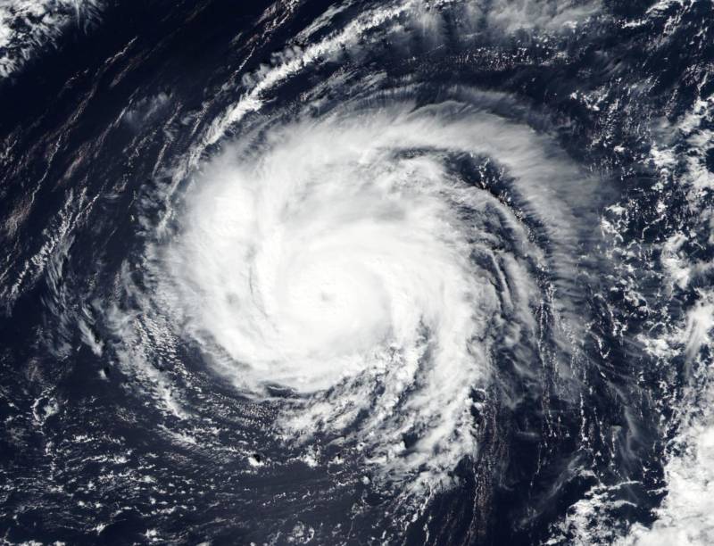
Scattered showers are expected to persist across the region Friday and Saturday before a second system moves through the region late Saturday into Sunday. The second system will be connected to a very strong storm -- formerly known as Typhoon Songda -- expected to hit the coast of northern Oregon and southern Washington state on Saturday.

Both storms are expected to bring exceptionally heavy rain and dangerously high winds to much of the Pacific Northwest.

The impact in the Bay Area is expected to be gentler, with periods of gusty winds and total rainfall by the end of the weekend ranging from 3 inches for the "usual suspect" locations in the coastal hills of northern Sonoma County -- yes, we're looking at you, Venado -- to three-quarters of an inch or so in San Jose and other lowland South Bay locales.

The storms far to the north and west will also generate big waves, prompting Bay Area forecasters to issue high surf and coastal flood advisories from Monterey Bay north to the Mendocino County line.

The National Weather Service says some weather models have suggested the possibility of a period of prolonged heavy rains in the Santa Cruz Mountains from late Saturday into Sunday. That would raise concerns about debris flows in the area of last month's Loma Fire.

Northwestern California, the state's wettest corner, could see more than a foot of rain in the Coast Range through the middle of next week.

The main impact of the first storm in the Sierra Nevada will be very high winds, with 125 mph gusts forecast over the Sierra ridges and 3- to 6-foot waves predicted for Lake Tahoe. Snow levels are expected to start out at about 9,000 feet, dropping to 7,000 feet late in the weekend.

Precipitation forecasts from the California-Nevada River Forecast Center show 7 to 8 inches of rain falling in the mountains above the state's two largest reservoirs, Shasta Lake and Lake Oroville.

As weather history fans up and down the West Coast are noting, the region has had some historic encounters with storms driven by remnant typhoons.

In 2009 -- exactly seven years ago today -- the remains of Typhoon Melor barged into California packing high winds and bringing a full-on deluge. Fifteen inches of rain fell in the Santa Lucia Range along Big Sur, and 10 inches fell in the Santa Cruz Mountains.

By far the best known of the October tempests, though, is the Columbus Day Storm of 1962, which had its origins in Typhoon Freda.

In the Bay Area, that event is remembered chiefly for forcing a three-day postponement of World Series Game 6 between the Giants and Yankees.

In the Pacific Northwest, gusts reached 83 mph in Seattle, 127 mph in Oregon's Willamette Valley and -- yes, people say this really happened -- 160 mph along the Washington coast.

Earlier this week, UCLA climate researcher Daniel Swain, proprietor of the peerless California Weather Blog, broke down a little of the history and dynamics of typhoons that impact the northern reaches of the West Coast:

Tropical cyclones in the warm West Pacific can occasionally “recurve” from their predominantly east-to-west trajectory, veering northward and then eventually eastward as they approach the active west-to-east storm track region and associated upper-atmospheric jet stream. Such recurving cyclones can affect West Coast weather via one or both of two possible mechanisms–either by strengthening and “extending” the East Asian jet stream further eastward over the North Pacific basin or less commonly by transitioning into a “hybrid” extratropical cyclone and arriving largely intact (but in weaker form) in the Pacific Northwest. In the present case, it appears that Songda will do a little of both–strengthening the overall storm track and persisting as a powerful remnant surface low as it treks eastward across the Pacific.

It might be a bit surprising to learn that former West Pacific typhoons can have such a profound influence upon West Coast weather. But history suggests that there is a relatively narrow window in autumn–mostly during the month of October–when a rare confluence of events can produce truly extreme storm conditions. One of the most significant California events of this kind in recent memory occurred in October 2009, when the remnants of Typhoon Melor re-intensified as an extratropical cyclone off the coast of Northern California and brought extraordinary rainfall and damaging winds to a wide region. But even the 2009 event pales in comparison to the incredibly destructive Columbus Day Storm of 1962, which drew its energy from the remnants of former Typhoon Freda. The so-called “Storm King” brought winds well in excess of 120 mph to much of coastal Oregon and near-hurricane force winds from the California border to Vancouver, BC–an event that would be even more disastrous today, given the large increase in population and human infrastructure that has occurred in that region since 1962. Fortunately, as disruptive as the upcoming event may be in Washington and Oregon, nothing even close to the magnitude of the 1962 event is anticipated.

lower waypoint
next waypoint
California Law Letting Property Owners Split Lots to Build New Homes Is 'Unconstitutional,' Judge RulesAlameda: The Island That Almost Wasn’tJust Days Left to Apply for California Program That Helps Pay for Your First HouseIn Fresno’s Chinatown, High-Speed Rail Sparks Hope and Debate Within ResidentsFresno's Chinatown Neighborhood To See Big Changes From High Speed RailRainn Wilson from ‘The Office’ on Why We Need a Spiritual RevolutionIs California Headed For Another Tax Revolt?UC Regent John Pérez on the Gaza Protests Roiling College CampusesNPR's Sarah McCammon on Leaving the Evangelical ChurchWill Less Homework Stress Make California Students Happier?