"They’re using multiple aircraft to try and get a line around the fire, get ahead of it to keep it from going into the homes in the Hesperia area," Sieliet said.
Ten water-dropping aircraft were attacking the fire Monday. The firefighting air fleet includes large and small helicopter air tankers, a small airplane and a DC-10.
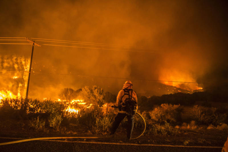
The fire is being fueled by very dry scrub and brush on national forest land that hasn't burned in at least 15 or 20 years, according to Bob Poole, a spokesman for the San Bernardino National Forest.
"As you know, in Southern California we are in our fifth year of a drought. The vegetation is extremely dry," Poole told KPCC's Take Two. "It's very receptive to fire, and what we're finding out is because of the vegetation type and the dryness, the fire is just moving rapidly through this brush."
So far, no structures have been burned, and there have been no injuries among the firefighters assigned to the Pilot Fire.
The cause of the fire is under investigation.
Evacuations
As of Monday afternoon, 4,700 homes on the mountain have been impacted by either mandatory or voluntary evacuations, according to the San Bernardino County Sheriff's Department. There were 500 homes impacted in Hesperia.
Some voluntary evacuations were made mandatory on Monday afternoon.
- There are mandatory evacuations north of Deep Creek Spillway, south of Rock Springs Road, east of the Mojave River and west of Kiowa Road. These homes are east of Hesperia Lake Park.
- There are also mandatory evacuations on the south side of Hesperia, south of Ranchero Road, Arrowhead Lake Road, to 173.
- Voluntary evacuations are underway for north Lake Arrowhead, from Brentwood east to Highway 173 and from Golf Course Road east to North Bay Road.
You can get information on what to do to prepare for an evacuation here.
The American Red Cross has set up a shelter at Oak Hills High School. A separate shelter for large animals has been established at the San Bernardino County Devore Animal Shelter in San Bernardino.
Another shelter at Ranchero Middle School in Hesperia was closed around midnight.
Evacuation orders were issued for residents of the Summit Valley area east of Cedar Springs Dam, which is a sparsely-populated community farther south and west.
Monday is the first day of school for Oak Hills, which has a campus of 2,500 students.
"We were raring and ready to go, and unfortunately yesterday the Pilot Fire broke out, so we're set up to accommodate evacuees," principal Mike Capps told KPCC.
Capps said the evacuation center in the school gym isn't limiting school activity. Just one household is making use of the center so far, but he was expecting more to arrive as the day goes on.
Fire officials said so far just 25 homes in the sparsely populated area are under evacuation orders.
Air quality
The Mojave Desert Air Quality Management District has issued a smoke advisory due to air pollution caused by the Pilot Fire burning above Silverwood Lake. Residents of Hesperia are most impacted by the smoke and ash in the air.
The district’s real-time air quality monitoring rated the air quality in Hesperia as moderate Monday afternoon — which is fine for most people to breathe, but could affect sensitive populations such as people with heart or lung problems as well as older people and children, said district spokeswoman Violette Roberts.
Much of the smoke is predicted to be on the north and east sides of the fire through Monday, according to the South Coast Air Quality Management District.
The Mojave Desert Air Quality Management District also issued a smoke advisory for the Victor Valley and surrounding communities.
Generally, a cloud of wildfire smoke high up in the air does not interfere with breathing — however smoke that you can smell, or see at ground level in the form of falling ash, is a signal to remain indoors, to use air conditioning on the re-circulate mode and to avoid strenuous exercise outdoors, she said.
This post has been updated.