upper waypoint

Bay Area, You've Got Another Date With a Storm

Save ArticleSave Article
Failed to save article

Please try again

A satellite view of storm system expected to arrive in Northern California late Thursday, bringing rain through Saturday. (NASA Worldview)

Our stormy January has produced a series of cool pictures from space. I'm partial to the photomosaics published every day on NASA's Worldview site.

You need to be a little patient each day, as the northern Pacific, where our weather is coming from, is generally the last part of the globe to be imaged each day by two NASA satellites orbiting about 430 miles up.

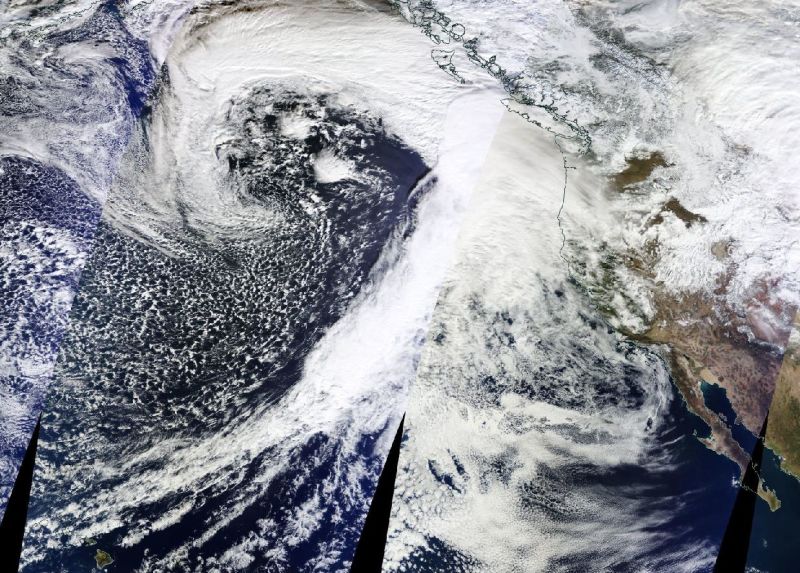
But the wait is usually worth it. Summertime images have often given dramatic evidence of California wildfires. And in the winter -- or at least this winter -- Worldview captures magnificent pictures of the big cyclones that have brought wave after wave of rain and wind to the West Coast this month.

The picture above (clipped from the original on Worldview) is of a system that's expected to bring two distinct rounds of stormy weather to the Bay Area and most of California, starting late Thursday.

The California Nevada River Forecast Center, in its Wednesday morning writeup of upcoming weather, describes the storm as "an impressive ... system spinning over the northeast Pacific near 47 North latitude and 147 West longitude. A broad cloud shield extends from just off the Pacific Northwest coast to the southwest. ... The moisture tap is also fairly impressive, extending from near the Hawaiian Islands to the northeast and then wrapping into the main circulation."

Sponsored

The "moisture tap" mentioned here is the long, long train of clouds extending more than 2,000 miles from near the island of Hawaii, just visible at lower left, up toward Washington state and British Columbia.

The storm is expected to bring between a half-inch to 2 inches of rain to sea-level locations and up to 4 inches at higher elevations in the Bay Area between late Thursday and Saturday. Flooding in coastal areas could be an issue with the arrival of king tides Thursday through the weekend. Forecasters also say that there's a more general concern for flooding and landslides throughout the region, as recent storms have saturated soils.

The National Weather Service Bay Area forecasters say gusty winds could be an issue Friday night into Saturday.

lower waypoint
next waypoint
California Legislature Halts 'Science of Reading' Mandate, Prompting Calls for Thorough ReviewProtesters Shut Down I-880 Freeway in Oakland as Part of 'Economic Blockade' for GazaForced Sterilization Survivors Undertake Own Healing After Feeling 'Silenced Again' by StateHalf Moon Bay Prepares to Break Ground on Farmworker HousingHow Aaron Peskin Shakes Up S.F.’s Mayoral RaceSilicon Valley Readies for Low-Simitian House Race Recount — but How Does It Work?Feds Abruptly Close East Bay Women’s Prison Following Sexual Abuse ScandalsRecall of Alameda County District Attorney Pamela Price Qualifies for a VotePlanned Parenthood Northern California Workers Unionize With SEIU Local 1021are u addicted to ur phone