A DC-10 firefighting aircraft drops fire retardant on a ridge in front of the Rocky Fire. (Justin Sullivan/Getty Images)
Update, Noon Wednesday, Aug. 5: Tuesday’s break from the hot, windy weather was more than welcome for crews battling the Rocky Fire, burning 80 miles north of San Francisco. Firefighting officials said crews made progress with some help from light rain Tuesday.
“We’re able to do things like cut fire line directly on the fire’s edge and not have to fall back and wait for the fire to come to us, so we can be more productive in that aspect,” says Jeff Ohs, a fire battalion chief from Long Beach.
But hot temperatures are expected to return today, creating the potential once again for extreme fire conditions.
In total the fire has burned 68,300 acres and is 20 percent contained. Thirty-nine residences and 52 outbuildings have been destroyed and four structures have been damaged. The blaze isn’t expected to be completely corralled until at least Monday. More than 3,000 firefighters are working on the fire.
Sponsored
Update, 5:30 p.m. Tuesday, Aug. 4: The Rocky Fire, southeast of Clear Lake, has burned 24 homes and spurred mandatory or advisory evacuation orders affecting some 13,000 people.
Listen to the Tuesday evening update below:
Update, 10:30 a.m., Tuesday, Aug. 4: The fire grew overnight to 65,000 acres, or about 101 square miles, and remains about 12 percent contained. It is expected to grow even larger today. Yesterday, firefighters were disappointed to see it cross Highway 20, into land that has plenty of fuel to burn.
“We are a little bit concerned about today’s weather,” says Cal Fire Capt. Don Camp. “We are expecting a slight increase of temperatures in the mid to upper 80s, but more trouble to us is we’re expecting a strong eastern wind push that could potentially push the fire west into areas that haven’t previously burnt.”
Filmmaker Jeff Frost has been sharing images and videos of the fire on his Instagram account. This timelapse of driving through the fire gives you a glimpse at what fire crews are facing.
Update, midnight Tuesday, Aug. 4: A quick note to say that the overall acreage on the Rocky Fire was reported to have grown “just” 2,000 acres during the day Monday — that’s more than 3 square miles, which is a lot, if you’re standing there looking at it. That puts the total acreage for the fire at 62,000, or about 97 square miles since it started last Wednesday.
Some 12,000 residents in the area, 80 miles north of San Francisco, are still under mandatory orders to leave their homes or have been advised they could be required to leave. The reported total of damaged structures — 24 homes and 26 outbuildings — has held steady since Saturday.
The relatively small total growth in the fire belies some grim moments Monday afternoon, when the blaze managed to jump Highway 20, which fire managers hoped would hold as a containment line on the northern side of the fire from the town of Clearlake 18 miles east to Highway 16. But as afternoon winds kicked up, spot fires started in several locations, forcing managers to redeploy strike teams, bulldozers, helicopters and air tankers to try to stop the new blazes from becoming established.
“The spot fires are very serious because of the winds, terrain and fuel bed,” Cal Fire Scott McLean said in an email to KQED’s Tara Siler.
The “fuel bed” McLean refers to involves the sprawling swath of countryside east of Clear Lake that hasn’t burned in decades and decades. The vegetation — grass, brush, oaks and pines — is extra dry after four years of drought, and McLean and other veteran firefighters are saying this is one of the most extreme wildfires they’ve ever seen.
Here’s Siler’s interview with McLean, aired at 5:30 p.m. Monday:
Update, 8:40 a.m. Monday, Aug. 3: The predictable news Monday morning from the Rocky Fire, burning near the southeast end of Clear Lake: It’s still growing. Cal Fire upped its estimate of acres burned to 60,000 — about 94 square miles or roughly double the size of San Francisco.
But there’s a welcome wrinkle in the fire agency’s morning report: After a weekend that saw the blaze race uncontrolled across vast sweeps of backcountry, firefighters have made some substantial progress toward containment. Fire lines have now been completed around 12 percent of the fire perimeter, up from the constant 5 percent reported over the last several days.
Cal Fire says 3,000 firefighters have now been assigned to the incident, along with four air tankers, 19 helicopters, 57 bulldozers and 285 fire engines.
Fire maps released Monday morning also show that fire managers have turned long stretches of Highway 20, along the fire’s northern edge, and Highway 16, on the eastern fringe, into de facto fire lines.
Cal Fire Capt. Tony McHale said crews conducted firing operations along both highways — igniting fires to deprive the advancing flames of fuel. Although that tactic has proved effective, McHale said that developments Sunday afternoon showed how quickly the fire can pose new threats.
“We had a lot of drama on the western flank,” McHale said, referring to the fire front near the town of Clearlake. “We had a spot fire just east of town that turned into a tremendous blow-up.”
That flare-up prompted new mandatory evacuation orders for residents of rural areas east of Clearlake. Cal Fire estimates a total of 12,000 people were either ordered from their homes or advised they may have to leave. It’s unclear how many have actually heeded orders to leave. The Lake County News website has reported that only a few dozen people had showed up at evacuation centers in Middletown and Kelseyville.
Update, 10:10 p.m. Sunday, Aug. 2: Cal Fire’s updated acreage total for the Rocky Fire is 54,000 acres, or about 84 square miles. The fire has doubled in size over the last 24 hours and, as noted earlier, it’s now the biggest fire of the state’s much-dreaded 2015 fire season, and it’s still just 5 percent contained.
Saturday, the fire burned rapidly to the north and east, forcing the closure of Highways 20 and 16. Sunday, Cal Fire says, the main growth in the blaze was on its northwest flank, in the general direction of the town of Clearlake.
That prompted a new round of mandatory evacuations in areas just east of that town. Cal Fire says about 12,000 people in more than 5,200 residences are under either mandatory orders to leave or have been warned they’ll have to evacuate if the fire continues to spread. It’s believed that most of those on alert live on the east side of Clearlake and the nearby town of Lower Lake.
A growing army of firefighters — about 2,700 in all — has been deployed to try to encircle the fire. Some of the increase in acreage Sunday was due to firing operations — a tactic in which crews set fires in carefully chosen areas to deny fuel to the advancing flames.
Update, 11:05 a.m. Sunday, Aug. 2: The Rocky Fire, now burning in three counties southeast of Clear Lake, is for now the biggest blaze of California’s 2015 fire season.
Cal Fire said this morning the fire, which started Wednesday afternoon, has covered 47,000 acres. That’s about 73.5 square miles — close to the same area as all of Oakland or double the size of San Francisco if you want to think of the blaze in Bay Area terms. The fire agency says the blaze is still just 5 percent contained.
The fire burned east from Lake County into Colusa and Yolo counties Saturday afternoon, apparently jumping a line ploughed by bulldozers on the blaze’s northeastern flank. The flames reached the edges of Highway 20 and Highway 16 at several points, prompting closure of both routes.
Mandatory evacuation orders are in place for a large area east of Clear Lake, while an advisory alerting residents they may need to leave their homes has been issued for those living on the east side of the towns of Lower Lake and Clearlake. The fire’s progress toward those two communities has slowed, however.
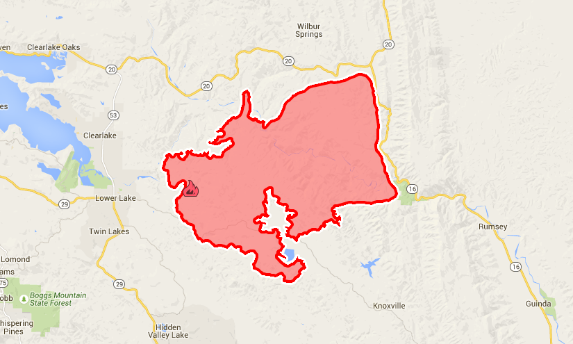
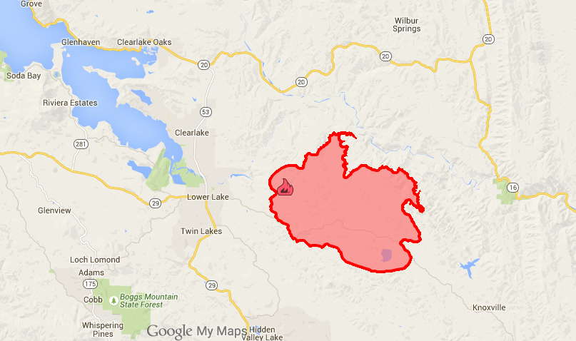
Cal Fire’s Sunday morning map of the Rocky Fire, east of Clear Lake. (Click map for full-size image.) (Cal Fire)
One piece of good news for the 2,000 firefighters brought into the battle: Weather is expected to be favorable for most of the coming week, with temperatures a little lower than normal and higher humidity expected. Afternoon conditions pose the biggest challenge, with gusty winds from the west and southwest helping push the fire further north and northeast.
Update, 9:40 p.m. Saturday, Aug. 1: The still-expanding Rocky Fire has shut down Highway 20, the main route between the southern Sacramento Valley, Clear Lake and the coast.
The route is now closed to through traffic between Highway 53, on the east shore of Clear Lake, and Highway 16 — a distance of 18 miles. Highway 16, which runs south from Highway 20 to the Capay Valley, has also been closed to through traffic at the Yolo-Lake county line.
Cal Fire says the blaze, now burning into its fourth full day, has charred 27,000 acres — about 42 square miles, an area a little larger than San Francisco and about half of Oakland. The fire agency say the fire has destroyed 24 homes and 26 outbuildings and is threatening about 6,000 residences, mostly in the Lake County towns of Clearlake and Lower Lake.
Residents have been ordered out of the mostly rural areas west, north and south of the fire. Residents on the east side of Clearlake and Lower Lake have been put on notice they may have to leave. Officials say the evacuation orders and advisories together affect about 12,000 people.
The fire is still reported to be 5 percent contained. The outlook? Cal Fire’s evening briefing is succinct: “The fire is expected to have significant activity and growth.” That’s because of continued hot, dry, windy conditions — and also because four years of drought in an area that hasn’t burned in a while have helped create ideal conditions for a major conflagration.
Update, 11:35 a.m. Saturday, Aug. 1: Cal Fire is reinforcing crews still struggling to contain the Rocky Fire southeast of Clear Lake, with the blaze growing to 22,500 acres — 35 square miles — early Saturday.
The continued rapid spread of the fire 80 miles north of San Francisco has prompted local officials to put thousands of residents in two towns — Lower Lake and Clearlake — on alert for a possible evacuation. Cal Fire maps suggest the blaze has burned to within about 2 miles of Lower Lake.
About 1,600 firefighters are now battling the blaze, which broke out Wednesday just east of the town of Lower Lake and has destroyed 14 homes and 16 outbuildings so far. The fire, burning in rugged oak woodlands, chaparral and grasslands typical of much of Lake County, is just 5 percent contained.
Cal Fire map of the Rocky Fire perimeter at midday Saturday, Aug. 1. (Click for larger image.)” (Cal Fire)
Residents have been ordered from hundreds of homes in rural areas east of Lower Lake. Saturday morning, the Lake County Sheriff’s Office issued an evacuation advisory — not an order, but an alert that an evacuation may be ordered — for the east sides of Lower Lake and Clearlake. About 6,100 homes and other structures are said to be threatened.
During a midday Saturday briefing, Cal Fire said the agency has about 9,000 firefighters working to contain 24 major fires across the state.
Update, 1:35 p.m. Friday, July 31: Cal Fire says the Rocky Fire, burning across the hilly countryside east of the town of Lower Lake, has consumed about 15,000 acres of oak, brush and grassland — about 24 square miles, or half the area of San Francisco.
About 1,000 firefighters were on the lines Friday morning, and the blaze was reported just 5 percent contained. So far, the fire is believed to have destroyed three homes and an undetermined number of barns, garages and other outbuildings.
About 650 residents were ordered from their homes in a rural area near Lower Lake on Wednesday night and Thursday morning, as the newly kindled fire raced east through dry vegetation. The fire spread to the south, east and north late Thursday and early Friday, and more mandatory evacuations were ordered Friday morning. It’s not immediately clear how many additional residents were affected.
YubaNet, perhaps the best non-official source of California fire news, reports Friday that about 8,000 firefighters are working on 18 major fires across the state.
Update, 11:50 a.m. Thursday, July 30: Cal Fire is rushing crews to the scene of a dangerous new fire that has forced evacuations in the hills southeast of Clear Lake.
The agency says the Rocky Fire, which began Wednesday afternoon, has burned 8,300 acres with no containment. Several homes and “multiple outbuildings” have reportedly burned in the area. Like much of the country between the Sacramento Valley and the coast, it’s steep terrain, riven by canyons and dominated by oaks, chaparral and grassland.
Residents along 5 miles of Morgan Valley Road east of the town of Lower Lake were ordered from their homes as the fire spread Wednesday evening.
Cal Fire says it has about 630 firefighters on the scene, supported by eight air tankers and 11 helicopters. That’s about double the number of firefighters on the scene last night, when the agency said its primary focus was on saving homes in the fire’s path.
Crews on the ground Thursday are contending with temperatures expected to peak between 100 and 105 degrees today, with humidity in the teens or single digits.
That same hot, dry weather has helped revive the Wragg Fire, a 7,500-acre blaze burning north of Vacaville and west of Winters at the southeast end of Lake Berryessa. Crews aided by relatively cool, humid weather seemed last weekend to be on the way to finishing containment of the fire — again, burning in extremely rugged country. But the return of scorching, sere conditions allowed the fire to flare up and resume its spread.
The blaze, announced at 6,591 acres early this week, has grown by about 1,000 acres in the last two days and has expanded to backup containment lines.
Update, 2:30 p.m. Saturday, July 25: Authorities have lifted all evacuation orders as fire crews continue to make rapid progress containing the fire that has burned across 6,900 acres at the southeast end of Lake Berryessa. Cal Fire says 1,825 firefighters are on the scene; the blaze was 47 percent contained as of noon Saturday.
Highway 128, the main access to Lake Berryessa from both the Napa Valley on the west and Interstate 505 on the east, was reopened Friday.
UC Davis’ Stebbins Cold Canyon Reserve, a popular hiking destination close to Monticello Dam, remains closed as officials assess damage to trail facilities.
Firefighters are also gaining ground on a relatively small but troublesome blaze near Kyburz, on U.S. 50 about 75 miles east of Sacramento. The 200-acre Kyburz Fire is now 30 percent contained.
The incident, sparked by a vehicle that had pulled off the side of the highway, had shut down the main route to Lake Tahoe. One lane of U.S. 50 was reopened Friday, with traffic being metered at Pollock Pines to the west and Meyers to the east.
Update, 10:30 a.m. Friday, July 24: Cal Fire reports the blaze burning near Lake Berryessa, the Wragg Fire, remains at 6,900 acres burned and has upped the containment number to 20 percent. Residents of the Golden Bear Estates, between the lake and Winters, have been allowed to return home. Residents of Quail Ridge, closer to the fire front, are still under a mandatory evacuation order.
The Kyburz Fire, burning along U.S. 50 about 75 miles east of Sacramento, doubled in size overnight to 200 acres. The main impact: The highway, one of the two main routes to Lake Tahoe from the Bay Area, is closed.
The weather forecast in both places is pretty favorable for firefighters — relatively mild temperatures and relatively high humidity, with no sustained high winds.
Update, 5:55 p.m. Thursday, July 23: Cal Fire is reporting some progress in containing the Wragg Fire, burning in rugged chaparral south of Lake Berryessa. As we noted earlier, containment is now reported at 15 percent, up from 5 percent earlier today.
Daniel Potter, who reports for KQED News and KQED Science, says that as the fire burns into more remote terrain, the threat to 200 homes that have been evacuated is easing. Weather conditions have improved somewhat, too.
“The winds have cooperated somewhat today, compared to yesterday, so firefighters are making really good progress,” said Amy Head, a Cal Fire captain and information office for the Wragg Fire. “We’re in obviously a very steep and rugged terrain area — crews are having to hike in. We’re using a lot of air resources as well. So it is a little bit slow-going, but we’re making good progress.”
Meantime, a new challenge for firefighters in the region: A blaze broke out this afternoon near the American River hamlet of Kyburz, on U.S. 50 about 75 miles east of Sacramento.
While that fire is not a big one yet — it had burned an estimated 100 acres or so as of 5:30 p.m. — it forced the closure of the highway, one of the two main routes between the Bay Area and Lake Tahoe. The highway is closed from just east of Pollock Pines east to Meyers. The most direct detour: Mormon Emigrant Trail, a well-maintained paved route that runs from outside Pollock Pines to Highway 88 near Silver Lake.
About 225 firefighters are on the lines trying to contain the blaze.
El Dorado National Forest officials reported mandatory evacuations have been ordered along a 5-mile stretch of U.S. 50 west of Kyburz, an unincorporated area dotted with campgrounds and summer cabins.
Update, 2:45 p.m. Thursday, July 23: Cal Fire reports that the Wragg Fire, which started Wednesday afternoon just south of Lake Berryessa, continues to grow rapidly. The agency says the blaze has now consumed about 6,900 acres — nearly 11 square miles.The fire is now reportedly 15 percent contained — up from 5 percent Thursday morning. A force of 1,300 firefighters, backed up by four air tankers and 10 helicopters, is working to limit the threat to two rural communities.
The most immediate threat, Cal Fire reports, is to 200 structures in an area called Quail Ridge. That’s close to the Markley Cove Marina at the southern end of the lake. Residents from Quail Ridge and from Golden Bear Estates — a community east of the lake — were ordered to evacuate Wednesday.
The fire has destroyed a barn and a tent trailer and damaged another building.
More information on the fire’s location and origin below.
Original post: Thursday, July 23 For the second time in two summers, Cal Fire is battling a major wildland blaze in the rugged country near the southern end of Lake Berryessa.
Last year, it was the 6,500-acre Monticello Fire, sparked by fireworks on the night of the Fourth of July.
This year, it’s the Wragg Fire, which Cal Fire says raced through 5,000 acres between about 2:30 p.m. and midnight Wednesday — nearly a square mile an hour. Early Thursday, the fire was reported 5 percent contained.
Cal Fire says the blaze is threatening about 150 structures and ordered mandatory evacuations of two unincorporated communities at the southern end of the lake: Quail Ridge, near the Markley Cove Resort in Napa County; and Golden Bear Estates, in Yolo County east of the lake and west of the town of Winters.
Two campgrounds in the area were also cleared out, and several hikers were helicoptered out of the Cold Canyon area near Monticello Dam, site of a UC Davis reserve and several popular trails.
An evacuation center has been set up in Winters. With many ranches in the area and livestock in peril — see the video below — a separate refuge was also set up north of town.
About 400 firefighters were trying to contend with the blaze, with more being dispatched to join the battle on Thursday. Among the aerial resources committed to the incident on Wednesday was a DC-10 jumbo jet that dropped fire retardant to try to slow the spread of the blaze.
Weather has been a major factor, with erratic winds driving the fire to the east and southeast from its suspected point of origin, a traffic accident at Highway 128 and Wragg Canyon Road. But the winds calmed Wednesday night, and more humid, cool weather is expected to help fire crews Thursday.
lower waypoint
Stay in touch. Sign up for our daily newsletter.
To learn more about how we use your information, please read our privacy policy.
window.__IS_SSR__=true
window.__INITIAL_STATE__={"attachmentsReducer":{"audio_0":{"type":"attachments","id":"audio_0","imgSizes":{"kqedFullSize":{"file":"https://ww2.kqed.org/news/wp-content/themes/KQED-unified/img/audio_bgs/background0.jpg"}}},"audio_1":{"type":"attachments","id":"audio_1","imgSizes":{"kqedFullSize":{"file":"https://ww2.kqed.org/news/wp-content/themes/KQED-unified/img/audio_bgs/background1.jpg"}}},"audio_2":{"type":"attachments","id":"audio_2","imgSizes":{"kqedFullSize":{"file":"https://ww2.kqed.org/news/wp-content/themes/KQED-unified/img/audio_bgs/background2.jpg"}}},"audio_3":{"type":"attachments","id":"audio_3","imgSizes":{"kqedFullSize":{"file":"https://ww2.kqed.org/news/wp-content/themes/KQED-unified/img/audio_bgs/background3.jpg"}}},"audio_4":{"type":"attachments","id":"audio_4","imgSizes":{"kqedFullSize":{"file":"https://ww2.kqed.org/news/wp-content/themes/KQED-unified/img/audio_bgs/background4.jpg"}}},"placeholder":{"type":"attachments","id":"placeholder","imgSizes":{"thumbnail":{"file":"https://ww2.kqed.org/wp-content/uploads/sites/10/2018/01/GettyImages-896326950-160x96.jpg","width":160,"height":96,"mimeType":"image/jpeg"},"medium":{"file":"https://ww2.kqed.org/wp-content/uploads/sites/10/2018/01/GettyImages-896326950-800x478.jpg","width":800,"height":478,"mimeType":"image/jpeg"},"large":{"file":"https://ww2.kqed.org/wp-content/uploads/sites/10/2018/01/GettyImages-896326950-1020x610.jpg","width":1020,"height":610,"mimeType":"image/jpeg"},"fd-lrg":{"file":"https://ww2.kqed.org/wp-content/uploads/sites/10/2018/01/GettyImages-896326950-1920x1148.jpg","width":1920,"height":1148,"mimeType":"image/jpeg"},"fd-med":{"file":"https://ww2.kqed.org/wp-content/uploads/sites/10/2018/01/GettyImages-896326950-1180x705.jpg","width":1180,"height":705,"mimeType":"image/jpeg"},"fd-sm":{"file":"https://ww2.kqed.org/wp-content/uploads/sites/10/2018/01/GettyImages-896326950-960x574.jpg","width":960,"height":574,"mimeType":"image/jpeg"},"post-thumbnail":{"file":"https://ww2.kqed.org/wp-content/uploads/sites/10/2018/01/GettyImages-896326950-672x372.jpg","width":672,"height":372,"mimeType":"image/jpeg"},"twentyfourteen-full-width":{"file":"https://ww2.kqed.org/wp-content/uploads/sites/10/2018/01/GettyImages-896326950-1038x576.jpg","width":1038,"height":576,"mimeType":"image/jpeg"},"xxsmall":{"file":"https://ww2.kqed.org/wp-content/uploads/sites/10/2018/01/GettyImages-896326950-240x143.jpg","width":240,"height":143,"mimeType":"image/jpeg"},"xsmall":{"file":"https://ww2.kqed.org/wp-content/uploads/sites/10/2018/01/GettyImages-896326950-375x224.jpg","width":375,"height":224,"mimeType":"image/jpeg"},"small":{"file":"https://ww2.kqed.org/wp-content/uploads/sites/10/2018/01/GettyImages-896326950-520x311.jpg","width":520,"height":311,"mimeType":"image/jpeg"},"xlarge":{"file":"https://ww2.kqed.org/wp-content/uploads/sites/10/2018/01/GettyImages-896326950-1180x705.jpg","width":1180,"height":705,"mimeType":"image/jpeg"},"full-width":{"file":"https://ww2.kqed.org/wp-content/uploads/sites/10/2018/01/GettyImages-896326950-1920x1148.jpg","width":1920,"height":1148,"mimeType":"image/jpeg"},"guest-author-32":{"file":"https://ww2.kqed.org/wp-content/uploads/sites/10/2018/01/GettyImages-896326950-32x32.jpg","width":32,"height":32,"mimeType":"image/jpeg"},"guest-author-50":{"file":"https://ww2.kqed.org/wp-content/uploads/sites/10/2018/01/GettyImages-896326950-50x50.jpg","width":50,"height":50,"mimeType":"image/jpeg"},"guest-author-64":{"file":"https://ww2.kqed.org/wp-content/uploads/sites/10/2018/01/GettyImages-896326950-64x64.jpg","width":64,"height":64,"mimeType":"image/jpeg"},"guest-author-96":{"file":"https://ww2.kqed.org/wp-content/uploads/sites/10/2018/01/GettyImages-896326950-96x96.jpg","width":96,"height":96,"mimeType":"image/jpeg"},"guest-author-128":{"file":"https://ww2.kqed.org/wp-content/uploads/sites/10/2018/01/GettyImages-896326950-128x128.jpg","width":128,"height":128,"mimeType":"image/jpeg"},"detail":{"file":"https://ww2.kqed.org/wp-content/uploads/sites/10/2018/01/GettyImages-896326950-150x150.jpg","width":150,"height":150,"mimeType":"image/jpeg"},"kqedFullSize":{"file":"https://ww2.kqed.org/wp-content/uploads/sites/10/2018/01/GettyImages-896326950-e1514998105161.jpg","width":1920,"height":1148}}},"news_11983202":{"type":"attachments","id":"news_11983202","meta":{"index":"attachments_1591205162","site":"news","id":"11983202","found":true},"title":"Crowds-flee","publishDate":1713314335,"status":"inherit","parent":11983182,"modified":1713387599,"caption":"People flee the fire that started after the earthquake on April 18, 1906.","credit":"\u003ca href=\"https://digitalsf.org/islandora/object/islandora%3A133324?solr_nav%5Bid%5D=2a1aaa750d80593cd80a&solr_nav%5Bpage%5D=1&solr_nav%5Boffset%5D=11\">San Francisco History Center/San Francisco Public Library\u003c/a>","altTag":"A black-and-white photo shows people running away from what looks like a massive fire.","description":null,"imgSizes":{"thumbnail":{"file":"https://cdn.kqed.org/wp-content/uploads/sites/10/2024/04/Crowds-flee-160x95.jpg","width":160,"height":95,"mimeType":"image/jpeg"},"kqedFullSize":{"file":"https://cdn.kqed.org/wp-content/uploads/sites/10/2024/04/Crowds-flee.jpg","width":600,"height":355}},"fetchFailed":false,"isLoading":false},"news_11982969":{"type":"attachments","id":"news_11982969","meta":{"index":"attachments_1591205162","site":"news","id":"11982969","found":true},"title":"DSC_0201","publishDate":1713197211,"status":"inherit","parent":11982940,"modified":1713197315,"caption":"Protesters stand on the roadway of southbound I-880 in West Oakland Monday morning. ","credit":"Beth LaBerge/KQED","altTag":null,"description":null,"imgSizes":{"medium":{"file":"https://cdn.kqed.org/wp-content/uploads/sites/10/2024/04/DSC_0201-800x533.jpg","width":800,"height":533,"mimeType":"image/jpeg"},"large":{"file":"https://cdn.kqed.org/wp-content/uploads/sites/10/2024/04/DSC_0201-1020x680.jpg","width":1020,"height":680,"mimeType":"image/jpeg"},"thumbnail":{"file":"https://cdn.kqed.org/wp-content/uploads/sites/10/2024/04/DSC_0201-160x107.jpg","width":160,"height":107,"mimeType":"image/jpeg"},"1536x1536":{"file":"https://cdn.kqed.org/wp-content/uploads/sites/10/2024/04/DSC_0201-1536x1024.jpg","width":1536,"height":1024,"mimeType":"image/jpeg"},"post-thumbnail":{"file":"https://cdn.kqed.org/wp-content/uploads/sites/10/2024/04/DSC_0201-672x372.jpg","width":672,"height":372,"mimeType":"image/jpeg"},"twentyfourteen-full-width":{"file":"https://cdn.kqed.org/wp-content/uploads/sites/10/2024/04/DSC_0201-1038x576.jpg","width":1038,"height":576,"mimeType":"image/jpeg"},"kqedFullSize":{"file":"https://cdn.kqed.org/wp-content/uploads/sites/10/2024/04/DSC_0201.jpg","width":1620,"height":1080}},"fetchFailed":false,"isLoading":false},"news_11983385":{"type":"attachments","id":"news_11983385","meta":{"index":"attachments_1591205162","site":"news","id":"11983385","found":true},"title":"Oakland International Airport on April 14, 2020.","publishDate":1713473411,"status":"inherit","parent":11983384,"modified":1713473500,"caption":"Oakland International Airport on April 14, 2020.","credit":"Beth LaBerge/KQED","altTag":"An airport terminal with line dividers and luggage check with a sign that reads \"Oakland International.\"","description":null,"imgSizes":{"medium":{"file":"https://cdn.kqed.org/wp-content/uploads/sites/10/2024/04/007_KQED_Oakland_Airport_04142020_qut-800x533.jpg","width":800,"height":533,"mimeType":"image/jpeg"},"large":{"file":"https://cdn.kqed.org/wp-content/uploads/sites/10/2024/04/007_KQED_Oakland_Airport_04142020_qut-1020x680.jpg","width":1020,"height":680,"mimeType":"image/jpeg"},"thumbnail":{"file":"https://cdn.kqed.org/wp-content/uploads/sites/10/2024/04/007_KQED_Oakland_Airport_04142020_qut-160x107.jpg","width":160,"height":107,"mimeType":"image/jpeg"},"1536x1536":{"file":"https://cdn.kqed.org/wp-content/uploads/sites/10/2024/04/007_KQED_Oakland_Airport_04142020_qut-1536x1024.jpg","width":1536,"height":1024,"mimeType":"image/jpeg"},"post-thumbnail":{"file":"https://cdn.kqed.org/wp-content/uploads/sites/10/2024/04/007_KQED_Oakland_Airport_04142020_qut-672x372.jpg","width":672,"height":372,"mimeType":"image/jpeg"},"twentyfourteen-full-width":{"file":"https://cdn.kqed.org/wp-content/uploads/sites/10/2024/04/007_KQED_Oakland_Airport_04142020_qut-1038x576.jpg","width":1038,"height":576,"mimeType":"image/jpeg"},"kqedFullSize":{"file":"https://cdn.kqed.org/wp-content/uploads/sites/10/2024/04/007_KQED_Oakland_Airport_04142020_qut.jpg","width":1920,"height":1280}},"fetchFailed":false,"isLoading":false},"forum_2010101905444":{"type":"attachments","id":"forum_2010101905444","meta":{"index":"attachments_1591205162","site":"forum","id":"2010101905444","found":true},"title":"1920 x 1080 template (15)","publishDate":1713474199,"status":"inherit","parent":2010101905441,"modified":1713474263,"caption":"Alua Arthur's new book is \"Briefly Perfectly Human: Making an Authentic Life by Getting Real About the End.\"","credit":"Yeofi Andoh","altTag":null,"description":null,"imgSizes":{"medium":{"file":"https://cdn.kqed.org/wp-content/uploads/sites/43/2024/04/1920-x-1080-template-15-800x450.png","width":800,"height":450,"mimeType":"image/png"},"large":{"file":"https://cdn.kqed.org/wp-content/uploads/sites/43/2024/04/1920-x-1080-template-15-1020x574.png","width":1020,"height":574,"mimeType":"image/png"},"thumbnail":{"file":"https://cdn.kqed.org/wp-content/uploads/sites/43/2024/04/1920-x-1080-template-15-160x90.png","width":160,"height":90,"mimeType":"image/png"},"medium_large":{"file":"https://cdn.kqed.org/wp-content/uploads/sites/43/2024/04/1920-x-1080-template-15-768x432.png","width":768,"height":432,"mimeType":"image/png"},"1536x1536":{"file":"https://cdn.kqed.org/wp-content/uploads/sites/43/2024/04/1920-x-1080-template-15-1536x864.png","width":1536,"height":864,"mimeType":"image/png"},"post-thumbnail":{"file":"https://cdn.kqed.org/wp-content/uploads/sites/43/2024/04/1920-x-1080-template-15-672x372.png","width":672,"height":372,"mimeType":"image/png"},"twentyfourteen-full-width":{"file":"https://cdn.kqed.org/wp-content/uploads/sites/43/2024/04/1920-x-1080-template-15-1038x576.png","width":1038,"height":576,"mimeType":"image/png"},"kqedFullSize":{"file":"https://cdn.kqed.org/wp-content/uploads/sites/43/2024/04/1920-x-1080-template-15.png","width":1920,"height":1080}},"fetchFailed":false,"isLoading":false},"news_11872820":{"type":"attachments","id":"news_11872820","meta":{"index":"attachments_1591205162","site":"news","id":"11872820","found":true},"title":"RS48839_022_Alameda_MarioGonzalezPressConf_04272021-qut","publishDate":1620427268,"status":"inherit","parent":11871887,"modified":1649440866,"caption":"Protesters gathered outside Alameda Police Department headquarters on April 27, 2021, the day police released bodycam footage of Gonzalez's April 19 death.","credit":"Beth LaBerge/KQED","altTag":"Someone holding a sign in front of the Alameda Police station","description":"Friends, family and supporters of Mario Gonzalez gathered outside the Alameda Police Dept. on April 27, 2021 for a press conference on the day police publicly released body cam footage of Gonzalez's death.","imgSizes":{"medium":{"file":"https://ww2.kqed.org/app/uploads/sites/10/2021/05/RS48839_022_Alameda_MarioGonzalezPressConf_04272021-qut-800x533.jpg","width":800,"height":533,"mimeType":"image/jpeg"},"large":{"file":"https://ww2.kqed.org/app/uploads/sites/10/2021/05/RS48839_022_Alameda_MarioGonzalezPressConf_04272021-qut-1020x679.jpg","width":1020,"height":679,"mimeType":"image/jpeg"},"thumbnail":{"file":"https://ww2.kqed.org/app/uploads/sites/10/2021/05/RS48839_022_Alameda_MarioGonzalezPressConf_04272021-qut-160x107.jpg","width":160,"height":107,"mimeType":"image/jpeg"},"1536x1536":{"file":"https://ww2.kqed.org/app/uploads/sites/10/2021/05/RS48839_022_Alameda_MarioGonzalezPressConf_04272021-qut-1536x1022.jpg","width":1536,"height":1022,"mimeType":"image/jpeg"},"post-thumbnail":{"file":"https://ww2.kqed.org/app/uploads/sites/10/2021/05/RS48839_022_Alameda_MarioGonzalezPressConf_04272021-qut-672x372.jpg","width":672,"height":372,"mimeType":"image/jpeg"},"twentyfourteen-full-width":{"file":"https://ww2.kqed.org/app/uploads/sites/10/2021/05/RS48839_022_Alameda_MarioGonzalezPressConf_04272021-qut-1038x576.jpg","width":1038,"height":576,"mimeType":"image/jpeg"},"kqedFullSize":{"file":"https://ww2.kqed.org/app/uploads/sites/10/2021/05/RS48839_022_Alameda_MarioGonzalezPressConf_04272021-qut.jpg","width":1920,"height":1278}},"fetchFailed":false,"isLoading":false},"news_11983320":{"type":"attachments","id":"news_11983320","meta":{"index":"attachments_1591205162","site":"news","id":"11983320","found":true},"title":"IMG-20230604-WA0001","publishDate":1713401922,"status":"inherit","parent":11983313,"modified":1713562494,"caption":"Phoeun You looking out on the Cambodian countryside.","credit":"Courtesy of Phoeun You","altTag":"A man seen from behind stands on a balcony at sunset, looking out at a lush forest and mountain landscape.","description":null,"imgSizes":{"medium":{"file":"https://cdn.kqed.org/wp-content/uploads/sites/10/2024/04/IMG-20230604-WA0001-800x600.jpg","width":800,"height":600,"mimeType":"image/jpeg"},"large":{"file":"https://cdn.kqed.org/wp-content/uploads/sites/10/2024/04/IMG-20230604-WA0001-1020x765.jpg","width":1020,"height":765,"mimeType":"image/jpeg"},"thumbnail":{"file":"https://cdn.kqed.org/wp-content/uploads/sites/10/2024/04/IMG-20230604-WA0001-160x120.jpg","width":160,"height":120,"mimeType":"image/jpeg"},"post-thumbnail":{"file":"https://cdn.kqed.org/wp-content/uploads/sites/10/2024/04/IMG-20230604-WA0001-672x372.jpg","width":672,"height":372,"mimeType":"image/jpeg"},"twentyfourteen-full-width":{"file":"https://cdn.kqed.org/wp-content/uploads/sites/10/2024/04/IMG-20230604-WA0001-1038x576.jpg","width":1038,"height":576,"mimeType":"image/jpeg"},"kqedFullSize":{"file":"https://cdn.kqed.org/wp-content/uploads/sites/10/2024/04/IMG-20230604-WA0001.jpg","width":1280,"height":960}},"fetchFailed":false,"isLoading":false},"news_11983324":{"type":"attachments","id":"news_11983324","meta":{"index":"attachments_1591205162","site":"news","id":"11983324","found":true},"title":"Dr. Huey P. Newton Way Dedication","publishDate":1713449266,"status":"inherit","parent":11983323,"modified":1713449405,"caption":"People hold their hands on their hearts as a prayer is read during the dedication of a section of 9th Street as \"u201cDr. Huey P. Newton Way\"u201d in West Oakland, Calif., on Wednesday, February 17, 2021. Newton, cofounder of the Black Panther Party, was shot and killed on the street in 1989.","credit":"Jane Tyska/Digital First Media/East Bay Times via Getty Images","altTag":null,"description":null,"imgSizes":{"medium":{"file":"https://cdn.kqed.org/wp-content/uploads/sites/10/2024/04/GettyImages-1302886066-800x550.jpg","width":800,"height":550,"mimeType":"image/jpeg"},"large":{"file":"https://cdn.kqed.org/wp-content/uploads/sites/10/2024/04/GettyImages-1302886066-1020x701.jpg","width":1020,"height":701,"mimeType":"image/jpeg"},"thumbnail":{"file":"https://cdn.kqed.org/wp-content/uploads/sites/10/2024/04/GettyImages-1302886066-160x110.jpg","width":160,"height":110,"mimeType":"image/jpeg"},"1536x1536":{"file":"https://cdn.kqed.org/wp-content/uploads/sites/10/2024/04/GettyImages-1302886066-1536x1056.jpg","width":1536,"height":1056,"mimeType":"image/jpeg"},"2048x2048":{"file":"https://cdn.kqed.org/wp-content/uploads/sites/10/2024/04/GettyImages-1302886066-2048x1408.jpg","width":2048,"height":1408,"mimeType":"image/jpeg"},"post-thumbnail":{"file":"https://cdn.kqed.org/wp-content/uploads/sites/10/2024/04/GettyImages-1302886066-672x372.jpg","width":672,"height":372,"mimeType":"image/jpeg"},"twentyfourteen-full-width":{"file":"https://cdn.kqed.org/wp-content/uploads/sites/10/2024/04/GettyImages-1302886066-1038x576.jpg","width":1038,"height":576,"mimeType":"image/jpeg"},"full-width":{"file":"https://cdn.kqed.org/wp-content/uploads/sites/10/2024/04/GettyImages-1302886066-1920x1320.jpg","width":1920,"height":1320,"mimeType":"image/jpeg"},"kqedFullSize":{"file":"https://cdn.kqed.org/wp-content/uploads/sites/10/2024/04/GettyImages-1302886066-scaled.jpg","width":2560,"height":1760}},"fetchFailed":false,"isLoading":false},"news_11983282":{"type":"attachments","id":"news_11983282","meta":{"index":"attachments_1591205162","site":"news","id":"11983282","found":true},"title":"freedom-flotilla-ships-2024","publishDate":1713392966,"status":"inherit","parent":11983233,"modified":1713469163,"caption":"A cargo ship and a passenger vessel are part of the Freedom Flotilla Coalition’s planned aid mission to Gaza this month.","credit":"Courtesy of Freedom Flotilla Coalition","altTag":null,"description":null,"imgSizes":{"medium":{"file":"https://cdn.kqed.org/wp-content/uploads/sites/10/2024/04/freedom-flotilla-ships-2024-800x533.jpeg","width":800,"height":533,"mimeType":"image/jpeg"},"large":{"file":"https://cdn.kqed.org/wp-content/uploads/sites/10/2024/04/freedom-flotilla-ships-2024-1020x680.jpeg","width":1020,"height":680,"mimeType":"image/jpeg"},"thumbnail":{"file":"https://cdn.kqed.org/wp-content/uploads/sites/10/2024/04/freedom-flotilla-ships-2024-160x107.jpeg","width":160,"height":107,"mimeType":"image/jpeg"},"1536x1536":{"file":"https://cdn.kqed.org/wp-content/uploads/sites/10/2024/04/freedom-flotilla-ships-2024-1536x1024.jpeg","width":1536,"height":1024,"mimeType":"image/jpeg"},"post-thumbnail":{"file":"https://cdn.kqed.org/wp-content/uploads/sites/10/2024/04/freedom-flotilla-ships-2024-672x372.jpeg","width":672,"height":372,"mimeType":"image/jpeg"},"twentyfourteen-full-width":{"file":"https://cdn.kqed.org/wp-content/uploads/sites/10/2024/04/freedom-flotilla-ships-2024-1038x576.jpeg","width":1038,"height":576,"mimeType":"image/jpeg"},"kqedFullSize":{"file":"https://cdn.kqed.org/wp-content/uploads/sites/10/2024/04/freedom-flotilla-ships-2024.jpeg","width":1920,"height":1280}},"fetchFailed":false,"isLoading":false},"news_11976906":{"type":"attachments","id":"news_11976906","meta":{"index":"attachments_1591205162","site":"news","id":"11976906","found":true},"title":"240222-CANNABISEQUITY-21-BL-KQED","publishDate":1708709805,"status":"inherit","parent":0,"modified":1713378477,"caption":"Ivan Castro stands outside the Mission Cannabis Club in San Francisco on Feb. 22, 2024.","credit":"Beth LaBerge/KQED","altTag":"A man wearing a green bomber jacket stands near a wall with cannabis leaves in the background.","description":null,"imgSizes":{"medium":{"file":"https://cdn.kqed.org/wp-content/uploads/sites/10/2024/02/240222-CANNABISEQUITY-21-BL-KQED-800x533.jpg","width":800,"height":533,"mimeType":"image/jpeg"},"large":{"file":"https://cdn.kqed.org/wp-content/uploads/sites/10/2024/02/240222-CANNABISEQUITY-21-BL-KQED-1020x680.jpg","width":1020,"height":680,"mimeType":"image/jpeg"},"thumbnail":{"file":"https://cdn.kqed.org/wp-content/uploads/sites/10/2024/02/240222-CANNABISEQUITY-21-BL-KQED-160x107.jpg","width":160,"height":107,"mimeType":"image/jpeg"},"1536x1536":{"file":"https://cdn.kqed.org/wp-content/uploads/sites/10/2024/02/240222-CANNABISEQUITY-21-BL-KQED-1536x1024.jpg","width":1536,"height":1024,"mimeType":"image/jpeg"},"post-thumbnail":{"file":"https://cdn.kqed.org/wp-content/uploads/sites/10/2024/02/240222-CANNABISEQUITY-21-BL-KQED-672x372.jpg","width":672,"height":372,"mimeType":"image/jpeg"},"twentyfourteen-full-width":{"file":"https://cdn.kqed.org/wp-content/uploads/sites/10/2024/02/240222-CANNABISEQUITY-21-BL-KQED-1038x576.jpg","width":1038,"height":576,"mimeType":"image/jpeg"},"full-width":{"file":"https://cdn.kqed.org/wp-content/uploads/sites/10/2024/02/240222-CANNABISEQUITY-21-BL-KQED-1920x1280.jpg","width":1920,"height":1280,"mimeType":"image/jpeg"},"kqedFullSize":{"file":"https://cdn.kqed.org/wp-content/uploads/sites/10/2024/02/240222-CANNABISEQUITY-21-BL-KQED.jpg","width":2000,"height":1333}},"fetchFailed":false,"isLoading":false},"forum_2010101905455":{"type":"attachments","id":"forum_2010101905455","meta":{"index":"attachments_1591205162","site":"forum","id":"2010101905455","found":true},"title":"Copy of 1920 x 1080 template","publishDate":1713481047,"status":"inherit","parent":2010101905447,"modified":1713481060,"caption":"Leslie Bennett and Julie Chai's new book is \"Garden Wonderland: Create Life-Changing Outdoor Spaces for Beauty, Harvest, Meaning, and Joy.\"","credit":"Rachel Weill","altTag":null,"description":null,"imgSizes":{"medium":{"file":"https://cdn.kqed.org/wp-content/uploads/sites/43/2024/04/Copy-of-1920-x-1080-template-2-800x450.png","width":800,"height":450,"mimeType":"image/png"},"large":{"file":"https://cdn.kqed.org/wp-content/uploads/sites/43/2024/04/Copy-of-1920-x-1080-template-2-1020x574.png","width":1020,"height":574,"mimeType":"image/png"},"thumbnail":{"file":"https://cdn.kqed.org/wp-content/uploads/sites/43/2024/04/Copy-of-1920-x-1080-template-2-160x90.png","width":160,"height":90,"mimeType":"image/png"},"medium_large":{"file":"https://cdn.kqed.org/wp-content/uploads/sites/43/2024/04/Copy-of-1920-x-1080-template-2-768x432.png","width":768,"height":432,"mimeType":"image/png"},"1536x1536":{"file":"https://cdn.kqed.org/wp-content/uploads/sites/43/2024/04/Copy-of-1920-x-1080-template-2-1536x864.png","width":1536,"height":864,"mimeType":"image/png"},"post-thumbnail":{"file":"https://cdn.kqed.org/wp-content/uploads/sites/43/2024/04/Copy-of-1920-x-1080-template-2-672x372.png","width":672,"height":372,"mimeType":"image/png"},"twentyfourteen-full-width":{"file":"https://cdn.kqed.org/wp-content/uploads/sites/43/2024/04/Copy-of-1920-x-1080-template-2-1038x576.png","width":1038,"height":576,"mimeType":"image/png"},"kqedFullSize":{"file":"https://cdn.kqed.org/wp-content/uploads/sites/43/2024/04/Copy-of-1920-x-1080-template-2.png","width":1920,"height":1080}},"fetchFailed":false,"isLoading":false},"news_10631460":{"type":"attachments","id":"news_10631460","meta":{"index":"attachments_1591205162","site":"news","id":"10631460","found":true},"title":"Rocky Fire","publishDate":1438803982,"status":"inherit","parent":10611968,"modified":1438833222,"caption":"A DC-10 firefighting aircraft drops fire retardant on a ridge in front of the Rocky Fire.","credit":"Justin Sullivan/Getty Images","description":"A DC-10 firefighting aircraft drops fire retardant on a ridge in front of the Rocky Fire.","imgSizes":{"thumbnail":{"file":"https://ww2.kqed.org/app/uploads/sites/10/2015/08/DC10Slurry-400x258.jpg","width":400,"height":258,"mimeType":"image/jpeg"},"medium":{"file":"https://ww2.kqed.org/app/uploads/sites/10/2015/08/DC10Slurry-800x515.jpg","width":800,"height":515,"mimeType":"image/jpeg"},"large":{"file":"https://ww2.kqed.org/app/uploads/sites/10/2015/08/DC10Slurry-1440x927.jpg","width":1440,"height":927,"mimeType":"image/jpeg"},"fd-lrg":{"file":"https://ww2.kqed.org/app/uploads/sites/10/2015/08/DC10Slurry-1920x1236.jpg","width":1920,"height":1236,"mimeType":"image/jpeg"},"fd-med":{"file":"https://ww2.kqed.org/app/uploads/sites/10/2015/08/DC10Slurry-1180x760.jpg","width":1180,"height":760,"mimeType":"image/jpeg"},"fd-sm":{"file":"https://ww2.kqed.org/app/uploads/sites/10/2015/08/DC10Slurry-960x618.jpg","width":960,"height":618,"mimeType":"image/jpeg"},"post-thumbnail":{"file":"https://ww2.kqed.org/app/uploads/sites/10/2015/08/DC10Slurry-672x372.jpg","width":672,"height":372,"mimeType":"image/jpeg"},"twentyfourteen-full-width":{"file":"https://ww2.kqed.org/app/uploads/sites/10/2015/08/DC10Slurry-1038x576.jpg","width":1038,"height":576,"mimeType":"image/jpeg"},"guest-author-32":{"file":"https://ww2.kqed.org/app/uploads/sites/10/2015/08/DC10Slurry-32x32.jpg","width":32,"height":32,"mimeType":"image/jpeg"},"guest-author-64":{"file":"https://ww2.kqed.org/app/uploads/sites/10/2015/08/DC10Slurry-64x64.jpg","width":64,"height":64,"mimeType":"image/jpeg"},"guest-author-96":{"file":"https://ww2.kqed.org/app/uploads/sites/10/2015/08/DC10Slurry-96x96.jpg","width":96,"height":96,"mimeType":"image/jpeg"},"guest-author-128":{"file":"https://ww2.kqed.org/app/uploads/sites/10/2015/08/DC10Slurry-128x128.jpg","width":128,"height":128,"mimeType":"image/jpeg"},"detail":{"file":"https://ww2.kqed.org/app/uploads/sites/10/2015/08/DC10Slurry-75x75.jpg","width":75,"height":75,"mimeType":"image/jpeg"},"jmtc-small-thumb":{"file":"https://ww2.kqed.org/app/uploads/sites/10/2015/08/DC10Slurry-280x150.jpg","width":280,"height":150,"mimeType":"image/jpeg"},"kqedFullSize":{"file":"https://ww2.kqed.org/app/uploads/sites/10/2015/08/DC10Slurry.jpg","width":1920,"height":1236}},"fetchFailed":false,"isLoading":false}},"audioPlayerReducer":{"postId":"stream_live"},"authorsReducer":{"byline_news_11983313":{"type":"authors","id":"byline_news_11983313","meta":{"override":true},"slug":"byline_news_11983313","name":"Mateo Schimpf","isLoading":false},"byline_news_11983231":{"type":"authors","id":"byline_news_11983231","meta":{"override":true},"slug":"byline_news_11983231","name":"Katie DeBenedetti","isLoading":false},"katrinaschwartz":{"type":"authors","id":"234","meta":{"index":"authors_1591205172","id":"234","found":true},"name":"Katrina Schwartz","firstName":"Katrina","lastName":"Schwartz","slug":"katrinaschwartz","email":"kschwartz@kqed.org","display_author_email":false,"staff_mastheads":["news"],"title":"Producer","bio":"Katrina Schwartz is a journalist based in San Francisco. She's worked at KPCC public radio in LA and has reported on air and online for KQED since 2010. She covered how teaching and learning is changing for MindShift between 2012 and 2020. She is the co-host of the MindShift podcast and now produces KQED's Bay Curious podcast.","avatar":"https://secure.gravatar.com/avatar/a6a567574dafefa959593925eead665c?s=600&d=blank&r=g","twitter":"kschwart","facebook":null,"instagram":null,"linkedin":null,"sites":[{"site":"news","roles":["editor"]},{"site":"mindshift","roles":["administrator"]},{"site":"stateofhealth","roles":["author"]},{"site":"science","roles":["editor"]}],"headData":{"title":"Katrina Schwartz | KQED","description":"Producer","ogImgSrc":"https://secure.gravatar.com/avatar/a6a567574dafefa959593925eead665c?s=600&d=blank&r=g","twImgSrc":"https://secure.gravatar.com/avatar/a6a567574dafefa959593925eead665c?s=600&d=blank&r=g"},"isLoading":false,"link":"/author/katrinaschwartz"},"kqed":{"type":"authors","id":"236","meta":{"index":"authors_1591205172","id":"236","found":true},"name":"KQED News Staff","firstName":"KQED News Staff","lastName":null,"slug":"kqed","email":"faq@kqed.org","display_author_email":false,"staff_mastheads":[],"title":null,"bio":null,"avatar":"https://secure.gravatar.com/avatar/ef0e801a68c4c54afa9180db14084167?s=600&d=blank&r=g","twitter":null,"facebook":null,"instagram":null,"linkedin":null,"sites":[{"site":"arts","roles":["contributor"]},{"site":"news","roles":["editor"]},{"site":"futureofyou","roles":["author"]}],"headData":{"title":"KQED News Staff | KQED","description":null,"ogImgSrc":"https://secure.gravatar.com/avatar/ef0e801a68c4c54afa9180db14084167?s=600&d=blank&r=g","twImgSrc":"https://secure.gravatar.com/avatar/ef0e801a68c4c54afa9180db14084167?s=600&d=blank&r=g"},"isLoading":false,"link":"/author/kqed"},"minakim":{"type":"authors","id":"243","meta":{"index":"authors_1591205172","id":"243","found":true},"name":"Mina Kim","firstName":"Mina","lastName":"Kim","slug":"minakim","email":"mkim@kqed.org","display_author_email":false,"staff_mastheads":["news"],"title":"Host, Forum","bio":"Mina Kim is host of the 10 a.m. statewide hour of Forum; a live daily talk show for curious Californians on issues that matter to the state and nation, with a particular emphasis on race and equity.\r\n\r\nBefore joining the Forum team, Mina was KQED’s evening news anchor, and health reporter for The California Report. Her award-winning work has included natural disasters in Napa and gun violence in Oakland. Mina grew up in St. John’s, Newfoundland.","avatar":"https://secure.gravatar.com/avatar/145ce657a2d08cb86d93686beb958982?s=600&d=blank&r=g","twitter":"mkimreporter","facebook":null,"instagram":null,"linkedin":null,"sites":[{"site":"news","roles":["contributor"]},{"site":"stateofhealth","roles":["author"]},{"site":"forum","roles":["editor"]}],"headData":{"title":"Mina Kim | KQED","description":"Host, Forum","ogImgSrc":"https://secure.gravatar.com/avatar/145ce657a2d08cb86d93686beb958982?s=600&d=blank&r=g","twImgSrc":"https://secure.gravatar.com/avatar/145ce657a2d08cb86d93686beb958982?s=600&d=blank&r=g"},"isLoading":false,"link":"/author/minakim"},"matthewgreen":{"type":"authors","id":"1263","meta":{"index":"authors_1591205172","id":"1263","found":true},"name":"Matthew Green","firstName":"Matthew","lastName":"Green","slug":"matthewgreen","email":"mgreen@kqed.org","display_author_email":false,"staff_mastheads":["news"],"title":"KQED Contributor","bio":"Matthew Green is a digital media producer for KQED News. He previously produced \u003ca href=\"http://www.kqed.org/lowdown\">The Lowdown\u003c/a>, KQED’s multimedia news education blog. Matthew's written for numerous Bay Area publications, including the Oakland Tribune and San Francisco Chronicle. He also taught journalism classes at Fremont High School in East Oakland.\r\n\r\nEmail: mgreen@kqed.org; Twitter: @MGreenKQED","avatar":"https://secure.gravatar.com/avatar/3bf498d1267ca02c8494f33d8cfc575e?s=600&d=mm&r=g","twitter":"MGreenKQED","facebook":null,"instagram":null,"linkedin":null,"sites":[{"site":"news","roles":["administrator"]},{"site":"lowdown","roles":["administrator"]},{"site":"stateofhealth","roles":["author"]},{"site":"science","roles":["administrator"]},{"site":"education","roles":["editor"]},{"site":"quest","roles":["editor"]},{"site":"forum","roles":["administrator"]},{"site":"elections","roles":["editor"]},{"site":"liveblog","roles":["editor"]}],"headData":{"title":"Matthew Green | KQED","description":"KQED Contributor","ogImgSrc":"https://secure.gravatar.com/avatar/3bf498d1267ca02c8494f33d8cfc575e?s=600&d=mm&r=g","twImgSrc":"https://secure.gravatar.com/avatar/3bf498d1267ca02c8494f33d8cfc575e?s=600&d=mm&r=g"},"isLoading":false,"link":"/author/matthewgreen"},"amadrigal":{"type":"authors","id":"11757","meta":{"index":"authors_1591205172","id":"11757","found":true},"name":"Alexis Madrigal","firstName":"Alexis","lastName":"Madrigal","slug":"amadrigal","email":"amadrigal@kqed.org","display_author_email":true,"staff_mastheads":[],"title":"Co-Host Forum","bio":"Alexis Madrigal is the co-host of Forum. He is also a contributing writer at \u003cem>The Atlantic \u003c/em>and the co-founder of the COVID Tracking Project. He's the creator of the podcast, \u003cem>Containers\u003c/em>, and has been a staff writer at \u003cem>Wired. \u003c/em>He was a visiting scholar at UC Berkeley's Information School, and is working on a book about Oakland and the Bay Area's revolutionary ideas.","avatar":"https://secure.gravatar.com/avatar/200d13dd6cebef55bf04327dec901b3d?s=600&d=blank&r=g","twitter":"alexismadrigal","facebook":null,"instagram":null,"linkedin":null,"sites":[{"site":"news","roles":["editor"]},{"site":"forum","roles":["editor"]}],"headData":{"title":"Alexis Madrigal | KQED","description":"Co-Host Forum","ogImgSrc":"https://secure.gravatar.com/avatar/200d13dd6cebef55bf04327dec901b3d?s=600&d=blank&r=g","twImgSrc":"https://secure.gravatar.com/avatar/200d13dd6cebef55bf04327dec901b3d?s=600&d=blank&r=g"},"isLoading":false,"link":"/author/amadrigal"},"nkhan":{"type":"authors","id":"11867","meta":{"index":"authors_1591205172","id":"11867","found":true},"name":"Nisa Khan","firstName":"Nisa","lastName":"Khan","slug":"nkhan","email":"nkhan@kqed.org","display_author_email":false,"staff_mastheads":[],"title":"KQED Contributor","bio":"Nisa Khan is a reporter for KQED's Audience News Desk. She was formerly a data reporter at Michigan Radio. She earned a Bachelor of Science in Information from the University of Michigan and a Master of Arts in Communication from Stanford University.","avatar":"https://secure.gravatar.com/avatar/a3bf1efcfbe7658d13a434cc54d0b2e3?s=600&d=blank&r=g","twitter":"mnisakhan","facebook":null,"instagram":null,"linkedin":null,"sites":[{"site":"arts","roles":["editor"]},{"site":"news","roles":["editor"]},{"site":"forum","roles":["editor"]}],"headData":{"title":"Nisa Khan | KQED","description":"KQED Contributor","ogImgSrc":"https://secure.gravatar.com/avatar/a3bf1efcfbe7658d13a434cc54d0b2e3?s=600&d=blank&r=g","twImgSrc":"https://secure.gravatar.com/avatar/a3bf1efcfbe7658d13a434cc54d0b2e3?s=600&d=blank&r=g"},"isLoading":false,"link":"/author/nkhan"},"naltenberg":{"type":"authors","id":"11896","meta":{"index":"authors_1591205172","id":"11896","found":true},"name":"Nik Altenberg","firstName":"Nik","lastName":"Altenberg","slug":"naltenberg","email":"naltenberg@kqed.org","display_author_email":false,"staff_mastheads":[],"title":"KQED Contributor","bio":"Nik Altenberg is a newscast intern for KQED and a copy editor and fact checker for Santa Cruz Local. Nik’s reporting interests include policing, public health, environment, immigration, housing and the points where these issues intersect.","avatar":"https://secure.gravatar.com/avatar/e391b3a18ce4a53a7ca3f3065c74418b?s=600&d=blank&r=g","twitter":null,"facebook":null,"instagram":"https://www.instagram.com/nikaltenberg/","linkedin":null,"sites":[{"site":"news","roles":["author"]}],"headData":{"title":"Nik Altenberg | KQED","description":"KQED Contributor","ogImgSrc":"https://secure.gravatar.com/avatar/e391b3a18ce4a53a7ca3f3065c74418b?s=600&d=blank&r=g","twImgSrc":"https://secure.gravatar.com/avatar/e391b3a18ce4a53a7ca3f3065c74418b?s=600&d=blank&r=g"},"isLoading":false,"link":"/author/naltenberg"},"danbrekke":{"type":"authors","id":"222","meta":{"index":"authors_1591205172","id":"222","found":true},"name":"Dan Brekke","firstName":"Dan","lastName":"Brekke","slug":"danbrekke","email":"dbrekke@kqed.org","display_author_email":true,"staff_mastheads":["news","science"],"title":"KQED Editor and Reporter","bio":"Dan Brekke is a reporter and editor for KQED News, responsible for coverage of topics ranging from California water issues to the Bay Area's transportation challenges. In a newsroom career that began in Chicago in 1972, Dan has worked for \u003cem>The San Francisco Examiner,\u003c/em> Wired and TechTV and has been published in The New York Times, The New York Times Magazine, Business 2.0, Salon and elsewhere.\r\n\r\nSince joining KQED in 2007, Dan has reported, edited and produced both radio and online features and breaking news pieces. He has shared as both editor and reporter in four Society of Professional Journalists Norcal Excellence in Journalism awards and one Edward R. Murrow regional award. He was chosen for a spring 2017 residency at the Mesa Refuge to advance his research on California salmon.\r\n\r\nEmail Dan at: \u003ca href=\"mailto:dbrekke@kqed.org\">dbrekke@kqed.org\u003c/a>\r\n\r\n\u003cstrong>Twitter:\u003c/strong> \u003ca href=\"https://twitter.com/danbrekke\" rel=\"noopener noreferrer\">twitter.com/danbrekke\u003c/a>\r\n\u003cstrong>Facebook:\u003c/strong> \u003ca href=\"https://www.facebook.com/danbrekke\" rel=\"noopener noreferrer\">www.facebook.com/danbrekke\u003c/a>\r\n\u003cstrong>LinkedIn:\u003c/strong> \u003ca href=\"https://www.linkedin.com/in/danbrekke\" rel=\"noopener noreferrer\">www.linkedin.com/in/danbrekke\u003c/a>","avatar":"https://secure.gravatar.com/avatar/c8126230345efca3f7aa89b1a402be45?s=600&d=mm&r=g","twitter":"danbrekke","facebook":null,"instagram":"https://www.instagram.com/dan.brekke/","linkedin":"https://www.linkedin.com/in/danbrekke/","sites":[{"site":"news","roles":["administrator","create_posts"]},{"site":"stateofhealth","roles":["editor"]},{"site":"science","roles":["editor"]},{"site":"quest","roles":["contributor"]},{"site":"food","roles":["contributor"]},{"site":"forum","roles":["contributor"]},{"site":"liveblog","roles":["editor"]}],"headData":{"title":"Dan Brekke | KQED","description":"KQED Editor and Reporter","ogImgSrc":"https://secure.gravatar.com/avatar/c8126230345efca3f7aa89b1a402be45?s=600&d=mm&r=g","twImgSrc":"https://secure.gravatar.com/avatar/c8126230345efca3f7aa89b1a402be45?s=600&d=mm&r=g"},"isLoading":false,"link":"/author/danbrekke"}},"breakingNewsReducer":{},"campaignFinanceReducer":{},"firebase":{"requesting":{},"requested":{},"timestamps":{},"data":{},"ordered":{},"auth":{"isLoaded":false,"isEmpty":true},"authError":null,"profile":{"isLoaded":false,"isEmpty":true},"listeners":{"byId":{},"allIds":[]},"isInitializing":false,"errors":[]},"navBarReducer":{"navBarId":"news","fullView":true,"showPlayer":false},"navMenuReducer":{"menus":[{"key":"menu1","items":[{"name":"News","link":"/","type":"title"},{"name":"Politics","link":"/politics"},{"name":"Science","link":"/science"},{"name":"Education","link":"/educationnews"},{"name":"Housing","link":"/housing"},{"name":"Immigration","link":"/immigration"},{"name":"Criminal Justice","link":"/criminaljustice"},{"name":"Silicon Valley","link":"/siliconvalley"},{"name":"Forum","link":"/forum"},{"name":"The California Report","link":"/californiareport"}]},{"key":"menu2","items":[{"name":"Arts & Culture","link":"/arts","type":"title"},{"name":"Critics’ Picks","link":"/thedolist"},{"name":"Cultural Commentary","link":"/artscommentary"},{"name":"Food & Drink","link":"/food"},{"name":"Bay Area Hip-Hop","link":"/bayareahiphop"},{"name":"Rebel Girls","link":"/rebelgirls"},{"name":"Arts Video","link":"/artsvideos"}]},{"key":"menu3","items":[{"name":"Podcasts","link":"/podcasts","type":"title"},{"name":"Bay Curious","link":"/podcasts/baycurious"},{"name":"Rightnowish","link":"/podcasts/rightnowish"},{"name":"The Bay","link":"/podcasts/thebay"},{"name":"On Our Watch","link":"/podcasts/onourwatch"},{"name":"Mindshift","link":"/podcasts/mindshift"},{"name":"Consider This","link":"/podcasts/considerthis"},{"name":"Political Breakdown","link":"/podcasts/politicalbreakdown"}]},{"key":"menu4","items":[{"name":"Live Radio","link":"/radio","type":"title"},{"name":"TV","link":"/tv","type":"title"},{"name":"Events","link":"/events","type":"title"},{"name":"For Educators","link":"/education","type":"title"},{"name":"Support KQED","link":"/support","type":"title"},{"name":"About","link":"/about","type":"title"},{"name":"Help Center","link":"https://kqed-helpcenter.kqed.org/s","type":"title"}]}]},"pagesReducer":{},"postsReducer":{"stream_live":{"type":"live","id":"stream_live","audioUrl":"https://streams.kqed.org/kqedradio","title":"Live Stream","excerpt":"Live Stream information currently unavailable.","link":"/radio","featImg":"","label":{"name":"KQED Live","link":"/"}},"stream_kqedNewscast":{"type":"posts","id":"stream_kqedNewscast","audioUrl":"https://www.kqed.org/.stream/anon/radio/RDnews/newscast.mp3?_=1","title":"KQED Newscast","featImg":"","label":{"name":"88.5 FM","link":"/"}},"news_11983182":{"type":"posts","id":"news_11983182","meta":{"index":"posts_1591205157","site":"news","id":"11983182","found":true},"guestAuthors":[],"slug":"stunning-archival-photos-of-the-1906-earthquake-and-fire","title":"Stunning Archival Photos of the 1906 Earthquake and Fire","publishDate":1713434446,"format":"standard","headTitle":"Stunning Archival Photos of the 1906 Earthquake and Fire | KQED","labelTerm":{"term":33523,"site":"news"},"content":"\u003cp>\u003ca href=\"#episode-transcript\">View the full episode transcript.\u003c/a>\u003c/p>\n\u003cp>On April 18, 1906, many San Franciscans awoke at 5:13 a.m. to feel the earth shaking. An estimated 7.9 earthquake rocked the San Andreas fault, causing the immediate collapse of many buildings in San Francisco’s downtown. That, in turn, began a fire that quickly spread throughout the city. It was a momentous day in the history of the Bay Area. Crucial records were lost in the blaze, and the event marked a dividing line in the historical record — pre- and post-quake.\u003c/p>\n\u003cp>[baycuriouspodcastinfo]\u003c/p>\n\u003cp>Every year, San Franciscans gather early in the morning at the corner of Kearny and Market streets to commemorate the event. People dress up in period costumes, trying to embody the historic moment. City leaders use the anniversary as an opportunity to remind citizens about earthquake preparedness and to celebrate first responders.\u003c/p>\n\u003cp>Bay Curious listener Allison Pennell grew up in Berkeley and learned all the lore around the 1906 earthquake, so she was surprised to see something \u003cem>new\u003c/em> while perusing a catalog from the Legion of Honor Museum. Staring back at her from the page was a photo of a group of African Americans dressed in turn-of-the-century clothing, watching from atop a hill as San Francisco burned.\u003c/p>\n\u003cfigure id=\"attachment_11983185\" class=\"wp-caption aligncenter\" style=\"max-width: 465px\">\u003ca href=\"https://oac.cdlib.org/ark:/13030/hb087004q7/?brand=oac4\">\u003cimg loading=\"lazy\" decoding=\"async\" class=\"size-full wp-image-11983185\" src=\"https://cdn.kqed.org/wp-content/uploads/sites/10/2024/04/Black-San-Franciscans-Clay-St-cropped.jpg\" alt=\"Black and white photo of early San Francisco. A small group of African Americans turn to the camera as huge smoke plumes rise behind them.\" width=\"465\" height=\"649\" srcset=\"https://cdn.kqed.org/wp-content/uploads/sites/10/2024/04/Black-San-Franciscans-Clay-St-cropped.jpg 465w, https://cdn.kqed.org/wp-content/uploads/sites/10/2024/04/Black-San-Franciscans-Clay-St-cropped-160x223.jpg 160w\" sizes=\"(max-width: 465px) 100vw, 465px\">\u003c/a>\u003cfigcaption class=\"wp-caption-text\">A group of African American San Franciscans watch the fire advance from Clay Street in 1906. \u003ccite>(\u003ca href=\"https://oac.cdlib.org/ark:/13030/hb087004q7/?brand=oac4\">UC Berkeley Bancroft Library\u003c/a>/Photographer: Arnold Genthe )\u003c/cite>\u003c/figcaption>\u003c/figure>\n\u003cp>“I just started to think about that photograph and what would have happened after the earthquake,” Allison said. “I know many people came over to the East Bay to set up an emergency situation over here. And so I thought, how did that work? Because you couldn’t probably, as a nonwhite person, go to the Claremont Hotel and say, ‘I’d like a suite,’ at that time. The discrimination was deep.”\u003c/p>\n\u003cp>[ad fullwidth]\u003c/p>\n\u003cp>She knew that Black people had been settling in San Francisco since before the Gold Rush but had never before given much thought to how the discrimination common at the time might have affected the community’s ability to recover, access aid and rebuild after the 1906 quake.\u003c/p>\n\u003cp>“I’m interested to know what Black San Franciscans did to survive after the 1906 San Francisco earthquake and how they reestablished themselves either in the East Bay or back in San Francisco,” she said.\u003c/p>\n\u003ch2>Before the Quake\u003c/h2>\n\u003cfigure id=\"attachment_11983203\" class=\"wp-caption aligncenter\" style=\"max-width: 600px\">\u003ca href=\"https://digitalsf.org/islandora/object/islandora%3A133093?solr_nav%5Bid%5D=e7446cdca8edd82a35cf&solr_nav%5Bpage%5D=46&solr_nav%5Boffset%5D=9\">\u003cimg loading=\"lazy\" decoding=\"async\" class=\"size-full wp-image-11983203\" src=\"https://cdn.kqed.org/wp-content/uploads/sites/10/2024/04/Devestation-featured.jpg\" alt=\"Sepia toned photo of a nearly flattened San Francisco from 1906.\" width=\"600\" height=\"454\" srcset=\"https://cdn.kqed.org/wp-content/uploads/sites/10/2024/04/Devestation-featured.jpg 600w, https://cdn.kqed.org/wp-content/uploads/sites/10/2024/04/Devestation-featured-160x121.jpg 160w\" sizes=\"(max-width: 600px) 100vw, 600px\">\u003c/a>\u003cfigcaption class=\"wp-caption-text\">View looking down California Street after the earthquake and fire of 1906. \u003ccite>(San Francisco History Center/San Francisco Public Library)\u003c/cite>\u003c/figcaption>\u003c/figure>\n\u003cp>By 1906, many Black San Franciscans had already begun moving to the East Bay in search of more space, fewer restrictions and less expensive housing. Those who stayed in San Francisco lived in neighborhoods all over the city. Like other groups that immigrated to California during the Gold Rush, early Black settlers here were mostly single men who tended to live in hotels downtown.\u003c/p>\n\u003cp>And while societal norms were a bit looser in the fledgling city, there was still plenty of racism, especially when it came to employment. The best, most skilled jobs were reserved for white people, while Black residents struggled to find the most menial work. Accounts from the time describe jobs like errand runners, elevator operators, valets and hotel workers.\u003c/p>\n\u003cfigure id=\"attachment_11983189\" class=\"wp-caption aligncenter\" style=\"max-width: 600px\">\u003ca href=\"https://digitalsf.org/islandora/object/islandora%3A217449?solr_nav%5Bid%5D=8b7fbf8474525807d377&solr_nav%5Bpage%5D=1&solr_nav%5Boffset%5D=1#birds_eye_container\">\u003cimg loading=\"lazy\" decoding=\"async\" class=\"size-full wp-image-11983189\" src=\"https://cdn.kqed.org/wp-content/uploads/sites/10/2024/04/palace-hotel-1906.jpg\" alt=\"Black and white photo of two grand buildings collapsing.\" width=\"600\" height=\"482\" srcset=\"https://cdn.kqed.org/wp-content/uploads/sites/10/2024/04/palace-hotel-1906.jpg 600w, https://cdn.kqed.org/wp-content/uploads/sites/10/2024/04/palace-hotel-1906-160x129.jpg 160w\" sizes=\"(max-width: 600px) 100vw, 600px\">\u003c/a>\u003cfigcaption class=\"wp-caption-text\">Grand Hotel (left) and Palace Hotel on fire as carriages go by. Some of the better jobs Black San Franciscans could find at the turn of the 20th century were in hotels like these, where they could earn tips. \u003ccite>(San Francisco History Center/The San Francisco Public Library)\u003c/cite>\u003c/figcaption>\u003c/figure>\n\u003cp>When the Trans-Pacific Railroad was built and the \u003ca href=\"https://www.kqed.org/news/11910890/how-oaklands-16th-street-train-station-helped-build-west-oakland-and-the-modern-civil-rights-movement\">Southern Pacific Railroad opened a terminus in Oakland,\u003c/a> more jobs for Black people became available working on the trains and in the station. That was another reason many families chose to relocate to Oakland. A community had started to thrive in West Oakland.\u003c/p>\n\u003ch2>Life Immediately After\u003c/h2>\n\u003cp>The 1906 earthquake and fire were catastrophic for all San Franciscans. And, as often happens in a crisis, people pulled together in the aftermath to help one another and to rebuild the city. It’s estimated that 80% of San Francisco was destroyed in the fire, and 200,000 people — rich and poor alike — were made homeless overnight. People of all backgrounds waited in long lines for basic supplies and sustenance, which added to the equalizing effect immediately after the earthquake.\u003c/p>\n\u003cfigure id=\"attachment_11983192\" class=\"wp-caption aligncenter\" style=\"max-width: 600px\">\u003ca href=\"https://digitalsf.org/islandora/object/islandora%3A133547?solr_nav%5Bid%5D=6e0cba7e67868ea50c84&solr_nav%5Bpage%5D=43&solr_nav%5Boffset%5D=0\">\u003cimg loading=\"lazy\" decoding=\"async\" class=\"size-full wp-image-11983192\" src=\"https://cdn.kqed.org/wp-content/uploads/sites/10/2024/04/food-lines.jpg\" alt=\"Black and white photo of weary people waiting in line with empty containers.\" width=\"600\" height=\"448\" srcset=\"https://cdn.kqed.org/wp-content/uploads/sites/10/2024/04/food-lines.jpg 600w, https://cdn.kqed.org/wp-content/uploads/sites/10/2024/04/food-lines-160x119.jpg 160w\" sizes=\"(max-width: 600px) 100vw, 600px\">\u003c/a>\u003cfigcaption class=\"wp-caption-text\">After the 1906 earthquake, San Franciscans of all types had to wait in lines for basic necessities. \u003ccite>(San Francisco HIstory Center/The San Francisco Public LIbrary)\u003c/cite>\u003c/figcaption>\u003c/figure>\n\u003cp>Artist-in-residence at the San Francisco Public Library, tanea lunsford lynx, discovered \u003ca href=\"https://digitalsf.org/islandora/object/islandora%3A48483\">a trove of oral histories from African Americans at the turn of the 20th century\u003c/a> and a few photos depicting Black San Franciscans during the earthquake and fire. tanea is a fourth-generation San Franciscan, so their roots go deep here, but they’d never seen or heard anything like this before.\u003c/p>\n\u003cp>“So even though my family has a deep history here, and even though we knew we were here, there hadn’t been photo proof that I’d seen,” they said. “And there certainly hadn’t been stories in our own voices about the experience of being here in 1906 and prior to that.”\u003c/p>\n\u003cp>tanea was inspired to create an exhibit that looks at how the oral history of one man, Aurelious Alberga, speaks to San Francisco’s present moment. Her poetry and interpretation are up on \u003ca href=\"https://www.tanealunsfordlynx.com/wewerehere\">a website she created called “We Were Here.”\u003c/a>\u003c/p>\n\u003cp>Below are excerpts of first-person accounts from Black San Franciscans who lived through the 1906 earthquake and fire. Their oral histories are archived at the San Francisco Public Library’s History Center in a collection entitled “\u003ca href=\"https://url.us.m.mimecastprotect.com/s/qqXrCJ6PLruKXKK8FVA8XA?domain=oac.cdlib.org\">Afro-Americans in San Francisco prior to World War II Oral history project records\u003c/a>.” The histories were recorded in 1978 by Dr. Albert Broussard, author of \u003cem>Black San Francisco: The Struggle for Racial Equality in the West, 1900–1954\u003c/em>. The work was co-sponsored by the \u003ca href=\"http://www.sfaahcs.org/\">San Francisco African-American Historical and Cultural Society\u003c/a>.\u003c/p>\n\u003cfigure id=\"attachment_11983193\" class=\"wp-caption aligncenter\" style=\"max-width: 1170px\">\u003ca href=\"https://www.tanealunsfordlynx.com/wewerehere\">\u003cimg loading=\"lazy\" decoding=\"async\" class=\"size-full wp-image-11983193\" src=\"https://cdn.kqed.org/wp-content/uploads/sites/10/2024/04/youngaurelious.jpg\" alt=\"Black and white portrait of a young black man.\" width=\"1170\" height=\"1186\" srcset=\"https://cdn.kqed.org/wp-content/uploads/sites/10/2024/04/youngaurelious.jpg 1170w, https://cdn.kqed.org/wp-content/uploads/sites/10/2024/04/youngaurelious-800x811.jpg 800w, https://cdn.kqed.org/wp-content/uploads/sites/10/2024/04/youngaurelious-1020x1034.jpg 1020w, https://cdn.kqed.org/wp-content/uploads/sites/10/2024/04/youngaurelious-160x162.jpg 160w\" sizes=\"(max-width: 1170px) 100vw, 1170px\">\u003c/a>\u003cfigcaption class=\"wp-caption-text\">A young Aurelious Alberga (1884–1988)\u003c/figcaption>\u003c/figure>\n\u003cp>Aurelious Alberga was born in San Francisco in 1884. He was a young man when the earthquake hit, renting a room in a hotel at the corner of Commercial and Kearny streets. His father rented a separate room on the floor above him.\u003c/p>\n\u003cblockquote>\u003cp>“The Quake loosened one side of the building and it collapsed. Outside the building were big windows, which years ago had iron shutters that pulled in and closed over a little balcony. When the bricks fell down, they forced the shutters closed. The doors in those days used to open out, and the door to my room was jammed shut — I couldn’t open it, you see. So I made enough noise and yelled out for my father. And he came down the best way he could and pulled away the rocks from the hallways to make the door wide enough so I could come out.” — Aurelious Alberga\u003c/p>\u003c/blockquote>\n\u003cfigure id=\"attachment_11983195\" class=\"wp-caption aligncenter\" style=\"max-width: 600px\">\u003ca href=\"https://digitalsf.org/islandora/object/islandora%3A217420?solr_nav%5Bid%5D=d274b845e2f43463a2a6&solr_nav%5Bpage%5D=2&solr_nav%5Boffset%5D=10\">\u003cimg loading=\"lazy\" decoding=\"async\" class=\"size-full wp-image-11983195\" src=\"https://cdn.kqed.org/wp-content/uploads/sites/10/2024/04/buildings-fall-down.jpg\" alt=\"Black and white photo of nearly flattened buildings, with people walking by on the street.\" width=\"600\" height=\"413\" srcset=\"https://cdn.kqed.org/wp-content/uploads/sites/10/2024/04/buildings-fall-down.jpg 600w, https://cdn.kqed.org/wp-content/uploads/sites/10/2024/04/buildings-fall-down-160x110.jpg 160w\" sizes=\"(max-width: 600px) 100vw, 600px\">\u003c/a>\u003cfigcaption class=\"wp-caption-text\">People walk down the street, stopping to look at buildings that have been nearly flattened in the 1906 earthquake. \u003ccite>(San Francisco History Center/San Francisco Public Library)\u003c/cite>\u003c/figcaption>\u003c/figure>\n\u003cblockquote>\u003cp>“In the meantime, the city had started on fire. The water mains had broken, and they had no water, and no hoses long enough to draw water from the Bay. There’s nothing that could stop it. It just went ahead.” — Aurelious Alberga\u003c/p>\u003c/blockquote>\n\u003cfigure id=\"attachment_11983197\" class=\"wp-caption aligncenter\" style=\"max-width: 600px\">\u003ca href=\"https://digitalsf.org/islandora/object/islandora%3A209339?solr_nav%5Bid%5D=168622d42efe2632415f&solr_nav%5Bpage%5D=4&solr_nav%5Boffset%5D=19\">\u003cimg loading=\"lazy\" decoding=\"async\" class=\"size-full wp-image-11983197\" src=\"https://cdn.kqed.org/wp-content/uploads/sites/10/2024/04/dramatic-fire-1906.jpg\" alt=\"Dramatic black and white photo of a fierce fire burning behind the remains of a building.\" width=\"600\" height=\"435\" srcset=\"https://cdn.kqed.org/wp-content/uploads/sites/10/2024/04/dramatic-fire-1906.jpg 600w, https://cdn.kqed.org/wp-content/uploads/sites/10/2024/04/dramatic-fire-1906-160x116.jpg 160w\" sizes=\"(max-width: 600px) 100vw, 600px\">\u003c/a>\u003cfigcaption class=\"wp-caption-text\">Buildings burning on Market Street after the 1906 earthquake. \u003ccite>(San Francisco History Center/San Francisco Public Library)\u003c/cite>\u003c/figcaption>\u003c/figure>\n\u003cp>Elizabeth Fisher Gordon was a little girl when the earthquake hit. Her family lived in a two-story flat on Jones Street at Broadway. She remembers that the week the quake hit was Easter vacation from school, so she and her mother and siblings had taken the ferry across the Bay to stay with her grandparents in Oakland for the week.\u003c/p>\n\u003cblockquote>\u003cp>“My father came over on the last boat before the earthquake hit, to my grandmother’s… I was so sure it was my fault because I didn’t kneel that night before I said prayers. I got into bed and then said my prayers because it was so cold. But I didn’t tell anyone that it was my fault the earthquake came.” —Elizabeth Fisher Gordon\u003c/p>\u003c/blockquote>\n\u003cp>When the aftershocks subsided, Elizabeth’s father wanted to go back to San Francisco to check on their house, but authorities were not letting people on the ferries back to the city. He had to get special permission to return to the devastated city.\u003c/p>\n\u003cblockquote>\u003cp>“And when he went over, he found out there was a whole lot of damage. But he was able to get a suitcase and put some things in it, never dreaming the fire would reach there, you know. And some of the things he brought were so insignificant my mother thought. I’ll never forget her repeating, “he brought \u003ci>that\u003c/i> book.” — Elizabeth Fisher Gordon\u003c/p>\u003c/blockquote>\n\u003cp>Elizabeth’s family stayed with her grandparents for several months after the earthquake until her father bought a plot of land in the Mission and built them a new house. She remembers many people in the Black community relying on friends and family for help during this time.\u003c/p>\n\u003cfigure id=\"attachment_11983198\" class=\"wp-caption aligncenter\" style=\"max-width: 600px\">\u003ca href=\"https://digitalsf.org/islandora/object/islandora%3A217433?solr_nav%5Bid%5D=8b7fbf8474525807d377&solr_nav%5Bpage%5D=1&solr_nav%5Boffset%5D=17\">\u003cimg loading=\"lazy\" decoding=\"async\" class=\"size-full wp-image-11983198\" src=\"https://cdn.kqed.org/wp-content/uploads/sites/10/2024/04/cooking-street.jpg\" alt=\"Black and white photo of of a woman cooking on a cast iron stove in the street.\" width=\"600\" height=\"428\" srcset=\"https://cdn.kqed.org/wp-content/uploads/sites/10/2024/04/cooking-street.jpg 600w, https://cdn.kqed.org/wp-content/uploads/sites/10/2024/04/cooking-street-160x114.jpg 160w\" sizes=\"(max-width: 600px) 100vw, 600px\">\u003c/a>\u003cfigcaption class=\"wp-caption-text\">People cooked in the streets or in their backyards after the quake because chimneys had fallen down, and it wasn’t safe to cook inside. \u003ccite>(San Francisco History Center/San Francisco Public Library)\u003c/cite>\u003c/figcaption>\u003c/figure>\n\u003cp>Alfred Butler was a teenager living in Oakland when the quake struck. His father worked on the railroad and had more access to goods than most people in the area.\u003c/p>\n\u003cblockquote>\u003cp>“He brought a lot of food out from Chicago to feed these people, White people all around the neighborhood. And the people all knew the Butlers. We had to eat in the backyard; we built a stove out of bricks to cook the meals on, because they wouldn’t allow you to cook in the house. The Earthquake had knocked all the chimneys down, so we had to eat in the backyard, fry and cook as best we could. People were thankful for that food too.” — Alfred Butler\u003c/p>\u003c/blockquote>\n\u003cfigure id=\"attachment_11983199\" class=\"wp-caption aligncenter\" style=\"max-width: 600px\">\u003ca href=\"https://digitalsf.org/islandora/object/islandora%3A132890?solr_nav%5Bid%5D=f31fecf33ee6f0edcd0d&solr_nav%5Bpage%5D=5&solr_nav%5Boffset%5D=14\">\u003cimg loading=\"lazy\" decoding=\"async\" class=\"size-full wp-image-11983199\" src=\"https://cdn.kqed.org/wp-content/uploads/sites/10/2024/04/refugee-camp-GGP.jpg\" alt=\"Rows of white tent set up in Golden Gate Park to house refugees from the 1906 earthquake.\" width=\"600\" height=\"345\" srcset=\"https://cdn.kqed.org/wp-content/uploads/sites/10/2024/04/refugee-camp-GGP.jpg 600w, https://cdn.kqed.org/wp-content/uploads/sites/10/2024/04/refugee-camp-GGP-160x92.jpg 160w\" sizes=\"(max-width: 600px) 100vw, 600px\">\u003c/a>\u003cfigcaption class=\"wp-caption-text\">Refugee camps like this one in Golden Gate Park were set up in parks throughout San Francisco to house the nearly 200,000 people who had become homeless overnight. The military managed the camps. \u003ccite>(San Francisco History Center/San Francisco Public Library)\u003c/cite>\u003c/figcaption>\u003c/figure>\n\u003cp>Butler visited San Francisco right after the earthquake and described it as mostly rubble. All the tall buildings had fallen down. But he said people were already cleaning up, and within a year, they’d started to rebuild. Many Black San Franciscans moved to the Western Addition after the earthquake, including his brother.\u003c/p>\n\u003cfigure id=\"attachment_11983201\" class=\"wp-caption aligncenter\" style=\"max-width: 600px\">\u003ca href=\"https://digitalsf.org/islandora/object/islandora%3A134029?solr_nav%5Bid%5D=d11fd6bd47c32fd8a6e1&solr_nav%5Bpage%5D=8&solr_nav%5Boffset%5D=17\">\u003cimg loading=\"lazy\" decoding=\"async\" class=\"size-full wp-image-11983201\" src=\"https://cdn.kqed.org/wp-content/uploads/sites/10/2024/04/rebuilding.jpg\" alt=\"Black and white photo of two men shoveling debris in front of burned out buildings.\" width=\"600\" height=\"486\" srcset=\"https://cdn.kqed.org/wp-content/uploads/sites/10/2024/04/rebuilding.jpg 600w, https://cdn.kqed.org/wp-content/uploads/sites/10/2024/04/rebuilding-160x130.jpg 160w\" sizes=\"(max-width: 600px) 100vw, 600px\">\u003c/a>\u003cfigcaption class=\"wp-caption-text\">It is said that the bricks weren’t even cool before San Franciscans started rebuilding their city. \u003ccite>(San Francisco History Center/The San Francisco Public Library)\u003c/cite>\u003c/figcaption>\u003c/figure>\n\u003cblockquote>\u003cp>“My brother, right after the earthquake, he rented a place on Post near Fillmore. He got a place. He was just lucky. After the Earthquake, everybody moved on Fillmore Street. Businesses moved down Fillmore Street. All the business on Fillmore Street started booming. That’s where all the life was.” — Albert Butler\u003c/p>\u003c/blockquote>\n\u003cp>By 1915, just nine years after the devastating quake, San Francisco had largely been rebuilt. City leaders hosted the Panama-Pacific International Exposition to show the world it had recovered. While many people left San Francisco immediately after the quake, not too long after the 1915 World’s Fair, World War I began. A wave of new migrants came to the Bay Area then and again during World War II. The Black community in the Bay Area continued to grow in the East Bay, especially as ferry service to San Francisco improved so people could easily commute to the city for work.\u003c/p>\n\u003cp>https://www.youtube.com/watch?v=aB0eK5KO8k8\u003c/p>\n\u003cp>[baycuriousquestion]\u003c/p>\n\u003ch2 id=\"episode-transcript\">Episode Transcript\u003c/h2>\n\u003cp>\u003cb>Olivia Allen-Price:\u003c/b> Every year on April 18th… at 5:13 in the morning…. San Franciscans gather at the corner of Market and Kearny Streets to remember.\u003c/p>\n\u003cp>\u003cb>Bob Sarlatte: \u003c/b>Once again, you crazy folks have come together at this ungodly hour to remember and honor the memories of those hearty San Franciscans who survived being tossed from their beds 117 years ago this morning.\u003c/p>\n\u003cp>\u003cb>Olivia Allen-Price: \u003c/b>People come dressed up in period costumes…trying to inhabit the moment in 1906 when an earthquake with an estimated magnitude of 7.9 brought devastation to the city.\u003c/p>\n\u003cp>\u003cb>Bob Sarlatte: \u003c/b>Wednesday, April 18th, 1906 5:12 a.m. A great foreshock is felt throughout the San Francisco Bay area.\u003c/p>\n\u003cp>\u003cb>Olivia Allen-Price: \u003c/b>San Franciscans startled awake …only to see their city burning.\u003c/p>\n\u003cp>\u003cb>Bob Sarlatte: \u003c/b>Fires rage and spread throughout the city. They are not stopped until 74 hours later. Many of San Francisco’s finest buildings collapse under the firestorms. Firefighters begin dynamiting buildings to create firebreaks.\u003c/p>\n\u003cp>\u003cb>Olivia Allen-Price: \u003c/b>But the fire kept leaping over the lines, traveling further west.\u003c/p>\n\u003cp>\u003cb>Bob Sarlatte: \u003c/b>The Great Fire reaches Van Ness Avenue, which is 125ft wide, facing the decision to blow his city to pieces or watch it burn, Mayor Schmitz finally agrees to let the army create a massive firebreak in the hopes that it can stop the raging inferno. Friday, April 20th, 1906 5 a.m. The fire break at Venice finally holds and the westward progression of the inferno was halted.\u003c/p>\n\u003cp>\u003cb>Olivia Allen-Price:\u003c/b> It took more than three days to fully put the fire out. And then San Franciscans took stock. Nearly 80-percent of the city had burned.\u003c/p>\n\u003cp>\u003cb>Bob Sarlatte: \u003c/b>So if we can just have a moment of silence for those who died and those who helped with the city after the earthquake. (Silence) Let’s hear those sirens go. Here we are.\u003c/p>\n\u003cp>\u003cb>Olivia Allen-Price:\u003c/b> The Great Earthquake and fire of 1906 were devastating to everyone living in San Francisco at the time, including its several thousand Black residents.\u003c/p>\n\u003cp>Bay Curious listener Allison Pennell started wondering about how this community fared after the earthquake when she saw an old photo in a museum booklet. It showed a group of Black San Franciscans standing at the top of Clay Street, watching the fire burn.\u003c/p>\n\u003cp>\u003cb>Allison Pennell: \u003c/b>And I just started to think about that photograph and what would have happened after the earthquake. I know many people came over to the East Bay, and they simply got into boats and got over here, to try to set up an emergency situation over here. And so I thought, how did that work? Because, you couldn’t just probably as a nonwhite person go to the Claremont Hotel and say, I’d like a suite. At that time, the discrimination was deep.\u003c/p>\n\u003cp>\u003cb>Olivia Allen-Price: \u003c/b>She wanted to know more.\u003c/p>\n\u003cp>\u003cb>Allison Pennell: \u003c/b>I’m interested to know what Black San Franciscans did to survive after the 1906 San Francisco earthquake and how they re-established themselves either in the East Bay or back in San Francisco.\u003c/p>\n\u003cp>\u003cb>Olivia Allen-Price: \u003c/b>Today on Bay Curious, on the anniversary of the Big One, we’ll hear some first person accounts from those who survived the 1906 earthquake and fire. And we’ll learn how their stories are still inspiring Black San Franciscans generations later. I’m Olivia Allen-Price. Stay with us.\u003c/p>\n\u003cp>SPONSOR\u003c/p>\n\u003cp>\u003cb>Olivia Allen-Price: \u003c/b>Stories and photos of the devastation wrought by the 1906 earthquake and fire are all around us in San Francisco. But it’s less common to see or hear explicit references to how the Black community fared after the quake. Bay Curious editor and producer Katrina Schwartz set out to learn more.\u003c/p>\n\u003cp>\u003ci>Sound of elevators at the library\u003c/i>\u003c/p>\n\u003cp>\u003cb>Katrina Schwartz:\u003c/b> You can find all kinds of cool stuff at the public library.\u003c/p>\n\u003cp>\u003cb>tanea lunsford lynx: \u003c/b>I was thinking like, where do where does the ephemera live? Where do the things live that we can’t touch? What are the less visited things of the library?\u003c/p>\n\u003cp>\u003cb>Katrina Schwartz: \u003c/b>tanea lunsford lynx was recently an artist in residence at the San Francisco Public Library,\u003c/p>\n\u003cp>\u003cb>tanea lunsford lynx: \u003c/b>And then I found that there was an oral history project that had over 25, recorded oral histories.\u003c/p>\n\u003cp>\u003cb>Katrina Schwartz: \u003c/b>She was \u003ci>transfixed\u003c/i> by the voices of Black Americans describing life in San Francisco at the turn of the 20th century.\u003c/p>\n\u003cp>\u003cb>tanea lunsford lynx: yea, we were here.\u003c/b>\u003c/p>\n\u003cp>\u003cb>Katrina Schwartz:\u003c/b> Now, tanea and I are standing in front of a display case on the third floor of the main branch …busy library life bustling around us.\u003c/p>\n\u003cp>\u003cb>tanea lunsford lynx: \u003c/b>I wanted folks to kind of happen upon it outside of the elevator. So when folks kind of get out there, struck by the photos that many of us have never seen. Of the 1906 earthquake.\u003c/p>\n\u003cp>\u003cb>Katrina Schwartz in scene: \u003c/b>Yeah. Some people have seen some of the photos, like of the fire and stuff like that. What’s different about these ones?\u003c/p>\n\u003cp>\u003cb>tanea lunsford lynx: \u003c/b>These photos are different because they’re featuring black American folks who were here in San Francisco at the time of the 1906 earthquake. So you not only see the plume of the fires, the smoke in the back of the photos, but you also see, black San Franciscans at the forefront of the photos who are, like, dressed very beautifully.\u003c/p>\n\u003cp>\u003cb>tanea lunsford lynx: \u003c/b>My name is tanea lunsford lynx. I’m a writer and artist and educator. And fourth generation, like San Franciscan on both sides.\u003c/p>\n\u003cp>\u003cb>Katrina Schwartz: \u003c/b>For Tanea, these photos were a revelation.\u003c/p>\n\u003cp>\u003cb>tanea lunsford lynx: \u003c/b>So even though my family has a deep history here, and even though we knew we were here, there hadn’t been like photo proof that I’d seen a lot.\u003c/p>\n\u003cp>\u003cb>Katrina Schwartz: \u003c/b>As part of her residency at the library she began digging into the archives kept here and stumbled across an oral history recorded in 1978… of a man named Aurelius Alberga. A black man and a survivor of the 1906 earthquake.\u003c/p>\n\u003cp>\u003cb>tanea lunsford lynx: \u003c/b>And there certainly hadn’t been stories in our own voices about the experience of being here in 1906 and prior to that.\u003c/p>\n\u003cp>\u003ci>Music \u003c/i>\u003c/p>\n\u003cp>\u003cb>tanea lunsford lynx: \u003c/b>I felt a kinship pretty quickly. Because something about. Alberga’s tone reminded me of my grandfather’s voice and something about the quality of the audio is…Very appropriate for the time that it was recorded. And so you can, like hear the hum of the machine. You can hear like background noises, like I was I was automatically seated in someone’s house, like listening to them tell their stories. And it was that kinship, that closeness, that sense of intimacy that I was looking for.\u003c/p>\n\u003cp>\u003cb>Aurelius Alberga: \u003c/b>October 22, 1884.\u003c/p>\n\u003cp>\u003cb>Dr. Albert Broussard: \u003c/b>Where were you born?\u003c/p>\n\u003cp>\u003cb>Aurelius Alberga: \u003c/b>San Francisco\u003c/p>\n\u003cp>\u003cb>Dr. Albert Broussard: \u003c/b>What about you parents. Where were they born?\u003c/p>\n\u003cp>\u003cb>Aurelius Alberga: \u003c/b>My father was born in Kingston, Jamaica. May mother was born in San Francisco.\u003c/p>\n\u003cp>\u003cb>tanea lunsford lynx: \u003c/b>He was very chill, for lack of a better word, about surviving that earthquake.\u003c/p>\n\u003cp>\u003cb>Katrina Schwartz:\u003c/b> Historian Dr. Albert Broussard recorded this oral history when Alberga was in his 90s. On the day of the Great Earthquake, Alberga was in his early 20s, sleeping in a room he rented at the corner of Commercial and Kearny Streets.\u003c/p>\n\u003cp>\u003cb>tanea lunsford lynx: \u003c/b>Aurelius Alberga is asleep in his apartment, which most likely was an SRO, single room occupancy. And he lived there, and his father lived in the apartment above him.\u003c/p>\n\u003cp>\u003cb>Aurelius Alberga:\u003c/b> My father was living there too. He had a room right upstairs directly over me. The Quake loosened and one side of the building collapsed. The doors in those days used to open out, and the door to my room was jammed shut — I couldn’t open it, you see.\u003c/p>\n\u003cp>\u003cb>tanea lunsford lynx:\u003c/b> He, like, yells for his father to know where he is, and his father comes down and helps him get out.\u003c/p>\n\u003cp>\u003cb>Katrina Schwartz:\u003c/b> After escaping his small room, Alberga and his father go their separate ways. Alberga is worried about the man he works for who is blind.\u003c/p>\n\u003cp>\u003cb>tanea lunsford lynx:\u003c/b> Alberga’s job at that time is being a chauffeur for a man he calls old Metzger, who’s a man that he works for, who’s, like, wealthy, who’s a blind man. And, he develops this relationship with kind of like, caring for him in different ways.\u003c/p>\n\u003cp>\u003cb>Aurelius Alberga:\u003c/b> He lived on O’Farrell Street between Stockton and Powell. The whole front side of the hotel had fallen out into the streets and left exposed the rooms on that end. He was right there.\u003c/p>\n\u003cp>\u003cb>tanea lunsford lynx:\u003c/b> And so Alberga is like, oh my gosh, I hope he’s okay. And he gets up to Metzger’s apartment. And this man is sleeping.\u003c/p>\n\u003cp>\u003cb>Aurelius Alberga:\u003c/b> He slept through it all, which was a blessing.\u003c/p>\n\u003cp>\u003cb>Katrina Schwartz:\u003c/b> After heroically saving Metzger’s life, he takes the old man to his mother’s house. Old Metzger is worried about savings he’s got stored in a safe downtown so he sends Alberga to retrieve the money. That errand takes Alberga all over the town and he watches as the city is destroyed. He recalls how the water mains were broken and firefighters struggled to contain the blaze.\u003c/p>\n\u003cp>\u003cb>Aurelius Alberga:\u003c/b> They had no water, and no hoses long enough to draw water from the Bay. There’s nothing that could stop it. It just went ahead.\u003c/p>\n\u003cp>\u003cb>tanea lunsford lynx:\u003c/b> It blew my mind that he could recall with precision the exact intersections of where things happened in San Francisco, particularly as a man of, like, more than 90 years old. Because I’m also aware of, like, yes, this was a trauma that he survived. And he was able to recall with such clarity where these things happened.\u003c/p>\n\u003cp>\u003cb>Katrina Schwartz: \u003c/b>Alberga had lost everything in the earthquake and fire, his home, all his possessions. He bounced around the city, staying with friends.\u003c/p>\n\u003cp>\u003cb>tanea lunsford lynx:\u003c/b> One of the things he did say was that folks across like, race and ethnicity were really welcoming to each other as far as, like, inviting folks to literally stay in their homes.\u003c/p>\n\u003cp>\u003cb>Aurelius Alberga:\u003c/b> I don’t think there were any people as friendly as the ole San Franciscans.\u003c/p>\n\u003cp>\u003cb>Katrina Schwartz:\u003c/b> No one as friendly as ‘ole San Franciscans. People were dragging their trunks down the road, nowhere to sleep…\u003c/p>\n\u003cp>\u003cb>Aurelius Alberga:\u003c/b> People were dragging their trunks along the street and someone would come along and help them. They’d take someone in their house they had never seen before in your life.\u003c/p>\n\u003cp>\u003cb>Katrina Schwartz: \u003c/b>Folks opened up their homes to people they’d never seen before in their lives.\u003c/p>\n\u003cp>\u003cb>tanea lunsford lynx: \u003c/b>So that mutual aid and that care was something that Alberga named as something that was distinctly San Franciscan at the time, that it was a very friendly place at that time, particularly after this moment of crisis. And so that really stood out to me, too.\u003c/p>\n\u003cp>\u003ci>Music transition\u003c/i>\u003c/p>\n\u003cp>\u003cb>Katrina Schwartz: \u003c/b>Elizabeth Fisher Gordon was just a little girl of nine-years-old when the earthquake struck. Her family lived in a flat in downtown San Francisco. But by 1906 many Black San Franciscans had relocated to the East Bay in search of more space and less expensive housing. Her grandmother lived in Oakland and Elizabeth had gone to stay with her for the Easter holidays, just before the quake.\u003c/p>\n\u003cp>\u003cb>Elizabeth Fisher Gordon: \u003c/b>And my mother came over later in the week and brought the rest of the children. My father came over on the last boat before the earthquake hit, to my grandmother’s. I was so sure it was my fault because I didn’t kneel that night before I said prayers. I got into bed and then said my prayers because it was so cold. But I didn’t tell anyone that it was my fault the earthquake came.\u003c/p>\n\u003cp>\u003cb>Katrina Schwartz: \u003c/b>Elizabeth remembers all the chimneys in Oakland falling down during the earthquake. As morning dawned, chaos reigned and authorities would not let Elizabeth’s father return to San Francisco on the ferry. He had to get special permission to go check on their house.\u003c/p>\n\u003cp>\u003cb>Elizabeth Fisher Gordon: \u003c/b>And when he went over, he found out there was a whole lot of damage. But he was able to get a suitcase and put some things in it, never dreaming the fire would reach there, you know. And some of the things he brought were so insignificant my mother thought. I’ll never forget her repeating, “he brought that book.” (chuckles).\u003c/p>\n\u003cp>\u003cb>Katrina Schwartz: \u003c/b>Her father returned to Oakland where his family was — and their home on Jones street was consumed by the fire. Elizabeth says the family was lucky to be able to stay with her grandparents in Oakland until her father purchased a plot of land in the Mission to build them a new house. She says many Black San Franciscans tapped into networks of friends and family in Oakland.\u003c/p>\n\u003cp>\u003cb>Elizabeth Fisher Gordon: \u003c/b>The people from San Francisco came over here when their houses burned down and they took care of them over here. Red Cross, and they set up temporary housing and what have you for the people.\u003c/p>\n\u003cp>\u003cb>Katrina Schwartz: \u003c/b>Tent cities sprang up in parks around San Francisco…housing 200-thousand people who had become homeless overnight. People set up outdoor kitchens and cooked together. Tanea lunsford lynx documented Black San Franciscans among these scenes in her exhibit.\u003c/p>\n\u003cp>\u003cb>tanea lunsford lynx: \u003c/b>The first photo that we see is a photo of two young black people, children who are sitting in the grass and you see tents and you see a clothing line up behind them, and you see a little stove for cooking as well. And this is a campsite that was set up in Golden Gate Park, because folks had lost everything.\u003c/p>\n\u003cp>\u003cb>Katrina Schwartz: \u003c/b>A PBS documentary called The Great 1906 San Francisco Earthquake paints a desolate picture of life in the aftermath.\u003c/p>\n\u003cp>\u003cb>The Great 1906 San Francisco Earthquake Narration: \u003c/b>Standing in bread lines, meat lines, soup lines, any kind of a line became the central activity of life. Everyone had to do it. Soldiers made sure nobody cheated.\u003c/p>\n\u003cp>\u003cb>Katrina Schwartz: \u003c/b>And anybody not standing in line, was put to work rebuilding the city.\u003c/p>\n\u003cp>\u003cb>The Great 1906 San Francisco Earthquake Narration: \u003c/b>It was said that in many places, the debris was not even allowed to cool, and bricks were pitched from lots when still as warm as muffins. Volunteers on the cleanup crews took up the refrain in the damnedest, finest ruins I’d rather be a brick than live anywhere else but San Francisco. The great cleanup had begun. Thousands of standing walls were torn down. An estimated 6.5 billion bricks were carted away or cleaned of mortar to be reused in new buildings.\u003c/p>\n\u003cp>\u003cb>Katrina Schwartz: \u003c/b>People who lived through these times remember it as a swift recovery. Alfred Butler was a Black teenager living in Oakland at the time of the earthquake. He took a mule and cart all the way down to San Jose and around the Bay in order to see what had happened to San Francisco for himself.\u003c/p>\n\u003cp>He recalls seeing a lot of rubble, and the biggest buildings knocked down. But over the following months the recovery progressed quickly.\u003c/p>\n\u003cp>\u003cb>Alfred Butler: \u003c/b>They built it up right away. In a year’s time, things were pretty well cleaned up. And then they started to build.\u003c/p>\n\u003cp>\u003cb>Katrina Schwartz: \u003c/b>At the turn of the 20th century, Black San Franciscans lived in neighborhoods scattered throughout San Francisco, but many single men were concentrated in hotels downtown…like Aurelius Alberga who we heard from earlier. Alfred Butler says after the earthquake, the Western Addition became the hub of Black life. That’s where his brother moved.\u003c/p>\n\u003cp>\u003cb>Alfred Butler: \u003c/b>After the earthquake, everybody moved on Fillmore Street. All the businesses on Fillmore Street started booming.\u003c/p>\n\u003cp>\u003cb>Katrina Schwartz: \u003c/b>San Franciscans came together after the quake and people from all walks of life helped one another in that moment of crises. But the oral histories of these Black Americans who survived it show that as the city rebuilt, it went back to the de facto racism that ruled it. Butler says good jobs were still reserved for white people, while Black people struggled to find menial ones.\u003c/p>\n\u003cp>\u003cb>Albert Butler: \u003c/b>It was hard to get a job. Negroes, we had a tough time getting a job. A menial job like washing windows or running errands or something like that. Running an elevator or something like that. It was hard to get a job.\u003c/p>\n\u003cp>\u003ci>Music transition\u003c/i>\u003c/p>\n\u003cp>\u003cb>Katrina Schwartz: \u003c/b>For Tanea, the photos of San Franciscans living in tents, cooking outdoors, waiting in line for basic necessities are eerily similar to scenes on the streets of the city today.\u003c/p>\n\u003cp>\u003cb>tanea lunsford lynx: \u003c/b>When looking at these photos, I began to see the past, speaking to the future and the future, speaking to the past.\u003c/p>\n\u003cp>\u003cb>Katrina Schwartz: \u003c/b>And as a Black person, tanea sees echoes of \u003ci>her San Francisco\u003c/i> in the oral histories she combed through. A small Black community fighting to stay in a changing city. The devastation of displacement and loss. But also the love of this place and the tenacity to survive. It’s all too familiar. Her poem “We Were Here” is an ode to the Black community in San Francisco, which stretches from the Gold Rush to now. Here’s an excerpt.\u003c/p>\n\u003cp>\u003cb>tanea lunsford lynx:\u003c/b> We were here already, living fantastical lives, already saving the best for the present, already studying the contours of the city. The bay knew us. This ocean was salted with our knowing already. We knew the feeling of firm ground. Before the shaking. We knew stability. The ground knew the planting and rising of our feet like a dance. We were already sending for each other, extending a fishing hook south and pulling each other up with calloused hands. We were already spinning tales about this mass of fog. We were already making home here. \u003ci>(fades under)\u003c/i>\u003c/p>\n\u003cp>\u003cb>Olivia Allen-Price: \u003c/b>That story was brought to us by Bay Curious editor and producer, Katrina Schwartz.\u003c/p>\n\u003cp>\u003cb>tanea lunsford lynx:\u003c/b> But of course, we were here, living in our signature ways. Of course, when the earth shifted, we went looking for who could be lost in the cracks. Of course it made for lore. Of course we were doing the fantastical feat like a dance. The earth cracked open and we kept time, an offering of our survival. We kept on living.\u003c/p>\n\u003cp>\u003ci>Music fades out\u003c/i>\u003c/p>\n\u003cp>\u003cb>Olivia Allen-Price:\u003c/b> tanea’s exhibit is no longer on display at the library, but you can see all the photos she used and \u003ca href=\"https://www.tanealunsfordlynx.com/wewerehere\">read her writing on the project’s website\u003c/a>. You can find a link in our show notes or on baycurious.org.\u003c/p>\n\u003cp>Special thanks to the San Francisco History Center, part of the San Francisco Public Library for letting us use the oral histories in their archive. And to the San Francisco African-American Historical and Cultural Society who co-sponsored the original oral history project.\u003c/p>\n\u003cp>There’s still time to vote in our April voting round. Here are your choices.\u003c/p>\n\u003cp>\u003cb>Voice 1:\u003c/b> I was recently at the Morcom Rose Garden in Oakland and saw three different official Oakland signs that read, “No glitter.” I would love to know what happened at the rose garden to warrant so many signs.\u003c/p>\n\u003cp>\u003cb>Voice 2:\u003c/b> Yesterday, I walked with a fellow science teacher on the Great Hwy. We commented on the blackish sand, made of iron filings. Where does the iron come from?\u003c/p>\n\u003cp>\u003cb>Voice 3:\u003c/b> Who are the de Youngs? I think they have some crazy stories!\u003c/p>\n\u003cp>\u003cb>Olivia Allen-Price: \u003c/b>Vote for which question you think we should tackle next at baycurious.org. While you’re there, sign up for our monthly newsletter, ask your own question, or get lost listening through the Bay Curious archive.\u003c/p>\n\u003cp>Bay Curious is made in San Francisco at member-supported KQED.\u003c/p>\n\u003cp>\u003cb>Olivia Allen-Price: \u003c/b>Our show is made by:\u003cbr>\n\u003cb>Katrina Schwartz: \u003c/b>Katrina Schwartz\u003c/p>\n\u003cp>\u003cb>Christopher Beale: \u003c/b>Christopher Beale\u003c/p>\n\u003cp>\u003cb>Katherine Monahan:\u003c/b> Katherine Monahan\u003c/p>\n\u003cp>\u003cb>Olivia Allen-Price: \u003c/b>and me, Olivia Allen Price. Additional support from:\u003cbr>\n\u003cb>Jen Chien: \u003c/b>Jen Chien\u003c/p>\n\u003cp>\u003cb>Katie Springer: \u003c/b>Katie Springer\u003c/p>\n\u003cp>\u003cb>Cesar Saldana: \u003c/b>Cesar Saldana\u003c/p>\n\u003cp>\u003cb>Maha Sanad: \u003c/b>Maha Sanad\u003c/p>\n\u003cp>\u003cb>Holly Kernan:\u003c/b> Holly Kernan\u003c/p>\n\u003cp>\u003cb>Crowd:\u003c/b> And the whole KQED family.\u003c/p>\n\u003cp>[ad floatright]\u003c/p>\n\u003cp>\u003cb>Olivia Allen-Price: \u003c/b>I’m Olivia Allen-Price. We’ll be back next week.\u003c/p>\n\n","blocks":[],"excerpt":"On the anniversary of San Francisco’s 1906 Earthquake and Fire, African Americans who lived through the catastrophe share their experiences.","status":"publish","parent":0,"modified":1713397394,"stats":{"hasAudio":false,"hasVideo":true,"hasChartOrMap":false,"iframeSrcs":[],"hasGoogleForm":false,"hasGallery":false,"hasHearkenModule":true,"hasPolis":false,"paragraphCount":139,"wordCount":5543},"headData":{"title":"Stunning Archival Photos of the 1906 Earthquake and Fire | KQED","description":"On the anniversary of San Francisco’s 1906 Earthquake and Fire, African Americans who lived through the catastrophe share their experiences.","ogTitle":"","ogDescription":"","ogImgId":"","twTitle":"","twDescription":"","twImgId":"","schema":{"@context":"http://schema.org","@type":"NewsArticle","headline":"Stunning Archival Photos of the 1906 Earthquake and Fire","datePublished":"2024-04-18T10:00:46.000Z","dateModified":"2024-04-17T23:43:14.000Z","image":"https://cdn.kqed.org/wp-content/uploads/2020/02/KQED-OG-Image@1x.png","isAccessibleForFree":"Y","publisher":{"@type":"NewsMediaOrganization","@id":"https://www.kqed.org/#organization","name":"KQED","url":"https://www.kqed.org","logo":"https://cdn.kqed.org/wp-content/uploads/2020/02/KQED-OG-Image@1x.png"}}},"audioUrl":"https://www.podtrac.com/pts/redirect.mp3/pdst.fm/e/chrt.fm/track/G6C7C3/traffic.megaphone.fm/KQINC2571744994.mp3?updated=1713397061","sticky":false,"excludeFromSiteSearch":"Include","articleAge":"0","path":"/news/11983182/stunning-archival-photos-of-the-1906-earthquake-and-fire","audioTrackLength":null,"parsedContent":[{"type":"contentString","content":"\u003cdiv class=\"post-body\">\u003cp>\u003cp>\u003ca href=\"#episode-transcript\">View the full episode transcript.\u003c/a>\u003c/p>\n\u003cp>On April 18, 1906, many San Franciscans awoke at 5:13 a.m. to feel the earth shaking. An estimated 7.9 earthquake rocked the San Andreas fault, causing the immediate collapse of many buildings in San Francisco’s downtown. That, in turn, began a fire that quickly spread throughout the city. It was a momentous day in the history of the Bay Area. Crucial records were lost in the blaze, and the event marked a dividing line in the historical record — pre- and post-quake.\u003c/p>\n\u003cp>\u003c/p>\u003cp>\u003caside class=\"alignleft utils-parseShortcode-shortcodes-__bayCuriousPodcastShortcode__bayCurious\">\u003cimg src=https://cdn.kqed.org/wp-content/uploads/2023/02/bayCuriousLogo.png alt=\"Bay Curious Podcast\" />\n \u003ca href=\"/news/series/baycurious\">Bay Curious\u003c/a> is a podcast that answers your questions about the Bay Area.\n Subscribe on \u003ca href=\"https://itunes.apple.com/us/podcast/bay-curious/id1172473406\" target=\"_blank\" rel=\"noopener noreferrer\">Apple Podcasts\u003c/a>,\n \u003ca href=\"http://www.npr.org/podcasts/500557090/bay-curious\" target=\"_blank\" rel=\"noopener noreferrer\">NPR One\u003c/a> or your favorite podcast platform.\u003c/aside>\u003c/p>\u003cp>\u003c/p>\n\u003cp>Every year, San Franciscans gather early in the morning at the corner of Kearny and Market streets to commemorate the event. People dress up in period costumes, trying to embody the historic moment. City leaders use the anniversary as an opportunity to remind citizens about earthquake preparedness and to celebrate first responders.\u003c/p>\n\u003cp>Bay Curious listener Allison Pennell grew up in Berkeley and learned all the lore around the 1906 earthquake, so she was surprised to see something \u003cem>new\u003c/em> while perusing a catalog from the Legion of Honor Museum. Staring back at her from the page was a photo of a group of African Americans dressed in turn-of-the-century clothing, watching from atop a hill as San Francisco burned.\u003c/p>\n\u003cfigure id=\"attachment_11983185\" class=\"wp-caption aligncenter\" style=\"max-width: 465px\">\u003ca href=\"https://oac.cdlib.org/ark:/13030/hb087004q7/?brand=oac4\">\u003cimg loading=\"lazy\" decoding=\"async\" class=\"size-full wp-image-11983185\" src=\"https://cdn.kqed.org/wp-content/uploads/sites/10/2024/04/Black-San-Franciscans-Clay-St-cropped.jpg\" alt=\"Black and white photo of early San Francisco. A small group of African Americans turn to the camera as huge smoke plumes rise behind them.\" width=\"465\" height=\"649\" srcset=\"https://cdn.kqed.org/wp-content/uploads/sites/10/2024/04/Black-San-Franciscans-Clay-St-cropped.jpg 465w, https://cdn.kqed.org/wp-content/uploads/sites/10/2024/04/Black-San-Franciscans-Clay-St-cropped-160x223.jpg 160w\" sizes=\"(max-width: 465px) 100vw, 465px\">\u003c/a>\u003cfigcaption class=\"wp-caption-text\">A group of African American San Franciscans watch the fire advance from Clay Street in 1906. \u003ccite>(\u003ca href=\"https://oac.cdlib.org/ark:/13030/hb087004q7/?brand=oac4\">UC Berkeley Bancroft Library\u003c/a>/Photographer: Arnold Genthe )\u003c/cite>\u003c/figcaption>\u003c/figure>\n\u003cp>“I just started to think about that photograph and what would have happened after the earthquake,” Allison said. “I know many people came over to the East Bay to set up an emergency situation over here. And so I thought, how did that work? Because you couldn’t probably, as a nonwhite person, go to the Claremont Hotel and say, ‘I’d like a suite,’ at that time. The discrimination was deep.”\u003c/p>\n\u003cp>\u003c/p>\u003c/div>","attributes":{"named":{},"numeric":[]}},{"type":"component","content":"","name":"ad","attributes":{"named":{"label":"fullwidth"},"numeric":["fullwidth"]}},{"type":"contentString","content":"\u003cdiv class=\"post-body\">\u003cp>\u003c/p>\n\u003cp>She knew that Black people had been settling in San Francisco since before the Gold Rush but had never before given much thought to how the discrimination common at the time might have affected the community’s ability to recover, access aid and rebuild after the 1906 quake.\u003c/p>\n\u003cp>“I’m interested to know what Black San Franciscans did to survive after the 1906 San Francisco earthquake and how they reestablished themselves either in the East Bay or back in San Francisco,” she said.\u003c/p>\n\u003ch2>Before the Quake\u003c/h2>\n\u003cfigure id=\"attachment_11983203\" class=\"wp-caption aligncenter\" style=\"max-width: 600px\">\u003ca href=\"https://digitalsf.org/islandora/object/islandora%3A133093?solr_nav%5Bid%5D=e7446cdca8edd82a35cf&solr_nav%5Bpage%5D=46&solr_nav%5Boffset%5D=9\">\u003cimg loading=\"lazy\" decoding=\"async\" class=\"size-full wp-image-11983203\" src=\"https://cdn.kqed.org/wp-content/uploads/sites/10/2024/04/Devestation-featured.jpg\" alt=\"Sepia toned photo of a nearly flattened San Francisco from 1906.\" width=\"600\" height=\"454\" srcset=\"https://cdn.kqed.org/wp-content/uploads/sites/10/2024/04/Devestation-featured.jpg 600w, https://cdn.kqed.org/wp-content/uploads/sites/10/2024/04/Devestation-featured-160x121.jpg 160w\" sizes=\"(max-width: 600px) 100vw, 600px\">\u003c/a>\u003cfigcaption class=\"wp-caption-text\">View looking down California Street after the earthquake and fire of 1906. \u003ccite>(San Francisco History Center/San Francisco Public Library)\u003c/cite>\u003c/figcaption>\u003c/figure>\n\u003cp>By 1906, many Black San Franciscans had already begun moving to the East Bay in search of more space, fewer restrictions and less expensive housing. Those who stayed in San Francisco lived in neighborhoods all over the city. Like other groups that immigrated to California during the Gold Rush, early Black settlers here were mostly single men who tended to live in hotels downtown.\u003c/p>\n\u003cp>And while societal norms were a bit looser in the fledgling city, there was still plenty of racism, especially when it came to employment. The best, most skilled jobs were reserved for white people, while Black residents struggled to find the most menial work. Accounts from the time describe jobs like errand runners, elevator operators, valets and hotel workers.\u003c/p>\n\u003cfigure id=\"attachment_11983189\" class=\"wp-caption aligncenter\" style=\"max-width: 600px\">\u003ca href=\"https://digitalsf.org/islandora/object/islandora%3A217449?solr_nav%5Bid%5D=8b7fbf8474525807d377&solr_nav%5Bpage%5D=1&solr_nav%5Boffset%5D=1#birds_eye_container\">\u003cimg loading=\"lazy\" decoding=\"async\" class=\"size-full wp-image-11983189\" src=\"https://cdn.kqed.org/wp-content/uploads/sites/10/2024/04/palace-hotel-1906.jpg\" alt=\"Black and white photo of two grand buildings collapsing.\" width=\"600\" height=\"482\" srcset=\"https://cdn.kqed.org/wp-content/uploads/sites/10/2024/04/palace-hotel-1906.jpg 600w, https://cdn.kqed.org/wp-content/uploads/sites/10/2024/04/palace-hotel-1906-160x129.jpg 160w\" sizes=\"(max-width: 600px) 100vw, 600px\">\u003c/a>\u003cfigcaption class=\"wp-caption-text\">Grand Hotel (left) and Palace Hotel on fire as carriages go by. Some of the better jobs Black San Franciscans could find at the turn of the 20th century were in hotels like these, where they could earn tips. \u003ccite>(San Francisco History Center/The San Francisco Public Library)\u003c/cite>\u003c/figcaption>\u003c/figure>\n\u003cp>When the Trans-Pacific Railroad was built and the \u003ca href=\"https://www.kqed.org/news/11910890/how-oaklands-16th-street-train-station-helped-build-west-oakland-and-the-modern-civil-rights-movement\">Southern Pacific Railroad opened a terminus in Oakland,\u003c/a> more jobs for Black people became available working on the trains and in the station. That was another reason many families chose to relocate to Oakland. A community had started to thrive in West Oakland.\u003c/p>\n\u003ch2>Life Immediately After\u003c/h2>\n\u003cp>The 1906 earthquake and fire were catastrophic for all San Franciscans. And, as often happens in a crisis, people pulled together in the aftermath to help one another and to rebuild the city. It’s estimated that 80% of San Francisco was destroyed in the fire, and 200,000 people — rich and poor alike — were made homeless overnight. People of all backgrounds waited in long lines for basic supplies and sustenance, which added to the equalizing effect immediately after the earthquake.\u003c/p>\n\u003cfigure id=\"attachment_11983192\" class=\"wp-caption aligncenter\" style=\"max-width: 600px\">\u003ca href=\"https://digitalsf.org/islandora/object/islandora%3A133547?solr_nav%5Bid%5D=6e0cba7e67868ea50c84&solr_nav%5Bpage%5D=43&solr_nav%5Boffset%5D=0\">\u003cimg loading=\"lazy\" decoding=\"async\" class=\"size-full wp-image-11983192\" src=\"https://cdn.kqed.org/wp-content/uploads/sites/10/2024/04/food-lines.jpg\" alt=\"Black and white photo of weary people waiting in line with empty containers.\" width=\"600\" height=\"448\" srcset=\"https://cdn.kqed.org/wp-content/uploads/sites/10/2024/04/food-lines.jpg 600w, https://cdn.kqed.org/wp-content/uploads/sites/10/2024/04/food-lines-160x119.jpg 160w\" sizes=\"(max-width: 600px) 100vw, 600px\">\u003c/a>\u003cfigcaption class=\"wp-caption-text\">After the 1906 earthquake, San Franciscans of all types had to wait in lines for basic necessities. \u003ccite>(San Francisco HIstory Center/The San Francisco Public LIbrary)\u003c/cite>\u003c/figcaption>\u003c/figure>\n\u003cp>Artist-in-residence at the San Francisco Public Library, tanea lunsford lynx, discovered \u003ca href=\"https://digitalsf.org/islandora/object/islandora%3A48483\">a trove of oral histories from African Americans at the turn of the 20th century\u003c/a> and a few photos depicting Black San Franciscans during the earthquake and fire. tanea is a fourth-generation San Franciscan, so their roots go deep here, but they’d never seen or heard anything like this before.\u003c/p>\n\u003cp>“So even though my family has a deep history here, and even though we knew we were here, there hadn’t been photo proof that I’d seen,” they said. “And there certainly hadn’t been stories in our own voices about the experience of being here in 1906 and prior to that.”\u003c/p>\n\u003cp>tanea was inspired to create an exhibit that looks at how the oral history of one man, Aurelious Alberga, speaks to San Francisco’s present moment. Her poetry and interpretation are up on \u003ca href=\"https://www.tanealunsfordlynx.com/wewerehere\">a website she created called “We Were Here.”\u003c/a>\u003c/p>\n\u003cp>Below are excerpts of first-person accounts from Black San Franciscans who lived through the 1906 earthquake and fire. Their oral histories are archived at the San Francisco Public Library’s History Center in a collection entitled “\u003ca href=\"https://url.us.m.mimecastprotect.com/s/qqXrCJ6PLruKXKK8FVA8XA?domain=oac.cdlib.org\">Afro-Americans in San Francisco prior to World War II Oral history project records\u003c/a>.” The histories were recorded in 1978 by Dr. Albert Broussard, author of \u003cem>Black San Francisco: The Struggle for Racial Equality in the West, 1900–1954\u003c/em>. The work was co-sponsored by the \u003ca href=\"http://www.sfaahcs.org/\">San Francisco African-American Historical and Cultural Society\u003c/a>.\u003c/p>\n\u003cfigure id=\"attachment_11983193\" class=\"wp-caption aligncenter\" style=\"max-width: 1170px\">\u003ca href=\"https://www.tanealunsfordlynx.com/wewerehere\">\u003cimg loading=\"lazy\" decoding=\"async\" class=\"size-full wp-image-11983193\" src=\"https://cdn.kqed.org/wp-content/uploads/sites/10/2024/04/youngaurelious.jpg\" alt=\"Black and white portrait of a young black man.\" width=\"1170\" height=\"1186\" srcset=\"https://cdn.kqed.org/wp-content/uploads/sites/10/2024/04/youngaurelious.jpg 1170w, https://cdn.kqed.org/wp-content/uploads/sites/10/2024/04/youngaurelious-800x811.jpg 800w, https://cdn.kqed.org/wp-content/uploads/sites/10/2024/04/youngaurelious-1020x1034.jpg 1020w, https://cdn.kqed.org/wp-content/uploads/sites/10/2024/04/youngaurelious-160x162.jpg 160w\" sizes=\"(max-width: 1170px) 100vw, 1170px\">\u003c/a>\u003cfigcaption class=\"wp-caption-text\">A young Aurelious Alberga (1884–1988)\u003c/figcaption>\u003c/figure>\n\u003cp>Aurelious Alberga was born in San Francisco in 1884. He was a young man when the earthquake hit, renting a room in a hotel at the corner of Commercial and Kearny streets. His father rented a separate room on the floor above him.\u003c/p>\n\u003cblockquote>\u003cp>“The Quake loosened one side of the building and it collapsed. Outside the building were big windows, which years ago had iron shutters that pulled in and closed over a little balcony. When the bricks fell down, they forced the shutters closed. The doors in those days used to open out, and the door to my room was jammed shut — I couldn’t open it, you see. So I made enough noise and yelled out for my father. And he came down the best way he could and pulled away the rocks from the hallways to make the door wide enough so I could come out.” — Aurelious Alberga\u003c/p>\u003c/blockquote>\n\u003cfigure id=\"attachment_11983195\" class=\"wp-caption aligncenter\" style=\"max-width: 600px\">\u003ca href=\"https://digitalsf.org/islandora/object/islandora%3A217420?solr_nav%5Bid%5D=d274b845e2f43463a2a6&solr_nav%5Bpage%5D=2&solr_nav%5Boffset%5D=10\">\u003cimg loading=\"lazy\" decoding=\"async\" class=\"size-full wp-image-11983195\" src=\"https://cdn.kqed.org/wp-content/uploads/sites/10/2024/04/buildings-fall-down.jpg\" alt=\"Black and white photo of nearly flattened buildings, with people walking by on the street.\" width=\"600\" height=\"413\" srcset=\"https://cdn.kqed.org/wp-content/uploads/sites/10/2024/04/buildings-fall-down.jpg 600w, https://cdn.kqed.org/wp-content/uploads/sites/10/2024/04/buildings-fall-down-160x110.jpg 160w\" sizes=\"(max-width: 600px) 100vw, 600px\">\u003c/a>\u003cfigcaption class=\"wp-caption-text\">People walk down the street, stopping to look at buildings that have been nearly flattened in the 1906 earthquake. \u003ccite>(San Francisco History Center/San Francisco Public Library)\u003c/cite>\u003c/figcaption>\u003c/figure>\n\u003cblockquote>\u003cp>“In the meantime, the city had started on fire. The water mains had broken, and they had no water, and no hoses long enough to draw water from the Bay. There’s nothing that could stop it. It just went ahead.” — Aurelious Alberga\u003c/p>\u003c/blockquote>\n\u003cfigure id=\"attachment_11983197\" class=\"wp-caption aligncenter\" style=\"max-width: 600px\">\u003ca href=\"https://digitalsf.org/islandora/object/islandora%3A209339?solr_nav%5Bid%5D=168622d42efe2632415f&solr_nav%5Bpage%5D=4&solr_nav%5Boffset%5D=19\">\u003cimg loading=\"lazy\" decoding=\"async\" class=\"size-full wp-image-11983197\" src=\"https://cdn.kqed.org/wp-content/uploads/sites/10/2024/04/dramatic-fire-1906.jpg\" alt=\"Dramatic black and white photo of a fierce fire burning behind the remains of a building.\" width=\"600\" height=\"435\" srcset=\"https://cdn.kqed.org/wp-content/uploads/sites/10/2024/04/dramatic-fire-1906.jpg 600w, https://cdn.kqed.org/wp-content/uploads/sites/10/2024/04/dramatic-fire-1906-160x116.jpg 160w\" sizes=\"(max-width: 600px) 100vw, 600px\">\u003c/a>\u003cfigcaption class=\"wp-caption-text\">Buildings burning on Market Street after the 1906 earthquake. \u003ccite>(San Francisco History Center/San Francisco Public Library)\u003c/cite>\u003c/figcaption>\u003c/figure>\n\u003cp>Elizabeth Fisher Gordon was a little girl when the earthquake hit. Her family lived in a two-story flat on Jones Street at Broadway. She remembers that the week the quake hit was Easter vacation from school, so she and her mother and siblings had taken the ferry across the Bay to stay with her grandparents in Oakland for the week.\u003c/p>\n\u003cblockquote>\u003cp>“My father came over on the last boat before the earthquake hit, to my grandmother’s… I was so sure it was my fault because I didn’t kneel that night before I said prayers. I got into bed and then said my prayers because it was so cold. But I didn’t tell anyone that it was my fault the earthquake came.” —Elizabeth Fisher Gordon\u003c/p>\u003c/blockquote>\n\u003cp>When the aftershocks subsided, Elizabeth’s father wanted to go back to San Francisco to check on their house, but authorities were not letting people on the ferries back to the city. He had to get special permission to return to the devastated city.\u003c/p>\n\u003cblockquote>\u003cp>“And when he went over, he found out there was a whole lot of damage. But he was able to get a suitcase and put some things in it, never dreaming the fire would reach there, you know. And some of the things he brought were so insignificant my mother thought. I’ll never forget her repeating, “he brought \u003ci>that\u003c/i> book.” — Elizabeth Fisher Gordon\u003c/p>\u003c/blockquote>\n\u003cp>Elizabeth’s family stayed with her grandparents for several months after the earthquake until her father bought a plot of land in the Mission and built them a new house. She remembers many people in the Black community relying on friends and family for help during this time.\u003c/p>\n\u003cfigure id=\"attachment_11983198\" class=\"wp-caption aligncenter\" style=\"max-width: 600px\">\u003ca href=\"https://digitalsf.org/islandora/object/islandora%3A217433?solr_nav%5Bid%5D=8b7fbf8474525807d377&solr_nav%5Bpage%5D=1&solr_nav%5Boffset%5D=17\">\u003cimg loading=\"lazy\" decoding=\"async\" class=\"size-full wp-image-11983198\" src=\"https://cdn.kqed.org/wp-content/uploads/sites/10/2024/04/cooking-street.jpg\" alt=\"Black and white photo of of a woman cooking on a cast iron stove in the street.\" width=\"600\" height=\"428\" srcset=\"https://cdn.kqed.org/wp-content/uploads/sites/10/2024/04/cooking-street.jpg 600w, https://cdn.kqed.org/wp-content/uploads/sites/10/2024/04/cooking-street-160x114.jpg 160w\" sizes=\"(max-width: 600px) 100vw, 600px\">\u003c/a>\u003cfigcaption class=\"wp-caption-text\">People cooked in the streets or in their backyards after the quake because chimneys had fallen down, and it wasn’t safe to cook inside. \u003ccite>(San Francisco History Center/San Francisco Public Library)\u003c/cite>\u003c/figcaption>\u003c/figure>\n\u003cp>Alfred Butler was a teenager living in Oakland when the quake struck. His father worked on the railroad and had more access to goods than most people in the area.\u003c/p>\n\u003cblockquote>\u003cp>“He brought a lot of food out from Chicago to feed these people, White people all around the neighborhood. And the people all knew the Butlers. We had to eat in the backyard; we built a stove out of bricks to cook the meals on, because they wouldn’t allow you to cook in the house. The Earthquake had knocked all the chimneys down, so we had to eat in the backyard, fry and cook as best we could. People were thankful for that food too.” — Alfred Butler\u003c/p>\u003c/blockquote>\n\u003cfigure id=\"attachment_11983199\" class=\"wp-caption aligncenter\" style=\"max-width: 600px\">\u003ca href=\"https://digitalsf.org/islandora/object/islandora%3A132890?solr_nav%5Bid%5D=f31fecf33ee6f0edcd0d&solr_nav%5Bpage%5D=5&solr_nav%5Boffset%5D=14\">\u003cimg loading=\"lazy\" decoding=\"async\" class=\"size-full wp-image-11983199\" src=\"https://cdn.kqed.org/wp-content/uploads/sites/10/2024/04/refugee-camp-GGP.jpg\" alt=\"Rows of white tent set up in Golden Gate Park to house refugees from the 1906 earthquake.\" width=\"600\" height=\"345\" srcset=\"https://cdn.kqed.org/wp-content/uploads/sites/10/2024/04/refugee-camp-GGP.jpg 600w, https://cdn.kqed.org/wp-content/uploads/sites/10/2024/04/refugee-camp-GGP-160x92.jpg 160w\" sizes=\"(max-width: 600px) 100vw, 600px\">\u003c/a>\u003cfigcaption class=\"wp-caption-text\">Refugee camps like this one in Golden Gate Park were set up in parks throughout San Francisco to house the nearly 200,000 people who had become homeless overnight. The military managed the camps. \u003ccite>(San Francisco History Center/San Francisco Public Library)\u003c/cite>\u003c/figcaption>\u003c/figure>\n\u003cp>Butler visited San Francisco right after the earthquake and described it as mostly rubble. All the tall buildings had fallen down. But he said people were already cleaning up, and within a year, they’d started to rebuild. Many Black San Franciscans moved to the Western Addition after the earthquake, including his brother.\u003c/p>\n\u003cfigure id=\"attachment_11983201\" class=\"wp-caption aligncenter\" style=\"max-width: 600px\">\u003ca href=\"https://digitalsf.org/islandora/object/islandora%3A134029?solr_nav%5Bid%5D=d11fd6bd47c32fd8a6e1&solr_nav%5Bpage%5D=8&solr_nav%5Boffset%5D=17\">\u003cimg loading=\"lazy\" decoding=\"async\" class=\"size-full wp-image-11983201\" src=\"https://cdn.kqed.org/wp-content/uploads/sites/10/2024/04/rebuilding.jpg\" alt=\"Black and white photo of two men shoveling debris in front of burned out buildings.\" width=\"600\" height=\"486\" srcset=\"https://cdn.kqed.org/wp-content/uploads/sites/10/2024/04/rebuilding.jpg 600w, https://cdn.kqed.org/wp-content/uploads/sites/10/2024/04/rebuilding-160x130.jpg 160w\" sizes=\"(max-width: 600px) 100vw, 600px\">\u003c/a>\u003cfigcaption class=\"wp-caption-text\">It is said that the bricks weren’t even cool before San Franciscans started rebuilding their city. \u003ccite>(San Francisco History Center/The San Francisco Public Library)\u003c/cite>\u003c/figcaption>\u003c/figure>\n\u003cblockquote>\u003cp>“My brother, right after the earthquake, he rented a place on Post near Fillmore. He got a place. He was just lucky. After the Earthquake, everybody moved on Fillmore Street. Businesses moved down Fillmore Street. All the business on Fillmore Street started booming. That’s where all the life was.” — Albert Butler\u003c/p>\u003c/blockquote>\n\u003cp>By 1915, just nine years after the devastating quake, San Francisco had largely been rebuilt. City leaders hosted the Panama-Pacific International Exposition to show the world it had recovered. While many people left San Francisco immediately after the quake, not too long after the 1915 World’s Fair, World War I began. A wave of new migrants came to the Bay Area then and again during World War II. The Black community in the Bay Area continued to grow in the East Bay, especially as ferry service to San Francisco improved so people could easily commute to the city for work.\u003c/p>\u003c/p>\u003cp>\u003cspan class='utils-parseShortcode-shortcodes-__youtubeShortcode__embedYoutube'>\n \u003cspan class='utils-parseShortcode-shortcodes-__youtubeShortcode__embedYoutubeInside'>\n \u003ciframe\n loading='lazy'\n class='utils-parseShortcode-shortcodes-__youtubeShortcode__youtubePlayer'\n type='text/html'\n src='//www.youtube.com/embed/aB0eK5KO8k8'\n title='//www.youtube.com/embed/aB0eK5KO8k8'\n allowfullscreen='true'\n style='border:0;'>\u003c/iframe>\n \u003c/span>\n \u003c/span>\u003c/p>\u003cp>\u003cp>\u003c/p>\u003c/div>","attributes":{"named":{},"numeric":[]}},{"type":"component","content":"","name":"baycuriousquestion","attributes":{"named":{"label":""},"numeric":[]}},{"type":"contentString","content":"\u003cdiv class=\"post-body\">\u003cp>\u003c/p>\n\u003ch2 id=\"episode-transcript\">Episode Transcript\u003c/h2>\n\u003cp>\u003cb>Olivia Allen-Price:\u003c/b> Every year on April 18th… at 5:13 in the morning…. San Franciscans gather at the corner of Market and Kearny Streets to remember.\u003c/p>\n\u003cp>\u003cb>Bob Sarlatte: \u003c/b>Once again, you crazy folks have come together at this ungodly hour to remember and honor the memories of those hearty San Franciscans who survived being tossed from their beds 117 years ago this morning.\u003c/p>\n\u003cp>\u003cb>Olivia Allen-Price: \u003c/b>People come dressed up in period costumes…trying to inhabit the moment in 1906 when an earthquake with an estimated magnitude of 7.9 brought devastation to the city.\u003c/p>\n\u003cp>\u003cb>Bob Sarlatte: \u003c/b>Wednesday, April 18th, 1906 5:12 a.m. A great foreshock is felt throughout the San Francisco Bay area.\u003c/p>\n\u003cp>\u003cb>Olivia Allen-Price: \u003c/b>San Franciscans startled awake …only to see their city burning.\u003c/p>\n\u003cp>\u003cb>Bob Sarlatte: \u003c/b>Fires rage and spread throughout the city. They are not stopped until 74 hours later. Many of San Francisco’s finest buildings collapse under the firestorms. Firefighters begin dynamiting buildings to create firebreaks.\u003c/p>\n\u003cp>\u003cb>Olivia Allen-Price: \u003c/b>But the fire kept leaping over the lines, traveling further west.\u003c/p>\n\u003cp>\u003cb>Bob Sarlatte: \u003c/b>The Great Fire reaches Van Ness Avenue, which is 125ft wide, facing the decision to blow his city to pieces or watch it burn, Mayor Schmitz finally agrees to let the army create a massive firebreak in the hopes that it can stop the raging inferno. Friday, April 20th, 1906 5 a.m. The fire break at Venice finally holds and the westward progression of the inferno was halted.\u003c/p>\n\u003cp>\u003cb>Olivia Allen-Price:\u003c/b> It took more than three days to fully put the fire out. And then San Franciscans took stock. Nearly 80-percent of the city had burned.\u003c/p>\n\u003cp>\u003cb>Bob Sarlatte: \u003c/b>So if we can just have a moment of silence for those who died and those who helped with the city after the earthquake. (Silence) Let’s hear those sirens go. Here we are.\u003c/p>\n\u003cp>\u003cb>Olivia Allen-Price:\u003c/b> The Great Earthquake and fire of 1906 were devastating to everyone living in San Francisco at the time, including its several thousand Black residents.\u003c/p>\n\u003cp>Bay Curious listener Allison Pennell started wondering about how this community fared after the earthquake when she saw an old photo in a museum booklet. It showed a group of Black San Franciscans standing at the top of Clay Street, watching the fire burn.\u003c/p>\n\u003cp>\u003cb>Allison Pennell: \u003c/b>And I just started to think about that photograph and what would have happened after the earthquake. I know many people came over to the East Bay, and they simply got into boats and got over here, to try to set up an emergency situation over here. And so I thought, how did that work? Because, you couldn’t just probably as a nonwhite person go to the Claremont Hotel and say, I’d like a suite. At that time, the discrimination was deep.\u003c/p>\n\u003cp>\u003cb>Olivia Allen-Price: \u003c/b>She wanted to know more.\u003c/p>\n\u003cp>\u003cb>Allison Pennell: \u003c/b>I’m interested to know what Black San Franciscans did to survive after the 1906 San Francisco earthquake and how they re-established themselves either in the East Bay or back in San Francisco.\u003c/p>\n\u003cp>\u003cb>Olivia Allen-Price: \u003c/b>Today on Bay Curious, on the anniversary of the Big One, we’ll hear some first person accounts from those who survived the 1906 earthquake and fire. And we’ll learn how their stories are still inspiring Black San Franciscans generations later. I’m Olivia Allen-Price. Stay with us.\u003c/p>\n\u003cp>SPONSOR\u003c/p>\n\u003cp>\u003cb>Olivia Allen-Price: \u003c/b>Stories and photos of the devastation wrought by the 1906 earthquake and fire are all around us in San Francisco. But it’s less common to see or hear explicit references to how the Black community fared after the quake. Bay Curious editor and producer Katrina Schwartz set out to learn more.\u003c/p>\n\u003cp>\u003ci>Sound of elevators at the library\u003c/i>\u003c/p>\n\u003cp>\u003cb>Katrina Schwartz:\u003c/b> You can find all kinds of cool stuff at the public library.\u003c/p>\n\u003cp>\u003cb>tanea lunsford lynx: \u003c/b>I was thinking like, where do where does the ephemera live? Where do the things live that we can’t touch? What are the less visited things of the library?\u003c/p>\n\u003cp>\u003cb>Katrina Schwartz: \u003c/b>tanea lunsford lynx was recently an artist in residence at the San Francisco Public Library,\u003c/p>\n\u003cp>\u003cb>tanea lunsford lynx: \u003c/b>And then I found that there was an oral history project that had over 25, recorded oral histories.\u003c/p>\n\u003cp>\u003cb>Katrina Schwartz: \u003c/b>She was \u003ci>transfixed\u003c/i> by the voices of Black Americans describing life in San Francisco at the turn of the 20th century.\u003c/p>\n\u003cp>\u003cb>tanea lunsford lynx: yea, we were here.\u003c/b>\u003c/p>\n\u003cp>\u003cb>Katrina Schwartz:\u003c/b> Now, tanea and I are standing in front of a display case on the third floor of the main branch …busy library life bustling around us.\u003c/p>\n\u003cp>\u003cb>tanea lunsford lynx: \u003c/b>I wanted folks to kind of happen upon it outside of the elevator. So when folks kind of get out there, struck by the photos that many of us have never seen. Of the 1906 earthquake.\u003c/p>\n\u003cp>\u003cb>Katrina Schwartz in scene: \u003c/b>Yeah. Some people have seen some of the photos, like of the fire and stuff like that. What’s different about these ones?\u003c/p>\n\u003cp>\u003cb>tanea lunsford lynx: \u003c/b>These photos are different because they’re featuring black American folks who were here in San Francisco at the time of the 1906 earthquake. So you not only see the plume of the fires, the smoke in the back of the photos, but you also see, black San Franciscans at the forefront of the photos who are, like, dressed very beautifully.\u003c/p>\n\u003cp>\u003cb>tanea lunsford lynx: \u003c/b>My name is tanea lunsford lynx. I’m a writer and artist and educator. And fourth generation, like San Franciscan on both sides.\u003c/p>\n\u003cp>\u003cb>Katrina Schwartz: \u003c/b>For Tanea, these photos were a revelation.\u003c/p>\n\u003cp>\u003cb>tanea lunsford lynx: \u003c/b>So even though my family has a deep history here, and even though we knew we were here, there hadn’t been like photo proof that I’d seen a lot.\u003c/p>\n\u003cp>\u003cb>Katrina Schwartz: \u003c/b>As part of her residency at the library she began digging into the archives kept here and stumbled across an oral history recorded in 1978… of a man named Aurelius Alberga. A black man and a survivor of the 1906 earthquake.\u003c/p>\n\u003cp>\u003cb>tanea lunsford lynx: \u003c/b>And there certainly hadn’t been stories in our own voices about the experience of being here in 1906 and prior to that.\u003c/p>\n\u003cp>\u003ci>Music \u003c/i>\u003c/p>\n\u003cp>\u003cb>tanea lunsford lynx: \u003c/b>I felt a kinship pretty quickly. Because something about. Alberga’s tone reminded me of my grandfather’s voice and something about the quality of the audio is…Very appropriate for the time that it was recorded. And so you can, like hear the hum of the machine. You can hear like background noises, like I was I was automatically seated in someone’s house, like listening to them tell their stories. And it was that kinship, that closeness, that sense of intimacy that I was looking for.\u003c/p>\n\u003cp>\u003cb>Aurelius Alberga: \u003c/b>October 22, 1884.\u003c/p>\n\u003cp>\u003cb>Dr. Albert Broussard: \u003c/b>Where were you born?\u003c/p>\n\u003cp>\u003cb>Aurelius Alberga: \u003c/b>San Francisco\u003c/p>\n\u003cp>\u003cb>Dr. Albert Broussard: \u003c/b>What about you parents. Where were they born?\u003c/p>\n\u003cp>\u003cb>Aurelius Alberga: \u003c/b>My father was born in Kingston, Jamaica. May mother was born in San Francisco.\u003c/p>\n\u003cp>\u003cb>tanea lunsford lynx: \u003c/b>He was very chill, for lack of a better word, about surviving that earthquake.\u003c/p>\n\u003cp>\u003cb>Katrina Schwartz:\u003c/b> Historian Dr. Albert Broussard recorded this oral history when Alberga was in his 90s. On the day of the Great Earthquake, Alberga was in his early 20s, sleeping in a room he rented at the corner of Commercial and Kearny Streets.\u003c/p>\n\u003cp>\u003cb>tanea lunsford lynx: \u003c/b>Aurelius Alberga is asleep in his apartment, which most likely was an SRO, single room occupancy. And he lived there, and his father lived in the apartment above him.\u003c/p>\n\u003cp>\u003cb>Aurelius Alberga:\u003c/b> My father was living there too. He had a room right upstairs directly over me. The Quake loosened and one side of the building collapsed. The doors in those days used to open out, and the door to my room was jammed shut — I couldn’t open it, you see.\u003c/p>\n\u003cp>\u003cb>tanea lunsford lynx:\u003c/b> He, like, yells for his father to know where he is, and his father comes down and helps him get out.\u003c/p>\n\u003cp>\u003cb>Katrina Schwartz:\u003c/b> After escaping his small room, Alberga and his father go their separate ways. Alberga is worried about the man he works for who is blind.\u003c/p>\n\u003cp>\u003cb>tanea lunsford lynx:\u003c/b> Alberga’s job at that time is being a chauffeur for a man he calls old Metzger, who’s a man that he works for, who’s, like, wealthy, who’s a blind man. And, he develops this relationship with kind of like, caring for him in different ways.\u003c/p>\n\u003cp>\u003cb>Aurelius Alberga:\u003c/b> He lived on O’Farrell Street between Stockton and Powell. The whole front side of the hotel had fallen out into the streets and left exposed the rooms on that end. He was right there.\u003c/p>\n\u003cp>\u003cb>tanea lunsford lynx:\u003c/b> And so Alberga is like, oh my gosh, I hope he’s okay. And he gets up to Metzger’s apartment. And this man is sleeping.\u003c/p>\n\u003cp>\u003cb>Aurelius Alberga:\u003c/b> He slept through it all, which was a blessing.\u003c/p>\n\u003cp>\u003cb>Katrina Schwartz:\u003c/b> After heroically saving Metzger’s life, he takes the old man to his mother’s house. Old Metzger is worried about savings he’s got stored in a safe downtown so he sends Alberga to retrieve the money. That errand takes Alberga all over the town and he watches as the city is destroyed. He recalls how the water mains were broken and firefighters struggled to contain the blaze.\u003c/p>\n\u003cp>\u003cb>Aurelius Alberga:\u003c/b> They had no water, and no hoses long enough to draw water from the Bay. There’s nothing that could stop it. It just went ahead.\u003c/p>\n\u003cp>\u003cb>tanea lunsford lynx:\u003c/b> It blew my mind that he could recall with precision the exact intersections of where things happened in San Francisco, particularly as a man of, like, more than 90 years old. Because I’m also aware of, like, yes, this was a trauma that he survived. And he was able to recall with such clarity where these things happened.\u003c/p>\n\u003cp>\u003cb>Katrina Schwartz: \u003c/b>Alberga had lost everything in the earthquake and fire, his home, all his possessions. He bounced around the city, staying with friends.\u003c/p>\n\u003cp>\u003cb>tanea lunsford lynx:\u003c/b> One of the things he did say was that folks across like, race and ethnicity were really welcoming to each other as far as, like, inviting folks to literally stay in their homes.\u003c/p>\n\u003cp>\u003cb>Aurelius Alberga:\u003c/b> I don’t think there were any people as friendly as the ole San Franciscans.\u003c/p>\n\u003cp>\u003cb>Katrina Schwartz:\u003c/b> No one as friendly as ‘ole San Franciscans. People were dragging their trunks down the road, nowhere to sleep…\u003c/p>\n\u003cp>\u003cb>Aurelius Alberga:\u003c/b> People were dragging their trunks along the street and someone would come along and help them. They’d take someone in their house they had never seen before in your life.\u003c/p>\n\u003cp>\u003cb>Katrina Schwartz: \u003c/b>Folks opened up their homes to people they’d never seen before in their lives.\u003c/p>\n\u003cp>\u003cb>tanea lunsford lynx: \u003c/b>So that mutual aid and that care was something that Alberga named as something that was distinctly San Franciscan at the time, that it was a very friendly place at that time, particularly after this moment of crisis. And so that really stood out to me, too.\u003c/p>\n\u003cp>\u003ci>Music transition\u003c/i>\u003c/p>\n\u003cp>\u003cb>Katrina Schwartz: \u003c/b>Elizabeth Fisher Gordon was just a little girl of nine-years-old when the earthquake struck. Her family lived in a flat in downtown San Francisco. But by 1906 many Black San Franciscans had relocated to the East Bay in search of more space and less expensive housing. Her grandmother lived in Oakland and Elizabeth had gone to stay with her for the Easter holidays, just before the quake.\u003c/p>\n\u003cp>\u003cb>Elizabeth Fisher Gordon: \u003c/b>And my mother came over later in the week and brought the rest of the children. My father came over on the last boat before the earthquake hit, to my grandmother’s. I was so sure it was my fault because I didn’t kneel that night before I said prayers. I got into bed and then said my prayers because it was so cold. But I didn’t tell anyone that it was my fault the earthquake came.\u003c/p>\n\u003cp>\u003cb>Katrina Schwartz: \u003c/b>Elizabeth remembers all the chimneys in Oakland falling down during the earthquake. As morning dawned, chaos reigned and authorities would not let Elizabeth’s father return to San Francisco on the ferry. He had to get special permission to go check on their house.\u003c/p>\n\u003cp>\u003cb>Elizabeth Fisher Gordon: \u003c/b>And when he went over, he found out there was a whole lot of damage. But he was able to get a suitcase and put some things in it, never dreaming the fire would reach there, you know. And some of the things he brought were so insignificant my mother thought. I’ll never forget her repeating, “he brought that book.” (chuckles).\u003c/p>\n\u003cp>\u003cb>Katrina Schwartz: \u003c/b>Her father returned to Oakland where his family was — and their home on Jones street was consumed by the fire. Elizabeth says the family was lucky to be able to stay with her grandparents in Oakland until her father purchased a plot of land in the Mission to build them a new house. She says many Black San Franciscans tapped into networks of friends and family in Oakland.\u003c/p>\n\u003cp>\u003cb>Elizabeth Fisher Gordon: \u003c/b>The people from San Francisco came over here when their houses burned down and they took care of them over here. Red Cross, and they set up temporary housing and what have you for the people.\u003c/p>\n\u003cp>\u003cb>Katrina Schwartz: \u003c/b>Tent cities sprang up in parks around San Francisco…housing 200-thousand people who had become homeless overnight. People set up outdoor kitchens and cooked together. Tanea lunsford lynx documented Black San Franciscans among these scenes in her exhibit.\u003c/p>\n\u003cp>\u003cb>tanea lunsford lynx: \u003c/b>The first photo that we see is a photo of two young black people, children who are sitting in the grass and you see tents and you see a clothing line up behind them, and you see a little stove for cooking as well. And this is a campsite that was set up in Golden Gate Park, because folks had lost everything.\u003c/p>\n\u003cp>\u003cb>Katrina Schwartz: \u003c/b>A PBS documentary called The Great 1906 San Francisco Earthquake paints a desolate picture of life in the aftermath.\u003c/p>\n\u003cp>\u003cb>The Great 1906 San Francisco Earthquake Narration: \u003c/b>Standing in bread lines, meat lines, soup lines, any kind of a line became the central activity of life. Everyone had to do it. Soldiers made sure nobody cheated.\u003c/p>\n\u003cp>\u003cb>Katrina Schwartz: \u003c/b>And anybody not standing in line, was put to work rebuilding the city.\u003c/p>\n\u003cp>\u003cb>The Great 1906 San Francisco Earthquake Narration: \u003c/b>It was said that in many places, the debris was not even allowed to cool, and bricks were pitched from lots when still as warm as muffins. Volunteers on the cleanup crews took up the refrain in the damnedest, finest ruins I’d rather be a brick than live anywhere else but San Francisco. The great cleanup had begun. Thousands of standing walls were torn down. An estimated 6.5 billion bricks were carted away or cleaned of mortar to be reused in new buildings.\u003c/p>\n\u003cp>\u003cb>Katrina Schwartz: \u003c/b>People who lived through these times remember it as a swift recovery. Alfred Butler was a Black teenager living in Oakland at the time of the earthquake. He took a mule and cart all the way down to San Jose and around the Bay in order to see what had happened to San Francisco for himself.\u003c/p>\n\u003cp>He recalls seeing a lot of rubble, and the biggest buildings knocked down. But over the following months the recovery progressed quickly.\u003c/p>\n\u003cp>\u003cb>Alfred Butler: \u003c/b>They built it up right away. In a year’s time, things were pretty well cleaned up. And then they started to build.\u003c/p>\n\u003cp>\u003cb>Katrina Schwartz: \u003c/b>At the turn of the 20th century, Black San Franciscans lived in neighborhoods scattered throughout San Francisco, but many single men were concentrated in hotels downtown…like Aurelius Alberga who we heard from earlier. Alfred Butler says after the earthquake, the Western Addition became the hub of Black life. That’s where his brother moved.\u003c/p>\n\u003cp>\u003cb>Alfred Butler: \u003c/b>After the earthquake, everybody moved on Fillmore Street. All the businesses on Fillmore Street started booming.\u003c/p>\n\u003cp>\u003cb>Katrina Schwartz: \u003c/b>San Franciscans came together after the quake and people from all walks of life helped one another in that moment of crises. But the oral histories of these Black Americans who survived it show that as the city rebuilt, it went back to the de facto racism that ruled it. Butler says good jobs were still reserved for white people, while Black people struggled to find menial ones.\u003c/p>\n\u003cp>\u003cb>Albert Butler: \u003c/b>It was hard to get a job. Negroes, we had a tough time getting a job. A menial job like washing windows or running errands or something like that. Running an elevator or something like that. It was hard to get a job.\u003c/p>\n\u003cp>\u003ci>Music transition\u003c/i>\u003c/p>\n\u003cp>\u003cb>Katrina Schwartz: \u003c/b>For Tanea, the photos of San Franciscans living in tents, cooking outdoors, waiting in line for basic necessities are eerily similar to scenes on the streets of the city today.\u003c/p>\n\u003cp>\u003cb>tanea lunsford lynx: \u003c/b>When looking at these photos, I began to see the past, speaking to the future and the future, speaking to the past.\u003c/p>\n\u003cp>\u003cb>Katrina Schwartz: \u003c/b>And as a Black person, tanea sees echoes of \u003ci>her San Francisco\u003c/i> in the oral histories she combed through. A small Black community fighting to stay in a changing city. The devastation of displacement and loss. But also the love of this place and the tenacity to survive. It’s all too familiar. Her poem “We Were Here” is an ode to the Black community in San Francisco, which stretches from the Gold Rush to now. Here’s an excerpt.\u003c/p>\n\u003cp>\u003cb>tanea lunsford lynx:\u003c/b> We were here already, living fantastical lives, already saving the best for the present, already studying the contours of the city. The bay knew us. This ocean was salted with our knowing already. We knew the feeling of firm ground. Before the shaking. We knew stability. The ground knew the planting and rising of our feet like a dance. We were already sending for each other, extending a fishing hook south and pulling each other up with calloused hands. We were already spinning tales about this mass of fog. We were already making home here. \u003ci>(fades under)\u003c/i>\u003c/p>\n\u003cp>\u003cb>Olivia Allen-Price: \u003c/b>That story was brought to us by Bay Curious editor and producer, Katrina Schwartz.\u003c/p>\n\u003cp>\u003cb>tanea lunsford lynx:\u003c/b> But of course, we were here, living in our signature ways. Of course, when the earth shifted, we went looking for who could be lost in the cracks. Of course it made for lore. Of course we were doing the fantastical feat like a dance. The earth cracked open and we kept time, an offering of our survival. We kept on living.\u003c/p>\n\u003cp>\u003ci>Music fades out\u003c/i>\u003c/p>\n\u003cp>\u003cb>Olivia Allen-Price:\u003c/b> tanea’s exhibit is no longer on display at the library, but you can see all the photos she used and \u003ca href=\"https://www.tanealunsfordlynx.com/wewerehere\">read her writing on the project’s website\u003c/a>. You can find a link in our show notes or on baycurious.org.\u003c/p>\n\u003cp>Special thanks to the San Francisco History Center, part of the San Francisco Public Library for letting us use the oral histories in their archive. And to the San Francisco African-American Historical and Cultural Society who co-sponsored the original oral history project.\u003c/p>\n\u003cp>There’s still time to vote in our April voting round. Here are your choices.\u003c/p>\n\u003cp>\u003cb>Voice 1:\u003c/b> I was recently at the Morcom Rose Garden in Oakland and saw three different official Oakland signs that read, “No glitter.” I would love to know what happened at the rose garden to warrant so many signs.\u003c/p>\n\u003cp>\u003cb>Voice 2:\u003c/b> Yesterday, I walked with a fellow science teacher on the Great Hwy. We commented on the blackish sand, made of iron filings. Where does the iron come from?\u003c/p>\n\u003cp>\u003cb>Voice 3:\u003c/b> Who are the de Youngs? I think they have some crazy stories!\u003c/p>\n\u003cp>\u003cb>Olivia Allen-Price: \u003c/b>Vote for which question you think we should tackle next at baycurious.org. While you’re there, sign up for our monthly newsletter, ask your own question, or get lost listening through the Bay Curious archive.\u003c/p>\n\u003cp>Bay Curious is made in San Francisco at member-supported KQED.\u003c/p>\n\u003cp>\u003cb>Olivia Allen-Price: \u003c/b>Our show is made by:\u003cbr>\n\u003cb>Katrina Schwartz: \u003c/b>Katrina Schwartz\u003c/p>\n\u003cp>\u003cb>Christopher Beale: \u003c/b>Christopher Beale\u003c/p>\n\u003cp>\u003cb>Katherine Monahan:\u003c/b> Katherine Monahan\u003c/p>\n\u003cp>\u003cb>Olivia Allen-Price: \u003c/b>and me, Olivia Allen Price. Additional support from:\u003cbr>\n\u003cb>Jen Chien: \u003c/b>Jen Chien\u003c/p>\n\u003cp>\u003cb>Katie Springer: \u003c/b>Katie Springer\u003c/p>\n\u003cp>\u003cb>Cesar Saldana: \u003c/b>Cesar Saldana\u003c/p>\n\u003cp>\u003cb>Maha Sanad: \u003c/b>Maha Sanad\u003c/p>\n\u003cp>\u003cb>Holly Kernan:\u003c/b> Holly Kernan\u003c/p>\n\u003cp>\u003cb>Crowd:\u003c/b> And the whole KQED family.\u003c/p>\n\u003cp>\u003c/p>\u003c/div>","attributes":{"named":{},"numeric":[]}},{"type":"component","content":"","name":"ad","attributes":{"named":{"label":"floatright"},"numeric":["floatright"]}},{"type":"contentString","content":"\u003cdiv class=\"post-body\">\u003cp>\u003c/p>\n\u003cp>\u003cb>Olivia Allen-Price: \u003c/b>I’m Olivia Allen-Price. We’ll be back next week.\u003c/p>\n\n\u003c/div>\u003c/p>","attributes":{"named":{},"numeric":[]}}],"link":"/news/11983182/stunning-archival-photos-of-the-1906-earthquake-and-fire","authors":["234"],"programs":["news_33523"],"series":["news_17986"],"categories":["news_8"],"tags":["news_993","news_5241","news_6627"],"featImg":"news_11983202","label":"news_33523"},"news_11983413":{"type":"posts","id":"news_11983413","meta":{"index":"posts_1591205157","site":"news","id":"11983413","found":true},"guestAuthors":[],"slug":"could-protesters-who-shut-down-golden-gate-bridge-be-charged-with-false-imprisonment","title":"Could Protesters Who Shut Down Golden Gate Bridge Be Charged With False Imprisonment?","publishDate":1713486749,"format":"standard","headTitle":"Could Protesters Who Shut Down Golden Gate Bridge Be Charged With False Imprisonment? | KQED","labelTerm":{"site":"news"},"content":"\u003cp>\u003cem>Updated 6:30 p.m. Thursday\u003c/em>\u003c/p>\n\u003cp>An announcement from San Francisco District Attorney Brooke Jenkins that she is considering the possibility of charging a group of pro-Palestinian protesters with a felony for \u003ca href=\"https://www.kqed.org/news/11982940/protesters-shut-down-880-freeway-in-oakland-as-part-of-economic-blockade-for-gaza\">blocking the Golden Gate Bridge on Monday\u003c/a> has been met with concern by legal experts and civil rights advocates.\u003c/p>\n\u003cp>They have also pushed back against \u003ca href=\"https://twitter.com/BrookeJenkinsSF/status/1780616603954204930\">Jenkins’ suggestion\u003c/a> that people who were stuck in traffic during the protest may be eligible for restitution as possible victims “detained against their will” or “\u003ca href=\"https://x.com/brookejenkinssf/status/1780369591367340514?s=46&t=7BBzFwo6eYLzJIVfAlumEQ\">falsely imprisoned”\u003c/a> — and should reach out to California Highway Patrol.\u003c/p>\n\u003cp>These people, Jenkins wrote on X on Wednesday, “may be entitled to restitution + have other victim rights guaranteed under \u003ca href=\"https://www.cdcr.ca.gov/victim-services/marsys-law/\">Marsy’s law.\u003c/a>”\u003c/p>\n\u003cp>https://twitter.com/BrookeJenkinsSF/status/1780616603954204930\u003c/p>\n\u003cp>ACLU Northern California’s legal director Shilpi Agarwal called the idea — that anyone disrupted by a protest can seek financial payment from protesters — a “red flag.”\u003c/p>\n\u003cp>“Lawful protests are, by design, meant to be visible and inconvenient,” Agarwal said. “Lawful protests often create roadblocks or shut down streets or create traffic … The idea that people who suffer that inconvenience are victims and should get money from the protesters is a very dangerous notion.”\u003c/p>\n\u003ch2>\u003cstrong>What happened after the Golden Gate Bridge protests?\u003c/strong>\u003c/h2>\n\u003cp>San Francisco and Alameda County prosecutors are still waiting to review evidence from CHP before announcing any charges against the protesters, who were part of an international “economic blockade” to oppose \u003ca href=\"https://www.kqed.org/news/tag/gaza/\">the United States’ financial support for Israel\u003c/a>.\u003c/p>\n\u003cp>[aside postID=news_11821950 hero='https://ww2.kqed.org/app/uploads/sites/10/2023/04/RS64575_022_KQED_AntiochPoliceRacistTextProtest_04182023-qut-1020x680.jpg']Israel’s monthslong siege of Gaza, in response to Hamas’ attack on Oct. 7 that killed some 1,200 Israelis according to Israel’s government, has caused \u003ca href=\"https://apnews.com/article/israel-hamas-gaza-war-statistics-95a6407fac94e9d589be234708cd5005\">widespread devastation:\u003c/a> 33,000 Palestinians — more than 13,000 of them children — have since been killed, according to Gaza health authorities.\u003c/p>\n\u003cp>Israel’s attacks have also displaced 70% of Gaza’s population, and the United Nations is warning that \u003ca href=\"https://apnews.com/article/israel-palestinians-un-humanitarian-famine-gaza-malnutrition-cf622f843fe531fb6dbd5657a39d6b49\">a famine is approaching\u003c/a>. Since the siege began more than six months ago, thousands in the Bay Area have joined \u003ca href=\"https://www.kqed.org/news/tag/gaza/\">rallies and protests demanding a cease-fire in Gaza\u003c/a>. (Read more about \u003ca href=\"https://www.npr.org/series/1205445976/middle-east-crisis\">the decades-long conflict from NPR’s “Middle East crisis — explained”\u003c/a> series.)\u003c/p>\n\u003cp>On Monday, the 12 protesters arrested in a separate protest on two different sections of Interstate 880 in Oakland were quickly released. However, most of the 26 arrested on the Golden Gate Bridge were booked and held in jail for more than 24 hours on suspicion of felony conspiracy.\u003c/p>\n\u003cp>The felony arrest charge gives Jenkins the opportunity to consider charging the Golden Gate Bridge protesters with a felony. Misdemeanors or infractions are more common charges for protesters, Agarwal said.\u003c/p>\n\u003cp>“While we must protect avenues for free speech, the exercise of free speech cannot compromise public safety,” Jenkins wrote in \u003ca href=\"https://twitter.com/BrookeJenkinsSF/status/1780369591367340514/photo/1\">a statement posted to X. \u003c/a>“I truly believe that there can be free expression while maintaining the safety of our communities.”\u003c/p>\n\u003cp>CHP spokesperson Andrew Barclay argued the protesters posed a serious threat to public safety.\u003c/p>\n\u003cp>“Everybody has a right to protest,” Barclay said. “People have a right to express their opinions. No one has the right to go on to a freeway and shut it down.”\u003c/p>\n\u003cp>In order for the charges to come to fruition, Barclay said CHP needs to speak to individuals “trapped on the bridge as this was happening” and needs “to actually show that there are specific individuals who were in this situation because of the actions of the protesters. And we need to do that in order to be able to meet those standards that will articulate that crime was committed.”\u003c/p>\n\u003cp>[ad fullwidth]\u003c/p>\n\u003cp>During an unrelated press conference on climate change on Tuesday, \u003ca href=\"https://www.politico.com/newsletters/california-playbook-pm/2024/04/16/dems-narrow-the-swing-district-gap-00152679\">Gov. Gavin Newsom also criticized Monday’s protests\u003c/a>: “I don’t think that’s helpful, and I don’t think that’s responsible.”\u003c/p>\n\u003cp>The governor said that he believed “there are better ways of protesting” and that “people need to be held to account for their actions.”\u003c/p>\n\u003ch2>\u003cstrong>What do legal voices and advocates say?\u003c/strong>\u003c/h2>\n\u003cp>The Center for Protest Law and Litigation — which is representing the freeway protesters — has blasted CHP and framed the possible allegations as trumped-up arrest charges meant to silence peaceful protest.\u003c/p>\n\u003cp>“It’s kind of a way of inflicting a preemptive punishment before charges have even been filed,” said Rachel Lederman, the group’s senior council. “We haven’t seen this in recent years in San Francisco or in the Bay Area.”\u003c/p>\n\u003cp>[aside label=\"Related Stories\" postID=\"news_11976328,news_11982940\"]Agarwal of the ACLU is concerned about the language Jenkins employed in the call out, which included \u003ca href=\"https://x.com/brookejenkinssf/status/1780369591367340514?s=46&t=7BBzFwo6eYLzJIVfAlumEQ\">“falsely imprisoned” and “restitution.” \u003c/a>\u003c/p>\n\u003cp>“The only kind of interpretation that I can glean from that is [that] she really wants to dissuade people from exercising their right to protest by sort of heaping on these protesters all kinds of unusual consequences, some of which are financial,” Agarwal said.\u003c/p>\n\u003cp>“Our concern is that’s really going to have a chilling effect on speech because lawful protesting is inconvenient,” she said. “It is how you draw attention to an issue.”\u003c/p>\n\u003cp>Lederman added that she thought “it’s a bit far-fetched to charge people with false imprisonment for blocking traffic” — although she said in her experience, restitution is common in criminal cases. She noted that \u003ca href=\"https://www.kqed.org/news/11967536/protesters-calling-for-gaza-ceasefire-block-bay-bridges-westbound-lanes\">78 pro-Palestinian protesters arrested after they blocked the Bay Bridge\u003c/a> are paying “a very small amount of restitution to one person who had a specific medical bill that they attributed to the traffic blockage.”\u003c/p>\n\u003cp>Jenkins previously filed charges against those \u003ca href=\"https://www.kqed.org/news/11967536/protesters-calling-for-gaza-ceasefire-block-bay-bridges-westbound-lanes\">Bay Bridge protesters\u003c/a>. However, a judge last month ordered them to pay the restitution and do community service instead of going to trial — a move Jenkins said she had to accept but did not support.\u003c/p>\n\u003cp>Agarwal said while she could not speak to the details of Monday’s actions, the government can place “reasonable limits on protest” in what is called \u003ca href=\"https://firstamendment.mtsu.edu/article/time-place-and-manner-restrictions/\">a “time, place, and manner restriction\u003c/a>,” by dictating certain parameters to try to ensure safety.\u003c/p>\n\u003cp>But “even in a situation where the protester does everything that they’re supposed to do, protests are inconvenient. They absolutely create traffic jams. They absolutely can create streets to shut down,” Agarwal said.\u003c/p>\n\u003cp>“That is a balance that we have struck in this country where we say we have a First Amendment right to voice our opinion on things, and we are willing to suffer some of the inconvenience that can come from that.”\u003c/p>\n\u003cp>\u003cem>KQED’s Sydney Johnson and David Marks contributed to this story.\u003c/em>\u003c/p>\n\u003cp>[ad floatright]\u003c/p>\n","blocks":[],"excerpt":"Advocates have expressed concern at San Francisco District Attorney Brooke Jenkins' announcement on possible charges for Monday's pro-Palestinian protesters.","status":"publish","parent":0,"modified":1713544337,"stats":{"hasAudio":false,"hasVideo":false,"hasChartOrMap":false,"iframeSrcs":[],"hasGoogleForm":false,"hasGallery":false,"hasHearkenModule":false,"hasPolis":false,"paragraphCount":30,"wordCount":1177},"headData":{"title":"Could Protesters Who Shut Down Golden Gate Bridge Be Charged With False Imprisonment? | KQED","description":"Advocates have expressed concern at San Francisco District Attorney Brooke Jenkins' announcement on possible charges for Monday's pro-Palestinian protesters.","ogTitle":"","ogDescription":"","ogImgId":"","twTitle":"","twDescription":"","twImgId":"","schema":{"@context":"http://schema.org","@type":"NewsArticle","headline":"Could Protesters Who Shut Down Golden Gate Bridge Be Charged With False Imprisonment?","datePublished":"2024-04-19T00:32:29.000Z","dateModified":"2024-04-19T16:32:17.000Z","image":"https://cdn.kqed.org/wp-content/uploads/2020/02/KQED-OG-Image@1x.png","isAccessibleForFree":"Y","publisher":{"@type":"NewsMediaOrganization","@id":"https://www.kqed.org/#organization","name":"KQED","url":"https://www.kqed.org","logo":"https://cdn.kqed.org/wp-content/uploads/2020/02/KQED-OG-Image@1x.png"}}},"sticky":false,"excludeFromSiteSearch":"Include","articleAge":"0","path":"/news/11983413/could-protesters-who-shut-down-golden-gate-bridge-be-charged-with-false-imprisonment","audioTrackLength":null,"parsedContent":[{"type":"contentString","content":"\u003cdiv class=\"post-body\">\u003cp>\u003cp>\u003cem>Updated 6:30 p.m. Thursday\u003c/em>\u003c/p>\n\u003cp>An announcement from San Francisco District Attorney Brooke Jenkins that she is considering the possibility of charging a group of pro-Palestinian protesters with a felony for \u003ca href=\"https://www.kqed.org/news/11982940/protesters-shut-down-880-freeway-in-oakland-as-part-of-economic-blockade-for-gaza\">blocking the Golden Gate Bridge on Monday\u003c/a> has been met with concern by legal experts and civil rights advocates.\u003c/p>\n\u003cp>They have also pushed back against \u003ca href=\"https://twitter.com/BrookeJenkinsSF/status/1780616603954204930\">Jenkins’ suggestion\u003c/a> that people who were stuck in traffic during the protest may be eligible for restitution as possible victims “detained against their will” or “\u003ca href=\"https://x.com/brookejenkinssf/status/1780369591367340514?s=46&t=7BBzFwo6eYLzJIVfAlumEQ\">falsely imprisoned”\u003c/a> — and should reach out to California Highway Patrol.\u003c/p>\n\u003cp>These people, Jenkins wrote on X on Wednesday, “may be entitled to restitution + have other victim rights guaranteed under \u003ca href=\"https://www.cdcr.ca.gov/victim-services/marsys-law/\">Marsy’s law.\u003c/a>”\u003c/p>\u003c/p>\u003c/div>","attributes":{"named":{},"numeric":[]}},{"type":"component","content":"","name":"singleTwitterStatus","attributes":{"named":{"id":"1780616603954204930"},"numeric":[]}},{"type":"contentString","content":"\u003cdiv class=\"post-body\">\u003cp>\n\u003cp>ACLU Northern California’s legal director Shilpi Agarwal called the idea — that anyone disrupted by a protest can seek financial payment from protesters — a “red flag.”\u003c/p>\n\u003cp>“Lawful protests are, by design, meant to be visible and inconvenient,” Agarwal said. “Lawful protests often create roadblocks or shut down streets or create traffic … The idea that people who suffer that inconvenience are victims and should get money from the protesters is a very dangerous notion.”\u003c/p>\n\u003ch2>\u003cstrong>What happened after the Golden Gate Bridge protests?\u003c/strong>\u003c/h2>\n\u003cp>San Francisco and Alameda County prosecutors are still waiting to review evidence from CHP before announcing any charges against the protesters, who were part of an international “economic blockade” to oppose \u003ca href=\"https://www.kqed.org/news/tag/gaza/\">the United States’ financial support for Israel\u003c/a>.\u003c/p>\n\u003cp>\u003c/p>\u003c/div>","attributes":{"named":{},"numeric":[]}},{"type":"component","content":"","name":"aside","attributes":{"named":{"postid":"news_11821950","hero":"https://ww2.kqed.org/app/uploads/sites/10/2023/04/RS64575_022_KQED_AntiochPoliceRacistTextProtest_04182023-qut-1020x680.jpg","label":""},"numeric":[]}},{"type":"contentString","content":"\u003cdiv class=\"post-body\">\u003cp>Israel’s monthslong siege of Gaza, in response to Hamas’ attack on Oct. 7 that killed some 1,200 Israelis according to Israel’s government, has caused \u003ca href=\"https://apnews.com/article/israel-hamas-gaza-war-statistics-95a6407fac94e9d589be234708cd5005\">widespread devastation:\u003c/a> 33,000 Palestinians — more than 13,000 of them children — have since been killed, according to Gaza health authorities.\u003c/p>\n\u003cp>Israel’s attacks have also displaced 70% of Gaza’s population, and the United Nations is warning that \u003ca href=\"https://apnews.com/article/israel-palestinians-un-humanitarian-famine-gaza-malnutrition-cf622f843fe531fb6dbd5657a39d6b49\">a famine is approaching\u003c/a>. Since the siege began more than six months ago, thousands in the Bay Area have joined \u003ca href=\"https://www.kqed.org/news/tag/gaza/\">rallies and protests demanding a cease-fire in Gaza\u003c/a>. (Read more about \u003ca href=\"https://www.npr.org/series/1205445976/middle-east-crisis\">the decades-long conflict from NPR’s “Middle East crisis — explained”\u003c/a> series.)\u003c/p>\n\u003cp>On Monday, the 12 protesters arrested in a separate protest on two different sections of Interstate 880 in Oakland were quickly released. However, most of the 26 arrested on the Golden Gate Bridge were booked and held in jail for more than 24 hours on suspicion of felony conspiracy.\u003c/p>\n\u003cp>The felony arrest charge gives Jenkins the opportunity to consider charging the Golden Gate Bridge protesters with a felony. Misdemeanors or infractions are more common charges for protesters, Agarwal said.\u003c/p>\n\u003cp>“While we must protect avenues for free speech, the exercise of free speech cannot compromise public safety,” Jenkins wrote in \u003ca href=\"https://twitter.com/BrookeJenkinsSF/status/1780369591367340514/photo/1\">a statement posted to X. \u003c/a>“I truly believe that there can be free expression while maintaining the safety of our communities.”\u003c/p>\n\u003cp>CHP spokesperson Andrew Barclay argued the protesters posed a serious threat to public safety.\u003c/p>\n\u003cp>“Everybody has a right to protest,” Barclay said. “People have a right to express their opinions. No one has the right to go on to a freeway and shut it down.”\u003c/p>\n\u003cp>In order for the charges to come to fruition, Barclay said CHP needs to speak to individuals “trapped on the bridge as this was happening” and needs “to actually show that there are specific individuals who were in this situation because of the actions of the protesters. And we need to do that in order to be able to meet those standards that will articulate that crime was committed.”\u003c/p>\n\u003cp>\u003c/p>\u003c/div>","attributes":{"named":{},"numeric":[]}},{"type":"component","content":"","name":"ad","attributes":{"named":{"label":"fullwidth"},"numeric":["fullwidth"]}},{"type":"contentString","content":"\u003cdiv class=\"post-body\">\u003cp>\u003c/p>\n\u003cp>During an unrelated press conference on climate change on Tuesday, \u003ca href=\"https://www.politico.com/newsletters/california-playbook-pm/2024/04/16/dems-narrow-the-swing-district-gap-00152679\">Gov. Gavin Newsom also criticized Monday’s protests\u003c/a>: “I don’t think that’s helpful, and I don’t think that’s responsible.”\u003c/p>\n\u003cp>The governor said that he believed “there are better ways of protesting” and that “people need to be held to account for their actions.”\u003c/p>\n\u003ch2>\u003cstrong>What do legal voices and advocates say?\u003c/strong>\u003c/h2>\n\u003cp>The Center for Protest Law and Litigation — which is representing the freeway protesters — has blasted CHP and framed the possible allegations as trumped-up arrest charges meant to silence peaceful protest.\u003c/p>\n\u003cp>“It’s kind of a way of inflicting a preemptive punishment before charges have even been filed,” said Rachel Lederman, the group’s senior council. “We haven’t seen this in recent years in San Francisco or in the Bay Area.”\u003c/p>\n\u003cp>\u003c/p>\u003c/div>","attributes":{"named":{},"numeric":[]}},{"type":"component","content":"","name":"aside","attributes":{"named":{"label":"Related Stories ","postid":"news_11976328,news_11982940"},"numeric":[]}},{"type":"contentString","content":"\u003cdiv class=\"post-body\">\u003cp>Agarwal of the ACLU is concerned about the language Jenkins employed in the call out, which included \u003ca href=\"https://x.com/brookejenkinssf/status/1780369591367340514?s=46&t=7BBzFwo6eYLzJIVfAlumEQ\">“falsely imprisoned” and “restitution.” \u003c/a>\u003c/p>\n\u003cp>“The only kind of interpretation that I can glean from that is [that] she really wants to dissuade people from exercising their right to protest by sort of heaping on these protesters all kinds of unusual consequences, some of which are financial,” Agarwal said.\u003c/p>\n\u003cp>“Our concern is that’s really going to have a chilling effect on speech because lawful protesting is inconvenient,” she said. “It is how you draw attention to an issue.”\u003c/p>\n\u003cp>Lederman added that she thought “it’s a bit far-fetched to charge people with false imprisonment for blocking traffic” — although she said in her experience, restitution is common in criminal cases. She noted that \u003ca href=\"https://www.kqed.org/news/11967536/protesters-calling-for-gaza-ceasefire-block-bay-bridges-westbound-lanes\">78 pro-Palestinian protesters arrested after they blocked the Bay Bridge\u003c/a> are paying “a very small amount of restitution to one person who had a specific medical bill that they attributed to the traffic blockage.”\u003c/p>\n\u003cp>Jenkins previously filed charges against those \u003ca href=\"https://www.kqed.org/news/11967536/protesters-calling-for-gaza-ceasefire-block-bay-bridges-westbound-lanes\">Bay Bridge protesters\u003c/a>. However, a judge last month ordered them to pay the restitution and do community service instead of going to trial — a move Jenkins said she had to accept but did not support.\u003c/p>\n\u003cp>Agarwal said while she could not speak to the details of Monday’s actions, the government can place “reasonable limits on protest” in what is called \u003ca href=\"https://firstamendment.mtsu.edu/article/time-place-and-manner-restrictions/\">a “time, place, and manner restriction\u003c/a>,” by dictating certain parameters to try to ensure safety.\u003c/p>\n\u003cp>But “even in a situation where the protester does everything that they’re supposed to do, protests are inconvenient. They absolutely create traffic jams. They absolutely can create streets to shut down,” Agarwal said.\u003c/p>\n\u003cp>“That is a balance that we have struck in this country where we say we have a First Amendment right to voice our opinion on things, and we are willing to suffer some of the inconvenience that can come from that.”\u003c/p>\n\u003cp>\u003cem>KQED’s Sydney Johnson and David Marks contributed to this story.\u003c/em>\u003c/p>\n\u003cp>\u003c/p>\u003c/div>","attributes":{"named":{},"numeric":[]}},{"type":"component","content":"","name":"ad","attributes":{"named":{"label":"floatright"},"numeric":["floatright"]}},{"type":"contentString","content":"\u003cdiv class=\"post-body\">\u003cp>\u003c/p>\n\u003c/div>\u003c/p>","attributes":{"named":{},"numeric":[]}}],"link":"/news/11983413/could-protesters-who-shut-down-golden-gate-bridge-be-charged-with-false-imprisonment","authors":["11867","1263"],"categories":["news_8"],"tags":["news_32707","news_31298","news_33900","news_27626","news_33647","news_38"],"featImg":"news_11982969","label":"news"},"news_11983384":{"type":"posts","id":"news_11983384","meta":{"index":"posts_1591205157","site":"news","id":"11983384","found":true},"guestAuthors":[],"slug":"san-francisco-sues-oakland-over-plan-to-change-airport-name","title":"San Francisco Sues Oakland Over Plan to Change Airport Name","publishDate":1713473845,"format":"standard","headTitle":"San Francisco Sues Oakland Over Plan to Change Airport Name | KQED","labelTerm":{"site":"news"},"content":"\u003cp>Ready for another Battle of the Bay?\u003c/p>\n\u003cp>San Francisco on Thursday sued Oakland to block the city from renaming Oakland International Airport to “San Francisco Bay Oakland International Airport.”\u003c/p>\n\u003cp>Filed in U.S. district court, the suit accuses Oakland of infringing on San Francisco International Airport’s (SFO) trademark. It comes a week after the Port of Oakland’s board of commissioners \u003ca href=\"https://www.kqed.org/news/11982744/oakland-officials-to-proceed-with-controversial-move-to-rename-airport\">voted unanimously\u003c/a> to move forward with the name change in a bid to draw more traffic to the airport.\u003c/p>\n\u003cp>But San Francisco City Attorney David Chiu said the renaming would lead to widespread confusion and chaos for travelers, particularly non-English speakers. He noted that at least one international airline — Portugal’s \u003ca href=\"https://www.azoresairlines.pt/\">Azores Airlines\u003c/a> — has already started using the new name on its flight reservations system.\u003c/p>\n\u003cp>“We believe that Oakland intentionally designed their new rename to divert those who were unfamiliar with Bay Area geography, and also is trying to mislead the public in suggesting that Oakland might have a business relationship with SFO, which it does not,” Chiu told KQED.\u003c/p>\n\u003cp>[ad fullwidth]\u003c/p>\n\u003cp>He said the name change would likely cause many travelers to go to the wrong airport and miss their flights and could result in major economic losses and damage to the regional travel industry.\u003c/p>\n\u003cp>Chiu added that his office only learned about the proposed name change about a half hour before the Oakland Port \u003ca href=\"https://www.youtube.com/watch?v=W7IDRj5KUF4\">publicly announced it last month\u003c/a>. Since then, he said, Oakland has rebuffed his repeated attempts to work with the city to come up with a more reasonable alternative.\u003c/p>\n\u003cp>“Litigation, from our perspective, is a last resort,” he said, “but given that Oakland has refused to engage with us, we’re forced to move forward with a lawsuit today.”\u003c/p>\n\u003cp>The suit seeks to force Oakland to stop using the new name, destroy all physical and digital materials that display it, and to pay any related damages and fees.\u003c/p>\n\u003cp>[aside postID=\"news_11982744\" label=\"Related Story\"]In a statement on Thursday, Port of Oakland Attorney Mary Richardson dismissed the notion that the proposed renaming in any way violated SFO’s trademark and said the port would “take all reasonable measures to ensure clarity for travelers.”\u003c/p>\n\u003cp>“SFO cannot lay claim to the geographically descriptive term ‘San Francisco,’ let alone claim exclusive rights to the San Francisco Bay,” she said. “The Port trusts that travelers understand that the San Francisco Bay — like virtually every other major metropolitan area throughout the world — can contain more than one airport.”\u003c/p>\n\u003cp>In its late March video announcement, Oakland Board of Port Commissioners President Barbara Leslie said increasing the public’s awareness of the airport’s central geographic location in the Bay Area was key to increasing the number of available flights and destinations.\u003c/p>\n\u003cp>“We’ve found that over half of frequent international travelers and nearly a third of domestic travelers are unaware of OAK’s amazing location in the heart of Northern California and the San Francisco Bay Area,” she said in the video.\u003c/p>\n\u003cp>Leslie added that the lack of awareness has meant flights haven’t performed as well as they could, leading to a loss of existing routes and a reluctance among airlines to add new routes.\u003c/p>\n\u003cp>Port officials last week also released the results of two surveys asking residents of Oakland and the broader East Bay region to weigh in on the proposed name change. Initially, only a slim majority said they were comfortable with the change. But after the rationale for the change was explained to them, roughly two-thirds of respondents said they approved of it.\u003c/p>\n\u003cp>But Chiu argued that there are many other ways for Oakland’s airport to reference its geographic location without infringing on SFO’s trademark and confusing countless travelers.\u003c/p>\n\u003cp>“Oakland is trying to profit off of the fact that SFO has invested billions of dollars over decades in the reputation of the name San Francisco International Airport, the services at San Francisco International Airport,” he said. “And that’s not fair.”\u003c/p>\n\u003cp>\u003c/p>\n\u003cp>\u003cem>This story includes reporting from KQED’s Juan Carlos Lara.\u003c/em>\u003c/p>\n\n","blocks":[],"excerpt":"The federal lawsuit argues that Oakland is intentionally trying to confuse passengers and divert traffic from SFO by renaming its airport ‘San Francisco Bay Oakland International Airport.’","status":"publish","parent":0,"modified":1713504925,"stats":{"hasAudio":false,"hasVideo":false,"hasChartOrMap":false,"iframeSrcs":[],"hasGoogleForm":false,"hasGallery":false,"hasHearkenModule":false,"hasPolis":false,"paragraphCount":20,"wordCount":710},"headData":{"title":"San Francisco Sues Oakland Over Plan to Change Airport Name | KQED","description":"The federal lawsuit argues that Oakland is intentionally trying to confuse passengers and divert traffic from SFO by renaming its airport ‘San Francisco Bay Oakland International Airport.’","ogTitle":"","ogDescription":"","ogImgId":"","twTitle":"","twDescription":"","twImgId":"","schema":{"@context":"http://schema.org","@type":"NewsArticle","headline":"San Francisco Sues Oakland Over Plan to Change Airport Name","datePublished":"2024-04-18T20:57:25.000Z","dateModified":"2024-04-19T05:35:25.000Z","image":"https://cdn.kqed.org/wp-content/uploads/2020/02/KQED-OG-Image@1x.png","isAccessibleForFree":"Y","publisher":{"@type":"NewsMediaOrganization","@id":"https://www.kqed.org/#organization","name":"KQED","url":"https://www.kqed.org","logo":"https://cdn.kqed.org/wp-content/uploads/2020/02/KQED-OG-Image@1x.png"}}},"sticky":false,"excludeFromSiteSearch":"Include","articleAge":"0","path":"/news/11983384/san-francisco-sues-oakland-over-plan-to-change-airport-name","audioTrackLength":null,"parsedContent":[{"type":"contentString","content":"\u003cdiv class=\"post-body\">\u003cp>\u003cp>Ready for another Battle of the Bay?\u003c/p>\n\u003cp>San Francisco on Thursday sued Oakland to block the city from renaming Oakland International Airport to “San Francisco Bay Oakland International Airport.”\u003c/p>\n\u003cp>Filed in U.S. district court, the suit accuses Oakland of infringing on San Francisco International Airport’s (SFO) trademark. It comes a week after the Port of Oakland’s board of commissioners \u003ca href=\"https://www.kqed.org/news/11982744/oakland-officials-to-proceed-with-controversial-move-to-rename-airport\">voted unanimously\u003c/a> to move forward with the name change in a bid to draw more traffic to the airport.\u003c/p>\n\u003cp>But San Francisco City Attorney David Chiu said the renaming would lead to widespread confusion and chaos for travelers, particularly non-English speakers. He noted that at least one international airline — Portugal’s \u003ca href=\"https://www.azoresairlines.pt/\">Azores Airlines\u003c/a> — has already started using the new name on its flight reservations system.\u003c/p>\n\u003cp>“We believe that Oakland intentionally designed their new rename to divert those who were unfamiliar with Bay Area geography, and also is trying to mislead the public in suggesting that Oakland might have a business relationship with SFO, which it does not,” Chiu told KQED.\u003c/p>\n\u003cp>\u003c/p>\u003c/div>","attributes":{"named":{},"numeric":[]}},{"type":"component","content":"","name":"ad","attributes":{"named":{"label":"fullwidth"},"numeric":["fullwidth"]}},{"type":"contentString","content":"\u003cdiv class=\"post-body\">\u003cp>\u003c/p>\n\u003cp>He said the name change would likely cause many travelers to go to the wrong airport and miss their flights and could result in major economic losses and damage to the regional travel industry.\u003c/p>\n\u003cp>Chiu added that his office only learned about the proposed name change about a half hour before the Oakland Port \u003ca href=\"https://www.youtube.com/watch?v=W7IDRj5KUF4\">publicly announced it last month\u003c/a>. Since then, he said, Oakland has rebuffed his repeated attempts to work with the city to come up with a more reasonable alternative.\u003c/p>\n\u003cp>“Litigation, from our perspective, is a last resort,” he said, “but given that Oakland has refused to engage with us, we’re forced to move forward with a lawsuit today.”\u003c/p>\n\u003cp>The suit seeks to force Oakland to stop using the new name, destroy all physical and digital materials that display it, and to pay any related damages and fees.\u003c/p>\n\u003cp>\u003c/p>\u003c/div>","attributes":{"named":{},"numeric":[]}},{"type":"component","content":"","name":"aside","attributes":{"named":{"postid":"news_11982744","label":"Related Story "},"numeric":[]}},{"type":"contentString","content":"\u003cdiv class=\"post-body\">\u003cp>In a statement on Thursday, Port of Oakland Attorney Mary Richardson dismissed the notion that the proposed renaming in any way violated SFO’s trademark and said the port would “take all reasonable measures to ensure clarity for travelers.”\u003c/p>\n\u003cp>“SFO cannot lay claim to the geographically descriptive term ‘San Francisco,’ let alone claim exclusive rights to the San Francisco Bay,” she said. “The Port trusts that travelers understand that the San Francisco Bay — like virtually every other major metropolitan area throughout the world — can contain more than one airport.”\u003c/p>\n\u003cp>In its late March video announcement, Oakland Board of Port Commissioners President Barbara Leslie said increasing the public’s awareness of the airport’s central geographic location in the Bay Area was key to increasing the number of available flights and destinations.\u003c/p>\n\u003cp>“We’ve found that over half of frequent international travelers and nearly a third of domestic travelers are unaware of OAK’s amazing location in the heart of Northern California and the San Francisco Bay Area,” she said in the video.\u003c/p>\n\u003cp>Leslie added that the lack of awareness has meant flights haven’t performed as well as they could, leading to a loss of existing routes and a reluctance among airlines to add new routes.\u003c/p>\n\u003cp>Port officials last week also released the results of two surveys asking residents of Oakland and the broader East Bay region to weigh in on the proposed name change. Initially, only a slim majority said they were comfortable with the change. But after the rationale for the change was explained to them, roughly two-thirds of respondents said they approved of it.\u003c/p>\n\u003cp>But Chiu argued that there are many other ways for Oakland’s airport to reference its geographic location without infringing on SFO’s trademark and confusing countless travelers.\u003c/p>\n\u003cp>“Oakland is trying to profit off of the fact that SFO has invested billions of dollars over decades in the reputation of the name San Francisco International Airport, the services at San Francisco International Airport,” he said. “And that’s not fair.”\u003c/p>\n\u003cp>\u003c/p>\n\u003cp>\u003cem>This story includes reporting from KQED’s Juan Carlos Lara.\u003c/em>\u003c/p>\n\n\u003c/div>\u003c/p>","attributes":{"named":{},"numeric":[]}}],"link":"/news/11983384/san-francisco-sues-oakland-over-plan-to-change-airport-name","authors":["1263"],"categories":["news_8","news_1397"],"tags":["news_25200","news_167","news_27626","news_33915","news_2767","news_20517"],"featImg":"news_11983385","label":"news"},"forum_2010101905441":{"type":"posts","id":"forum_2010101905441","meta":{"index":"posts_1591205157","site":"forum","id":"2010101905441","found":true},"guestAuthors":[],"slug":"death-doula-alua-arthur-on-how-and-why-to-prepare-for-the-end","title":"Death Doula Alua Arthur on How and Why to Prepare for the End","publishDate":1713474304,"format":"audio","headTitle":"Death Doula Alua Arthur on How and Why to Prepare for the End | KQED","labelTerm":{"site":"forum"},"content":"\u003cp>Alua Arthur is a death doula — someone who helps people prepare logistically, mentally and emotionally for the end of life. There are practical considerations, like memorial planning and medical directives. And then there’s the act of thinking how we’d ideally want to die — outdoors or indoors, surrounded by loved ones, arguments resolved — that shows what’s most important to us and can help us live in alignment with those priorities. Arthur’s new memoir, “Briefly Perfectly Human,” is an account of the relationships she formed with her dying clients and the reflections they shared with her — including regrets in romance and work, their vulnerabilities in a failing body and what brought them authentic joy. We’ll talk to Arthur about how to ease our transitions to death and hear how tending to the dying has shaped her own life and outlook.\u003c/p>\n\u003cp>[ad fullwidth]\u003c/p>\u003cp>\u003c/p>\n","blocks":[],"excerpt":"We'll talk to Arthur about how to ease our transitions to death and hear how tending to the dying has shaped her own life and outlook.","status":"publish","parent":0,"modified":1713555445,"stats":{"hasAudio":false,"hasVideo":false,"hasChartOrMap":false,"iframeSrcs":[],"hasGoogleForm":false,"hasGallery":false,"hasHearkenModule":false,"hasPolis":false,"paragraphCount":3,"wordCount":156},"headData":{"title":"Death Doula Alua Arthur on How and Why to Prepare for the End | KQED","description":"We'll talk to Arthur about how to ease our transitions to death and hear how tending to the dying has shaped her own life and outlook.","ogTitle":"","ogDescription":"","ogImgId":"","twTitle":"","twDescription":"","twImgId":"","schema":{"@context":"http://schema.org","@type":"Article","headline":"Death Doula Alua Arthur on How and Why to Prepare for the End","datePublished":"2024-04-18T21:05:04.000Z","dateModified":"2024-04-19T19:37:25.000Z","image":"https://cdn.kqed.org/wp-content/uploads/2020/02/KQED-OG-Image@1x.png"}},"audioUrl":"https://www.podtrac.com/pts/redirect.mp3/pdst.fm/e/chrt.fm/track/G6C7C3/traffic.megaphone.fm/KQINC6185751653.mp3?updated=1713555657","airdate":1713546000,"forumGuests":[{"name":"Alua Arthur","bio":"death doula, attorney, and adjunct professor; author, “Briefly Perfectly Human: Making an Authentic Life by Getting Real About the End\"; founder, Going with Grace — a death doula training and end-of-life planning organization"}],"sticky":false,"excludeFromSiteSearch":"Include","articleAge":"0","path":"/forum/2010101905441/death-doula-alua-arthur-on-how-and-why-to-prepare-for-the-end","audioTrackLength":null,"parsedContent":[{"type":"contentString","content":"\u003cdiv class=\"post-body\">\u003cp>\u003cp>Alua Arthur is a death doula — someone who helps people prepare logistically, mentally and emotionally for the end of life. There are practical considerations, like memorial planning and medical directives. And then there’s the act of thinking how we’d ideally want to die — outdoors or indoors, surrounded by loved ones, arguments resolved — that shows what’s most important to us and can help us live in alignment with those priorities. Arthur’s new memoir, “Briefly Perfectly Human,” is an account of the relationships she formed with her dying clients and the reflections they shared with her — including regrets in romance and work, their vulnerabilities in a failing body and what brought them authentic joy. We’ll talk to Arthur about how to ease our transitions to death and hear how tending to the dying has shaped her own life and outlook.\u003c/p>\n\u003cp>\u003c/p>\u003c/div>","attributes":{"named":{},"numeric":[]}},{"type":"component","content":"","name":"ad","attributes":{"named":{"label":"fullwidth"},"numeric":["fullwidth"]}},{"type":"contentString","content":"\u003cdiv class=\"post-body\">\u003cp>\u003c/p>\u003cp>\u003c/p>\n\u003c/div>\u003c/p>","attributes":{"named":{},"numeric":[]}}],"link":"/forum/2010101905441/death-doula-alua-arthur-on-how-and-why-to-prepare-for-the-end","authors":["243"],"categories":["forum_165"],"featImg":"forum_2010101905444","label":"forum"},"news_11983439":{"type":"posts","id":"news_11983439","meta":{"index":"posts_1591205157","site":"news","id":"11983439","found":true},"guestAuthors":[],"slug":"alameda-county-da-files-manslaughter-charges-against-police-officers-in-mario-gonzalezs-death","title":"Alameda County DA Charges 3 Police Officers With Manslaughter in Death of Mario Gonzalez","publishDate":1713497857,"format":"standard","headTitle":"Alameda County DA Charges 3 Police Officers With Manslaughter in Death of Mario Gonzalez | KQED","labelTerm":{"site":"news"},"content":"\u003cp>\u003cem>Updated 5 p.m. Friday\u003c/em>\u003c/p>\n\u003cp>Alameda County District Attorney Pamela Price on Thursday announced her office had filed involuntary manslaughter charges against three Alameda police officers involved in the 2021 death of Mario Gonzalez, a young, unarmed man who stopped breathing after they pinned him face-down to the ground in a city park.\u003c/p>\n\u003cp>Price’s move to file felony charges against the officers — Eric McKinley, James Fisher and Cameron Leahy — reverses the decision of her predecessor, \u003ca class=\"\" href=\"https://www.kqed.org/news/11910601/no-criminal-charges-against-alameda-officers-in-death-of-mario-gonzalez\" data-link=\"native\">who in 2022 declined to charge them after finding no evidence of wrongdoing.\u003c/a>\u003c/p>\n\u003cp>The Gonzalez case was one of the highest-profile of \u003ca class=\"\" href=\"https://www.sfchronicle.com/eastbay/article/alameda-county-d-a-reopening-investigations-for-17754790.php\" data-link=\"native\">eight police shootings or in-custody deaths\u003c/a> that Price, a former civil rights attorney, reopened shortly after taking office last year.\u003c/p>\n\u003cp>[ad fullwidth]\u003c/p>\n\u003cp>At a Thursday press conference, Price said she had been “walled off” from this particular case and that her office’s Public Accountability Unit had independently made the charging decision. Price created that unit after taking office to review officer misconduct cases like this one.\u003c/p>\n\u003cp>“It is important that we have a Public Accountability Unit, that we hold people accountable when there is harm, and that we don’t have a double standard,” said Price, who is also now facing \u003ca class=\"\" href=\"https://www.sfchronicle.com/bayarea/article/pamela-price-alameda-county-da-face-recall-vote-19404771.php\" data-link=\"native\">a recall election\u003c/a>. “We won’t be able to administer justice if the community doesn’t trust that the system is going to work for everybody on an equal basis.”\u003c/p>\n\u003cp>“We’re trying to rebuild trust in a system that has not always been fair to folks, particularly in Alameda County,” she said.\u003c/p>\n\u003cp>If convicted, the officers could face up to four years in state prison.\u003c/p>\n\u003cp>During Thursday’s press conference, Price declined to say if any new evidence had been introduced that may have influenced the decision to bring the new charges, which were were filed just before the criminal statute of limitations expired.\u003c/p>\n\u003cp>All three officers continue to work in law enforcement. Fisher is a Contra Costa County sheriff’s deputy, while Leahy and McKinley are still at the Alameda Police Department. The two were placed on leave on April 17, after the department was notified of the charges, Alameda Police Chief Nishant Joshi said in a statement on Friday.[aside label=\"related coverage\" tag=\"mario-gonzalez\"]Joshi, who became chief shortly after the incident, said he was confident in the justice system and pledged to fully cooperate with the process.\u003c/p>\n\u003cp>But he also noted that he had conducted his own “independent review” of the multiple previous investigations — including those done by the Alameda County Sheriff’s Office, the Coroner’s Bureau, and the city — and said he “concurred that Alameda police officers did not engage in any misconduct and I stand by that decision today.”\u003c/p>\n\u003cp>Alison Berry Wilkinson, an attorney who represented the three officers during the previous investigations, blasted the DA’s decision, calling it a blatant act of “political prosecution.”\u003c/p>\n\u003cp>“The District Attorney waited until the 11th hour before the statute of limitations was set to expire to bring these charges just days after it was confirmed she would face recall,” she said in an email statement. “There is no new evidence.”\u003c/p>\n\u003cp>Wilkinson defended the officers’ actions while taking Gonzalez into custody as “reasonable, necessary, and lawful” and attributed his death to “drug toxicity, not criminal misconduct.”\u003c/p>\n\u003cp>“We are confident a jury will see through this charade and exonerate the officers, just as the two prior independent investigations did,” she added.\u003c/p>\n\u003cp>But Oakland civil rights attorney Michael Haddad praised the DA’s decision to file charges.\u003c/p>\n\u003cp>“These charges are long overdue. They’re not excessive,” Haddad told KQED on Friday.\u003c/p>\n\u003cp>“They’re very appropriate and in fact obvious in this situation. I think that from our work in the civil case, we basically gave the district attorney this case tied up in a bow, just from the records we filed in open court,” he said. “And it’s really clear that a jury should decide whether these officers are criminally responsible.”\u003c/p>\n\u003cp>Gonzalez, a 26-year-old man from Oakland, was confronted by three police officers in a small Alameda park on the \u003ca href=\"https://www.kqed.org/news/11871345/city-of-alameda-releases-police-body-cam-footage-of-mario-gonzalez-death\">morning of April 19, 2021\u003c/a>, after several neighbors called 911 reporting a man behaving erratically.\u003c/p>\n\u003cp>As captured in the nearly \u003ca href=\"https://www.youtube.com/watch?v=OBJnToNolHw\">hour-long police body camera video\u003c/a>, the interaction began calmly but quickly escalated after the officers made repeated, unsuccessful attempts to obtain Gonzalez’s full name and ID. They then grabbed him without ever accusing him of a crime or placing him under arrest. When Gonzalez resisted, the officers took him to the ground, pinning him on his stomach, with at least one of them pressing an elbow and knee into his back and shoulder as he struggled.\u003c/p>\n\u003cp>The officers continued to hold Gonzalez in a prone position, his hands restrained behind his back, for roughly five minutes, at which point he went limp and appeared to stop breathing.\u003c/p>\n\u003cp>After officers performed CPR and administered at least two doses of Narcan, a drug used to counteract opiate overdoses, paramedics rushed Gonzalez to Alameda Hospital, where he was pronounced dead.\u003c/p>\n\u003cp>The incident sparked fierce local protests.\u003c/p>\n\u003cp>The 2022 review of the case by then-DA Nancy O’Malley’s office found the officers acted reasonably out of concern that Gonzalez might pose a threat to them, himself and others. O’Malley’s office said the officers had tried to “deescalate” the situation by using “necessary” force but never struck Gonzalez or used any illicit chokeholds or weapons.\u003c/p>\n\u003cp>An autopsy \u003ca href=\"https://www.alamedaca.gov/files/assets/public/alameda-pio/gonzalez-mario-coroners-investigation.pdf\">performed by the Alameda County coroner (PDF)\u003c/a>, and released nearly eight months after the incident, classified Gonzalez’s death as a homicide, but identified the “toxic effects of methamphetamine” as the leading cause of his fatal cardiac arrest. A \u003ca href=\"https://www.sfchronicle.com/bayarea/article/Second-autopsy-finds-Mario-Gonzalez-died-of-17131892.php\">subsequent independent autopsy\u003c/a>, requested by attorneys representing Gonzalez’s family, classified the death as a homicide, attributing it to “restraint asphyxiation.”\u003c/p>\n\u003cp>Robert Weisberg, law professor and co-director of Stanford University’s Criminal Justice Center, told KQED on Friday it would be a potentially close case.\u003c/p>\n\u003cp>“These would be difficult jury questions,” Weisberg said. “First if the restraint even played a significant causal role in his death, and second of course whether the officers displayed gross negligence or recklessness in supplying that excessive pressure.”\u003c/p>\n\u003cp>“I can imagine a judge saying ‘Yes, I think there’s sufficient evidence,’ from which a jury could conclude that there’s a basis for an involuntary manslaughter charge. But it’s very tough to say whether a jury would come to that conclusion.”\u003c/p>\n\u003cp>Last December, the city of Alameda agreed \u003ca href=\"https://www.kqed.org/news/11970180/attorney-for-family-of-mario-gonzalez-calls-11-million-settlement-a-historic-amount\">to pay $11 million to Gonzalez’s 7-year-old son\u003c/a> and $350,000 to his mother to settle a civil rights suit.\u003c/p>\n\u003cp>\u003cem>This story includes reporting from KQED’s Alex Emslie.\u003c/em>\u003c/p>\n\u003cp>[ad floatright]\u003c/p>\n","blocks":[],"excerpt":"The move by District Attorney Pamela Price's office to file felony involuntary manslaughter charges against the officers reverses the decision of her predecessor, who in 2022 declined to charge them after finding no evidence of wrongdoing.","status":"publish","parent":0,"modified":1713575700,"stats":{"hasAudio":false,"hasVideo":false,"hasChartOrMap":false,"iframeSrcs":[],"hasGoogleForm":false,"hasGallery":false,"hasHearkenModule":false,"hasPolis":false,"paragraphCount":32,"wordCount":1199},"headData":{"title":"Alameda County DA Charges 3 Police Officers With Manslaughter in Death of Mario Gonzalez | KQED","description":"The move by District Attorney Pamela Price's office to file felony involuntary manslaughter charges against the officers reverses the decision of her predecessor, who in 2022 declined to charge them after finding no evidence of wrongdoing.","ogTitle":"","ogDescription":"","ogImgId":"","twTitle":"","twDescription":"","twImgId":"","schema":{"@context":"http://schema.org","@type":"NewsArticle","headline":"Alameda County DA Charges 3 Police Officers With Manslaughter in Death of Mario Gonzalez","datePublished":"2024-04-19T03:37:37.000Z","dateModified":"2024-04-20T01:15:00.000Z","image":"https://cdn.kqed.org/wp-content/uploads/2020/02/KQED-OG-Image@1x.png","isAccessibleForFree":"Y","publisher":{"@type":"NewsMediaOrganization","@id":"https://www.kqed.org/#organization","name":"KQED","url":"https://www.kqed.org","logo":"https://cdn.kqed.org/wp-content/uploads/2020/02/KQED-OG-Image@1x.png"}}},"sticky":false,"excludeFromSiteSearch":"Include","showOnAuthorArchivePages":"No","articleAge":"0","path":"/news/11983439/alameda-county-da-files-manslaughter-charges-against-police-officers-in-mario-gonzalezs-death","audioTrackLength":null,"parsedContent":[{"type":"contentString","content":"\u003cdiv class=\"post-body\">\u003cp>\u003cp>\u003cem>Updated 5 p.m. Friday\u003c/em>\u003c/p>\n\u003cp>Alameda County District Attorney Pamela Price on Thursday announced her office had filed involuntary manslaughter charges against three Alameda police officers involved in the 2021 death of Mario Gonzalez, a young, unarmed man who stopped breathing after they pinned him face-down to the ground in a city park.\u003c/p>\n\u003cp>Price’s move to file felony charges against the officers — Eric McKinley, James Fisher and Cameron Leahy — reverses the decision of her predecessor, \u003ca class=\"\" href=\"https://www.kqed.org/news/11910601/no-criminal-charges-against-alameda-officers-in-death-of-mario-gonzalez\" data-link=\"native\">who in 2022 declined to charge them after finding no evidence of wrongdoing.\u003c/a>\u003c/p>\n\u003cp>The Gonzalez case was one of the highest-profile of \u003ca class=\"\" href=\"https://www.sfchronicle.com/eastbay/article/alameda-county-d-a-reopening-investigations-for-17754790.php\" data-link=\"native\">eight police shootings or in-custody deaths\u003c/a> that Price, a former civil rights attorney, reopened shortly after taking office last year.\u003c/p>\n\u003cp>\u003c/p>\u003c/div>","attributes":{"named":{},"numeric":[]}},{"type":"component","content":"","name":"ad","attributes":{"named":{"label":"fullwidth"},"numeric":["fullwidth"]}},{"type":"contentString","content":"\u003cdiv class=\"post-body\">\u003cp>\u003c/p>\n\u003cp>At a Thursday press conference, Price said she had been “walled off” from this particular case and that her office’s Public Accountability Unit had independently made the charging decision. Price created that unit after taking office to review officer misconduct cases like this one.\u003c/p>\n\u003cp>“It is important that we have a Public Accountability Unit, that we hold people accountable when there is harm, and that we don’t have a double standard,” said Price, who is also now facing \u003ca class=\"\" href=\"https://www.sfchronicle.com/bayarea/article/pamela-price-alameda-county-da-face-recall-vote-19404771.php\" data-link=\"native\">a recall election\u003c/a>. “We won’t be able to administer justice if the community doesn’t trust that the system is going to work for everybody on an equal basis.”\u003c/p>\n\u003cp>“We’re trying to rebuild trust in a system that has not always been fair to folks, particularly in Alameda County,” she said.\u003c/p>\n\u003cp>If convicted, the officers could face up to four years in state prison.\u003c/p>\n\u003cp>During Thursday’s press conference, Price declined to say if any new evidence had been introduced that may have influenced the decision to bring the new charges, which were were filed just before the criminal statute of limitations expired.\u003c/p>\n\u003cp>All three officers continue to work in law enforcement. Fisher is a Contra Costa County sheriff’s deputy, while Leahy and McKinley are still at the Alameda Police Department. The two were placed on leave on April 17, after the department was notified of the charges, Alameda Police Chief Nishant Joshi said in a statement on Friday.\u003c/p>\u003c/div>","attributes":{"named":{},"numeric":[]}},{"type":"component","content":"","name":"aside","attributes":{"named":{"label":"related coverage ","tag":"mario-gonzalez"},"numeric":[]}},{"type":"contentString","content":"\u003cdiv class=\"post-body\">\u003cp>Joshi, who became chief shortly after the incident, said he was confident in the justice system and pledged to fully cooperate with the process.\u003c/p>\n\u003cp>But he also noted that he had conducted his own “independent review” of the multiple previous investigations — including those done by the Alameda County Sheriff’s Office, the Coroner’s Bureau, and the city — and said he “concurred that Alameda police officers did not engage in any misconduct and I stand by that decision today.”\u003c/p>\n\u003cp>Alison Berry Wilkinson, an attorney who represented the three officers during the previous investigations, blasted the DA’s decision, calling it a blatant act of “political prosecution.”\u003c/p>\n\u003cp>“The District Attorney waited until the 11th hour before the statute of limitations was set to expire to bring these charges just days after it was confirmed she would face recall,” she said in an email statement. “There is no new evidence.”\u003c/p>\n\u003cp>Wilkinson defended the officers’ actions while taking Gonzalez into custody as “reasonable, necessary, and lawful” and attributed his death to “drug toxicity, not criminal misconduct.”\u003c/p>\n\u003cp>“We are confident a jury will see through this charade and exonerate the officers, just as the two prior independent investigations did,” she added.\u003c/p>\n\u003cp>But Oakland civil rights attorney Michael Haddad praised the DA’s decision to file charges.\u003c/p>\n\u003cp>“These charges are long overdue. They’re not excessive,” Haddad told KQED on Friday.\u003c/p>\n\u003cp>“They’re very appropriate and in fact obvious in this situation. I think that from our work in the civil case, we basically gave the district attorney this case tied up in a bow, just from the records we filed in open court,” he said. “And it’s really clear that a jury should decide whether these officers are criminally responsible.”\u003c/p>\n\u003cp>Gonzalez, a 26-year-old man from Oakland, was confronted by three police officers in a small Alameda park on the \u003ca href=\"https://www.kqed.org/news/11871345/city-of-alameda-releases-police-body-cam-footage-of-mario-gonzalez-death\">morning of April 19, 2021\u003c/a>, after several neighbors called 911 reporting a man behaving erratically.\u003c/p>\n\u003cp>As captured in the nearly \u003ca href=\"https://www.youtube.com/watch?v=OBJnToNolHw\">hour-long police body camera video\u003c/a>, the interaction began calmly but quickly escalated after the officers made repeated, unsuccessful attempts to obtain Gonzalez’s full name and ID. They then grabbed him without ever accusing him of a crime or placing him under arrest. When Gonzalez resisted, the officers took him to the ground, pinning him on his stomach, with at least one of them pressing an elbow and knee into his back and shoulder as he struggled.\u003c/p>\n\u003cp>The officers continued to hold Gonzalez in a prone position, his hands restrained behind his back, for roughly five minutes, at which point he went limp and appeared to stop breathing.\u003c/p>\n\u003cp>After officers performed CPR and administered at least two doses of Narcan, a drug used to counteract opiate overdoses, paramedics rushed Gonzalez to Alameda Hospital, where he was pronounced dead.\u003c/p>\n\u003cp>The incident sparked fierce local protests.\u003c/p>\n\u003cp>The 2022 review of the case by then-DA Nancy O’Malley’s office found the officers acted reasonably out of concern that Gonzalez might pose a threat to them, himself and others. O’Malley’s office said the officers had tried to “deescalate” the situation by using “necessary” force but never struck Gonzalez or used any illicit chokeholds or weapons.\u003c/p>\n\u003cp>An autopsy \u003ca href=\"https://www.alamedaca.gov/files/assets/public/alameda-pio/gonzalez-mario-coroners-investigation.pdf\">performed by the Alameda County coroner (PDF)\u003c/a>, and released nearly eight months after the incident, classified Gonzalez’s death as a homicide, but identified the “toxic effects of methamphetamine” as the leading cause of his fatal cardiac arrest. A \u003ca href=\"https://www.sfchronicle.com/bayarea/article/Second-autopsy-finds-Mario-Gonzalez-died-of-17131892.php\">subsequent independent autopsy\u003c/a>, requested by attorneys representing Gonzalez’s family, classified the death as a homicide, attributing it to “restraint asphyxiation.”\u003c/p>\n\u003cp>Robert Weisberg, law professor and co-director of Stanford University’s Criminal Justice Center, told KQED on Friday it would be a potentially close case.\u003c/p>\n\u003cp>“These would be difficult jury questions,” Weisberg said. “First if the restraint even played a significant causal role in his death, and second of course whether the officers displayed gross negligence or recklessness in supplying that excessive pressure.”\u003c/p>\n\u003cp>“I can imagine a judge saying ‘Yes, I think there’s sufficient evidence,’ from which a jury could conclude that there’s a basis for an involuntary manslaughter charge. But it’s very tough to say whether a jury would come to that conclusion.”\u003c/p>\n\u003cp>Last December, the city of Alameda agreed \u003ca href=\"https://www.kqed.org/news/11970180/attorney-for-family-of-mario-gonzalez-calls-11-million-settlement-a-historic-amount\">to pay $11 million to Gonzalez’s 7-year-old son\u003c/a> and $350,000 to his mother to settle a civil rights suit.\u003c/p>\n\u003cp>\u003cem>This story includes reporting from KQED’s Alex Emslie.\u003c/em>\u003c/p>\n\u003cp>\u003c/p>\u003c/div>","attributes":{"named":{},"numeric":[]}},{"type":"component","content":"","name":"ad","attributes":{"named":{"label":"floatright"},"numeric":["floatright"]}},{"type":"contentString","content":"\u003cdiv class=\"post-body\">\u003cp>\u003c/p>\n\u003c/div>\u003c/p>","attributes":{"named":{},"numeric":[]}}],"link":"/news/11983439/alameda-county-da-files-manslaughter-charges-against-police-officers-in-mario-gonzalezs-death","authors":["1263"],"categories":["news_8"],"tags":["news_23318","news_29448","news_17725","news_27626","news_29381"],"featImg":"news_11872820","label":"news"},"news_11983313":{"type":"posts","id":"news_11983313","meta":{"index":"posts_1591205157","site":"news","id":"11983313","found":true},"guestAuthors":[],"slug":"after-parole-ice-deported-this-refugee-back-to-a-country-he-never-knew","title":"After Parole, ICE Deported This Refugee Back to a Country He Never Knew","publishDate":1713524452,"format":"standard","headTitle":"After Parole, ICE Deported This Refugee Back to a Country He Never Knew | KQED","labelTerm":{"term":26731,"site":"news"},"content":"\u003cp>When Phoeun You landed in Phnom Penh in March 2022, he was surprised by how tall the buildings were. “I thought about Cambodia like, man, I’m gonna see cows on the road. Dirt roads and stuff like that.”\u003c/p>\n\u003cp>He was born there, but by the time he returned at almost 50 years old, he was effectively a foreigner.\u003c/p>\n\u003cp>You was an infant when his family fled the \u003ca href=\"https://www.nytimes.com/2018/11/15/world/asia/khmer-rouge-cambodia-genocide.html\">Cambodian genocide\u003c/a> in 1976. Fifteen of them — siblings, parents, grandma, nieces and nephews — ended up in a refugee camp in Thailand. It was a harrowing but familiar path for the estimated 1 million Cambodians who escaped Pol Pot’s bloody dictatorship.\u003c/p>\n\u003cp>You spent the first five years of his life in the refugee camp in Thailand. It wasn’t until later in life that he realized how traumatic those early years were. Small things, like powdered milk, now transport him back there.\u003c/p>\n\u003cp>“That smell, that feel of chalk … it took me right back to the refugee camp,” he recently remembered.\u003c/p>\n\u003cp>In the aftermath of the Vietnam War, the State Department contracted with religious agencies to help resettle the hundreds of thousands of refugees arriving in the U.S. from Southeast Asia. After receiving his green card, Phoeun landed with a Mormon family in northern Utah.\u003c/p>\n\u003cp>His first memories in the U.S. were of eating tuna fish sandwiches and macaroni and cheese. Everything, including the enormous Wasatch Mountains, felt surreal.\u003c/p>\n\u003cp>[ad fullwidth]\u003c/p>\n\u003cp>“I remember the first time it snowed,” he said. “It scared the hell out of me. I was like, ‘Man, this is cold. Are we gonna freeze out here?’”\u003c/p>\n\u003cp>After life stabilized in Utah, You’s parents moved the family to Long Beach, California. Thanks to a student exchange program at Cal State Long Beach, the city’s Cambodian population had grown since the 1950s. By the time the Khmer Rouge fell in 1979, Long Beach had the largest population of Cambodians outside of Cambodia. In some ways, it felt like home.\u003c/p>\n\u003cp>However, the move to California also brought unwanted reminders of the country they left behind. Long Beach was a violent place in the 1980s, particularly for Southeast Asian refugees moving into historically Black and Latino neighborhoods. You was bullied at school, and when he was 13, he joined his older brother’s gang for protection. His life spiraled out of control from there.\u003c/p>\n\u003cp>In 1995, a gang beat up You and his nephew in a school parking lot. The next day, You fired a shotgun into a crowd of teenagers in retaliation. It killed one of the young men and injured four others. A year later, he was convicted of first-degree murder and given a 35-year-to-life sentence.\u003c/p>\n\u003cp>You’s first few years of adulthood began in California’s state prison system, and it was rough. He regularly witnessed fights and stabbings at Salinas Valley State Prison.\u003c/p>\n\u003cp>“You almost have to stop yourself from being human,” he recalls. “Every time you see blood, the human side of me makes me wanna care. Like, ‘Hey man, I know this is a prison, but are you OK?’ But I can’t do that.”\u003c/p>\n\u003cp>It wasn’t until You suffered his own loss that he reflected on his crime. The news came through a letter in the mail from an older sister.\u003c/p>\n\u003cp>“[It] said, ‘Hey, look, we have some news that your sister was murdered.’”\u003c/p>\n\u003cp>His sister had been shot in a parking lot by a jealous boyfriend, according to You. He felt anger but also a strange sense of clarity.\u003c/p>\n\u003cp>[aside label=\"Related Stories\" postID=\"news_11966564,news_11975246,news_11800255,news_11975904\"]“It dawned on me that this must be how the victim’s family felt when I took their son away from them,” he reflected.\u003c/p>\n\u003cp>After a dozen years in California maximum security prisons, You was transferred to San Quentin State Prison. He enrolled in rehabilitation programs, including the intensive Victim Offender Education Group. The early sessions helped him confront the magnitude of his crime and, for the first time, unpack the traumatic life events that led up to it.\u003c/p>\n\u003cp>Eventually, he started his own program for other Asian American and Pacific Islander inmates at San Quentin to talk about history, war, and how to enter back into society.\u003c/p>\n\u003cp>In 2021, after 25 years behind bars, You was up for parole. It was actually his second time presenting his case to the state’s board — the first time, he said, he completely froze up. This time, though, You was ready.\u003c/p>\n\u003cp>But when he first heard the news of his freedom through a Zoom meeting during the COVID-19 pandemic, You struggled to take it in.\u003c/p>\n\u003cp>“To finally hear those words just didn’t feel real,” he said.\u003c/p>\n\u003cp>He said that feeling joy didn’t feel right either. “It takes away from the crime I’ve committed.”\u003c/p>\n\u003cp>Unfortunately for You, things were about to become much more complicated.\u003c/p>\n\u003ch2>\u003cstrong>Deported to Cambodia\u003c/strong>\u003c/h2>\n\u003cp>A few days before he was set to be released, he got a visit from a federal official who informed him that U.S. Immigration and Customs Enforcement had placed a hold on him.\u003c/p>\n\u003cp>Although You became eligible for U.S. citizenship when he turned 18, his parents’ hectic home life — with 12 family members rotating in and out of a three-bedroom house — kept them from pursuing an application.\u003c/p>\n\u003cp>When You lost his green card status following the murder conviction, he was no longer a protected refugee. Rather, he was now illegally on U.S. soil.\u003c/p>\n\u003cfigure id=\"attachment_11983321\" class=\"wp-caption alignnone\" style=\"max-width: 1280px\">\u003cimg loading=\"lazy\" decoding=\"async\" class=\"size-full wp-image-11983321\" src=\"https://cdn.kqed.org/wp-content/uploads/sites/10/2024/04/IMG-20240413-WA0014.jpg\" alt=\"\" width=\"1280\" height=\"960\" srcset=\"https://cdn.kqed.org/wp-content/uploads/sites/10/2024/04/IMG-20240413-WA0014.jpg 1280w, https://cdn.kqed.org/wp-content/uploads/sites/10/2024/04/IMG-20240413-WA0014-800x600.jpg 800w, https://cdn.kqed.org/wp-content/uploads/sites/10/2024/04/IMG-20240413-WA0014-1020x765.jpg 1020w, https://cdn.kqed.org/wp-content/uploads/sites/10/2024/04/IMG-20240413-WA0014-160x120.jpg 160w\" sizes=\"(max-width: 1280px) 100vw, 1280px\">\u003cfigcaption class=\"wp-caption-text\">\u003cem>Phoeun \u003c/em>You takes a selfie in Phnom Penh, Cambodia. \u003ccite>(Courtesy of Pheoun You)\u003c/cite>\u003c/figcaption>\u003c/figure>\n\u003cp>The ICE hold meant that federal officials could try to deport him after his release from prison. Instead of walking out of San Quentin, a free man, You was transferred to an immigration detention center in central California where he could choose to appeal his case.\u003c/p>\n\u003cp>You said that was a difficult decision. If he fought his case, it would happen from a detention cell in central California — a process that could take years.\u003c/p>\n\u003cp>“You have to weigh it out like, does it matter when the law is already set in stone? Do you prolong your sentence and your stay if you know you’re gonna lose the case anyways?”\u003c/p>\n\u003cp>So You signed his own deportation papers.\u003c/p>\n\u003cp>When he stepped off the plane in Phnom Penh a few months later, he was accompanied by three ICE agents.\u003c/p>\n\u003cp>The entire experience left him shell-shocked. You didn’t have a job or speak Khmer and had no friends or professional contacts. And he had no proof he was a citizen of any country; documentation of his birth was destroyed during the genocide.\u003c/p>\n\u003cp>Luckily, You still had relatives in Cambodia. He spent the first few weeks of his new life in Southeast Asia, reconnecting with his aunt in the Cambodian countryside.\u003c/p>\n\u003cp>He hadn’t seen her in nearly 50 years, but she offered to sponsor his Cambodian citizenship application.\u003c/p>\n\u003ch2>\u003cstrong>New life in Cambodia\u003c/strong>\u003c/h2>\n\u003cp>You’s aunt hooked him up with a third-floor studio on the outskirts of Phnom Penh. After weeks of watching the neighborhood wake up from his balcony — food carts passing by, moms walking their kids to school — he started to feel more settled.\u003c/p>\n\u003cp>But other adjustments have come more slowly. Because of the language barrier, You spends a lot of time alone in his apartment. He uses a translator app on his phone to communicate at restaurants or the grocery store, but he’s hesitant to date or make new friends.\u003c/p>\n\u003cp>“I’m a social person,” he said. “I want to mingle. I want to connect on a deeper level, and I don’t have the words to do that. And it feels really awkward because I can’t express (myself) fully.”\u003c/p>\n\u003cp>[pullquote align=\"right\" size=\"medium\" citation=\"Phoeun You\"]‘You have to weigh it out like, does it matter when the law is already set in stone? Do you prolong your sentence and your stay if you know you’re gonna lose the case anyways?’[/pullquote]Everywhere he looks, You is reminded that he’s far away from home. Billboards are in different languages. There are no sidewalks or street lamps, and the food stalls still amaze him.\u003c/p>\n\u003cp>People stare at him — which makes him uncomfortable.\u003c/p>\n\u003cp>“They look at me, and it’s like, OK: the tattoos, the shaved head … They’ll notice my accent is a little off. They get the hint like, ‘This guy’s not completely one of us.’”\u003c/p>\n\u003cp>Very quickly, You had to start looking for a job in a country where he didn’t speak the language.\u003c/p>\n\u003cp>But his last job was more than two decades ago, working at a casino in Las Vegas. With some experience teaching English as a second language to adults at San Quentin, You thought he might land a similar gig in Phnom Penh.\u003c/p>\n\u003cp>“I was applying for a good four months,” he said — pursuing around 20 different positions — but he kept getting turned down. “I was like, ‘Man, what is going on?’”\u003c/p>\n\u003cp>You wasn’t sure, but he had a sinking feeling that his criminal record in the U.S. followed him to Cambodia. He said most hiring managers didn’t know about his conviction right away, but when interviewers asked him what a working-aged man from the U.S. was doing in Phnom Penh, You felt like they were piecing things together.\u003c/p>\n\u003cp>You spent months worrying he’d never get back on his feet. But finally, he broke through. In October 2023, he landed a job teaching English at an international school in Phnom Penh.\u003c/p>\n\u003cp>He said the work is exhausting: He teaches five grade levels and isn’t paid much. But he said it’s helping him find purpose again.\u003c/p>\n\u003cp>Recently, he assigned his ninth-grade students to interview their parents. He said it’s sometimes difficult for Cambodians to communicate on a deeper level with their parents, so his goal is for them to get to know themselves better by learning about their family’s history.\u003c/p>\n\u003cp>“I think of my own past, growing up,” he said. “I didn’t know my parents enough.”\u003c/p>\n\u003cp>You laments the lack of love and connection he felt at home as a kid. Part of him feels like life might have been different otherwise.\u003c/p>\n\u003cp>He can’t change the past, but he said that teaching helps him reflect on his childhood and look forward to a future with a family of his own.\u003c/p>\n\u003cp>[ad floatright]\u003c/p>\n","blocks":[],"excerpt":"Phoeun You knows what it’s like to be a refugee in the United States, serve prison time for a violent crime, and be deported to a country he never knew. ","status":"publish","parent":0,"modified":1713562501,"stats":{"hasAudio":false,"hasVideo":false,"hasChartOrMap":false,"iframeSrcs":[],"hasGoogleForm":false,"hasGallery":false,"hasHearkenModule":false,"hasPolis":false,"paragraphCount":53,"wordCount":1850},"headData":{"title":"After Parole, ICE Deported This Refugee Back to a Country He Never Knew | KQED","description":"Phoeun You knows what it’s like to be a refugee in the United States, serve prison time for a violent crime, and be deported to a country he never knew. ","ogTitle":"","ogDescription":"","ogImgId":"","twTitle":"","twDescription":"","twImgId":"","schema":{"@context":"http://schema.org","@type":"NewsArticle","headline":"After Parole, ICE Deported This Refugee Back to a Country He Never Knew","datePublished":"2024-04-19T11:00:52.000Z","dateModified":"2024-04-19T21:35:01.000Z","image":"https://cdn.kqed.org/wp-content/uploads/2020/02/KQED-OG-Image@1x.png","isAccessibleForFree":"Y","publisher":{"@type":"NewsMediaOrganization","@id":"https://www.kqed.org/#organization","name":"KQED","url":"https://www.kqed.org","logo":"https://cdn.kqed.org/wp-content/uploads/2020/02/KQED-OG-Image@1x.png"}}},"audioUrl":"https://www.podtrac.com/pts/redirect.mp3/chrt.fm/track/G6C7C3/traffic.megaphone.fm/KQINC2374918807.mp3?updated=1713372438","sticky":false,"nprByline":"Mateo Schimpf","excludeFromSiteSearch":"Include","showOnAuthorArchivePages":"No","articleAge":"0","path":"/news/11983313/after-parole-ice-deported-this-refugee-back-to-a-country-he-never-knew","audioTrackLength":null,"parsedContent":[{"type":"contentString","content":"\u003cdiv class=\"post-body\">\u003cp>\u003cp>When Phoeun You landed in Phnom Penh in March 2022, he was surprised by how tall the buildings were. “I thought about Cambodia like, man, I’m gonna see cows on the road. Dirt roads and stuff like that.”\u003c/p>\n\u003cp>He was born there, but by the time he returned at almost 50 years old, he was effectively a foreigner.\u003c/p>\n\u003cp>You was an infant when his family fled the \u003ca href=\"https://www.nytimes.com/2018/11/15/world/asia/khmer-rouge-cambodia-genocide.html\">Cambodian genocide\u003c/a> in 1976. Fifteen of them — siblings, parents, grandma, nieces and nephews — ended up in a refugee camp in Thailand. It was a harrowing but familiar path for the estimated 1 million Cambodians who escaped Pol Pot’s bloody dictatorship.\u003c/p>\n\u003cp>You spent the first five years of his life in the refugee camp in Thailand. It wasn’t until later in life that he realized how traumatic those early years were. Small things, like powdered milk, now transport him back there.\u003c/p>\n\u003cp>“That smell, that feel of chalk … it took me right back to the refugee camp,” he recently remembered.\u003c/p>\n\u003cp>In the aftermath of the Vietnam War, the State Department contracted with religious agencies to help resettle the hundreds of thousands of refugees arriving in the U.S. from Southeast Asia. After receiving his green card, Phoeun landed with a Mormon family in northern Utah.\u003c/p>\n\u003cp>His first memories in the U.S. were of eating tuna fish sandwiches and macaroni and cheese. Everything, including the enormous Wasatch Mountains, felt surreal.\u003c/p>\n\u003cp>\u003c/p>\u003c/div>","attributes":{"named":{},"numeric":[]}},{"type":"component","content":"","name":"ad","attributes":{"named":{"label":"fullwidth"},"numeric":["fullwidth"]}},{"type":"contentString","content":"\u003cdiv class=\"post-body\">\u003cp>\u003c/p>\n\u003cp>“I remember the first time it snowed,” he said. “It scared the hell out of me. I was like, ‘Man, this is cold. Are we gonna freeze out here?’”\u003c/p>\n\u003cp>After life stabilized in Utah, You’s parents moved the family to Long Beach, California. Thanks to a student exchange program at Cal State Long Beach, the city’s Cambodian population had grown since the 1950s. By the time the Khmer Rouge fell in 1979, Long Beach had the largest population of Cambodians outside of Cambodia. In some ways, it felt like home.\u003c/p>\n\u003cp>However, the move to California also brought unwanted reminders of the country they left behind. Long Beach was a violent place in the 1980s, particularly for Southeast Asian refugees moving into historically Black and Latino neighborhoods. You was bullied at school, and when he was 13, he joined his older brother’s gang for protection. His life spiraled out of control from there.\u003c/p>\n\u003cp>In 1995, a gang beat up You and his nephew in a school parking lot. The next day, You fired a shotgun into a crowd of teenagers in retaliation. It killed one of the young men and injured four others. A year later, he was convicted of first-degree murder and given a 35-year-to-life sentence.\u003c/p>\n\u003cp>You’s first few years of adulthood began in California’s state prison system, and it was rough. He regularly witnessed fights and stabbings at Salinas Valley State Prison.\u003c/p>\n\u003cp>“You almost have to stop yourself from being human,” he recalls. “Every time you see blood, the human side of me makes me wanna care. Like, ‘Hey man, I know this is a prison, but are you OK?’ But I can’t do that.”\u003c/p>\n\u003cp>It wasn’t until You suffered his own loss that he reflected on his crime. The news came through a letter in the mail from an older sister.\u003c/p>\n\u003cp>“[It] said, ‘Hey, look, we have some news that your sister was murdered.’”\u003c/p>\n\u003cp>His sister had been shot in a parking lot by a jealous boyfriend, according to You. He felt anger but also a strange sense of clarity.\u003c/p>\n\u003cp>\u003c/p>\u003c/div>","attributes":{"named":{},"numeric":[]}},{"type":"component","content":"","name":"aside","attributes":{"named":{"label":"Related Stories ","postid":"news_11966564,news_11975246,news_11800255,news_11975904"},"numeric":[]}},{"type":"contentString","content":"\u003cdiv class=\"post-body\">\u003cp>“It dawned on me that this must be how the victim’s family felt when I took their son away from them,” he reflected.\u003c/p>\n\u003cp>After a dozen years in California maximum security prisons, You was transferred to San Quentin State Prison. He enrolled in rehabilitation programs, including the intensive Victim Offender Education Group. The early sessions helped him confront the magnitude of his crime and, for the first time, unpack the traumatic life events that led up to it.\u003c/p>\n\u003cp>Eventually, he started his own program for other Asian American and Pacific Islander inmates at San Quentin to talk about history, war, and how to enter back into society.\u003c/p>\n\u003cp>In 2021, after 25 years behind bars, You was up for parole. It was actually his second time presenting his case to the state’s board — the first time, he said, he completely froze up. This time, though, You was ready.\u003c/p>\n\u003cp>But when he first heard the news of his freedom through a Zoom meeting during the COVID-19 pandemic, You struggled to take it in.\u003c/p>\n\u003cp>“To finally hear those words just didn’t feel real,” he said.\u003c/p>\n\u003cp>He said that feeling joy didn’t feel right either. “It takes away from the crime I’ve committed.”\u003c/p>\n\u003cp>Unfortunately for You, things were about to become much more complicated.\u003c/p>\n\u003ch2>\u003cstrong>Deported to Cambodia\u003c/strong>\u003c/h2>\n\u003cp>A few days before he was set to be released, he got a visit from a federal official who informed him that U.S. Immigration and Customs Enforcement had placed a hold on him.\u003c/p>\n\u003cp>Although You became eligible for U.S. citizenship when he turned 18, his parents’ hectic home life — with 12 family members rotating in and out of a three-bedroom house — kept them from pursuing an application.\u003c/p>\n\u003cp>When You lost his green card status following the murder conviction, he was no longer a protected refugee. Rather, he was now illegally on U.S. soil.\u003c/p>\n\u003cfigure id=\"attachment_11983321\" class=\"wp-caption alignnone\" style=\"max-width: 1280px\">\u003cimg loading=\"lazy\" decoding=\"async\" class=\"size-full wp-image-11983321\" src=\"https://cdn.kqed.org/wp-content/uploads/sites/10/2024/04/IMG-20240413-WA0014.jpg\" alt=\"\" width=\"1280\" height=\"960\" srcset=\"https://cdn.kqed.org/wp-content/uploads/sites/10/2024/04/IMG-20240413-WA0014.jpg 1280w, https://cdn.kqed.org/wp-content/uploads/sites/10/2024/04/IMG-20240413-WA0014-800x600.jpg 800w, https://cdn.kqed.org/wp-content/uploads/sites/10/2024/04/IMG-20240413-WA0014-1020x765.jpg 1020w, https://cdn.kqed.org/wp-content/uploads/sites/10/2024/04/IMG-20240413-WA0014-160x120.jpg 160w\" sizes=\"(max-width: 1280px) 100vw, 1280px\">\u003cfigcaption class=\"wp-caption-text\">\u003cem>Phoeun \u003c/em>You takes a selfie in Phnom Penh, Cambodia. \u003ccite>(Courtesy of Pheoun You)\u003c/cite>\u003c/figcaption>\u003c/figure>\n\u003cp>The ICE hold meant that federal officials could try to deport him after his release from prison. Instead of walking out of San Quentin, a free man, You was transferred to an immigration detention center in central California where he could choose to appeal his case.\u003c/p>\n\u003cp>You said that was a difficult decision. If he fought his case, it would happen from a detention cell in central California — a process that could take years.\u003c/p>\n\u003cp>“You have to weigh it out like, does it matter when the law is already set in stone? Do you prolong your sentence and your stay if you know you’re gonna lose the case anyways?”\u003c/p>\n\u003cp>So You signed his own deportation papers.\u003c/p>\n\u003cp>When he stepped off the plane in Phnom Penh a few months later, he was accompanied by three ICE agents.\u003c/p>\n\u003cp>The entire experience left him shell-shocked. You didn’t have a job or speak Khmer and had no friends or professional contacts. And he had no proof he was a citizen of any country; documentation of his birth was destroyed during the genocide.\u003c/p>\n\u003cp>Luckily, You still had relatives in Cambodia. He spent the first few weeks of his new life in Southeast Asia, reconnecting with his aunt in the Cambodian countryside.\u003c/p>\n\u003cp>He hadn’t seen her in nearly 50 years, but she offered to sponsor his Cambodian citizenship application.\u003c/p>\n\u003ch2>\u003cstrong>New life in Cambodia\u003c/strong>\u003c/h2>\n\u003cp>You’s aunt hooked him up with a third-floor studio on the outskirts of Phnom Penh. After weeks of watching the neighborhood wake up from his balcony — food carts passing by, moms walking their kids to school — he started to feel more settled.\u003c/p>\n\u003cp>But other adjustments have come more slowly. Because of the language barrier, You spends a lot of time alone in his apartment. He uses a translator app on his phone to communicate at restaurants or the grocery store, but he’s hesitant to date or make new friends.\u003c/p>\n\u003cp>“I’m a social person,” he said. “I want to mingle. I want to connect on a deeper level, and I don’t have the words to do that. And it feels really awkward because I can’t express (myself) fully.”\u003c/p>\n\u003cp>\u003c/p>\u003c/div>","attributes":{"named":{},"numeric":[]}},{"type":"component","content":"‘You have to weigh it out like, does it matter when the law is already set in stone? Do you prolong your sentence and your stay if you know you’re gonna lose the case anyways?’","name":"pullquote","attributes":{"named":{"align":"right","size":"medium","citation":"Phoeun You","label":""},"numeric":[]}},{"type":"contentString","content":"\u003cdiv class=\"post-body\">\u003cp>Everywhere he looks, You is reminded that he’s far away from home. Billboards are in different languages. There are no sidewalks or street lamps, and the food stalls still amaze him.\u003c/p>\n\u003cp>People stare at him — which makes him uncomfortable.\u003c/p>\n\u003cp>“They look at me, and it’s like, OK: the tattoos, the shaved head … They’ll notice my accent is a little off. They get the hint like, ‘This guy’s not completely one of us.’”\u003c/p>\n\u003cp>Very quickly, You had to start looking for a job in a country where he didn’t speak the language.\u003c/p>\n\u003cp>But his last job was more than two decades ago, working at a casino in Las Vegas. With some experience teaching English as a second language to adults at San Quentin, You thought he might land a similar gig in Phnom Penh.\u003c/p>\n\u003cp>“I was applying for a good four months,” he said — pursuing around 20 different positions — but he kept getting turned down. “I was like, ‘Man, what is going on?’”\u003c/p>\n\u003cp>You wasn’t sure, but he had a sinking feeling that his criminal record in the U.S. followed him to Cambodia. He said most hiring managers didn’t know about his conviction right away, but when interviewers asked him what a working-aged man from the U.S. was doing in Phnom Penh, You felt like they were piecing things together.\u003c/p>\n\u003cp>You spent months worrying he’d never get back on his feet. But finally, he broke through. In October 2023, he landed a job teaching English at an international school in Phnom Penh.\u003c/p>\n\u003cp>He said the work is exhausting: He teaches five grade levels and isn’t paid much. But he said it’s helping him find purpose again.\u003c/p>\n\u003cp>Recently, he assigned his ninth-grade students to interview their parents. He said it’s sometimes difficult for Cambodians to communicate on a deeper level with their parents, so his goal is for them to get to know themselves better by learning about their family’s history.\u003c/p>\n\u003cp>“I think of my own past, growing up,” he said. “I didn’t know my parents enough.”\u003c/p>\n\u003cp>You laments the lack of love and connection he felt at home as a kid. Part of him feels like life might have been different otherwise.\u003c/p>\n\u003cp>He can’t change the past, but he said that teaching helps him reflect on his childhood and look forward to a future with a family of his own.\u003c/p>\n\u003cp>\u003c/p>\u003c/div>","attributes":{"named":{},"numeric":[]}},{"type":"component","content":"","name":"ad","attributes":{"named":{"label":"floatright"},"numeric":["floatright"]}},{"type":"contentString","content":"\u003cdiv class=\"post-body\">\u003cp>\u003c/p>\n\u003c/div>\u003c/p>","attributes":{"named":{},"numeric":[]}}],"link":"/news/11983313/after-parole-ice-deported-this-refugee-back-to-a-country-he-never-knew","authors":["byline_news_11983313"],"programs":["news_72","news_26731"],"categories":["news_1169","news_6188","news_8"],"tags":["news_17725","news_18123","news_27626","news_21027","news_20202","news_20463"],"featImg":"news_11983320","label":"news_26731"},"news_11983323":{"type":"posts","id":"news_11983323","meta":{"index":"posts_1591205157","site":"news","id":"11983323","found":true},"guestAuthors":[],"slug":"despite-progress-black-californians-still-face-major-challenges-in-closing-equality-gap","title":"Despite Progress, Black Californians Still Face Major Challenges In Closing Equality Gap","publishDate":1713450378,"format":"audio","headTitle":"Despite Progress, Black Californians Still Face Major Challenges In Closing Equality Gap | KQED","labelTerm":{},"content":"\u003ch2>\u003cstrong>Study Looks At Quality Of Life Improvements, Challenges Facing Black Californians\u003c/strong>\u003c/h2>\n\u003cp>There’s a new study out that takes a demographic and socioeconomic snapshot of African-Americans in the Golden State. It’s called the state of Black California. Despite gains in the quality of life for Black Californians over a 20-year period, the study found that racial inequality continues to persist compared to other racial and ethnic groups.\u003cbr>\n\u003cem>Guest: Michael Stoll, Professor of Public Policy, UCLA\u003c/em>\u003c/p>\n\u003ch2>\u003cstrong>Autonomous Taxi Bill Advances In Sacramento\u003c/strong>\u003c/h2>\n\u003cp>\u003cspan style=\"font-weight: 400\">A bill that would give California cities and counties the ability to regulate robotaxi services has passed its first test in the Legislature – despite doubts expressed by some lawmakers. \u003c/span>\u003cbr>\n\u003cem>\u003cspan style=\"font-weight: 400\">Reporter: Dan Brekke, KQED \u003c/span>\u003c/em>\u003c/p>\n\u003cp>[ad fullwidth]\u003c/p>\u003cp>\u003c/p>\n","blocks":[],"excerpt":null,"status":"publish","parent":0,"modified":1713452062,"stats":{"hasAudio":false,"hasVideo":false,"hasChartOrMap":false,"iframeSrcs":[],"hasGoogleForm":false,"hasGallery":false,"hasHearkenModule":false,"hasPolis":false,"paragraphCount":4,"wordCount":124},"headData":{"title":"Despite Progress, Black Californians Still Face Major Challenges In Closing Equality Gap | KQED","description":"Study Looks At Quality Of Life Improvements, Challenges Facing Black Californians There’s a new study out that takes a demographic and socioeconomic snapshot of African-Americans in the Golden State. It’s called the state of Black California. Despite gains in the quality of life for Black Californians over a 20-year period, the study found that racial inequality continues to persist compared to other racial and ethnic groups. Guest: Michael Stoll, Professor of Public Policy, UCLA Autonomous Taxi Bill Advances In Sacramento A bill that would give California cities and counties the ability to regulate robotaxi services has passed its first test","ogTitle":"","ogDescription":"","ogImgId":"","twTitle":"","twDescription":"","twImgId":"","schema":{"@context":"http://schema.org","@type":"NewsArticle","headline":"Despite Progress, Black Californians Still Face Major Challenges In Closing Equality Gap","datePublished":"2024-04-18T14:26:18.000Z","dateModified":"2024-04-18T14:54:22.000Z","image":"https://cdn.kqed.org/wp-content/uploads/2020/02/KQED-OG-Image@1x.png","isAccessibleForFree":"Y","publisher":{"@type":"NewsMediaOrganization","@id":"https://www.kqed.org/#organization","name":"KQED","url":"https://www.kqed.org","logo":"https://cdn.kqed.org/wp-content/uploads/2020/02/KQED-OG-Image@1x.png"}}},"source":"Morning Report","sourceUrl":"https://www.kqed.org/news/tag/tcrarchive/","audioUrl":"https://www.podtrac.com/pts/redirect.mp3/chrt.fm/track/G6C7C3/traffic.megaphone.fm/KQINC2484021200.mp3?updated=1713452252","sticky":false,"excludeFromSiteSearch":"Include","articleAge":"0","path":"/news/11983323/despite-progress-black-californians-still-face-major-challenges-in-closing-equality-gap","audioTrackLength":null,"parsedContent":[{"type":"contentString","content":"\u003cdiv class=\"post-body\">\u003cp>\u003ch2>\u003cstrong>Study Looks At Quality Of Life Improvements, Challenges Facing Black Californians\u003c/strong>\u003c/h2>\n\u003cp>There’s a new study out that takes a demographic and socioeconomic snapshot of African-Americans in the Golden State. It’s called the state of Black California. Despite gains in the quality of life for Black Californians over a 20-year period, the study found that racial inequality continues to persist compared to other racial and ethnic groups.\u003cbr>\n\u003cem>Guest: Michael Stoll, Professor of Public Policy, UCLA\u003c/em>\u003c/p>\n\u003ch2>\u003cstrong>Autonomous Taxi Bill Advances In Sacramento\u003c/strong>\u003c/h2>\n\u003cp>\u003cspan style=\"font-weight: 400\">A bill that would give California cities and counties the ability to regulate robotaxi services has passed its first test in the Legislature – despite doubts expressed by some lawmakers. \u003c/span>\u003cbr>\n\u003cem>\u003cspan style=\"font-weight: 400\">Reporter: Dan Brekke, KQED \u003c/span>\u003c/em>\u003c/p>\n\u003cp>\u003c/p>\u003c/div>","attributes":{"named":{},"numeric":[]}},{"type":"component","content":"","name":"ad","attributes":{"named":{"label":"fullwidth"},"numeric":["fullwidth"]}},{"type":"contentString","content":"\u003cdiv class=\"post-body\">\u003cp>\u003c/p>\u003cp>\u003c/p>\n\u003c/div>\u003c/p>","attributes":{"named":{},"numeric":[]}}],"link":"/news/11983323/despite-progress-black-californians-still-face-major-challenges-in-closing-equality-gap","authors":["236"],"programs":["news_72"],"categories":["news_21291"],"tags":["news_21998","news_21268"],"featImg":"news_11983324","label":"source_news_11983323"},"news_11983361":{"type":"posts","id":"news_11983361","meta":{"index":"posts_1591205157","site":"news","id":"11983361","found":true},"guestAuthors":[],"slug":"bay-area-residents-to-join-gaza-aid-flotilla","title":"Gaza Aid Flotilla to Include Bay Area Residents","publishDate":1713470405,"format":"standard","headTitle":"Gaza Aid Flotilla to Include Bay Area Residents | KQED","labelTerm":{"site":"news"},"content":"\u003cp>Three Bay Area residents arrived in Istanbul, Turkey, on Thursday to join the Freedom Flotilla Coalition, an international aid group that said it would attempt to break through Israel’s naval blockade to deliver 5,500 tons of humanitarian aid to Gaza by sea.\u003c/p>\n\u003cp>The coalition has embarked on dozens of missions to deliver aid to Gaza since Israel imposed a near-total blockade on the territory in 2007. This latest mission, however, comes as more than 1 million people in Gaza endure “\u003ca href=\"https://www.ipcinfo.org/ipcinfo-website/alerts-archive/issue-97/en/\">catastrophic food insecurity\u003c/a>.” Members of the UN Security Council recently \u003ca href=\"https://press.un.org/en/2024/sc15658.doc.htm\">reiterated concerns over imminent famine in Gaza\u003c/a> and called for “the immediate lifting of all barriers to the delivery of humanitarian aid at scale to the civilian population.”\u003c/p>\n\u003cp>KQED spoke to one of the activists from the Bay Area before he left for Turkey.\u003c/p>\n\u003cp>“It is an emergency mission,” said Carlos Michaud, an Oakland resident who decided to join the coalition earlier this month. “Mass starvation is imminent if aid isn’t delivered immediately.”\u003c/p>\n\u003cp>The flotilla is expected to comprise at least three vessels, including a cargo ship carrying most of the aid and two passenger ships. Several hundred people from dozens of countries plan to join the mission, many arriving in Istanbul this week. A press conference to announce more details of the trip is scheduled for Friday in a shipyard near Istanbul.\u003c/p>\n\u003cp>[ad fullwidth]\u003c/p>\n\u003cp>Part of the purpose of the trip is to bring international attention to the humanitarian crisis in Gaza, Michaud said. And though the goal is to deliver food, medicine and ambulances — he said it’s unlikely they will make it past Israel’s naval blockade.\u003c/p>\n\u003cp>“There’s no guarantee of any of this, including that the Israeli occupation forces will not become violent when we reach the naval blockade,” he said. “But we are unarmed peace activists and legal observers and journalists that will be publicizing that we are coming through on a peaceful aid mission.”\u003c/p>\n\u003cp>In 2010, the Israeli Navy \u003ca href=\"https://www.theguardian.com/world/2010/may/31/israeli-attacks-gaza-flotilla-activists\">raided the six ships of a flotilla aid mission to Gaza while it was in international waters\u003c/a>. \u003ca href=\"https://www.theguardian.com/world/2010/jun/04/gaza-flotilla-activists-autopsy-results\">The raid killed nine flotilla activists\u003c/a>, and another died after four years in a coma.\u003c/p>\n\u003cp>“We are fully aware of the dangers that we’re going into,” Michaud said. “This is by no means a suicide mission, but we are opting into a dangerous situation because we know that the unaccountable Israeli government is more accountable to what happens to us than to Palestinians.”\u003c/p>\n\u003cp>Michaud said the international outcry among Western media and politicians over \u003ca href=\"https://www.kqed.org/news/11981650/world-central-kitchen-has-fed-crisis-zones-for-years-including-in-california\">Israel’s killing of seven World Central Kitchen workers in Gaza earlier this month\u003c/a> shows “that some lives are more valuable than others.”\u003c/p>\n\u003cp>“We feel that [this mission] is our duty because our lives are more valued by the current power paradigm,” he said.\u003c/p>\n\u003cp>[aside label='Related Coverage' tag='gaza']Huwaida Arraf, an organizer of the Freedom Flotilla Coalition and a co-founder of the International Solidarity Movement, spoke to KQED from Istanbul.\u003c/p>\n\u003cp>“We are demanding safe passage to Gaza,” Arraf said. “What we need is to be able to reach Gaza and deliver the aid to the people of Gaza. That is what we need. And that is what we are demanding that our governments help ensure, but we don’t know what Israel will do.”\u003c/p>\n\u003cp>Arraf has been on eight flotilla missions bound for Gaza, but this will be her first as a mother.\u003c/p>\n\u003cp>“I’m a mother of two elementary school children. The world that I want to pass on to them compels me to do what I’m doing despite the risks,” she said. “Our governments need to be doing this; our governments need to be forcing Israel to stop slaughtering and starving the Palestinian people — but they are not, and that compels civilians to take action.”\u003c/p>\n\u003cp>Earlier this month, \u003ca href=\"https://www.whitehouse.gov/briefing-room/statements-releases/2024/04/04/readout-of-president-joe-bidens-call-with-prime-minister-netanyahu-of-israel-3/\">President Joe Biden told Israeli Prime Minister Benjamin Netanyahu\u003c/a> by phone that “the strikes on humanitarian workers and the overall humanitarian situation are unacceptable.” Since Oct. 7, the U.S. has approved more than 100 separate military sales to Israel, \u003ca href=\"https://www.washingtonpost.com/national-security/2024/03/06/us-weapons-israel-gaza/\">according to \u003cem>The Washington Post\u003c/em>\u003c/a>\u003cem>.\u003c/em>\u003c/p>\n\u003cp>Israeli bombardment of Gaza since Oct. 7 has left more than 30,000 people dead and more than 75,000 wounded, according to local health authorities.\u003c/p>\n\u003cp>\u003c/p>\n\u003cp>“We are fighting, not only to save people’s lives but also for a world in which this is never allowed to happen,” Arraf said.\u003c/p>\n\n","blocks":[],"excerpt":"Three Bay Area residents will join a multi-vessel attempt by the Freedom Flotilla Coalition to break Israel's naval blockade of Gaza, aiming to transport 5,500 tons of humanitarian aid.","status":"publish","parent":0,"modified":1713481945,"stats":{"hasAudio":false,"hasVideo":false,"hasChartOrMap":false,"iframeSrcs":[],"hasGoogleForm":false,"hasGallery":false,"hasHearkenModule":false,"hasPolis":false,"paragraphCount":20,"wordCount":778},"headData":{"title":"Gaza Aid Flotilla to Include Bay Area Residents | KQED","description":"Three Bay Area residents will join a multi-vessel attempt by the Freedom Flotilla Coalition to break Israel's naval blockade of Gaza, aiming to transport 5,500 tons of humanitarian aid.","ogTitle":"","ogDescription":"","ogImgId":"","twTitle":"","twDescription":"","twImgId":"","schema":{"@context":"http://schema.org","@type":"NewsArticle","headline":"Gaza Aid Flotilla to Include Bay Area Residents","datePublished":"2024-04-18T20:00:05.000Z","dateModified":"2024-04-18T23:12:25.000Z","image":"https://cdn.kqed.org/wp-content/uploads/2020/02/KQED-OG-Image@1x.png","isAccessibleForFree":"Y","publisher":{"@type":"NewsMediaOrganization","@id":"https://www.kqed.org/#organization","name":"KQED","url":"https://www.kqed.org","logo":"https://cdn.kqed.org/wp-content/uploads/2020/02/KQED-OG-Image@1x.png"}}},"sticky":false,"templateType":"standard","featuredImageType":"standard","excludeFromSiteSearch":"Include","articleAge":"0","path":"/news/11983361/bay-area-residents-to-join-gaza-aid-flotilla","audioTrackLength":null,"parsedContent":[{"type":"contentString","content":"\u003cdiv class=\"post-body\">\u003cp>\u003cp>Three Bay Area residents arrived in Istanbul, Turkey, on Thursday to join the Freedom Flotilla Coalition, an international aid group that said it would attempt to break through Israel’s naval blockade to deliver 5,500 tons of humanitarian aid to Gaza by sea.\u003c/p>\n\u003cp>The coalition has embarked on dozens of missions to deliver aid to Gaza since Israel imposed a near-total blockade on the territory in 2007. This latest mission, however, comes as more than 1 million people in Gaza endure “\u003ca href=\"https://www.ipcinfo.org/ipcinfo-website/alerts-archive/issue-97/en/\">catastrophic food insecurity\u003c/a>.” Members of the UN Security Council recently \u003ca href=\"https://press.un.org/en/2024/sc15658.doc.htm\">reiterated concerns over imminent famine in Gaza\u003c/a> and called for “the immediate lifting of all barriers to the delivery of humanitarian aid at scale to the civilian population.”\u003c/p>\n\u003cp>KQED spoke to one of the activists from the Bay Area before he left for Turkey.\u003c/p>\n\u003cp>“It is an emergency mission,” said Carlos Michaud, an Oakland resident who decided to join the coalition earlier this month. “Mass starvation is imminent if aid isn’t delivered immediately.”\u003c/p>\n\u003cp>The flotilla is expected to comprise at least three vessels, including a cargo ship carrying most of the aid and two passenger ships. Several hundred people from dozens of countries plan to join the mission, many arriving in Istanbul this week. A press conference to announce more details of the trip is scheduled for Friday in a shipyard near Istanbul.\u003c/p>\n\u003cp>\u003c/p>\u003c/div>","attributes":{"named":{},"numeric":[]}},{"type":"component","content":"","name":"ad","attributes":{"named":{"label":"fullwidth"},"numeric":["fullwidth"]}},{"type":"contentString","content":"\u003cdiv class=\"post-body\">\u003cp>\u003c/p>\n\u003cp>Part of the purpose of the trip is to bring international attention to the humanitarian crisis in Gaza, Michaud said. And though the goal is to deliver food, medicine and ambulances — he said it’s unlikely they will make it past Israel’s naval blockade.\u003c/p>\n\u003cp>“There’s no guarantee of any of this, including that the Israeli occupation forces will not become violent when we reach the naval blockade,” he said. “But we are unarmed peace activists and legal observers and journalists that will be publicizing that we are coming through on a peaceful aid mission.”\u003c/p>\n\u003cp>In 2010, the Israeli Navy \u003ca href=\"https://www.theguardian.com/world/2010/may/31/israeli-attacks-gaza-flotilla-activists\">raided the six ships of a flotilla aid mission to Gaza while it was in international waters\u003c/a>. \u003ca href=\"https://www.theguardian.com/world/2010/jun/04/gaza-flotilla-activists-autopsy-results\">The raid killed nine flotilla activists\u003c/a>, and another died after four years in a coma.\u003c/p>\n\u003cp>“We are fully aware of the dangers that we’re going into,” Michaud said. “This is by no means a suicide mission, but we are opting into a dangerous situation because we know that the unaccountable Israeli government is more accountable to what happens to us than to Palestinians.”\u003c/p>\n\u003cp>Michaud said the international outcry among Western media and politicians over \u003ca href=\"https://www.kqed.org/news/11981650/world-central-kitchen-has-fed-crisis-zones-for-years-including-in-california\">Israel’s killing of seven World Central Kitchen workers in Gaza earlier this month\u003c/a> shows “that some lives are more valuable than others.”\u003c/p>\n\u003cp>“We feel that [this mission] is our duty because our lives are more valued by the current power paradigm,” he said.\u003c/p>\n\u003cp>\u003c/p>\u003c/div>","attributes":{"named":{},"numeric":[]}},{"type":"component","content":"","name":"aside","attributes":{"named":{"label":"Related Coverage ","tag":"gaza"},"numeric":[]}},{"type":"contentString","content":"\u003cdiv class=\"post-body\">\u003cp>Huwaida Arraf, an organizer of the Freedom Flotilla Coalition and a co-founder of the International Solidarity Movement, spoke to KQED from Istanbul.\u003c/p>\n\u003cp>“We are demanding safe passage to Gaza,” Arraf said. “What we need is to be able to reach Gaza and deliver the aid to the people of Gaza. That is what we need. And that is what we are demanding that our governments help ensure, but we don’t know what Israel will do.”\u003c/p>\n\u003cp>Arraf has been on eight flotilla missions bound for Gaza, but this will be her first as a mother.\u003c/p>\n\u003cp>“I’m a mother of two elementary school children. The world that I want to pass on to them compels me to do what I’m doing despite the risks,” she said. “Our governments need to be doing this; our governments need to be forcing Israel to stop slaughtering and starving the Palestinian people — but they are not, and that compels civilians to take action.”\u003c/p>\n\u003cp>Earlier this month, \u003ca href=\"https://www.whitehouse.gov/briefing-room/statements-releases/2024/04/04/readout-of-president-joe-bidens-call-with-prime-minister-netanyahu-of-israel-3/\">President Joe Biden told Israeli Prime Minister Benjamin Netanyahu\u003c/a> by phone that “the strikes on humanitarian workers and the overall humanitarian situation are unacceptable.” Since Oct. 7, the U.S. has approved more than 100 separate military sales to Israel, \u003ca href=\"https://www.washingtonpost.com/national-security/2024/03/06/us-weapons-israel-gaza/\">according to \u003cem>The Washington Post\u003c/em>\u003c/a>\u003cem>.\u003c/em>\u003c/p>\n\u003cp>Israeli bombardment of Gaza since Oct. 7 has left more than 30,000 people dead and more than 75,000 wounded, according to local health authorities.\u003c/p>\n\u003cp>\u003c/p>\n\u003cp>“We are fighting, not only to save people’s lives but also for a world in which this is never allowed to happen,” Arraf said.\u003c/p>\n\n\u003c/div>\u003c/p>","attributes":{"named":{},"numeric":[]}}],"link":"/news/11983361/bay-area-residents-to-join-gaza-aid-flotilla","authors":["11896"],"categories":["news_31795","news_28250","news_8"],"tags":["news_6631"],"featImg":"news_11983282","label":"news"},"news_11983231":{"type":"posts","id":"news_11983231","meta":{"index":"posts_1591205157","site":"news","id":"11983231","found":true},"guestAuthors":[],"slug":"how-the-cannabis-industry-has-changed","title":"SF’s Equity Program Fails to Address Racial Disparities in Cannabis Industry","publishDate":1713438040,"format":"standard","headTitle":"SF’s Equity Program Fails to Address Racial Disparities in Cannabis Industry | KQED","labelTerm":{"site":"news"},"content":"\u003cp>Mimi Cavalheiro was in the cannabis industry for over 20 years.\u003c/p>\n\u003cp>She started working on cannabis farms in Humboldt County in the late 1990s. The county is part of the coastal region in Northern California known as The Emerald Triangle and includes Trinity and Mendocino counties. It was the center of cannabis production in the United States before recreational marijuana was legalized.\u003c/p>\n\u003cp>Farmers who planted marijuana alongside other crops on their land for decades taught Cavalheiro their tricks for growing high-quality cannabis. In 2004, she moved to San Francisco and started her own business, selling products to medical dispensaries under Proposition 215.\u003c/p>\n\u003cp>[pullquote size=\"medium\" align=\"right\" citation=\"Ramon Garcia, cannabis entrepreneur\"]‘You’re taking impacted people that may not have gotten through high school or even college or been arrested, and you’re expecting them to run a highly restrictive, highly regulated business.’[/pullquote]“Man, I miss 215,” she said, laughing as we walked through the historic home of Dennis Peron, widely considered the father of medical marijuana in California. The house, known as the Castro Castle, is an archive of cannabis and AIDS activism in San Francisco in the 1980s and 90s. The walls are plastered with newspaper cut-outs, framed protest photos, and Proposition 215 posters, pins and T-shirts.\u003c/p>\n\u003cp>Peron co-authored the proposition, a state law that allowed people to possess and cultivate marijuana for personal medical use with a doctor’s recommendation. Peron was a staunch advocate for medicinal marijuana because he saw how it eased the pain of AIDS patients as the epidemic swept through San Francisco in the 1980s. His partner, Jonathan West, died from complications of the disease in 1990.\u003c/p>\n\u003cp>[ad fullwidth]\u003c/p>\n\u003cp>The law, which passed in 1996, was expanded to protect growers like Cavalheiro, who were producing and selling modest amounts of marijuana. Two decades later, Proposition 64 legalized adult recreational use of cannabis in California.\u003c/p>\n\u003cp>San Francisco created an equity program in 2018 that aimed to help Black and brown people, who were disproportionately arrested and imprisoned during the so-called War on Drugs, enter the industry. In six years, hundreds have been verified as candidates for the program, but only a few dozen equity operators have active businesses in the city. Cavalheiro, a Mexican and Brazilian woman in her late 40s, isn’t one of them.\u003c/p>\n\u003cfigure id=\"attachment_11976904\" class=\"wp-caption aligncenter\" style=\"max-width: 2000px\">\u003ca href=\"https://cdn.kqed.org/wp-content/uploads/sites/10/2024/02/240222-CANNABISEQUITY-05-BL-KQED.jpg\">\u003cimg loading=\"lazy\" decoding=\"async\" class=\"size-full wp-image-11976904\" src=\"https://cdn.kqed.org/wp-content/uploads/sites/10/2024/02/240222-CANNABISEQUITY-05-BL-KQED.jpg\" alt=\"A hand holds papers and a green folder with writing on the front.\" width=\"2000\" height=\"1333\" srcset=\"https://cdn.kqed.org/wp-content/uploads/sites/10/2024/02/240222-CANNABISEQUITY-05-BL-KQED.jpg 2000w, https://cdn.kqed.org/wp-content/uploads/sites/10/2024/02/240222-CANNABISEQUITY-05-BL-KQED-800x533.jpg 800w, https://cdn.kqed.org/wp-content/uploads/sites/10/2024/02/240222-CANNABISEQUITY-05-BL-KQED-1020x680.jpg 1020w, https://cdn.kqed.org/wp-content/uploads/sites/10/2024/02/240222-CANNABISEQUITY-05-BL-KQED-160x107.jpg 160w, https://cdn.kqed.org/wp-content/uploads/sites/10/2024/02/240222-CANNABISEQUITY-05-BL-KQED-1536x1024.jpg 1536w, https://cdn.kqed.org/wp-content/uploads/sites/10/2024/02/240222-CANNABISEQUITY-05-BL-KQED-1920x1280.jpg 1920w\" sizes=\"(max-width: 2000px) 100vw, 2000px\">\u003c/a>\u003cfigcaption class=\"wp-caption-text\">Ivan Castro looks through paperwork related to the cannabis equity program at Mission Cannabis Club in San Francisco on Feb. 22, 2024. \u003ccite>(Beth LaBerge/KQED)\u003c/cite>\u003c/figcaption>\u003c/figure>\n\u003cp>Cavalheiro and other Black and brown cannabis business owners interviewed by KQED said they feel that the equity program has failed.\u003c/p>\n\u003cp>“I never had this huge operation, and I wasn’t making millions of dollars, but I could support myself, and I lived a nice life,” said Cavalheiro, a single mother. “I don’t have a college degree. I could have easily been on food stamps. I was able to support myself.”\u003c/p>\n\u003cp>Legalization shuttered Cavalheiro’s business because she needed a permit to grow cannabis. And new regulations meant she couldn’t sell directly to the dispensary owners she had decadeslong relationships with. The legal market was quickly saturated by operators from outside California and speculative venture capitalists.[aside postID=\"news_11820721,news_11719852,news_11981277\" label=\"Related Stories\"]\u003c/p>\n\u003cp>Legalization was met with a rush of excitement, but seven years later, California’s cannabis industry is struggling economically. According to data released in February by the California Department of Tax and Fee Administration, \u003ca href=\"https://cdtfa.ca.gov/dataportal/dataset.htm?url=CannabisTaxRevenues\">sales at dispensaries in the state were down for the second consecutive year\u003c/a> as consumers, who buy tax-free weed products from illicit dealers and stores, continue to undermine the legal market. The price of cannabis has plummeted, and \u003ca href=\"https://calmatters.org/politics/2023/02/emerald-triangle-cannabis-communities/\">some cannabis cultivators in the Emerald Triangle are broke and starving\u003c/a>.\u003c/p>\n\u003cp>Two weeks ago, San Francisco canceled its annual \u003ca href=\"https://www.kqed.org/news/11980820/san-franciscos-annual-420-celebration-on-hippie-hill-canceled-for-2024\">420 celebration at Hippie Hill\u003c/a>, a city-supported event since legalization, in part because of the industry’s financial problems. David Downs, a cannabis journalist and creator of \u003ca href=\"https://sfweedweek.com/\">SF Weed Week\u003c/a>, which runs through Friday, told KQED that industry revenues have plateaued at around $5 billion and profit margins remain thin.\u003c/p>\n\u003cp>The festival has historically brought hazy skies and crowds of up to 20,000 to share joints and dance to DJ sets in Golden Gate Park. This year will be the first time in decades that San Francisco has no formal event. Local equity cannabis entrepreneurs don’t feel like there’s much to celebrate anyway because they bear the brunt of the industry’s downturn.\u003c/p>\n\u003cp>Ramon Garcia, a cannabis entrepreneur, advocated for Oakland’s first-in-the-nation cannabis equity program in 2017 and the similar one developed in San Francisco the following year. San Francisco’s program provides priority permitting, application fee waivers, industry partnerships and technical support to people who qualify. Garcia said the city hasn’t provided enough resources, such as business education and money for startup costs.\u003c/p>\n\u003cp>“You’re taking impacted people that may not have gotten through high school or even college or been arrested, and you’re expecting them to run a highly restrictive, highly regulated business,” said Garcia, the former equity chair of the California Grower’s Association. “You’re admitting to the fact that you did this damage and giving them the licenses, but you’re not giving them any resources to actually be able to service it.”\u003c/p>\n\u003cp>According to Lily Moser, a communications and legislative analyst for the city administrator’s office, more than 450 people have been verified as equity applicants, and 150 have submitted at least one business permit application.\u003c/p>\n\u003cp>As of March, just 45 equity-owned cannabis businesses were operating in San Francisco.\u003c/p>\n\u003cfigure id=\"attachment_11976905\" class=\"wp-caption aligncenter\" style=\"max-width: 2000px\">\u003ca href=\"https://cdn.kqed.org/wp-content/uploads/sites/10/2024/02/240222-CANNABISEQUITY-17-BL-KQED.jpg\">\u003cimg loading=\"lazy\" decoding=\"async\" class=\"size-full wp-image-11976905\" src=\"https://cdn.kqed.org/wp-content/uploads/sites/10/2024/02/240222-CANNABISEQUITY-17-BL-KQED.jpg\" alt=\"A man wearing a green bomber jacket sits down in a booth.\" width=\"2000\" height=\"1333\" srcset=\"https://cdn.kqed.org/wp-content/uploads/sites/10/2024/02/240222-CANNABISEQUITY-17-BL-KQED.jpg 2000w, https://cdn.kqed.org/wp-content/uploads/sites/10/2024/02/240222-CANNABISEQUITY-17-BL-KQED-800x533.jpg 800w, https://cdn.kqed.org/wp-content/uploads/sites/10/2024/02/240222-CANNABISEQUITY-17-BL-KQED-1020x680.jpg 1020w, https://cdn.kqed.org/wp-content/uploads/sites/10/2024/02/240222-CANNABISEQUITY-17-BL-KQED-160x107.jpg 160w, https://cdn.kqed.org/wp-content/uploads/sites/10/2024/02/240222-CANNABISEQUITY-17-BL-KQED-1536x1024.jpg 1536w, https://cdn.kqed.org/wp-content/uploads/sites/10/2024/02/240222-CANNABISEQUITY-17-BL-KQED-1920x1280.jpg 1920w\" sizes=\"(max-width: 2000px) 100vw, 2000px\">\u003c/a>\u003cfigcaption class=\"wp-caption-text\">Ivan Castro (left) speaks with Peter Maggs, general manager at Mission Cannabis Club, at the dispensary in San Francisco on Feb. 22, 2024. \u003ccite>(Beth LaBerge/KQED)\u003c/cite>\u003c/figcaption>\u003c/figure>\n\u003cp>Ivan Castro, who started selling weed to classmates and neighbors in the Mission as a teenager, owns one of them.\u003c/p>\n\u003cp>Castro, 47, was working in internet sales when he learned he could qualify for the San Francisco equity program. He was still selling weed as a side hustle, and Castro saw it as an opportunity to pair his marketing skills with his cannabis knowledge. He went through the verification process, digging up a lease for his childhood home, foreclosure documents and an old arrest record for marijuana possession to qualify.\u003c/p>\n\u003cp>He applied for a retail permit to open a dispensary. It is stalled in the permitting queue.\u003c/p>\n\u003cp>A review of cannabis in San Francisco since legalization by the City Services Auditor found that the average waiting time for approval of an equity cannabis business permit was between \u003ca href=\"https://sfcontroller.org/sites/default/files/Documents/Auditing/Cannabis%20in%20San%20Francisco_A%20Review%20Following%20Adult-Use%20Legalization_FINAL%20REPORT.pdf\">18 and 24 months\u003c/a>. Castro, who submitted his dispensary permit in 2019, said it still hasn’t been reviewed.\u003c/p>\n\u003cp>“Given the current wait time for equity applications, the businesses most likely to survive to market will be from the more well-resourced applicants, including businesses that sold partial ownership to investors,” the review concluded. “Applications from individuals such as sole proprietors with little outside investment will be less likely to survive [to get their product] to market due to the capital needed.”\u003c/p>\n\u003cp>To apply for a permit, applicants must have an existing lease on the space where they will operate. According to Castro, rent is about $40,000 a month, and he hopes to open a dispensary in the South of Market neighborhood. As the City Services Auditor review noted, San Francisco does not provide direct capital assistance to equity applicants other than waiving application and permit fees. Castro couldn’t afford the rent, so he used one of the equity program’s pillars, incubation, to secure a lease.\u003c/p>\n\u003cp>The incubator initiative pairs equity and non-equity cannabis operators. The non-equity partner pays for the equity partner’s working space for at least three years. In exchange, both get priority permitting.\u003c/p>\n\u003cp>Castro’s lease with his incubator was supposed to continue until 2027, according to a lease document reviewed by KQED. But in May 2023, the company determined that the rent on the building was too high to keep paying without a permit, so it stopped, according to Castro. When his permit is finally reviewed, an active lease won’t be attached.\u003c/p>\n\u003cfigure id=\"attachment_11976907\" class=\"wp-caption aligncenter\" style=\"max-width: 2000px\">\u003ca href=\"https://cdn.kqed.org/wp-content/uploads/sites/10/2024/02/240222-CANNABISEQUITY-22-BL-KQED.jpg\">\u003cimg loading=\"lazy\" decoding=\"async\" class=\"size-full wp-image-11976907\" src=\"https://cdn.kqed.org/wp-content/uploads/sites/10/2024/02/240222-CANNABISEQUITY-22-BL-KQED.jpg\" alt='A man wearing a green bomber jacket holds a packet that says \"SyncSF.\"' width=\"2000\" height=\"1333\" srcset=\"https://cdn.kqed.org/wp-content/uploads/sites/10/2024/02/240222-CANNABISEQUITY-22-BL-KQED.jpg 2000w, https://cdn.kqed.org/wp-content/uploads/sites/10/2024/02/240222-CANNABISEQUITY-22-BL-KQED-800x533.jpg 800w, https://cdn.kqed.org/wp-content/uploads/sites/10/2024/02/240222-CANNABISEQUITY-22-BL-KQED-1020x680.jpg 1020w, https://cdn.kqed.org/wp-content/uploads/sites/10/2024/02/240222-CANNABISEQUITY-22-BL-KQED-160x107.jpg 160w, https://cdn.kqed.org/wp-content/uploads/sites/10/2024/02/240222-CANNABISEQUITY-22-BL-KQED-1536x1024.jpg 1536w, https://cdn.kqed.org/wp-content/uploads/sites/10/2024/02/240222-CANNABISEQUITY-22-BL-KQED-1920x1280.jpg 1920w\" sizes=\"(max-width: 2000px) 100vw, 2000px\">\u003c/a>\u003cfigcaption class=\"wp-caption-text\">Ivan Castro holds SyncSF cannabis flower at Mission Cannabis Club in San Francisco on Feb. 22, 2024. \u003ccite>(Beth LaBerge/KQED)\u003c/cite>\u003c/figcaption>\u003c/figure>\n\u003cp>Without the dispensary permit, Castro pivoted and started \u003ca href=\"https://www.getinsyncsf.com/\">SyncSF\u003c/a>, a manufacturing business. Getting SyncSF products to consumers is difficult. His brand is only on shelves at six of the roughly 80 dispensaries in San Francisco and isn’t available for delivery in the city on Eaze or Weedmaps, two of the major online cannabis delivery platforms.\u003c/p>\n\u003cp>Under Proposition 215, Castro would grow, package and deliver his weed to dispensaries, which paid him directly. As a manufacturer under Proposition 64, he can only manufacture cannabis products. Cultivating, transporting and selling weed requires different permits, so Castro has to contract with other operators.\u003c/p>\n\u003cp>Transactions between cultivators, manufacturers and retailers cut into profits. For this reason, some large operators have several permits, but most small equity operators don’t have the financial backing to do the same.\u003c/p>\n\u003cp>“The most successful cannabis businesses are more vertically integrated — those are the only ones that are going to survive,” Cavalheiro said. “But you have to have a lot of capital and a lot of people to do that.”\u003c/p>\n\u003cp>Cavalheiro worked in business relations after legalization, helping cannabis producers from Humboldt connect to the Bay Area market. She’s also worked for companies trying to bridge the gap between cultivators, manufacturers and retailers within the disjointed legal market.\u003c/p>\n\u003cp>She was a retail relations manager for Buyers Club SF, a now-defunct cannabis showroom and event space. She lost her job at Buyers Club when the company went bankrupt last year. Cavalheiro hasn’t been able to find a similar position.\u003c/p>\n\u003cp>When Proposition 64 passed in 2016, she had a newborn and didn’t have time — or money — to get a new business off the ground. Looking at the current market, she said there’s no way she’d pursue a cannabis license.\u003c/p>\n\u003cp>“I have friends who have done it, and five years later, they’re just empty-handed,” she said.\u003c/p>\n\u003cp>Instead, she’s looking for steady work outside the cannabis world, taking temporary jobs wherever she can while studying for the insurance license exam. She enrolled in food stamps.\u003c/p>\n\u003cp>[ad floatright]\u003c/p>\n\u003cp>“I have a daughter I need to feed and bills I need to pay,” she said. “If I can’t even do that, it might just be time to switch gears completely.”\u003c/p>\n\n","blocks":[],"excerpt":"San Francisco’s 2018 equity program aimed to help Black and brown people impacted by the so-called War on Drugs enter the industry. But in six years, only a few dozen equity operators have active businesses in the city.","status":"publish","parent":0,"modified":1713397033,"stats":{"hasAudio":false,"hasVideo":false,"hasChartOrMap":false,"iframeSrcs":[],"hasGoogleForm":false,"hasGallery":false,"hasHearkenModule":false,"hasPolis":false,"paragraphCount":37,"wordCount":1828},"headData":{"title":"SF’s Equity Program Fails to Address Racial Disparities in Cannabis Industry | KQED","description":"San Francisco’s 2018 equity program aimed to help Black and brown people impacted by the so-called War on Drugs enter the industry. But in six years, only a few dozen equity operators have active businesses in the city.","ogTitle":"","ogDescription":"","ogImgId":"","twTitle":"","twDescription":"","twImgId":"","schema":{"@context":"http://schema.org","@type":"NewsArticle","headline":"SF’s Equity Program Fails to Address Racial Disparities in Cannabis Industry","datePublished":"2024-04-18T11:00:40.000Z","dateModified":"2024-04-17T23:37:13.000Z","image":"https://cdn.kqed.org/wp-content/uploads/2020/02/KQED-OG-Image@1x.png","isAccessibleForFree":"Y","publisher":{"@type":"NewsMediaOrganization","@id":"https://www.kqed.org/#organization","name":"KQED","url":"https://www.kqed.org","logo":"https://cdn.kqed.org/wp-content/uploads/2020/02/KQED-OG-Image@1x.png"}}},"sticky":false,"nprByline":"Katie DeBenedetti","excludeFromSiteSearch":"Include","showOnAuthorArchivePages":"No","articleAge":"0","path":"/news/11983231/how-the-cannabis-industry-has-changed","audioTrackLength":null,"parsedContent":[{"type":"contentString","content":"\u003cdiv class=\"post-body\">\u003cp>\u003cp>Mimi Cavalheiro was in the cannabis industry for over 20 years.\u003c/p>\n\u003cp>She started working on cannabis farms in Humboldt County in the late 1990s. The county is part of the coastal region in Northern California known as The Emerald Triangle and includes Trinity and Mendocino counties. It was the center of cannabis production in the United States before recreational marijuana was legalized.\u003c/p>\n\u003cp>Farmers who planted marijuana alongside other crops on their land for decades taught Cavalheiro their tricks for growing high-quality cannabis. In 2004, she moved to San Francisco and started her own business, selling products to medical dispensaries under Proposition 215.\u003c/p>\n\u003cp>\u003c/p>\u003c/div>","attributes":{"named":{},"numeric":[]}},{"type":"component","content":"‘You’re taking impacted people that may not have gotten through high school or even college or been arrested, and you’re expecting them to run a highly restrictive, highly regulated business.’","name":"pullquote","attributes":{"named":{"size":"medium","align":"right","citation":"Ramon Garcia, cannabis entrepreneur","label":""},"numeric":[]}},{"type":"contentString","content":"\u003cdiv class=\"post-body\">\u003cp>“Man, I miss 215,” she said, laughing as we walked through the historic home of Dennis Peron, widely considered the father of medical marijuana in California. The house, known as the Castro Castle, is an archive of cannabis and AIDS activism in San Francisco in the 1980s and 90s. The walls are plastered with newspaper cut-outs, framed protest photos, and Proposition 215 posters, pins and T-shirts.\u003c/p>\n\u003cp>Peron co-authored the proposition, a state law that allowed people to possess and cultivate marijuana for personal medical use with a doctor’s recommendation. Peron was a staunch advocate for medicinal marijuana because he saw how it eased the pain of AIDS patients as the epidemic swept through San Francisco in the 1980s. His partner, Jonathan West, died from complications of the disease in 1990.\u003c/p>\n\u003cp>\u003c/p>\u003c/div>","attributes":{"named":{},"numeric":[]}},{"type":"component","content":"","name":"ad","attributes":{"named":{"label":"fullwidth"},"numeric":["fullwidth"]}},{"type":"contentString","content":"\u003cdiv class=\"post-body\">\u003cp>\u003c/p>\n\u003cp>The law, which passed in 1996, was expanded to protect growers like Cavalheiro, who were producing and selling modest amounts of marijuana. Two decades later, Proposition 64 legalized adult recreational use of cannabis in California.\u003c/p>\n\u003cp>San Francisco created an equity program in 2018 that aimed to help Black and brown people, who were disproportionately arrested and imprisoned during the so-called War on Drugs, enter the industry. In six years, hundreds have been verified as candidates for the program, but only a few dozen equity operators have active businesses in the city. Cavalheiro, a Mexican and Brazilian woman in her late 40s, isn’t one of them.\u003c/p>\n\u003cfigure id=\"attachment_11976904\" class=\"wp-caption aligncenter\" style=\"max-width: 2000px\">\u003ca href=\"https://cdn.kqed.org/wp-content/uploads/sites/10/2024/02/240222-CANNABISEQUITY-05-BL-KQED.jpg\">\u003cimg loading=\"lazy\" decoding=\"async\" class=\"size-full wp-image-11976904\" src=\"https://cdn.kqed.org/wp-content/uploads/sites/10/2024/02/240222-CANNABISEQUITY-05-BL-KQED.jpg\" alt=\"A hand holds papers and a green folder with writing on the front.\" width=\"2000\" height=\"1333\" srcset=\"https://cdn.kqed.org/wp-content/uploads/sites/10/2024/02/240222-CANNABISEQUITY-05-BL-KQED.jpg 2000w, https://cdn.kqed.org/wp-content/uploads/sites/10/2024/02/240222-CANNABISEQUITY-05-BL-KQED-800x533.jpg 800w, https://cdn.kqed.org/wp-content/uploads/sites/10/2024/02/240222-CANNABISEQUITY-05-BL-KQED-1020x680.jpg 1020w, https://cdn.kqed.org/wp-content/uploads/sites/10/2024/02/240222-CANNABISEQUITY-05-BL-KQED-160x107.jpg 160w, https://cdn.kqed.org/wp-content/uploads/sites/10/2024/02/240222-CANNABISEQUITY-05-BL-KQED-1536x1024.jpg 1536w, https://cdn.kqed.org/wp-content/uploads/sites/10/2024/02/240222-CANNABISEQUITY-05-BL-KQED-1920x1280.jpg 1920w\" sizes=\"(max-width: 2000px) 100vw, 2000px\">\u003c/a>\u003cfigcaption class=\"wp-caption-text\">Ivan Castro looks through paperwork related to the cannabis equity program at Mission Cannabis Club in San Francisco on Feb. 22, 2024. \u003ccite>(Beth LaBerge/KQED)\u003c/cite>\u003c/figcaption>\u003c/figure>\n\u003cp>Cavalheiro and other Black and brown cannabis business owners interviewed by KQED said they feel that the equity program has failed.\u003c/p>\n\u003cp>“I never had this huge operation, and I wasn’t making millions of dollars, but I could support myself, and I lived a nice life,” said Cavalheiro, a single mother. “I don’t have a college degree. I could have easily been on food stamps. I was able to support myself.”\u003c/p>\n\u003cp>Legalization shuttered Cavalheiro’s business because she needed a permit to grow cannabis. And new regulations meant she couldn’t sell directly to the dispensary owners she had decadeslong relationships with. The legal market was quickly saturated by operators from outside California and speculative venture capitalists.\u003c/p>\u003c/div>","attributes":{"named":{},"numeric":[]}},{"type":"component","content":"","name":"aside","attributes":{"named":{"postid":"news_11820721,news_11719852,news_11981277","label":"Related Stories "},"numeric":[]}},{"type":"contentString","content":"\u003cdiv class=\"post-body\">\u003cp>\u003c/p>\n\u003cp>Legalization was met with a rush of excitement, but seven years later, California’s cannabis industry is struggling economically. According to data released in February by the California Department of Tax and Fee Administration, \u003ca href=\"https://cdtfa.ca.gov/dataportal/dataset.htm?url=CannabisTaxRevenues\">sales at dispensaries in the state were down for the second consecutive year\u003c/a> as consumers, who buy tax-free weed products from illicit dealers and stores, continue to undermine the legal market. The price of cannabis has plummeted, and \u003ca href=\"https://calmatters.org/politics/2023/02/emerald-triangle-cannabis-communities/\">some cannabis cultivators in the Emerald Triangle are broke and starving\u003c/a>.\u003c/p>\n\u003cp>Two weeks ago, San Francisco canceled its annual \u003ca href=\"https://www.kqed.org/news/11980820/san-franciscos-annual-420-celebration-on-hippie-hill-canceled-for-2024\">420 celebration at Hippie Hill\u003c/a>, a city-supported event since legalization, in part because of the industry’s financial problems. David Downs, a cannabis journalist and creator of \u003ca href=\"https://sfweedweek.com/\">SF Weed Week\u003c/a>, which runs through Friday, told KQED that industry revenues have plateaued at around $5 billion and profit margins remain thin.\u003c/p>\n\u003cp>The festival has historically brought hazy skies and crowds of up to 20,000 to share joints and dance to DJ sets in Golden Gate Park. This year will be the first time in decades that San Francisco has no formal event. Local equity cannabis entrepreneurs don’t feel like there’s much to celebrate anyway because they bear the brunt of the industry’s downturn.\u003c/p>\n\u003cp>Ramon Garcia, a cannabis entrepreneur, advocated for Oakland’s first-in-the-nation cannabis equity program in 2017 and the similar one developed in San Francisco the following year. San Francisco’s program provides priority permitting, application fee waivers, industry partnerships and technical support to people who qualify. Garcia said the city hasn’t provided enough resources, such as business education and money for startup costs.\u003c/p>\n\u003cp>“You’re taking impacted people that may not have gotten through high school or even college or been arrested, and you’re expecting them to run a highly restrictive, highly regulated business,” said Garcia, the former equity chair of the California Grower’s Association. “You’re admitting to the fact that you did this damage and giving them the licenses, but you’re not giving them any resources to actually be able to service it.”\u003c/p>\n\u003cp>According to Lily Moser, a communications and legislative analyst for the city administrator’s office, more than 450 people have been verified as equity applicants, and 150 have submitted at least one business permit application.\u003c/p>\n\u003cp>As of March, just 45 equity-owned cannabis businesses were operating in San Francisco.\u003c/p>\n\u003cfigure id=\"attachment_11976905\" class=\"wp-caption aligncenter\" style=\"max-width: 2000px\">\u003ca href=\"https://cdn.kqed.org/wp-content/uploads/sites/10/2024/02/240222-CANNABISEQUITY-17-BL-KQED.jpg\">\u003cimg loading=\"lazy\" decoding=\"async\" class=\"size-full wp-image-11976905\" src=\"https://cdn.kqed.org/wp-content/uploads/sites/10/2024/02/240222-CANNABISEQUITY-17-BL-KQED.jpg\" alt=\"A man wearing a green bomber jacket sits down in a booth.\" width=\"2000\" height=\"1333\" srcset=\"https://cdn.kqed.org/wp-content/uploads/sites/10/2024/02/240222-CANNABISEQUITY-17-BL-KQED.jpg 2000w, https://cdn.kqed.org/wp-content/uploads/sites/10/2024/02/240222-CANNABISEQUITY-17-BL-KQED-800x533.jpg 800w, https://cdn.kqed.org/wp-content/uploads/sites/10/2024/02/240222-CANNABISEQUITY-17-BL-KQED-1020x680.jpg 1020w, https://cdn.kqed.org/wp-content/uploads/sites/10/2024/02/240222-CANNABISEQUITY-17-BL-KQED-160x107.jpg 160w, https://cdn.kqed.org/wp-content/uploads/sites/10/2024/02/240222-CANNABISEQUITY-17-BL-KQED-1536x1024.jpg 1536w, https://cdn.kqed.org/wp-content/uploads/sites/10/2024/02/240222-CANNABISEQUITY-17-BL-KQED-1920x1280.jpg 1920w\" sizes=\"(max-width: 2000px) 100vw, 2000px\">\u003c/a>\u003cfigcaption class=\"wp-caption-text\">Ivan Castro (left) speaks with Peter Maggs, general manager at Mission Cannabis Club, at the dispensary in San Francisco on Feb. 22, 2024. \u003ccite>(Beth LaBerge/KQED)\u003c/cite>\u003c/figcaption>\u003c/figure>\n\u003cp>Ivan Castro, who started selling weed to classmates and neighbors in the Mission as a teenager, owns one of them.\u003c/p>\n\u003cp>Castro, 47, was working in internet sales when he learned he could qualify for the San Francisco equity program. He was still selling weed as a side hustle, and Castro saw it as an opportunity to pair his marketing skills with his cannabis knowledge. He went through the verification process, digging up a lease for his childhood home, foreclosure documents and an old arrest record for marijuana possession to qualify.\u003c/p>\n\u003cp>He applied for a retail permit to open a dispensary. It is stalled in the permitting queue.\u003c/p>\n\u003cp>A review of cannabis in San Francisco since legalization by the City Services Auditor found that the average waiting time for approval of an equity cannabis business permit was between \u003ca href=\"https://sfcontroller.org/sites/default/files/Documents/Auditing/Cannabis%20in%20San%20Francisco_A%20Review%20Following%20Adult-Use%20Legalization_FINAL%20REPORT.pdf\">18 and 24 months\u003c/a>. Castro, who submitted his dispensary permit in 2019, said it still hasn’t been reviewed.\u003c/p>\n\u003cp>“Given the current wait time for equity applications, the businesses most likely to survive to market will be from the more well-resourced applicants, including businesses that sold partial ownership to investors,” the review concluded. “Applications from individuals such as sole proprietors with little outside investment will be less likely to survive [to get their product] to market due to the capital needed.”\u003c/p>\n\u003cp>To apply for a permit, applicants must have an existing lease on the space where they will operate. According to Castro, rent is about $40,000 a month, and he hopes to open a dispensary in the South of Market neighborhood. As the City Services Auditor review noted, San Francisco does not provide direct capital assistance to equity applicants other than waiving application and permit fees. Castro couldn’t afford the rent, so he used one of the equity program’s pillars, incubation, to secure a lease.\u003c/p>\n\u003cp>The incubator initiative pairs equity and non-equity cannabis operators. The non-equity partner pays for the equity partner’s working space for at least three years. In exchange, both get priority permitting.\u003c/p>\n\u003cp>Castro’s lease with his incubator was supposed to continue until 2027, according to a lease document reviewed by KQED. But in May 2023, the company determined that the rent on the building was too high to keep paying without a permit, so it stopped, according to Castro. When his permit is finally reviewed, an active lease won’t be attached.\u003c/p>\n\u003cfigure id=\"attachment_11976907\" class=\"wp-caption aligncenter\" style=\"max-width: 2000px\">\u003ca href=\"https://cdn.kqed.org/wp-content/uploads/sites/10/2024/02/240222-CANNABISEQUITY-22-BL-KQED.jpg\">\u003cimg loading=\"lazy\" decoding=\"async\" class=\"size-full wp-image-11976907\" src=\"https://cdn.kqed.org/wp-content/uploads/sites/10/2024/02/240222-CANNABISEQUITY-22-BL-KQED.jpg\" alt='A man wearing a green bomber jacket holds a packet that says \"SyncSF.\"' width=\"2000\" height=\"1333\" srcset=\"https://cdn.kqed.org/wp-content/uploads/sites/10/2024/02/240222-CANNABISEQUITY-22-BL-KQED.jpg 2000w, https://cdn.kqed.org/wp-content/uploads/sites/10/2024/02/240222-CANNABISEQUITY-22-BL-KQED-800x533.jpg 800w, https://cdn.kqed.org/wp-content/uploads/sites/10/2024/02/240222-CANNABISEQUITY-22-BL-KQED-1020x680.jpg 1020w, https://cdn.kqed.org/wp-content/uploads/sites/10/2024/02/240222-CANNABISEQUITY-22-BL-KQED-160x107.jpg 160w, https://cdn.kqed.org/wp-content/uploads/sites/10/2024/02/240222-CANNABISEQUITY-22-BL-KQED-1536x1024.jpg 1536w, https://cdn.kqed.org/wp-content/uploads/sites/10/2024/02/240222-CANNABISEQUITY-22-BL-KQED-1920x1280.jpg 1920w\" sizes=\"(max-width: 2000px) 100vw, 2000px\">\u003c/a>\u003cfigcaption class=\"wp-caption-text\">Ivan Castro holds SyncSF cannabis flower at Mission Cannabis Club in San Francisco on Feb. 22, 2024. \u003ccite>(Beth LaBerge/KQED)\u003c/cite>\u003c/figcaption>\u003c/figure>\n\u003cp>Without the dispensary permit, Castro pivoted and started \u003ca href=\"https://www.getinsyncsf.com/\">SyncSF\u003c/a>, a manufacturing business. Getting SyncSF products to consumers is difficult. His brand is only on shelves at six of the roughly 80 dispensaries in San Francisco and isn’t available for delivery in the city on Eaze or Weedmaps, two of the major online cannabis delivery platforms.\u003c/p>\n\u003cp>Under Proposition 215, Castro would grow, package and deliver his weed to dispensaries, which paid him directly. As a manufacturer under Proposition 64, he can only manufacture cannabis products. Cultivating, transporting and selling weed requires different permits, so Castro has to contract with other operators.\u003c/p>\n\u003cp>Transactions between cultivators, manufacturers and retailers cut into profits. For this reason, some large operators have several permits, but most small equity operators don’t have the financial backing to do the same.\u003c/p>\n\u003cp>“The most successful cannabis businesses are more vertically integrated — those are the only ones that are going to survive,” Cavalheiro said. “But you have to have a lot of capital and a lot of people to do that.”\u003c/p>\n\u003cp>Cavalheiro worked in business relations after legalization, helping cannabis producers from Humboldt connect to the Bay Area market. She’s also worked for companies trying to bridge the gap between cultivators, manufacturers and retailers within the disjointed legal market.\u003c/p>\n\u003cp>She was a retail relations manager for Buyers Club SF, a now-defunct cannabis showroom and event space. She lost her job at Buyers Club when the company went bankrupt last year. Cavalheiro hasn’t been able to find a similar position.\u003c/p>\n\u003cp>When Proposition 64 passed in 2016, she had a newborn and didn’t have time — or money — to get a new business off the ground. Looking at the current market, she said there’s no way she’d pursue a cannabis license.\u003c/p>\n\u003cp>“I have friends who have done it, and five years later, they’re just empty-handed,” she said.\u003c/p>\n\u003cp>Instead, she’s looking for steady work outside the cannabis world, taking temporary jobs wherever she can while studying for the insurance license exam. She enrolled in food stamps.\u003c/p>\n\u003cp>\u003c/p>\u003c/div>","attributes":{"named":{},"numeric":[]}},{"type":"component","content":"","name":"ad","attributes":{"named":{"label":"floatright"},"numeric":["floatright"]}},{"type":"contentString","content":"\u003cdiv class=\"post-body\">\u003cp>\u003c/p>\n\u003cp>“I have a daughter I need to feed and bills I need to pay,” she said. “If I can’t even do that, it might just be time to switch gears completely.”\u003c/p>\n\n\u003c/div>\u003c/p>","attributes":{"named":{},"numeric":[]}}],"link":"/news/11983231/how-the-cannabis-industry-has-changed","authors":["byline_news_11983231"],"categories":["news_8"],"tags":["news_32364","news_21405","news_27626","news_18584"],"featImg":"news_11976906","label":"news"},"forum_2010101905456":{"type":"posts","id":"forum_2010101905456","meta":{"index":"posts_1591205157","site":"forum","id":"2010101905456","found":true},"guestAuthors":[],"slug":"how-to-create-your-own-garden-wonderland","title":"How to Create Your Own ‘Garden Wonderland’","publishDate":1713481286,"format":"audio","headTitle":"How to Create Your Own ‘Garden Wonderland’ | KQED","labelTerm":{"site":"forum"},"content":"\u003cp>Have you ever walked by a lush, green space filled with pollinators and thought, “How can I create one of those?” Your answer might be found in the new book, “Garden Wonderland,” by Bay Area landscape and garden expert Leslie Bennett and her co-author Julie Chai. Their new book offers advice on how to create landscapes that include flowers, fruits and vegetables, healing plants, and gathering spaces that honor a gardener’s personal culture. In time for spring, we talk to Bennet and Chai as well as nursery owner Flora Grubb about your garden wonderlands.\u003c/p>\n\u003cp>[ad fullwidth]\u003c/p>\u003cp>\u003c/p>\n","blocks":[],"excerpt":"In time for spring, we talk to Bennet and Chai as well as nursery owner Flora Grubb about your garden wonderlands.","status":"publish","parent":0,"modified":1713555269,"stats":{"hasAudio":false,"hasVideo":false,"hasChartOrMap":false,"iframeSrcs":[],"hasGoogleForm":false,"hasGallery":false,"hasHearkenModule":false,"hasPolis":false,"paragraphCount":3,"wordCount":103},"headData":{"title":"How to Create Your Own ‘Garden Wonderland’ | KQED","description":"In time for spring, we talk to Bennet and Chai as well as nursery owner Flora Grubb about your garden wonderlands.","ogTitle":"","ogDescription":"","ogImgId":"","twTitle":"","twDescription":"","twImgId":"","schema":{"@context":"http://schema.org","@type":"Article","headline":"How to Create Your Own ‘Garden Wonderland’","datePublished":"2024-04-18T23:01:26.000Z","dateModified":"2024-04-19T19:34:29.000Z","image":"https://cdn.kqed.org/wp-content/uploads/2020/02/KQED-OG-Image@1x.png"}},"audioUrl":"https://www.podtrac.com/pts/redirect.mp3/pdst.fm/e/chrt.fm/track/G6C7C3/traffic.megaphone.fm/KQINC4118937890.mp3?updated=1713555452","airdate":1713542400,"forumGuests":[{"name":"Flora Grubb","bio":"co-owner, Flora Grubb Gardens in San Francisco and Los Angeles, and Grubb and Nadler Nurseries"},{"name":"Leslie Bennett","bio":"owner and creative director, Pine House Edible Gardens; co-author, \"Garden Wonderland: Create Life-Changing Outdoor Spaces for Beauty, Harvest, Meaning and Joy\" "},{"name":"Julie Chai","bio":"co-author, \"Garden Wonderland: Create Life-Changing Outdoor Spaces for Beauty, Harvest, Meaning and Joy\""}],"sticky":false,"excludeFromSiteSearch":"Include","articleAge":"0","path":"/forum/2010101905456/how-to-create-your-own-garden-wonderland","audioTrackLength":null,"parsedContent":[{"type":"contentString","content":"\u003cdiv class=\"post-body\">\u003cp>\u003cp>Have you ever walked by a lush, green space filled with pollinators and thought, “How can I create one of those?” Your answer might be found in the new book, “Garden Wonderland,” by Bay Area landscape and garden expert Leslie Bennett and her co-author Julie Chai. Their new book offers advice on how to create landscapes that include flowers, fruits and vegetables, healing plants, and gathering spaces that honor a gardener’s personal culture. In time for spring, we talk to Bennet and Chai as well as nursery owner Flora Grubb about your garden wonderlands.\u003c/p>\n\u003cp>\u003c/p>\u003c/div>","attributes":{"named":{},"numeric":[]}},{"type":"component","content":"","name":"ad","attributes":{"named":{"label":"fullwidth"},"numeric":["fullwidth"]}},{"type":"contentString","content":"\u003cdiv class=\"post-body\">\u003cp>\u003c/p>\u003cp>\u003c/p>\n\u003c/div>\u003c/p>","attributes":{"named":{},"numeric":[]}}],"link":"/forum/2010101905456/how-to-create-your-own-garden-wonderland","authors":["11757"],"categories":["forum_165"],"featImg":"forum_2010101905455","label":"forum"},"news_10611968":{"type":"posts","id":"news_10611968","meta":{"index":"posts_1591205157","site":"news","id":"10611968","found":true},"guestAuthors":[],"slug":"fast-moving-fire-forces-evacuations-near-lake-berryessa","title":"Aug. 5 California Wildfire Update: Rocky Fire Now at 68,000 Acres","publishDate":1438800624,"format":"standard","headTitle":"Aug. 5 California Wildfire Update: Rocky Fire Now at 68,000 Acres | KQED","labelTerm":{"term":72,"site":"news"},"content":"\u003cp>\u003cstrong>Update, Noon Wednesday, Aug. 5:\u003c/strong> Tuesday’s break from the hot, windy weather was more than welcome for crews battling the Rocky Fire, burning 80 miles north of San Francisco. Firefighting officials said crews made progress with some help from light rain Tuesday.\u003c/p>\n\u003cp>“We’re able to do things like cut fire line directly on the fire’s edge and not have to fall back and wait for the fire to come to us, so we can be more productive in that aspect,” says Jeff Ohs, a fire battalion chief from Long Beach.\u003c/p>\n\u003cp>But hot temperatures are expected to return today, creating the potential once again for extreme fire conditions.\u003c/p>\n\u003cp>[contextly_sidebar id=”cQgeXQ46C0oO4ARnnY5Lxgo6pSC1t9XE”]\u003c/p>\n\u003cp>In total the fire has burned 68,300 acres and is 20 percent contained. Thirty-nine residences and 52 outbuildings have been destroyed and four structures have been damaged. The blaze isn’t expected to be completely corralled until at least Monday. More than 3,000 firefighters are working on the fire.\u003c/p>\n\u003cp>[ad fullwidth]\u003c/p>\n\u003cp>\u003cstrong>Update, 5:30 p.m. Tuesday, Aug. 4:\u003c/strong> The Rocky Fire, southeast of Clear Lake, has burned 24 homes and spurred mandatory or advisory evacuation orders affecting some 13,000 people.\u003c/p>\n\u003cp>Listen to the Tuesday evening update below:\u003c/p>\n\u003cp>[soundcloud url=”https://api.soundcloud.com/tracks/217927113″ params=”color=ff5500&auto_play=false&hide_related=false&show_comments=true&show_user=true&show_reposts=false” width=”100%” height=”166″ iframe=”true” /]\u003c/p>\n\u003cp>\u003cstrong>Update, 10:30 a.m., Tuesday, Aug. 4:\u003c/strong> The fire grew overnight to 65,000 acres, or about 101 square miles, and remains about 12 percent contained. It is expected to grow even larger today. Yesterday, firefighters were disappointed to see it cross Highway 20, into land that has plenty of fuel to burn.\u003c/p>\n\u003cp>“We are a little bit concerned about today’s weather,” says Cal Fire Capt. Don Camp. “We are expecting a slight increase of temperatures in the mid to upper 80s, but more trouble to us is we’re expecting a strong eastern wind push that could potentially push the fire west into areas that haven’t previously burnt.”\u003c/p>\n\u003cp>Filmmaker Jeff Frost has been sharing images and videos of the fire on \u003ca href=\"https://instagram.com/frostjeff/\" target=\"_blank\" rel=\"noopener\">his Instagram account\u003c/a>. This timelapse of driving through the fire gives you a glimpse at what fire crews are facing.\u003c/p>\n\u003cp>https://instagram.com/p/58nihEsQ9-/?taken-by=frostjeff\u003c/p>\n\u003cp>\u003cstrong>Update, midnight Tuesday, Aug. 4:\u003c/strong> A quick note to say that the overall acreage on the \u003ca href=\"http://cdfdata.fire.ca.gov/incidents/incidents_details_info?incident_id=1161\" target=\"_blank\" rel=\"noopener\">Rocky Fire\u003c/a> was reported to have grown “just” 2,000 acres during the day Monday — that’s more than 3 square miles, which is a lot, if you’re standing there looking at it. That puts the total acreage for the fire at 62,000, or about 97 square miles since it started last Wednesday.\u003c/p>\n\u003cp>Some 12,000 residents in the area, 80 miles north of San Francisco, are still under mandatory orders to leave their homes or have been advised they could be required to leave. The reported total of damaged structures — 24 homes and 26 outbuildings — has held steady since Saturday.\u003c/p>\n\u003cp>The relatively small total growth in the fire belies some grim moments Monday afternoon, when the blaze managed to jump Highway 20, which fire managers hoped would hold as a containment line on the northern side of the fire from the town of Clearlake 18 miles east to Highway 16. But as afternoon winds kicked up, spot fires started in several locations, forcing managers to redeploy strike teams, bulldozers, helicopters and air tankers to try to stop the new blazes from becoming established.\u003c/p>\n\u003cp>“The spot fires are very serious because of the winds, terrain and fuel bed,” Cal Fire Scott McLean said in an email to KQED’s Tara Siler.\u003c/p>\n\u003cp>The “fuel bed” McLean refers to involves the sprawling swath of countryside east of Clear Lake that hasn’t burned in decades and decades. The vegetation — grass, brush, oaks and pines — is extra dry after four years of drought, and McLean and other veteran firefighters are saying this is one of the most extreme wildfires they’ve ever seen.\u003c/p>\n\u003cp>Here’s Siler’s interview with McLean, aired at 5:30 p.m. Monday:\u003c/p>\n\u003cp>\u003c!-- iframe plugin v.4.3 wordpress.org/plugins/iframe/ -->\u003cbr>\n\u003ciframe loading=\"lazy\" width=\"100%\" height=\"166\" scrolling=\"no\" frameborder=\"no\" src=\"https://w.soundcloud.com/player/?url=https%3A//api.soundcloud.com/tracks/217672908&color=ff5500&auto_play=false&hide_related=false&show_comments=true&show_user=true&show_reposts=false\" class=\"iframe-class\">\u003c/iframe>\u003c/p>\n\u003cp>\u003cstrong>Update, 8:40 a.m. Monday, Aug. 3:\u003c/strong> The predictable news Monday morning from the Rocky Fire, burning near the southeast end of Clear Lake: It’s still growing. Cal Fire upped its estimate of acres burned to 60,000 — about 94 square miles or roughly double the size of San Francisco.\u003c/p>\n\u003cp>But there’s a welcome wrinkle in the fire agency’s morning report: After a weekend that saw the blaze race uncontrolled across vast sweeps of backcountry, firefighters have made some substantial progress toward containment. Fire lines have now been completed around 12 percent of the fire perimeter, up from the constant 5 percent reported over the last several days.\u003c/p>\n\u003cp>Cal Fire says 3,000 firefighters have now been assigned to the incident, along with four air tankers, 19 helicopters, 57 bulldozers and 285 fire engines.\u003c/p>\n\u003cp>Fire maps released Monday morning also show that fire managers have turned long stretches of Highway 20, along the fire’s northern edge, and Highway 16, on the eastern fringe, into de facto fire lines.\u003c/p>\n\u003cp>Cal Fire Capt. Tony McHale said crews conducted firing operations along both highways — igniting fires to deprive the advancing flames of fuel. Although that tactic has proved effective, McHale said that developments Sunday afternoon showed how quickly the fire can pose new threats.\u003c/p>\n\u003cp>“We had a lot of drama on the western flank,” McHale said, referring to the fire front near the town of Clearlake. “We had a spot fire just east of town that turned into a tremendous blow-up.”\u003c/p>\n\u003cp>That flare-up prompted new mandatory evacuation orders for residents of rural areas east of Clearlake. Cal Fire estimates a total of 12,000 people were either ordered from their homes or advised they may have to leave. It’s unclear how many have actually heeded orders to leave. The Lake County News website has reported that only a few dozen people had showed up at evacuation centers in Middletown and Kelseyville.\u003c/p>\n\u003cp>\u003cstrong>Update, 10:10 p.m. Sunday, Aug. 2:\u003c/strong> Cal Fire’s updated acreage total for the Rocky Fire is 54,000 acres, or about 84 square miles. The fire has doubled in size over the last 24 hours and, as noted earlier, it’s now the biggest fire of the state’s much-dreaded 2015 fire season, and it’s still just 5 percent contained.\u003c/p>\n\u003cp>Saturday, the fire burned rapidly to the north and east, forcing the closure of Highways 20 and 16. Sunday, Cal Fire says, the main growth in the blaze was on its northwest flank, in the general direction of the town of Clearlake.\u003c/p>\n\u003cp>That prompted a new round of mandatory evacuations in areas just east of that town. Cal Fire says about 12,000 people in more than 5,200 residences are under either mandatory orders to leave or have been warned they’ll have to evacuate if the fire continues to spread. It’s believed that most of those on alert live on the east side of Clearlake and the nearby town of Lower Lake.\u003c/p>\n\u003cp>A growing army of firefighters — about 2,700 in all — has been deployed to try to encircle the fire. Some of the increase in acreage Sunday was due to firing operations — a tactic in which crews set fires in carefully chosen areas to deny fuel to the advancing flames.\u003c/p>\n\u003cp>\u003cstrong>Update, 11:05 a.m. Sunday, Aug. 2:\u003c/strong> The \u003ca href=\"http://cdfdata.fire.ca.gov/incidents/incidents_details_info?incident_id=1161\">Rocky Fire\u003c/a>, now burning in three counties southeast of Clear Lake, is for now the biggest blaze of California’s 2015 fire season.\u003c/p>\n\u003cp>Cal Fire said this morning the fire, which started Wednesday afternoon, has covered 47,000 acres. That’s about 73.5 square miles — close to the same area as all of Oakland or double the size of San Francisco if you want to think of the blaze in Bay Area terms. The fire agency says the blaze is still just 5 percent contained.\u003c/p>\n\u003cp>The fire burned east from Lake County into Colusa and Yolo counties Saturday afternoon, apparently jumping a line ploughed by bulldozers on the blaze’s northeastern flank. The flames reached the edges of Highway 20 and Highway 16 at several points, prompting closure of both routes.\u003c/p>\n\u003cp>Mandatory evacuation orders are in place for a large area east of Clear Lake, while an advisory alerting residents they may need to leave their homes has been issued for those living on the east side of the towns of Lower Lake and Clearlake. The fire’s progress toward those two communities has slowed, however.\u003c/p>\n\u003cfigure id=\"attachment_10626984\" class=\"wp-caption alignright\" style=\"max-width: 400px\">\u003ca href=\"http://ww2.kqed.org/news/wp-content/uploads/sites/10/2015/08/Screenshot-2015-08-02-11.05.24.png\">\u003cimg decoding=\"async\" loading=\"lazy\" class=\"size-thumbnail wp-image-10626984\" src=\"http://ww2.kqed.org/news/wp-content/uploads/sites/10/2015/08/Screenshot-2015-08-02-11.05.24-400x240.png\" alt=\"Cal Fire's Sunday morning map of the Rocky Fire, east of Clear Lake. (Click map for full-size image.) \" width=\"400\" height=\"240\" srcset=\"https://ww2.kqed.org/app/uploads/sites/10/2015/08/Screenshot-2015-08-02-11.05.24-400x240.png 400w, https://ww2.kqed.org/app/uploads/sites/10/2015/08/Screenshot-2015-08-02-11.05.24-800x480.png 800w, https://ww2.kqed.org/app/uploads/sites/10/2015/08/Screenshot-2015-08-02-11.05.24.png 825w\" sizes=\"(max-width: 400px) 100vw, 400px\">\u003c/a>\u003cfigcaption class=\"wp-caption-text\">Cal Fire’s Sunday morning map of the Rocky Fire, east of Clear Lake. (Click map for full-size image.) \u003ccite>(Cal Fire)\u003c/cite>\u003c/figcaption>\u003c/figure>\n\u003cp>One piece of good news for the 2,000 firefighters brought into the battle: Weather is expected to be favorable for most of the coming week, with temperatures a little lower than normal and higher humidity expected. Afternoon conditions pose the biggest challenge, with gusty winds from the west and southwest helping push the fire further north and northeast.\u003c/p>\n\u003cp>\u003cstrong>Update, 9:40 p.m. Saturday, Aug. 1:\u003c/strong> The still-expanding \u003ca href=\"http://cdfdata.fire.ca.gov/incidents/incidents_details_info?incident_id=1161\" target=\"_blank\" rel=\"noopener\">Rocky Fire\u003c/a> has shut down Highway 20, the main route between the southern Sacramento Valley, Clear Lake and the coast.\u003c/p>\n\u003cp>The route is now closed to through traffic between Highway 53, on the east shore of Clear Lake, and Highway 16 — a distance of 18 miles. Highway 16, which runs south from Highway 20 to the Capay Valley, has also been closed to through traffic at the Yolo-Lake county line.\u003c/p>\n\u003cp>Cal Fire says the blaze, now burning into its fourth full day, has charred 27,000 acres — about 42 square miles, an area a little larger than San Francisco and about half of Oakland. The fire agency say the fire has destroyed 24 homes and 26 outbuildings and is threatening about 6,000 residences, mostly in the Lake County towns of Clearlake and Lower Lake.\u003c/p>\n\u003cp>Residents have been ordered out of the mostly rural areas west, north and south of the fire. Residents on the east side of Clearlake and Lower Lake have been put on notice they may have to leave. Officials say the evacuation orders and advisories together affect about 12,000 people.\u003c/p>\n\u003cp>The fire is still reported to be 5 percent contained. The outlook? Cal Fire’s evening briefing is succinct: “The fire is expected to have significant activity and growth.” That’s because of continued hot, dry, windy conditions — and also because four years of drought in an area that hasn’t burned in a while have helped create ideal conditions for a major conflagration.\u003c/p>\n\u003cp>\u003cstrong>Update, 11:35 a.m. Saturday, Aug. 1:\u003c/strong> Cal Fire is reinforcing crews still struggling to contain the Rocky Fire southeast of Clear Lake, with the blaze growing to 22,500 acres — 35 square miles — early Saturday.\u003c/p>\n\u003cp>The continued rapid spread of the fire 80 miles north of San Francisco has prompted local officials to put thousands of residents in two towns — Lower Lake and Clearlake — on alert for a possible evacuation. Cal Fire maps suggest the blaze has burned to within about 2 miles of Lower Lake.\u003c/p>\n\u003cp>About 1,600 firefighters are now battling the blaze, which broke out Wednesday just east of the town of Lower Lake and has destroyed 14 homes and 16 outbuildings so far. The fire, burning in rugged oak woodlands, chaparral and grasslands typical of much of Lake County, is just 5 percent contained.\u003c/p>\n\u003cfigure id=\"attachment_10625688\" class=\"wp-caption alignright\" style=\"max-width: 400px\">\u003ca href=\"http://ww2.kqed.org/news/wp-content/uploads/sites/10/2015/08/Screenshot-2015-08-01-12.48.46.png\">\u003cimg decoding=\"async\" loading=\"lazy\" class=\"size-thumbnail wp-image-10625688\" src=\"http://ww2.kqed.org/news/wp-content/uploads/sites/10/2015/08/Screenshot-2015-08-01-12.48.46-400x237.png\" alt=\"Cal Fire map of the Rocky Fire perimeter at midday Saturday, Aug. 1. (Click for larger image.)\" width=\"400\" height=\"237\" srcset=\"https://ww2.kqed.org/app/uploads/sites/10/2015/08/Screenshot-2015-08-01-12.48.46-400x237.png 400w, https://ww2.kqed.org/app/uploads/sites/10/2015/08/Screenshot-2015-08-01-12.48.46-800x474.png 800w, https://ww2.kqed.org/app/uploads/sites/10/2015/08/Screenshot-2015-08-01-12.48.46.png 807w\" sizes=\"(max-width: 400px) 100vw, 400px\">\u003c/a>\u003cfigcaption class=\"wp-caption-text\">Cal Fire map of the Rocky Fire perimeter at midday Saturday, Aug. 1. (Click for larger image.)” \u003ccite>(Cal Fire)\u003c/cite>\u003c/figcaption>\u003c/figure>\n\u003cp>Residents have been ordered from hundreds of homes in rural areas east of Lower Lake. Saturday morning, the Lake County Sheriff’s Office issued an evacuation advisory — not an order, but an alert that an evacuation may be ordered — for the east sides of Lower Lake and Clearlake. About 6,100 homes and other structures are said to be threatened.\u003c/p>\n\u003cp>During a midday Saturday briefing, Cal Fire said the agency has about 9,000 firefighters working to contain 24 major fires across the state.\u003c/p>\n\u003cp>https://twitter.com/NASA/status/627221952239927296\u003c/p>\n\u003cp>\u003cstrong>Update, 1:35 p.m. Friday, July 31:\u003c/strong> Cal Fire says the \u003ca href=\"http://cdfdata.fire.ca.gov/incidents/incidents_details_info?incident_id=1161\" target=\"_blank\" rel=\"noopener\">Rocky Fire\u003c/a>, burning across the hilly countryside east of the town of Lower Lake, has consumed about 15,000 acres of oak, brush and grassland — about 24 square miles, or half the area of San Francisco.\u003c/p>\n\u003cp>About 1,000 firefighters were on the lines Friday morning, and the blaze was reported just 5 percent contained. So far, the fire is believed to have destroyed three homes and an undetermined number of barns, garages and other outbuildings.\u003c/p>\n\u003cp>About 650 residents were ordered from their homes in a rural area near Lower Lake on Wednesday night and Thursday morning, as the newly kindled fire raced east through dry vegetation. The fire spread to the south, east and north late Thursday and early Friday, and more mandatory evacuations were ordered Friday morning. It’s not immediately clear how many additional residents were affected.\u003c/p>\n\u003cp>\u003ca href=\"http://yubanet.com/fire.php\" target=\"_blank\" rel=\"noopener\">YubaNet\u003c/a>, perhaps the best non-official source of California fire news, reports Friday that about 8,000 firefighters are working on 18 major fires across the state.\u003c/p>\n\u003cp>\u003cstrong>Update, 11:50 a.m. Thursday, July 30:\u003c/strong> Cal Fire is rushing crews to the scene of a dangerous new fire that has forced evacuations in the hills southeast of Clear Lake.\u003c/p>\n\u003cp>The agency says the Rocky Fire, which began Wednesday afternoon, has burned 8,300 acres with no containment. Several homes and “multiple outbuildings” have reportedly burned in the area. Like much of the country between the Sacramento Valley and the coast, it’s steep terrain, riven by canyons and dominated by oaks, chaparral and grassland.\u003c/p>\n\u003cp>Residents along 5 miles of Morgan Valley Road east of the town of Lower Lake were ordered from their homes as the fire spread Wednesday evening.\u003c/p>\n\u003cp>Cal Fire says it has about 630 firefighters on the scene, supported by eight air tankers and 11 helicopters. That’s about double the number of firefighters on the scene last night, when the agency said its primary focus was on saving homes in the fire’s path.\u003c/p>\n\u003cp>Crews on the ground Thursday are contending with temperatures expected to peak between 100 and 105 degrees today, with humidity in the teens or single digits.\u003c/p>\n\u003cp>That same hot, dry weather has helped revive the Wragg Fire, a 7,500-acre blaze burning north of Vacaville and west of Winters at the southeast end of Lake Berryessa. Crews aided by relatively cool, humid weather seemed last weekend to be on the way to finishing containment of the fire — again, burning in extremely rugged country. But the return of scorching, sere conditions allowed the fire to flare up and resume its spread.\u003c/p>\n\u003cp>The blaze, announced at 6,591 acres early this week, has grown by about 1,000 acres in the last two days and has expanded to backup containment lines.\u003c/p>\n\u003cp>https://twitter.com/CALFIRE_PIO/status/626788593797763072\u003c/p>\n\u003cp>\u003cstrong>Update, 2:30 p.m. Saturday, July 25: \u003c/strong>Authorities have lifted all evacuation orders as fire crews continue to make rapid progress containing the fire that has burned across 6,900 acres at the southeast end of Lake Berryessa. Cal Fire says 1,825 firefighters are on the scene; the blaze was 47 percent contained as of noon Saturday.\u003c/p>\n\u003cp>Highway 128, the main access to Lake Berryessa from both the Napa Valley on the west and Interstate 505 on the east, was reopened Friday.\u003c/p>\n\u003cp>UC Davis’ Stebbins Cold Canyon Reserve, a popular hiking destination close to Monticello Dam, remains closed as officials assess damage to trail facilities.\u003c/p>\n\u003cp>Firefighters are also gaining ground on a relatively small but troublesome blaze near Kyburz, on U.S. 50 about 75 miles east of Sacramento. The \u003ca href=\"http://inciweb.nwcg.gov/incident/4408/\" target=\"_blank\" rel=\"noopener\">200-acre Kyburz Fire\u003c/a> is now 30 percent contained.\u003c/p>\n\u003cp>The incident, sparked by a vehicle that had pulled off the side of the highway, had shut down the main route to Lake Tahoe. One lane of U.S. 50 was reopened Friday, with traffic being metered at Pollock Pines to the west and Meyers to the east.\u003c/p>\n\u003cp>\u003cstrong>Update, 10:30 a.m. Friday, July 24:\u003c/strong> Cal Fire reports the blaze burning near Lake Berryessa, the Wragg Fire, remains at 6,900 acres burned and has upped the containment number to 20 percent. Residents of the Golden Bear Estates, between the lake and Winters, have been allowed to return home. Residents of Quail Ridge, closer to the fire front, are still under a mandatory evacuation order.\u003c/p>\n\u003cp>The Kyburz Fire, burning along U.S. 50 about 75 miles east of Sacramento, doubled in size overnight to 200 acres. The main impact: The highway, one of the two main routes to Lake Tahoe from the Bay Area, is closed.\u003c/p>\n\u003cp>The weather forecast in both places is pretty favorable for firefighters — relatively mild temperatures and relatively high humidity, with no sustained high winds.\u003c/p>\n\u003cp>\u003cstrong>Update, 5:55 p.m. Thursday, July 23:\u003c/strong> Cal Fire is reporting some progress in containing the \u003ca href=\"http://cdfdata.fire.ca.gov/incidents/incidents_details_info?incident_id=1148\" target=\"_blank\" rel=\"noopener\">Wragg Fire\u003c/a>, burning in rugged chaparral south of Lake Berryessa. As we noted earlier, containment is now reported at 15 percent, up from 5 percent earlier today.\u003c/p>\n\u003cp>\u003ca href=\"https://twitter.com/hellodanpo\" target=\"_blank\" rel=\"noopener\">Daniel Potter\u003c/a>, who reports for KQED News and KQED Science, says that as the fire burns into more remote terrain, the threat to 200 homes that have been evacuated is easing. Weather conditions have improved somewhat, too.\u003c/p>\n\u003cp>“The winds have cooperated somewhat today, compared to yesterday, so firefighters are making really good progress,” said Amy Head, a Cal Fire captain and information office for the Wragg Fire. “We’re in obviously a very steep and rugged terrain area — crews are having to hike in. We’re using a lot of air resources as well. So it is a little bit slow-going, but we’re making good progress.”\u003c/p>\n\u003cp>Meantime, a new challenge for firefighters in the region: \u003ca href=\"http://inciweb.nwcg.gov/incident/4408/\" target=\"_blank\" rel=\"noopener\">A blaze broke out\u003c/a> this afternoon near the American River hamlet of Kyburz, on U.S. 50 about 75 miles east of Sacramento.\u003c/p>\n\u003cp>While that fire is not a big one yet — it had burned an estimated 100 acres or so as of 5:30 p.m. — it forced the closure of the highway, one of the two main routes between the Bay Area and Lake Tahoe. The highway is closed from just east of Pollock Pines east to Meyers. The most direct detour: Mormon Emigrant Trail, a well-maintained paved route that runs from outside Pollock Pines to Highway 88 near Silver Lake.\u003c/p>\n\u003cp>About 225 firefighters are on the lines trying to contain the blaze.\u003c/p>\n\u003cp>El Dorado National Forest officials reported mandatory evacuations have been ordered along a 5-mile stretch of U.S. 50 west of Kyburz, an unincorporated area dotted with campgrounds and summer cabins.\u003c/p>\n\u003cp>https://twitter.com/News10_CA/status/624337487050186752\u003c/p>\n\u003cp>\u003cstrong>Update, 2:45 p.m. Thursday, July 23:\u003c/strong> Cal Fire reports that the \u003ca href=\"http://cdfdata.fire.ca.gov/incidents/incidents_details_info?incident_id=1148\" target=\"_blank\" rel=\"noopener\">Wragg Fire\u003c/a>, which started Wednesday afternoon just south of Lake Berryessa, continues to grow rapidly. The agency says the blaze has now consumed about 6,900 acres — nearly 11 square miles.The fire is now reportedly 15 percent contained — up from 5 percent Thursday morning. A force of 1,300 firefighters, backed up by four air tankers and 10 helicopters, is working to limit the threat to two rural communities.\u003c/p>\n\u003cp>The most immediate threat, Cal Fire reports, is to 200 structures in an area called Quail Ridge. That’s close to the Markley Cove Marina at the southern end of the lake. Residents from Quail Ridge and from Golden Bear Estates — a community east of the lake — were ordered to evacuate Wednesday.\u003c/p>\n\u003cp>The fire has destroyed a barn and a tent trailer and damaged another building.\u003c/p>\n\u003cp>https://twitter.com/abc7newsBayArea/status/624296687025176576\u003c/p>\n\u003cp>More information on the fire’s location and origin below.\u003c/p>\n\u003cp>\u003cstrong>Original post: Thursday, July 23\u003c/strong> For the second time in two summers, Cal Fire is battling a major wildland blaze in the rugged country near the southern end of Lake Berryessa.\u003c/p>\n\u003cp>Last year, it was the 6,500-acre \u003ca href=\"http://cdfdata.fire.ca.gov/incidents/incidents_details_info?incident_id=995\" target=\"_blank\" rel=\"noopener\">Monticello Fire\u003c/a>, sparked by fireworks on the night of the Fourth of July.\u003c/p>\n\u003cp>This year, it’s the \u003ca href=\"http://cdfdata.fire.ca.gov/incidents/incidents_details_info?incident_id=1148\" target=\"_blank\" rel=\"noopener\">Wragg Fire\u003c/a>, which Cal Fire says raced through 5,000 acres between about 2:30 p.m. and midnight Wednesday — nearly a square mile an hour. Early Thursday, the fire was reported 5 percent contained.\u003c/p>\n\u003cp>\u003c!-- iframe plugin v.4.3 wordpress.org/plugins/iframe/ -->\u003cbr>\n\u003ciframe loading=\"lazy\" width=\"100%\" height=\"500px\" frameborder=\"0\" src=\"https://a.tiles.mapbox.com/v4/dbrekke.mpl3khoc/attribution,zoompan,zoomwheel,geocoder,share.html?access_token=pk.eyJ1IjoiZGJyZWtrZSIsImEiOiJjZUQzZ05nIn0.ZqSnN4vdLKsiZTEjAPSDrg\" scrolling=\"yes\" class=\"iframe-class\">\u003c/iframe>\u003c/p>\n\u003cp>Cal Fire says the blaze is threatening about 150 structures and ordered mandatory evacuations of two unincorporated communities at the southern end of the lake: Quail Ridge, near the Markley Cove Resort in Napa County; and Golden Bear Estates, in Yolo County east of the lake and west of the town of Winters.\u003c/p>\n\u003cp>Two campgrounds in the area were also cleared out, and several hikers were helicoptered out of the Cold Canyon area near Monticello Dam, site of a UC Davis reserve and several popular trails.\u003c/p>\n\u003cp>An evacuation center has been set up in Winters. With many ranches in the area and livestock in peril — see the video below — a separate refuge was also set up north of town.\u003c/p>\n\u003cp>https://twitter.com/AlanWangABC7/status/624068281977036801\u003c/p>\n\u003cp>About 400 firefighters were trying to contend with the blaze, with more being dispatched to join the battle on Thursday. Among the aerial resources committed to the incident on Wednesday was a DC-10 jumbo jet that dropped fire retardant to try to slow the spread of the blaze.\u003c/p>\n\u003cp>[ad floatright]\u003c/p>\n\u003cp>Weather has been a major factor, with erratic winds driving the fire to the east and southeast from its suspected point of origin, a traffic accident at Highway 128 and Wragg Canyon Road. But the winds calmed Wednesday night, and more humid, cool weather is expected to help fire crews Thursday.\u003c/p>\n\n","blocks":[],"excerpt":"Fire southeast of Clear Lake continues to expand. Thousands of residents still on alert for evacuations.","status":"publish","parent":0,"modified":1687369991,"stats":{"hasAudio":true,"hasVideo":false,"hasChartOrMap":true,"iframeSrcs":["https://a.tiles.mapbox.com/v4/dbrekke.mpl3khoc/attribution,zoompan,zoomwheel,geocoder,share.html"],"hasGoogleForm":false,"hasGallery":false,"hasHearkenModule":false,"hasPolis":false,"paragraphCount":85,"wordCount":3745},"headData":{"title":"Aug. 5 California Wildfire Update: Rocky Fire Now at 68,000 Acres | KQED","description":"Fire southeast of Clear Lake continues to expand. Thousands of residents still on alert for evacuations.","ogTitle":"","ogDescription":"","ogImgId":"","twTitle":"","twDescription":"","twImgId":"","schema":{"@context":"http://schema.org","@type":"NewsArticle","headline":"Aug. 5 California Wildfire Update: Rocky Fire Now at 68,000 Acres","datePublished":"2015-08-05T18:50:24.000Z","dateModified":"2023-06-21T17:53:11.000Z","image":"https://cdn.kqed.org/wp-content/uploads/2020/02/KQED-OG-Image@1x.png","isAccessibleForFree":"Y","publisher":{"@type":"NewsMediaOrganization","@id":"https://www.kqed.org/#organization","name":"KQED","url":"https://www.kqed.org","logo":"https://cdn.kqed.org/wp-content/uploads/2020/02/KQED-OG-Image@1x.png"}},"authorsData":[{"type":"authors","id":"222","meta":{"index":"authors_1591205172","id":"222","found":true},"name":"Dan Brekke","firstName":"Dan","lastName":"Brekke","slug":"danbrekke","email":"dbrekke@kqed.org","display_author_email":true,"staff_mastheads":["news","science"],"title":"KQED Editor and Reporter","bio":"Dan Brekke is a reporter and editor for KQED News, responsible for coverage of topics ranging from California water issues to the Bay Area's transportation challenges. In a newsroom career that began in Chicago in 1972, Dan has worked for \u003cem>The San Francisco Examiner,\u003c/em> Wired and TechTV and has been published in The New York Times, The New York Times Magazine, Business 2.0, Salon and elsewhere.\r\n\r\nSince joining KQED in 2007, Dan has reported, edited and produced both radio and online features and breaking news pieces. He has shared as both editor and reporter in four Society of Professional Journalists Norcal Excellence in Journalism awards and one Edward R. Murrow regional award. He was chosen for a spring 2017 residency at the Mesa Refuge to advance his research on California salmon.\r\n\r\nEmail Dan at: \u003ca href=\"mailto:dbrekke@kqed.org\">dbrekke@kqed.org\u003c/a>\r\n\r\n\u003cstrong>Twitter:\u003c/strong> \u003ca href=\"https://twitter.com/danbrekke\" rel=\"noopener noreferrer\">twitter.com/danbrekke\u003c/a>\r\n\u003cstrong>Facebook:\u003c/strong> \u003ca href=\"https://www.facebook.com/danbrekke\" rel=\"noopener noreferrer\">www.facebook.com/danbrekke\u003c/a>\r\n\u003cstrong>LinkedIn:\u003c/strong> \u003ca href=\"https://www.linkedin.com/in/danbrekke\" rel=\"noopener noreferrer\">www.linkedin.com/in/danbrekke\u003c/a>","avatar":"https://secure.gravatar.com/avatar/c8126230345efca3f7aa89b1a402be45?s=600&d=mm&r=g","twitter":"danbrekke","facebook":null,"instagram":"https://www.instagram.com/dan.brekke/","linkedin":"https://www.linkedin.com/in/danbrekke/","sites":[{"site":"news","roles":["administrator","create_posts"]},{"site":"stateofhealth","roles":["editor"]},{"site":"science","roles":["editor"]},{"site":"quest","roles":["contributor"]},{"site":"food","roles":["contributor"]},{"site":"forum","roles":["contributor"]},{"site":"liveblog","roles":["editor"]}],"headData":{"title":"Dan Brekke | KQED","description":"KQED Editor and Reporter","ogImgSrc":"https://secure.gravatar.com/avatar/c8126230345efca3f7aa89b1a402be45?s=600&d=mm&r=g","twImgSrc":"https://secure.gravatar.com/avatar/c8126230345efca3f7aa89b1a402be45?s=600&d=mm&r=g"},"isLoading":false,"link":"/author/danbrekke"}],"imageData":{"ogImageSize":{"file":"https://ww2.kqed.org/app/uploads/sites/10/2015/08/DC10Slurry-1440x927.jpg","width":1440,"height":927,"mimeType":"image/jpeg"},"twImageSize":{"file":"https://ww2.kqed.org/app/uploads/sites/10/2015/08/DC10Slurry-1440x927.jpg","width":1440,"height":927,"mimeType":"image/jpeg"},"twitterCard":"summary_large_image"},"tagData":{"tags":["Cal Fire","Rocky Fire","the-california-report-featured","Wragg Fire"]}},"customPermalink":"2015/07/23/wragg-fire-lake-berryessa/","excludeFromSiteSearch":"Include","articleAge":"0","path":"/news/10611968/fast-moving-fire-forces-evacuations-near-lake-berryessa","audioTrackLength":null,"parsedContent":[{"type":"contentString","content":"\u003cdiv class=\"post-body\">\u003cp>\u003cp>\u003cstrong>Update, Noon Wednesday, Aug. 5:\u003c/strong> Tuesday’s break from the hot, windy weather was more than welcome for crews battling the Rocky Fire, burning 80 miles north of San Francisco. Firefighting officials said crews made progress with some help from light rain Tuesday.\u003c/p>\n\u003cp>“We’re able to do things like cut fire line directly on the fire’s edge and not have to fall back and wait for the fire to come to us, so we can be more productive in that aspect,” says Jeff Ohs, a fire battalion chief from Long Beach.\u003c/p>\n\u003cp>But hot temperatures are expected to return today, creating the potential once again for extreme fire conditions.\u003c/p>\n\u003cp>\u003c/p>\u003cp>\u003c/p>\u003cp>\u003c/p>\n\u003cp>In total the fire has burned 68,300 acres and is 20 percent contained. Thirty-nine residences and 52 outbuildings have been destroyed and four structures have been damaged. The blaze isn’t expected to be completely corralled until at least Monday. More than 3,000 firefighters are working on the fire.\u003c/p>\n\u003cp>\u003c/p>\u003c/div>","attributes":{"named":{},"numeric":[]}},{"type":"component","content":"","name":"ad","attributes":{"named":{"label":"fullwidth"},"numeric":["fullwidth"]}},{"type":"contentString","content":"\u003cdiv class=\"post-body\">\u003cp>\u003c/p>\n\u003cp>\u003cstrong>Update, 5:30 p.m. Tuesday, Aug. 4:\u003c/strong> The Rocky Fire, southeast of Clear Lake, has burned 24 homes and spurred mandatory or advisory evacuation orders affecting some 13,000 people.\u003c/p>\n\u003cp>Listen to the Tuesday evening update below:\u003c/p>\n\u003cp>\u003c/p>\u003cp>\u003cdiv class='utils-parseShortcode-shortcodes-__shortcodes__shortcodeWrapper'>\n \u003ciframe width='”100%”' height='”166″'\n scrolling='no' frameborder='no'\n src='https://w.soundcloud.com/player/?url=”https://api.soundcloud.com/tracks/217927113″&visual=true&”color=ff5500&auto_play=false&hide_related=false&show_comments=true&show_user=true&show_reposts=false”'\n title='”https://api.soundcloud.com/tracks/217927113″'>\n \u003c/iframe>\n \u003c/div>\u003c/p>\u003cp>\u003c/p>\n\u003cp>\u003cstrong>Update, 10:30 a.m., Tuesday, Aug. 4:\u003c/strong> The fire grew overnight to 65,000 acres, or about 101 square miles, and remains about 12 percent contained. It is expected to grow even larger today. Yesterday, firefighters were disappointed to see it cross Highway 20, into land that has plenty of fuel to burn.\u003c/p>\n\u003cp>“We are a little bit concerned about today’s weather,” says Cal Fire Capt. Don Camp. “We are expecting a slight increase of temperatures in the mid to upper 80s, but more trouble to us is we’re expecting a strong eastern wind push that could potentially push the fire west into areas that haven’t previously burnt.”\u003c/p>\n\u003cp>Filmmaker Jeff Frost has been sharing images and videos of the fire on \u003ca href=\"https://instagram.com/frostjeff/\" target=\"_blank\" rel=\"noopener\">his Instagram account\u003c/a>. This timelapse of driving through the fire gives you a glimpse at what fire crews are facing.\u003c/p>\n\u003cp>https://instagram.com/p/58nihEsQ9-/?taken-by=frostjeff\u003c/p>\n\u003cp>\u003cstrong>Update, midnight Tuesday, Aug. 4:\u003c/strong> A quick note to say that the overall acreage on the \u003ca href=\"http://cdfdata.fire.ca.gov/incidents/incidents_details_info?incident_id=1161\" target=\"_blank\" rel=\"noopener\">Rocky Fire\u003c/a> was reported to have grown “just” 2,000 acres during the day Monday — that’s more than 3 square miles, which is a lot, if you’re standing there looking at it. That puts the total acreage for the fire at 62,000, or about 97 square miles since it started last Wednesday.\u003c/p>\n\u003cp>Some 12,000 residents in the area, 80 miles north of San Francisco, are still under mandatory orders to leave their homes or have been advised they could be required to leave. The reported total of damaged structures — 24 homes and 26 outbuildings — has held steady since Saturday.\u003c/p>\n\u003cp>The relatively small total growth in the fire belies some grim moments Monday afternoon, when the blaze managed to jump Highway 20, which fire managers hoped would hold as a containment line on the northern side of the fire from the town of Clearlake 18 miles east to Highway 16. But as afternoon winds kicked up, spot fires started in several locations, forcing managers to redeploy strike teams, bulldozers, helicopters and air tankers to try to stop the new blazes from becoming established.\u003c/p>\n\u003cp>“The spot fires are very serious because of the winds, terrain and fuel bed,” Cal Fire Scott McLean said in an email to KQED’s Tara Siler.\u003c/p>\n\u003cp>The “fuel bed” McLean refers to involves the sprawling swath of countryside east of Clear Lake that hasn’t burned in decades and decades. The vegetation — grass, brush, oaks and pines — is extra dry after four years of drought, and McLean and other veteran firefighters are saying this is one of the most extreme wildfires they’ve ever seen.\u003c/p>\n\u003cp>Here’s Siler’s interview with McLean, aired at 5:30 p.m. Monday:\u003c/p>\n\u003cp>\u003c!-- iframe plugin v.4.3 wordpress.org/plugins/iframe/ -->\u003cbr>\n\u003ciframe loading=\"lazy\" width=\"100%\" height=\"166\" scrolling=\"no\" frameborder=\"no\" src=\"https://w.soundcloud.com/player/?url=https%3A//api.soundcloud.com/tracks/217672908&color=ff5500&auto_play=false&hide_related=false&show_comments=true&show_user=true&show_reposts=false\" class=\"iframe-class\">\u003c/iframe>\u003c/p>\n\u003cp>\u003cstrong>Update, 8:40 a.m. Monday, Aug. 3:\u003c/strong> The predictable news Monday morning from the Rocky Fire, burning near the southeast end of Clear Lake: It’s still growing. Cal Fire upped its estimate of acres burned to 60,000 — about 94 square miles or roughly double the size of San Francisco.\u003c/p>\n\u003cp>But there’s a welcome wrinkle in the fire agency’s morning report: After a weekend that saw the blaze race uncontrolled across vast sweeps of backcountry, firefighters have made some substantial progress toward containment. Fire lines have now been completed around 12 percent of the fire perimeter, up from the constant 5 percent reported over the last several days.\u003c/p>\n\u003cp>Cal Fire says 3,000 firefighters have now been assigned to the incident, along with four air tankers, 19 helicopters, 57 bulldozers and 285 fire engines.\u003c/p>\n\u003cp>Fire maps released Monday morning also show that fire managers have turned long stretches of Highway 20, along the fire’s northern edge, and Highway 16, on the eastern fringe, into de facto fire lines.\u003c/p>\n\u003cp>Cal Fire Capt. Tony McHale said crews conducted firing operations along both highways — igniting fires to deprive the advancing flames of fuel. Although that tactic has proved effective, McHale said that developments Sunday afternoon showed how quickly the fire can pose new threats.\u003c/p>\n\u003cp>“We had a lot of drama on the western flank,” McHale said, referring to the fire front near the town of Clearlake. “We had a spot fire just east of town that turned into a tremendous blow-up.”\u003c/p>\n\u003cp>That flare-up prompted new mandatory evacuation orders for residents of rural areas east of Clearlake. Cal Fire estimates a total of 12,000 people were either ordered from their homes or advised they may have to leave. It’s unclear how many have actually heeded orders to leave. The Lake County News website has reported that only a few dozen people had showed up at evacuation centers in Middletown and Kelseyville.\u003c/p>\n\u003cp>\u003cstrong>Update, 10:10 p.m. Sunday, Aug. 2:\u003c/strong> Cal Fire’s updated acreage total for the Rocky Fire is 54,000 acres, or about 84 square miles. The fire has doubled in size over the last 24 hours and, as noted earlier, it’s now the biggest fire of the state’s much-dreaded 2015 fire season, and it’s still just 5 percent contained.\u003c/p>\n\u003cp>Saturday, the fire burned rapidly to the north and east, forcing the closure of Highways 20 and 16. Sunday, Cal Fire says, the main growth in the blaze was on its northwest flank, in the general direction of the town of Clearlake.\u003c/p>\n\u003cp>That prompted a new round of mandatory evacuations in areas just east of that town. Cal Fire says about 12,000 people in more than 5,200 residences are under either mandatory orders to leave or have been warned they’ll have to evacuate if the fire continues to spread. It’s believed that most of those on alert live on the east side of Clearlake and the nearby town of Lower Lake.\u003c/p>\n\u003cp>A growing army of firefighters — about 2,700 in all — has been deployed to try to encircle the fire. Some of the increase in acreage Sunday was due to firing operations — a tactic in which crews set fires in carefully chosen areas to deny fuel to the advancing flames.\u003c/p>\n\u003cp>\u003cstrong>Update, 11:05 a.m. Sunday, Aug. 2:\u003c/strong> The \u003ca href=\"http://cdfdata.fire.ca.gov/incidents/incidents_details_info?incident_id=1161\">Rocky Fire\u003c/a>, now burning in three counties southeast of Clear Lake, is for now the biggest blaze of California’s 2015 fire season.\u003c/p>\n\u003cp>Cal Fire said this morning the fire, which started Wednesday afternoon, has covered 47,000 acres. That’s about 73.5 square miles — close to the same area as all of Oakland or double the size of San Francisco if you want to think of the blaze in Bay Area terms. The fire agency says the blaze is still just 5 percent contained.\u003c/p>\n\u003cp>The fire burned east from Lake County into Colusa and Yolo counties Saturday afternoon, apparently jumping a line ploughed by bulldozers on the blaze’s northeastern flank. The flames reached the edges of Highway 20 and Highway 16 at several points, prompting closure of both routes.\u003c/p>\n\u003cp>Mandatory evacuation orders are in place for a large area east of Clear Lake, while an advisory alerting residents they may need to leave their homes has been issued for those living on the east side of the towns of Lower Lake and Clearlake. The fire’s progress toward those two communities has slowed, however.\u003c/p>\n\u003cfigure id=\"attachment_10626984\" class=\"wp-caption alignright\" style=\"max-width: 400px\">\u003ca href=\"http://ww2.kqed.org/news/wp-content/uploads/sites/10/2015/08/Screenshot-2015-08-02-11.05.24.png\">\u003cimg decoding=\"async\" loading=\"lazy\" class=\"size-thumbnail wp-image-10626984\" src=\"http://ww2.kqed.org/news/wp-content/uploads/sites/10/2015/08/Screenshot-2015-08-02-11.05.24-400x240.png\" alt=\"Cal Fire's Sunday morning map of the Rocky Fire, east of Clear Lake. (Click map for full-size image.) \" width=\"400\" height=\"240\" srcset=\"https://ww2.kqed.org/app/uploads/sites/10/2015/08/Screenshot-2015-08-02-11.05.24-400x240.png 400w, https://ww2.kqed.org/app/uploads/sites/10/2015/08/Screenshot-2015-08-02-11.05.24-800x480.png 800w, https://ww2.kqed.org/app/uploads/sites/10/2015/08/Screenshot-2015-08-02-11.05.24.png 825w\" sizes=\"(max-width: 400px) 100vw, 400px\">\u003c/a>\u003cfigcaption class=\"wp-caption-text\">Cal Fire’s Sunday morning map of the Rocky Fire, east of Clear Lake. (Click map for full-size image.) \u003ccite>(Cal Fire)\u003c/cite>\u003c/figcaption>\u003c/figure>\n\u003cp>One piece of good news for the 2,000 firefighters brought into the battle: Weather is expected to be favorable for most of the coming week, with temperatures a little lower than normal and higher humidity expected. Afternoon conditions pose the biggest challenge, with gusty winds from the west and southwest helping push the fire further north and northeast.\u003c/p>\n\u003cp>\u003cstrong>Update, 9:40 p.m. Saturday, Aug. 1:\u003c/strong> The still-expanding \u003ca href=\"http://cdfdata.fire.ca.gov/incidents/incidents_details_info?incident_id=1161\" target=\"_blank\" rel=\"noopener\">Rocky Fire\u003c/a> has shut down Highway 20, the main route between the southern Sacramento Valley, Clear Lake and the coast.\u003c/p>\n\u003cp>The route is now closed to through traffic between Highway 53, on the east shore of Clear Lake, and Highway 16 — a distance of 18 miles. Highway 16, which runs south from Highway 20 to the Capay Valley, has also been closed to through traffic at the Yolo-Lake county line.\u003c/p>\n\u003cp>Cal Fire says the blaze, now burning into its fourth full day, has charred 27,000 acres — about 42 square miles, an area a little larger than San Francisco and about half of Oakland. The fire agency say the fire has destroyed 24 homes and 26 outbuildings and is threatening about 6,000 residences, mostly in the Lake County towns of Clearlake and Lower Lake.\u003c/p>\n\u003cp>Residents have been ordered out of the mostly rural areas west, north and south of the fire. Residents on the east side of Clearlake and Lower Lake have been put on notice they may have to leave. Officials say the evacuation orders and advisories together affect about 12,000 people.\u003c/p>\n\u003cp>The fire is still reported to be 5 percent contained. The outlook? Cal Fire’s evening briefing is succinct: “The fire is expected to have significant activity and growth.” That’s because of continued hot, dry, windy conditions — and also because four years of drought in an area that hasn’t burned in a while have helped create ideal conditions for a major conflagration.\u003c/p>\n\u003cp>\u003cstrong>Update, 11:35 a.m. Saturday, Aug. 1:\u003c/strong> Cal Fire is reinforcing crews still struggling to contain the Rocky Fire southeast of Clear Lake, with the blaze growing to 22,500 acres — 35 square miles — early Saturday.\u003c/p>\n\u003cp>The continued rapid spread of the fire 80 miles north of San Francisco has prompted local officials to put thousands of residents in two towns — Lower Lake and Clearlake — on alert for a possible evacuation. Cal Fire maps suggest the blaze has burned to within about 2 miles of Lower Lake.\u003c/p>\n\u003cp>About 1,600 firefighters are now battling the blaze, which broke out Wednesday just east of the town of Lower Lake and has destroyed 14 homes and 16 outbuildings so far. The fire, burning in rugged oak woodlands, chaparral and grasslands typical of much of Lake County, is just 5 percent contained.\u003c/p>\n\u003cfigure id=\"attachment_10625688\" class=\"wp-caption alignright\" style=\"max-width: 400px\">\u003ca href=\"http://ww2.kqed.org/news/wp-content/uploads/sites/10/2015/08/Screenshot-2015-08-01-12.48.46.png\">\u003cimg decoding=\"async\" loading=\"lazy\" class=\"size-thumbnail wp-image-10625688\" src=\"http://ww2.kqed.org/news/wp-content/uploads/sites/10/2015/08/Screenshot-2015-08-01-12.48.46-400x237.png\" alt=\"Cal Fire map of the Rocky Fire perimeter at midday Saturday, Aug. 1. (Click for larger image.)\" width=\"400\" height=\"237\" srcset=\"https://ww2.kqed.org/app/uploads/sites/10/2015/08/Screenshot-2015-08-01-12.48.46-400x237.png 400w, https://ww2.kqed.org/app/uploads/sites/10/2015/08/Screenshot-2015-08-01-12.48.46-800x474.png 800w, https://ww2.kqed.org/app/uploads/sites/10/2015/08/Screenshot-2015-08-01-12.48.46.png 807w\" sizes=\"(max-width: 400px) 100vw, 400px\">\u003c/a>\u003cfigcaption class=\"wp-caption-text\">Cal Fire map of the Rocky Fire perimeter at midday Saturday, Aug. 1. (Click for larger image.)” \u003ccite>(Cal Fire)\u003c/cite>\u003c/figcaption>\u003c/figure>\n\u003cp>Residents have been ordered from hundreds of homes in rural areas east of Lower Lake. Saturday morning, the Lake County Sheriff’s Office issued an evacuation advisory — not an order, but an alert that an evacuation may be ordered — for the east sides of Lower Lake and Clearlake. About 6,100 homes and other structures are said to be threatened.\u003c/p>\n\u003cp>During a midday Saturday briefing, Cal Fire said the agency has about 9,000 firefighters working to contain 24 major fires across the state.\u003c/p>\u003c/p>\u003c/div>","attributes":{"named":{},"numeric":[]}},{"type":"component","content":"","name":"singleTwitterStatus","attributes":{"named":{"id":"627221952239927296"},"numeric":[]}},{"type":"contentString","content":"\u003cdiv class=\"post-body\">\u003cp>\n\u003cp>\u003cstrong>Update, 1:35 p.m. Friday, July 31:\u003c/strong> Cal Fire says the \u003ca href=\"http://cdfdata.fire.ca.gov/incidents/incidents_details_info?incident_id=1161\" target=\"_blank\" rel=\"noopener\">Rocky Fire\u003c/a>, burning across the hilly countryside east of the town of Lower Lake, has consumed about 15,000 acres of oak, brush and grassland — about 24 square miles, or half the area of San Francisco.\u003c/p>\n\u003cp>About 1,000 firefighters were on the lines Friday morning, and the blaze was reported just 5 percent contained. So far, the fire is believed to have destroyed three homes and an undetermined number of barns, garages and other outbuildings.\u003c/p>\n\u003cp>About 650 residents were ordered from their homes in a rural area near Lower Lake on Wednesday night and Thursday morning, as the newly kindled fire raced east through dry vegetation. The fire spread to the south, east and north late Thursday and early Friday, and more mandatory evacuations were ordered Friday morning. It’s not immediately clear how many additional residents were affected.\u003c/p>\n\u003cp>\u003ca href=\"http://yubanet.com/fire.php\" target=\"_blank\" rel=\"noopener\">YubaNet\u003c/a>, perhaps the best non-official source of California fire news, reports Friday that about 8,000 firefighters are working on 18 major fires across the state.\u003c/p>\n\u003cp>\u003cstrong>Update, 11:50 a.m. Thursday, July 30:\u003c/strong> Cal Fire is rushing crews to the scene of a dangerous new fire that has forced evacuations in the hills southeast of Clear Lake.\u003c/p>\n\u003cp>The agency says the Rocky Fire, which began Wednesday afternoon, has burned 8,300 acres with no containment. Several homes and “multiple outbuildings” have reportedly burned in the area. Like much of the country between the Sacramento Valley and the coast, it’s steep terrain, riven by canyons and dominated by oaks, chaparral and grassland.\u003c/p>\n\u003cp>Residents along 5 miles of Morgan Valley Road east of the town of Lower Lake were ordered from their homes as the fire spread Wednesday evening.\u003c/p>\n\u003cp>Cal Fire says it has about 630 firefighters on the scene, supported by eight air tankers and 11 helicopters. That’s about double the number of firefighters on the scene last night, when the agency said its primary focus was on saving homes in the fire’s path.\u003c/p>\n\u003cp>Crews on the ground Thursday are contending with temperatures expected to peak between 100 and 105 degrees today, with humidity in the teens or single digits.\u003c/p>\n\u003cp>That same hot, dry weather has helped revive the Wragg Fire, a 7,500-acre blaze burning north of Vacaville and west of Winters at the southeast end of Lake Berryessa. Crews aided by relatively cool, humid weather seemed last weekend to be on the way to finishing containment of the fire — again, burning in extremely rugged country. But the return of scorching, sere conditions allowed the fire to flare up and resume its spread.\u003c/p>\n\u003cp>The blaze, announced at 6,591 acres early this week, has grown by about 1,000 acres in the last two days and has expanded to backup containment lines.\u003c/p>\u003c/p>\u003c/div>","attributes":{"named":{},"numeric":[]}},{"type":"component","content":"","name":"singleTwitterStatus","attributes":{"named":{"id":"626788593797763072"},"numeric":[]}},{"type":"contentString","content":"\u003cdiv class=\"post-body\">\u003cp>\n\u003cp>\u003cstrong>Update, 2:30 p.m. Saturday, July 25: \u003c/strong>Authorities have lifted all evacuation orders as fire crews continue to make rapid progress containing the fire that has burned across 6,900 acres at the southeast end of Lake Berryessa. Cal Fire says 1,825 firefighters are on the scene; the blaze was 47 percent contained as of noon Saturday.\u003c/p>\n\u003cp>Highway 128, the main access to Lake Berryessa from both the Napa Valley on the west and Interstate 505 on the east, was reopened Friday.\u003c/p>\n\u003cp>UC Davis’ Stebbins Cold Canyon Reserve, a popular hiking destination close to Monticello Dam, remains closed as officials assess damage to trail facilities.\u003c/p>\n\u003cp>Firefighters are also gaining ground on a relatively small but troublesome blaze near Kyburz, on U.S. 50 about 75 miles east of Sacramento. The \u003ca href=\"http://inciweb.nwcg.gov/incident/4408/\" target=\"_blank\" rel=\"noopener\">200-acre Kyburz Fire\u003c/a> is now 30 percent contained.\u003c/p>\n\u003cp>The incident, sparked by a vehicle that had pulled off the side of the highway, had shut down the main route to Lake Tahoe. One lane of U.S. 50 was reopened Friday, with traffic being metered at Pollock Pines to the west and Meyers to the east.\u003c/p>\n\u003cp>\u003cstrong>Update, 10:30 a.m. Friday, July 24:\u003c/strong> Cal Fire reports the blaze burning near Lake Berryessa, the Wragg Fire, remains at 6,900 acres burned and has upped the containment number to 20 percent. Residents of the Golden Bear Estates, between the lake and Winters, have been allowed to return home. Residents of Quail Ridge, closer to the fire front, are still under a mandatory evacuation order.\u003c/p>\n\u003cp>The Kyburz Fire, burning along U.S. 50 about 75 miles east of Sacramento, doubled in size overnight to 200 acres. The main impact: The highway, one of the two main routes to Lake Tahoe from the Bay Area, is closed.\u003c/p>\n\u003cp>The weather forecast in both places is pretty favorable for firefighters — relatively mild temperatures and relatively high humidity, with no sustained high winds.\u003c/p>\n\u003cp>\u003cstrong>Update, 5:55 p.m. Thursday, July 23:\u003c/strong> Cal Fire is reporting some progress in containing the \u003ca href=\"http://cdfdata.fire.ca.gov/incidents/incidents_details_info?incident_id=1148\" target=\"_blank\" rel=\"noopener\">Wragg Fire\u003c/a>, burning in rugged chaparral south of Lake Berryessa. As we noted earlier, containment is now reported at 15 percent, up from 5 percent earlier today.\u003c/p>\n\u003cp>\u003ca href=\"https://twitter.com/hellodanpo\" target=\"_blank\" rel=\"noopener\">Daniel Potter\u003c/a>, who reports for KQED News and KQED Science, says that as the fire burns into more remote terrain, the threat to 200 homes that have been evacuated is easing. Weather conditions have improved somewhat, too.\u003c/p>\n\u003cp>“The winds have cooperated somewhat today, compared to yesterday, so firefighters are making really good progress,” said Amy Head, a Cal Fire captain and information office for the Wragg Fire. “We’re in obviously a very steep and rugged terrain area — crews are having to hike in. We’re using a lot of air resources as well. So it is a little bit slow-going, but we’re making good progress.”\u003c/p>\n\u003cp>Meantime, a new challenge for firefighters in the region: \u003ca href=\"http://inciweb.nwcg.gov/incident/4408/\" target=\"_blank\" rel=\"noopener\">A blaze broke out\u003c/a> this afternoon near the American River hamlet of Kyburz, on U.S. 50 about 75 miles east of Sacramento.\u003c/p>\n\u003cp>While that fire is not a big one yet — it had burned an estimated 100 acres or so as of 5:30 p.m. — it forced the closure of the highway, one of the two main routes between the Bay Area and Lake Tahoe. The highway is closed from just east of Pollock Pines east to Meyers. The most direct detour: Mormon Emigrant Trail, a well-maintained paved route that runs from outside Pollock Pines to Highway 88 near Silver Lake.\u003c/p>\n\u003cp>About 225 firefighters are on the lines trying to contain the blaze.\u003c/p>\n\u003cp>El Dorado National Forest officials reported mandatory evacuations have been ordered along a 5-mile stretch of U.S. 50 west of Kyburz, an unincorporated area dotted with campgrounds and summer cabins.\u003c/p>\u003c/p>\u003c/div>","attributes":{"named":{},"numeric":[]}},{"type":"component","content":"","name":"singleTwitterStatus","attributes":{"named":{"id":"624337487050186752"},"numeric":[]}},{"type":"contentString","content":"\u003cdiv class=\"post-body\">\u003cp>\n\u003cp>\u003cstrong>Update, 2:45 p.m. Thursday, July 23:\u003c/strong> Cal Fire reports that the \u003ca href=\"http://cdfdata.fire.ca.gov/incidents/incidents_details_info?incident_id=1148\" target=\"_blank\" rel=\"noopener\">Wragg Fire\u003c/a>, which started Wednesday afternoon just south of Lake Berryessa, continues to grow rapidly. The agency says the blaze has now consumed about 6,900 acres — nearly 11 square miles.The fire is now reportedly 15 percent contained — up from 5 percent Thursday morning. A force of 1,300 firefighters, backed up by four air tankers and 10 helicopters, is working to limit the threat to two rural communities.\u003c/p>\n\u003cp>The most immediate threat, Cal Fire reports, is to 200 structures in an area called Quail Ridge. That’s close to the Markley Cove Marina at the southern end of the lake. Residents from Quail Ridge and from Golden Bear Estates — a community east of the lake — were ordered to evacuate Wednesday.\u003c/p>\n\u003cp>The fire has destroyed a barn and a tent trailer and damaged another building.\u003c/p>\u003c/p>\u003c/div>","attributes":{"named":{},"numeric":[]}},{"type":"component","content":"","name":"singleTwitterStatus","attributes":{"named":{"id":"624296687025176576"},"numeric":[]}},{"type":"contentString","content":"\u003cdiv class=\"post-body\">\u003cp>\n\u003cp>More information on the fire’s location and origin below.\u003c/p>\n\u003cp>\u003cstrong>Original post: Thursday, July 23\u003c/strong> For the second time in two summers, Cal Fire is battling a major wildland blaze in the rugged country near the southern end of Lake Berryessa.\u003c/p>\n\u003cp>Last year, it was the 6,500-acre \u003ca href=\"http://cdfdata.fire.ca.gov/incidents/incidents_details_info?incident_id=995\" target=\"_blank\" rel=\"noopener\">Monticello Fire\u003c/a>, sparked by fireworks on the night of the Fourth of July.\u003c/p>\n\u003cp>This year, it’s the \u003ca href=\"http://cdfdata.fire.ca.gov/incidents/incidents_details_info?incident_id=1148\" target=\"_blank\" rel=\"noopener\">Wragg Fire\u003c/a>, which Cal Fire says raced through 5,000 acres between about 2:30 p.m. and midnight Wednesday — nearly a square mile an hour. Early Thursday, the fire was reported 5 percent contained.\u003c/p>\n\u003cp>\u003c!-- iframe plugin v.4.3 wordpress.org/plugins/iframe/ -->\u003cbr>\n\u003ciframe loading=\"lazy\" width=\"100%\" height=\"500px\" frameborder=\"0\" src=\"https://a.tiles.mapbox.com/v4/dbrekke.mpl3khoc/attribution,zoompan,zoomwheel,geocoder,share.html?access_token=pk.eyJ1IjoiZGJyZWtrZSIsImEiOiJjZUQzZ05nIn0.ZqSnN4vdLKsiZTEjAPSDrg\" scrolling=\"yes\" class=\"iframe-class\">\u003c/iframe>\u003c/p>\n\u003cp>Cal Fire says the blaze is threatening about 150 structures and ordered mandatory evacuations of two unincorporated communities at the southern end of the lake: Quail Ridge, near the Markley Cove Resort in Napa County; and Golden Bear Estates, in Yolo County east of the lake and west of the town of Winters.\u003c/p>\n\u003cp>Two campgrounds in the area were also cleared out, and several hikers were helicoptered out of the Cold Canyon area near Monticello Dam, site of a UC Davis reserve and several popular trails.\u003c/p>\n\u003cp>An evacuation center has been set up in Winters. With many ranches in the area and livestock in peril — see the video below — a separate refuge was also set up north of town.\u003c/p>\u003c/p>\u003c/div>","attributes":{"named":{},"numeric":[]}},{"type":"component","content":"","name":"singleTwitterStatus","attributes":{"named":{"id":"624068281977036801"},"numeric":[]}},{"type":"contentString","content":"\u003cdiv class=\"post-body\">\u003cp>\n\u003cp>About 400 firefighters were trying to contend with the blaze, with more being dispatched to join the battle on Thursday. Among the aerial resources committed to the incident on Wednesday was a DC-10 jumbo jet that dropped fire retardant to try to slow the spread of the blaze.\u003c/p>\n\u003cp>\u003c/p>\u003c/div>","attributes":{"named":{},"numeric":[]}},{"type":"component","content":"","name":"ad","attributes":{"named":{"label":"floatright"},"numeric":["floatright"]}},{"type":"contentString","content":"\u003cdiv class=\"post-body\">\u003cp>\u003c/p>\n\u003cp>Weather has been a major factor, with erratic winds driving the fire to the east and southeast from its suspected point of origin, a traffic accident at Highway 128 and Wragg Canyon Road. But the winds calmed Wednesday night, and more humid, cool weather is expected to help fire crews Thursday.\u003c/p>\n\n\u003c/div>\u003c/p>","attributes":{"named":{},"numeric":[]}}],"link":"/news/10611968/fast-moving-fire-forces-evacuations-near-lake-berryessa","authors":["222"],"programs":["news_6944","news_72"],"categories":["news_19906","news_8"],"tags":["news_6383","news_18396","news_17041","news_18363"],"featImg":"news_10631460","label":"news_72","isLoading":false,"hasAllInfo":true}},"programsReducer":{"possible":{"id":"possible","title":"Possible","info":"Possible is hosted by entrepreneur Reid Hoffman and writer Aria Finger. Together in Possible, Hoffman and Finger lead enlightening discussions about building a brighter collective future. The show features interviews with visionary guests like Trevor Noah, Sam Altman and Janette Sadik-Khan. Possible paints an optimistic portrait of the world we can create through science, policy, business, art and our shared humanity. It asks: What if everything goes right for once? How can we get there? Each episode also includes a short fiction story generated by advanced AI GPT-4, serving as a thought-provoking springboard to speculate how humanity could leverage technology for good.","airtime":"SUN 2pm","imageSrc":"https://cdn.kqed.org/wp-content/uploads/2024/04/Possible-Podcast-Tile-360x360-1.jpg","officialWebsiteLink":"https://www.possible.fm/","meta":{"site":"news","source":"Possible"},"link":"/radio/program/possible","subscribe":{"apple":"https://podcasts.apple.com/us/podcast/possible/id1677184070","spotify":"https://open.spotify.com/show/730YpdUSNlMyPQwNnyjp4k"}},"1a":{"id":"1a","title":"1A","info":"1A is home to the national conversation. 1A brings on great guests and frames the best debate in ways that make you think, share and engage.","airtime":"MON-THU 11pm-12am","imageSrc":"https://ww2.kqed.org/radio/wp-content/uploads/sites/50/2018/04/1a.jpg","officialWebsiteLink":"https://the1a.org/","meta":{"site":"news","source":"npr"},"link":"/radio/program/1a","subscribe":{"npr":"https://rpb3r.app.goo.gl/RBrW","apple":"https://itunes.apple.com/WebObjects/MZStore.woa/wa/viewPodcast?s=143441&mt=2&id=1188724250&at=11l79Y&ct=nprdirectory","tuneIn":"https://tunein.com/radio/1A-p947376/","rss":"https://feeds.npr.org/510316/podcast.xml"}},"all-things-considered":{"id":"all-things-considered","title":"All Things Considered","info":"Every weekday, \u003cem>All Things Considered\u003c/em> hosts Robert Siegel, Audie Cornish, Ari Shapiro, and Kelly McEvers present the program's trademark mix of news, interviews, commentaries, reviews, and offbeat features. Michel Martin hosts on the weekends.","airtime":"MON-FRI 1pm-2pm, 4:30pm-6:30pm\u003cbr />SAT-SUN 5pm-6pm","imageSrc":"https://cdn.kqed.org/wp-content/uploads/2024/04/All-Things-Considered-Podcast-Tile-360x360-1.jpg","officialWebsiteLink":"https://www.npr.org/programs/all-things-considered/","meta":{"site":"news","source":"npr"},"link":"/radio/program/all-things-considered"},"american-suburb-podcast":{"id":"american-suburb-podcast","title":"American Suburb: The Podcast","tagline":"The flip side of gentrification, told through one town","info":"Gentrification is changing cities across America, forcing people from neighborhoods they have long called home. Call them the displaced. Now those priced out of the Bay Area are looking for a better life in an unlikely place. American Suburb follows this migration to one California town along the Delta, 45 miles from San Francisco. But is this once sleepy suburb ready for them?","imageSrc":"https://cdn.kqed.org/wp-content/uploads/2024/04/American-Suburb-Podcast-Tile-703x703-1.jpg","officialWebsiteLink":"/news/series/american-suburb-podcast","meta":{"site":"news","source":"kqed","order":"13"},"link":"/news/series/american-suburb-podcast/","subscribe":{"npr":"https://rpb3r.app.goo.gl/RBrW","apple":"https://itunes.apple.com/WebObjects/MZStore.woa/wa/viewPodcast?mt=2&id=1287748328","tuneIn":"https://tunein.com/radio/American-Suburb-p1086805/","rss":"https://ww2.kqed.org/news/series/american-suburb-podcast/feed/podcast","google":"https://podcasts.google.com/feed/aHR0cHM6Ly9mZWVkcy5tZWdhcGhvbmUuZm0vS1FJTkMzMDExODgxNjA5"}},"baycurious":{"id":"baycurious","title":"Bay Curious","tagline":"Exploring the Bay Area, one question at a time","info":"KQED’s new podcast, Bay Curious, gets to the bottom of the mysteries — both profound and peculiar — that give the Bay Area its unique identity. And we’ll do it with your help! You ask the questions. You decide what Bay Curious investigates. And you join us on the journey to find the answers.","imageSrc":"https://cdn.kqed.org/wp-content/uploads/2024/04/Bay-Curious-Podcast-Tile-703x703-1.jpg","imageAlt":"\"KQED Bay Curious","officialWebsiteLink":"/news/series/baycurious","meta":{"site":"news","source":"kqed","order":"4"},"link":"/podcasts/baycurious","subscribe":{"apple":"https://podcasts.apple.com/us/podcast/bay-curious/id1172473406","npr":"https://www.npr.org/podcasts/500557090/bay-curious","rss":"https://ww2.kqed.org/news/category/bay-curious-podcast/feed/podcast","google":"https://podcasts.google.com/feed/aHR0cHM6Ly93dzIua3FlZC5vcmcvbmV3cy9jYXRlZ29yeS9iYXktY3VyaW91cy1wb2RjYXN0L2ZlZWQvcG9kY2FzdA","stitcher":"https://www.stitcher.com/podcast/kqed/bay-curious","spotify":"https://open.spotify.com/show/6O76IdmhixfijmhTZLIJ8k"}},"bbc-world-service":{"id":"bbc-world-service","title":"BBC World Service","info":"The day's top stories from BBC News compiled twice daily in the week, once at weekends.","airtime":"MON-FRI 9pm-10pm, TUE-FRI 1am-2am","imageSrc":"https://cdn.kqed.org/wp-content/uploads/2024/04/BBC-World-Service-Podcast-Tile-360x360-1.jpg","officialWebsiteLink":"https://www.bbc.co.uk/sounds/play/live:bbc_world_service","meta":{"site":"news","source":"BBC World Service"},"link":"/radio/program/bbc-world-service","subscribe":{"apple":"https://itunes.apple.com/us/podcast/global-news-podcast/id135067274?mt=2","tuneIn":"https://tunein.com/radio/BBC-World-Service-p455581/","rss":"https://podcasts.files.bbci.co.uk/p02nq0gn.rss"}},"code-switch-life-kit":{"id":"code-switch-life-kit","title":"Code Switch / Life Kit","info":"\u003cem>Code Switch\u003c/em>, which listeners will hear in the first part of the hour, has fearless and much-needed conversations about race. Hosted by journalists of color, the show tackles the subject of race head-on, exploring how it impacts every part of society — from politics and pop culture to history, sports and more.\u003cbr />\u003cbr />\u003cem>Life Kit\u003c/em>, which will be in the second part of the hour, guides you through spaces and feelings no one prepares you for — from finances to mental health, from workplace microaggressions to imposter syndrome, from relationships to parenting. The show features experts with real world experience and shares their knowledge. Because everyone needs a little help being human.\u003cbr />\u003cbr />\u003ca href=\"https://www.npr.org/podcasts/510312/codeswitch\">\u003cem>Code Switch\u003c/em> offical site and podcast\u003c/a>\u003cbr />\u003ca href=\"https://www.npr.org/lifekit\">\u003cem>Life Kit\u003c/em> offical site and podcast\u003c/a>\u003cbr />","airtime":"SUN 9pm-10pm","imageSrc":"https://cdn.kqed.org/wp-content/uploads/2024/04/Code-Switch-Life-Kit-Podcast-Tile-360x360-1.jpg","meta":{"site":"radio","source":"npr"},"link":"/radio/program/code-switch-life-kit","subscribe":{"apple":"https://podcasts.apple.com/podcast/1112190608?mt=2&at=11l79Y&ct=nprdirectory","google":"https://podcasts.google.com/feed/aHR0cHM6Ly93d3cubnByLm9yZy9yc3MvcG9kY2FzdC5waHA_aWQ9NTEwMzEy","spotify":"https://open.spotify.com/show/3bExJ9JQpkwNhoHvaIIuyV","rss":"https://feeds.npr.org/510312/podcast.xml"}},"commonwealth-club":{"id":"commonwealth-club","title":"Commonwealth Club of California Podcast","info":"The Commonwealth Club of California is the nation's oldest and largest public affairs forum. As a non-partisan forum, The Club brings to the public airwaves diverse viewpoints on important topics. The Club's weekly radio broadcast - the oldest in the U.S., dating back to 1924 - is carried across the nation on public radio stations and is now podcasting. Our website archive features audio of our recent programs, as well as selected speeches from our long and distinguished history. This podcast feed is usually updated twice a week and is always un-edited.","airtime":"THU 10pm, FRI 1am","imageSrc":"https://cdn.kqed.org/wp-content/uploads/2024/04/Commonwealth-Club-Podcast-Tile-360x360-1.jpg","officialWebsiteLink":"https://www.commonwealthclub.org/podcasts","meta":{"site":"news","source":"Commonwealth Club of California"},"link":"/radio/program/commonwealth-club","subscribe":{"apple":"https://itunes.apple.com/us/podcast/commonwealth-club-of-california-podcast/id976334034?mt=2","google":"https://podcasts.google.com/feed/aHR0cDovL3d3dy5jb21tb253ZWFsdGhjbHViLm9yZy9hdWRpby9wb2RjYXN0L3dlZWtseS54bWw","tuneIn":"https://tunein.com/radio/Commonwealth-Club-of-California-p1060/"}},"considerthis":{"id":"considerthis","title":"Consider This","tagline":"Make sense of the day","info":"Make sense of the day. Every weekday afternoon, Consider This helps you consider the major stories of the day in less than 15 minutes, featuring the reporting and storytelling resources of NPR. Plus, KQED’s Bianca Taylor brings you the local KQED news you need to know.","imageSrc":"https://cdn.kqed.org/wp-content/uploads/2024/04/Consider-This-Podcast-Tile-703x703-1.jpg","imageAlt":"Consider This from NPR and KQED","officialWebsiteLink":"/podcasts/considerthis","meta":{"site":"news","source":"kqed","order":"7"},"link":"/podcasts/considerthis","subscribe":{"apple":"https://podcasts.apple.com/podcast/id1503226625?mt=2&at=11l79Y&ct=nprdirectory","npr":"https://rpb3r.app.goo.gl/coronavirusdaily","google":"https://podcasts.google.com/feed/aHR0cHM6Ly9mZWVkcy5ucHIub3JnLzUxMDM1NS9wb2RjYXN0LnhtbA","spotify":"https://open.spotify.com/show/3Z6JdCS2d0eFEpXHKI6WqH"}},"forum":{"id":"forum","title":"Forum","tagline":"The conversation starts here","info":"KQED’s live call-in program discussing local, state, national and international issues, as well as in-depth interviews.","airtime":"MON-FRI 9am-11am, 10pm-11pm","imageSrc":"https://cdn.kqed.org/wp-content/uploads/2024/04/Forum-Podcast-Tile-703x703-1.jpg","imageAlt":"KQED Forum with Mina Kim and Alexis Madrigal","officialWebsiteLink":"/forum","meta":{"site":"news","source":"kqed","order":"8"},"link":"/forum","subscribe":{"apple":"https://podcasts.apple.com/us/podcast/kqeds-forum/id73329719","google":"https://podcasts.google.com/feed/aHR0cHM6Ly9mZWVkcy5tZWdhcGhvbmUuZm0vS1FJTkM5NTU3MzgxNjMz","npr":"https://www.npr.org/podcasts/432307980/forum","stitcher":"https://www.stitcher.com/podcast/kqedfm-kqeds-forum-podcast","rss":"https://feeds.megaphone.fm/KQINC9557381633"}},"freakonomics-radio":{"id":"freakonomics-radio","title":"Freakonomics Radio","info":"Freakonomics Radio is a one-hour award-winning podcast and public-radio project hosted by Stephen Dubner, with co-author Steve Levitt as a regular guest. It is produced in partnership with WNYC.","imageSrc":"https://ww2.kqed.org/news/wp-content/uploads/sites/10/2018/05/freakonomicsRadio.png","officialWebsiteLink":"http://freakonomics.com/","airtime":"SUN 1am-2am, SAT 3pm-4pm","meta":{"site":"radio","source":"WNYC"},"link":"/radio/program/freakonomics-radio","subscribe":{"npr":"https://rpb3r.app.goo.gl/4s8b","apple":"https://itunes.apple.com/us/podcast/freakonomics-radio/id354668519","tuneIn":"https://tunein.com/podcasts/WNYC-Podcasts/Freakonomics-Radio-p272293/","rss":"https://feeds.feedburner.com/freakonomicsradio"}},"fresh-air":{"id":"fresh-air","title":"Fresh Air","info":"Hosted by Terry Gross, \u003cem>Fresh Air from WHYY\u003c/em> is the Peabody Award-winning weekday magazine of contemporary arts and issues. One of public radio's most popular programs, Fresh Air features intimate conversations with today's biggest luminaries.","airtime":"MON-FRI 7pm-8pm","imageSrc":"https://cdn.kqed.org/wp-content/uploads/2024/04/Fresh-Air-Podcast-Tile-360x360-1.jpg","officialWebsiteLink":"https://www.npr.org/programs/fresh-air/","meta":{"site":"radio","source":"npr"},"link":"/radio/program/fresh-air","subscribe":{"npr":"https://rpb3r.app.goo.gl/4s8b","apple":"https://itunes.apple.com/WebObjects/MZStore.woa/wa/viewPodcast?s=143441&mt=2&id=214089682&at=11l79Y&ct=nprdirectory","tuneIn":"https://tunein.com/radio/Fresh-Air-p17/","rss":"https://feeds.npr.org/381444908/podcast.xml"}},"here-and-now":{"id":"here-and-now","title":"Here & Now","info":"A live production of NPR and WBUR Boston, in collaboration with stations across the country, Here & Now reflects the fluid world of news as it's happening in the middle of the day, with timely, in-depth news, interviews and conversation. Hosted by Robin Young, Jeremy Hobson and Tonya Mosley.","airtime":"MON-THU 11am-12pm","imageSrc":"https://cdn.kqed.org/wp-content/uploads/2024/04/Here-And-Now-Podcast-Tile-360x360-1.jpg","officialWebsiteLink":"http://www.wbur.org/hereandnow","meta":{"site":"news","source":"npr"},"link":"/radio/program/here-and-now","subsdcribe":{"apple":"https://itunes.apple.com/WebObjects/MZStore.woa/wa/viewPodcast?mt=2&id=426698661","tuneIn":"https://tunein.com/radio/Here--Now-p211/","rss":"https://feeds.npr.org/510051/podcast.xml"}},"how-i-built-this":{"id":"how-i-built-this","title":"How I Built This with Guy Raz","info":"Guy Raz dives into the stories behind some of the world's best known companies. How I Built This weaves a narrative journey about innovators, entrepreneurs and idealists—and the movements they built.","imageSrc":"https://ww2.kqed.org/news/wp-content/uploads/sites/10/2018/05/howIBuiltThis.png","officialWebsiteLink":"https://www.npr.org/podcasts/510313/how-i-built-this","airtime":"SUN 7:30pm-8pm","meta":{"site":"news","source":"npr"},"link":"/radio/program/how-i-built-this","subscribe":{"npr":"https://rpb3r.app.goo.gl/3zxy","apple":"https://itunes.apple.com/us/podcast/how-i-built-this-with-guy-raz/id1150510297?mt=2","tuneIn":"https://tunein.com/podcasts/Arts--Culture-Podcasts/How-I-Built-This-p910896/","rss":"https://feeds.npr.org/510313/podcast.xml"}},"inside-europe":{"id":"inside-europe","title":"Inside Europe","info":"Inside Europe, a one-hour weekly news magazine hosted by Helen Seeney and Keith Walker, explores the topical issues shaping the continent. No other part of the globe has experienced such dynamic political and social change in recent years.","airtime":"SAT 3am-4am","imageSrc":"https://cdn.kqed.org/wp-content/uploads/2024/04/Inside-Europe-Podcast-Tile-300x300-1.jpg","meta":{"site":"news","source":"Deutsche Welle"},"link":"/radio/program/inside-europe","subscribe":{"apple":"https://itunes.apple.com/us/podcast/inside-europe/id80106806?mt=2","tuneIn":"https://tunein.com/radio/Inside-Europe-p731/","rss":"https://partner.dw.com/xml/podcast_inside-europe"}},"latino-usa":{"id":"latino-usa","title":"Latino USA","airtime":"MON 1am-2am, SUN 6pm-7pm","info":"Latino USA, the radio journal of news and culture, is the only national, English-language radio program produced from a Latino perspective.","imageSrc":"https://ww2.kqed.org/radio/wp-content/uploads/sites/50/2018/04/latinoUsa.jpg","officialWebsiteLink":"http://latinousa.org/","meta":{"site":"news","source":"npr"},"link":"/radio/program/latino-usa","subscribe":{"npr":"https://rpb3r.app.goo.gl/xtTd","apple":"https://itunes.apple.com/WebObjects/MZStore.woa/wa/viewPodcast?s=143441&mt=2&id=79681317&at=11l79Y&ct=nprdirectory","tuneIn":"https://tunein.com/radio/Latino-USA-p621/","rss":"https://feeds.npr.org/510016/podcast.xml"}},"live-from-here-highlights":{"id":"live-from-here-highlights","title":"Live from Here Highlights","info":"Chris Thile steps to the mic as the host of Live from Here (formerly A Prairie Home Companion), a live public radio variety show. Download Chris’s Song of the Week plus other highlights from the broadcast. Produced by American Public Media.","airtime":"SAT 6pm-8pm, SUN 11am-1pm","imageSrc":"https://cdn.kqed.org/wp-content/uploads/2024/04/Live-From-Here-Podcast-Tile-360x360-1.jpg","officialWebsiteLink":"https://www.livefromhere.org/","meta":{"site":"arts","source":"american public media"},"link":"/radio/program/live-from-here-highlights","subscribe":{"apple":"https://itunes.apple.com/us/podcast/id1167173941","tuneIn":"https://tunein.com/radio/Live-from-Here-Highlights-p921744/","rss":"https://feeds.publicradio.org/public_feeds/a-prairie-home-companion-highlights/rss/rss"}},"marketplace":{"id":"marketplace","title":"Marketplace","info":"Our flagship program, helmed by Kai Ryssdal, examines what the day in money delivered, through stories, conversations, newsworthy numbers and more. Updated Monday through Friday at about 3:30 p.m. PT.","airtime":"MON-FRI 4pm-4:30pm, MON-WED 6:30pm-7pm","imageSrc":"https://cdn.kqed.org/wp-content/uploads/2024/04/Marketplace-Podcast-Tile-360x360-1.jpg","officialWebsiteLink":"https://www.marketplace.org/","meta":{"site":"news","source":"American Public Media"},"link":"/radio/program/marketplace","subscribe":{"apple":"https://itunes.apple.com/WebObjects/MZStore.woa/wa/viewPodcast?s=143441&mt=2&id=201853034&at=11l79Y&ct=nprdirectory","tuneIn":"https://tunein.com/radio/APM-Marketplace-p88/","rss":"https://feeds.publicradio.org/public_feeds/marketplace-pm/rss/rss"}},"mindshift":{"id":"mindshift","title":"MindShift","tagline":"A podcast about the future of learning and how we raise our kids","info":"The MindShift podcast explores the innovations in education that are shaping how kids learn. Hosts Ki Sung and Katrina Schwartz introduce listeners to educators, researchers, parents and students who are developing effective ways to improve how kids learn. We cover topics like how fed-up administrators are developing surprising tactics to deal with classroom disruptions; how listening to podcasts are helping kids develop reading skills; the consequences of overparenting; and why interdisciplinary learning can engage students on all ends of the traditional achievement spectrum. This podcast is part of the MindShift education site, a division of KQED News. KQED is an NPR/PBS member station based in San Francisco. You can also visit the MindShift website for episodes and supplemental blog posts or tweet us \u003ca href=\"https://twitter.com/MindShiftKQED\">@MindShiftKQED\u003c/a> or visit us at \u003ca href=\"/mindshift\">MindShift.KQED.org\u003c/a>","imageSrc":"https://cdn.kqed.org/wp-content/uploads/2024/04/Mindshift-Podcast-Tile-703x703-1.jpg","imageAlt":"KQED MindShift: How We Will Learn","officialWebsiteLink":"/mindshift/","meta":{"site":"news","source":"kqed","order":"2"},"link":"/podcasts/mindshift","subscribe":{"apple":"https://podcasts.apple.com/us/podcast/mindshift-podcast/id1078765985","google":"https://podcasts.google.com/feed/aHR0cHM6Ly9mZWVkcy5tZWdhcGhvbmUuZm0vS1FJTkM1NzY0NjAwNDI5","npr":"https://www.npr.org/podcasts/464615685/mind-shift-podcast","stitcher":"https://www.stitcher.com/podcast/kqed/stories-teachers-share","spotify":"https://open.spotify.com/show/0MxSpNYZKNprFLCl7eEtyx"}},"morning-edition":{"id":"morning-edition","title":"Morning Edition","info":"\u003cem>Morning Edition\u003c/em> takes listeners around the country and the world with multi-faceted stories and commentaries every weekday. Hosts Steve Inskeep, David Greene and Rachel Martin bring you the latest breaking news and features to prepare you for the day.","airtime":"MON-FRI 3am-9am","imageSrc":"https://cdn.kqed.org/wp-content/uploads/2024/04/Morning-Edition-Podcast-Tile-360x360-1.jpg","officialWebsiteLink":"https://www.npr.org/programs/morning-edition/","meta":{"site":"news","source":"npr"},"link":"/radio/program/morning-edition"},"onourwatch":{"id":"onourwatch","title":"On Our Watch","tagline":"Police secrets, unsealed","info":"For decades, the process for how police police themselves has been inconsistent – if not opaque. In some states, like California, these proceedings were completely hidden. After a new police transparency law unsealed scores of internal affairs files, our reporters set out to examine these cases and the shadow world of police discipline. On Our Watch brings listeners into the rooms where officers are questioned and witnesses are interrogated to find out who this system is really protecting. Is it the officers, or the public they've sworn to serve?","imageSrc":"https://cdn.kqed.org/wp-content/uploads/2024/04/On-Our-Watch-Podcast-Tile-703x703-1.jpg","imageAlt":"On Our Watch from NPR and KQED","officialWebsiteLink":"/podcasts/onourwatch","meta":{"site":"news","source":"kqed","order":"1"},"link":"/podcasts/onourwatch","subscribe":{"apple":"https://podcasts.apple.com/podcast/id1567098962","google":"https://podcasts.google.com/feed/aHR0cHM6Ly9mZWVkcy5ucHIub3JnLzUxMDM2MC9wb2RjYXN0LnhtbD9zYz1nb29nbGVwb2RjYXN0cw","npr":"https://rpb3r.app.goo.gl/onourwatch","spotify":"https://open.spotify.com/show/0OLWoyizopu6tY1XiuX70x","tuneIn":"https://tunein.com/radio/On-Our-Watch-p1436229/","stitcher":"https://www.stitcher.com/show/on-our-watch","rss":"https://feeds.npr.org/510360/podcast.xml"}},"on-the-media":{"id":"on-the-media","title":"On The Media","info":"Our weekly podcast explores how the media 'sausage' is made, casts an incisive eye on fluctuations in the marketplace of ideas, and examines threats to the freedom of information and expression in America and abroad. For one hour a week, the show tries to lift the veil from the process of \"making media,\" especially news media, because it's through that lens that we see the world and the world sees us","airtime":"SUN 2pm-3pm, MON 12am-1am","imageSrc":"https://ww2.kqed.org/radio/wp-content/uploads/sites/50/2018/04/onTheMedia.png","officialWebsiteLink":"https://www.wnycstudios.org/shows/otm","meta":{"site":"news","source":"wnyc"},"link":"/radio/program/on-the-media","subscribe":{"apple":"https://itunes.apple.com/us/podcast/on-the-media/id73330715?mt=2","tuneIn":"https://tunein.com/radio/On-the-Media-p69/","rss":"http://feeds.wnyc.org/onthemedia"}},"our-body-politic":{"id":"our-body-politic","title":"Our Body Politic","info":"Presented by KQED, KCRW and KPCC, and created and hosted by award-winning journalist Farai Chideya, Our Body Politic is unapologetically centered on reporting on not just how women of color experience the major political events of today, but how they’re impacting those very issues.","airtime":"SAT 6pm-7pm, SUN 1am-2am","imageSrc":"https://cdn.kqed.org/wp-content/uploads/2024/04/Our-Body-Politic-Podcast-Tile-360x360-1.jpg","officialWebsiteLink":"https://our-body-politic.simplecast.com/","meta":{"site":"news","source":"kcrw"},"link":"/radio/program/our-body-politic","subscribe":{"apple":"https://podcasts.apple.com/us/podcast/our-body-politic/id1533069868","google":"https://podcasts.google.com/feed/aHR0cHM6Ly9mZWVkcy5zaW1wbGVjYXN0LmNvbS9feGFQaHMxcw","spotify":"https://open.spotify.com/show/4ApAiLT1kV153TttWAmqmc","rss":"https://feeds.simplecast.com/_xaPhs1s","tuneIn":"https://tunein.com/podcasts/News--Politics-Podcasts/Our-Body-Politic-p1369211/"}},"pbs-newshour":{"id":"pbs-newshour","title":"PBS NewsHour","info":"Analysis, background reports and updates from the PBS NewsHour putting today's news in context.","airtime":"MON-FRI 3pm-4pm","imageSrc":"https://cdn.kqed.org/wp-content/uploads/2024/04/PBS-News-Hour-Podcast-Tile-360x360-1.jpg","officialWebsiteLink":"https://www.pbs.org/newshour/","meta":{"site":"news","source":"pbs"},"link":"/radio/program/pbs-newshour","subscribe":{"apple":"https://itunes.apple.com/us/podcast/pbs-newshour-full-show/id394432287?mt=2","tuneIn":"https://tunein.com/radio/PBS-NewsHour---Full-Show-p425698/","rss":"https://www.pbs.org/newshour/feeds/rss/podcasts/show"}},"perspectives":{"id":"perspectives","title":"Perspectives","tagline":"KQED's series of of daily listener commentaries since 1991","info":"KQED's series of of daily listener commentaries since 1991.","imageSrc":"https://cdn.kqed.org/wp-content/uploads/2024/04/Perspectives-Podcast-Tile-703x703-1.jpg","officialWebsiteLink":"/perspectives/","meta":{"site":"radio","source":"kqed","order":"15"},"link":"/perspectives","subscribe":{"apple":"https://podcasts.apple.com/us/podcast/id73801135","npr":"https://www.npr.org/podcasts/432309616/perspectives","rss":"https://ww2.kqed.org/perspectives/category/perspectives/feed/","google":"https://podcasts.google.com/feed/aHR0cHM6Ly93dzIua3FlZC5vcmcvcGVyc3BlY3RpdmVzL2NhdGVnb3J5L3BlcnNwZWN0aXZlcy9mZWVkLw"}},"planet-money":{"id":"planet-money","title":"Planet Money","info":"The economy explained. Imagine you could call up a friend and say, Meet me at the bar and tell me what's going on with the economy. Now imagine that's actually a fun evening.","airtime":"SUN 3pm-4pm","imageSrc":"https://ww2.kqed.org/radio/wp-content/uploads/sites/50/2018/04/planetmoney.jpg","officialWebsiteLink":"https://www.npr.org/sections/money/","meta":{"site":"news","source":"npr"},"link":"/radio/program/planet-money","subscribe":{"npr":"https://rpb3r.app.goo.gl/M4f5","apple":"https://itunes.apple.com/us/podcast/planet-money/id290783428?mt=2","tuneIn":"https://tunein.com/podcasts/Business--Economics-Podcasts/Planet-Money-p164680/","rss":"https://feeds.npr.org/510289/podcast.xml"}},"politicalbreakdown":{"id":"politicalbreakdown","title":"Political Breakdown","tagline":"Politics from a personal perspective","info":"Political Breakdown is a new series that explores the political intersection of California and the nation. Each week hosts Scott Shafer and Marisa Lagos are joined with a new special guest to unpack politics -- with personality — and offer an insider’s glimpse at how politics happens.","airtime":"THU 6:30pm-7pm","imageSrc":"https://cdn.kqed.org/wp-content/uploads/2024/04/Political-Breakdown-2024-Podcast-Tile-703x703-1.jpg","imageAlt":"KQED Political Breakdown","officialWebsiteLink":"/podcasts/politicalbreakdown","meta":{"site":"radio","source":"kqed","order":"11"},"link":"/podcasts/politicalbreakdown","subscribe":{"apple":"https://podcasts.apple.com/us/podcast/political-breakdown/id1327641087","google":"https://podcasts.google.com/feed/aHR0cHM6Ly9mZWVkcy5tZWdhcGhvbmUuZm0vS1FJTkM5Nzk2MzI2MTEx","npr":"https://www.npr.org/podcasts/572155894/political-breakdown","stitcher":"https://www.stitcher.com/podcast/kqed/political-breakdown","spotify":"https://open.spotify.com/show/07RVyIjIdk2WDuVehvBMoN","rss":"https://ww2.kqed.org/news/tag/political-breakdown/feed/podcast"}},"pri-the-world":{"id":"pri-the-world","title":"PRI's The World: Latest Edition","info":"Each weekday, host Marco Werman and his team of producers bring you the world's most interesting stories in an hour of radio that reminds us just how small our planet really is.","airtime":"MON-FRI 2pm-3pm","imageSrc":"https://cdn.kqed.org/wp-content/uploads/2024/04/The-World-Podcast-Tile-360x360-1.jpg","officialWebsiteLink":"https://www.pri.org/programs/the-world","meta":{"site":"news","source":"PRI"},"link":"/radio/program/pri-the-world","subscribe":{"apple":"https://itunes.apple.com/us/podcast/pris-the-world-latest-edition/id278196007?mt=2","tuneIn":"https://tunein.com/podcasts/News--Politics-Podcasts/PRIs-The-World-p24/","rss":"http://feeds.feedburner.com/pri/theworld"}},"radiolab":{"id":"radiolab","title":"Radiolab","info":"A two-time Peabody Award-winner, Radiolab is an investigation told through sounds and stories, and centered around one big idea. In the Radiolab world, information sounds like music and science and culture collide. Hosted by Jad Abumrad and Robert Krulwich, the show is designed for listeners who demand skepticism, but appreciate wonder. WNYC Studios is the producer of other leading podcasts including Freakonomics Radio, Death, Sex & Money, On the Media and many more.","airtime":"SUN 12am-1am, SAT 2pm-3pm","imageSrc":"https://ww2.kqed.org/radio/wp-content/uploads/sites/50/2018/04/radiolab1400.png","officialWebsiteLink":"https://www.wnycstudios.org/shows/radiolab/","meta":{"site":"science","source":"WNYC"},"link":"/radio/program/radiolab","subscribe":{"apple":"https://itunes.apple.com/us/podcast/radiolab/id152249110?mt=2","tuneIn":"https://tunein.com/radio/RadioLab-p68032/","rss":"https://feeds.wnyc.org/radiolab"}},"reveal":{"id":"reveal","title":"Reveal","info":"Created by The Center for Investigative Reporting and PRX, Reveal is public radios first one-hour weekly radio show and podcast dedicated to investigative reporting. Credible, fact based and without a partisan agenda, Reveal combines the power and artistry of driveway moment storytelling with data-rich reporting on critically important issues. The result is stories that inform and inspire, arming our listeners with information to right injustices, hold the powerful accountable and improve lives.Reveal is hosted by Al Letson and showcases the award-winning work of CIR and newsrooms large and small across the nation. In a radio and podcast market crowded with choices, Reveal focuses on important and often surprising stories that illuminate the world for our listeners.","airtime":"SAT 4pm-5pm","imageSrc":"https://ww2.kqed.org/radio/wp-content/uploads/sites/50/2018/04/reveal300px.png","officialWebsiteLink":"https://www.revealnews.org/episodes/","meta":{"site":"news","source":"npr"},"link":"/radio/program/reveal","subscribe":{"apple":"https://itunes.apple.com/us/podcast/reveal/id886009669","tuneIn":"https://tunein.com/radio/Reveal-p679597/","rss":"http://feeds.revealradio.org/revealpodcast"}},"says-you":{"id":"says-you","title":"Says You!","info":"Public radio's game show of bluff and bluster, words and whimsy. The warmest, wittiest cocktail party - it's spirited and civil, brainy and boisterous, peppered with musical interludes. Fast paced and playful, it's the most fun you can have with language without getting your mouth washed out with soap. Our motto: It's not important to know the answers, it's important to like the answers!","airtime":"SUN 4pm-5pm","imageSrc":"https://cdn.kqed.org/wp-content/uploads/2024/04/Says-You-Podcast-Tile-360x360-1.jpg","officialWebsiteLink":"http://www.saysyouradio.com/","meta":{"site":"comedy","source":"Pipit and Finch"},"link":"/radio/program/says-you","subscribe":{"apple":"https://itunes.apple.com/us/podcast/says-you!/id1050199826","tuneIn":"https://tunein.com/radio/Says-You-p480/","rss":"https://saysyou.libsyn.com/rss"}},"science-friday":{"id":"science-friday","title":"Science Friday","info":"Science Friday is a weekly science talk show, broadcast live over public radio stations nationwide. Each week, the show focuses on science topics that are in the news and tries to bring an educated, balanced discussion to bear on the scientific issues at hand. Panels of expert guests join host Ira Flatow, a veteran science journalist, to discuss science and to take questions from listeners during the call-in portion of the program.","airtime":"FRI 11am-1pm","imageSrc":"https://cdn.kqed.org/wp-content/uploads/2024/04/Science-Friday-Podcast-Tile-360x360-1.jpg","officialWebsiteLink":"https://www.wnycstudios.org/shows/science-friday","meta":{"site":"news","source":"npr"},"link":"/radio/program/science-friday","subscribe":{"apple":"https://itunes.apple.com/WebObjects/MZStore.woa/wa/viewPodcast?s=143441&mt=2&id=73329284&at=11l79Y&ct=nprdirectory","tuneIn":"https://tunein.com/radio/Science-Friday-p394/","rss":"http://feeds.wnyc.org/science-friday"}},"science-podcast":{"id":"science-podcast","title":"KQED Science News","tagline":"From the lab, to your ears","info":"KQED Science explores science and environment news, trends, and events from the Bay Area and beyond.","imageSrc":"https://cdn.kqed.org/wp-content/uploads/2024/04/Science-News-Podcast-Tile-703x703-1.jpg","officialWebsiteLink":"https://ww2.kqed.org/science/category/science-podcast/","meta":{"site":"science","source":"kqed","order":"17"},"link":"/science/category/science-podcast","subscribe":{"apple":"https://podcasts.apple.com/us/podcast/kqed-science-news/id214663465","google":"https://podcasts.google.com/feed/aHR0cDovL2Jsb2dzLmtxZWQub3JnL3NjaWVuY2UvZmVlZC8","stitcher":"https://www.stitcher.com/podcast/kqed-science-news","rss":"https://ww2.kqed.org/science/category/science-podcast/feed/podcast"}},"selected-shorts":{"id":"selected-shorts","title":"Selected Shorts","info":"Spellbinding short stories by established and emerging writers take on a new life when they are performed by stars of the stage and screen.","airtime":"SAT 8pm-9pm","imageSrc":"https://cdn.kqed.org/wp-content/uploads/2024/04/Selected-Shorts-Podcast-Tile-360x360-1.jpg","officialWebsiteLink":"https://www.pri.org/programs/selected-shorts","meta":{"site":"arts","source":"pri"},"link":"/radio/program/selected-shorts","subscribe":{"apple":"https://itunes.apple.com/WebObjects/MZStore.woa/wa/viewPodcast?s=143441&mt=2&id=253191824&at=11l79Y&ct=nprdirectory","tuneIn":"https://tunein.com/radio/Selected-Shorts-p31792/","rss":"https://feeds.megaphone.fm/selectedshorts"}},"snap-judgment":{"id":"snap-judgment","title":"Snap Judgment","info":"Snap Judgment (Storytelling, with a BEAT) mixes real stories with killer beats to produce cinematic, dramatic, kick-ass radio. Snap’s raw, musical brand of storytelling dares listeners to see the world through the eyes of another. WNYC studios is the producer of leading podcasts including Radiolab, Freakonomics Radio, Note To Self, Here’s The Thing With Alec Baldwin, and more.","airtime":"SAT 1pm-2pm, 9pm-10pm","imageSrc":"https://ww2.kqed.org/radio/wp-content/uploads/sites/50/2018/04/snapJudgement.jpg","officialWebsiteLink":"https://snapjudgment.org","meta":{"site":"arts","source":"WNYC"},"link":"/radio/program/snap-judgment","subscribe":{"apple":"https://itunes.apple.com/WebObjects/MZStore.woa/wa/viewPodcast?s=143441&mt=2&id=283657561&at=11l79Y&ct=nprdirectory","tuneIn":"https://tunein.com/radio/Snap-Judgment-p243817/","rss":"https://feeds.feedburner.com/snapjudgment-wnyc"}},"soldout":{"id":"soldout","title":"SOLD OUT: Rethinking Housing in America","tagline":"A new future for housing","info":"Sold Out: Rethinking Housing in America","imageSrc":"https://cdn.kqed.org/wp-content/uploads/2024/04/Sold-Out-Podcast-Tile-703x703-1.jpg","imageAlt":"KQED Sold Out: Rethinking Housing in America","officialWebsiteLink":"/podcasts/soldout","meta":{"site":"news","source":"kqed","order":3},"link":"/podcasts/soldout","subscribe":{"npr":"https://www.npr.org/podcasts/911586047/s-o-l-d-o-u-t-a-new-future-for-housing","apple":"https://podcasts.apple.com/us/podcast/introducing-sold-out-rethinking-housing-in-america/id1531354937","rss":"https://feeds.megaphone.fm/soldout","spotify":"https://open.spotify.com/show/38dTBSk2ISFoPiyYNoKn1X","stitcher":"https://www.stitcher.com/podcast/kqed/sold-out-rethinking-housing-in-america","tunein":"https://tunein.com/radio/SOLD-OUT-Rethinking-Housing-in-America-p1365871/","google":"https://podcasts.google.com/feed/aHR0cHM6Ly9mZWVkcy5tZWdhcGhvbmUuZm0vc29sZG91dA"}},"ted-radio-hour":{"id":"ted-radio-hour","title":"TED Radio Hour","info":"The TED Radio Hour is a journey through fascinating ideas, astonishing inventions, fresh approaches to old problems, and new ways to think and create.","airtime":"SUN 3pm-4pm, SAT 10pm-11pm","imageSrc":"https://ww2.kqed.org/radio/wp-content/uploads/sites/50/2018/04/tedRadioHour.jpg","officialWebsiteLink":"https://www.npr.org/programs/ted-radio-hour/?showDate=2018-06-22","meta":{"site":"news","source":"npr"},"link":"/radio/program/ted-radio-hour","subscribe":{"npr":"https://rpb3r.app.goo.gl/8vsS","apple":"https://itunes.apple.com/WebObjects/MZStore.woa/wa/viewPodcast?s=143441&mt=2&id=523121474&at=11l79Y&ct=nprdirectory","tuneIn":"https://tunein.com/radio/TED-Radio-Hour-p418021/","rss":"https://feeds.npr.org/510298/podcast.xml"}},"tech-nation":{"id":"tech-nation","title":"Tech Nation Radio Podcast","info":"Tech Nation is a weekly public radio program, hosted by Dr. Moira Gunn. Founded in 1993, it has grown from a simple interview show to a multi-faceted production, featuring conversations with noted technology and science leaders, and a weekly science and technology-related commentary.","airtime":"FRI 10pm","imageSrc":"https://cdn.kqed.org/wp-content/uploads/2024/04/Tech-Nation-Radio-Podcast-Tile-360x360-1.jpg","officialWebsiteLink":"http://technation.podomatic.com/","meta":{"site":"science","source":"Tech Nation Media"},"link":"/radio/program/tech-nation","subscribe":{"rss":"https://technation.podomatic.com/rss2.xml"}},"thebay":{"id":"thebay","title":"The Bay","tagline":"Local news to keep you rooted","info":"Host Devin Katayama walks you through the biggest story of the day with reporters and newsmakers.","imageSrc":"https://cdn.kqed.org/wp-content/uploads/2024/04/The-Bay-Podcast-Tile-703x703-1.jpg","imageAlt":"\"KQED The Bay","officialWebsiteLink":"/podcasts/thebay","meta":{"site":"radio","source":"kqed","order":"6"},"link":"/podcasts/thebay","subscribe":{"apple":"https://podcasts.apple.com/us/podcast/the-bay/id1350043452","google":"https://podcasts.google.com/feed/aHR0cHM6Ly9mZWVkcy5tZWdhcGhvbmUuZm0vS1FJTkM4MjU5Nzg2MzI3","npr":"https://www.npr.org/podcasts/586725995/the-bay","stitcher":"https://www.stitcher.com/podcast/kqed/the-bay","spotify":"https://open.spotify.com/show/4BIKBKIujizLHlIlBNaAqQ","rss":"https://feeds.megaphone.fm/KQINC8259786327"}},"californiareport":{"id":"californiareport","title":"The California Report","tagline":"California, day by day","info":"KQED’s statewide radio news program providing daily coverage of issues, trends and public policy decisions.","imageSrc":"https://cdn.kqed.org/wp-content/uploads/2024/04/The-California-Report-Podcast-Tile-703x703-1.jpg","imageAlt":"KQED The California Report","officialWebsiteLink":"/californiareport","meta":{"site":"news","source":"kqed","order":"9"},"link":"/californiareport","subscribe":{"apple":"https://podcasts.apple.com/us/podcast/kqeds-the-california-report/id79681292","google":"https://podcasts.google.com/feed/aHR0cHM6Ly9mZWVkcy5tZWdhcGhvbmUuZm0vS1FJTkM1MDAyODE4NTgz","npr":"https://www.npr.org/podcasts/432285393/the-california-report","stitcher":"https://www.stitcher.com/podcast/kqedfm-kqeds-the-california-report-podcast-8838","rss":"https://ww2.kqed.org/news/tag/tcram/feed/podcast"}},"californiareportmagazine":{"id":"californiareportmagazine","title":"The California Report Magazine","tagline":"Your state, your stories","info":"Every week, The California Report Magazine takes you on a road trip for the ears: to visit the places and meet the people who make California unique. The in-depth storytelling podcast from the California Report.","airtime":"FRI 4:30pm-5pm, 6:30pm-7pm, 11pm-11:30pm","imageSrc":"https://cdn.kqed.org/wp-content/uploads/2024/04/The-California-Report-Magazine-Podcast-Tile-703x703-1.jpg","officialWebsiteLink":"/californiareportmagazine","meta":{"site":"news","source":"kqed","order":"10"},"link":"/californiareportmagazine","subscribe":{"apple":"https://podcasts.apple.com/us/podcast/the-california-report-magazine/id1314750545","google":"https://podcasts.google.com/feed/aHR0cHM6Ly9mZWVkcy5tZWdhcGhvbmUuZm0vS1FJTkM3NjkwNjk1OTAz","npr":"https://www.npr.org/podcasts/564733126/the-california-report-magazine","stitcher":"https://www.stitcher.com/podcast/kqed/the-california-report-magazine","rss":"https://ww2.kqed.org/news/tag/tcrmag/feed/podcast"}},"theleap":{"id":"theleap","title":"The Leap","tagline":"What if you closed your eyes, and jumped?","info":"Stories about people making dramatic, risky changes, told by award-winning public radio reporter Judy Campbell.","imageSrc":"https://cdn.kqed.org/wp-content/uploads/2024/04/The-Leap-Podcast-Tile-703x703-1.jpg","imageAlt":"KQED The Leap","officialWebsiteLink":"/podcasts/theleap","meta":{"site":"news","source":"kqed","order":"14"},"link":"/podcasts/theleap","subscribe":{"apple":"https://podcasts.apple.com/us/podcast/the-leap/id1046668171","google":"https://podcasts.google.com/feed/aHR0cHM6Ly9mZWVkcy5tZWdhcGhvbmUuZm0vS1FJTkM0NTcwODQ2MjY2","npr":"https://www.npr.org/podcasts/447248267/the-leap","stitcher":"https://www.stitcher.com/podcast/kqed/the-leap","spotify":"https://open.spotify.com/show/3sSlVHHzU0ytLwuGs1SD1U","rss":"https://ww2.kqed.org/news/programs/the-leap/feed/podcast"}},"masters-of-scale":{"id":"masters-of-scale","title":"Masters of Scale","info":"Masters of Scale is an original podcast in which LinkedIn co-founder and Greylock Partner Reid Hoffman sets out to describe and prove theories that explain how great entrepreneurs take their companies from zero to a gazillion in ingenious fashion.","airtime":"Every other Wednesday June 12 through October 16 at 8pm (repeats Thursdays at 2am)","imageSrc":"https://cdn.kqed.org/wp-content/uploads/2024/04/Masters-of-Scale-Podcast-Tile-360x360-1.jpg","officialWebsiteLink":"https://mastersofscale.com/","meta":{"site":"radio","source":"WaitWhat"},"link":"/radio/program/masters-of-scale","subscribe":{"apple":"http://mastersofscale.app.link/","rss":"https://rss.art19.com/masters-of-scale"}},"the-moth-radio-hour":{"id":"the-moth-radio-hour","title":"The Moth Radio Hour","info":"Since its launch in 1997, The Moth has presented thousands of true stories, told live and without notes, to standing-room-only crowds worldwide. Moth storytellers stand alone, under a spotlight, with only a microphone and a roomful of strangers. The storyteller and the audience embark on a high-wire act of shared experience which is both terrifying and exhilarating. Since 2008, The Moth podcast has featured many of our favorite stories told live on Moth stages around the country. For information on all of our programs and live events, visit themoth.org.","airtime":"SAT 8pm-9pm and SUN 11am-12pm","imageSrc":"https://ww2.kqed.org/radio/wp-content/uploads/sites/50/2018/04/theMoth.jpg","officialWebsiteLink":"https://themoth.org/","meta":{"site":"arts","source":"prx"},"link":"/radio/program/the-moth-radio-hour","subscribe":{"apple":"https://itunes.apple.com/us/podcast/the-moth-podcast/id275699983?mt=2","tuneIn":"https://tunein.com/radio/The-Moth-p273888/","rss":"http://feeds.themoth.org/themothpodcast"}},"the-new-yorker-radio-hour":{"id":"the-new-yorker-radio-hour","title":"The New Yorker Radio Hour","info":"The New Yorker Radio Hour is a weekly program presented by the magazine's editor, David Remnick, and produced by WNYC Studios and The New Yorker. Each episode features a diverse mix of interviews, profiles, storytelling, and an occasional burst of humor inspired by the magazine, and shaped by its writers, artists, and editors. This isn't a radio version of a magazine, but something all its own, reflecting the rich possibilities of audio storytelling and conversation. Theme music for the show was composed and performed by Merrill Garbus of tUnE-YArDs.","airtime":"SAT 10am-11am","imageSrc":"https://cdn.kqed.org/wp-content/uploads/2024/04/The-New-Yorker-Podcast-Tile-360x360-1.jpg","officialWebsiteLink":"https://www.wnycstudios.org/shows/tnyradiohour","meta":{"site":"arts","source":"WNYC"},"link":"/radio/program/the-new-yorker-radio-hour","subscribe":{"apple":"https://itunes.apple.com/us/podcast/id1050430296","tuneIn":"https://tunein.com/podcasts/WNYC-Podcasts/New-Yorker-Radio-Hour-p803804/","rss":"https://feeds.feedburner.com/newyorkerradiohour"}},"the-takeaway":{"id":"the-takeaway","title":"The Takeaway","info":"The Takeaway is produced in partnership with its national audience. It delivers perspective and analysis to help us better understand the day’s news. Be a part of the American conversation on-air and online.","airtime":"MON-THU 12pm-1pm","imageSrc":"https://cdn.kqed.org/wp-content/uploads/2024/04/The-Takeaway-Podcast-Tile-360x360-1.jpg","officialWebsiteLink":"https://www.wnycstudios.org/shows/takeaway","meta":{"site":"news","source":"WNYC"},"link":"/radio/program/the-takeaway","subscribe":{"apple":"https://itunes.apple.com/us/podcast/the-takeaway/id363143310?mt=2","tuneIn":"http://tunein.com/radio/The-Takeaway-p150731/","rss":"https://feeds.feedburner.com/takeawaypodcast"}},"this-american-life":{"id":"this-american-life","title":"This American Life","info":"This American Life is a weekly public radio show, heard by 2.2 million people on more than 500 stations. Another 2.5 million people download the weekly podcast. It is hosted by Ira Glass, produced in collaboration with Chicago Public Media, delivered to stations by PRX The Public Radio Exchange, and has won all of the major broadcasting awards.","airtime":"SAT 12pm-1pm, 7pm-8pm","imageSrc":"https://ww2.kqed.org/radio/wp-content/uploads/sites/50/2018/04/thisAmericanLife.png","officialWebsiteLink":"https://www.thisamericanlife.org/","meta":{"site":"news","source":"wbez"},"link":"/radio/program/this-american-life","subscribe":{"apple":"https://itunes.apple.com/WebObjects/MZStore.woa/wa/viewPodcast?s=143441&mt=2&id=201671138&at=11l79Y&ct=nprdirectory","rss":"https://www.thisamericanlife.org/podcast/rss.xml"}},"truthbetold":{"id":"truthbetold","title":"Truth Be Told","tagline":"Advice by and for people of color","info":"We’re the friend you call after a long day, the one who gets it. Through wisdom from some of the greatest thinkers of our time, host Tonya Mosley explores what it means to grow and thrive as a Black person in America, while discovering new ways of being that serve as a portal to more love, more healing, and more joy.","airtime":"","imageSrc":"https://cdn.kqed.org/wp-content/uploads/2024/04/Truth-Be-Told-Podcast-Tile-360x360-1.jpg","imageAlt":"KQED Truth Be Told with Tonya Mosley","officialWebsiteLink":"https://www.kqed.ord/podcasts/truthbetold","meta":{"site":"news","source":"npr","order":"12"},"link":"/podcasts/truthbetold","subscribe":{"apple":"https://podcasts.apple.com/us/podcast/truth-be-told/id1462216572","google":"https://podcasts.google.com/feed/aHR0cHM6Ly93dzIua3FlZC5vcmcvbmV3cy9jYXRlZ29yeS90cnV0aC1iZS10b2xkLXBvZGNhc3QvZmVlZA","npr":"https://www.npr.org/podcasts/719210818/truth-be-told","stitcher":"https://www.stitcher.com/s?fid=398170&refid=stpr","spotify":"https://open.spotify.com/show/587DhwTBxke6uvfwDfaV5N"}},"wait-wait-dont-tell-me":{"id":"wait-wait-dont-tell-me","title":"Wait Wait... Don't Tell Me!","info":"Peter Sagal and Bill Kurtis host the weekly NPR News quiz show alongside some of the best and brightest news and entertainment personalities.","airtime":"SUN 10am-11am, SAT 11am-12pm, SAT 6pm-7pm","imageSrc":"https://cdn.kqed.org/wp-content/uploads/2024/04/Wait-Wait-Podcast-Tile-300x300-1.jpg","officialWebsiteLink":"https://www.npr.org/programs/wait-wait-dont-tell-me/","meta":{"site":"news","source":"npr"},"link":"/radio/program/wait-wait-dont-tell-me","subscribe":{"npr":"https://rpb3r.app.goo.gl/Xogv","apple":"https://itunes.apple.com/WebObjects/MZStore.woa/wa/viewPodcast?s=143441&mt=2&id=121493804&at=11l79Y&ct=nprdirectory","tuneIn":"https://tunein.com/radio/Wait-Wait-Dont-Tell-Me-p46/","rss":"https://feeds.npr.org/344098539/podcast.xml"}},"washington-week":{"id":"washington-week","title":"Washington Week","info":"For 50 years, Washington Week has been the most intelligent and up to date conversation about the most important news stories of the week. Washington Week is the longest-running news and public affairs program on PBS and features journalists -- not pundits -- lending insight and perspective to the week's important news stories.","airtime":"SAT 1:30am-2am","imageSrc":"https://ww2.kqed.org/radio/wp-content/uploads/sites/50/2018/04/washington-week.jpg","officialWebsiteLink":"http://www.pbs.org/weta/washingtonweek/","meta":{"site":"news","source":"pbs"},"link":"/radio/program/washington-week","subscribe":{"apple":"https://itunes.apple.com/us/podcast/washington-week-audio-pbs/id83324702?mt=2","tuneIn":"https://tunein.com/podcasts/Current-Affairs/Washington-Week-p693/","rss":"http://feeds.pbs.org/pbs/weta/washingtonweek-audio"}},"weekend-edition-saturday":{"id":"weekend-edition-saturday","title":"Weekend Edition Saturday","info":"Weekend Edition Saturday wraps up the week's news and offers a mix of analysis and features on a wide range of topics, including arts, sports, entertainment, and human interest stories. The two-hour program is hosted by NPR's Peabody Award-winning Scott Simon.","airtime":"SAT 5am-10am","imageSrc":"https://cdn.kqed.org/wp-content/uploads/2024/04/Weekend-Edition-Podcast-Tile-360x360-1.jpg","officialWebsiteLink":"https://www.npr.org/programs/weekend-edition-saturday/","meta":{"site":"news","source":"npr"},"link":"/radio/program/weekend-edition-saturday"},"weekend-edition-sunday":{"id":"weekend-edition-sunday","title":"Weekend Edition Sunday","info":"Weekend Edition Sunday features interviews with newsmakers, artists, scientists, politicians, musicians, writers, theologians and historians. The program has covered news events from Nelson Mandela's 1990 release from a South African prison to the capture of Saddam Hussein.","airtime":"SUN 5am-10am","imageSrc":"https://cdn.kqed.org/wp-content/uploads/2024/04/Weekend-Edition-Podcast-Tile-360x360-1.jpg","officialWebsiteLink":"https://www.npr.org/programs/weekend-edition-sunday/","meta":{"site":"news","source":"npr"},"link":"/radio/program/weekend-edition-sunday"},"world-affairs":{"id":"world-affairs","title":"World Affairs","info":"The world as we knew it is undergoing a rapid transformation…so what's next? Welcome to WorldAffairs, your guide to a changing world. We give you the context you need to navigate across borders and ideologies. Through sound-rich stories and in-depth interviews, we break down what it means to be a global citizen on a hot, crowded planet. Our hosts, Ray Suarez, Teresa Cotsirilos and Philip Yun help you make sense of an uncertain world, one story at a time.","airtime":"MON 10pm, TUE 1am, SAT 3am","imageSrc":"https://cdn.kqed.org/wp-content/uploads/2024/04/World-Affairs-Podcast-Tile-360x360-1.jpg ","officialWebsiteLink":"https://www.worldaffairs.org/","meta":{"site":"news","source":"World Affairs"},"link":"/radio/program/world-affairs","subscribe":{"apple":"https://itunes.apple.com/us/podcast/world-affairs/id101215657?mt=2","tuneIn":"https://tunein.com/radio/WorldAffairs-p1665/","rss":"https://worldaffairs.libsyn.com/rss"}},"on-shifting-ground":{"id":"on-shifting-ground","title":"On Shifting Ground with Ray Suarez","info":"Geopolitical turmoil. A warming planet. Authoritarians on the rise. We live in a chaotic world that’s rapidly shifting around us. “On Shifting Ground with Ray Suarez” explores international fault lines and how they impact us all. Each week, NPR veteran Ray Suarez hosts conversations with journalists, leaders and policy experts to help us read between the headlines – and give us hope for human resilience.","airtime":"MON 10pm, TUE 1am, SAT 3am","imageSrc":"https://ww2.kqed.org/app/uploads/2022/12/onshiftingground-600x600-1.png","officialWebsiteLink":"https://worldaffairs.org/radio-podcast/","meta":{"site":"news","source":"On Shifting Ground"},"link":"/radio/program/on-shifting-ground","subscribe":{"apple":"https://podcasts.apple.com/ie/podcast/on-shifting-ground/id101215657","rss":"https://feeds.libsyn.com/36668/rss"}},"hidden-brain":{"id":"hidden-brain","title":"Hidden Brain","info":"Shankar Vedantam uses science and storytelling to reveal the unconscious patterns that drive human behavior, shape our choices and direct our relationships.","imageSrc":"https://ww2.kqed.org/radio/wp-content/uploads/sites/50/2018/05/hiddenbrain.jpg","officialWebsiteLink":"https://www.npr.org/series/423302056/hidden-brain","airtime":"SUN 7pm-8pm","meta":{"site":"news","source":"NPR"},"link":"/radio/program/hidden-brain","subscribe":{"apple":"https://itunes.apple.com/us/podcast/hidden-brain/id1028908750?mt=2","tuneIn":"https://tunein.com/podcasts/Science-Podcasts/Hidden-Brain-p787503/","rss":"https://feeds.npr.org/510308/podcast.xml"}},"city-arts":{"id":"city-arts","title":"City Arts & Lectures","info":"A one-hour radio program to hear celebrated writers, artists and thinkers address contemporary ideas and values, often discussing the creative process. Please note: tapes or transcripts are not available","imageSrc":"https://ww2.kqed.org/radio/wp-content/uploads/sites/50/2018/05/cityartsandlecture-300x300.jpg","officialWebsiteLink":"https://www.cityarts.net/","airtime":"SUN 1pm-2pm, TUE 10pm, WED 1am","meta":{"site":"news","source":"City Arts & Lectures"},"link":"https://www.cityarts.net","subscribe":{"tuneIn":"https://tunein.com/radio/City-Arts-and-Lectures-p692/","rss":"https://www.cityarts.net/feed/"}},"white-lies":{"id":"white-lies","title":"White Lies","info":"In 1965, Rev. James Reeb was murdered in Selma, Alabama. Three men were tried and acquitted, but no one was ever held to account. Fifty years later, two journalists from Alabama return to the city where it happened, expose the lies that kept the murder from being solved and uncover a story about guilt and memory that says as much about America today as it does about the past.","imageSrc":"https://cdn.kqed.org/wp-content/uploads/2024/04/White-Lies-Podcast-Tile-360x360-1.jpg","officialWebsiteLink":"https://www.npr.org/podcasts/510343/white-lies","meta":{"site":"news","source":"npr"},"link":"/radio/program/white-lies","subscribe":{"npr":"https://rpb3r.app.goo.gl/whitelies","apple":"https://podcasts.apple.com/podcast/id1462650519?mt=2&at=11l79Y&ct=nprdirectory","google":"https://podcasts.google.com/feed/aHR0cHM6Ly9mZWVkcy5ucHIub3JnLzUxMDM0My9wb2RjYXN0LnhtbA","spotify":"https://open.spotify.com/show/12yZ2j8vxqhc0QZyRES3ft?si=LfWYEK6URA63hueKVxRLAw","rss":"https://feeds.npr.org/510343/podcast.xml"}},"rightnowish":{"id":"rightnowish","title":"Rightnowish","tagline":"Art is where you find it","info":"Rightnowish digs into life in the Bay Area right now… ish. Journalist Pendarvis Harshaw takes us to galleries painted on the sides of liquor stores in West Oakland. We'll dance in warehouses in the Bayview, make smoothies with kids in South Berkeley, and listen to classical music in a 1984 Cutlass Supreme in Richmond. Every week, Pen talks to movers and shakers about how the Bay Area shapes what they create, and how they shape the place we call home.","imageSrc":"https://cdn.kqed.org/wp-content/uploads/2024/04/Rightnowish-Podcast-Tile-500x500-1.jpg","imageAlt":"KQED Rightnowish with Pendarvis Harshaw","officialWebsiteLink":"/podcasts/rightnowish","meta":{"site":"arts","source":"kqed","order":"5"},"link":"/podcasts/rightnowish","subscribe":{"npr":"https://www.npr.org/podcasts/721590300/rightnowish","rss":"https://ww2.kqed.org/arts/programs/rightnowish/feed/podcast","apple":"https://podcasts.apple.com/us/podcast/rightnowish/id1482187648","stitcher":"https://www.stitcher.com/podcast/kqed/rightnowish","google":"https://podcasts.google.com/feed/aHR0cHM6Ly9mZWVkcy5tZWdhcGhvbmUuZm0vS1FJTkMxMjU5MTY3NDc4","spotify":"https://open.spotify.com/show/7kEJuafTzTVan7B78ttz1I"}},"jerrybrown":{"id":"jerrybrown","title":"The Political Mind of Jerry Brown","tagline":"Lessons from a lifetime in politics","info":"The Political Mind of Jerry Brown brings listeners the wisdom of the former Governor, Mayor, and presidential candidate. Scott Shafer interviewed Brown for more than 40 hours, covering the former governor's life and half-century in the political game – and Brown has some lessons he'd like to share. ","imageSrc":"https://cdn.kqed.org/wp-content/uploads/2024/04/The-Political-Mind-of-Jerry-Brown-Podcast-Tile-703x703-1.jpg","imageAlt":"KQED The Political Mind of Jerry Brown","officialWebsiteLink":"/podcasts/jerrybrown","meta":{"site":"news","source":"kqed","order":"16"},"link":"/podcasts/jerrybrown","subscribe":{"npr":"https://www.npr.org/podcasts/790253322/the-political-mind-of-jerry-brown","apple":"https://itunes.apple.com/us/podcast/id1492194549","rss":"https://ww2.kqed.org/news/series/jerrybrown/feed/podcast/","tuneIn":"http://tun.in/pjGcK","stitcher":"https://www.stitcher.com/podcast/kqed/the-political-mind-of-jerry-brown","spotify":"https://open.spotify.com/show/54C1dmuyFyKMFttY6X2j6r?si=K8SgRCoISNK6ZbjpXrX5-w","google":"https://podcasts.google.com/feed/aHR0cHM6Ly93dzIua3FlZC5vcmcvbmV3cy9zZXJpZXMvamVycnlicm93bi9mZWVkL3BvZGNhc3Qv"}},"the-splendid-table":{"id":"the-splendid-table","title":"The Splendid Table","info":"\u003cem>The Splendid Table\u003c/em> hosts our nation's conversations about cooking, sustainability and food culture.","imageSrc":"https://cdn.kqed.org/wp-content/uploads/2024/04/The-Splendid-Table-Podcast-Tile-360x360-1.jpg","officialWebsiteLink":"https://www.splendidtable.org/","airtime":"SUN 10-11 pm","meta":{"site":"radio","source":"npr"},"link":"/radio/program/the-splendid-table"}},"racesReducer":{"5921":{"id":"5921","type":"apRace","location":"State of California","raceName":"U.S. House of Representatives, District 7","raceDescription":"Top candidate wins seat.","raceType":"top2","totalVotes":158422,"precinctsReportPercentage":98.97,"eevp":99,"tabulationStatus":"Tabulation Paused","dateUpdated":"March 22, 2024","timeUpdated":"4:48 PM","source":"AP","candidates":[{"candidateName":"Doris Matsui","candidateIncumbent":true,"candidateParty":"D","voteCount":89456,"isWinner":true},{"candidateName":"Tom Silva","candidateIncumbent":false,"candidateParty":"R","voteCount":48920,"isWinner":true},{"candidateName":"David Mandel","candidateIncumbent":false,"candidateParty":"D","voteCount":20046,"isWinner":false}],"winnerDateTime":"2024-03-09T01:00:38.194Z"},"5922":{"id":"5922","type":"apRace","location":"State of California","raceName":"U.S. House of Representatives, District 8","raceDescription":"Top candidate wins seat.","raceType":"top2","totalVotes":0,"uncontested":true,"precinctsReportPercentage":0,"eevp":0,"tabulationStatus":"Tabulation Paused","dateUpdated":"March 22, 2024","timeUpdated":"4:20 PM","source":"AP","candidates":[{"candidateName":"Rudy Recile","candidateIncumbent":false,"candidateParty":"R","voteCount":0,"isWinner":true},{"candidateName":"John Garamendi","candidateIncumbent":true,"candidateParty":"D","voteCount":0,"isWinner":true}],"winnerDateTime":"2024-03-06T04:00:30.000Z"},"5924":{"id":"5924","type":"apRace","location":"State of California","raceName":"U.S. House of Representatives, District 10","raceDescription":"Top candidate wins seat.","raceType":"top2","totalVotes":185034,"precinctsReportPercentage":99.07,"eevp":99,"tabulationStatus":"Tabulation Paused","dateUpdated":"March 22, 2024","timeUpdated":"4:48 PM","source":"AP","candidates":[{"candidateName":"Mark DeSaulnier","candidateIncumbent":true,"candidateParty":"D","voteCount":121265,"isWinner":true},{"candidateName":"Katherine Piccinini","candidateIncumbent":false,"candidateParty":"R","voteCount":34883,"isWinner":true},{"candidateName":"Nolan Chen","candidateIncumbent":false,"candidateParty":"R","voteCount":19459,"isWinner":false},{"candidateName":"Joe Sweeney","candidateIncumbent":false,"candidateParty":"NPP","voteCount":7606,"isWinner":false},{"candidateName":"Mohamed Elsherbini","candidateIncumbent":false,"candidateParty":"NPP","voteCount":1821,"isWinner":false}],"winnerDateTime":"2024-03-09T01:02:32.415Z"},"5926":{"id":"5926","type":"apRace","location":"State of California","raceName":"U.S. House of Representatives, District 12","raceDescription":"Top candidate wins seat.","raceType":"top2","totalVotes":153801,"precinctsReportPercentage":98.88,"eevp":99,"tabulationStatus":"Tabulation Paused","dateUpdated":"March 20, 2024","timeUpdated":"4:41 PM","source":"AP","candidates":[{"candidateName":"Lateefah Simon","candidateIncumbent":false,"candidateParty":"D","voteCount":85905,"isWinner":true},{"candidateName":"Jennifer Tran","candidateIncumbent":false,"candidateParty":"D","voteCount":22964,"isWinner":true},{"candidateName":"Tony Daysog","candidateIncumbent":false,"candidateParty":"D","voteCount":17197,"isWinner":false},{"candidateName":"Stephen Slauson","candidateIncumbent":false,"candidateParty":"R","voteCount":9699,"isWinner":false},{"candidateName":"Glenn Kaplan","candidateIncumbent":false,"candidateParty":"D","voteCount":6785,"isWinner":false},{"candidateName":"Eric Wilson","candidateIncumbent":false,"candidateParty":"D","voteCount":4243,"isWinner":false},{"candidateName":"Abdur Sikder","candidateIncumbent":false,"candidateParty":"D","voteCount":2847,"isWinner":false},{"candidateName":"Ned Nuerge","candidateIncumbent":false,"candidateParty":"R","voteCount":2532,"isWinner":false},{"candidateName":"Andre Todd","candidateIncumbent":false,"candidateParty":"D","voteCount":1629,"isWinner":false}],"winnerDateTime":"2024-03-16T00:22:36.062Z"},"5928":{"id":"5928","type":"apRace","location":"State of California","raceName":"U.S. House of Representatives, District 14","raceDescription":"Top candidate wins seat.","raceType":"top2","totalVotes":125831,"precinctsReportPercentage":99.14,"eevp":99,"tabulationStatus":"Tabulation Paused","dateUpdated":"March 20, 2024","timeUpdated":"4:41 PM","source":"AP","candidates":[{"candidateName":"Eric Swalwell","candidateIncumbent":true,"candidateParty":"D","voteCount":83989,"isWinner":true},{"candidateName":"Vin Kruttiventi","candidateIncumbent":false,"candidateParty":"R","voteCount":22106,"isWinner":true},{"candidateName":"Alison Hayden","candidateIncumbent":false,"candidateParty":"R","voteCount":11928,"isWinner":false},{"candidateName":"Luis Reynoso","candidateIncumbent":false,"candidateParty":"R","voteCount":7808,"isWinner":false}],"winnerDateTime":"2024-03-12T00:51:36.366Z"},"5930":{"id":"5930","type":"apRace","location":"State of California","raceName":"U.S. House of Representatives, District 16","raceDescription":"Top candidate wins seat.","raceType":"top2","totalVotes":182135,"precinctsReportPercentage":98.91,"eevp":99,"tabulationStatus":"Tabulation Paused","dateUpdated":"April 3, 2024","timeUpdated":"3:04 PM","source":"AP","candidates":[{"candidateName":"Sam Liccardo","candidateIncumbent":false,"candidateParty":"D","voteCount":38489,"isWinner":true},{"candidateName":"Evan Low","candidateIncumbent":false,"candidateParty":"D","voteCount":30249,"isWinner":false},{"candidateName":"Joe Simitian","candidateIncumbent":false,"candidateParty":"D","voteCount":30249,"isWinner":false},{"candidateName":"Peter Ohtaki","candidateIncumbent":false,"candidateParty":"R","voteCount":23275,"isWinner":false},{"candidateName":"Peter Dixon","candidateIncumbent":false,"candidateParty":"D","voteCount":14673,"isWinner":false},{"candidateName":"Rishi Kumar","candidateIncumbent":false,"candidateParty":"D","voteCount":12377,"isWinner":false},{"candidateName":"Karl Ryan","candidateIncumbent":false,"candidateParty":"R","voteCount":11557,"isWinner":false},{"candidateName":"Julie Lythcott-Haims","candidateIncumbent":false,"candidateParty":"D","voteCount":11383,"isWinner":false},{"candidateName":"Ahmed Mostafa","candidateIncumbent":false,"candidateParty":"D","voteCount":5811,"isWinner":false},{"candidateName":"Greg Tanaka","candidateIncumbent":false,"candidateParty":"D","voteCount":2421,"isWinner":false},{"candidateName":"Joby Bernstein","candidateIncumbent":false,"candidateParty":"D","voteCount":1651,"isWinner":false}],"winnerDateTime":"2024-03-12T00:32:05.002Z"},"5931":{"id":"5931","type":"apRace","location":"State of California","raceName":"U.S. House of Representatives, District 17","raceDescription":"Top candidate wins seat.","raceType":"top2","totalVotes":117534,"precinctsReportPercentage":98.92,"eevp":99,"tabulationStatus":"Tabulation Paused","dateUpdated":"March 22, 2024","timeUpdated":"4:20 PM","source":"AP","candidates":[{"candidateName":"Ro Khanna","candidateIncumbent":true,"candidateParty":"D","voteCount":73941,"isWinner":true},{"candidateName":"Anita Chen","candidateIncumbent":false,"candidateParty":"R","voteCount":31539,"isWinner":true},{"candidateName":"Ritesh Tandon","candidateIncumbent":false,"candidateParty":"D","voteCount":5728,"isWinner":false},{"candidateName":"Mario Ramirez","candidateIncumbent":false,"candidateParty":"D","voteCount":4491,"isWinner":false},{"candidateName":"Joe Dehn","candidateIncumbent":false,"candidateParty":"Lib","voteCount":1835,"isWinner":false}],"winnerDateTime":"2024-03-08T01:50:53.956Z"},"5932":{"id":"5932","type":"apRace","location":"State of California","raceName":"U.S. House of Representatives, District 18","raceDescription":"Top candidate wins seat.","raceType":"top2","totalVotes":96302,"precinctsReportPercentage":98.93,"eevp":98.83,"tabulationStatus":"Tabulation Paused","dateUpdated":"March 25, 2024","timeUpdated":"5:47 AM","source":"AP","candidates":[{"candidateName":"Zoe Lofgren","candidateIncumbent":true,"candidateParty":"D","voteCount":49323,"isWinner":true},{"candidateName":"Peter Hernandez","candidateIncumbent":false,"candidateParty":"R","voteCount":31622,"isWinner":true},{"candidateName":"Charlene Nijmeh","candidateIncumbent":false,"candidateParty":"D","voteCount":10614,"isWinner":false},{"candidateName":"Lawrence Milan","candidateIncumbent":false,"candidateParty":"D","voteCount":2712,"isWinner":false},{"candidateName":"Luele Kifle","candidateIncumbent":false,"candidateParty":"D","voteCount":2031,"isWinner":false}],"winnerDateTime":"2024-03-12T00:26:02.706Z"},"5963":{"id":"5963","type":"apRace","location":"State of California","raceName":"State House, District 2","raceDescription":"Top candidate wins seat.","raceType":"top2","totalVotes":139085,"precinctsReportPercentage":98.62,"eevp":98.6,"tabulationStatus":"Tabulation Paused","dateUpdated":"March 22, 2024","timeUpdated":"4:20 PM","source":"AP","candidates":[{"candidateName":"Michael Greer","candidateIncumbent":false,"candidateParty":"R","voteCount":38079,"isWinner":true},{"candidateName":"Chris Rogers","candidateIncumbent":false,"candidateParty":"D","voteCount":27126,"isWinner":true},{"candidateName":"Rusty Hicks","candidateIncumbent":false,"candidateParty":"D","voteCount":25615,"isWinner":false},{"candidateName":"Ariel Kelley","candidateIncumbent":false,"candidateParty":"D","voteCount":19483,"isWinner":false},{"candidateName":"Frankie Myers","candidateIncumbent":false,"candidateParty":"D","voteCount":17694,"isWinner":false},{"candidateName":"Ted Williams","candidateIncumbent":false,"candidateParty":"D","voteCount":9550,"isWinner":false},{"candidateName":"Cynthia Click","candidateIncumbent":false,"candidateParty":"D","voteCount":1538,"isWinner":false}],"winnerDateTime":"2024-03-22T21:38:36.711Z"},"5972":{"id":"5972","type":"apRace","location":"State of California","raceName":"State House, District 11","raceDescription":"Top candidate wins seat.","raceType":"top2","totalVotes":99775,"precinctsReportPercentage":99,"eevp":99,"tabulationStatus":"Tabulation Paused","dateUpdated":"March 22, 2024","timeUpdated":"4:48 PM","source":"AP","candidates":[{"candidateName":"Lori Wilson","candidateIncumbent":true,"candidateParty":"D","voteCount":50085,"isWinner":true},{"candidateName":"Dave Ennis","candidateIncumbent":false,"candidateParty":"R","voteCount":26074,"isWinner":true},{"candidateName":"Wanda Wallis","candidateIncumbent":false,"candidateParty":"R","voteCount":14638,"isWinner":false},{"candidateName":"Jeffrey Flack","candidateIncumbent":false,"candidateParty":"D","voteCount":8978,"isWinner":false}],"winnerDateTime":"2024-03-08T02:01:24.524Z"},"5973":{"id":"5973","type":"apRace","location":"State of California","raceName":"State House, District 12","raceDescription":"Top candidate wins seat.","raceType":"top2","totalVotes":143532,"precinctsReportPercentage":99.19,"eevp":99,"tabulationStatus":"Tabulation Paused","dateUpdated":"March 22, 2024","timeUpdated":"4:38 PM","source":"AP","candidates":[{"candidateName":"Damon Connolly","candidateIncumbent":true,"candidateParty":"D","voteCount":111275,"isWinner":true},{"candidateName":"Andy Podshadley","candidateIncumbent":false,"candidateParty":"R","voteCount":17240,"isWinner":true},{"candidateName":"Eryn Cervantes","candidateIncumbent":false,"candidateParty":"R","voteCount":15017,"isWinner":false}],"winnerDateTime":"2024-03-21T00:25:32.262Z"},"5975":{"id":"5975","type":"apRace","location":"State of California","raceName":"State House, District 14","raceDescription":"Top candidate wins seat.","raceType":"top2","totalVotes":106997,"precinctsReportPercentage":99.06,"eevp":99,"tabulationStatus":"Tabulation Paused","dateUpdated":"March 22, 2024","timeUpdated":"4:48 PM","source":"AP","candidates":[{"candidateName":"Buffy Wicks","candidateIncumbent":true,"candidateParty":"D","voteCount":78678,"isWinner":true},{"candidateName":"Margot Smith","candidateIncumbent":false,"candidateParty":"D","voteCount":18251,"isWinner":true},{"candidateName":"Utkarsh Jain","candidateIncumbent":false,"candidateParty":"R","voteCount":10068,"isWinner":false}],"winnerDateTime":"2024-03-15T01:30:34.539Z"},"5976":{"id":"5976","type":"apRace","location":"State of California","raceName":"State House, District 15","raceDescription":"Top candidate wins seat.","raceType":"top2","totalVotes":97144,"precinctsReportPercentage":98.98,"eevp":99,"tabulationStatus":"Tabulation Paused","dateUpdated":"March 22, 2024","timeUpdated":"4:48 PM","source":"AP","candidates":[{"candidateName":"Sonia Ledo","candidateIncumbent":false,"candidateParty":"R","voteCount":30946,"isWinner":true},{"candidateName":"Anamarie Farias","candidateIncumbent":false,"candidateParty":"D","voteCount":29512,"isWinner":true},{"candidateName":"Monica Wilson","candidateIncumbent":false,"candidateParty":"D","voteCount":24775,"isWinner":false},{"candidateName":"Karen Mitchoff","candidateIncumbent":false,"candidateParty":"D","voteCount":11911,"isWinner":false}],"winnerDateTime":"2024-03-14T00:19:38.858Z"},"5977":{"id":"5977","type":"apRace","location":"State of California","raceName":"State House, District 16","raceDescription":"Top candidate wins seat.","raceType":"top2","totalVotes":0,"uncontested":true,"precinctsReportPercentage":0,"eevp":0,"tabulationStatus":"Tabulation Paused","dateUpdated":"March 22, 2024","timeUpdated":"4:20 PM","source":"AP","candidates":[{"candidateName":"Joseph Rubay","candidateIncumbent":false,"candidateParty":"R","voteCount":0,"isWinner":true},{"candidateName":"Rebecca Bauer-Kahan","candidateIncumbent":true,"candidateParty":"D","voteCount":0,"isWinner":true}],"winnerDateTime":"2024-03-06T04:00:30.000Z"},"5978":{"id":"5978","type":"apRace","location":"State of California","raceName":"State House, District 17","raceDescription":"Top candidate wins seat.","raceType":"top2","totalVotes":111003,"precinctsReportPercentage":98.99,"eevp":99,"tabulationStatus":"Tabulation Paused","dateUpdated":"March 22, 2024","timeUpdated":"8:25 AM","source":"AP","candidates":[{"candidateName":"Matt Haney","candidateIncumbent":true,"candidateParty":"D","voteCount":90915,"isWinner":true},{"candidateName":"Manuel Noris-Barrera","candidateIncumbent":false,"candidateParty":"R","voteCount":13843,"isWinner":true},{"candidateName":"Otto Duke","candidateIncumbent":false,"candidateParty":"D","voteCount":6245,"isWinner":false}],"winnerDateTime":"2024-03-12T00:36:19.697Z"},"5979":{"id":"5979","type":"apRace","location":"State of California","raceName":"State House, District 18","raceDescription":"Top candidate wins seat.","raceType":"top2","totalVotes":86008,"precinctsReportPercentage":99.1,"eevp":99,"tabulationStatus":"Tabulation Paused","dateUpdated":"March 20, 2024","timeUpdated":"4:41 PM","source":"AP","candidates":[{"candidateName":"Mia Bonta","candidateIncumbent":true,"candidateParty":"D","voteCount":73040,"isWinner":true},{"candidateName":"Andre Sandford","candidateIncumbent":false,"candidateParty":"AIP","voteCount":4575,"isWinner":false},{"candidateName":"Mindy Pechenuk","candidateIncumbent":false,"candidateParty":"R","voteCount":4389,"isWinner":false},{"candidateName":"Cheyenne Kenney","candidateIncumbent":false,"candidateParty":"R","voteCount":4004,"isWinner":false}],"winnerDateTime":"2024-03-06T08:03:23.729Z"},"5980":{"id":"5980","type":"apRace","location":"State of California","raceName":"State House, District 19","raceDescription":"Top candidate wins seat.","raceType":"top2","totalVotes":113959,"precinctsReportPercentage":98.8,"eevp":99,"tabulationStatus":"Tabulation Paused","dateUpdated":"March 22, 2024","timeUpdated":"4:20 PM","source":"AP","candidates":[{"candidateName":"Catherine Stefani","candidateIncumbent":false,"candidateParty":"D","voteCount":64960,"isWinner":true},{"candidateName":"David Lee","candidateIncumbent":false,"candidateParty":"D","voteCount":33035,"isWinner":true},{"candidateName":"Nadia Flamenco","candidateIncumbent":false,"candidateParty":"R","voteCount":8335,"isWinner":false},{"candidateName":"Arjun Sodhani","candidateIncumbent":false,"candidateParty":"R","voteCount":7629,"isWinner":false}],"winnerDateTime":"2024-03-11T23:50:23.109Z"},"5981":{"id":"5981","type":"apRace","location":"State of California","raceName":"State House, District 20","raceDescription":"Top candidate wins seat.","raceType":"top2","totalVotes":0,"uncontested":true,"precinctsReportPercentage":0,"eevp":0,"tabulationStatus":"Tabulation Paused","dateUpdated":"March 20, 2024","timeUpdated":"4:36 PM","source":"AP","candidates":[{"candidateName":"Liz Ortega","candidateIncumbent":true,"candidateParty":"D","voteCount":0,"isWinner":true}],"winnerDateTime":"2024-03-06T04:00:30.000Z"},"5982":{"id":"5982","type":"apRace","location":"State of California","raceName":"State House, District 21","raceDescription":"Top candidate wins seat.","raceType":"top2","totalVotes":0,"uncontested":true,"precinctsReportPercentage":0,"eevp":0,"tabulationStatus":"Tabulation Paused","dateUpdated":"March 22, 2024","timeUpdated":"4:20 PM","source":"AP","candidates":[{"candidateName":"Mark Gilham","candidateIncumbent":false,"candidateParty":"R","voteCount":0,"isWinner":true},{"candidateName":"Diane Papan","candidateIncumbent":true,"candidateParty":"D","voteCount":0,"isWinner":true}],"winnerDateTime":"2024-03-06T04:00:30.000Z"},"5984":{"id":"5984","type":"apRace","location":"State of California","raceName":"State House, District 23","raceDescription":"Top candidate wins seat.","raceType":"top2","totalVotes":116963,"precinctsReportPercentage":98.91,"eevp":99,"tabulationStatus":"Tabulation Paused","dateUpdated":"March 22, 2024","timeUpdated":"4:20 PM","source":"AP","candidates":[{"candidateName":"Marc Berman","candidateIncumbent":true,"candidateParty":"D","voteCount":67106,"isWinner":true},{"candidateName":"Lydia Kou","candidateIncumbent":false,"candidateParty":"D","voteCount":23699,"isWinner":true},{"candidateName":"Gus Mattammal","candidateIncumbent":false,"candidateParty":"R","voteCount":13277,"isWinner":false},{"candidateName":"Allan Marson","candidateIncumbent":false,"candidateParty":"R","voteCount":12881,"isWinner":false}],"winnerDateTime":"2024-03-12T01:13:06.280Z"},"5987":{"id":"5987","type":"apRace","location":"State of California","raceName":"State House, District 26","raceDescription":"Top candidate wins seat.","raceType":"top2","totalVotes":72753,"precinctsReportPercentage":99.19,"eevp":99,"tabulationStatus":"Tabulation Paused","dateUpdated":"March 22, 2024","timeUpdated":"4:20 PM","source":"AP","candidates":[{"candidateName":"Patrick Ahrens","candidateIncumbent":false,"candidateParty":"D","voteCount":25036,"isWinner":true},{"candidateName":"Tara Sreekrishnan","candidateIncumbent":false,"candidateParty":"D","voteCount":19600,"isWinner":true},{"candidateName":"Sophie Song","candidateIncumbent":false,"candidateParty":"R","voteCount":15954,"isWinner":false},{"candidateName":"Omar Din","candidateIncumbent":false,"candidateParty":"D","voteCount":8772,"isWinner":false},{"candidateName":"Bob Goodwyn","candidateIncumbent":false,"candidateParty":"Lib","voteCount":2170,"isWinner":false},{"candidateName":"Ashish Garg","candidateIncumbent":false,"candidateParty":"NPP","voteCount":1221,"isWinner":false}],"winnerDateTime":"2024-03-13T21:06:29.070Z"},"5989":{"id":"5989","type":"apRace","location":"State of California","raceName":"State House, District 28","raceDescription":"Top candidate wins seat.","raceType":"top2","totalVotes":0,"uncontested":true,"precinctsReportPercentage":0,"eevp":0,"tabulationStatus":"Tabulation Paused","dateUpdated":"March 22, 2024","timeUpdated":"5:10 PM","source":"AP","candidates":[{"candidateName":"Gail Pellerin","candidateIncumbent":true,"candidateParty":"D","voteCount":0,"isWinner":true},{"candidateName":"Liz Lawler","candidateIncumbent":false,"candidateParty":"R","voteCount":0,"isWinner":true}],"winnerDateTime":"2024-03-06T04:00:30.000Z"},"6010":{"id":"6010","type":"apRace","location":"State of California","raceName":"State House, District 49","raceDescription":"Top candidate wins seat.","raceType":"top2","totalVotes":0,"uncontested":true,"precinctsReportPercentage":0,"eevp":0,"tabulationStatus":"Tabulation Paused","dateUpdated":"March 22, 2024","timeUpdated":"4:36 PM","source":"AP","candidates":[{"candidateName":"Mike Fong","candidateIncumbent":true,"candidateParty":"D","voteCount":0,"isWinner":true},{"candidateName":"Long Liu","candidateIncumbent":false,"candidateParty":"R","voteCount":0,"isWinner":true}],"winnerDateTime":"2024-03-06T04:00:30.000Z"},"6018":{"id":"6018","type":"apRace","location":"State of California","raceName":"U.S. House of Representatives, District 2","raceDescription":"Top candidate wins seat.","raceType":"top2","totalVotes":229348,"precinctsReportPercentage":99.05,"eevp":99,"tabulationStatus":"Tabulation Paused","dateUpdated":"March 22, 2024","timeUpdated":"4:38 PM","source":"AP","candidates":[{"candidateName":"Jared Huffman","candidateIncumbent":true,"candidateParty":"D","voteCount":169005,"isWinner":true},{"candidateName":"Chris Coulombe","candidateIncumbent":false,"candidateParty":"R","voteCount":37372,"isWinner":true},{"candidateName":"Tief Gibbs","candidateIncumbent":false,"candidateParty":"R","voteCount":18437,"isWinner":false},{"candidateName":"Jolian Kangas","candidateIncumbent":false,"candidateParty":"NPP","voteCount":3166,"isWinner":false},{"candidateName":"Jason Brisendine","candidateIncumbent":false,"candidateParty":"NPP","voteCount":1368,"isWinner":false}],"winnerDateTime":"2024-03-12T00:46:10.103Z"},"6020":{"id":"6020","type":"apRace","location":"State of California","raceName":"U.S. House of Representatives, District 4","raceDescription":"Top candidate wins seat.","raceType":"top2","totalVotes":187640,"precinctsReportPercentage":96.32,"eevp":96.36,"tabulationStatus":"Tabulation Paused","dateUpdated":"March 22, 2024","timeUpdated":"4:20 PM","source":"AP","candidates":[{"candidateName":"Mike Thompson","candidateIncumbent":true,"candidateParty":"D","voteCount":118147,"isWinner":true},{"candidateName":"John Munn","candidateIncumbent":false,"candidateParty":"R","voteCount":56232,"isWinner":true},{"candidateName":"Andrew Engdahl","candidateIncumbent":false,"candidateParty":"D","voteCount":11202,"isWinner":false},{"candidateName":"Niket Patwardhan","candidateIncumbent":false,"candidateParty":"NPP","voteCount":2059,"isWinner":false}],"winnerDateTime":"2024-03-07T00:30:57.980Z"},"6025":{"id":"6025","type":"apRace","location":"State of California","raceName":"U.S. House of Representatives, District 9","raceDescription":"Top candidate wins seat.","raceType":"top2","totalVotes":121271,"precinctsReportPercentage":99.17,"eevp":99,"tabulationStatus":"Tabulation Paused","dateUpdated":"March 22, 2024","timeUpdated":"5:10 PM","source":"AP","candidates":[{"candidateName":"Josh Harder","candidateIncumbent":true,"candidateParty":"D","voteCount":60396,"isWinner":true},{"candidateName":"Kevin Lincoln","candidateIncumbent":false,"candidateParty":"R","voteCount":36346,"isWinner":true},{"candidateName":"John McBride","candidateIncumbent":false,"candidateParty":"R","voteCount":15525,"isWinner":false},{"candidateName":"Khalid Jafri","candidateIncumbent":false,"candidateParty":"R","voteCount":9004,"isWinner":false}],"winnerDateTime":"2024-03-12T00:49:44.113Z"},"6031":{"id":"6031","type":"apRace","location":"State of California","raceName":"U.S. House of Representatives, District 15","raceDescription":"Top candidate wins seat.","raceType":"top2","totalVotes":0,"uncontested":true,"precinctsReportPercentage":0,"eevp":0,"tabulationStatus":"Tabulation Paused","dateUpdated":"March 22, 2024","timeUpdated":"4:20 PM","source":"AP","candidates":[{"candidateName":"Anna Kramer","candidateIncumbent":false,"candidateParty":"R","voteCount":0,"isWinner":true},{"candidateName":"Kevin Mullin","candidateIncumbent":true,"candidateParty":"D","voteCount":0,"isWinner":true}],"winnerDateTime":"2024-03-06T04:00:30.000Z"},"6035":{"id":"6035","type":"apRace","location":"State of California","raceName":"U.S. House of Representatives, District 19","raceDescription":"Top candidate wins seat.","raceType":"top2","totalVotes":203670,"precinctsReportPercentage":99.11,"eevp":99,"tabulationStatus":"Tabulation Paused","dateUpdated":"March 25, 2024","timeUpdated":"5:47 AM","source":"AP","candidates":[{"candidateName":"Jimmy Panetta","candidateIncumbent":true,"candidateParty":"D","voteCount":132540,"isWinner":true},{"candidateName":"Jason Anderson","candidateIncumbent":false,"candidateParty":"R","voteCount":58120,"isWinner":true},{"candidateName":"Sean Dougherty","candidateIncumbent":false,"candidateParty":"Grn","voteCount":13010,"isWinner":false}],"winnerDateTime":"2024-03-07T00:23:46.779Z"},"6066":{"id":"6066","type":"apRace","location":"State of California","raceName":"State House, District 3","raceDescription":"Top candidate wins seat.","raceType":"top2","totalVotes":0,"uncontested":true,"precinctsReportPercentage":0,"eevp":0,"tabulationStatus":"Tabulation Paused","dateUpdated":"March 22, 2024","timeUpdated":"5:10 PM","source":"AP","candidates":[{"candidateName":"Jamie Gallagher","candidateIncumbent":true,"candidateParty":"R","voteCount":0,"isWinner":true},{"candidateName":"Aaron Draper","candidateIncumbent":false,"candidateParty":"D","voteCount":0,"isWinner":true}],"winnerDateTime":"2024-03-06T04:00:30.000Z"},"6067":{"id":"6067","type":"apRace","location":"State of California","raceName":"State House, District 4","raceDescription":"Top candidate wins seat.","raceType":"top2","totalVotes":0,"uncontested":true,"precinctsReportPercentage":0,"eevp":0,"tabulationStatus":"Tabulation Paused","dateUpdated":"March 22, 2024","timeUpdated":"4:20 PM","source":"AP","candidates":[{"candidateName":"Cecilia Aguiar-Curry","candidateIncumbent":true,"candidateParty":"D","voteCount":0,"isWinner":true}],"winnerDateTime":"2024-03-06T04:00:30.000Z"},"6087":{"id":"6087","type":"apRace","location":"State of California","raceName":"State House, District 24","raceDescription":"Top candidate wins seat.","raceType":"top2","totalVotes":66643,"precinctsReportPercentage":99.19,"eevp":99,"tabulationStatus":"Tabulation Paused","dateUpdated":"March 22, 2024","timeUpdated":"4:20 PM","source":"AP","candidates":[{"candidateName":"Alex Lee","candidateIncumbent":true,"candidateParty":"D","voteCount":45544,"isWinner":true},{"candidateName":"Bob Brunton","candidateIncumbent":false,"candidateParty":"R","voteCount":14951,"isWinner":true},{"candidateName":"Marti Souza","candidateIncumbent":false,"candidateParty":"R","voteCount":6148,"isWinner":false}],"winnerDateTime":"2024-03-14T23:23:49.770Z"},"6088":{"id":"6088","type":"apRace","location":"State of California","raceName":"State House, District 25","raceDescription":"Top candidate wins seat.","raceType":"top2","totalVotes":69560,"precinctsReportPercentage":99.31,"eevp":99,"tabulationStatus":"Tabulation Paused","dateUpdated":"March 22, 2024","timeUpdated":"4:20 PM","source":"AP","candidates":[{"candidateName":"Ash Kalra","candidateIncumbent":true,"candidateParty":"D","voteCount":35821,"isWinner":true},{"candidateName":"Ted Stroll","candidateIncumbent":false,"candidateParty":"R","voteCount":18255,"isWinner":true},{"candidateName":"Lan Ngo","candidateIncumbent":false,"candidateParty":"D","voteCount":15484,"isWinner":false}],"winnerDateTime":"2024-03-14T02:40:57.200Z"},"6092":{"id":"6092","type":"apRace","location":"State of California","raceName":"State House, District 29","raceDescription":"Top candidate wins seat.","raceType":"top2","totalVotes":0,"uncontested":true,"precinctsReportPercentage":0,"eevp":0,"tabulationStatus":"Tabulation Paused","dateUpdated":"March 25, 2024","timeUpdated":"5:47 AM","source":"AP","candidates":[{"candidateName":"Robert Rivas","candidateIncumbent":true,"candidateParty":"D","voteCount":0,"isWinner":true},{"candidateName":"J.W. Paine","candidateIncumbent":false,"candidateParty":"R","voteCount":0,"isWinner":true}],"winnerDateTime":"2024-03-06T04:00:30.000Z"},"6223":{"id":"6223","type":"apRace","location":"State of California","raceName":"U.S. House of Representatives, District 46","raceDescription":"Top candidate wins seat.","raceType":"top2","totalVotes":0,"uncontested":true,"precinctsReportPercentage":0,"eevp":0,"tabulationStatus":"Tabulation Paused","dateUpdated":"March 22, 2024","timeUpdated":"5:16 PM","source":"AP","candidates":[{"candidateName":"Lou Correa","candidateIncumbent":true,"candidateParty":"D","voteCount":0,"isWinner":true},{"candidateName":"David Pan","candidateIncumbent":false,"candidateParty":"R","voteCount":0,"isWinner":true}],"winnerDateTime":"2024-03-06T04:00:30.000Z"},"6530":{"id":"6530","type":"apRace","location":"State of California","raceName":"State Senate, District 3","raceDescription":"Top candidate wins seat.","raceType":"top2","totalVotes":222193,"precinctsReportPercentage":98.99,"eevp":99,"tabulationStatus":"Tabulation Paused","dateUpdated":"March 22, 2024","timeUpdated":"4:48 PM","source":"AP","candidates":[{"candidateName":"Thom Bogue","candidateIncumbent":false,"candidateParty":"R","voteCount":61776,"isWinner":true},{"candidateName":"Christopher Cabaldon","candidateIncumbent":false,"candidateParty":"D","voteCount":59041,"isWinner":true},{"candidateName":"Rozzana Verder-Aliga","candidateIncumbent":false,"candidateParty":"D","voteCount":45546,"isWinner":false},{"candidateName":"Jackie Elward","candidateIncumbent":false,"candidateParty":"D","voteCount":41127,"isWinner":false},{"candidateName":"Jimih Jones","candidateIncumbent":false,"candidateParty":"R","voteCount":14703,"isWinner":false}],"winnerDateTime":"2024-03-15T01:24:31.539Z"},"6531":{"id":"6531","type":"apRace","location":"State of California","raceName":"State Senate, District 5","raceDescription":"Top candidate wins seat.","raceType":"top2","totalVotes":171623,"precinctsReportPercentage":99.09,"eevp":99,"tabulationStatus":"Tabulation Paused","dateUpdated":"March 22, 2024","timeUpdated":"5:10 PM","source":"AP","candidates":[{"candidateName":"Jim Shoemaker","candidateIncumbent":false,"candidateParty":"R","voteCount":74935,"isWinner":true},{"candidateName":"Jerry McNerney","candidateIncumbent":false,"candidateParty":"D","voteCount":57040,"isWinner":true},{"candidateName":"Carlos Villapudua","candidateIncumbent":false,"candidateParty":"D","voteCount":39648,"isWinner":false}],"winnerDateTime":"2024-03-13T20:07:46.382Z"},"6532":{"id":"6532","type":"apRace","location":"State of California","raceName":"State Senate, District 7","raceDescription":"Top candidate wins seat.","raceType":"top2","totalVotes":192446,"precinctsReportPercentage":98.72,"eevp":98.78,"tabulationStatus":"Tabulation Paused","dateUpdated":"March 22, 2024","timeUpdated":"4:48 PM","source":"AP","candidates":[{"candidateName":"Jesse Arreguín","candidateIncumbent":false,"candidateParty":"D","voteCount":61837,"isWinner":true},{"candidateName":"Jovanka Beckles","candidateIncumbent":false,"candidateParty":"D","voteCount":34025,"isWinner":true},{"candidateName":"Dan Kalb","candidateIncumbent":false,"candidateParty":"D","voteCount":28842,"isWinner":false},{"candidateName":"Kathryn Lybarger","candidateIncumbent":false,"candidateParty":"D","voteCount":28041,"isWinner":false},{"candidateName":"Sandre Swanson","candidateIncumbent":false,"candidateParty":"D","voteCount":22862,"isWinner":false},{"candidateName":"Jeanne Solnordal","candidateIncumbent":false,"candidateParty":"R","voteCount":16839,"isWinner":false}],"winnerDateTime":"2024-03-16T00:58:11.533Z"},"6533":{"id":"6533","type":"apRace","location":"State of California","raceName":"State Senate, District 9","raceDescription":"Top candidate wins seat.","raceType":"top2","totalVotes":0,"uncontested":true,"precinctsReportPercentage":0,"eevp":0,"tabulationStatus":"Tabulation Paused","dateUpdated":"March 22, 2024","timeUpdated":"4:20 PM","source":"AP","candidates":[{"candidateName":"Tim Grayson","candidateIncumbent":false,"candidateParty":"D","voteCount":0,"isWinner":true},{"candidateName":"Marisol Rubio","candidateIncumbent":false,"candidateParty":"D","voteCount":0,"isWinner":true}],"winnerDateTime":"2024-03-06T04:00:30.000Z"},"6534":{"id":"6534","type":"apRace","location":"State of California","raceName":"State Senate, District 11","raceDescription":"Top candidate wins seat.","raceType":"top2","totalVotes":228260,"precinctsReportPercentage":99.09,"eevp":99,"tabulationStatus":"Tabulation Paused","dateUpdated":"March 22, 2024","timeUpdated":"4:20 PM","source":"AP","candidates":[{"candidateName":"Scott Wiener","candidateIncumbent":true,"candidateParty":"D","voteCount":166592,"isWinner":true},{"candidateName":"Yvette Corkrean","candidateIncumbent":false,"candidateParty":"R","voteCount":34438,"isWinner":true},{"candidateName":"Cynthia Cravens","candidateIncumbent":false,"candidateParty":"D","voteCount":18513,"isWinner":false},{"candidateName":"Jing Xiong","candidateIncumbent":false,"candidateParty":"NPP","voteCount":8717,"isWinner":false}],"winnerDateTime":"2024-03-12T02:01:51.597Z"},"6535":{"id":"6535","type":"apRace","location":"State of California","raceName":"State Senate, District 13","raceDescription":"Top candidate wins seat.","raceType":"top2","totalVotes":227191,"precinctsReportPercentage":98.88,"eevp":99,"tabulationStatus":"Tabulation Paused","dateUpdated":"March 22, 2024","timeUpdated":"4:20 PM","source":"AP","candidates":[{"candidateName":"Josh Becker","candidateIncumbent":true,"candidateParty":"D","voteCount":167127,"isWinner":true},{"candidateName":"Alexander Glew","candidateIncumbent":false,"candidateParty":"R","voteCount":42788,"isWinner":true},{"candidateName":"Christina Laskowski","candidateIncumbent":false,"candidateParty":"R","voteCount":17276,"isWinner":false}],"winnerDateTime":"2024-03-12T01:56:24.964Z"},"6536":{"id":"6536","type":"apRace","location":"State of California","raceName":"State Senate, District 15","raceDescription":"Top candidate wins seat.","raceType":"top2","totalVotes":180231,"precinctsReportPercentage":98.81,"eevp":98.95,"tabulationStatus":"Tabulation Paused","dateUpdated":"March 22, 2024","timeUpdated":"4:20 PM","source":"AP","candidates":[{"candidateName":"Dave Cortese","candidateIncumbent":true,"candidateParty":"D","voteCount":124440,"isWinner":true},{"candidateName":"Robert Howell","candidateIncumbent":false,"candidateParty":"R","voteCount":34173,"isWinner":true},{"candidateName":"Tony Loaiza","candidateIncumbent":false,"candidateParty":"R","voteCount":21618,"isWinner":false}],"winnerDateTime":"2024-03-13T01:15:45.365Z"},"6548":{"id":"6548","type":"apRace","location":"State of California","raceName":"State Senate, District 39","raceDescription":"Top candidate wins seat.","raceType":"top2","totalVotes":0,"uncontested":true,"precinctsReportPercentage":0,"eevp":0,"tabulationStatus":"Tabulation Paused","dateUpdated":"March 20, 2024","timeUpdated":"4:55 PM","source":"AP","candidates":[{"candidateName":"Akilah Weber","candidateIncumbent":false,"candidateParty":"D","voteCount":0,"isWinner":true},{"candidateName":"Bob Divine","candidateIncumbent":false,"candidateParty":"R","voteCount":0,"isWinner":true}],"winnerDateTime":"2024-03-06T04:00:30.000Z"},"6611":{"id":"6611","type":"apRace","location":"State of California","raceName":"U.S. House of Representatives, District 11","raceDescription":"Top candidate wins seat.","raceType":"top2","totalVotes":188732,"precinctsReportPercentage":98.89,"eevp":99,"tabulationStatus":"Tabulation Paused","dateUpdated":"March 22, 2024","timeUpdated":"8:25 AM","source":"AP","candidates":[{"candidateName":"Nancy Pelosi","candidateIncumbent":true,"candidateParty":"D","voteCount":138285,"isWinner":true},{"candidateName":"Bruce Lou","candidateIncumbent":false,"candidateParty":"R","voteCount":16285,"isWinner":true},{"candidateName":"Marjorie Mikels","candidateIncumbent":false,"candidateParty":"D","voteCount":9363,"isWinner":false},{"candidateName":"Bianca Von Krieg","candidateIncumbent":false,"candidateParty":"D","voteCount":7634,"isWinner":false},{"candidateName":"Jason Zeng","candidateIncumbent":false,"candidateParty":"R","voteCount":6607,"isWinner":false},{"candidateName":"Jason Boyce","candidateIncumbent":false,"candidateParty":"D","voteCount":4325,"isWinner":false},{"candidateName":"Larry Nichelson","candidateIncumbent":false,"candidateParty":"R","voteCount":3482,"isWinner":false},{"candidateName":"Eve Del Castello","candidateIncumbent":false,"candidateParty":"R","voteCount":2751,"isWinner":false}],"winnerDateTime":"2024-03-12T00:31:55.445Z"},"8589":{"id":"8589","type":"apRace","location":"State of California","raceName":"U.S. Senate, Class I","raceDescription":"Top candidate wins seat.","raceType":"top2","totalVotes":7276537,"precinctsReportPercentage":99,"eevp":99,"tabulationStatus":"Tabulation Paused","dateUpdated":"March 25, 2024","timeUpdated":"5:47 AM","source":"AP","candidates":[{"candidateName":"Adam Schiff","candidateIncumbent":false,"candidateParty":"D","voteCount":2299507,"isWinner":true},{"candidateName":"Steve Garvey","candidateIncumbent":false,"candidateParty":"R","voteCount":2292414,"isWinner":true},{"candidateName":"Katie Porter","candidateIncumbent":false,"candidateParty":"D","voteCount":1115606,"isWinner":false},{"candidateName":"Barbara Lee","candidateIncumbent":false,"candidateParty":"D","voteCount":714408,"isWinner":false},{"candidateName":"Eric Early","candidateIncumbent":false,"candidateParty":"R","voteCount":240723,"isWinner":false},{"candidateName":"James Bradley","candidateIncumbent":false,"candidateParty":"R","voteCount":98180,"isWinner":false},{"candidateName":"Christina Pascucci","candidateIncumbent":false,"candidateParty":"D","voteCount":61755,"isWinner":false},{"candidateName":"Sharleta Bassett","candidateIncumbent":false,"candidateParty":"R","voteCount":54422,"isWinner":false},{"candidateName":"Sarah Liew","candidateIncumbent":false,"candidateParty":"R","voteCount":38483,"isWinner":false},{"candidateName":"Laura Garza ","candidateIncumbent":false,"candidateParty":"NPP","voteCount":34320,"isWinner":false},{"candidateName":"Jonathan Reiss","candidateIncumbent":false,"candidateParty":"R","voteCount":34283,"isWinner":false},{"candidateName":"Sepi Gilani","candidateIncumbent":false,"candidateParty":"D","voteCount":34056,"isWinner":false},{"candidateName":"Gail Lightfoot","candidateIncumbent":false,"candidateParty":"Lib","voteCount":33046,"isWinner":false},{"candidateName":"Denice Gary-Pandol","candidateIncumbent":false,"candidateParty":"R","voteCount":25494,"isWinner":false},{"candidateName":"James Macauley","candidateIncumbent":false,"candidateParty":"R","voteCount":23168,"isWinner":false},{"candidateName":"Harmesh Kumar","candidateIncumbent":false,"candidateParty":"D","voteCount":21522,"isWinner":false},{"candidateName":"David Peterson","candidateIncumbent":false,"candidateParty":"D","voteCount":21076,"isWinner":false},{"candidateName":"Douglas Pierce","candidateIncumbent":false,"candidateParty":"D","voteCount":19371,"isWinner":false},{"candidateName":"Major Singh","candidateIncumbent":false,"candidateParty":"NPP","voteCount":16965,"isWinner":false},{"candidateName":"John Rose","candidateIncumbent":false,"candidateParty":"D","voteCount":14577,"isWinner":false},{"candidateName":"Perry Pound","candidateIncumbent":false,"candidateParty":"D","voteCount":14134,"isWinner":false},{"candidateName":"Raji Rab","candidateIncumbent":false,"candidateParty":"D","voteCount":13558,"isWinner":false},{"candidateName":"Mark Ruzon","candidateIncumbent":false,"candidateParty":"NPP","voteCount":13429,"isWinner":false},{"candidateName":"Forrest Jones","candidateIncumbent":false,"candidateParty":"AIP","voteCount":13027,"isWinner":false},{"candidateName":"Stefan Simchowitz","candidateIncumbent":false,"candidateParty":"R","voteCount":12717,"isWinner":false},{"candidateName":"Martin Veprauskas","candidateIncumbent":false,"candidateParty":"R","voteCount":9714,"isWinner":false},{"candidateName":"Don Grundmann","candidateIncumbent":false,"candidateParty":"NPP","voteCount":6582,"isWinner":false}],"winnerDateTime":"2024-03-06T05:01:46.589Z"},"8686":{"id":"8686","type":"apRace","location":"State of California","raceName":"President,","raceDescription":"Top candidate wins seat.","raceType":"top1","totalVotes":3589127,"precinctsReportPercentage":99,"eevp":99,"tabulationStatus":"Tabulation Paused","dateUpdated":"March 25, 2024","timeUpdated":"5:48 AM","source":"AP","candidates":[{"candidateName":"Joe Biden","candidateIncumbent":true,"candidateParty":"D","voteCount":3200188,"isWinner":true},{"candidateName":"Marianne Williamson","candidateIncumbent":false,"candidateParty":"D","voteCount":145690,"isWinner":false},{"candidateName":"Dean Phillips","candidateIncumbent":false,"candidateParty":"D","voteCount":99981,"isWinner":false},{"candidateName":"Armando Perez-Serrato","candidateIncumbent":false,"candidateParty":"D","voteCount":42925,"isWinner":false},{"candidateName":"Gabriel Cornejo","candidateIncumbent":false,"candidateParty":"D","voteCount":41261,"isWinner":false},{"candidateName":"President Boddie","candidateIncumbent":false,"candidateParty":"D","voteCount":25373,"isWinner":false},{"candidateName":"Stephen Lyons","candidateIncumbent":false,"candidateParty":"D","voteCount":21008,"isWinner":false},{"candidateName":"Eban Cambridge","candidateIncumbent":false,"candidateParty":"D","voteCount":12701,"isWinner":false}],"winnerDateTime":"2024-03-06T04:12:27.559Z"},"8688":{"id":"8688","type":"apRace","location":"State of California","raceName":"President,","raceDescription":"Top candidate wins seat.","raceType":"top1","totalVotes":2466569,"precinctsReportPercentage":99,"eevp":99,"tabulationStatus":"Tabulation Paused","dateUpdated":"March 25, 2024","timeUpdated":"5:47 AM","source":"AP","candidates":[{"candidateName":"Donald Trump","candidateIncumbent":false,"candidateParty":"R","voteCount":1953947,"isWinner":true},{"candidateName":"Nikki Haley","candidateIncumbent":false,"candidateParty":"R","voteCount":430792,"isWinner":false},{"candidateName":"Ron DeSantis","candidateIncumbent":false,"candidateParty":"R","voteCount":35581,"isWinner":false},{"candidateName":"Chris Christie","candidateIncumbent":false,"candidateParty":"R","voteCount":20164,"isWinner":false},{"candidateName":"Vivek Ramaswamy","candidateIncumbent":false,"candidateParty":"R","voteCount":11069,"isWinner":false},{"candidateName":"Rachel Swift","candidateIncumbent":false,"candidateParty":"R","voteCount":4231,"isWinner":false},{"candidateName":"David Stuckenberg","candidateIncumbent":false,"candidateParty":"R","voteCount":3895,"isWinner":false},{"candidateName":"Ryan Binkley","candidateIncumbent":false,"candidateParty":"R","voteCount":3563,"isWinner":false},{"candidateName":"Asa Hutchinson","candidateIncumbent":false,"candidateParty":"R","voteCount":3327,"isWinner":false}],"winnerDateTime":"2024-03-06T04:13:19.766Z"},"81993":{"id":"81993","type":"apRace","location":"State of California","raceName":"U.S. Senate, Class I Unexpired Term","raceDescription":"Top candidate wins seat.","raceType":"top2","totalVotes":7358837,"precinctsReportPercentage":99,"eevp":99,"tabulationStatus":"Tabulation Paused","dateUpdated":"March 25, 2024","timeUpdated":"5:47 AM","source":"AP","candidates":[{"candidateName":"Steve Garvey","candidateIncumbent":false,"candidateParty":"R","voteCount":2444940,"isWinner":true},{"candidateName":"Adam Schiff","candidateIncumbent":false,"candidateParty":"D","voteCount":2155146,"isWinner":true},{"candidateName":"Katie Porter","candidateIncumbent":false,"candidateParty":"D","voteCount":1269194,"isWinner":false},{"candidateName":"Barbara Lee","candidateIncumbent":false,"candidateParty":"D","voteCount":863278,"isWinner":false},{"candidateName":"Eric Early","candidateIncumbent":false,"candidateParty":"R","voteCount":448788,"isWinner":false},{"candidateName":"Christina Pascucci","candidateIncumbent":false,"candidateParty":"D","voteCount":109421,"isWinner":false},{"candidateName":"Sepi Gilani","candidateIncumbent":false,"candidateParty":"D","voteCount":68070,"isWinner":false}],"winnerDateTime":"2024-03-06T04:31:08.186Z"},"82014":{"id":"82014","type":"apRace","location":"State of California","raceName":"Proposition, 1 - Behavioral Health Services Program","raceDescription":"Top candidate wins seat.","raceType":"top1","totalVotes":7221972,"precinctsReportPercentage":99,"eevp":99,"tabulationStatus":"Tabulation Paused","dateUpdated":"March 25, 2024","timeUpdated":"5:47 AM","source":"AP","candidates":[{"candidateName":"Yes","candidateIncumbent":false,"candidateParty":null,"voteCount":3624998,"isWinner":true},{"candidateName":"No","candidateIncumbent":false,"candidateParty":null,"voteCount":3596974,"isWinner":false}],"winnerDateTime":"2024-03-21T00:11:06.265Z"},"timeLoaded":"April 19, 2024 8:09 PM","nationalRacesLoaded":true,"localRacesLoaded":true,"overrides":[{"id":"5921","raceName":"U.S. House of Representatives, District 7","raceDescription":"Top two candidates advance to general election.","raceReadTheStory":""},{"id":"5922","raceName":"U.S. House of Representatives, District 8","raceDescription":"Top two candidates advance to general election.","raceReadTheStory":""},{"id":"5924","raceName":"U.S. House of Representatives, District 10","raceDescription":"Top two candidates advance to general election.","raceReadTheStory":""},{"id":"5926","raceName":"U.S. House of Representatives, District 12","raceDescription":"Top two candidates advance to general election.","raceReadTheStory":"https://www.kqed.org/elections/results/alameda/congress-12th-district"},{"id":"5928","raceName":"U.S. House of Representatives, District 14","raceDescription":"Top two candidates advance to general election.","raceReadTheStory":""},{"id":"5930","raceName":"U.S. House of Representatives, District 16","raceDescription":"Top two candidates advance to general election.","raceReadTheStory":"https://www.kqed.org/elections/results/california/congress-16th-district"},{"id":"5931","raceName":"U.S. House of Representatives, District 17","raceDescription":"Top two candidates advance to general election.","raceReadTheStory":""},{"id":"5932","raceName":"U.S. House of Representatives, District 18","raceDescription":"Top two candidates advance to general election.","raceReadTheStory":""},{"id":"5963","raceName":"State Assembly, District 2","raceDescription":"Top two candidates advance to general election.","raceReadTheStory":""},{"id":"5972","raceName":"State Assembly, District 11","raceDescription":"Top two candidates advance to general election.","raceReadTheStory":""},{"id":"5973","raceName":"State Assembly, District 12","raceDescription":"Top two candidates advance to general election.","raceReadTheStory":""},{"id":"5975","raceName":"State Assembly, District 14","raceDescription":"Top two candidates advance to general election.","raceReadTheStory":""},{"id":"5976","raceName":"State Assembly, District 15","raceDescription":"Top two candidates advance to general election.","raceReadTheStory":"https://www.kqed.org/elections/results/contracosta/state-assembly"},{"id":"5977","raceName":"State Assembly, District 16","raceDescription":"Top two candidates advance to general election.","raceReadTheStory":""},{"id":"5978","raceName":"State Assembly, District 17","raceDescription":"Top two candidates advance to general election.","raceReadTheStory":""},{"id":"5979","raceName":"State Assembly, District 18","raceDescription":"Top two candidates advance to general election.","raceReadTheStory":""},{"id":"5980","raceName":"State Assembly, District 19","raceDescription":"Top two candidates advance to general election.","raceReadTheStory":""},{"id":"5981","raceName":"State Assembly, District 20","raceDescription":"Top two candidates advance to general election.","raceReadTheStory":""},{"id":"5982","raceName":"State Assembly, District 21","raceDescription":"Top two candidates advance to general election.","raceReadTheStory":""},{"id":"5984","raceName":"State Assembly, District 23","raceDescription":"Top two candidates advance to general election.","raceReadTheStory":"https://www.kqed.org/elections/results/california/state-assembly-23rd-district"},{"id":"5987","raceName":"State Assembly, District 26","raceDescription":"Top two candidates advance to general election.","raceReadTheStory":"https://www.kqed.org/elections/results/santaclara/state-assembly-26th-district"},{"id":"5989","raceName":"State Assembly, District 28","raceDescription":"Top two candidates advance to general election.","raceReadTheStory":""},{"id":"6010","raceName":"State Assembly, District 4","raceDescription":"Top two candidates advance to general election.","raceReadTheStory":""},{"id":"6018","raceName":"U.S. House of Representatives, District 2","raceDescription":"Top two candidates advance to general election.","raceReadTheStory":""},{"id":"6020","raceName":"U.S. House of Representatives, District 4","raceDescription":"Top two candidates advance to general election.","raceReadTheStory":""},{"id":"6025","raceName":"U.S. House of Representatives, District 9","raceDescription":"Top two candidates advance to general election.","raceReadTheStory":""},{"id":"6031","raceName":"U.S. House of Representatives, District 15","raceDescription":"Top two candidates advance to general election.","raceReadTheStory":""},{"id":"6035","raceName":"U.S. House of Representatives, District 19","raceDescription":"Top two candidates advance to general election.","raceReadTheStory":""},{"id":"6067","raceName":"State Assembly, District 4","raceDescription":"Top two candidates advance to general election.","raceReadTheStory":""},{"id":"6087","raceName":"State Assembly, District 24","raceDescription":"Top two candidates advance to general election.","raceReadTheStory":""},{"id":"6088","raceName":"State Assembly, District 25","raceDescription":"Top two candidates advance to general election.","raceReadTheStory":""},{"id":"6092","raceName":"State Assembly, District 29","raceDescription":"Top two candidates advance to general election.","raceReadTheStory":""},{"id":"6223","raceName":"U.S. House of Representatives, District 4","raceDescription":"Top two candidates advance to general election.","raceReadTheStory":""},{"id":"6530","raceName":"State Senate, District 3","raceDescription":"Top two candidates advance to general election.","raceReadTheStory":"https://www.kqed.org/elections/results/california/state-senate-3rd-district"},{"id":"6531","raceName":"State Senate, District 5","raceDescription":"Top two candidates advance to general election.","raceReadTheStory":""},{"id":"6532","raceName":"State Senate, District 7","raceDescription":"Top two candidates advance to general election.","raceReadTheStory":"https://www.kqed.org/elections/results/california/state-senate-7th-district"},{"id":"6533","raceName":"State Senate, District 9","raceDescription":"Top two candidates advance to general election.","raceReadTheStory":""},{"id":"6534","raceName":"State Senate, District 11","raceDescription":"Top two candidates advance to general election.","raceReadTheStory":""},{"id":"6535","raceName":"State Senate, District 13","raceDescription":"Top two candidates advance to general election.","raceReadTheStory":""},{"id":"6536","raceName":"State Senate, District 15","raceDescription":"Top two candidates advance to general election.","raceReadTheStory":""},{"id":"6611","raceName":"U.S. House of Representatives, District 11","raceDescription":"Top two candidates advance to general election.","raceReadTheStory":""},{"id":"8589","raceName":"U.S. Senate (Full Term)","raceDescription":"Top two candidates advance to general election.","raceReadTheStory":"https://www.kqed.org/elections/results/california/senator"},{"id":"8686","raceName":"California Democratic Presidential Primary","raceDescription":"Candidates are competing for 496 delegates.","raceReadTheStory":"https://www.kqed.org/elections/results/president/democrat"},{"id":"8688","raceName":"California Republican Presidential Primary","raceDescription":"Candidates are competing for 169 delegates.","raceReadTheStory":"https://kqed.org/elections/results/president/republican"},{"id":"81993","raceName":"U.S. Senate (Partial/Unexpired Term)","raceDescription":"Top two candidates advance to general election."},{"id":"82014","raceName":"Proposition 1","raceDescription":"Bond and mental health reforms. Passes with majority vote.","raceReadTheStory":"https://www.kqed.org/elections/results/california/proposition-1"}],"AlamedaJudge5":{"id":"AlamedaJudge5","type":"localRace","location":"Alameda","raceName":"Superior Court Judge, Office 5","raceDescription":"Top candidate wins seat.","raceReadTheStory":"","raceType":"top1","timeUpdated":"7:02 PM","dateUpdated":"April 1, 2024","totalVotes":200601,"candidates":[{"candidateName":"Terry Wiley","candidateIncumbent":true,"candidateParty":"","voteCount":200601}]},"AlamedaJudge12":{"id":"AlamedaJudge12","type":"localRace","location":"Alameda","raceName":"Superior Court Judge, Office 12","raceDescription":"Top candidate wins seat.","raceReadTheStory":"","raceType":"top1","timeUpdated":"7:02 PM","dateUpdated":"April 1, 2024","totalVotes":240853,"candidates":[{"candidateName":"Mark Fickes","candidateIncumbent":false,"candidateParty":"","voteCount":133009},{"candidateName":"Michael P. Johnson","candidateIncumbent":false,"candidateParty":"","voteCount":107844}]},"AlamedaBoard2":{"id":"AlamedaBoard2","type":"localRace","location":"Alameda","raceName":"Board of Education, Trustee Area 2","raceDescription":"Top candidate wins seat.","raceReadTheStory":"","raceType":"top1","timeUpdated":"7:02 PM","dateUpdated":"April 1, 2024","totalVotes":33580,"candidates":[{"candidateName":"John Lewis","candidateIncumbent":false,"candidateParty":"","voteCount":6943},{"candidateName":"Angela Normand","candidateIncumbent":true,"candidateParty":"","voteCount":26637}]},"AlamedaBoard5":{"id":"AlamedaBoard5","type":"localRace","location":"Alameda","raceName":"Board of Education, Trustee Area 5","raceDescription":"Top candidate wins seat.","raceReadTheStory":"","raceType":"top1","timeUpdated":"7:02 PM","dateUpdated":"April 1, 2024","totalVotes":26072,"candidates":[{"candidateName":"Guadalupe \"Lupe\" Angulo","candidateIncumbent":false,"candidateParty":"","voteCount":7521},{"candidateName":"Janevette Cole","candidateIncumbent":true,"candidateParty":"","voteCount":13338},{"candidateName":"Joe Orlando Ramos","candidateIncumbent":false,"candidateParty":"","voteCount":5213}]},"AlamedaBoard6":{"id":"AlamedaBoard6","type":"localRace","location":"Alameda","raceName":"Board of Education, Trustee Area 6","raceDescription":"Top candidate wins seat.","raceReadTheStory":"","raceType":"top1","timeUpdated":"7:02 PM","dateUpdated":"April 1, 2024","totalVotes":30864,"candidates":[{"candidateName":"John Guerrero","candidateIncumbent":false,"candidateParty":"","voteCount":9989},{"candidateName":"Eileen McDonald","candidateIncumbent":true,"candidateParty":"","voteCount":20875}]},"AlamedaSup1":{"id":"AlamedaSup1","type":"localRace","location":"Alameda","raceName":"Board of Supervisors, District 1","raceDescription":"Candidate with majority vote wins seat. If no candidate reaches majority, top two candidates advance to runoff in general election.","raceReadTheStory":"","raceType":"top1","timeUpdated":"7:02 PM","dateUpdated":"April 1, 2024","totalVotes":41038,"candidates":[{"candidateName":"David Haubert","candidateIncumbent":true,"candidateParty":"","voteCount":41038}]},"AlamedaSup2":{"id":"AlamedaSup2","type":"localRace","location":"Alameda","raceName":"Board of Supervisors, District 2","raceDescription":"Candidate with majority vote wins seat. If no candidate reaches majority, top two candidates advance to runoff in general election.","raceReadTheStory":"","raceType":"top2","timeUpdated":"7:02 PM","dateUpdated":"April 1, 2024","totalVotes":31034,"candidates":[{"candidateName":"Elisa Márquez","candidateIncumbent":true,"candidateParty":"","voteCount":31034}]},"AlamedaSup4":{"id":"AlamedaSup4","type":"localRace","location":"Alameda","raceName":"Board of Supervisors, District 4","raceDescription":"Candidate with majority vote wins seat. If no candidate reaches majority, top two candidates advance to runoff in general election.","raceReadTheStory":"https://www.kqed.org/elections/results/alameda/supervisor-4th-district","raceType":"top2","timeUpdated":"7:02 PM","dateUpdated":"April 1, 2024","totalVotes":57007,"candidates":[{"candidateName":"Jennifer Esteen","candidateIncumbent":false,"candidateParty":"","voteCount":22400},{"candidateName":"Nate Miley","candidateIncumbent":true,"candidateParty":"","voteCount":34607}]},"AlamedaSup5":{"id":"AlamedaSup5","type":"localRace","location":"Alameda","raceName":"Board of Supervisors, District 5","raceDescription":"Candidate with majority vote wins seat. If no candidate reaches majority, top two candidates advance to runoff in general election.","raceReadTheStory":"https://www.kqed.org/elections/results/alameda/supervisor-5th-district","raceType":"top2","timeUpdated":"7:02 PM","dateUpdated":"April 1, 2024","totalVotes":81059,"candidates":[{"candidateName":"Ben Bartlett","candidateIncumbent":false,"candidateParty":"","voteCount":13518},{"candidateName":"Nikki Fortunato Bas","candidateIncumbent":false,"candidateParty":"","voteCount":27597},{"candidateName":"John J. Bauters","candidateIncumbent":false,"candidateParty":"","voteCount":16783},{"candidateName":"Ken Berrick","candidateIncumbent":false,"candidateParty":"","voteCount":7520},{"candidateName":"Omar Farmer","candidateIncumbent":false,"candidateParty":"","voteCount":1240},{"candidateName":"Gregory Hodge","candidateIncumbent":false,"candidateParty":"","voteCount":3419},{"candidateName":"Chris Moore","candidateIncumbent":false,"candidateParty":"","voteCount":7428},{"candidateName":"Gerald Pechenuk","candidateIncumbent":false,"candidateParty":"","voteCount":305},{"candidateName":"Lorrel Plimier","candidateIncumbent":false,"candidateParty":"","voteCount":3249}]},"AlamedaBoard7":{"id":"AlamedaBoard7","type":"localRace","location":"Alameda","raceName":"Flood Control & Water Conservation District Director, Zone 7, Full Term","raceDescription":"Top three candidates win seat.","raceReadTheStory":"","raceType":"top3","timeUpdated":"7:02 PM","dateUpdated":"April 1, 2024","totalVotes":134340,"candidates":[{"candidateName":"Alan Burnham","candidateIncumbent":false,"candidateParty":"","voteCount":15723},{"candidateName":"Sandy Figuers","candidateIncumbent":false,"candidateParty":"","voteCount":22454},{"candidateName":"Laurene K. Green","candidateIncumbent":false,"candidateParty":"","voteCount":30343},{"candidateName":"Kathy Narum","candidateIncumbent":true,"candidateParty":"","voteCount":23833},{"candidateName":"Seema Badar","candidateIncumbent":false,"candidateParty":"","voteCount":7468},{"candidateName":"Catherine Brown","candidateIncumbent":false,"candidateParty":"","voteCount":34519}]},"AlamedaAuditor":{"id":"AlamedaAuditor","type":"localRace","location":"Alameda","raceName":"Oakland Auditor","raceDescription":"Top candidate wins seat.","raceReadTheStory":"","raceType":"top1","timeUpdated":"7:02 PM","dateUpdated":"April 1, 2024","totalVotes":59227,"candidates":[{"candidateName":"Michael Houston","candidateIncumbent":true,"candidateParty":"","voteCount":59227}]},"AlamedaMeasureA":{"id":"AlamedaMeasureA","type":"localRace","location":"Alameda","raceName":"Measure A","raceDescription":"Alameda County. Civil service. Passes with majority vote.","raceReadTheStory":"","raceType":"yesNo","timeUpdated":"7:02 PM","dateUpdated":"April 1, 2024","totalVotes":282335,"candidates":[{"candidateName":"Yes","candidateIncumbent":false,"candidateParty":"","voteCount":167903},{"candidateName":"No","candidateIncumbent":false,"candidateParty":"","voteCount":114432}]},"AlamedaMeasureB":{"id":"AlamedaMeasureB","type":"localRace","location":"Alameda","raceName":"Measure B","raceDescription":"Alameda County. Recall rules. Passes with majority vote.","raceReadTheStory":"https://www.kqed.org/elections/results/alameda/measure-b","raceType":"yesNo","timeUpdated":"7:02 PM","dateUpdated":"April 1, 2024","totalVotes":282683,"candidates":[{"candidateName":"Yes","candidateIncumbent":false,"candidateParty":"","voteCount":182200},{"candidateName":"No","candidateIncumbent":false,"candidateParty":"","voteCount":100483}]},"AlamedaMeasureD":{"id":"AlamedaMeasureD","type":"localRace","location":"Alameda","raceName":"Measure D","raceDescription":"Oakland. Appropriations limit. Passes with majority vote.","raceReadTheStory":"","raceType":"yesNo","timeUpdated":"7:02 PM","dateUpdated":"April 1, 2024","totalVotes":79797,"candidates":[{"candidateName":"Yes","candidateIncumbent":false,"candidateParty":"","voteCount":59852},{"candidateName":"No","candidateIncumbent":false,"candidateParty":"","voteCount":19945}]},"AlamedaMeasureE":{"id":"AlamedaMeasureE","type":"localRace","location":"Alameda","raceName":"Measure E","raceDescription":"Alameda Unified School District. Parcel tax. Passes with 2/3 vote.","raceReadTheStory":"","raceType":"yesNo","timeUpdated":"7:02 PM","dateUpdated":"April 1, 2024","totalVotes":22692,"candidates":[{"candidateName":"Yes","candidateIncumbent":false,"candidateParty":"","voteCount":17280},{"candidateName":"No","candidateIncumbent":false,"candidateParty":"","voteCount":5412}]},"AlamedaMeasureF":{"id":"AlamedaMeasureF","type":"localRace","location":"Alameda","raceName":"Measure F","raceDescription":"Piedmont. Parcel tax. Passes with 2/3 vote.","raceReadTheStory":"","raceType":"yesNo","timeUpdated":"7:02 PM","dateUpdated":"April 1, 2024","totalVotes":4855,"candidates":[{"candidateName":"Yes","candidateIncumbent":false,"candidateParty":"","voteCount":3673},{"candidateName":"No","candidateIncumbent":false,"candidateParty":"","voteCount":1182}]},"AlamedaMeasureG":{"id":"AlamedaMeasureG","type":"localRace","location":"Alameda","raceName":"Measure G","raceDescription":"Albany Unified School District. Parcel tax. Passes with 2/3 vote. ","raceReadTheStory":"","raceType":"yesNo","timeUpdated":"7:02 PM","dateUpdated":"April 1, 2024","totalVotes":5898,"candidates":[{"candidateName":"Yes","candidateIncumbent":false,"candidateParty":"","voteCount":4651},{"candidateName":"No","candidateIncumbent":false,"candidateParty":"","voteCount":1247}]},"AlamedaMeasureH":{"id":"AlamedaMeasureH","type":"localRace","location":"Alameda","raceName":"Measure H","raceDescription":"Berkeley Unified School District. Parcel tax. Passes with 2/3 vote.","raceReadTheStory":"","raceType":"yesNo","timeUpdated":"7:02 PM","dateUpdated":"April 1, 2024","totalVotes":33331,"candidates":[{"candidateName":"Yes","candidateIncumbent":false,"candidateParty":"","voteCount":29418},{"candidateName":"No","candidateIncumbent":false,"candidateParty":"","voteCount":3913}]},"AlamedaMeasureI":{"id":"AlamedaMeasureI","type":"localRace","location":"Alameda","raceName":"Measure I","raceDescription":"Hayward Unified School District. School bond. Passes with 55% vote.","raceReadTheStory":"","raceType":"yesNo","timeUpdated":"7:02 PM","dateUpdated":"April 1, 2024","totalVotes":21929,"candidates":[{"candidateName":"Yes","candidateIncumbent":false,"candidateParty":"","voteCount":14151},{"candidateName":"No","candidateIncumbent":false,"candidateParty":"","voteCount":7778}]},"AlamedaMeasureJ":{"id":"AlamedaMeasureJ","type":"localRace","location":"Alameda","raceName":"Measure J","raceDescription":"San Leandro Unified School District. School bond. Passes with 55% vote.","raceReadTheStory":"","raceType":"yesNo","timeUpdated":"7:02 PM","dateUpdated":"April 1, 2024","totalVotes":12338,"candidates":[{"candidateName":"Yes","candidateIncumbent":false,"candidateParty":"","voteCount":7784},{"candidateName":"No","candidateIncumbent":false,"candidateParty":"","voteCount":4554}]},"CCD2":{"id":"CCD2","type":"localRace","location":"Contra Costa","raceName":"Board of Supervisors, District 2","raceDescription":"Candidate with majority vote wins seat. If no candidate reaches majority, top two candidates advance to runoff in general election.","raceReadTheStory":"","raceType":"yesNo","timeUpdated":"6:45 PM","dateUpdated":"March 28, 2024","totalVotes":45776,"candidates":[{"candidateName":"Candace Andersen","candidateIncumbent":true,"candidateParty":"","voteCount":45776}]},"CCD3":{"id":"CCD3","type":"localRace","location":"Contra Costa","raceName":"Board of Supervisors, District 3","raceDescription":"Candidate with majority vote wins seat. If no candidate reaches majority, top two candidates advance to runoff in general election.","raceReadTheStory":"","raceType":"top1","timeUpdated":"6:45 PM","dateUpdated":"March 28, 2024","totalVotes":25120,"candidates":[{"candidateName":"Diane Burgis","candidateIncumbent":true,"candidateParty":"","voteCount":25120}]},"CCD5":{"id":"CCD5","type":"localRace","location":"Contra Costa","raceName":"Board of Supervisors, District 5","raceDescription":"Candidate with majority vote wins seat. If no candidate reaches majority, top two candidates advance to runoff in general election.","raceReadTheStory":"https://www.kqed.org/elections/results/contracosta/supervisor-5th-district","raceType":"top2","timeUpdated":"6:45 PM","dateUpdated":"March 28, 2024","totalVotes":37045,"candidates":[{"candidateName":"Mike Barbanica","candidateIncumbent":false,"candidateParty":"","voteCount":14338},{"candidateName":"Jelani Killings","candidateIncumbent":false,"candidateParty":"","voteCount":5683},{"candidateName":"Shanelle Scales-Preston","candidateIncumbent":false,"candidateParty":"","voteCount":12993},{"candidateName":"Iztaccuauhtli Hector Gonzalez","candidateIncumbent":false,"candidateParty":"","voteCount":4031}]},"CCMeasureA":{"id":"CCMeasureA","type":"localRace","location":"Contra Costa","raceName":"Measure A","raceDescription":"Martinez. Appoint City Clerk. Passes with a majority vote.","raceReadTheStory":"","raceType":"yesNo","timeUpdated":"6:45 PM","dateUpdated":"March 28, 2024","totalVotes":11513,"candidates":[{"candidateName":"Yes","candidateIncumbent":false,"candidateParty":"","voteCount":7554},{"candidateName":"No","candidateIncumbent":false,"candidateParty":"","voteCount":3959}]},"CCMeasureB":{"id":"CCMeasureB","type":"localRace","location":"Contra Costa","raceName":"Measure B","raceDescription":"Antioch Unified School District. School bond. Passes with 55% vote.","raceReadTheStory":"","raceType":"yesNo","timeUpdated":"6:45 PM","dateUpdated":"March 28, 2024","totalVotes":17971,"candidates":[{"candidateName":"Yes","candidateIncumbent":false,"candidateParty":"","voteCount":10397},{"candidateName":"No","candidateIncumbent":false,"candidateParty":"","voteCount":7574}]},"CCMeasureC":{"id":"CCMeasureC","type":"localRace","location":"Contra Costa","raceName":"Measure C","raceDescription":"Martinez Unified School District. Parcel tax. Passes with 2/3 vote.","raceReadTheStory":"","raceType":"yesNo","timeUpdated":"6:45 PM","dateUpdated":"March 28, 2024","totalVotes":9230,"candidates":[{"candidateName":"Yes","candidateIncumbent":false,"candidateParty":"","voteCount":6917},{"candidateName":"No","candidateIncumbent":false,"candidateParty":"","voteCount":2313}]},"CCMeasureD":{"id":"CCMeasureD","type":"localRace","location":"Contra Costa","raceName":"Measure D","raceDescription":"Moraga School District. School bond. Passes with 55% vote.","raceReadTheStory":"","raceType":"yesNo","timeUpdated":"6:45 PM","dateUpdated":"March 28, 2024","totalVotes":6007,"candidates":[{"candidateName":"Yes","candidateIncumbent":false,"candidateParty":"","voteCount":4052},{"candidateName":"No","candidateIncumbent":false,"candidateParty":"","voteCount":1955}]},"MarinD2":{"id":"MarinD2","type":"localRace","location":"Marin","raceName":"Board of Supervisors, District 2","raceDescription":"Candidate with majority vote wins seat. If no candidate reaches majority, top two candidates advance to runoff in general election.","raceReadTheStory":"https://www.kqed.org/elections/results/marin/supervisor-2nd-district","raceType":"top2","timeUpdated":"6:54 PM","dateUpdated":"March 27, 2024","totalVotes":18466,"candidates":[{"candidateName":"Brian Colbert","candidateIncumbent":false,"candidateParty":"","voteCount":7971},{"candidateName":"Heather McPhail Sridharan","candidateIncumbent":false,"candidateParty":"","voteCount":4851},{"candidateName":"Ryan O'Neil","candidateIncumbent":false,"candidateParty":"","voteCount":2647},{"candidateName":"Gabe Paulson","candidateIncumbent":false,"candidateParty":"","voteCount":2997}]},"MarinD3":{"id":"MarinD3","type":"localRace","location":"Marin","raceName":"Board of Supervisors, District 3","raceDescription":"Candidate with majority vote wins seat. If no candidate reaches majority, top two candidates advance to runoff in general election.","raceReadTheStory":"","raceType":"top1","timeUpdated":"6:54 PM","dateUpdated":"March 27, 2024","totalVotes":13274,"candidates":[{"candidateName":"Stephanie Moulton-Peters","candidateIncumbent":true,"candidateParty":"","voteCount":13274}]},"MarinD4":{"id":"MarinD4","type":"localRace","location":"Marin","raceName":"Board of Supervisors, District 4","raceDescription":"Candidate with majority vote wins seat. If no candidate reaches majority, top two candidates advance to runoff in general election.","raceReadTheStory":"","raceType":"top1","timeUpdated":"6:54 PM","dateUpdated":"March 27, 2024","totalVotes":12986,"candidates":[{"candidateName":"Dennis Rodoni","candidateIncumbent":true,"candidateParty":"","voteCount":10086},{"candidateName":"Francis Drouillard","candidateIncumbent":false,"candidateParty":"","voteCount":2900}]},"MarinLarkspurCC":{"id":"MarinLarkspurCC","type":"localRace","location":"Marin","raceName":"Larkspur City Council (Short Term)","raceDescription":"Top candidate wins seat.","raceReadTheStory":"","raceType":"top1","timeUpdated":"6:54 PM","dateUpdated":"March 27, 2024","totalVotes":4176,"candidates":[{"candidateName":"Stephanie Andre","candidateIncumbent":false,"candidateParty":"","voteCount":2514},{"candidateName":"Claire Paquette","candidateIncumbent":false,"candidateParty":"","voteCount":1008},{"candidateName":"Lana Scott","candidateIncumbent":false,"candidateParty":"","voteCount":654}]},"MarinRossCouncil":{"id":"MarinRossCouncil","type":"localRace","location":"Marin","raceName":"Ross Town Council","raceDescription":"Top three candidates win seat.","raceReadTheStory":"","raceType":"top3","timeUpdated":"6:54 PM","dateUpdated":"March 27, 2024","totalVotes":1740,"candidates":[{"candidateName":"Charles William \"Bill\" Kircher, Jr.","candidateIncumbent":false,"candidateParty":"","voteCount":536},{"candidateName":"Mathew Salter","candidateIncumbent":false,"candidateParty":"","voteCount":502},{"candidateName":"Shadi Aboukhater","candidateIncumbent":false,"candidateParty":"","voteCount":187},{"candidateName":"Teri Dowling","candidateIncumbent":false,"candidateParty":"","voteCount":515}]},"MarinMeasureA":{"id":"MarinMeasureA","type":"localRace","location":"Marin","raceName":"Measure A","raceDescription":"Tamalpais Union High School District. School bond. Passes with 55% vote.","raceReadTheStory":"","raceType":"yesNo","timeUpdated":"6:54 PM","dateUpdated":"March 27, 2024","totalVotes":45345,"candidates":[{"candidateName":"Yes","candidateIncumbent":false,"candidateParty":"","voteCount":24376},{"candidateName":"No","candidateIncumbent":false,"candidateParty":"","voteCount":20969}]},"MarinMeasureB":{"id":"MarinMeasureB","type":"localRace","location":"Marin","raceName":"Measure B","raceDescription":"Petaluma Joint Union High School District. Parcel tax. Passes with 2/3 vote.","raceReadTheStory":"","raceType":"yesNo","timeUpdated":"6:54 PM","dateUpdated":"March 27, 2024","totalVotes":132,"candidates":[{"candidateName":"Yes","candidateIncumbent":false,"candidateParty":"","voteCount":62},{"candidateName":"No","candidateIncumbent":false,"candidateParty":"","voteCount":70}]},"MarinMeasureC":{"id":"MarinMeasureC","type":"localRace","location":"Marin","raceName":"Measure C","raceDescription":"Belvedere. Appropriation limit. Passes with majority vote.","raceReadTheStory":"","raceType":"yesNo","timeUpdated":"6:54 PM","dateUpdated":"March 27, 2024","totalVotes":870,"candidates":[{"candidateName":"Yes","candidateIncumbent":false,"candidateParty":"","voteCount":679},{"candidateName":"No","candidateIncumbent":false,"candidateParty":"","voteCount":191}]},"MarinMeasureD":{"id":"MarinMeasureD","type":"localRace","location":"Marin","raceName":"Measure D","raceDescription":"Larkspur. Rent stabilization. Passes with majority vote.","raceReadTheStory":"https://www.kqed.org/elections/results/marin/measure-d","raceType":"yesNo","timeUpdated":"6:54 PM","dateUpdated":"March 27, 2024","totalVotes":4955,"candidates":[{"candidateName":"Yes","candidateIncumbent":false,"candidateParty":"","voteCount":2573},{"candidateName":"No","candidateIncumbent":false,"candidateParty":"","voteCount":2382}]},"MarinMeasureE":{"id":"MarinMeasureE","type":"localRace","location":"Marin","raceName":"Measure E","raceDescription":"Ross. Special tax. Passes with 2/3 vote.","raceReadTheStory":"https://www.kqed.org/elections/results/marin/measure-e","raceType":"yesNo","timeUpdated":"6:54 PM","dateUpdated":"March 27, 2024","totalVotes":874,"candidates":[{"candidateName":"Yes","candidateIncumbent":false,"candidateParty":"","voteCount":683},{"candidateName":"No","candidateIncumbent":false,"candidateParty":"","voteCount":191}]},"MarinMeasureF":{"id":"MarinMeasureF","type":"localRace","location":"Marin","raceName":"Measure F","raceDescription":"San Anselmo. Flood Control and Water Conservation District. Passes with majority vote.","raceReadTheStory":"","raceType":"yesNo","timeUpdated":"6:54 PM","dateUpdated":"March 27, 2024","totalVotes":5193,"candidates":[{"candidateName":"Yes","candidateIncumbent":false,"candidateParty":"","voteCount":3083},{"candidateName":"No","candidateIncumbent":false,"candidateParty":"","voteCount":2110}]},"MarinMeasureG":{"id":"MarinMeasureG","type":"localRace","location":"Marin","raceName":"Measure G","raceDescription":"Bel Marin Keys Community Services District. Special tax. Passes with 2/3 vote.","raceReadTheStory":"","raceType":"yesNo","timeUpdated":"6:54 PM","dateUpdated":"March 27, 2024","totalVotes":830,"candidates":[{"candidateName":"Yes","candidateIncumbent":false,"candidateParty":"","voteCount":661},{"candidateName":"No","candidateIncumbent":false,"candidateParty":"","voteCount":169}]},"MarinMeasureH":{"id":"MarinMeasureH","type":"localRace","location":"Marin","raceName":"Measure H","raceDescription":"Marinwood Community Services District. Appropriations limit, fire protection. Passes with a majority vote.","raceReadTheStory":"","raceType":"yesNo","timeUpdated":"6:54 PM","dateUpdated":"March 27, 2024","totalVotes":1738,"candidates":[{"candidateName":"Yes","candidateIncumbent":false,"candidateParty":"","voteCount":1369},{"candidateName":"No","candidateIncumbent":false,"candidateParty":"","voteCount":369}]},"MarinMeasureI":{"id":"MarinMeasureI","type":"localRace","location":"Marin","raceName":"Measure I","raceDescription":"Marinwood Community Services District. Appropriations limit, parks. Passes with a majority vote.","raceReadTheStory":"","raceType":"yesNo","timeUpdated":"6:54 PM","dateUpdated":"March 27, 2024","totalVotes":1735,"candidates":[{"candidateName":"Yes","candidateIncumbent":false,"candidateParty":"","voteCount":1336},{"candidateName":"No","candidateIncumbent":false,"candidateParty":"","voteCount":399}]},"NapaD2":{"id":"NapaD2","type":"localRace","location":"Napa","raceName":"Board of Supervisors, District 2","raceDescription":"Candidate with majority vote wins seat. If no candidate reaches majority, top two candidates advance to runoff in general election.","raceReadTheStory":"","raceType":"top1","timeUpdated":"6:50 PM","dateUpdated":"April 3, 2024","totalVotes":8351,"candidates":[{"candidateName":"Liz Alessio","candidateIncumbent":false,"candidateParty":"","voteCount":6340},{"candidateName":"Doris Gentry","candidateIncumbent":false,"candidateParty":"","voteCount":2011}]},"NapaD4":{"id":"NapaD4","type":"localRace","location":"Napa","raceName":"Board of Supervisors, District 4","raceDescription":"Candidate with majority vote wins seat. If no candidate reaches majority, top two candidates advance to runoff in general election.","raceReadTheStory":"https://www.kqed.org/elections/results/napa/supervisor-4th-district","raceType":"top1","timeUpdated":"6:50 PM","dateUpdated":"April 3, 2024","totalVotes":7306,"candidates":[{"candidateName":"Amber Manfree","candidateIncumbent":false,"candidateParty":"","voteCount":3913},{"candidateName":"Pete Mott","candidateIncumbent":false,"candidateParty":"","voteCount":3393}]},"NapaD5":{"id":"NapaD5","type":"localRace","location":"Napa","raceName":"Board of Supervisors, District 5","raceDescription":"Candidate with majority vote wins seat. If no candidate reaches majority, top two candidates advance to runoff in general election.","raceReadTheStory":"https://www.kqed.org/elections/results/napa/supervisor-5th-district","raceType":"top1","timeUpdated":"6:50 PM","dateUpdated":"April 3, 2024","totalVotes":5356,"candidates":[{"candidateName":"Mariam Aboudamous","candidateIncumbent":false,"candidateParty":"","voteCount":2379},{"candidateName":"Belia Ramos","candidateIncumbent":true,"candidateParty":"","voteCount":2977}]},"NapaMeasureD":{"id":"NapaMeasureD","type":"localRace","location":"Napa","raceName":"Measure D","raceDescription":"Howell Mountain Elementary School District. School bond. Passes with 55% vote.","raceReadTheStory":"","raceType":"yesNo","timeUpdated":"6:50 PM","dateUpdated":"April 3, 2024","totalVotes":741,"candidates":[{"candidateName":"Yes","candidateIncumbent":false,"candidateParty":"","voteCount":367},{"candidateName":"No","candidateIncumbent":false,"candidateParty":"","voteCount":374}]},"NapaMeasureU":{"id":"NapaMeasureU","type":"localRace","location":"Napa","raceName":"Measure U","raceDescription":"Lake Berryessa Resort Improvement District. Appropriations limit. Passes with majority vote. ","raceReadTheStory":"","raceType":"yesNo","timeUpdated":"6:50 PM","dateUpdated":"April 3, 2024","totalVotes":86,"candidates":[{"candidateName":"Yes","candidateIncumbent":false,"candidateParty":"","voteCount":63},{"candidateName":"No","candidateIncumbent":false,"candidateParty":"","voteCount":23}]},"NapaMeasureU1":{"id":"NapaMeasureU1","type":"localRace","location":"Napa","raceName":"Measure U","raceDescription":"Yountville. Appropriations limit. Passes with majority vote. ","raceReadTheStory":"","raceType":"yesNo","timeUpdated":"6:50 PM","dateUpdated":"April 3, 2024","totalVotes":925,"candidates":[{"candidateName":"Yes","candidateIncumbent":false,"candidateParty":"","voteCount":793},{"candidateName":"No","candidateIncumbent":false,"candidateParty":"","voteCount":132}]},"SFJudge1":{"id":"SFJudge1","type":"localRace","location":"San Francisco","raceName":"Superior Court Judge, Seat 1","raceDescription":"Candidate with majority vote wins seat. If no candidate reaches majority, top two candidates advance to runoff in general election.","raceReadTheStory":"https://www.kqed.org/elections/results/sanfrancisco/superior-court-seat-1","raceType":"top1","timeUpdated":"6:50 PM","dateUpdated":"March 21, 2024","totalVotes":202960,"candidates":[{"candidateName":"Michael Begert","candidateIncumbent":true,"candidateParty":"","voteCount":124943},{"candidateName":"Chip Zecher","candidateIncumbent":false,"candidateParty":"","voteCount":78017}]},"SFJudge13":{"id":"SFJudge13","type":"localRace","location":"San Francisco","raceName":"Superior Court Judge, Seat 13","raceDescription":"Candidate with majority vote wins seat. If no candidate reaches majority, top two candidates advance to runoff in general election.","raceReadTheStory":"https://www.kqed.org/elections/results/sanfrancisco/superior-court-seat-13","raceType":"top1","timeUpdated":"6:50 PM","dateUpdated":"March 21, 2024","totalVotes":202386,"candidates":[{"candidateName":"Jean Myungjin Roland","candidateIncumbent":false,"candidateParty":"","voteCount":90012},{"candidateName":"Patrick S. Thompson","candidateIncumbent":true,"candidateParty":"","voteCount":112374}]},"SFPropA":{"id":"SFPropA","type":"localRace","location":"San Francisco","raceName":"Proposition A","raceDescription":"Housing bond. Passes with 2/3 vote.","raceReadTheStory":"https://www.kqed.org/elections/results/sanfrancisco/proposition-a","raceType":"yesNo","timeUpdated":"6:50 PM","dateUpdated":"March 21, 2024","totalVotes":225187,"candidates":[{"candidateName":"Yes","candidateIncumbent":false,"candidateParty":"","voteCount":158497},{"candidateName":"No","candidateIncumbent":false,"candidateParty":"","voteCount":66690}]},"SFPropB":{"id":"SFPropB","type":"localRace","location":"San Francisco","raceName":"Proposition B","raceDescription":"Police staffing. Passes with majority vote.","raceReadTheStory":"","raceType":"yesNo","timeUpdated":"6:50 PM","dateUpdated":"March 21, 2024","totalVotes":222954,"candidates":[{"candidateName":"Yes","candidateIncumbent":false,"candidateParty":"","voteCount":61580},{"candidateName":"No","candidateIncumbent":false,"candidateParty":"","voteCount":161374}]},"SFPropC":{"id":"SFPropC","type":"localRace","location":"San Francisco","raceName":"Proposition C","raceDescription":"Transfer tax exemption. Passes with majority vote.","raceReadTheStory":"","raceType":"yesNo","timeUpdated":"6:50 PM","dateUpdated":"March 21, 2024","totalVotes":220349,"candidates":[{"candidateName":"Yes","candidateIncumbent":false,"candidateParty":"","voteCount":116311},{"candidateName":"No","candidateIncumbent":false,"candidateParty":"","voteCount":104038}]},"SFPropD":{"id":"SFPropD","type":"localRace","location":"San Francisco","raceName":"Proposition D","raceDescription":"Ethics laws. Passes with majority vote.","raceReadTheStory":"","raceType":"yesNo","timeUpdated":"6:50 PM","dateUpdated":"March 21, 2024","totalVotes":222615,"candidates":[{"candidateName":"Yes","candidateIncumbent":false,"candidateParty":"","voteCount":198584},{"candidateName":"No","candidateIncumbent":false,"candidateParty":"","voteCount":24031}]},"SFPropE":{"id":"SFPropE","type":"localRace","location":"San Francisco","raceName":"Proposition E","raceDescription":"Police policies. Passes with majority vote.","raceReadTheStory":"https://www.kqed.org/elections/results/sanfrancisco/proposition-e","raceType":"yesNo","timeUpdated":"6:50 PM","dateUpdated":"March 21, 2024","totalVotes":222817,"candidates":[{"candidateName":"Yes","candidateIncumbent":false,"candidateParty":"","voteCount":120529},{"candidateName":"No","candidateIncumbent":false,"candidateParty":"","voteCount":102288}]},"SFPropF":{"id":"SFPropF","type":"localRace","location":"San Francisco","raceName":"Proposition F","raceDescription":"Drug screening. Passes with majority vote.","raceReadTheStory":"https://www.kqed.org/elections/results/sanfrancisco/proposition-f","raceType":"yesNo","timeUpdated":"6:50 PM","dateUpdated":"March 21, 2024","totalVotes":224004,"candidates":[{"candidateName":"Yes","candidateIncumbent":false,"candidateParty":"","voteCount":130214},{"candidateName":"No","candidateIncumbent":false,"candidateParty":"","voteCount":93790}]},"SFPropG":{"id":"SFPropG","type":"localRace","location":"San Francisco","raceName":"Proposition G","raceDescription":"Eighth-grade algebra. Passes with majority vote.","raceReadTheStory":"","raceType":"yesNo","timeUpdated":"6:50 PM","dateUpdated":"March 21, 2024","totalVotes":222704,"candidates":[{"candidateName":"Yes","candidateIncumbent":false,"candidateParty":"","voteCount":182066},{"candidateName":"No","candidateIncumbent":false,"candidateParty":"","voteCount":40638}]},"SMJudge4":{"id":"SMJudge4","type":"localRace","location":"San Mateo","raceName":"Superior Court Judge, Office 4","raceDescription":"Candidate with majority vote wins seat. If no candidate reaches majority, top two candidates advance to runoff in general election.","raceReadTheStory":"","raceType":"top1","timeUpdated":"6:56 PM","dateUpdated":"April 4, 2024","totalVotes":108919,"candidates":[{"candidateName":"Sarah Burdick","candidateIncumbent":false,"candidateParty":"","voteCount":108919}]},"SMD1":{"id":"SMD1","type":"localRace","location":"San Mateo","raceName":"Board of Supervisors, District 1","raceDescription":"Candidate with majority vote wins seat. If no candidate reaches majority, top two candidates advance to runoff in general election.","raceReadTheStory":"https://www.kqed.org/elections/results/sanmateo/supervisor-1st-district","raceType":"top1","timeUpdated":"6:56 PM","dateUpdated":"April 4, 2024","totalVotes":29650,"candidates":[{"candidateName":"Jackie Speier","candidateIncumbent":false,"candidateParty":"","voteCount":20353},{"candidateName":"Ann Schneider","candidateIncumbent":false,"candidateParty":"","voteCount":9297}]},"SMD4":{"id":"SMD4","type":"localRace","location":"San Mateo","raceName":"Board of Supervisors, District 4","raceDescription":"Candidate with majority vote wins seat. If no candidate reaches majority, top two candidates advance to runoff in general election.","raceReadTheStory":"https://www.kqed.org/elections/results/sanmateo/supervisor-4th-district","raceType":"top2","timeUpdated":"6:56 PM","dateUpdated":"April 4, 2024","totalVotes":22725,"candidates":[{"candidateName":"Antonio Lopez","candidateIncumbent":false,"candidateParty":"","voteCount":5730},{"candidateName":"Lisa Gauthier","candidateIncumbent":false,"candidateParty":"","voteCount":10358},{"candidateName":"Celeste Brevard","candidateIncumbent":false,"candidateParty":"","voteCount":1268},{"candidateName":"Paul Bocanegra","candidateIncumbent":false,"candidateParty":"","voteCount":1909},{"candidateName":"Maggie Cornejo","candidateIncumbent":false,"candidateParty":"","voteCount":3460}]},"SMD5":{"id":"SMD5","type":"localRace","location":"San Mateo","raceName":"Board of Supervisors, District 5","raceDescription":"Candidate with majority vote wins seat. If no candidate reaches majority, top two candidates advance to runoff in general election.","raceReadTheStory":"","raceType":"top1","timeUpdated":"6:56 PM","dateUpdated":"April 4, 2024","totalVotes":19937,"candidates":[{"candidateName":"David Canepa","candidateIncumbent":true,"candidateParty":"","voteCount":19937}]},"SMMeasureB":{"id":"SMMeasureB","type":"localRace","location":"San Mateo","raceName":"Measure B","raceDescription":"County Service Area #1 (Highlands). Special tax. Passes with 2/3 vote.","raceReadTheStory":"","raceType":"yesNo","timeUpdated":"6:56 PM","dateUpdated":"April 4, 2024","totalVotes":1549,"candidates":[{"candidateName":"Yes","candidateIncumbent":false,"candidateParty":"","voteCount":1360},{"candidateName":"No","candidateIncumbent":false,"candidateParty":"","voteCount":189}]},"SMMeasureC":{"id":"SMMeasureC","type":"localRace","location":"San Mateo","raceName":"Measure C","raceDescription":"Jefferson Elementary School District. Parcel tax. Passes with 2/3 vote","raceReadTheStory":"","raceType":"yesNo","timeUpdated":"6:56 PM","dateUpdated":"April 4, 2024","totalVotes":12234,"candidates":[{"candidateName":"Yes","candidateIncumbent":false,"candidateParty":"","voteCount":8543},{"candidateName":"No","candidateIncumbent":false,"candidateParty":"","voteCount":3691}]},"SMMeasureE":{"id":"SMMeasureE","type":"localRace","location":"San Mateo","raceName":"Measure E","raceDescription":"Woodside Elementary School District. School bond. Passes with 55% vote.","raceReadTheStory":"","raceType":"yesNo","timeUpdated":"6:56 PM","dateUpdated":"April 4, 2024","totalVotes":1392,"candidates":[{"candidateName":"Yes","candidateIncumbent":false,"candidateParty":"","voteCount":910},{"candidateName":"No","candidateIncumbent":false,"candidateParty":"","voteCount":482}]},"SMMeasureG":{"id":"SMMeasureG","type":"localRace","location":"San Mateo","raceName":"Measure G","raceDescription":"Pacifica School District. School bond. Passes with 55% vote.","raceReadTheStory":"","raceType":"yesNo","timeUpdated":"6:56 PM","dateUpdated":"April 4, 2024","totalVotes":11548,"candidates":[{"candidateName":"Yes","candidateIncumbent":false,"candidateParty":"","voteCount":7067},{"candidateName":"No","candidateIncumbent":false,"candidateParty":"","voteCount":4481}]},"SMMeasureH":{"id":"SMMeasureH","type":"localRace","location":"San Mateo","raceName":"Measure H","raceDescription":"San Carlos School District. School bond. Passes with 55% vote.","raceReadTheStory":"","raceType":"yesNo","timeUpdated":"6:56 PM","dateUpdated":"April 4, 2024","totalVotes":9938,"candidates":[{"candidateName":"Yes","candidateIncumbent":false,"candidateParty":"","voteCount":6283},{"candidateName":"No","candidateIncumbent":false,"candidateParty":"","voteCount":3655}]},"SCJudge5":{"id":"SCJudge5","type":"localRace","location":"Santa Clara","raceName":"Superior Court Judge, Office 5","raceDescription":"Candidate with majority vote wins seat. If no candidate reaches majority, top two candidates advance to runoff in general election.","raceReadTheStory":"","raceType":"top1","timeUpdated":"7:05 PM","dateUpdated":"April 4, 2024","totalVotes":301953,"candidates":[{"candidateName":"Jay Boyarsky","candidateIncumbent":false,"candidateParty":"","voteCount":142549},{"candidateName":"Nicole M. Ford","candidateIncumbent":false,"candidateParty":"","voteCount":52147},{"candidateName":"Johnene Linda Stebbins","candidateIncumbent":false,"candidateParty":"","voteCount":107257}]},"SCD2":{"id":"SCD2","type":"localRace","location":"Santa Clara","raceName":"Board of Supervisors, District 2","raceDescription":"Candidate with majority vote wins seat. If no candidate reaches majority, top two candidates advance to runoff in general election.","raceReadTheStory":"https://www.kqed.org/elections/results/santaclara/supervisor-2nd-district","raceType":"top2","timeUpdated":"7:05 PM","dateUpdated":"April 4, 2024","totalVotes":44059,"candidates":[{"candidateName":"Corina Herrera-Loera","candidateIncumbent":false,"candidateParty":"","voteCount":10519},{"candidateName":"Jennifer Margaret Celaya","candidateIncumbent":false,"candidateParty":"","voteCount":2394},{"candidateName":"Madison Nguyen","candidateIncumbent":false,"candidateParty":"","voteCount":12794},{"candidateName":"Betty Duong","candidateIncumbent":false,"candidateParty":"","voteCount":14031},{"candidateName":"Nelson McElmurry","candidateIncumbent":false,"candidateParty":"","voteCount":4321}]},"SCD3":{"id":"SCD3","type":"localRace","location":"Santa Clara","raceName":"Board of Supervisors, District 3","raceDescription":"Candidate with majority vote wins seat. If no candidate reaches majority, top two candidates advance to runoff in general election.","raceReadTheStory":"","raceType":"top1","timeUpdated":"7:05 PM","dateUpdated":"April 4, 2024","totalVotes":42549,"candidates":[{"candidateName":"Otto Lee","candidateIncumbent":true,"candidateParty":"","voteCount":42549}]},"SCD5":{"id":"SCD5","type":"localRace","location":"Santa Clara","raceName":"Board of Supervisors, District 5","raceDescription":"Candidate with majority vote wins seat. If no candidate reaches majority, top two candidates advance to runoff in general election.","raceReadTheStory":"https://www.kqed.org/elections/results/santaclara/supervisor-5th-district","raceType":"top2","timeUpdated":"7:05 PM","dateUpdated":"April 4, 2024","totalVotes":88712,"candidates":[{"candidateName":"Margaret Abe-Koga","candidateIncumbent":false,"candidateParty":"","voteCount":37172},{"candidateName":"Sally J. Lieber","candidateIncumbent":false,"candidateParty":"","voteCount":21962},{"candidateName":"Barry Chang","candidateIncumbent":false,"candidateParty":"","voteCount":6164},{"candidateName":"Peter C. Fung","candidateIncumbent":false,"candidateParty":"","voteCount":17892},{"candidateName":"Sandy Sans","candidateIncumbent":false,"candidateParty":"","voteCount":5522}]},"SCSJMayor":{"id":"SCSJMayor","type":"localRace","location":"Santa Clara","raceName":"San José Mayor","raceDescription":"Candidate with majority vote wins seat. If no candidate reaches majority, top two candidates advance to runoff in general election.","raceReadTheStory":"","raceType":"top1","timeUpdated":"7:05 PM","dateUpdated":"April 4, 2024","totalVotes":167064,"candidates":[{"candidateName":"Matt Mahan","candidateIncumbent":true,"candidateParty":"","voteCount":144701},{"candidateName":"Tyrone Wade","candidateIncumbent":false,"candidateParty":"","voteCount":22363}]},"SCSJD2":{"id":"SCSJD2","type":"localRace","location":"Santa Clara","raceName":"San José City Council, District 2","raceDescription":"Candidate with majority vote wins seat. If no candidate reaches majority, top two candidates advance to runoff in general election.","raceReadTheStory":"","raceType":"top2","timeUpdated":"7:05 PM","dateUpdated":"April 4, 2024","totalVotes":14131,"candidates":[{"candidateName":"Joe Lopez","candidateIncumbent":false,"candidateParty":"","voteCount":4950},{"candidateName":"Pamela Campos","candidateIncumbent":false,"candidateParty":"","voteCount":3436},{"candidateName":"Vanessa Sandoval","candidateIncumbent":false,"candidateParty":"","voteCount":2719},{"candidateName":"Babu Prasad","candidateIncumbent":false,"candidateParty":"","voteCount":3026}]},"SCSJD4":{"id":"SCSJD4","type":"localRace","location":"Santa Clara","raceName":"San José City Council, District 4","raceDescription":"Candidate with majority vote wins seat. If no candidate reaches majority, top two candidates advance to runoff in general election.","raceReadTheStory":"","raceType":"top1","timeUpdated":"7:05 PM","dateUpdated":"April 4, 2024","totalVotes":14322,"candidates":[{"candidateName":"Kansen Chu","candidateIncumbent":false,"candidateParty":"","voteCount":5931},{"candidateName":"David Cohen","candidateIncumbent":true,"candidateParty":"","voteCount":8391}]},"SCSJD6":{"id":"SCSJD6","type":"localRace","location":"Santa Clara","raceName":"San José City Council, District 6","raceDescription":"Candidate with majority vote wins seat. If no candidate reaches majority, top two candidates advance to runoff in general election.","raceReadTheStory":"","raceType":"top2","timeUpdated":"7:05 PM","dateUpdated":"April 4, 2024","totalVotes":25108,"candidates":[{"candidateName":"David Cohen","candidateIncumbent":false,"candidateParty":"","voteCount":9875},{"candidateName":"Alex Shoor","candidateIncumbent":false,"candidateParty":"","voteCount":3850},{"candidateName":"Angelo \"A.J.\" Pasciuti","candidateIncumbent":false,"candidateParty":"","voteCount":2688},{"candidateName":"Michael Mulcahy","candidateIncumbent":false,"candidateParty":"","voteCount":8695}]},"SCSJD8":{"id":"SCSJD8","type":"localRace","location":"Santa Clara","raceName":"San José City Council, District 8","raceDescription":"Candidate with majority vote wins seat. If no candidate reaches majority, top two candidates advance to runoff in general election.","raceReadTheStory":"","raceType":"top2","timeUpdated":"7:05 PM","dateUpdated":"April 4, 2024","totalVotes":21462,"candidates":[{"candidateName":"Tam Truong","candidateIncumbent":false,"candidateParty":"","voteCount":6982},{"candidateName":"Domingo Candelas","candidateIncumbent":true,"candidateParty":"","voteCount":8466},{"candidateName":"Sukhdev Singh Bainiwal","candidateIncumbent":false,"candidateParty":"","voteCount":5513},{"candidateName":"Surinder Kaur Dhaliwal","candidateIncumbent":false,"candidateParty":"","voteCount":501}]},"SCSJD10":{"id":"SCSJD10","type":"localRace","location":"Santa Clara","raceName":"San José City Council, District 10","raceDescription":"Candidate with majority vote wins seat. If no candidate reaches majority, top two candidates advance to runoff in general election.","raceReadTheStory":"","raceType":"top2","timeUpdated":"7:05 PM","dateUpdated":"April 4, 2024","totalVotes":22799,"candidates":[{"candidateName":"George Casey","candidateIncumbent":false,"candidateParty":"","voteCount":8805},{"candidateName":"Arjun Batra","candidateIncumbent":true,"candidateParty":"","voteCount":8354},{"candidateName":"Lenka Wright","candidateIncumbent":false,"candidateParty":"","voteCount":5640}]},"SCMeasureA":{"id":"SCMeasureA","type":"localRace","location":"Santa Clara","raceName":"Measure A","raceDescription":"Santa Clara. Appointed city clerk. Passes with majority vote.","raceReadTheStory":"","raceType":"yesNo","timeUpdated":"7:05 PM","dateUpdated":"April 4, 2024","totalVotes":20315,"candidates":[{"candidateName":"Yes","candidateIncumbent":false,"candidateParty":"","voteCount":6580},{"candidateName":"No","candidateIncumbent":false,"candidateParty":"","voteCount":13735}]},"SCMeasureB":{"id":"SCMeasureB","type":"localRace","location":"Santa Clara","raceName":"Measure B","raceDescription":"Santa Clara. Appointed police chief. Passes with majority vote.","raceReadTheStory":"","raceType":"yesNo","timeUpdated":"7:05 PM","dateUpdated":"April 4, 2024","totalVotes":20567,"candidates":[{"candidateName":"Yes","candidateIncumbent":false,"candidateParty":"","voteCount":5680},{"candidateName":"No","candidateIncumbent":false,"candidateParty":"","voteCount":14887}]},"SCMeasureC":{"id":"SCMeasureC","type":"localRace","location":"Santa Clara","raceName":"Measure C","raceDescription":"Sunnyvale School District. School bond. Passes with 55% vote.","raceReadTheStory":"","raceType":"yesNo","timeUpdated":"7:05 PM","dateUpdated":"April 4, 2024","totalVotes":14656,"candidates":[{"candidateName":"Yes","candidateIncumbent":false,"candidateParty":"","voteCount":10261},{"candidateName":"No","candidateIncumbent":false,"candidateParty":"","voteCount":4395}]},"SolanoD15":{"id":"SolanoD15","type":"localRace","location":"Solano","raceName":"Superior Court Judge, Department 15","raceDescription":"Candidate with majority vote wins seat. If no candidate reaches majority, top two candidates advance to runoff in general election.","raceReadTheStory":"","raceType":"","timeUpdated":"7:08 PM","dateUpdated":"March 28, 2024","totalVotes":81709,"candidates":[{"candidateName":"Mike Thompson","candidateIncumbent":false,"candidateParty":"","voteCount":36844},{"candidateName":"Bryan J. Kim","candidateIncumbent":false,"candidateParty":"","voteCount":44865}]},"SolanoD1":{"id":"SolanoD1","type":"localRace","location":"Solano","raceName":"Board of Supervisors, District 1","raceDescription":"Candidate with majority vote wins seat. If no candidate reaches majority, top two candidates advance to runoff in general election.","raceReadTheStory":"https://www.kqed.org/elections/results/solano/supervisor-1st-district","raceType":"","timeUpdated":"7:08 PM","dateUpdated":"March 28, 2024","totalVotes":13786,"candidates":[{"candidateName":"Michael Wilson","candidateIncumbent":false,"candidateParty":"","voteCount":6401},{"candidateName":"Cassandra James","candidateIncumbent":false,"candidateParty":"","voteCount":7385}]},"SolanoD2":{"id":"SolanoD2","type":"localRace","location":"Solano","raceName":"Board of Supervisors, District 2","raceDescription":"Candidate with majority vote wins seat. If no candidate reaches majority, top two candidates advance to runoff in general election.","raceReadTheStory":"","raceType":"","timeUpdated":"7:08 PM","dateUpdated":"March 28, 2024","totalVotes":19903,"candidates":[{"candidateName":"Monica Brown","candidateIncumbent":true,"candidateParty":"","voteCount":10951},{"candidateName":"Nora Dizon","candidateIncumbent":false,"candidateParty":"","voteCount":3135},{"candidateName":"Rochelle Sherlock","candidateIncumbent":false,"candidateParty":"","voteCount":5817}]},"SolanoD5":{"id":"SolanoD5","type":"localRace","location":"Solano","raceName":"Board of Supervisors, District 5","raceDescription":"Candidate with majority vote wins seat. If no candidate reaches majority, top two candidates advance to runoff in general election.","raceReadTheStory":"","raceType":"","timeUpdated":"7:08 PM","dateUpdated":"March 28, 2024","totalVotes":17888,"candidates":[{"candidateName":"Mitch Mashburn","candidateIncumbent":true,"candidateParty":"","voteCount":11210},{"candidateName":"Chadwick J. Ledoux","candidateIncumbent":false,"candidateParty":"","voteCount":6678}]},"SolanoEducation":{"id":"SolanoEducation","type":"localRace","location":"Solano","raceName":"Sacramento County Board of Education","raceDescription":"Candidate with majority vote wins seat. If no candidate reaches majority, top two candidates advance to runoff in general election.","raceReadTheStory":"","raceType":"","timeUpdated":"7:08 PM","dateUpdated":"March 28, 2024","totalVotes":3650,"candidates":[{"candidateName":"Heather Davis","candidateIncumbent":true,"candidateParty":"","voteCount":2960},{"candidateName":"Shazleen Khan","candidateIncumbent":false,"candidateParty":"","voteCount":690}]},"SolanoMeasureA":{"id":"SolanoMeasureA","type":"localRace","location":"Solano","raceName":"Measure A","raceDescription":"Benicia. Hotel tax. Passes with majority vote.","raceReadTheStory":"https://www.kqed.org/elections/results/solano/measure-a","raceType":"yesNo","timeUpdated":"7:08 PM","dateUpdated":"March 28, 2024","totalVotes":10136,"candidates":[{"candidateName":"Yes","candidateIncumbent":false,"candidateParty":"","voteCount":7869},{"candidateName":"No","candidateIncumbent":false,"candidateParty":"","voteCount":2267}]},"SolanoMeasureB":{"id":"SolanoMeasureB","type":"localRace","location":"Solano","raceName":"Measure B","raceDescription":"Benicia. Sales tax. Passes with majority vote.","raceReadTheStory":"https://www.kqed.org/elections/results/solano/measure-b","raceType":"yesNo","timeUpdated":"7:08 PM","dateUpdated":"March 28, 2024","totalVotes":10164,"candidates":[{"candidateName":"Yes","candidateIncumbent":false,"candidateParty":"","voteCount":7335},{"candidateName":"No","candidateIncumbent":false,"candidateParty":"","voteCount":2829}]},"SolanoMeasureC":{"id":"SolanoMeasureC","type":"localRace","location":"Solano","raceName":"Measure C","raceDescription":"Benicia Unified School District. School bond. Passes with 55% vote.","raceReadTheStory":"","raceType":"yesNo","timeUpdated":"7:08 PM","dateUpdated":"March 28, 2024","totalVotes":10112,"candidates":[{"candidateName":"Yes","candidateIncumbent":false,"candidateParty":"","voteCount":6316},{"candidateName":"No","candidateIncumbent":false,"candidateParty":"","voteCount":3796}]},"SolanoMeasureN":{"id":"SolanoMeasureN","type":"localRace","location":"Solano","raceName":"Measure N","raceDescription":"Davis Joint Unified School District. Parcel tax. Passes with 2/3 vote.","raceReadTheStory":"","raceType":"yesNo","timeUpdated":"7:08 PM","dateUpdated":"March 28, 2024","totalVotes":15,"candidates":[{"candidateName":"Yes","candidateIncumbent":false,"candidateParty":"","voteCount":5},{"candidateName":"No","candidateIncumbent":false,"candidateParty":"","voteCount":10}]},"SonomaJudge3":{"id":"SonomaJudge3","type":"localRace","location":"Sonoma","raceName":"Superior Court Judge, Office 3","raceDescription":"Candidate with majority vote wins seat. If no candidate reaches majority, top two candidates advance to runoff in general election.","raceReadTheStory":"","raceType":"top1","timeUpdated":"6:51 PM","dateUpdated":"March 29, 2024","totalVotes":115405,"candidates":[{"candidateName":"Kristine M. Burk","candidateIncumbent":false,"candidateParty":"","voteCount":79498},{"candidateName":"Beki Berrey","candidateIncumbent":false,"candidateParty":"","voteCount":35907}]},"SonomaJudge4":{"id":"SonomaJudge4","type":"localRace","location":"Sonoma","raceName":"Superior Court Judge, Office 4","raceDescription":"Candidate with majority vote wins seat. If no candidate reaches majority, top two candidates advance to runoff in general election.","raceReadTheStory":"","raceType":"top1","timeUpdated":"6:51 PM","dateUpdated":"March 29, 2024","totalVotes":86789,"candidates":[{"candidateName":"Paul J. Lozada","candidateIncumbent":false,"candidateParty":"","voteCount":86789}]},"SonomaJudge6":{"id":"SonomaJudge6","type":"localRace","location":"Sonoma","raceName":"Superior Court Judge, Office 6","raceDescription":"Candidate with majority vote wins seat. If no candidate reaches majority, top two candidates advance to runoff in general election.","raceReadTheStory":"","raceType":"top1","timeUpdated":"6:51 PM","dateUpdated":"March 29, 2024","totalVotes":117990,"candidates":[{"candidateName":"Omar Figueroa","candidateIncumbent":false,"candidateParty":"","voteCount":42236},{"candidateName":"Kenneth English","candidateIncumbent":false,"candidateParty":"","voteCount":75754}]},"SonomaD1":{"id":"SonomaD1","type":"localRace","location":"Sonoma","raceName":"Board of Supervisors, District 1","raceDescription":"Candidate with majority vote wins seat. If no candidate reaches majority, top two candidates advance to runoff in general election.","raceReadTheStory":"","raceType":"top1","timeUpdated":"6:51 PM","dateUpdated":"March 29, 2024","totalVotes":30348,"candidates":[{"candidateName":"Rebecca Hermosillo","candidateIncumbent":false,"candidateParty":"","voteCount":23958},{"candidateName":"Jonathan Mathieu","candidateIncumbent":false,"candidateParty":"","voteCount":6390}]},"SonomaD3":{"id":"SonomaD3","type":"localRace","location":"Sonoma","raceName":"Board of Supervisors, District 3","raceDescription":"Candidate with majority vote wins seat. If no candidate reaches majority, top two candidates advance to runoff in general election.","raceReadTheStory":"https://www.kqed.org/elections/results/sonoma/supervisor-3rd-district","raceType":"top1","timeUpdated":"6:51 PM","dateUpdated":"March 29, 2024","totalVotes":16312,"candidates":[{"candidateName":"Chris Coursey","candidateIncumbent":true,"candidateParty":"","voteCount":11346},{"candidateName":"Omar Medina","candidateIncumbent":false,"candidateParty":"","voteCount":4966}]},"SonomaD5":{"id":"SonomaD5","type":"localRace","location":"Sonoma","raceName":"Board of Supervisors, District 5","raceDescription":"Candidate with majority vote wins seat. If no candidate reaches majority, top two candidates advance to runoff in general election.","raceReadTheStory":"","raceType":"top1","timeUpdated":"6:51 PM","dateUpdated":"March 29, 2024","totalVotes":23356,"candidates":[{"candidateName":"Lynda Hopkins","candidateIncumbent":true,"candidateParty":"","voteCount":23356}]},"SonomaMeasureA":{"id":"SonomaMeasureA","type":"localRace","location":"Sonoma","raceName":"Measure A","raceDescription":"Cotati-Rohnert Park Unified School District. Parcel tax. Passes with 2/3 vote.","raceReadTheStory":"","raceType":"yesNo","timeUpdated":"6:51 PM","dateUpdated":"March 29, 2024","totalVotes":13756,"candidates":[{"candidateName":"Yes","candidateIncumbent":false,"candidateParty":"","voteCount":10320},{"candidateName":"No","candidateIncumbent":false,"candidateParty":"","voteCount":3436}]},"SonomaMeasureB":{"id":"SonomaMeasureB","type":"localRace","location":"Sonoma","raceName":"Measure B","raceDescription":"Petaluma Joint Union High School District. Parcel tax. Passes with 2/3 vote.","raceReadTheStory":"","raceType":"yesNo","timeUpdated":"6:51 PM","dateUpdated":"March 29, 2024","totalVotes":24877,"candidates":[{"candidateName":"Yes","candidateIncumbent":false,"candidateParty":"","voteCount":15795},{"candidateName":"No","candidateIncumbent":false,"candidateParty":"","voteCount":9082}]},"SonomaMeasureC":{"id":"SonomaMeasureC","type":"localRace","location":"Sonoma","raceName":"Measure C","raceDescription":"Fort Ross School District. School bond. Passes with 55% vote.","raceReadTheStory":"","raceType":"yesNo","timeUpdated":"6:51 PM","dateUpdated":"March 29, 2024","totalVotes":286,"candidates":[{"candidateName":"Yes","candidateIncumbent":false,"candidateParty":"","voteCount":159},{"candidateName":"No","candidateIncumbent":false,"candidateParty":"","voteCount":127}]},"SonomaMeasureD":{"id":"SonomaMeasureD","type":"localRace","location":"Sonoma","raceName":"Measure D","raceDescription":"Harmony Union School District. School bond. Passes with 55% vote.","raceReadTheStory":"","raceType":"yesNo","timeUpdated":"6:51 PM","dateUpdated":"March 29, 2024","totalVotes":1925,"candidates":[{"candidateName":"Yes","candidateIncumbent":false,"candidateParty":"","voteCount":1089},{"candidateName":"No","candidateIncumbent":false,"candidateParty":"","voteCount":836}]},"SonomaMeasureE":{"id":"SonomaMeasureE","type":"localRace","location":"Sonoma","raceName":"Measure E","raceDescription":"Petaluma City (Elementary) School District. Parcel tax. Passes with 2/3 vote.","raceReadTheStory":"","raceType":"yesNo","timeUpdated":"6:51 PM","dateUpdated":"March 29, 2024","totalVotes":11133,"candidates":[{"candidateName":"Yes","candidateIncumbent":false,"candidateParty":"","voteCount":7622},{"candidateName":"No","candidateIncumbent":false,"candidateParty":"","voteCount":3511}]},"SonomaMeasureG":{"id":"SonomaMeasureG","type":"localRace","location":"Sonoma","raceName":"Measure G","raceDescription":"Rincon Valley Union School District. School bond. Passes with 55% vote.","raceReadTheStory":"","raceType":"yesNo","timeUpdated":"6:51 PM","dateUpdated":"March 29, 2024","totalVotes":14577,"candidates":[{"candidateName":"Yes","candidateIncumbent":false,"candidateParty":"","voteCount":8668},{"candidateName":"No","candidateIncumbent":false,"candidateParty":"","voteCount":5909}]},"SonomaMeasureH":{"id":"SonomaMeasureH","type":"localRace","location":"Sonoma","raceName":"Measure H","raceDescription":"Sonoma County. Sales tax. Passes with majority vote.","raceReadTheStory":"https://www.kqed.org/elections/results/sonoma/measure-h","raceType":"yesNo","timeUpdated":"6:51 PM","dateUpdated":"March 29, 2024","totalVotes":145261,"candidates":[{"candidateName":"Yes","candidateIncumbent":false,"candidateParty":"","voteCount":89646},{"candidateName":"No","candidateIncumbent":false,"candidateParty":"","voteCount":55615}]}},"radioSchedulesReducer":{},"listsReducer":{"trending/news,forum?daysPublished=2":{"isFetching":false,"latestQuery":{"from":0,"postsToRender":10},"tag":null,"vitalsOnly":true,"totalRequested":10,"isLoading":false,"isLoadingMore":false,"total":10,"items":["news_11983182","news_11983413","news_11983384","forum_2010101905441","news_11983439","news_11983313","news_11983323","news_11983361","news_11983231","forum_2010101905456"]}},"recallGuideReducer":{"intros":{},"policy":{},"candidates":{}},"savedPostsReducer":{},"pfsSessionReducer":{},"siteSettingsReducer":{},"subscriptionsReducer":{},"termsReducer":{"about":{"name":"About","type":"terms","id":"about","slug":"about","link":"/about","taxonomy":"site"},"arts":{"name":"Arts & Culture","grouping":["arts","pop","trulyca"],"description":"KQED Arts provides daily in-depth coverage of the Bay Area's music, art, film, performing arts, literature and arts news, as well as cultural commentary and criticism.","type":"terms","id":"arts","slug":"arts","link":"/arts","taxonomy":"site"},"artschool":{"name":"Art School","parent":"arts","type":"terms","id":"artschool","slug":"artschool","link":"/artschool","taxonomy":"site"},"bayareabites":{"name":"KQED food","grouping":["food","bayareabites","checkplease"],"parent":"food","type":"terms","id":"bayareabites","slug":"bayareabites","link":"/food","taxonomy":"site"},"bayareahiphop":{"name":"Bay Area Hiphop","type":"terms","id":"bayareahiphop","slug":"bayareahiphop","link":"/bayareahiphop","taxonomy":"site"},"campaign21":{"name":"Campaign 21","type":"terms","id":"campaign21","slug":"campaign21","link":"/campaign21","taxonomy":"site"},"checkplease":{"name":"KQED food","grouping":["food","bayareabites","checkplease"],"parent":"food","type":"terms","id":"checkplease","slug":"checkplease","link":"/food","taxonomy":"site"},"education":{"name":"Education","grouping":["education"],"type":"terms","id":"education","slug":"education","link":"/education","taxonomy":"site"},"elections":{"name":"Elections","type":"terms","id":"elections","slug":"elections","link":"/elections","taxonomy":"site"},"events":{"name":"Events","type":"terms","id":"events","slug":"events","link":"/events","taxonomy":"site"},"event":{"name":"Event","alias":"events","type":"terms","id":"event","slug":"event","link":"/event","taxonomy":"site"},"filmschoolshorts":{"name":"Film School Shorts","type":"terms","id":"filmschoolshorts","slug":"filmschoolshorts","link":"/filmschoolshorts","taxonomy":"site"},"food":{"name":"KQED food","grouping":["food","bayareabites","checkplease"],"type":"terms","id":"food","slug":"food","link":"/food","taxonomy":"site"},"forum":{"name":"Forum","relatedContentQuery":"posts/forum?","parent":"news","type":"terms","id":"forum","slug":"forum","link":"/forum","taxonomy":"site"},"futureofyou":{"name":"Future of You","grouping":["science","futureofyou"],"parent":"science","type":"terms","id":"futureofyou","slug":"futureofyou","link":"/futureofyou","taxonomy":"site"},"jpepinheart":{"name":"KQED food","relatedContentQuery":"trending/food,bayareabites,checkplease","parent":"food","type":"terms","id":"jpepinheart","slug":"jpepinheart","link":"/food","taxonomy":"site"},"liveblog":{"name":"Live Blog","type":"terms","id":"liveblog","slug":"liveblog","link":"/liveblog","taxonomy":"site"},"livetv":{"name":"Live TV","parent":"tv","type":"terms","id":"livetv","slug":"livetv","link":"/livetv","taxonomy":"site"},"lowdown":{"name":"The Lowdown","relatedContentQuery":"posts/lowdown?","parent":"news","type":"terms","id":"lowdown","slug":"lowdown","link":"/lowdown","taxonomy":"site"},"mindshift":{"name":"Mindshift","parent":"news","description":"MindShift explores the future of education by highlighting the innovative – and sometimes counterintuitive – ways educators and parents are helping all children succeed.","type":"terms","id":"mindshift","slug":"mindshift","link":"/mindshift","taxonomy":"site"},"news":{"name":"News","grouping":["news","forum"],"type":"terms","id":"news","slug":"news","link":"/news","taxonomy":"site"},"perspectives":{"name":"Perspectives","parent":"radio","type":"terms","id":"perspectives","slug":"perspectives","link":"/perspectives","taxonomy":"site"},"podcasts":{"name":"Podcasts","type":"terms","id":"podcasts","slug":"podcasts","link":"/podcasts","taxonomy":"site"},"pop":{"name":"Pop","parent":"arts","type":"terms","id":"pop","slug":"pop","link":"/pop","taxonomy":"site"},"pressroom":{"name":"Pressroom","type":"terms","id":"pressroom","slug":"pressroom","link":"/pressroom","taxonomy":"site"},"quest":{"name":"Quest","parent":"science","type":"terms","id":"quest","slug":"quest","link":"/quest","taxonomy":"site"},"radio":{"name":"Radio","grouping":["forum","perspectives"],"description":"Listen to KQED Public Radio – home of Forum and The California Report – on 88.5 FM in San Francisco, 89.3 FM in Sacramento, 88.3 FM in Santa Rosa and 88.1 FM in Martinez.","type":"terms","id":"radio","slug":"radio","link":"/radio","taxonomy":"site"},"root":{"name":"KQED","image":"https://ww2.kqed.org/app/uploads/2020/02/KQED-OG-Image@1x.png","imageWidth":1200,"imageHeight":630,"headData":{"title":"KQED | News, Radio, Podcasts, TV | Public Media for Northern California","description":"KQED provides public radio, television, and independent reporting on issues that matter to the Bay Area. We’re the NPR and PBS member station for Northern California."},"type":"terms","id":"root","slug":"root","link":"/root","taxonomy":"site"},"science":{"name":"Science","grouping":["science","futureofyou"],"description":"KQED Science brings you award-winning science and environment coverage from the Bay Area and beyond.","type":"terms","id":"science","slug":"science","link":"/science","taxonomy":"site"},"stateofhealth":{"name":"State of Health","parent":"science","type":"terms","id":"stateofhealth","slug":"stateofhealth","link":"/stateofhealth","taxonomy":"site"},"support":{"name":"Support","type":"terms","id":"support","slug":"support","link":"/support","taxonomy":"site"},"thedolist":{"name":"The Do List","parent":"arts","type":"terms","id":"thedolist","slug":"thedolist","link":"/thedolist","taxonomy":"site"},"trulyca":{"name":"Truly CA","grouping":["arts","pop","trulyca"],"parent":"arts","type":"terms","id":"trulyca","slug":"trulyca","link":"/trulyca","taxonomy":"site"},"tv":{"name":"TV","type":"terms","id":"tv","slug":"tv","link":"/tv","taxonomy":"site"},"voterguide":{"name":"Voter Guide","parent":"elections","alias":"elections","type":"terms","id":"voterguide","slug":"voterguide","link":"/voterguide","taxonomy":"site"},"source_news_11983323":{"type":"terms","id":"source_news_11983323","meta":{"override":true},"name":"Morning Report","link":"https://www.kqed.org/news/tag/tcrarchive/","isLoading":false},"news_33523":{"type":"terms","id":"news_33523","meta":{"index":"terms_1591234321","site":"news","id":"33523","found":true},"relationships":{},"included":{},"name":"Bay Curious","slug":"bay-curious","taxonomy":"program","description":null,"featImg":null,"headData":{"title":"Bay Curious Archives | KQED News","description":null,"ogTitle":null,"ogDescription":null,"ogImgId":null,"twTitle":null,"twDescription":null,"twImgId":null},"ttid":33540,"isLoading":false,"link":"/news/program/bay-curious"},"news_17986":{"type":"terms","id":"news_17986","meta":{"index":"terms_1591234321","site":"news","id":"17986","found":true},"relationships":{},"included":{},"name":"Bay Curious","slug":"baycurious","taxonomy":"series","description":"\u003ch2>A podcast exploring the Bay Area one question at a time\u003c/h2>\r\n\r\n\u003caside>\r\n\u003cdiv style=\"width: 100%; padding-right: 20px;\">\r\n\r\nKQED’s \u003cstrong>Bay Curious\u003c/strong> gets to the bottom of the mysteries — both profound and peculiar — that give the Bay Area its unique identity. And we’ll do it with your help! You ask the questions. You decide what Bay Curious investigates. And you join us on the journey to find the answers.\r\n\u003cbr />\r\n\u003cspan class=\"alignleft\">\u003ca href=\"https://itunes.apple.com/us/podcast/id1172473406\">\u003cimg width=\"75px\" src=\"https://ww2.kqed.org/news/wp-content/uploads/sites/10/2016/11/DownloadOniTunes_100x100.png\">\u003c/a> \u003ca href=\"https://goo.gl/app/playmusic?ibi=com.google.PlayMusic&isi=691797987&ius=googleplaymusic&link=https://play.google.com/music/m/Ipi2mc5aqfen4nr2daayiziiyuy?t%3DBay_Curious\">\u003cimg width=\"75px\" src=\"https://ww2.kqed.org/news/wp-content/uploads/sites/10/2016/11/Google_Play_100x100.png\">\u003c/a>\u003c/span>\u003c/div>\r\n\u003c/aside> \r\n\u003ch2>What's your question?\u003c/h2>\r\n\u003cdiv id=\"huxq6\" class=\"curiosity-module\" data-pym-src=\"//modules.wearehearken.com/kqed/curiosity_modules/133\">\u003c/div>\r\n\u003cscript src=\"//assets.wearehearken.com/production/thirdparty/p.m.js\">\u003c/script>\r\n\u003ch2>Bay Curious monthly newsletter\u003c/h2>\r\nWe're launching it soon! \u003ca href=\"https://docs.google.com/forms/d/e/1FAIpQLSdEtzbyNbSQkRHCCAkKhoGiAl3Bd0zWxhk0ZseJ1KH_o_ZDjQ/viewform\" target=\"_blank\">Sign up\u003c/a> so you don't miss it when it drops.\r\n","featImg":"https://ww2.kqed.org/app/uploads/sites/10/2016/11/BayCuriousLogoFinal01-e1493662037229.png","headData":{"title":"Bay Curious Archives | KQED News","description":"A podcast exploring the Bay Area one question at a time KQED’s Bay Curious gets to the bottom of the mysteries — both profound and peculiar — that give the Bay Area its unique identity. And we’ll do it with your help! You ask the questions. You decide what Bay Curious investigates. And you join us on the journey to find the answers. What's your question? Bay Curious monthly newsletter We're launching it soon! Sign up so you don't miss it when it drops.","ogTitle":null,"ogDescription":null,"ogImgId":null,"twTitle":null,"twDescription":null,"twImgId":null},"ttid":18020,"isLoading":false,"link":"/news/series/baycurious"},"news_8":{"type":"terms","id":"news_8","meta":{"index":"terms_1591234321","site":"news","id":"8","found":true},"relationships":{},"included":{},"name":"News","slug":"news","taxonomy":"category","description":null,"featImg":null,"headData":{"title":"News Archives | KQED News","description":null,"ogTitle":null,"ogDescription":null,"ogImgId":null,"twTitle":null,"twDescription":null,"twImgId":null},"ttid":8,"isLoading":false,"link":"/news/category/news"},"news_993":{"type":"terms","id":"news_993","meta":{"index":"terms_1591234321","site":"news","id":"993","found":true},"relationships":{},"included":{},"name":"1906 earthquake","slug":"1906-earthquake","taxonomy":"tag","description":null,"featImg":null,"headData":{"title":"1906 earthquake Archives | KQED News","description":null,"ogTitle":null,"ogDescription":null,"ogImgId":null,"twTitle":null,"twDescription":null,"twImgId":null},"ttid":1003,"isLoading":false,"link":"/news/tag/1906-earthquake"},"news_5241":{"type":"terms","id":"news_5241","meta":{"index":"terms_1591234321","site":"news","id":"5241","found":true},"relationships":{},"included":{},"name":"African-American history","slug":"african-american-history","taxonomy":"tag","description":null,"featImg":null,"headData":{"title":"African-American history Archives | KQED News","description":null,"ogTitle":null,"ogDescription":null,"ogImgId":null,"twTitle":null,"twDescription":null,"twImgId":null},"ttid":5263,"isLoading":false,"link":"/news/tag/african-american-history"},"news_6627":{"type":"terms","id":"news_6627","meta":{"index":"terms_1591234321","site":"news","id":"6627","found":true},"relationships":{},"included":{},"name":"San Francisco history","slug":"san-francisco-history","taxonomy":"tag","description":null,"featImg":null,"headData":{"title":"San Francisco history Archives | KQED News","description":null,"ogTitle":null,"ogDescription":null,"ogImgId":null,"twTitle":null,"twDescription":null,"twImgId":null},"ttid":6651,"isLoading":false,"link":"/news/tag/san-francisco-history"},"news_32707":{"type":"terms","id":"news_32707","meta":{"index":"terms_1591234321","site":"news","id":"32707","found":true},"relationships":{},"included":{},"name":"audience-news","slug":"audience-news","taxonomy":"tag","description":null,"featImg":null,"headData":{"title":"audience-news Archives | KQED News","description":null,"ogTitle":null,"ogDescription":null,"ogImgId":null,"twTitle":null,"twDescription":null,"twImgId":null},"ttid":32724,"isLoading":false,"link":"/news/tag/audience-news"},"news_31298":{"type":"terms","id":"news_31298","meta":{"index":"terms_1591234321","site":"news","id":"31298","found":true},"relationships":{},"included":{},"name":"brooke jenkins","slug":"brooke-jenkins","taxonomy":"tag","description":null,"featImg":null,"headData":{"title":"brooke jenkins Archives | KQED News","description":null,"ogTitle":null,"ogDescription":null,"ogImgId":null,"twTitle":null,"twDescription":null,"twImgId":null},"ttid":31315,"isLoading":false,"link":"/news/tag/brooke-jenkins"},"news_33900":{"type":"terms","id":"news_33900","meta":{"index":"terms_1591234321","site":"news","id":"33900","found":true},"relationships":{},"included":{},"name":"featured-audience","slug":"featured-audience","taxonomy":"tag","description":null,"featImg":null,"headData":{"title":"featured-audience Archives | KQED News","description":null,"ogTitle":null,"ogDescription":null,"ogImgId":null,"twTitle":null,"twDescription":null,"twImgId":null},"ttid":33917,"isLoading":false,"link":"/news/tag/featured-audience"},"news_27626":{"type":"terms","id":"news_27626","meta":{"index":"terms_1591234321","site":"news","id":"27626","found":true},"relationships":{},"included":{},"name":"featured-news","slug":"featured-news","taxonomy":"tag","description":null,"featImg":null,"headData":{"title":"featured-news Archives | KQED News","description":null,"ogTitle":null,"ogDescription":null,"ogImgId":null,"twTitle":null,"twDescription":null,"twImgId":null},"ttid":27643,"isLoading":false,"link":"/news/tag/featured-news"},"news_33647":{"type":"terms","id":"news_33647","meta":{"index":"terms_1591234321","site":"news","id":"33647","found":true},"relationships":{},"included":{},"name":"pro-palestinian protest","slug":"pro-palestinian-protest","taxonomy":"tag","description":null,"featImg":null,"headData":{"title":"pro-palestinian protest Archives | KQED News","description":null,"ogTitle":null,"ogDescription":null,"ogImgId":null,"twTitle":null,"twDescription":null,"twImgId":null},"ttid":33664,"isLoading":false,"link":"/news/tag/pro-palestinian-protest"},"news_38":{"type":"terms","id":"news_38","meta":{"index":"terms_1591234321","site":"news","id":"38","found":true},"relationships":{},"included":{},"name":"San Francisco","slug":"san-francisco","taxonomy":"tag","description":null,"featImg":null,"headData":{"title":"San Francisco Archives | KQED News","description":null,"ogTitle":null,"ogDescription":null,"ogImgId":null,"twTitle":null,"twDescription":null,"twImgId":null},"ttid":58,"isLoading":false,"link":"/news/tag/san-francisco"},"news_33745":{"type":"terms","id":"news_33745","meta":{"index":"terms_1591234321","site":"news","id":"33745","found":true},"relationships":{},"included":{},"name":"Criminal Justice","slug":"criminal-justice","taxonomy":"interest","description":null,"featImg":null,"headData":{"title":"Criminal Justice Archives | KQED News","description":null,"ogTitle":null,"ogDescription":null,"ogImgId":null,"twTitle":null,"twDescription":null,"twImgId":null},"ttid":33762,"isLoading":false,"link":"/news/interest/criminal-justice"},"news_33733":{"type":"terms","id":"news_33733","meta":{"index":"terms_1591234321","site":"news","id":"33733","found":true},"relationships":{},"included":{},"name":"News","slug":"news","taxonomy":"interest","description":null,"featImg":null,"headData":{"title":"News Archives | KQED News","description":null,"ogTitle":null,"ogDescription":null,"ogImgId":null,"twTitle":null,"twDescription":null,"twImgId":null},"ttid":33750,"isLoading":false,"link":"/news/interest/news"},"news_33729":{"type":"terms","id":"news_33729","meta":{"index":"terms_1591234321","site":"news","id":"33729","found":true},"relationships":{},"included":{},"name":"San Francisco","slug":"san-francisco","taxonomy":"interest","description":null,"featImg":null,"headData":{"title":"San Francisco Archives | KQED News","description":null,"ogTitle":null,"ogDescription":null,"ogImgId":null,"twTitle":null,"twDescription":null,"twImgId":null},"ttid":33746,"isLoading":false,"link":"/news/interest/san-francisco"},"news_1397":{"type":"terms","id":"news_1397","meta":{"index":"terms_1591234321","site":"news","id":"1397","found":true},"relationships":{},"included":{},"name":"Transportation","slug":"transportation","taxonomy":"category","description":null,"featImg":null,"headData":{"title":"Transportation Archives | KQED News","description":null,"ogTitle":null,"ogDescription":null,"ogImgId":null,"twTitle":null,"twDescription":null,"twImgId":null},"ttid":1409,"isLoading":false,"link":"/news/category/transportation"},"news_25200":{"type":"terms","id":"news_25200","meta":{"index":"terms_1591234321","site":"news","id":"25200","found":true},"relationships":{},"included":{},"name":"airlines","slug":"airlines","taxonomy":"tag","description":null,"featImg":null,"headData":{"title":"airlines Archives | KQED News","description":null,"ogTitle":null,"ogDescription":null,"ogImgId":null,"twTitle":null,"twDescription":null,"twImgId":null},"ttid":25217,"isLoading":false,"link":"/news/tag/airlines"},"news_167":{"type":"terms","id":"news_167","meta":{"index":"terms_1591234321","site":"news","id":"167","found":true},"relationships":{},"included":{},"name":"David Chiu","slug":"david-chiu","taxonomy":"tag","description":null,"featImg":null,"headData":{"title":"David Chiu Archives | KQED News","description":null,"ogTitle":null,"ogDescription":null,"ogImgId":null,"twTitle":null,"twDescription":null,"twImgId":null},"ttid":174,"isLoading":false,"link":"/news/tag/david-chiu"},"news_33915":{"type":"terms","id":"news_33915","meta":{"index":"terms_1591234321","site":"news","id":"33915","found":true},"relationships":{},"included":{},"name":"Oakland Airport","slug":"oakland-airport","taxonomy":"tag","description":null,"featImg":null,"headData":{"title":"Oakland Airport Archives | KQED News","description":null,"ogTitle":null,"ogDescription":null,"ogImgId":null,"twTitle":null,"twDescription":null,"twImgId":null},"ttid":33932,"isLoading":false,"link":"/news/tag/oakland-airport"},"news_2767":{"type":"terms","id":"news_2767","meta":{"index":"terms_1591234321","site":"news","id":"2767","found":true},"relationships":{},"included":{},"name":"San Francisco international Airport","slug":"san-francisco-international-airport","taxonomy":"tag","description":null,"featImg":null,"headData":{"title":"San Francisco international Airport Archives | KQED News","description":null,"ogTitle":null,"ogDescription":null,"ogImgId":null,"twTitle":null,"twDescription":null,"twImgId":null},"ttid":2785,"isLoading":false,"link":"/news/tag/san-francisco-international-airport"},"news_20517":{"type":"terms","id":"news_20517","meta":{"index":"terms_1591234321","site":"news","id":"20517","found":true},"relationships":{},"included":{},"name":"transportation","slug":"transportation","taxonomy":"tag","description":null,"featImg":null,"headData":{"title":"transportation Archives | KQED News","description":null,"ogTitle":null,"ogDescription":null,"ogImgId":null,"twTitle":null,"twDescription":null,"twImgId":null},"ttid":20534,"isLoading":false,"link":"/news/tag/transportation"},"news_33730":{"type":"terms","id":"news_33730","meta":{"index":"terms_1591234321","site":"news","id":"33730","found":true},"relationships":{},"included":{},"name":"Oakland","slug":"oakland","taxonomy":"interest","description":null,"featImg":null,"headData":{"title":"Oakland Archives | KQED News","description":null,"ogTitle":null,"ogDescription":null,"ogImgId":null,"twTitle":null,"twDescription":null,"twImgId":null},"ttid":33747,"isLoading":false,"link":"/news/interest/oakland"},"forum_165":{"type":"terms","id":"forum_165","meta":{"index":"terms_1591234321","site":"forum","id":"165","found":true},"relationships":{},"included":{},"name":"Default","slug":"default","taxonomy":"category","description":null,"featImg":null,"headData":{"title":"Default Archives | KQED Forum","description":null,"ogTitle":null,"ogDescription":null,"ogImgId":null,"twTitle":null,"twDescription":null,"twImgId":null},"ttid":165,"isLoading":false,"link":"/forum/category/default"},"news_23318":{"type":"terms","id":"news_23318","meta":{"index":"terms_1591234321","site":"news","id":"23318","found":true},"relationships":{},"included":{},"name":"Alameda County District Attorney's Office","slug":"alameda-county-district-attorneys-office","taxonomy":"tag","description":null,"featImg":null,"headData":{"title":"Alameda County District Attorney's Office Archives | KQED News","description":null,"ogTitle":null,"ogDescription":null,"ogImgId":null,"twTitle":null,"twDescription":null,"twImgId":null},"ttid":23335,"isLoading":false,"link":"/news/tag/alameda-county-district-attorneys-office"},"news_29448":{"type":"terms","id":"news_29448","meta":{"index":"terms_1591234321","site":"news","id":"29448","found":true},"relationships":{},"included":{},"name":"alameda police","slug":"alameda-police","taxonomy":"tag","description":null,"featImg":null,"headData":{"title":"alameda police Archives | KQED News","description":null,"ogTitle":null,"ogDescription":null,"ogImgId":null,"twTitle":null,"twDescription":null,"twImgId":null},"ttid":29465,"isLoading":false,"link":"/news/tag/alameda-police"},"news_17725":{"type":"terms","id":"news_17725","meta":{"index":"terms_1591234321","site":"news","id":"17725","found":true},"relationships":{},"included":{},"name":"criminal justice","slug":"criminal-justice","taxonomy":"tag","description":null,"featImg":null,"headData":{"title":"criminal justice Archives | KQED News","description":null,"ogTitle":null,"ogDescription":null,"ogImgId":null,"twTitle":null,"twDescription":null,"twImgId":null},"ttid":17759,"isLoading":false,"link":"/news/tag/criminal-justice"},"news_29381":{"type":"terms","id":"news_29381","meta":{"index":"terms_1591234321","site":"news","id":"29381","found":true},"relationships":{},"included":{},"name":"Mario Gonzalez","slug":"mario-gonzalez","taxonomy":"tag","description":null,"featImg":null,"headData":{"title":"Mario Gonzalez Archives | KQED News","description":null,"ogTitle":null,"ogDescription":null,"ogImgId":null,"twTitle":null,"twDescription":null,"twImgId":null},"ttid":29398,"isLoading":false,"link":"/news/tag/mario-gonzalez"},"news_72":{"type":"terms","id":"news_72","meta":{"index":"terms_1591234321","site":"news","id":"72","found":true},"relationships":{},"included":{},"name":"The California Report","slug":"the-california-report","taxonomy":"program","description":null,"featImg":"https://ww2.kqed.org/app/uploads/sites/10/2014/10/TCR-2-Logo-Web-Banners-03.png","headData":{"title":"The California Report Archives | KQED News","description":null,"ogTitle":null,"ogDescription":null,"ogImgId":null,"twTitle":null,"twDescription":null,"twImgId":null},"ttid":6969,"isLoading":false,"link":"/news/program/the-california-report"},"news_26731":{"type":"terms","id":"news_26731","meta":{"index":"terms_1591234321","site":"news","id":"26731","found":true},"relationships":{},"included":{},"name":"The California Report Magazine","slug":"the-california-report-magazine","taxonomy":"program","description":null,"featImg":null,"headData":{"title":"The California Report Magazine Archives | KQED News","description":null,"ogTitle":null,"ogDescription":null,"ogImgId":null,"twTitle":null,"twDescription":null,"twImgId":null},"ttid":26748,"isLoading":false,"link":"/news/program/the-california-report-magazine"},"news_1169":{"type":"terms","id":"news_1169","meta":{"index":"terms_1591234321","site":"news","id":"1169","found":true},"relationships":{},"included":{},"name":"Immigration","slug":"immigration","taxonomy":"category","description":null,"featImg":null,"headData":{"title":"Immigration Archives | KQED News","description":null,"ogTitle":null,"ogDescription":null,"ogImgId":null,"twTitle":null,"twDescription":null,"twImgId":null},"ttid":1180,"isLoading":false,"link":"/news/category/immigration"},"news_6188":{"type":"terms","id":"news_6188","meta":{"index":"terms_1591234321","site":"news","id":"6188","found":true},"relationships":{},"included":{},"name":"Law and Justice","slug":"law-and-justice","taxonomy":"category","description":null,"featImg":null,"headData":{"title":"Law and Justice Archives | KQED News","description":null,"ogTitle":null,"ogDescription":null,"ogImgId":null,"twTitle":null,"twDescription":null,"twImgId":null},"ttid":6212,"isLoading":false,"link":"/news/category/law-and-justice"},"news_18123":{"type":"terms","id":"news_18123","meta":{"index":"terms_1591234321","site":"news","id":"18123","found":true},"relationships":{},"included":{},"name":"deportation","slug":"deportation","taxonomy":"tag","description":null,"featImg":null,"headData":{"title":"deportation Archives | KQED News","description":null,"ogTitle":null,"ogDescription":null,"ogImgId":null,"twTitle":null,"twDescription":null,"twImgId":null},"ttid":18157,"isLoading":false,"link":"/news/tag/deportation"},"news_21027":{"type":"terms","id":"news_21027","meta":{"index":"terms_1591234321","site":"news","id":"21027","found":true},"relationships":{},"included":{},"name":"ICE","slug":"ice","taxonomy":"tag","description":null,"featImg":null,"headData":{"title":"ICE Archives | KQED News","description":null,"ogTitle":null,"ogDescription":null,"ogImgId":null,"twTitle":null,"twDescription":null,"twImgId":null},"ttid":21044,"isLoading":false,"link":"/news/tag/ice"},"news_20202":{"type":"terms","id":"news_20202","meta":{"index":"terms_1591234321","site":"news","id":"20202","found":true},"relationships":{},"included":{},"name":"immigration","slug":"immigration","taxonomy":"tag","description":null,"featImg":null,"headData":{"title":"immigration Archives | KQED News","description":null,"ogTitle":null,"ogDescription":null,"ogImgId":null,"twTitle":null,"twDescription":null,"twImgId":null},"ttid":20219,"isLoading":false,"link":"/news/tag/immigration"},"news_20463":{"type":"terms","id":"news_20463","meta":{"index":"terms_1591234321","site":"news","id":"20463","found":true},"relationships":{},"included":{},"name":"refugee","slug":"refugee","taxonomy":"tag","description":null,"featImg":null,"headData":{"title":"refugee Archives | KQED News","description":null,"ogTitle":null,"ogDescription":null,"ogImgId":null,"twTitle":null,"twDescription":null,"twImgId":null},"ttid":20480,"isLoading":false,"link":"/news/tag/refugee"},"news_33748":{"type":"terms","id":"news_33748","meta":{"index":"terms_1591234321","site":"news","id":"33748","found":true},"relationships":{},"included":{},"name":"Immigration","slug":"immigration","taxonomy":"interest","description":null,"featImg":null,"headData":{"title":"Immigration Archives | KQED News","description":null,"ogTitle":null,"ogDescription":null,"ogImgId":null,"twTitle":null,"twDescription":null,"twImgId":null},"ttid":33765,"isLoading":false,"link":"/news/interest/immigration"},"news_21291":{"type":"terms","id":"news_21291","meta":{"index":"terms_1591234321","site":"news","id":"21291","found":true},"relationships":{},"included":{},"name":"Uncategorized","slug":"uncategorized","taxonomy":"category","description":null,"featImg":null,"headData":{"title":"Uncategorized Archives | KQED News","description":null,"ogTitle":null,"ogDescription":null,"ogImgId":null,"twTitle":null,"twDescription":null,"twImgId":null},"ttid":21308,"isLoading":false,"link":"/news/category/uncategorized"},"news_21998":{"type":"terms","id":"news_21998","meta":{"index":"terms_1591234321","site":"news","id":"21998","found":true},"relationships":{},"included":{},"name":"TCRAM","slug":"tcram","taxonomy":"tag","description":null,"featImg":null,"headData":{"title":"TCRAM Archives | KQED News","description":null,"ogTitle":null,"ogDescription":null,"ogImgId":null,"twTitle":null,"twDescription":null,"twImgId":null},"ttid":22015,"isLoading":false,"link":"/news/tag/tcram"},"news_21268":{"type":"terms","id":"news_21268","meta":{"index":"terms_1591234321","site":"news","id":"21268","found":true},"relationships":{},"included":{},"name":"tcrarchive","slug":"tcrarchive","taxonomy":"tag","description":null,"featImg":null,"headData":{"title":"tcrarchive Archives | KQED News","description":null,"ogTitle":null,"ogDescription":null,"ogImgId":null,"twTitle":null,"twDescription":null,"twImgId":null},"ttid":21285,"isLoading":false,"link":"/news/tag/tcrarchive"},"news_31795":{"type":"terms","id":"news_31795","meta":{"index":"terms_1591234321","site":"news","id":"31795","found":true},"relationships":{},"included":{},"name":"California","slug":"california","taxonomy":"category","description":null,"featImg":null,"headData":{"title":"California Archives | KQED News","description":null,"ogTitle":null,"ogDescription":null,"ogImgId":null,"twTitle":null,"twDescription":null,"twImgId":null},"ttid":31812,"isLoading":false,"link":"/news/category/california"},"news_28250":{"type":"terms","id":"news_28250","meta":{"index":"terms_1591234321","site":"news","id":"28250","found":true},"relationships":{},"included":{},"name":"Local","slug":"local","taxonomy":"category","description":null,"featImg":null,"headData":{"title":"Local Archives | KQED News","description":null,"ogTitle":null,"ogDescription":null,"ogImgId":null,"twTitle":null,"twDescription":null,"twImgId":null},"ttid":28267,"isLoading":false,"link":"/news/category/local"},"news_6631":{"type":"terms","id":"news_6631","meta":{"index":"terms_1591234321","site":"news","id":"6631","found":true},"relationships":{},"included":{},"name":"Gaza","slug":"gaza","taxonomy":"tag","description":null,"featImg":null,"headData":{"title":"Gaza Archives | KQED News","description":null,"ogTitle":null,"ogDescription":null,"ogImgId":null,"twTitle":null,"twDescription":null,"twImgId":null},"ttid":6655,"isLoading":false,"link":"/news/tag/gaza"},"news_32364":{"type":"terms","id":"news_32364","meta":{"index":"terms_1591234321","site":"news","id":"32364","found":true},"relationships":{},"included":{},"name":"cannabis industry","slug":"cannabis-industry","taxonomy":"tag","description":null,"featImg":null,"headData":{"title":"cannabis industry Archives | KQED News","description":null,"ogTitle":null,"ogDescription":null,"ogImgId":null,"twTitle":null,"twDescription":null,"twImgId":null},"ttid":32381,"isLoading":false,"link":"/news/tag/cannabis-industry"},"news_21405":{"type":"terms","id":"news_21405","meta":{"index":"terms_1591234321","site":"news","id":"21405","found":true},"relationships":{},"included":{},"name":"equity","slug":"equity","taxonomy":"tag","description":null,"featImg":null,"headData":{"title":"equity Archives | KQED News","description":null,"ogTitle":null,"ogDescription":null,"ogImgId":null,"twTitle":null,"twDescription":null,"twImgId":null},"ttid":21422,"isLoading":false,"link":"/news/tag/equity"},"news_18584":{"type":"terms","id":"news_18584","meta":{"index":"terms_1591234321","site":"news","id":"18584","found":true},"relationships":{},"included":{},"name":"marijuana legalization","slug":"marijuana-legalization","taxonomy":"tag","description":null,"featImg":null,"headData":{"title":"marijuana legalization Archives | KQED News","description":null,"ogTitle":null,"ogDescription":null,"ogImgId":null,"twTitle":null,"twDescription":null,"twImgId":null},"ttid":18601,"isLoading":false,"link":"/news/tag/marijuana-legalization"},"news_6944":{"type":"terms","id":"news_6944","meta":{"index":"terms_1591234321","site":"news","id":"6944","found":true},"relationships":{},"included":{},"name":"News Fix","slug":"news-fix","taxonomy":"program","description":null,"featImg":"https://ww2.kqed.org/app/uploads/sites/10/2014/10/News-Fix-Logo-Web-Banners-04.png","headData":{"title":"News Fix - Daily Dose of Bay Area News | KQED","description":"The News Fix is a daily news podcast from KQED that breaks down the latest headlines and provides in-depth analysis of the stories that matter to the Bay Area.","ogTitle":null,"ogDescription":null,"ogImgId":null,"twTitle":null,"twDescription":null,"twImgId":null},"ttid":6968,"isLoading":false,"link":"/news/program/news-fix"},"news_19906":{"type":"terms","id":"news_19906","meta":{"index":"terms_1591234321","site":"news","id":"19906","found":true},"relationships":{},"included":{},"name":"Environment","slug":"environment","taxonomy":"category","description":null,"featImg":null,"headData":{"title":"Environment Archives | KQED News","description":null,"ogTitle":null,"ogDescription":null,"ogImgId":null,"twTitle":null,"twDescription":null,"twImgId":null},"ttid":19923,"isLoading":false,"link":"/news/category/environment"},"news_6383":{"type":"terms","id":"news_6383","meta":{"index":"terms_1591234321","site":"news","id":"6383","found":true},"relationships":{},"included":{},"name":"Cal Fire","slug":"cal-fire","taxonomy":"tag","description":null,"featImg":null,"headData":{"title":"Cal Fire Archives | KQED News","description":null,"ogTitle":null,"ogDescription":null,"ogImgId":null,"twTitle":null,"twDescription":null,"twImgId":null},"ttid":6407,"isLoading":false,"link":"/news/tag/cal-fire"},"news_18396":{"type":"terms","id":"news_18396","meta":{"index":"terms_1591234321","site":"news","id":"18396","found":true},"relationships":{},"included":{},"name":"Rocky Fire","slug":"rocky-fire","taxonomy":"tag","description":null,"featImg":null,"headData":{"title":"Rocky Fire Archives | KQED News","description":null,"ogTitle":null,"ogDescription":null,"ogImgId":null,"twTitle":null,"twDescription":null,"twImgId":null},"ttid":18430,"isLoading":false,"link":"/news/tag/rocky-fire"},"news_17041":{"type":"terms","id":"news_17041","meta":{"index":"terms_1591234321","site":"news","id":"17041","found":true},"relationships":{},"included":{},"name":"the-california-report-featured","slug":"the-california-report-featured","taxonomy":"tag","description":null,"featImg":null,"headData":{"title":"the-california-report-featured Archives | KQED News","description":null,"ogTitle":null,"ogDescription":null,"ogImgId":null,"twTitle":null,"twDescription":null,"twImgId":null},"ttid":17067,"isLoading":false,"link":"/news/tag/the-california-report-featured"},"news_18363":{"type":"terms","id":"news_18363","meta":{"index":"terms_1591234321","site":"news","id":"18363","found":true},"relationships":{},"included":{},"name":"Wragg Fire","slug":"wragg-fire","taxonomy":"tag","description":null,"featImg":null,"headData":{"title":"Wragg Fire Archives | KQED News","description":null,"ogTitle":null,"ogDescription":null,"ogImgId":null,"twTitle":null,"twDescription":null,"twImgId":null},"ttid":18397,"isLoading":false,"link":"/news/tag/wragg-fire"}},"userAgentReducer":{"userAgent":"Mozilla/5.0 AppleWebKit/537.36 (KHTML, like Gecko; compatible; ClaudeBot/1.0; +claudebot@anthropic.com)","isBot":true},"userPermissionsReducer":{"wpLoggedIn":false},"localStorageReducer":{},"browserHistoryReducer":[],"eventsReducer":{},"fssReducer":{},"tvDailyScheduleReducer":{},"tvWeeklyScheduleReducer":{},"tvPrimetimeScheduleReducer":{},"tvMonthlyScheduleReducer":{},"userAccountReducer":{"routeTo":"","showDeleteConfirmModal":false,"user":{"userId":"","isFound":false,"firstName":"","lastName":"","phoneNumber":"","email":"","articles":[]}},"youthMediaReducer":{},"checkPleaseReducer":{"filterData":{},"restaurantData":[]},"reframeReducer":{"attendee":null},"location":{"pathname":"/news/10611968/fast-moving-fire-forces-evacuations-near-lake-berryessa","previousPathname":"/"}}