Update, March 24, 2015: So, we started this season's water-watching in December with an eye to what early winter storms were doing to replenish the state's critically low water reservoirs. We all know what's happened since:
A wet December followed by one of the driest Januaries on record.
In February, a couple of nice shots of rain in Northern California, with scant precipitation farther south.
And then March. It's not one of California's Big Three months for precipitation. But in 1991, an occasion that water-watchers recall with increasing wistfulness, March produced such a bounty of rain and snow that it's still known as a miracle.
A week before the end of the month, it's clear we'll witness no miracle this time. What we're seeing instead is nothing short of shocking. The April 1 snowpack, to be officially reported next week, will be the lowest on record. And "lowest on record" doesn't quite convey how extreme the situation really is.
Last year, the "snow-water equivalent" in the thin blanket of white covering California's mountains stood at a shade under 25 percent of its historic average. That beat the record, a hair over 25 percent, set during the severe drought season of 1976-77.
And this year's snowpack?
The network of electronic sensors sending in reports from highland locations from the Trinity Alps down to the southern Sierra is showing that statewide, the snowpack is at 9 percent of average -- not even half of where it was last year, when it was at its record low.
Part of the standard California water lecture is to talk about our "frozen reservoir" in the mountains -- a reference to the fact that anywhere between a third and a half of the water we use each year falls as snow, melts gradually as the weather warms, then comes tumbling down to our valleys as clear, cold water.
So, that's not happening this year. Regardless of what the statistical summaries say about our reservoirs -- our big Northern California lakes are still in good shape relative to last year, though far below average for the date -- the near-total absence of snow means California, its 38 million people and its giant farm economy are headed into unknown territory.
Unknown, except that it will be very dry.
Update, March 3, 2015: As others have written -- notably Paul Rogers, managing editor of KQED's Science unit and environmental writer for the San Jose Mercury News -- one of the strong patterns that has emerged this winter is an atypical divide between how much precipitation Northern California has gotten this "wet" season and how much is falling south of the latitude of, say, San Jose.
Just to be clear, climatic records show that Northern California gets more rain than Southern California, period. But this winter, many locations in Northern California are at -- or even a little above -- their seasonal average for precipitation, thanks mostly to a very wet December, while to the south, many locations are lagging far behind seasonal precipitation.
So, San Jose has gotten 11.74 inches of rain since Oct. 1, which is 104 percent of "normal." Fresno, in the San Joaquin Valley, has gotten 4.58 inches, or 58 percent of normal. (Here's a short list of these and other stations from the California Nevada River Forecast Center.)
One result of this general pattern is that there's been a healthy increase in storage at big reservoirs in Northern California. Shasta Lake, the state's biggest reservoir, is at 78 percent of average for this date (though it's just 58 percent full). Lake Oroville, the second-biggest storage facility, is at 70 percent of average and 49 percent full. Both are running far ahead of storage levels at this time last year. Folsom Lake is actually above average, at 103 percent.
But to the south, the bigger reservoirs are mostly in abysmal shape. New Melones, on the Stanislaus River and the state's fourth-biggest storage facility, is 25 percent full and 48 percent of average. Lake Don Pedro, the No. 5 reservoir, is 43 percent full and 60 percent of normal. (See the Department of Water Resources' daily summary of major reservoirs.
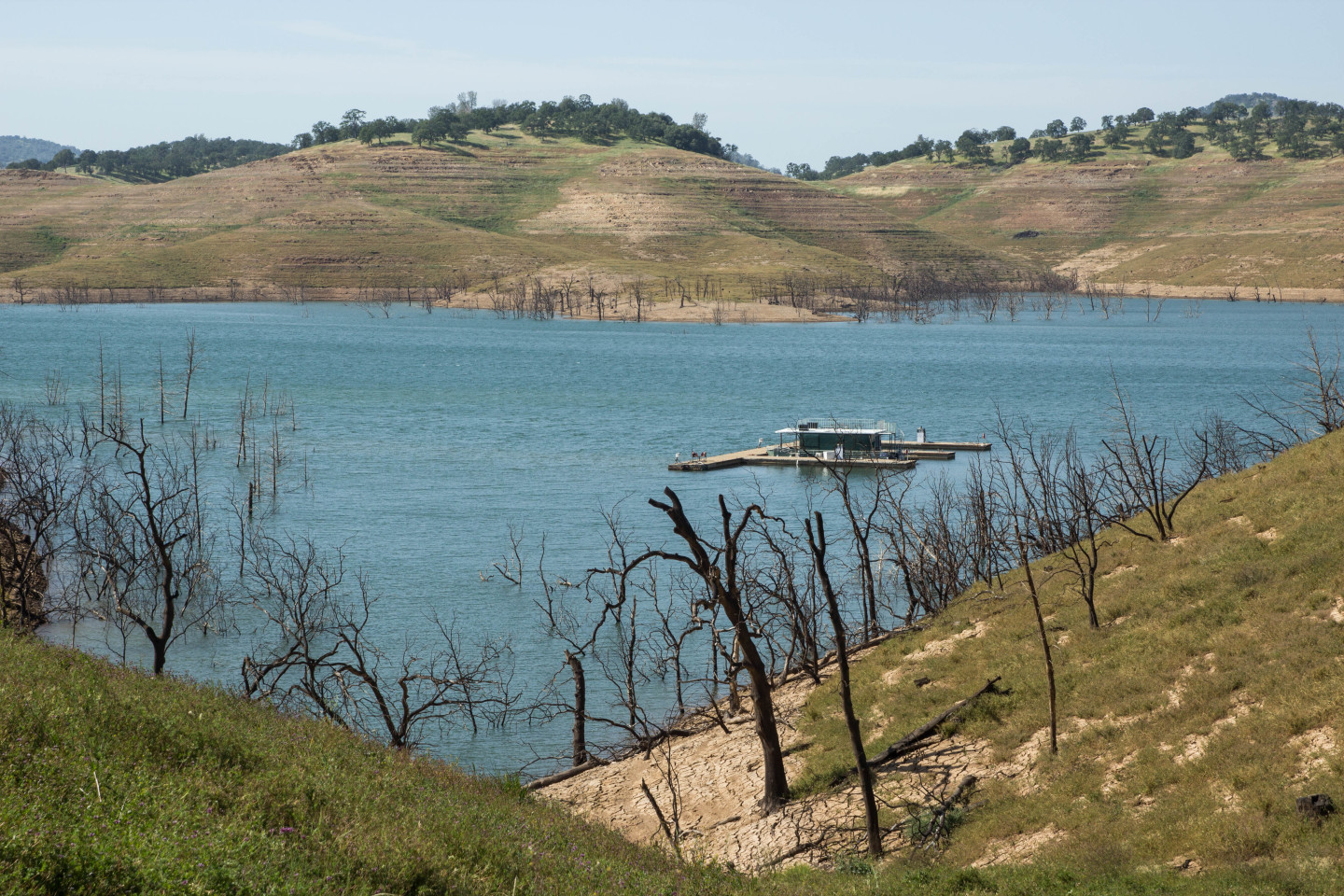
Of the state's 10 biggest reservoirs, none is in as bad shape as Lake McClure, on the Merced River downstream from Yosemite.
A month ago, Feb. 3, Lake McClure fell to its lowest level since it was filled in the 1960s. Per statistics from the state Department of Water Resources, its volume shrank to 63,489 acre-feet (remember, capacity is 1 million) and its surface was at 585.99 feet above sea level. That broke a record set during the six-year drought of 1986-1992, when the lake fell to 66,228 acre-feet, 588.48 surface elevation.
The Lake McClure nadir during the terrible drought of 1976-77 -- the drought that saw Shasta Lake and Lake Oroville, among others, fall to their record lows -- was 72,200 acre-feet, 594 surface elevation.
And here's an update to the update: The Department of Water Resources conducted its third monthly snow survey of the season earlier Tuesday. The measurement, taken in a meadow near Echo Summit on U.S. 50 high above Lake Tahoe, confirmed what the state's network of electronic monitoring stations has been reporting on a daily basis: the Sierra snowpack remains shockingly thin.
At the survey location itself, near Phillips Station, the water content of the snow is just 5 percent of its historical March 3 average.
DWR said its network of 103 stations has a composite average of 19 percent of the snow-water content typical for this time of year.
The Department notes that the only year in which snow was as scant as it is now was 1991. Then, the state's water supply was saved by a "Miracle March" deluge that built up the snowpack and also dramatically increased the tiny volume of water stored in Lake McClure.
To play forecast-watcher for a moment, NOAA's Climate Prediction Center's six-to-10-day outlook is showing a relatively high chance of above-median precipitation for most of California.
When might we see rain instead of just a forecast of rain?
The National Weather Service San Francisco Bay Area office in Monterey says models are pointing to the possibility of a wet storm arriving around the middle of next week. Between now and then, a familiar word: dry.
Update, Feb. 9, 2015: As expected, the big rains that have fallen in the northern half of California have boosted storage at the state's principal reservoirs. So now we're confronted with a glass half-full/half-empty proposition when we appraise how they're looking.
Case in point: The federal Central Valley Project's Shasta Lake, the state's biggest reservoir, which has risen to almost precisely 50 percent capacity as of Monday. About 9.5 inches of rain have fallen at Shasta Dam in the past week, typical of the heavy precipitation that's fallen in the 6,700-square-mile watershed that feeds the lake. That's dumped about 220,000 acre-feet of water into the reservoir since the first of the month and lifted it to 71 percent of normal for this time of year, up from 52 percent in mid-December.
The State Water Project's Lake Oroville, California's second-biggest reservoir, has gotten much less rain recently -- about 3 inches at Oroville Dam since Thursday, with totals up to 10 inches in the 3,200-square-mile drainage basin. About 100,000 acre-feet have flowed into the reservoir since Feb. 1, raising it to 43 percent full and 64 percent of average for this time of year. That's up from 53 percent of normal in mid-December.
Shasta is storing about one-third more water than it was at this time last year; Oroville has about one-sixth more.
Other reservoirs of note:
- San Luis Reservoir, the joint federal-state lake just west of Los Banos in the San Joaquin Valley -- a facility that's wholly dependent on water pumped down from the Delta -- is at 70 percent of average for early February and, thanks largely to our wet December, holds nearly double the water it did a year ago.
- Trinity Lake, the big federal reservoir northwest of Redding, has seen a spike in flows during the past week's rains. But it's still only at 41 percent of capacity and 58 percent of its average for early February. Trinity Lake was tapped last summer to provide higher flows on the Trinity and Klamath rivers to head off a massive die-off of migrating chinook salmon.
- Reservoirs in the southern half of the state have not enjoyed even the partial recovery seen up north. Lake McClure, the major reservoir on the Merced River, is at just 6 percent of capacity. Pine Flat Reservoir, on the King's River, is at 14 percent of capacity.
Update, Jan. 20, 2015: Just over a month ago, we were watching rain gauges fill up and going to sleep at night with visions of our reservoirs rising again after a long, punishing drought. We'd had one of the rainiest Decembers in Bay Area history, with San Francisco getting 2½ times its normal rainfall for the year's final month; San Jose's total was three times normal.
Rainfall around the state's two biggest reservoirs -- Shasta Lake, on the Sacramento River north of Redding, and Lake Oroville, on the Feather River just upstream from its namesake city -- was just as copious as it was here on the coast. Shasta Dam got 23.5 inches of rain and Oroville got just over 13 inches, the highest December totals in decades.
The total volume of water stored in those two reservoirs jumped about 60 percent in just 31 days -- about 1.3 million acre-feet, or roughly enough water for the entire Bay Area for a year.
And then?
The last time we saw real rain here in the Bay Area was Christmas Eve, when a front blew through the Bay Area and gave us a short, intense burst of precipitation. Since then, meteorologists say, we've seen the re-emergence of atmospheric conditions similar to those that kept us dry the last couple of winters.
So how do the reservoirs look now?
The California Data Exchange Center, the go-to resource for state water data, publishes a daily summary of reservoir conditions, and that snapshot shows a collection of key state reservoirs at 61 percent of normal for this time of year. That's better than things looked a month ago, and that's good news. The bad news, naturally, is that the torrents that were pouring into the Northern California reservoirs a month ago have slowed to a relative trickle.
Continuing to scrape for something that looks positive, we'll note that Shasta Lake and Lake Oroville are holding more water than they did a year ago at this time -- about 18 percent more in Shasta's case, about 12 percent for Oroville.
Far to the south of the big northern lakes, San Luis Reservoir, a facility that's crucial to San Joaquin Valley farmers and to Southern California water districts, has about 60 percent more water than it did at this time last year. But it's still only half full.
One other dire fact to mention in this update: The Sierra snowpack is about one-third of normal. Here's the California Weather Blog's synopsis of the reasons for the snow drought:
December’s very heavy coastal rainfall did not translate to nearly as much mountain snowfall as might have been expected in a typical year, and mid-January snow water equivalent is tracking at near record-low levels once again–and is in fact on a very similar trajectory to both 1976-1977 and 2013-2014. The extremely minimal Sierra snowpack this year is the combined result of both regionally below-average precipitation to date across eastern California and well-above average (record-breaking) temperatures. Much of the moisture from December’s extremely wet “atmospheric river” event fell near the coast, and never made it all the way inland to parts of the state that are critically important for snowpack storage. Both daytime and nighttime temperatures have been well-above average in the Sierra for several consecutive winters (in some cases, elevations as high as 10,000 feet have been experiencing mean temperatures above freezing in mid-winter!), and has caused precipitation in this typically snowy region to fall primarily as rain. 2014 has officially gone down in the record books as California’s warmest year in recorded history (by a very wide margin), and one of the most visible manifestations of that record warmth is apparent in California’s extremely low snowpack.
Original post (Dec. 15, 2014): It's raining again, and if you believe weather forecasters and the computer models on which they rely, we're in for wet weather for most of this week.
That comes on top of an outlandish volume of water that fell across the state last week, variously computed as between 17 million and 100 million gallons per square mile to 10 trillion gallons statewide.
That's great news in our parched state, for sure. By now you know, though, that there always has to be a "but," or in this case, several.
That's great news, but remember how it quit raining after a beautiful wet December two years ago?
That's great news, but the Sierra snowpack is still unseasonably thin.
That's great news, but the state's reservoirs are still way below normal.
And the biggest "but" of all: That's great news, but when will we know for sure the drought's over?
That final question is tough to answer, and the truth is that unless something surprising (though not unprecedented) happens, we'll be able to say whether the drought is really over only months and months from now. So I'm going to exercise my privilege as executive blogger and stick to what we can say objectively now, based on the mountain of daily statistics from the state Department of Water Resources.
As to the snow, the DWR California Data Exchange Center publishes a daily summary of water content for the Sierra Nevada snowpack. It's an important number because the state relies heavily on runoff from the Sierra snows to help fill reservoirs. (How much water is stored in the snowpack? About 15 million acre-feet in an "average" year, according to past DWR calculations. An acre-foot is about 326,000 gallons, and one rule of thumb says that's about enough to supply two average California households for a year.)
So the snowpack so far this year? As of Monday, it's 41 percent of normal for the date. That's not great. If you're looking for a silver lining to that meager-sounding number, here it is: We're still early in the season, and historically most of the snowpack is built during January and February. So there's still lots of time to catch up.
You can say the same about reservoir levels. Right now, storage at the big artificial lakes the state uses to manage its water supply is running far behind normal. A daily state report on conditions at major reservoirs says they're at about 55 percent of the average for mid-December.
The picture is about the same when you drill down to Shasta Lake and Lake Oroville, the state's two biggest reservoirs. Shasta, a federal facility, and Oroville, the main storehouse for the State Water Project, have a combined capacity of 8 million acre-feet and are used to direct water to farms throughout the Central Valley and to cities from the Bay Area all the way down to San Diego.
As of Monday, Lake Oroville was at 53 percent of average for this time of year and Shasta was at 52 percent. Both lakes are less than one-third of capacity.