But the most startling rainfall report I've seen as I look through the various precipitation tables comes from the Middle Peak rain gauge on Mount Tamalpais. More than 10 inches of rain fell there Saturday, and the total since the current round of wet weather began Wednesday evening is 15.73 inches 20.67 inches (and counting).
Yes, Mount Tamalpais is a famously wet place during winter storms. Rainfall at Lake Lagunitas, a small reservoir on the north flank of the mountain, averages 52 inches of rain a year (compared with about 21 inches a year in downtown San Francisco, about 10 miles or so away). But, like the rest of the state, it's been dry up there this year. Middle Peak got just .06 of an inch of rain in January -- the same as San Francisco -- and for the water year beginning last July 1, it had recorded 7.28 inches of precipitation before the first drops of rain started to fall around sunset on Wednesday. Going into Sunday morning, that total stands at 23.01 inches 27.95 inches. It'll be interesting to see how that affects the water supply for the Marin Municipal Water District, which is almost entirely dependent on storing water running off Mount Tam. As of last week, the district's reservoirs were a little more than half full and at just 64 percent of average storage for this time of year.
It's safe to say the rest of the Bay Area hasn't seen anything like the deluge that's been pouring down on the North Bay. But most of the region have gotten a decent soaking. The big exception so far: most of the South Bay east of the Skyline Boulevard crest and Santa Cruz Mountains. For instance, Palo Alto got .12 of an inch and Moffett Field .13 in the 72 hours ending Sunday morning. Yes, that's less than 1 percent of what's fallen on Mount Tam, a result of topography and the fact that the richest source of moisture for the current storm has been focused far to the north of Silicon Valley.
Here's the NWS regional rainfall report with three-day storm totals for dozens of locations through Sunday morning:
Public Information Statement: 3-Day Rainfall Reports
Update, 1:45 p.m. Saturday: First, let's remind everyone: The drought's not over. All the meteorological, climatological and hydrological experts agree: Most of California, including the Bay Area, has gone far too long with far too little precipitation for the current storm to do anything more than dent the drought.
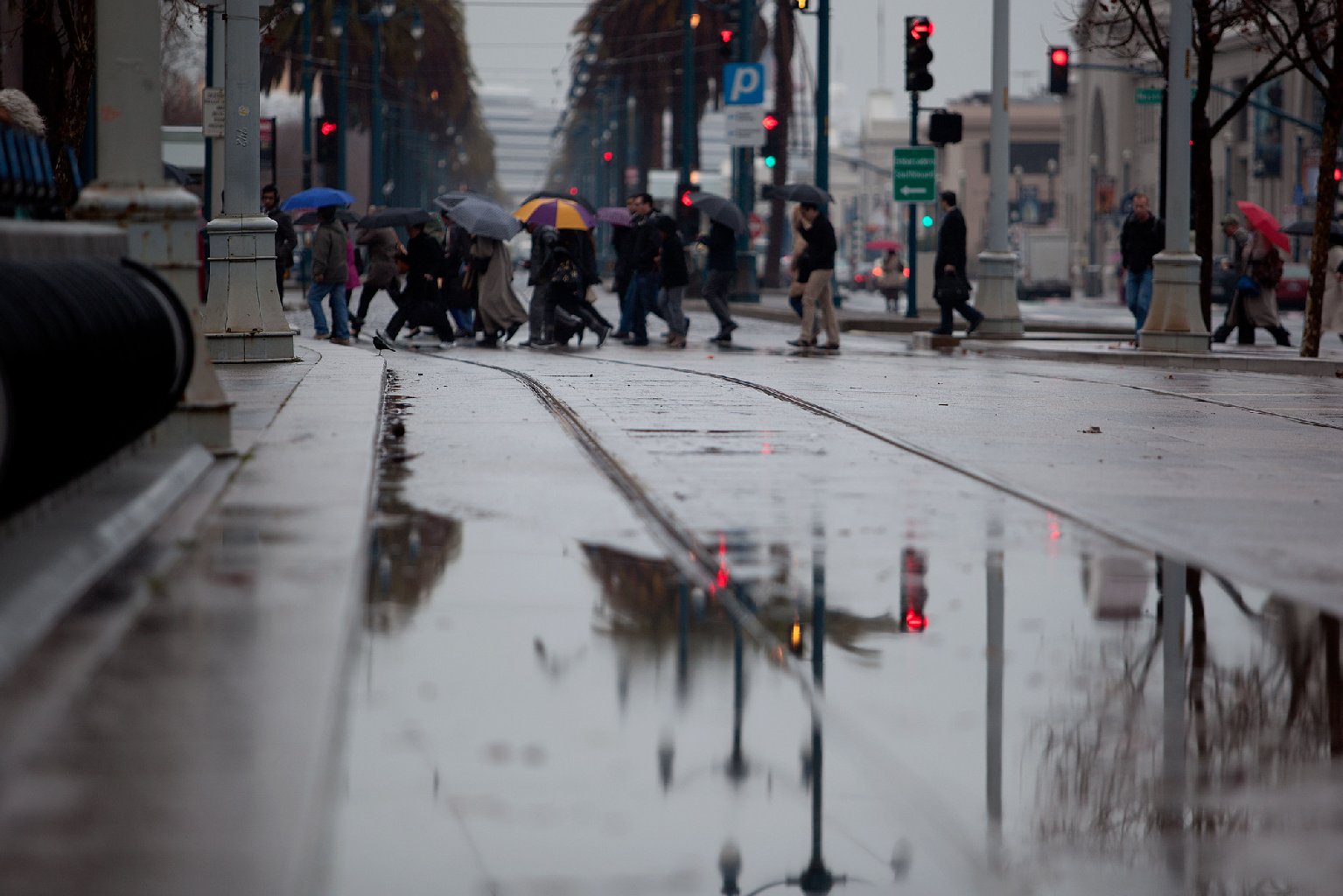
But that having been said: Parts of the Bay Area sure are getting a lot of rain. The deluge, a half-inch or more per hour at times in the North Bay, prompted the National Weather Service this morning to issue a flood advisory for most of Marin and Sonoma counties.
How much rain are we talking about for the past three days?
As much as 10 More than 11 inches over some of the peaks and ridges of the North Bay, more than half a foot in Napa, nearly 5 inches in the Santa Cruz Mountains. Lower totals have been recorded around the Bay shore and in the South Bay: an inch and a half in San Francisco, a little more than an inch in Oakland, three-quarters of an inch in downtown San Jose.
Here's a super-complete regional list with three-day storm totals through this morning from the National Weather Service:
Public Information Statement: 3-Day Rainfall Reports
NWS Forecasters say most of the Bay Area is in for rain off and on through Sunday night.
Update: Friday 4:30 p.m.: Rainfall totals so far today are bearing out the forecast for heavier precipitation to the north. Willits, the Mendocino County town that's down to 300 acre-feet of reservoir water for its 5,000 residents, has the highest "local" total (it's about 150 miles northwest of San Francisco) with 1.32 inches in the last 24 hours. St. Helena in the Napa Valley has .96 of an inch in the same period.
Some 24-hour rainfall totals, as of 4 p.m. Friday (mostly from the National Weather Service's statewide report):
Berkeley .34
Mount Diablo .35
Mount Umunhum .31
Napa .26
Oakland Airport .24
Palo Alto .08
Petaluma .48
St. Helena .96
San Francisco .27
SFO .18
San Jose .10
Santa Rosa .59
Willits 1.32
Update: Friday 10:45 a.m.: The National Weather Service reports our next storm, promising the biggest rain since the very rainy December of 2012, is already starting to fill rain gauges in the North Bay. Locations in Napa and Sonoma counties have gotten more than a quarter-inch of precipitation already this morning. And the NWS forecast office in Monterey says the storm is on track to deliver a real wallop of to our thirsty, thirsty region.
The heaviest rain is expected to arrive early Saturday, between roughly 4 a.m. and 10 a.m., depending on where you live. The precipitation will slacken or even stop by midday or early afternoon, though it's expected to continue in the North Bay hills and Santa Cruz Mountains. Another round of rain is expected throughout the region on Sunday. After that, at least a couple of dry days are forecast.
The storm is expected to bring heavy snow to the Sierra Nevada, and winter storm warnings are in effect for virtually the entire range.
Update Thursday:
Flood advisories for Alameda, Santa Clara and San Mateo counties expire at 10:45 a.m.
Here's the latest forecast from the National Weather Service, as of 9:24 a.m. We edited to strip out the weather-geek stuff. As KQED's Paul Rogers told us yesterday, the storm won't end the drought, but will reduce fire risk. Rogers said we're in for the most rain in 14 months.
- Wet weather expected through the weekend. Light rain continues across the Bay Area this morning with occasionally moderate to heavy showers from Santa Cruz south. Rain and showers should begin to taper off later this morning as the current storm system exits the area and some drier air works its way in.
- A moister storm system is expected to impact the area, beginning roughly late Friday afternoon and lasting through at least Sunday. This storm system will result in urban and possibly small stream flooding.
- Precipitation forecast to begin in the North Bay area early Friday afternoon, spreading south throughout the day. Around 1.25 inches arriving to the coast Friday evening, rising to 1.39 inches by late Saturday morning and slowly decreasing Saturday night into Sunday.
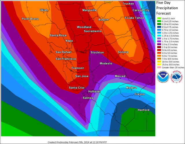
- The current storm total precipitation forecast from Friday afternoon through Sunday: up to 7.5 inches of rainfall along the North Bay coastal hills, around 1.5 inches in the San Francisco Bay Area and 2.5 inches in the Santa Cruz mountains. These are substantial rainfall values, which will result in urban and possibly small stream flooding this weekend. Please be sure to clean your storm drains and gutters in advance of this rainfall.
Original post
Here's the map from the National Weather Service. As you can see, 3 to 5 inches of rain are forecast throughout the Bay Area, starting tonight through the weekend. KQED Science Managing Editor Paul Rogers tells us this won't be enough rain to end the drought, but will be enough, if it materializes, to reduce fire risk and clear the air. It would also be the biggest storm in 14 months.
Here are the parts of the forecast from the NWS related to the wet stuff ....
Expecting rainfall to begin to develop across the North Bay late this evening and spread southward overnight. Fairly widespread rain will continue through the morning hours on Thursday. Areawide forecast amounts through this event will likely range from 1/2" to 3/4". A few of the higher resolution models indicate upward of 1" to 1.5" will be possible in the coastal mountains ... especially the Santa Cruz mountains.
The heaviest rain expected during Thursday morning rush hour, commuters are urged to drive with caution and allow for extra driving time.
Rain chances will taper off Thursday night into early Friday morning across much of the region.
A much deeper plume of moisture with origins from the central Pacific is forecast to impact the region this coming weekend. While confidence is high for the overall set up ... the exact placement remains a forecast challenge.
The general consensus keeps the deepest moisture plume across Northern California and the North Bay. Rain totals for this weekend across the North Bay are expected to reach 3 to 5 inches with isolated totals upwards of 6+ inches in the North Bay coastal mountains.
The heaviest rain appears to be Saturday morning as a mid/upper level disturbance passes through. Areas from the Golden Gate down to Santa Cruz can pick up an additional 2 to 3 inches of rainfall this weekend. With the best plume of moisture to the north of the Monterey Bay area ... rainfall amounts between 1/2" to 1.25" (highest in the Santa Lucias) will be possible ...
The weekend rain chances diminish late Sunday into Monday as a stronger mid/upper level trough sweeps through the region and drier air filters in aloft…
For days 7 and 8 it appears the jet stream will be focused over the Pacific Northwest with drier/warmer conditions across Central California. Will keep slight chance across our northern areas with a possibility of another weak system moving through. Will continue to monitor the development and forecast placement of this
weekend's atmospheric river event in the coming days. Stay tuned.
Meanwhile, water reserves across the state are only at about 10 to 20 percent of normal. The water shortage isn't hitting all stakeholders equally. During a discussion on KQED's "Forum" today, Paul Rogers talked about who the dry spell is hitting the hardest.
"I would say overall, statewide, if you put them in sort of a ranking, ranchers are being hit the worst -- they don't have green grass that they need for their herds, they're having to buy hay, and it's very expensive to feed their cattle. And many of them are having to sell cattle off.
Second are farmers. Farmers are not getting water from the Delta and from surface streams and rivers, so as a result they're having to pump ground water even more heavily in the Central Valley than they normally do. They're going to be fallowing hundreds of thousand of acres of land this summer. Unemployment in the Central Valley is going to skyrocket.
Third is small towns and small water districts. Some of them are running very low on water because a lot of them don't have the money to have backup supplies.
And finally the groups that have it the easiest in the state, I would argue at this point, are the large cities: Los Angeles, the folks that get their water from the Hetch Hetchy system here in the Bay Area -- San Francisco, the Peninsula, folks in the EBMUD system and then folks in the Santa Clara Valley Water District area down south.
The reason they have a relatively better situation is that they have hundreds of millions of dollars in their budgets, they have big staffs, and since the last drought in 1987 and '92 they have been running decades of rebates and conservation programs to keep demand down. They've put in backup supplies like in Contra Costa where they built Los Vaqueros Reservoir over the last decade. They've been storing water in underground banks, so they have plan B, plan C and plan D."
Rogers pointed out that San Francisco has received only 2.4 inches of rain since July 1 rather than its normal 14 inches, and that rainfall totals all around the Bay Area are only 10 to 20 percent of normal, which puts us in the driest period since California became a state in 1850, when records were first kept.