upper waypoint

Forecasters Extend Red-Flag Warning Into Sierra Nevada

Save ArticleSave Article
Failed to save article

Please try again

Briones Regional Park near Lafayette, typical of Bay Area landscapes experiencing high fire danger in the current drought. (Dan Brekke/KQED)

Update, 9:15 a.m. Wednesday: The National Weather Service red-flag warning is still in place for the North Bay and East Bay Hills (and for the Coast Range to the north of the Bay Area and the Diablo Range east of San Jose). The good news: Despite the windy, extremely dry conditions, no major fires have broken out (although a wind-driven 50-acre blaze on Kimball Island in the Sacramento-San Joaquin Delta on Tuesday burned three homes on Tuesday.)

The bad news is that red-flag warnings are now in place for almost the entire western slope of the Sierra Nevada, from near Quincy, in Plumas County, down to the Tehachapi Mountains east of Bakersfield. The Bay Area fire weather warning is in effect until Thursday morning. The warning for the Sierra will be in place until Friday.

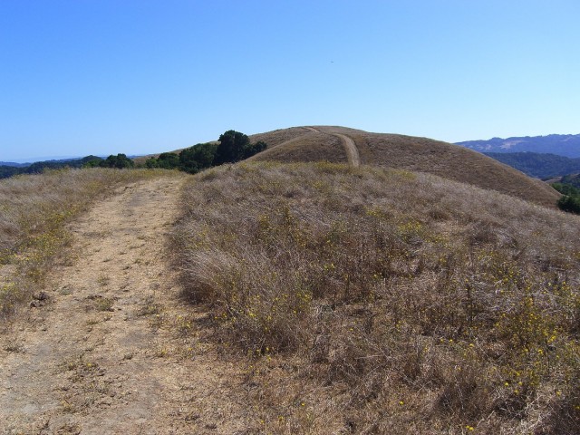
Original post (Tuesday): Weather forecasters say today will be warm, windy and bone-dry, with humidity readings of just 5 to 10 percent. That sounds like September or October in the Bay Area, when gusty northerly or northeasterly winds occasionally howl across the hills and increase the danger of fire. In the fall, those Diablo Winds, the local cousins to Southern California's Santa Anas, can combine with dry brush and an ignition source — an arcing power line, an unattended campfire, a spark from a lawnmower — to touch off a wildfire. Here in the Bay Area, the classic, tragic example is the devastating East Bay Hills fire of October 1991.

National Weather Service map showing red-flag fire conditions for the Bay Area and Northern California. (Click on map to go to National Weather Service/Bay Area home page.)

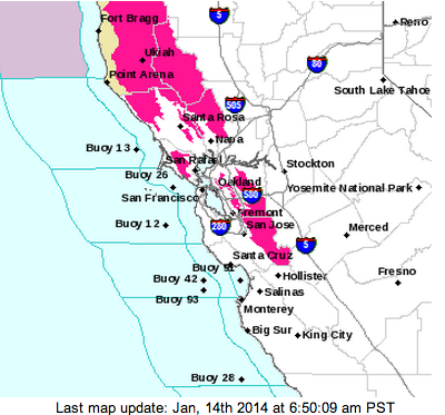
We're now in the middle of what should be our wet season, and any talk of fire danger is something we normally would have left behind months ago. But with our typical rains having vanished for now, nothing about this season is normal. Take a look at the home page of the National Weather Service for the Bay Area. Its regional map is covered with crimson splotches that signal forecasters have posted a red-flag warning for the hills and mountains throughout the region.

Today's warning extends through Thursday morning. It reaches from the Coast Range in Humboldt County down to the Santa Cruz Mountains and covers all the hilly areas in the North Bay and East Bay.

Sponsored

We could put away the red-flag warnings for the season if only the rains return. Is there any short-term hope of that happening? Here's what the National Weather Service forecasters in Monterey have to say in their latest forecast discussion:

For those hoping for rainfall, unfortunately nothing encouraging to report even looking out through 16 days (January 30th). ... Good shot that we will see more record highs set next week. ... Confidence remains very high for the much drier than normal weather to continue. ... Unless there is a huge change in the pattern that the models are not picking up on, we are on track to have the driest January on record for virtually all locations.

And Paul Rogers, the managing editor of KQED Science and an environment and science reporter at the San Jose Mercury News, has a story today that has a memorable description of the persistent ridge of high pressure that's steering storms away from the California coast:

Like a brick wall, the mass of high pressure air has been blocking Pacific winter storms from coming ashore in California, deflecting them up into Alaska and British Columbia, even delivering rain and cold weather to the East Coast. Similar high-pressure zones pop up all the time during most winters, but they usually break down, allowing rain to get through to California. This one, ominously, has anchored itself for 13 months, since December 2012, making it unprecedented in modern weather records and leaving researchers scratching their heads.

"It's like the Sierra -- a mountain range just sitting off the West Coast -- only bigger," said Bob Benjamin, a forecaster with the National Weather Service in Monterey. "This ridge is sort of a mountain in the atmosphere. In most years, it comes and goes. This year it came and didn't go."

lower waypoint
next waypoint
California Preschools Wrestle to Comply With State’s Tightened Suspension RulesSan Francisco’s New Parking Rules Set to Displace RV Community Near SF StateA New Bay Area Clásico? SF's El Farolito and Oakland Roots Set to Battle in HaywardDemocrats Again Vote Down California Ban on Unhoused EncampmentsWhat the 99 Cents Only Stores Closure Means to CaliforniansCalifornia Legislators Take Aim at Construction Fees to Boost HousingJail Deaths Prompt Calls To Separate Coroner And Sheriff's Departments In Riverside CountyBay Area Diaspora Closely Watching India’s Upcoming ElectionSan José Police Department Sees Drop in Officer ComplaintsProtesters Shut Down I-880 Freeway in Oakland as Part of 'Economic Blockade' for Gaza