upper waypoint

Oaklanders, Here's the Voting District You May Be in Next Year ...

Save ArticleSave Article
Failed to save article

Please try again

oaklandmap
Click on the map to see a clearer view of the Oakland City Council's proposed new voting districts. If approved, thousands of residents could end up in new City Council and school board districts

by Barbara Grady, Oakland Local

After months of public discussion on how Oakland’s voting districts might be changed and with 50 proposed maps to consider, the Oakland City Council voted nearly unanimously Tuesday night to tentatively approve a single map that encapsulates many opinions.

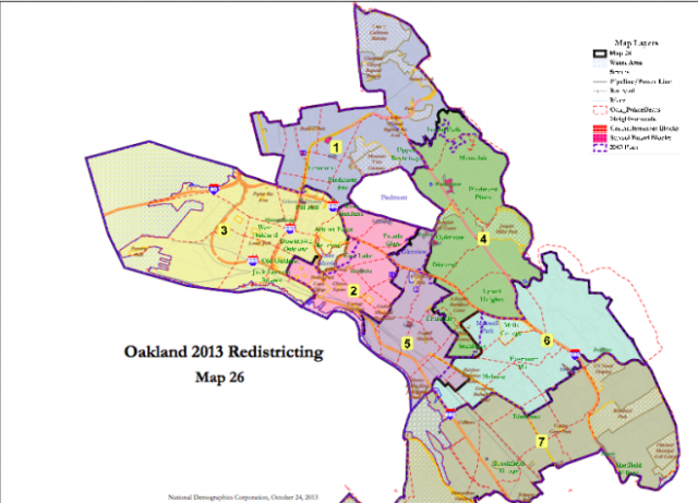
Map #26, pictured above, was submitted only four days earlier, October 25, by Council Member Lynette Gibson McElhaney, but it includes ideas represented in many of the 50 maps put forth by residents, other Council members and experts — particularly to keep distinct neighborhoods together rather than splitting them into two or more districts — as the city went through its once-in-a-decade redistricting process.

The chief changes in Map #26 from current districts are to combine the Maxwell Park neighborhood into one district, District 6, and to switch the Cleveland Heights neighborhood east of Lake Merritt into the same district as its adjacent neighborhoods, District 2, according to McElhaney. (Before, Cleveland Heights was an outlier combined with neighborhoods to the west of Lake Merritt in District 3.) These wishes were represented in three earlier maps the Council considered, which in turn represented common opinions, as described by the city here.

But it also keeps the Adams Point neighborhood intact, in District 3, defeating proposals to split it up, after the Adams Point Neighborhood Association sent a letter to the Council asking that the neighborhood be kept together in its current district, McElhaney said. Map #26 also keeps the Glen Echo / Richmond Boulevard neighborhood in one district.

The Council voted 6 to 1, with Council member Desley Brooks (District 6) objecting, to make the new district boundaries reflect this map, pending the outcome public hearings. Council member Larry Reid (District 7) was absent and did not vote.

Sponsored

What happens now is that City staff will develop an ordinance citing this new map as the City’s official definition of its districts, and then two public hearings will be held on that ordinance, November 19 and December 10, concluding with a final vote by the Council, likely on December 10, according to Devan Reiff, the planner from the City’s Department of Planning and Building, who has overseen the redistricting process. More can be learned under the Redistricting menu on the City’s website.

Redistricting is required by City Charter, as well as by federal and state law, if voting districts change so substantially in population size over a decade, as shown by the U.S. census, as to render them unequal. Over the last 10 years since Oakland’s last redistricting process in 2003, West Oakland, or District 3′s population, has soared by 12 percent, while the populations in District 2, generally east of Lake Merritt and part of downtown, and District 5, including the Fruitvale and surrounding areas, have shrunk considerably.

No districts are supposed to deviate more than 5 percent from the median population count, which is 55,800 per district in Oakland. The City Council voted on June 4 that redistricting was warranted because of the population shifts and interest in creating more equity. Since then it has held a dozen meetings in district neighborhoods and at City Hall while a coalition of community groups, the Oakland Votes Coalition, also held several meetings to encourage public participation. Oakland Votes members today drew an illustration of how the new redistricting map compares with the existing map created in 2003.

While some residents and community groups raised the idea of creating districts that were socio-economically homogenous to give more voting clout to often under-represented flatland neighborhoods and school districts, the maps the Council voted on do not include wholesale changes to the City’s past districts, just some adjustments. As before, Districts 4, 5, 6 and 7 — and particularly 6 and 7 — include both wealthy neighborhoods in the hills and low-income neighborhoods in the flatlands.

The June 4 vote stipulated that the 2013 redistricting should accomplish the following:

  1. Each Council District shall contain a nearly equal number of inhabitants.
  2. Council District borders shall be drawn in a manner that complies with the U.S. Constitution and the Federal Voting Rights Act.
  3. Council Districts shall respect communities of interest as much as possible.
  4. Council Districts shall consist of contiguous territory in a reasonably compact form.
  5. Council District borders shall follow visible natural and man-made geographical and
    topographical features as much as possible.
  6. The population and territory of each existing Council District shall be considered when drawing each corresponding new Council District.
  7. Council Districts should avoid displacing any incumbent City Councilmember or Oakland Unified School District Board member from the district he or she was elected to represent.

Council members went into Tuesday night’s meeting prepared to vote for either Map #23, #24 or #25, maps that under their earlier direction combined, but slightly tweaked, maps submitted by constituents. The biggest debate was about whether to make Maxwell Park a part of District 4 or District 6, with residents calling for each. The vote approving Map #26 puts it in District 6.

Instead, they voted on a completely new map that included some of the changes but also resolved some as yet not settled issues, particularly what to do with the Adams Point neighborhood, which McElhaney represents.


The proposed districts on Google Maps
:

lower waypoint
next waypoint
Stunning Archival Photos of the 1906 Earthquake and FireCould Protesters Who Shut Down Golden Gate Bridge Be Charged With False Imprisonment?Why Nearly 50 California Hospitals Were Forced to End Maternity Ward ServicesSan Francisco Sues Oakland Over Plan to Change Airport NameFederal Bureau of Prisons Challenges Judge’s Order Delaying Inmate Transfers from FCI DublinDemocrats Again Vote Down California Ban on Unhoused EncampmentsFirst Trump Criminal Trial Underway in New YorkAlameda County DA Charges 3 Police Officers With Manslaughter in Death of Mario GonzalezDespite Progress, Black Californians Still Face Major Challenges In Closing Equality GapJail Deaths Prompt Calls To Separate Coroner And Sheriff's Departments In Riverside County