Here are detailed directions for getting to the new bike path, complete with a slideshow and Google map (after the step-by-step instructions). Driving directions are at the bottom of the post.
Bicycling from MacArthur BART:
1. After exiting fare gets, go left to access 40th Street. You'll want to head left, or west, on 40th Street, so you'll need to cross at the traffic signal at the MacArthur BART driveway.
2. Head west .1 mile on 40th Street under the BART/Highway 24 overpass. The first light you'll come to is Martin Luther King Jr. Way. (If the first light you hit is Telegraph Avenue, you're headed the wrong way. Turn around!). Total mileage: .1
3. Continue west .5 mile on 40th Street past signals at West Street, Market Street, to Adeline Street, where 40th jogs slightly to the left. Total mileage: .6
4. Continue west .8 mile on 40th Street across San Pablo Avenue, then past signals at Hollis Street and Horton Street to the foot of the overpass, where Shellmound Street begins. Total mileage: 1.4.
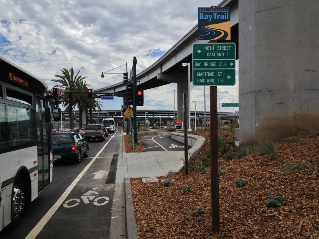
5. Continue .4 mile across overpass as Shellmound curves right (north) to the first traffic signal. The signal marks both the entrance to the Ikea parking lots and one entry to the Bay Bridge bike/pedestrian path. The access is clearly marked with a sign for the Bay Trail and an informational display for the Bay Bridge bike/pedestrian path. Total mileage: 1.8.
6. Entering the path at this point allows you to circle under the Shellmound Street overpass and join the main path.
7. There is a second entrance to the path, from southbound Shellmound Street, immediately across the street from the first described above. Walkers and riders can reach it by crossing at the Ikea traffic signal or by looping under the overpass as described in Step 6 above. It affords ready access to people traveling south from Berkeley -- say, from Aquatic Park and along Shellmound.
Bicycling from West Oakland BART:
West Oakland Option 1, via Mandela Parkway.
1. Exit the station to Mandela Parkway, at the east end of the station property (the end nearer downtown Oakland).
2. Turn left (north) on Mandela. Cross 7th Street. (If you find yourself crossing 5th Street, then curving left under a freeway overpass, you're going the wrong way. Turn around.)
3. Continue 1.3 miles north on Mandela past major intersections at 14th Street (traffic signal at .5 mile), West Grand Avenue (traffic signal at .9 mile), and 32nd Street (1.3 miles). Total mileage: 1.3 miles.
4. Continue .5 mile on Mandela. After 32nd Street, Mandela curves gradually to the left. The parkway narrows to a four-lane street at 34th Street. Then the street curves right (east) under the MacArthur Maze freeway overpasses to Horton Street. Total mileage: 1.8 miles.
5. Turn left at Horton Street, a four-way stop (you'll have a Target Store on your left and a Best Buy on your right at the intersection). Continue .1 mile to 40th Street. Total mileage: 1.9 miles.
6. Turn left at 40th Street.
7. Continue .4 mile across overpass as Shellmound curves right (north) to the first traffic signal. The signal marks both the entrance to the Ikea parking lots and one entry to the Bay Bridge bike/pedestrian path. The access is clearly marked with a sign for the Bay Trail and an informational display for the Bay Bridge bike/pedestrian path. Total mileage: 2.3 miles.
8. Entering the path at this point allows you to circle under the Shellmound Street overpass and join the main path.
9. There is a second entrance to the path, from southbound Shellmound Street, immediately across the street from the first described above. Walkers and riders can reach it by crossing at the Ikea traffic signal or by looping under the overpass as described in Step 6 above. It affords read access to people traveling south from Berkeley--say from Aquatic Park and along Shellmound.
West Oakland Option 2, via 7th Street and Maritime Street.
1. Exit the station to 7th Street.
2. Cross 7th Street and go left (west) on 7th (there is a traffic signal at Center Street, in front of the station, which is an easy place to cross).
3. Head west .2 mile. The first light you'll come to is Peralta Street. (If you've passed Mandela Parkway or Adeline Street after leaving BART, you're going the wrong way. Turn around). Total mileage: .2 mile.
4. Continue on 7th Street .2 mile to Wood Street (traffic signal). You'll be riding along the BART tracks (overhead and to the left). Total mileage: .4 mile.
5. Continue on 7th Street .6 mile, through two viaducts, to Maritime Street. Total mileage: 1.0 mile.
- CAUTION: The first viaduct contains two traffic signals and freeway on- and off-ramps for Interstate 880. The second viaduct is shorter but darker with bad pavement. You should expect truck traffic from the freeway ramps all the way to the bike/pedestrian trail access points at Maritime Street and Burma Road.
6. At the first traffic signal after the viaducts, take the gradual right turn onto Maritime Street. At the next signal, make another gradual right turn. Total mileage: 1.1 miles.
7. Continue north .9 mile to Burma Road, passing traffic signals at 14th Street and 21st Street/Bataan Avenue on the way. Burma Road is well marked with a traffic signal. The path is not clearly marked as you approach from the south, but the path access point is to your left, at the northwest corner of the intersection. Total mileage: 1.9 miles.
Driving directions:
From San Francisco:
1. At east end of Bay Bridge, follow signs for exit to Interstate 880 south (to Alameda/San Jose)
2. Take exit on the right for I-880 south.
3. From the I-880 exit, take the first exit: West Grand Avenue/Maritime Street.
4. Turn right (south) on Maritime Street (the first traffic signal)/
5. Go 400 feet south on Maritime to Burma Road. Path access is on your right at the corner.
6. A few on-street parking spaces are available along Burma Road. More on-street parking is available along the west side (northbound side) of Maritime Street.
From Oakland (Grand Avenue and Broadway):
1. Head west onto West Grand Avenue.
2. Continue west on West Grand across major intersections at San Pablo Avenue (.3 mile), Market Street (.7 mile) and Mandela Parkway (1.2 miles).
3. Continue west 1.0 mile to Maritime Street; get in left-turn lane. Total mileage: 2.2 miles.
4. Turn left on Maritime Street. Total mileage: 2.3 miles.
5. Go 400 feet south on Maritime Street to Burma Road. Path access is on your right at the corner.
6. A few on-street parking spaces are available along Burma Road. More on-street parking is available along the west side (northbound side) of Maritime Street.