upper waypoint

Mount Diablo Blaze Grows Rapidly, Forces Evacuations

Save ArticleSave Article
Failed to save article

Please try again

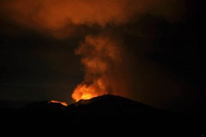
Morgan Fire, burning east of Mount Diablo, as seen from Lafayette late Sunday night. At least 3,700 acres have burned southeast of the town of Clayton. (Susan Welty)

Our latest update: Weather Helps Crews Corral Mount Diablo Blaze

Update 4:45 p.m. Monday: The wildfire burning on and around Mount Diablo in central Contra Costa County has grown rapidly today. Cal Fire says the fire has covered 3,700 acres and is now 20 percent contained. DC-10 jumbo jets outfitted to drop 100,000 pounds of fire retardant on a single run have reportedly been called in to help in the fight.

Smoke from the fire has been visible in much of the Bay Area. The huge plume drifting south from the blaze prompted the Bay Area Air Quality Management District to issue a smoke advisory this afternoon for residents of Contra Costa, Alameda and Santa Clara counties.

The blaze began Sunday afternoon in a sparsely populated area of homes and small ranches southeast of the town of Clayton. The rapidly moving fire prompted mandatory evacuations for residents of about 100 ranches and homes in the area.

KQED's Tara Siler offered an update this morning from fire information officer Lewis Broschard of the Contra Costa County Fire Protection District:

The fire is burning in very steep, rugged terrain on the eastern slope of Mount Diablo. The fuel and topography is such that the fire will continue to spread. We are going to be working at getting additional containment. Approximately 500 firefighters are going to be working the lines today and we do have aircraft en route to the fire as we speak to support ground operations. But the fire is burning in an area of the park that hasn't burned for a very long period of time and the fire is well established right now. The fire did burn actively all night and we did obviously see a large increase in the number of acres burned.

Cal Fire announced several road closures in the Clayton area and in the rural area east of the mountain (open to residents only, with photo identification). Marsh Creek Road closed from Camino Diablo to Regency Road in Clayton. Morgan Territory Road is closed from Marsh Creek Road to Highland Road (Alameda County).
Persons needing to evacuate large animals may take them to the Heather Farms Equestrian Center in Walnut Creek. For more information, please visit: www.ecwc.org or call 925-939-2929.

Sponsored

Immediately below: a cool six-second time lapse of Mount Diablo as it burned Sunday night:

Here's a Storify collection of fire coverage this morning:

***
Original post (5 p.m. Sunday): A wildfire that broke out earlier this afternoon near Morgan Territory Road southeast of the town of Clayton has burned about 300 acres in just three hours. Cal Fire reports the fire, burning in a relatively sparsely populated area near the eastern boundary of Mount Diablo State Park, is about 10 percent contained. Cal Fire says 50 to 75 structures are threatened. Contra Costa County authorities broadcast orders for an immediate evacuation for residents of the Oak Hill Lane and Curry Creek Road area. That's about 5 miles southeast of downtown Clayton.

Cal Fire also says that about 200 firefighters are on the scene, backed up by four fixed-wing air tankers and three helicopters. A webcam apparently positioned southwest of Mount Diablo shows the top of the peak enveloped in smoke, even though it's apparently several miles from where the fire is burning.

For historical context: Mount Diablo was the scene of a major wildfire in August 1977, when lightning ignited drought-parched chaparral and burned more than 6,000 acres on and around the mountain.

Comments on the Claycord community news site include this account of residents leaving the fire zone:

I called Camp 4 Paws at 5 PM to ask if they needed help evacuating the dogs. I was told that they were almost finished with getting all of the animals into vehicles and evacuate.

I saw a lot of trucks with horse trailers full of families and horses driving away from immediate fire area. Two family-filled trucks were carrying three horses in each trailer.

There are a lot of ranches and horses, dogs, burros, donkeys, goats, cats, chickens, alpacas, ponies, all pets in the area affected and one way in and one way out. My heart goes out to the families who are trying to leave safely with all of their loved ones.

Here's a long-distance shot of the fire posted on Instagram by user margaret_w:

lower waypoint
next waypoint
State Prisons Offset New Inmate Wage Hikes by Cutting Hours for Some WorkersCecil Williams, Legendary Pastor of Glide Church, Dies at 94Erik Aadahl on the Power of Sound in FilmFresno's Chinatown Neighborhood To See Big Changes From High Speed RailKQED Youth Takeover: How Can San Jose Schools Create Safer Campuses?How to Attend a Rally Safely in the Bay Area: Your Rights, Protections and the PoliceWill Less Homework Stress Make California Students Happier?Nurses Warn Patient Safety at Risk as AI Use Spreads in Health CareSilicon Valley House Seat Race Gets a RecountBill to Curb California Utilities’ Use of Customer Money Fails to Pass