upper waypoint

Map Shows Spread of Rim Fire Day by Day

Save ArticleSave Article
Failed to save article

Please try again

Here's a very good map from InciWeb showing the spread of the Rim Fire day by day, from Aug 17 to yesterday, Aug 26. As you can see, the rate of growth has slowed considerably. AP reports this morning that the fire is 20 percent contained, up from 15 percent on Monday. Officials said the fire has grown to about 280 square miles, up from about 252 square miles the previous day, but back burning by crews was responsible for at least part of that increase. The fire is currently the seventh largest in state history, having consumed more than 179,000 acres.

Click on the map for a larger image. More updates on the fire from InciWeb here.
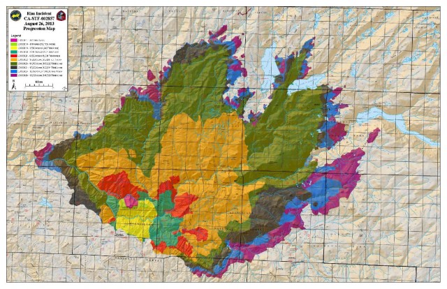
inciwebfiremap

Sponsored

lower waypoint
next waypoint
Why California Environmentalists Are Divided Over Plan to Change Power Utility RatesWhy Renaming Oakland's Airport Is a Big DealAllegations of Prosecutorial Bias Spark Review of Death Penalty Convictions in Alameda CountyCecil Williams, Legendary Pastor of Glide Church, Dies at 94SF Democratic Party’s Support of Unlimited Housing Could Pressure Mayoral CandidatesNurses Warn Patient Safety at Risk as AI Use Spreads in Health CareBay Area Indians Brace for India’s Pivotal 2024 Election: Here’s What to Know‘Sweeps Kill’: Bay Area Homeless Advocates Weigh in on Pivotal US Supreme Court CaseCalifornia’s Future Educators Divided on How to Teach ReadingWhen Rivers Caught Fire: A Brief History of Earth Day