Snow blanked South Lake Tahoe in California, United States on November 8, 2022 as Winter Storm warning in effect for Lake Tahoe and Nevada mountains. (Photo by Tayfun Coskun/Anadolu Agency via Getty Images) (Tayfun Coskun/Anadolu Agency via Getty Images)
The Lake Tahoe region is one of the most beautiful places on earth, especially in winter. And it’s no wonder that so many of us in the Bay Area want to drive up there at this time of year.
But if you were planning on heading up to Tahoe this weekend, you should be aware of a storm that could drop as much as 3 feet of snow over parts of the Sierra Nevada through Sunday morning and make travel very difficult.
On Thursday, the National Weather Service (NWS) issued a Winter Storm Warning for areas above 5,000 feet starting at 12 p.m. on Friday, March 22 and lasting until 8 a.m. on Sunday, March 24.
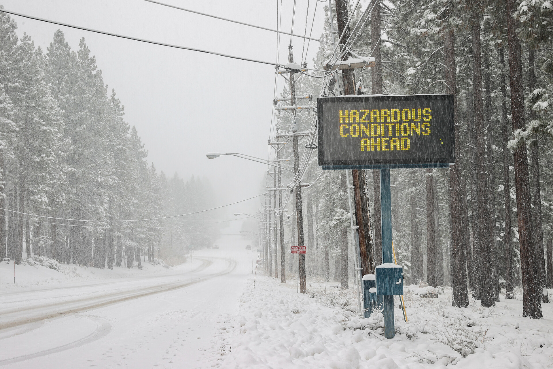
The agency says that the heaviest snowfall will occur “overnight Friday into Saturday” and that travel is “highly discouraged” due to the chance of slick and snow-covered roads, chain control and downed tree branches.
And if you’re still not convinced by the forecast, it might be helpful to know that in the past, weather conditions in the Sierra like this have not only caused travel delays and road closures but also impacted operations at ski resorts in the Tahoe area (for example, high winds causing lift closures.) After heavy snowfall, it may also take many hours for roads to be plowed and for chain control to be lifted, making travel potentially slow and difficult even after an active storm window has passed.
Snow blankets South Lake Tahoe on Nov. 8, 2022, with a winter storm warning in effect for Lake Tahoe and the Nevada mountains. (Tayfun Coskun/Anadolu Agency via Getty Images)
For when the storm passes …
Even without major weather events like this in the forecast, traveling in the mountains of Tahoe in winter is a serious business at the best of times — especially if you’ve never lived somewhere with frequent snowfall and don’t have a ton of experience with winter driving just yet. And nobody wants their trip marked by delays, car trouble, road closures or even a serious accident on these winter roads.
If you’re hoping to drive to the Lake Tahoe region this winter — after this latest storm, that is — and want to make sure you’re as prepared as possible for a safe journey, keep reading for our guide on what to know about traveling to Tahoe.
Why it’s so important to know how to drive safely to Tahoe
Caltrans’ own winter driving guidance articulates just how variable winter mountain driving can be, noting that it can be “a pleasant adventure or it can be frustrating, tiring and sometimes even hazardous.” This is not an exaggeration, and driving to and around Tahoe during the winter should always be something you truly come prepared for, rather than hoping for the best.
Most folks in the Tahoe region completely understand why people from out of town want to visit this beautiful part of California in winter, says Steve Nelson, public information officer for Caltrans District 3, which covers the region. But “the No. 1 problem by far,” he says, “is that motorists head out the door without being prepared for the conditions.”
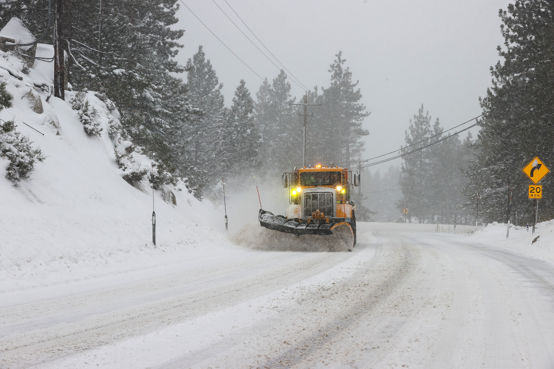
A snowplow is seen as snow blankets Route 237 in Stateline, Nevada, on Nov. 8, 2022. (Tayfun Coskun/Anadolu Agency via Getty Images)
And a storm in the Tahoe area is no joke, especially on roads at such high elevation — well over 7,000 feet on both the Donner Pass on Interstate 80 and Echo Summit on Highway 50. “And when you’re talking about 4 to 6 feet of snow, and people that have never driven in it before, it can get pretty, pretty gnarly,” says Nelson.
How to check the weather and road conditions
Weather predictions can evolve and change on a dime, and a storm can suddenly switch gears and arrive sooner (or later) than first forecast.
This is why it’s important not just to keep checking the weather forecast for the area of Tahoe you’re visiting, but to make sure you’re getting information that’s as reliable as possible. During periods of extreme weather, officials will urge you not to travel for any nonessential reasons, and stay off the roads whenever possible. You should always heed these advisories.
Trust the experts (not a quick Google search)
The National Weather Service’s Reno office offers an online Lake Tahoe weather report you can consult. The National Weather Service’s presences on X, formerly known as Twitter, are also frequently updated sources of information about Tahoe weather, and you don’t have to have an X account to see their tweets. Check:
Caltrans’ X accounts also provide frequent forecasts, warnings and updates specifically geared to road travel. Check:
@CaltransDist3 on X (serving Butte, Colusa, El Dorado, Glenn, Nevada, Placer, Sacramento, Sierra, Sutter, Yolo and Yuba counties)
@CaltransDist10 on X (serving Alpine, Amador, Calaveras, Mariposa, Merced, San Joaquin, Stanislaus and Tuolumne counties)
Nelson says that while these X accounts are very frequently updated and get a lot of inquiries from the public, drivers need to remember that they’re “not a 24/7 resource” and should be realistic about using these accounts as a source of real-time help. (“A lot of times we’ll get messages in the middle of the night saying, ‘Hey, can I get up to Tahoe?,’ and we’re not monitoring [X] at three in the morning,” says Nelson.)
You can find subscription-only weather forecasting services as well, like Open Snow (which offers a free seven-day trial). These paid services often promise to give a greater degree of granularity around forecasts and longer-range predictions.
If you’re heading up to Tahoe for winter sports, consider also checking the website and social media of any resort you’re hoping to visit, as they will almost certainly be featuring weather reports and predictions. For example, Heavenly in South Lake Tahoe has an X account (@HVconditions), which gives status reports on mountain operations and weather forecasts — with a focus on when there’s a risk of wind holds for chairlifts and terrain closures.
Remember: A resort warning you that weather might affect their operations is a good sign it’s the kind of weather you should take seriously when it comes to travel.
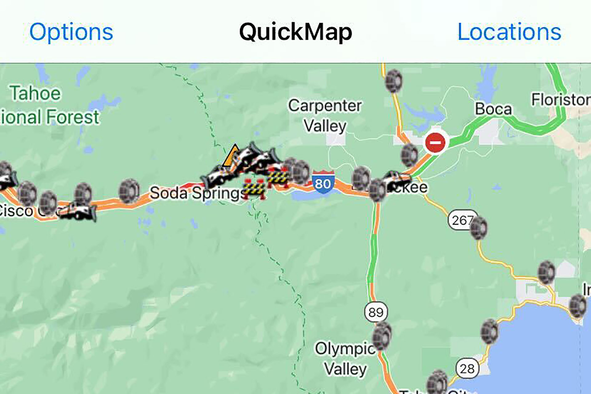
This map uses Caltrans’ own data to show you the latest road conditions and travel information, so you can be prepared ahead of time.
Caltrans’ QuickMap app, showing chain controls, snowplows and more. (Courtesy Caltrans)
When first using QuickMap, be sure to hit “Options” on either the website or the app, and select all the options you want to see on the map, including:
Full closures
CHP incidents
Highway information
Chain controls
Snowplows
Once you’ve done this, you’ll be able to either select the location “Tahoe” under “Locations,” or swipe and zoom over to your desired area on the map, just as you would using Google Maps. You can then tap on the icons you see on the map, to learn more about what they mean. This is especially important when it comes to chain controls, which often apply to different kinds of vehicles.
Use QuickMap before setting off on your travels and — if it’s safe to do so — during your journey, as conditions and chain requirements can develop fast in the Tahoe area. Don’t let warm, sunny and dry conditions in the Bay Area lull you into a false sense of security about the weather you’ll encounter up in the mountains.
Know when it’s safe to travel — and be prepared to delay a trip
It’s always frustrating when plans change. But delaying, postponing or even canceling a trip to Tahoe is often the safest thing to do when weather means you’ll be battling hazardous conditions to get there.
Nelson says that during the fierce storms over the New Year of 2023, “it was nonstop” for Caltrans and the California Highway Patrol, rescuing stranded motorists on Interstate 80 and Highway 50. He notes that often, it’s the fact that people have travel plans they don’t want to cancel or lose money on that convinces folks to attempt the drive to Tahoe despite bad weather, with little to no winter driving experience.
“They desperately want to get up to Tahoe and they don’t really care what’s going on outside,” he says. “So that’s when we run into problems.”
Remember, even if you’re secure in your own mountain driving abilities, not everyone on the road is — and bad weather can mean accidents between vehicles that can cause traffic jams, delays and even road closures. This is just another reason to consider delaying or canceling a planned Tahoe trip because of weather: Do you really want to be stuck on I-80 for seven hours? At the least, you might consider delaying your travel until weather passes to have a better chance of a smoother journey.
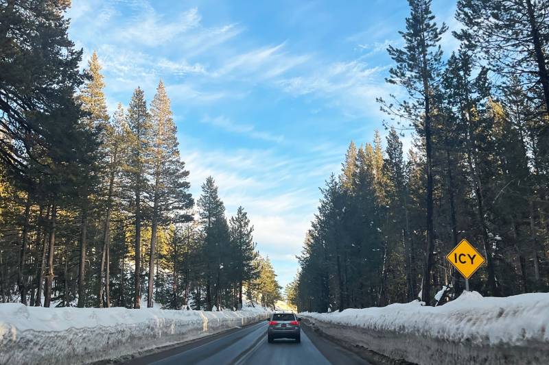
Driving to Tahoe in winter is serious business, with weather and road conditions that can change quickly. (Courtesy of Gabe Farthing)
If you’re traveling to Tahoe for winter sports, remember, too, that just because it’s snowing, or has recently snowed, a ski resort is not necessarily operational and does not necessarily have all their terrain open. High winds frequently mean that resort chairlifts can be placed on wind hold or closed for the day, especially on the upper mountain. Sometimes, strong storms mean loss of power to the resorts, and equipment like chairlifts can get iced over and become nonoperational. In short: You could battle the worst weather and road conditions to make it to the resort of your choice, only to find that the resort isn’t even able to open.
If the worst happens, and you realize you need to change your trip, don’t assume you’ll lose all your money from postponing. While hotels and ski resorts often won’t let you outright cancel your prepaid purchases due to weather, you might find you can change the date itself free of charge.
Consider calling the hotel or resort directly, being prepared to be patient and courteous (and mindful that you might be one of many folks making the same call) and ask them what’s possible.
Chain control: Do I have the right vehicle for Tahoe?
Know exactly what ‘chain control’ means
Chain control is a reality of traveling to and around the Tahoe region, and you shouldn’t travel to Tahoe without knowing about it.
“Chains” is a catchall term for a traction device that’s fitted onto the tires of a vehicle’s drive wheels and gives that vehicle more traction on snowy and icy roads. These can look like link-type chains, or what’s called alternative traction devices (ATD), which can include cable chains, textile snow chains, wheel-hub-attached chains and automatic tire chains.
California has three levels of chain requirements (“R”). R1 applies to the heaviest vehicles, like trucks. R2 is the chain requirement that applies most to drivers of passenger cars headed up to Tahoe. (R3 chain control requires chains on all vehicles, even those with AWD and snow tires, although it’s more likely a road would be closed outright before R3 chain controls were implemented.)
How do I know if I need chains?
R2 chain control means that unless your vehicle has all-wheel drive (AWD, also known as four-wheel drive) and snow-tread tires on all four wheels, you need to use chains on your vehicle.
This means that if you have AWD but no snow-tread tires, you need to install chains on your car in a chain control area.
Less commonly, if you have snow-tread tires but no AWD, you also need to use chains.
Caltrans says that you’ll usually have “about a mile” between “Chains Required” signs and any chain control checkpoint to install your chains. You can be cited and fined by the California Highway Patrol for not observing chain controls in Tahoe. Read more from Caltrans about chain control requirements.
Don’t assume your AWD vehicle has the right tires
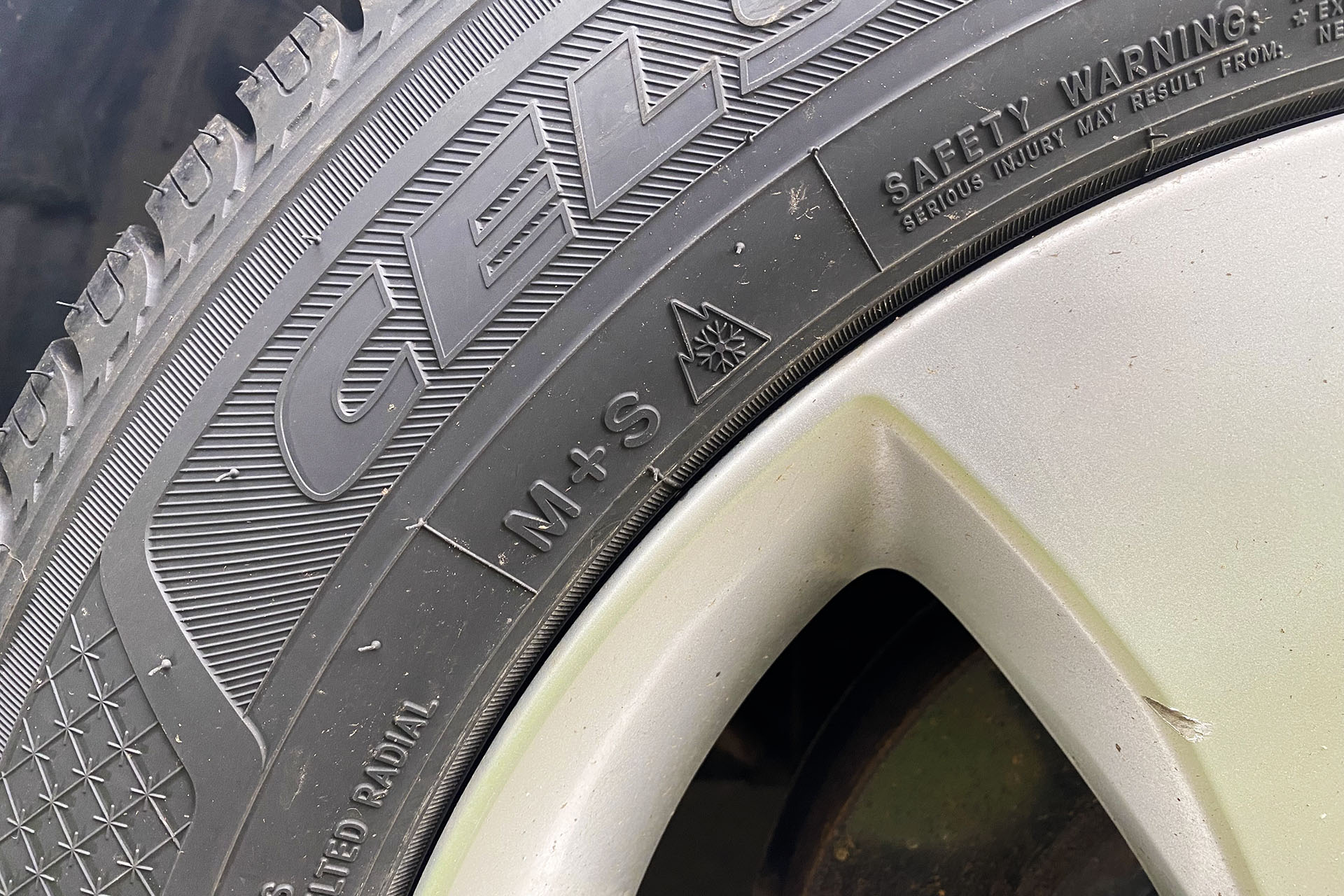
“All-wheel drive is useless if you don’t have the right tires,” says Nelson. So how do you know whether your vehicle has snow-tread tires?
They’ll say “mud and snow” on the tires themselves, usually marked as “M + S.” You might also see a snowflake symbol on the sidewall.
Wondering if your car has snow-tread tires? Look for ‘M + S’ and the snowflake icon on your tire’s sidewall. (Carly Severn/KQED)
Even if you have AWD and snow-tread tires, you should still carry chains
You may be asked to show these chains in your vehicle at a checkpoint. For that reason, it’s a good idea to have them clearly visible in your car so a Caltrans worker can see they’re present.
Rental cars might not let you use chains
It’s totally understandable to want to rent a vehicle to travel up to Tahoe — maybe you’re flying into a nearby airport like Sacramento or Reno, or you need a car that carries a larger party for your trip.
But there’s one thing you absolutely must know about: Many rental car companies will not allow you to fit chains or other traction devices on the tires of your rental car. And if you’ve rented a car that doesn’t have mud and snow tires — even if it has AWD — and you hit an area where R2 chain control is in effect, a Caltrans chains checkpoint will make you turn around.
This is something that happens “pretty frequently,” confirms Nelson, who says he and his Caltrans colleagues see drivers of rental cars without mud and snow tires “basically pleading, begging” to be allowed through a Tahoe chain control checkpoint without chains.
“It’s not going to matter,” says Nelson. “We’re going to turn them around, because it’s a safety factor for us.”
Always check directly with your rental car company about their chain installation policy. Some rental companies will also let you filter results for cars on their site by whether they have mud and snow tires, before you book.
How do I know whether chain control is in effect where I’m traveling?
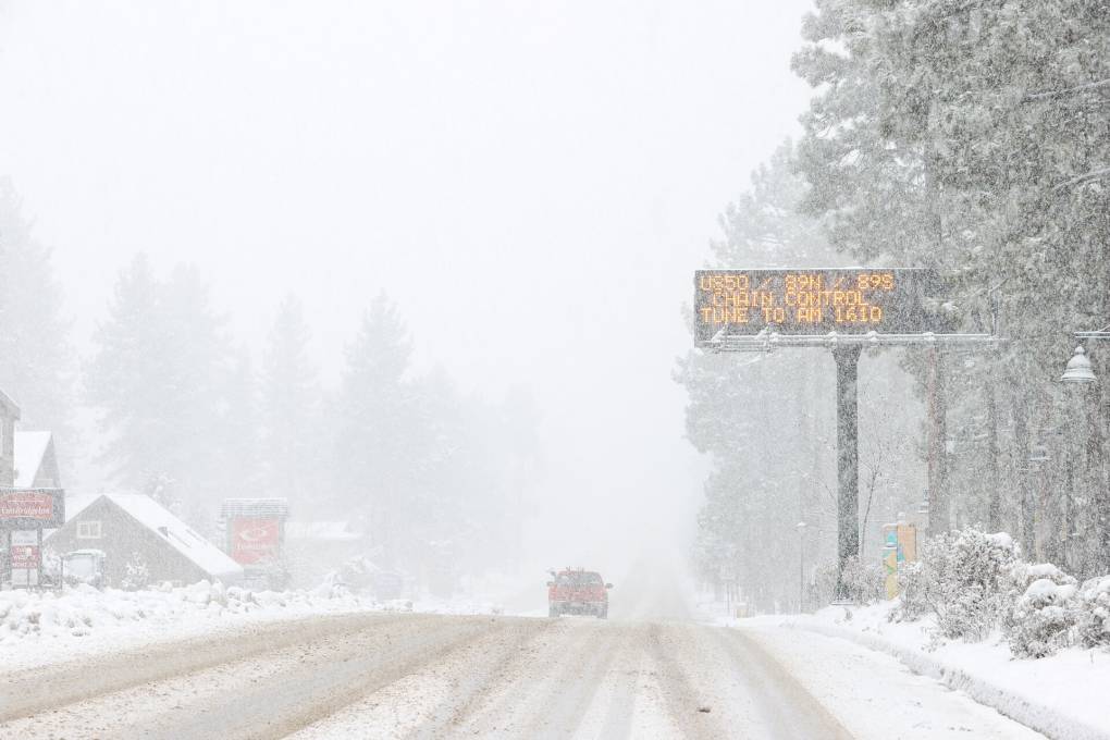
If chain control is in effect in an area, you’ll see signs on the road indicating this. They’ll either look like permanent black signs on the side of the road, flipped around so they’re facing oncoming traffic, or illuminated signs over the highway. On lower-elevation areas of roads like I-80, Highway 50 and Highway 88, you may also see illuminated road signs giving you the heads-up about chain controls up ahead.
You can see chain control areas marked on Caltrans’ QuickMap site or app, or call the Caltrans Highway Information Network at (800) 427-7623.
Certain roads may also have a Caltrans checkpoint at the start of a chain control area, staffed by Caltrans workers. At these checkpoints, Caltrans staff will manually verify whether you have the required vehicle and tires to go through the checkpoint.
If you don’t have AWD and snow-tread tires, they’ll ask you to pull over or turn around to install chains on your vehicle. If you aren’t carrying chains, you will be asked to turn around and leave the area the way you came.
Even if there’s no checkpoint, or road authority staff present in a chain control area, you still need to pull over safely and install your chains, if your vehicle needs them. You might hit a checkpoint further up the road, or have a Caltrans staffer or California Highway Patrol officer pull you over if you don’t have chains in a chain control area, where you can be fined.
Whether you’re having someone fit your chains for you, or installing them yourself, you must only pull over to the right and fit your chains in an area where it’s safe, which will almost certainly be in a designated chain installation area off the side of the road. You must not block the road to fit your chains, or risk your safety (or that of others) when installing your chains. Jump to more information about installing chains in chain control areas.
How do I know which chains I should buy or rent for my vehicle?
Check your vehicle’s manual for any information about which chain-style traction devices are recommended (or even prohibited, as with certain vehicles). The exact chains or other traction devices you buy will also depend on your tires’ size. You can find your tire size on the sidewall of your tires, which will start with a “P.”
You can buy chains up in the Tahoe region, and in fact you’ll see several businesses along major entry roads to the Lake Tahoe area advertising their chains. Buying chains in Tahoe when you need them might well be more expensive than purchasing them back in the Bay Area, especially during periods of strong weather and frequent chain control.
Option 1 for chain installation: Pay someone to fit your chains for you
At chain control checkpoints, you’ll very often see chain installers who can do it for you — for a price.
These installers aren’t Caltrans employees, says Nelson, but they’re contracted and permitted through the agency. A usual price for this would be $40 to install chains, and $20 to remove them at the point where chain control ends, but “sometimes they’ll raise their rates depending on the need,” advises Nelson.
Caltrans makes clear that these independent chain installers are not allowed to sell or rent chains to you — only fit or remove ones you already have. The agency also recommends that if you pay an installer to fit your chains, you should get a receipt and “jot the installer’s badge number on it,” which they say “may help with any misunderstandings later.”
But remember, not all areas where chain control is in effect will have contracted installers on hand to fit your chains for you. That’s why it’s a good idea to opt for the second option …
Option 2 for chain installation: Learn how to do it yourself (recommended)
“If you can [fit your chains] yourself, you’re going to save some time and some money,” says Nelson.
If you’ve never installed chains before, you will find it tricky and time-consuming the first few times you practice. This is why it’s a really good idea to do several of these “practice rounds” at home on your own street or driveway. “You definitely don’t want your first time putting chains on to be actually up on the mountain,” warns Nelson.
Remember, you could very well find yourself installing chains for real at a chain control checkpoint in the dark, or when it’s very cold, or actively snowing or raining. Consider packing a headlamp (or a flashlight for someone else to hold), and fingerless gloves to allow you to maneuver the chain links.
For true realism, also consider practicing installing your chains at home at night, or even when it’s raining — because that could well be the environment in which you’re doing this for real in the mountains, at much higher elevation and in the freezing cold.
Sunrise view as snow blankets South Lake Tahoe on Nov. 8, 2022. (Tayfun Coskun/Anadolu Agency via Getty Images)
Advice for safer driving in Tahoe in the winter
Preparing yourself and your vehicle for a winter journey
You’ll need to prepare more for a winter journey in Tahoe than you usually would for travel outside the mountains. In addition to making sure your vehicle’s in good working order (brakes, wipers, heater, etc.), you’ll need to carry chains (see above).
Make sure you also have as much fuel as possible at all times. Not only could gas become more expensive as you approach the mountains, but you could be delayed or even held on the road, which will burn up the fuel in your tank. Gaining elevation as you ascend into the mountains will also use more gas. Running out of gas at the best of times is no fun — running out of gas at 7,000 feet of elevation in a freezing blizzard is way worse.
Since winter travel brings with it the possibility of delays, or even being stuck on a road when it’s closed due to weather, it’s also a good idea to have the following items in your car:
Food and water
Warm blankets
Extra clothing
A shovel, in case you need to dig your vehicle out of snow
An ice scraper
Sponsored
Don’t always follow Google Maps and co.
Strong weather can mean more traffic, and navigation apps like Google Maps, Apple Maps and Waze can sometimes suggest alternative routes to save you time, or “shortcuts.”
In the mountains, and especially during or just after bad weather, you should be very wary of taking these shortcuts. That’s because your navigation app very well might not account for weather or road conditions on the side roads it’s recommending, and you could find yourself on a steep, unplowed road that’s not safe for your particular vehicle to drive in winter conditions.
If in doubt, stick to the main, plowed roads, even if there’s traffic.
Take it slow
You’ll see the words “Ice and snow, take it slow” on road signs in Tahoe, and you should heed the advice — especially in areas with chain control, which is in effect for a reason.
“It is tricky driving in snow and ice, but I’ll tell you, if people actually drove the speed limit in chain controls, they’d have no issues on Interstate 80,” says Nelson. “It’s 30 miles an hour. And on Highway 50, it’s 25 miles an hour in chain checkpoint areas.”
If you adhere to the speed limits, says Nelson, “then you’re fine. It’s the people that still try to drive 55, 60 miles an hour in snow. That’s when problems start.”
Leave far more braking distance between you and the car ahead than you normally would. If cars behind you are clearly trying to go much faster than you, that’s their issue. Pull over only when it’s safe to do so, and let them pass.
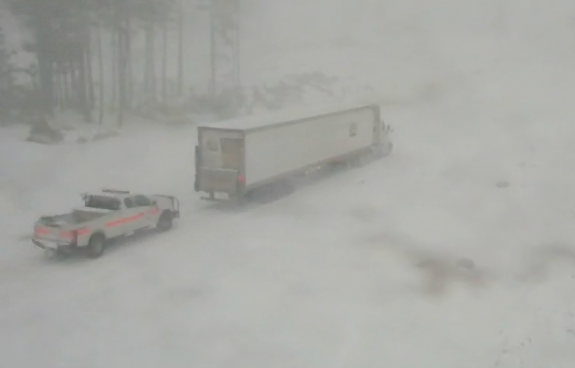
A screenshot of trucks driving through the snowy conditions on Interstate 80 at Donner Summit on Dec. 1, 2022. (Courtesy of Caltrans)
… you might be glad you brought the shovel mentioned above if you wake up at your hotel or accommodation to find your car has accumulated several feet of snow overnight. (Hotels will often provide shovels, too, but they’ll be shared among many guests trying to do the same thing.)
Be sure to brush as much of the snow off the top of your vehicle as you can before leaving a parking lot. If you don’t, a large sheet of snow can later fall off your car — either blocking your own windshield, or falling onto the road (or the car) behind you and causing a potential hazard to other motorists. Caltrans suggests you could even bring a broom in your car for this purpose, if snow is forecast during your stay. At the very least, it’s a courtesy to your fellow motorists — at the most, you’ll avoid causing a potentially serious accident.
Finally, remember: You don’t have to drive to go to Tahoe
If all of this advice about winter driving is making you reconsider driving up to Tahoe, but you still really want to visit the mountains, you should know there are several public and private options for traveling to Tahoe other than driving.
Several hotels offer shuttles (sometimes free, sometimes paid) to the resorts, and many resorts also offer shuttles to different locations and parking lots.
An earlier version of this story was originally published on Feb. 28.
Sponsored
lower waypoint
Stay in touch. Sign up for our daily newsletter.
To learn more about how we use your information, please read our privacy policy.
window.__IS_SSR__=true
window.__INITIAL_STATE__={"attachmentsReducer":{"audio_0":{"type":"attachments","id":"audio_0","imgSizes":{"kqedFullSize":{"file":"https://ww2.kqed.org/news/wp-content/themes/KQED-unified/img/audio_bgs/background0.jpg"}}},"audio_1":{"type":"attachments","id":"audio_1","imgSizes":{"kqedFullSize":{"file":"https://ww2.kqed.org/news/wp-content/themes/KQED-unified/img/audio_bgs/background1.jpg"}}},"audio_2":{"type":"attachments","id":"audio_2","imgSizes":{"kqedFullSize":{"file":"https://ww2.kqed.org/news/wp-content/themes/KQED-unified/img/audio_bgs/background2.jpg"}}},"audio_3":{"type":"attachments","id":"audio_3","imgSizes":{"kqedFullSize":{"file":"https://ww2.kqed.org/news/wp-content/themes/KQED-unified/img/audio_bgs/background3.jpg"}}},"audio_4":{"type":"attachments","id":"audio_4","imgSizes":{"kqedFullSize":{"file":"https://ww2.kqed.org/news/wp-content/themes/KQED-unified/img/audio_bgs/background4.jpg"}}},"placeholder":{"type":"attachments","id":"placeholder","imgSizes":{"thumbnail":{"file":"https://ww2.kqed.org/wp-content/uploads/sites/10/2018/01/GettyImages-896326950-160x96.jpg","width":160,"height":96,"mimeType":"image/jpeg"},"medium":{"file":"https://ww2.kqed.org/wp-content/uploads/sites/10/2018/01/GettyImages-896326950-800x478.jpg","width":800,"height":478,"mimeType":"image/jpeg"},"large":{"file":"https://ww2.kqed.org/wp-content/uploads/sites/10/2018/01/GettyImages-896326950-1020x610.jpg","width":1020,"height":610,"mimeType":"image/jpeg"},"fd-lrg":{"file":"https://ww2.kqed.org/wp-content/uploads/sites/10/2018/01/GettyImages-896326950-1920x1148.jpg","width":1920,"height":1148,"mimeType":"image/jpeg"},"fd-med":{"file":"https://ww2.kqed.org/wp-content/uploads/sites/10/2018/01/GettyImages-896326950-1180x705.jpg","width":1180,"height":705,"mimeType":"image/jpeg"},"fd-sm":{"file":"https://ww2.kqed.org/wp-content/uploads/sites/10/2018/01/GettyImages-896326950-960x574.jpg","width":960,"height":574,"mimeType":"image/jpeg"},"post-thumbnail":{"file":"https://ww2.kqed.org/wp-content/uploads/sites/10/2018/01/GettyImages-896326950-672x372.jpg","width":672,"height":372,"mimeType":"image/jpeg"},"twentyfourteen-full-width":{"file":"https://ww2.kqed.org/wp-content/uploads/sites/10/2018/01/GettyImages-896326950-1038x576.jpg","width":1038,"height":576,"mimeType":"image/jpeg"},"xxsmall":{"file":"https://ww2.kqed.org/wp-content/uploads/sites/10/2018/01/GettyImages-896326950-240x143.jpg","width":240,"height":143,"mimeType":"image/jpeg"},"xsmall":{"file":"https://ww2.kqed.org/wp-content/uploads/sites/10/2018/01/GettyImages-896326950-375x224.jpg","width":375,"height":224,"mimeType":"image/jpeg"},"small":{"file":"https://ww2.kqed.org/wp-content/uploads/sites/10/2018/01/GettyImages-896326950-520x311.jpg","width":520,"height":311,"mimeType":"image/jpeg"},"xlarge":{"file":"https://ww2.kqed.org/wp-content/uploads/sites/10/2018/01/GettyImages-896326950-1180x705.jpg","width":1180,"height":705,"mimeType":"image/jpeg"},"full-width":{"file":"https://ww2.kqed.org/wp-content/uploads/sites/10/2018/01/GettyImages-896326950-1920x1148.jpg","width":1920,"height":1148,"mimeType":"image/jpeg"},"guest-author-32":{"file":"https://ww2.kqed.org/wp-content/uploads/sites/10/2018/01/GettyImages-896326950-32x32.jpg","width":32,"height":32,"mimeType":"image/jpeg"},"guest-author-50":{"file":"https://ww2.kqed.org/wp-content/uploads/sites/10/2018/01/GettyImages-896326950-50x50.jpg","width":50,"height":50,"mimeType":"image/jpeg"},"guest-author-64":{"file":"https://ww2.kqed.org/wp-content/uploads/sites/10/2018/01/GettyImages-896326950-64x64.jpg","width":64,"height":64,"mimeType":"image/jpeg"},"guest-author-96":{"file":"https://ww2.kqed.org/wp-content/uploads/sites/10/2018/01/GettyImages-896326950-96x96.jpg","width":96,"height":96,"mimeType":"image/jpeg"},"guest-author-128":{"file":"https://ww2.kqed.org/wp-content/uploads/sites/10/2018/01/GettyImages-896326950-128x128.jpg","width":128,"height":128,"mimeType":"image/jpeg"},"detail":{"file":"https://ww2.kqed.org/wp-content/uploads/sites/10/2018/01/GettyImages-896326950-150x150.jpg","width":150,"height":150,"mimeType":"image/jpeg"},"kqedFullSize":{"file":"https://ww2.kqed.org/wp-content/uploads/sites/10/2018/01/GettyImages-896326950-e1514998105161.jpg","width":1920,"height":1148}}},"news_11984136":{"type":"attachments","id":"news_11984136","meta":{"index":"attachments_1591205162","site":"news","id":"11984136","found":true},"title":"240425-StanfordGazaProtest-022-BL","publishDate":1714149444,"status":"inherit","parent":0,"modified":1714178507,"caption":"A pro-Israel counterprotester waves an Israel flag during a pro-Palestinian march through the Stanford University campus on April 25, 2024, calling for the university to divest from Israel. The rally took place during Stanford's Admit Weekend, a time for incoming students to tour the university.","credit":"Beth LaBerge/KQED","altTag":null,"description":null,"imgSizes":{"medium":{"file":"https://cdn.kqed.org/wp-content/uploads/sites/10/2024/04/240425-StanfordGazaProtest-022-BL-800x533.jpg","width":800,"height":533,"mimeType":"image/jpeg"},"large":{"file":"https://cdn.kqed.org/wp-content/uploads/sites/10/2024/04/240425-StanfordGazaProtest-022-BL-1020x680.jpg","width":1020,"height":680,"mimeType":"image/jpeg"},"thumbnail":{"file":"https://cdn.kqed.org/wp-content/uploads/sites/10/2024/04/240425-StanfordGazaProtest-022-BL-160x107.jpg","width":160,"height":107,"mimeType":"image/jpeg"},"1536x1536":{"file":"https://cdn.kqed.org/wp-content/uploads/sites/10/2024/04/240425-StanfordGazaProtest-022-BL-1536x1024.jpg","width":1536,"height":1024,"mimeType":"image/jpeg"},"post-thumbnail":{"file":"https://cdn.kqed.org/wp-content/uploads/sites/10/2024/04/240425-StanfordGazaProtest-022-BL-672x372.jpg","width":672,"height":372,"mimeType":"image/jpeg"},"twentyfourteen-full-width":{"file":"https://cdn.kqed.org/wp-content/uploads/sites/10/2024/04/240425-StanfordGazaProtest-022-BL-1038x576.jpg","width":1038,"height":576,"mimeType":"image/jpeg"},"kqedFullSize":{"file":"https://cdn.kqed.org/wp-content/uploads/sites/10/2024/04/240425-StanfordGazaProtest-022-BL.jpg","width":1920,"height":1280}},"fetchFailed":false,"isLoading":false},"news_11984293":{"type":"attachments","id":"news_11984293","meta":{"index":"attachments_1591205162","site":"news","id":"11984293","found":true},"title":"Police Response","publishDate":1714246070,"status":"inherit","parent":11984288,"modified":1714246157,"caption":"An investigation by The Associated Press has found that at least 16 people died in California over a decade following physical encounters with police during which medical personnel also injected them with a powerful sedative. ","credit":"MattGush/Getty Images","altTag":null,"description":null,"imgSizes":{"medium":{"file":"https://cdn.kqed.org/wp-content/uploads/sites/10/2024/04/GettyImages-1284632794-800x533.jpg","width":800,"height":533,"mimeType":"image/jpeg"},"large":{"file":"https://cdn.kqed.org/wp-content/uploads/sites/10/2024/04/GettyImages-1284632794-1020x680.jpg","width":1020,"height":680,"mimeType":"image/jpeg"},"thumbnail":{"file":"https://cdn.kqed.org/wp-content/uploads/sites/10/2024/04/GettyImages-1284632794-160x107.jpg","width":160,"height":107,"mimeType":"image/jpeg"},"1536x1536":{"file":"https://cdn.kqed.org/wp-content/uploads/sites/10/2024/04/GettyImages-1284632794-1536x1024.jpg","width":1536,"height":1024,"mimeType":"image/jpeg"},"2048x2048":{"file":"https://cdn.kqed.org/wp-content/uploads/sites/10/2024/04/GettyImages-1284632794-2048x1365.jpg","width":2048,"height":1365,"mimeType":"image/jpeg"},"post-thumbnail":{"file":"https://cdn.kqed.org/wp-content/uploads/sites/10/2024/04/GettyImages-1284632794-672x372.jpg","width":672,"height":372,"mimeType":"image/jpeg"},"twentyfourteen-full-width":{"file":"https://cdn.kqed.org/wp-content/uploads/sites/10/2024/04/GettyImages-1284632794-1038x576.jpg","width":1038,"height":576,"mimeType":"image/jpeg"},"full-width":{"file":"https://cdn.kqed.org/wp-content/uploads/sites/10/2024/04/GettyImages-1284632794-1920x1280.jpg","width":1920,"height":1280,"mimeType":"image/jpeg"},"kqedFullSize":{"file":"https://cdn.kqed.org/wp-content/uploads/sites/10/2024/04/GettyImages-1284632794.jpg","width":2121,"height":1414}},"fetchFailed":false,"isLoading":false},"news_11984165":{"type":"attachments","id":"news_11984165","meta":{"index":"attachments_1591205162","site":"news","id":"11984165","found":true},"title":"033023-Hollister-Hospital-LV_CM_14 copy","publishDate":1714154910,"status":"inherit","parent":11984163,"modified":1714162995,"caption":"California's Office of Health Care Affordability handed down a regulation that aims to limit rising health care costs by capping industry spending increases. Here, a nurse checks on a patient in the emergency room unit of Hazel Hawkins Memorial Hospital in Hollister on March 30, 2023.","credit":"Larry Valenzuela/CalMatters/CatchLight Local","altTag":"A female nurse is seen from behind, attending to a patient in a hospital room with medical equipment.","description":null,"imgSizes":{"medium":{"file":"https://cdn.kqed.org/wp-content/uploads/sites/10/2024/04/033023-Hollister-Hospital-LV_CM_14-copy-800x533.jpg","width":800,"height":533,"mimeType":"image/jpeg"},"large":{"file":"https://cdn.kqed.org/wp-content/uploads/sites/10/2024/04/033023-Hollister-Hospital-LV_CM_14-copy-1020x680.jpg","width":1020,"height":680,"mimeType":"image/jpeg"},"thumbnail":{"file":"https://cdn.kqed.org/wp-content/uploads/sites/10/2024/04/033023-Hollister-Hospital-LV_CM_14-copy-160x107.jpg","width":160,"height":107,"mimeType":"image/jpeg"},"1536x1536":{"file":"https://cdn.kqed.org/wp-content/uploads/sites/10/2024/04/033023-Hollister-Hospital-LV_CM_14-copy-1536x1024.jpg","width":1536,"height":1024,"mimeType":"image/jpeg"},"post-thumbnail":{"file":"https://cdn.kqed.org/wp-content/uploads/sites/10/2024/04/033023-Hollister-Hospital-LV_CM_14-copy-672x372.jpg","width":672,"height":372,"mimeType":"image/jpeg"},"twentyfourteen-full-width":{"file":"https://cdn.kqed.org/wp-content/uploads/sites/10/2024/04/033023-Hollister-Hospital-LV_CM_14-copy-1038x576.jpg","width":1038,"height":576,"mimeType":"image/jpeg"},"full-width":{"file":"https://cdn.kqed.org/wp-content/uploads/sites/10/2024/04/033023-Hollister-Hospital-LV_CM_14-copy-1920x1280.jpg","width":1920,"height":1280,"mimeType":"image/jpeg"},"kqedFullSize":{"file":"https://cdn.kqed.org/wp-content/uploads/sites/10/2024/04/033023-Hollister-Hospital-LV_CM_14-copy.jpg","width":2000,"height":1333}},"fetchFailed":false,"isLoading":false},"news_11984193":{"type":"attachments","id":"news_11984193","meta":{"index":"attachments_1591205162","site":"news","id":"11984193","found":true},"title":"Supreme Court Rejects California Sentencing Law","publishDate":1714162850,"status":"inherit","parent":11984169,"modified":1714164270,"caption":"A section of the California seal hangs on the front of the State of California Earl Warren Building on Jan. 22, 2007, in San Francisco, California.","credit":"Justin Sullivan/Getty Images","altTag":null,"description":null,"imgSizes":{"medium":{"file":"https://cdn.kqed.org/wp-content/uploads/sites/10/2024/04/73076353-800x533.jpg","width":800,"height":533,"mimeType":"image/jpeg"},"large":{"file":"https://cdn.kqed.org/wp-content/uploads/sites/10/2024/04/73076353-1020x680.jpg","width":1020,"height":680,"mimeType":"image/jpeg"},"thumbnail":{"file":"https://cdn.kqed.org/wp-content/uploads/sites/10/2024/04/73076353-160x107.jpg","width":160,"height":107,"mimeType":"image/jpeg"},"1536x1536":{"file":"https://cdn.kqed.org/wp-content/uploads/sites/10/2024/04/73076353-1536x1024.jpg","width":1536,"height":1024,"mimeType":"image/jpeg"},"post-thumbnail":{"file":"https://cdn.kqed.org/wp-content/uploads/sites/10/2024/04/73076353-672x372.jpg","width":672,"height":372,"mimeType":"image/jpeg"},"twentyfourteen-full-width":{"file":"https://cdn.kqed.org/wp-content/uploads/sites/10/2024/04/73076353-1038x576.jpg","width":1038,"height":576,"mimeType":"image/jpeg"},"kqedFullSize":{"file":"https://cdn.kqed.org/wp-content/uploads/sites/10/2024/04/73076353.jpg","width":1920,"height":1280}},"fetchFailed":false,"isLoading":false},"news_11983951":{"type":"attachments","id":"news_11983951","meta":{"index":"attachments_1591205162","site":"news","id":"11983951","found":true},"title":"Fremont HS Class Photo","publishDate":1713991106,"status":"inherit","parent":11983949,"modified":1713991701,"caption":"Students and staff from Fremont High School in East Oakland.","credit":"Rachel Roberson/KQED","altTag":null,"description":null,"imgSizes":{"medium":{"file":"https://cdn.kqed.org/wp-content/uploads/sites/10/2024/04/Fremont-HS-Class-Photo--800x600.jpg","width":800,"height":600,"mimeType":"image/jpeg"},"large":{"file":"https://cdn.kqed.org/wp-content/uploads/sites/10/2024/04/Fremont-HS-Class-Photo--1020x765.jpg","width":1020,"height":765,"mimeType":"image/jpeg"},"thumbnail":{"file":"https://cdn.kqed.org/wp-content/uploads/sites/10/2024/04/Fremont-HS-Class-Photo--160x120.jpg","width":160,"height":120,"mimeType":"image/jpeg"},"1536x1536":{"file":"https://cdn.kqed.org/wp-content/uploads/sites/10/2024/04/Fremont-HS-Class-Photo--1536x1152.jpg","width":1536,"height":1152,"mimeType":"image/jpeg"},"2048x2048":{"file":"https://cdn.kqed.org/wp-content/uploads/sites/10/2024/04/Fremont-HS-Class-Photo--2048x1536.jpg","width":2048,"height":1536,"mimeType":"image/jpeg"},"post-thumbnail":{"file":"https://cdn.kqed.org/wp-content/uploads/sites/10/2024/04/Fremont-HS-Class-Photo--672x372.jpg","width":672,"height":372,"mimeType":"image/jpeg"},"twentyfourteen-full-width":{"file":"https://cdn.kqed.org/wp-content/uploads/sites/10/2024/04/Fremont-HS-Class-Photo--1038x576.jpg","width":1038,"height":576,"mimeType":"image/jpeg"},"full-width":{"file":"https://cdn.kqed.org/wp-content/uploads/sites/10/2024/04/Fremont-HS-Class-Photo--1920x1440.jpg","width":1920,"height":1440,"mimeType":"image/jpeg"},"kqedFullSize":{"file":"https://cdn.kqed.org/wp-content/uploads/sites/10/2024/04/Fremont-HS-Class-Photo--scaled.jpg","width":2560,"height":1920}},"fetchFailed":false,"isLoading":false},"news_11984097":{"type":"attachments","id":"news_11984097","meta":{"index":"attachments_1591205162","site":"news","id":"11984097","found":true},"title":"SAN JOSE LICENSE PLATE READERS-11-KQED","publishDate":1714086991,"status":"inherit","parent":11983813,"modified":1714087481,"caption":"A Flock Safety worker holds up a new Automated License Plate Reader that was being installed in East San José on Tuesday, April 23, 2024.","credit":"Joseph Geha/KQED","altTag":"A man with a fluorescent yellow coat holds a black machine.","description":null,"imgSizes":{"medium":{"file":"https://cdn.kqed.org/wp-content/uploads/sites/10/2024/04/SAN-JOSE-LICENSE-PLATE-READERS-11-KQED-800x533.jpg","width":800,"height":533,"mimeType":"image/jpeg"},"large":{"file":"https://cdn.kqed.org/wp-content/uploads/sites/10/2024/04/SAN-JOSE-LICENSE-PLATE-READERS-11-KQED-1020x680.jpg","width":1020,"height":680,"mimeType":"image/jpeg"},"thumbnail":{"file":"https://cdn.kqed.org/wp-content/uploads/sites/10/2024/04/SAN-JOSE-LICENSE-PLATE-READERS-11-KQED-160x107.jpg","width":160,"height":107,"mimeType":"image/jpeg"},"1536x1536":{"file":"https://cdn.kqed.org/wp-content/uploads/sites/10/2024/04/SAN-JOSE-LICENSE-PLATE-READERS-11-KQED-1536x1024.jpg","width":1536,"height":1024,"mimeType":"image/jpeg"},"post-thumbnail":{"file":"https://cdn.kqed.org/wp-content/uploads/sites/10/2024/04/SAN-JOSE-LICENSE-PLATE-READERS-11-KQED-672x372.jpg","width":672,"height":372,"mimeType":"image/jpeg"},"twentyfourteen-full-width":{"file":"https://cdn.kqed.org/wp-content/uploads/sites/10/2024/04/SAN-JOSE-LICENSE-PLATE-READERS-11-KQED-1038x576.jpg","width":1038,"height":576,"mimeType":"image/jpeg"},"full-width":{"file":"https://cdn.kqed.org/wp-content/uploads/sites/10/2024/04/SAN-JOSE-LICENSE-PLATE-READERS-11-KQED-1920x1280.jpg","width":1920,"height":1280,"mimeType":"image/jpeg"},"kqedFullSize":{"file":"https://cdn.kqed.org/wp-content/uploads/sites/10/2024/04/SAN-JOSE-LICENSE-PLATE-READERS-11-KQED.jpg","width":2000,"height":1333}},"fetchFailed":false,"isLoading":false},"forum_2010101905540":{"type":"attachments","id":"forum_2010101905540","meta":{"index":"attachments_1591205162","site":"forum","id":"2010101905540","found":true},"title":"tree","publishDate":1714170276,"status":"inherit","parent":2010101905535,"modified":1714170319,"caption":"Newly arrived refugees from Darfur in Sudan, gather at a relocation camp near the border on April 19, 2024 in Adre, Chad.","credit":"Dan Kitwood/Getty Images","altTag":null,"description":null,"imgSizes":{"medium":{"file":"https://cdn.kqed.org/wp-content/uploads/sites/43/2024/04/tree-800x480.png","width":800,"height":480,"mimeType":"image/png"},"large":{"file":"https://cdn.kqed.org/wp-content/uploads/sites/43/2024/04/tree-1020x613.png","width":1020,"height":613,"mimeType":"image/png"},"thumbnail":{"file":"https://cdn.kqed.org/wp-content/uploads/sites/43/2024/04/tree-160x96.png","width":160,"height":96,"mimeType":"image/png"},"medium_large":{"file":"https://cdn.kqed.org/wp-content/uploads/sites/43/2024/04/tree-768x461.png","width":768,"height":461,"mimeType":"image/png"},"1536x1536":{"file":"https://cdn.kqed.org/wp-content/uploads/sites/43/2024/04/tree-1536x922.png","width":1536,"height":922,"mimeType":"image/png"},"post-thumbnail":{"file":"https://cdn.kqed.org/wp-content/uploads/sites/43/2024/04/tree-672x372.png","width":672,"height":372,"mimeType":"image/png"},"twentyfourteen-full-width":{"file":"https://cdn.kqed.org/wp-content/uploads/sites/43/2024/04/tree-1038x576.png","width":1038,"height":576,"mimeType":"image/png"},"kqedFullSize":{"file":"https://cdn.kqed.org/wp-content/uploads/sites/43/2024/04/tree.png","width":1920,"height":1153}},"fetchFailed":false,"isLoading":false},"news_11984069":{"type":"attachments","id":"news_11984069","meta":{"index":"attachments_1591205162","site":"news","id":"11984069","found":true},"title":"Single family homes in Alameda on Jan. 12, 2023.","publishDate":1714077079,"status":"inherit","parent":11984016,"modified":1714077110,"caption":"Single family homes in Alameda on Jan. 12, 2023.","credit":"Beth LaBerge/KQED","altTag":"Single family houses in a suburban neighborhood.","description":null,"imgSizes":{"medium":{"file":"https://cdn.kqed.org/wp-content/uploads/sites/10/2024/04/016_KQED_AlamedaAffordableHousing_01122023_qut-800x533.jpg","width":800,"height":533,"mimeType":"image/jpeg"},"large":{"file":"https://cdn.kqed.org/wp-content/uploads/sites/10/2024/04/016_KQED_AlamedaAffordableHousing_01122023_qut-1020x680.jpg","width":1020,"height":680,"mimeType":"image/jpeg"},"thumbnail":{"file":"https://cdn.kqed.org/wp-content/uploads/sites/10/2024/04/016_KQED_AlamedaAffordableHousing_01122023_qut-160x107.jpg","width":160,"height":107,"mimeType":"image/jpeg"},"1536x1536":{"file":"https://cdn.kqed.org/wp-content/uploads/sites/10/2024/04/016_KQED_AlamedaAffordableHousing_01122023_qut-1536x1024.jpg","width":1536,"height":1024,"mimeType":"image/jpeg"},"post-thumbnail":{"file":"https://cdn.kqed.org/wp-content/uploads/sites/10/2024/04/016_KQED_AlamedaAffordableHousing_01122023_qut-672x372.jpg","width":672,"height":372,"mimeType":"image/jpeg"},"twentyfourteen-full-width":{"file":"https://cdn.kqed.org/wp-content/uploads/sites/10/2024/04/016_KQED_AlamedaAffordableHousing_01122023_qut-1038x576.jpg","width":1038,"height":576,"mimeType":"image/jpeg"},"kqedFullSize":{"file":"https://cdn.kqed.org/wp-content/uploads/sites/10/2024/04/016_KQED_AlamedaAffordableHousing_01122023_qut.jpg","width":1920,"height":1280}},"fetchFailed":false,"isLoading":false},"news_11984228":{"type":"attachments","id":"news_11984228","meta":{"index":"attachments_1591205162","site":"news","id":"11984228","found":true},"title":"133A1642","publishDate":1714166395,"status":"inherit","parent":11984189,"modified":1714166778,"caption":"An emergency dispatcher monitors the Computer Aided Dispatch System in San Francisco.","credit":"Courtesy of Department of Emergency Management","altTag":null,"description":null,"imgSizes":{"medium":{"file":"https://cdn.kqed.org/wp-content/uploads/sites/10/2024/04/133A1642-800x533.jpg","width":800,"height":533,"mimeType":"image/jpeg"},"large":{"file":"https://cdn.kqed.org/wp-content/uploads/sites/10/2024/04/133A1642-1020x680.jpg","width":1020,"height":680,"mimeType":"image/jpeg"},"thumbnail":{"file":"https://cdn.kqed.org/wp-content/uploads/sites/10/2024/04/133A1642-160x107.jpg","width":160,"height":107,"mimeType":"image/jpeg"},"1536x1536":{"file":"https://cdn.kqed.org/wp-content/uploads/sites/10/2024/04/133A1642-1536x1024.jpg","width":1536,"height":1024,"mimeType":"image/jpeg"},"2048x2048":{"file":"https://cdn.kqed.org/wp-content/uploads/sites/10/2024/04/133A1642-2048x1365.jpg","width":2048,"height":1365,"mimeType":"image/jpeg"},"post-thumbnail":{"file":"https://cdn.kqed.org/wp-content/uploads/sites/10/2024/04/133A1642-672x372.jpg","width":672,"height":372,"mimeType":"image/jpeg"},"twentyfourteen-full-width":{"file":"https://cdn.kqed.org/wp-content/uploads/sites/10/2024/04/133A1642-1038x576.jpg","width":1038,"height":576,"mimeType":"image/jpeg"},"full-width":{"file":"https://cdn.kqed.org/wp-content/uploads/sites/10/2024/04/133A1642-1920x1280.jpg","width":1920,"height":1280,"mimeType":"image/jpeg"},"kqedFullSize":{"file":"https://cdn.kqed.org/wp-content/uploads/sites/10/2024/04/133A1642-scaled.jpg","width":2560,"height":1707}},"fetchFailed":false,"isLoading":false},"news_11984120":{"type":"attachments","id":"news_11984120","meta":{"index":"attachments_1591205162","site":"news","id":"11984120","found":true},"title":"230816-FCI DUBLIN WOMENS PRISON-MD-03_qut","publishDate":1714091409,"status":"inherit","parent":11984115,"modified":1714091453,"caption":"FCI Dublin Women's Prison in Dublin on Aug. 16, 2023.","credit":"Martin do Nascimento/KQED","altTag":null,"description":null,"imgSizes":{"medium":{"file":"https://cdn.kqed.org/wp-content/uploads/sites/10/2024/04/230816-FCI-DUBLIN-WOMENS-PRISON-MD-03_qut-800x533.jpg","width":800,"height":533,"mimeType":"image/jpeg"},"large":{"file":"https://cdn.kqed.org/wp-content/uploads/sites/10/2024/04/230816-FCI-DUBLIN-WOMENS-PRISON-MD-03_qut-1020x680.jpg","width":1020,"height":680,"mimeType":"image/jpeg"},"thumbnail":{"file":"https://cdn.kqed.org/wp-content/uploads/sites/10/2024/04/230816-FCI-DUBLIN-WOMENS-PRISON-MD-03_qut-160x107.jpg","width":160,"height":107,"mimeType":"image/jpeg"},"1536x1536":{"file":"https://cdn.kqed.org/wp-content/uploads/sites/10/2024/04/230816-FCI-DUBLIN-WOMENS-PRISON-MD-03_qut-1536x1024.jpg","width":1536,"height":1024,"mimeType":"image/jpeg"},"post-thumbnail":{"file":"https://cdn.kqed.org/wp-content/uploads/sites/10/2024/04/230816-FCI-DUBLIN-WOMENS-PRISON-MD-03_qut-672x372.jpg","width":672,"height":372,"mimeType":"image/jpeg"},"twentyfourteen-full-width":{"file":"https://cdn.kqed.org/wp-content/uploads/sites/10/2024/04/230816-FCI-DUBLIN-WOMENS-PRISON-MD-03_qut-1038x576.jpg","width":1038,"height":576,"mimeType":"image/jpeg"},"kqedFullSize":{"file":"https://cdn.kqed.org/wp-content/uploads/sites/10/2024/04/230816-FCI-DUBLIN-WOMENS-PRISON-MD-03_qut.jpg","width":1920,"height":1280}},"fetchFailed":false,"isLoading":false},"news_11980519":{"type":"attachments","id":"news_11980519","meta":{"index":"attachments_1591205162","site":"news","id":"11980519","found":true},"title":"snow-weather-report-storm-tahoe-sierra","publishDate":1711137895,"status":"inherit","parent":11937204,"modified":1711137928,"caption":"Snow blanked South Lake Tahoe in California, United States on November 8, 2022 as Winter Storm warning in effect for Lake Tahoe and Nevada mountains. (Photo by Tayfun Coskun/Anadolu Agency via Getty Images)","credit":"Tayfun Coskun/Anadolu Agency via Getty Images","altTag":null,"description":null,"imgSizes":{"medium":{"file":"https://cdn.kqed.org/wp-content/uploads/sites/10/2024/02/GettyImages-1244621245_qut-800x533.jpg","width":800,"height":533,"mimeType":"image/jpeg"},"large":{"file":"https://cdn.kqed.org/wp-content/uploads/sites/10/2024/02/GettyImages-1244621245_qut-1020x680.jpg","width":1020,"height":680,"mimeType":"image/jpeg"},"thumbnail":{"file":"https://cdn.kqed.org/wp-content/uploads/sites/10/2024/02/GettyImages-1244621245_qut-160x107.jpg","width":160,"height":107,"mimeType":"image/jpeg"},"1536x1536":{"file":"https://cdn.kqed.org/wp-content/uploads/sites/10/2024/02/GettyImages-1244621245_qut-1536x1024.jpg","width":1536,"height":1024,"mimeType":"image/jpeg"},"post-thumbnail":{"file":"https://cdn.kqed.org/wp-content/uploads/sites/10/2024/02/GettyImages-1244621245_qut-672x372.jpg","width":672,"height":372,"mimeType":"image/jpeg"},"twentyfourteen-full-width":{"file":"https://cdn.kqed.org/wp-content/uploads/sites/10/2024/02/GettyImages-1244621245_qut-1038x576.jpg","width":1038,"height":576,"mimeType":"image/jpeg"},"kqedFullSize":{"file":"https://cdn.kqed.org/wp-content/uploads/sites/10/2024/02/GettyImages-1244621245_qut.jpg","width":1920,"height":1280}},"fetchFailed":false,"isLoading":false}},"audioPlayerReducer":{"postId":"stream_live"},"authorsReducer":{"byline_news_11984288":{"type":"authors","id":"byline_news_11984288","meta":{"override":true},"slug":"byline_news_11984288","name":"Ryan J. Foley, Carla K. Johnson\u003cbr>Associated Press","isLoading":false},"byline_news_11984163":{"type":"authors","id":"byline_news_11984163","meta":{"override":true},"slug":"byline_news_11984163","name":"\u003ca href=\"https://calmatters.org/author/kristen-hwang/\">Kristen Hwang\u003c/a>","isLoading":false},"kqed":{"type":"authors","id":"236","meta":{"index":"authors_1591205172","id":"236","found":true},"name":"KQED News Staff","firstName":"KQED News Staff","lastName":null,"slug":"kqed","email":"faq@kqed.org","display_author_email":false,"staff_mastheads":[],"title":null,"bio":null,"avatar":"https://secure.gravatar.com/avatar/ef0e801a68c4c54afa9180db14084167?s=600&d=blank&r=g","twitter":null,"facebook":null,"instagram":null,"linkedin":null,"sites":[{"site":"arts","roles":["contributor"]},{"site":"news","roles":["editor"]},{"site":"futureofyou","roles":["author"]}],"headData":{"title":"KQED News Staff | KQED","description":null,"ogImgSrc":"https://secure.gravatar.com/avatar/ef0e801a68c4c54afa9180db14084167?s=600&d=blank&r=g","twImgSrc":"https://secure.gravatar.com/avatar/ef0e801a68c4c54afa9180db14084167?s=600&d=blank&r=g"},"isLoading":false,"link":"/author/kqed"},"minakim":{"type":"authors","id":"243","meta":{"index":"authors_1591205172","id":"243","found":true},"name":"Mina Kim","firstName":"Mina","lastName":"Kim","slug":"minakim","email":"mkim@kqed.org","display_author_email":false,"staff_mastheads":["news"],"title":"Host, Forum","bio":"Mina Kim is host of the 10 a.m. statewide hour of Forum; a live daily talk show for curious Californians on issues that matter to the state and nation, with a particular emphasis on race and equity.\r\n\r\nBefore joining the Forum team, Mina was KQED’s evening news anchor, and health reporter for The California Report. Her award-winning work has included natural disasters in Napa and gun violence in Oakland. Mina grew up in St. John’s, Newfoundland.","avatar":"https://secure.gravatar.com/avatar/145ce657a2d08cb86d93686beb958982?s=600&d=blank&r=g","twitter":"mkimreporter","facebook":null,"instagram":null,"linkedin":null,"sites":[{"site":"news","roles":["contributor"]},{"site":"stateofhealth","roles":["author"]},{"site":"forum","roles":["editor"]}],"headData":{"title":"Mina Kim | KQED","description":"Host, Forum","ogImgSrc":"https://secure.gravatar.com/avatar/145ce657a2d08cb86d93686beb958982?s=600&d=blank&r=g","twImgSrc":"https://secure.gravatar.com/avatar/145ce657a2d08cb86d93686beb958982?s=600&d=blank&r=g"},"isLoading":false,"link":"/author/minakim"},"ebaldassari":{"type":"authors","id":"11652","meta":{"index":"authors_1591205172","id":"11652","found":true},"name":"Erin Baldassari","firstName":"Erin","lastName":"Baldassari","slug":"ebaldassari","email":"ebaldassari@KQED.org","display_author_email":true,"staff_mastheads":["news"],"title":"Staff Writer","bio":"Erin Baldassari covers housing for KQED. She's a former print journalist and most recently worked as the transportation reporter for the \u003cem>Mercury News\u003c/em> and \u003cem>East Bay Times. \u003c/em>There, she focused on how the Bay Area’s housing shortage has changed the way people move around the region. She also served on the \u003cem>East Bay Times\u003c/em>’ 2017 Pulitzer Prize-winning team for coverage of the Ghost Ship Fire in Oakland. Prior to that, Erin worked as a breaking news and general assignment reporter for a variety of outlets in the Bay Area and the greater Boston area. A Tufts University alumna, Erin grew up in the foothills of the Sierra Nevada mountains and in Sonoma County. She is a life-long KQED listener.","avatar":"https://secure.gravatar.com/avatar/660ce35d088ca54ad606d7e941abc652?s=600&d=blank&r=g","twitter":"e_baldi","facebook":null,"instagram":null,"linkedin":null,"sites":[{"site":"news","roles":["author","edit_others_posts"]},{"site":"science","roles":["editor"]}],"headData":{"title":"Erin Baldassari | KQED","description":"Staff Writer","ogImgSrc":"https://secure.gravatar.com/avatar/660ce35d088ca54ad606d7e941abc652?s=600&d=blank&r=g","twImgSrc":"https://secure.gravatar.com/avatar/660ce35d088ca54ad606d7e941abc652?s=600&d=blank&r=g"},"isLoading":false,"link":"/author/ebaldassari"},"jlara":{"type":"authors","id":"11761","meta":{"index":"authors_1591205172","id":"11761","found":true},"name":"Juan Carlos Lara","firstName":"Juan Carlos","lastName":"Lara","slug":"jlara","email":"jlara@kqed.org","display_author_email":false,"staff_mastheads":[],"title":"KQED Contributor","bio":null,"avatar":"https://secure.gravatar.com/avatar/19e2052b9b05657c5ff2af2121846e9c?s=600&d=blank&r=g","twitter":null,"facebook":null,"instagram":null,"linkedin":null,"sites":[{"site":"arts","roles":["editor"]},{"site":"news","roles":["editor"]},{"site":"forum","roles":["editor"]},{"site":"liveblog","roles":["contributor"]}],"headData":{"title":"Juan Carlos Lara | KQED","description":"KQED Contributor","ogImgSrc":"https://secure.gravatar.com/avatar/19e2052b9b05657c5ff2af2121846e9c?s=600&d=blank&r=g","twImgSrc":"https://secure.gravatar.com/avatar/19e2052b9b05657c5ff2af2121846e9c?s=600&d=blank&r=g"},"isLoading":false,"link":"/author/jlara"},"adahlstromeckman":{"type":"authors","id":"11785","meta":{"index":"authors_1591205172","id":"11785","found":true},"name":"Azul Dahlstrom-Eckman","firstName":"Azul","lastName":"Dahlstrom-Eckman","slug":"adahlstromeckman","email":"adahlstrom-eckman@kqed.org","display_author_email":true,"staff_mastheads":[],"title":"Weekend News Editor","bio":"Azul is the Weekend News Editor at KQED, responsible for overseeing radio and digital news on the weekends. He joined KQED in 2021 as an alumna of KALW's Audio Academy radio journalism training program. He was born and raised on Potrero Hill in San Francisco and holds a B.A. in Environmental Studies from the University of Oregon.","avatar":"https://secure.gravatar.com/avatar/99c0cfc680078897572931b34e941e1e?s=600&d=blank&r=g","twitter":"@zuliemann","facebook":null,"instagram":null,"linkedin":null,"sites":[{"site":"arts","roles":["editor"]},{"site":"news","roles":["editor"]},{"site":"science","roles":["editor"]}],"headData":{"title":"Azul Dahlstrom-Eckman | KQED","description":"Weekend News Editor","ogImgSrc":"https://secure.gravatar.com/avatar/99c0cfc680078897572931b34e941e1e?s=600&d=blank&r=g","twImgSrc":"https://secure.gravatar.com/avatar/99c0cfc680078897572931b34e941e1e?s=600&d=blank&r=g"},"isLoading":false,"link":"/author/adahlstromeckman"},"daisynguyen":{"type":"authors","id":"11829","meta":{"index":"authors_1591205172","id":"11829","found":true},"name":"Daisy Nguyen","firstName":"Daisy","lastName":"Nguyen","slug":"daisynguyen","email":"daisynguyen@kqed.org","display_author_email":true,"staff_mastheads":["news"],"title":"KQED Contributor","bio":"Daisy Nguyen is KQED's early childhood education reporter. She focuses on the pandemic’s effect on young children; the child care crisis and its effects on families, caregivers and the economy; and how policy decisions affect individual lives and communities. Her work has appeared on NPR, Marketplace and Here & Now. She worked at The Associated Press for 20 years, covering breaking news throughout California.","avatar":"https://secure.gravatar.com/avatar/2da2127c27f7143b53ebd419800fd55f?s=600&d=blank&r=g","twitter":"@daisynguyen","facebook":null,"instagram":null,"linkedin":null,"sites":[{"site":"news","roles":["author"]}],"headData":{"title":"Daisy Nguyen | KQED","description":"KQED Contributor","ogImgSrc":"https://secure.gravatar.com/avatar/2da2127c27f7143b53ebd419800fd55f?s=600&d=blank&r=g","twImgSrc":"https://secure.gravatar.com/avatar/2da2127c27f7143b53ebd419800fd55f?s=600&d=blank&r=g"},"isLoading":false,"link":"/author/daisynguyen"},"sjohnson":{"type":"authors","id":"11840","meta":{"index":"authors_1591205172","id":"11840","found":true},"name":"Sydney Johnson","firstName":"Sydney","lastName":"Johnson","slug":"sjohnson","email":"sjohnson@kqed.org","display_author_email":false,"staff_mastheads":["news"],"title":"KQED Reporter","bio":"Sydney Johnson is a general assignment reporter at KQED. She previously reported on public health and city government at the San Francisco Examiner, and before that, she covered statewide education policy for EdSource. Her reporting has won multiple local, state and national awards. Sydney is a graduate of the University of California, Berkeley and lives in San Francisco.","avatar":"https://secure.gravatar.com/avatar/97855f2719b72ad6190b7c535fe642c8?s=600&d=blank&r=g","twitter":"sydneyfjohnson","facebook":null,"instagram":null,"linkedin":null,"sites":[{"site":"news","roles":["editor"]}],"headData":{"title":"Sydney Johnson | KQED","description":"KQED Reporter","ogImgSrc":"https://secure.gravatar.com/avatar/97855f2719b72ad6190b7c535fe642c8?s=600&d=blank&r=g","twImgSrc":"https://secure.gravatar.com/avatar/97855f2719b72ad6190b7c535fe642c8?s=600&d=blank&r=g"},"isLoading":false,"link":"/author/sjohnson"},"jgeha":{"type":"authors","id":"11906","meta":{"index":"authors_1591205172","id":"11906","found":true},"name":"Joseph Geha","firstName":"Joseph","lastName":"Geha","slug":"jgeha","email":"jgeha@kqed.org","display_author_email":false,"staff_mastheads":["news","science"],"title":"KQED Contributor","bio":null,"avatar":"https://secure.gravatar.com/avatar/06334764312afacae9c3d6cd48fd9fd7?s=600&d=blank&r=g","twitter":null,"facebook":null,"instagram":null,"linkedin":null,"sites":[{"site":"news","roles":["editor"]}],"headData":{"title":"Joseph Geha | KQED","description":"KQED Contributor","ogImgSrc":"https://secure.gravatar.com/avatar/06334764312afacae9c3d6cd48fd9fd7?s=600&d=blank&r=g","twImgSrc":"https://secure.gravatar.com/avatar/06334764312afacae9c3d6cd48fd9fd7?s=600&d=blank&r=g"},"isLoading":false,"link":"/author/jgeha"},"carlysevern":{"type":"authors","id":"3243","meta":{"index":"authors_1591205172","id":"3243","found":true},"name":"Carly Severn","firstName":"Carly","lastName":"Severn","slug":"carlysevern","email":"csevern@kqed.org","display_author_email":false,"staff_mastheads":["news"],"title":"Senior Editor, Audience News ","bio":"Carly is KQED's Senior Editor of Audience News on the Digital News team, and has reported for the California Report Magazine, Bay Curious and KQED Arts. She's formerly the host of \u003ca href=\"http://ww2.kqed.org/pop/category/the-cooler/\" rel=\"noopener noreferrer\">The Cooler\u003c/a> podcast.","avatar":"https://secure.gravatar.com/avatar/2d8d6765f186e64c798cf7f0c8088a41?s=600&d=blank&r=g","twitter":"teacupinthebay","facebook":null,"instagram":null,"linkedin":null,"sites":[{"site":"","roles":["editor"]},{"site":"arts","roles":["editor"]},{"site":"news","roles":["administrator"]},{"site":"pop","roles":["editor"]},{"site":"futureofyou","roles":["editor"]},{"site":"about","roles":["administrator"]},{"site":"mindshift","roles":["editor"]},{"site":"bayareabites","roles":["editor"]},{"site":"stateofhealth","roles":["editor"]},{"site":"science","roles":["editor"]},{"site":"food","roles":["contributor"]},{"site":"forum","roles":["editor"]},{"site":"perspectives","roles":["administrator"]}],"headData":{"title":"Carly Severn | KQED","description":"Senior Editor, Audience News ","ogImgSrc":"https://secure.gravatar.com/avatar/2d8d6765f186e64c798cf7f0c8088a41?s=600&d=blank&r=g","twImgSrc":"https://secure.gravatar.com/avatar/2d8d6765f186e64c798cf7f0c8088a41?s=600&d=blank&r=g"},"isLoading":false,"link":"/author/carlysevern"}},"breakingNewsReducer":{},"campaignFinanceReducer":{},"firebase":{"requesting":{},"requested":{},"timestamps":{},"data":{},"ordered":{},"auth":{"isLoaded":false,"isEmpty":true},"authError":null,"profile":{"isLoaded":false,"isEmpty":true},"listeners":{"byId":{},"allIds":[]},"isInitializing":false,"errors":[]},"navBarReducer":{"navBarId":"news","fullView":true,"showPlayer":false},"navMenuReducer":{"menus":[{"key":"menu1","items":[{"name":"News","link":"/","type":"title"},{"name":"Politics","link":"/politics"},{"name":"Science","link":"/science"},{"name":"Education","link":"/educationnews"},{"name":"Housing","link":"/housing"},{"name":"Immigration","link":"/immigration"},{"name":"Criminal Justice","link":"/criminaljustice"},{"name":"Silicon Valley","link":"/siliconvalley"},{"name":"Forum","link":"/forum"},{"name":"The California Report","link":"/californiareport"}]},{"key":"menu2","items":[{"name":"Arts & Culture","link":"/arts","type":"title"},{"name":"Critics’ Picks","link":"/thedolist"},{"name":"Cultural Commentary","link":"/artscommentary"},{"name":"Food & Drink","link":"/food"},{"name":"Bay Area Hip-Hop","link":"/bayareahiphop"},{"name":"Rebel Girls","link":"/rebelgirls"},{"name":"Arts Video","link":"/artsvideos"}]},{"key":"menu3","items":[{"name":"Podcasts","link":"/podcasts","type":"title"},{"name":"Bay Curious","link":"/podcasts/baycurious"},{"name":"Rightnowish","link":"/podcasts/rightnowish"},{"name":"The Bay","link":"/podcasts/thebay"},{"name":"On Our Watch","link":"/podcasts/onourwatch"},{"name":"Mindshift","link":"/podcasts/mindshift"},{"name":"Consider This","link":"/podcasts/considerthis"},{"name":"Political Breakdown","link":"/podcasts/politicalbreakdown"}]},{"key":"menu4","items":[{"name":"Live Radio","link":"/radio","type":"title"},{"name":"TV","link":"/tv","type":"title"},{"name":"Events","link":"/events","type":"title"},{"name":"For Educators","link":"/education","type":"title"},{"name":"Support KQED","link":"/support","type":"title"},{"name":"About","link":"/about","type":"title"},{"name":"Help Center","link":"https://kqed-helpcenter.kqed.org/s","type":"title"}]}]},"pagesReducer":{},"postsReducer":{"stream_live":{"type":"live","id":"stream_live","audioUrl":"https://streams.kqed.org/kqedradio","title":"Live Stream","excerpt":"Live Stream information currently unavailable.","link":"/radio","featImg":"","label":{"name":"KQED Live","link":"/"}},"stream_kqedNewscast":{"type":"posts","id":"stream_kqedNewscast","audioUrl":"https://www.kqed.org/.stream/anon/radio/RDnews/newscast.mp3?_=1","title":"KQED Newscast","featImg":"","label":{"name":"88.5 FM","link":"/"}},"news_11984203":{"type":"posts","id":"news_11984203","meta":{"index":"posts_1591205157","site":"news","id":"11984203","found":true},"guestAuthors":[],"slug":"pro-palestinian-protests-sweep-california-college-campuses-amid-israel-hamas-war","title":"Pro-Palestinian Protests Sweep Bay Area College Campuses Amid Surging National Movement","publishDate":1714226413,"format":"standard","headTitle":"Pro-Palestinian Protests Sweep Bay Area College Campuses Amid Surging National Movement | KQED","labelTerm":{"site":"news"},"content":"\u003cp>Capping a week where student protesters at colleges across California staged actions decrying their universities’ business dealings with Israeli-linked companies, students at Stanford University became the latest to join the fray on Thursday evening.\u003c/p>\n\u003cp>This week, students at Cal Poly Humboldt began occupying a building on that campus, police clashed with student protesters at the University of Southern California and UC Berkeley attendees started an encampment in front of Sproul Hall.\u003c/p>\n\u003cp>On Thursday, around 200 students peacefully marched around the Stanford campus for over an hour. The protest coincided with the university’s “Admit Weekend,” when prospective students are on campus for orientation activities.\u003c/p>\n\u003cfigure id=\"attachment_11984137\" class=\"wp-caption aligncenter\" style=\"max-width: 1920px\">\u003cimg loading=\"lazy\" decoding=\"async\" class=\"size-full wp-image-11984137\" src=\"https://cdn.kqed.org/wp-content/uploads/sites/10/2024/04/240425-StanfordGazaProtest-023-BL.jpg\" alt=\"\" width=\"1920\" height=\"1280\" srcset=\"https://cdn.kqed.org/wp-content/uploads/sites/10/2024/04/240425-StanfordGazaProtest-023-BL.jpg 1920w, https://cdn.kqed.org/wp-content/uploads/sites/10/2024/04/240425-StanfordGazaProtest-023-BL-800x533.jpg 800w, https://cdn.kqed.org/wp-content/uploads/sites/10/2024/04/240425-StanfordGazaProtest-023-BL-1020x680.jpg 1020w, https://cdn.kqed.org/wp-content/uploads/sites/10/2024/04/240425-StanfordGazaProtest-023-BL-160x107.jpg 160w, https://cdn.kqed.org/wp-content/uploads/sites/10/2024/04/240425-StanfordGazaProtest-023-BL-1536x1024.jpg 1536w\" sizes=\"(max-width: 1920px) 100vw, 1920px\">\u003cfigcaption class=\"wp-caption-text\">Hundreds of pro-Palestinian demonstrators march through the Stanford University campus on April 25, 2024, calling for the university to divest from Israel. \u003ccite>(Beth LaBerge/KQED)\u003c/cite>\u003c/figcaption>\u003c/figure>\n\u003cp>Once the protest passed White Plaza, what the university calls its “designated free speech zone,” students rushed to quickly form a perimeter around the plaza and throw down tents and tarps. Yungsu Kim, a student at Stanford and one of the organizers of the protest there, said they were setting up a “People’s University” and planned to stay at least through Friday and hold free classes on the subjects of Palestine and the effect of United States imperialism.\u003c/p>\n\u003cp>https://twitter.com/zuliemann/status/1783651064425877558\u003c/p>\n\u003cp>Students like Kim are not only calling on the University to divest but to first disclose their investments, saying there is a lack of transparency by Stanford in its investments.\u003c/p>\n\u003cp>“They play this shadowy game where they refuse to shed any light on which companies the university is actually invested in,” Kim said.\u003c/p>\n\u003cfigure id=\"attachment_11984143\" class=\"wp-caption aligncenter\" style=\"max-width: 1920px\">\u003cimg loading=\"lazy\" decoding=\"async\" class=\"wp-image-11984143 size-full\" src=\"https://cdn.kqed.org/wp-content/uploads/sites/10/2024/04/240425-StanfordGazaProtest-014-BL.jpg\" alt=\"\" width=\"1920\" height=\"1280\" srcset=\"https://cdn.kqed.org/wp-content/uploads/sites/10/2024/04/240425-StanfordGazaProtest-014-BL.jpg 1920w, https://cdn.kqed.org/wp-content/uploads/sites/10/2024/04/240425-StanfordGazaProtest-014-BL-800x533.jpg 800w, https://cdn.kqed.org/wp-content/uploads/sites/10/2024/04/240425-StanfordGazaProtest-014-BL-1020x680.jpg 1020w, https://cdn.kqed.org/wp-content/uploads/sites/10/2024/04/240425-StanfordGazaProtest-014-BL-160x107.jpg 160w, https://cdn.kqed.org/wp-content/uploads/sites/10/2024/04/240425-StanfordGazaProtest-014-BL-1536x1024.jpg 1536w\" sizes=\"(max-width: 1920px) 100vw, 1920px\">\u003cfigcaption class=\"wp-caption-text\">Pro-Palestinian demonstrators march through the Stanford University campus on April 25, 2024.\u003c/figcaption>\u003c/figure>\n\u003cp>In a statement to KQED, director of university public relations Charlene Gage wrote:\u003c/p>\n\u003cp>“The university’s endowment has no direct holdings in Israeli companies, or direct holdings in defense contractors, beyond small exposures resulting from passive funds that track broad indexes such as the S&P 500,” Gage wrote.\u003c/p>\n\u003cp>But that doesn’t necessarily mean that the university doesn’t invest in companies that do business in Israel.\u003c/p>\n\u003cp>“Divestment decisions are made by Stanford’s Board of Trustees. In 2015, the Board declined a proposal to divest of certain companies doing business in Israel. The Board has not received another formal divestment petition on this subject, and its 2015 decision remains in place,” wrote Gage.\u003c/p>\n\u003cfigure id=\"attachment_11984142\" class=\"wp-caption aligncenter\" style=\"max-width: 1920px\">\u003cimg loading=\"lazy\" decoding=\"async\" class=\"wp-image-11984142 size-full\" src=\"https://cdn.kqed.org/wp-content/uploads/sites/10/2024/04/240425-StanfordGazaProtest-009-BL.jpg\" alt=\"\" width=\"1920\" height=\"1280\" srcset=\"https://cdn.kqed.org/wp-content/uploads/sites/10/2024/04/240425-StanfordGazaProtest-009-BL.jpg 1920w, https://cdn.kqed.org/wp-content/uploads/sites/10/2024/04/240425-StanfordGazaProtest-009-BL-800x533.jpg 800w, https://cdn.kqed.org/wp-content/uploads/sites/10/2024/04/240425-StanfordGazaProtest-009-BL-1020x680.jpg 1020w, https://cdn.kqed.org/wp-content/uploads/sites/10/2024/04/240425-StanfordGazaProtest-009-BL-160x107.jpg 160w, https://cdn.kqed.org/wp-content/uploads/sites/10/2024/04/240425-StanfordGazaProtest-009-BL-1536x1024.jpg 1536w\" sizes=\"(max-width: 1920px) 100vw, 1920px\">\u003cfigcaption class=\"wp-caption-text\">Pro-Palestinian demonstrators listen to speakers before marching through the Stanford University campus in Stanford on April 25, 2024. \u003ccite>(Beth LaBerge/KQED)\u003c/cite>\u003c/figcaption>\u003c/figure>\n\u003cp>Beheshta Kohistani was among the new students on campus on Thursday for Admit Weekend. The prospective student plans to study biology at Stanford and said that watching how universities respond to peaceful protests like these is “very telling,” especially after seeing how police violently arrested at least 100 people at a student encampment at Columbia University in New York City last week.\u003c/p>\n\u003cp>“I think the violent response from Columbia is very telling of the environment, and I wouldn’t want to be in that type of environment learning. So I’m really interested to see how Stanford responds to these student protests because they are largely peaceful, and I think they’re for the good,” Kohistani said.\u003c/p>\n\u003cp>[ad fullwidth]\u003c/p>\n\u003cp>Stanford has maintained that the university “respects the interest of students in advocating for their views” but has maintained that overnight camping on the campus is prohibited and poses a safety risk.\u003c/p>\n\u003cp>On Friday, Stanford President Richard Saller and Provost Jenny Martinez released a statement that said, “Last night after 8 p.m., university staff handed out letters signed by the two of us to approximately 60 students who remained on White Plaza, notifying them of the university policies they were violating.”\u003c/p>\n\u003cp>The letter said: “The submission of students’ names to the Office of Community Standards (OCS) has begun.” As graduation approaches, a previous letter from the University noted that “the initiation of an OCS proceeding at this time of year may inhibit the timely conferral of a diploma.”\u003c/p>\n\u003cfigure id=\"attachment_11984134\" class=\"wp-caption aligncenter\" style=\"max-width: 1920px\">\u003cimg loading=\"lazy\" decoding=\"async\" class=\"wp-image-11984134 size-full\" src=\"https://cdn.kqed.org/wp-content/uploads/sites/10/2024/04/240425-StanfordGazaProtest-020-BL.jpg\" alt=\"\" width=\"1920\" height=\"1280\" srcset=\"https://cdn.kqed.org/wp-content/uploads/sites/10/2024/04/240425-StanfordGazaProtest-020-BL.jpg 1920w, https://cdn.kqed.org/wp-content/uploads/sites/10/2024/04/240425-StanfordGazaProtest-020-BL-800x533.jpg 800w, https://cdn.kqed.org/wp-content/uploads/sites/10/2024/04/240425-StanfordGazaProtest-020-BL-1020x680.jpg 1020w, https://cdn.kqed.org/wp-content/uploads/sites/10/2024/04/240425-StanfordGazaProtest-020-BL-160x107.jpg 160w, https://cdn.kqed.org/wp-content/uploads/sites/10/2024/04/240425-StanfordGazaProtest-020-BL-1536x1024.jpg 1536w\" sizes=\"(max-width: 1920px) 100vw, 1920px\">\u003cfigcaption class=\"wp-caption-text\">Pro-Palestinian demonstrators march through the Stanford University campus on April 25, 2024. \u003ccite>(Beth LaBerge/KQED)\u003c/cite>\u003c/figcaption>\u003c/figure>\n\u003cp>Organizer Yungsu Kim said he is aware of the risks of protesting.\u003c/p>\n\u003cp>“I am also continuing a legacy of sorts of student involvement in mass movements, where all sectors of society are involved because they know that things like this just cannot continue. Injustice like this can’t continue,” Kim said.\u003c/p>\n\u003cp>An encampment that began Monday is ongoing and growing at UC Berkeley’s Sproul Plaza.\u003c/p>\n\u003cfigure id=\"attachment_11984220\" class=\"wp-caption aligncenter\" style=\"max-width: 1920px\">\u003cimg loading=\"lazy\" decoding=\"async\" class=\"wp-image-11984220 size-full\" src=\"https://cdn.kqed.org/wp-content/uploads/sites/10/2024/04/240424-BERKELEY-GAZA-ENCAMPMENT-MD-06_qut.jpg\" alt=\"\" width=\"1920\" height=\"1280\" srcset=\"https://cdn.kqed.org/wp-content/uploads/sites/10/2024/04/240424-BERKELEY-GAZA-ENCAMPMENT-MD-06_qut.jpg 1920w, https://cdn.kqed.org/wp-content/uploads/sites/10/2024/04/240424-BERKELEY-GAZA-ENCAMPMENT-MD-06_qut-800x533.jpg 800w, https://cdn.kqed.org/wp-content/uploads/sites/10/2024/04/240424-BERKELEY-GAZA-ENCAMPMENT-MD-06_qut-1020x680.jpg 1020w, https://cdn.kqed.org/wp-content/uploads/sites/10/2024/04/240424-BERKELEY-GAZA-ENCAMPMENT-MD-06_qut-160x107.jpg 160w, https://cdn.kqed.org/wp-content/uploads/sites/10/2024/04/240424-BERKELEY-GAZA-ENCAMPMENT-MD-06_qut-1536x1024.jpg 1536w\" sizes=\"(max-width: 1920px) 100vw, 1920px\">\u003cfigcaption class=\"wp-caption-text\">The UC Berkeley Gaza Solidarity Encampment in front of Sproul Hall on April 24, 2024. \u003ccite>(Martin do Nascimento/KQED)\u003c/cite>\u003c/figcaption>\u003c/figure>\n\u003cp>On Monday, students like Lev Collins unfurled their tents across the iconic Sproul steps, home to the 1960s Free Speech movement, which made an indelible mark on campus activism and the country at large.\u003c/p>\n\u003cp>“I am here because of the genocide that’s going on in Gaza. It is completely unacceptable and tragic, and it’s upsetting that our tuition money and our tax dollars are funding this genocide,” Collins said.\u003c/p>\n\u003cp>Students have vowed to stay there until UC stops investing in companies that benefit Israel.\u003c/p>\n\u003cfigure id=\"attachment_11984215\" class=\"wp-caption aligncenter\" style=\"max-width: 1920px\">\u003cimg loading=\"lazy\" decoding=\"async\" class=\"wp-image-11984215 size-full\" src=\"https://cdn.kqed.org/wp-content/uploads/sites/10/2024/04/240423-BERKELEY-GAZA-ENCAMPMENT-MD-05_qut.jpg\" alt=\"\" width=\"1920\" height=\"1280\" srcset=\"https://cdn.kqed.org/wp-content/uploads/sites/10/2024/04/240423-BERKELEY-GAZA-ENCAMPMENT-MD-05_qut.jpg 1920w, https://cdn.kqed.org/wp-content/uploads/sites/10/2024/04/240423-BERKELEY-GAZA-ENCAMPMENT-MD-05_qut-800x533.jpg 800w, https://cdn.kqed.org/wp-content/uploads/sites/10/2024/04/240423-BERKELEY-GAZA-ENCAMPMENT-MD-05_qut-1020x680.jpg 1020w, https://cdn.kqed.org/wp-content/uploads/sites/10/2024/04/240423-BERKELEY-GAZA-ENCAMPMENT-MD-05_qut-160x107.jpg 160w, https://cdn.kqed.org/wp-content/uploads/sites/10/2024/04/240423-BERKELEY-GAZA-ENCAMPMENT-MD-05_qut-1536x1024.jpg 1536w\" sizes=\"(max-width: 1920px) 100vw, 1920px\">\u003cfigcaption class=\"wp-caption-text\">UC Berkeley students at the UC Berkeley Gaza Solidarity Encampment in front of Sproul Hall on April 23, 2024. \u003ccite>(Martin do Nascimento/KQED)\u003c/cite>\u003c/figcaption>\u003c/figure>\n\u003cp>Yousuf Abubakr studies mechanical engineering at Cal. He has just three weeks left to graduate and said he’s doing his best to juggle his studies while running security for the new overnight encampment.\u003c/p>\n\u003cp>“A lot of us are falling behind in school, whatever. But, you know, you look at the struggles that we’re seeing on the other side of the world, and we can’t let that go,” Abubakr said.\u003c/p>\n\u003cfigure id=\"attachment_11984219\" class=\"wp-caption aligncenter\" style=\"max-width: 1920px\">\u003cimg loading=\"lazy\" decoding=\"async\" class=\"wp-image-11984219 size-full\" src=\"https://cdn.kqed.org/wp-content/uploads/sites/10/2024/04/240424-BERKELEY-GAZA-ENCAMPMENT-MD-03_qut.jpg\" alt=\"\" width=\"1920\" height=\"1280\" srcset=\"https://cdn.kqed.org/wp-content/uploads/sites/10/2024/04/240424-BERKELEY-GAZA-ENCAMPMENT-MD-03_qut.jpg 1920w, https://cdn.kqed.org/wp-content/uploads/sites/10/2024/04/240424-BERKELEY-GAZA-ENCAMPMENT-MD-03_qut-800x533.jpg 800w, https://cdn.kqed.org/wp-content/uploads/sites/10/2024/04/240424-BERKELEY-GAZA-ENCAMPMENT-MD-03_qut-1020x680.jpg 1020w, https://cdn.kqed.org/wp-content/uploads/sites/10/2024/04/240424-BERKELEY-GAZA-ENCAMPMENT-MD-03_qut-160x107.jpg 160w, https://cdn.kqed.org/wp-content/uploads/sites/10/2024/04/240424-BERKELEY-GAZA-ENCAMPMENT-MD-03_qut-1536x1024.jpg 1536w\" sizes=\"(max-width: 1920px) 100vw, 1920px\">\u003cfigcaption class=\"wp-caption-text\">Signs set beside tents at UC Berkeley Gaza Solidarity Encampment in front of Sproul Hall on April 24, 2024. \u003ccite>(Martin do Nascimento/KQED)\u003c/cite>\u003c/figcaption>\u003c/figure>\n\u003cp>In a statement, UC Berkeley said it has no plans to change its investment policies and practices, and UC’s Office of the Chief Investment Officer declined to comment.\u003c/p>\n\u003cp>\u003cem>KQED’s \u003ca href=\"https://www.kqed.org/author/shossaini\">Sara Hossaini\u003c/a> contributed reporting to this story.\u003c/em>\u003c/p>\n\u003cp>\u003c/p>\n","blocks":[],"excerpt":"Protests on college campuses over the Israel-Hamas War in Gaza are spreading throughout California. KQED captured images of demonstrations taking place at UC Berkeley and Stanford University.","status":"publish","parent":0,"modified":1714238521,"stats":{"hasAudio":false,"hasVideo":false,"hasChartOrMap":false,"iframeSrcs":[],"hasGoogleForm":false,"hasGallery":false,"hasHearkenModule":false,"hasPolis":false,"paragraphCount":27,"wordCount":1061},"headData":{"title":"Pro-Palestinian Protests Sweep Bay Area College Campuses Amid Surging National Movement | KQED","description":"Protests on college campuses over the Israel-Hamas War in Gaza are spreading throughout California. KQED captured images of demonstrations taking place at UC Berkeley and Stanford University.","ogTitle":"","ogDescription":"","ogImgId":"","twTitle":"","twDescription":"","twImgId":"","schema":{"@context":"http://schema.org","@type":"NewsArticle","headline":"Pro-Palestinian Protests Sweep Bay Area College Campuses Amid Surging National Movement","datePublished":"2024-04-27T14:00:13.000Z","dateModified":"2024-04-27T17:22:01.000Z","image":"https://cdn.kqed.org/wp-content/uploads/2020/02/KQED-OG-Image@1x.png","isAccessibleForFree":"Y","publisher":{"@type":"NewsMediaOrganization","@id":"https://www.kqed.org/#organization","name":"KQED","url":"https://www.kqed.org","logo":"https://cdn.kqed.org/wp-content/uploads/2020/02/KQED-OG-Image@1x.png"}}},"sticky":false,"excludeFromSiteSearch":"Include","articleAge":"0","path":"/news/11984203/pro-palestinian-protests-sweep-california-college-campuses-amid-israel-hamas-war","audioTrackLength":null,"parsedContent":[{"type":"contentString","content":"\u003cdiv class=\"post-body\">\u003cp>\u003cp>Capping a week where student protesters at colleges across California staged actions decrying their universities’ business dealings with Israeli-linked companies, students at Stanford University became the latest to join the fray on Thursday evening.\u003c/p>\n\u003cp>This week, students at Cal Poly Humboldt began occupying a building on that campus, police clashed with student protesters at the University of Southern California and UC Berkeley attendees started an encampment in front of Sproul Hall.\u003c/p>\n\u003cp>On Thursday, around 200 students peacefully marched around the Stanford campus for over an hour. The protest coincided with the university’s “Admit Weekend,” when prospective students are on campus for orientation activities.\u003c/p>\n\u003cfigure id=\"attachment_11984137\" class=\"wp-caption aligncenter\" style=\"max-width: 1920px\">\u003cimg loading=\"lazy\" decoding=\"async\" class=\"size-full wp-image-11984137\" src=\"https://cdn.kqed.org/wp-content/uploads/sites/10/2024/04/240425-StanfordGazaProtest-023-BL.jpg\" alt=\"\" width=\"1920\" height=\"1280\" srcset=\"https://cdn.kqed.org/wp-content/uploads/sites/10/2024/04/240425-StanfordGazaProtest-023-BL.jpg 1920w, https://cdn.kqed.org/wp-content/uploads/sites/10/2024/04/240425-StanfordGazaProtest-023-BL-800x533.jpg 800w, https://cdn.kqed.org/wp-content/uploads/sites/10/2024/04/240425-StanfordGazaProtest-023-BL-1020x680.jpg 1020w, https://cdn.kqed.org/wp-content/uploads/sites/10/2024/04/240425-StanfordGazaProtest-023-BL-160x107.jpg 160w, https://cdn.kqed.org/wp-content/uploads/sites/10/2024/04/240425-StanfordGazaProtest-023-BL-1536x1024.jpg 1536w\" sizes=\"(max-width: 1920px) 100vw, 1920px\">\u003cfigcaption class=\"wp-caption-text\">Hundreds of pro-Palestinian demonstrators march through the Stanford University campus on April 25, 2024, calling for the university to divest from Israel. \u003ccite>(Beth LaBerge/KQED)\u003c/cite>\u003c/figcaption>\u003c/figure>\n\u003cp>Once the protest passed White Plaza, what the university calls its “designated free speech zone,” students rushed to quickly form a perimeter around the plaza and throw down tents and tarps. Yungsu Kim, a student at Stanford and one of the organizers of the protest there, said they were setting up a “People’s University” and planned to stay at least through Friday and hold free classes on the subjects of Palestine and the effect of United States imperialism.\u003c/p>\u003c/p>\u003c/div>","attributes":{"named":{},"numeric":[]}},{"type":"component","content":"","name":"singleTwitterStatus","attributes":{"named":{"id":"1783651064425877558"},"numeric":[]}},{"type":"contentString","content":"\u003cdiv class=\"post-body\">\u003cp>\n\u003cp>Students like Kim are not only calling on the University to divest but to first disclose their investments, saying there is a lack of transparency by Stanford in its investments.\u003c/p>\n\u003cp>“They play this shadowy game where they refuse to shed any light on which companies the university is actually invested in,” Kim said.\u003c/p>\n\u003cfigure id=\"attachment_11984143\" class=\"wp-caption aligncenter\" style=\"max-width: 1920px\">\u003cimg loading=\"lazy\" decoding=\"async\" class=\"wp-image-11984143 size-full\" src=\"https://cdn.kqed.org/wp-content/uploads/sites/10/2024/04/240425-StanfordGazaProtest-014-BL.jpg\" alt=\"\" width=\"1920\" height=\"1280\" srcset=\"https://cdn.kqed.org/wp-content/uploads/sites/10/2024/04/240425-StanfordGazaProtest-014-BL.jpg 1920w, https://cdn.kqed.org/wp-content/uploads/sites/10/2024/04/240425-StanfordGazaProtest-014-BL-800x533.jpg 800w, https://cdn.kqed.org/wp-content/uploads/sites/10/2024/04/240425-StanfordGazaProtest-014-BL-1020x680.jpg 1020w, https://cdn.kqed.org/wp-content/uploads/sites/10/2024/04/240425-StanfordGazaProtest-014-BL-160x107.jpg 160w, https://cdn.kqed.org/wp-content/uploads/sites/10/2024/04/240425-StanfordGazaProtest-014-BL-1536x1024.jpg 1536w\" sizes=\"(max-width: 1920px) 100vw, 1920px\">\u003cfigcaption class=\"wp-caption-text\">Pro-Palestinian demonstrators march through the Stanford University campus on April 25, 2024.\u003c/figcaption>\u003c/figure>\n\u003cp>In a statement to KQED, director of university public relations Charlene Gage wrote:\u003c/p>\n\u003cp>“The university’s endowment has no direct holdings in Israeli companies, or direct holdings in defense contractors, beyond small exposures resulting from passive funds that track broad indexes such as the S&P 500,” Gage wrote.\u003c/p>\n\u003cp>But that doesn’t necessarily mean that the university doesn’t invest in companies that do business in Israel.\u003c/p>\n\u003cp>“Divestment decisions are made by Stanford’s Board of Trustees. In 2015, the Board declined a proposal to divest of certain companies doing business in Israel. The Board has not received another formal divestment petition on this subject, and its 2015 decision remains in place,” wrote Gage.\u003c/p>\n\u003cfigure id=\"attachment_11984142\" class=\"wp-caption aligncenter\" style=\"max-width: 1920px\">\u003cimg loading=\"lazy\" decoding=\"async\" class=\"wp-image-11984142 size-full\" src=\"https://cdn.kqed.org/wp-content/uploads/sites/10/2024/04/240425-StanfordGazaProtest-009-BL.jpg\" alt=\"\" width=\"1920\" height=\"1280\" srcset=\"https://cdn.kqed.org/wp-content/uploads/sites/10/2024/04/240425-StanfordGazaProtest-009-BL.jpg 1920w, https://cdn.kqed.org/wp-content/uploads/sites/10/2024/04/240425-StanfordGazaProtest-009-BL-800x533.jpg 800w, https://cdn.kqed.org/wp-content/uploads/sites/10/2024/04/240425-StanfordGazaProtest-009-BL-1020x680.jpg 1020w, https://cdn.kqed.org/wp-content/uploads/sites/10/2024/04/240425-StanfordGazaProtest-009-BL-160x107.jpg 160w, https://cdn.kqed.org/wp-content/uploads/sites/10/2024/04/240425-StanfordGazaProtest-009-BL-1536x1024.jpg 1536w\" sizes=\"(max-width: 1920px) 100vw, 1920px\">\u003cfigcaption class=\"wp-caption-text\">Pro-Palestinian demonstrators listen to speakers before marching through the Stanford University campus in Stanford on April 25, 2024. \u003ccite>(Beth LaBerge/KQED)\u003c/cite>\u003c/figcaption>\u003c/figure>\n\u003cp>Beheshta Kohistani was among the new students on campus on Thursday for Admit Weekend. The prospective student plans to study biology at Stanford and said that watching how universities respond to peaceful protests like these is “very telling,” especially after seeing how police violently arrested at least 100 people at a student encampment at Columbia University in New York City last week.\u003c/p>\n\u003cp>“I think the violent response from Columbia is very telling of the environment, and I wouldn’t want to be in that type of environment learning. So I’m really interested to see how Stanford responds to these student protests because they are largely peaceful, and I think they’re for the good,” Kohistani said.\u003c/p>\n\u003cp>\u003c/p>\u003c/div>","attributes":{"named":{},"numeric":[]}},{"type":"component","content":"","name":"ad","attributes":{"named":{"label":"fullwidth"},"numeric":["fullwidth"]}},{"type":"contentString","content":"\u003cdiv class=\"post-body\">\u003cp>\u003c/p>\n\u003cp>Stanford has maintained that the university “respects the interest of students in advocating for their views” but has maintained that overnight camping on the campus is prohibited and poses a safety risk.\u003c/p>\n\u003cp>On Friday, Stanford President Richard Saller and Provost Jenny Martinez released a statement that said, “Last night after 8 p.m., university staff handed out letters signed by the two of us to approximately 60 students who remained on White Plaza, notifying them of the university policies they were violating.”\u003c/p>\n\u003cp>The letter said: “The submission of students’ names to the Office of Community Standards (OCS) has begun.” As graduation approaches, a previous letter from the University noted that “the initiation of an OCS proceeding at this time of year may inhibit the timely conferral of a diploma.”\u003c/p>\n\u003cfigure id=\"attachment_11984134\" class=\"wp-caption aligncenter\" style=\"max-width: 1920px\">\u003cimg loading=\"lazy\" decoding=\"async\" class=\"wp-image-11984134 size-full\" src=\"https://cdn.kqed.org/wp-content/uploads/sites/10/2024/04/240425-StanfordGazaProtest-020-BL.jpg\" alt=\"\" width=\"1920\" height=\"1280\" srcset=\"https://cdn.kqed.org/wp-content/uploads/sites/10/2024/04/240425-StanfordGazaProtest-020-BL.jpg 1920w, https://cdn.kqed.org/wp-content/uploads/sites/10/2024/04/240425-StanfordGazaProtest-020-BL-800x533.jpg 800w, https://cdn.kqed.org/wp-content/uploads/sites/10/2024/04/240425-StanfordGazaProtest-020-BL-1020x680.jpg 1020w, https://cdn.kqed.org/wp-content/uploads/sites/10/2024/04/240425-StanfordGazaProtest-020-BL-160x107.jpg 160w, https://cdn.kqed.org/wp-content/uploads/sites/10/2024/04/240425-StanfordGazaProtest-020-BL-1536x1024.jpg 1536w\" sizes=\"(max-width: 1920px) 100vw, 1920px\">\u003cfigcaption class=\"wp-caption-text\">Pro-Palestinian demonstrators march through the Stanford University campus on April 25, 2024. \u003ccite>(Beth LaBerge/KQED)\u003c/cite>\u003c/figcaption>\u003c/figure>\n\u003cp>Organizer Yungsu Kim said he is aware of the risks of protesting.\u003c/p>\n\u003cp>“I am also continuing a legacy of sorts of student involvement in mass movements, where all sectors of society are involved because they know that things like this just cannot continue. Injustice like this can’t continue,” Kim said.\u003c/p>\n\u003cp>An encampment that began Monday is ongoing and growing at UC Berkeley’s Sproul Plaza.\u003c/p>\n\u003cfigure id=\"attachment_11984220\" class=\"wp-caption aligncenter\" style=\"max-width: 1920px\">\u003cimg loading=\"lazy\" decoding=\"async\" class=\"wp-image-11984220 size-full\" src=\"https://cdn.kqed.org/wp-content/uploads/sites/10/2024/04/240424-BERKELEY-GAZA-ENCAMPMENT-MD-06_qut.jpg\" alt=\"\" width=\"1920\" height=\"1280\" srcset=\"https://cdn.kqed.org/wp-content/uploads/sites/10/2024/04/240424-BERKELEY-GAZA-ENCAMPMENT-MD-06_qut.jpg 1920w, https://cdn.kqed.org/wp-content/uploads/sites/10/2024/04/240424-BERKELEY-GAZA-ENCAMPMENT-MD-06_qut-800x533.jpg 800w, https://cdn.kqed.org/wp-content/uploads/sites/10/2024/04/240424-BERKELEY-GAZA-ENCAMPMENT-MD-06_qut-1020x680.jpg 1020w, https://cdn.kqed.org/wp-content/uploads/sites/10/2024/04/240424-BERKELEY-GAZA-ENCAMPMENT-MD-06_qut-160x107.jpg 160w, https://cdn.kqed.org/wp-content/uploads/sites/10/2024/04/240424-BERKELEY-GAZA-ENCAMPMENT-MD-06_qut-1536x1024.jpg 1536w\" sizes=\"(max-width: 1920px) 100vw, 1920px\">\u003cfigcaption class=\"wp-caption-text\">The UC Berkeley Gaza Solidarity Encampment in front of Sproul Hall on April 24, 2024. \u003ccite>(Martin do Nascimento/KQED)\u003c/cite>\u003c/figcaption>\u003c/figure>\n\u003cp>On Monday, students like Lev Collins unfurled their tents across the iconic Sproul steps, home to the 1960s Free Speech movement, which made an indelible mark on campus activism and the country at large.\u003c/p>\n\u003cp>“I am here because of the genocide that’s going on in Gaza. It is completely unacceptable and tragic, and it’s upsetting that our tuition money and our tax dollars are funding this genocide,” Collins said.\u003c/p>\n\u003cp>Students have vowed to stay there until UC stops investing in companies that benefit Israel.\u003c/p>\n\u003cfigure id=\"attachment_11984215\" class=\"wp-caption aligncenter\" style=\"max-width: 1920px\">\u003cimg loading=\"lazy\" decoding=\"async\" class=\"wp-image-11984215 size-full\" src=\"https://cdn.kqed.org/wp-content/uploads/sites/10/2024/04/240423-BERKELEY-GAZA-ENCAMPMENT-MD-05_qut.jpg\" alt=\"\" width=\"1920\" height=\"1280\" srcset=\"https://cdn.kqed.org/wp-content/uploads/sites/10/2024/04/240423-BERKELEY-GAZA-ENCAMPMENT-MD-05_qut.jpg 1920w, https://cdn.kqed.org/wp-content/uploads/sites/10/2024/04/240423-BERKELEY-GAZA-ENCAMPMENT-MD-05_qut-800x533.jpg 800w, https://cdn.kqed.org/wp-content/uploads/sites/10/2024/04/240423-BERKELEY-GAZA-ENCAMPMENT-MD-05_qut-1020x680.jpg 1020w, https://cdn.kqed.org/wp-content/uploads/sites/10/2024/04/240423-BERKELEY-GAZA-ENCAMPMENT-MD-05_qut-160x107.jpg 160w, https://cdn.kqed.org/wp-content/uploads/sites/10/2024/04/240423-BERKELEY-GAZA-ENCAMPMENT-MD-05_qut-1536x1024.jpg 1536w\" sizes=\"(max-width: 1920px) 100vw, 1920px\">\u003cfigcaption class=\"wp-caption-text\">UC Berkeley students at the UC Berkeley Gaza Solidarity Encampment in front of Sproul Hall on April 23, 2024. \u003ccite>(Martin do Nascimento/KQED)\u003c/cite>\u003c/figcaption>\u003c/figure>\n\u003cp>Yousuf Abubakr studies mechanical engineering at Cal. He has just three weeks left to graduate and said he’s doing his best to juggle his studies while running security for the new overnight encampment.\u003c/p>\n\u003cp>“A lot of us are falling behind in school, whatever. But, you know, you look at the struggles that we’re seeing on the other side of the world, and we can’t let that go,” Abubakr said.\u003c/p>\n\u003cfigure id=\"attachment_11984219\" class=\"wp-caption aligncenter\" style=\"max-width: 1920px\">\u003cimg loading=\"lazy\" decoding=\"async\" class=\"wp-image-11984219 size-full\" src=\"https://cdn.kqed.org/wp-content/uploads/sites/10/2024/04/240424-BERKELEY-GAZA-ENCAMPMENT-MD-03_qut.jpg\" alt=\"\" width=\"1920\" height=\"1280\" srcset=\"https://cdn.kqed.org/wp-content/uploads/sites/10/2024/04/240424-BERKELEY-GAZA-ENCAMPMENT-MD-03_qut.jpg 1920w, https://cdn.kqed.org/wp-content/uploads/sites/10/2024/04/240424-BERKELEY-GAZA-ENCAMPMENT-MD-03_qut-800x533.jpg 800w, https://cdn.kqed.org/wp-content/uploads/sites/10/2024/04/240424-BERKELEY-GAZA-ENCAMPMENT-MD-03_qut-1020x680.jpg 1020w, https://cdn.kqed.org/wp-content/uploads/sites/10/2024/04/240424-BERKELEY-GAZA-ENCAMPMENT-MD-03_qut-160x107.jpg 160w, https://cdn.kqed.org/wp-content/uploads/sites/10/2024/04/240424-BERKELEY-GAZA-ENCAMPMENT-MD-03_qut-1536x1024.jpg 1536w\" sizes=\"(max-width: 1920px) 100vw, 1920px\">\u003cfigcaption class=\"wp-caption-text\">Signs set beside tents at UC Berkeley Gaza Solidarity Encampment in front of Sproul Hall on April 24, 2024. \u003ccite>(Martin do Nascimento/KQED)\u003c/cite>\u003c/figcaption>\u003c/figure>\n\u003cp>In a statement, UC Berkeley said it has no plans to change its investment policies and practices, and UC’s Office of the Chief Investment Officer declined to comment.\u003c/p>\n\u003cp>\u003cem>KQED’s \u003ca href=\"https://www.kqed.org/author/shossaini\">Sara Hossaini\u003c/a> contributed reporting to this story.\u003c/em>\u003c/p>\n\u003cp>\u003c/p>\n\u003c/div>\u003c/p>","attributes":{"named":{},"numeric":[]}}],"link":"/news/11984203/pro-palestinian-protests-sweep-california-college-campuses-amid-israel-hamas-war","authors":["11785"],"categories":["news_18540","news_8"],"tags":["news_1386","news_18538","news_20013","news_27626","news_6631","news_33333","news_745","news_1928","news_17597","news_33765"],"featImg":"news_11984136","label":"news"},"news_11984288":{"type":"posts","id":"news_11984288","meta":{"index":"posts_1591205157","site":"news","id":"11984288","found":true},"guestAuthors":[],"slug":"at-least-16-people-died-in-california-after-medics-injected-sedatives-during-police-encounters","title":"At Least 16 People Died in California After Medics Injected Sedatives During Police Encounters","publishDate":1714251629,"format":"standard","headTitle":"At Least 16 People Died in California After Medics Injected Sedatives During Police Encounters | KQED","labelTerm":{"site":"news"},"content":"\u003cp>At least 16 people died in California over a decade following a physical encounter with police during which medical personnel also injected them with a powerful sedative, \u003ca href=\"http://apnews.com/621909ba7491abc2af8ad2e33ba3415b\">an investigation led by The Associated Press has found\u003c/a>.\u003c/p>\n\u003cp>Several of the deaths happened in the San Francisco Bay Area, including two in recent years involving people restrained by the Richmond Police Department. Other places with cases included Los Angeles, San Diego and cities in Orange and San Bernardino counties.\u003c/p>\n\u003cp>While the use of the drug \u003ca href=\"https://apnews.com/article/ap-top-news-health-politics-mn-state-wire-us-news-a872ba9aeeba2f5b0624f8af77f928d3\">ketamine\u003c/a> has drawn scrutiny in other states, AP’s investigation found that California paramedics almost always used midazolam, better known by its brand name Versed.\u003c/p>\n\u003cp>The deaths were among \u003ca href=\"https://apnews.com/article/associated-press-investigation-deaths-police-encounters-02881a2bd3fbeb1fc31af9208bb0e310\">more than 1,000 that AP’s investigation documented\u003c/a> across the United States of people who died after officers used not their guns, but physical force or weapons such as Tasers that — like sedatives — are not meant to kill. Medical officials said police force caused or contributed to about half of all deaths.\u003c/p>\n\u003cp>[ad fullwidth]\u003c/p>\n\u003cp>It was impossible for the AP to determine the exact role injections may have played in many of the 94 deaths involving sedation that reporters found nationally during the investigation’s 2012–2021 timeframe. Few of those deaths were attributed to the sedation and authorities rarely investigated whether injections were appropriate, focusing more often on the use of force by police and the other drugs in people’s systems.\u003c/p>\n\u003cp>The idea behind the injections is to calm people who are combative, often due to drugs or a psychotic episode, so they can be transported to the hospital. Supporters say sedatives enable rapid treatment while protecting frontline responders from violence. Critics argue that the medications, given without consent, can be too risky to be administered during police encounters.\u003c/p>\n\u003cp>California was among the states with the most sedation cases, \u003ca href=\"https://apnews.com/projects/investigation-police-use-of-force/\">according to the investigation\u003c/a>, which the AP did in collaboration with FRONTLINE (PBS) and the Howard Centers for Investigative Journalism.\u003c/p>\n\u003cp>Midazolam was given in 15 of the 16 California cases, all by paramedics outside of a hospital. The drug can cause respiratory depression, a side effect experts say may be dangerous when mixed with police restraint tactics that restrict breathing — or with alcohol or certain drugs that a person may already have consumed.\u003c/p>\n\u003cp>The 16th case involved a man injected with a similar class of drug, lorazepam, while police restrained him at a hospital in San Diego.\u003c/p>\n\u003cp>Two emergency room doctors in San Diego told the AP they have discussed switching to ketamine, which supporters say is safer and works faster than midazolam. But the doctors said negative headlines about ketamine, especially after deaths and misuse in Colorado, stalled that idea.\u003c/p>\n\u003cp>[aside label=\"Related Stories\" postID=\"news_11981111,news_11871364,news_11979576\"]AP’s investigation shows that the risks of sedation during behavioral emergencies go beyond any specific drug, said Eric Jaeger, an emergency medical services educator in New Hampshire who has studied the issue and advocates for additional safety measures and training.\u003c/p>\n\u003cp>“Now that we have better information, we know that it can present a significant danger regardless of the sedative agent used,” he said.\u003c/p>\n\u003cp>Sedatives were often given as treatments for “excited delirium,” an agitated condition linked to drug use or mental illness that medical groups have disavowed in recent years. California in 2023 became the first state to bar excited delirium as a valid medical diagnosis, including as a cause of death in autopsies.\u003c/p>\n\u003cp>\u003cem>This story is part of an ongoing investigation led by The Associated Press in collaboration with the Howard Center for Investigative Journalism programs and FRONTLINE (PBS). The investigation includes the Lethal Restraint \u003ca href=\"https://apnews.com/projects/investigation-police-use-of-force/visual-story/\">interactive story\u003c/a>, \u003ca href=\"https://apnews.com/projects/investigation-police-use-of-force/all-cases/\">database\u003c/a> and the documentary, “Documenting Police Use Of Force,” premiering April 30 on PBS. Contact AP’s global investigative team at Investigative@ap.org or \u003ca href=\"https://www.ap.org/tips/\">https://www.ap.org/tips/\u003c/a>\u003c/em>\u003c/p>\n\u003cp>\u003c/p>\n","blocks":[],"excerpt":"An ongoing AP investigation has found that the deaths happened over the past decade in the Bay Area, Los Angeles, San Diego and cities in Orange and San Bernardino counties.","status":"publish","parent":0,"modified":1714246724,"stats":{"hasAudio":false,"hasVideo":false,"hasChartOrMap":false,"iframeSrcs":[],"hasGoogleForm":false,"hasGallery":false,"hasHearkenModule":false,"hasPolis":false,"paragraphCount":16,"wordCount":657},"headData":{"title":"At Least 16 People Died in California After Medics Injected Sedatives During Police Encounters | KQED","description":"An ongoing AP investigation has found that the deaths happened over the past decade in the Bay Area, Los Angeles, San Diego and cities in Orange and San Bernardino counties.","ogTitle":"","ogDescription":"","ogImgId":"","twTitle":"","twDescription":"","twImgId":"","schema":{"@context":"http://schema.org","@type":"NewsArticle","headline":"At Least 16 People Died in California After Medics Injected Sedatives During Police Encounters","datePublished":"2024-04-27T21:00:29.000Z","dateModified":"2024-04-27T19:38:44.000Z","image":"https://cdn.kqed.org/wp-content/uploads/2020/02/KQED-OG-Image@1x.png","isAccessibleForFree":"Y","publisher":{"@type":"NewsMediaOrganization","@id":"https://www.kqed.org/#organization","name":"KQED","url":"https://www.kqed.org","logo":"https://cdn.kqed.org/wp-content/uploads/2020/02/KQED-OG-Image@1x.png"}}},"sticky":false,"nprByline":"Ryan J. Foley, Carla K. Johnson\u003cbr>Associated Press","excludeFromSiteSearch":"Include","showOnAuthorArchivePages":"No","articleAge":"0","path":"/news/11984288/at-least-16-people-died-in-california-after-medics-injected-sedatives-during-police-encounters","audioTrackLength":null,"parsedContent":[{"type":"contentString","content":"\u003cdiv class=\"post-body\">\u003cp>\u003cp>At least 16 people died in California over a decade following a physical encounter with police during which medical personnel also injected them with a powerful sedative, \u003ca href=\"http://apnews.com/621909ba7491abc2af8ad2e33ba3415b\">an investigation led by The Associated Press has found\u003c/a>.\u003c/p>\n\u003cp>Several of the deaths happened in the San Francisco Bay Area, including two in recent years involving people restrained by the Richmond Police Department. Other places with cases included Los Angeles, San Diego and cities in Orange and San Bernardino counties.\u003c/p>\n\u003cp>While the use of the drug \u003ca href=\"https://apnews.com/article/ap-top-news-health-politics-mn-state-wire-us-news-a872ba9aeeba2f5b0624f8af77f928d3\">ketamine\u003c/a> has drawn scrutiny in other states, AP’s investigation found that California paramedics almost always used midazolam, better known by its brand name Versed.\u003c/p>\n\u003cp>The deaths were among \u003ca href=\"https://apnews.com/article/associated-press-investigation-deaths-police-encounters-02881a2bd3fbeb1fc31af9208bb0e310\">more than 1,000 that AP’s investigation documented\u003c/a> across the United States of people who died after officers used not their guns, but physical force or weapons such as Tasers that — like sedatives — are not meant to kill. Medical officials said police force caused or contributed to about half of all deaths.\u003c/p>\n\u003cp>\u003c/p>\u003c/div>","attributes":{"named":{},"numeric":[]}},{"type":"component","content":"","name":"ad","attributes":{"named":{"label":"fullwidth"},"numeric":["fullwidth"]}},{"type":"contentString","content":"\u003cdiv class=\"post-body\">\u003cp>\u003c/p>\n\u003cp>It was impossible for the AP to determine the exact role injections may have played in many of the 94 deaths involving sedation that reporters found nationally during the investigation’s 2012–2021 timeframe. Few of those deaths were attributed to the sedation and authorities rarely investigated whether injections were appropriate, focusing more often on the use of force by police and the other drugs in people’s systems.\u003c/p>\n\u003cp>The idea behind the injections is to calm people who are combative, often due to drugs or a psychotic episode, so they can be transported to the hospital. Supporters say sedatives enable rapid treatment while protecting frontline responders from violence. Critics argue that the medications, given without consent, can be too risky to be administered during police encounters.\u003c/p>\n\u003cp>California was among the states with the most sedation cases, \u003ca href=\"https://apnews.com/projects/investigation-police-use-of-force/\">according to the investigation\u003c/a>, which the AP did in collaboration with FRONTLINE (PBS) and the Howard Centers for Investigative Journalism.\u003c/p>\n\u003cp>Midazolam was given in 15 of the 16 California cases, all by paramedics outside of a hospital. The drug can cause respiratory depression, a side effect experts say may be dangerous when mixed with police restraint tactics that restrict breathing — or with alcohol or certain drugs that a person may already have consumed.\u003c/p>\n\u003cp>The 16th case involved a man injected with a similar class of drug, lorazepam, while police restrained him at a hospital in San Diego.\u003c/p>\n\u003cp>Two emergency room doctors in San Diego told the AP they have discussed switching to ketamine, which supporters say is safer and works faster than midazolam. But the doctors said negative headlines about ketamine, especially after deaths and misuse in Colorado, stalled that idea.\u003c/p>\n\u003cp>\u003c/p>\u003c/div>","attributes":{"named":{},"numeric":[]}},{"type":"component","content":"","name":"aside","attributes":{"named":{"label":"Related Stories ","postid":"news_11981111,news_11871364,news_11979576"},"numeric":[]}},{"type":"contentString","content":"\u003cdiv class=\"post-body\">\u003cp>AP’s investigation shows that the risks of sedation during behavioral emergencies go beyond any specific drug, said Eric Jaeger, an emergency medical services educator in New Hampshire who has studied the issue and advocates for additional safety measures and training.\u003c/p>\n\u003cp>“Now that we have better information, we know that it can present a significant danger regardless of the sedative agent used,” he said.\u003c/p>\n\u003cp>Sedatives were often given as treatments for “excited delirium,” an agitated condition linked to drug use or mental illness that medical groups have disavowed in recent years. California in 2023 became the first state to bar excited delirium as a valid medical diagnosis, including as a cause of death in autopsies.\u003c/p>\n\u003cp>\u003cem>This story is part of an ongoing investigation led by The Associated Press in collaboration with the Howard Center for Investigative Journalism programs and FRONTLINE (PBS). The investigation includes the Lethal Restraint \u003ca href=\"https://apnews.com/projects/investigation-police-use-of-force/visual-story/\">interactive story\u003c/a>, \u003ca href=\"https://apnews.com/projects/investigation-police-use-of-force/all-cases/\">database\u003c/a> and the documentary, “Documenting Police Use Of Force,” premiering April 30 on PBS. Contact AP’s global investigative team at Investigative@ap.org or \u003ca href=\"https://www.ap.org/tips/\">https://www.ap.org/tips/\u003c/a>\u003c/em>\u003c/p>\n\u003cp>\u003c/p>\n\u003c/div>\u003c/p>","attributes":{"named":{},"numeric":[]}}],"link":"/news/11984288/at-least-16-people-died-in-california-after-medics-injected-sedatives-during-police-encounters","authors":["byline_news_11984288"],"categories":["news_6188","news_8"],"tags":["news_33136","news_19662"],"featImg":"news_11984293","label":"news"},"news_11984163":{"type":"posts","id":"news_11984163","meta":{"index":"posts_1591205157","site":"news","id":"11984163","found":true},"guestAuthors":[],"slug":"california-caps-rising-health-care-costs-heres-how-it-works","title":"California Regulators Just Approved New Rule to Cap Health Care Costs. Here's How It Works","publishDate":1714244427,"format":"standard","headTitle":"California Regulators Just Approved New Rule to Cap Health Care Costs. Here’s How It Works | KQED","labelTerm":{"term":18481,"site":"news"},"content":"\u003cp>You won’t notice it right away, but a new California state agency took a major step this week toward \u003ca href=\"https://calmatters.org/health/2024/02/health-care-costs-cap/\">reining in the seemingly uncontrollable costs of health care\u003c/a>.\u003c/p>\n\u003cp>The \u003ca href=\"https://leginfo.legislature.ca.gov/faces/billNavClient.xhtml?bill_id=202120220SB184\">Office of Health Care Affordability\u003c/a> approved the state’s first cap on health industry spending increases, limiting growth to 3% by 2029. This means that hospitals, doctors and health insurers will need to find ways to cut costs to prevent annual per capita spending from exceeding the target. Between 2015 and 2020, per capita health spending in California grew more than 5% each year, according to federal data.\u003c/p>\n\u003cp>A board appointed by Gov. Gavin Newsom and the Legislature on Wednesday approved the new regulations in a 6–1 vote.\u003c/p>\n\u003cp>Health and Human Services Secretary Dr. Mark Ghaly, who chairs the board, said the regulations recognize that Californians are struggling every day to pay for\u003ca href=\"https://calmatters.org/category/health/\"> health care\u003c/a> and that the state has a role in helping them.\u003c/p>\n\u003cp>“We have a place in making sure it becomes more affordable,” Ghaly said.\u003c/p>\n\u003cp>Hospitals, doctors and insurers battled over the regulations for months, arguing that rising inflation and labor costs would make the target impossible to achieve. An earlier proposal would have moved more aggressively to cap costs. The final version gives the industry time to rein in spending.\u003c/p>\n\u003cp>Ghaly said he is confident that health care industry leaders will be able to find solutions to meet the new target. “When that happens, it’s going to be great for Californians.”\u003c/p>\n\u003ch2 id=\"h-how-does-it-work\" class=\"wp-block-heading\">How does it work?\u003c/h2>\n\u003cp>Increased health spending most often translates to higher out-of-pocket costs for consumers through premiums, deductibles and copays. The annual spending benchmark would require health care providers to limit spending growth to 3.5% next year, decreasing to 3% by 2029. Providers — including hospitals, doctors groups and health insurers — must submit spending data to the state to demonstrate that they comply with the cap.\u003c/p>\n\u003cp>The affordability office also has the authority to enforce penalties, including performance improvement plans and fines, for organizations that exceed the benchmark. It will not enforce penalties until 2029.\u003c/p>\n\u003cp>[ad fullwidth]\u003c/p>\n\u003cp>Assemblymember Jim Wood, a Democrat from Ukiah, at the meeting, urged the board to send a clear message to Californians that the state is taking affordability seriously. Wood spearheaded the legislation that created the office in 2022.\u003c/p>\n\u003cp>“It is not an exaggeration to say that people are deciding whether to get food on the table or get their medicines,” Wood said. “This is not an exercise. This is an effort to impact the real-life experiences of people in California.”\u003c/p>\n\u003ch2 id=\"h-how-will-providers-lower-health-care-costs\" class=\"wp-block-heading\">How will providers lower health care costs?\u003c/h2>\n\u003cp>Ultimately, it’s up to the health care organizations.\u003c/p>\n\u003cp>The board hopes health care organizations will crack down on inefficient and wasteful health spending, such as administrative inefficiency and redundant or poorly coordinated testing. But it doesn’t want to discourage spending on primary care and behavioral health. The affordability office will monitor spending in those areas to ensure organizations do not reduce services or access to preventative care.\u003c/p>\n\u003ch2 id=\"h-will-californians-see-cheaper-health-care\" class=\"wp-block-heading\">Will Californians see cheaper health care?\u003c/h2>\n\u003cp>Yes, but it may not feel like it.\u003c/p>\n\u003cp>The growth cap is not a mandate for providers to lower prices. Californians will not pay less for health insurance next year than they did this year. For those who already can’t afford health care — some estimates peg that number at \u003ca href=\"https://www.chcf.org/publication/2024-chcf-california-health-policy-survey/\" target=\"_blank\" rel=\"noreferrer noopener\">more than 50% of Californians \u003c/a>— the cap won’t bring any immediate relief.\u003c/p>\n\u003cp>The goal of the cap is to prevent future prices from increasing uncontrollably. This year, health insurance premiums on the state’s Affordable Care Act Exchange increased by 9.6% statewide, with double-digit increases in many regions. Personal health care spending shot up 60% between 2010 and 2020, reaching $405 billion, according to federal data. That’s $10,299 per person. \u003ca href=\"https://www.healthsystemtracker.org/brief/tracking-the-rise-in-premium-contributions-and-cost-sharing-for-families-with-large-employer-coverage/#Cumulative%20growth%20in%20out-of-pocket%20and%20total%20health%20spending%20for%20people%20with%20large%20employer%20coverage,%202007-2017\" target=\"_blank\" rel=\"noreferrer noopener\">Household health spending\u003c/a> has also grown twice as fast as wages, according to the Kaiser Family Foundation.\u003c/p>\n\u003cp>In an effort to recognize how many Californians can’t pay for health care, the affordability office tied the cap to the average annual median household income growth, which has historically been about 3% over the past two decades.\u003c/p>\n\u003ch2 id=\"h-will-california-succeed\" class=\"wp-block-heading\">Will California succeed?\u003c/h2>\n\u003cp>California is not the first state to try to lower health care costs. \u003ca href=\"https://www.chcf.org/publication/cost-commissions-eight-states-address-cost-growth/\" target=\"_blank\" rel=\"noreferrer noopener\">Eight other states\u003c/a> have similar cost benchmarks, although California’s is one of the more aggressive targets.\u003c/p>\n\u003cp>Massachusetts, the first state to set a health spending benchmark, has largely met its target growth rate of 3.6% over the past 10 years.\u003c/p>\n\u003cp>However, in recent years, with the impact of the COVID-19 pandemic, states have found it harder to contain costs. \u003ca href=\"https://www.healthaffairs.org/content/forefront/6-29-angeles-piece\" target=\"_blank\" rel=\"noreferrer noopener\">Connecticut, Delaware and Massachusetts\u003c/a> significantly surpassed their spending targets between 2020 and 2021 primarily because of increased health care use, according to a report by the policy journal Health Affairs.\u003c/p>\n\u003ch2 id=\"h-who-opposed-the-spending-cap\" class=\"wp-block-heading\">Who opposed the spending cap?\u003c/h2>\n\u003cp>Former state Sen. Dr. Richard Pan was the sole no-vote on the new regulations, arguing that the state needed to recognize how changing population needs, such as aging, would affect future health care spending.\u003c/p>\n\u003cp>Pan and groups representing hospitals and doctors have argued that the state should have set a more “realistic” target rather than one most organizations will fail to achieve.\u003c/p>\n\u003cp>In a letter to the board, the California Hospital Association proposed a 6.3% target for 2025 and urged state regulators to consider how inflation, aging and a new law that raises the state \u003ca href=\"https://calmatters.org/health/2023/11/california-health-care-minimum-wage-cost/#:~:text=While%20the%20original%20bill%20would,because%20of%20the%20new%20law.\" target=\"_blank\" rel=\"noreferrer noopener\">minimum wage for health care workers\u003c/a> would drive up costs. Association President Carmela Coyle said in a statement after the vote that the new regulations will worsen access to care as organizations are forced to make cuts.\u003c/p>\n\u003cp>“The office is charged by law to do more than limit spending,” Coyle said. “It’s imperative that the board analyze the impact of its decision on patients and create a process to reconsider future targets to protect access to equitable, quality care for every Californian.”\u003c/p>\n\u003cp>The California Association of Health Plans, representing most insurers, and the California Medical Association, representing doctors, voiced support for the phased-in 3% target this week but have previously pushed the affordability office to consider other options.\u003c/p>\n\u003cp>“Adopting a 3% health care spending growth target, which most physician practices and health care entities will be unable to meet, will negatively impact access to health care for Californians,” medical association President Dr. Tanya Spirtos wrote ahead of the vote.\u003c/p>\n\u003ch2 id=\"h-who-supported-the-health-spending-cap\" class=\"wp-block-heading\">Who supported the health spending cap?\u003c/h2>\n\u003cp>The new regulations are largely supported by unions, employers and consumer advocates. Supporters turned up in force at the vote to give examples of how housekeepers, bartenders, teachers, carpenters, nurses and other workers cannot afford health care even with insurance and frequently forgo raises to pay for ever-growing medical spending.\u003c/p>\n\u003cp>[aside label=\"Related Stories\" postID=\"news_11975284,science_1991871,news_11983752\"]“Consumers, particularly people of color, are burdened by record medical debt and are making daily choices between health care, housing, and food,” said Kiran Savage-Sangwan, executive director of the California Pan-Ethnic Health Network, at the meeting. “If we want a different outcome, we need to change the incentives in our system.”\u003c/p>\n\u003cp>Anthony Wright, executive director of Health Access California, said the new spending target was “long-awaited, but welcome news for Californians.”\u003c/p>\n\u003cp>“California consumers, patients and payers have been screaming for years about the cost,” Wright said. “This will provide some downward pressure on what has been ever-increasing hikes in our health care costs.”\u003c/p>\n\u003cp>\u003cem>Supported by the California Health Care Foundation (CHCF), which works to ensure that\u003c/em> \u003cem>people have access to the care they need, when they need it, at a price they can afford. Visit \u003c/em>\u003ca href=\"http://www.chcf.org/\">\u003cem>www.chcf.org\u003c/em>\u003c/a>\u003cem> to learn more.\u003c/em>\u003c/p>\n\u003cp>[ad floatright]\u003c/p>\n","blocks":[],"excerpt":"California now is one of 9 states with regulations limiting health care cost increases. Consumers won’t necessarily notice the changes, but supporters say they will make a difference over time.","status":"publish","parent":0,"modified":1714246821,"stats":{"hasAudio":false,"hasVideo":false,"hasChartOrMap":false,"iframeSrcs":[],"hasGoogleForm":false,"hasGallery":false,"hasHearkenModule":false,"hasPolis":false,"paragraphCount":33,"wordCount":1327},"headData":{"title":"California Regulators Just Approved New Rule to Cap Health Care Costs. Here's How It Works | KQED","description":"California now is one of 9 states with regulations limiting health care cost increases. Consumers won’t necessarily notice the changes, but supporters say they will make a difference over time.","ogTitle":"","ogDescription":"","ogImgId":"","twTitle":"","twDescription":"","twImgId":"","schema":{"@context":"http://schema.org","@type":"NewsArticle","headline":"California Regulators Just Approved New Rule to Cap Health Care Costs. Here's How It Works","datePublished":"2024-04-27T19:00:27.000Z","dateModified":"2024-04-27T19:40:21.000Z","image":"https://cdn.kqed.org/wp-content/uploads/2020/02/KQED-OG-Image@1x.png","isAccessibleForFree":"Y","publisher":{"@type":"NewsMediaOrganization","@id":"https://www.kqed.org/#organization","name":"KQED","url":"https://www.kqed.org","logo":"https://cdn.kqed.org/wp-content/uploads/2020/02/KQED-OG-Image@1x.png"}}},"sticky":false,"nprByline":"\u003ca href=\"https://calmatters.org/author/kristen-hwang/\">Kristen Hwang\u003c/a>","excludeFromSiteSearch":"Include","showOnAuthorArchivePages":"No","articleAge":"0","path":"/news/11984163/california-caps-rising-health-care-costs-heres-how-it-works","audioTrackLength":null,"parsedContent":[{"type":"contentString","content":"\u003cdiv class=\"post-body\">\u003cp>\u003cp>You won’t notice it right away, but a new California state agency took a major step this week toward \u003ca href=\"https://calmatters.org/health/2024/02/health-care-costs-cap/\">reining in the seemingly uncontrollable costs of health care\u003c/a>.\u003c/p>\n\u003cp>The \u003ca href=\"https://leginfo.legislature.ca.gov/faces/billNavClient.xhtml?bill_id=202120220SB184\">Office of Health Care Affordability\u003c/a> approved the state’s first cap on health industry spending increases, limiting growth to 3% by 2029. This means that hospitals, doctors and health insurers will need to find ways to cut costs to prevent annual per capita spending from exceeding the target. Between 2015 and 2020, per capita health spending in California grew more than 5% each year, according to federal data.\u003c/p>\n\u003cp>A board appointed by Gov. Gavin Newsom and the Legislature on Wednesday approved the new regulations in a 6–1 vote.\u003c/p>\n\u003cp>Health and Human Services Secretary Dr. Mark Ghaly, who chairs the board, said the regulations recognize that Californians are struggling every day to pay for\u003ca href=\"https://calmatters.org/category/health/\"> health care\u003c/a> and that the state has a role in helping them.\u003c/p>\n\u003cp>“We have a place in making sure it becomes more affordable,” Ghaly said.\u003c/p>\n\u003cp>Hospitals, doctors and insurers battled over the regulations for months, arguing that rising inflation and labor costs would make the target impossible to achieve. An earlier proposal would have moved more aggressively to cap costs. The final version gives the industry time to rein in spending.\u003c/p>\n\u003cp>Ghaly said he is confident that health care industry leaders will be able to find solutions to meet the new target. “When that happens, it’s going to be great for Californians.”\u003c/p>\n\u003ch2 id=\"h-how-does-it-work\" class=\"wp-block-heading\">How does it work?\u003c/h2>\n\u003cp>Increased health spending most often translates to higher out-of-pocket costs for consumers through premiums, deductibles and copays. The annual spending benchmark would require health care providers to limit spending growth to 3.5% next year, decreasing to 3% by 2029. Providers — including hospitals, doctors groups and health insurers — must submit spending data to the state to demonstrate that they comply with the cap.\u003c/p>\n\u003cp>The affordability office also has the authority to enforce penalties, including performance improvement plans and fines, for organizations that exceed the benchmark. It will not enforce penalties until 2029.\u003c/p>\n\u003cp>\u003c/p>\u003c/div>","attributes":{"named":{},"numeric":[]}},{"type":"component","content":"","name":"ad","attributes":{"named":{"label":"fullwidth"},"numeric":["fullwidth"]}},{"type":"contentString","content":"\u003cdiv class=\"post-body\">\u003cp>\u003c/p>\n\u003cp>Assemblymember Jim Wood, a Democrat from Ukiah, at the meeting, urged the board to send a clear message to Californians that the state is taking affordability seriously. Wood spearheaded the legislation that created the office in 2022.\u003c/p>\n\u003cp>“It is not an exaggeration to say that people are deciding whether to get food on the table or get their medicines,” Wood said. “This is not an exercise. This is an effort to impact the real-life experiences of people in California.”\u003c/p>\n\u003ch2 id=\"h-how-will-providers-lower-health-care-costs\" class=\"wp-block-heading\">How will providers lower health care costs?\u003c/h2>\n\u003cp>Ultimately, it’s up to the health care organizations.\u003c/p>\n\u003cp>The board hopes health care organizations will crack down on inefficient and wasteful health spending, such as administrative inefficiency and redundant or poorly coordinated testing. But it doesn’t want to discourage spending on primary care and behavioral health. The affordability office will monitor spending in those areas to ensure organizations do not reduce services or access to preventative care.\u003c/p>\n\u003ch2 id=\"h-will-californians-see-cheaper-health-care\" class=\"wp-block-heading\">Will Californians see cheaper health care?\u003c/h2>\n\u003cp>Yes, but it may not feel like it.\u003c/p>\n\u003cp>The growth cap is not a mandate for providers to lower prices. Californians will not pay less for health insurance next year than they did this year. For those who already can’t afford health care — some estimates peg that number at \u003ca href=\"https://www.chcf.org/publication/2024-chcf-california-health-policy-survey/\" target=\"_blank\" rel=\"noreferrer noopener\">more than 50% of Californians \u003c/a>— the cap won’t bring any immediate relief.\u003c/p>\n\u003cp>The goal of the cap is to prevent future prices from increasing uncontrollably. This year, health insurance premiums on the state’s Affordable Care Act Exchange increased by 9.6% statewide, with double-digit increases in many regions. Personal health care spending shot up 60% between 2010 and 2020, reaching $405 billion, according to federal data. That’s $10,299 per person. \u003ca href=\"https://www.healthsystemtracker.org/brief/tracking-the-rise-in-premium-contributions-and-cost-sharing-for-families-with-large-employer-coverage/#Cumulative%20growth%20in%20out-of-pocket%20and%20total%20health%20spending%20for%20people%20with%20large%20employer%20coverage,%202007-2017\" target=\"_blank\" rel=\"noreferrer noopener\">Household health spending\u003c/a> has also grown twice as fast as wages, according to the Kaiser Family Foundation.\u003c/p>\n\u003cp>In an effort to recognize how many Californians can’t pay for health care, the affordability office tied the cap to the average annual median household income growth, which has historically been about 3% over the past two decades.\u003c/p>\n\u003ch2 id=\"h-will-california-succeed\" class=\"wp-block-heading\">Will California succeed?\u003c/h2>\n\u003cp>California is not the first state to try to lower health care costs. \u003ca href=\"https://www.chcf.org/publication/cost-commissions-eight-states-address-cost-growth/\" target=\"_blank\" rel=\"noreferrer noopener\">Eight other states\u003c/a> have similar cost benchmarks, although California’s is one of the more aggressive targets.\u003c/p>\n\u003cp>Massachusetts, the first state to set a health spending benchmark, has largely met its target growth rate of 3.6% over the past 10 years.\u003c/p>\n\u003cp>However, in recent years, with the impact of the COVID-19 pandemic, states have found it harder to contain costs. \u003ca href=\"https://www.healthaffairs.org/content/forefront/6-29-angeles-piece\" target=\"_blank\" rel=\"noreferrer noopener\">Connecticut, Delaware and Massachusetts\u003c/a> significantly surpassed their spending targets between 2020 and 2021 primarily because of increased health care use, according to a report by the policy journal Health Affairs.\u003c/p>\n\u003ch2 id=\"h-who-opposed-the-spending-cap\" class=\"wp-block-heading\">Who opposed the spending cap?\u003c/h2>\n\u003cp>Former state Sen. Dr. Richard Pan was the sole no-vote on the new regulations, arguing that the state needed to recognize how changing population needs, such as aging, would affect future health care spending.\u003c/p>\n\u003cp>Pan and groups representing hospitals and doctors have argued that the state should have set a more “realistic” target rather than one most organizations will fail to achieve.\u003c/p>\n\u003cp>In a letter to the board, the California Hospital Association proposed a 6.3% target for 2025 and urged state regulators to consider how inflation, aging and a new law that raises the state \u003ca href=\"https://calmatters.org/health/2023/11/california-health-care-minimum-wage-cost/#:~:text=While%20the%20original%20bill%20would,because%20of%20the%20new%20law.\" target=\"_blank\" rel=\"noreferrer noopener\">minimum wage for health care workers\u003c/a> would drive up costs. Association President Carmela Coyle said in a statement after the vote that the new regulations will worsen access to care as organizations are forced to make cuts.\u003c/p>\n\u003cp>“The office is charged by law to do more than limit spending,” Coyle said. “It’s imperative that the board analyze the impact of its decision on patients and create a process to reconsider future targets to protect access to equitable, quality care for every Californian.”\u003c/p>\n\u003cp>The California Association of Health Plans, representing most insurers, and the California Medical Association, representing doctors, voiced support for the phased-in 3% target this week but have previously pushed the affordability office to consider other options.\u003c/p>\n\u003cp>“Adopting a 3% health care spending growth target, which most physician practices and health care entities will be unable to meet, will negatively impact access to health care for Californians,” medical association President Dr. Tanya Spirtos wrote ahead of the vote.\u003c/p>\n\u003ch2 id=\"h-who-supported-the-health-spending-cap\" class=\"wp-block-heading\">Who supported the health spending cap?\u003c/h2>\n\u003cp>The new regulations are largely supported by unions, employers and consumer advocates. Supporters turned up in force at the vote to give examples of how housekeepers, bartenders, teachers, carpenters, nurses and other workers cannot afford health care even with insurance and frequently forgo raises to pay for ever-growing medical spending.\u003c/p>\n\u003cp>\u003c/p>\u003c/div>","attributes":{"named":{},"numeric":[]}},{"type":"component","content":"","name":"aside","attributes":{"named":{"label":"Related Stories ","postid":"news_11975284,science_1991871,news_11983752"},"numeric":[]}},{"type":"contentString","content":"\u003cdiv class=\"post-body\">\u003cp>“Consumers, particularly people of color, are burdened by record medical debt and are making daily choices between health care, housing, and food,” said Kiran Savage-Sangwan, executive director of the California Pan-Ethnic Health Network, at the meeting. “If we want a different outcome, we need to change the incentives in our system.”\u003c/p>\n\u003cp>Anthony Wright, executive director of Health Access California, said the new spending target was “long-awaited, but welcome news for Californians.”\u003c/p>\n\u003cp>“California consumers, patients and payers have been screaming for years about the cost,” Wright said. “This will provide some downward pressure on what has been ever-increasing hikes in our health care costs.”\u003c/p>\n\u003cp>\u003cem>Supported by the California Health Care Foundation (CHCF), which works to ensure that\u003c/em> \u003cem>people have access to the care they need, when they need it, at a price they can afford. Visit \u003c/em>\u003ca href=\"http://www.chcf.org/\">\u003cem>www.chcf.org\u003c/em>\u003c/a>\u003cem> to learn more.\u003c/em>\u003c/p>\n\u003cp>\u003c/p>\u003c/div>","attributes":{"named":{},"numeric":[]}},{"type":"component","content":"","name":"ad","attributes":{"named":{"label":"floatright"},"numeric":["floatright"]}},{"type":"contentString","content":"\u003cdiv class=\"post-body\">\u003cp>\u003c/p>\n\u003c/div>\u003c/p>","attributes":{"named":{},"numeric":[]}}],"link":"/news/11984163/california-caps-rising-health-care-costs-heres-how-it-works","authors":["byline_news_11984163"],"categories":["news_457","news_8"],"tags":["news_25015","news_18543","news_683"],"affiliates":["news_18481"],"featImg":"news_11984165","label":"news_18481"},"news_11984169":{"type":"posts","id":"news_11984169","meta":{"index":"posts_1591205157","site":"news","id":"11984169","found":true},"guestAuthors":[],"slug":"state-court-upholds-alameda-county-tax-measure-yielding-hundreds-of-millions-for-child-care","title":"State Court Upholds Alameda County Tax Measure Yielding Hundreds of Millions for Child Care","publishDate":1714164766,"format":"standard","headTitle":"State Court Upholds Alameda County Tax Measure Yielding Hundreds of Millions for Child Care | KQED","labelTerm":{"site":"news"},"content":"\u003cp>After four years of legal debate, California’s highest court upheld an Alameda County sales tax measure to increase access to child care and pediatric health care for lower-income families.\u003c/p>\n\u003cp>This ruling makes Alameda County the latest Bay Area local government to increase a tax to fund early childhood education and care. San Francisco began implementing Baby Proposition C about two years ago after a legal challenge to the commercial tax initiative was resolved in court.\u003c/p>\n\u003cp>On Wednesday, the state Supreme Court \u003ca href=\"https://appellatecases.courtinfo.ca.gov/search/case/dockets.cfm?dist=1&doc_id=2410200&doc_no=A166404&request_token=NiIwLSEnXkw7W1BZSyMtTE9IMEw6UVxfJSM%2BVzpSMCAgCg%3D%3D\">denied a petition\u003c/a> to review a lower court’s ruling that Measure C is legitimate, thus making that decision final. That will allow the county to spend hundreds of millions of dollars collected from the 0.5% sales tax since July 2021. The funds have been held in escrow pending a taxpayer group’s legal challenge to the measure.\u003c/p>\n\u003cp>The ruling “validates the will of Alameda County voters to fund early education and ensure child care is accessible to all families, and that the labor of child care providers is honored and respected,” Clarissa Doutherd, executive director of the advocacy group Parent Voices Oakland.\u003c/p>\n\u003cp>“We are thrilled for the initial funding that will lift up children and families throughout the county who have had to suffer through delays that would have helped address growing poverty, under-resourced child care facilities, and severe pediatric needs,” she said.\u003c/p>\n\u003cp>[ad fullwidth]\u003c/p>\n\u003cp>The measure was passed by 64% of voters in March 2020, but the Alameda County Taxpayers Association argued\u003ca href=\"https://www.mercurynews.com/2022/07/07/alameda-countys-measure-c-for-child-care-funding-scores-a-legal-win-but-money-cant-flow-yet/\"> that state law requires 66%, or two-thirds vote, to pass\u003c/a> for local governments to raise taxes for a specific purpose. The group contends that elected officials, including the late county supervisor Wilma Chan, initiated the measure.\u003c/p>\n\u003cp>The county countered that the measure was put on the ballot after enough signatures were gathered to support it. For that reason, only a simple majority is needed for a citizen initiative.\u003c/p>\n\u003cp>Doutherd’s effort to put the measure before voters was the \u003ca href=\"https://www.clarissasbattle.com/\">subject of a documentary called “Clarissa’s Battle.”\u003c/a> Her struggle as a single mother trying to maintain work as a bookkeeper and pay for preschool for her son led to her advocacy for affordable early childhood education.[aside label='Related Coverage' tag='early-childhood']“What this means for me is that in my lifetime, I will see a huge transformation through this initiative that will make sure that parents at least will have an easier time and not know the panic and the fear and the pain of not being able to support themselves and go to work or go to school or even just know that their children are in a safe, nurturing environment,” she said.\u003c/p>\n\u003cp>\u003ca href=\"https://first5alameda.org/files/Appendix%20C-%20Local%20Child%20Care%20Ballot%20Measures.pdf\">When it was first proposed,\u003c/a> officials estimated the tax would raise about $150 million a year over 20 years to add more subsidized child care slots, increase early educators’ pay to at least $15 per hour (with annual adjustments for inflation) and offer free or low-cost pediatric health care.\u003c/p>\n\u003cp>First 5 Alameda County, which will administer the child care fund, also plans to use the money to fund training and professional development classes for providers to raise the quality of early education programs. The effort mirrors an ongoing effort in San Francisco to \u003ca href=\"https://www.kqed.org/news/11948690/business-tax-provides-crucial-funding-for-early-childhood-education-and-care-in-san-francisco\">use revenue from a commercial rent tax \u003c/a>to better compensate early educators and lower child care costs.\u003c/p>\n\u003cp>“The impact of this investment on Alameda County’s children, families and [early childhood education] workforce is not just transformative; it’s imperative for the health of our communities,” Kristin Spanos, CEO of First 5 Alameda County, said in a statement.\u003c/p>\n\u003cp>She said 21 licensed child care centers and 270 in-home family child care businesses in the county closed permanently between 2019 and 2021.\u003c/p>\n\u003cp>“The COVID-19 pandemic exposed and deepened the vulnerabilities of our already fragile, underfunded and fragmented system of licensed care,” Spanos said. “Funding from Measure C is a significant milestone in our journey toward creating an equity-centered early childhood system of care.”\u003c/p>\n\u003cp>A citizen oversight committee will oversee spending from the pediatric health care fund.\u003c/p>\n\u003cp>\u003c/p>\n","blocks":[],"excerpt":"After a long legal battle, the ruling makes Alameda County the latest Bay Area local government to increase a tax to fund early childhood education and care.","status":"publish","parent":0,"modified":1714164766,"stats":{"hasAudio":false,"hasVideo":false,"hasChartOrMap":false,"iframeSrcs":[],"hasGoogleForm":false,"hasGallery":false,"hasHearkenModule":false,"hasPolis":false,"paragraphCount":16,"wordCount":699},"headData":{"title":"State Court Upholds Alameda County Tax Measure Yielding Hundreds of Millions for Child Care | KQED","description":"After a long legal battle, the ruling makes Alameda County the latest Bay Area local government to increase a tax to fund early childhood education and care.","ogTitle":"","ogDescription":"","ogImgId":"","twTitle":"","twDescription":"","twImgId":"","schema":{"@context":"http://schema.org","@type":"NewsArticle","headline":"State Court Upholds Alameda County Tax Measure Yielding Hundreds of Millions for Child Care","datePublished":"2024-04-26T20:52:46.000Z","dateModified":"2024-04-26T20:52:46.000Z","image":"https://cdn.kqed.org/wp-content/uploads/2020/02/KQED-OG-Image@1x.png","isAccessibleForFree":"Y","publisher":{"@type":"NewsMediaOrganization","@id":"https://www.kqed.org/#organization","name":"KQED","url":"https://www.kqed.org","logo":"https://cdn.kqed.org/wp-content/uploads/2020/02/KQED-OG-Image@1x.png"}}},"sticky":false,"excludeFromSiteSearch":"Include","articleAge":"0","path":"/news/11984169/state-court-upholds-alameda-county-tax-measure-yielding-hundreds-of-millions-for-child-care","audioTrackLength":null,"parsedContent":[{"type":"contentString","content":"\u003cdiv class=\"post-body\">\u003cp>\u003cp>After four years of legal debate, California’s highest court upheld an Alameda County sales tax measure to increase access to child care and pediatric health care for lower-income families.\u003c/p>\n\u003cp>This ruling makes Alameda County the latest Bay Area local government to increase a tax to fund early childhood education and care. San Francisco began implementing Baby Proposition C about two years ago after a legal challenge to the commercial tax initiative was resolved in court.\u003c/p>\n\u003cp>On Wednesday, the state Supreme Court \u003ca href=\"https://appellatecases.courtinfo.ca.gov/search/case/dockets.cfm?dist=1&doc_id=2410200&doc_no=A166404&request_token=NiIwLSEnXkw7W1BZSyMtTE9IMEw6UVxfJSM%2BVzpSMCAgCg%3D%3D\">denied a petition\u003c/a> to review a lower court’s ruling that Measure C is legitimate, thus making that decision final. That will allow the county to spend hundreds of millions of dollars collected from the 0.5% sales tax since July 2021. The funds have been held in escrow pending a taxpayer group’s legal challenge to the measure.\u003c/p>\n\u003cp>The ruling “validates the will of Alameda County voters to fund early education and ensure child care is accessible to all families, and that the labor of child care providers is honored and respected,” Clarissa Doutherd, executive director of the advocacy group Parent Voices Oakland.\u003c/p>\n\u003cp>“We are thrilled for the initial funding that will lift up children and families throughout the county who have had to suffer through delays that would have helped address growing poverty, under-resourced child care facilities, and severe pediatric needs,” she said.\u003c/p>\n\u003cp>\u003c/p>\u003c/div>","attributes":{"named":{},"numeric":[]}},{"type":"component","content":"","name":"ad","attributes":{"named":{"label":"fullwidth"},"numeric":["fullwidth"]}},{"type":"contentString","content":"\u003cdiv class=\"post-body\">\u003cp>\u003c/p>\n\u003cp>The measure was passed by 64% of voters in March 2020, but the Alameda County Taxpayers Association argued\u003ca href=\"https://www.mercurynews.com/2022/07/07/alameda-countys-measure-c-for-child-care-funding-scores-a-legal-win-but-money-cant-flow-yet/\"> that state law requires 66%, or two-thirds vote, to pass\u003c/a> for local governments to raise taxes for a specific purpose. The group contends that elected officials, including the late county supervisor Wilma Chan, initiated the measure.\u003c/p>\n\u003cp>The county countered that the measure was put on the ballot after enough signatures were gathered to support it. For that reason, only a simple majority is needed for a citizen initiative.\u003c/p>\n\u003cp>Doutherd’s effort to put the measure before voters was the \u003ca href=\"https://www.clarissasbattle.com/\">subject of a documentary called “Clarissa’s Battle.”\u003c/a> Her struggle as a single mother trying to maintain work as a bookkeeper and pay for preschool for her son led to her advocacy for affordable early childhood education.\u003c/p>\u003c/div>","attributes":{"named":{},"numeric":[]}},{"type":"component","content":"","name":"aside","attributes":{"named":{"label":"Related Coverage ","tag":"early-childhood"},"numeric":[]}},{"type":"contentString","content":"\u003cdiv class=\"post-body\">\u003cp>“What this means for me is that in my lifetime, I will see a huge transformation through this initiative that will make sure that parents at least will have an easier time and not know the panic and the fear and the pain of not being able to support themselves and go to work or go to school or even just know that their children are in a safe, nurturing environment,” she said.\u003c/p>\n\u003cp>\u003ca href=\"https://first5alameda.org/files/Appendix%20C-%20Local%20Child%20Care%20Ballot%20Measures.pdf\">When it was first proposed,\u003c/a> officials estimated the tax would raise about $150 million a year over 20 years to add more subsidized child care slots, increase early educators’ pay to at least $15 per hour (with annual adjustments for inflation) and offer free or low-cost pediatric health care.\u003c/p>\n\u003cp>First 5 Alameda County, which will administer the child care fund, also plans to use the money to fund training and professional development classes for providers to raise the quality of early education programs. The effort mirrors an ongoing effort in San Francisco to \u003ca href=\"https://www.kqed.org/news/11948690/business-tax-provides-crucial-funding-for-early-childhood-education-and-care-in-san-francisco\">use revenue from a commercial rent tax \u003c/a>to better compensate early educators and lower child care costs.\u003c/p>\n\u003cp>“The impact of this investment on Alameda County’s children, families and [early childhood education] workforce is not just transformative; it’s imperative for the health of our communities,” Kristin Spanos, CEO of First 5 Alameda County, said in a statement.\u003c/p>\n\u003cp>She said 21 licensed child care centers and 270 in-home family child care businesses in the county closed permanently between 2019 and 2021.\u003c/p>\n\u003cp>“The COVID-19 pandemic exposed and deepened the vulnerabilities of our already fragile, underfunded and fragmented system of licensed care,” Spanos said. “Funding from Measure C is a significant milestone in our journey toward creating an equity-centered early childhood system of care.”\u003c/p>\n\u003cp>A citizen oversight committee will oversee spending from the pediatric health care fund.\u003c/p>\n\u003cp>\u003c/p>\n\u003c/div>\u003c/p>","attributes":{"named":{},"numeric":[]}}],"link":"/news/11984169/state-court-upholds-alameda-county-tax-measure-yielding-hundreds-of-millions-for-child-care","authors":["11829"],"categories":["news_8"],"tags":["news_260","news_20754","news_32698","news_32102","news_32928","news_27626"],"featImg":"news_11984193","label":"news"},"news_11983949":{"type":"posts","id":"news_11983949","meta":{"index":"posts_1591205157","site":"news","id":"11983949","found":true},"guestAuthors":[],"slug":"youth-takeover-parents-and-teachers-just-dont-understand","title":"Youth Takeover: Parents (and Teachers) Just Don't Understand","publishDate":1714156805,"format":"standard","headTitle":"Youth Takeover: Parents (and Teachers) Just Don’t Understand | KQED","labelTerm":{},"content":"\u003cp>\u003cem>\u003ca href=\"http://itunes.apple.com/us/podcast/the-california-report-magazine/id1314750545?mt=2\" target=\"_blank\" rel=\"noopener noreferrer\">Listen to this and more in-depth storytelling by subscribing to The California Report Magazine podcast.\u003c/a>\u003c/em>\u003c/p>\n\u003ch2 class=\"routes-Site-routes-Post-Title-__Title__title\">\u003cstrong>Parents (and Teachers) Just Don’t Understand\u003c/strong>\u003c/h2>\n\u003cp>It’s Youth Takeover week here at KQED, a time when we hand the mics over to local high school students. This year, we hear from teens at Fremont High School in East Oakland. They share the challenges they face right now and tell us why they feel so misunderstood.\u003c/p>\n\u003ch2>\u003ca href=\"https://laist.com/news/education/sylmar-charter-high-school-floriculture-horticulture-program-prom-flowers\">\u003cstrong>\u003cspan dir=\"auto\">Sylmar Teens Grow Their Own Flowers For the Prom \u003c/span>\u003c/strong>\u003c/a>\u003c/h2>\n\u003cp>\u003cspan style=\"font-weight: 400\">In the San Fernando Valley, high school seniors have taken over one of the most anticipated rights of passage: prom. LAist’s Mariana Dale discovered a program at Sylmar Charter High School where students don’t just choose the theme and set up decorations: They actually \u003c/span>\u003cspan style=\"font-weight: 400\">grow \u003c/span>\u003cspan style=\"font-weight: 400\">and arrange the \u003c/span>\u003cspan style=\"font-weight: 400\">flowers \u003c/span>\u003cspan style=\"font-weight: 400\">for the big event.\u003c/span>\u003c/p>\n\u003ch2>\u003ca href=\"https://www.kqed.org/news/11980715/why-dont-more-bay-area-kids-ride-school-buses\">\u003cstrong>\u003cspan dir=\"auto\">Why Doesn’t California Have More School Buses?\u003c/span>\u003c/strong>\u003c/a>\u003c/h2>\n\u003cp>\u003cspan style=\"font-weight: 400\">How kids get to and from school is a big part of the school experience for many kids. But if you’ve been looking closely you may have noticed there aren’t as many school buses as there are in other states. Katrina Schwartz, who’s a producer with KQED’s Bay Curious podcast, set out to figure out why that is. \u003c/span>\u003c/p>\n\u003cp>[ad fullwidth]\u003c/p>\n\u003cp>\u003c/p>\n","blocks":[],"excerpt":"It’s Youth Takeover week at KQED and we're handing the mic to students from East Oakland's Fremont High School. ","status":"publish","parent":0,"modified":1714157102,"stats":{"hasAudio":false,"hasVideo":false,"hasChartOrMap":false,"iframeSrcs":[],"hasGoogleForm":false,"hasGallery":false,"hasHearkenModule":false,"hasPolis":false,"paragraphCount":6,"wordCount":220},"headData":{"title":"Youth Takeover: Parents (and Teachers) Just Don't Understand | KQED","description":"It’s Youth Takeover week here at KQED, a time when we hand the mics over to local high school students. This year, we hear from teens at Fremont High School in East Oakland. They share the challenges they face right now and tell us why they feel so misunderstood.","ogTitle":"","ogDescription":"","ogImgId":"","twTitle":"","twDescription":"","twImgId":"","socialDescription":"It’s Youth Takeover week here at KQED, a time when we hand the mics over to local high school students. This year, we hear from teens at Fremont High School in East Oakland. They share the challenges they face right now and tell us why they feel so misunderstood.","schema":{"@context":"http://schema.org","@type":"NewsArticle","headline":"Youth Takeover: Parents (and Teachers) Just Don't Understand","datePublished":"2024-04-26T18:40:05.000Z","dateModified":"2024-04-26T18:45:02.000Z","image":"https://cdn.kqed.org/wp-content/uploads/2020/02/KQED-OG-Image@1x.png","isAccessibleForFree":"Y","publisher":{"@type":"NewsMediaOrganization","@id":"https://www.kqed.org/#organization","name":"KQED","url":"https://www.kqed.org","logo":"https://cdn.kqed.org/wp-content/uploads/2020/02/KQED-OG-Image@1x.png"}}},"source":"The California Report Magazine","sourceUrl":"https://www.kqed.org/news/tag/tcrmag/ ","audioUrl":"https://www.podtrac.com/pts/redirect.mp3/chrt.fm/track/G6C7C3/traffic.megaphone.fm/KQINC1219835287.mp3?updated=1713992364864450","sticky":false,"excludeFromSiteSearch":"Include","articleAge":"0","path":"/news/11983949/youth-takeover-parents-and-teachers-just-dont-understand","audioTrackLength":null,"parsedContent":[{"type":"contentString","content":"\u003cdiv class=\"post-body\">\u003cp>\u003cp>\u003cem>\u003ca href=\"http://itunes.apple.com/us/podcast/the-california-report-magazine/id1314750545?mt=2\" target=\"_blank\" rel=\"noopener noreferrer\">Listen to this and more in-depth storytelling by subscribing to The California Report Magazine podcast.\u003c/a>\u003c/em>\u003c/p>\n\u003ch2 class=\"routes-Site-routes-Post-Title-__Title__title\">\u003cstrong>Parents (and Teachers) Just Don’t Understand\u003c/strong>\u003c/h2>\n\u003cp>It’s Youth Takeover week here at KQED, a time when we hand the mics over to local high school students. This year, we hear from teens at Fremont High School in East Oakland. They share the challenges they face right now and tell us why they feel so misunderstood.\u003c/p>\n\u003ch2>\u003ca href=\"https://laist.com/news/education/sylmar-charter-high-school-floriculture-horticulture-program-prom-flowers\">\u003cstrong>\u003cspan dir=\"auto\">Sylmar Teens Grow Their Own Flowers For the Prom \u003c/span>\u003c/strong>\u003c/a>\u003c/h2>\n\u003cp>\u003cspan style=\"font-weight: 400\">In the San Fernando Valley, high school seniors have taken over one of the most anticipated rights of passage: prom. LAist’s Mariana Dale discovered a program at Sylmar Charter High School where students don’t just choose the theme and set up decorations: They actually \u003c/span>\u003cspan style=\"font-weight: 400\">grow \u003c/span>\u003cspan style=\"font-weight: 400\">and arrange the \u003c/span>\u003cspan style=\"font-weight: 400\">flowers \u003c/span>\u003cspan style=\"font-weight: 400\">for the big event.\u003c/span>\u003c/p>\n\u003ch2>\u003ca href=\"https://www.kqed.org/news/11980715/why-dont-more-bay-area-kids-ride-school-buses\">\u003cstrong>\u003cspan dir=\"auto\">Why Doesn’t California Have More School Buses?\u003c/span>\u003c/strong>\u003c/a>\u003c/h2>\n\u003cp>\u003cspan style=\"font-weight: 400\">How kids get to and from school is a big part of the school experience for many kids. But if you’ve been looking closely you may have noticed there aren’t as many school buses as there are in other states. Katrina Schwartz, who’s a producer with KQED’s Bay Curious podcast, set out to figure out why that is. \u003c/span>\u003c/p>\n\u003cp>\u003c/p>\u003c/div>","attributes":{"named":{},"numeric":[]}},{"type":"component","content":"","name":"ad","attributes":{"named":{"label":"fullwidth"},"numeric":["fullwidth"]}},{"type":"contentString","content":"\u003cdiv class=\"post-body\">\u003cp>\u003c/p>\n\u003cp>\u003c/p>\n\u003c/div>\u003c/p>","attributes":{"named":{},"numeric":[]}}],"link":"/news/11983949/youth-takeover-parents-and-teachers-just-dont-understand","authors":["236"],"programs":["news_72","news_26731"],"categories":["news_21291"],"tags":["news_5438","news_20004","news_126","news_23013","news_33987"],"featImg":"news_11983951","label":"source_news_11983949"},"news_11983813":{"type":"posts","id":"news_11983813","meta":{"index":"posts_1591205157","site":"news","id":"11983813","found":true},"guestAuthors":[],"slug":"san-jose-adding-hundreds-of-license-plate-readers-amid-privacy-and-efficacy-concerns","title":"San José Adding Hundreds of License Plate Readers Amid Privacy and Efficacy Concerns","publishDate":1714141802,"format":"standard","headTitle":"San José Adding Hundreds of License Plate Readers Amid Privacy and Efficacy Concerns | KQED","labelTerm":{"site":"news"},"content":"\u003cp>In an effort to address crime, San José is rapidly blanketing the city with hundreds of automated license plate readers.\u003c/p>\n\u003cp>Mayor Matt Mahan helped install the city’s 235th device this week and said San José aims to have 500 up and running by the summer. Leaders say the ALPRs from Atlanta-based Flock Safety are a critical support for investigators.\u003c/p>\n\u003cp>“It has already proven an incredible tool for our thinly staffed police department,” Mahan said Tuesday during a press conference in East San José where a new ALPR was being installed.\u003c/p>\n\u003cp>He said the network of cameras in 2023 alone helped recover $2 million worth of stolen vehicles and led to the arrests of nearly 200 people suspected of crimes.\u003c/p>\n\u003cp>Acting Police Chief Paul Joseph said the ALPRs have been invaluable.\u003c/p>\n\u003cp>[ad fullwidth]\u003c/p>\n\u003cp>“These cameras make a difference by helping to identify and apprehend suspects, curbing criminal activity and providing crime victims with a feeling of closure and justice,” Joseph said.\u003c/p>\n\u003cp>However, some privacy advocates and residents say the cameras aren’t actually effective at reducing crime and instead create massive logs about the movements of locals and visitors. They worry about the amount of data police are keeping, the length of time it’s retained, and how it is shared across law enforcement agencies.\u003c/p>\n\u003cp>“Complicated issues like safety deserve really well thought out and focused solutions,” said Nick Hidalgo, a staff attorney for the American Civil Liberties Union of Northern California.\u003c/p>\n\u003cp>“Installing hundreds of expensive devices that effectively turn San José into a surveillance city is like using a bazooka instead of a fly swatter. It’s expensive, unnecessary, ineffective and does a lot more harm than good.”\u003c/p>\n\u003cp>The Flock devices capture not only license plates but also a car’s make and model and other characteristics like customizations or bumper stickers. Flock’s software pings police when a car matching a “hotlist” crosses the path of the cameras, and police can also search the data logs for specific cars and plates.\u003c/p>\n\u003cp>Officials say the cameras do not have facial recognition features, nor do they photograph inside a car. City officials said they are proud of the data privacy protections San José follows and noted that the data, under state law requirements, is only shared with other California law enforcement agencies and is prohibited from being used for immigration enforcement.\u003c/p>\n\u003cp>Danny Garza, a 65-year resident of East San José’s Plata Arroyo neighborhood, trusted the police to handle the information securely and said he and others have requested cameras be put up in the area for years.\u003c/p>\n\u003cp>“We’re asking that these license plate readers help protect layer upon layer of community gains,” Garza said. “All we’re interested in is community safety. We’ve had shootings in the past, and they’ve gotten away. Nobody knows where they went.”\u003c/p>\n\u003cp>Though police leaders say the technology is effective and has helped capture people suspected of car theft, rape, and homicide, among other crimes, the department declined to use a specific metric to measure the success of the program over time.\u003c/p>\n\u003cfigure id=\"attachment_11984099\" class=\"wp-caption alignnone\" style=\"max-width: 2000px\">\u003cimg loading=\"lazy\" decoding=\"async\" class=\"size-full wp-image-11984099\" src=\"https://cdn.kqed.org/wp-content/uploads/sites/10/2024/04/San-Jose-License-Plate-Readers-08.jpg\" alt=\"A white middle aged man speaks into microphones wearing a blue suit and a white collared shirt with no tie.\" width=\"2000\" height=\"1333\" srcset=\"https://cdn.kqed.org/wp-content/uploads/sites/10/2024/04/San-Jose-License-Plate-Readers-08.jpg 2000w, https://cdn.kqed.org/wp-content/uploads/sites/10/2024/04/San-Jose-License-Plate-Readers-08-800x533.jpg 800w, https://cdn.kqed.org/wp-content/uploads/sites/10/2024/04/San-Jose-License-Plate-Readers-08-1020x680.jpg 1020w, https://cdn.kqed.org/wp-content/uploads/sites/10/2024/04/San-Jose-License-Plate-Readers-08-160x107.jpg 160w, https://cdn.kqed.org/wp-content/uploads/sites/10/2024/04/San-Jose-License-Plate-Readers-08-1536x1024.jpg 1536w, https://cdn.kqed.org/wp-content/uploads/sites/10/2024/04/San-Jose-License-Plate-Readers-08-1920x1280.jpg 1920w\" sizes=\"(max-width: 2000px) 100vw, 2000px\">\u003cfigcaption class=\"wp-caption-text\">San José Mayor Matt Mahan during a press conference in East San José where a new ALPR was being installed on Tuesday, April 23, 2024. \u003ccite>(Joseph Geha/KQED)\u003c/cite>\u003c/figcaption>\u003c/figure>\n\u003cp>“We like to measure our success in terms of usefulness in our pursuit of public safety by solving and reducing crime,” Sgt. Jorge Garibay, a department spokesperson, told KQED in an email.\u003c/p>\n\u003cp>“Crime trends fluctuate, as do crime types. What most of these have in common is a mode of transportation to and from the scene of crime. When that mode is a vehicle, ALPR success is achieved when a hit has been broadcasted and officers have a tangible lead to follow up on.”\u003c/p>\n\u003cp>The cameras installed to date — 241 of them as of this writing — are already amassing huge troves of data about the cars driving in San José. The current camera network has detected nearly 3 million unique cars per month, according to the city’s Flock portal.\u003c/p>\n\u003cp>In just an 18-day period in December 2022, the city’s cameras captured nearly 16 million total scans, which can include multiple scans of the same vehicle in different locations, according to police. The total scans will only increase as the city’s arsenal of cameras more than doubles.\u003c/p>\n\u003cp>“It casts a net over the entire community, tracking where drivers go and allowing law enforcement to, if they chose, create maps of where drivers work, live, worship, seek medical care, and travel,” said Hidalgo of ACLU Northern California.\u003c/p>\n\u003cp>His research into San José’s ALPR program from 2022 showed that more than 99.99% of the plates scanned do not match any hotlists for police. If the car or plate is not implicated in an investigation, the SJPD then keeps every plate scanned for a year before purging it.\u003c/p>\n\u003cp>Many law enforcement agencies using similar Flock systems purge license plate data every 30 days.\u003c/p>\n\u003cp>Hidalgo said it’s not just invasive that police track that much data on people who aren’t suspected of any crimes, but by keeping it for a year, the city puts the data at further risk for misuse or to be inadvertently disclosed in a data breach.\u003c/p>\n\u003cp>Joseph, the police chief, said the department keeps the data for one year based on the recommendation of the city attorney’s office, indicating the law requires it.\u003c/p>\n\u003cp>[aside label=\"Related Stories\" postID=\"news_11983106,news_11983119,news_11966615\"]Albert Gehami, San José’s privacy officer, said the city is aware other agencies do not keep similar data for as long as San José does.\u003c/p>\n\u003cp>“When it has nothing to do with an investigation, a year is excessive,” Gehami said of the data. “Police departments up and down, everyone that we speak to, [say] there is no need for that information. It is strictly what our attorney’s office has decided is the current interpretation.”\u003c/p>\n\u003cp>City Attorney Nora Frimann said the retention period has been in place for more than a decade, going back to when the police department trialed other license plate reader technology and before the state required cities to have formal ALPR policies in place.\u003c/p>\n\u003cp>“It just made sense to keep it for a year,” Frimann said. However, she noted the retention time is a policy question that the city council can change if it sees fit. “As a city, we can revisit the time frame,” she said.\u003c/p>\n\u003cp>The extra time San José police choose to keep the data also costs the city more money.\u003c/p>\n\u003cp>San José police could not immediately provide total cost estimates for the program but noted that each camera costs the city about $2,500 per year to lease from Flock, along with a $350 one-time fee.\u003c/p>\n\u003cp>Flock’s head of policy and communication, Josh Thomas, said San José pays an extra $300 per camera each year for the longer data retention periods.\u003c/p>\n\u003cp>[ad floatright]\u003c/p>\n","blocks":[],"excerpt":"The city’s cameras scan millions of license plates per month and helped recover $2 million in stolen vehicles last year. However, privacy advocates say they don’t help reduce crime.","status":"publish","parent":0,"modified":1714093166,"stats":{"hasAudio":false,"hasVideo":false,"hasChartOrMap":false,"iframeSrcs":[],"hasGoogleForm":false,"hasGallery":false,"hasHearkenModule":false,"hasPolis":false,"paragraphCount":32,"wordCount":1220},"headData":{"title":"San José Adding Hundreds of License Plate Readers Amid Privacy and Efficacy Concerns | KQED","description":"The city’s cameras scan millions of license plates per month and helped recover $2 million in stolen vehicles last year. However, privacy advocates say they don’t help reduce crime.","ogTitle":"","ogDescription":"","ogImgId":"","twTitle":"","twDescription":"","twImgId":"","schema":{"@context":"http://schema.org","@type":"NewsArticle","headline":"San José Adding Hundreds of License Plate Readers Amid Privacy and Efficacy Concerns","datePublished":"2024-04-26T14:30:02.000Z","dateModified":"2024-04-26T00:59:26.000Z","image":"https://cdn.kqed.org/wp-content/uploads/2020/02/KQED-OG-Image@1x.png","isAccessibleForFree":"Y","publisher":{"@type":"NewsMediaOrganization","@id":"https://www.kqed.org/#organization","name":"KQED","url":"https://www.kqed.org","logo":"https://cdn.kqed.org/wp-content/uploads/2020/02/KQED-OG-Image@1x.png"}}},"sticky":false,"excludeFromSiteSearch":"Include","articleAge":"0","path":"/news/11983813/san-jose-adding-hundreds-of-license-plate-readers-amid-privacy-and-efficacy-concerns","audioTrackLength":null,"parsedContent":[{"type":"contentString","content":"\u003cdiv class=\"post-body\">\u003cp>\u003cp>In an effort to address crime, San José is rapidly blanketing the city with hundreds of automated license plate readers.\u003c/p>\n\u003cp>Mayor Matt Mahan helped install the city’s 235th device this week and said San José aims to have 500 up and running by the summer. Leaders say the ALPRs from Atlanta-based Flock Safety are a critical support for investigators.\u003c/p>\n\u003cp>“It has already proven an incredible tool for our thinly staffed police department,” Mahan said Tuesday during a press conference in East San José where a new ALPR was being installed.\u003c/p>\n\u003cp>He said the network of cameras in 2023 alone helped recover $2 million worth of stolen vehicles and led to the arrests of nearly 200 people suspected of crimes.\u003c/p>\n\u003cp>Acting Police Chief Paul Joseph said the ALPRs have been invaluable.\u003c/p>\n\u003cp>\u003c/p>\u003c/div>","attributes":{"named":{},"numeric":[]}},{"type":"component","content":"","name":"ad","attributes":{"named":{"label":"fullwidth"},"numeric":["fullwidth"]}},{"type":"contentString","content":"\u003cdiv class=\"post-body\">\u003cp>\u003c/p>\n\u003cp>“These cameras make a difference by helping to identify and apprehend suspects, curbing criminal activity and providing crime victims with a feeling of closure and justice,” Joseph said.\u003c/p>\n\u003cp>However, some privacy advocates and residents say the cameras aren’t actually effective at reducing crime and instead create massive logs about the movements of locals and visitors. They worry about the amount of data police are keeping, the length of time it’s retained, and how it is shared across law enforcement agencies.\u003c/p>\n\u003cp>“Complicated issues like safety deserve really well thought out and focused solutions,” said Nick Hidalgo, a staff attorney for the American Civil Liberties Union of Northern California.\u003c/p>\n\u003cp>“Installing hundreds of expensive devices that effectively turn San José into a surveillance city is like using a bazooka instead of a fly swatter. It’s expensive, unnecessary, ineffective and does a lot more harm than good.”\u003c/p>\n\u003cp>The Flock devices capture not only license plates but also a car’s make and model and other characteristics like customizations or bumper stickers. Flock’s software pings police when a car matching a “hotlist” crosses the path of the cameras, and police can also search the data logs for specific cars and plates.\u003c/p>\n\u003cp>Officials say the cameras do not have facial recognition features, nor do they photograph inside a car. City officials said they are proud of the data privacy protections San José follows and noted that the data, under state law requirements, is only shared with other California law enforcement agencies and is prohibited from being used for immigration enforcement.\u003c/p>\n\u003cp>Danny Garza, a 65-year resident of East San José’s Plata Arroyo neighborhood, trusted the police to handle the information securely and said he and others have requested cameras be put up in the area for years.\u003c/p>\n\u003cp>“We’re asking that these license plate readers help protect layer upon layer of community gains,” Garza said. “All we’re interested in is community safety. We’ve had shootings in the past, and they’ve gotten away. Nobody knows where they went.”\u003c/p>\n\u003cp>Though police leaders say the technology is effective and has helped capture people suspected of car theft, rape, and homicide, among other crimes, the department declined to use a specific metric to measure the success of the program over time.\u003c/p>\n\u003cfigure id=\"attachment_11984099\" class=\"wp-caption alignnone\" style=\"max-width: 2000px\">\u003cimg loading=\"lazy\" decoding=\"async\" class=\"size-full wp-image-11984099\" src=\"https://cdn.kqed.org/wp-content/uploads/sites/10/2024/04/San-Jose-License-Plate-Readers-08.jpg\" alt=\"A white middle aged man speaks into microphones wearing a blue suit and a white collared shirt with no tie.\" width=\"2000\" height=\"1333\" srcset=\"https://cdn.kqed.org/wp-content/uploads/sites/10/2024/04/San-Jose-License-Plate-Readers-08.jpg 2000w, https://cdn.kqed.org/wp-content/uploads/sites/10/2024/04/San-Jose-License-Plate-Readers-08-800x533.jpg 800w, https://cdn.kqed.org/wp-content/uploads/sites/10/2024/04/San-Jose-License-Plate-Readers-08-1020x680.jpg 1020w, https://cdn.kqed.org/wp-content/uploads/sites/10/2024/04/San-Jose-License-Plate-Readers-08-160x107.jpg 160w, https://cdn.kqed.org/wp-content/uploads/sites/10/2024/04/San-Jose-License-Plate-Readers-08-1536x1024.jpg 1536w, https://cdn.kqed.org/wp-content/uploads/sites/10/2024/04/San-Jose-License-Plate-Readers-08-1920x1280.jpg 1920w\" sizes=\"(max-width: 2000px) 100vw, 2000px\">\u003cfigcaption class=\"wp-caption-text\">San José Mayor Matt Mahan during a press conference in East San José where a new ALPR was being installed on Tuesday, April 23, 2024. \u003ccite>(Joseph Geha/KQED)\u003c/cite>\u003c/figcaption>\u003c/figure>\n\u003cp>“We like to measure our success in terms of usefulness in our pursuit of public safety by solving and reducing crime,” Sgt. Jorge Garibay, a department spokesperson, told KQED in an email.\u003c/p>\n\u003cp>“Crime trends fluctuate, as do crime types. What most of these have in common is a mode of transportation to and from the scene of crime. When that mode is a vehicle, ALPR success is achieved when a hit has been broadcasted and officers have a tangible lead to follow up on.”\u003c/p>\n\u003cp>The cameras installed to date — 241 of them as of this writing — are already amassing huge troves of data about the cars driving in San José. The current camera network has detected nearly 3 million unique cars per month, according to the city’s Flock portal.\u003c/p>\n\u003cp>In just an 18-day period in December 2022, the city’s cameras captured nearly 16 million total scans, which can include multiple scans of the same vehicle in different locations, according to police. The total scans will only increase as the city’s arsenal of cameras more than doubles.\u003c/p>\n\u003cp>“It casts a net over the entire community, tracking where drivers go and allowing law enforcement to, if they chose, create maps of where drivers work, live, worship, seek medical care, and travel,” said Hidalgo of ACLU Northern California.\u003c/p>\n\u003cp>His research into San José’s ALPR program from 2022 showed that more than 99.99% of the plates scanned do not match any hotlists for police. If the car or plate is not implicated in an investigation, the SJPD then keeps every plate scanned for a year before purging it.\u003c/p>\n\u003cp>Many law enforcement agencies using similar Flock systems purge license plate data every 30 days.\u003c/p>\n\u003cp>Hidalgo said it’s not just invasive that police track that much data on people who aren’t suspected of any crimes, but by keeping it for a year, the city puts the data at further risk for misuse or to be inadvertently disclosed in a data breach.\u003c/p>\n\u003cp>Joseph, the police chief, said the department keeps the data for one year based on the recommendation of the city attorney’s office, indicating the law requires it.\u003c/p>\n\u003cp>\u003c/p>\u003c/div>","attributes":{"named":{},"numeric":[]}},{"type":"component","content":"","name":"aside","attributes":{"named":{"label":"Related Stories ","postid":"news_11983106,news_11983119,news_11966615"},"numeric":[]}},{"type":"contentString","content":"\u003cdiv class=\"post-body\">\u003cp>Albert Gehami, San José’s privacy officer, said the city is aware other agencies do not keep similar data for as long as San José does.\u003c/p>\n\u003cp>“When it has nothing to do with an investigation, a year is excessive,” Gehami said of the data. “Police departments up and down, everyone that we speak to, [say] there is no need for that information. It is strictly what our attorney’s office has decided is the current interpretation.”\u003c/p>\n\u003cp>City Attorney Nora Frimann said the retention period has been in place for more than a decade, going back to when the police department trialed other license plate reader technology and before the state required cities to have formal ALPR policies in place.\u003c/p>\n\u003cp>“It just made sense to keep it for a year,” Frimann said. However, she noted the retention time is a policy question that the city council can change if it sees fit. “As a city, we can revisit the time frame,” she said.\u003c/p>\n\u003cp>The extra time San José police choose to keep the data also costs the city more money.\u003c/p>\n\u003cp>San José police could not immediately provide total cost estimates for the program but noted that each camera costs the city about $2,500 per year to lease from Flock, along with a $350 one-time fee.\u003c/p>\n\u003cp>Flock’s head of policy and communication, Josh Thomas, said San José pays an extra $300 per camera each year for the longer data retention periods.\u003c/p>\n\u003cp>\u003c/p>\u003c/div>","attributes":{"named":{},"numeric":[]}},{"type":"component","content":"","name":"ad","attributes":{"named":{"label":"floatright"},"numeric":["floatright"]}},{"type":"contentString","content":"\u003cdiv class=\"post-body\">\u003cp>\u003c/p>\n\u003c/div>\u003c/p>","attributes":{"named":{},"numeric":[]}}],"link":"/news/11983813/san-jose-adding-hundreds-of-license-plate-readers-amid-privacy-and-efficacy-concerns","authors":["11906"],"categories":["news_31795","news_8"],"tags":["news_18538","news_27626","news_16","news_4287","news_31197","news_18541","news_667"],"featImg":"news_11984097","label":"news"},"forum_2010101905535":{"type":"posts","id":"forum_2010101905535","meta":{"index":"posts_1591205157","site":"forum","id":"2010101905535","found":true},"guestAuthors":[],"slug":"violence-escalates-in-sudan-as-civil-war-enters-second-year","title":"Violence Escalates in Sudan as Civil War Enters Second Year","publishDate":1714170385,"format":"audio","headTitle":"Violence Escalates in Sudan as Civil War Enters Second Year | KQED","labelTerm":{"site":"forum"},"content":"\u003cp>The United Nations on Friday warned of a “dramatic escalation of tensions” among warring parties near El Fasher, North Darfur. The area is already on the brink of famine, according to the UN, and an attack on the city could have devastating consequences for civilians. The crisis in El Fasher comes as Sudan’s calamitous war between the Sudanese Armed Forces and the paramilitary group Rapid Support Forces enters its second year. The war has left more than 15,000 people dead and more than 8 million displaced, according to relief agencies. We look at conditions on the ground, the forces that are driving the conflict and how the global community is responding.\u003c/p>\n\u003cp>[ad fullwidth]\u003c/p>\u003cp>\u003c/p>\n","blocks":[],"excerpt":"We look at conditions on the ground, the forces that are driving the conflict and how the global community is responding.","status":"publish","parent":0,"modified":1714170385,"stats":{"hasAudio":false,"hasVideo":false,"hasChartOrMap":false,"iframeSrcs":[],"hasGoogleForm":false,"hasGallery":false,"hasHearkenModule":false,"hasPolis":false,"paragraphCount":3,"wordCount":118},"headData":{"title":"Violence Escalates in Sudan as Civil War Enters Second Year | KQED","description":"We look at conditions on the ground, the forces that are driving the conflict and how the global community is responding.","ogTitle":"","ogDescription":"","ogImgId":"","twTitle":"","twDescription":"","twImgId":"","schema":{"@context":"http://schema.org","@type":"Article","headline":"Violence Escalates in Sudan as Civil War Enters Second Year","datePublished":"2024-04-26T22:26:25.000Z","dateModified":"2024-04-26T22:26:25.000Z","image":"https://cdn.kqed.org/wp-content/uploads/2020/02/KQED-OG-Image@1x.png"}},"airdate":1714410000,"forumGuests":[{"name":"Beverly Ochieng","bio":"senior journalist and Africa analyst, BBC Monitoring"},{"name":"Ali Ali-Dinar","bio":"Sudanese scholar and senior lecturer in the department of Africana Studies, University of Pennsylvania"},{"name":"Amb. Susan Page","bio":"professor of practice in international diplomacy, University of Michigan; former US ambassador to the Republic of South Sudan (2011-2014)"}],"sticky":false,"excludeFromSiteSearch":"Include","articleAge":"0","path":"/forum/2010101905535/violence-escalates-in-sudan-as-civil-war-enters-second-year","audioTrackLength":null,"parsedContent":[{"type":"contentString","content":"\u003cdiv class=\"post-body\">\u003cp>\u003cp>The United Nations on Friday warned of a “dramatic escalation of tensions” among warring parties near El Fasher, North Darfur. The area is already on the brink of famine, according to the UN, and an attack on the city could have devastating consequences for civilians. The crisis in El Fasher comes as Sudan’s calamitous war between the Sudanese Armed Forces and the paramilitary group Rapid Support Forces enters its second year. The war has left more than 15,000 people dead and more than 8 million displaced, according to relief agencies. We look at conditions on the ground, the forces that are driving the conflict and how the global community is responding.\u003c/p>\n\u003cp>\u003c/p>\u003c/div>","attributes":{"named":{},"numeric":[]}},{"type":"component","content":"","name":"ad","attributes":{"named":{"label":"fullwidth"},"numeric":["fullwidth"]}},{"type":"contentString","content":"\u003cdiv class=\"post-body\">\u003cp>\u003c/p>\u003cp>\u003c/p>\n\u003c/div>\u003c/p>","attributes":{"named":{},"numeric":[]}}],"link":"/forum/2010101905535/violence-escalates-in-sudan-as-civil-war-enters-second-year","authors":["243"],"categories":["forum_165"],"featImg":"forum_2010101905540","label":"forum"},"news_11984016":{"type":"posts","id":"news_11984016","meta":{"index":"posts_1591205157","site":"news","id":"11984016","found":true},"guestAuthors":[],"slug":"judge-rules-california-split-lot-housing-law-unconstitutional","title":"California Law Letting Property Owners Split Lots to Build New Homes Is 'Unconstitutional,' Judge Rules","publishDate":1714079477,"format":"standard","headTitle":"California Law Letting Property Owners Split Lots to Build New Homes Is ‘Unconstitutional,’ Judge Rules | KQED","labelTerm":{"site":"news"},"content":"\u003cp>A \u003ca href=\"https://www.kqed.org/news/11860308/why-just-allowing-fourplexes-wont-solve-californias-housing-affordability-crisis\">controversial 2021 law\u003c/a> that allows property owners in California to split their lots and build up to two new homes is unconstitutional, a Los Angeles Superior Court judge ruled this week.\u003c/p>\n\u003cp>\u003ca href=\"https://cdn.kqed.org/wp-content/uploads/sites/10/2024/04/20240422-Los-Angeles-Superior-Court-Judge-ruling-on-SB-9.pdf\" target=\"_blank\" rel=\"noopener\">The ruling\u003c/a> striking down \u003ca href=\"https://focus.senate.ca.gov/sb9\">Senate Bill 9\u003c/a> only applies to the five Southern California charter cities that were parties to the case: Redondo Beach, Whittier, Carson, Del Mar and Torrance. However, if the case is appealed, the appellate court’s ruling will apply to \u003ca href=\"https://www.cacities.org/UploadedFiles/LeagueInternet/6b/6bbb4ee3-88f9-4d8f-93ad-0075a7b486c4.pdf\">charter cities\u003c/a> statewide, including San Francisco, Oakland and San José.\u003c/p>\n\u003cp>The decision, issued on Monday, is a blow to key state leaders, who \u003ca href=\"https://www.gov.ca.gov/2021/09/16/governor-newsom-signs-historic-legislation-to-boost-californias-housing-supply-and-fight-the-housing-crisis/\">hailed the law\u003c/a> as a way to \u003ca href=\"https://www.kqed.org/news/11840548/the-racist-history-of-single-family-home-zoning\">open single-family neighborhoods\u003c/a> to desperately needed housing.\u003c/p>\n\u003cp>And it’s an endorsement of an opposing idea: that suburban neighborhoods should be reserved for single-family homes, said Chris Elmendorf, a law professor at UC Davis.\u003c/p>\n\u003cp>“It’s an indication of unease or discomfort with housing laws that are trying to transform single-family-home neighborhoods,” he said.\u003c/p>\n\u003cp>[ad fullwidth]\u003c/p>\n\u003cp>A spokesperson for state Attorney General Rob Bonta, the named defendant in the case, said his office is reviewing the case and would “consider all options in defense of SB 9.” The office of Gov. Gavin Newsom, a supporter of the law, did not respond to a request for comment.\u003c/p>\n\u003cp>Pam Lee, an attorney with Aleshire & Wynder, who represented the plaintiffs in the case, said the ruling came as a surprise.\u003c/p>\n\u003cp>“We knew that the stakes were high, but we also knew that it was an uphill battle,” Lee said. “So many of the [housing] laws that have been challenged — in particular, cases against charter cities — have just not been met with a favorable fate.”[aside label=\"more housing coverage\" tag=\"affordable-housing\"]Charter cities have special privileges under the state Constitution, Lee said, including the right to enact their own laws. When the state Legislature wants its laws to apply to those charter cities, Lee said lawmakers have to demonstrate the law addresses a statewide concern.\u003c/p>\n\u003cp>In his decision, Judge Curtis Kin said the Legislature didn’t do that in this case. Specifically, SB 9 says its purpose is to “ensure access to affordable housing.” Lee and her colleagues argued that “affordable housing” means something very specific: below-market-rate, deed-restricted housing.\u003c/p>\n\u003cp>Since the law doesn’t specifically require property owners to develop that kind of housing, the law is unconstitutional, Kin ruled.\u003c/p>\n\u003cp>Elmendorf called that interpretation “kind of silly.”\u003c/p>\n\u003cp>By allowing property owners to split their lots and build up to two homes on each new one, the law promotes the construction of homes that are smaller and therefore relatively more affordable, he said.\u003c/p>\n\u003cp>“The Legislature is not a house full of idiots,” Elmendorf said, adding the law itself clearly states the Legislature’s intent.\u003c/p>\n\u003cp>In a statement, state Sen. Toni Atkins (D-San Diego), who authored SB 9, called the judge’s ruling “sadly misguided” and vowed to “remedy any loopholes biased city governments might utilize” to block new housing.\u003c/p>\n\u003cp>“The assertion by NIMBY city governments that SB 9 is only about subsidized housing is a stretch at best,” said Atkins, who recently stepped down as Senate President Pro Tempore. “The goal of SB 9 has always been to increase equity and accessibility in our neighborhoods while growing our housing supply and production across the state.”\u003c/p>\n\u003cp>Since it went into effect in 2022, however, the law has produced little in the way of new lots or housing. A \u003ca href=\"https://www.kqed.org/news/11980785/these-california-companies-want-to-buy-your-backyard-and-build-a-house\">KQED survey\u003c/a> of 16 cities of varying sizes found that between 2022 and 2023, the cities collectively approved 75 lot-split applications and 112 applications for new units under the law. That’s compared to more than 8,800 accessory dwelling units, or in-law apartments, the cities permitted during the same time frame.\u003c/p>\n\u003cp>Developers have generally supported the bill but have criticized anti-speculation provisions in the law that require a property owner requesting a lot split to agree to live in the house for at least three years. They have also argued that fees and other barriers cities have imposed have prevented the law from working as intended.\u003c/p>\n\u003cp>Atkins authored a second bill, SB 450, to address some of those issues, but it is currently on hold.\u003c/p>\n\u003cp>Elmendorf said the Legislature’s unwillingness to address those issues demonstrates a certain unease with the law’s intent to open single-family neighborhoods to more housing — even among lawmakers who voted to approve it.\u003c/p>\n\u003cp>“That unease is reflected in SB 9 itself,” he said. “SB 9 is written with loopholes.”\u003c/p>\n\u003cp>The state could easily fix those loopholes, Elmendorf said, just as it can easily remedy the error Kin identified in his ruling. How swiftly it does so will demonstrate how serious lawmakers are about dismantling barriers to housing in single-family neighborhoods.\u003c/p>\n\u003cp>“I think it’s worth watching the legislative response to this case,” he said.\u003c/p>\n\u003cp>\u003c/p>\n\u003cp>Doing so will better answer the question underlying SB 9, Elmendorf added. “Do we really want these traditional single-family home neighborhoods to be transformed into something that’s a little bit different?”\u003c/p>\n\n","blocks":[],"excerpt":"A Los Angeles Superior Court judge this week struck down SB 9, a 2021 California law allowing property owners to split their lots and build up to two new homes.","status":"publish","parent":0,"modified":1714153584,"stats":{"hasAudio":false,"hasVideo":false,"hasChartOrMap":false,"iframeSrcs":[],"hasGoogleForm":false,"hasGallery":false,"hasHearkenModule":false,"hasPolis":false,"paragraphCount":25,"wordCount":896},"headData":{"title":"California Law Letting Property Owners Split Lots to Build New Homes Is 'Unconstitutional,' Judge Rules | KQED","description":"A Los Angeles Superior Court judge this week struck down SB 9, a 2021 California law allowing property owners to split their lots and build up to two new homes.","ogTitle":"","ogDescription":"","ogImgId":"","twTitle":"","twDescription":"","twImgId":"","schema":{"@context":"http://schema.org","@type":"NewsArticle","headline":"California Law Letting Property Owners Split Lots to Build New Homes Is 'Unconstitutional,' Judge Rules","datePublished":"2024-04-25T21:11:17.000Z","dateModified":"2024-04-26T17:46:24.000Z","image":"https://cdn.kqed.org/wp-content/uploads/2020/02/KQED-OG-Image@1x.png","isAccessibleForFree":"Y","publisher":{"@type":"NewsMediaOrganization","@id":"https://www.kqed.org/#organization","name":"KQED","url":"https://www.kqed.org","logo":"https://cdn.kqed.org/wp-content/uploads/2020/02/KQED-OG-Image@1x.png"}}},"sticky":false,"excludeFromSiteSearch":"Include","articleAge":"0","path":"/news/11984016/judge-rules-california-split-lot-housing-law-unconstitutional","audioTrackLength":null,"parsedContent":[{"type":"contentString","content":"\u003cdiv class=\"post-body\">\u003cp>\u003cp>A \u003ca href=\"https://www.kqed.org/news/11860308/why-just-allowing-fourplexes-wont-solve-californias-housing-affordability-crisis\">controversial 2021 law\u003c/a> that allows property owners in California to split their lots and build up to two new homes is unconstitutional, a Los Angeles Superior Court judge ruled this week.\u003c/p>\n\u003cp>\u003ca href=\"https://cdn.kqed.org/wp-content/uploads/sites/10/2024/04/20240422-Los-Angeles-Superior-Court-Judge-ruling-on-SB-9.pdf\" target=\"_blank\" rel=\"noopener\">The ruling\u003c/a> striking down \u003ca href=\"https://focus.senate.ca.gov/sb9\">Senate Bill 9\u003c/a> only applies to the five Southern California charter cities that were parties to the case: Redondo Beach, Whittier, Carson, Del Mar and Torrance. However, if the case is appealed, the appellate court’s ruling will apply to \u003ca href=\"https://www.cacities.org/UploadedFiles/LeagueInternet/6b/6bbb4ee3-88f9-4d8f-93ad-0075a7b486c4.pdf\">charter cities\u003c/a> statewide, including San Francisco, Oakland and San José.\u003c/p>\n\u003cp>The decision, issued on Monday, is a blow to key state leaders, who \u003ca href=\"https://www.gov.ca.gov/2021/09/16/governor-newsom-signs-historic-legislation-to-boost-californias-housing-supply-and-fight-the-housing-crisis/\">hailed the law\u003c/a> as a way to \u003ca href=\"https://www.kqed.org/news/11840548/the-racist-history-of-single-family-home-zoning\">open single-family neighborhoods\u003c/a> to desperately needed housing.\u003c/p>\n\u003cp>And it’s an endorsement of an opposing idea: that suburban neighborhoods should be reserved for single-family homes, said Chris Elmendorf, a law professor at UC Davis.\u003c/p>\n\u003cp>“It’s an indication of unease or discomfort with housing laws that are trying to transform single-family-home neighborhoods,” he said.\u003c/p>\n\u003cp>\u003c/p>\u003c/div>","attributes":{"named":{},"numeric":[]}},{"type":"component","content":"","name":"ad","attributes":{"named":{"label":"fullwidth"},"numeric":["fullwidth"]}},{"type":"contentString","content":"\u003cdiv class=\"post-body\">\u003cp>\u003c/p>\n\u003cp>A spokesperson for state Attorney General Rob Bonta, the named defendant in the case, said his office is reviewing the case and would “consider all options in defense of SB 9.” The office of Gov. Gavin Newsom, a supporter of the law, did not respond to a request for comment.\u003c/p>\n\u003cp>Pam Lee, an attorney with Aleshire & Wynder, who represented the plaintiffs in the case, said the ruling came as a surprise.\u003c/p>\n\u003cp>“We knew that the stakes were high, but we also knew that it was an uphill battle,” Lee said. “So many of the [housing] laws that have been challenged — in particular, cases against charter cities — have just not been met with a favorable fate.”\u003c/p>\u003c/div>","attributes":{"named":{},"numeric":[]}},{"type":"component","content":"","name":"aside","attributes":{"named":{"label":"more housing coverage ","tag":"affordable-housing"},"numeric":[]}},{"type":"contentString","content":"\u003cdiv class=\"post-body\">\u003cp>Charter cities have special privileges under the state Constitution, Lee said, including the right to enact their own laws. When the state Legislature wants its laws to apply to those charter cities, Lee said lawmakers have to demonstrate the law addresses a statewide concern.\u003c/p>\n\u003cp>In his decision, Judge Curtis Kin said the Legislature didn’t do that in this case. Specifically, SB 9 says its purpose is to “ensure access to affordable housing.” Lee and her colleagues argued that “affordable housing” means something very specific: below-market-rate, deed-restricted housing.\u003c/p>\n\u003cp>Since the law doesn’t specifically require property owners to develop that kind of housing, the law is unconstitutional, Kin ruled.\u003c/p>\n\u003cp>Elmendorf called that interpretation “kind of silly.”\u003c/p>\n\u003cp>By allowing property owners to split their lots and build up to two homes on each new one, the law promotes the construction of homes that are smaller and therefore relatively more affordable, he said.\u003c/p>\n\u003cp>“The Legislature is not a house full of idiots,” Elmendorf said, adding the law itself clearly states the Legislature’s intent.\u003c/p>\n\u003cp>In a statement, state Sen. Toni Atkins (D-San Diego), who authored SB 9, called the judge’s ruling “sadly misguided” and vowed to “remedy any loopholes biased city governments might utilize” to block new housing.\u003c/p>\n\u003cp>“The assertion by NIMBY city governments that SB 9 is only about subsidized housing is a stretch at best,” said Atkins, who recently stepped down as Senate President Pro Tempore. “The goal of SB 9 has always been to increase equity and accessibility in our neighborhoods while growing our housing supply and production across the state.”\u003c/p>\n\u003cp>Since it went into effect in 2022, however, the law has produced little in the way of new lots or housing. A \u003ca href=\"https://www.kqed.org/news/11980785/these-california-companies-want-to-buy-your-backyard-and-build-a-house\">KQED survey\u003c/a> of 16 cities of varying sizes found that between 2022 and 2023, the cities collectively approved 75 lot-split applications and 112 applications for new units under the law. That’s compared to more than 8,800 accessory dwelling units, or in-law apartments, the cities permitted during the same time frame.\u003c/p>\n\u003cp>Developers have generally supported the bill but have criticized anti-speculation provisions in the law that require a property owner requesting a lot split to agree to live in the house for at least three years. They have also argued that fees and other barriers cities have imposed have prevented the law from working as intended.\u003c/p>\n\u003cp>Atkins authored a second bill, SB 450, to address some of those issues, but it is currently on hold.\u003c/p>\n\u003cp>Elmendorf said the Legislature’s unwillingness to address those issues demonstrates a certain unease with the law’s intent to open single-family neighborhoods to more housing — even among lawmakers who voted to approve it.\u003c/p>\n\u003cp>“That unease is reflected in SB 9 itself,” he said. “SB 9 is written with loopholes.”\u003c/p>\n\u003cp>The state could easily fix those loopholes, Elmendorf said, just as it can easily remedy the error Kin identified in his ruling. How swiftly it does so will demonstrate how serious lawmakers are about dismantling barriers to housing in single-family neighborhoods.\u003c/p>\n\u003cp>“I think it’s worth watching the legislative response to this case,” he said.\u003c/p>\n\u003cp>\u003c/p>\n\u003cp>Doing so will better answer the question underlying SB 9, Elmendorf added. “Do we really want these traditional single-family home neighborhoods to be transformed into something that’s a little bit different?”\u003c/p>\n\n\u003c/div>\u003c/p>","attributes":{"named":{},"numeric":[]}}],"link":"/news/11984016/judge-rules-california-split-lot-housing-law-unconstitutional","authors":["11652"],"categories":["news_8"],"tags":["news_3921","news_24805","news_1775","news_22804"],"featImg":"news_11984069","label":"news"},"news_11984189":{"type":"posts","id":"news_11984189","meta":{"index":"posts_1591205157","site":"news","id":"11984189","found":true},"guestAuthors":[],"slug":"sf-emergency-dispatchers-struggle-to-respond-amid-outdated-systems-severe-understaffing","title":"SF Emergency Dispatchers Struggle to Respond Amid Outdated Systems, Severe Understaffing","publishDate":1714168839,"format":"standard","headTitle":"SF Emergency Dispatchers Struggle to Respond Amid Outdated Systems, Severe Understaffing | KQED","labelTerm":{"site":"news"},"content":"\u003cp>San Francisco emergency dispatchers — already dangerously understaffed and overworked — say that sporadic outages in their aging computer system are making their jobs even harder.\u003c/p>\n\u003cp>Under normal circumstances, dispatchers answering 911 calls type the information they get into the Computer Aided Dispatch System. That information goes to the dispatch center’s radio operators and emergency responders via the computers inside city police cars, fire trucks and ambulances.\u003c/p>\n\u003cp>But sometimes, like in the early hours of Thursday morning, the CAD system goes down, usually for hours at a time. When that happens, call-takers switch to handwritten notes, which other workers then run over to dispatchers on the radios, relaying the call information to first responders. All communications are then done over radio.\u003c/p>\n\u003cp>“A three- to five-minute call might end up being a five- to eight-minute call,” said Burt Wilson, president of the dispatchers union chapter. “So if you’re the next person, waiting for a dispatcher, calling 911, it could delay response to the calls.”\u003c/p>\n\u003cp>[ad fullwidth]\u003c/p>\n\u003cp>Some workers also have to be removed from their current assignments to run those notes back and forth. This could fall on supervisors or trainees, but in some cases, a dispatcher has to be removed from phone duty to run the notes, meaning calls get answered even slower.\u003c/p>\n\u003cp>“So it could work,” Wilson said. “But like I said, it’s just a little bit more tedious for us and a lot more work.”\u003c/p>\n\u003cp>Wilson said he believes there have been three outages in the past week, all lasting more than three hours, though he didn’t personally witness all of them. And this isn’t a new problem. \u003ca href=\"https://abc7news.com/san-francisco-emergency-dispatch-system-office-of-management-outage/1134441/\">News stories\u003c/a> about CAD problems go back to \u003ca href=\"https://abc7news.com/archive/8129222/\">at least 2011.\u003c/a>\u003c/p>\n\u003ch2>A system that is ‘end of life’\u003c/h2>\n\u003cp>The Department of Emergency Management said the current system is functional but acknowledged it is “end of life” and said a replacement is coming.\u003c/p>\n\u003cp>“We know outdated infrastructure has limitations, and interruptions are unpredictable, which is why investing in new technology and infrastructure is critical and important,” DEM said in a statement.\u003c/p>\n\u003cp>The department aims to get the new system fully up and running by late 2026, according to a \u003ca href=\"https://sfgov.legistar.com/View.ashx?M=F&ID=12667002&GUID=59D1ABDD-93AA-4EA8-BA22-891D5F7290D8\">February memo (PDF)\u003c/a>.\u003c/p>\n\u003cp>In 2019, a DEM official told city supervisors the projected completion date was late 2023. It was unclear why the project was delayed three years, though the pandemic likely played a part.\u003c/p>\n\u003cfigure id=\"attachment_11984230\" class=\"wp-caption alignnone\" style=\"max-width: 2560px\">\u003cimg loading=\"lazy\" decoding=\"async\" class=\"size-full wp-image-11984230\" src=\"https://cdn.kqed.org/wp-content/uploads/sites/10/2024/04/IMG_3701-scaled.jpg\" alt=\"\" width=\"2560\" height=\"1920\" srcset=\"https://cdn.kqed.org/wp-content/uploads/sites/10/2024/04/IMG_3701-scaled.jpg 2560w, https://cdn.kqed.org/wp-content/uploads/sites/10/2024/04/IMG_3701-800x600.jpg 800w, https://cdn.kqed.org/wp-content/uploads/sites/10/2024/04/IMG_3701-1020x765.jpg 1020w, https://cdn.kqed.org/wp-content/uploads/sites/10/2024/04/IMG_3701-160x120.jpg 160w, https://cdn.kqed.org/wp-content/uploads/sites/10/2024/04/IMG_3701-1536x1152.jpg 1536w, https://cdn.kqed.org/wp-content/uploads/sites/10/2024/04/IMG_3701-2048x1536.jpg 2048w, https://cdn.kqed.org/wp-content/uploads/sites/10/2024/04/IMG_3701-1920x1440.jpg 1920w\" sizes=\"(max-width: 2560px) 100vw, 2560px\">\u003cfigcaption class=\"wp-caption-text\">DEM Executive Director Mary Ellen Carroll speaks at a press conference for the reopening of the newly renovated dispatch center with San Francisco Mayor London Breed to her left on Wednesday, April 24, 2024. \u003ccite>(Juan Carlos Lara/KQED)\u003c/cite>\u003c/figcaption>\u003c/figure>\n\u003cp>The department has not answered questions about the frequency of outages or the process and timeline for replacing the existing system.\u003c/p>\n\u003cp>Motorola’s new system will cost $22.2 million, with another $22.6 million over 11 years to cover annual maintenance, according to a report from the \u003ca href=\"https://sfgov.legistar.com/View.ashx?M=F&ID=12743296&GUID=3545170E-B577-45EC-BAF6-A70F12FFAC8C\">Budget and Legislative Analyst’s Office (PDF). \u003c/a>\u003c/p>\n\u003cp>San Francisco first bought its current CAD system from Tiburon Inc. in 1999. Starting in 2012, the city contracted with the same company for upgrades and maintenance, with that contract being extended twice. It’s now set to expire in late 2027.\u003c/p>\n\u003cp>According to a 2019 report from the \u003ca href=\"https://sfgov.legistar.com/View.ashx?M=F&ID=7813829&GUID=131A840B-1748-4DA5-91D6-529E1E9F2668\">Budget and Legislative Analyst’s Office (PDF)\u003c/a>, DEM chose to contract Tiburon Inc. because upgrading the system would be cheaper than replacing it.\u003c/p>\n\u003ch2>Not meeting standards\u003c/h2>\n\u003cp>Even without unpredictable outages, city response times are not what they should be. San Francisco strives to answer 95% of incoming 911 calls within 15 seconds, but in \u003ca href=\"https://sfgov.org/scorecards/public-safety/911-call-volume-and-response\">February, dispatchers only managed that in 73% of calls. \u003c/a>\u003c/p>\n\u003cp>“We’ve been very open about not meeting those standards for the last probably year or so, but that is all about our staffing,” said Mary Ellen Carroll, executive director of DEM. The city has not met that standard since June of 2020.\u003c/p>\n\u003cp>Carroll spoke in front of the city’s dispatch center on Wednesday to celebrate its newly completed renovation, just one day before the most recent CAD outage. She said the city is working to increase staffing. A soon-to-start academy class, with 14 trainees, is the biggest the department has seen since the start of the pandemic.\u003c/p>\n\u003cfigure id=\"attachment_11984231\" class=\"wp-caption alignnone\" style=\"max-width: 2560px\">\u003cimg loading=\"lazy\" decoding=\"async\" class=\"size-full wp-image-11984231\" src=\"https://cdn.kqed.org/wp-content/uploads/sites/10/2024/04/133A1608-scaled.jpg\" alt=\"\" width=\"2560\" height=\"1707\" srcset=\"https://cdn.kqed.org/wp-content/uploads/sites/10/2024/04/133A1608-scaled.jpg 2560w, https://cdn.kqed.org/wp-content/uploads/sites/10/2024/04/133A1608-800x533.jpg 800w, https://cdn.kqed.org/wp-content/uploads/sites/10/2024/04/133A1608-1020x680.jpg 1020w, https://cdn.kqed.org/wp-content/uploads/sites/10/2024/04/133A1608-160x107.jpg 160w, https://cdn.kqed.org/wp-content/uploads/sites/10/2024/04/133A1608-1536x1024.jpg 1536w, https://cdn.kqed.org/wp-content/uploads/sites/10/2024/04/133A1608-2048x1365.jpg 2048w, https://cdn.kqed.org/wp-content/uploads/sites/10/2024/04/133A1608-1920x1280.jpg 1920w\" sizes=\"(max-width: 2560px) 100vw, 2560px\">\u003cfigcaption class=\"wp-caption-text\">A view of the emergency dispatch center in San Francisco. \u003ccite>(Courtesy of Department of Emergency Management)\u003c/cite>\u003c/figcaption>\u003c/figure>\n\u003cp>The city said its goal is 160 to 165 fully trained dispatchers; currently, there are about 124. However, new trainees will need about two years to be fully ready for the job, and some of the current workers may retire or switch jobs in that time.\u003c/p>\n\u003cp>And while the department works to get fully staffed, dispatchers are working long days, in many cases involving mandatory overtime, to fill the gaps.\u003c/p>\n\u003cp>Valerie Tucker, who has been a dispatcher for eight years, said she works an average of 14- to 16-hour days, four days a week, and often comes in on days off to help cover for coworkers.\u003c/p>\n\u003cp>“It’s difficult. It’s not sustainable on any kind of long-term basis. And quite honestly, I think we are getting to the end of our rope on it,” Tucker said. “I basically wake up, come to work. I eat three meals a day here, brush my teeth and hygiene myself here occasionally, go home, get in bed, turn around and come back and do it all over again. That’s what my day looks like. That’s what I’ve been doing for pretty much the last two years here.”\u003c/p>\n\u003ch2>Adjusting to outages\u003c/h2>\n\u003cp>Dispatchers also aren’t the only city workers who feel hampered by CAD outages. Police access the CAD system from their cruisers and rely on that information as they respond to calls.\u003c/p>\n\u003cp>Tracy McCray, president of the San Francisco Police Officers Association, said an outage could present a safety issue for officers who can’t receive information in a timely manner. In some cases, police have even called off pursuits if the system is down.\u003c/p>\n\u003cp>“It’s not only tracking the calls for service … but our ability to access other databases like the DOJ database when we run people,” McCray said. “Well, if CAD goes down, we can’t do that. We can’t run people because there’s no access. So we don’t know who we may be dealing with on the street.”\u003c/p>\n\u003cp>[aside label=\"Related Stories\" postID=\"news_11977185,news_11473803,news_10780569\"]An outage would also prevent officers from running a license plate to determine whether a car is stolen, McCray said.\u003c/p>\n\u003cp>McCray said that she thinks the outages have become more frequent since last year but did not provide concrete figures.\u003c/p>\n\u003cp>The department said in a statement, “Our dispatchers are trained and equipped to respond to 911 calls in the event of outages and service interruptions, which have not impacted the public’s ability to call 911 or our ability to dispatch emergency services.”\u003c/p>\n\u003cp>Wilson, the dispatch union leader, agreed that they are very used to adjusting to outages due to their frequency.\u003c/p>\n\u003cp>The fire department also has to adjust when outages happen, including having one person monitoring the radio at all times. But SFFD Rescue Capt. Justin Schorr said he doesn’t feel they impact their response times.\u003c/p>\n\u003cp>“It’s going back to how we used to do things before the computers came along and reminding ourselves that we can pass this information from A to B,” Schorr said. “It is so much more accurate to be able to do it on the computers now, but we still need to be able to know how to do it when the computers aren’t there.”\u003c/p>\n\u003cp>[ad floatright]\u003c/p>\n","blocks":[],"excerpt":"The Department of Emergency Management acknowledged that the current dispatch system is 'end of life.' A new system was expected to be in place by 2023, but it has been delayed for three years to late 2026.","status":"publish","parent":0,"modified":1714171697,"stats":{"hasAudio":false,"hasVideo":false,"hasChartOrMap":false,"iframeSrcs":[],"hasGoogleForm":false,"hasGallery":false,"hasHearkenModule":false,"hasPolis":false,"paragraphCount":33,"wordCount":1334},"headData":{"title":"SF Emergency Dispatchers Struggle to Respond Amid Outdated Systems, Severe Understaffing | KQED","description":"The Department of Emergency Management acknowledged that the current dispatch system is 'end of life.' A new system was expected to be in place by 2023, but it has been delayed for three years to late 2026.","ogTitle":"","ogDescription":"","ogImgId":"","twTitle":"","twDescription":"","twImgId":"","schema":{"@context":"http://schema.org","@type":"NewsArticle","headline":"SF Emergency Dispatchers Struggle to Respond Amid Outdated Systems, Severe Understaffing","datePublished":"2024-04-26T22:00:39.000Z","dateModified":"2024-04-26T22:48:17.000Z","image":"https://cdn.kqed.org/wp-content/uploads/2020/02/KQED-OG-Image@1x.png","isAccessibleForFree":"Y","publisher":{"@type":"NewsMediaOrganization","@id":"https://www.kqed.org/#organization","name":"KQED","url":"https://www.kqed.org","logo":"https://cdn.kqed.org/wp-content/uploads/2020/02/KQED-OG-Image@1x.png"}}},"sticky":false,"excludeFromSiteSearch":"Include","articleAge":"0","path":"/news/11984189/sf-emergency-dispatchers-struggle-to-respond-amid-outdated-systems-severe-understaffing","audioTrackLength":null,"parsedContent":[{"type":"contentString","content":"\u003cdiv class=\"post-body\">\u003cp>\u003cp>San Francisco emergency dispatchers — already dangerously understaffed and overworked — say that sporadic outages in their aging computer system are making their jobs even harder.\u003c/p>\n\u003cp>Under normal circumstances, dispatchers answering 911 calls type the information they get into the Computer Aided Dispatch System. That information goes to the dispatch center’s radio operators and emergency responders via the computers inside city police cars, fire trucks and ambulances.\u003c/p>\n\u003cp>But sometimes, like in the early hours of Thursday morning, the CAD system goes down, usually for hours at a time. When that happens, call-takers switch to handwritten notes, which other workers then run over to dispatchers on the radios, relaying the call information to first responders. All communications are then done over radio.\u003c/p>\n\u003cp>“A three- to five-minute call might end up being a five- to eight-minute call,” said Burt Wilson, president of the dispatchers union chapter. “So if you’re the next person, waiting for a dispatcher, calling 911, it could delay response to the calls.”\u003c/p>\n\u003cp>\u003c/p>\u003c/div>","attributes":{"named":{},"numeric":[]}},{"type":"component","content":"","name":"ad","attributes":{"named":{"label":"fullwidth"},"numeric":["fullwidth"]}},{"type":"contentString","content":"\u003cdiv class=\"post-body\">\u003cp>\u003c/p>\n\u003cp>Some workers also have to be removed from their current assignments to run those notes back and forth. This could fall on supervisors or trainees, but in some cases, a dispatcher has to be removed from phone duty to run the notes, meaning calls get answered even slower.\u003c/p>\n\u003cp>“So it could work,” Wilson said. “But like I said, it’s just a little bit more tedious for us and a lot more work.”\u003c/p>\n\u003cp>Wilson said he believes there have been three outages in the past week, all lasting more than three hours, though he didn’t personally witness all of them. And this isn’t a new problem. \u003ca href=\"https://abc7news.com/san-francisco-emergency-dispatch-system-office-of-management-outage/1134441/\">News stories\u003c/a> about CAD problems go back to \u003ca href=\"https://abc7news.com/archive/8129222/\">at least 2011.\u003c/a>\u003c/p>\n\u003ch2>A system that is ‘end of life’\u003c/h2>\n\u003cp>The Department of Emergency Management said the current system is functional but acknowledged it is “end of life” and said a replacement is coming.\u003c/p>\n\u003cp>“We know outdated infrastructure has limitations, and interruptions are unpredictable, which is why investing in new technology and infrastructure is critical and important,” DEM said in a statement.\u003c/p>\n\u003cp>The department aims to get the new system fully up and running by late 2026, according to a \u003ca href=\"https://sfgov.legistar.com/View.ashx?M=F&ID=12667002&GUID=59D1ABDD-93AA-4EA8-BA22-891D5F7290D8\">February memo (PDF)\u003c/a>.\u003c/p>\n\u003cp>In 2019, a DEM official told city supervisors the projected completion date was late 2023. It was unclear why the project was delayed three years, though the pandemic likely played a part.\u003c/p>\n\u003cfigure id=\"attachment_11984230\" class=\"wp-caption alignnone\" style=\"max-width: 2560px\">\u003cimg loading=\"lazy\" decoding=\"async\" class=\"size-full wp-image-11984230\" src=\"https://cdn.kqed.org/wp-content/uploads/sites/10/2024/04/IMG_3701-scaled.jpg\" alt=\"\" width=\"2560\" height=\"1920\" srcset=\"https://cdn.kqed.org/wp-content/uploads/sites/10/2024/04/IMG_3701-scaled.jpg 2560w, https://cdn.kqed.org/wp-content/uploads/sites/10/2024/04/IMG_3701-800x600.jpg 800w, https://cdn.kqed.org/wp-content/uploads/sites/10/2024/04/IMG_3701-1020x765.jpg 1020w, https://cdn.kqed.org/wp-content/uploads/sites/10/2024/04/IMG_3701-160x120.jpg 160w, https://cdn.kqed.org/wp-content/uploads/sites/10/2024/04/IMG_3701-1536x1152.jpg 1536w, https://cdn.kqed.org/wp-content/uploads/sites/10/2024/04/IMG_3701-2048x1536.jpg 2048w, https://cdn.kqed.org/wp-content/uploads/sites/10/2024/04/IMG_3701-1920x1440.jpg 1920w\" sizes=\"(max-width: 2560px) 100vw, 2560px\">\u003cfigcaption class=\"wp-caption-text\">DEM Executive Director Mary Ellen Carroll speaks at a press conference for the reopening of the newly renovated dispatch center with San Francisco Mayor London Breed to her left on Wednesday, April 24, 2024. \u003ccite>(Juan Carlos Lara/KQED)\u003c/cite>\u003c/figcaption>\u003c/figure>\n\u003cp>The department has not answered questions about the frequency of outages or the process and timeline for replacing the existing system.\u003c/p>\n\u003cp>Motorola’s new system will cost $22.2 million, with another $22.6 million over 11 years to cover annual maintenance, according to a report from the \u003ca href=\"https://sfgov.legistar.com/View.ashx?M=F&ID=12743296&GUID=3545170E-B577-45EC-BAF6-A70F12FFAC8C\">Budget and Legislative Analyst’s Office (PDF). \u003c/a>\u003c/p>\n\u003cp>San Francisco first bought its current CAD system from Tiburon Inc. in 1999. Starting in 2012, the city contracted with the same company for upgrades and maintenance, with that contract being extended twice. It’s now set to expire in late 2027.\u003c/p>\n\u003cp>According to a 2019 report from the \u003ca href=\"https://sfgov.legistar.com/View.ashx?M=F&ID=7813829&GUID=131A840B-1748-4DA5-91D6-529E1E9F2668\">Budget and Legislative Analyst’s Office (PDF)\u003c/a>, DEM chose to contract Tiburon Inc. because upgrading the system would be cheaper than replacing it.\u003c/p>\n\u003ch2>Not meeting standards\u003c/h2>\n\u003cp>Even without unpredictable outages, city response times are not what they should be. San Francisco strives to answer 95% of incoming 911 calls within 15 seconds, but in \u003ca href=\"https://sfgov.org/scorecards/public-safety/911-call-volume-and-response\">February, dispatchers only managed that in 73% of calls. \u003c/a>\u003c/p>\n\u003cp>“We’ve been very open about not meeting those standards for the last probably year or so, but that is all about our staffing,” said Mary Ellen Carroll, executive director of DEM. The city has not met that standard since June of 2020.\u003c/p>\n\u003cp>Carroll spoke in front of the city’s dispatch center on Wednesday to celebrate its newly completed renovation, just one day before the most recent CAD outage. She said the city is working to increase staffing. A soon-to-start academy class, with 14 trainees, is the biggest the department has seen since the start of the pandemic.\u003c/p>\n\u003cfigure id=\"attachment_11984231\" class=\"wp-caption alignnone\" style=\"max-width: 2560px\">\u003cimg loading=\"lazy\" decoding=\"async\" class=\"size-full wp-image-11984231\" src=\"https://cdn.kqed.org/wp-content/uploads/sites/10/2024/04/133A1608-scaled.jpg\" alt=\"\" width=\"2560\" height=\"1707\" srcset=\"https://cdn.kqed.org/wp-content/uploads/sites/10/2024/04/133A1608-scaled.jpg 2560w, https://cdn.kqed.org/wp-content/uploads/sites/10/2024/04/133A1608-800x533.jpg 800w, https://cdn.kqed.org/wp-content/uploads/sites/10/2024/04/133A1608-1020x680.jpg 1020w, https://cdn.kqed.org/wp-content/uploads/sites/10/2024/04/133A1608-160x107.jpg 160w, https://cdn.kqed.org/wp-content/uploads/sites/10/2024/04/133A1608-1536x1024.jpg 1536w, https://cdn.kqed.org/wp-content/uploads/sites/10/2024/04/133A1608-2048x1365.jpg 2048w, https://cdn.kqed.org/wp-content/uploads/sites/10/2024/04/133A1608-1920x1280.jpg 1920w\" sizes=\"(max-width: 2560px) 100vw, 2560px\">\u003cfigcaption class=\"wp-caption-text\">A view of the emergency dispatch center in San Francisco. \u003ccite>(Courtesy of Department of Emergency Management)\u003c/cite>\u003c/figcaption>\u003c/figure>\n\u003cp>The city said its goal is 160 to 165 fully trained dispatchers; currently, there are about 124. However, new trainees will need about two years to be fully ready for the job, and some of the current workers may retire or switch jobs in that time.\u003c/p>\n\u003cp>And while the department works to get fully staffed, dispatchers are working long days, in many cases involving mandatory overtime, to fill the gaps.\u003c/p>\n\u003cp>Valerie Tucker, who has been a dispatcher for eight years, said she works an average of 14- to 16-hour days, four days a week, and often comes in on days off to help cover for coworkers.\u003c/p>\n\u003cp>“It’s difficult. It’s not sustainable on any kind of long-term basis. And quite honestly, I think we are getting to the end of our rope on it,” Tucker said. “I basically wake up, come to work. I eat three meals a day here, brush my teeth and hygiene myself here occasionally, go home, get in bed, turn around and come back and do it all over again. That’s what my day looks like. That’s what I’ve been doing for pretty much the last two years here.”\u003c/p>\n\u003ch2>Adjusting to outages\u003c/h2>\n\u003cp>Dispatchers also aren’t the only city workers who feel hampered by CAD outages. Police access the CAD system from their cruisers and rely on that information as they respond to calls.\u003c/p>\n\u003cp>Tracy McCray, president of the San Francisco Police Officers Association, said an outage could present a safety issue for officers who can’t receive information in a timely manner. In some cases, police have even called off pursuits if the system is down.\u003c/p>\n\u003cp>“It’s not only tracking the calls for service … but our ability to access other databases like the DOJ database when we run people,” McCray said. “Well, if CAD goes down, we can’t do that. We can’t run people because there’s no access. So we don’t know who we may be dealing with on the street.”\u003c/p>\n\u003cp>\u003c/p>\u003c/div>","attributes":{"named":{},"numeric":[]}},{"type":"component","content":"","name":"aside","attributes":{"named":{"label":"Related Stories ","postid":"news_11977185,news_11473803,news_10780569"},"numeric":[]}},{"type":"contentString","content":"\u003cdiv class=\"post-body\">\u003cp>An outage would also prevent officers from running a license plate to determine whether a car is stolen, McCray said.\u003c/p>\n\u003cp>McCray said that she thinks the outages have become more frequent since last year but did not provide concrete figures.\u003c/p>\n\u003cp>The department said in a statement, “Our dispatchers are trained and equipped to respond to 911 calls in the event of outages and service interruptions, which have not impacted the public’s ability to call 911 or our ability to dispatch emergency services.”\u003c/p>\n\u003cp>Wilson, the dispatch union leader, agreed that they are very used to adjusting to outages due to their frequency.\u003c/p>\n\u003cp>The fire department also has to adjust when outages happen, including having one person monitoring the radio at all times. But SFFD Rescue Capt. Justin Schorr said he doesn’t feel they impact their response times.\u003c/p>\n\u003cp>“It’s going back to how we used to do things before the computers came along and reminding ourselves that we can pass this information from A to B,” Schorr said. “It is so much more accurate to be able to do it on the computers now, but we still need to be able to know how to do it when the computers aren’t there.”\u003c/p>\n\u003cp>\u003c/p>\u003c/div>","attributes":{"named":{},"numeric":[]}},{"type":"component","content":"","name":"ad","attributes":{"named":{"label":"floatright"},"numeric":["floatright"]}},{"type":"contentString","content":"\u003cdiv class=\"post-body\">\u003cp>\u003c/p>\n\u003c/div>\u003c/p>","attributes":{"named":{},"numeric":[]}}],"link":"/news/11984189/sf-emergency-dispatchers-struggle-to-respond-amid-outdated-systems-severe-understaffing","authors":["11761"],"categories":["news_8"],"tags":["news_33988","news_29376","news_27626","news_4229","news_116","news_38"],"featImg":"news_11984228","label":"news"},"news_11984115":{"type":"posts","id":"news_11984115","meta":{"index":"posts_1591205157","site":"news","id":"11984115","found":true},"guestAuthors":[],"slug":"women-forced-to-relocate-from-fci-dublin-prison-report-traumatizing-journey-seek-compassionate-release","title":"Women at Troubled East Bay Prison Forced to Relocate Across the Country","publishDate":1714222806,"format":"standard","headTitle":"Women at Troubled East Bay Prison Forced to Relocate Across the Country | KQED","labelTerm":{"site":"news"},"content":"\u003cp>Nearly all 605 people who were incarcerated at a \u003ca href=\"https://www.kqed.org/news/11979936/judge-certifies-class-action-lawsuit-for-women-incarcerated-at-fci-dublin\">scandal-ridden federal women’s prison\u003c/a> in the East Bay are being forced to transfer to different facilities across the country, sending some thousands of miles away from their families and attorneys.\u003c/p>\n\u003cp>“I’m depressed, I’m sad, I’m mad, I just have all these emotions,” said Ashley Castillo, who was transferred from the Federal Correctional Institution (FCI) Dublin to FCI Aliceville in Alabama over the weekend. “Alabama is really far from home, I don’t want to be here.”\u003c/p>\n\u003cp>Last week, guards began loading women on buses to transfer them to the small handful of other low-security federal women’s prisons around the country, located in Alabama, Connecticut, Florida, Minnesota, Texas and West Virginia.\u003c/p>\n\u003cp>Castillo’s relocation involved a multi-leg bus ride to Las Vegas, Nevada, where she boarded a plane to Atlanta, Georgia. From there, she was loaded on another bus, for a nearly four-hour trip to the remote town of Aliceville. The bus had one non-flush toilet with a “see-through” privacy sheet, she said, but women were not even able to take off their handcuffs to use it.\u003c/p>\n\u003cp>“It was disgusting. I was on my menstrual [cycle] and I bled through my underwear,” Castillo told KQED on a collect call from FCI Aliceville. “Just putting on or taking off a pad was so hard and the shackles hurt so badly because they would tighten them like we were going to escape or something.”\u003c/p>\n\u003cp>Last October, long before Castillo knew FCI Dublin would eventually be shuttered, she filed a motion for early compassionate release, a process that allows individuals to be released early from prison due to extraordinary circumstances. After the transfers started this month, dozens of other people incarcerated at the facility have filed similar motions, according to court filings and attorneys.\u003c/p>\n\u003cp>“I suffer from extreme trauma and anxiety and high blood pressure. We were told abruptly that we were relocating and had only 20 minutes to pack out (sic) all my personal belongings,” reads one such recent request to BOP from an incarcerated person at FCI Dublin. “This is unfair, unhuman.”\u003c/p>\n\u003cp>[ad fullwidth]\u003c/p>\n\u003cp>The relocations began after the Federal Bureau of Prisons \u003ca href=\"https://www.kqed.org/news/11982973/feds-abruptly-close-east-bay-womens-prison-following-sexual-abuse-scandals\">abruptly started to shut down the facility\u003c/a> on April 15, following \u003ca href=\"https://www.kqed.org/news/11904298/ap-investigation-dublin-womens-prison-fostered-culture-of-abuse\">years of reports of sexual abuse\u003c/a> by guards, and allegations of as well as retaliation against incarcerated women who reported misconduct.\u003c/p>\n\u003cp>Eight former FCI Dublin prison officers, including the former warden and a former chaplain, have been charged over the last two years with sexual abuse and seven have been \u003ca href=\"https://www.kqed.org/news/11980960/another-dublin-womens-prison-officer-sentenced-for-sexual-abuse\">sentenced\u003c/a>. The prison still faces nearly 60 individual lawsuits from women formerly incarcerated there, as well as a class action suit.\u003c/p>\n\u003cp>KQED reviewed nearly two dozen compassionate release requests that have been submitted since the prison closed. Many cited medical issues and anxiety that have been amplified during the relocation process, as well as ongoing concerns about being far away from families and children.\u003c/p>\n\u003cp>“I have a young daughter who was left behind at age 11 with my elderly ill parents, who have already passed away since,” reads another letter.\u003c/p>\n\u003cp>As of Thursday, a small fraction of incarcerated women remained at the prison, including those whose release is pending or who may be transferred to a facility outside the BOP system, according to BOP spokesperson Scott Taylor.\u003c/p>\n\u003cp>“The process involved careful planning and coordination to ensure the safe transfer of women to other facilities, with special attention given to their unique programming, medical, and mental health requirements,” Taylor wrote in an email. “We continue to expect that the women’s needs are addressed with compassion and respect, providing ongoing support as needed.”\u003c/p>\n\u003cp>But attorneys for some of the transferred women who are now seeking compassionate release said their clients told them the experience was unnecessarily harsh, with reports of guards yelling at the women to hurry up and throwing out some of their personal belongings, like photographs.\u003c/p>\n\u003cp>“Once they were actually being transferred, the travel process was pretty brutal,” said Alana McMains, Castillo’s attorney. “Many women were given little notice in advance to leave and given little time to pack their belongings.”\u003c/p>\n\u003cp>U.S. District \u003ca href=\"https://www.kqed.org/news/11983285/federal-bureau-of-prisons-challenges-judges-decision-to-delay-inmate-transfers-from-fci-dublin\">Judge Yvonne Gonzalez Rogers earlier this month ordered to delay the transfers\u003c/a> and for BOP to follow certain protocols before doing so, including evaluating medical conditions and eligibility for release.\u003c/p>\n\u003cp>But McMains said many of the incarcerated women she represents told her those protocols were largely ignored.\u003c/p>\n\u003cp>Some women reported that they didn’t have access to a bathroom and were forced to defecate on themselves, McMains said. “One woman told me she did not have her medication and was vomiting.”\u003c/p>\n\u003cp>Attorney Jaehyun Oh has represented a total of 36 women who have alleged that guards at FCI Dublin sexually abused them. Four of her clients were still housed at the prison when it closed last week and shared similar horrific experiences with her, she said.\u003c/p>\n\u003cp>“People are happy the prison is closed. But the way that it happened, the abruptness and how there was no preparation for it whatsoever has been very hard,” Oh told KQED. “A lot of them have family in California or on the West Coast, and my four clients are no longer on the West Coast.”\u003c/p>\n\u003cp>BOP announced that it was closing FCI Dublin just over a week after U.S. District Judge Yvonne Gonzales Rogers \u003ca href=\"https://www.kqed.org/news/11982014/judge-chooses-top-pick-for-special-master-to-oversee-womens-prison-following-rampant-abuse\">appointed Wendy Still to be the agency’s first ever “special master”\u003c/a> and oversee mandatory changes at the prison.\u003c/p>\n\u003cp>BOP has not said how long it plans to keep FCI Dublin closed or what will become of the facility if it never reopens, although its staff will not lose their jobs, Taylor said.\u003c/p>\n\u003cp>This week, California Sens. Lafonza Butler and Alex Padilla were among five senators who asked the BOP to respond to reports of the hectic prison transfers and other issues.\u003c/p>\n\u003cp>[aside label=\"Related Stories\" postID=\"news_11983285,news_11982973,news_11982014\"]The letter said they intend to exercise the oversight authority of the U.S. Senate Judiciary Committee over the BOP to monitor the situation.\u003c/p>\n\u003cp>“This reporting is appalling and even more concerning in light of the well-documented abuses that have taken place previously at FCI Dublin,” the letter reads. “Individuals in custody at FCI Dublin have long endured a toxic carceral culture marked by sexual assault, harassment and medical neglect at the hands of BOP staff.”\u003c/p>\n\u003cp>Advocates for incarcerated women are also calling on President Joe Biden to grant clemency to all of the women who claimed they were sexually abused at FCI Dublin, and for U.S. Immigration and Customs Enforcement to lift immigration detainers for noncitizens who were held there.\u003c/p>\n\u003cp>“It’s heartbreaking. Everybody is upset. So many of these individuals had already suffered extensive trauma before they came to FCI Dublin, and at FCI Dublin, and this appears to have been handled the worst way possible,” said Kara Janssen, a plaintiff attorney at Rosen Bien Galvan & Grunfeld LLP.\u003c/p>\n\u003cp>The influx of compassionate release requests, she said, “shows the chaos this process has caused.”\u003c/p>\n\u003cp>“There was no reason for this process to be so rushed.”\u003c/p>\n\u003cp>\u003cem>KQED reporter Alex Hall contributed to this story. \u003c/em>\u003c/p>\n\u003cp>[ad floatright]\u003c/p>\n","blocks":[],"excerpt":"The Federal Bureau of Prisons abruptly shut down FCI Dublin following years of sexual abuse reports. ","status":"publish","parent":0,"modified":1714182954,"stats":{"hasAudio":false,"hasVideo":false,"hasChartOrMap":false,"iframeSrcs":[],"hasGoogleForm":false,"hasGallery":false,"hasHearkenModule":false,"hasPolis":false,"paragraphCount":32,"wordCount":1253},"headData":{"title":"Women at Troubled East Bay Prison Forced to Relocate Across the Country | KQED","description":"The Federal Bureau of Prisons abruptly shut down FCI Dublin following years of sexual abuse reports. ","ogTitle":"","ogDescription":"","ogImgId":"","twTitle":"","twDescription":"","twImgId":"","schema":{"@context":"http://schema.org","@type":"NewsArticle","headline":"Women at Troubled East Bay Prison Forced to Relocate Across the Country","datePublished":"2024-04-27T13:00:06.000Z","dateModified":"2024-04-27T01:55:54.000Z","image":"https://cdn.kqed.org/wp-content/uploads/2020/02/KQED-OG-Image@1x.png","isAccessibleForFree":"Y","publisher":{"@type":"NewsMediaOrganization","@id":"https://www.kqed.org/#organization","name":"KQED","url":"https://www.kqed.org","logo":"https://cdn.kqed.org/wp-content/uploads/2020/02/KQED-OG-Image@1x.png"}}},"sticky":false,"excludeFromSiteSearch":"Include","articleAge":"0","path":"/news/11984115/women-forced-to-relocate-from-fci-dublin-prison-report-traumatizing-journey-seek-compassionate-release","audioTrackLength":null,"parsedContent":[{"type":"contentString","content":"\u003cdiv class=\"post-body\">\u003cp>\u003cp>Nearly all 605 people who were incarcerated at a \u003ca href=\"https://www.kqed.org/news/11979936/judge-certifies-class-action-lawsuit-for-women-incarcerated-at-fci-dublin\">scandal-ridden federal women’s prison\u003c/a> in the East Bay are being forced to transfer to different facilities across the country, sending some thousands of miles away from their families and attorneys.\u003c/p>\n\u003cp>“I’m depressed, I’m sad, I’m mad, I just have all these emotions,” said Ashley Castillo, who was transferred from the Federal Correctional Institution (FCI) Dublin to FCI Aliceville in Alabama over the weekend. “Alabama is really far from home, I don’t want to be here.”\u003c/p>\n\u003cp>Last week, guards began loading women on buses to transfer them to the small handful of other low-security federal women’s prisons around the country, located in Alabama, Connecticut, Florida, Minnesota, Texas and West Virginia.\u003c/p>\n\u003cp>Castillo’s relocation involved a multi-leg bus ride to Las Vegas, Nevada, where she boarded a plane to Atlanta, Georgia. From there, she was loaded on another bus, for a nearly four-hour trip to the remote town of Aliceville. The bus had one non-flush toilet with a “see-through” privacy sheet, she said, but women were not even able to take off their handcuffs to use it.\u003c/p>\n\u003cp>“It was disgusting. I was on my menstrual [cycle] and I bled through my underwear,” Castillo told KQED on a collect call from FCI Aliceville. “Just putting on or taking off a pad was so hard and the shackles hurt so badly because they would tighten them like we were going to escape or something.”\u003c/p>\n\u003cp>Last October, long before Castillo knew FCI Dublin would eventually be shuttered, she filed a motion for early compassionate release, a process that allows individuals to be released early from prison due to extraordinary circumstances. After the transfers started this month, dozens of other people incarcerated at the facility have filed similar motions, according to court filings and attorneys.\u003c/p>\n\u003cp>“I suffer from extreme trauma and anxiety and high blood pressure. We were told abruptly that we were relocating and had only 20 minutes to pack out (sic) all my personal belongings,” reads one such recent request to BOP from an incarcerated person at FCI Dublin. “This is unfair, unhuman.”\u003c/p>\n\u003cp>\u003c/p>\u003c/div>","attributes":{"named":{},"numeric":[]}},{"type":"component","content":"","name":"ad","attributes":{"named":{"label":"fullwidth"},"numeric":["fullwidth"]}},{"type":"contentString","content":"\u003cdiv class=\"post-body\">\u003cp>\u003c/p>\n\u003cp>The relocations began after the Federal Bureau of Prisons \u003ca href=\"https://www.kqed.org/news/11982973/feds-abruptly-close-east-bay-womens-prison-following-sexual-abuse-scandals\">abruptly started to shut down the facility\u003c/a> on April 15, following \u003ca href=\"https://www.kqed.org/news/11904298/ap-investigation-dublin-womens-prison-fostered-culture-of-abuse\">years of reports of sexual abuse\u003c/a> by guards, and allegations of as well as retaliation against incarcerated women who reported misconduct.\u003c/p>\n\u003cp>Eight former FCI Dublin prison officers, including the former warden and a former chaplain, have been charged over the last two years with sexual abuse and seven have been \u003ca href=\"https://www.kqed.org/news/11980960/another-dublin-womens-prison-officer-sentenced-for-sexual-abuse\">sentenced\u003c/a>. The prison still faces nearly 60 individual lawsuits from women formerly incarcerated there, as well as a class action suit.\u003c/p>\n\u003cp>KQED reviewed nearly two dozen compassionate release requests that have been submitted since the prison closed. Many cited medical issues and anxiety that have been amplified during the relocation process, as well as ongoing concerns about being far away from families and children.\u003c/p>\n\u003cp>“I have a young daughter who was left behind at age 11 with my elderly ill parents, who have already passed away since,” reads another letter.\u003c/p>\n\u003cp>As of Thursday, a small fraction of incarcerated women remained at the prison, including those whose release is pending or who may be transferred to a facility outside the BOP system, according to BOP spokesperson Scott Taylor.\u003c/p>\n\u003cp>“The process involved careful planning and coordination to ensure the safe transfer of women to other facilities, with special attention given to their unique programming, medical, and mental health requirements,” Taylor wrote in an email. “We continue to expect that the women’s needs are addressed with compassion and respect, providing ongoing support as needed.”\u003c/p>\n\u003cp>But attorneys for some of the transferred women who are now seeking compassionate release said their clients told them the experience was unnecessarily harsh, with reports of guards yelling at the women to hurry up and throwing out some of their personal belongings, like photographs.\u003c/p>\n\u003cp>“Once they were actually being transferred, the travel process was pretty brutal,” said Alana McMains, Castillo’s attorney. “Many women were given little notice in advance to leave and given little time to pack their belongings.”\u003c/p>\n\u003cp>U.S. District \u003ca href=\"https://www.kqed.org/news/11983285/federal-bureau-of-prisons-challenges-judges-decision-to-delay-inmate-transfers-from-fci-dublin\">Judge Yvonne Gonzalez Rogers earlier this month ordered to delay the transfers\u003c/a> and for BOP to follow certain protocols before doing so, including evaluating medical conditions and eligibility for release.\u003c/p>\n\u003cp>But McMains said many of the incarcerated women she represents told her those protocols were largely ignored.\u003c/p>\n\u003cp>Some women reported that they didn’t have access to a bathroom and were forced to defecate on themselves, McMains said. “One woman told me she did not have her medication and was vomiting.”\u003c/p>\n\u003cp>Attorney Jaehyun Oh has represented a total of 36 women who have alleged that guards at FCI Dublin sexually abused them. Four of her clients were still housed at the prison when it closed last week and shared similar horrific experiences with her, she said.\u003c/p>\n\u003cp>“People are happy the prison is closed. But the way that it happened, the abruptness and how there was no preparation for it whatsoever has been very hard,” Oh told KQED. “A lot of them have family in California or on the West Coast, and my four clients are no longer on the West Coast.”\u003c/p>\n\u003cp>BOP announced that it was closing FCI Dublin just over a week after U.S. District Judge Yvonne Gonzales Rogers \u003ca href=\"https://www.kqed.org/news/11982014/judge-chooses-top-pick-for-special-master-to-oversee-womens-prison-following-rampant-abuse\">appointed Wendy Still to be the agency’s first ever “special master”\u003c/a> and oversee mandatory changes at the prison.\u003c/p>\n\u003cp>BOP has not said how long it plans to keep FCI Dublin closed or what will become of the facility if it never reopens, although its staff will not lose their jobs, Taylor said.\u003c/p>\n\u003cp>This week, California Sens. Lafonza Butler and Alex Padilla were among five senators who asked the BOP to respond to reports of the hectic prison transfers and other issues.\u003c/p>\n\u003cp>\u003c/p>\u003c/div>","attributes":{"named":{},"numeric":[]}},{"type":"component","content":"","name":"aside","attributes":{"named":{"label":"Related Stories ","postid":"news_11983285,news_11982973,news_11982014"},"numeric":[]}},{"type":"contentString","content":"\u003cdiv class=\"post-body\">\u003cp>The letter said they intend to exercise the oversight authority of the U.S. Senate Judiciary Committee over the BOP to monitor the situation.\u003c/p>\n\u003cp>“This reporting is appalling and even more concerning in light of the well-documented abuses that have taken place previously at FCI Dublin,” the letter reads. “Individuals in custody at FCI Dublin have long endured a toxic carceral culture marked by sexual assault, harassment and medical neglect at the hands of BOP staff.”\u003c/p>\n\u003cp>Advocates for incarcerated women are also calling on President Joe Biden to grant clemency to all of the women who claimed they were sexually abused at FCI Dublin, and for U.S. Immigration and Customs Enforcement to lift immigration detainers for noncitizens who were held there.\u003c/p>\n\u003cp>“It’s heartbreaking. Everybody is upset. So many of these individuals had already suffered extensive trauma before they came to FCI Dublin, and at FCI Dublin, and this appears to have been handled the worst way possible,” said Kara Janssen, a plaintiff attorney at Rosen Bien Galvan & Grunfeld LLP.\u003c/p>\n\u003cp>The influx of compassionate release requests, she said, “shows the chaos this process has caused.”\u003c/p>\n\u003cp>“There was no reason for this process to be so rushed.”\u003c/p>\n\u003cp>\u003cem>KQED reporter Alex Hall contributed to this story. \u003c/em>\u003c/p>\n\u003cp>\u003c/p>\u003c/div>","attributes":{"named":{},"numeric":[]}},{"type":"component","content":"","name":"ad","attributes":{"named":{"label":"floatright"},"numeric":["floatright"]}},{"type":"contentString","content":"\u003cdiv class=\"post-body\">\u003cp>\u003c/p>\n\u003c/div>\u003c/p>","attributes":{"named":{},"numeric":[]}}],"link":"/news/11984115/women-forced-to-relocate-from-fci-dublin-prison-report-traumatizing-journey-seek-compassionate-release","authors":["11840"],"categories":["news_6188","news_8"],"tags":["news_32044","news_33723","news_27626"],"featImg":"news_11984120","label":"news"},"news_11937204":{"type":"posts","id":"news_11937204","meta":{"index":"posts_1591205157","site":"news","id":"11937204","found":true},"guestAuthors":[],"slug":"lake-tahoe-weather-forecast-road-conditions-snow-chains","title":"Tahoe Storm Forecast: Why Sierra Driving Is 'Highly Discouraged' This Weekend","publishDate":1711142136,"format":"image","headTitle":"Tahoe Storm Forecast: Why Sierra Driving Is ‘Highly Discouraged’ This Weekend | KQED","labelTerm":{"site":"news"},"content":"\u003cp>The Lake Tahoe region is one of the most beautiful places on earth, especially in winter. And it’s no wonder that so many of us in the Bay Area want to drive up there at this time of year.\u003c/p>\n\u003cp>But if you were planning on heading up to Tahoe this weekend, you should be aware of \u003ca href=\"https://www.kqed.org/science/1992018/californias-sierra-nevada-residents-prepare-for-up-to-3-feet-of-snow\">a storm that could drop as much as 3 feet of snow\u003c/a> over parts of the Sierra Nevada through Sunday morning and make travel very difficult.\u003c/p>\n\u003cp>https://twitter.com/NWSSacramento/status/1770922951971324203\u003c/p>\n\u003cp>On Thursday, the National Weather Service (NWS) issued a Winter Storm Warning for areas above 5,000 feet starting at 12 p.m. on Friday, March 22 and lasting until 8 a.m. on Sunday, March 24.\u003c/p>\n\u003cp>The agency says that the heaviest snowfall will occur “overnight Friday into Saturday” and that travel is “highly discouraged” due to the chance of slick and snow-covered roads, \u003ca href=\"#chaincontroltahoe\">chain control\u003c/a> and downed tree branches.\u003c/p>\n\u003cp>https://twitter.com/NWSSacramento/status/1771220296286220585\u003c/p>\n\u003cp>And if you’re still not convinced by the forecast, it might be helpful to know that in the past, weather conditions in the Sierra like this have not only caused travel delays and road closures but also impacted operations at ski resorts in the Tahoe area (for example, high winds causing lift closures.) After heavy snowfall, it may also take many hours for roads to be plowed and for \u003ca href=\"#chaincontroltahoe\">chain control to be lifted\u003c/a>, making travel potentially slow and difficult even after an active storm window has passed.\u003c/p>\n\u003cp>Jump straight to \u003ca href=\"#snowroadclosures\">where to find the up-to-date snow forecasts and road closures\u003c/a> in Tahoe, \u003ca href=\"#chaincontroltahoe\">details on chain control\u003c/a> and \u003ca href=\"#canceltahoe\">advice for canceling or rescheduling a Tahoe trip.\u003c/a>\u003c/p>\n\u003cfigure id=\"attachment_11937340\" class=\"wp-caption alignnone\" style=\"max-width: 1920px\">\u003cimg loading=\"lazy\" decoding=\"async\" class=\"size-full wp-image-11937340\" src=\"https://cdn.kqed.org/wp-content/uploads/sites/10/2023/01/RS61931_GettyImages-1244621387-qut.jpg\" alt=\"Snow blanked road with a Hazardous Conditions Ahead sign.\" width=\"1920\" height=\"1280\" srcset=\"https://cdn.kqed.org/wp-content/uploads/sites/10/2023/01/RS61931_GettyImages-1244621387-qut.jpg 1920w, https://cdn.kqed.org/wp-content/uploads/sites/10/2023/01/RS61931_GettyImages-1244621387-qut-800x533.jpg 800w, https://cdn.kqed.org/wp-content/uploads/sites/10/2023/01/RS61931_GettyImages-1244621387-qut-1020x680.jpg 1020w, https://cdn.kqed.org/wp-content/uploads/sites/10/2023/01/RS61931_GettyImages-1244621387-qut-160x107.jpg 160w, https://cdn.kqed.org/wp-content/uploads/sites/10/2023/01/RS61931_GettyImages-1244621387-qut-1536x1024.jpg 1536w\" sizes=\"(max-width: 1920px) 100vw, 1920px\">\u003cfigcaption class=\"wp-caption-text\">Snow blankets South Lake Tahoe on Nov. 8, 2022, with a winter storm warning in effect for Lake Tahoe and the Nevada mountains. \u003ccite>(Tayfun Coskun/Anadolu Agency via Getty Images)\u003c/cite>\u003c/figcaption>\u003c/figure>\n\u003ch2>For when the storm passes …\u003c/h2>\n\u003cp>Even without major weather events like this in the forecast, traveling in the mountains of Tahoe in winter is a serious business at the best of times — especially if you’ve never lived somewhere with frequent snowfall and don’t have a ton of experience with winter driving just yet. And nobody wants their trip marked by delays, car trouble, road closures or even a serious accident on these winter roads.\u003c/p>\n\u003cp>If you’re hoping to drive to the Lake Tahoe region this winter — \u003cem>after\u003c/em> this latest storm, that is — and want to make sure you’re as prepared as possible for a safe journey, keep reading for our guide on what to know about traveling to Tahoe.\u003c/p>\n\u003cp>\u003cstrong>Jump straight to:\u003c/strong>\u003c/p>\n\u003cul>\n\u003cli>\u003cstrong>\u003ca href=\"#snowroadclosures\">Most accurate ways to monitor snow forecasts and road closures\u003c/a>\u003c/strong>\u003c/li>\n\u003cli>\u003cstrong>\u003ca href=\"#canceltahoe\">When should I cancel my Tahoe trip?\u003c/a>\u003c/strong>\u003c/li>\n\u003cli>\u003cstrong>\u003ca href=\"#chaincontroltahoe\">Does chain control apply to me?\u003c/a>\u003c/strong>\u003c/li>\n\u003cli>\u003cstrong>\u003ca href=\"#rentalcarchains\">What to know about rental cars and chains in Tahoe\u003c/a>\u003c/strong>\u003c/li>\n\u003cli>\u003cstrong>\u003ca href=\"#safetodrivetahoe\">How to be a safer driver on winter mountain roads\u003c/a>\u003c/strong>\u003c/li>\n\u003c/ul>\n\u003ch2>Why it’s so important to know how to drive safely to Tahoe\u003c/h2>\n\u003cp>\u003ca href=\"https://dot.ca.gov/travel/winter-driving-tips\">Caltrans’ own winter driving guidance\u003c/a> articulates just how variable winter mountain driving can be, noting that it can be “a pleasant adventure or it can be frustrating, tiring and sometimes even hazardous.” This is not an exaggeration, and driving to and around Tahoe during the winter should always be something you truly come prepared for, rather than hoping for the best.\u003c/p>\n\u003cp>Most folks in the Tahoe region completely understand why people from out of town want to visit this beautiful part of California in winter, says Steve Nelson, public information officer for Caltrans District 3, which covers the region. But “the No. 1 problem by far,” he says, “is that motorists head out the door without being prepared for the conditions.”\u003c/p>\n\u003cfigure id=\"attachment_11937339\" class=\"wp-caption alignnone\" style=\"max-width: 1920px\">\u003cimg loading=\"lazy\" decoding=\"async\" class=\"wp-image-11937339 size-full\" src=\"https://ww2.kqed.org/app/uploads/sites/10/2023/01/RS61930_GettyImages-1244621487-qut.jpg\" alt=\"A mostly white photo, of a two-lane road covered in white and gray snow, penned in by snowy embankments on both sides with conifers, and an orange truck with bright yellow headlights clearing the road on the left side, facing the camera.\" width=\"1920\" height=\"1280\" srcset=\"https://cdn.kqed.org/wp-content/uploads/sites/10/2023/01/RS61930_GettyImages-1244621487-qut.jpg 1920w, https://cdn.kqed.org/wp-content/uploads/sites/10/2023/01/RS61930_GettyImages-1244621487-qut-800x533.jpg 800w, https://cdn.kqed.org/wp-content/uploads/sites/10/2023/01/RS61930_GettyImages-1244621487-qut-1020x680.jpg 1020w, https://cdn.kqed.org/wp-content/uploads/sites/10/2023/01/RS61930_GettyImages-1244621487-qut-160x107.jpg 160w, https://cdn.kqed.org/wp-content/uploads/sites/10/2023/01/RS61930_GettyImages-1244621487-qut-1536x1024.jpg 1536w\" sizes=\"(max-width: 1920px) 100vw, 1920px\">\u003cfigcaption class=\"wp-caption-text\">A snowplow is seen as snow blankets Route 237 in Stateline, Nevada, on Nov. 8, 2022. \u003ccite>(Tayfun Coskun/Anadolu Agency via Getty Images)\u003c/cite>\u003c/figcaption>\u003c/figure>\n\u003cp>And a storm in the Tahoe area is no joke, especially on roads at such high elevation — well over 7,000 feet on both the Donner Pass on Interstate 80 and Echo Summit on Highway 50. “And when you’re talking about 4 to 6 feet of snow, and people that have never driven in it before, it can get pretty, pretty gnarly,” says Nelson.\u003c/p>\n\u003ch2>\u003ca id=\"snowroadclosures\">\u003c/a>How to check the weather and road conditions\u003c/h2>\n\u003cp>Weather predictions can evolve and change on a dime, and a storm can suddenly switch gears and arrive sooner (or later) than first forecast.\u003c/p>\n\u003cp>This is why it’s important not just to \u003cem>keep\u003c/em> checking the weather forecast for the area of Tahoe you’re visiting, but to make sure you’re getting information that’s as reliable as possible. During periods of extreme weather, officials will urge you not to travel for any nonessential reasons, and stay off the roads whenever possible. You should always heed these advisories.\u003c/p>\n\u003cp>\u003cstrong>Trust the experts (not a quick Google search)\u003c/strong>\u003c/p>\n\u003cp>The National Weather Service’s Reno office offers \u003ca href=\"https://forecast.weather.gov/MapClick.php?zoneid=CAZ072\">an online Lake Tahoe weather report\u003c/a> you can consult. The National Weather Service’s presences on X, formerly known as Twitter, are also frequently updated sources of information about Tahoe weather, and you don’t have to have an X account to see their tweets. Check:\u003c/p>\n\u003cul>\n\u003cli>\u003ca href=\"https://twitter.com/NWSSacramento\">@NWSSacramento on X \u003c/a>\u003c/li>\n\u003cli>\u003ca href=\"https://twitter.com/NWSReno\">@NWSReno on X\u003c/a>\u003c/li>\n\u003c/ul>\n\u003cp>Caltrans’ X accounts also provide frequent forecasts, warnings and updates specifically geared to road travel. Check:\u003c/p>\n\u003cul>\n\u003cli>\u003ca href=\"https://twitter.com/CaltransDist3\">@CaltransDist3 on X \u003c/a>(serving Butte, Colusa, El Dorado, Glenn, Nevada, Placer, Sacramento, Sierra, Sutter, Yolo and Yuba counties)\u003c/li>\n\u003cli>\u003ca href=\"https://twitter.com/CaltransDist10\">@CaltransDist10 on X\u003c/a> (serving Alpine, Amador, Calaveras, Mariposa, Merced, San Joaquin, Stanislaus and Tuolumne counties)\u003c/li>\n\u003c/ul>\n\u003cp>Nelson says that while these X accounts are very frequently updated and get a lot of inquiries from the public, drivers need to remember that they’re “not a 24/7 resource” and should be realistic about using these accounts as a source of real-time help. (“A lot of times we’ll get messages in the middle of the night saying, ‘Hey, can I get up to Tahoe?,’ and we’re not monitoring [X] at three in the morning,” says Nelson.)\u003c/p>\n\u003cp>https://twitter.com/CaltransDist3/status/1611459599516991488\u003c/p>\n\u003cp>California Highway Patrol Truckee provides updates on road travel around the I-80 corridor \u003ca href=\"https://twitter.com/CHP_Truckee\">on X (@CHP_Truckee\u003c/a>) and\u003ca href=\"https://www.instagram.com/chp_truckee/?hl=en\"> on Instagram (@chp_truckee)\u003c/a>.\u003c/p>\n\u003cp>The Department of Transportation also makes their network of road cameras available for you to monitor road conditions in real time. \u003ca href=\"https://cwwp2.dot.ca.gov/vm/iframemap.htm\">Use the map to find the area you want, and click/tap on the camera icons to open the live road cam.\u003c/a>\u003c/p>\n\u003cp>You can find subscription-only weather forecasting services as well, like \u003ca href=\"https://opensnow.com/\">Open Snow\u003c/a> (which offers a free seven-day trial). These paid services often promise to give a greater degree of granularity around forecasts and longer-range predictions.\u003c/p>\n\u003cp>If you’re heading up to Tahoe for winter sports, consider also checking the website and social media of any resort you’re hoping to visit, as they will almost certainly be featuring weather reports and predictions. For example, Heavenly in South Lake Tahoe has an X account (\u003ca href=\"https://twitter.com/hvconditions?lang=en\">@HVconditions\u003c/a>), which gives status reports on mountain operations and weather forecasts — with a focus on when there’s a risk of wind holds for chairlifts and terrain closures.\u003c/p>\n\u003cp>Remember: A resort warning you that weather might affect their operations is a good sign it’s the kind of weather you should take seriously when it comes to travel.\u003c/p>\n\u003cp>\u003cstrong>Use Caltrans’ QuickMap \u003c/strong>\u003c/p>\n\u003cp>Nelson says that the best way to stay on top of current road conditions in the Tahoe area is to use \u003ca href=\"https://quickmap.dot.ca.gov/\">Caltrans’ own QuickMap site\u003c/a>, or \u003ca href=\"https://quickmap.dot.ca.gov/QM/app.htm\">the QuickMap app (available on the App Store and Google Play)\u003c/a>. If you prefer not to download the app, you can view a \u003ca href=\"http://quickmap.dot.ca.gov/mindex.html\">mobile-friendly version of the QuickMap website\u003c/a> (and even add a shortcut to your mobile home screen).\u003c/p>\n\u003cp>This map uses Caltrans’ own data to show you the latest road conditions and travel information, so you can be prepared ahead of time.\u003c/p>\n\u003cfigure id=\"attachment_11937375\" class=\"wp-caption alignnone\" style=\"max-width: 1920px\">\u003cimg loading=\"lazy\" decoding=\"async\" class=\"wp-image-11937375 size-full\" src=\"https://ww2.kqed.org/app/uploads/sites/10/2023/01/QuickMap.jpg\" alt='A screenshot of a graphical interface, with light green indicated earth, some blue indicating waterways, and a yellow line across it clustered with icons, as well as a blue-and-red award-shaped sign saying \"80\" to indicate the highway number.' width=\"1920\" height=\"1280\" srcset=\"https://cdn.kqed.org/wp-content/uploads/sites/10/2023/01/QuickMap.jpg 1920w, https://cdn.kqed.org/wp-content/uploads/sites/10/2023/01/QuickMap-800x533.jpg 800w, https://cdn.kqed.org/wp-content/uploads/sites/10/2023/01/QuickMap-1020x680.jpg 1020w, https://cdn.kqed.org/wp-content/uploads/sites/10/2023/01/QuickMap-160x107.jpg 160w, https://cdn.kqed.org/wp-content/uploads/sites/10/2023/01/QuickMap-1536x1024.jpg 1536w\" sizes=\"(max-width: 1920px) 100vw, 1920px\">\u003cfigcaption class=\"wp-caption-text\">Caltrans’ QuickMap app, showing chain controls, snowplows and more. \u003ccite>(Courtesy Caltrans)\u003c/cite>\u003c/figcaption>\u003c/figure>\n\u003cp>When first using QuickMap, be sure to hit “Options” on either the website or the app, and select all the options you want to see on the map, including:\u003c/p>\n\u003cul>\n\u003cli>Full closures\u003c/li>\n\u003cli>CHP incidents\u003c/li>\n\u003cli>Highway information\u003c/li>\n\u003cli>Chain controls\u003c/li>\n\u003cli>Snowplows\u003c/li>\n\u003c/ul>\n\u003cp>Once you’ve done this, you’ll be able to either select the location “Tahoe” under “Locations,” or swipe and zoom over to your desired area on the map, just as you would using Google Maps. You can then tap on the icons you see on the map, to learn more about what they mean. This is especially important when it comes to chain controls, which often apply to different kinds of vehicles.\u003c/p>\n\u003cp>Use QuickMap before setting off on your travels and — if it’s safe to do so — during your journey, as conditions and chain requirements can develop fast in the Tahoe area. Don’t let warm, sunny and dry conditions in the Bay Area lull you into a false sense of security about the weather you’ll encounter up in the mountains.\u003c/p>\n\u003cp>\u003ca id=\"canceltahoe\">\u003c/a>\u003cstrong>Know when it’s safe to travel — and be prepared to delay a trip\u003c/strong>\u003c/p>\n\u003cp>It’s always frustrating when plans change. But delaying, postponing or even canceling a trip to Tahoe is often the safest thing to do when weather means you’ll be battling hazardous conditions to get there.\u003c/p>\n\u003cp>Nelson says that during the fierce storms over the New Year of 2023, “it was nonstop” for Caltrans and the California Highway Patrol, rescuing stranded motorists on Interstate 80 and Highway 50. He notes that often, it’s the fact that people have travel plans they don’t want to cancel or lose money on that convinces folks to attempt the drive to Tahoe despite bad weather, with little to no winter driving experience.\u003c/p>\n\u003cp>“They desperately want to get up to Tahoe and they don’t really care what’s going on outside,” he says. “So that’s when we run into problems.”\u003c/p>\n\u003cp>Remember, even if you’re secure in your own mountain driving abilities, not everyone on the road is — and bad weather can mean accidents between vehicles that can cause traffic jams, delays and even road closures. This is just another reason to consider delaying or canceling a planned Tahoe trip because of weather: Do you \u003cem>really\u003c/em> want to be stuck on I-80 for seven hours? At the least, you might consider delaying your travel until weather passes to have a better chance of a smoother journey.\u003c/p>\n\u003cfigure id=\"attachment_11937335\" class=\"wp-caption alignnone\" style=\"max-width: 800px\">\u003cimg loading=\"lazy\" decoding=\"async\" class=\"size-medium wp-image-11937335\" src=\"https://ww2.kqed.org/app/uploads/sites/10/2023/01/TAHOEDRIVING-800x533.jpg\" alt=\"A photo of a road taken from inside a car, with banks of snow on either side, one car up ahead and a bright blue sky and pine trees.\" width=\"800\" height=\"533\" srcset=\"https://cdn.kqed.org/wp-content/uploads/sites/10/2023/01/TAHOEDRIVING-800x533.jpg 800w, https://cdn.kqed.org/wp-content/uploads/sites/10/2023/01/TAHOEDRIVING-1020x680.jpg 1020w, https://cdn.kqed.org/wp-content/uploads/sites/10/2023/01/TAHOEDRIVING-160x107.jpg 160w, https://cdn.kqed.org/wp-content/uploads/sites/10/2023/01/TAHOEDRIVING-1536x1024.jpg 1536w, https://cdn.kqed.org/wp-content/uploads/sites/10/2023/01/TAHOEDRIVING.jpg 1920w\" sizes=\"(max-width: 800px) 100vw, 800px\">\u003cfigcaption class=\"wp-caption-text\">Driving to Tahoe in winter is serious business, with weather and road conditions that can change quickly. \u003ccite>(Courtesy of Gabe Farthing)\u003c/cite>\u003c/figcaption>\u003c/figure>\n\u003cp>If you’re traveling to Tahoe for winter sports, remember, too, that just because it’s snowing, or has recently snowed, a ski resort is not necessarily operational and does not necessarily have all their terrain open. High winds frequently mean that resort chairlifts can be placed on wind hold or closed for the day, especially on the upper mountain. Sometimes, strong storms mean loss of power to the resorts, and equipment like chairlifts can get iced over and become nonoperational. In short: You could battle the worst weather and road conditions to make it to the resort of your choice, only to find that the resort isn’t even \u003cem>able\u003c/em> to open.\u003c/p>\n\u003cp>If the worst happens, and you realize you need to change your trip, don’t assume you’ll lose all your money from postponing. While hotels and ski resorts often won’t let you outright \u003cem>cancel\u003c/em> your prepaid purchases due to weather, you might find you can change the date itself free of charge.\u003c/p>\n\u003cp>Consider calling the hotel or resort directly, being prepared to be patient and courteous (and mindful that you might be one of many folks making the same call) and ask them what’s possible.\u003c/p>\n\u003ch2>\u003ca id=\"chaincontroltahoe\">\u003c/a>Chain control: Do I have the right vehicle for Tahoe?\u003c/h2>\n\u003cp>\u003cstrong>Know exactly what ‘chain control’ means\u003c/strong>\u003c/p>\n\u003cp>Chain control is a reality of traveling to and around the Tahoe region, and you shouldn’t travel to Tahoe without knowing about it.\u003c/p>\n\u003cp>“Chains” is a catchall term for a traction device that’s fitted onto the tires of a vehicle’s drive wheels and gives that vehicle more traction on snowy and icy roads. These can look like link-type chains, or what’s called alternative traction devices (ATD), which can include cable chains, textile snow chains, wheel-hub-attached chains and automatic tire chains.\u003c/p>\n\u003cp>Different kinds of chains are best for different types of vehicles, and you can purchase your own chains for your vehicle or rent them for your trip. \u003ca href=\"https://dot.ca.gov/-/media/dot-media/documents/chainrequire-a11y.pdf\">Read more about the kinds of chains you can use on your vehicle (PDF).\u003c/a>\u003c/p>\n\u003cp>\u003ca href=\"https://dot.ca.gov/travel/winter-driving-tips/chain-controls\">California has three levels of chain requirements (“R”)\u003c/a>. R1 applies to the heaviest vehicles, like trucks. R2 is the chain requirement that applies most to drivers of passenger cars headed up to Tahoe. (R3 chain control requires chains on \u003cem>all\u003c/em> vehicles, even those with AWD and snow tires, although it’s more likely a road would be closed outright before R3 chain controls were implemented.)\u003c/p>\n\u003cp>\u003cstrong>How do I know if I need chains?\u003c/strong>\u003c/p>\n\u003cp>R2 chain control means that unless your vehicle has all-wheel drive (AWD, also known as four-wheel drive) and snow-tread tires on all four wheels, you need to use chains on your vehicle.\u003c/p>\n\u003cp>This means that if you have AWD but no snow-tread tires, you need to install chains on your car in a chain control area.\u003c/p>\n\u003cp>Less commonly, if you have snow-tread tires but no AWD, you also need to use chains.\u003c/p>\n\u003cp>Caltrans says that you’ll usually have “about a mile” between “Chains Required” signs and any chain control checkpoint to install your chains. You can be cited and fined by the California Highway Patrol for not observing chain controls in Tahoe. \u003ca href=\"https://dot.ca.gov/travel/winter-driving-tips/chain-controls\">Read more from Caltrans about chain control requirements.\u003c/a>\u003c/p>\n\u003cp>\u003cstrong>Don’t assume your AWD vehicle has the right tires\u003c/strong>\u003c/p>\n\u003cp>“All-wheel drive is useless if you don’t have the right tires,” says Nelson. So how do you know whether your vehicle has snow-tread tires?\u003c/p>\n\u003cp>They’ll say “mud and snow” on the tires themselves, usually marked as “M + S.” You might also see a snowflake symbol on the sidewall.\u003c/p>\n\u003cfigure id=\"attachment_11937287\" class=\"wp-caption alignnone\" style=\"max-width: 1920px\">\u003cimg loading=\"lazy\" decoding=\"async\" class=\"size-full wp-image-11937287\" src=\"https://ww2.kqed.org/app/uploads/sites/10/2023/01/M-and-S-tires.jpg\" alt=\"A closeup photo of a car tire, with markings on it.\" width=\"1920\" height=\"1280\" srcset=\"https://cdn.kqed.org/wp-content/uploads/sites/10/2023/01/M-and-S-tires.jpg 1920w, https://cdn.kqed.org/wp-content/uploads/sites/10/2023/01/M-and-S-tires-800x533.jpg 800w, https://cdn.kqed.org/wp-content/uploads/sites/10/2023/01/M-and-S-tires-1020x680.jpg 1020w, https://cdn.kqed.org/wp-content/uploads/sites/10/2023/01/M-and-S-tires-160x107.jpg 160w, https://cdn.kqed.org/wp-content/uploads/sites/10/2023/01/M-and-S-tires-1536x1024.jpg 1536w\" sizes=\"(max-width: 1920px) 100vw, 1920px\">\u003cfigcaption class=\"wp-caption-text\">Wondering if your car has snow-tread tires? Look for ‘M + S’ and the snowflake icon on your tire’s sidewall. \u003ccite>(Carly Severn/KQED)\u003c/cite>\u003c/figcaption>\u003c/figure>\n\u003cp>\u003cstrong>Even if you have AWD and snow-tread tires, you should still carry chains\u003c/strong>\u003c/p>\n\u003cp>Caltrans makes it clear: Even if you’re driving an AWD vehicle, you must still \u003cem>carry\u003c/em> chains in chain control areas. This is because \u003ca href=\"https://dot.ca.gov/travel/winter-driving-tips/chain-controls\">the highest R3 chain control requirement technically requires all vehicles, regardless of AWD or tires, to use chains\u003c/a>.\u003c/p>\n\u003cp>You may be asked to show these chains in your vehicle at a checkpoint. For that reason, it’s a good idea to have them clearly visible in your car so a Caltrans worker can see they’re present.\u003c/p>\n\u003cp>\u003ca id=\"rentalcarchains\">\u003c/a>\u003cstrong>Rental cars might not let you use chains\u003c/strong>\u003c/p>\n\u003cp>It’s totally understandable to want to rent a vehicle to travel up to Tahoe — maybe you’re flying into a nearby airport like Sacramento or Reno, or you need a car that carries a larger party for your trip.\u003c/p>\n\u003cp>But there’s one thing you absolutely must know about: Many rental car companies will not allow you to fit chains or other traction devices on the tires of your rental car. And if you’ve rented a car that doesn’t have mud and snow tires — even if it has AWD — and you hit an area where R2 chain control is in effect, a Caltrans chains checkpoint \u003cem>will\u003c/em> make you turn around.\u003c/p>\n\u003cp>This is something that happens “pretty frequently,” confirms Nelson, who says he and his Caltrans colleagues see drivers of rental cars without mud and snow tires “basically pleading, begging” to be allowed through a Tahoe chain control checkpoint without chains.\u003c/p>\n\u003cp>“It’s not going to matter,” says Nelson. “We’re going to turn them around, because it’s a safety factor for us.”\u003c/p>\n\u003cp>Always check directly with your rental car company about their chain installation policy. Some rental companies will also let you filter results for cars on their site by whether they have mud and snow tires, before you book.\u003c/p>\n\u003cp>\u003cstrong>How do I know whether chain control is in effect where I’m traveling?\u003c/strong>\u003c/p>\n\u003cp>If chain control is in effect in an area, you’ll see signs on the road indicating this. They’ll either look like permanent black signs on the side of the road, flipped around so they’re facing oncoming traffic, or illuminated signs over the highway. On lower-elevation areas of roads like I-80, Highway 50 and Highway 88, you may also see illuminated road signs giving you the heads-up about chain controls up ahead.\u003c/p>\n\u003cp>You can see chain control areas marked on \u003ca href=\"https://quickmap.dot.ca.gov/\">Caltrans’ QuickMap site or app\u003c/a>, or call the Caltrans Highway Information Network at (800) 427-7623.\u003c/p>\n\u003cp>Certain roads may also have a Caltrans checkpoint at the start of a chain control area, staffed by Caltrans workers. At these checkpoints, Caltrans staff will manually verify whether you have the required vehicle and tires to go through the checkpoint.\u003c/p>\n\u003cp>If you don’t have AWD and snow-tread tires, they’ll ask you to pull over or turn around to install chains on your vehicle. If you aren’t carrying chains, you \u003cem>will\u003c/em> be asked to turn around and leave the area the way you came.\u003c/p>\n\u003cp>Even if there’s no checkpoint, or road authority staff present in a chain control area, you still need to pull over safely and install your chains, if your vehicle needs them. You might hit a checkpoint further up the road, or have a Caltrans staffer or California Highway Patrol officer pull you over if you don’t have chains in a chain control area, where you can be fined.\u003c/p>\n\u003cp>Whether you’re having someone fit your chains for you, or installing them yourself, you must only pull over to the right and fit your chains in an area where it’s safe, which will almost certainly be in a designated chain installation area off the side of the road. You must not block the road to fit your chains, or risk your safety (or that of others) when installing your chains. \u003cstrong>\u003ca href=\"#chaincontroltahoe\">Jump to more information about installing chains in chain control areas. \u003c/a>\u003c/strong>\u003c/p>\n\u003cp>https://twitter.com/CaltransDist3/status/1611399433434042371\u003c/p>\n\u003cp>\u003cstrong>How do I know which chains I should buy or rent for my vehicle?\u003c/strong>\u003c/p>\n\u003cp>Check your vehicle’s manual for any information about which chain-style traction devices are recommended (or even prohibited, as with certain vehicles). The exact chains or other traction devices you buy will also depend on your tires’ size. You can find your tire size on the sidewall of your tires, which will start with a “P.”\u003c/p>\n\u003cp>You can also find \u003ca href=\"https://www.etrailer.com/faq-snow-tire-chain-comparison.aspx\">guides like this online with advice on buying and fitting snow chains\u003c/a>.\u003c/p>\n\u003cp>You can buy chains up in the Tahoe region, and in fact you’ll see several businesses along major entry roads to the Lake Tahoe area advertising their chains. Buying chains in Tahoe when you need them might well be more expensive than purchasing them back in the Bay Area, especially during periods of strong weather and frequent chain control.\u003c/p>\n\u003cp>\u003cstrong>Option 1 for chain installation: Pay someone to fit your chains for you\u003c/strong>\u003c/p>\n\u003cp>At chain control checkpoints, you’ll very often see chain installers who can do it for you — for a price.\u003c/p>\n\u003cp>These installers aren’t Caltrans employees, says Nelson, but they’re contracted and permitted through the agency. A usual price for this would be $40 to install chains, and $20 to remove them at the point where chain control ends, but “sometimes they’ll raise their rates depending on the need,” advises Nelson.\u003c/p>\n\u003cp>Caltrans makes clear that these independent chain installers are not allowed to sell or rent chains to you — only fit or remove ones you already have. The agency also recommends that if you pay an installer to fit your chains, you should get a receipt and “jot the installer’s badge number on it,” which they say “may help with any misunderstandings later.”\u003c/p>\n\u003cp>But remember, not all areas where chain control is in effect will have contracted installers on hand to fit your chains for you. That’s why it’s a good idea to opt for the second option …\u003c/p>\n\u003cp>\u003cstrong>Option 2 for chain installation: Learn how to do it yourself (recommended)\u003c/strong>\u003c/p>\n\u003cp>“If you can [fit your chains] yourself, you’re going to save some time and some money,” says Nelson.\u003c/p>\n\u003cp>You can find \u003ca href=\"https://www.youtube.com/results?search_query=how+to+fit+snow+chains\">many YouTube video tutorials that demonstrate how to install your vehicle’s chains\u003c/a>. Installing chains is definitely easier with more than two people on hand, but it’s a very useful skill to know how to do it solo, too.\u003c/p>\n\u003cp>If you’ve never installed chains before, you \u003cem>will\u003c/em> find it tricky and time-consuming the first few times you practice. This is why it’s a really good idea to do several of these “practice rounds” at home on your own street or driveway. “You definitely don’t want your first time putting chains on to be actually up on the mountain,” warns Nelson.\u003c/p>\n\u003cp>Remember, you could very well find yourself installing chains for real at a chain control checkpoint in the dark, or when it’s very cold, or actively snowing or raining. Consider packing a headlamp (or a flashlight for someone else to hold), and fingerless gloves to allow you to maneuver the chain links.\u003c/p>\n\u003cp>For true realism, also consider practicing installing your chains at home at night, or even when it’s raining — because that could well be the environment in which you’re doing this for real in the mountains, at much higher elevation and in the freezing cold.\u003c/p>\n\u003cfigure id=\"attachment_11937341\" class=\"wp-caption alignnone\" style=\"max-width: 1920px\">\u003cimg loading=\"lazy\" decoding=\"async\" class=\"wp-image-11937341 size-full\" src=\"https://ww2.kqed.org/app/uploads/sites/10/2023/01/RS61932_GettyImages-1244611410-qut.jpg\" alt=\"A peachy pink sky, with a low, blue line of clouds, taken from the side of a snowy road overlooking a valley full of conifers and snow.\" width=\"1920\" height=\"1280\" srcset=\"https://cdn.kqed.org/wp-content/uploads/sites/10/2023/01/RS61932_GettyImages-1244611410-qut.jpg 1920w, https://cdn.kqed.org/wp-content/uploads/sites/10/2023/01/RS61932_GettyImages-1244611410-qut-800x533.jpg 800w, https://cdn.kqed.org/wp-content/uploads/sites/10/2023/01/RS61932_GettyImages-1244611410-qut-1020x680.jpg 1020w, https://cdn.kqed.org/wp-content/uploads/sites/10/2023/01/RS61932_GettyImages-1244611410-qut-160x107.jpg 160w, https://cdn.kqed.org/wp-content/uploads/sites/10/2023/01/RS61932_GettyImages-1244611410-qut-1536x1024.jpg 1536w\" sizes=\"(max-width: 1920px) 100vw, 1920px\">\u003cfigcaption class=\"wp-caption-text\">Sunrise view as snow blankets South Lake Tahoe on Nov. 8, 2022. \u003ccite>(Tayfun Coskun/Anadolu Agency via Getty Images)\u003c/cite>\u003c/figcaption>\u003c/figure>\n\u003ch2>\u003ca id=\"safetodrivetahoe\">\u003c/a>Advice for safer driving in Tahoe in the winter\u003c/h2>\n\u003cp>\u003cstrong>Preparing yourself and your vehicle for a winter journey\u003c/strong>\u003c/p>\n\u003cp>You’ll need to prepare more for a winter journey in Tahoe than you usually would for travel outside the mountains. In addition to making sure your vehicle’s in good working order (brakes, wipers, heater, etc.), you’ll need to carry chains (see above).\u003c/p>\n\u003cp>Make sure you also have as much fuel as possible at all times. Not only could gas become more expensive as you approach the mountains, but you could be delayed or even held on the road, which will burn up the fuel in your tank. Gaining elevation as you ascend into the mountains will also use more gas. Running out of gas at the best of times is no fun — running out of gas at 7,000 feet of elevation in a freezing blizzard is way worse.\u003c/p>\n\u003cp>Since winter travel brings with it the possibility of delays, or even being stuck on a road when it’s closed due to weather, it’s also a good idea to have the following items in your car:\u003c/p>\n\u003cul>\n\u003cli>Food and water\u003c/li>\n\u003cli>Warm blankets\u003c/li>\n\u003cli>Extra clothing\u003c/li>\n\u003cli>A shovel, in case you need to dig your vehicle out of snow\u003c/li>\n\u003cli>An ice scraper\u003c/li>\n\u003c/ul>\n\u003cp>[ad fullwidth]\u003c/p>\n\u003cp>\u003cstrong>Don’t always follow Google Maps and co.\u003c/strong>\u003c/p>\n\u003cp>Strong weather can mean more traffic, and navigation apps like Google Maps, Apple Maps and Waze can sometimes suggest alternative routes to save you time, or “shortcuts.”\u003c/p>\n\u003cp>In the mountains, and especially during or just after bad weather, you should be very wary of taking these shortcuts. That’s because your navigation app very well might not account for weather or road conditions on the side roads it’s recommending, and you could find yourself on a steep, unplowed road that’s not safe for your particular vehicle to drive in winter conditions.\u003c/p>\n\u003cp>If in doubt, stick to the main, plowed roads, even if there’s traffic.\u003c/p>\n\u003cp>\u003cstrong>Take it slow\u003c/strong>\u003c/p>\n\u003cp>You’ll see the words “Ice and snow, take it slow” on road signs in Tahoe, and you should heed the advice — especially in areas with chain control, which is in effect for a reason.\u003c/p>\n\u003cp>“It is tricky driving in snow and ice, but I’ll tell you, if people actually drove the speed limit in chain controls, they’d have no issues on Interstate 80,” says Nelson. “It’s 30 miles an hour. And on Highway 50, it’s 25 miles an hour in chain checkpoint areas.”\u003c/p>\n\u003cp>If you adhere to the speed limits, says Nelson, “then you’re fine. It’s the people that still try to drive 55, 60 miles an hour in snow. That’s when problems start.”\u003c/p>\n\u003cp>Leave far more braking distance between you and the car ahead than you normally would. If cars behind you are clearly trying to go much faster than you, that’s their issue. Pull over only when it’s safe to do so, and let them pass.\u003c/p>\n\u003cfigure id=\"attachment_11933784\" class=\"wp-caption alignnone\" style=\"max-width: 1920px\">\u003cimg loading=\"lazy\" decoding=\"async\" class=\"size-full wp-image-11933784\" src=\"https://ww2.kqed.org/app/uploads/sites/10/2022/12/Tahoe-screenshot.png\" alt=\"A screenshot of trucks driving through the snowy conditions on the road.\" width=\"1920\" height=\"1230\" srcset=\"https://cdn.kqed.org/wp-content/uploads/sites/10/2022/12/Tahoe-screenshot.png 1920w, https://cdn.kqed.org/wp-content/uploads/sites/10/2022/12/Tahoe-screenshot-800x513.png 800w, https://cdn.kqed.org/wp-content/uploads/sites/10/2022/12/Tahoe-screenshot-1020x653.png 1020w, https://cdn.kqed.org/wp-content/uploads/sites/10/2022/12/Tahoe-screenshot-160x103.png 160w, https://cdn.kqed.org/wp-content/uploads/sites/10/2022/12/Tahoe-screenshot-1536x984.png 1536w\" sizes=\"(max-width: 1920px) 100vw, 1920px\">\u003cfigcaption class=\"wp-caption-text\">A screenshot of trucks driving through the snowy conditions on Interstate 80 at Donner Summit on Dec. 1, 2022. \u003ccite>(Courtesy of Caltrans)\u003c/cite>\u003c/figcaption>\u003c/figure>\n\u003cp>\u003cstrong>Know how to drive safer on winter mountain roads\u003c/strong>\u003c/p>\n\u003cp>\u003ca href=\"https://dot.ca.gov/travel/winter-driving-tips\">Caltrans has a list of winter driving tips\u003c/a> you’d be wise to read before making your journey to Tahoe.\u003c/p>\n\u003cp>In addition to taking it slow and steady, be aware of the risk of ice in areas of the road that are shaded by the sun — and also on \u003ca href=\"https://www.forbes.com/sites/marshallshepherd/2017/12/19/the-science-of-why-bridges-ice-before-roads/?sh=194a49857cd0\">bridges, which freeze faster that the road before and after them\u003c/a> owing to the air underneath.\u003c/p>\n\u003cp>\u003ca href=\"https://www.youtube.com/watch?v=ssgAWdMfqz0\">Watch for the flashing amber lights of snow removal equipment\u003c/a> on the road, such as snowplows or salt brine trucks, and give them a wide berth.\u003c/p>\n\u003cp>Know what you’d do if your vehicle did hit a patch of ice and go into a skid. There are \u003ca href=\"https://www.youtube.com/results?search_query=how+to+get+out+of+skid\">many video tutorials online demonstrating how to control and correct a skid\u003c/a>. It’s a good idea to watch a few of them so you can see what the advice for correcting a skid — \u003ca href=\"https://www.aarp.org/auto/driver-safety/the-car-skids-what-you-should-do/\">take your feet off the pedals and turn into the direction you want to go\u003c/a> — looks like in action.\u003c/p>\n\u003cp>\u003cstrong>Remember, when you finally reach the Tahoe area …\u003c/strong>\u003c/p>\n\u003cp>… you might be glad you brought the shovel mentioned above if you wake up at your hotel or accommodation to find your car has accumulated several feet of snow overnight. (Hotels will often provide shovels, too, but they’ll be shared among many guests trying to do the same thing.)\u003c/p>\n\u003cp>Be sure to brush as much of the snow off the top of your vehicle as you can before leaving a parking lot. If you don’t, a large sheet of snow can later fall off your car — either blocking your own windshield, or falling onto the road (or the car) behind you and causing a potential hazard to other motorists. Caltrans suggests you could even bring a broom in your car for this purpose, if snow is forecast during your stay. At the very least, it’s a courtesy to your fellow motorists — at the most, you’ll avoid causing a potentially serious accident.\u003c/p>\n\u003cp>\u003cstrong>Finally, remember: You don’t have to \u003cem>drive\u003c/em> to go to Tahoe\u003c/strong>\u003c/p>\n\u003cp>If all of this advice about winter driving is making you reconsider driving up to Tahoe, but you still really want to visit the mountains, you should know there are several public and private options for traveling to Tahoe other than driving.\u003c/p>\n\u003cp>These include:\u003c/p>\n\u003cul>\n\u003cli>\u003ca href=\"https://shop.sportsbasement.com/products/sbskibus\">The Sports Basement Ski Bus\u003c/a>\u003c/li>\n\u003cli>\u003ca href=\"https://www.tahoeskitrips.net/browse-trips/teen-family\">Tahoe Ski Bus\u003c/a>\u003c/li>\n\u003cli>\u003ca href=\"https://www.amtrak.com/stations/tru\">Amtrak to Truckee\u003c/a>\u003c/li>\n\u003cli>\u003ca href=\"https://www.greyhound.com/en-us/bus-stations-in-truckee\">Greyhound to Truckee\u003c/a>\u003c/li>\n\u003c/ul>\n\u003cp>Several hotels offer shuttles (sometimes free, sometimes paid) to the resorts, and many resorts also offer shuttles to different locations and parking lots.\u003c/p>\n\u003cp>\u003cem>An earlier version of this story was originally published on Feb. 28.\u003c/em>\u003c/p>\n\u003cp>[ad floatright]\u003c/p>\n","blocks":[],"excerpt":"Winter mountain travel in Tahoe is a serious business, especially if you don't have a ton of experience. From chain control to weather forecasts and road conditions, here's what to know about safe Tahoe travel from the Bay Area.","status":"publish","parent":0,"modified":1711142618,"stats":{"hasAudio":false,"hasVideo":false,"hasChartOrMap":false,"iframeSrcs":[],"hasGoogleForm":false,"hasGallery":false,"hasHearkenModule":false,"hasPolis":false,"paragraphCount":109,"wordCount":4858},"headData":{"title":"Tahoe Storm Forecast: Why Sierra Driving Is 'Highly Discouraged' This Weekend | KQED","description":"Winter mountain travel in Tahoe is a serious business, especially if you don't have a ton of experience. From chain control to weather forecasts and road conditions, here's what to know about safe Tahoe travel from the Bay Area.","ogTitle":"","ogDescription":"","ogImgId":"","twTitle":"","twDescription":"","twImgId":"","schema":{"@context":"http://schema.org","@type":"NewsArticle","headline":"Tahoe Storm Forecast: Why Sierra Driving Is 'Highly Discouraged' This Weekend","datePublished":"2024-03-22T21:15:36.000Z","dateModified":"2024-03-22T21:23:38.000Z","image":"https://cdn.kqed.org/wp-content/uploads/2020/02/KQED-OG-Image@1x.png","isAccessibleForFree":"Y","publisher":{"@type":"NewsMediaOrganization","@id":"https://www.kqed.org/#organization","name":"KQED","url":"https://www.kqed.org","logo":"https://cdn.kqed.org/wp-content/uploads/2020/02/KQED-OG-Image@1x.png"}},"authorsData":[{"type":"authors","id":"3243","meta":{"index":"authors_1591205172","id":"3243","found":true},"name":"Carly Severn","firstName":"Carly","lastName":"Severn","slug":"carlysevern","email":"csevern@kqed.org","display_author_email":false,"staff_mastheads":["news"],"title":"Senior Editor, Audience News ","bio":"Carly is KQED's Senior Editor of Audience News on the Digital News team, and has reported for the California Report Magazine, Bay Curious and KQED Arts. She's formerly the host of \u003ca href=\"http://ww2.kqed.org/pop/category/the-cooler/\" rel=\"noopener noreferrer\">The Cooler\u003c/a> podcast.","avatar":"https://secure.gravatar.com/avatar/2d8d6765f186e64c798cf7f0c8088a41?s=600&d=blank&r=g","twitter":"teacupinthebay","facebook":null,"instagram":null,"linkedin":null,"sites":[{"site":"","roles":["editor"]},{"site":"arts","roles":["editor"]},{"site":"news","roles":["administrator"]},{"site":"pop","roles":["editor"]},{"site":"futureofyou","roles":["editor"]},{"site":"about","roles":["administrator"]},{"site":"mindshift","roles":["editor"]},{"site":"bayareabites","roles":["editor"]},{"site":"stateofhealth","roles":["editor"]},{"site":"science","roles":["editor"]},{"site":"food","roles":["contributor"]},{"site":"forum","roles":["editor"]},{"site":"perspectives","roles":["administrator"]}],"headData":{"title":"Carly Severn | KQED","description":"Senior Editor, Audience News ","ogImgSrc":"https://secure.gravatar.com/avatar/2d8d6765f186e64c798cf7f0c8088a41?s=600&d=blank&r=g","twImgSrc":"https://secure.gravatar.com/avatar/2d8d6765f186e64c798cf7f0c8088a41?s=600&d=blank&r=g"},"isLoading":false,"link":"/author/carlysevern"}],"imageData":{"ogImageSize":{"file":"https://cdn.kqed.org/wp-content/uploads/sites/10/2024/02/GettyImages-1244621245_qut-1020x680.jpg","width":1020,"height":680,"mimeType":"image/jpeg"},"twImageSize":{"file":"https://cdn.kqed.org/wp-content/uploads/sites/10/2024/02/GettyImages-1244621245_qut-1020x680.jpg","width":1020,"height":680,"mimeType":"image/jpeg"},"twitterCard":"summary_large_image"},"tagData":{"tags":["Atmospheric River","audience-news","Caltrans","cars","Lake Tahoe","snow","snow storm","tahoe"]}},"sticky":false,"excludeFromSiteSearch":"Include","articleAge":"0","path":"/news/11937204/lake-tahoe-weather-forecast-road-conditions-snow-chains","audioTrackLength":null,"parsedContent":[{"type":"contentString","content":"\u003cdiv class=\"post-body\">\u003cp>\u003cp>The Lake Tahoe region is one of the most beautiful places on earth, especially in winter. And it’s no wonder that so many of us in the Bay Area want to drive up there at this time of year.\u003c/p>\n\u003cp>But if you were planning on heading up to Tahoe this weekend, you should be aware of \u003ca href=\"https://www.kqed.org/science/1992018/californias-sierra-nevada-residents-prepare-for-up-to-3-feet-of-snow\">a storm that could drop as much as 3 feet of snow\u003c/a> over parts of the Sierra Nevada through Sunday morning and make travel very difficult.\u003c/p>\u003c/p>\u003c/div>","attributes":{"named":{},"numeric":[]}},{"type":"component","content":"","name":"singleTwitterStatus","attributes":{"named":{"id":"1770922951971324203"},"numeric":[]}},{"type":"contentString","content":"\u003cdiv class=\"post-body\">\u003cp>\n\u003cp>On Thursday, the National Weather Service (NWS) issued a Winter Storm Warning for areas above 5,000 feet starting at 12 p.m. on Friday, March 22 and lasting until 8 a.m. on Sunday, March 24.\u003c/p>\n\u003cp>The agency says that the heaviest snowfall will occur “overnight Friday into Saturday” and that travel is “highly discouraged” due to the chance of slick and snow-covered roads, \u003ca href=\"#chaincontroltahoe\">chain control\u003c/a> and downed tree branches.\u003c/p>\u003c/p>\u003c/div>","attributes":{"named":{},"numeric":[]}},{"type":"component","content":"","name":"singleTwitterStatus","attributes":{"named":{"id":"1771220296286220585"},"numeric":[]}},{"type":"contentString","content":"\u003cdiv class=\"post-body\">\u003cp>\n\u003cp>And if you’re still not convinced by the forecast, it might be helpful to know that in the past, weather conditions in the Sierra like this have not only caused travel delays and road closures but also impacted operations at ski resorts in the Tahoe area (for example, high winds causing lift closures.) After heavy snowfall, it may also take many hours for roads to be plowed and for \u003ca href=\"#chaincontroltahoe\">chain control to be lifted\u003c/a>, making travel potentially slow and difficult even after an active storm window has passed.\u003c/p>\n\u003cp>Jump straight to \u003ca href=\"#snowroadclosures\">where to find the up-to-date snow forecasts and road closures\u003c/a> in Tahoe, \u003ca href=\"#chaincontroltahoe\">details on chain control\u003c/a> and \u003ca href=\"#canceltahoe\">advice for canceling or rescheduling a Tahoe trip.\u003c/a>\u003c/p>\n\u003cfigure id=\"attachment_11937340\" class=\"wp-caption alignnone\" style=\"max-width: 1920px\">\u003cimg loading=\"lazy\" decoding=\"async\" class=\"size-full wp-image-11937340\" src=\"https://cdn.kqed.org/wp-content/uploads/sites/10/2023/01/RS61931_GettyImages-1244621387-qut.jpg\" alt=\"Snow blanked road with a Hazardous Conditions Ahead sign.\" width=\"1920\" height=\"1280\" srcset=\"https://cdn.kqed.org/wp-content/uploads/sites/10/2023/01/RS61931_GettyImages-1244621387-qut.jpg 1920w, https://cdn.kqed.org/wp-content/uploads/sites/10/2023/01/RS61931_GettyImages-1244621387-qut-800x533.jpg 800w, https://cdn.kqed.org/wp-content/uploads/sites/10/2023/01/RS61931_GettyImages-1244621387-qut-1020x680.jpg 1020w, https://cdn.kqed.org/wp-content/uploads/sites/10/2023/01/RS61931_GettyImages-1244621387-qut-160x107.jpg 160w, https://cdn.kqed.org/wp-content/uploads/sites/10/2023/01/RS61931_GettyImages-1244621387-qut-1536x1024.jpg 1536w\" sizes=\"(max-width: 1920px) 100vw, 1920px\">\u003cfigcaption class=\"wp-caption-text\">Snow blankets South Lake Tahoe on Nov. 8, 2022, with a winter storm warning in effect for Lake Tahoe and the Nevada mountains. \u003ccite>(Tayfun Coskun/Anadolu Agency via Getty Images)\u003c/cite>\u003c/figcaption>\u003c/figure>\n\u003ch2>For when the storm passes …\u003c/h2>\n\u003cp>Even without major weather events like this in the forecast, traveling in the mountains of Tahoe in winter is a serious business at the best of times — especially if you’ve never lived somewhere with frequent snowfall and don’t have a ton of experience with winter driving just yet. And nobody wants their trip marked by delays, car trouble, road closures or even a serious accident on these winter roads.\u003c/p>\n\u003cp>If you’re hoping to drive to the Lake Tahoe region this winter — \u003cem>after\u003c/em> this latest storm, that is — and want to make sure you’re as prepared as possible for a safe journey, keep reading for our guide on what to know about traveling to Tahoe.\u003c/p>\n\u003cp>\u003cstrong>Jump straight to:\u003c/strong>\u003c/p>\n\u003cul>\n\u003cli>\u003cstrong>\u003ca href=\"#snowroadclosures\">Most accurate ways to monitor snow forecasts and road closures\u003c/a>\u003c/strong>\u003c/li>\n\u003cli>\u003cstrong>\u003ca href=\"#canceltahoe\">When should I cancel my Tahoe trip?\u003c/a>\u003c/strong>\u003c/li>\n\u003cli>\u003cstrong>\u003ca href=\"#chaincontroltahoe\">Does chain control apply to me?\u003c/a>\u003c/strong>\u003c/li>\n\u003cli>\u003cstrong>\u003ca href=\"#rentalcarchains\">What to know about rental cars and chains in Tahoe\u003c/a>\u003c/strong>\u003c/li>\n\u003cli>\u003cstrong>\u003ca href=\"#safetodrivetahoe\">How to be a safer driver on winter mountain roads\u003c/a>\u003c/strong>\u003c/li>\n\u003c/ul>\n\u003ch2>Why it’s so important to know how to drive safely to Tahoe\u003c/h2>\n\u003cp>\u003ca href=\"https://dot.ca.gov/travel/winter-driving-tips\">Caltrans’ own winter driving guidance\u003c/a> articulates just how variable winter mountain driving can be, noting that it can be “a pleasant adventure or it can be frustrating, tiring and sometimes even hazardous.” This is not an exaggeration, and driving to and around Tahoe during the winter should always be something you truly come prepared for, rather than hoping for the best.\u003c/p>\n\u003cp>Most folks in the Tahoe region completely understand why people from out of town want to visit this beautiful part of California in winter, says Steve Nelson, public information officer for Caltrans District 3, which covers the region. But “the No. 1 problem by far,” he says, “is that motorists head out the door without being prepared for the conditions.”\u003c/p>\n\u003cfigure id=\"attachment_11937339\" class=\"wp-caption alignnone\" style=\"max-width: 1920px\">\u003cimg loading=\"lazy\" decoding=\"async\" class=\"wp-image-11937339 size-full\" src=\"https://ww2.kqed.org/app/uploads/sites/10/2023/01/RS61930_GettyImages-1244621487-qut.jpg\" alt=\"A mostly white photo, of a two-lane road covered in white and gray snow, penned in by snowy embankments on both sides with conifers, and an orange truck with bright yellow headlights clearing the road on the left side, facing the camera.\" width=\"1920\" height=\"1280\" srcset=\"https://cdn.kqed.org/wp-content/uploads/sites/10/2023/01/RS61930_GettyImages-1244621487-qut.jpg 1920w, https://cdn.kqed.org/wp-content/uploads/sites/10/2023/01/RS61930_GettyImages-1244621487-qut-800x533.jpg 800w, https://cdn.kqed.org/wp-content/uploads/sites/10/2023/01/RS61930_GettyImages-1244621487-qut-1020x680.jpg 1020w, https://cdn.kqed.org/wp-content/uploads/sites/10/2023/01/RS61930_GettyImages-1244621487-qut-160x107.jpg 160w, https://cdn.kqed.org/wp-content/uploads/sites/10/2023/01/RS61930_GettyImages-1244621487-qut-1536x1024.jpg 1536w\" sizes=\"(max-width: 1920px) 100vw, 1920px\">\u003cfigcaption class=\"wp-caption-text\">A snowplow is seen as snow blankets Route 237 in Stateline, Nevada, on Nov. 8, 2022. \u003ccite>(Tayfun Coskun/Anadolu Agency via Getty Images)\u003c/cite>\u003c/figcaption>\u003c/figure>\n\u003cp>And a storm in the Tahoe area is no joke, especially on roads at such high elevation — well over 7,000 feet on both the Donner Pass on Interstate 80 and Echo Summit on Highway 50. “And when you’re talking about 4 to 6 feet of snow, and people that have never driven in it before, it can get pretty, pretty gnarly,” says Nelson.\u003c/p>\n\u003ch2>\u003ca id=\"snowroadclosures\">\u003c/a>How to check the weather and road conditions\u003c/h2>\n\u003cp>Weather predictions can evolve and change on a dime, and a storm can suddenly switch gears and arrive sooner (or later) than first forecast.\u003c/p>\n\u003cp>This is why it’s important not just to \u003cem>keep\u003c/em> checking the weather forecast for the area of Tahoe you’re visiting, but to make sure you’re getting information that’s as reliable as possible. During periods of extreme weather, officials will urge you not to travel for any nonessential reasons, and stay off the roads whenever possible. You should always heed these advisories.\u003c/p>\n\u003cp>\u003cstrong>Trust the experts (not a quick Google search)\u003c/strong>\u003c/p>\n\u003cp>The National Weather Service’s Reno office offers \u003ca href=\"https://forecast.weather.gov/MapClick.php?zoneid=CAZ072\">an online Lake Tahoe weather report\u003c/a> you can consult. The National Weather Service’s presences on X, formerly known as Twitter, are also frequently updated sources of information about Tahoe weather, and you don’t have to have an X account to see their tweets. Check:\u003c/p>\n\u003cul>\n\u003cli>\u003ca href=\"https://twitter.com/NWSSacramento\">@NWSSacramento on X \u003c/a>\u003c/li>\n\u003cli>\u003ca href=\"https://twitter.com/NWSReno\">@NWSReno on X\u003c/a>\u003c/li>\n\u003c/ul>\n\u003cp>Caltrans’ X accounts also provide frequent forecasts, warnings and updates specifically geared to road travel. Check:\u003c/p>\n\u003cul>\n\u003cli>\u003ca href=\"https://twitter.com/CaltransDist3\">@CaltransDist3 on X \u003c/a>(serving Butte, Colusa, El Dorado, Glenn, Nevada, Placer, Sacramento, Sierra, Sutter, Yolo and Yuba counties)\u003c/li>\n\u003cli>\u003ca href=\"https://twitter.com/CaltransDist10\">@CaltransDist10 on X\u003c/a> (serving Alpine, Amador, Calaveras, Mariposa, Merced, San Joaquin, Stanislaus and Tuolumne counties)\u003c/li>\n\u003c/ul>\n\u003cp>Nelson says that while these X accounts are very frequently updated and get a lot of inquiries from the public, drivers need to remember that they’re “not a 24/7 resource” and should be realistic about using these accounts as a source of real-time help. (“A lot of times we’ll get messages in the middle of the night saying, ‘Hey, can I get up to Tahoe?,’ and we’re not monitoring [X] at three in the morning,” says Nelson.)\u003c/p>\u003c/p>\u003c/div>","attributes":{"named":{},"numeric":[]}},{"type":"component","content":"","name":"singleTwitterStatus","attributes":{"named":{"id":"1611459599516991488"},"numeric":[]}},{"type":"contentString","content":"\u003cdiv class=\"post-body\">\u003cp>\n\u003cp>California Highway Patrol Truckee provides updates on road travel around the I-80 corridor \u003ca href=\"https://twitter.com/CHP_Truckee\">on X (@CHP_Truckee\u003c/a>) and\u003ca href=\"https://www.instagram.com/chp_truckee/?hl=en\"> on Instagram (@chp_truckee)\u003c/a>.\u003c/p>\n\u003cp>The Department of Transportation also makes their network of road cameras available for you to monitor road conditions in real time. \u003ca href=\"https://cwwp2.dot.ca.gov/vm/iframemap.htm\">Use the map to find the area you want, and click/tap on the camera icons to open the live road cam.\u003c/a>\u003c/p>\n\u003cp>You can find subscription-only weather forecasting services as well, like \u003ca href=\"https://opensnow.com/\">Open Snow\u003c/a> (which offers a free seven-day trial). These paid services often promise to give a greater degree of granularity around forecasts and longer-range predictions.\u003c/p>\n\u003cp>If you’re heading up to Tahoe for winter sports, consider also checking the website and social media of any resort you’re hoping to visit, as they will almost certainly be featuring weather reports and predictions. For example, Heavenly in South Lake Tahoe has an X account (\u003ca href=\"https://twitter.com/hvconditions?lang=en\">@HVconditions\u003c/a>), which gives status reports on mountain operations and weather forecasts — with a focus on when there’s a risk of wind holds for chairlifts and terrain closures.\u003c/p>\n\u003cp>Remember: A resort warning you that weather might affect their operations is a good sign it’s the kind of weather you should take seriously when it comes to travel.\u003c/p>\n\u003cp>\u003cstrong>Use Caltrans’ QuickMap \u003c/strong>\u003c/p>\n\u003cp>Nelson says that the best way to stay on top of current road conditions in the Tahoe area is to use \u003ca href=\"https://quickmap.dot.ca.gov/\">Caltrans’ own QuickMap site\u003c/a>, or \u003ca href=\"https://quickmap.dot.ca.gov/QM/app.htm\">the QuickMap app (available on the App Store and Google Play)\u003c/a>. If you prefer not to download the app, you can view a \u003ca href=\"http://quickmap.dot.ca.gov/mindex.html\">mobile-friendly version of the QuickMap website\u003c/a> (and even add a shortcut to your mobile home screen).\u003c/p>\n\u003cp>This map uses Caltrans’ own data to show you the latest road conditions and travel information, so you can be prepared ahead of time.\u003c/p>\n\u003cfigure id=\"attachment_11937375\" class=\"wp-caption alignnone\" style=\"max-width: 1920px\">\u003cimg loading=\"lazy\" decoding=\"async\" class=\"wp-image-11937375 size-full\" src=\"https://ww2.kqed.org/app/uploads/sites/10/2023/01/QuickMap.jpg\" alt='A screenshot of a graphical interface, with light green indicated earth, some blue indicating waterways, and a yellow line across it clustered with icons, as well as a blue-and-red award-shaped sign saying \"80\" to indicate the highway number.' width=\"1920\" height=\"1280\" srcset=\"https://cdn.kqed.org/wp-content/uploads/sites/10/2023/01/QuickMap.jpg 1920w, https://cdn.kqed.org/wp-content/uploads/sites/10/2023/01/QuickMap-800x533.jpg 800w, https://cdn.kqed.org/wp-content/uploads/sites/10/2023/01/QuickMap-1020x680.jpg 1020w, https://cdn.kqed.org/wp-content/uploads/sites/10/2023/01/QuickMap-160x107.jpg 160w, https://cdn.kqed.org/wp-content/uploads/sites/10/2023/01/QuickMap-1536x1024.jpg 1536w\" sizes=\"(max-width: 1920px) 100vw, 1920px\">\u003cfigcaption class=\"wp-caption-text\">Caltrans’ QuickMap app, showing chain controls, snowplows and more. \u003ccite>(Courtesy Caltrans)\u003c/cite>\u003c/figcaption>\u003c/figure>\n\u003cp>When first using QuickMap, be sure to hit “Options” on either the website or the app, and select all the options you want to see on the map, including:\u003c/p>\n\u003cul>\n\u003cli>Full closures\u003c/li>\n\u003cli>CHP incidents\u003c/li>\n\u003cli>Highway information\u003c/li>\n\u003cli>Chain controls\u003c/li>\n\u003cli>Snowplows\u003c/li>\n\u003c/ul>\n\u003cp>Once you’ve done this, you’ll be able to either select the location “Tahoe” under “Locations,” or swipe and zoom over to your desired area on the map, just as you would using Google Maps. You can then tap on the icons you see on the map, to learn more about what they mean. This is especially important when it comes to chain controls, which often apply to different kinds of vehicles.\u003c/p>\n\u003cp>Use QuickMap before setting off on your travels and — if it’s safe to do so — during your journey, as conditions and chain requirements can develop fast in the Tahoe area. Don’t let warm, sunny and dry conditions in the Bay Area lull you into a false sense of security about the weather you’ll encounter up in the mountains.\u003c/p>\n\u003cp>\u003ca id=\"canceltahoe\">\u003c/a>\u003cstrong>Know when it’s safe to travel — and be prepared to delay a trip\u003c/strong>\u003c/p>\n\u003cp>It’s always frustrating when plans change. But delaying, postponing or even canceling a trip to Tahoe is often the safest thing to do when weather means you’ll be battling hazardous conditions to get there.\u003c/p>\n\u003cp>Nelson says that during the fierce storms over the New Year of 2023, “it was nonstop” for Caltrans and the California Highway Patrol, rescuing stranded motorists on Interstate 80 and Highway 50. He notes that often, it’s the fact that people have travel plans they don’t want to cancel or lose money on that convinces folks to attempt the drive to Tahoe despite bad weather, with little to no winter driving experience.\u003c/p>\n\u003cp>“They desperately want to get up to Tahoe and they don’t really care what’s going on outside,” he says. “So that’s when we run into problems.”\u003c/p>\n\u003cp>Remember, even if you’re secure in your own mountain driving abilities, not everyone on the road is — and bad weather can mean accidents between vehicles that can cause traffic jams, delays and even road closures. This is just another reason to consider delaying or canceling a planned Tahoe trip because of weather: Do you \u003cem>really\u003c/em> want to be stuck on I-80 for seven hours? At the least, you might consider delaying your travel until weather passes to have a better chance of a smoother journey.\u003c/p>\n\u003cfigure id=\"attachment_11937335\" class=\"wp-caption alignnone\" style=\"max-width: 800px\">\u003cimg loading=\"lazy\" decoding=\"async\" class=\"size-medium wp-image-11937335\" src=\"https://ww2.kqed.org/app/uploads/sites/10/2023/01/TAHOEDRIVING-800x533.jpg\" alt=\"A photo of a road taken from inside a car, with banks of snow on either side, one car up ahead and a bright blue sky and pine trees.\" width=\"800\" height=\"533\" srcset=\"https://cdn.kqed.org/wp-content/uploads/sites/10/2023/01/TAHOEDRIVING-800x533.jpg 800w, https://cdn.kqed.org/wp-content/uploads/sites/10/2023/01/TAHOEDRIVING-1020x680.jpg 1020w, https://cdn.kqed.org/wp-content/uploads/sites/10/2023/01/TAHOEDRIVING-160x107.jpg 160w, https://cdn.kqed.org/wp-content/uploads/sites/10/2023/01/TAHOEDRIVING-1536x1024.jpg 1536w, https://cdn.kqed.org/wp-content/uploads/sites/10/2023/01/TAHOEDRIVING.jpg 1920w\" sizes=\"(max-width: 800px) 100vw, 800px\">\u003cfigcaption class=\"wp-caption-text\">Driving to Tahoe in winter is serious business, with weather and road conditions that can change quickly. \u003ccite>(Courtesy of Gabe Farthing)\u003c/cite>\u003c/figcaption>\u003c/figure>\n\u003cp>If you’re traveling to Tahoe for winter sports, remember, too, that just because it’s snowing, or has recently snowed, a ski resort is not necessarily operational and does not necessarily have all their terrain open. High winds frequently mean that resort chairlifts can be placed on wind hold or closed for the day, especially on the upper mountain. Sometimes, strong storms mean loss of power to the resorts, and equipment like chairlifts can get iced over and become nonoperational. In short: You could battle the worst weather and road conditions to make it to the resort of your choice, only to find that the resort isn’t even \u003cem>able\u003c/em> to open.\u003c/p>\n\u003cp>If the worst happens, and you realize you need to change your trip, don’t assume you’ll lose all your money from postponing. While hotels and ski resorts often won’t let you outright \u003cem>cancel\u003c/em> your prepaid purchases due to weather, you might find you can change the date itself free of charge.\u003c/p>\n\u003cp>Consider calling the hotel or resort directly, being prepared to be patient and courteous (and mindful that you might be one of many folks making the same call) and ask them what’s possible.\u003c/p>\n\u003ch2>\u003ca id=\"chaincontroltahoe\">\u003c/a>Chain control: Do I have the right vehicle for Tahoe?\u003c/h2>\n\u003cp>\u003cstrong>Know exactly what ‘chain control’ means\u003c/strong>\u003c/p>\n\u003cp>Chain control is a reality of traveling to and around the Tahoe region, and you shouldn’t travel to Tahoe without knowing about it.\u003c/p>\n\u003cp>“Chains” is a catchall term for a traction device that’s fitted onto the tires of a vehicle’s drive wheels and gives that vehicle more traction on snowy and icy roads. These can look like link-type chains, or what’s called alternative traction devices (ATD), which can include cable chains, textile snow chains, wheel-hub-attached chains and automatic tire chains.\u003c/p>\n\u003cp>Different kinds of chains are best for different types of vehicles, and you can purchase your own chains for your vehicle or rent them for your trip. \u003ca href=\"https://dot.ca.gov/-/media/dot-media/documents/chainrequire-a11y.pdf\">Read more about the kinds of chains you can use on your vehicle (PDF).\u003c/a>\u003c/p>\n\u003cp>\u003ca href=\"https://dot.ca.gov/travel/winter-driving-tips/chain-controls\">California has three levels of chain requirements (“R”)\u003c/a>. R1 applies to the heaviest vehicles, like trucks. R2 is the chain requirement that applies most to drivers of passenger cars headed up to Tahoe. (R3 chain control requires chains on \u003cem>all\u003c/em> vehicles, even those with AWD and snow tires, although it’s more likely a road would be closed outright before R3 chain controls were implemented.)\u003c/p>\n\u003cp>\u003cstrong>How do I know if I need chains?\u003c/strong>\u003c/p>\n\u003cp>R2 chain control means that unless your vehicle has all-wheel drive (AWD, also known as four-wheel drive) and snow-tread tires on all four wheels, you need to use chains on your vehicle.\u003c/p>\n\u003cp>This means that if you have AWD but no snow-tread tires, you need to install chains on your car in a chain control area.\u003c/p>\n\u003cp>Less commonly, if you have snow-tread tires but no AWD, you also need to use chains.\u003c/p>\n\u003cp>Caltrans says that you’ll usually have “about a mile” between “Chains Required” signs and any chain control checkpoint to install your chains. You can be cited and fined by the California Highway Patrol for not observing chain controls in Tahoe. \u003ca href=\"https://dot.ca.gov/travel/winter-driving-tips/chain-controls\">Read more from Caltrans about chain control requirements.\u003c/a>\u003c/p>\n\u003cp>\u003cstrong>Don’t assume your AWD vehicle has the right tires\u003c/strong>\u003c/p>\n\u003cp>“All-wheel drive is useless if you don’t have the right tires,” says Nelson. So how do you know whether your vehicle has snow-tread tires?\u003c/p>\n\u003cp>They’ll say “mud and snow” on the tires themselves, usually marked as “M + S.” You might also see a snowflake symbol on the sidewall.\u003c/p>\n\u003cfigure id=\"attachment_11937287\" class=\"wp-caption alignnone\" style=\"max-width: 1920px\">\u003cimg loading=\"lazy\" decoding=\"async\" class=\"size-full wp-image-11937287\" src=\"https://ww2.kqed.org/app/uploads/sites/10/2023/01/M-and-S-tires.jpg\" alt=\"A closeup photo of a car tire, with markings on it.\" width=\"1920\" height=\"1280\" srcset=\"https://cdn.kqed.org/wp-content/uploads/sites/10/2023/01/M-and-S-tires.jpg 1920w, https://cdn.kqed.org/wp-content/uploads/sites/10/2023/01/M-and-S-tires-800x533.jpg 800w, https://cdn.kqed.org/wp-content/uploads/sites/10/2023/01/M-and-S-tires-1020x680.jpg 1020w, https://cdn.kqed.org/wp-content/uploads/sites/10/2023/01/M-and-S-tires-160x107.jpg 160w, https://cdn.kqed.org/wp-content/uploads/sites/10/2023/01/M-and-S-tires-1536x1024.jpg 1536w\" sizes=\"(max-width: 1920px) 100vw, 1920px\">\u003cfigcaption class=\"wp-caption-text\">Wondering if your car has snow-tread tires? Look for ‘M + S’ and the snowflake icon on your tire’s sidewall. \u003ccite>(Carly Severn/KQED)\u003c/cite>\u003c/figcaption>\u003c/figure>\n\u003cp>\u003cstrong>Even if you have AWD and snow-tread tires, you should still carry chains\u003c/strong>\u003c/p>\n\u003cp>Caltrans makes it clear: Even if you’re driving an AWD vehicle, you must still \u003cem>carry\u003c/em> chains in chain control areas. This is because \u003ca href=\"https://dot.ca.gov/travel/winter-driving-tips/chain-controls\">the highest R3 chain control requirement technically requires all vehicles, regardless of AWD or tires, to use chains\u003c/a>.\u003c/p>\n\u003cp>You may be asked to show these chains in your vehicle at a checkpoint. For that reason, it’s a good idea to have them clearly visible in your car so a Caltrans worker can see they’re present.\u003c/p>\n\u003cp>\u003ca id=\"rentalcarchains\">\u003c/a>\u003cstrong>Rental cars might not let you use chains\u003c/strong>\u003c/p>\n\u003cp>It’s totally understandable to want to rent a vehicle to travel up to Tahoe — maybe you’re flying into a nearby airport like Sacramento or Reno, or you need a car that carries a larger party for your trip.\u003c/p>\n\u003cp>But there’s one thing you absolutely must know about: Many rental car companies will not allow you to fit chains or other traction devices on the tires of your rental car. And if you’ve rented a car that doesn’t have mud and snow tires — even if it has AWD — and you hit an area where R2 chain control is in effect, a Caltrans chains checkpoint \u003cem>will\u003c/em> make you turn around.\u003c/p>\n\u003cp>This is something that happens “pretty frequently,” confirms Nelson, who says he and his Caltrans colleagues see drivers of rental cars without mud and snow tires “basically pleading, begging” to be allowed through a Tahoe chain control checkpoint without chains.\u003c/p>\n\u003cp>“It’s not going to matter,” says Nelson. “We’re going to turn them around, because it’s a safety factor for us.”\u003c/p>\n\u003cp>Always check directly with your rental car company about their chain installation policy. Some rental companies will also let you filter results for cars on their site by whether they have mud and snow tires, before you book.\u003c/p>\n\u003cp>\u003cstrong>How do I know whether chain control is in effect where I’m traveling?\u003c/strong>\u003c/p>\n\u003cp>If chain control is in effect in an area, you’ll see signs on the road indicating this. They’ll either look like permanent black signs on the side of the road, flipped around so they’re facing oncoming traffic, or illuminated signs over the highway. On lower-elevation areas of roads like I-80, Highway 50 and Highway 88, you may also see illuminated road signs giving you the heads-up about chain controls up ahead.\u003c/p>\n\u003cp>You can see chain control areas marked on \u003ca href=\"https://quickmap.dot.ca.gov/\">Caltrans’ QuickMap site or app\u003c/a>, or call the Caltrans Highway Information Network at (800) 427-7623.\u003c/p>\n\u003cp>Certain roads may also have a Caltrans checkpoint at the start of a chain control area, staffed by Caltrans workers. At these checkpoints, Caltrans staff will manually verify whether you have the required vehicle and tires to go through the checkpoint.\u003c/p>\n\u003cp>If you don’t have AWD and snow-tread tires, they’ll ask you to pull over or turn around to install chains on your vehicle. If you aren’t carrying chains, you \u003cem>will\u003c/em> be asked to turn around and leave the area the way you came.\u003c/p>\n\u003cp>Even if there’s no checkpoint, or road authority staff present in a chain control area, you still need to pull over safely and install your chains, if your vehicle needs them. You might hit a checkpoint further up the road, or have a Caltrans staffer or California Highway Patrol officer pull you over if you don’t have chains in a chain control area, where you can be fined.\u003c/p>\n\u003cp>Whether you’re having someone fit your chains for you, or installing them yourself, you must only pull over to the right and fit your chains in an area where it’s safe, which will almost certainly be in a designated chain installation area off the side of the road. You must not block the road to fit your chains, or risk your safety (or that of others) when installing your chains. \u003cstrong>\u003ca href=\"#chaincontroltahoe\">Jump to more information about installing chains in chain control areas. \u003c/a>\u003c/strong>\u003c/p>\u003c/p>\u003c/div>","attributes":{"named":{},"numeric":[]}},{"type":"component","content":"","name":"singleTwitterStatus","attributes":{"named":{"id":"1611399433434042371"},"numeric":[]}},{"type":"contentString","content":"\u003cdiv class=\"post-body\">\u003cp>\n\u003cp>\u003cstrong>How do I know which chains I should buy or rent for my vehicle?\u003c/strong>\u003c/p>\n\u003cp>Check your vehicle’s manual for any information about which chain-style traction devices are recommended (or even prohibited, as with certain vehicles). The exact chains or other traction devices you buy will also depend on your tires’ size. You can find your tire size on the sidewall of your tires, which will start with a “P.”\u003c/p>\n\u003cp>You can also find \u003ca href=\"https://www.etrailer.com/faq-snow-tire-chain-comparison.aspx\">guides like this online with advice on buying and fitting snow chains\u003c/a>.\u003c/p>\n\u003cp>You can buy chains up in the Tahoe region, and in fact you’ll see several businesses along major entry roads to the Lake Tahoe area advertising their chains. Buying chains in Tahoe when you need them might well be more expensive than purchasing them back in the Bay Area, especially during periods of strong weather and frequent chain control.\u003c/p>\n\u003cp>\u003cstrong>Option 1 for chain installation: Pay someone to fit your chains for you\u003c/strong>\u003c/p>\n\u003cp>At chain control checkpoints, you’ll very often see chain installers who can do it for you — for a price.\u003c/p>\n\u003cp>These installers aren’t Caltrans employees, says Nelson, but they’re contracted and permitted through the agency. A usual price for this would be $40 to install chains, and $20 to remove them at the point where chain control ends, but “sometimes they’ll raise their rates depending on the need,” advises Nelson.\u003c/p>\n\u003cp>Caltrans makes clear that these independent chain installers are not allowed to sell or rent chains to you — only fit or remove ones you already have. The agency also recommends that if you pay an installer to fit your chains, you should get a receipt and “jot the installer’s badge number on it,” which they say “may help with any misunderstandings later.”\u003c/p>\n\u003cp>But remember, not all areas where chain control is in effect will have contracted installers on hand to fit your chains for you. That’s why it’s a good idea to opt for the second option …\u003c/p>\n\u003cp>\u003cstrong>Option 2 for chain installation: Learn how to do it yourself (recommended)\u003c/strong>\u003c/p>\n\u003cp>“If you can [fit your chains] yourself, you’re going to save some time and some money,” says Nelson.\u003c/p>\n\u003cp>You can find \u003ca href=\"https://www.youtube.com/results?search_query=how+to+fit+snow+chains\">many YouTube video tutorials that demonstrate how to install your vehicle’s chains\u003c/a>. Installing chains is definitely easier with more than two people on hand, but it’s a very useful skill to know how to do it solo, too.\u003c/p>\n\u003cp>If you’ve never installed chains before, you \u003cem>will\u003c/em> find it tricky and time-consuming the first few times you practice. This is why it’s a really good idea to do several of these “practice rounds” at home on your own street or driveway. “You definitely don’t want your first time putting chains on to be actually up on the mountain,” warns Nelson.\u003c/p>\n\u003cp>Remember, you could very well find yourself installing chains for real at a chain control checkpoint in the dark, or when it’s very cold, or actively snowing or raining. Consider packing a headlamp (or a flashlight for someone else to hold), and fingerless gloves to allow you to maneuver the chain links.\u003c/p>\n\u003cp>For true realism, also consider practicing installing your chains at home at night, or even when it’s raining — because that could well be the environment in which you’re doing this for real in the mountains, at much higher elevation and in the freezing cold.\u003c/p>\n\u003cfigure id=\"attachment_11937341\" class=\"wp-caption alignnone\" style=\"max-width: 1920px\">\u003cimg loading=\"lazy\" decoding=\"async\" class=\"wp-image-11937341 size-full\" src=\"https://ww2.kqed.org/app/uploads/sites/10/2023/01/RS61932_GettyImages-1244611410-qut.jpg\" alt=\"A peachy pink sky, with a low, blue line of clouds, taken from the side of a snowy road overlooking a valley full of conifers and snow.\" width=\"1920\" height=\"1280\" srcset=\"https://cdn.kqed.org/wp-content/uploads/sites/10/2023/01/RS61932_GettyImages-1244611410-qut.jpg 1920w, https://cdn.kqed.org/wp-content/uploads/sites/10/2023/01/RS61932_GettyImages-1244611410-qut-800x533.jpg 800w, https://cdn.kqed.org/wp-content/uploads/sites/10/2023/01/RS61932_GettyImages-1244611410-qut-1020x680.jpg 1020w, https://cdn.kqed.org/wp-content/uploads/sites/10/2023/01/RS61932_GettyImages-1244611410-qut-160x107.jpg 160w, https://cdn.kqed.org/wp-content/uploads/sites/10/2023/01/RS61932_GettyImages-1244611410-qut-1536x1024.jpg 1536w\" sizes=\"(max-width: 1920px) 100vw, 1920px\">\u003cfigcaption class=\"wp-caption-text\">Sunrise view as snow blankets South Lake Tahoe on Nov. 8, 2022. \u003ccite>(Tayfun Coskun/Anadolu Agency via Getty Images)\u003c/cite>\u003c/figcaption>\u003c/figure>\n\u003ch2>\u003ca id=\"safetodrivetahoe\">\u003c/a>Advice for safer driving in Tahoe in the winter\u003c/h2>\n\u003cp>\u003cstrong>Preparing yourself and your vehicle for a winter journey\u003c/strong>\u003c/p>\n\u003cp>You’ll need to prepare more for a winter journey in Tahoe than you usually would for travel outside the mountains. In addition to making sure your vehicle’s in good working order (brakes, wipers, heater, etc.), you’ll need to carry chains (see above).\u003c/p>\n\u003cp>Make sure you also have as much fuel as possible at all times. Not only could gas become more expensive as you approach the mountains, but you could be delayed or even held on the road, which will burn up the fuel in your tank. Gaining elevation as you ascend into the mountains will also use more gas. Running out of gas at the best of times is no fun — running out of gas at 7,000 feet of elevation in a freezing blizzard is way worse.\u003c/p>\n\u003cp>Since winter travel brings with it the possibility of delays, or even being stuck on a road when it’s closed due to weather, it’s also a good idea to have the following items in your car:\u003c/p>\n\u003cul>\n\u003cli>Food and water\u003c/li>\n\u003cli>Warm blankets\u003c/li>\n\u003cli>Extra clothing\u003c/li>\n\u003cli>A shovel, in case you need to dig your vehicle out of snow\u003c/li>\n\u003cli>An ice scraper\u003c/li>\n\u003c/ul>\n\u003cp>\u003c/p>\u003c/div>","attributes":{"named":{},"numeric":[]}},{"type":"component","content":"","name":"ad","attributes":{"named":{"label":"fullwidth"},"numeric":["fullwidth"]}},{"type":"contentString","content":"\u003cdiv class=\"post-body\">\u003cp>\u003c/p>\n\u003cp>\u003cstrong>Don’t always follow Google Maps and co.\u003c/strong>\u003c/p>\n\u003cp>Strong weather can mean more traffic, and navigation apps like Google Maps, Apple Maps and Waze can sometimes suggest alternative routes to save you time, or “shortcuts.”\u003c/p>\n\u003cp>In the mountains, and especially during or just after bad weather, you should be very wary of taking these shortcuts. That’s because your navigation app very well might not account for weather or road conditions on the side roads it’s recommending, and you could find yourself on a steep, unplowed road that’s not safe for your particular vehicle to drive in winter conditions.\u003c/p>\n\u003cp>If in doubt, stick to the main, plowed roads, even if there’s traffic.\u003c/p>\n\u003cp>\u003cstrong>Take it slow\u003c/strong>\u003c/p>\n\u003cp>You’ll see the words “Ice and snow, take it slow” on road signs in Tahoe, and you should heed the advice — especially in areas with chain control, which is in effect for a reason.\u003c/p>\n\u003cp>“It is tricky driving in snow and ice, but I’ll tell you, if people actually drove the speed limit in chain controls, they’d have no issues on Interstate 80,” says Nelson. “It’s 30 miles an hour. And on Highway 50, it’s 25 miles an hour in chain checkpoint areas.”\u003c/p>\n\u003cp>If you adhere to the speed limits, says Nelson, “then you’re fine. It’s the people that still try to drive 55, 60 miles an hour in snow. That’s when problems start.”\u003c/p>\n\u003cp>Leave far more braking distance between you and the car ahead than you normally would. If cars behind you are clearly trying to go much faster than you, that’s their issue. Pull over only when it’s safe to do so, and let them pass.\u003c/p>\n\u003cfigure id=\"attachment_11933784\" class=\"wp-caption alignnone\" style=\"max-width: 1920px\">\u003cimg loading=\"lazy\" decoding=\"async\" class=\"size-full wp-image-11933784\" src=\"https://ww2.kqed.org/app/uploads/sites/10/2022/12/Tahoe-screenshot.png\" alt=\"A screenshot of trucks driving through the snowy conditions on the road.\" width=\"1920\" height=\"1230\" srcset=\"https://cdn.kqed.org/wp-content/uploads/sites/10/2022/12/Tahoe-screenshot.png 1920w, https://cdn.kqed.org/wp-content/uploads/sites/10/2022/12/Tahoe-screenshot-800x513.png 800w, https://cdn.kqed.org/wp-content/uploads/sites/10/2022/12/Tahoe-screenshot-1020x653.png 1020w, https://cdn.kqed.org/wp-content/uploads/sites/10/2022/12/Tahoe-screenshot-160x103.png 160w, https://cdn.kqed.org/wp-content/uploads/sites/10/2022/12/Tahoe-screenshot-1536x984.png 1536w\" sizes=\"(max-width: 1920px) 100vw, 1920px\">\u003cfigcaption class=\"wp-caption-text\">A screenshot of trucks driving through the snowy conditions on Interstate 80 at Donner Summit on Dec. 1, 2022. \u003ccite>(Courtesy of Caltrans)\u003c/cite>\u003c/figcaption>\u003c/figure>\n\u003cp>\u003cstrong>Know how to drive safer on winter mountain roads\u003c/strong>\u003c/p>\n\u003cp>\u003ca href=\"https://dot.ca.gov/travel/winter-driving-tips\">Caltrans has a list of winter driving tips\u003c/a> you’d be wise to read before making your journey to Tahoe.\u003c/p>\n\u003cp>In addition to taking it slow and steady, be aware of the risk of ice in areas of the road that are shaded by the sun — and also on \u003ca href=\"https://www.forbes.com/sites/marshallshepherd/2017/12/19/the-science-of-why-bridges-ice-before-roads/?sh=194a49857cd0\">bridges, which freeze faster that the road before and after them\u003c/a> owing to the air underneath.\u003c/p>\n\u003cp>\u003ca href=\"https://www.youtube.com/watch?v=ssgAWdMfqz0\">Watch for the flashing amber lights of snow removal equipment\u003c/a> on the road, such as snowplows or salt brine trucks, and give them a wide berth.\u003c/p>\n\u003cp>Know what you’d do if your vehicle did hit a patch of ice and go into a skid. There are \u003ca href=\"https://www.youtube.com/results?search_query=how+to+get+out+of+skid\">many video tutorials online demonstrating how to control and correct a skid\u003c/a>. It’s a good idea to watch a few of them so you can see what the advice for correcting a skid — \u003ca href=\"https://www.aarp.org/auto/driver-safety/the-car-skids-what-you-should-do/\">take your feet off the pedals and turn into the direction you want to go\u003c/a> — looks like in action.\u003c/p>\n\u003cp>\u003cstrong>Remember, when you finally reach the Tahoe area …\u003c/strong>\u003c/p>\n\u003cp>… you might be glad you brought the shovel mentioned above if you wake up at your hotel or accommodation to find your car has accumulated several feet of snow overnight. (Hotels will often provide shovels, too, but they’ll be shared among many guests trying to do the same thing.)\u003c/p>\n\u003cp>Be sure to brush as much of the snow off the top of your vehicle as you can before leaving a parking lot. If you don’t, a large sheet of snow can later fall off your car — either blocking your own windshield, or falling onto the road (or the car) behind you and causing a potential hazard to other motorists. Caltrans suggests you could even bring a broom in your car for this purpose, if snow is forecast during your stay. At the very least, it’s a courtesy to your fellow motorists — at the most, you’ll avoid causing a potentially serious accident.\u003c/p>\n\u003cp>\u003cstrong>Finally, remember: You don’t have to \u003cem>drive\u003c/em> to go to Tahoe\u003c/strong>\u003c/p>\n\u003cp>If all of this advice about winter driving is making you reconsider driving up to Tahoe, but you still really want to visit the mountains, you should know there are several public and private options for traveling to Tahoe other than driving.\u003c/p>\n\u003cp>These include:\u003c/p>\n\u003cul>\n\u003cli>\u003ca href=\"https://shop.sportsbasement.com/products/sbskibus\">The Sports Basement Ski Bus\u003c/a>\u003c/li>\n\u003cli>\u003ca href=\"https://www.tahoeskitrips.net/browse-trips/teen-family\">Tahoe Ski Bus\u003c/a>\u003c/li>\n\u003cli>\u003ca href=\"https://www.amtrak.com/stations/tru\">Amtrak to Truckee\u003c/a>\u003c/li>\n\u003cli>\u003ca href=\"https://www.greyhound.com/en-us/bus-stations-in-truckee\">Greyhound to Truckee\u003c/a>\u003c/li>\n\u003c/ul>\n\u003cp>Several hotels offer shuttles (sometimes free, sometimes paid) to the resorts, and many resorts also offer shuttles to different locations and parking lots.\u003c/p>\n\u003cp>\u003cem>An earlier version of this story was originally published on Feb. 28.\u003c/em>\u003c/p>\n\u003cp>\u003c/p>\u003c/div>","attributes":{"named":{},"numeric":[]}},{"type":"component","content":"","name":"ad","attributes":{"named":{"label":"floatright"},"numeric":["floatright"]}},{"type":"contentString","content":"\u003cdiv class=\"post-body\">\u003cp>\u003c/p>\n\u003c/div>\u003c/p>","attributes":{"named":{},"numeric":[]}}],"link":"/news/11937204/lake-tahoe-weather-forecast-road-conditions-snow-chains","authors":["3243"],"categories":["news_8"],"tags":["news_20061","news_32707","news_943","news_1202","news_1430","news_466","news_30441","news_29871"],"featImg":"news_11980519","label":"news","isLoading":false,"hasAllInfo":true}},"programsReducer":{"possible":{"id":"possible","title":"Possible","info":"Possible is hosted by entrepreneur Reid Hoffman and writer Aria Finger. Together in Possible, Hoffman and Finger lead enlightening discussions about building a brighter collective future. The show features interviews with visionary guests like Trevor Noah, Sam Altman and Janette Sadik-Khan. Possible paints an optimistic portrait of the world we can create through science, policy, business, art and our shared humanity. It asks: What if everything goes right for once? How can we get there? Each episode also includes a short fiction story generated by advanced AI GPT-4, serving as a thought-provoking springboard to speculate how humanity could leverage technology for good.","airtime":"SUN 2pm","imageSrc":"https://cdn.kqed.org/wp-content/uploads/2024/04/Possible-Podcast-Tile-360x360-1.jpg","officialWebsiteLink":"https://www.possible.fm/","meta":{"site":"news","source":"Possible"},"link":"/radio/program/possible","subscribe":{"apple":"https://podcasts.apple.com/us/podcast/possible/id1677184070","spotify":"https://open.spotify.com/show/730YpdUSNlMyPQwNnyjp4k"}},"1a":{"id":"1a","title":"1A","info":"1A is home to the national conversation. 1A brings on great guests and frames the best debate in ways that make you think, share and engage.","airtime":"MON-THU 11pm-12am","imageSrc":"https://ww2.kqed.org/radio/wp-content/uploads/sites/50/2018/04/1a.jpg","officialWebsiteLink":"https://the1a.org/","meta":{"site":"news","source":"npr"},"link":"/radio/program/1a","subscribe":{"npr":"https://rpb3r.app.goo.gl/RBrW","apple":"https://itunes.apple.com/WebObjects/MZStore.woa/wa/viewPodcast?s=143441&mt=2&id=1188724250&at=11l79Y&ct=nprdirectory","tuneIn":"https://tunein.com/radio/1A-p947376/","rss":"https://feeds.npr.org/510316/podcast.xml"}},"all-things-considered":{"id":"all-things-considered","title":"All Things Considered","info":"Every weekday, \u003cem>All Things Considered\u003c/em> hosts Robert Siegel, Audie Cornish, Ari Shapiro, and Kelly McEvers present the program's trademark mix of news, interviews, commentaries, reviews, and offbeat features. Michel Martin hosts on the weekends.","airtime":"MON-FRI 1pm-2pm, 4:30pm-6:30pm\u003cbr />SAT-SUN 5pm-6pm","imageSrc":"https://cdn.kqed.org/wp-content/uploads/2024/04/All-Things-Considered-Podcast-Tile-360x360-1.jpg","officialWebsiteLink":"https://www.npr.org/programs/all-things-considered/","meta":{"site":"news","source":"npr"},"link":"/radio/program/all-things-considered"},"american-suburb-podcast":{"id":"american-suburb-podcast","title":"American Suburb: The Podcast","tagline":"The flip side of gentrification, told through one town","info":"Gentrification is changing cities across America, forcing people from neighborhoods they have long called home. Call them the displaced. Now those priced out of the Bay Area are looking for a better life in an unlikely place. American Suburb follows this migration to one California town along the Delta, 45 miles from San Francisco. But is this once sleepy suburb ready for them?","imageSrc":"https://cdn.kqed.org/wp-content/uploads/2024/04/American-Suburb-Podcast-Tile-703x703-1.jpg","officialWebsiteLink":"/news/series/american-suburb-podcast","meta":{"site":"news","source":"kqed","order":"13"},"link":"/news/series/american-suburb-podcast/","subscribe":{"npr":"https://rpb3r.app.goo.gl/RBrW","apple":"https://itunes.apple.com/WebObjects/MZStore.woa/wa/viewPodcast?mt=2&id=1287748328","tuneIn":"https://tunein.com/radio/American-Suburb-p1086805/","rss":"https://ww2.kqed.org/news/series/american-suburb-podcast/feed/podcast","google":"https://podcasts.google.com/feed/aHR0cHM6Ly9mZWVkcy5tZWdhcGhvbmUuZm0vS1FJTkMzMDExODgxNjA5"}},"baycurious":{"id":"baycurious","title":"Bay Curious","tagline":"Exploring the Bay Area, one question at a time","info":"KQED’s new podcast, Bay Curious, gets to the bottom of the mysteries — both profound and peculiar — that give the Bay Area its unique identity. And we’ll do it with your help! You ask the questions. You decide what Bay Curious investigates. And you join us on the journey to find the answers.","imageSrc":"https://cdn.kqed.org/wp-content/uploads/2024/04/Bay-Curious-Podcast-Tile-703x703-1.jpg","imageAlt":"\"KQED Bay Curious","officialWebsiteLink":"/news/series/baycurious","meta":{"site":"news","source":"kqed","order":"4"},"link":"/podcasts/baycurious","subscribe":{"apple":"https://podcasts.apple.com/us/podcast/bay-curious/id1172473406","npr":"https://www.npr.org/podcasts/500557090/bay-curious","rss":"https://ww2.kqed.org/news/category/bay-curious-podcast/feed/podcast","google":"https://podcasts.google.com/feed/aHR0cHM6Ly93dzIua3FlZC5vcmcvbmV3cy9jYXRlZ29yeS9iYXktY3VyaW91cy1wb2RjYXN0L2ZlZWQvcG9kY2FzdA","stitcher":"https://www.stitcher.com/podcast/kqed/bay-curious","spotify":"https://open.spotify.com/show/6O76IdmhixfijmhTZLIJ8k"}},"bbc-world-service":{"id":"bbc-world-service","title":"BBC World Service","info":"The day's top stories from BBC News compiled twice daily in the week, once at weekends.","airtime":"MON-FRI 9pm-10pm, TUE-FRI 1am-2am","imageSrc":"https://cdn.kqed.org/wp-content/uploads/2024/04/BBC-World-Service-Podcast-Tile-360x360-1.jpg","officialWebsiteLink":"https://www.bbc.co.uk/sounds/play/live:bbc_world_service","meta":{"site":"news","source":"BBC World Service"},"link":"/radio/program/bbc-world-service","subscribe":{"apple":"https://itunes.apple.com/us/podcast/global-news-podcast/id135067274?mt=2","tuneIn":"https://tunein.com/radio/BBC-World-Service-p455581/","rss":"https://podcasts.files.bbci.co.uk/p02nq0gn.rss"}},"code-switch-life-kit":{"id":"code-switch-life-kit","title":"Code Switch / Life Kit","info":"\u003cem>Code Switch\u003c/em>, which listeners will hear in the first part of the hour, has fearless and much-needed conversations about race. Hosted by journalists of color, the show tackles the subject of race head-on, exploring how it impacts every part of society — from politics and pop culture to history, sports and more.\u003cbr />\u003cbr />\u003cem>Life Kit\u003c/em>, which will be in the second part of the hour, guides you through spaces and feelings no one prepares you for — from finances to mental health, from workplace microaggressions to imposter syndrome, from relationships to parenting. The show features experts with real world experience and shares their knowledge. Because everyone needs a little help being human.\u003cbr />\u003cbr />\u003ca href=\"https://www.npr.org/podcasts/510312/codeswitch\">\u003cem>Code Switch\u003c/em> offical site and podcast\u003c/a>\u003cbr />\u003ca href=\"https://www.npr.org/lifekit\">\u003cem>Life Kit\u003c/em> offical site and podcast\u003c/a>\u003cbr />","airtime":"SUN 9pm-10pm","imageSrc":"https://cdn.kqed.org/wp-content/uploads/2024/04/Code-Switch-Life-Kit-Podcast-Tile-360x360-1.jpg","meta":{"site":"radio","source":"npr"},"link":"/radio/program/code-switch-life-kit","subscribe":{"apple":"https://podcasts.apple.com/podcast/1112190608?mt=2&at=11l79Y&ct=nprdirectory","google":"https://podcasts.google.com/feed/aHR0cHM6Ly93d3cubnByLm9yZy9yc3MvcG9kY2FzdC5waHA_aWQ9NTEwMzEy","spotify":"https://open.spotify.com/show/3bExJ9JQpkwNhoHvaIIuyV","rss":"https://feeds.npr.org/510312/podcast.xml"}},"commonwealth-club":{"id":"commonwealth-club","title":"Commonwealth Club of California Podcast","info":"The Commonwealth Club of California is the nation's oldest and largest public affairs forum. As a non-partisan forum, The Club brings to the public airwaves diverse viewpoints on important topics. The Club's weekly radio broadcast - the oldest in the U.S., dating back to 1924 - is carried across the nation on public radio stations and is now podcasting. Our website archive features audio of our recent programs, as well as selected speeches from our long and distinguished history. This podcast feed is usually updated twice a week and is always un-edited.","airtime":"THU 10pm, FRI 1am","imageSrc":"https://cdn.kqed.org/wp-content/uploads/2024/04/Commonwealth-Club-Podcast-Tile-360x360-1.jpg","officialWebsiteLink":"https://www.commonwealthclub.org/podcasts","meta":{"site":"news","source":"Commonwealth Club of California"},"link":"/radio/program/commonwealth-club","subscribe":{"apple":"https://itunes.apple.com/us/podcast/commonwealth-club-of-california-podcast/id976334034?mt=2","google":"https://podcasts.google.com/feed/aHR0cDovL3d3dy5jb21tb253ZWFsdGhjbHViLm9yZy9hdWRpby9wb2RjYXN0L3dlZWtseS54bWw","tuneIn":"https://tunein.com/radio/Commonwealth-Club-of-California-p1060/"}},"considerthis":{"id":"considerthis","title":"Consider This","tagline":"Make sense of the day","info":"Make sense of the day. Every weekday afternoon, Consider This helps you consider the major stories of the day in less than 15 minutes, featuring the reporting and storytelling resources of NPR. Plus, KQED’s Bianca Taylor brings you the local KQED news you need to know.","imageSrc":"https://cdn.kqed.org/wp-content/uploads/2024/04/Consider-This-Podcast-Tile-703x703-1.jpg","imageAlt":"Consider This from NPR and KQED","officialWebsiteLink":"/podcasts/considerthis","meta":{"site":"news","source":"kqed","order":"7"},"link":"/podcasts/considerthis","subscribe":{"apple":"https://podcasts.apple.com/podcast/id1503226625?mt=2&at=11l79Y&ct=nprdirectory","npr":"https://rpb3r.app.goo.gl/coronavirusdaily","google":"https://podcasts.google.com/feed/aHR0cHM6Ly9mZWVkcy5ucHIub3JnLzUxMDM1NS9wb2RjYXN0LnhtbA","spotify":"https://open.spotify.com/show/3Z6JdCS2d0eFEpXHKI6WqH"}},"forum":{"id":"forum","title":"Forum","tagline":"The conversation starts here","info":"KQED’s live call-in program discussing local, state, national and international issues, as well as in-depth interviews.","airtime":"MON-FRI 9am-11am, 10pm-11pm","imageSrc":"https://cdn.kqed.org/wp-content/uploads/2024/04/Forum-Podcast-Tile-703x703-1.jpg","imageAlt":"KQED Forum with Mina Kim and Alexis Madrigal","officialWebsiteLink":"/forum","meta":{"site":"news","source":"kqed","order":"8"},"link":"/forum","subscribe":{"apple":"https://podcasts.apple.com/us/podcast/kqeds-forum/id73329719","google":"https://podcasts.google.com/feed/aHR0cHM6Ly9mZWVkcy5tZWdhcGhvbmUuZm0vS1FJTkM5NTU3MzgxNjMz","npr":"https://www.npr.org/podcasts/432307980/forum","stitcher":"https://www.stitcher.com/podcast/kqedfm-kqeds-forum-podcast","rss":"https://feeds.megaphone.fm/KQINC9557381633"}},"freakonomics-radio":{"id":"freakonomics-radio","title":"Freakonomics Radio","info":"Freakonomics Radio is a one-hour award-winning podcast and public-radio project hosted by Stephen Dubner, with co-author Steve Levitt as a regular guest. It is produced in partnership with WNYC.","imageSrc":"https://ww2.kqed.org/news/wp-content/uploads/sites/10/2018/05/freakonomicsRadio.png","officialWebsiteLink":"http://freakonomics.com/","airtime":"SUN 1am-2am, SAT 3pm-4pm","meta":{"site":"radio","source":"WNYC"},"link":"/radio/program/freakonomics-radio","subscribe":{"npr":"https://rpb3r.app.goo.gl/4s8b","apple":"https://itunes.apple.com/us/podcast/freakonomics-radio/id354668519","tuneIn":"https://tunein.com/podcasts/WNYC-Podcasts/Freakonomics-Radio-p272293/","rss":"https://feeds.feedburner.com/freakonomicsradio"}},"fresh-air":{"id":"fresh-air","title":"Fresh Air","info":"Hosted by Terry Gross, \u003cem>Fresh Air from WHYY\u003c/em> is the Peabody Award-winning weekday magazine of contemporary arts and issues. One of public radio's most popular programs, Fresh Air features intimate conversations with today's biggest luminaries.","airtime":"MON-FRI 7pm-8pm","imageSrc":"https://cdn.kqed.org/wp-content/uploads/2024/04/Fresh-Air-Podcast-Tile-360x360-1.jpg","officialWebsiteLink":"https://www.npr.org/programs/fresh-air/","meta":{"site":"radio","source":"npr"},"link":"/radio/program/fresh-air","subscribe":{"npr":"https://rpb3r.app.goo.gl/4s8b","apple":"https://itunes.apple.com/WebObjects/MZStore.woa/wa/viewPodcast?s=143441&mt=2&id=214089682&at=11l79Y&ct=nprdirectory","tuneIn":"https://tunein.com/radio/Fresh-Air-p17/","rss":"https://feeds.npr.org/381444908/podcast.xml"}},"here-and-now":{"id":"here-and-now","title":"Here & Now","info":"A live production of NPR and WBUR Boston, in collaboration with stations across the country, Here & Now reflects the fluid world of news as it's happening in the middle of the day, with timely, in-depth news, interviews and conversation. Hosted by Robin Young, Jeremy Hobson and Tonya Mosley.","airtime":"MON-THU 11am-12pm","imageSrc":"https://cdn.kqed.org/wp-content/uploads/2024/04/Here-And-Now-Podcast-Tile-360x360-1.jpg","officialWebsiteLink":"http://www.wbur.org/hereandnow","meta":{"site":"news","source":"npr"},"link":"/radio/program/here-and-now","subsdcribe":{"apple":"https://itunes.apple.com/WebObjects/MZStore.woa/wa/viewPodcast?mt=2&id=426698661","tuneIn":"https://tunein.com/radio/Here--Now-p211/","rss":"https://feeds.npr.org/510051/podcast.xml"}},"how-i-built-this":{"id":"how-i-built-this","title":"How I Built This with Guy Raz","info":"Guy Raz dives into the stories behind some of the world's best known companies. How I Built This weaves a narrative journey about innovators, entrepreneurs and idealists—and the movements they built.","imageSrc":"https://ww2.kqed.org/news/wp-content/uploads/sites/10/2018/05/howIBuiltThis.png","officialWebsiteLink":"https://www.npr.org/podcasts/510313/how-i-built-this","airtime":"SUN 7:30pm-8pm","meta":{"site":"news","source":"npr"},"link":"/radio/program/how-i-built-this","subscribe":{"npr":"https://rpb3r.app.goo.gl/3zxy","apple":"https://itunes.apple.com/us/podcast/how-i-built-this-with-guy-raz/id1150510297?mt=2","tuneIn":"https://tunein.com/podcasts/Arts--Culture-Podcasts/How-I-Built-This-p910896/","rss":"https://feeds.npr.org/510313/podcast.xml"}},"inside-europe":{"id":"inside-europe","title":"Inside Europe","info":"Inside Europe, a one-hour weekly news magazine hosted by Helen Seeney and Keith Walker, explores the topical issues shaping the continent. No other part of the globe has experienced such dynamic political and social change in recent years.","airtime":"SAT 3am-4am","imageSrc":"https://cdn.kqed.org/wp-content/uploads/2024/04/Inside-Europe-Podcast-Tile-300x300-1.jpg","meta":{"site":"news","source":"Deutsche Welle"},"link":"/radio/program/inside-europe","subscribe":{"apple":"https://itunes.apple.com/us/podcast/inside-europe/id80106806?mt=2","tuneIn":"https://tunein.com/radio/Inside-Europe-p731/","rss":"https://partner.dw.com/xml/podcast_inside-europe"}},"latino-usa":{"id":"latino-usa","title":"Latino USA","airtime":"MON 1am-2am, SUN 6pm-7pm","info":"Latino USA, the radio journal of news and culture, is the only national, English-language radio program produced from a Latino perspective.","imageSrc":"https://ww2.kqed.org/radio/wp-content/uploads/sites/50/2018/04/latinoUsa.jpg","officialWebsiteLink":"http://latinousa.org/","meta":{"site":"news","source":"npr"},"link":"/radio/program/latino-usa","subscribe":{"npr":"https://rpb3r.app.goo.gl/xtTd","apple":"https://itunes.apple.com/WebObjects/MZStore.woa/wa/viewPodcast?s=143441&mt=2&id=79681317&at=11l79Y&ct=nprdirectory","tuneIn":"https://tunein.com/radio/Latino-USA-p621/","rss":"https://feeds.npr.org/510016/podcast.xml"}},"live-from-here-highlights":{"id":"live-from-here-highlights","title":"Live from Here Highlights","info":"Chris Thile steps to the mic as the host of Live from Here (formerly A Prairie Home Companion), a live public radio variety show. Download Chris’s Song of the Week plus other highlights from the broadcast. Produced by American Public Media.","airtime":"SAT 6pm-8pm, SUN 11am-1pm","imageSrc":"https://cdn.kqed.org/wp-content/uploads/2024/04/Live-From-Here-Podcast-Tile-360x360-1.jpg","officialWebsiteLink":"https://www.livefromhere.org/","meta":{"site":"arts","source":"american public media"},"link":"/radio/program/live-from-here-highlights","subscribe":{"apple":"https://itunes.apple.com/us/podcast/id1167173941","tuneIn":"https://tunein.com/radio/Live-from-Here-Highlights-p921744/","rss":"https://feeds.publicradio.org/public_feeds/a-prairie-home-companion-highlights/rss/rss"}},"marketplace":{"id":"marketplace","title":"Marketplace","info":"Our flagship program, helmed by Kai Ryssdal, examines what the day in money delivered, through stories, conversations, newsworthy numbers and more. Updated Monday through Friday at about 3:30 p.m. PT.","airtime":"MON-FRI 4pm-4:30pm, MON-WED 6:30pm-7pm","imageSrc":"https://cdn.kqed.org/wp-content/uploads/2024/04/Marketplace-Podcast-Tile-360x360-1.jpg","officialWebsiteLink":"https://www.marketplace.org/","meta":{"site":"news","source":"American Public Media"},"link":"/radio/program/marketplace","subscribe":{"apple":"https://itunes.apple.com/WebObjects/MZStore.woa/wa/viewPodcast?s=143441&mt=2&id=201853034&at=11l79Y&ct=nprdirectory","tuneIn":"https://tunein.com/radio/APM-Marketplace-p88/","rss":"https://feeds.publicradio.org/public_feeds/marketplace-pm/rss/rss"}},"mindshift":{"id":"mindshift","title":"MindShift","tagline":"A podcast about the future of learning and how we raise our kids","info":"The MindShift podcast explores the innovations in education that are shaping how kids learn. Hosts Ki Sung and Katrina Schwartz introduce listeners to educators, researchers, parents and students who are developing effective ways to improve how kids learn. We cover topics like how fed-up administrators are developing surprising tactics to deal with classroom disruptions; how listening to podcasts are helping kids develop reading skills; the consequences of overparenting; and why interdisciplinary learning can engage students on all ends of the traditional achievement spectrum. This podcast is part of the MindShift education site, a division of KQED News. KQED is an NPR/PBS member station based in San Francisco. You can also visit the MindShift website for episodes and supplemental blog posts or tweet us \u003ca href=\"https://twitter.com/MindShiftKQED\">@MindShiftKQED\u003c/a> or visit us at \u003ca href=\"/mindshift\">MindShift.KQED.org\u003c/a>","imageSrc":"https://cdn.kqed.org/wp-content/uploads/2024/04/Mindshift-Podcast-Tile-703x703-1.jpg","imageAlt":"KQED MindShift: How We Will Learn","officialWebsiteLink":"/mindshift/","meta":{"site":"news","source":"kqed","order":"2"},"link":"/podcasts/mindshift","subscribe":{"apple":"https://podcasts.apple.com/us/podcast/mindshift-podcast/id1078765985","google":"https://podcasts.google.com/feed/aHR0cHM6Ly9mZWVkcy5tZWdhcGhvbmUuZm0vS1FJTkM1NzY0NjAwNDI5","npr":"https://www.npr.org/podcasts/464615685/mind-shift-podcast","stitcher":"https://www.stitcher.com/podcast/kqed/stories-teachers-share","spotify":"https://open.spotify.com/show/0MxSpNYZKNprFLCl7eEtyx"}},"morning-edition":{"id":"morning-edition","title":"Morning Edition","info":"\u003cem>Morning Edition\u003c/em> takes listeners around the country and the world with multi-faceted stories and commentaries every weekday. Hosts Steve Inskeep, David Greene and Rachel Martin bring you the latest breaking news and features to prepare you for the day.","airtime":"MON-FRI 3am-9am","imageSrc":"https://cdn.kqed.org/wp-content/uploads/2024/04/Morning-Edition-Podcast-Tile-360x360-1.jpg","officialWebsiteLink":"https://www.npr.org/programs/morning-edition/","meta":{"site":"news","source":"npr"},"link":"/radio/program/morning-edition"},"onourwatch":{"id":"onourwatch","title":"On Our Watch","tagline":"Police secrets, unsealed","info":"For decades, the process for how police police themselves has been inconsistent – if not opaque. In some states, like California, these proceedings were completely hidden. After a new police transparency law unsealed scores of internal affairs files, our reporters set out to examine these cases and the shadow world of police discipline. On Our Watch brings listeners into the rooms where officers are questioned and witnesses are interrogated to find out who this system is really protecting. Is it the officers, or the public they've sworn to serve?","imageSrc":"https://cdn.kqed.org/wp-content/uploads/2024/04/On-Our-Watch-Podcast-Tile-703x703-1.jpg","imageAlt":"On Our Watch from NPR and KQED","officialWebsiteLink":"/podcasts/onourwatch","meta":{"site":"news","source":"kqed","order":"1"},"link":"/podcasts/onourwatch","subscribe":{"apple":"https://podcasts.apple.com/podcast/id1567098962","google":"https://podcasts.google.com/feed/aHR0cHM6Ly9mZWVkcy5ucHIub3JnLzUxMDM2MC9wb2RjYXN0LnhtbD9zYz1nb29nbGVwb2RjYXN0cw","npr":"https://rpb3r.app.goo.gl/onourwatch","spotify":"https://open.spotify.com/show/0OLWoyizopu6tY1XiuX70x","tuneIn":"https://tunein.com/radio/On-Our-Watch-p1436229/","stitcher":"https://www.stitcher.com/show/on-our-watch","rss":"https://feeds.npr.org/510360/podcast.xml"}},"on-the-media":{"id":"on-the-media","title":"On The Media","info":"Our weekly podcast explores how the media 'sausage' is made, casts an incisive eye on fluctuations in the marketplace of ideas, and examines threats to the freedom of information and expression in America and abroad. For one hour a week, the show tries to lift the veil from the process of \"making media,\" especially news media, because it's through that lens that we see the world and the world sees us","airtime":"SUN 2pm-3pm, MON 12am-1am","imageSrc":"https://ww2.kqed.org/radio/wp-content/uploads/sites/50/2018/04/onTheMedia.png","officialWebsiteLink":"https://www.wnycstudios.org/shows/otm","meta":{"site":"news","source":"wnyc"},"link":"/radio/program/on-the-media","subscribe":{"apple":"https://itunes.apple.com/us/podcast/on-the-media/id73330715?mt=2","tuneIn":"https://tunein.com/radio/On-the-Media-p69/","rss":"http://feeds.wnyc.org/onthemedia"}},"our-body-politic":{"id":"our-body-politic","title":"Our Body Politic","info":"Presented by KQED, KCRW and KPCC, and created and hosted by award-winning journalist Farai Chideya, Our Body Politic is unapologetically centered on reporting on not just how women of color experience the major political events of today, but how they’re impacting those very issues.","airtime":"SAT 6pm-7pm, SUN 1am-2am","imageSrc":"https://cdn.kqed.org/wp-content/uploads/2024/04/Our-Body-Politic-Podcast-Tile-360x360-1.jpg","officialWebsiteLink":"https://our-body-politic.simplecast.com/","meta":{"site":"news","source":"kcrw"},"link":"/radio/program/our-body-politic","subscribe":{"apple":"https://podcasts.apple.com/us/podcast/our-body-politic/id1533069868","google":"https://podcasts.google.com/feed/aHR0cHM6Ly9mZWVkcy5zaW1wbGVjYXN0LmNvbS9feGFQaHMxcw","spotify":"https://open.spotify.com/show/4ApAiLT1kV153TttWAmqmc","rss":"https://feeds.simplecast.com/_xaPhs1s","tuneIn":"https://tunein.com/podcasts/News--Politics-Podcasts/Our-Body-Politic-p1369211/"}},"pbs-newshour":{"id":"pbs-newshour","title":"PBS NewsHour","info":"Analysis, background reports and updates from the PBS NewsHour putting today's news in context.","airtime":"MON-FRI 3pm-4pm","imageSrc":"https://cdn.kqed.org/wp-content/uploads/2024/04/PBS-News-Hour-Podcast-Tile-360x360-1.jpg","officialWebsiteLink":"https://www.pbs.org/newshour/","meta":{"site":"news","source":"pbs"},"link":"/radio/program/pbs-newshour","subscribe":{"apple":"https://itunes.apple.com/us/podcast/pbs-newshour-full-show/id394432287?mt=2","tuneIn":"https://tunein.com/radio/PBS-NewsHour---Full-Show-p425698/","rss":"https://www.pbs.org/newshour/feeds/rss/podcasts/show"}},"perspectives":{"id":"perspectives","title":"Perspectives","tagline":"KQED's series of of daily listener commentaries since 1991","info":"KQED's series of of daily listener commentaries since 1991.","imageSrc":"https://cdn.kqed.org/wp-content/uploads/2024/04/Perspectives-Podcast-Tile-703x703-1.jpg","officialWebsiteLink":"/perspectives/","meta":{"site":"radio","source":"kqed","order":"15"},"link":"/perspectives","subscribe":{"apple":"https://podcasts.apple.com/us/podcast/id73801135","npr":"https://www.npr.org/podcasts/432309616/perspectives","rss":"https://ww2.kqed.org/perspectives/category/perspectives/feed/","google":"https://podcasts.google.com/feed/aHR0cHM6Ly93dzIua3FlZC5vcmcvcGVyc3BlY3RpdmVzL2NhdGVnb3J5L3BlcnNwZWN0aXZlcy9mZWVkLw"}},"planet-money":{"id":"planet-money","title":"Planet Money","info":"The economy explained. Imagine you could call up a friend and say, Meet me at the bar and tell me what's going on with the economy. Now imagine that's actually a fun evening.","airtime":"SUN 3pm-4pm","imageSrc":"https://ww2.kqed.org/radio/wp-content/uploads/sites/50/2018/04/planetmoney.jpg","officialWebsiteLink":"https://www.npr.org/sections/money/","meta":{"site":"news","source":"npr"},"link":"/radio/program/planet-money","subscribe":{"npr":"https://rpb3r.app.goo.gl/M4f5","apple":"https://itunes.apple.com/us/podcast/planet-money/id290783428?mt=2","tuneIn":"https://tunein.com/podcasts/Business--Economics-Podcasts/Planet-Money-p164680/","rss":"https://feeds.npr.org/510289/podcast.xml"}},"politicalbreakdown":{"id":"politicalbreakdown","title":"Political Breakdown","tagline":"Politics from a personal perspective","info":"Political Breakdown is a new series that explores the political intersection of California and the nation. Each week hosts Scott Shafer and Marisa Lagos are joined with a new special guest to unpack politics -- with personality — and offer an insider’s glimpse at how politics happens.","airtime":"THU 6:30pm-7pm","imageSrc":"https://cdn.kqed.org/wp-content/uploads/2024/04/Political-Breakdown-2024-Podcast-Tile-703x703-1.jpg","imageAlt":"KQED Political Breakdown","officialWebsiteLink":"/podcasts/politicalbreakdown","meta":{"site":"radio","source":"kqed","order":"11"},"link":"/podcasts/politicalbreakdown","subscribe":{"apple":"https://podcasts.apple.com/us/podcast/political-breakdown/id1327641087","google":"https://podcasts.google.com/feed/aHR0cHM6Ly9mZWVkcy5tZWdhcGhvbmUuZm0vS1FJTkM5Nzk2MzI2MTEx","npr":"https://www.npr.org/podcasts/572155894/political-breakdown","stitcher":"https://www.stitcher.com/podcast/kqed/political-breakdown","spotify":"https://open.spotify.com/show/07RVyIjIdk2WDuVehvBMoN","rss":"https://ww2.kqed.org/news/tag/political-breakdown/feed/podcast"}},"pri-the-world":{"id":"pri-the-world","title":"PRI's The World: Latest Edition","info":"Each weekday, host Marco Werman and his team of producers bring you the world's most interesting stories in an hour of radio that reminds us just how small our planet really is.","airtime":"MON-FRI 2pm-3pm","imageSrc":"https://cdn.kqed.org/wp-content/uploads/2024/04/The-World-Podcast-Tile-360x360-1.jpg","officialWebsiteLink":"https://www.pri.org/programs/the-world","meta":{"site":"news","source":"PRI"},"link":"/radio/program/pri-the-world","subscribe":{"apple":"https://itunes.apple.com/us/podcast/pris-the-world-latest-edition/id278196007?mt=2","tuneIn":"https://tunein.com/podcasts/News--Politics-Podcasts/PRIs-The-World-p24/","rss":"http://feeds.feedburner.com/pri/theworld"}},"radiolab":{"id":"radiolab","title":"Radiolab","info":"A two-time Peabody Award-winner, Radiolab is an investigation told through sounds and stories, and centered around one big idea. In the Radiolab world, information sounds like music and science and culture collide. Hosted by Jad Abumrad and Robert Krulwich, the show is designed for listeners who demand skepticism, but appreciate wonder. WNYC Studios is the producer of other leading podcasts including Freakonomics Radio, Death, Sex & Money, On the Media and many more.","airtime":"SUN 12am-1am, SAT 2pm-3pm","imageSrc":"https://ww2.kqed.org/radio/wp-content/uploads/sites/50/2018/04/radiolab1400.png","officialWebsiteLink":"https://www.wnycstudios.org/shows/radiolab/","meta":{"site":"science","source":"WNYC"},"link":"/radio/program/radiolab","subscribe":{"apple":"https://itunes.apple.com/us/podcast/radiolab/id152249110?mt=2","tuneIn":"https://tunein.com/radio/RadioLab-p68032/","rss":"https://feeds.wnyc.org/radiolab"}},"reveal":{"id":"reveal","title":"Reveal","info":"Created by The Center for Investigative Reporting and PRX, Reveal is public radios first one-hour weekly radio show and podcast dedicated to investigative reporting. Credible, fact based and without a partisan agenda, Reveal combines the power and artistry of driveway moment storytelling with data-rich reporting on critically important issues. The result is stories that inform and inspire, arming our listeners with information to right injustices, hold the powerful accountable and improve lives.Reveal is hosted by Al Letson and showcases the award-winning work of CIR and newsrooms large and small across the nation. In a radio and podcast market crowded with choices, Reveal focuses on important and often surprising stories that illuminate the world for our listeners.","airtime":"SAT 4pm-5pm","imageSrc":"https://ww2.kqed.org/radio/wp-content/uploads/sites/50/2018/04/reveal300px.png","officialWebsiteLink":"https://www.revealnews.org/episodes/","meta":{"site":"news","source":"npr"},"link":"/radio/program/reveal","subscribe":{"apple":"https://itunes.apple.com/us/podcast/reveal/id886009669","tuneIn":"https://tunein.com/radio/Reveal-p679597/","rss":"http://feeds.revealradio.org/revealpodcast"}},"says-you":{"id":"says-you","title":"Says You!","info":"Public radio's game show of bluff and bluster, words and whimsy. The warmest, wittiest cocktail party - it's spirited and civil, brainy and boisterous, peppered with musical interludes. Fast paced and playful, it's the most fun you can have with language without getting your mouth washed out with soap. Our motto: It's not important to know the answers, it's important to like the answers!","airtime":"SUN 4pm-5pm","imageSrc":"https://cdn.kqed.org/wp-content/uploads/2024/04/Says-You-Podcast-Tile-360x360-1.jpg","officialWebsiteLink":"http://www.saysyouradio.com/","meta":{"site":"comedy","source":"Pipit and Finch"},"link":"/radio/program/says-you","subscribe":{"apple":"https://itunes.apple.com/us/podcast/says-you!/id1050199826","tuneIn":"https://tunein.com/radio/Says-You-p480/","rss":"https://saysyou.libsyn.com/rss"}},"science-friday":{"id":"science-friday","title":"Science Friday","info":"Science Friday is a weekly science talk show, broadcast live over public radio stations nationwide. Each week, the show focuses on science topics that are in the news and tries to bring an educated, balanced discussion to bear on the scientific issues at hand. Panels of expert guests join host Ira Flatow, a veteran science journalist, to discuss science and to take questions from listeners during the call-in portion of the program.","airtime":"FRI 11am-1pm","imageSrc":"https://cdn.kqed.org/wp-content/uploads/2024/04/Science-Friday-Podcast-Tile-360x360-1.jpg","officialWebsiteLink":"https://www.wnycstudios.org/shows/science-friday","meta":{"site":"news","source":"npr"},"link":"/radio/program/science-friday","subscribe":{"apple":"https://itunes.apple.com/WebObjects/MZStore.woa/wa/viewPodcast?s=143441&mt=2&id=73329284&at=11l79Y&ct=nprdirectory","tuneIn":"https://tunein.com/radio/Science-Friday-p394/","rss":"http://feeds.wnyc.org/science-friday"}},"science-podcast":{"id":"science-podcast","title":"KQED Science News","tagline":"From the lab, to your ears","info":"KQED Science explores science and environment news, trends, and events from the Bay Area and beyond.","imageSrc":"https://cdn.kqed.org/wp-content/uploads/2024/04/Science-News-Podcast-Tile-703x703-1.jpg","officialWebsiteLink":"https://ww2.kqed.org/science/category/science-podcast/","meta":{"site":"science","source":"kqed","order":"17"},"link":"/science/category/science-podcast","subscribe":{"apple":"https://podcasts.apple.com/us/podcast/kqed-science-news/id214663465","google":"https://podcasts.google.com/feed/aHR0cDovL2Jsb2dzLmtxZWQub3JnL3NjaWVuY2UvZmVlZC8","stitcher":"https://www.stitcher.com/podcast/kqed-science-news","rss":"https://ww2.kqed.org/science/category/science-podcast/feed/podcast"}},"selected-shorts":{"id":"selected-shorts","title":"Selected Shorts","info":"Spellbinding short stories by established and emerging writers take on a new life when they are performed by stars of the stage and screen.","airtime":"SAT 8pm-9pm","imageSrc":"https://cdn.kqed.org/wp-content/uploads/2024/04/Selected-Shorts-Podcast-Tile-360x360-1.jpg","officialWebsiteLink":"https://www.pri.org/programs/selected-shorts","meta":{"site":"arts","source":"pri"},"link":"/radio/program/selected-shorts","subscribe":{"apple":"https://itunes.apple.com/WebObjects/MZStore.woa/wa/viewPodcast?s=143441&mt=2&id=253191824&at=11l79Y&ct=nprdirectory","tuneIn":"https://tunein.com/radio/Selected-Shorts-p31792/","rss":"https://feeds.megaphone.fm/selectedshorts"}},"snap-judgment":{"id":"snap-judgment","title":"Snap Judgment","info":"Snap Judgment (Storytelling, with a BEAT) mixes real stories with killer beats to produce cinematic, dramatic, kick-ass radio. Snap’s raw, musical brand of storytelling dares listeners to see the world through the eyes of another. WNYC studios is the producer of leading podcasts including Radiolab, Freakonomics Radio, Note To Self, Here’s The Thing With Alec Baldwin, and more.","airtime":"SAT 1pm-2pm, 9pm-10pm","imageSrc":"https://ww2.kqed.org/radio/wp-content/uploads/sites/50/2018/04/snapJudgement.jpg","officialWebsiteLink":"https://snapjudgment.org","meta":{"site":"arts","source":"WNYC"},"link":"/radio/program/snap-judgment","subscribe":{"apple":"https://itunes.apple.com/WebObjects/MZStore.woa/wa/viewPodcast?s=143441&mt=2&id=283657561&at=11l79Y&ct=nprdirectory","tuneIn":"https://tunein.com/radio/Snap-Judgment-p243817/","rss":"https://feeds.feedburner.com/snapjudgment-wnyc"}},"soldout":{"id":"soldout","title":"SOLD OUT: Rethinking Housing in America","tagline":"A new future for housing","info":"Sold Out: Rethinking Housing in America","imageSrc":"https://cdn.kqed.org/wp-content/uploads/2024/04/Sold-Out-Podcast-Tile-703x703-1.jpg","imageAlt":"KQED Sold Out: Rethinking Housing in America","officialWebsiteLink":"/podcasts/soldout","meta":{"site":"news","source":"kqed","order":3},"link":"/podcasts/soldout","subscribe":{"npr":"https://www.npr.org/podcasts/911586047/s-o-l-d-o-u-t-a-new-future-for-housing","apple":"https://podcasts.apple.com/us/podcast/introducing-sold-out-rethinking-housing-in-america/id1531354937","rss":"https://feeds.megaphone.fm/soldout","spotify":"https://open.spotify.com/show/38dTBSk2ISFoPiyYNoKn1X","stitcher":"https://www.stitcher.com/podcast/kqed/sold-out-rethinking-housing-in-america","tunein":"https://tunein.com/radio/SOLD-OUT-Rethinking-Housing-in-America-p1365871/","google":"https://podcasts.google.com/feed/aHR0cHM6Ly9mZWVkcy5tZWdhcGhvbmUuZm0vc29sZG91dA"}},"ted-radio-hour":{"id":"ted-radio-hour","title":"TED Radio Hour","info":"The TED Radio Hour is a journey through fascinating ideas, astonishing inventions, fresh approaches to old problems, and new ways to think and create.","airtime":"SUN 3pm-4pm, SAT 10pm-11pm","imageSrc":"https://ww2.kqed.org/radio/wp-content/uploads/sites/50/2018/04/tedRadioHour.jpg","officialWebsiteLink":"https://www.npr.org/programs/ted-radio-hour/?showDate=2018-06-22","meta":{"site":"news","source":"npr"},"link":"/radio/program/ted-radio-hour","subscribe":{"npr":"https://rpb3r.app.goo.gl/8vsS","apple":"https://itunes.apple.com/WebObjects/MZStore.woa/wa/viewPodcast?s=143441&mt=2&id=523121474&at=11l79Y&ct=nprdirectory","tuneIn":"https://tunein.com/radio/TED-Radio-Hour-p418021/","rss":"https://feeds.npr.org/510298/podcast.xml"}},"tech-nation":{"id":"tech-nation","title":"Tech Nation Radio Podcast","info":"Tech Nation is a weekly public radio program, hosted by Dr. Moira Gunn. Founded in 1993, it has grown from a simple interview show to a multi-faceted production, featuring conversations with noted technology and science leaders, and a weekly science and technology-related commentary.","airtime":"FRI 10pm","imageSrc":"https://cdn.kqed.org/wp-content/uploads/2024/04/Tech-Nation-Radio-Podcast-Tile-360x360-1.jpg","officialWebsiteLink":"http://technation.podomatic.com/","meta":{"site":"science","source":"Tech Nation Media"},"link":"/radio/program/tech-nation","subscribe":{"rss":"https://technation.podomatic.com/rss2.xml"}},"thebay":{"id":"thebay","title":"The Bay","tagline":"Local news to keep you rooted","info":"Host Devin Katayama walks you through the biggest story of the day with reporters and newsmakers.","imageSrc":"https://cdn.kqed.org/wp-content/uploads/2024/04/The-Bay-Podcast-Tile-703x703-1.jpg","imageAlt":"\"KQED The Bay","officialWebsiteLink":"/podcasts/thebay","meta":{"site":"radio","source":"kqed","order":"6"},"link":"/podcasts/thebay","subscribe":{"apple":"https://podcasts.apple.com/us/podcast/the-bay/id1350043452","google":"https://podcasts.google.com/feed/aHR0cHM6Ly9mZWVkcy5tZWdhcGhvbmUuZm0vS1FJTkM4MjU5Nzg2MzI3","npr":"https://www.npr.org/podcasts/586725995/the-bay","stitcher":"https://www.stitcher.com/podcast/kqed/the-bay","spotify":"https://open.spotify.com/show/4BIKBKIujizLHlIlBNaAqQ","rss":"https://feeds.megaphone.fm/KQINC8259786327"}},"californiareport":{"id":"californiareport","title":"The California Report","tagline":"California, day by day","info":"KQED’s statewide radio news program providing daily coverage of issues, trends and public policy decisions.","imageSrc":"https://cdn.kqed.org/wp-content/uploads/2024/04/The-California-Report-Podcast-Tile-703x703-1.jpg","imageAlt":"KQED The California Report","officialWebsiteLink":"/californiareport","meta":{"site":"news","source":"kqed","order":"9"},"link":"/californiareport","subscribe":{"apple":"https://podcasts.apple.com/us/podcast/kqeds-the-california-report/id79681292","google":"https://podcasts.google.com/feed/aHR0cHM6Ly9mZWVkcy5tZWdhcGhvbmUuZm0vS1FJTkM1MDAyODE4NTgz","npr":"https://www.npr.org/podcasts/432285393/the-california-report","stitcher":"https://www.stitcher.com/podcast/kqedfm-kqeds-the-california-report-podcast-8838","rss":"https://ww2.kqed.org/news/tag/tcram/feed/podcast"}},"californiareportmagazine":{"id":"californiareportmagazine","title":"The California Report Magazine","tagline":"Your state, your stories","info":"Every week, The California Report Magazine takes you on a road trip for the ears: to visit the places and meet the people who make California unique. The in-depth storytelling podcast from the California Report.","airtime":"FRI 4:30pm-5pm, 6:30pm-7pm, 11pm-11:30pm","imageSrc":"https://cdn.kqed.org/wp-content/uploads/2024/04/The-California-Report-Magazine-Podcast-Tile-703x703-1.jpg","officialWebsiteLink":"/californiareportmagazine","meta":{"site":"news","source":"kqed","order":"10"},"link":"/californiareportmagazine","subscribe":{"apple":"https://podcasts.apple.com/us/podcast/the-california-report-magazine/id1314750545","google":"https://podcasts.google.com/feed/aHR0cHM6Ly9mZWVkcy5tZWdhcGhvbmUuZm0vS1FJTkM3NjkwNjk1OTAz","npr":"https://www.npr.org/podcasts/564733126/the-california-report-magazine","stitcher":"https://www.stitcher.com/podcast/kqed/the-california-report-magazine","rss":"https://ww2.kqed.org/news/tag/tcrmag/feed/podcast"}},"theleap":{"id":"theleap","title":"The Leap","tagline":"What if you closed your eyes, and jumped?","info":"Stories about people making dramatic, risky changes, told by award-winning public radio reporter Judy Campbell.","imageSrc":"https://cdn.kqed.org/wp-content/uploads/2024/04/The-Leap-Podcast-Tile-703x703-1.jpg","imageAlt":"KQED The Leap","officialWebsiteLink":"/podcasts/theleap","meta":{"site":"news","source":"kqed","order":"14"},"link":"/podcasts/theleap","subscribe":{"apple":"https://podcasts.apple.com/us/podcast/the-leap/id1046668171","google":"https://podcasts.google.com/feed/aHR0cHM6Ly9mZWVkcy5tZWdhcGhvbmUuZm0vS1FJTkM0NTcwODQ2MjY2","npr":"https://www.npr.org/podcasts/447248267/the-leap","stitcher":"https://www.stitcher.com/podcast/kqed/the-leap","spotify":"https://open.spotify.com/show/3sSlVHHzU0ytLwuGs1SD1U","rss":"https://ww2.kqed.org/news/programs/the-leap/feed/podcast"}},"masters-of-scale":{"id":"masters-of-scale","title":"Masters of Scale","info":"Masters of Scale is an original podcast in which LinkedIn co-founder and Greylock Partner Reid Hoffman sets out to describe and prove theories that explain how great entrepreneurs take their companies from zero to a gazillion in ingenious fashion.","airtime":"Every other Wednesday June 12 through October 16 at 8pm (repeats Thursdays at 2am)","imageSrc":"https://cdn.kqed.org/wp-content/uploads/2024/04/Masters-of-Scale-Podcast-Tile-360x360-1.jpg","officialWebsiteLink":"https://mastersofscale.com/","meta":{"site":"radio","source":"WaitWhat"},"link":"/radio/program/masters-of-scale","subscribe":{"apple":"http://mastersofscale.app.link/","rss":"https://rss.art19.com/masters-of-scale"}},"the-moth-radio-hour":{"id":"the-moth-radio-hour","title":"The Moth Radio Hour","info":"Since its launch in 1997, The Moth has presented thousands of true stories, told live and without notes, to standing-room-only crowds worldwide. Moth storytellers stand alone, under a spotlight, with only a microphone and a roomful of strangers. The storyteller and the audience embark on a high-wire act of shared experience which is both terrifying and exhilarating. Since 2008, The Moth podcast has featured many of our favorite stories told live on Moth stages around the country. For information on all of our programs and live events, visit themoth.org.","airtime":"SAT 8pm-9pm and SUN 11am-12pm","imageSrc":"https://ww2.kqed.org/radio/wp-content/uploads/sites/50/2018/04/theMoth.jpg","officialWebsiteLink":"https://themoth.org/","meta":{"site":"arts","source":"prx"},"link":"/radio/program/the-moth-radio-hour","subscribe":{"apple":"https://itunes.apple.com/us/podcast/the-moth-podcast/id275699983?mt=2","tuneIn":"https://tunein.com/radio/The-Moth-p273888/","rss":"http://feeds.themoth.org/themothpodcast"}},"the-new-yorker-radio-hour":{"id":"the-new-yorker-radio-hour","title":"The New Yorker Radio Hour","info":"The New Yorker Radio Hour is a weekly program presented by the magazine's editor, David Remnick, and produced by WNYC Studios and The New Yorker. Each episode features a diverse mix of interviews, profiles, storytelling, and an occasional burst of humor inspired by the magazine, and shaped by its writers, artists, and editors. This isn't a radio version of a magazine, but something all its own, reflecting the rich possibilities of audio storytelling and conversation. Theme music for the show was composed and performed by Merrill Garbus of tUnE-YArDs.","airtime":"SAT 10am-11am","imageSrc":"https://cdn.kqed.org/wp-content/uploads/2024/04/The-New-Yorker-Podcast-Tile-360x360-1.jpg","officialWebsiteLink":"https://www.wnycstudios.org/shows/tnyradiohour","meta":{"site":"arts","source":"WNYC"},"link":"/radio/program/the-new-yorker-radio-hour","subscribe":{"apple":"https://itunes.apple.com/us/podcast/id1050430296","tuneIn":"https://tunein.com/podcasts/WNYC-Podcasts/New-Yorker-Radio-Hour-p803804/","rss":"https://feeds.feedburner.com/newyorkerradiohour"}},"the-takeaway":{"id":"the-takeaway","title":"The Takeaway","info":"The Takeaway is produced in partnership with its national audience. It delivers perspective and analysis to help us better understand the day’s news. Be a part of the American conversation on-air and online.","airtime":"MON-THU 12pm-1pm","imageSrc":"https://cdn.kqed.org/wp-content/uploads/2024/04/The-Takeaway-Podcast-Tile-360x360-1.jpg","officialWebsiteLink":"https://www.wnycstudios.org/shows/takeaway","meta":{"site":"news","source":"WNYC"},"link":"/radio/program/the-takeaway","subscribe":{"apple":"https://itunes.apple.com/us/podcast/the-takeaway/id363143310?mt=2","tuneIn":"http://tunein.com/radio/The-Takeaway-p150731/","rss":"https://feeds.feedburner.com/takeawaypodcast"}},"this-american-life":{"id":"this-american-life","title":"This American Life","info":"This American Life is a weekly public radio show, heard by 2.2 million people on more than 500 stations. Another 2.5 million people download the weekly podcast. It is hosted by Ira Glass, produced in collaboration with Chicago Public Media, delivered to stations by PRX The Public Radio Exchange, and has won all of the major broadcasting awards.","airtime":"SAT 12pm-1pm, 7pm-8pm","imageSrc":"https://ww2.kqed.org/radio/wp-content/uploads/sites/50/2018/04/thisAmericanLife.png","officialWebsiteLink":"https://www.thisamericanlife.org/","meta":{"site":"news","source":"wbez"},"link":"/radio/program/this-american-life","subscribe":{"apple":"https://itunes.apple.com/WebObjects/MZStore.woa/wa/viewPodcast?s=143441&mt=2&id=201671138&at=11l79Y&ct=nprdirectory","rss":"https://www.thisamericanlife.org/podcast/rss.xml"}},"truthbetold":{"id":"truthbetold","title":"Truth Be Told","tagline":"Advice by and for people of color","info":"We’re the friend you call after a long day, the one who gets it. Through wisdom from some of the greatest thinkers of our time, host Tonya Mosley explores what it means to grow and thrive as a Black person in America, while discovering new ways of being that serve as a portal to more love, more healing, and more joy.","airtime":"","imageSrc":"https://cdn.kqed.org/wp-content/uploads/2024/04/Truth-Be-Told-Podcast-Tile-360x360-1.jpg","imageAlt":"KQED Truth Be Told with Tonya Mosley","officialWebsiteLink":"https://www.kqed.ord/podcasts/truthbetold","meta":{"site":"news","source":"npr","order":"12"},"link":"/podcasts/truthbetold","subscribe":{"apple":"https://podcasts.apple.com/us/podcast/truth-be-told/id1462216572","google":"https://podcasts.google.com/feed/aHR0cHM6Ly93dzIua3FlZC5vcmcvbmV3cy9jYXRlZ29yeS90cnV0aC1iZS10b2xkLXBvZGNhc3QvZmVlZA","npr":"https://www.npr.org/podcasts/719210818/truth-be-told","stitcher":"https://www.stitcher.com/s?fid=398170&refid=stpr","spotify":"https://open.spotify.com/show/587DhwTBxke6uvfwDfaV5N"}},"wait-wait-dont-tell-me":{"id":"wait-wait-dont-tell-me","title":"Wait Wait... Don't Tell Me!","info":"Peter Sagal and Bill Kurtis host the weekly NPR News quiz show alongside some of the best and brightest news and entertainment personalities.","airtime":"SUN 10am-11am, SAT 11am-12pm, SAT 6pm-7pm","imageSrc":"https://cdn.kqed.org/wp-content/uploads/2024/04/Wait-Wait-Podcast-Tile-300x300-1.jpg","officialWebsiteLink":"https://www.npr.org/programs/wait-wait-dont-tell-me/","meta":{"site":"news","source":"npr"},"link":"/radio/program/wait-wait-dont-tell-me","subscribe":{"npr":"https://rpb3r.app.goo.gl/Xogv","apple":"https://itunes.apple.com/WebObjects/MZStore.woa/wa/viewPodcast?s=143441&mt=2&id=121493804&at=11l79Y&ct=nprdirectory","tuneIn":"https://tunein.com/radio/Wait-Wait-Dont-Tell-Me-p46/","rss":"https://feeds.npr.org/344098539/podcast.xml"}},"washington-week":{"id":"washington-week","title":"Washington Week","info":"For 50 years, Washington Week has been the most intelligent and up to date conversation about the most important news stories of the week. Washington Week is the longest-running news and public affairs program on PBS and features journalists -- not pundits -- lending insight and perspective to the week's important news stories.","airtime":"SAT 1:30am-2am","imageSrc":"https://ww2.kqed.org/radio/wp-content/uploads/sites/50/2018/04/washington-week.jpg","officialWebsiteLink":"http://www.pbs.org/weta/washingtonweek/","meta":{"site":"news","source":"pbs"},"link":"/radio/program/washington-week","subscribe":{"apple":"https://itunes.apple.com/us/podcast/washington-week-audio-pbs/id83324702?mt=2","tuneIn":"https://tunein.com/podcasts/Current-Affairs/Washington-Week-p693/","rss":"http://feeds.pbs.org/pbs/weta/washingtonweek-audio"}},"weekend-edition-saturday":{"id":"weekend-edition-saturday","title":"Weekend Edition Saturday","info":"Weekend Edition Saturday wraps up the week's news and offers a mix of analysis and features on a wide range of topics, including arts, sports, entertainment, and human interest stories. The two-hour program is hosted by NPR's Peabody Award-winning Scott Simon.","airtime":"SAT 5am-10am","imageSrc":"https://cdn.kqed.org/wp-content/uploads/2024/04/Weekend-Edition-Podcast-Tile-360x360-1.jpg","officialWebsiteLink":"https://www.npr.org/programs/weekend-edition-saturday/","meta":{"site":"news","source":"npr"},"link":"/radio/program/weekend-edition-saturday"},"weekend-edition-sunday":{"id":"weekend-edition-sunday","title":"Weekend Edition Sunday","info":"Weekend Edition Sunday features interviews with newsmakers, artists, scientists, politicians, musicians, writers, theologians and historians. The program has covered news events from Nelson Mandela's 1990 release from a South African prison to the capture of Saddam Hussein.","airtime":"SUN 5am-10am","imageSrc":"https://cdn.kqed.org/wp-content/uploads/2024/04/Weekend-Edition-Podcast-Tile-360x360-1.jpg","officialWebsiteLink":"https://www.npr.org/programs/weekend-edition-sunday/","meta":{"site":"news","source":"npr"},"link":"/radio/program/weekend-edition-sunday"},"world-affairs":{"id":"world-affairs","title":"World Affairs","info":"The world as we knew it is undergoing a rapid transformation…so what's next? Welcome to WorldAffairs, your guide to a changing world. We give you the context you need to navigate across borders and ideologies. Through sound-rich stories and in-depth interviews, we break down what it means to be a global citizen on a hot, crowded planet. Our hosts, Ray Suarez, Teresa Cotsirilos and Philip Yun help you make sense of an uncertain world, one story at a time.","airtime":"MON 10pm, TUE 1am, SAT 3am","imageSrc":"https://cdn.kqed.org/wp-content/uploads/2024/04/World-Affairs-Podcast-Tile-360x360-1.jpg ","officialWebsiteLink":"https://www.worldaffairs.org/","meta":{"site":"news","source":"World Affairs"},"link":"/radio/program/world-affairs","subscribe":{"apple":"https://itunes.apple.com/us/podcast/world-affairs/id101215657?mt=2","tuneIn":"https://tunein.com/radio/WorldAffairs-p1665/","rss":"https://worldaffairs.libsyn.com/rss"}},"on-shifting-ground":{"id":"on-shifting-ground","title":"On Shifting Ground with Ray Suarez","info":"Geopolitical turmoil. A warming planet. Authoritarians on the rise. We live in a chaotic world that’s rapidly shifting around us. “On Shifting Ground with Ray Suarez” explores international fault lines and how they impact us all. Each week, NPR veteran Ray Suarez hosts conversations with journalists, leaders and policy experts to help us read between the headlines – and give us hope for human resilience.","airtime":"MON 10pm, TUE 1am, SAT 3am","imageSrc":"https://ww2.kqed.org/app/uploads/2022/12/onshiftingground-600x600-1.png","officialWebsiteLink":"https://worldaffairs.org/radio-podcast/","meta":{"site":"news","source":"On Shifting Ground"},"link":"/radio/program/on-shifting-ground","subscribe":{"apple":"https://podcasts.apple.com/ie/podcast/on-shifting-ground/id101215657","rss":"https://feeds.libsyn.com/36668/rss"}},"hidden-brain":{"id":"hidden-brain","title":"Hidden Brain","info":"Shankar Vedantam uses science and storytelling to reveal the unconscious patterns that drive human behavior, shape our choices and direct our relationships.","imageSrc":"https://ww2.kqed.org/radio/wp-content/uploads/sites/50/2018/05/hiddenbrain.jpg","officialWebsiteLink":"https://www.npr.org/series/423302056/hidden-brain","airtime":"SUN 7pm-8pm","meta":{"site":"news","source":"NPR"},"link":"/radio/program/hidden-brain","subscribe":{"apple":"https://itunes.apple.com/us/podcast/hidden-brain/id1028908750?mt=2","tuneIn":"https://tunein.com/podcasts/Science-Podcasts/Hidden-Brain-p787503/","rss":"https://feeds.npr.org/510308/podcast.xml"}},"city-arts":{"id":"city-arts","title":"City Arts & Lectures","info":"A one-hour radio program to hear celebrated writers, artists and thinkers address contemporary ideas and values, often discussing the creative process. Please note: tapes or transcripts are not available","imageSrc":"https://ww2.kqed.org/radio/wp-content/uploads/sites/50/2018/05/cityartsandlecture-300x300.jpg","officialWebsiteLink":"https://www.cityarts.net/","airtime":"SUN 1pm-2pm, TUE 10pm, WED 1am","meta":{"site":"news","source":"City Arts & Lectures"},"link":"https://www.cityarts.net","subscribe":{"tuneIn":"https://tunein.com/radio/City-Arts-and-Lectures-p692/","rss":"https://www.cityarts.net/feed/"}},"white-lies":{"id":"white-lies","title":"White Lies","info":"In 1965, Rev. James Reeb was murdered in Selma, Alabama. Three men were tried and acquitted, but no one was ever held to account. Fifty years later, two journalists from Alabama return to the city where it happened, expose the lies that kept the murder from being solved and uncover a story about guilt and memory that says as much about America today as it does about the past.","imageSrc":"https://cdn.kqed.org/wp-content/uploads/2024/04/White-Lies-Podcast-Tile-360x360-1.jpg","officialWebsiteLink":"https://www.npr.org/podcasts/510343/white-lies","meta":{"site":"news","source":"npr"},"link":"/radio/program/white-lies","subscribe":{"npr":"https://rpb3r.app.goo.gl/whitelies","apple":"https://podcasts.apple.com/podcast/id1462650519?mt=2&at=11l79Y&ct=nprdirectory","google":"https://podcasts.google.com/feed/aHR0cHM6Ly9mZWVkcy5ucHIub3JnLzUxMDM0My9wb2RjYXN0LnhtbA","spotify":"https://open.spotify.com/show/12yZ2j8vxqhc0QZyRES3ft?si=LfWYEK6URA63hueKVxRLAw","rss":"https://feeds.npr.org/510343/podcast.xml"}},"rightnowish":{"id":"rightnowish","title":"Rightnowish","tagline":"Art is where you find it","info":"Rightnowish digs into life in the Bay Area right now… ish. Journalist Pendarvis Harshaw takes us to galleries painted on the sides of liquor stores in West Oakland. We'll dance in warehouses in the Bayview, make smoothies with kids in South Berkeley, and listen to classical music in a 1984 Cutlass Supreme in Richmond. Every week, Pen talks to movers and shakers about how the Bay Area shapes what they create, and how they shape the place we call home.","imageSrc":"https://cdn.kqed.org/wp-content/uploads/2024/04/Rightnowish-Podcast-Tile-500x500-1.jpg","imageAlt":"KQED Rightnowish with Pendarvis Harshaw","officialWebsiteLink":"/podcasts/rightnowish","meta":{"site":"arts","source":"kqed","order":"5"},"link":"/podcasts/rightnowish","subscribe":{"npr":"https://www.npr.org/podcasts/721590300/rightnowish","rss":"https://ww2.kqed.org/arts/programs/rightnowish/feed/podcast","apple":"https://podcasts.apple.com/us/podcast/rightnowish/id1482187648","stitcher":"https://www.stitcher.com/podcast/kqed/rightnowish","google":"https://podcasts.google.com/feed/aHR0cHM6Ly9mZWVkcy5tZWdhcGhvbmUuZm0vS1FJTkMxMjU5MTY3NDc4","spotify":"https://open.spotify.com/show/7kEJuafTzTVan7B78ttz1I"}},"jerrybrown":{"id":"jerrybrown","title":"The Political Mind of Jerry Brown","tagline":"Lessons from a lifetime in politics","info":"The Political Mind of Jerry Brown brings listeners the wisdom of the former Governor, Mayor, and presidential candidate. Scott Shafer interviewed Brown for more than 40 hours, covering the former governor's life and half-century in the political game – and Brown has some lessons he'd like to share. ","imageSrc":"https://cdn.kqed.org/wp-content/uploads/2024/04/The-Political-Mind-of-Jerry-Brown-Podcast-Tile-703x703-1.jpg","imageAlt":"KQED The Political Mind of Jerry Brown","officialWebsiteLink":"/podcasts/jerrybrown","meta":{"site":"news","source":"kqed","order":"16"},"link":"/podcasts/jerrybrown","subscribe":{"npr":"https://www.npr.org/podcasts/790253322/the-political-mind-of-jerry-brown","apple":"https://itunes.apple.com/us/podcast/id1492194549","rss":"https://ww2.kqed.org/news/series/jerrybrown/feed/podcast/","tuneIn":"http://tun.in/pjGcK","stitcher":"https://www.stitcher.com/podcast/kqed/the-political-mind-of-jerry-brown","spotify":"https://open.spotify.com/show/54C1dmuyFyKMFttY6X2j6r?si=K8SgRCoISNK6ZbjpXrX5-w","google":"https://podcasts.google.com/feed/aHR0cHM6Ly93dzIua3FlZC5vcmcvbmV3cy9zZXJpZXMvamVycnlicm93bi9mZWVkL3BvZGNhc3Qv"}},"the-splendid-table":{"id":"the-splendid-table","title":"The Splendid Table","info":"\u003cem>The Splendid Table\u003c/em> hosts our nation's conversations about cooking, sustainability and food culture.","imageSrc":"https://cdn.kqed.org/wp-content/uploads/2024/04/The-Splendid-Table-Podcast-Tile-360x360-1.jpg","officialWebsiteLink":"https://www.splendidtable.org/","airtime":"SUN 10-11 pm","meta":{"site":"radio","source":"npr"},"link":"/radio/program/the-splendid-table"}},"racesReducer":{"5921":{"id":"5921","type":"apRace","location":"State of California","raceName":"U.S. House of Representatives, District 7","raceDescription":"Top candidate wins seat.","raceType":"top2","totalVotes":158422,"precinctsReportPercentage":98.97,"eevp":99,"tabulationStatus":"Tabulation Paused","dateUpdated":"March 22, 2024","timeUpdated":"4:48 PM","source":"AP","candidates":[{"candidateName":"Doris Matsui","candidateIncumbent":true,"candidateParty":"D","voteCount":89456,"isWinner":true},{"candidateName":"Tom Silva","candidateIncumbent":false,"candidateParty":"R","voteCount":48920,"isWinner":true},{"candidateName":"David Mandel","candidateIncumbent":false,"candidateParty":"D","voteCount":20046,"isWinner":false}],"winnerDateTime":"2024-03-09T01:00:38.194Z"},"5922":{"id":"5922","type":"apRace","location":"State of California","raceName":"U.S. House of Representatives, District 8","raceDescription":"Top candidate wins seat.","raceType":"top2","totalVotes":0,"uncontested":true,"precinctsReportPercentage":0,"eevp":0,"tabulationStatus":"Tabulation Paused","dateUpdated":"March 22, 2024","timeUpdated":"4:20 PM","source":"AP","candidates":[{"candidateName":"Rudy Recile","candidateIncumbent":false,"candidateParty":"R","voteCount":0,"isWinner":true},{"candidateName":"John Garamendi","candidateIncumbent":true,"candidateParty":"D","voteCount":0,"isWinner":true}],"winnerDateTime":"2024-03-06T04:00:30.000Z"},"5924":{"id":"5924","type":"apRace","location":"State of California","raceName":"U.S. House of Representatives, District 10","raceDescription":"Top candidate wins seat.","raceType":"top2","totalVotes":185034,"precinctsReportPercentage":99.07,"eevp":99,"tabulationStatus":"Tabulation Paused","dateUpdated":"March 22, 2024","timeUpdated":"4:48 PM","source":"AP","candidates":[{"candidateName":"Mark DeSaulnier","candidateIncumbent":true,"candidateParty":"D","voteCount":121265,"isWinner":true},{"candidateName":"Katherine Piccinini","candidateIncumbent":false,"candidateParty":"R","voteCount":34883,"isWinner":true},{"candidateName":"Nolan Chen","candidateIncumbent":false,"candidateParty":"R","voteCount":19459,"isWinner":false},{"candidateName":"Joe Sweeney","candidateIncumbent":false,"candidateParty":"NPP","voteCount":7606,"isWinner":false},{"candidateName":"Mohamed Elsherbini","candidateIncumbent":false,"candidateParty":"NPP","voteCount":1821,"isWinner":false}],"winnerDateTime":"2024-03-09T01:02:32.415Z"},"5926":{"id":"5926","type":"apRace","location":"State of California","raceName":"U.S. House of Representatives, District 12","raceDescription":"Top candidate wins seat.","raceType":"top2","totalVotes":153801,"precinctsReportPercentage":98.88,"eevp":99,"tabulationStatus":"Tabulation Paused","dateUpdated":"March 20, 2024","timeUpdated":"4:41 PM","source":"AP","candidates":[{"candidateName":"Lateefah Simon","candidateIncumbent":false,"candidateParty":"D","voteCount":85905,"isWinner":true},{"candidateName":"Jennifer Tran","candidateIncumbent":false,"candidateParty":"D","voteCount":22964,"isWinner":true},{"candidateName":"Tony Daysog","candidateIncumbent":false,"candidateParty":"D","voteCount":17197,"isWinner":false},{"candidateName":"Stephen Slauson","candidateIncumbent":false,"candidateParty":"R","voteCount":9699,"isWinner":false},{"candidateName":"Glenn Kaplan","candidateIncumbent":false,"candidateParty":"D","voteCount":6785,"isWinner":false},{"candidateName":"Eric Wilson","candidateIncumbent":false,"candidateParty":"D","voteCount":4243,"isWinner":false},{"candidateName":"Abdur Sikder","candidateIncumbent":false,"candidateParty":"D","voteCount":2847,"isWinner":false},{"candidateName":"Ned Nuerge","candidateIncumbent":false,"candidateParty":"R","voteCount":2532,"isWinner":false},{"candidateName":"Andre Todd","candidateIncumbent":false,"candidateParty":"D","voteCount":1629,"isWinner":false}],"winnerDateTime":"2024-03-16T00:22:36.062Z"},"5928":{"id":"5928","type":"apRace","location":"State of California","raceName":"U.S. House of Representatives, District 14","raceDescription":"Top candidate wins seat.","raceType":"top2","totalVotes":125831,"precinctsReportPercentage":99.14,"eevp":99,"tabulationStatus":"Tabulation Paused","dateUpdated":"March 20, 2024","timeUpdated":"4:41 PM","source":"AP","candidates":[{"candidateName":"Eric Swalwell","candidateIncumbent":true,"candidateParty":"D","voteCount":83989,"isWinner":true},{"candidateName":"Vin Kruttiventi","candidateIncumbent":false,"candidateParty":"R","voteCount":22106,"isWinner":true},{"candidateName":"Alison Hayden","candidateIncumbent":false,"candidateParty":"R","voteCount":11928,"isWinner":false},{"candidateName":"Luis Reynoso","candidateIncumbent":false,"candidateParty":"R","voteCount":7808,"isWinner":false}],"winnerDateTime":"2024-03-12T00:51:36.366Z"},"5930":{"id":"5930","type":"apRace","location":"State of California","raceName":"U.S. House of Representatives, District 16","raceDescription":"Top candidate wins seat.","raceType":"top2","totalVotes":182135,"precinctsReportPercentage":98.91,"eevp":99,"tabulationStatus":"Tabulation Paused","dateUpdated":"April 3, 2024","timeUpdated":"3:04 PM","source":"AP","candidates":[{"candidateName":"Sam Liccardo","candidateIncumbent":false,"candidateParty":"D","voteCount":38489,"isWinner":true},{"candidateName":"Evan Low","candidateIncumbent":false,"candidateParty":"D","voteCount":30249,"isWinner":false},{"candidateName":"Joe Simitian","candidateIncumbent":false,"candidateParty":"D","voteCount":30249,"isWinner":false},{"candidateName":"Peter Ohtaki","candidateIncumbent":false,"candidateParty":"R","voteCount":23275,"isWinner":false},{"candidateName":"Peter Dixon","candidateIncumbent":false,"candidateParty":"D","voteCount":14673,"isWinner":false},{"candidateName":"Rishi Kumar","candidateIncumbent":false,"candidateParty":"D","voteCount":12377,"isWinner":false},{"candidateName":"Karl Ryan","candidateIncumbent":false,"candidateParty":"R","voteCount":11557,"isWinner":false},{"candidateName":"Julie Lythcott-Haims","candidateIncumbent":false,"candidateParty":"D","voteCount":11383,"isWinner":false},{"candidateName":"Ahmed Mostafa","candidateIncumbent":false,"candidateParty":"D","voteCount":5811,"isWinner":false},{"candidateName":"Greg Tanaka","candidateIncumbent":false,"candidateParty":"D","voteCount":2421,"isWinner":false},{"candidateName":"Joby Bernstein","candidateIncumbent":false,"candidateParty":"D","voteCount":1651,"isWinner":false}],"winnerDateTime":"2024-03-12T00:32:05.002Z"},"5931":{"id":"5931","type":"apRace","location":"State of California","raceName":"U.S. House of Representatives, District 17","raceDescription":"Top candidate wins seat.","raceType":"top2","totalVotes":117534,"precinctsReportPercentage":98.92,"eevp":99,"tabulationStatus":"Tabulation Paused","dateUpdated":"March 22, 2024","timeUpdated":"4:20 PM","source":"AP","candidates":[{"candidateName":"Ro Khanna","candidateIncumbent":true,"candidateParty":"D","voteCount":73941,"isWinner":true},{"candidateName":"Anita Chen","candidateIncumbent":false,"candidateParty":"R","voteCount":31539,"isWinner":true},{"candidateName":"Ritesh Tandon","candidateIncumbent":false,"candidateParty":"D","voteCount":5728,"isWinner":false},{"candidateName":"Mario Ramirez","candidateIncumbent":false,"candidateParty":"D","voteCount":4491,"isWinner":false},{"candidateName":"Joe Dehn","candidateIncumbent":false,"candidateParty":"Lib","voteCount":1835,"isWinner":false}],"winnerDateTime":"2024-03-08T01:50:53.956Z"},"5932":{"id":"5932","type":"apRace","location":"State of California","raceName":"U.S. House of Representatives, District 18","raceDescription":"Top candidate wins seat.","raceType":"top2","totalVotes":96302,"precinctsReportPercentage":98.93,"eevp":98.83,"tabulationStatus":"Tabulation Paused","dateUpdated":"March 25, 2024","timeUpdated":"5:47 AM","source":"AP","candidates":[{"candidateName":"Zoe Lofgren","candidateIncumbent":true,"candidateParty":"D","voteCount":49323,"isWinner":true},{"candidateName":"Peter Hernandez","candidateIncumbent":false,"candidateParty":"R","voteCount":31622,"isWinner":true},{"candidateName":"Charlene Nijmeh","candidateIncumbent":false,"candidateParty":"D","voteCount":10614,"isWinner":false},{"candidateName":"Lawrence Milan","candidateIncumbent":false,"candidateParty":"D","voteCount":2712,"isWinner":false},{"candidateName":"Luele Kifle","candidateIncumbent":false,"candidateParty":"D","voteCount":2031,"isWinner":false}],"winnerDateTime":"2024-03-12T00:26:02.706Z"},"5963":{"id":"5963","type":"apRace","location":"State of California","raceName":"State House, District 2","raceDescription":"Top candidate wins seat.","raceType":"top2","totalVotes":139085,"precinctsReportPercentage":98.62,"eevp":98.6,"tabulationStatus":"Tabulation Paused","dateUpdated":"March 22, 2024","timeUpdated":"4:20 PM","source":"AP","candidates":[{"candidateName":"Michael Greer","candidateIncumbent":false,"candidateParty":"R","voteCount":38079,"isWinner":true},{"candidateName":"Chris Rogers","candidateIncumbent":false,"candidateParty":"D","voteCount":27126,"isWinner":true},{"candidateName":"Rusty Hicks","candidateIncumbent":false,"candidateParty":"D","voteCount":25615,"isWinner":false},{"candidateName":"Ariel Kelley","candidateIncumbent":false,"candidateParty":"D","voteCount":19483,"isWinner":false},{"candidateName":"Frankie Myers","candidateIncumbent":false,"candidateParty":"D","voteCount":17694,"isWinner":false},{"candidateName":"Ted Williams","candidateIncumbent":false,"candidateParty":"D","voteCount":9550,"isWinner":false},{"candidateName":"Cynthia Click","candidateIncumbent":false,"candidateParty":"D","voteCount":1538,"isWinner":false}],"winnerDateTime":"2024-03-22T21:38:36.711Z"},"5972":{"id":"5972","type":"apRace","location":"State of California","raceName":"State House, District 11","raceDescription":"Top candidate wins seat.","raceType":"top2","totalVotes":99775,"precinctsReportPercentage":99,"eevp":99,"tabulationStatus":"Tabulation Paused","dateUpdated":"March 22, 2024","timeUpdated":"4:48 PM","source":"AP","candidates":[{"candidateName":"Lori Wilson","candidateIncumbent":true,"candidateParty":"D","voteCount":50085,"isWinner":true},{"candidateName":"Dave Ennis","candidateIncumbent":false,"candidateParty":"R","voteCount":26074,"isWinner":true},{"candidateName":"Wanda Wallis","candidateIncumbent":false,"candidateParty":"R","voteCount":14638,"isWinner":false},{"candidateName":"Jeffrey Flack","candidateIncumbent":false,"candidateParty":"D","voteCount":8978,"isWinner":false}],"winnerDateTime":"2024-03-08T02:01:24.524Z"},"5973":{"id":"5973","type":"apRace","location":"State of California","raceName":"State House, District 12","raceDescription":"Top candidate wins seat.","raceType":"top2","totalVotes":143532,"precinctsReportPercentage":99.19,"eevp":99,"tabulationStatus":"Tabulation Paused","dateUpdated":"March 22, 2024","timeUpdated":"4:38 PM","source":"AP","candidates":[{"candidateName":"Damon Connolly","candidateIncumbent":true,"candidateParty":"D","voteCount":111275,"isWinner":true},{"candidateName":"Andy Podshadley","candidateIncumbent":false,"candidateParty":"R","voteCount":17240,"isWinner":true},{"candidateName":"Eryn Cervantes","candidateIncumbent":false,"candidateParty":"R","voteCount":15017,"isWinner":false}],"winnerDateTime":"2024-03-21T00:25:32.262Z"},"5975":{"id":"5975","type":"apRace","location":"State of California","raceName":"State House, District 14","raceDescription":"Top candidate wins seat.","raceType":"top2","totalVotes":106997,"precinctsReportPercentage":99.06,"eevp":99,"tabulationStatus":"Tabulation Paused","dateUpdated":"March 22, 2024","timeUpdated":"4:48 PM","source":"AP","candidates":[{"candidateName":"Buffy Wicks","candidateIncumbent":true,"candidateParty":"D","voteCount":78678,"isWinner":true},{"candidateName":"Margot Smith","candidateIncumbent":false,"candidateParty":"D","voteCount":18251,"isWinner":true},{"candidateName":"Utkarsh Jain","candidateIncumbent":false,"candidateParty":"R","voteCount":10068,"isWinner":false}],"winnerDateTime":"2024-03-15T01:30:34.539Z"},"5976":{"id":"5976","type":"apRace","location":"State of California","raceName":"State House, District 15","raceDescription":"Top candidate wins seat.","raceType":"top2","totalVotes":97144,"precinctsReportPercentage":98.98,"eevp":99,"tabulationStatus":"Tabulation Paused","dateUpdated":"March 22, 2024","timeUpdated":"4:48 PM","source":"AP","candidates":[{"candidateName":"Sonia Ledo","candidateIncumbent":false,"candidateParty":"R","voteCount":30946,"isWinner":true},{"candidateName":"Anamarie Farias","candidateIncumbent":false,"candidateParty":"D","voteCount":29512,"isWinner":true},{"candidateName":"Monica Wilson","candidateIncumbent":false,"candidateParty":"D","voteCount":24775,"isWinner":false},{"candidateName":"Karen Mitchoff","candidateIncumbent":false,"candidateParty":"D","voteCount":11911,"isWinner":false}],"winnerDateTime":"2024-03-14T00:19:38.858Z"},"5977":{"id":"5977","type":"apRace","location":"State of California","raceName":"State House, District 16","raceDescription":"Top candidate wins seat.","raceType":"top2","totalVotes":0,"uncontested":true,"precinctsReportPercentage":0,"eevp":0,"tabulationStatus":"Tabulation Paused","dateUpdated":"March 22, 2024","timeUpdated":"4:20 PM","source":"AP","candidates":[{"candidateName":"Joseph Rubay","candidateIncumbent":false,"candidateParty":"R","voteCount":0,"isWinner":true},{"candidateName":"Rebecca Bauer-Kahan","candidateIncumbent":true,"candidateParty":"D","voteCount":0,"isWinner":true}],"winnerDateTime":"2024-03-06T04:00:30.000Z"},"5978":{"id":"5978","type":"apRace","location":"State of California","raceName":"State House, District 17","raceDescription":"Top candidate wins seat.","raceType":"top2","totalVotes":111003,"precinctsReportPercentage":98.99,"eevp":99,"tabulationStatus":"Tabulation Paused","dateUpdated":"March 22, 2024","timeUpdated":"8:25 AM","source":"AP","candidates":[{"candidateName":"Matt Haney","candidateIncumbent":true,"candidateParty":"D","voteCount":90915,"isWinner":true},{"candidateName":"Manuel Noris-Barrera","candidateIncumbent":false,"candidateParty":"R","voteCount":13843,"isWinner":true},{"candidateName":"Otto Duke","candidateIncumbent":false,"candidateParty":"D","voteCount":6245,"isWinner":false}],"winnerDateTime":"2024-03-12T00:36:19.697Z"},"5979":{"id":"5979","type":"apRace","location":"State of California","raceName":"State House, District 18","raceDescription":"Top candidate wins seat.","raceType":"top2","totalVotes":86008,"precinctsReportPercentage":99.1,"eevp":99,"tabulationStatus":"Tabulation Paused","dateUpdated":"March 20, 2024","timeUpdated":"4:41 PM","source":"AP","candidates":[{"candidateName":"Mia Bonta","candidateIncumbent":true,"candidateParty":"D","voteCount":73040,"isWinner":true},{"candidateName":"Andre Sandford","candidateIncumbent":false,"candidateParty":"AIP","voteCount":4575,"isWinner":false},{"candidateName":"Mindy Pechenuk","candidateIncumbent":false,"candidateParty":"R","voteCount":4389,"isWinner":false},{"candidateName":"Cheyenne Kenney","candidateIncumbent":false,"candidateParty":"R","voteCount":4004,"isWinner":false}],"winnerDateTime":"2024-03-06T08:03:23.729Z"},"5980":{"id":"5980","type":"apRace","location":"State of California","raceName":"State House, District 19","raceDescription":"Top candidate wins seat.","raceType":"top2","totalVotes":113959,"precinctsReportPercentage":98.8,"eevp":99,"tabulationStatus":"Tabulation Paused","dateUpdated":"March 22, 2024","timeUpdated":"4:20 PM","source":"AP","candidates":[{"candidateName":"Catherine Stefani","candidateIncumbent":false,"candidateParty":"D","voteCount":64960,"isWinner":true},{"candidateName":"David Lee","candidateIncumbent":false,"candidateParty":"D","voteCount":33035,"isWinner":true},{"candidateName":"Nadia Flamenco","candidateIncumbent":false,"candidateParty":"R","voteCount":8335,"isWinner":false},{"candidateName":"Arjun Sodhani","candidateIncumbent":false,"candidateParty":"R","voteCount":7629,"isWinner":false}],"winnerDateTime":"2024-03-11T23:50:23.109Z"},"5981":{"id":"5981","type":"apRace","location":"State of California","raceName":"State House, District 20","raceDescription":"Top candidate wins seat.","raceType":"top2","totalVotes":0,"uncontested":true,"precinctsReportPercentage":0,"eevp":0,"tabulationStatus":"Tabulation Paused","dateUpdated":"March 20, 2024","timeUpdated":"4:36 PM","source":"AP","candidates":[{"candidateName":"Liz Ortega","candidateIncumbent":true,"candidateParty":"D","voteCount":0,"isWinner":true}],"winnerDateTime":"2024-03-06T04:00:30.000Z"},"5982":{"id":"5982","type":"apRace","location":"State of California","raceName":"State House, District 21","raceDescription":"Top candidate wins seat.","raceType":"top2","totalVotes":0,"uncontested":true,"precinctsReportPercentage":0,"eevp":0,"tabulationStatus":"Tabulation Paused","dateUpdated":"March 22, 2024","timeUpdated":"4:20 PM","source":"AP","candidates":[{"candidateName":"Mark Gilham","candidateIncumbent":false,"candidateParty":"R","voteCount":0,"isWinner":true},{"candidateName":"Diane Papan","candidateIncumbent":true,"candidateParty":"D","voteCount":0,"isWinner":true}],"winnerDateTime":"2024-03-06T04:00:30.000Z"},"5984":{"id":"5984","type":"apRace","location":"State of California","raceName":"State House, District 23","raceDescription":"Top candidate wins seat.","raceType":"top2","totalVotes":116963,"precinctsReportPercentage":98.91,"eevp":99,"tabulationStatus":"Tabulation Paused","dateUpdated":"March 22, 2024","timeUpdated":"4:20 PM","source":"AP","candidates":[{"candidateName":"Marc Berman","candidateIncumbent":true,"candidateParty":"D","voteCount":67106,"isWinner":true},{"candidateName":"Lydia Kou","candidateIncumbent":false,"candidateParty":"D","voteCount":23699,"isWinner":true},{"candidateName":"Gus Mattammal","candidateIncumbent":false,"candidateParty":"R","voteCount":13277,"isWinner":false},{"candidateName":"Allan Marson","candidateIncumbent":false,"candidateParty":"R","voteCount":12881,"isWinner":false}],"winnerDateTime":"2024-03-12T01:13:06.280Z"},"5987":{"id":"5987","type":"apRace","location":"State of California","raceName":"State House, District 26","raceDescription":"Top candidate wins seat.","raceType":"top2","totalVotes":72753,"precinctsReportPercentage":99.19,"eevp":99,"tabulationStatus":"Tabulation Paused","dateUpdated":"March 22, 2024","timeUpdated":"4:20 PM","source":"AP","candidates":[{"candidateName":"Patrick Ahrens","candidateIncumbent":false,"candidateParty":"D","voteCount":25036,"isWinner":true},{"candidateName":"Tara Sreekrishnan","candidateIncumbent":false,"candidateParty":"D","voteCount":19600,"isWinner":true},{"candidateName":"Sophie Song","candidateIncumbent":false,"candidateParty":"R","voteCount":15954,"isWinner":false},{"candidateName":"Omar Din","candidateIncumbent":false,"candidateParty":"D","voteCount":8772,"isWinner":false},{"candidateName":"Bob Goodwyn","candidateIncumbent":false,"candidateParty":"Lib","voteCount":2170,"isWinner":false},{"candidateName":"Ashish Garg","candidateIncumbent":false,"candidateParty":"NPP","voteCount":1221,"isWinner":false}],"winnerDateTime":"2024-03-13T21:06:29.070Z"},"5989":{"id":"5989","type":"apRace","location":"State of California","raceName":"State House, District 28","raceDescription":"Top candidate wins seat.","raceType":"top2","totalVotes":0,"uncontested":true,"precinctsReportPercentage":0,"eevp":0,"tabulationStatus":"Tabulation Paused","dateUpdated":"March 22, 2024","timeUpdated":"5:10 PM","source":"AP","candidates":[{"candidateName":"Gail Pellerin","candidateIncumbent":true,"candidateParty":"D","voteCount":0,"isWinner":true},{"candidateName":"Liz Lawler","candidateIncumbent":false,"candidateParty":"R","voteCount":0,"isWinner":true}],"winnerDateTime":"2024-03-06T04:00:30.000Z"},"6010":{"id":"6010","type":"apRace","location":"State of California","raceName":"State House, District 49","raceDescription":"Top candidate wins seat.","raceType":"top2","totalVotes":0,"uncontested":true,"precinctsReportPercentage":0,"eevp":0,"tabulationStatus":"Tabulation Paused","dateUpdated":"March 22, 2024","timeUpdated":"4:36 PM","source":"AP","candidates":[{"candidateName":"Mike Fong","candidateIncumbent":true,"candidateParty":"D","voteCount":0,"isWinner":true},{"candidateName":"Long Liu","candidateIncumbent":false,"candidateParty":"R","voteCount":0,"isWinner":true}],"winnerDateTime":"2024-03-06T04:00:30.000Z"},"6018":{"id":"6018","type":"apRace","location":"State of California","raceName":"U.S. House of Representatives, District 2","raceDescription":"Top candidate wins seat.","raceType":"top2","totalVotes":229348,"precinctsReportPercentage":99.05,"eevp":99,"tabulationStatus":"Tabulation Paused","dateUpdated":"March 22, 2024","timeUpdated":"4:38 PM","source":"AP","candidates":[{"candidateName":"Jared Huffman","candidateIncumbent":true,"candidateParty":"D","voteCount":169005,"isWinner":true},{"candidateName":"Chris Coulombe","candidateIncumbent":false,"candidateParty":"R","voteCount":37372,"isWinner":true},{"candidateName":"Tief Gibbs","candidateIncumbent":false,"candidateParty":"R","voteCount":18437,"isWinner":false},{"candidateName":"Jolian Kangas","candidateIncumbent":false,"candidateParty":"NPP","voteCount":3166,"isWinner":false},{"candidateName":"Jason Brisendine","candidateIncumbent":false,"candidateParty":"NPP","voteCount":1368,"isWinner":false}],"winnerDateTime":"2024-03-12T00:46:10.103Z"},"6020":{"id":"6020","type":"apRace","location":"State of California","raceName":"U.S. House of Representatives, District 4","raceDescription":"Top candidate wins seat.","raceType":"top2","totalVotes":187640,"precinctsReportPercentage":96.32,"eevp":96.36,"tabulationStatus":"Tabulation Paused","dateUpdated":"March 22, 2024","timeUpdated":"4:20 PM","source":"AP","candidates":[{"candidateName":"Mike Thompson","candidateIncumbent":true,"candidateParty":"D","voteCount":118147,"isWinner":true},{"candidateName":"John Munn","candidateIncumbent":false,"candidateParty":"R","voteCount":56232,"isWinner":true},{"candidateName":"Andrew Engdahl","candidateIncumbent":false,"candidateParty":"D","voteCount":11202,"isWinner":false},{"candidateName":"Niket Patwardhan","candidateIncumbent":false,"candidateParty":"NPP","voteCount":2059,"isWinner":false}],"winnerDateTime":"2024-03-07T00:30:57.980Z"},"6025":{"id":"6025","type":"apRace","location":"State of California","raceName":"U.S. House of Representatives, District 9","raceDescription":"Top candidate wins seat.","raceType":"top2","totalVotes":121271,"precinctsReportPercentage":99.17,"eevp":99,"tabulationStatus":"Tabulation Paused","dateUpdated":"March 22, 2024","timeUpdated":"5:10 PM","source":"AP","candidates":[{"candidateName":"Josh Harder","candidateIncumbent":true,"candidateParty":"D","voteCount":60396,"isWinner":true},{"candidateName":"Kevin Lincoln","candidateIncumbent":false,"candidateParty":"R","voteCount":36346,"isWinner":true},{"candidateName":"John McBride","candidateIncumbent":false,"candidateParty":"R","voteCount":15525,"isWinner":false},{"candidateName":"Khalid Jafri","candidateIncumbent":false,"candidateParty":"R","voteCount":9004,"isWinner":false}],"winnerDateTime":"2024-03-12T00:49:44.113Z"},"6031":{"id":"6031","type":"apRace","location":"State of California","raceName":"U.S. House of Representatives, District 15","raceDescription":"Top candidate wins seat.","raceType":"top2","totalVotes":0,"uncontested":true,"precinctsReportPercentage":0,"eevp":0,"tabulationStatus":"Tabulation Paused","dateUpdated":"March 22, 2024","timeUpdated":"4:20 PM","source":"AP","candidates":[{"candidateName":"Anna Kramer","candidateIncumbent":false,"candidateParty":"R","voteCount":0,"isWinner":true},{"candidateName":"Kevin Mullin","candidateIncumbent":true,"candidateParty":"D","voteCount":0,"isWinner":true}],"winnerDateTime":"2024-03-06T04:00:30.000Z"},"6035":{"id":"6035","type":"apRace","location":"State of California","raceName":"U.S. House of Representatives, District 19","raceDescription":"Top candidate wins seat.","raceType":"top2","totalVotes":203670,"precinctsReportPercentage":99.11,"eevp":99,"tabulationStatus":"Tabulation Paused","dateUpdated":"March 25, 2024","timeUpdated":"5:47 AM","source":"AP","candidates":[{"candidateName":"Jimmy Panetta","candidateIncumbent":true,"candidateParty":"D","voteCount":132540,"isWinner":true},{"candidateName":"Jason Anderson","candidateIncumbent":false,"candidateParty":"R","voteCount":58120,"isWinner":true},{"candidateName":"Sean Dougherty","candidateIncumbent":false,"candidateParty":"Grn","voteCount":13010,"isWinner":false}],"winnerDateTime":"2024-03-07T00:23:46.779Z"},"6066":{"id":"6066","type":"apRace","location":"State of California","raceName":"State House, District 3","raceDescription":"Top candidate wins seat.","raceType":"top2","totalVotes":0,"uncontested":true,"precinctsReportPercentage":0,"eevp":0,"tabulationStatus":"Tabulation Paused","dateUpdated":"March 22, 2024","timeUpdated":"5:10 PM","source":"AP","candidates":[{"candidateName":"Jamie Gallagher","candidateIncumbent":true,"candidateParty":"R","voteCount":0,"isWinner":true},{"candidateName":"Aaron Draper","candidateIncumbent":false,"candidateParty":"D","voteCount":0,"isWinner":true}],"winnerDateTime":"2024-03-06T04:00:30.000Z"},"6067":{"id":"6067","type":"apRace","location":"State of California","raceName":"State House, District 4","raceDescription":"Top candidate wins seat.","raceType":"top2","totalVotes":0,"uncontested":true,"precinctsReportPercentage":0,"eevp":0,"tabulationStatus":"Tabulation Paused","dateUpdated":"March 22, 2024","timeUpdated":"4:20 PM","source":"AP","candidates":[{"candidateName":"Cecilia Aguiar-Curry","candidateIncumbent":true,"candidateParty":"D","voteCount":0,"isWinner":true}],"winnerDateTime":"2024-03-06T04:00:30.000Z"},"6087":{"id":"6087","type":"apRace","location":"State of California","raceName":"State House, District 24","raceDescription":"Top candidate wins seat.","raceType":"top2","totalVotes":66643,"precinctsReportPercentage":99.19,"eevp":99,"tabulationStatus":"Tabulation Paused","dateUpdated":"March 22, 2024","timeUpdated":"4:20 PM","source":"AP","candidates":[{"candidateName":"Alex Lee","candidateIncumbent":true,"candidateParty":"D","voteCount":45544,"isWinner":true},{"candidateName":"Bob Brunton","candidateIncumbent":false,"candidateParty":"R","voteCount":14951,"isWinner":true},{"candidateName":"Marti Souza","candidateIncumbent":false,"candidateParty":"R","voteCount":6148,"isWinner":false}],"winnerDateTime":"2024-03-14T23:23:49.770Z"},"6088":{"id":"6088","type":"apRace","location":"State of California","raceName":"State House, District 25","raceDescription":"Top candidate wins seat.","raceType":"top2","totalVotes":69560,"precinctsReportPercentage":99.31,"eevp":99,"tabulationStatus":"Tabulation Paused","dateUpdated":"March 22, 2024","timeUpdated":"4:20 PM","source":"AP","candidates":[{"candidateName":"Ash Kalra","candidateIncumbent":true,"candidateParty":"D","voteCount":35821,"isWinner":true},{"candidateName":"Ted Stroll","candidateIncumbent":false,"candidateParty":"R","voteCount":18255,"isWinner":true},{"candidateName":"Lan Ngo","candidateIncumbent":false,"candidateParty":"D","voteCount":15484,"isWinner":false}],"winnerDateTime":"2024-03-14T02:40:57.200Z"},"6092":{"id":"6092","type":"apRace","location":"State of California","raceName":"State House, District 29","raceDescription":"Top candidate wins seat.","raceType":"top2","totalVotes":0,"uncontested":true,"precinctsReportPercentage":0,"eevp":0,"tabulationStatus":"Tabulation Paused","dateUpdated":"March 25, 2024","timeUpdated":"5:47 AM","source":"AP","candidates":[{"candidateName":"Robert Rivas","candidateIncumbent":true,"candidateParty":"D","voteCount":0,"isWinner":true},{"candidateName":"J.W. Paine","candidateIncumbent":false,"candidateParty":"R","voteCount":0,"isWinner":true}],"winnerDateTime":"2024-03-06T04:00:30.000Z"},"6223":{"id":"6223","type":"apRace","location":"State of California","raceName":"U.S. House of Representatives, District 46","raceDescription":"Top candidate wins seat.","raceType":"top2","totalVotes":0,"uncontested":true,"precinctsReportPercentage":0,"eevp":0,"tabulationStatus":"Tabulation Paused","dateUpdated":"March 22, 2024","timeUpdated":"5:16 PM","source":"AP","candidates":[{"candidateName":"Lou Correa","candidateIncumbent":true,"candidateParty":"D","voteCount":0,"isWinner":true},{"candidateName":"David Pan","candidateIncumbent":false,"candidateParty":"R","voteCount":0,"isWinner":true}],"winnerDateTime":"2024-03-06T04:00:30.000Z"},"6530":{"id":"6530","type":"apRace","location":"State of California","raceName":"State Senate, District 3","raceDescription":"Top candidate wins seat.","raceType":"top2","totalVotes":222193,"precinctsReportPercentage":98.99,"eevp":99,"tabulationStatus":"Tabulation Paused","dateUpdated":"March 22, 2024","timeUpdated":"4:48 PM","source":"AP","candidates":[{"candidateName":"Thom Bogue","candidateIncumbent":false,"candidateParty":"R","voteCount":61776,"isWinner":true},{"candidateName":"Christopher Cabaldon","candidateIncumbent":false,"candidateParty":"D","voteCount":59041,"isWinner":true},{"candidateName":"Rozzana Verder-Aliga","candidateIncumbent":false,"candidateParty":"D","voteCount":45546,"isWinner":false},{"candidateName":"Jackie Elward","candidateIncumbent":false,"candidateParty":"D","voteCount":41127,"isWinner":false},{"candidateName":"Jimih Jones","candidateIncumbent":false,"candidateParty":"R","voteCount":14703,"isWinner":false}],"winnerDateTime":"2024-03-15T01:24:31.539Z"},"6531":{"id":"6531","type":"apRace","location":"State of California","raceName":"State Senate, District 5","raceDescription":"Top candidate wins seat.","raceType":"top2","totalVotes":171623,"precinctsReportPercentage":99.09,"eevp":99,"tabulationStatus":"Tabulation Paused","dateUpdated":"March 22, 2024","timeUpdated":"5:10 PM","source":"AP","candidates":[{"candidateName":"Jim Shoemaker","candidateIncumbent":false,"candidateParty":"R","voteCount":74935,"isWinner":true},{"candidateName":"Jerry McNerney","candidateIncumbent":false,"candidateParty":"D","voteCount":57040,"isWinner":true},{"candidateName":"Carlos Villapudua","candidateIncumbent":false,"candidateParty":"D","voteCount":39648,"isWinner":false}],"winnerDateTime":"2024-03-13T20:07:46.382Z"},"6532":{"id":"6532","type":"apRace","location":"State of California","raceName":"State Senate, District 7","raceDescription":"Top candidate wins seat.","raceType":"top2","totalVotes":192446,"precinctsReportPercentage":98.72,"eevp":98.78,"tabulationStatus":"Tabulation Paused","dateUpdated":"March 22, 2024","timeUpdated":"4:48 PM","source":"AP","candidates":[{"candidateName":"Jesse Arreguín","candidateIncumbent":false,"candidateParty":"D","voteCount":61837,"isWinner":true},{"candidateName":"Jovanka Beckles","candidateIncumbent":false,"candidateParty":"D","voteCount":34025,"isWinner":true},{"candidateName":"Dan Kalb","candidateIncumbent":false,"candidateParty":"D","voteCount":28842,"isWinner":false},{"candidateName":"Kathryn Lybarger","candidateIncumbent":false,"candidateParty":"D","voteCount":28041,"isWinner":false},{"candidateName":"Sandre Swanson","candidateIncumbent":false,"candidateParty":"D","voteCount":22862,"isWinner":false},{"candidateName":"Jeanne Solnordal","candidateIncumbent":false,"candidateParty":"R","voteCount":16839,"isWinner":false}],"winnerDateTime":"2024-03-16T00:58:11.533Z"},"6533":{"id":"6533","type":"apRace","location":"State of California","raceName":"State Senate, District 9","raceDescription":"Top candidate wins seat.","raceType":"top2","totalVotes":0,"uncontested":true,"precinctsReportPercentage":0,"eevp":0,"tabulationStatus":"Tabulation Paused","dateUpdated":"March 22, 2024","timeUpdated":"4:20 PM","source":"AP","candidates":[{"candidateName":"Tim Grayson","candidateIncumbent":false,"candidateParty":"D","voteCount":0,"isWinner":true},{"candidateName":"Marisol Rubio","candidateIncumbent":false,"candidateParty":"D","voteCount":0,"isWinner":true}],"winnerDateTime":"2024-03-06T04:00:30.000Z"},"6534":{"id":"6534","type":"apRace","location":"State of California","raceName":"State Senate, District 11","raceDescription":"Top candidate wins seat.","raceType":"top2","totalVotes":228260,"precinctsReportPercentage":99.09,"eevp":99,"tabulationStatus":"Tabulation Paused","dateUpdated":"March 22, 2024","timeUpdated":"4:20 PM","source":"AP","candidates":[{"candidateName":"Scott Wiener","candidateIncumbent":true,"candidateParty":"D","voteCount":166592,"isWinner":true},{"candidateName":"Yvette Corkrean","candidateIncumbent":false,"candidateParty":"R","voteCount":34438,"isWinner":true},{"candidateName":"Cynthia Cravens","candidateIncumbent":false,"candidateParty":"D","voteCount":18513,"isWinner":false},{"candidateName":"Jing Xiong","candidateIncumbent":false,"candidateParty":"NPP","voteCount":8717,"isWinner":false}],"winnerDateTime":"2024-03-12T02:01:51.597Z"},"6535":{"id":"6535","type":"apRace","location":"State of California","raceName":"State Senate, District 13","raceDescription":"Top candidate wins seat.","raceType":"top2","totalVotes":227191,"precinctsReportPercentage":98.88,"eevp":99,"tabulationStatus":"Tabulation Paused","dateUpdated":"March 22, 2024","timeUpdated":"4:20 PM","source":"AP","candidates":[{"candidateName":"Josh Becker","candidateIncumbent":true,"candidateParty":"D","voteCount":167127,"isWinner":true},{"candidateName":"Alexander Glew","candidateIncumbent":false,"candidateParty":"R","voteCount":42788,"isWinner":true},{"candidateName":"Christina Laskowski","candidateIncumbent":false,"candidateParty":"R","voteCount":17276,"isWinner":false}],"winnerDateTime":"2024-03-12T01:56:24.964Z"},"6536":{"id":"6536","type":"apRace","location":"State of California","raceName":"State Senate, District 15","raceDescription":"Top candidate wins seat.","raceType":"top2","totalVotes":180231,"precinctsReportPercentage":98.81,"eevp":98.95,"tabulationStatus":"Tabulation Paused","dateUpdated":"March 22, 2024","timeUpdated":"4:20 PM","source":"AP","candidates":[{"candidateName":"Dave Cortese","candidateIncumbent":true,"candidateParty":"D","voteCount":124440,"isWinner":true},{"candidateName":"Robert Howell","candidateIncumbent":false,"candidateParty":"R","voteCount":34173,"isWinner":true},{"candidateName":"Tony Loaiza","candidateIncumbent":false,"candidateParty":"R","voteCount":21618,"isWinner":false}],"winnerDateTime":"2024-03-13T01:15:45.365Z"},"6548":{"id":"6548","type":"apRace","location":"State of California","raceName":"State Senate, District 39","raceDescription":"Top candidate wins seat.","raceType":"top2","totalVotes":0,"uncontested":true,"precinctsReportPercentage":0,"eevp":0,"tabulationStatus":"Tabulation Paused","dateUpdated":"March 20, 2024","timeUpdated":"4:55 PM","source":"AP","candidates":[{"candidateName":"Akilah Weber","candidateIncumbent":false,"candidateParty":"D","voteCount":0,"isWinner":true},{"candidateName":"Bob Divine","candidateIncumbent":false,"candidateParty":"R","voteCount":0,"isWinner":true}],"winnerDateTime":"2024-03-06T04:00:30.000Z"},"6611":{"id":"6611","type":"apRace","location":"State of California","raceName":"U.S. House of Representatives, District 11","raceDescription":"Top candidate wins seat.","raceType":"top2","totalVotes":188732,"precinctsReportPercentage":98.89,"eevp":99,"tabulationStatus":"Tabulation Paused","dateUpdated":"March 22, 2024","timeUpdated":"8:25 AM","source":"AP","candidates":[{"candidateName":"Nancy Pelosi","candidateIncumbent":true,"candidateParty":"D","voteCount":138285,"isWinner":true},{"candidateName":"Bruce Lou","candidateIncumbent":false,"candidateParty":"R","voteCount":16285,"isWinner":true},{"candidateName":"Marjorie Mikels","candidateIncumbent":false,"candidateParty":"D","voteCount":9363,"isWinner":false},{"candidateName":"Bianca Von Krieg","candidateIncumbent":false,"candidateParty":"D","voteCount":7634,"isWinner":false},{"candidateName":"Jason Zeng","candidateIncumbent":false,"candidateParty":"R","voteCount":6607,"isWinner":false},{"candidateName":"Jason Boyce","candidateIncumbent":false,"candidateParty":"D","voteCount":4325,"isWinner":false},{"candidateName":"Larry Nichelson","candidateIncumbent":false,"candidateParty":"R","voteCount":3482,"isWinner":false},{"candidateName":"Eve Del Castello","candidateIncumbent":false,"candidateParty":"R","voteCount":2751,"isWinner":false}],"winnerDateTime":"2024-03-12T00:31:55.445Z"},"8589":{"id":"8589","type":"apRace","location":"State of California","raceName":"U.S. Senate, Class I","raceDescription":"Top candidate wins seat.","raceType":"top2","totalVotes":7276537,"precinctsReportPercentage":99,"eevp":99,"tabulationStatus":"Tabulation Paused","dateUpdated":"March 25, 2024","timeUpdated":"5:47 AM","source":"AP","candidates":[{"candidateName":"Adam Schiff","candidateIncumbent":false,"candidateParty":"D","voteCount":2299507,"isWinner":true},{"candidateName":"Steve Garvey","candidateIncumbent":false,"candidateParty":"R","voteCount":2292414,"isWinner":true},{"candidateName":"Katie Porter","candidateIncumbent":false,"candidateParty":"D","voteCount":1115606,"isWinner":false},{"candidateName":"Barbara Lee","candidateIncumbent":false,"candidateParty":"D","voteCount":714408,"isWinner":false},{"candidateName":"Eric Early","candidateIncumbent":false,"candidateParty":"R","voteCount":240723,"isWinner":false},{"candidateName":"James Bradley","candidateIncumbent":false,"candidateParty":"R","voteCount":98180,"isWinner":false},{"candidateName":"Christina Pascucci","candidateIncumbent":false,"candidateParty":"D","voteCount":61755,"isWinner":false},{"candidateName":"Sharleta Bassett","candidateIncumbent":false,"candidateParty":"R","voteCount":54422,"isWinner":false},{"candidateName":"Sarah Liew","candidateIncumbent":false,"candidateParty":"R","voteCount":38483,"isWinner":false},{"candidateName":"Laura Garza ","candidateIncumbent":false,"candidateParty":"NPP","voteCount":34320,"isWinner":false},{"candidateName":"Jonathan Reiss","candidateIncumbent":false,"candidateParty":"R","voteCount":34283,"isWinner":false},{"candidateName":"Sepi Gilani","candidateIncumbent":false,"candidateParty":"D","voteCount":34056,"isWinner":false},{"candidateName":"Gail Lightfoot","candidateIncumbent":false,"candidateParty":"Lib","voteCount":33046,"isWinner":false},{"candidateName":"Denice Gary-Pandol","candidateIncumbent":false,"candidateParty":"R","voteCount":25494,"isWinner":false},{"candidateName":"James Macauley","candidateIncumbent":false,"candidateParty":"R","voteCount":23168,"isWinner":false},{"candidateName":"Harmesh Kumar","candidateIncumbent":false,"candidateParty":"D","voteCount":21522,"isWinner":false},{"candidateName":"David Peterson","candidateIncumbent":false,"candidateParty":"D","voteCount":21076,"isWinner":false},{"candidateName":"Douglas Pierce","candidateIncumbent":false,"candidateParty":"D","voteCount":19371,"isWinner":false},{"candidateName":"Major Singh","candidateIncumbent":false,"candidateParty":"NPP","voteCount":16965,"isWinner":false},{"candidateName":"John Rose","candidateIncumbent":false,"candidateParty":"D","voteCount":14577,"isWinner":false},{"candidateName":"Perry Pound","candidateIncumbent":false,"candidateParty":"D","voteCount":14134,"isWinner":false},{"candidateName":"Raji Rab","candidateIncumbent":false,"candidateParty":"D","voteCount":13558,"isWinner":false},{"candidateName":"Mark Ruzon","candidateIncumbent":false,"candidateParty":"NPP","voteCount":13429,"isWinner":false},{"candidateName":"Forrest Jones","candidateIncumbent":false,"candidateParty":"AIP","voteCount":13027,"isWinner":false},{"candidateName":"Stefan Simchowitz","candidateIncumbent":false,"candidateParty":"R","voteCount":12717,"isWinner":false},{"candidateName":"Martin Veprauskas","candidateIncumbent":false,"candidateParty":"R","voteCount":9714,"isWinner":false},{"candidateName":"Don Grundmann","candidateIncumbent":false,"candidateParty":"NPP","voteCount":6582,"isWinner":false}],"winnerDateTime":"2024-03-06T05:01:46.589Z"},"8686":{"id":"8686","type":"apRace","location":"State of California","raceName":"President,","raceDescription":"Top candidate wins seat.","raceType":"top1","totalVotes":3589127,"precinctsReportPercentage":99,"eevp":99,"tabulationStatus":"Tabulation Paused","dateUpdated":"March 25, 2024","timeUpdated":"5:48 AM","source":"AP","candidates":[{"candidateName":"Joe Biden","candidateIncumbent":true,"candidateParty":"D","voteCount":3200188,"isWinner":true},{"candidateName":"Marianne Williamson","candidateIncumbent":false,"candidateParty":"D","voteCount":145690,"isWinner":false},{"candidateName":"Dean Phillips","candidateIncumbent":false,"candidateParty":"D","voteCount":99981,"isWinner":false},{"candidateName":"Armando Perez-Serrato","candidateIncumbent":false,"candidateParty":"D","voteCount":42925,"isWinner":false},{"candidateName":"Gabriel Cornejo","candidateIncumbent":false,"candidateParty":"D","voteCount":41261,"isWinner":false},{"candidateName":"President Boddie","candidateIncumbent":false,"candidateParty":"D","voteCount":25373,"isWinner":false},{"candidateName":"Stephen Lyons","candidateIncumbent":false,"candidateParty":"D","voteCount":21008,"isWinner":false},{"candidateName":"Eban Cambridge","candidateIncumbent":false,"candidateParty":"D","voteCount":12701,"isWinner":false}],"winnerDateTime":"2024-03-06T04:12:27.559Z"},"8688":{"id":"8688","type":"apRace","location":"State of California","raceName":"President,","raceDescription":"Top candidate wins seat.","raceType":"top1","totalVotes":2466569,"precinctsReportPercentage":99,"eevp":99,"tabulationStatus":"Tabulation Paused","dateUpdated":"March 25, 2024","timeUpdated":"5:47 AM","source":"AP","candidates":[{"candidateName":"Donald Trump","candidateIncumbent":false,"candidateParty":"R","voteCount":1953947,"isWinner":true},{"candidateName":"Nikki Haley","candidateIncumbent":false,"candidateParty":"R","voteCount":430792,"isWinner":false},{"candidateName":"Ron DeSantis","candidateIncumbent":false,"candidateParty":"R","voteCount":35581,"isWinner":false},{"candidateName":"Chris Christie","candidateIncumbent":false,"candidateParty":"R","voteCount":20164,"isWinner":false},{"candidateName":"Vivek Ramaswamy","candidateIncumbent":false,"candidateParty":"R","voteCount":11069,"isWinner":false},{"candidateName":"Rachel Swift","candidateIncumbent":false,"candidateParty":"R","voteCount":4231,"isWinner":false},{"candidateName":"David Stuckenberg","candidateIncumbent":false,"candidateParty":"R","voteCount":3895,"isWinner":false},{"candidateName":"Ryan Binkley","candidateIncumbent":false,"candidateParty":"R","voteCount":3563,"isWinner":false},{"candidateName":"Asa Hutchinson","candidateIncumbent":false,"candidateParty":"R","voteCount":3327,"isWinner":false}],"winnerDateTime":"2024-03-06T04:13:19.766Z"},"81993":{"id":"81993","type":"apRace","location":"State of California","raceName":"U.S. Senate, Class I Unexpired Term","raceDescription":"Top candidate wins seat.","raceType":"top2","totalVotes":7358837,"precinctsReportPercentage":99,"eevp":99,"tabulationStatus":"Tabulation Paused","dateUpdated":"March 25, 2024","timeUpdated":"5:47 AM","source":"AP","candidates":[{"candidateName":"Steve Garvey","candidateIncumbent":false,"candidateParty":"R","voteCount":2444940,"isWinner":true},{"candidateName":"Adam Schiff","candidateIncumbent":false,"candidateParty":"D","voteCount":2155146,"isWinner":true},{"candidateName":"Katie Porter","candidateIncumbent":false,"candidateParty":"D","voteCount":1269194,"isWinner":false},{"candidateName":"Barbara Lee","candidateIncumbent":false,"candidateParty":"D","voteCount":863278,"isWinner":false},{"candidateName":"Eric Early","candidateIncumbent":false,"candidateParty":"R","voteCount":448788,"isWinner":false},{"candidateName":"Christina Pascucci","candidateIncumbent":false,"candidateParty":"D","voteCount":109421,"isWinner":false},{"candidateName":"Sepi Gilani","candidateIncumbent":false,"candidateParty":"D","voteCount":68070,"isWinner":false}],"winnerDateTime":"2024-03-06T04:31:08.186Z"},"82014":{"id":"82014","type":"apRace","location":"State of California","raceName":"Proposition, 1 - Behavioral Health Services Program","raceDescription":"Top candidate wins seat.","raceType":"top1","totalVotes":7221972,"precinctsReportPercentage":99,"eevp":99,"tabulationStatus":"Tabulation Paused","dateUpdated":"March 25, 2024","timeUpdated":"5:47 AM","source":"AP","candidates":[{"candidateName":"Yes","candidateIncumbent":false,"candidateParty":null,"voteCount":3624998,"isWinner":true},{"candidateName":"No","candidateIncumbent":false,"candidateParty":null,"voteCount":3596974,"isWinner":false}],"winnerDateTime":"2024-03-21T00:11:06.265Z"},"timeLoaded":"April 28, 2024 2:26 PM","nationalRacesLoaded":true,"localRacesLoaded":true,"overrides":[{"id":"5921","raceName":"U.S. House of Representatives, District 7","raceDescription":"Top two candidates advance to general election.","raceReadTheStory":""},{"id":"5922","raceName":"U.S. House of Representatives, District 8","raceDescription":"Top two candidates advance to general election.","raceReadTheStory":""},{"id":"5924","raceName":"U.S. House of Representatives, District 10","raceDescription":"Top two candidates advance to general election.","raceReadTheStory":""},{"id":"5926","raceName":"U.S. House of Representatives, District 12","raceDescription":"Top two candidates advance to general election.","raceReadTheStory":"https://www.kqed.org/elections/results/alameda/congress-12th-district"},{"id":"5928","raceName":"U.S. House of Representatives, District 14","raceDescription":"Top two candidates advance to general election.","raceReadTheStory":""},{"id":"5930","raceName":"U.S. House of Representatives, District 16","raceDescription":"Top two candidates advance to general election.","raceReadTheStory":"https://www.kqed.org/elections/results/california/congress-16th-district"},{"id":"5931","raceName":"U.S. House of Representatives, District 17","raceDescription":"Top two candidates advance to general election.","raceReadTheStory":""},{"id":"5932","raceName":"U.S. House of Representatives, District 18","raceDescription":"Top two candidates advance to general election.","raceReadTheStory":""},{"id":"5963","raceName":"State Assembly, District 2","raceDescription":"Top two candidates advance to general election.","raceReadTheStory":""},{"id":"5972","raceName":"State Assembly, District 11","raceDescription":"Top two candidates advance to general election.","raceReadTheStory":""},{"id":"5973","raceName":"State Assembly, District 12","raceDescription":"Top two candidates advance to general election.","raceReadTheStory":""},{"id":"5975","raceName":"State Assembly, District 14","raceDescription":"Top two candidates advance to general election.","raceReadTheStory":""},{"id":"5976","raceName":"State Assembly, District 15","raceDescription":"Top two candidates advance to general election.","raceReadTheStory":"https://www.kqed.org/elections/results/contracosta/state-assembly"},{"id":"5977","raceName":"State Assembly, District 16","raceDescription":"Top two candidates advance to general election.","raceReadTheStory":""},{"id":"5978","raceName":"State Assembly, District 17","raceDescription":"Top two candidates advance to general election.","raceReadTheStory":""},{"id":"5979","raceName":"State Assembly, District 18","raceDescription":"Top two candidates advance to general election.","raceReadTheStory":""},{"id":"5980","raceName":"State Assembly, District 19","raceDescription":"Top two candidates advance to general election.","raceReadTheStory":""},{"id":"5981","raceName":"State Assembly, District 20","raceDescription":"Top two candidates advance to general election.","raceReadTheStory":""},{"id":"5982","raceName":"State Assembly, District 21","raceDescription":"Top two candidates advance to general election.","raceReadTheStory":""},{"id":"5984","raceName":"State Assembly, District 23","raceDescription":"Top two candidates advance to general election.","raceReadTheStory":"https://www.kqed.org/elections/results/california/state-assembly-23rd-district"},{"id":"5987","raceName":"State Assembly, District 26","raceDescription":"Top two candidates advance to general election.","raceReadTheStory":"https://www.kqed.org/elections/results/santaclara/state-assembly-26th-district"},{"id":"5989","raceName":"State Assembly, District 28","raceDescription":"Top two candidates advance to general election.","raceReadTheStory":""},{"id":"6010","raceName":"State Assembly, District 4","raceDescription":"Top two candidates advance to general election.","raceReadTheStory":""},{"id":"6018","raceName":"U.S. House of Representatives, District 2","raceDescription":"Top two candidates advance to general election.","raceReadTheStory":""},{"id":"6020","raceName":"U.S. House of Representatives, District 4","raceDescription":"Top two candidates advance to general election.","raceReadTheStory":""},{"id":"6025","raceName":"U.S. House of Representatives, District 9","raceDescription":"Top two candidates advance to general election.","raceReadTheStory":""},{"id":"6031","raceName":"U.S. House of Representatives, District 15","raceDescription":"Top two candidates advance to general election.","raceReadTheStory":""},{"id":"6035","raceName":"U.S. House of Representatives, District 19","raceDescription":"Top two candidates advance to general election.","raceReadTheStory":""},{"id":"6067","raceName":"State Assembly, District 4","raceDescription":"Top two candidates advance to general election.","raceReadTheStory":""},{"id":"6087","raceName":"State Assembly, District 24","raceDescription":"Top two candidates advance to general election.","raceReadTheStory":""},{"id":"6088","raceName":"State Assembly, District 25","raceDescription":"Top two candidates advance to general election.","raceReadTheStory":""},{"id":"6092","raceName":"State Assembly, District 29","raceDescription":"Top two candidates advance to general election.","raceReadTheStory":""},{"id":"6223","raceName":"U.S. House of Representatives, District 4","raceDescription":"Top two candidates advance to general election.","raceReadTheStory":""},{"id":"6530","raceName":"State Senate, District 3","raceDescription":"Top two candidates advance to general election.","raceReadTheStory":"https://www.kqed.org/elections/results/california/state-senate-3rd-district"},{"id":"6531","raceName":"State Senate, District 5","raceDescription":"Top two candidates advance to general election.","raceReadTheStory":""},{"id":"6532","raceName":"State Senate, District 7","raceDescription":"Top two candidates advance to general election.","raceReadTheStory":"https://www.kqed.org/elections/results/california/state-senate-7th-district"},{"id":"6533","raceName":"State Senate, District 9","raceDescription":"Top two candidates advance to general election.","raceReadTheStory":""},{"id":"6534","raceName":"State Senate, District 11","raceDescription":"Top two candidates advance to general election.","raceReadTheStory":""},{"id":"6535","raceName":"State Senate, District 13","raceDescription":"Top two candidates advance to general election.","raceReadTheStory":""},{"id":"6536","raceName":"State Senate, District 15","raceDescription":"Top two candidates advance to general election.","raceReadTheStory":""},{"id":"6611","raceName":"U.S. House of Representatives, District 11","raceDescription":"Top two candidates advance to general election.","raceReadTheStory":""},{"id":"8589","raceName":"U.S. Senate (Full Term)","raceDescription":"Top two candidates advance to general election.","raceReadTheStory":"https://www.kqed.org/elections/results/california/senator"},{"id":"8686","raceName":"California Democratic Presidential Primary","raceDescription":"Candidates are competing for 496 delegates.","raceReadTheStory":"https://www.kqed.org/elections/results/president/democrat"},{"id":"8688","raceName":"California Republican Presidential Primary","raceDescription":"Candidates are competing for 169 delegates.","raceReadTheStory":"https://kqed.org/elections/results/president/republican"},{"id":"81993","raceName":"U.S. Senate (Partial/Unexpired Term)","raceDescription":"Top two candidates advance to general election."},{"id":"82014","raceName":"Proposition 1","raceDescription":"Bond and mental health reforms. Passes with majority vote.","raceReadTheStory":"https://www.kqed.org/elections/results/california/proposition-1"}],"AlamedaJudge5":{"id":"AlamedaJudge5","type":"localRace","location":"Alameda","raceName":"Superior Court Judge, Office 5","raceDescription":"Top candidate wins seat.","raceReadTheStory":"","raceType":"top1","timeUpdated":"7:02 PM","dateUpdated":"April 1, 2024","totalVotes":200601,"candidates":[{"candidateName":"Terry Wiley","candidateIncumbent":true,"candidateParty":"","voteCount":200601}]},"AlamedaJudge12":{"id":"AlamedaJudge12","type":"localRace","location":"Alameda","raceName":"Superior Court Judge, Office 12","raceDescription":"Top candidate wins seat.","raceReadTheStory":"","raceType":"top1","timeUpdated":"7:02 PM","dateUpdated":"April 1, 2024","totalVotes":240853,"candidates":[{"candidateName":"Mark Fickes","candidateIncumbent":false,"candidateParty":"","voteCount":133009},{"candidateName":"Michael P. Johnson","candidateIncumbent":false,"candidateParty":"","voteCount":107844}]},"AlamedaBoard2":{"id":"AlamedaBoard2","type":"localRace","location":"Alameda","raceName":"Board of Education, Trustee Area 2","raceDescription":"Top candidate wins seat.","raceReadTheStory":"","raceType":"top1","timeUpdated":"7:02 PM","dateUpdated":"April 1, 2024","totalVotes":33580,"candidates":[{"candidateName":"John Lewis","candidateIncumbent":false,"candidateParty":"","voteCount":6943},{"candidateName":"Angela Normand","candidateIncumbent":true,"candidateParty":"","voteCount":26637}]},"AlamedaBoard5":{"id":"AlamedaBoard5","type":"localRace","location":"Alameda","raceName":"Board of Education, Trustee Area 5","raceDescription":"Top candidate wins seat.","raceReadTheStory":"","raceType":"top1","timeUpdated":"7:02 PM","dateUpdated":"April 1, 2024","totalVotes":26072,"candidates":[{"candidateName":"Guadalupe \"Lupe\" Angulo","candidateIncumbent":false,"candidateParty":"","voteCount":7521},{"candidateName":"Janevette Cole","candidateIncumbent":true,"candidateParty":"","voteCount":13338},{"candidateName":"Joe Orlando Ramos","candidateIncumbent":false,"candidateParty":"","voteCount":5213}]},"AlamedaBoard6":{"id":"AlamedaBoard6","type":"localRace","location":"Alameda","raceName":"Board of Education, Trustee Area 6","raceDescription":"Top candidate wins seat.","raceReadTheStory":"","raceType":"top1","timeUpdated":"7:02 PM","dateUpdated":"April 1, 2024","totalVotes":30864,"candidates":[{"candidateName":"John Guerrero","candidateIncumbent":false,"candidateParty":"","voteCount":9989},{"candidateName":"Eileen McDonald","candidateIncumbent":true,"candidateParty":"","voteCount":20875}]},"AlamedaSup1":{"id":"AlamedaSup1","type":"localRace","location":"Alameda","raceName":"Board of Supervisors, District 1","raceDescription":"Candidate with majority vote wins seat. If no candidate reaches majority, top two candidates advance to runoff in general election.","raceReadTheStory":"","raceType":"top1","timeUpdated":"7:02 PM","dateUpdated":"April 1, 2024","totalVotes":41038,"candidates":[{"candidateName":"David Haubert","candidateIncumbent":true,"candidateParty":"","voteCount":41038}]},"AlamedaSup2":{"id":"AlamedaSup2","type":"localRace","location":"Alameda","raceName":"Board of Supervisors, District 2","raceDescription":"Candidate with majority vote wins seat. If no candidate reaches majority, top two candidates advance to runoff in general election.","raceReadTheStory":"","raceType":"top2","timeUpdated":"7:02 PM","dateUpdated":"April 1, 2024","totalVotes":31034,"candidates":[{"candidateName":"Elisa Márquez","candidateIncumbent":true,"candidateParty":"","voteCount":31034}]},"AlamedaSup4":{"id":"AlamedaSup4","type":"localRace","location":"Alameda","raceName":"Board of Supervisors, District 4","raceDescription":"Candidate with majority vote wins seat. If no candidate reaches majority, top two candidates advance to runoff in general election.","raceReadTheStory":"https://www.kqed.org/elections/results/alameda/supervisor-4th-district","raceType":"top2","timeUpdated":"7:02 PM","dateUpdated":"April 1, 2024","totalVotes":57007,"candidates":[{"candidateName":"Jennifer Esteen","candidateIncumbent":false,"candidateParty":"","voteCount":22400},{"candidateName":"Nate Miley","candidateIncumbent":true,"candidateParty":"","voteCount":34607}]},"AlamedaSup5":{"id":"AlamedaSup5","type":"localRace","location":"Alameda","raceName":"Board of Supervisors, District 5","raceDescription":"Candidate with majority vote wins seat. If no candidate reaches majority, top two candidates advance to runoff in general election.","raceReadTheStory":"https://www.kqed.org/elections/results/alameda/supervisor-5th-district","raceType":"top2","timeUpdated":"7:02 PM","dateUpdated":"April 1, 2024","totalVotes":81059,"candidates":[{"candidateName":"Ben Bartlett","candidateIncumbent":false,"candidateParty":"","voteCount":13518},{"candidateName":"Nikki Fortunato Bas","candidateIncumbent":false,"candidateParty":"","voteCount":27597},{"candidateName":"John J. Bauters","candidateIncumbent":false,"candidateParty":"","voteCount":16783},{"candidateName":"Ken Berrick","candidateIncumbent":false,"candidateParty":"","voteCount":7520},{"candidateName":"Omar Farmer","candidateIncumbent":false,"candidateParty":"","voteCount":1240},{"candidateName":"Gregory Hodge","candidateIncumbent":false,"candidateParty":"","voteCount":3419},{"candidateName":"Chris Moore","candidateIncumbent":false,"candidateParty":"","voteCount":7428},{"candidateName":"Gerald Pechenuk","candidateIncumbent":false,"candidateParty":"","voteCount":305},{"candidateName":"Lorrel Plimier","candidateIncumbent":false,"candidateParty":"","voteCount":3249}]},"AlamedaBoard7":{"id":"AlamedaBoard7","type":"localRace","location":"Alameda","raceName":"Flood Control & Water Conservation District Director, Zone 7, Full Term","raceDescription":"Top three candidates win seat.","raceReadTheStory":"","raceType":"top3","timeUpdated":"7:02 PM","dateUpdated":"April 1, 2024","totalVotes":134340,"candidates":[{"candidateName":"Alan Burnham","candidateIncumbent":false,"candidateParty":"","voteCount":15723},{"candidateName":"Sandy Figuers","candidateIncumbent":false,"candidateParty":"","voteCount":22454},{"candidateName":"Laurene K. Green","candidateIncumbent":false,"candidateParty":"","voteCount":30343},{"candidateName":"Kathy Narum","candidateIncumbent":true,"candidateParty":"","voteCount":23833},{"candidateName":"Seema Badar","candidateIncumbent":false,"candidateParty":"","voteCount":7468},{"candidateName":"Catherine Brown","candidateIncumbent":false,"candidateParty":"","voteCount":34519}]},"AlamedaAuditor":{"id":"AlamedaAuditor","type":"localRace","location":"Alameda","raceName":"Oakland Auditor","raceDescription":"Top candidate wins seat.","raceReadTheStory":"","raceType":"top1","timeUpdated":"7:02 PM","dateUpdated":"April 1, 2024","totalVotes":59227,"candidates":[{"candidateName":"Michael Houston","candidateIncumbent":true,"candidateParty":"","voteCount":59227}]},"AlamedaMeasureA":{"id":"AlamedaMeasureA","type":"localRace","location":"Alameda","raceName":"Measure A","raceDescription":"Alameda County. Civil service. Passes with majority vote.","raceReadTheStory":"","raceType":"yesNo","timeUpdated":"7:02 PM","dateUpdated":"April 1, 2024","totalVotes":282335,"candidates":[{"candidateName":"Yes","candidateIncumbent":false,"candidateParty":"","voteCount":167903},{"candidateName":"No","candidateIncumbent":false,"candidateParty":"","voteCount":114432}]},"AlamedaMeasureB":{"id":"AlamedaMeasureB","type":"localRace","location":"Alameda","raceName":"Measure B","raceDescription":"Alameda County. Recall rules. Passes with majority vote.","raceReadTheStory":"https://www.kqed.org/elections/results/alameda/measure-b","raceType":"yesNo","timeUpdated":"7:02 PM","dateUpdated":"April 1, 2024","totalVotes":282683,"candidates":[{"candidateName":"Yes","candidateIncumbent":false,"candidateParty":"","voteCount":182200},{"candidateName":"No","candidateIncumbent":false,"candidateParty":"","voteCount":100483}]},"AlamedaMeasureD":{"id":"AlamedaMeasureD","type":"localRace","location":"Alameda","raceName":"Measure D","raceDescription":"Oakland. Appropriations limit. Passes with majority vote.","raceReadTheStory":"","raceType":"yesNo","timeUpdated":"7:02 PM","dateUpdated":"April 1, 2024","totalVotes":79797,"candidates":[{"candidateName":"Yes","candidateIncumbent":false,"candidateParty":"","voteCount":59852},{"candidateName":"No","candidateIncumbent":false,"candidateParty":"","voteCount":19945}]},"AlamedaMeasureE":{"id":"AlamedaMeasureE","type":"localRace","location":"Alameda","raceName":"Measure E","raceDescription":"Alameda Unified School District. Parcel tax. Passes with 2/3 vote.","raceReadTheStory":"","raceType":"yesNo","timeUpdated":"7:02 PM","dateUpdated":"April 1, 2024","totalVotes":22692,"candidates":[{"candidateName":"Yes","candidateIncumbent":false,"candidateParty":"","voteCount":17280},{"candidateName":"No","candidateIncumbent":false,"candidateParty":"","voteCount":5412}]},"AlamedaMeasureF":{"id":"AlamedaMeasureF","type":"localRace","location":"Alameda","raceName":"Measure F","raceDescription":"Piedmont. Parcel tax. Passes with 2/3 vote.","raceReadTheStory":"","raceType":"yesNo","timeUpdated":"7:02 PM","dateUpdated":"April 1, 2024","totalVotes":4855,"candidates":[{"candidateName":"Yes","candidateIncumbent":false,"candidateParty":"","voteCount":3673},{"candidateName":"No","candidateIncumbent":false,"candidateParty":"","voteCount":1182}]},"AlamedaMeasureG":{"id":"AlamedaMeasureG","type":"localRace","location":"Alameda","raceName":"Measure G","raceDescription":"Albany Unified School District. Parcel tax. Passes with 2/3 vote. ","raceReadTheStory":"","raceType":"yesNo","timeUpdated":"7:02 PM","dateUpdated":"April 1, 2024","totalVotes":5898,"candidates":[{"candidateName":"Yes","candidateIncumbent":false,"candidateParty":"","voteCount":4651},{"candidateName":"No","candidateIncumbent":false,"candidateParty":"","voteCount":1247}]},"AlamedaMeasureH":{"id":"AlamedaMeasureH","type":"localRace","location":"Alameda","raceName":"Measure H","raceDescription":"Berkeley Unified School District. Parcel tax. Passes with 2/3 vote.","raceReadTheStory":"","raceType":"yesNo","timeUpdated":"7:02 PM","dateUpdated":"April 1, 2024","totalVotes":33331,"candidates":[{"candidateName":"Yes","candidateIncumbent":false,"candidateParty":"","voteCount":29418},{"candidateName":"No","candidateIncumbent":false,"candidateParty":"","voteCount":3913}]},"AlamedaMeasureI":{"id":"AlamedaMeasureI","type":"localRace","location":"Alameda","raceName":"Measure I","raceDescription":"Hayward Unified School District. School bond. Passes with 55% vote.","raceReadTheStory":"","raceType":"yesNo","timeUpdated":"7:02 PM","dateUpdated":"April 1, 2024","totalVotes":21929,"candidates":[{"candidateName":"Yes","candidateIncumbent":false,"candidateParty":"","voteCount":14151},{"candidateName":"No","candidateIncumbent":false,"candidateParty":"","voteCount":7778}]},"AlamedaMeasureJ":{"id":"AlamedaMeasureJ","type":"localRace","location":"Alameda","raceName":"Measure J","raceDescription":"San Leandro Unified School District. School bond. Passes with 55% vote.","raceReadTheStory":"","raceType":"yesNo","timeUpdated":"7:02 PM","dateUpdated":"April 1, 2024","totalVotes":12338,"candidates":[{"candidateName":"Yes","candidateIncumbent":false,"candidateParty":"","voteCount":7784},{"candidateName":"No","candidateIncumbent":false,"candidateParty":"","voteCount":4554}]},"CCD2":{"id":"CCD2","type":"localRace","location":"Contra Costa","raceName":"Board of Supervisors, District 2","raceDescription":"Candidate with majority vote wins seat. If no candidate reaches majority, top two candidates advance to runoff in general election.","raceReadTheStory":"","raceType":"yesNo","timeUpdated":"6:45 PM","dateUpdated":"March 28, 2024","totalVotes":45776,"candidates":[{"candidateName":"Candace Andersen","candidateIncumbent":true,"candidateParty":"","voteCount":45776}]},"CCD3":{"id":"CCD3","type":"localRace","location":"Contra Costa","raceName":"Board of Supervisors, District 3","raceDescription":"Candidate with majority vote wins seat. If no candidate reaches majority, top two candidates advance to runoff in general election.","raceReadTheStory":"","raceType":"top1","timeUpdated":"6:45 PM","dateUpdated":"March 28, 2024","totalVotes":25120,"candidates":[{"candidateName":"Diane Burgis","candidateIncumbent":true,"candidateParty":"","voteCount":25120}]},"CCD5":{"id":"CCD5","type":"localRace","location":"Contra Costa","raceName":"Board of Supervisors, District 5","raceDescription":"Candidate with majority vote wins seat. If no candidate reaches majority, top two candidates advance to runoff in general election.","raceReadTheStory":"https://www.kqed.org/elections/results/contracosta/supervisor-5th-district","raceType":"top2","timeUpdated":"6:45 PM","dateUpdated":"March 28, 2024","totalVotes":37045,"candidates":[{"candidateName":"Mike Barbanica","candidateIncumbent":false,"candidateParty":"","voteCount":14338},{"candidateName":"Jelani Killings","candidateIncumbent":false,"candidateParty":"","voteCount":5683},{"candidateName":"Shanelle Scales-Preston","candidateIncumbent":false,"candidateParty":"","voteCount":12993},{"candidateName":"Iztaccuauhtli Hector Gonzalez","candidateIncumbent":false,"candidateParty":"","voteCount":4031}]},"CCMeasureA":{"id":"CCMeasureA","type":"localRace","location":"Contra Costa","raceName":"Measure A","raceDescription":"Martinez. Appoint City Clerk. Passes with a majority vote.","raceReadTheStory":"","raceType":"yesNo","timeUpdated":"6:45 PM","dateUpdated":"March 28, 2024","totalVotes":11513,"candidates":[{"candidateName":"Yes","candidateIncumbent":false,"candidateParty":"","voteCount":7554},{"candidateName":"No","candidateIncumbent":false,"candidateParty":"","voteCount":3959}]},"CCMeasureB":{"id":"CCMeasureB","type":"localRace","location":"Contra Costa","raceName":"Measure B","raceDescription":"Antioch Unified School District. School bond. Passes with 55% vote.","raceReadTheStory":"","raceType":"yesNo","timeUpdated":"6:45 PM","dateUpdated":"March 28, 2024","totalVotes":17971,"candidates":[{"candidateName":"Yes","candidateIncumbent":false,"candidateParty":"","voteCount":10397},{"candidateName":"No","candidateIncumbent":false,"candidateParty":"","voteCount":7574}]},"CCMeasureC":{"id":"CCMeasureC","type":"localRace","location":"Contra Costa","raceName":"Measure C","raceDescription":"Martinez Unified School District. Parcel tax. Passes with 2/3 vote.","raceReadTheStory":"","raceType":"yesNo","timeUpdated":"6:45 PM","dateUpdated":"March 28, 2024","totalVotes":9230,"candidates":[{"candidateName":"Yes","candidateIncumbent":false,"candidateParty":"","voteCount":6917},{"candidateName":"No","candidateIncumbent":false,"candidateParty":"","voteCount":2313}]},"CCMeasureD":{"id":"CCMeasureD","type":"localRace","location":"Contra Costa","raceName":"Measure D","raceDescription":"Moraga School District. School bond. Passes with 55% vote.","raceReadTheStory":"","raceType":"yesNo","timeUpdated":"6:45 PM","dateUpdated":"March 28, 2024","totalVotes":6007,"candidates":[{"candidateName":"Yes","candidateIncumbent":false,"candidateParty":"","voteCount":4052},{"candidateName":"No","candidateIncumbent":false,"candidateParty":"","voteCount":1955}]},"MarinD2":{"id":"MarinD2","type":"localRace","location":"Marin","raceName":"Board of Supervisors, District 2","raceDescription":"Candidate with majority vote wins seat. If no candidate reaches majority, top two candidates advance to runoff in general election.","raceReadTheStory":"https://www.kqed.org/elections/results/marin/supervisor-2nd-district","raceType":"top2","timeUpdated":"6:54 PM","dateUpdated":"March 27, 2024","totalVotes":18466,"candidates":[{"candidateName":"Brian Colbert","candidateIncumbent":false,"candidateParty":"","voteCount":7971},{"candidateName":"Heather McPhail Sridharan","candidateIncumbent":false,"candidateParty":"","voteCount":4851},{"candidateName":"Ryan O'Neil","candidateIncumbent":false,"candidateParty":"","voteCount":2647},{"candidateName":"Gabe Paulson","candidateIncumbent":false,"candidateParty":"","voteCount":2997}]},"MarinD3":{"id":"MarinD3","type":"localRace","location":"Marin","raceName":"Board of Supervisors, District 3","raceDescription":"Candidate with majority vote wins seat. If no candidate reaches majority, top two candidates advance to runoff in general election.","raceReadTheStory":"","raceType":"top1","timeUpdated":"6:54 PM","dateUpdated":"March 27, 2024","totalVotes":13274,"candidates":[{"candidateName":"Stephanie Moulton-Peters","candidateIncumbent":true,"candidateParty":"","voteCount":13274}]},"MarinD4":{"id":"MarinD4","type":"localRace","location":"Marin","raceName":"Board of Supervisors, District 4","raceDescription":"Candidate with majority vote wins seat. If no candidate reaches majority, top two candidates advance to runoff in general election.","raceReadTheStory":"","raceType":"top1","timeUpdated":"6:54 PM","dateUpdated":"March 27, 2024","totalVotes":12986,"candidates":[{"candidateName":"Dennis Rodoni","candidateIncumbent":true,"candidateParty":"","voteCount":10086},{"candidateName":"Francis Drouillard","candidateIncumbent":false,"candidateParty":"","voteCount":2900}]},"MarinLarkspurCC":{"id":"MarinLarkspurCC","type":"localRace","location":"Marin","raceName":"Larkspur City Council (Short Term)","raceDescription":"Top candidate wins seat.","raceReadTheStory":"","raceType":"top1","timeUpdated":"6:54 PM","dateUpdated":"March 27, 2024","totalVotes":4176,"candidates":[{"candidateName":"Stephanie Andre","candidateIncumbent":false,"candidateParty":"","voteCount":2514},{"candidateName":"Claire Paquette","candidateIncumbent":false,"candidateParty":"","voteCount":1008},{"candidateName":"Lana Scott","candidateIncumbent":false,"candidateParty":"","voteCount":654}]},"MarinRossCouncil":{"id":"MarinRossCouncil","type":"localRace","location":"Marin","raceName":"Ross Town Council","raceDescription":"Top three candidates win seat.","raceReadTheStory":"","raceType":"top3","timeUpdated":"6:54 PM","dateUpdated":"March 27, 2024","totalVotes":1740,"candidates":[{"candidateName":"Charles William \"Bill\" Kircher, Jr.","candidateIncumbent":false,"candidateParty":"","voteCount":536},{"candidateName":"Mathew Salter","candidateIncumbent":false,"candidateParty":"","voteCount":502},{"candidateName":"Shadi Aboukhater","candidateIncumbent":false,"candidateParty":"","voteCount":187},{"candidateName":"Teri Dowling","candidateIncumbent":false,"candidateParty":"","voteCount":515}]},"MarinMeasureA":{"id":"MarinMeasureA","type":"localRace","location":"Marin","raceName":"Measure A","raceDescription":"Tamalpais Union High School District. School bond. Passes with 55% vote.","raceReadTheStory":"","raceType":"yesNo","timeUpdated":"6:54 PM","dateUpdated":"March 27, 2024","totalVotes":45345,"candidates":[{"candidateName":"Yes","candidateIncumbent":false,"candidateParty":"","voteCount":24376},{"candidateName":"No","candidateIncumbent":false,"candidateParty":"","voteCount":20969}]},"MarinMeasureB":{"id":"MarinMeasureB","type":"localRace","location":"Marin","raceName":"Measure B","raceDescription":"Petaluma Joint Union High School District. Parcel tax. Passes with 2/3 vote.","raceReadTheStory":"","raceType":"yesNo","timeUpdated":"6:54 PM","dateUpdated":"March 27, 2024","totalVotes":132,"candidates":[{"candidateName":"Yes","candidateIncumbent":false,"candidateParty":"","voteCount":62},{"candidateName":"No","candidateIncumbent":false,"candidateParty":"","voteCount":70}]},"MarinMeasureC":{"id":"MarinMeasureC","type":"localRace","location":"Marin","raceName":"Measure C","raceDescription":"Belvedere. Appropriation limit. Passes with majority vote.","raceReadTheStory":"","raceType":"yesNo","timeUpdated":"6:54 PM","dateUpdated":"March 27, 2024","totalVotes":870,"candidates":[{"candidateName":"Yes","candidateIncumbent":false,"candidateParty":"","voteCount":679},{"candidateName":"No","candidateIncumbent":false,"candidateParty":"","voteCount":191}]},"MarinMeasureD":{"id":"MarinMeasureD","type":"localRace","location":"Marin","raceName":"Measure D","raceDescription":"Larkspur. Rent stabilization. Passes with majority vote.","raceReadTheStory":"https://www.kqed.org/elections/results/marin/measure-d","raceType":"yesNo","timeUpdated":"6:54 PM","dateUpdated":"March 27, 2024","totalVotes":4955,"candidates":[{"candidateName":"Yes","candidateIncumbent":false,"candidateParty":"","voteCount":2573},{"candidateName":"No","candidateIncumbent":false,"candidateParty":"","voteCount":2382}]},"MarinMeasureE":{"id":"MarinMeasureE","type":"localRace","location":"Marin","raceName":"Measure E","raceDescription":"Ross. Special tax. Passes with 2/3 vote.","raceReadTheStory":"https://www.kqed.org/elections/results/marin/measure-e","raceType":"yesNo","timeUpdated":"6:54 PM","dateUpdated":"March 27, 2024","totalVotes":874,"candidates":[{"candidateName":"Yes","candidateIncumbent":false,"candidateParty":"","voteCount":683},{"candidateName":"No","candidateIncumbent":false,"candidateParty":"","voteCount":191}]},"MarinMeasureF":{"id":"MarinMeasureF","type":"localRace","location":"Marin","raceName":"Measure F","raceDescription":"San Anselmo. Flood Control and Water Conservation District. Passes with majority vote.","raceReadTheStory":"","raceType":"yesNo","timeUpdated":"6:54 PM","dateUpdated":"March 27, 2024","totalVotes":5193,"candidates":[{"candidateName":"Yes","candidateIncumbent":false,"candidateParty":"","voteCount":3083},{"candidateName":"No","candidateIncumbent":false,"candidateParty":"","voteCount":2110}]},"MarinMeasureG":{"id":"MarinMeasureG","type":"localRace","location":"Marin","raceName":"Measure G","raceDescription":"Bel Marin Keys Community Services District. Special tax. Passes with 2/3 vote.","raceReadTheStory":"","raceType":"yesNo","timeUpdated":"6:54 PM","dateUpdated":"March 27, 2024","totalVotes":830,"candidates":[{"candidateName":"Yes","candidateIncumbent":false,"candidateParty":"","voteCount":661},{"candidateName":"No","candidateIncumbent":false,"candidateParty":"","voteCount":169}]},"MarinMeasureH":{"id":"MarinMeasureH","type":"localRace","location":"Marin","raceName":"Measure H","raceDescription":"Marinwood Community Services District. Appropriations limit, fire protection. Passes with a majority vote.","raceReadTheStory":"","raceType":"yesNo","timeUpdated":"6:54 PM","dateUpdated":"March 27, 2024","totalVotes":1738,"candidates":[{"candidateName":"Yes","candidateIncumbent":false,"candidateParty":"","voteCount":1369},{"candidateName":"No","candidateIncumbent":false,"candidateParty":"","voteCount":369}]},"MarinMeasureI":{"id":"MarinMeasureI","type":"localRace","location":"Marin","raceName":"Measure I","raceDescription":"Marinwood Community Services District. Appropriations limit, parks. Passes with a majority vote.","raceReadTheStory":"","raceType":"yesNo","timeUpdated":"6:54 PM","dateUpdated":"March 27, 2024","totalVotes":1735,"candidates":[{"candidateName":"Yes","candidateIncumbent":false,"candidateParty":"","voteCount":1336},{"candidateName":"No","candidateIncumbent":false,"candidateParty":"","voteCount":399}]},"NapaD2":{"id":"NapaD2","type":"localRace","location":"Napa","raceName":"Board of Supervisors, District 2","raceDescription":"Candidate with majority vote wins seat. If no candidate reaches majority, top two candidates advance to runoff in general election.","raceReadTheStory":"","raceType":"top1","timeUpdated":"6:50 PM","dateUpdated":"April 3, 2024","totalVotes":8351,"candidates":[{"candidateName":"Liz Alessio","candidateIncumbent":false,"candidateParty":"","voteCount":6340},{"candidateName":"Doris Gentry","candidateIncumbent":false,"candidateParty":"","voteCount":2011}]},"NapaD4":{"id":"NapaD4","type":"localRace","location":"Napa","raceName":"Board of Supervisors, District 4","raceDescription":"Candidate with majority vote wins seat. If no candidate reaches majority, top two candidates advance to runoff in general election.","raceReadTheStory":"https://www.kqed.org/elections/results/napa/supervisor-4th-district","raceType":"top1","timeUpdated":"6:50 PM","dateUpdated":"April 3, 2024","totalVotes":7306,"candidates":[{"candidateName":"Amber Manfree","candidateIncumbent":false,"candidateParty":"","voteCount":3913},{"candidateName":"Pete Mott","candidateIncumbent":false,"candidateParty":"","voteCount":3393}]},"NapaD5":{"id":"NapaD5","type":"localRace","location":"Napa","raceName":"Board of Supervisors, District 5","raceDescription":"Candidate with majority vote wins seat. If no candidate reaches majority, top two candidates advance to runoff in general election.","raceReadTheStory":"https://www.kqed.org/elections/results/napa/supervisor-5th-district","raceType":"top1","timeUpdated":"6:50 PM","dateUpdated":"April 3, 2024","totalVotes":5356,"candidates":[{"candidateName":"Mariam Aboudamous","candidateIncumbent":false,"candidateParty":"","voteCount":2379},{"candidateName":"Belia Ramos","candidateIncumbent":true,"candidateParty":"","voteCount":2977}]},"NapaMeasureD":{"id":"NapaMeasureD","type":"localRace","location":"Napa","raceName":"Measure D","raceDescription":"Howell Mountain Elementary School District. School bond. Passes with 55% vote.","raceReadTheStory":"","raceType":"yesNo","timeUpdated":"6:50 PM","dateUpdated":"April 3, 2024","totalVotes":741,"candidates":[{"candidateName":"Yes","candidateIncumbent":false,"candidateParty":"","voteCount":367},{"candidateName":"No","candidateIncumbent":false,"candidateParty":"","voteCount":374}]},"NapaMeasureU":{"id":"NapaMeasureU","type":"localRace","location":"Napa","raceName":"Measure U","raceDescription":"Lake Berryessa Resort Improvement District. Appropriations limit. Passes with majority vote. ","raceReadTheStory":"","raceType":"yesNo","timeUpdated":"6:50 PM","dateUpdated":"April 3, 2024","totalVotes":86,"candidates":[{"candidateName":"Yes","candidateIncumbent":false,"candidateParty":"","voteCount":63},{"candidateName":"No","candidateIncumbent":false,"candidateParty":"","voteCount":23}]},"NapaMeasureU1":{"id":"NapaMeasureU1","type":"localRace","location":"Napa","raceName":"Measure U","raceDescription":"Yountville. Appropriations limit. Passes with majority vote. ","raceReadTheStory":"","raceType":"yesNo","timeUpdated":"6:50 PM","dateUpdated":"April 3, 2024","totalVotes":925,"candidates":[{"candidateName":"Yes","candidateIncumbent":false,"candidateParty":"","voteCount":793},{"candidateName":"No","candidateIncumbent":false,"candidateParty":"","voteCount":132}]},"SFJudge1":{"id":"SFJudge1","type":"localRace","location":"San Francisco","raceName":"Superior Court Judge, Seat 1","raceDescription":"Candidate with majority vote wins seat. If no candidate reaches majority, top two candidates advance to runoff in general election.","raceReadTheStory":"https://www.kqed.org/elections/results/sanfrancisco/superior-court-seat-1","raceType":"top1","timeUpdated":"6:50 PM","dateUpdated":"March 21, 2024","totalVotes":202960,"candidates":[{"candidateName":"Michael Begert","candidateIncumbent":true,"candidateParty":"","voteCount":124943},{"candidateName":"Chip Zecher","candidateIncumbent":false,"candidateParty":"","voteCount":78017}]},"SFJudge13":{"id":"SFJudge13","type":"localRace","location":"San Francisco","raceName":"Superior Court Judge, Seat 13","raceDescription":"Candidate with majority vote wins seat. If no candidate reaches majority, top two candidates advance to runoff in general election.","raceReadTheStory":"https://www.kqed.org/elections/results/sanfrancisco/superior-court-seat-13","raceType":"top1","timeUpdated":"6:50 PM","dateUpdated":"March 21, 2024","totalVotes":202386,"candidates":[{"candidateName":"Jean Myungjin Roland","candidateIncumbent":false,"candidateParty":"","voteCount":90012},{"candidateName":"Patrick S. Thompson","candidateIncumbent":true,"candidateParty":"","voteCount":112374}]},"SFPropA":{"id":"SFPropA","type":"localRace","location":"San Francisco","raceName":"Proposition A","raceDescription":"Housing bond. Passes with 2/3 vote.","raceReadTheStory":"https://www.kqed.org/elections/results/sanfrancisco/proposition-a","raceType":"yesNo","timeUpdated":"6:50 PM","dateUpdated":"March 21, 2024","totalVotes":225187,"candidates":[{"candidateName":"Yes","candidateIncumbent":false,"candidateParty":"","voteCount":158497},{"candidateName":"No","candidateIncumbent":false,"candidateParty":"","voteCount":66690}]},"SFPropB":{"id":"SFPropB","type":"localRace","location":"San Francisco","raceName":"Proposition B","raceDescription":"Police staffing. Passes with majority vote.","raceReadTheStory":"","raceType":"yesNo","timeUpdated":"6:50 PM","dateUpdated":"March 21, 2024","totalVotes":222954,"candidates":[{"candidateName":"Yes","candidateIncumbent":false,"candidateParty":"","voteCount":61580},{"candidateName":"No","candidateIncumbent":false,"candidateParty":"","voteCount":161374}]},"SFPropC":{"id":"SFPropC","type":"localRace","location":"San Francisco","raceName":"Proposition C","raceDescription":"Transfer tax exemption. Passes with majority vote.","raceReadTheStory":"","raceType":"yesNo","timeUpdated":"6:50 PM","dateUpdated":"March 21, 2024","totalVotes":220349,"candidates":[{"candidateName":"Yes","candidateIncumbent":false,"candidateParty":"","voteCount":116311},{"candidateName":"No","candidateIncumbent":false,"candidateParty":"","voteCount":104038}]},"SFPropD":{"id":"SFPropD","type":"localRace","location":"San Francisco","raceName":"Proposition D","raceDescription":"Ethics laws. Passes with majority vote.","raceReadTheStory":"","raceType":"yesNo","timeUpdated":"6:50 PM","dateUpdated":"March 21, 2024","totalVotes":222615,"candidates":[{"candidateName":"Yes","candidateIncumbent":false,"candidateParty":"","voteCount":198584},{"candidateName":"No","candidateIncumbent":false,"candidateParty":"","voteCount":24031}]},"SFPropE":{"id":"SFPropE","type":"localRace","location":"San Francisco","raceName":"Proposition E","raceDescription":"Police policies. Passes with majority vote.","raceReadTheStory":"https://www.kqed.org/elections/results/sanfrancisco/proposition-e","raceType":"yesNo","timeUpdated":"6:50 PM","dateUpdated":"March 21, 2024","totalVotes":222817,"candidates":[{"candidateName":"Yes","candidateIncumbent":false,"candidateParty":"","voteCount":120529},{"candidateName":"No","candidateIncumbent":false,"candidateParty":"","voteCount":102288}]},"SFPropF":{"id":"SFPropF","type":"localRace","location":"San Francisco","raceName":"Proposition F","raceDescription":"Drug screening. Passes with majority vote.","raceReadTheStory":"https://www.kqed.org/elections/results/sanfrancisco/proposition-f","raceType":"yesNo","timeUpdated":"6:50 PM","dateUpdated":"March 21, 2024","totalVotes":224004,"candidates":[{"candidateName":"Yes","candidateIncumbent":false,"candidateParty":"","voteCount":130214},{"candidateName":"No","candidateIncumbent":false,"candidateParty":"","voteCount":93790}]},"SFPropG":{"id":"SFPropG","type":"localRace","location":"San Francisco","raceName":"Proposition G","raceDescription":"Eighth-grade algebra. Passes with majority vote.","raceReadTheStory":"","raceType":"yesNo","timeUpdated":"6:50 PM","dateUpdated":"March 21, 2024","totalVotes":222704,"candidates":[{"candidateName":"Yes","candidateIncumbent":false,"candidateParty":"","voteCount":182066},{"candidateName":"No","candidateIncumbent":false,"candidateParty":"","voteCount":40638}]},"SMJudge4":{"id":"SMJudge4","type":"localRace","location":"San Mateo","raceName":"Superior Court Judge, Office 4","raceDescription":"Candidate with majority vote wins seat. If no candidate reaches majority, top two candidates advance to runoff in general election.","raceReadTheStory":"","raceType":"top1","timeUpdated":"6:56 PM","dateUpdated":"April 4, 2024","totalVotes":108919,"candidates":[{"candidateName":"Sarah Burdick","candidateIncumbent":false,"candidateParty":"","voteCount":108919}]},"SMD1":{"id":"SMD1","type":"localRace","location":"San Mateo","raceName":"Board of Supervisors, District 1","raceDescription":"Candidate with majority vote wins seat. If no candidate reaches majority, top two candidates advance to runoff in general election.","raceReadTheStory":"https://www.kqed.org/elections/results/sanmateo/supervisor-1st-district","raceType":"top1","timeUpdated":"6:56 PM","dateUpdated":"April 4, 2024","totalVotes":29650,"candidates":[{"candidateName":"Jackie Speier","candidateIncumbent":false,"candidateParty":"","voteCount":20353},{"candidateName":"Ann Schneider","candidateIncumbent":false,"candidateParty":"","voteCount":9297}]},"SMD4":{"id":"SMD4","type":"localRace","location":"San Mateo","raceName":"Board of Supervisors, District 4","raceDescription":"Candidate with majority vote wins seat. If no candidate reaches majority, top two candidates advance to runoff in general election.","raceReadTheStory":"https://www.kqed.org/elections/results/sanmateo/supervisor-4th-district","raceType":"top2","timeUpdated":"6:56 PM","dateUpdated":"April 4, 2024","totalVotes":22725,"candidates":[{"candidateName":"Antonio Lopez","candidateIncumbent":false,"candidateParty":"","voteCount":5730},{"candidateName":"Lisa Gauthier","candidateIncumbent":false,"candidateParty":"","voteCount":10358},{"candidateName":"Celeste Brevard","candidateIncumbent":false,"candidateParty":"","voteCount":1268},{"candidateName":"Paul Bocanegra","candidateIncumbent":false,"candidateParty":"","voteCount":1909},{"candidateName":"Maggie Cornejo","candidateIncumbent":false,"candidateParty":"","voteCount":3460}]},"SMD5":{"id":"SMD5","type":"localRace","location":"San Mateo","raceName":"Board of Supervisors, District 5","raceDescription":"Candidate with majority vote wins seat. If no candidate reaches majority, top two candidates advance to runoff in general election.","raceReadTheStory":"","raceType":"top1","timeUpdated":"6:56 PM","dateUpdated":"April 4, 2024","totalVotes":19937,"candidates":[{"candidateName":"David Canepa","candidateIncumbent":true,"candidateParty":"","voteCount":19937}]},"SMMeasureB":{"id":"SMMeasureB","type":"localRace","location":"San Mateo","raceName":"Measure B","raceDescription":"County Service Area #1 (Highlands). Special tax. Passes with 2/3 vote.","raceReadTheStory":"","raceType":"yesNo","timeUpdated":"6:56 PM","dateUpdated":"April 4, 2024","totalVotes":1549,"candidates":[{"candidateName":"Yes","candidateIncumbent":false,"candidateParty":"","voteCount":1360},{"candidateName":"No","candidateIncumbent":false,"candidateParty":"","voteCount":189}]},"SMMeasureC":{"id":"SMMeasureC","type":"localRace","location":"San Mateo","raceName":"Measure C","raceDescription":"Jefferson Elementary School District. Parcel tax. Passes with 2/3 vote","raceReadTheStory":"","raceType":"yesNo","timeUpdated":"6:56 PM","dateUpdated":"April 4, 2024","totalVotes":12234,"candidates":[{"candidateName":"Yes","candidateIncumbent":false,"candidateParty":"","voteCount":8543},{"candidateName":"No","candidateIncumbent":false,"candidateParty":"","voteCount":3691}]},"SMMeasureE":{"id":"SMMeasureE","type":"localRace","location":"San Mateo","raceName":"Measure E","raceDescription":"Woodside Elementary School District. School bond. Passes with 55% vote.","raceReadTheStory":"","raceType":"yesNo","timeUpdated":"6:56 PM","dateUpdated":"April 4, 2024","totalVotes":1392,"candidates":[{"candidateName":"Yes","candidateIncumbent":false,"candidateParty":"","voteCount":910},{"candidateName":"No","candidateIncumbent":false,"candidateParty":"","voteCount":482}]},"SMMeasureG":{"id":"SMMeasureG","type":"localRace","location":"San Mateo","raceName":"Measure G","raceDescription":"Pacifica School District. School bond. Passes with 55% vote.","raceReadTheStory":"","raceType":"yesNo","timeUpdated":"6:56 PM","dateUpdated":"April 4, 2024","totalVotes":11548,"candidates":[{"candidateName":"Yes","candidateIncumbent":false,"candidateParty":"","voteCount":7067},{"candidateName":"No","candidateIncumbent":false,"candidateParty":"","voteCount":4481}]},"SMMeasureH":{"id":"SMMeasureH","type":"localRace","location":"San Mateo","raceName":"Measure H","raceDescription":"San Carlos School District. School bond. Passes with 55% vote.","raceReadTheStory":"","raceType":"yesNo","timeUpdated":"6:56 PM","dateUpdated":"April 4, 2024","totalVotes":9938,"candidates":[{"candidateName":"Yes","candidateIncumbent":false,"candidateParty":"","voteCount":6283},{"candidateName":"No","candidateIncumbent":false,"candidateParty":"","voteCount":3655}]},"SCJudge5":{"id":"SCJudge5","type":"localRace","location":"Santa Clara","raceName":"Superior Court Judge, Office 5","raceDescription":"Candidate with majority vote wins seat. If no candidate reaches majority, top two candidates advance to runoff in general election.","raceReadTheStory":"","raceType":"top1","timeUpdated":"7:05 PM","dateUpdated":"April 4, 2024","totalVotes":301953,"candidates":[{"candidateName":"Jay Boyarsky","candidateIncumbent":false,"candidateParty":"","voteCount":142549},{"candidateName":"Nicole M. Ford","candidateIncumbent":false,"candidateParty":"","voteCount":52147},{"candidateName":"Johnene Linda Stebbins","candidateIncumbent":false,"candidateParty":"","voteCount":107257}]},"SCD2":{"id":"SCD2","type":"localRace","location":"Santa Clara","raceName":"Board of Supervisors, District 2","raceDescription":"Candidate with majority vote wins seat. If no candidate reaches majority, top two candidates advance to runoff in general election.","raceReadTheStory":"https://www.kqed.org/elections/results/santaclara/supervisor-2nd-district","raceType":"top2","timeUpdated":"7:05 PM","dateUpdated":"April 4, 2024","totalVotes":44059,"candidates":[{"candidateName":"Corina Herrera-Loera","candidateIncumbent":false,"candidateParty":"","voteCount":10519},{"candidateName":"Jennifer Margaret Celaya","candidateIncumbent":false,"candidateParty":"","voteCount":2394},{"candidateName":"Madison Nguyen","candidateIncumbent":false,"candidateParty":"","voteCount":12794},{"candidateName":"Betty Duong","candidateIncumbent":false,"candidateParty":"","voteCount":14031},{"candidateName":"Nelson McElmurry","candidateIncumbent":false,"candidateParty":"","voteCount":4321}]},"SCD3":{"id":"SCD3","type":"localRace","location":"Santa Clara","raceName":"Board of Supervisors, District 3","raceDescription":"Candidate with majority vote wins seat. If no candidate reaches majority, top two candidates advance to runoff in general election.","raceReadTheStory":"","raceType":"top1","timeUpdated":"7:05 PM","dateUpdated":"April 4, 2024","totalVotes":42549,"candidates":[{"candidateName":"Otto Lee","candidateIncumbent":true,"candidateParty":"","voteCount":42549}]},"SCD5":{"id":"SCD5","type":"localRace","location":"Santa Clara","raceName":"Board of Supervisors, District 5","raceDescription":"Candidate with majority vote wins seat. If no candidate reaches majority, top two candidates advance to runoff in general election.","raceReadTheStory":"https://www.kqed.org/elections/results/santaclara/supervisor-5th-district","raceType":"top2","timeUpdated":"7:05 PM","dateUpdated":"April 4, 2024","totalVotes":88712,"candidates":[{"candidateName":"Margaret Abe-Koga","candidateIncumbent":false,"candidateParty":"","voteCount":37172},{"candidateName":"Sally J. Lieber","candidateIncumbent":false,"candidateParty":"","voteCount":21962},{"candidateName":"Barry Chang","candidateIncumbent":false,"candidateParty":"","voteCount":6164},{"candidateName":"Peter C. Fung","candidateIncumbent":false,"candidateParty":"","voteCount":17892},{"candidateName":"Sandy Sans","candidateIncumbent":false,"candidateParty":"","voteCount":5522}]},"SCSJMayor":{"id":"SCSJMayor","type":"localRace","location":"Santa Clara","raceName":"San José Mayor","raceDescription":"Candidate with majority vote wins seat. If no candidate reaches majority, top two candidates advance to runoff in general election.","raceReadTheStory":"","raceType":"top1","timeUpdated":"7:05 PM","dateUpdated":"April 4, 2024","totalVotes":167064,"candidates":[{"candidateName":"Matt Mahan","candidateIncumbent":true,"candidateParty":"","voteCount":144701},{"candidateName":"Tyrone Wade","candidateIncumbent":false,"candidateParty":"","voteCount":22363}]},"SCSJD2":{"id":"SCSJD2","type":"localRace","location":"Santa Clara","raceName":"San José City Council, District 2","raceDescription":"Candidate with majority vote wins seat. If no candidate reaches majority, top two candidates advance to runoff in general election.","raceReadTheStory":"","raceType":"top2","timeUpdated":"7:05 PM","dateUpdated":"April 4, 2024","totalVotes":14131,"candidates":[{"candidateName":"Joe Lopez","candidateIncumbent":false,"candidateParty":"","voteCount":4950},{"candidateName":"Pamela Campos","candidateIncumbent":false,"candidateParty":"","voteCount":3436},{"candidateName":"Vanessa Sandoval","candidateIncumbent":false,"candidateParty":"","voteCount":2719},{"candidateName":"Babu Prasad","candidateIncumbent":false,"candidateParty":"","voteCount":3026}]},"SCSJD4":{"id":"SCSJD4","type":"localRace","location":"Santa Clara","raceName":"San José City Council, District 4","raceDescription":"Candidate with majority vote wins seat. If no candidate reaches majority, top two candidates advance to runoff in general election.","raceReadTheStory":"","raceType":"top1","timeUpdated":"7:05 PM","dateUpdated":"April 4, 2024","totalVotes":14322,"candidates":[{"candidateName":"Kansen Chu","candidateIncumbent":false,"candidateParty":"","voteCount":5931},{"candidateName":"David Cohen","candidateIncumbent":true,"candidateParty":"","voteCount":8391}]},"SCSJD6":{"id":"SCSJD6","type":"localRace","location":"Santa Clara","raceName":"San José City Council, District 6","raceDescription":"Candidate with majority vote wins seat. If no candidate reaches majority, top two candidates advance to runoff in general election.","raceReadTheStory":"","raceType":"top2","timeUpdated":"7:05 PM","dateUpdated":"April 4, 2024","totalVotes":25108,"candidates":[{"candidateName":"David Cohen","candidateIncumbent":false,"candidateParty":"","voteCount":9875},{"candidateName":"Alex Shoor","candidateIncumbent":false,"candidateParty":"","voteCount":3850},{"candidateName":"Angelo \"A.J.\" Pasciuti","candidateIncumbent":false,"candidateParty":"","voteCount":2688},{"candidateName":"Michael Mulcahy","candidateIncumbent":false,"candidateParty":"","voteCount":8695}]},"SCSJD8":{"id":"SCSJD8","type":"localRace","location":"Santa Clara","raceName":"San José City Council, District 8","raceDescription":"Candidate with majority vote wins seat. If no candidate reaches majority, top two candidates advance to runoff in general election.","raceReadTheStory":"","raceType":"top2","timeUpdated":"7:05 PM","dateUpdated":"April 4, 2024","totalVotes":21462,"candidates":[{"candidateName":"Tam Truong","candidateIncumbent":false,"candidateParty":"","voteCount":6982},{"candidateName":"Domingo Candelas","candidateIncumbent":true,"candidateParty":"","voteCount":8466},{"candidateName":"Sukhdev Singh Bainiwal","candidateIncumbent":false,"candidateParty":"","voteCount":5513},{"candidateName":"Surinder Kaur Dhaliwal","candidateIncumbent":false,"candidateParty":"","voteCount":501}]},"SCSJD10":{"id":"SCSJD10","type":"localRace","location":"Santa Clara","raceName":"San José City Council, District 10","raceDescription":"Candidate with majority vote wins seat. If no candidate reaches majority, top two candidates advance to runoff in general election.","raceReadTheStory":"","raceType":"top2","timeUpdated":"7:05 PM","dateUpdated":"April 4, 2024","totalVotes":22799,"candidates":[{"candidateName":"George Casey","candidateIncumbent":false,"candidateParty":"","voteCount":8805},{"candidateName":"Arjun Batra","candidateIncumbent":true,"candidateParty":"","voteCount":8354},{"candidateName":"Lenka Wright","candidateIncumbent":false,"candidateParty":"","voteCount":5640}]},"SCMeasureA":{"id":"SCMeasureA","type":"localRace","location":"Santa Clara","raceName":"Measure A","raceDescription":"Santa Clara. Appointed city clerk. Passes with majority vote.","raceReadTheStory":"","raceType":"yesNo","timeUpdated":"7:05 PM","dateUpdated":"April 4, 2024","totalVotes":20315,"candidates":[{"candidateName":"Yes","candidateIncumbent":false,"candidateParty":"","voteCount":6580},{"candidateName":"No","candidateIncumbent":false,"candidateParty":"","voteCount":13735}]},"SCMeasureB":{"id":"SCMeasureB","type":"localRace","location":"Santa Clara","raceName":"Measure B","raceDescription":"Santa Clara. Appointed police chief. Passes with majority vote.","raceReadTheStory":"","raceType":"yesNo","timeUpdated":"7:05 PM","dateUpdated":"April 4, 2024","totalVotes":20567,"candidates":[{"candidateName":"Yes","candidateIncumbent":false,"candidateParty":"","voteCount":5680},{"candidateName":"No","candidateIncumbent":false,"candidateParty":"","voteCount":14887}]},"SCMeasureC":{"id":"SCMeasureC","type":"localRace","location":"Santa Clara","raceName":"Measure C","raceDescription":"Sunnyvale School District. School bond. Passes with 55% vote.","raceReadTheStory":"","raceType":"yesNo","timeUpdated":"7:05 PM","dateUpdated":"April 4, 2024","totalVotes":14656,"candidates":[{"candidateName":"Yes","candidateIncumbent":false,"candidateParty":"","voteCount":10261},{"candidateName":"No","candidateIncumbent":false,"candidateParty":"","voteCount":4395}]},"SolanoD15":{"id":"SolanoD15","type":"localRace","location":"Solano","raceName":"Superior Court Judge, Department 15","raceDescription":"Candidate with majority vote wins seat. If no candidate reaches majority, top two candidates advance to runoff in general election.","raceReadTheStory":"","raceType":"","timeUpdated":"7:08 PM","dateUpdated":"March 28, 2024","totalVotes":81709,"candidates":[{"candidateName":"Mike Thompson","candidateIncumbent":false,"candidateParty":"","voteCount":36844},{"candidateName":"Bryan J. Kim","candidateIncumbent":false,"candidateParty":"","voteCount":44865}]},"SolanoD1":{"id":"SolanoD1","type":"localRace","location":"Solano","raceName":"Board of Supervisors, District 1","raceDescription":"Candidate with majority vote wins seat. If no candidate reaches majority, top two candidates advance to runoff in general election.","raceReadTheStory":"https://www.kqed.org/elections/results/solano/supervisor-1st-district","raceType":"","timeUpdated":"7:08 PM","dateUpdated":"March 28, 2024","totalVotes":13786,"candidates":[{"candidateName":"Michael Wilson","candidateIncumbent":false,"candidateParty":"","voteCount":6401},{"candidateName":"Cassandra James","candidateIncumbent":false,"candidateParty":"","voteCount":7385}]},"SolanoD2":{"id":"SolanoD2","type":"localRace","location":"Solano","raceName":"Board of Supervisors, District 2","raceDescription":"Candidate with majority vote wins seat. If no candidate reaches majority, top two candidates advance to runoff in general election.","raceReadTheStory":"","raceType":"","timeUpdated":"7:08 PM","dateUpdated":"March 28, 2024","totalVotes":19903,"candidates":[{"candidateName":"Monica Brown","candidateIncumbent":true,"candidateParty":"","voteCount":10951},{"candidateName":"Nora Dizon","candidateIncumbent":false,"candidateParty":"","voteCount":3135},{"candidateName":"Rochelle Sherlock","candidateIncumbent":false,"candidateParty":"","voteCount":5817}]},"SolanoD5":{"id":"SolanoD5","type":"localRace","location":"Solano","raceName":"Board of Supervisors, District 5","raceDescription":"Candidate with majority vote wins seat. If no candidate reaches majority, top two candidates advance to runoff in general election.","raceReadTheStory":"","raceType":"","timeUpdated":"7:08 PM","dateUpdated":"March 28, 2024","totalVotes":17888,"candidates":[{"candidateName":"Mitch Mashburn","candidateIncumbent":true,"candidateParty":"","voteCount":11210},{"candidateName":"Chadwick J. Ledoux","candidateIncumbent":false,"candidateParty":"","voteCount":6678}]},"SolanoEducation":{"id":"SolanoEducation","type":"localRace","location":"Solano","raceName":"Sacramento County Board of Education","raceDescription":"Candidate with majority vote wins seat. If no candidate reaches majority, top two candidates advance to runoff in general election.","raceReadTheStory":"","raceType":"","timeUpdated":"7:08 PM","dateUpdated":"March 28, 2024","totalVotes":3650,"candidates":[{"candidateName":"Heather Davis","candidateIncumbent":true,"candidateParty":"","voteCount":2960},{"candidateName":"Shazleen Khan","candidateIncumbent":false,"candidateParty":"","voteCount":690}]},"SolanoMeasureA":{"id":"SolanoMeasureA","type":"localRace","location":"Solano","raceName":"Measure A","raceDescription":"Benicia. Hotel tax. Passes with majority vote.","raceReadTheStory":"https://www.kqed.org/elections/results/solano/measure-a","raceType":"yesNo","timeUpdated":"7:08 PM","dateUpdated":"March 28, 2024","totalVotes":10136,"candidates":[{"candidateName":"Yes","candidateIncumbent":false,"candidateParty":"","voteCount":7869},{"candidateName":"No","candidateIncumbent":false,"candidateParty":"","voteCount":2267}]},"SolanoMeasureB":{"id":"SolanoMeasureB","type":"localRace","location":"Solano","raceName":"Measure B","raceDescription":"Benicia. Sales tax. Passes with majority vote.","raceReadTheStory":"https://www.kqed.org/elections/results/solano/measure-b","raceType":"yesNo","timeUpdated":"7:08 PM","dateUpdated":"March 28, 2024","totalVotes":10164,"candidates":[{"candidateName":"Yes","candidateIncumbent":false,"candidateParty":"","voteCount":7335},{"candidateName":"No","candidateIncumbent":false,"candidateParty":"","voteCount":2829}]},"SolanoMeasureC":{"id":"SolanoMeasureC","type":"localRace","location":"Solano","raceName":"Measure C","raceDescription":"Benicia Unified School District. School bond. Passes with 55% vote.","raceReadTheStory":"","raceType":"yesNo","timeUpdated":"7:08 PM","dateUpdated":"March 28, 2024","totalVotes":10112,"candidates":[{"candidateName":"Yes","candidateIncumbent":false,"candidateParty":"","voteCount":6316},{"candidateName":"No","candidateIncumbent":false,"candidateParty":"","voteCount":3796}]},"SolanoMeasureN":{"id":"SolanoMeasureN","type":"localRace","location":"Solano","raceName":"Measure N","raceDescription":"Davis Joint Unified School District. Parcel tax. Passes with 2/3 vote.","raceReadTheStory":"","raceType":"yesNo","timeUpdated":"7:08 PM","dateUpdated":"March 28, 2024","totalVotes":15,"candidates":[{"candidateName":"Yes","candidateIncumbent":false,"candidateParty":"","voteCount":5},{"candidateName":"No","candidateIncumbent":false,"candidateParty":"","voteCount":10}]},"SonomaJudge3":{"id":"SonomaJudge3","type":"localRace","location":"Sonoma","raceName":"Superior Court Judge, Office 3","raceDescription":"Candidate with majority vote wins seat. If no candidate reaches majority, top two candidates advance to runoff in general election.","raceReadTheStory":"","raceType":"top1","timeUpdated":"6:51 PM","dateUpdated":"March 29, 2024","totalVotes":115405,"candidates":[{"candidateName":"Kristine M. Burk","candidateIncumbent":false,"candidateParty":"","voteCount":79498},{"candidateName":"Beki Berrey","candidateIncumbent":false,"candidateParty":"","voteCount":35907}]},"SonomaJudge4":{"id":"SonomaJudge4","type":"localRace","location":"Sonoma","raceName":"Superior Court Judge, Office 4","raceDescription":"Candidate with majority vote wins seat. If no candidate reaches majority, top two candidates advance to runoff in general election.","raceReadTheStory":"","raceType":"top1","timeUpdated":"6:51 PM","dateUpdated":"March 29, 2024","totalVotes":86789,"candidates":[{"candidateName":"Paul J. Lozada","candidateIncumbent":false,"candidateParty":"","voteCount":86789}]},"SonomaJudge6":{"id":"SonomaJudge6","type":"localRace","location":"Sonoma","raceName":"Superior Court Judge, Office 6","raceDescription":"Candidate with majority vote wins seat. If no candidate reaches majority, top two candidates advance to runoff in general election.","raceReadTheStory":"","raceType":"top1","timeUpdated":"6:51 PM","dateUpdated":"March 29, 2024","totalVotes":117990,"candidates":[{"candidateName":"Omar Figueroa","candidateIncumbent":false,"candidateParty":"","voteCount":42236},{"candidateName":"Kenneth English","candidateIncumbent":false,"candidateParty":"","voteCount":75754}]},"SonomaD1":{"id":"SonomaD1","type":"localRace","location":"Sonoma","raceName":"Board of Supervisors, District 1","raceDescription":"Candidate with majority vote wins seat. If no candidate reaches majority, top two candidates advance to runoff in general election.","raceReadTheStory":"","raceType":"top1","timeUpdated":"6:51 PM","dateUpdated":"March 29, 2024","totalVotes":30348,"candidates":[{"candidateName":"Rebecca Hermosillo","candidateIncumbent":false,"candidateParty":"","voteCount":23958},{"candidateName":"Jonathan Mathieu","candidateIncumbent":false,"candidateParty":"","voteCount":6390}]},"SonomaD3":{"id":"SonomaD3","type":"localRace","location":"Sonoma","raceName":"Board of Supervisors, District 3","raceDescription":"Candidate with majority vote wins seat. If no candidate reaches majority, top two candidates advance to runoff in general election.","raceReadTheStory":"https://www.kqed.org/elections/results/sonoma/supervisor-3rd-district","raceType":"top1","timeUpdated":"6:51 PM","dateUpdated":"March 29, 2024","totalVotes":16312,"candidates":[{"candidateName":"Chris Coursey","candidateIncumbent":true,"candidateParty":"","voteCount":11346},{"candidateName":"Omar Medina","candidateIncumbent":false,"candidateParty":"","voteCount":4966}]},"SonomaD5":{"id":"SonomaD5","type":"localRace","location":"Sonoma","raceName":"Board of Supervisors, District 5","raceDescription":"Candidate with majority vote wins seat. If no candidate reaches majority, top two candidates advance to runoff in general election.","raceReadTheStory":"","raceType":"top1","timeUpdated":"6:51 PM","dateUpdated":"March 29, 2024","totalVotes":23356,"candidates":[{"candidateName":"Lynda Hopkins","candidateIncumbent":true,"candidateParty":"","voteCount":23356}]},"SonomaMeasureA":{"id":"SonomaMeasureA","type":"localRace","location":"Sonoma","raceName":"Measure A","raceDescription":"Cotati-Rohnert Park Unified School District. Parcel tax. Passes with 2/3 vote.","raceReadTheStory":"","raceType":"yesNo","timeUpdated":"6:51 PM","dateUpdated":"March 29, 2024","totalVotes":13756,"candidates":[{"candidateName":"Yes","candidateIncumbent":false,"candidateParty":"","voteCount":10320},{"candidateName":"No","candidateIncumbent":false,"candidateParty":"","voteCount":3436}]},"SonomaMeasureB":{"id":"SonomaMeasureB","type":"localRace","location":"Sonoma","raceName":"Measure B","raceDescription":"Petaluma Joint Union High School District. Parcel tax. Passes with 2/3 vote.","raceReadTheStory":"","raceType":"yesNo","timeUpdated":"6:51 PM","dateUpdated":"March 29, 2024","totalVotes":24877,"candidates":[{"candidateName":"Yes","candidateIncumbent":false,"candidateParty":"","voteCount":15795},{"candidateName":"No","candidateIncumbent":false,"candidateParty":"","voteCount":9082}]},"SonomaMeasureC":{"id":"SonomaMeasureC","type":"localRace","location":"Sonoma","raceName":"Measure C","raceDescription":"Fort Ross School District. School bond. Passes with 55% vote.","raceReadTheStory":"","raceType":"yesNo","timeUpdated":"6:51 PM","dateUpdated":"March 29, 2024","totalVotes":286,"candidates":[{"candidateName":"Yes","candidateIncumbent":false,"candidateParty":"","voteCount":159},{"candidateName":"No","candidateIncumbent":false,"candidateParty":"","voteCount":127}]},"SonomaMeasureD":{"id":"SonomaMeasureD","type":"localRace","location":"Sonoma","raceName":"Measure D","raceDescription":"Harmony Union School District. School bond. Passes with 55% vote.","raceReadTheStory":"","raceType":"yesNo","timeUpdated":"6:51 PM","dateUpdated":"March 29, 2024","totalVotes":1925,"candidates":[{"candidateName":"Yes","candidateIncumbent":false,"candidateParty":"","voteCount":1089},{"candidateName":"No","candidateIncumbent":false,"candidateParty":"","voteCount":836}]},"SonomaMeasureE":{"id":"SonomaMeasureE","type":"localRace","location":"Sonoma","raceName":"Measure E","raceDescription":"Petaluma City (Elementary) School District. Parcel tax. Passes with 2/3 vote.","raceReadTheStory":"","raceType":"yesNo","timeUpdated":"6:51 PM","dateUpdated":"March 29, 2024","totalVotes":11133,"candidates":[{"candidateName":"Yes","candidateIncumbent":false,"candidateParty":"","voteCount":7622},{"candidateName":"No","candidateIncumbent":false,"candidateParty":"","voteCount":3511}]},"SonomaMeasureG":{"id":"SonomaMeasureG","type":"localRace","location":"Sonoma","raceName":"Measure G","raceDescription":"Rincon Valley Union School District. School bond. Passes with 55% vote.","raceReadTheStory":"","raceType":"yesNo","timeUpdated":"6:51 PM","dateUpdated":"March 29, 2024","totalVotes":14577,"candidates":[{"candidateName":"Yes","candidateIncumbent":false,"candidateParty":"","voteCount":8668},{"candidateName":"No","candidateIncumbent":false,"candidateParty":"","voteCount":5909}]},"SonomaMeasureH":{"id":"SonomaMeasureH","type":"localRace","location":"Sonoma","raceName":"Measure H","raceDescription":"Sonoma County. Sales tax. Passes with majority vote.","raceReadTheStory":"https://www.kqed.org/elections/results/sonoma/measure-h","raceType":"yesNo","timeUpdated":"6:51 PM","dateUpdated":"March 29, 2024","totalVotes":145261,"candidates":[{"candidateName":"Yes","candidateIncumbent":false,"candidateParty":"","voteCount":89646},{"candidateName":"No","candidateIncumbent":false,"candidateParty":"","voteCount":55615}]}},"radioSchedulesReducer":{},"listsReducer":{"trending/news,forum?daysPublished=2":{"isFetching":false,"latestQuery":{"from":0,"postsToRender":10},"tag":null,"vitalsOnly":true,"totalRequested":10,"isLoading":false,"isLoadingMore":false,"total":10,"items":["news_11984203","news_11984288","news_11984163","news_11984169","news_11983949","news_11983813","forum_2010101905535","news_11984016","news_11984189","news_11984115"]}},"recallGuideReducer":{"intros":{},"policy":{},"candidates":{}},"savedPostsReducer":{},"pfsSessionReducer":{},"siteSettingsReducer":{},"subscriptionsReducer":{},"termsReducer":{"about":{"name":"About","type":"terms","id":"about","slug":"about","link":"/about","taxonomy":"site"},"arts":{"name":"Arts & Culture","grouping":["arts","pop","trulyca"],"description":"KQED Arts provides daily in-depth coverage of the Bay Area's music, art, film, performing arts, literature and arts news, as well as cultural commentary and criticism.","type":"terms","id":"arts","slug":"arts","link":"/arts","taxonomy":"site"},"artschool":{"name":"Art School","parent":"arts","type":"terms","id":"artschool","slug":"artschool","link":"/artschool","taxonomy":"site"},"bayareabites":{"name":"KQED food","grouping":["food","bayareabites","checkplease"],"parent":"food","type":"terms","id":"bayareabites","slug":"bayareabites","link":"/food","taxonomy":"site"},"bayareahiphop":{"name":"Bay Area Hiphop","type":"terms","id":"bayareahiphop","slug":"bayareahiphop","link":"/bayareahiphop","taxonomy":"site"},"campaign21":{"name":"Campaign 21","type":"terms","id":"campaign21","slug":"campaign21","link":"/campaign21","taxonomy":"site"},"checkplease":{"name":"KQED food","grouping":["food","bayareabites","checkplease"],"parent":"food","type":"terms","id":"checkplease","slug":"checkplease","link":"/food","taxonomy":"site"},"education":{"name":"Education","grouping":["education"],"type":"terms","id":"education","slug":"education","link":"/education","taxonomy":"site"},"elections":{"name":"Elections","type":"terms","id":"elections","slug":"elections","link":"/elections","taxonomy":"site"},"events":{"name":"Events","type":"terms","id":"events","slug":"events","link":"/events","taxonomy":"site"},"event":{"name":"Event","alias":"events","type":"terms","id":"event","slug":"event","link":"/event","taxonomy":"site"},"filmschoolshorts":{"name":"Film School Shorts","type":"terms","id":"filmschoolshorts","slug":"filmschoolshorts","link":"/filmschoolshorts","taxonomy":"site"},"food":{"name":"KQED food","grouping":["food","bayareabites","checkplease"],"type":"terms","id":"food","slug":"food","link":"/food","taxonomy":"site"},"forum":{"name":"Forum","relatedContentQuery":"posts/forum?","parent":"news","type":"terms","id":"forum","slug":"forum","link":"/forum","taxonomy":"site"},"futureofyou":{"name":"Future of You","grouping":["science","futureofyou"],"parent":"science","type":"terms","id":"futureofyou","slug":"futureofyou","link":"/futureofyou","taxonomy":"site"},"jpepinheart":{"name":"KQED food","relatedContentQuery":"trending/food,bayareabites,checkplease","parent":"food","type":"terms","id":"jpepinheart","slug":"jpepinheart","link":"/food","taxonomy":"site"},"liveblog":{"name":"Live Blog","type":"terms","id":"liveblog","slug":"liveblog","link":"/liveblog","taxonomy":"site"},"livetv":{"name":"Live TV","parent":"tv","type":"terms","id":"livetv","slug":"livetv","link":"/livetv","taxonomy":"site"},"lowdown":{"name":"The Lowdown","relatedContentQuery":"posts/lowdown?","parent":"news","type":"terms","id":"lowdown","slug":"lowdown","link":"/lowdown","taxonomy":"site"},"mindshift":{"name":"Mindshift","parent":"news","description":"MindShift explores the future of education by highlighting the innovative – and sometimes counterintuitive – ways educators and parents are helping all children succeed.","type":"terms","id":"mindshift","slug":"mindshift","link":"/mindshift","taxonomy":"site"},"news":{"name":"News","grouping":["news","forum"],"type":"terms","id":"news","slug":"news","link":"/news","taxonomy":"site"},"perspectives":{"name":"Perspectives","parent":"radio","type":"terms","id":"perspectives","slug":"perspectives","link":"/perspectives","taxonomy":"site"},"podcasts":{"name":"Podcasts","type":"terms","id":"podcasts","slug":"podcasts","link":"/podcasts","taxonomy":"site"},"pop":{"name":"Pop","parent":"arts","type":"terms","id":"pop","slug":"pop","link":"/pop","taxonomy":"site"},"pressroom":{"name":"Pressroom","type":"terms","id":"pressroom","slug":"pressroom","link":"/pressroom","taxonomy":"site"},"quest":{"name":"Quest","parent":"science","type":"terms","id":"quest","slug":"quest","link":"/quest","taxonomy":"site"},"radio":{"name":"Radio","grouping":["forum","perspectives"],"description":"Listen to KQED Public Radio – home of Forum and The California Report – on 88.5 FM in San Francisco, 89.3 FM in Sacramento, 88.3 FM in Santa Rosa and 88.1 FM in Martinez.","type":"terms","id":"radio","slug":"radio","link":"/radio","taxonomy":"site"},"root":{"name":"KQED","image":"https://ww2.kqed.org/app/uploads/2020/02/KQED-OG-Image@1x.png","imageWidth":1200,"imageHeight":630,"headData":{"title":"KQED | News, Radio, Podcasts, TV | Public Media for Northern California","description":"KQED provides public radio, television, and independent reporting on issues that matter to the Bay Area. We’re the NPR and PBS member station for Northern California."},"type":"terms","id":"root","slug":"root","link":"/root","taxonomy":"site"},"science":{"name":"Science","grouping":["science","futureofyou"],"description":"KQED Science brings you award-winning science and environment coverage from the Bay Area and beyond.","type":"terms","id":"science","slug":"science","link":"/science","taxonomy":"site"},"stateofhealth":{"name":"State of Health","parent":"science","type":"terms","id":"stateofhealth","slug":"stateofhealth","link":"/stateofhealth","taxonomy":"site"},"support":{"name":"Support","type":"terms","id":"support","slug":"support","link":"/support","taxonomy":"site"},"thedolist":{"name":"The Do List","parent":"arts","type":"terms","id":"thedolist","slug":"thedolist","link":"/thedolist","taxonomy":"site"},"trulyca":{"name":"Truly CA","grouping":["arts","pop","trulyca"],"parent":"arts","type":"terms","id":"trulyca","slug":"trulyca","link":"/trulyca","taxonomy":"site"},"tv":{"name":"TV","type":"terms","id":"tv","slug":"tv","link":"/tv","taxonomy":"site"},"voterguide":{"name":"Voter Guide","parent":"elections","alias":"elections","type":"terms","id":"voterguide","slug":"voterguide","link":"/voterguide","taxonomy":"site"},"source_news_11983949":{"type":"terms","id":"source_news_11983949","meta":{"override":true},"name":"The California Report Magazine","link":"https://www.kqed.org/news/tag/tcrmag/ ","isLoading":false},"news_18540":{"type":"terms","id":"news_18540","meta":{"index":"terms_1591234321","site":"news","id":"18540","found":true},"relationships":{},"included":{},"name":"Education","slug":"education","taxonomy":"category","description":null,"featImg":null,"headData":{"title":"Education Archives | KQED News","description":null,"ogTitle":null,"ogDescription":null,"ogImgId":null,"twTitle":null,"twDescription":null,"twImgId":null},"ttid":2595,"isLoading":false,"link":"/news/category/education"},"news_8":{"type":"terms","id":"news_8","meta":{"index":"terms_1591234321","site":"news","id":"8","found":true},"relationships":{},"included":{},"name":"News","slug":"news","taxonomy":"category","description":null,"featImg":null,"headData":{"title":"News Archives | KQED News","description":null,"ogTitle":null,"ogDescription":null,"ogImgId":null,"twTitle":null,"twDescription":null,"twImgId":null},"ttid":8,"isLoading":false,"link":"/news/category/news"},"news_1386":{"type":"terms","id":"news_1386","meta":{"index":"terms_1591234321","site":"news","id":"1386","found":true},"relationships":{},"included":{},"name":"Bay Area","slug":"bay-area","taxonomy":"tag","description":null,"featImg":null,"headData":{"title":"Bay Area Archives | KQED News","description":null,"ogTitle":null,"ogDescription":null,"ogImgId":null,"twTitle":null,"twDescription":null,"twImgId":null},"ttid":1398,"isLoading":false,"link":"/news/tag/bay-area"},"news_18538":{"type":"terms","id":"news_18538","meta":{"index":"terms_1591234321","site":"news","id":"18538","found":true},"relationships":{},"included":{},"name":"California","slug":"california","taxonomy":"tag","description":null,"featImg":null,"headData":{"title":"California Archives | KQED News","description":null,"ogTitle":null,"ogDescription":null,"ogImgId":null,"twTitle":null,"twDescription":null,"twImgId":null},"ttid":31,"isLoading":false,"link":"/news/tag/california"},"news_20013":{"type":"terms","id":"news_20013","meta":{"index":"terms_1591234321","site":"news","id":"20013","found":true},"relationships":{},"included":{},"name":"education","slug":"education","taxonomy":"tag","description":null,"featImg":null,"headData":{"title":"education Archives | KQED News","description":null,"ogTitle":null,"ogDescription":null,"ogImgId":null,"twTitle":null,"twDescription":null,"twImgId":null},"ttid":20030,"isLoading":false,"link":"/news/tag/education"},"news_27626":{"type":"terms","id":"news_27626","meta":{"index":"terms_1591234321","site":"news","id":"27626","found":true},"relationships":{},"included":{},"name":"featured-news","slug":"featured-news","taxonomy":"tag","description":null,"featImg":null,"headData":{"title":"featured-news Archives | KQED News","description":null,"ogTitle":null,"ogDescription":null,"ogImgId":null,"twTitle":null,"twDescription":null,"twImgId":null},"ttid":27643,"isLoading":false,"link":"/news/tag/featured-news"},"news_6631":{"type":"terms","id":"news_6631","meta":{"index":"terms_1591234321","site":"news","id":"6631","found":true},"relationships":{},"included":{},"name":"Gaza","slug":"gaza","taxonomy":"tag","description":null,"featImg":null,"headData":{"title":"Gaza Archives | KQED News","description":null,"ogTitle":null,"ogDescription":null,"ogImgId":null,"twTitle":null,"twDescription":null,"twImgId":null},"ttid":6655,"isLoading":false,"link":"/news/tag/gaza"},"news_33333":{"type":"terms","id":"news_33333","meta":{"index":"terms_1591234321","site":"news","id":"33333","found":true},"relationships":{},"included":{},"name":"Israel-Hamas War","slug":"israel-hamas-war","taxonomy":"tag","description":null,"featImg":null,"headData":{"title":"Israel-Hamas War Archives | KQED News","description":null,"ogTitle":null,"ogDescription":null,"ogImgId":null,"twTitle":null,"twDescription":null,"twImgId":null},"ttid":33350,"isLoading":false,"link":"/news/tag/israel-hamas-war"},"news_745":{"type":"terms","id":"news_745","meta":{"index":"terms_1591234321","site":"news","id":"745","found":true},"relationships":{},"included":{},"name":"protests","slug":"protests","taxonomy":"tag","description":null,"featImg":null,"headData":{"title":"protests Archives | KQED News","description":null,"ogTitle":null,"ogDescription":null,"ogImgId":null,"twTitle":null,"twDescription":null,"twImgId":null},"ttid":754,"isLoading":false,"link":"/news/tag/protests"},"news_1928":{"type":"terms","id":"news_1928","meta":{"index":"terms_1591234321","site":"news","id":"1928","found":true},"relationships":{},"included":{},"name":"Stanford University","slug":"stanford-university","taxonomy":"tag","description":null,"featImg":null,"headData":{"title":"Stanford University Archives | KQED News","description":null,"ogTitle":null,"ogDescription":null,"ogImgId":null,"twTitle":null,"twDescription":null,"twImgId":null},"ttid":1943,"isLoading":false,"link":"/news/tag/stanford-university"},"news_17597":{"type":"terms","id":"news_17597","meta":{"index":"terms_1591234321","site":"news","id":"17597","found":true},"relationships":{},"included":{},"name":"UC Berkeley","slug":"uc-berkeley","taxonomy":"tag","description":null,"featImg":null,"headData":{"title":"UC Berkeley Archives | KQED News","description":null,"ogTitle":null,"ogDescription":null,"ogImgId":null,"twTitle":null,"twDescription":null,"twImgId":null},"ttid":17631,"isLoading":false,"link":"/news/tag/uc-berkeley"},"news_33765":{"type":"terms","id":"news_33765","meta":{"index":"terms_1591234321","site":"news","id":"33765","found":true},"relationships":{},"included":{},"name":"universities","slug":"universities","taxonomy":"tag","description":null,"featImg":null,"headData":{"title":"universities Archives | KQED News","description":null,"ogTitle":null,"ogDescription":null,"ogImgId":null,"twTitle":null,"twDescription":null,"twImgId":null},"ttid":33782,"isLoading":false,"link":"/news/tag/universities"},"news_33738":{"type":"terms","id":"news_33738","meta":{"index":"terms_1591234321","site":"news","id":"33738","found":true},"relationships":{},"included":{},"name":"California","slug":"california","taxonomy":"interest","description":null,"featImg":null,"headData":{"title":"California Archives | KQED News","description":null,"ogTitle":null,"ogDescription":null,"ogImgId":null,"twTitle":null,"twDescription":null,"twImgId":null},"ttid":33755,"isLoading":false,"link":"/news/interest/california"},"news_33746":{"type":"terms","id":"news_33746","meta":{"index":"terms_1591234321","site":"news","id":"33746","found":true},"relationships":{},"included":{},"name":"Education","slug":"education","taxonomy":"interest","description":null,"featImg":null,"headData":{"title":"Education Archives | KQED News","description":null,"ogTitle":null,"ogDescription":null,"ogImgId":null,"twTitle":null,"twDescription":null,"twImgId":null},"ttid":33763,"isLoading":false,"link":"/news/interest/education"},"news_33733":{"type":"terms","id":"news_33733","meta":{"index":"terms_1591234321","site":"news","id":"33733","found":true},"relationships":{},"included":{},"name":"News","slug":"news","taxonomy":"interest","description":null,"featImg":null,"headData":{"title":"News Archives | KQED News","description":null,"ogTitle":null,"ogDescription":null,"ogImgId":null,"twTitle":null,"twDescription":null,"twImgId":null},"ttid":33750,"isLoading":false,"link":"/news/interest/news"},"news_6188":{"type":"terms","id":"news_6188","meta":{"index":"terms_1591234321","site":"news","id":"6188","found":true},"relationships":{},"included":{},"name":"Law and Justice","slug":"law-and-justice","taxonomy":"category","description":null,"featImg":null,"headData":{"title":"Law and Justice Archives | KQED News","description":null,"ogTitle":null,"ogDescription":null,"ogImgId":null,"twTitle":null,"twDescription":null,"twImgId":null},"ttid":6212,"isLoading":false,"link":"/news/category/law-and-justice"},"news_33136":{"type":"terms","id":"news_33136","meta":{"index":"terms_1591234321","site":"news","id":"33136","found":true},"relationships":{},"included":{},"name":"california police","slug":"california-police","taxonomy":"tag","description":null,"featImg":null,"headData":{"title":"california police Archives | KQED News","description":null,"ogTitle":null,"ogDescription":null,"ogImgId":null,"twTitle":null,"twDescription":null,"twImgId":null},"ttid":33153,"isLoading":false,"link":"/news/tag/california-police"},"news_19662":{"type":"terms","id":"news_19662","meta":{"index":"terms_1591234321","site":"news","id":"19662","found":true},"relationships":{},"included":{},"name":"Richmond Police Department","slug":"richmond-police-department","taxonomy":"tag","description":null,"featImg":null,"headData":{"title":"Richmond Police Department Archives | KQED News","description":null,"ogTitle":null,"ogDescription":null,"ogImgId":null,"twTitle":null,"twDescription":null,"twImgId":null},"ttid":19679,"isLoading":false,"link":"/news/tag/richmond-police-department"},"news_33745":{"type":"terms","id":"news_33745","meta":{"index":"terms_1591234321","site":"news","id":"33745","found":true},"relationships":{},"included":{},"name":"Criminal Justice","slug":"criminal-justice","taxonomy":"interest","description":null,"featImg":null,"headData":{"title":"Criminal Justice Archives | KQED News","description":null,"ogTitle":null,"ogDescription":null,"ogImgId":null,"twTitle":null,"twDescription":null,"twImgId":null},"ttid":33762,"isLoading":false,"link":"/news/interest/criminal-justice"},"news_457":{"type":"terms","id":"news_457","meta":{"index":"terms_1591234321","site":"news","id":"457","found":true},"relationships":{},"included":{},"name":"Health","slug":"health","taxonomy":"category","description":null,"featImg":null,"headData":{"title":"Health Archives | KQED News","description":null,"ogTitle":null,"ogDescription":null,"ogImgId":null,"twTitle":null,"twDescription":null,"twImgId":null},"ttid":16998,"isLoading":false,"link":"/news/category/health"},"news_25015":{"type":"terms","id":"news_25015","meta":{"index":"terms_1591234321","site":"news","id":"25015","found":true},"relationships":{},"included":{},"name":"Gov. Gavin Newsom","slug":"gov-gavin-newsom","taxonomy":"tag","description":null,"featImg":null,"headData":{"title":"Gov. Gavin Newsom Archives | KQED News","description":null,"ogTitle":null,"ogDescription":null,"ogImgId":null,"twTitle":null,"twDescription":null,"twImgId":null},"ttid":25032,"isLoading":false,"link":"/news/tag/gov-gavin-newsom"},"news_18543":{"type":"terms","id":"news_18543","meta":{"index":"terms_1591234321","site":"news","id":"18543","found":true},"relationships":{},"included":{},"name":"Health","slug":"health","taxonomy":"tag","description":null,"featImg":null,"headData":{"title":"Health Archives | KQED News","description":null,"ogTitle":null,"ogDescription":null,"ogImgId":null,"twTitle":null,"twDescription":null,"twImgId":null},"ttid":466,"isLoading":false,"link":"/news/tag/health"},"news_683":{"type":"terms","id":"news_683","meta":{"index":"terms_1591234321","site":"news","id":"683","found":true},"relationships":{},"included":{},"name":"health care","slug":"health-care","taxonomy":"tag","description":null,"featImg":null,"headData":{"title":"health care Archives | KQED News","description":null,"ogTitle":null,"ogDescription":null,"ogImgId":null,"twTitle":null,"twDescription":null,"twImgId":null},"ttid":692,"isLoading":false,"link":"/news/tag/health-care"},"news_18481":{"type":"terms","id":"news_18481","meta":{"index":"terms_1591234321","site":"news","id":"18481","found":true},"relationships":{},"included":{},"name":"CALmatters","slug":"calmatters","taxonomy":"affiliate","description":null,"featImg":null,"headData":{"title":"CALmatters Archives | KQED Arts","description":null,"ogTitle":null,"ogDescription":null,"ogImgId":null,"twTitle":null,"twDescription":null,"twImgId":null},"ttid":18515,"isLoading":false,"link":"/news/affiliate/calmatters"},"news_33747":{"type":"terms","id":"news_33747","meta":{"index":"terms_1591234321","site":"news","id":"33747","found":true},"relationships":{},"included":{},"name":"Health","slug":"health","taxonomy":"interest","description":null,"featImg":null,"headData":{"title":"Health Archives | KQED News","description":null,"ogTitle":null,"ogDescription":null,"ogImgId":null,"twTitle":null,"twDescription":null,"twImgId":null},"ttid":33764,"isLoading":false,"link":"/news/interest/health"},"news_260":{"type":"terms","id":"news_260","meta":{"index":"terms_1591234321","site":"news","id":"260","found":true},"relationships":{},"included":{},"name":"Alameda County","slug":"alameda-county","taxonomy":"tag","description":null,"featImg":null,"headData":{"title":"Alameda County Archives | KQED News","description":null,"ogTitle":null,"ogDescription":null,"ogImgId":null,"twTitle":null,"twDescription":null,"twImgId":null},"ttid":268,"isLoading":false,"link":"/news/tag/alameda-county"},"news_20754":{"type":"terms","id":"news_20754","meta":{"index":"terms_1591234321","site":"news","id":"20754","found":true},"relationships":{},"included":{},"name":"child care","slug":"child-care","taxonomy":"tag","description":null,"featImg":null,"headData":{"title":"child care Archives | KQED News","description":null,"ogTitle":null,"ogDescription":null,"ogImgId":null,"twTitle":null,"twDescription":null,"twImgId":null},"ttid":20771,"isLoading":false,"link":"/news/tag/child-care"},"news_32698":{"type":"terms","id":"news_32698","meta":{"index":"terms_1591234321","site":"news","id":"32698","found":true},"relationships":{},"included":{},"name":"early childhood","slug":"early-childhood","taxonomy":"tag","description":null,"featImg":null,"headData":{"title":"early childhood Archives | KQED News","description":null,"ogTitle":null,"ogDescription":null,"ogImgId":null,"twTitle":null,"twDescription":null,"twImgId":null},"ttid":32715,"isLoading":false,"link":"/news/tag/early-childhood"},"news_32102":{"type":"terms","id":"news_32102","meta":{"index":"terms_1591234321","site":"news","id":"32102","found":true},"relationships":{},"included":{},"name":"early childhood education and care","slug":"early-childhood-education-and-care","taxonomy":"tag","description":null,"featImg":null,"headData":{"title":"early childhood education and care Archives | KQED News","description":null,"ogTitle":null,"ogDescription":null,"ogImgId":null,"twTitle":null,"twDescription":null,"twImgId":null},"ttid":32119,"isLoading":false,"link":"/news/tag/early-childhood-education-and-care"},"news_32928":{"type":"terms","id":"news_32928","meta":{"index":"terms_1591234321","site":"news","id":"32928","found":true},"relationships":{},"included":{},"name":"early childhood services","slug":"early-childhood-services","taxonomy":"tag","description":null,"featImg":null,"headData":{"title":"early childhood services Archives | KQED News","description":null,"ogTitle":null,"ogDescription":null,"ogImgId":null,"twTitle":null,"twDescription":null,"twImgId":null},"ttid":32945,"isLoading":false,"link":"/news/tag/early-childhood-services"},"news_72":{"type":"terms","id":"news_72","meta":{"index":"terms_1591234321","site":"news","id":"72","found":true},"relationships":{},"included":{},"name":"The California Report","slug":"the-california-report","taxonomy":"program","description":null,"featImg":"https://ww2.kqed.org/app/uploads/sites/10/2014/10/TCR-2-Logo-Web-Banners-03.png","headData":{"title":"The California Report Archives | KQED News","description":null,"ogTitle":null,"ogDescription":null,"ogImgId":null,"twTitle":null,"twDescription":null,"twImgId":null},"ttid":6969,"isLoading":false,"link":"/news/program/the-california-report"},"news_26731":{"type":"terms","id":"news_26731","meta":{"index":"terms_1591234321","site":"news","id":"26731","found":true},"relationships":{},"included":{},"name":"The California Report Magazine","slug":"the-california-report-magazine","taxonomy":"program","description":null,"featImg":null,"headData":{"title":"The California Report Magazine Archives | KQED News","description":null,"ogTitle":null,"ogDescription":null,"ogImgId":null,"twTitle":null,"twDescription":null,"twImgId":null},"ttid":26748,"isLoading":false,"link":"/news/program/the-california-report-magazine"},"news_21291":{"type":"terms","id":"news_21291","meta":{"index":"terms_1591234321","site":"news","id":"21291","found":true},"relationships":{},"included":{},"name":"Uncategorized","slug":"uncategorized","taxonomy":"category","description":null,"featImg":null,"headData":{"title":"Uncategorized Archives | KQED News","description":null,"ogTitle":null,"ogDescription":null,"ogImgId":null,"twTitle":null,"twDescription":null,"twImgId":null},"ttid":21308,"isLoading":false,"link":"/news/category/uncategorized"},"news_5438":{"type":"terms","id":"news_5438","meta":{"index":"terms_1591234321","site":"news","id":"5438","found":true},"relationships":{},"included":{},"name":"gay rights","slug":"gay-rights","taxonomy":"tag","description":null,"featImg":null,"headData":{"title":"gay rights Archives | KQED News","description":null,"ogTitle":null,"ogDescription":null,"ogImgId":null,"twTitle":null,"twDescription":null,"twImgId":null},"ttid":5461,"isLoading":false,"link":"/news/tag/gay-rights"},"news_20004":{"type":"terms","id":"news_20004","meta":{"index":"terms_1591234321","site":"news","id":"20004","found":true},"relationships":{},"included":{},"name":"LGBTQ","slug":"lgbtq","taxonomy":"tag","description":null,"featImg":null,"headData":{"title":"LGBTQ Archives | KQED News","description":null,"ogTitle":null,"ogDescription":null,"ogImgId":null,"twTitle":null,"twDescription":null,"twImgId":null},"ttid":20021,"isLoading":false,"link":"/news/tag/lgbtq"},"news_126":{"type":"terms","id":"news_126","meta":{"index":"terms_1591234321","site":"news","id":"126","found":true},"relationships":{},"included":{},"name":"Proposition 8","slug":"proposition-8","taxonomy":"tag","description":null,"featImg":null,"headData":{"title":"Proposition 8 Archives | KQED News","description":null,"ogTitle":null,"ogDescription":null,"ogImgId":null,"twTitle":null,"twDescription":null,"twImgId":null},"ttid":130,"isLoading":false,"link":"/news/tag/proposition-8"},"news_23013":{"type":"terms","id":"news_23013","meta":{"index":"terms_1591234321","site":"news","id":"23013","found":true},"relationships":{},"included":{},"name":"Youth Takeover","slug":"youth-takeover","taxonomy":"tag","description":null,"featImg":null,"headData":{"title":"Youth Takeover Archives | KQED News","description":null,"ogTitle":null,"ogDescription":null,"ogImgId":null,"twTitle":null,"twDescription":null,"twImgId":null},"ttid":23030,"isLoading":false,"link":"/news/tag/youth-takeover"},"news_33987":{"type":"terms","id":"news_33987","meta":{"index":"terms_1591234321","site":"news","id":"33987","found":true},"relationships":{},"included":{},"name":"youthtakeover","slug":"youthtakeover","taxonomy":"tag","description":null,"featImg":null,"headData":{"title":"youthtakeover Archives | KQED News","description":null,"ogTitle":null,"ogDescription":null,"ogImgId":null,"twTitle":null,"twDescription":null,"twImgId":null},"ttid":34004,"isLoading":false,"link":"/news/tag/youthtakeover"},"news_31795":{"type":"terms","id":"news_31795","meta":{"index":"terms_1591234321","site":"news","id":"31795","found":true},"relationships":{},"included":{},"name":"California","slug":"california","taxonomy":"category","description":null,"featImg":null,"headData":{"title":"California Archives | KQED News","description":null,"ogTitle":null,"ogDescription":null,"ogImgId":null,"twTitle":null,"twDescription":null,"twImgId":null},"ttid":31812,"isLoading":false,"link":"/news/category/california"},"news_16":{"type":"terms","id":"news_16","meta":{"index":"terms_1591234321","site":"news","id":"16","found":true},"relationships":{},"included":{},"name":"Gavin Newsom","slug":"gavin-newsom","taxonomy":"tag","description":null,"featImg":null,"headData":{"title":"Gavin Newsom Archives | KQED News","description":null,"ogTitle":null,"ogDescription":null,"ogImgId":null,"twTitle":null,"twDescription":null,"twImgId":null},"ttid":16,"isLoading":false,"link":"/news/tag/gavin-newsom"},"news_4287":{"type":"terms","id":"news_4287","meta":{"index":"terms_1591234321","site":"news","id":"4287","found":true},"relationships":{},"included":{},"name":"license plate readers","slug":"license-plate-readers","taxonomy":"tag","description":null,"featImg":null,"headData":{"title":"license plate readers Archives | KQED News","description":null,"ogTitle":null,"ogDescription":null,"ogImgId":null,"twTitle":null,"twDescription":null,"twImgId":null},"ttid":4306,"isLoading":false,"link":"/news/tag/license-plate-readers"},"news_31197":{"type":"terms","id":"news_31197","meta":{"index":"terms_1591234321","site":"news","id":"31197","found":true},"relationships":{},"included":{},"name":"matt mahan","slug":"matt-mahan","taxonomy":"tag","description":null,"featImg":null,"headData":{"title":"matt mahan Archives | KQED News","description":null,"ogTitle":null,"ogDescription":null,"ogImgId":null,"twTitle":null,"twDescription":null,"twImgId":null},"ttid":31214,"isLoading":false,"link":"/news/tag/matt-mahan"},"news_18541":{"type":"terms","id":"news_18541","meta":{"index":"terms_1591234321","site":"news","id":"18541","found":true},"relationships":{},"included":{},"name":"San Jose","slug":"san-jose","taxonomy":"tag","description":null,"featImg":null,"headData":{"title":"San Jose Archives | KQED News","description":null,"ogTitle":null,"ogDescription":null,"ogImgId":null,"twTitle":null,"twDescription":null,"twImgId":null},"ttid":91,"isLoading":false,"link":"/news/tag/san-jose"},"news_667":{"type":"terms","id":"news_667","meta":{"index":"terms_1591234321","site":"news","id":"667","found":true},"relationships":{},"included":{},"name":"San Jose police","slug":"san-jose-police","taxonomy":"tag","description":null,"featImg":null,"headData":{"title":"San Jose police Archives | KQED News","description":null,"ogTitle":null,"ogDescription":null,"ogImgId":null,"twTitle":null,"twDescription":null,"twImgId":null},"ttid":676,"isLoading":false,"link":"/news/tag/san-jose-police"},"news_33731":{"type":"terms","id":"news_33731","meta":{"index":"terms_1591234321","site":"news","id":"33731","found":true},"relationships":{},"included":{},"name":"South Bay","slug":"south-bay","taxonomy":"interest","description":null,"featImg":null,"headData":{"title":"South Bay Archives | KQED News","description":null,"ogTitle":null,"ogDescription":null,"ogImgId":null,"twTitle":null,"twDescription":null,"twImgId":null},"ttid":33748,"isLoading":false,"link":"/news/interest/south-bay"},"forum_165":{"type":"terms","id":"forum_165","meta":{"index":"terms_1591234321","site":"forum","id":"165","found":true},"relationships":{},"included":{},"name":"Default","slug":"default","taxonomy":"category","description":null,"featImg":null,"headData":{"title":"Default Archives | KQED Forum","description":null,"ogTitle":null,"ogDescription":null,"ogImgId":null,"twTitle":null,"twDescription":null,"twImgId":null},"ttid":165,"isLoading":false,"link":"/forum/category/default"},"news_3921":{"type":"terms","id":"news_3921","meta":{"index":"terms_1591234321","site":"news","id":"3921","found":true},"relationships":{},"included":{},"name":"affordable housing","slug":"affordable-housing","taxonomy":"tag","description":null,"featImg":null,"headData":{"title":"affordable housing Archives | KQED News","description":null,"ogTitle":null,"ogDescription":null,"ogImgId":null,"twTitle":null,"twDescription":null,"twImgId":null},"ttid":3940,"isLoading":false,"link":"/news/tag/affordable-housing"},"news_24805":{"type":"terms","id":"news_24805","meta":{"index":"terms_1591234321","site":"news","id":"24805","found":true},"relationships":{},"included":{},"name":"affordable housing crisis","slug":"affordable-housing-crisis","taxonomy":"tag","description":null,"featImg":null,"headData":{"title":"affordable housing crisis Archives | KQED News","description":null,"ogTitle":null,"ogDescription":null,"ogImgId":null,"twTitle":null,"twDescription":null,"twImgId":null},"ttid":24822,"isLoading":false,"link":"/news/tag/affordable-housing-crisis"},"news_1775":{"type":"terms","id":"news_1775","meta":{"index":"terms_1591234321","site":"news","id":"1775","found":true},"relationships":{},"included":{},"name":"housing","slug":"housing","taxonomy":"tag","description":null,"featImg":null,"headData":{"title":"housing Archives | KQED News","description":null,"ogTitle":null,"ogDescription":null,"ogImgId":null,"twTitle":null,"twDescription":null,"twImgId":null},"ttid":1790,"isLoading":false,"link":"/news/tag/housing"},"news_22804":{"type":"terms","id":"news_22804","meta":{"index":"terms_1591234321","site":"news","id":"22804","found":true},"relationships":{},"included":{},"name":"Sen. Toni Atkins","slug":"sen-toni-atkins","taxonomy":"tag","description":null,"featImg":null,"headData":{"title":"Sen. Toni Atkins Archives | KQED News","description":null,"ogTitle":null,"ogDescription":null,"ogImgId":null,"twTitle":null,"twDescription":null,"twImgId":null},"ttid":22821,"isLoading":false,"link":"/news/tag/sen-toni-atkins"},"news_33739":{"type":"terms","id":"news_33739","meta":{"index":"terms_1591234321","site":"news","id":"33739","found":true},"relationships":{},"included":{},"name":"Housing","slug":"housing","taxonomy":"interest","description":null,"featImg":null,"headData":{"title":"Housing Archives | KQED News","description":null,"ogTitle":null,"ogDescription":null,"ogImgId":null,"twTitle":null,"twDescription":null,"twImgId":null},"ttid":33756,"isLoading":false,"link":"/news/interest/housing"},"news_33988":{"type":"terms","id":"news_33988","meta":{"index":"terms_1591234321","site":"news","id":"33988","found":true},"relationships":{},"included":{},"name":"ambulance","slug":"ambulance","taxonomy":"tag","description":null,"featImg":null,"headData":{"title":"ambulance Archives | KQED News","description":null,"ogTitle":null,"ogDescription":null,"ogImgId":null,"twTitle":null,"twDescription":null,"twImgId":null},"ttid":34005,"isLoading":false,"link":"/news/tag/ambulance"},"news_29376":{"type":"terms","id":"news_29376","meta":{"index":"terms_1591234321","site":"news","id":"29376","found":true},"relationships":{},"included":{},"name":"emergency","slug":"emergency","taxonomy":"tag","description":null,"featImg":null,"headData":{"title":"emergency Archives | KQED News","description":null,"ogTitle":null,"ogDescription":null,"ogImgId":null,"twTitle":null,"twDescription":null,"twImgId":null},"ttid":29393,"isLoading":false,"link":"/news/tag/emergency"},"news_4229":{"type":"terms","id":"news_4229","meta":{"index":"terms_1591234321","site":"news","id":"4229","found":true},"relationships":{},"included":{},"name":"fire fighters","slug":"fire-fighters","taxonomy":"tag","description":null,"featImg":null,"headData":{"title":"fire fighters Archives | KQED News","description":null,"ogTitle":null,"ogDescription":null,"ogImgId":null,"twTitle":null,"twDescription":null,"twImgId":null},"ttid":4248,"isLoading":false,"link":"/news/tag/fire-fighters"},"news_116":{"type":"terms","id":"news_116","meta":{"index":"terms_1591234321","site":"news","id":"116","found":true},"relationships":{},"included":{},"name":"police","slug":"police","taxonomy":"tag","description":null,"featImg":null,"headData":{"title":"police Archives | KQED News","description":null,"ogTitle":null,"ogDescription":null,"ogImgId":null,"twTitle":null,"twDescription":null,"twImgId":null},"ttid":120,"isLoading":false,"link":"/news/tag/police"},"news_38":{"type":"terms","id":"news_38","meta":{"index":"terms_1591234321","site":"news","id":"38","found":true},"relationships":{},"included":{},"name":"San Francisco","slug":"san-francisco","taxonomy":"tag","description":null,"featImg":null,"headData":{"title":"San Francisco Archives | KQED News","description":null,"ogTitle":null,"ogDescription":null,"ogImgId":null,"twTitle":null,"twDescription":null,"twImgId":null},"ttid":58,"isLoading":false,"link":"/news/tag/san-francisco"},"news_33729":{"type":"terms","id":"news_33729","meta":{"index":"terms_1591234321","site":"news","id":"33729","found":true},"relationships":{},"included":{},"name":"San Francisco","slug":"san-francisco","taxonomy":"interest","description":null,"featImg":null,"headData":{"title":"San Francisco Archives | KQED News","description":null,"ogTitle":null,"ogDescription":null,"ogImgId":null,"twTitle":null,"twDescription":null,"twImgId":null},"ttid":33746,"isLoading":false,"link":"/news/interest/san-francisco"},"news_33732":{"type":"terms","id":"news_33732","meta":{"index":"terms_1591234321","site":"news","id":"33732","found":true},"relationships":{},"included":{},"name":"Technology","slug":"technology","taxonomy":"interest","description":null,"featImg":null,"headData":{"title":"Technology Archives | KQED News","description":null,"ogTitle":null,"ogDescription":null,"ogImgId":null,"twTitle":null,"twDescription":null,"twImgId":null},"ttid":33749,"isLoading":false,"link":"/news/interest/technology"},"news_32044":{"type":"terms","id":"news_32044","meta":{"index":"terms_1591234321","site":"news","id":"32044","found":true},"relationships":{},"included":{},"name":"bureau of prisons","slug":"bureau-of-prisons","taxonomy":"tag","description":null,"featImg":null,"headData":{"title":"bureau of prisons Archives | KQED News","description":null,"ogTitle":null,"ogDescription":null,"ogImgId":null,"twTitle":null,"twDescription":null,"twImgId":null},"ttid":32061,"isLoading":false,"link":"/news/tag/bureau-of-prisons"},"news_33723":{"type":"terms","id":"news_33723","meta":{"index":"terms_1591234321","site":"news","id":"33723","found":true},"relationships":{},"included":{},"name":"fci dublin","slug":"fci-dublin","taxonomy":"tag","description":null,"featImg":null,"headData":{"title":"fci dublin Archives | KQED News","description":null,"ogTitle":null,"ogDescription":null,"ogImgId":null,"twTitle":null,"twDescription":null,"twImgId":null},"ttid":33740,"isLoading":false,"link":"/news/tag/fci-dublin"},"news_33741":{"type":"terms","id":"news_33741","meta":{"index":"terms_1591234321","site":"news","id":"33741","found":true},"relationships":{},"included":{},"name":"East Bay","slug":"east-bay","taxonomy":"interest","description":null,"featImg":null,"headData":{"title":"East Bay Archives | KQED News","description":null,"ogTitle":null,"ogDescription":null,"ogImgId":null,"twTitle":null,"twDescription":null,"twImgId":null},"ttid":33758,"isLoading":false,"link":"/news/interest/east-bay"},"news_20061":{"type":"terms","id":"news_20061","meta":{"index":"terms_1591234321","site":"news","id":"20061","found":true},"relationships":{},"included":{},"name":"Atmospheric River","slug":"atmospheric-river","taxonomy":"tag","description":null,"featImg":null,"headData":{"title":"Atmospheric River Archives | KQED News","description":null,"ogTitle":null,"ogDescription":null,"ogImgId":null,"twTitle":null,"twDescription":null,"twImgId":null},"ttid":20078,"isLoading":false,"link":"/news/tag/atmospheric-river"},"news_32707":{"type":"terms","id":"news_32707","meta":{"index":"terms_1591234321","site":"news","id":"32707","found":true},"relationships":{},"included":{},"name":"audience-news","slug":"audience-news","taxonomy":"tag","description":null,"featImg":null,"headData":{"title":"audience-news Archives | KQED News","description":null,"ogTitle":null,"ogDescription":null,"ogImgId":null,"twTitle":null,"twDescription":null,"twImgId":null},"ttid":32724,"isLoading":false,"link":"/news/tag/audience-news"},"news_943":{"type":"terms","id":"news_943","meta":{"index":"terms_1591234321","site":"news","id":"943","found":true},"relationships":{},"included":{},"name":"Caltrans","slug":"caltrans","taxonomy":"tag","description":null,"featImg":null,"headData":{"title":"Caltrans Archives | KQED News","description":null,"ogTitle":null,"ogDescription":null,"ogImgId":null,"twTitle":null,"twDescription":null,"twImgId":null},"ttid":953,"isLoading":false,"link":"/news/tag/caltrans"},"news_1202":{"type":"terms","id":"news_1202","meta":{"index":"terms_1591234321","site":"news","id":"1202","found":true},"relationships":{},"included":{},"name":"cars","slug":"cars","taxonomy":"tag","description":null,"featImg":null,"headData":{"title":"cars Archives | KQED News","description":null,"ogTitle":null,"ogDescription":null,"ogImgId":null,"twTitle":null,"twDescription":null,"twImgId":null},"ttid":1214,"isLoading":false,"link":"/news/tag/cars"},"news_1430":{"type":"terms","id":"news_1430","meta":{"index":"terms_1591234321","site":"news","id":"1430","found":true},"relationships":{},"included":{},"name":"Lake Tahoe","slug":"lake-tahoe","taxonomy":"tag","description":null,"featImg":null,"headData":{"title":"Lake Tahoe Archives | KQED News","description":null,"ogTitle":null,"ogDescription":null,"ogImgId":null,"twTitle":null,"twDescription":null,"twImgId":null},"ttid":1442,"isLoading":false,"link":"/news/tag/lake-tahoe"},"news_466":{"type":"terms","id":"news_466","meta":{"index":"terms_1591234321","site":"news","id":"466","found":true},"relationships":{},"included":{},"name":"snow","slug":"snow","taxonomy":"tag","description":null,"featImg":null,"headData":{"title":"snow Archives | KQED News","description":null,"ogTitle":null,"ogDescription":null,"ogImgId":null,"twTitle":null,"twDescription":null,"twImgId":null},"ttid":475,"isLoading":false,"link":"/news/tag/snow"},"news_30441":{"type":"terms","id":"news_30441","meta":{"index":"terms_1591234321","site":"news","id":"30441","found":true},"relationships":{},"included":{},"name":"snow storm","slug":"snow-storm","taxonomy":"tag","description":null,"featImg":null,"headData":{"title":"snow storm Archives | KQED News","description":null,"ogTitle":null,"ogDescription":null,"ogImgId":null,"twTitle":null,"twDescription":null,"twImgId":null},"ttid":30458,"isLoading":false,"link":"/news/tag/snow-storm"},"news_29871":{"type":"terms","id":"news_29871","meta":{"index":"terms_1591234321","site":"news","id":"29871","found":true},"relationships":{},"included":{},"name":"tahoe","slug":"tahoe","taxonomy":"tag","description":null,"featImg":null,"headData":{"title":"tahoe Archives | KQED News","description":null,"ogTitle":null,"ogDescription":null,"ogImgId":null,"twTitle":null,"twDescription":null,"twImgId":null},"ttid":29888,"isLoading":false,"link":"/news/tag/tahoe"}},"userAgentReducer":{"userAgent":"Mozilla/5.0 AppleWebKit/537.36 (KHTML, like Gecko; compatible; ClaudeBot/1.0; +claudebot@anthropic.com)","isBot":true},"userPermissionsReducer":{"wpLoggedIn":false},"localStorageReducer":{},"browserHistoryReducer":[],"eventsReducer":{},"fssReducer":{},"tvDailyScheduleReducer":{},"tvWeeklyScheduleReducer":{},"tvPrimetimeScheduleReducer":{},"tvMonthlyScheduleReducer":{},"userAccountReducer":{"routeTo":"","showDeleteConfirmModal":false,"user":{"userId":"","isFound":false,"firstName":"","lastName":"","phoneNumber":"","email":"","articles":[]}},"youthMediaReducer":{},"checkPleaseReducer":{"filterData":{},"restaurantData":[]},"reframeReducer":{"attendee":null},"location":{"pathname":"/news/11937204/lake-tahoe-weather-forecast-road-conditions-snow-chains","previousPathname":"/"}}