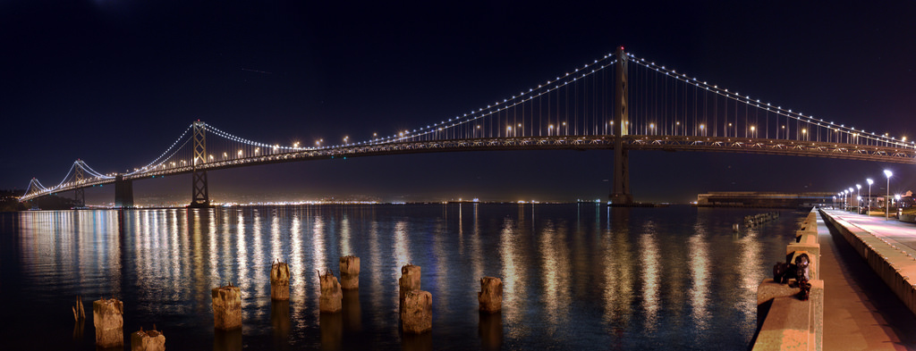
A 2015 (pre-Salesforce Tower) view from Grizzly Peak Boulevard in the Oakland Hills featuring jammed Saturday night traffic at the Bay Bridge Toll Plaza. (Dan Brekke/KQED)
o first, the serious stuff. The people who keep track of how truly rotten traffic can be in the Bay Area have come out with their annual analysis of where we spend the most time jammed up watching everyone else's tail lights.
The Metropolitan Transportation Commission's congestion study, released in late October, has an air of perennial predictability to it.
Nine of the 10 worst locations were in the top 10 last year. And the top four gnarliest stretches of freeway in 2017 were identical to the ones identified in the previous report:
Northbound U.S. 101 and eastbound Interstate 80, from Cesar Chavez Street in San Francisco to the Treasure Island Tunnel (roughly 5 miles).
Interstate 80, westbound, from Highway 4 in Hercules all the way to the Bay Bridge Toll Plaza. (15 miles).
Southbound U.S. 101 from Fair Oaks Avenue in Sunnyvale to Oakland Road in San Jose (7 miles).
Northbound Interstate 680 from Scott Creek Road in Fremont to Andrade Road outside Sunol in southern Alameda County (9 miles).
Three of those segments involve afternoon commutes. The one that doesn't -- I-80 from Hercules to the Bay Bridge -- is listed as congested continuously from 5:25 a.m. to 6:35 p.m. every weekday.
For further exploration, the MTC posted lists of both the Top 10 and Top 50 most congested freeway segments.
Sponsored
N
ow, let's step back. Yes, congestion is maddening and it's costing all of us in terms of time, money, health and environmental degradation. That's why so many of us look for alternatives to driving and support ballot measures we hope will live up to the promise of making things better.
It occurred to me that maybe it's possible to step outside our little capsules of commute misery and look at our situation from a different perspective.
Even the worst workday trip in the Bay Area contains a moment of wonder at the scene around us. The light playing on the hills and bay. The fog cascading over the hills. The crazy, rising cityscapes. The boats and ships navigating the port. Sometimes even the sweep and scale of this awful sprawl of concrete and asphalt we've laid down around us
So, with the thought that it's possible to stop occasionally and take in both the enormity of vehicular congestion and the somehow-surviving magnificence of our surroundings, here's a list of the 10 best places to see (and ponder, and wonder at) really bad traffic and the sublime scene beyond. Most can be reached by transit and/or bicycle. I'll also add at the outset that my list is very Central Bay Area-centric. I'd love to hear suggestions for cool vantage points in the South Bay and North Bay.
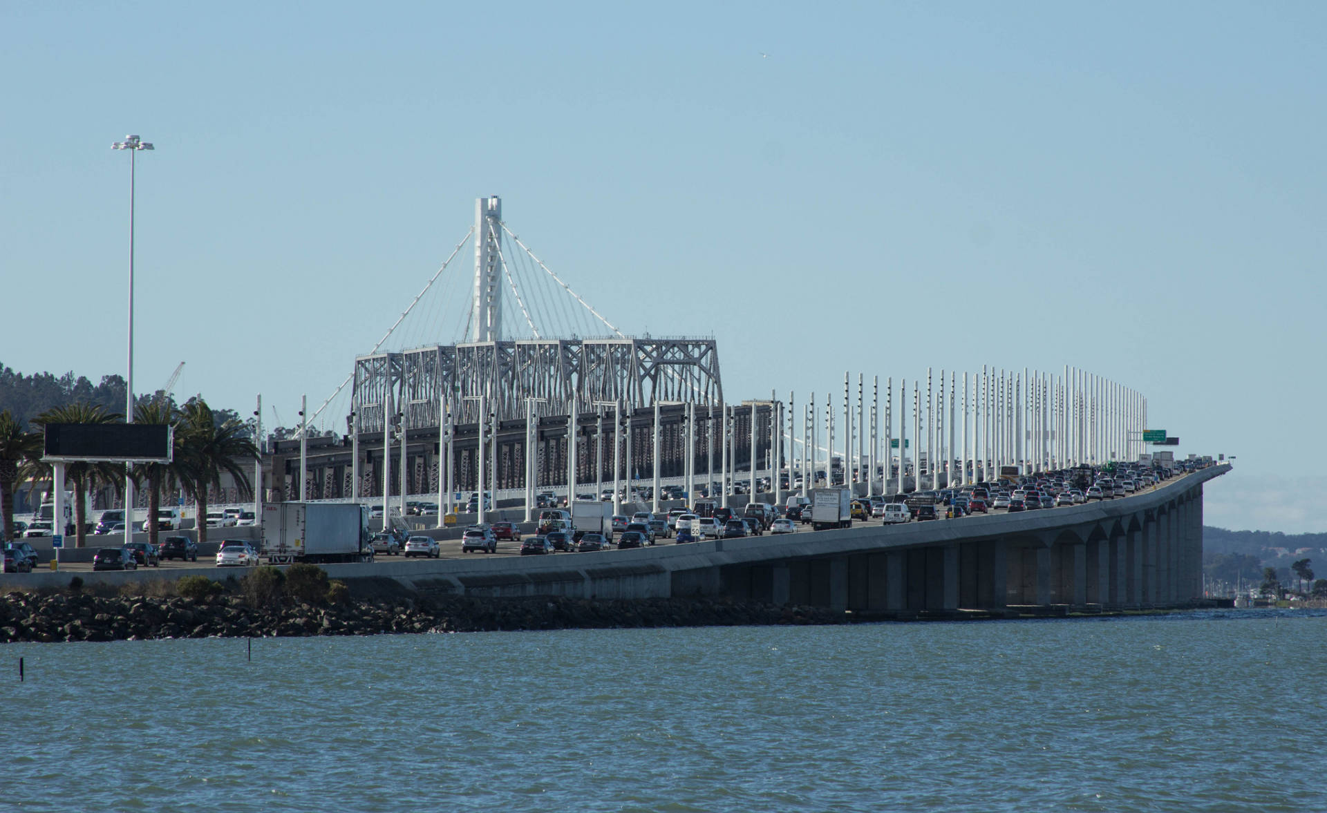
A November 2015 view of the new and old eastern spans of the Bay Bridge as seen from Oakland's Radio Beach. (Dan Brekke/KQED)
Radio Beach, Oakland: If you're crawling up to the Bay Bridge Toll Plaza from the Oakland side and glance to the right -- on your compass, that's to the north -- you'll see a grassy, marshy area containing several radio towers. Occasionally, you'll see a car parked out there, too, and wonder how the heck they got out there. That's Radio Beach, and it gives an unparalleled view of activity at the toll plaza, of the new eastern span of the Bay Bridge and of the bay to the north. Folks go out there to fish, to walk their dogs or just to explore. One caution: There's dumping in the area. How to get there: As you approach the toll plaza heading westbound, follow the signs for West Grand Avenue/Maritime Street. At the very beginning of that exit, look for a sharp right turn that will take you onto the frontage road. The road is paved but narrow. Watch out for recently dumped trash as you drive west past the toll plaza, where there are a couple of unpaved areas to park. There is no bicycle route or transit connection to Radio Beach.
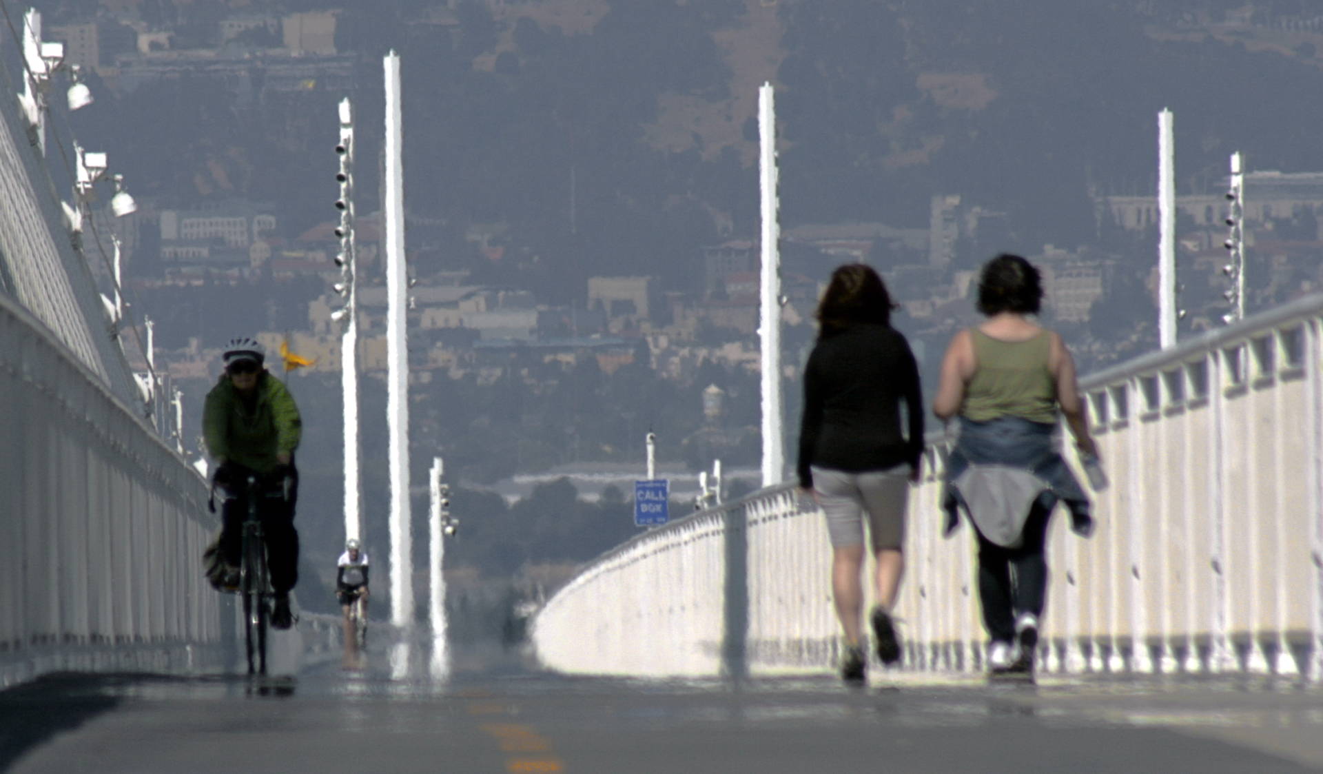
The bike-pedestrian path on the new eastern span of the Bay Bridge, pictured in May 2014. (TJ Gehling/Flickr)
Bay Bridge bike and pedestrian path, Oakland/San Francisco: The thrill here is that you can cycle or hike right alongside some of the worst traffic in the United States, all the while taking in amazing views of the Port of Oakland. The path terminates at Yerba Buena Island. For those determined to get to Treasure Island and its stunning view of the San Francisco skyline, a shuttle runs on weekends and holidays. How to get there: See 511.org for maps and directions, including information on how to reach the Bay Bridge path on transit.
U.S. 101 in San Francisco, just south of the Interstate 80 junction, from the 18th Street overcrossing. (Dan Brekke/KQED)
18th Street/Potrero Hill pedestrian overcrossing: Everything a congestion and skyline watcher could want: drama on the U.S. 101 transition to Interstate 80 and the Bay Bridge and all those reflective skyscrapers in the distance. I'm also partial to Berkeley's Interstate 80 pedestrian bridge. How to get there: The 18th Street pedestrian bridge crosses 101 between Utah Street on the west and San Bruno Avenue on the east. Several Muni bus lines -- the 9-San Bruno, 19-Polk, 22-Fillmore, 27-Bryant and 33-Ashbury/18th Street all run close by.
Albany Bulb, at left, with Interstates 80 and 580 in the lower foreground. (TJ Gehling/Flickr)
Albany Bulb: Some of the best places to take in the wonders of Bay Area traffic and nature are former bayfront garbage dumps. The Albany Bulb is one such place. Long known for its serious trash-art scene, once the long-term home for many with nowhere else to live, the bulb is slowly transitioning to a state and regional park. The east side of the property, along the lower portion of Albany's Buchanan Street, features a bluff that overlooks a mud flat often teeming with shorebirds. That spot also affords congestion connoisseurs a straight-on view of an elevated section of frequently jammed westbound Interstate 80 as it merges with often equally crowded eastbound I-580. How to get there: From eastbound I-580, take the Buchanan Street exit, then turn right at the first traffic light. From eastbound I-80, take the Buchanan Street exit. Turn left at the first light onto Buchanan, then proceed straight past a second signal; the park area will be to your right. Cyclists can reach the Albany Bulb via the Bay Trail. Transit connection is AC Transit's 80 bus to Buchanan and Pierce streets.
The Bay Bridge as seen from San Francisco's Embarcadero. (Joe Parks/Flickr)
The Embarcadero, San Francisco: Maybe this is cheating a little, but what fantastic views of the bay (nature) and Bay Bridge (traffic). To take in the nature piece, stroll the entire Embarcadero from AT&T Park north. For the traffic piece, the stretch from Harrison Street to Bryant Street affords an up-close view of the bridge, with the added auditory experience of eastbound traffic pounding along the lower deck. How to get there: You'd be a fool to drive. The Embarcadero is well served by BART, Muni and ferries from the North Bay and East Bay.
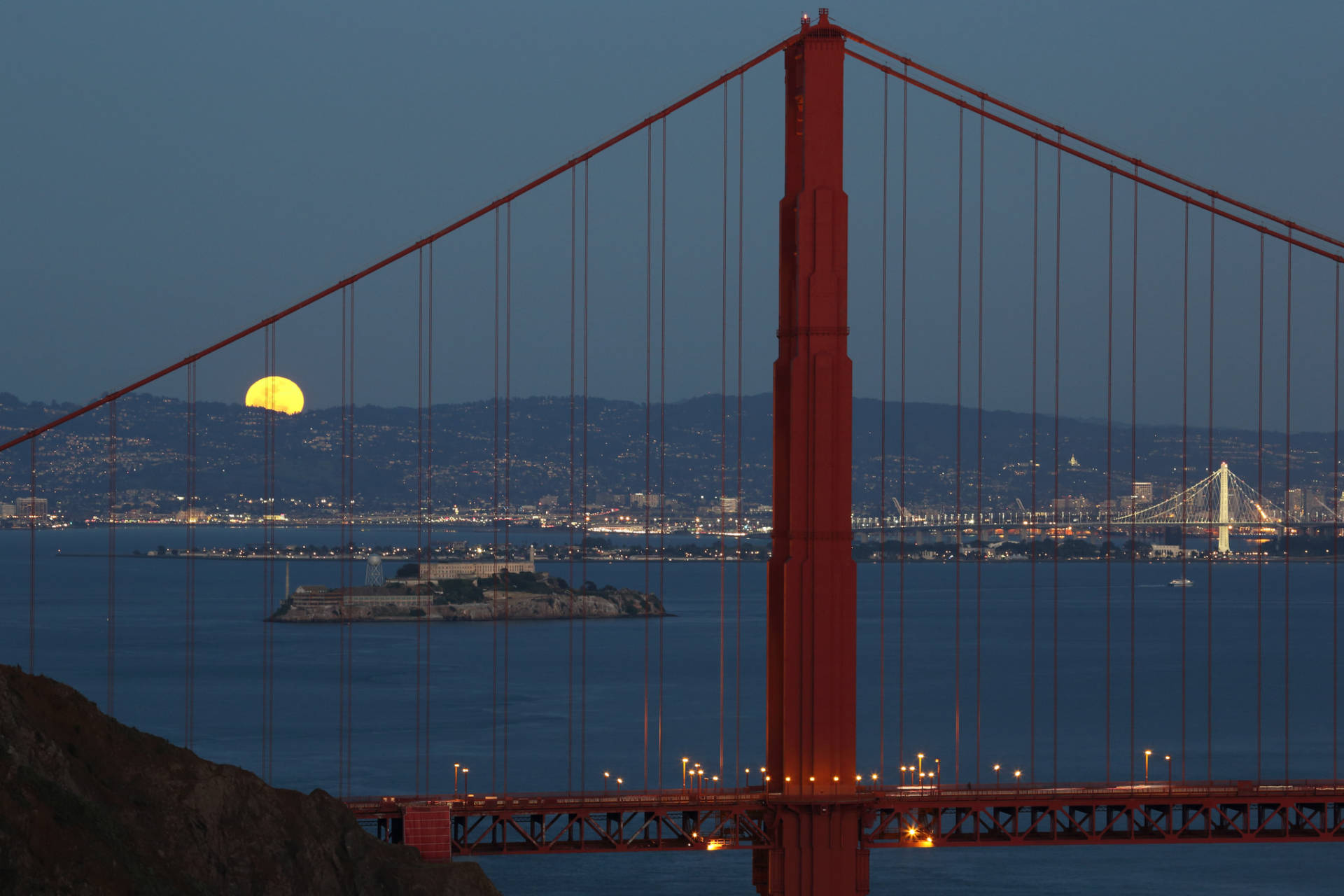
The moon rises over the East Bay hills -- as seen from the Marin Headlands through the cables of the Golden Gate Bridge. (Don McCullough/Flickr)
Marin Headlands: The Golden Gate Bridge is not rated as one of the region's 50 worst traffic congestion sites. But it's a symbol of the entire region, and it's plenty busy. Perhaps the most iconic views of this most iconic of bridges are from the heights along Conzelman Road, in the Marin Headlands at the northern end of the span. How to get there: The headlands are accessible by car, bike and, on weekends, transit. By car, both northbound and southbound traffic exit U.S. 101 on Alexander Avenue. Signs at the end of the ramps point the way to the headlands. Cyclists can cross the Golden Gate Bridge to access Conzelman Road, which is a steep, winding, strenuous route. Muni's 76X Marin Headlands Express, one of the Bay Area's true transit treasures, runs to and from the Financial District on weekends and holidays.
The high-rise section of the San Mateo Bridge as seen from Hayward Regional Shoreline. (caligula1995/Flickr)
Hayward Regional Shoreline: Highway 92 west from Interstate 880 to the San Mateo-Hayward Bridge Toll Plaza is rated the 32nd most congested stretch of freeway in the Bay Area. The Hayward Regional Shoreline -- featuring miles of trails through wetlands that were long ago diked and turned into salt collection ponds -- is on the north side of the freeway. The area is full of shorebirds, marshy vistas and the sound of traffic. How to get there: There are two main access points. See the Hayward Shoreline Interpretive Center site for directions from Highway 92. The East Bay Regional Park's site for the shoreline includes maps and directions for entering the park from West Winton Avenue. AC Transit's 86 bus, which runs between BART's Hayward and South Hayward stations, has a stop at West Winton and Cabot avenues, about three-quarters of a mile from the northern entrance to the park.
The Richmond-San Rafael Bridge from the Contra Costa shoreline, with Mount Tamalpais in the background. (Dan Brekke/KQED)
Point Molate: The westbound Interstate 580 approach to the Richmond-San Rafael Bridge ranks as the 35th most congested spot in the Bay Area. If you want to depart the jam and contemplate it from afar, Point Molate is for you. The property, accessed across Chevron refinery property, was once the site of a huge wine shipping center and Navy installation and now hosts a Richmond city park and a hunting and fishing club. And yes -- there are great views of the undulating form of the Richmond-San Rafael Bridge, passing ferries and oil tankers, and Mount Tamalpais. How to get there: The only road access is the Stenmark Drive exit off Interstate 580, just before you get to the toll plaza. Follow the signs for Point Molate. There's access for cyclists, too -- if they're patient. Caltrans is building a new protected bike path from Point Richmond. While it's under construction, the agency is running a bicycle shuttle to Point Molate from 7 a.m. to 7 p.m., seven days a week. Details here.
A Valentine's Day 2015 (pre-Salesforce Tower) view from Grizzly Peak Boulevard in the Oakland Hills featuring jammed Saturday night traffic at the Bay Bridge toll plaza and Highway 24 traffic near the Caldecott Tunnel. (Dan Brekke/KQED)
Grizzly Peak Boulevard, Oakland Hills: This is a little out of the way, and it's strictly a bike-to or drive-to site, but it's an old favorite. Many spots on Grizzly Peak Boulevard open onto an amazing vista of flatlands, bay, and the city and mountains beyond. But there are a few select locations between Claremont Avenue and Skyline Boulevard where you can pull over and see not only the torrent of traffic heading to or coming from the Bay Bridge, but also cars approaching or exiting the Caldecott Tunnel on Highway 24 (afternoon commute traffic on this segment of 24 is rated as the ninth most congested spot in the Bay Area). How to get there: The easiest driving access to this section of Grizzly Peak is up Claremont Avenue past the Claremont Hotel. Turn right at Grizzly Peak, and look for places where it's safe to pull completely off the pavement. On bicycle, the best routes to Grizzly Peak are up Spruce Street in Berkeley or Tunnel Road and Skyline Boulevard in Oakland.
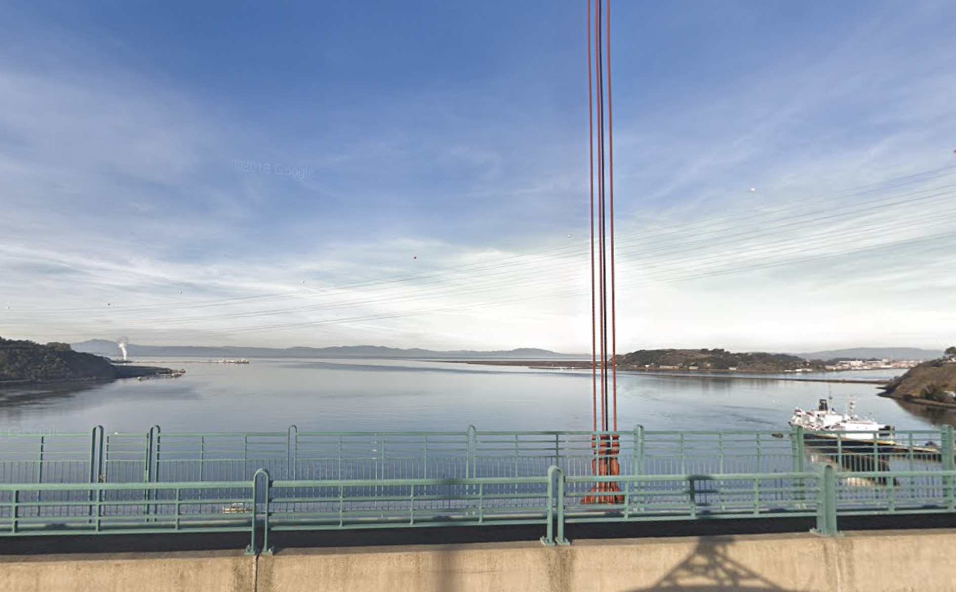
The view of San Pablo Bay from the Alfred Zampa Memorial Bridge, on Interstate 80 between Vallejo and Crockett. (Google Streetview)
Al Zampa Memorial Bridge bike/pedestrian path: Interstate 80 north of Highway 4 in Contra Costa County is not one of the 50 worst congestion spots. But the north end of that stretch, at the Carquinez Strait between Crockett and Vallejo, is a great spot for watching traffic and adjacent waterscapes. The Alfred Zampa Memorial Bridge, the southbound suspension span across the strait, includes a bike and pedestrian path from which you can watch cars pass or, more interestingly, the hill- and mountain-rimmed expanse of San Pablo Bay. How to get there: On eastbound/northbound Interstate 80, take the Crockett/Pomona Street exit at the south end of the bridge. At the end of the ramp -- San Pablo Avenue -- turn right, where you'll immediately see parking on the right. On westbound/southbound I-80, take the Crockett/Pomona Street exit and follow the directions as above. Cyclists can access the path via San Pablo Avenue on the Crockett side or Maritime Academy Drive on the Vallejo side.
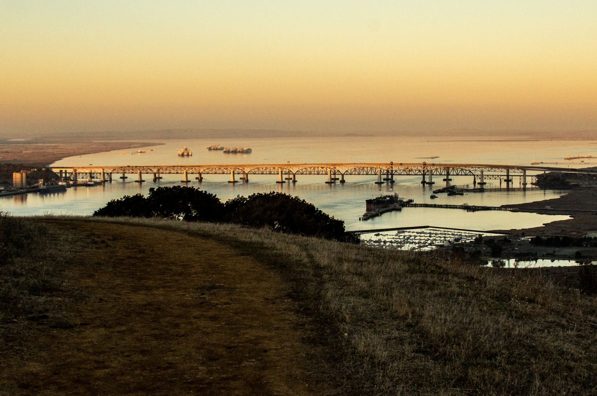
The Benicia Bridge and Suisun Bay, viewed from Franklin Ridge in Carquinez Strait Regional Shoreline. (Dan Brekke/KQED)
Sponsored
Carquinez Strait Regional Shoreline: Another drive-to or cycle-to spot. A steep creekside climb in the eastern unit of this park, just outside Martinez, takes you to a ridgetop with a 360-degree view that includes Mount Diablo, Carquinez Strait, Suisun Bay, the North Bay mountains, three nearby oil refineries and the Benicia-Martinez Bridge. How to get there: See the East Bay Regional Park's site, Carquinez Strait Regional Shoreline, for directions and maps.
lower waypoint
Stay in touch. Sign up for our daily newsletter.
To learn more about how we use your information, please read our privacy policy.
window.__IS_SSR__=true
window.__INITIAL_STATE__={"attachmentsReducer":{"audio_0":{"type":"attachments","id":"audio_0","imgSizes":{"kqedFullSize":{"file":"https://ww2.kqed.org/news/wp-content/themes/KQED-unified/img/audio_bgs/background0.jpg"}}},"audio_1":{"type":"attachments","id":"audio_1","imgSizes":{"kqedFullSize":{"file":"https://ww2.kqed.org/news/wp-content/themes/KQED-unified/img/audio_bgs/background1.jpg"}}},"audio_2":{"type":"attachments","id":"audio_2","imgSizes":{"kqedFullSize":{"file":"https://ww2.kqed.org/news/wp-content/themes/KQED-unified/img/audio_bgs/background2.jpg"}}},"audio_3":{"type":"attachments","id":"audio_3","imgSizes":{"kqedFullSize":{"file":"https://ww2.kqed.org/news/wp-content/themes/KQED-unified/img/audio_bgs/background3.jpg"}}},"audio_4":{"type":"attachments","id":"audio_4","imgSizes":{"kqedFullSize":{"file":"https://ww2.kqed.org/news/wp-content/themes/KQED-unified/img/audio_bgs/background4.jpg"}}},"placeholder":{"type":"attachments","id":"placeholder","imgSizes":{"thumbnail":{"file":"https://ww2.kqed.org/wp-content/uploads/sites/10/2018/01/GettyImages-896326950-160x96.jpg","width":160,"height":96,"mimeType":"image/jpeg"},"medium":{"file":"https://ww2.kqed.org/wp-content/uploads/sites/10/2018/01/GettyImages-896326950-800x478.jpg","width":800,"height":478,"mimeType":"image/jpeg"},"large":{"file":"https://ww2.kqed.org/wp-content/uploads/sites/10/2018/01/GettyImages-896326950-1020x610.jpg","width":1020,"height":610,"mimeType":"image/jpeg"},"fd-lrg":{"file":"https://ww2.kqed.org/wp-content/uploads/sites/10/2018/01/GettyImages-896326950-1920x1148.jpg","width":1920,"height":1148,"mimeType":"image/jpeg"},"fd-med":{"file":"https://ww2.kqed.org/wp-content/uploads/sites/10/2018/01/GettyImages-896326950-1180x705.jpg","width":1180,"height":705,"mimeType":"image/jpeg"},"fd-sm":{"file":"https://ww2.kqed.org/wp-content/uploads/sites/10/2018/01/GettyImages-896326950-960x574.jpg","width":960,"height":574,"mimeType":"image/jpeg"},"post-thumbnail":{"file":"https://ww2.kqed.org/wp-content/uploads/sites/10/2018/01/GettyImages-896326950-672x372.jpg","width":672,"height":372,"mimeType":"image/jpeg"},"twentyfourteen-full-width":{"file":"https://ww2.kqed.org/wp-content/uploads/sites/10/2018/01/GettyImages-896326950-1038x576.jpg","width":1038,"height":576,"mimeType":"image/jpeg"},"xxsmall":{"file":"https://ww2.kqed.org/wp-content/uploads/sites/10/2018/01/GettyImages-896326950-240x143.jpg","width":240,"height":143,"mimeType":"image/jpeg"},"xsmall":{"file":"https://ww2.kqed.org/wp-content/uploads/sites/10/2018/01/GettyImages-896326950-375x224.jpg","width":375,"height":224,"mimeType":"image/jpeg"},"small":{"file":"https://ww2.kqed.org/wp-content/uploads/sites/10/2018/01/GettyImages-896326950-520x311.jpg","width":520,"height":311,"mimeType":"image/jpeg"},"xlarge":{"file":"https://ww2.kqed.org/wp-content/uploads/sites/10/2018/01/GettyImages-896326950-1180x705.jpg","width":1180,"height":705,"mimeType":"image/jpeg"},"full-width":{"file":"https://ww2.kqed.org/wp-content/uploads/sites/10/2018/01/GettyImages-896326950-1920x1148.jpg","width":1920,"height":1148,"mimeType":"image/jpeg"},"guest-author-32":{"file":"https://ww2.kqed.org/wp-content/uploads/sites/10/2018/01/GettyImages-896326950-32x32.jpg","width":32,"height":32,"mimeType":"image/jpeg"},"guest-author-50":{"file":"https://ww2.kqed.org/wp-content/uploads/sites/10/2018/01/GettyImages-896326950-50x50.jpg","width":50,"height":50,"mimeType":"image/jpeg"},"guest-author-64":{"file":"https://ww2.kqed.org/wp-content/uploads/sites/10/2018/01/GettyImages-896326950-64x64.jpg","width":64,"height":64,"mimeType":"image/jpeg"},"guest-author-96":{"file":"https://ww2.kqed.org/wp-content/uploads/sites/10/2018/01/GettyImages-896326950-96x96.jpg","width":96,"height":96,"mimeType":"image/jpeg"},"guest-author-128":{"file":"https://ww2.kqed.org/wp-content/uploads/sites/10/2018/01/GettyImages-896326950-128x128.jpg","width":128,"height":128,"mimeType":"image/jpeg"},"detail":{"file":"https://ww2.kqed.org/wp-content/uploads/sites/10/2018/01/GettyImages-896326950-150x150.jpg","width":150,"height":150,"mimeType":"image/jpeg"},"kqedFullSize":{"file":"https://ww2.kqed.org/wp-content/uploads/sites/10/2018/01/GettyImages-896326950-e1514998105161.jpg","width":1920,"height":1148}}},"news_10816492":{"type":"attachments","id":"news_10816492","meta":{"index":"attachments_1591205162","site":"news","id":"10816492","found":true},"title":"14289_transform","publishDate":1451601199,"status":"inherit","parent":10809415,"modified":1714680162,"caption":"Residents of the 14-room Mission District house made an eviction-proof deal.","credit":"Jeremy Raff/KQED","altTag":"A woman holding the hands of two small children walks down the street past a large home.","description":null,"imgSizes":{"thumbnail":{"file":"https://cdn.kqed.org/wp-content/uploads/sites/10/2015/12/14289_transform-400x267.jpg","width":400,"height":267,"mimeType":"image/jpeg"},"medium":{"file":"https://cdn.kqed.org/wp-content/uploads/sites/10/2015/12/14289_transform-800x533.jpg","width":800,"height":533,"mimeType":"image/jpeg"},"medium_large":{"file":"https://cdn.kqed.org/wp-content/uploads/sites/10/2015/12/14289_transform-768x512.jpg","width":768,"height":512,"mimeType":"image/jpeg"},"large":{"file":"https://cdn.kqed.org/wp-content/uploads/sites/10/2015/12/14289_transform-1440x960.jpg","width":1440,"height":960,"mimeType":"image/jpeg"},"fd-lrg":{"file":"https://cdn.kqed.org/wp-content/uploads/sites/10/2015/12/14289_transform-1920x1280.jpg","width":1920,"height":1280,"mimeType":"image/jpeg"},"fd-med":{"file":"https://cdn.kqed.org/wp-content/uploads/sites/10/2015/12/14289_transform-1180x787.jpg","width":1180,"height":787,"mimeType":"image/jpeg"},"fd-sm":{"file":"https://cdn.kqed.org/wp-content/uploads/sites/10/2015/12/14289_transform-960x640.jpg","width":960,"height":640,"mimeType":"image/jpeg"},"post-thumbnail":{"file":"https://cdn.kqed.org/wp-content/uploads/sites/10/2015/12/14289_transform-672x372.jpg","width":672,"height":372,"mimeType":"image/jpeg"},"twentyfourteen-full-width":{"file":"https://cdn.kqed.org/wp-content/uploads/sites/10/2015/12/14289_transform-1038x576.jpg","width":1038,"height":576,"mimeType":"image/jpeg"},"guest-author-32":{"file":"https://cdn.kqed.org/wp-content/uploads/sites/10/2015/12/14289_transform-32x32.jpg","width":32,"height":32,"mimeType":"image/jpeg"},"guest-author-64":{"file":"https://cdn.kqed.org/wp-content/uploads/sites/10/2015/12/14289_transform-64x64.jpg","width":64,"height":64,"mimeType":"image/jpeg"},"guest-author-96":{"file":"https://cdn.kqed.org/wp-content/uploads/sites/10/2015/12/14289_transform-96x96.jpg","width":96,"height":96,"mimeType":"image/jpeg"},"guest-author-128":{"file":"https://cdn.kqed.org/wp-content/uploads/sites/10/2015/12/14289_transform-128x128.jpg","width":128,"height":128,"mimeType":"image/jpeg"},"detail":{"file":"https://cdn.kqed.org/wp-content/uploads/sites/10/2015/12/14289_transform-75x75.jpg","width":75,"height":75,"mimeType":"image/jpeg"},"jmtc-small-thumb":{"file":"https://cdn.kqed.org/wp-content/uploads/sites/10/2015/12/14289_transform-280x150.jpg","width":280,"height":150,"mimeType":"image/jpeg"},"kqedFullSize":{"file":"https://cdn.kqed.org/wp-content/uploads/sites/10/2015/12/14289_transform.jpg","width":1920,"height":1280}},"fetchFailed":false,"isLoading":false},"forum_2010101905611":{"type":"attachments","id":"forum_2010101905611","meta":{"index":"attachments_1591205162","site":"forum","id":"2010101905611","found":true},"title":"bill","publishDate":1714687942,"status":"inherit","parent":2010101905607,"modified":1714687964,"caption":"A close up of a person calculating bills.","credit":"Krisanapong Detraphiphat/Getty Images","altTag":null,"description":null,"imgSizes":{"medium":{"file":"https://cdn.kqed.org/wp-content/uploads/sites/43/2024/05/bill-1-800x480.png","width":800,"height":480,"mimeType":"image/png"},"large":{"file":"https://cdn.kqed.org/wp-content/uploads/sites/43/2024/05/bill-1-1020x613.png","width":1020,"height":613,"mimeType":"image/png"},"thumbnail":{"file":"https://cdn.kqed.org/wp-content/uploads/sites/43/2024/05/bill-1-160x96.png","width":160,"height":96,"mimeType":"image/png"},"medium_large":{"file":"https://cdn.kqed.org/wp-content/uploads/sites/43/2024/05/bill-1-768x461.png","width":768,"height":461,"mimeType":"image/png"},"1536x1536":{"file":"https://cdn.kqed.org/wp-content/uploads/sites/43/2024/05/bill-1-1536x922.png","width":1536,"height":922,"mimeType":"image/png"},"post-thumbnail":{"file":"https://cdn.kqed.org/wp-content/uploads/sites/43/2024/05/bill-1-672x372.png","width":672,"height":372,"mimeType":"image/png"},"twentyfourteen-full-width":{"file":"https://cdn.kqed.org/wp-content/uploads/sites/43/2024/05/bill-1-1038x576.png","width":1038,"height":576,"mimeType":"image/png"},"kqedFullSize":{"file":"https://cdn.kqed.org/wp-content/uploads/sites/43/2024/05/bill-1.png","width":1920,"height":1153}},"fetchFailed":false,"isLoading":false},"forum_2010101905620":{"type":"attachments","id":"forum_2010101905620","meta":{"index":"attachments_1591205162","site":"forum","id":"2010101905620","found":true},"title":"tik","publishDate":1714761815,"status":"inherit","parent":2010101905617,"modified":1714761853,"caption":"The TikTok app is seen on an iPhone.","credit":"Jaap Arriens/NurPhoto via Getty Images","altTag":null,"description":null,"imgSizes":{"medium":{"file":"https://cdn.kqed.org/wp-content/uploads/sites/43/2024/05/tik-800x450.png","width":800,"height":450,"mimeType":"image/png"},"large":{"file":"https://cdn.kqed.org/wp-content/uploads/sites/43/2024/05/tik-1020x574.png","width":1020,"height":574,"mimeType":"image/png"},"thumbnail":{"file":"https://cdn.kqed.org/wp-content/uploads/sites/43/2024/05/tik-160x90.png","width":160,"height":90,"mimeType":"image/png"},"medium_large":{"file":"https://cdn.kqed.org/wp-content/uploads/sites/43/2024/05/tik-768x432.png","width":768,"height":432,"mimeType":"image/png"},"1536x1536":{"file":"https://cdn.kqed.org/wp-content/uploads/sites/43/2024/05/tik-1536x864.png","width":1536,"height":864,"mimeType":"image/png"},"post-thumbnail":{"file":"https://cdn.kqed.org/wp-content/uploads/sites/43/2024/05/tik-672x372.png","width":672,"height":372,"mimeType":"image/png"},"twentyfourteen-full-width":{"file":"https://cdn.kqed.org/wp-content/uploads/sites/43/2024/05/tik-1038x576.png","width":1038,"height":576,"mimeType":"image/png"},"kqedFullSize":{"file":"https://cdn.kqed.org/wp-content/uploads/sites/43/2024/05/tik.png","width":1920,"height":1080}},"fetchFailed":false,"isLoading":false},"news_11984867":{"type":"attachments","id":"news_11984867","meta":{"index":"attachments_1591205162","site":"news","id":"11984867","found":true},"title":"240429-SFSU GAZA RALLY-MD-16_qut","publishDate":1714686263,"status":"inherit","parent":11984845,"modified":1714686445,"caption":"San Francisco State University students rally outside the Cesar Chavez Student Center on April 30, 2024, calling on the university to disclose its financial ties to Israel.","credit":"Martin do Nascimento/KQED","altTag":"A group of young protesters holding a sign that says 'Divest.'","description":null,"imgSizes":{"medium":{"file":"https://cdn.kqed.org/wp-content/uploads/sites/10/2024/05/240429-SFSU-GAZA-RALLY-MD-16_qut-800x533.jpg","width":800,"height":533,"mimeType":"image/jpeg"},"large":{"file":"https://cdn.kqed.org/wp-content/uploads/sites/10/2024/05/240429-SFSU-GAZA-RALLY-MD-16_qut-1020x680.jpg","width":1020,"height":680,"mimeType":"image/jpeg"},"thumbnail":{"file":"https://cdn.kqed.org/wp-content/uploads/sites/10/2024/05/240429-SFSU-GAZA-RALLY-MD-16_qut-160x107.jpg","width":160,"height":107,"mimeType":"image/jpeg"},"1536x1536":{"file":"https://cdn.kqed.org/wp-content/uploads/sites/10/2024/05/240429-SFSU-GAZA-RALLY-MD-16_qut-1536x1024.jpg","width":1536,"height":1024,"mimeType":"image/jpeg"},"post-thumbnail":{"file":"https://cdn.kqed.org/wp-content/uploads/sites/10/2024/05/240429-SFSU-GAZA-RALLY-MD-16_qut-672x372.jpg","width":672,"height":372,"mimeType":"image/jpeg"},"twentyfourteen-full-width":{"file":"https://cdn.kqed.org/wp-content/uploads/sites/10/2024/05/240429-SFSU-GAZA-RALLY-MD-16_qut-1038x576.jpg","width":1038,"height":576,"mimeType":"image/jpeg"},"kqedFullSize":{"file":"https://cdn.kqed.org/wp-content/uploads/sites/10/2024/05/240429-SFSU-GAZA-RALLY-MD-16_qut.jpg","width":1920,"height":1280}},"fetchFailed":false,"isLoading":false},"forum_2010101905630":{"type":"attachments","id":"forum_2010101905630","meta":{"index":"attachments_1591205162","site":"forum","id":"2010101905630","found":true},"title":"gaza (1)","publishDate":1714775765,"status":"inherit","parent":2010101905623,"modified":1714775810,"caption":"People walk past destroyed buildings in Khan Yunis in the southern Gaza Strip on April 22, 2024 amid the ongoing conflict in the Palestinian territory between Israel and the militant group Hamas.","credit":"AFP via Getty Images","altTag":null,"description":null,"imgSizes":{"medium":{"file":"https://cdn.kqed.org/wp-content/uploads/sites/43/2024/05/gaza-1-800x450.png","width":800,"height":450,"mimeType":"image/png"},"large":{"file":"https://cdn.kqed.org/wp-content/uploads/sites/43/2024/05/gaza-1-1020x574.png","width":1020,"height":574,"mimeType":"image/png"},"thumbnail":{"file":"https://cdn.kqed.org/wp-content/uploads/sites/43/2024/05/gaza-1-160x90.png","width":160,"height":90,"mimeType":"image/png"},"medium_large":{"file":"https://cdn.kqed.org/wp-content/uploads/sites/43/2024/05/gaza-1-768x432.png","width":768,"height":432,"mimeType":"image/png"},"1536x1536":{"file":"https://cdn.kqed.org/wp-content/uploads/sites/43/2024/05/gaza-1-1536x864.png","width":1536,"height":864,"mimeType":"image/png"},"post-thumbnail":{"file":"https://cdn.kqed.org/wp-content/uploads/sites/43/2024/05/gaza-1-672x372.png","width":672,"height":372,"mimeType":"image/png"},"twentyfourteen-full-width":{"file":"https://cdn.kqed.org/wp-content/uploads/sites/43/2024/05/gaza-1-1038x576.png","width":1038,"height":576,"mimeType":"image/png"},"kqedFullSize":{"file":"https://cdn.kqed.org/wp-content/uploads/sites/43/2024/05/gaza-1.png","width":1920,"height":1080}},"fetchFailed":false,"isLoading":false},"news_11783907":{"type":"attachments","id":"news_11783907","meta":{"index":"attachments_1591205162","site":"news","id":"11783907","found":true},"title":"RS39774_Carly_MEgan_02","publishDate":1572472843,"status":"inherit","parent":11782405,"modified":1572473087,"caption":"Many dangers lurk underground in San Francisco. ","credit":"Sruti Mamidanna/KQED","description":"Many dangers lurk underground in San Francisco. ","imgSizes":{"thumbnail":{"file":"https://ww2.kqed.org/app/uploads/sites/10/2019/10/RS39774_Carly_MEgan_02-160x90.jpg","width":160,"height":90,"mimeType":"image/jpeg"},"medium":{"file":"https://ww2.kqed.org/app/uploads/sites/10/2019/10/RS39774_Carly_MEgan_02-800x450.jpg","width":800,"height":450,"mimeType":"image/jpeg"},"large":{"file":"https://ww2.kqed.org/app/uploads/sites/10/2019/10/RS39774_Carly_MEgan_02-1020x574.jpg","width":1020,"height":574,"mimeType":"image/jpeg"},"complete_open_graph":{"file":"https://ww2.kqed.org/app/uploads/sites/10/2019/10/RS39774_Carly_MEgan_02-1200x675.jpg","width":1200,"height":675,"mimeType":"image/jpeg"},"post-thumbnail":{"file":"https://ww2.kqed.org/app/uploads/sites/10/2019/10/RS39774_Carly_MEgan_02-672x372.jpg","width":672,"height":372,"mimeType":"image/jpeg"},"twentyfourteen-full-width":{"file":"https://ww2.kqed.org/app/uploads/sites/10/2019/10/RS39774_Carly_MEgan_02-1038x576.jpg","width":1038,"height":576,"mimeType":"image/jpeg"},"apple_news_ca_landscape_9_7":{"file":"https://ww2.kqed.org/app/uploads/sites/10/2019/10/RS39774_Carly_MEgan_02-1376x1027.jpg","width":1376,"height":1027,"mimeType":"image/jpeg"},"apple_news_ca_landscape_5_5":{"file":"https://ww2.kqed.org/app/uploads/sites/10/2019/10/RS39774_Carly_MEgan_02-1044x783.jpg","width":1044,"height":783,"mimeType":"image/jpeg"},"apple_news_ca_landscape_4_7":{"file":"https://ww2.kqed.org/app/uploads/sites/10/2019/10/RS39774_Carly_MEgan_02-632x474.jpg","width":632,"height":474,"mimeType":"image/jpeg"},"apple_news_ca_landscape_4_0":{"file":"https://ww2.kqed.org/app/uploads/sites/10/2019/10/RS39774_Carly_MEgan_02-536x402.jpg","width":536,"height":402,"mimeType":"image/jpeg"},"apple_news_ca_portrait_12_9":{"file":"https://ww2.kqed.org/app/uploads/sites/10/2019/10/RS39774_Carly_MEgan_02-1122x1027.jpg","width":1122,"height":1027,"mimeType":"image/jpeg"},"apple_news_ca_portrait_9_7":{"file":"https://ww2.kqed.org/app/uploads/sites/10/2019/10/RS39774_Carly_MEgan_02-840x1027.jpg","width":840,"height":1027,"mimeType":"image/jpeg"},"apple_news_ca_portrait_5_5":{"file":"https://ww2.kqed.org/app/uploads/sites/10/2019/10/RS39774_Carly_MEgan_02-687x916.jpg","width":687,"height":916,"mimeType":"image/jpeg"},"apple_news_ca_portrait_4_7":{"file":"https://ww2.kqed.org/app/uploads/sites/10/2019/10/RS39774_Carly_MEgan_02-414x552.jpg","width":414,"height":552,"mimeType":"image/jpeg"},"apple_news_ca_portrait_4_0":{"file":"https://ww2.kqed.org/app/uploads/sites/10/2019/10/RS39774_Carly_MEgan_02-354x472.jpg","width":354,"height":472,"mimeType":"image/jpeg"},"apple_news_ca_square_12_9":{"file":"https://ww2.kqed.org/app/uploads/sites/10/2019/10/RS39774_Carly_MEgan_02-1472x1027.jpg","width":1472,"height":1027,"mimeType":"image/jpeg"},"apple_news_ca_square_9_7":{"file":"https://ww2.kqed.org/app/uploads/sites/10/2019/10/RS39774_Carly_MEgan_02-1104x1027.jpg","width":1104,"height":1027,"mimeType":"image/jpeg"},"apple_news_ca_square_5_5":{"file":"https://ww2.kqed.org/app/uploads/sites/10/2019/10/RS39774_Carly_MEgan_02-912x912.jpg","width":912,"height":912,"mimeType":"image/jpeg"},"apple_news_ca_square_4_7":{"file":"https://ww2.kqed.org/app/uploads/sites/10/2019/10/RS39774_Carly_MEgan_02-550x550.jpg","width":550,"height":550,"mimeType":"image/jpeg"},"apple_news_ca_square_4_0":{"file":"https://ww2.kqed.org/app/uploads/sites/10/2019/10/RS39774_Carly_MEgan_02-470x470.jpg","width":470,"height":470,"mimeType":"image/jpeg"},"kqedFullSize":{"file":"https://ww2.kqed.org/app/uploads/sites/10/2019/10/RS39774_Carly_MEgan_02.jpg","width":1825,"height":1027}},"fetchFailed":false,"isLoading":false},"news_11984510":{"type":"attachments","id":"news_11984510","meta":{"index":"attachments_1591205162","site":"news","id":"11984510","found":true},"title":"240425-STANFORDGAZAPROTEST-011-BL-KQED","publishDate":1714504701,"status":"inherit","parent":11984645,"modified":1714593712,"caption":"Pro-Palestinian demonstrators march through the Stanford University campus in Palo Alto on April 25, calling for the university to divest from Israel.","credit":"Beth LaBerge/KQED","altTag":null,"description":null,"imgSizes":{"medium":{"file":"https://cdn.kqed.org/wp-content/uploads/sites/10/2024/04/240425-STANFORDGAZAPROTEST-011-BL-KQED-800x533.jpg","width":800,"height":533,"mimeType":"image/jpeg"},"large":{"file":"https://cdn.kqed.org/wp-content/uploads/sites/10/2024/04/240425-STANFORDGAZAPROTEST-011-BL-KQED-1020x680.jpg","width":1020,"height":680,"mimeType":"image/jpeg"},"thumbnail":{"file":"https://cdn.kqed.org/wp-content/uploads/sites/10/2024/04/240425-STANFORDGAZAPROTEST-011-BL-KQED-160x107.jpg","width":160,"height":107,"mimeType":"image/jpeg"},"1536x1536":{"file":"https://cdn.kqed.org/wp-content/uploads/sites/10/2024/04/240425-STANFORDGAZAPROTEST-011-BL-KQED-1536x1024.jpg","width":1536,"height":1024,"mimeType":"image/jpeg"},"post-thumbnail":{"file":"https://cdn.kqed.org/wp-content/uploads/sites/10/2024/04/240425-STANFORDGAZAPROTEST-011-BL-KQED-672x372.jpg","width":672,"height":372,"mimeType":"image/jpeg"},"twentyfourteen-full-width":{"file":"https://cdn.kqed.org/wp-content/uploads/sites/10/2024/04/240425-STANFORDGAZAPROTEST-011-BL-KQED-1038x576.jpg","width":1038,"height":576,"mimeType":"image/jpeg"},"full-width":{"file":"https://cdn.kqed.org/wp-content/uploads/sites/10/2024/04/240425-STANFORDGAZAPROTEST-011-BL-KQED-1920x1280.jpg","width":1920,"height":1280,"mimeType":"image/jpeg"},"kqedFullSize":{"file":"https://cdn.kqed.org/wp-content/uploads/sites/10/2024/04/240425-STANFORDGAZAPROTEST-011-BL-KQED.jpg","width":2000,"height":1333}},"fetchFailed":false,"isLoading":false},"news_11984781":{"type":"attachments","id":"news_11984781","meta":{"index":"attachments_1591205162","site":"news","id":"11984781","found":true},"title":"APTOPIX Israel Palestinians Campus Protests","publishDate":1714671020,"status":"inherit","parent":11984762,"modified":1714675849,"caption":"Police advance on pro-Palestinian demonstrators in an encampment on the UCLA campus on Thursday, May 2, 2024, in Los Angeles. ","credit":"Jae C. Hong/The Associated Press","altTag":"Multiple police knock over a barricade and point their weapons.","description":null,"imgSizes":{"medium":{"file":"https://cdn.kqed.org/wp-content/uploads/sites/10/2024/05/AP24123441309819-800x533.jpg","width":800,"height":533,"mimeType":"image/jpeg"},"large":{"file":"https://cdn.kqed.org/wp-content/uploads/sites/10/2024/05/AP24123441309819-1020x680.jpg","width":1020,"height":680,"mimeType":"image/jpeg"},"thumbnail":{"file":"https://cdn.kqed.org/wp-content/uploads/sites/10/2024/05/AP24123441309819-160x107.jpg","width":160,"height":107,"mimeType":"image/jpeg"},"1536x1536":{"file":"https://cdn.kqed.org/wp-content/uploads/sites/10/2024/05/AP24123441309819-1536x1024.jpg","width":1536,"height":1024,"mimeType":"image/jpeg"},"2048x2048":{"file":"https://cdn.kqed.org/wp-content/uploads/sites/10/2024/05/AP24123441309819-2048x1365.jpg","width":2048,"height":1365,"mimeType":"image/jpeg"},"post-thumbnail":{"file":"https://cdn.kqed.org/wp-content/uploads/sites/10/2024/05/AP24123441309819-672x372.jpg","width":672,"height":372,"mimeType":"image/jpeg"},"twentyfourteen-full-width":{"file":"https://cdn.kqed.org/wp-content/uploads/sites/10/2024/05/AP24123441309819-1038x576.jpg","width":1038,"height":576,"mimeType":"image/jpeg"},"full-width":{"file":"https://cdn.kqed.org/wp-content/uploads/sites/10/2024/05/AP24123441309819-1920x1280.jpg","width":1920,"height":1280,"mimeType":"image/jpeg"},"kqedFullSize":{"file":"https://cdn.kqed.org/wp-content/uploads/sites/10/2024/05/AP24123441309819-scaled.jpg","width":2560,"height":1707}},"fetchFailed":false,"isLoading":false},"forum_2010101905605":{"type":"attachments","id":"forum_2010101905605","meta":{"index":"attachments_1591205162","site":"forum","id":"2010101905605","found":true},"title":"1920 x 1080 template (18)","publishDate":1714684586,"status":"inherit","parent":2010101905604,"modified":1714684724,"caption":"Leila Mottley's new book is \"woke up no light: poems.\"","credit":"Photo Credit: Leila Mottley","altTag":null,"description":null,"imgSizes":{"medium":{"file":"https://cdn.kqed.org/wp-content/uploads/sites/43/2024/05/1920-x-1080-template-18-800x450.png","width":800,"height":450,"mimeType":"image/png"},"large":{"file":"https://cdn.kqed.org/wp-content/uploads/sites/43/2024/05/1920-x-1080-template-18-1020x574.png","width":1020,"height":574,"mimeType":"image/png"},"thumbnail":{"file":"https://cdn.kqed.org/wp-content/uploads/sites/43/2024/05/1920-x-1080-template-18-160x90.png","width":160,"height":90,"mimeType":"image/png"},"medium_large":{"file":"https://cdn.kqed.org/wp-content/uploads/sites/43/2024/05/1920-x-1080-template-18-768x432.png","width":768,"height":432,"mimeType":"image/png"},"1536x1536":{"file":"https://cdn.kqed.org/wp-content/uploads/sites/43/2024/05/1920-x-1080-template-18-1536x864.png","width":1536,"height":864,"mimeType":"image/png"},"post-thumbnail":{"file":"https://cdn.kqed.org/wp-content/uploads/sites/43/2024/05/1920-x-1080-template-18-672x372.png","width":672,"height":372,"mimeType":"image/png"},"twentyfourteen-full-width":{"file":"https://cdn.kqed.org/wp-content/uploads/sites/43/2024/05/1920-x-1080-template-18-1038x576.png","width":1038,"height":576,"mimeType":"image/png"},"kqedFullSize":{"file":"https://cdn.kqed.org/wp-content/uploads/sites/43/2024/05/1920-x-1080-template-18.png","width":1920,"height":1080}},"fetchFailed":false,"isLoading":false},"news_11984981":{"type":"attachments","id":"news_11984981","meta":{"index":"attachments_1591205162","site":"news","id":"11984981","found":true},"title":"240502-CaliforniaForever-01-BL_qut","publishDate":1714755761,"status":"inherit","parent":11984830,"modified":1714755991,"caption":"A billboard for California Forever sits on top of an apartment building along I-80 in Vallejo on May 2, 2024.","credit":"Beth LaBerge/KQED","altTag":null,"description":null,"imgSizes":{"medium":{"file":"https://cdn.kqed.org/wp-content/uploads/sites/10/2024/05/240502-CaliforniaForever-01-BL_qut-800x533.jpg","width":800,"height":533,"mimeType":"image/jpeg"},"large":{"file":"https://cdn.kqed.org/wp-content/uploads/sites/10/2024/05/240502-CaliforniaForever-01-BL_qut-1020x680.jpg","width":1020,"height":680,"mimeType":"image/jpeg"},"thumbnail":{"file":"https://cdn.kqed.org/wp-content/uploads/sites/10/2024/05/240502-CaliforniaForever-01-BL_qut-160x107.jpg","width":160,"height":107,"mimeType":"image/jpeg"},"1536x1536":{"file":"https://cdn.kqed.org/wp-content/uploads/sites/10/2024/05/240502-CaliforniaForever-01-BL_qut-1536x1024.jpg","width":1536,"height":1024,"mimeType":"image/jpeg"},"post-thumbnail":{"file":"https://cdn.kqed.org/wp-content/uploads/sites/10/2024/05/240502-CaliforniaForever-01-BL_qut-672x372.jpg","width":672,"height":372,"mimeType":"image/jpeg"},"twentyfourteen-full-width":{"file":"https://cdn.kqed.org/wp-content/uploads/sites/10/2024/05/240502-CaliforniaForever-01-BL_qut-1038x576.jpg","width":1038,"height":576,"mimeType":"image/jpeg"},"kqedFullSize":{"file":"https://cdn.kqed.org/wp-content/uploads/sites/10/2024/05/240502-CaliforniaForever-01-BL_qut.jpg","width":1920,"height":1280}},"fetchFailed":false,"isLoading":false},"news_11704676":{"type":"attachments","id":"news_11704676","meta":{"index":"attachments_1591205162","site":"news","id":"11704676","found":true},"title":"Oakland Hills-Grizzly Peak Boulevard","publishDate":1541624539,"status":"inherit","parent":11700881,"modified":1541719302,"caption":"A 2015 (pre-Salesforce Tower) view from Grizzly Peak Boulevard in the Oakland Hills featuring jammed Saturday night traffic at the Bay Bridge Toll Plaza. ","credit":"Dan Brekke/KQED","description":null,"imgSizes":{"thumbnail":{"file":"https://ww2.kqed.org/app/uploads/sites/10/2018/10/15934771493_96ac66c65d_o-160x107.jpg","width":160,"height":107,"mimeType":"image/jpeg"},"medium":{"file":"https://ww2.kqed.org/app/uploads/sites/10/2018/10/15934771493_96ac66c65d_o-800x537.jpg","width":800,"height":537,"mimeType":"image/jpeg"},"large":{"file":"https://ww2.kqed.org/app/uploads/sites/10/2018/10/15934771493_96ac66c65d_o-1020x685.jpg","width":1020,"height":685,"mimeType":"image/jpeg"},"complete_open_graph":{"file":"https://ww2.kqed.org/app/uploads/sites/10/2018/10/15934771493_96ac66c65d_o-1200x806.jpg","width":1200,"height":806,"mimeType":"image/jpeg"},"fd-lrg":{"file":"https://ww2.kqed.org/app/uploads/sites/10/2018/10/15934771493_96ac66c65d_o-1920x1290.jpg","width":1920,"height":1290,"mimeType":"image/jpeg"},"fd-med":{"file":"https://ww2.kqed.org/app/uploads/sites/10/2018/10/15934771493_96ac66c65d_o-1180x793.jpg","width":1180,"height":793,"mimeType":"image/jpeg"},"fd-sm":{"file":"https://ww2.kqed.org/app/uploads/sites/10/2018/10/15934771493_96ac66c65d_o-960x645.jpg","width":960,"height":645,"mimeType":"image/jpeg"},"post-thumbnail":{"file":"https://ww2.kqed.org/app/uploads/sites/10/2018/10/15934771493_96ac66c65d_o-672x372.jpg","width":672,"height":372,"mimeType":"image/jpeg"},"twentyfourteen-full-width":{"file":"https://ww2.kqed.org/app/uploads/sites/10/2018/10/15934771493_96ac66c65d_o-1038x576.jpg","width":1038,"height":576,"mimeType":"image/jpeg"},"xxsmall":{"file":"https://ww2.kqed.org/app/uploads/sites/10/2018/10/15934771493_96ac66c65d_o-240x161.jpg","width":240,"height":161,"mimeType":"image/jpeg"},"xsmall":{"file":"https://ww2.kqed.org/app/uploads/sites/10/2018/10/15934771493_96ac66c65d_o-375x252.jpg","width":375,"height":252,"mimeType":"image/jpeg"},"small":{"file":"https://ww2.kqed.org/app/uploads/sites/10/2018/10/15934771493_96ac66c65d_o-520x349.jpg","width":520,"height":349,"mimeType":"image/jpeg"},"xlarge":{"file":"https://ww2.kqed.org/app/uploads/sites/10/2018/10/15934771493_96ac66c65d_o-1180x793.jpg","width":1180,"height":793,"mimeType":"image/jpeg"},"full-width":{"file":"https://ww2.kqed.org/app/uploads/sites/10/2018/10/15934771493_96ac66c65d_o-1920x1290.jpg","width":1920,"height":1290,"mimeType":"image/jpeg"},"guest-author-32":{"file":"https://ww2.kqed.org/app/uploads/sites/10/2018/10/15934771493_96ac66c65d_o-32x32.jpg","width":32,"height":32,"mimeType":"image/jpeg"},"guest-author-50":{"file":"https://ww2.kqed.org/app/uploads/sites/10/2018/10/15934771493_96ac66c65d_o-50x50.jpg","width":50,"height":50,"mimeType":"image/jpeg"},"guest-author-64":{"file":"https://ww2.kqed.org/app/uploads/sites/10/2018/10/15934771493_96ac66c65d_o-64x64.jpg","width":64,"height":64,"mimeType":"image/jpeg"},"guest-author-96":{"file":"https://ww2.kqed.org/app/uploads/sites/10/2018/10/15934771493_96ac66c65d_o-96x96.jpg","width":96,"height":96,"mimeType":"image/jpeg"},"guest-author-128":{"file":"https://ww2.kqed.org/app/uploads/sites/10/2018/10/15934771493_96ac66c65d_o-128x128.jpg","width":128,"height":128,"mimeType":"image/jpeg"},"detail":{"file":"https://ww2.kqed.org/app/uploads/sites/10/2018/10/15934771493_96ac66c65d_o-150x150.jpg","width":150,"height":150,"mimeType":"image/jpeg"},"kqedFullSize":{"file":"https://ww2.kqed.org/app/uploads/sites/10/2018/10/15934771493_96ac66c65d_o-e1541624688760.jpg","width":1920,"height":1290}},"fetchFailed":false,"isLoading":false}},"audioPlayerReducer":{"postId":"stream_live"},"authorsReducer":{"byline_news_11984762":{"type":"authors","id":"byline_news_11984762","meta":{"override":true},"slug":"byline_news_11984762","name":"Atmika Iyer, CalMatters","isLoading":false},"gmarzorati":{"type":"authors","id":"227","meta":{"index":"authors_1591205172","id":"227","found":true},"name":"Guy Marzorati","firstName":"Guy","lastName":"Marzorati","slug":"gmarzorati","email":"gmarzorati@KQED.org","display_author_email":true,"staff_mastheads":["news"],"title":"Correspondent","bio":"Guy Marzorati is a correspondent on KQED's California Politics and Government Desk, based in San Jose. Guy joined KQED in 2013, and reports on state and local politics. He produces KQED's weekly radio show and podcast \u003cem>Political Breakdown \u003c/em>and KQED's digital voter guide. Guy is a graduate of Santa Clara University.","avatar":"https://secure.gravatar.com/avatar/e7038b8dbfd55b104369b76b1cd0b9de?s=600&d=mm&r=g","twitter":"guymarzorati","facebook":null,"instagram":null,"linkedin":null,"sites":[{"site":"","roles":["editor"]},{"site":"news","roles":["editor"]},{"site":"forum","roles":["editor"]},{"site":"elections","roles":["editor"]},{"site":"liveblog","roles":["editor"]}],"headData":{"title":"Guy Marzorati | KQED","description":"Correspondent","ogImgSrc":"https://secure.gravatar.com/avatar/e7038b8dbfd55b104369b76b1cd0b9de?s=600&d=mm&r=g","twImgSrc":"https://secure.gravatar.com/avatar/e7038b8dbfd55b104369b76b1cd0b9de?s=600&d=mm&r=g"},"isLoading":false,"link":"/author/gmarzorati"},"minakim":{"type":"authors","id":"243","meta":{"index":"authors_1591205172","id":"243","found":true},"name":"Mina Kim","firstName":"Mina","lastName":"Kim","slug":"minakim","email":"mkim@kqed.org","display_author_email":false,"staff_mastheads":["news"],"title":"Host, Forum","bio":"Mina Kim is host of the 10 a.m. statewide hour of Forum; a live daily talk show for curious Californians on issues that matter to the state and nation, with a particular emphasis on race and equity.\r\n\r\nBefore joining the Forum team, Mina was KQED’s evening news anchor, and health reporter for The California Report. Her award-winning work has included natural disasters in Napa and gun violence in Oakland. Mina grew up in St. John’s, Newfoundland.","avatar":"https://secure.gravatar.com/avatar/145ce657a2d08cb86d93686beb958982?s=600&d=blank&r=g","twitter":"mkimreporter","facebook":null,"instagram":null,"linkedin":null,"sites":[{"site":"news","roles":["contributor"]},{"site":"stateofhealth","roles":["author"]},{"site":"forum","roles":["editor"]}],"headData":{"title":"Mina Kim | KQED","description":"Host, Forum","ogImgSrc":"https://secure.gravatar.com/avatar/145ce657a2d08cb86d93686beb958982?s=600&d=blank&r=g","twImgSrc":"https://secure.gravatar.com/avatar/145ce657a2d08cb86d93686beb958982?s=600&d=blank&r=g"},"isLoading":false,"link":"/author/minakim"},"mlagos":{"type":"authors","id":"3239","meta":{"index":"authors_1591205172","id":"3239","found":true},"name":"Marisa Lagos","firstName":"Marisa","lastName":"Lagos","slug":"mlagos","email":"mlagos@kqed.org","display_author_email":false,"staff_mastheads":["news"],"title":"KQED Contributor","bio":"\u003cspan style=\"font-weight: 400;\">Marisa Lagos is a correspondent for KQED’s California Politics and Government Desk and co-hosts a weekly show and podcast, \u003c/span>\u003ci>\u003cspan style=\"font-weight: 400;\">Political Breakdown.\u003c/span>\u003c/i> \u003cspan style=\"font-weight: 400;\">At KQED, Lagos conducts reporting, analysis and investigations into state, local and national politics for radio, TV and online. Every week, she and cohost Scott Shafer sit down with political insiders on \u003c/span>\u003ci>\u003cspan style=\"font-weight: 400;\">Political Breakdown\u003c/span>\u003c/i>\u003cspan style=\"font-weight: 400;\">, where they offer a peek into lives and personalities of those driving politics in California and beyond. \u003c/span>\r\n\r\n\u003cspan style=\"font-weight: 400;\">Previously, she worked for nine years at the San Francisco Chronicle covering San Francisco City Hall and state politics; and at the San Francisco Examiner and Los Angeles Time,. She has won awards for her work investigating the 2017 wildfires and her ongoing coverage of criminal justice issues in California. She lives in San Francisco with her two sons and husband.\u003c/span>","avatar":"https://secure.gravatar.com/avatar/a261a0d3696fc066871ef96b85b5e7d2?s=600&d=blank&r=g","twitter":"@mlagos","facebook":null,"instagram":null,"linkedin":null,"sites":[{"site":"news","roles":["editor"]},{"site":"science","roles":["editor"]},{"site":"forum","roles":["author"]}],"headData":{"title":"Marisa Lagos | KQED","description":"KQED Contributor","ogImgSrc":"https://secure.gravatar.com/avatar/a261a0d3696fc066871ef96b85b5e7d2?s=600&d=blank&r=g","twImgSrc":"https://secure.gravatar.com/avatar/a261a0d3696fc066871ef96b85b5e7d2?s=600&d=blank&r=g"},"isLoading":false,"link":"/author/mlagos"},"carlysevern":{"type":"authors","id":"3243","meta":{"index":"authors_1591205172","id":"3243","found":true},"name":"Carly Severn","firstName":"Carly","lastName":"Severn","slug":"carlysevern","email":"csevern@kqed.org","display_author_email":false,"staff_mastheads":["news"],"title":"Senior Editor, Audience News ","bio":"Carly is KQED's Senior Editor of Audience News on the Digital News team, and has reported for the California Report Magazine, Bay Curious and KQED Arts. She's formerly the host of \u003ca href=\"http://ww2.kqed.org/pop/category/the-cooler/\" rel=\"noopener noreferrer\">The Cooler\u003c/a> podcast.","avatar":"https://secure.gravatar.com/avatar/2d8d6765f186e64c798cf7f0c8088a41?s=600&d=blank&r=g","twitter":"teacupinthebay","facebook":null,"instagram":null,"linkedin":null,"sites":[{"site":"","roles":["editor"]},{"site":"arts","roles":["editor"]},{"site":"news","roles":["administrator"]},{"site":"pop","roles":["editor"]},{"site":"futureofyou","roles":["editor"]},{"site":"about","roles":["administrator"]},{"site":"mindshift","roles":["editor"]},{"site":"bayareabites","roles":["editor"]},{"site":"stateofhealth","roles":["editor"]},{"site":"science","roles":["editor"]},{"site":"food","roles":["contributor"]},{"site":"forum","roles":["editor"]},{"site":"perspectives","roles":["administrator"]}],"headData":{"title":"Carly Severn | KQED","description":"Senior Editor, Audience News ","ogImgSrc":"https://secure.gravatar.com/avatar/2d8d6765f186e64c798cf7f0c8088a41?s=600&d=blank&r=g","twImgSrc":"https://secure.gravatar.com/avatar/2d8d6765f186e64c798cf7f0c8088a41?s=600&d=blank&r=g"},"isLoading":false,"link":"/author/carlysevern"},"aproehl":{"type":"authors","id":"11296","meta":{"index":"authors_1591205172","id":"11296","found":true},"name":"Ariana Proehl","firstName":"Ariana","lastName":"Proehl","slug":"aproehl","email":"aproehl@KQED.org","display_author_email":true,"staff_mastheads":["news"],"title":"Culture Reporter, KQED","bio":"Ariana Proehl is a Culture Reporter and Host.","avatar":"https://secure.gravatar.com/avatar/c96b24567eb5bb3a4f8bb295ed53e232?s=600&d=blank&r=g","twitter":"ArianaProehl","facebook":null,"instagram":null,"linkedin":null,"sites":[{"site":"arts","roles":["author"]},{"site":"news","roles":["editor"]},{"site":"education","roles":["editor"]},{"site":"forum","roles":["administrator"]}],"headData":{"title":"Ariana Proehl | KQED","description":"Culture Reporter, KQED","ogImgSrc":"https://secure.gravatar.com/avatar/c96b24567eb5bb3a4f8bb295ed53e232?s=600&d=blank&r=g","twImgSrc":"https://secure.gravatar.com/avatar/c96b24567eb5bb3a4f8bb295ed53e232?s=600&d=blank&r=g"},"isLoading":false,"link":"/author/aproehl"},"ebaldassari":{"type":"authors","id":"11652","meta":{"index":"authors_1591205172","id":"11652","found":true},"name":"Erin Baldassari","firstName":"Erin","lastName":"Baldassari","slug":"ebaldassari","email":"ebaldassari@KQED.org","display_author_email":true,"staff_mastheads":["news"],"title":"Staff Writer","bio":"Erin Baldassari covers housing for KQED. She's a former print journalist and most recently worked as the transportation reporter for the \u003cem>Mercury News\u003c/em> and \u003cem>East Bay Times. \u003c/em>There, she focused on how the Bay Area’s housing shortage has changed the way people move around the region. She also served on the \u003cem>East Bay Times\u003c/em>’ 2017 Pulitzer Prize-winning team for coverage of the Ghost Ship Fire in Oakland. Prior to that, Erin worked as a breaking news and general assignment reporter for a variety of outlets in the Bay Area and the greater Boston area. A Tufts University alumna, Erin grew up in the foothills of the Sierra Nevada mountains and in Sonoma County. She is a life-long KQED listener.","avatar":"https://secure.gravatar.com/avatar/660ce35d088ca54ad606d7e941abc652?s=600&d=blank&r=g","twitter":"e_baldi","facebook":null,"instagram":null,"linkedin":null,"sites":[{"site":"news","roles":["author","edit_others_posts"]},{"site":"science","roles":["editor"]}],"headData":{"title":"Erin Baldassari | KQED","description":"Staff Writer","ogImgSrc":"https://secure.gravatar.com/avatar/660ce35d088ca54ad606d7e941abc652?s=600&d=blank&r=g","twImgSrc":"https://secure.gravatar.com/avatar/660ce35d088ca54ad606d7e941abc652?s=600&d=blank&r=g"},"isLoading":false,"link":"/author/ebaldassari"},"abandlamudi":{"type":"authors","id":"11672","meta":{"index":"authors_1591205172","id":"11672","found":true},"name":"Adhiti Bandlamudi","firstName":"Adhiti","lastName":"Bandlamudi","slug":"abandlamudi","email":"abandlamudi@kqed.org","display_author_email":false,"staff_mastheads":["news"],"title":"KQED Housing Reporter","bio":"Adhiti Bandlamudi reports for KQED's Housing desk. She focuses on how housing gets built across the Bay Area. Before joining KQED in 2020, she reported for WUNC in Durham, North Carolina, WABE in Atlanta, Georgia and Capital Public Radio in Sacramento. In 2017, she was awarded a Kroc Fellowship at NPR where she reported on everything from sprinkles to the Golden State Killer's arrest. When she's not reporting, she's baking new recipes in her kitchen or watching movies with friends and family. She's originally from Georgia and has strong opinions about Great British Bake Off.","avatar":"https://secure.gravatar.com/avatar/868129c8b257bb99a3500e2c86a65400?s=600&d=blank&r=g","twitter":"oddity_adhiti","facebook":null,"instagram":null,"linkedin":null,"sites":[{"site":"arts","roles":["author"]},{"site":"news","roles":["editor"]}],"headData":{"title":"Adhiti Bandlamudi | KQED","description":"KQED Housing Reporter","ogImgSrc":"https://secure.gravatar.com/avatar/868129c8b257bb99a3500e2c86a65400?s=600&d=blank&r=g","twImgSrc":"https://secure.gravatar.com/avatar/868129c8b257bb99a3500e2c86a65400?s=600&d=blank&r=g"},"isLoading":false,"link":"/author/abandlamudi"},"nkhan":{"type":"authors","id":"11867","meta":{"index":"authors_1591205172","id":"11867","found":true},"name":"Nisa Khan","firstName":"Nisa","lastName":"Khan","slug":"nkhan","email":"nkhan@kqed.org","display_author_email":false,"staff_mastheads":[],"title":"KQED Contributor","bio":"Nisa Khan is a reporter for KQED's Audience News Desk. She was formerly a data reporter at Michigan Radio. She earned a Bachelor of Science in Information from the University of Michigan and a Master of Arts in Communication from Stanford University.","avatar":"https://secure.gravatar.com/avatar/a3bf1efcfbe7658d13a434cc54d0b2e3?s=600&d=blank&r=g","twitter":"mnisakhan","facebook":null,"instagram":null,"linkedin":null,"sites":[{"site":"arts","roles":["editor"]},{"site":"news","roles":["editor"]},{"site":"forum","roles":["editor"]}],"headData":{"title":"Nisa Khan | KQED","description":"KQED Contributor","ogImgSrc":"https://secure.gravatar.com/avatar/a3bf1efcfbe7658d13a434cc54d0b2e3?s=600&d=blank&r=g","twImgSrc":"https://secure.gravatar.com/avatar/a3bf1efcfbe7658d13a434cc54d0b2e3?s=600&d=blank&r=g"},"isLoading":false,"link":"/author/nkhan"},"danbrekke":{"type":"authors","id":"222","meta":{"index":"authors_1591205172","id":"222","found":true},"name":"Dan Brekke","firstName":"Dan","lastName":"Brekke","slug":"danbrekke","email":"dbrekke@kqed.org","display_author_email":true,"staff_mastheads":["news","science"],"title":"KQED Editor and Reporter","bio":"Dan Brekke is a reporter and editor for KQED News, responsible for coverage of topics ranging from California water issues to the Bay Area's transportation challenges. In a newsroom career that began in Chicago in 1972, Dan has worked for \u003cem>The San Francisco Examiner,\u003c/em> Wired and TechTV and has been published in The New York Times, The New York Times Magazine, Business 2.0, Salon and elsewhere.\r\n\r\nSince joining KQED in 2007, Dan has reported, edited and produced both radio and online features and breaking news pieces. He has shared as both editor and reporter in four Society of Professional Journalists Norcal Excellence in Journalism awards and one Edward R. Murrow regional award. He was chosen for a spring 2017 residency at the Mesa Refuge to advance his research on California salmon.\r\n\r\nEmail Dan at: \u003ca href=\"mailto:dbrekke@kqed.org\">dbrekke@kqed.org\u003c/a>\r\n\r\n\u003cstrong>Twitter:\u003c/strong> \u003ca href=\"https://twitter.com/danbrekke\" rel=\"noopener noreferrer\">twitter.com/danbrekke\u003c/a>\r\n\u003cstrong>Facebook:\u003c/strong> \u003ca href=\"https://www.facebook.com/danbrekke\" rel=\"noopener noreferrer\">www.facebook.com/danbrekke\u003c/a>\r\n\u003cstrong>LinkedIn:\u003c/strong> \u003ca href=\"https://www.linkedin.com/in/danbrekke\" rel=\"noopener noreferrer\">www.linkedin.com/in/danbrekke\u003c/a>","avatar":"https://secure.gravatar.com/avatar/c8126230345efca3f7aa89b1a402be45?s=600&d=mm&r=g","twitter":"danbrekke","facebook":null,"instagram":"https://www.instagram.com/dan.brekke/","linkedin":"https://www.linkedin.com/in/danbrekke/","sites":[{"site":"news","roles":["administrator","create_posts"]},{"site":"stateofhealth","roles":["editor"]},{"site":"science","roles":["editor"]},{"site":"quest","roles":["contributor"]},{"site":"food","roles":["contributor"]},{"site":"forum","roles":["contributor"]},{"site":"liveblog","roles":["editor"]}],"headData":{"title":"Dan Brekke | KQED","description":"KQED Editor and Reporter","ogImgSrc":"https://secure.gravatar.com/avatar/c8126230345efca3f7aa89b1a402be45?s=600&d=mm&r=g","twImgSrc":"https://secure.gravatar.com/avatar/c8126230345efca3f7aa89b1a402be45?s=600&d=mm&r=g"},"isLoading":false,"link":"/author/danbrekke"}},"breakingNewsReducer":{},"campaignFinanceReducer":{},"firebase":{"requesting":{},"requested":{},"timestamps":{},"data":{},"ordered":{},"auth":{"isLoaded":false,"isEmpty":true},"authError":null,"profile":{"isLoaded":false,"isEmpty":true},"listeners":{"byId":{},"allIds":[]},"isInitializing":false,"errors":[]},"navBarReducer":{"navBarId":"news","fullView":true,"showPlayer":false},"navMenuReducer":{"menus":[{"key":"menu1","items":[{"name":"News","link":"/","type":"title"},{"name":"Politics","link":"/politics"},{"name":"Science","link":"/science"},{"name":"Education","link":"/educationnews"},{"name":"Housing","link":"/housing"},{"name":"Immigration","link":"/immigration"},{"name":"Criminal Justice","link":"/criminaljustice"},{"name":"Silicon Valley","link":"/siliconvalley"},{"name":"Forum","link":"/forum"},{"name":"The California Report","link":"/californiareport"}]},{"key":"menu2","items":[{"name":"Arts & Culture","link":"/arts","type":"title"},{"name":"Critics’ Picks","link":"/thedolist"},{"name":"Cultural Commentary","link":"/artscommentary"},{"name":"Food & Drink","link":"/food"},{"name":"Bay Area Hip-Hop","link":"/bayareahiphop"},{"name":"Rebel Girls","link":"/rebelgirls"},{"name":"Arts Video","link":"/artsvideos"}]},{"key":"menu3","items":[{"name":"Podcasts","link":"/podcasts","type":"title"},{"name":"Bay Curious","link":"/podcasts/baycurious"},{"name":"Rightnowish","link":"/podcasts/rightnowish"},{"name":"The Bay","link":"/podcasts/thebay"},{"name":"On Our Watch","link":"/podcasts/onourwatch"},{"name":"Mindshift","link":"/podcasts/mindshift"},{"name":"Consider This","link":"/podcasts/considerthis"},{"name":"Political Breakdown","link":"/podcasts/politicalbreakdown"}]},{"key":"menu4","items":[{"name":"Live Radio","link":"/radio","type":"title"},{"name":"TV","link":"/tv","type":"title"},{"name":"Events","link":"/events","type":"title"},{"name":"For Educators","link":"/education","type":"title"},{"name":"Support KQED","link":"/support","type":"title"},{"name":"About","link":"/about","type":"title"},{"name":"Help Center","link":"https://kqed-helpcenter.kqed.org/s","type":"title"}]}]},"pagesReducer":{},"postsReducer":{"stream_live":{"type":"live","id":"stream_live","audioUrl":"https://streams.kqed.org/kqedradio","title":"Live Stream","excerpt":"Live Stream information currently unavailable.","link":"/radio","featImg":"","label":{"name":"KQED Live","link":"/"}},"stream_kqedNewscast":{"type":"posts","id":"stream_kqedNewscast","audioUrl":"https://www.kqed.org/.stream/anon/radio/RDnews/newscast.mp3?_=1","title":"KQED Newscast","featImg":"","label":{"name":"88.5 FM","link":"/"}},"news_11984656":{"type":"posts","id":"news_11984656","meta":{"index":"posts_1591205157","site":"news","id":"11984656","found":true},"guestAuthors":[],"slug":"california-housing-is-even-less-affordable-than-you-think-uc-berkeley-study-says","title":"California Housing Is Even Less Affordable Than You Think, UC Berkeley Study Says","publishDate":1714665606,"format":"standard","headTitle":"California Housing Is Even Less Affordable Than You Think, UC Berkeley Study Says | KQED","labelTerm":{"site":"news"},"content":"\u003cp>As California tries to claw its way out of its housing affordability crisis, policymakers have been asking the wrong question, according to a new study from UC Berkeley.\u003c/p>\n\u003cp>\u003ca href=\"https://url.us.m.mimecastprotect.com/s/3YtGCn5zDjCmJQVlu9g94t?domain=ternercenter.berkeley.edu\">The study\u003c/a>, published Thursday by researchers at the Terner Center for Housing Innovation, argues the classic question — “Is a place affordable?” — should instead be supplanted with a new one: “Who can afford this place?”\u003c/p>\n\u003cp>That might seem like a subtle distinction, said Issi Romem, co-author and founder of economics research firm, \u003ca href=\"https://metrosight.com/\" target=\"_blank\" rel=\"noopener\">MetroSight\u003c/a>. But its implications are enormous.\u003c/p>\n\u003cp>“The differences are just really stark,” Romem said. “We have been, on a grand scale, misleading ourselves with our current metrics to think they are much more affordable than they are.”\u003c/p>\n\u003cp>The problem, Romem said, is that those metrics don’t account for a simple truth: People who can’t afford rent or mortgage payments in a place often don’t live there.\u003c/p>\n\u003cp>[ad fullwidth]\u003c/p>\n\u003cp>“In other words, we’ve been saying Beverly Hills is perfectly affordable because the people who live there can afford it,” Romem said. “And we’ve been doing that for a broader geography than just Beverly Hills.”\u003c/p>\n\u003cp>To determine whether a given county is affordable, policymakers might look at how many people earning the area’s median income can afford to rent or buy a median-priced home. A home is considered “affordable” if the household’s earners are paying no more than 30% of their income on rent.\u003c/p>\n\u003cp>To craft a new definition of affordability, Romem, and co-author, Dan Shoag looked at responses to a Census questionnaire that asked whether people felt they could afford their expenses after paying for housing costs comfortably, were doing OK, just getting by, or having difficulty. They then looked at a broader set of Census respondents’ incomes and housing costs and used that as the basis for determining the affordability of each county for all Californians, including those not living in the county.\u003c/p>\n\u003cp>The \u003ca href=\"https://url.us.m.mimecastprotect.com/s/o_suCo2OEkuv7Jmlszepp4?domain=ternercenter.berkeley.edu\">result is an interactive map\u003c/a> that shows how many Californians could afford to live in each county — which paints a much bleaker picture of the state’s most expensive areas than had previously been shown.\u003c/p>\n\u003cp>Take San Francisco, for example, where the median household income was close to \u003ca href=\"https://www.census.gov/quickfacts/fact/table/sanfranciscocitycalifornia/PST045222\">$137,000 in 2022.\u003c/a> Under the classic definition of affordability, 67% of renters are “comfortable” or “doing OK.” However, under the definition Romem and his colleagues created, only 23% of Californians would be able to rent there either comfortably or OK.\u003c/p>\n\u003cp>It’s an idea that resonates with 31-year-old software developer Nick Fallon. Until December, when he was laid off from his job, he was making $120,000 and paying $2,650 per month in rent for a one-bedroom apartment in the Castro District. He could afford it but felt like it was impossible to save any money.\u003c/p>\n\u003cp>“I can’t see a future where I could retire here,” Fallon said. “I don’t see a future where I could have children if I wanted them. Buying a house is completely out of the picture. Ever.”\u003c/p>\n\u003cp>[aside label='More Housing Coverage' tag='housing']But rather than simply showing that expensive places like San Francisco are indeed expensive, the Terner Center’s new tool goes further. It allows users to add transportation and childcare costs and accounts for relative differences in incomes across counties, providing a more nuanced picture of rural areas than had previously been shown.\u003c/p>\n\u003cp>It shows that access to public transportation makes urban areas more affordable than they might otherwise be, and rural places — where transit is scarce and incomes are relatively lower — end up being less affordable than they would otherwise seem.\u003c/p>\n\u003cp>That’s something Colin Sanders experienced firsthand when he moved from Oakland to Twain Harte, a small mountain community in Tuolumne County. The 34-year-old mechanic had been splitting a master bedroom in a West Oakland home for $1,600 per month. In 2020, Sanders bought a 900-square-foot, off-grid home in Twain Harte for around $100,000.\u003c/p>\n\u003cp>Although he can afford the home, Sanders said he was forced to buy a newer, more reliable truck since public transportation is nearly nonexistent, and constantly repairing an older vehicle cost him work. He travels around the county, working as a handyman and electrician, and now pays around $1,100 a month in car payments and fuel, he said.\u003c/p>\n\u003cp>“I really underestimated how much I’d be driving and how much I’d be spending on fuel,” Sanders said. “I’m not making much more out here than I did there (in Oakland), and I thought that it would go further, but it’s not.”\u003c/p>\n\u003cp>If policymakers chose to adopt the new definition of affordability, publicly funded affordable housing developers would consider not just the incomes of people who live in the area but also those who might want or need to live there, Romem said.\u003c/p>\n\u003cp>It would help solve a problem Teri Baldwin said she sees in her role as a kindergarten teacher and president of the Palo Alto Educators Association. The union is currently working with a developer on a project to \u003ca href=\"https://www.paloaltoonline.com/news/2023/04/21/new-housing-proposal-looks-to-aid-palo-alto-teachers/\">build affordable housing for Palo Alto teachers\u003c/a>.\u003c/p>\n\u003cp>A fifth of the development’s 44 apartments will be available to teachers, making between 50% to 80% of Palo Alto’s median income, which was \u003ca href=\"https://www.census.gov/quickfacts/fact/table/paloaltocitycalifornia/PST045222\">$214,118 in 2022\u003c/a>. The remaining apartments will be reserved for people making between 80% and 120% of the median income. But what counts as an “affordable” rent for people within those income bands is still pretty expensive, Baldwin said.\u003c/p>\n\u003cp>“It’s still pretty high,” she said. “It’s a high percentage of your salary going towards rent.”\u003c/p>\n\u003cp>She said even this “affordable” housing is out of reach for many of the district’s support staff, who make even less than teachers. Baldwin is hoping the state can provide deeper subsidies to developers.\u003c/p>\n\u003cp>“I would like the state to give incentives, more tax breaks or something like that to developers who want to help,” she said, adding the state should look at ways to build housing that doesn’t tie rents to the median income.\u003c/p>\n\u003cp>Doing that will be difficult this year, as the state faces an \u003ca href=\"https://lao.ca.gov/Publications/Report/4850#:~:text=Under%20LAO%20Revenue%20Update%2C%20Budget,budget%20was%20proposed%20in%20January.\">estimated $73 billion deficit\u003c/a>, said Matthew Schwartz, president and CEO of the California Housing Partnership, an affordable housing policy and advocacy organization.\u003c/p>\n\u003cp>Deepening subsidies to make it more affordable to some will mean providing less of that housing, he said.\u003c/p>\n\u003cp>“That’s a pretty Hobbesian choice, and I don’t think most of us would be in favor of it,” he said.\u003c/p>\n\u003cp>The state already saw affordable housing production shrink last year — dropping from more than 23,500 below-market-rate units in 2022 to just under 14,000 in 2023, \u003ca href=\"https://chpc.net/wp-content/uploads/2024/03/California-Affordable-Housing-Needs-Report-2024-1.pdf\">according to the partnership\u003c/a>.\u003c/p>\n\u003cp>Remedying the situation will require more money, he said. Schwartz hopes the legislature will support Assemblymember Buffy Wicks’ proposal to put a statewide \u003ca href=\"https://a14.asmdc.org/press-releases/20230425-assemblymember-wicks-announces-aim-put-10b-housing-bond-2024-primary-ballot\">$10 billion affordable housing bond\u003c/a> on the November ballot. A separate \u003ca href=\"https://mtc.ca.gov/about-mtc/authorities/bay-area-housing-finance-authority/bay-area-affordable-housing-bond\">$10 billion to $20 billion bond measure\u003c/a> is also being proposed for the Bay Area.\u003c/p>\n\u003cp>“We saw production last year decline by almost one third,” Schwartz said, adding that a big reason for that was the exhaustion of an earlier statewide affordable housing bond.\u003c/p>\n\u003cp>Building more deeply affordable housing is not the only solution, Romem argues. Instead, he said the state should encourage developers to build more housing for people at all income levels, which will slow the growth in home prices.\u003c/p>\n\u003cp>But ensuring that the housing that gets built is actually affordable requires a different approach than one the federal government and California have taken so far, he said.\u003c/p>\n\u003cp>[ad floatright]\u003c/p>\n\u003cp>“We value what we measure, and that means that we want to be measuring the right thing,” Romem said. And that requires asking the right question, he said: “How affordable San Francisco or Beverly Hills or Los Angeles are — not just to the people who have been able to make it there — but to the people who would make it there if they could.”\u003c/p>\n\n","blocks":[],"excerpt":"A few major flaws exist in defining whether housing is affordable for Californians. A new study from UC Berkeley’s Terner Center for Housing Innovation seeks to remedy that.","status":"publish","parent":0,"modified":1714683809,"stats":{"hasAudio":false,"hasVideo":false,"hasChartOrMap":false,"iframeSrcs":[],"hasGoogleForm":false,"hasGallery":false,"hasHearkenModule":false,"hasPolis":false,"paragraphCount":34,"wordCount":1418},"headData":{"title":"California Housing Is Even Less Affordable Than You Think, UC Berkeley Study Says | KQED","description":"A few major flaws exist in defining whether housing is affordable for Californians. A new study from UC Berkeley’s Terner Center for Housing Innovation seeks to remedy that.","ogTitle":"","ogDescription":"","ogImgId":"","twTitle":"","twDescription":"","twImgId":"","schema":{"@context":"http://schema.org","@type":"NewsArticle","headline":"California Housing Is Even Less Affordable Than You Think, UC Berkeley Study Says","datePublished":"2024-05-02T16:00:06.000Z","dateModified":"2024-05-02T21:03:29.000Z","image":"https://cdn.kqed.org/wp-content/uploads/2020/02/KQED-OG-Image@1x.png","isAccessibleForFree":"Y","publisher":{"@type":"NewsMediaOrganization","@id":"https://www.kqed.org/#organization","name":"KQED","url":"https://www.kqed.org","logo":"https://cdn.kqed.org/wp-content/uploads/2020/02/KQED-OG-Image@1x.png"}}},"sticky":false,"nprStoryId":"kqed-11984656","excludeFromSiteSearch":"Include","articleAge":"0","path":"/news/11984656/california-housing-is-even-less-affordable-than-you-think-uc-berkeley-study-says","audioTrackLength":null,"parsedContent":[{"type":"contentString","content":"\u003cdiv class=\"post-body\">\u003cp>\u003cp>As California tries to claw its way out of its housing affordability crisis, policymakers have been asking the wrong question, according to a new study from UC Berkeley.\u003c/p>\n\u003cp>\u003ca href=\"https://url.us.m.mimecastprotect.com/s/3YtGCn5zDjCmJQVlu9g94t?domain=ternercenter.berkeley.edu\">The study\u003c/a>, published Thursday by researchers at the Terner Center for Housing Innovation, argues the classic question — “Is a place affordable?” — should instead be supplanted with a new one: “Who can afford this place?”\u003c/p>\n\u003cp>That might seem like a subtle distinction, said Issi Romem, co-author and founder of economics research firm, \u003ca href=\"https://metrosight.com/\" target=\"_blank\" rel=\"noopener\">MetroSight\u003c/a>. But its implications are enormous.\u003c/p>\n\u003cp>“The differences are just really stark,” Romem said. “We have been, on a grand scale, misleading ourselves with our current metrics to think they are much more affordable than they are.”\u003c/p>\n\u003cp>The problem, Romem said, is that those metrics don’t account for a simple truth: People who can’t afford rent or mortgage payments in a place often don’t live there.\u003c/p>\n\u003cp>\u003c/p>\u003c/div>","attributes":{"named":{},"numeric":[]}},{"type":"component","content":"","name":"ad","attributes":{"named":{"label":"fullwidth"},"numeric":["fullwidth"]}},{"type":"contentString","content":"\u003cdiv class=\"post-body\">\u003cp>\u003c/p>\n\u003cp>“In other words, we’ve been saying Beverly Hills is perfectly affordable because the people who live there can afford it,” Romem said. “And we’ve been doing that for a broader geography than just Beverly Hills.”\u003c/p>\n\u003cp>To determine whether a given county is affordable, policymakers might look at how many people earning the area’s median income can afford to rent or buy a median-priced home. A home is considered “affordable” if the household’s earners are paying no more than 30% of their income on rent.\u003c/p>\n\u003cp>To craft a new definition of affordability, Romem, and co-author, Dan Shoag looked at responses to a Census questionnaire that asked whether people felt they could afford their expenses after paying for housing costs comfortably, were doing OK, just getting by, or having difficulty. They then looked at a broader set of Census respondents’ incomes and housing costs and used that as the basis for determining the affordability of each county for all Californians, including those not living in the county.\u003c/p>\n\u003cp>The \u003ca href=\"https://url.us.m.mimecastprotect.com/s/o_suCo2OEkuv7Jmlszepp4?domain=ternercenter.berkeley.edu\">result is an interactive map\u003c/a> that shows how many Californians could afford to live in each county — which paints a much bleaker picture of the state’s most expensive areas than had previously been shown.\u003c/p>\n\u003cp>Take San Francisco, for example, where the median household income was close to \u003ca href=\"https://www.census.gov/quickfacts/fact/table/sanfranciscocitycalifornia/PST045222\">$137,000 in 2022.\u003c/a> Under the classic definition of affordability, 67% of renters are “comfortable” or “doing OK.” However, under the definition Romem and his colleagues created, only 23% of Californians would be able to rent there either comfortably or OK.\u003c/p>\n\u003cp>It’s an idea that resonates with 31-year-old software developer Nick Fallon. Until December, when he was laid off from his job, he was making $120,000 and paying $2,650 per month in rent for a one-bedroom apartment in the Castro District. He could afford it but felt like it was impossible to save any money.\u003c/p>\n\u003cp>“I can’t see a future where I could retire here,” Fallon said. “I don’t see a future where I could have children if I wanted them. Buying a house is completely out of the picture. Ever.”\u003c/p>\n\u003cp>\u003c/p>\u003c/div>","attributes":{"named":{},"numeric":[]}},{"type":"component","content":"","name":"aside","attributes":{"named":{"label":"More Housing Coverage ","tag":"housing"},"numeric":[]}},{"type":"contentString","content":"\u003cdiv class=\"post-body\">\u003cp>But rather than simply showing that expensive places like San Francisco are indeed expensive, the Terner Center’s new tool goes further. It allows users to add transportation and childcare costs and accounts for relative differences in incomes across counties, providing a more nuanced picture of rural areas than had previously been shown.\u003c/p>\n\u003cp>It shows that access to public transportation makes urban areas more affordable than they might otherwise be, and rural places — where transit is scarce and incomes are relatively lower — end up being less affordable than they would otherwise seem.\u003c/p>\n\u003cp>That’s something Colin Sanders experienced firsthand when he moved from Oakland to Twain Harte, a small mountain community in Tuolumne County. The 34-year-old mechanic had been splitting a master bedroom in a West Oakland home for $1,600 per month. In 2020, Sanders bought a 900-square-foot, off-grid home in Twain Harte for around $100,000.\u003c/p>\n\u003cp>Although he can afford the home, Sanders said he was forced to buy a newer, more reliable truck since public transportation is nearly nonexistent, and constantly repairing an older vehicle cost him work. He travels around the county, working as a handyman and electrician, and now pays around $1,100 a month in car payments and fuel, he said.\u003c/p>\n\u003cp>“I really underestimated how much I’d be driving and how much I’d be spending on fuel,” Sanders said. “I’m not making much more out here than I did there (in Oakland), and I thought that it would go further, but it’s not.”\u003c/p>\n\u003cp>If policymakers chose to adopt the new definition of affordability, publicly funded affordable housing developers would consider not just the incomes of people who live in the area but also those who might want or need to live there, Romem said.\u003c/p>\n\u003cp>It would help solve a problem Teri Baldwin said she sees in her role as a kindergarten teacher and president of the Palo Alto Educators Association. The union is currently working with a developer on a project to \u003ca href=\"https://www.paloaltoonline.com/news/2023/04/21/new-housing-proposal-looks-to-aid-palo-alto-teachers/\">build affordable housing for Palo Alto teachers\u003c/a>.\u003c/p>\n\u003cp>A fifth of the development’s 44 apartments will be available to teachers, making between 50% to 80% of Palo Alto’s median income, which was \u003ca href=\"https://www.census.gov/quickfacts/fact/table/paloaltocitycalifornia/PST045222\">$214,118 in 2022\u003c/a>. The remaining apartments will be reserved for people making between 80% and 120% of the median income. But what counts as an “affordable” rent for people within those income bands is still pretty expensive, Baldwin said.\u003c/p>\n\u003cp>“It’s still pretty high,” she said. “It’s a high percentage of your salary going towards rent.”\u003c/p>\n\u003cp>She said even this “affordable” housing is out of reach for many of the district’s support staff, who make even less than teachers. Baldwin is hoping the state can provide deeper subsidies to developers.\u003c/p>\n\u003cp>“I would like the state to give incentives, more tax breaks or something like that to developers who want to help,” she said, adding the state should look at ways to build housing that doesn’t tie rents to the median income.\u003c/p>\n\u003cp>Doing that will be difficult this year, as the state faces an \u003ca href=\"https://lao.ca.gov/Publications/Report/4850#:~:text=Under%20LAO%20Revenue%20Update%2C%20Budget,budget%20was%20proposed%20in%20January.\">estimated $73 billion deficit\u003c/a>, said Matthew Schwartz, president and CEO of the California Housing Partnership, an affordable housing policy and advocacy organization.\u003c/p>\n\u003cp>Deepening subsidies to make it more affordable to some will mean providing less of that housing, he said.\u003c/p>\n\u003cp>“That’s a pretty Hobbesian choice, and I don’t think most of us would be in favor of it,” he said.\u003c/p>\n\u003cp>The state already saw affordable housing production shrink last year — dropping from more than 23,500 below-market-rate units in 2022 to just under 14,000 in 2023, \u003ca href=\"https://chpc.net/wp-content/uploads/2024/03/California-Affordable-Housing-Needs-Report-2024-1.pdf\">according to the partnership\u003c/a>.\u003c/p>\n\u003cp>Remedying the situation will require more money, he said. Schwartz hopes the legislature will support Assemblymember Buffy Wicks’ proposal to put a statewide \u003ca href=\"https://a14.asmdc.org/press-releases/20230425-assemblymember-wicks-announces-aim-put-10b-housing-bond-2024-primary-ballot\">$10 billion affordable housing bond\u003c/a> on the November ballot. A separate \u003ca href=\"https://mtc.ca.gov/about-mtc/authorities/bay-area-housing-finance-authority/bay-area-affordable-housing-bond\">$10 billion to $20 billion bond measure\u003c/a> is also being proposed for the Bay Area.\u003c/p>\n\u003cp>“We saw production last year decline by almost one third,” Schwartz said, adding that a big reason for that was the exhaustion of an earlier statewide affordable housing bond.\u003c/p>\n\u003cp>Building more deeply affordable housing is not the only solution, Romem argues. Instead, he said the state should encourage developers to build more housing for people at all income levels, which will slow the growth in home prices.\u003c/p>\n\u003cp>But ensuring that the housing that gets built is actually affordable requires a different approach than one the federal government and California have taken so far, he said.\u003c/p>\n\u003cp>\u003c/p>\u003c/div>","attributes":{"named":{},"numeric":[]}},{"type":"component","content":"","name":"ad","attributes":{"named":{"label":"floatright"},"numeric":["floatright"]}},{"type":"contentString","content":"\u003cdiv class=\"post-body\">\u003cp>\u003c/p>\n\u003cp>“We value what we measure, and that means that we want to be measuring the right thing,” Romem said. And that requires asking the right question, he said: “How affordable San Francisco or Beverly Hills or Los Angeles are — not just to the people who have been able to make it there — but to the people who would make it there if they could.”\u003c/p>\n\n\u003c/div>\u003c/p>","attributes":{"named":{},"numeric":[]}}],"link":"/news/11984656/california-housing-is-even-less-affordable-than-you-think-uc-berkeley-study-says","authors":["11652"],"categories":["news_6266","news_8"],"tags":["news_3921","news_27626","news_1775","news_21358","news_17597"],"featImg":"news_10816492","label":"news"},"forum_2010101905607":{"type":"posts","id":"forum_2010101905607","meta":{"index":"posts_1591205157","site":"forum","id":"2010101905607","found":true},"guestAuthors":[],"slug":"california-puc-considers-new-fixed-charge-for-electricity","title":"California PUC Considers New Fixed Charge for Electricity","publishDate":1714688019,"format":"audio","headTitle":"California PUC Considers New Fixed Charge for Electricity | KQED","labelTerm":{"site":"forum"},"content":"\u003cp>Beginning as early as next year you might see a new fixed monthly charge of up to $24 on your electric bill. That’s if the California Public Utilities Commission approves a proposal to rework how we pay for power. The CPUC, which is taking a vote next week, says that the new charge would lower electricity costs for many Californians. But the reality is more complicated. We take a close look and hear what’s driving high electricity prices in the state.\u003c/p>\n\u003cp>[ad fullwidth]\u003c/p>\u003cp>\u003c/p>\n","blocks":[],"excerpt":"We take a close look and hear what's driving high electricity prices in the state.","status":"publish","parent":0,"modified":1714762385,"stats":{"hasAudio":false,"hasVideo":false,"hasChartOrMap":false,"iframeSrcs":[],"hasGoogleForm":false,"hasGallery":false,"hasHearkenModule":false,"hasPolis":false,"paragraphCount":3,"wordCount":87},"headData":{"title":"California PUC Considers New Fixed Charge for Electricity | KQED","description":"We take a close look and hear what's driving high electricity prices in the state.","ogTitle":"","ogDescription":"","ogImgId":"","twTitle":"","twDescription":"","twImgId":"","schema":{"@context":"http://schema.org","@type":"Article","headline":"California PUC Considers New Fixed Charge for Electricity","datePublished":"2024-05-02T22:13:39.000Z","dateModified":"2024-05-03T18:53:05.000Z","image":"https://cdn.kqed.org/wp-content/uploads/2020/02/KQED-OG-Image@1x.png"}},"audioUrl":"https://www.podtrac.com/pts/redirect.mp3/pdst.fm/e/chrt.fm/track/G6C7C3/traffic.megaphone.fm/KQINC8195160969.mp3?updated=1714762491","airdate":1714755600,"forumGuests":[{"name":"Ben Christopher","bio":"reporter, CalMatters"},{"name":"Loretta Lynch","bio":"former President, California Public Utilities Commission"}],"sticky":false,"excludeFromSiteSearch":"Include","articleAge":"0","path":"/forum/2010101905607/california-puc-considers-new-fixed-charge-for-electricity","audioTrackLength":null,"parsedContent":[{"type":"contentString","content":"\u003cdiv class=\"post-body\">\u003cp>\u003cp>Beginning as early as next year you might see a new fixed monthly charge of up to $24 on your electric bill. That’s if the California Public Utilities Commission approves a proposal to rework how we pay for power. The CPUC, which is taking a vote next week, says that the new charge would lower electricity costs for many Californians. But the reality is more complicated. We take a close look and hear what’s driving high electricity prices in the state.\u003c/p>\n\u003cp>\u003c/p>\u003c/div>","attributes":{"named":{},"numeric":[]}},{"type":"component","content":"","name":"ad","attributes":{"named":{"label":"fullwidth"},"numeric":["fullwidth"]}},{"type":"contentString","content":"\u003cdiv class=\"post-body\">\u003cp>\u003c/p>\u003cp>\u003c/p>\n\u003c/div>\u003c/p>","attributes":{"named":{},"numeric":[]}}],"link":"/forum/2010101905607/california-puc-considers-new-fixed-charge-for-electricity","authors":["227"],"categories":["forum_165"],"featImg":"forum_2010101905611","label":"forum"},"forum_2010101905617":{"type":"posts","id":"forum_2010101905617","meta":{"index":"posts_1591205157","site":"forum","id":"2010101905617","found":true},"guestAuthors":[],"slug":"will-the-u-s-really-ban-tiktok","title":"Will the U.S. Really Ban TikTok?","publishDate":1714761961,"format":"audio","headTitle":"Will the U.S. Really Ban TikTok? | KQED","labelTerm":{"site":"forum"},"content":"\u003cp>What’s next for TikTok? President Biden signed legislation on April 24 that would ban the popular video-sharing app unless its Chinese owner ByteDance sells to a U.S-based company. Supporters of the law say TikTok poses national security risks, warning that the Chinese government could potentially access sensitive user data or spread misinformation on the app. ByteDance says it has no intention of selling and will fight in the courts to stay in business. We’ll look at what it all could mean for TikTok and its 170 million users in the US.\u003c/p>\n\u003cp>[ad fullwidth]\u003c/p>\u003cp>\u003c/p>\n","blocks":[],"excerpt":"President Biden signed legislation on April 24 that would ban the popular video-sharing app unless its Chinese owner ByteDance sells to a U.S-based company. We’ll look at what it all could mean for TikTok and its 170 million users in the US.","status":"publish","parent":0,"modified":1714772218,"stats":{"hasAudio":false,"hasVideo":false,"hasChartOrMap":false,"iframeSrcs":[],"hasGoogleForm":false,"hasGallery":false,"hasHearkenModule":false,"hasPolis":false,"paragraphCount":3,"wordCount":100},"headData":{"title":"Will the U.S. Really Ban TikTok? | KQED","description":"President Biden signed legislation on April 24 that would ban the popular video-sharing app unless its Chinese owner ByteDance sells to a U.S-based company. We’ll look at what it all could mean for TikTok and its 170 million users in the US.","ogTitle":"","ogDescription":"","ogImgId":"","twTitle":"","twDescription":"","twImgId":"","schema":{"@context":"http://schema.org","@type":"Article","headline":"Will the U.S. Really Ban TikTok?","datePublished":"2024-05-03T18:46:01.000Z","dateModified":"2024-05-03T21:36:58.000Z","image":"https://cdn.kqed.org/wp-content/uploads/2020/02/KQED-OG-Image@1x.png"}},"airdate":1715011200,"forumGuests":[{"name":"Tim Wu","bio":"professor of law, science and technology, Columbia Law School - His latest book is \"The Curse of Bigness: Antitrust in the New Gilded Age.\""},{"name":"Suzy Loftus","bio":"Head of Trust and Safety, TikTok USDS"},{"name":"Sapna Maheshwari","bio":"business reporter, New York Times - covering TikTok and emerging media."},{"name":"Vivian Xue","bio":"TikTok creator; CEO, Pamper Nail Gallery - based in San Francisco."}],"sticky":false,"excludeFromSiteSearch":"Include","articleAge":"0","path":"/forum/2010101905617/will-the-u-s-really-ban-tiktok","audioTrackLength":null,"parsedContent":[{"type":"contentString","content":"\u003cdiv class=\"post-body\">\u003cp>\u003cp>What’s next for TikTok? President Biden signed legislation on April 24 that would ban the popular video-sharing app unless its Chinese owner ByteDance sells to a U.S-based company. Supporters of the law say TikTok poses national security risks, warning that the Chinese government could potentially access sensitive user data or spread misinformation on the app. ByteDance says it has no intention of selling and will fight in the courts to stay in business. We’ll look at what it all could mean for TikTok and its 170 million users in the US.\u003c/p>\n\u003cp>\u003c/p>\u003c/div>","attributes":{"named":{},"numeric":[]}},{"type":"component","content":"","name":"ad","attributes":{"named":{"label":"fullwidth"},"numeric":["fullwidth"]}},{"type":"contentString","content":"\u003cdiv class=\"post-body\">\u003cp>\u003c/p>\u003cp>\u003c/p>\n\u003c/div>\u003c/p>","attributes":{"named":{},"numeric":[]}}],"link":"/forum/2010101905617/will-the-u-s-really-ban-tiktok","authors":["3239"],"categories":["forum_165"],"featImg":"forum_2010101905620","label":"forum"},"news_11984845":{"type":"posts","id":"news_11984845","meta":{"index":"posts_1591205157","site":"news","id":"11984845","found":true},"guestAuthors":[],"slug":"pro-palestinian-protests-on-california-college-campuses-what-are-students-demanding","title":"Pro-Palestinian Protests on California College Campuses: What Are Students Demanding?","publishDate":1714734006,"format":"standard","headTitle":"Pro-Palestinian Protests on California College Campuses: What Are Students Demanding? | KQED","labelTerm":{"site":"news"},"content":"\u003cp>Just weeks before summer break, as most students are wrapping up their semesters or preparing for graduation, pro-Palestinian protests and encampments have sprung up on scores of college campuses across California — as they have throughout the country. While most protests have remained peaceful, a handful of campuses around the state have been rocked in recent days by sweeping law enforcement crackdowns.\u003c/p>\n\u003cp>The encampments have been part of a movement that has spread quickly across the country following the \u003ca href=\"https://www.npr.org/2024/04/18/1245642588/nypd-breaks-up-pro-palestinian-protest-at-columbia-university\">New York Police Department’s \u003c/a>first attempted crackdown, in mid-April, of a student demonstration at Columbia University in New York.\u003c/p>\n\u003cp>“I think that we really are at a moment that feels historic in a way that student organizing hasn’t in quite a few years,” Angus Johnston, a historian and advocate of American student movements, said earlier this week \u003ca href=\"https://www.kqed.org/forum/2010101905545/whats-next-for-pro-palestinian-campus-protests\">on KQED’s \u003cem>Forum\u003c/em>\u003c/a>. “It really was not until Columbia’s crackdown that we saw this explosion of defiance on campuses, whose number is increasing every single day at this point. That is a pace of acceleration that we haven’t seen in a very, very long time.”\u003c/p>\n\u003cp>\u003cstrong>Jump straight to:\u003c/strong>\u003c/p>\n\u003cul>\n\u003cli>\u003ca href=\"#A\">Why are students protesting?\u003c/a>\u003c/li>\n\u003cli>\u003ca href=\"#B\">Where are the protests happening?\u003c/a>\u003c/li>\n\u003cli>\u003ca href=\"#C\">What do protesters want universities to divest from?\u003c/a>\u003c/li>\n\u003cli>\u003ca href=\"#D\">How are colleges responding to the protests?\u003c/a>\u003c/li>\n\u003cli>\u003ca href=\"#E\">Have there been previous divestment campaigns?\u003c/a>\u003c/li>\n\u003c/ul>\n\u003cp>[ad fullwidth]\u003c/p>\n\u003ch2>\u003ca id=\"A\">\u003c/a>Why are students protesting?\u003c/h2>\n\u003cp>While specific goals vary by campus, Johnston said there have been four general demands that student protesters across the country have made of their academic institutions:\u003c/p>\n\u003cul>\n\u003cli>Divest from all financial holdings — \u003ca href=\"https://www.kqed.org/news/11984140/growing-protests-over-the-israel-hamas-war-puts-spotlight-on-college-endowments\">often through their endowments\u003c/a> — in companies that have ties to Israel or contribute to Israel’s military.\u003c/li>\n\u003cli>Institute an academic boycott of Israel, including ending all research with Israeli universities that have military ties and canceling studying abroad programs in the country.\u003c/li>\n\u003cli>Increase transparency about its involvement and connection — financial or academic — to the Israeli military and other institutions.\u003c/li>\n\u003cli>Offer amnesty to student protesters who have been arrested or received academic discipline.\u003c/li>\n\u003c/ul>\n\u003cp>Malak Afaneh, \u003ca href=\"https://www.kqed.org/news/11982697/confrontation-at-uc-berkeley-law-school-deans-home-highlights-campus-tensions\">a third-year UC Berkeley law student \u003c/a>and\u003ca href=\"https://www.kqed.org/forum/2010101905545/whats-next-for-pro-palestinian-campus-protests\"> co-president of Law Students for Justice in Palestine\u003c/a>, told \u003cem>Forum\u003c/em> that protesters also want the university to officially acknowledge the situation “in Palestine \u003ca href=\"https://www.reuters.com/world/middle-east/un-expert-says-israel-has-committed-genocide-gaza-calls-arms-embargo-2024-03-26/\">as a genocide\u003c/a> because they’ve failed to do so.”\u003c/p>\n\u003cp>[aside postID=news_11984645 hero='https://cdn.kqed.org/wp-content/uploads/sites/10/2024/04/240423-BERKELEY-GAZA-ENCAMPMENT-MD-09-KQED-1020x680.jpg']Israel’s siege of Gaza has been raging for nearly seven months. Israeli forces have killed over 34,000 Palestinians in retaliation for Hamas’ Oct. 7 attack on Israel, in which militants killed some 1,200 people and took 240 hostages, according to Gazan and Israeli authorities, respectively.\u003c/p>\n\u003cp>Israel’s attacks have displaced some \u003ca href=\"https://apnews.com/article/israel-hamas-war-news-04-30-2024-f5e14fd176d69f9c4e23b48f3ab5af6a#:~:text=The%20war%20in%20Gaza%20has,to%20the%20brink%20of%20famine.\">80% of Gaza’s 2.3 million\u003c/a> residents, and the United Nations has rung the alarm about \u003ca href=\"https://www.reuters.com/world/middle-east/un-chief-says-incremental-progress-toward-averting-gaza-famine-2024-04-30/\">a possible famine in the northern part of the enclave\u003c/a>. The Biden administration has mostly been \u003ca href=\"https://www.nytimes.com/2024/04/24/world/middleeast/israel-us-aid.html\">unwavering in its support of Israel\u003c/a>. Although Biden has more recently demanded that Israel implement new steps to protect civilians and aid workers — and urged its leaders to seek a cease-fire agreement — he has also consistently supported efforts to continue sending huge amounts of military aid to the country.\u003c/p>\n\u003cp>\u003ca href=\"https://www.kqed.org/news/tag/gaza/\">\u003cem>Follow KQED’s coverage of the war\u003c/em>\u003c/a>\u003cem>, and read about the history of the decades-long conflict in NPR’s \u003c/em>\u003ca href=\"https://www.npr.org/series/1205445976/middle-east-crisis\">\u003cem>‘Middle East crisis — explained’ series\u003c/em>\u003c/a>\u003cem>.\u003c/em>\u003c/p>\n\u003ch2>\u003ca id=\"B\">\u003c/a>Where are the protests happening?\u003c/h2>\n\u003cp>As of May 2, there are at least 14 pro-Palestinian encampments on college campuses throughout California. They include multiple campuses in the Bay Area, such as \u003ca href=\"https://www.kqed.org/news/11984403/sfsu-pro-palestinian-encampment-established-as-students-rally-for-divestment\">San Francisco State University\u003c/a>, \u003ca href=\"https://www.kqed.org/news/11984203/pro-palestinian-protests-sweep-california-college-campuses-amid-israel-hamas-war\">Stanford University\u003c/a>, UC Berkeley, Sonoma State University and the University of San Francisco.\u003c/p>\n\u003cp>\u003c!-- iframe plugin v.4.3 wordpress.org/plugins/iframe/ -->\u003cbr>\n\u003ciframe loading=\"lazy\" title=\"Pro-Palestinian protests on California college campuses\" aria-label=\"Map\" id=\"datawrapper-chart-BxKrr\" src=\"https://datawrapper.dwcdn.net/BxKrr/17/\" scrolling=\"no\" frameborder=\"0\" style=\"border: none;\" width=\"650\" height=\"845\" data-external=\"1\" class=\"iframe-class\">\u003c/iframe>\u003c/p>\n\u003cp>Most encampments have been established in central campus locations. At UC Berkeley’s encampment, which began last week, there are now nearly 100 tents — occupied by students, alums and faculty — sprawled in front of Sproul Hall, a center of student life on campus. (Some campuses have also seen counterprotests by supporters of Israel, such as a recent demonstration at UCLA that received \u003ca href=\"https://dailybruin.com/2024/04/27/counter-protests-of-ucla-encampment-raise-over-50000-on-gofundme\">thousands of dollars of support on GoFundMe\u003c/a>.)\u003c/p>\n\u003cp>The pro-Palestinian student protests have largely been peaceful, noted Johnston, the historian, adding that some people inaccurately view the student protesters of the 1960s as more “disciplined” than their counterparts today.\u003c/p>\n\u003cp>“I would say that in terms of tactics, the students of 2024 are much more restrained than \u003ca href=\"https://www.jstor.org/stable/10.1525/j.ctt1pp8w8\">the students of 1968, ’69, ’70,”\u003c/a> Johnston said. “They haven’t been engaging in battles with police. We’ve seen only a few building takeovers. We’ve seen very little property destruction.”\u003c/p>\n\u003ch2>\u003ca id=\"C\">\u003c/a>What do protesters want universities to divest from?\u003c/h2>\n\u003cp>Afaneh explained that divestment should include “any of the university’s endowments, any of their partnerships, that are in partnership with institutions complicit in this genocide — whether it be weapons, arms manufacturers, and things like that.”\u003c/p>\n\u003cp>Calls for divestment from companies linked to Israel — a key strategy in the global \u003ca href=\"https://bdsmovement.net/what-is-bds\">Boycott, Divest, Sanction\u003c/a> (BDS) movement — is nothing new among student activists \u003ca href=\"https://www.vox.com/23924319/israel-palestine-apartheid-meaning-history-debate\">fighting for the rights of Palestinians\u003c/a>.\u003c/p>\n\u003cfigure id=\"attachment_11984515\" class=\"wp-caption alignnone\" style=\"max-width: 2000px\">\u003cimg loading=\"lazy\" decoding=\"async\" class=\"size-full wp-image-11984515\" src=\"https://cdn.kqed.org/wp-content/uploads/sites/10/2024/04/240429-SFSU-GAZA-RALLY-MD-10-KQED.jpg\" alt=\"\" width=\"2000\" height=\"1333\" srcset=\"https://cdn.kqed.org/wp-content/uploads/sites/10/2024/04/240429-SFSU-GAZA-RALLY-MD-10-KQED.jpg 2000w, https://cdn.kqed.org/wp-content/uploads/sites/10/2024/04/240429-SFSU-GAZA-RALLY-MD-10-KQED-800x533.jpg 800w, https://cdn.kqed.org/wp-content/uploads/sites/10/2024/04/240429-SFSU-GAZA-RALLY-MD-10-KQED-1020x680.jpg 1020w, https://cdn.kqed.org/wp-content/uploads/sites/10/2024/04/240429-SFSU-GAZA-RALLY-MD-10-KQED-160x107.jpg 160w, https://cdn.kqed.org/wp-content/uploads/sites/10/2024/04/240429-SFSU-GAZA-RALLY-MD-10-KQED-1536x1024.jpg 1536w, https://cdn.kqed.org/wp-content/uploads/sites/10/2024/04/240429-SFSU-GAZA-RALLY-MD-10-KQED-1920x1280.jpg 1920w\" sizes=\"(max-width: 2000px) 100vw, 2000px\">\u003cfigcaption class=\"wp-caption-text\">San Francisco State University student Zinaib I. speaks at a rally outside the student center on April 30. \u003ccite>(Martin do Nascimento/KQED)\u003c/cite>\u003c/figcaption>\u003c/figure>\n\u003cp>In fact, UC Berkeley’s student government passed \u003ca href=\"https://www.dailycal.org/archives/uc-student-association-votes-to-divest-from-companies-allegedly-violating-palestinian-rights/article_c2874bba-98af-5771-b3a2-4c92c5ba6271.html\">a resolution calling for similar divestment actions in 2015\u003c/a>. The prevalence of such activism has even led to \u003ca href=\"https://www.eastbaytimes.com/2024/04/28/an-obscure-california-law-may-prevent-action-on-protesters-calls-for-divestment-from-israel/#:~:text=The%20law%20forbids%20the%20award,known%20by%20the%20acronym%20BDS.\">anti-boycott laws\u003c/a> in California and other states — legislation condemned\u003ca href=\"https://www.hrw.org/news/2019/04/23/us-states-use-anti-boycott-laws-punish-responsible-businesses\"> by Human Rights Watch\u003c/a> — that has \u003ca href=\"https://theintercept.com/2018/11/22/israel-boycott-canary-mission-blacklist/\">landed some students on blacklists\u003c/a>, potentially affecting their future employment.\u003c/p>\n\u003cp>Some of the main companies activists have targeted include \u003ca href=\"https://www.dailycal.org/archives/uc-student-association-votes-to-divest-from-companies-allegedly-violating-palestinian-rights/article_c2874bba-98af-5771-b3a2-4c92c5ba6271.html\">General Electric, Boeing, Caterpillar, Google and Hewlett-Packard\u003c/a>, all of which, they say, \u003ca href=\"https://www.amnestyusa.org/no-weapons-for-war-crimes/\">profiteer from Israel’s war crimes\u003c/a>.\u003c/p>\n\u003cp>According to Johnston, the Vietnam War student protests revealed “a web of relationships between universities, the government, the national security state, the military-industrial complex. [And] when those relationships were revealed, the pressure to draw them back became intense.”\u003c/p>\n\u003cp>Yousuf Abubakr, a UC Berkeley student studying mechanical engineering, said big \u003ca href=\"https://www.cbsnews.com/sanfrancisco/news/pro-palestinian-protesters-block-entrances-to-lockheed-martin-facility-in-sunnyvale/\">defense contractors like Lockheed Martin\u003c/a> and Boeing often attend engineering career fairs on campus.\u003c/p>\n\u003cp>“I think it’d be great to get engineering students more aware of the companies and their position in this genocide and ethnic cleansing,” he told KQED.\u003c/p>\n\u003ch2>\u003ca id=\"D\">\u003c/a>How are colleges responding to the protests?\u003c/h2>\n\u003cp>Reactions from colleges have varied significantly across the state.\u003c/p>\n\u003cp>\u003cstrong>UCLA \u003c/strong>declared its pro-Palestinian encampments \u003ca href=\"https://www.latimes.com/california/story/2024-04-30/ucla-moves-to-shut-down-pro-palestinian-encampment-as-unlawful\">“unlawful”\u003c/a> Tuesday evening, saying students face possible suspension or expulsion, with \u003ca href=\"https://twitter.com/pplscitycouncil/status/1785203795645063207?s=46&t=7BBzFwo6eYLzJIVfAlumEQ\">videos showing police in riot gear on campus\u003c/a>. On April 30, UCLA’s independent student newspaper reported that \u003ca href=\"https://x.com/dailybruin/status/1785549519989735509?s=46&t=7BBzFwo6eYLzJIVfAlumEQ\">pro-Israel supporters were tearing down pro-Palestinian encampment\u003c/a> barricades, clashing with protesters and allegedly setting off fireworks. The \u003cem>LA Times \u003c/em>reported that security guards \u003ca href=\"https://www.latimes.com/california/story/2024-04-30/ucla-moves-to-shut-down-pro-palestinian-encampment-as-unlawful\">watching the scene did not intervene\u003c/a>. Classes were \u003ca href=\"https://bso.ucla.edu/\">canceled the next day\u003c/a> and UC President Michael V. Drake ordered an independent review of the incident.\u003c/p>\n\u003cp>Early on Thursday morning, \u003ca href=\"https://www.latimes.com/california/story/2024-05-01/la-me-ucla-camp-police\">more than 200 protesters were arrested\u003c/a> as police in riot gear clashed with them and dismantled the encampment.\u003c/p>\n\u003cfigure id=\"attachment_11984868\" class=\"wp-caption alignnone\" style=\"max-width: 2560px\">\u003cimg loading=\"lazy\" decoding=\"async\" class=\"size-full wp-image-11984868\" src=\"https://cdn.kqed.org/wp-content/uploads/sites/10/2024/05/AP24123593377542-scaled.jpg\" alt=\"\" width=\"2560\" height=\"1707\" srcset=\"https://cdn.kqed.org/wp-content/uploads/sites/10/2024/05/AP24123593377542-scaled.jpg 2560w, https://cdn.kqed.org/wp-content/uploads/sites/10/2024/05/AP24123593377542-800x533.jpg 800w, https://cdn.kqed.org/wp-content/uploads/sites/10/2024/05/AP24123593377542-1020x680.jpg 1020w, https://cdn.kqed.org/wp-content/uploads/sites/10/2024/05/AP24123593377542-160x107.jpg 160w, https://cdn.kqed.org/wp-content/uploads/sites/10/2024/05/AP24123593377542-1536x1024.jpg 1536w, https://cdn.kqed.org/wp-content/uploads/sites/10/2024/05/AP24123593377542-2048x1365.jpg 2048w, https://cdn.kqed.org/wp-content/uploads/sites/10/2024/05/AP24123593377542-1920x1280.jpg 1920w\" sizes=\"(max-width: 2560px) 100vw, 2560px\">\u003cfigcaption class=\"wp-caption-text\">Police advance on pro-Palestinian demonstrators on the UCLA campus Thursday, May 2, 2024, in Los Angeles. \u003ccite>(Ethan Swope/AP Photo)\u003c/cite>\u003c/figcaption>\u003c/figure>\n\u003cp>At \u003cstrong>UC Riverside\u003c/strong> on Friday, pro-Palestinian student protesters said they had reached an agreement with university leaders and \u003ca href=\"https://riversiderecord.org/student-protesters-ucr-administration-reach-agreement-to-end-encampment/\">announced their encampment would be coming down\u003c/a>. As part of the \u003ca href=\"https://documents.ucr.edu/chancellor/May_3_ammended-agreement.pdf\">agreement, signed by its chancellor\u003c/a>, UC Riverside pledged to form a task force of students and faculty to explore the potential removal of the university’s endowment from the UC Investment Office’s management.\u003c/p>\n\u003cp>At \u003cstrong>Cal Poly Humboldt\u003c/strong>, \u003ca href=\"https://www.latimes.com/california/story/2024-04-30/cal-poly-humboldt\">students last week took over an administrative building\u003c/a>. On Thursday, \u003ca href=\"https://www.sfchronicle.com/us-world/article/cal-poly-humboldt-police-declare-demonstration-19429921.php\">some 300 officers in riot gear arrested 35 protesters\u003c/a>, including \u003ca href=\"https://twitter.com/E__C___/status/1785353134828839383\">an assistant professor\u003c/a>, \u003ca href=\"https://www.nytimes.com/2024/04/30/nyregion/california-poly-humboldt-protests-arrests.html\">ending the building takeover\u003c/a>.\u003c/p>\n\u003cp>At\u003cstrong> Stanford University\u003c/strong>, officials have repeatedly warned student protesters in encampments that they are violating campus policies and may face suspension. The school \u003ca href=\"https://stanforddaily.com/2024/04/30/stanford-forwards-encampment-photo-to-fbi/\">also recently sent a photo to the FBI\u003c/a> of an unidentified person at the encampment with a green headband resembling those worn by Hamas, according to \u003cem>The Stanford Daily\u003c/em>, the school’s independent student newspaper\u003cstrong>. \u003c/strong>\u003c/p>\n\u003cp>The \u003cstrong>University of Southern California \u003c/strong>made headlines in mid-April when the administration announced \u003ca href=\"https://www.cnn.com/2024/04/19/us/usc-cancels-outside-speakers-2024-commencement/index.html#:~:text=The%20University%20of%20Southern%20California%20announced%20it's%20calling%20off%20appearances,what%20it%20called%20security%20concerns.\">it was canceling the commencement speech\u003c/a> of its Muslim valediction — who has previously expressed pro-Palestinian views — citing safety concerns. Following the Columbia protests, a large group of students set up a campus encampment last week. On April 24, social media \u003ca href=\"https://www.nbcnews.com/now/video/lapd-marches-towards-usc-protesters-209660485756\">videos\u003c/a> and \u003ca href=\"https://laist.com/news/education/pro-palestinian-demonstrators-usc-campus-israel-hamas-protest#how-effective-is-this-form-of-protest\">news coverage\u003c/a> showing the Los Angeles Police Department marching toward campus and arresting \u003ca href=\"https://www.latimes.com/california/story/2024-04-24/usc-pro-palestinian-encampment\">nearly a hundred students\u003c/a> drew national attention. On April 25, the school announced it was\u003ca href=\"https://commencement.usc.edu/2024/04/25/commencement-update-april-25-2024/\"> canceling its main graduation ceremony\u003c/a>. Earlier this week, the university’s president met with pro-Palestine students.\u003c/p>\n\u003cp>Most schools in California where protests are happening, however, have so far allowed them to proceed without disruption as long as they are conducted peacefully. \u003cstrong>SFSU\u003c/strong> spokesperson Kent Bravo said the school has long honored the right of community members to peacefully protest \u003ca href=\"https://www.kqed.org/news/11984403/sfsu-pro-palestinian-encampment-established-as-students-rally-for-divestment\">“while preserving a safe campus environment.”\u003cbr>\n\u003c/a>\u003cbr>\n\u003cstrong>Sacramento State\u003c/strong> President Luke Woods extended approval for the pro-Palestinian encampment on that school’s campus. “Our job is not to squash free speech,” Wood said, the \u003ca href=\"https://twitter.com/thestatehornet/status/1785473239214669939?s=46&t=7BBzFwo6eYLzJIVfAlumEQ\">student newspaper, \u003cem>The State Hornet, reported \u003c/em>on X\u003c/a>. “Our job is to protect safety.”\u003c/p>\n\u003cp>Irvine Mayor Farrah N. Khan took preemptive action and \u003ca href=\"https://twitter.com/bencamach0/status/1785056654444404887?s=46&t=7BBzFwo6eYLzJIVfAlumEQ\">released a statement\u003c/a> asking the city’s police to “stand down.”\u003c/p>\n\u003cp>“I will not tolerate any violence to students’ rights to peacefully assemble and protest,” Khan said.\u003c/p>\n\u003cp>At \u003cstrong>UC Berkeley’s \u003c/strong>growing encampment, there has so far been virtually no police intervention, which is in sharp contrast to what’s transpired at UCLA. Dan Mogulof, an administration spokesperson, told \u003ca href=\"https://www.kqed.org/forum/2010101905545/whats-next-for-pro-palestinian-campus-protests\">\u003cem>KQED’s Forum\u003c/em>\u003c/a> that the University of California changed its policy on responding to “non-violent political protests” after \u003ca href=\"https://www.dailydemocrat.com/2021/11/18/10-years-later-uc-davis-implements-change-following-pepper-spraying-incident/\">the 2012 Occupy Wall Street movement, during which an officer pepper-sprayed a group of UC Davis protesters\u003c/a>. The new policy, he said, stipulates that school officials should no longer call in law enforcement preemptively but only “when there’s a clear, imminent threat to the campus, to life safety and to the safety of the campus community.”\u003c/p>\n\u003cp>[aside postID=news_11984625 hero='https://cdn.kqed.org/wp-content/uploads/sites/10/2024/05/20240501_MAYDAYRALLY-27-GC-KQED-1020x680.jpg']“What we’re seeing around the country, bringing in law enforcement can have unintended consequences and can make the matter worse,” Mogulof said. “But there’s another level. We must, at the same time, be prepared to respond to individual or isolated incidents of alleged criminal behavior, harassment, or discrimination.” (He added that police are investigating an alleged incident in which a Jewish law student, who was also interviewed on the \u003cem>Forum\u003c/em> show, said he was punched while filming at a pro-Palestinian rally.)\u003c/p>\n\u003cp>On Thursday, according to the \u003cem>Daily Cal, \u003c/em>Berkeley’s independent student newspaper, the university’s administration had \u003ca href=\"https://www.dailycal.org/featured/uc-berkeley-administration-begins-negotiations-with-free-palestine-encampment/article_3da3ceee-082c-11ef-96a5-5750ec0f7ab4.html\">“begun negotiations”\u003c/a> with the encampment protesters.\u003c/p>\n\u003cp>Meanwhile, UC President Michael V. Drake said in a statement on Tuesday, “The University of California campuses will work with students, faculty and staff to make space available and do all we can to protect these protests and demonstrations.” But he added that “Disruptive unlawful protests that violate the rights of our fellow citizens are unacceptable and cannot be tolerated.”\u003c/p>\n\u003cp>According to the \u003cem>LA Times\u003c/em>, Drake did not specify what behavior he found disruptive.\u003c/p>\n\u003cp>“I think that one of the things that’s really distinctive about this moment is that — [and] it has been true for quite a while — that student dissent and student protest around the issue of Israel and Palestine has been more likely to be met with suppressive tactics from administrators and police, than a lot of other kinds of protest,” added Johnston, the historian.\u003c/p>\n\u003cp>Few schools have met with student protesters to discuss divestment options so far. Some have said their investments mainly consist of large mutual funds rather than holdings in individual companies, which they say \u003ca href=\"https://www.ajc.com/news/atlanta-news/calls-to-divest-from-israel-part-of-campus-protests-thats-not-easy-to-do-experts-say/4FBKI3MFFVBY3K65FYNLDRLD4A/\">makes divestment decisions far more complicated\u003c/a>.\u003c/p>\n\u003cp>Stanford University wrote in an email to KQED that the school’s board makes divestment decisions of trustees. “In 2015, the Board declined a proposal to divest of certain companies doing business in Israel,” it said. “The Board has not received another formal divestment petition on this subject, and its 2015 decision remains in place.”\u003c/p>\n\u003cfigure id=\"attachment_11984510\" class=\"wp-caption alignnone\" style=\"max-width: 2000px\">\u003cimg loading=\"lazy\" decoding=\"async\" class=\"size-full wp-image-11984510\" src=\"https://cdn.kqed.org/wp-content/uploads/sites/10/2024/04/240425-STANFORDGAZAPROTEST-011-BL-KQED.jpg\" alt=\"\" width=\"2000\" height=\"1333\" srcset=\"https://cdn.kqed.org/wp-content/uploads/sites/10/2024/04/240425-STANFORDGAZAPROTEST-011-BL-KQED.jpg 2000w, https://cdn.kqed.org/wp-content/uploads/sites/10/2024/04/240425-STANFORDGAZAPROTEST-011-BL-KQED-800x533.jpg 800w, https://cdn.kqed.org/wp-content/uploads/sites/10/2024/04/240425-STANFORDGAZAPROTEST-011-BL-KQED-1020x680.jpg 1020w, https://cdn.kqed.org/wp-content/uploads/sites/10/2024/04/240425-STANFORDGAZAPROTEST-011-BL-KQED-160x107.jpg 160w, https://cdn.kqed.org/wp-content/uploads/sites/10/2024/04/240425-STANFORDGAZAPROTEST-011-BL-KQED-1536x1024.jpg 1536w, https://cdn.kqed.org/wp-content/uploads/sites/10/2024/04/240425-STANFORDGAZAPROTEST-011-BL-KQED-1920x1280.jpg 1920w\" sizes=\"(max-width: 2000px) 100vw, 2000px\">\u003cfigcaption class=\"wp-caption-text\">Pro-Palestinian demonstrators march through the Stanford University campus in Palo Alto on April 25, calling for the university to divest from Israel. \u003ccite>(Beth LaBerge/KQED)\u003c/cite>\u003c/figcaption>\u003c/figure>\n\u003ch2>\u003ca id=\"E\">\u003c/a>Have there been previous divestment campaigns?\u003c/h2>\n\u003cp>Divestment campaigns have been pursued for decades by activists fighting for various human rights and environmental causes.\u003c/p>\n\u003cp>It’s “not unusual at all for that to be a strategy that goes on for decades before winning full fruition,” Johnston said. For example, climate activists have long pushed for \u003ca href=\"https://www.aljazeera.com/news/2024/4/29/apartheid-to-fossil-fuels-columbias-history-of-divestment-before-gaza\">universities to divest from fossil fuel companies\u003c/a>.\u003c/p>\n\u003cp>In 2006, \u003ca href=\"https://www.ucsf.edu/news/2006/03/101734/uc-regents-vote-divest-companies-business-ties-sudanese-government\">the University of California Board of Regents voted to divest\u003c/a> “from several companies involved in significant business activities that provide revenue to the Sudanese government to continue acts of genocide in Darfur” — an \u003ca href=\"https://www.latimes.com/archives/la-xpm-2006-apr-09-me-ucsudan9-story.html\">outcome largely credited to student protesters\u003c/a>.\u003c/p>\n\u003cp>“The University of California has taken a principled stand against the tragedy in Sudan by severing its financial connections from those nine companies who aid the genocide and by lending its voice to those calling for peace in the region,” Gerald L. Parsky, chairman of the board, said \u003ca href=\"https://www.ucsf.edu/news/2006/03/101734/uc-regents-vote-divest-companies-business-ties-sudanese-government\">at the time\u003c/a>.\u003c/p>\n\u003cp>And perhaps most famously — and drawing the clearest parallels to today’s protests — are the anti-apartheid protests of the mid-1980s, when activists demanded universities and other institutions divest from companies that did business with South Africa.\u003c/p>\n\u003cp>South Africa’s apartheid was \u003ca href=\"https://history.state.gov/milestones/1989-1992/apartheid\">an institutional system under an all-white government that enforced racial segregation\u003c/a> in \u003ca href=\"https://au.int/en/auhrm-project-focus-area-apartheid\">almost all aspects of life\u003c/a>, a racist system \u003ca href=\"https://www.vox.com/23924319/israel-palestine-apartheid-meaning-history-debate\">that some human rights groups\u003c/a> say mirrors Israel’s treatment of Palestinians.\u003c/p>\n\u003cp>[aside label=\"Related Stories\" postID=\"news_11984403,news_11984203,news_11830384\"]In 1985, after the University of California initially refused to divest from companies that did business with South Africa, \u003ca href=\"https://www.kqed.org/perspectives/201312110735/thank-you-mr-mandela\">students at UC Berkeley and other campuses \u003c/a>\u003ca href=\"https://www.lib.berkeley.edu/visit/bancroft/oral-history-center/projects/managing-protest\">protested for six weeks\u003c/a>, staging sit-ins, camp-outs, and teach-ins about the apartheid regime. During this time, \u003ca href=\"https://www.lib.berkeley.edu/visit/bancroft/oral-history-center/projects/managing-protest\">hundreds of students were detained by police\u003c/a>.\u003c/p>\n\u003cp>\u003ca href=\"https://www.npr.org/2024/04/30/1248088063/divest-divestment-university-college-protesters-campus-israel-gaza-invasion\">The pressure campaign\u003c/a> prompted \u003ca href=\"https://www.lib.berkeley.edu/visit/bancroft/oral-history-center/projects/managing-protest\">the University of California \u003c/a>the following year to reverse course and dump some $3 billion of its investments in companies linked to South Africa.\u003c/p>\n\u003cp>Johnston, the historian, noted that, contrary to popular belief, the anti-apartheid movement didn’t suddenly emerge in the 1980s. Although that’s when it came to a head, he said, the movement actually began in the 1950s and had been building momentum for decades.\u003c/p>\n\u003cp>“The other thing that I think is really important to remember is — as somebody who was on campus in the late 1980s — very few of us expected the kinds of changes that we saw in South Africa to happen as quickly as they did,” Johnston added.\u003c/p>\n\u003cp>“The transition of the South African country from apartheid to a multiracial democracy,” he said, “is one that happened in no small part as a result of economic, political and cultural pressure from outside.”\u003c/p>\n\u003cp>\u003cem>KQED’s Sarah Hossaini, Azul Dahlstrom-Eckman, Matthew Green, and Alexis Madrigal contributed to this report.\u003c/em>\u003c/p>\n\u003cp>\u003cem>This story has been updated.\u003c/em>\u003c/p>\n\u003cp>[ad floatright]\u003c/p>\n","blocks":[],"excerpt":"Thousands of California college students and their supporters have joined encampments on campuses large and small across the state, demanding their schools divest from companies that do business with Israel.","status":"publish","parent":0,"modified":1714780438,"stats":{"hasAudio":false,"hasVideo":false,"hasChartOrMap":true,"iframeSrcs":["https://datawrapper.dwcdn.net/BxKrr/17/"],"hasGoogleForm":false,"hasGallery":false,"hasHearkenModule":false,"hasPolis":false,"paragraphCount":54,"wordCount":2649},"headData":{"title":"Pro-Palestinian Protests on California College Campuses: What Are Students Demanding? | KQED","description":"Thousands of California college students and their supporters have joined encampments on campuses large and small across the state, demanding their schools divest from companies that do business with Israel.","ogTitle":"","ogDescription":"","ogImgId":"","twTitle":"","twDescription":"","twImgId":"","schema":{"@context":"http://schema.org","@type":"NewsArticle","headline":"Pro-Palestinian Protests on California College Campuses: What Are Students Demanding?","datePublished":"2024-05-03T11:00:06.000Z","dateModified":"2024-05-03T23:53:58.000Z","image":"https://cdn.kqed.org/wp-content/uploads/2020/02/KQED-OG-Image@1x.png","isAccessibleForFree":"Y","publisher":{"@type":"NewsMediaOrganization","@id":"https://www.kqed.org/#organization","name":"KQED","url":"https://www.kqed.org","logo":"https://cdn.kqed.org/wp-content/uploads/2020/02/KQED-OG-Image@1x.png"}}},"sticky":false,"nprStoryId":"kqed-11984845","excludeFromSiteSearch":"Include","articleAge":"0","path":"/news/11984845/pro-palestinian-protests-on-california-college-campuses-what-are-students-demanding","audioTrackLength":null,"parsedContent":[{"type":"contentString","content":"\u003cdiv class=\"post-body\">\u003cp>\u003cp>Just weeks before summer break, as most students are wrapping up their semesters or preparing for graduation, pro-Palestinian protests and encampments have sprung up on scores of college campuses across California — as they have throughout the country. While most protests have remained peaceful, a handful of campuses around the state have been rocked in recent days by sweeping law enforcement crackdowns.\u003c/p>\n\u003cp>The encampments have been part of a movement that has spread quickly across the country following the \u003ca href=\"https://www.npr.org/2024/04/18/1245642588/nypd-breaks-up-pro-palestinian-protest-at-columbia-university\">New York Police Department’s \u003c/a>first attempted crackdown, in mid-April, of a student demonstration at Columbia University in New York.\u003c/p>\n\u003cp>“I think that we really are at a moment that feels historic in a way that student organizing hasn’t in quite a few years,” Angus Johnston, a historian and advocate of American student movements, said earlier this week \u003ca href=\"https://www.kqed.org/forum/2010101905545/whats-next-for-pro-palestinian-campus-protests\">on KQED’s \u003cem>Forum\u003c/em>\u003c/a>. “It really was not until Columbia’s crackdown that we saw this explosion of defiance on campuses, whose number is increasing every single day at this point. That is a pace of acceleration that we haven’t seen in a very, very long time.”\u003c/p>\n\u003cp>\u003cstrong>Jump straight to:\u003c/strong>\u003c/p>\n\u003cul>\n\u003cli>\u003ca href=\"#A\">Why are students protesting?\u003c/a>\u003c/li>\n\u003cli>\u003ca href=\"#B\">Where are the protests happening?\u003c/a>\u003c/li>\n\u003cli>\u003ca href=\"#C\">What do protesters want universities to divest from?\u003c/a>\u003c/li>\n\u003cli>\u003ca href=\"#D\">How are colleges responding to the protests?\u003c/a>\u003c/li>\n\u003cli>\u003ca href=\"#E\">Have there been previous divestment campaigns?\u003c/a>\u003c/li>\n\u003c/ul>\n\u003cp>\u003c/p>\u003c/div>","attributes":{"named":{},"numeric":[]}},{"type":"component","content":"","name":"ad","attributes":{"named":{"label":"fullwidth"},"numeric":["fullwidth"]}},{"type":"contentString","content":"\u003cdiv class=\"post-body\">\u003cp>\u003c/p>\n\u003ch2>\u003ca id=\"A\">\u003c/a>Why are students protesting?\u003c/h2>\n\u003cp>While specific goals vary by campus, Johnston said there have been four general demands that student protesters across the country have made of their academic institutions:\u003c/p>\n\u003cul>\n\u003cli>Divest from all financial holdings — \u003ca href=\"https://www.kqed.org/news/11984140/growing-protests-over-the-israel-hamas-war-puts-spotlight-on-college-endowments\">often through their endowments\u003c/a> — in companies that have ties to Israel or contribute to Israel’s military.\u003c/li>\n\u003cli>Institute an academic boycott of Israel, including ending all research with Israeli universities that have military ties and canceling studying abroad programs in the country.\u003c/li>\n\u003cli>Increase transparency about its involvement and connection — financial or academic — to the Israeli military and other institutions.\u003c/li>\n\u003cli>Offer amnesty to student protesters who have been arrested or received academic discipline.\u003c/li>\n\u003c/ul>\n\u003cp>Malak Afaneh, \u003ca href=\"https://www.kqed.org/news/11982697/confrontation-at-uc-berkeley-law-school-deans-home-highlights-campus-tensions\">a third-year UC Berkeley law student \u003c/a>and\u003ca href=\"https://www.kqed.org/forum/2010101905545/whats-next-for-pro-palestinian-campus-protests\"> co-president of Law Students for Justice in Palestine\u003c/a>, told \u003cem>Forum\u003c/em> that protesters also want the university to officially acknowledge the situation “in Palestine \u003ca href=\"https://www.reuters.com/world/middle-east/un-expert-says-israel-has-committed-genocide-gaza-calls-arms-embargo-2024-03-26/\">as a genocide\u003c/a> because they’ve failed to do so.”\u003c/p>\n\u003cp>\u003c/p>\u003c/div>","attributes":{"named":{},"numeric":[]}},{"type":"component","content":"","name":"aside","attributes":{"named":{"postid":"news_11984645","hero":"https://cdn.kqed.org/wp-content/uploads/sites/10/2024/04/240423-BERKELEY-GAZA-ENCAMPMENT-MD-09-KQED-1020x680.jpg","label":""},"numeric":[]}},{"type":"contentString","content":"\u003cdiv class=\"post-body\">\u003cp>Israel’s siege of Gaza has been raging for nearly seven months. Israeli forces have killed over 34,000 Palestinians in retaliation for Hamas’ Oct. 7 attack on Israel, in which militants killed some 1,200 people and took 240 hostages, according to Gazan and Israeli authorities, respectively.\u003c/p>\n\u003cp>Israel’s attacks have displaced some \u003ca href=\"https://apnews.com/article/israel-hamas-war-news-04-30-2024-f5e14fd176d69f9c4e23b48f3ab5af6a#:~:text=The%20war%20in%20Gaza%20has,to%20the%20brink%20of%20famine.\">80% of Gaza’s 2.3 million\u003c/a> residents, and the United Nations has rung the alarm about \u003ca href=\"https://www.reuters.com/world/middle-east/un-chief-says-incremental-progress-toward-averting-gaza-famine-2024-04-30/\">a possible famine in the northern part of the enclave\u003c/a>. The Biden administration has mostly been \u003ca href=\"https://www.nytimes.com/2024/04/24/world/middleeast/israel-us-aid.html\">unwavering in its support of Israel\u003c/a>. Although Biden has more recently demanded that Israel implement new steps to protect civilians and aid workers — and urged its leaders to seek a cease-fire agreement — he has also consistently supported efforts to continue sending huge amounts of military aid to the country.\u003c/p>\n\u003cp>\u003ca href=\"https://www.kqed.org/news/tag/gaza/\">\u003cem>Follow KQED’s coverage of the war\u003c/em>\u003c/a>\u003cem>, and read about the history of the decades-long conflict in NPR’s \u003c/em>\u003ca href=\"https://www.npr.org/series/1205445976/middle-east-crisis\">\u003cem>‘Middle East crisis — explained’ series\u003c/em>\u003c/a>\u003cem>.\u003c/em>\u003c/p>\n\u003ch2>\u003ca id=\"B\">\u003c/a>Where are the protests happening?\u003c/h2>\n\u003cp>As of May 2, there are at least 14 pro-Palestinian encampments on college campuses throughout California. They include multiple campuses in the Bay Area, such as \u003ca href=\"https://www.kqed.org/news/11984403/sfsu-pro-palestinian-encampment-established-as-students-rally-for-divestment\">San Francisco State University\u003c/a>, \u003ca href=\"https://www.kqed.org/news/11984203/pro-palestinian-protests-sweep-california-college-campuses-amid-israel-hamas-war\">Stanford University\u003c/a>, UC Berkeley, Sonoma State University and the University of San Francisco.\u003c/p>\n\u003cp>\u003c!-- iframe plugin v.4.3 wordpress.org/plugins/iframe/ -->\u003cbr>\n\u003ciframe loading=\"lazy\" title=\"Pro-Palestinian protests on California college campuses\" aria-label=\"Map\" id=\"datawrapper-chart-BxKrr\" src=\"https://datawrapper.dwcdn.net/BxKrr/17/\" scrolling=\"no\" frameborder=\"0\" style=\"border: none;\" width=\"650\" height=\"845\" data-external=\"1\" class=\"iframe-class\">\u003c/iframe>\u003c/p>\n\u003cp>Most encampments have been established in central campus locations. At UC Berkeley’s encampment, which began last week, there are now nearly 100 tents — occupied by students, alums and faculty — sprawled in front of Sproul Hall, a center of student life on campus. (Some campuses have also seen counterprotests by supporters of Israel, such as a recent demonstration at UCLA that received \u003ca href=\"https://dailybruin.com/2024/04/27/counter-protests-of-ucla-encampment-raise-over-50000-on-gofundme\">thousands of dollars of support on GoFundMe\u003c/a>.)\u003c/p>\n\u003cp>The pro-Palestinian student protests have largely been peaceful, noted Johnston, the historian, adding that some people inaccurately view the student protesters of the 1960s as more “disciplined” than their counterparts today.\u003c/p>\n\u003cp>“I would say that in terms of tactics, the students of 2024 are much more restrained than \u003ca href=\"https://www.jstor.org/stable/10.1525/j.ctt1pp8w8\">the students of 1968, ’69, ’70,”\u003c/a> Johnston said. “They haven’t been engaging in battles with police. We’ve seen only a few building takeovers. We’ve seen very little property destruction.”\u003c/p>\n\u003ch2>\u003ca id=\"C\">\u003c/a>What do protesters want universities to divest from?\u003c/h2>\n\u003cp>Afaneh explained that divestment should include “any of the university’s endowments, any of their partnerships, that are in partnership with institutions complicit in this genocide — whether it be weapons, arms manufacturers, and things like that.”\u003c/p>\n\u003cp>Calls for divestment from companies linked to Israel — a key strategy in the global \u003ca href=\"https://bdsmovement.net/what-is-bds\">Boycott, Divest, Sanction\u003c/a> (BDS) movement — is nothing new among student activists \u003ca href=\"https://www.vox.com/23924319/israel-palestine-apartheid-meaning-history-debate\">fighting for the rights of Palestinians\u003c/a>.\u003c/p>\n\u003cfigure id=\"attachment_11984515\" class=\"wp-caption alignnone\" style=\"max-width: 2000px\">\u003cimg loading=\"lazy\" decoding=\"async\" class=\"size-full wp-image-11984515\" src=\"https://cdn.kqed.org/wp-content/uploads/sites/10/2024/04/240429-SFSU-GAZA-RALLY-MD-10-KQED.jpg\" alt=\"\" width=\"2000\" height=\"1333\" srcset=\"https://cdn.kqed.org/wp-content/uploads/sites/10/2024/04/240429-SFSU-GAZA-RALLY-MD-10-KQED.jpg 2000w, https://cdn.kqed.org/wp-content/uploads/sites/10/2024/04/240429-SFSU-GAZA-RALLY-MD-10-KQED-800x533.jpg 800w, https://cdn.kqed.org/wp-content/uploads/sites/10/2024/04/240429-SFSU-GAZA-RALLY-MD-10-KQED-1020x680.jpg 1020w, https://cdn.kqed.org/wp-content/uploads/sites/10/2024/04/240429-SFSU-GAZA-RALLY-MD-10-KQED-160x107.jpg 160w, https://cdn.kqed.org/wp-content/uploads/sites/10/2024/04/240429-SFSU-GAZA-RALLY-MD-10-KQED-1536x1024.jpg 1536w, https://cdn.kqed.org/wp-content/uploads/sites/10/2024/04/240429-SFSU-GAZA-RALLY-MD-10-KQED-1920x1280.jpg 1920w\" sizes=\"(max-width: 2000px) 100vw, 2000px\">\u003cfigcaption class=\"wp-caption-text\">San Francisco State University student Zinaib I. speaks at a rally outside the student center on April 30. \u003ccite>(Martin do Nascimento/KQED)\u003c/cite>\u003c/figcaption>\u003c/figure>\n\u003cp>In fact, UC Berkeley’s student government passed \u003ca href=\"https://www.dailycal.org/archives/uc-student-association-votes-to-divest-from-companies-allegedly-violating-palestinian-rights/article_c2874bba-98af-5771-b3a2-4c92c5ba6271.html\">a resolution calling for similar divestment actions in 2015\u003c/a>. The prevalence of such activism has even led to \u003ca href=\"https://www.eastbaytimes.com/2024/04/28/an-obscure-california-law-may-prevent-action-on-protesters-calls-for-divestment-from-israel/#:~:text=The%20law%20forbids%20the%20award,known%20by%20the%20acronym%20BDS.\">anti-boycott laws\u003c/a> in California and other states — legislation condemned\u003ca href=\"https://www.hrw.org/news/2019/04/23/us-states-use-anti-boycott-laws-punish-responsible-businesses\"> by Human Rights Watch\u003c/a> — that has \u003ca href=\"https://theintercept.com/2018/11/22/israel-boycott-canary-mission-blacklist/\">landed some students on blacklists\u003c/a>, potentially affecting their future employment.\u003c/p>\n\u003cp>Some of the main companies activists have targeted include \u003ca href=\"https://www.dailycal.org/archives/uc-student-association-votes-to-divest-from-companies-allegedly-violating-palestinian-rights/article_c2874bba-98af-5771-b3a2-4c92c5ba6271.html\">General Electric, Boeing, Caterpillar, Google and Hewlett-Packard\u003c/a>, all of which, they say, \u003ca href=\"https://www.amnestyusa.org/no-weapons-for-war-crimes/\">profiteer from Israel’s war crimes\u003c/a>.\u003c/p>\n\u003cp>According to Johnston, the Vietnam War student protests revealed “a web of relationships between universities, the government, the national security state, the military-industrial complex. [And] when those relationships were revealed, the pressure to draw them back became intense.”\u003c/p>\n\u003cp>Yousuf Abubakr, a UC Berkeley student studying mechanical engineering, said big \u003ca href=\"https://www.cbsnews.com/sanfrancisco/news/pro-palestinian-protesters-block-entrances-to-lockheed-martin-facility-in-sunnyvale/\">defense contractors like Lockheed Martin\u003c/a> and Boeing often attend engineering career fairs on campus.\u003c/p>\n\u003cp>“I think it’d be great to get engineering students more aware of the companies and their position in this genocide and ethnic cleansing,” he told KQED.\u003c/p>\n\u003ch2>\u003ca id=\"D\">\u003c/a>How are colleges responding to the protests?\u003c/h2>\n\u003cp>Reactions from colleges have varied significantly across the state.\u003c/p>\n\u003cp>\u003cstrong>UCLA \u003c/strong>declared its pro-Palestinian encampments \u003ca href=\"https://www.latimes.com/california/story/2024-04-30/ucla-moves-to-shut-down-pro-palestinian-encampment-as-unlawful\">“unlawful”\u003c/a> Tuesday evening, saying students face possible suspension or expulsion, with \u003ca href=\"https://twitter.com/pplscitycouncil/status/1785203795645063207?s=46&t=7BBzFwo6eYLzJIVfAlumEQ\">videos showing police in riot gear on campus\u003c/a>. On April 30, UCLA’s independent student newspaper reported that \u003ca href=\"https://x.com/dailybruin/status/1785549519989735509?s=46&t=7BBzFwo6eYLzJIVfAlumEQ\">pro-Israel supporters were tearing down pro-Palestinian encampment\u003c/a> barricades, clashing with protesters and allegedly setting off fireworks. The \u003cem>LA Times \u003c/em>reported that security guards \u003ca href=\"https://www.latimes.com/california/story/2024-04-30/ucla-moves-to-shut-down-pro-palestinian-encampment-as-unlawful\">watching the scene did not intervene\u003c/a>. Classes were \u003ca href=\"https://bso.ucla.edu/\">canceled the next day\u003c/a> and UC President Michael V. Drake ordered an independent review of the incident.\u003c/p>\n\u003cp>Early on Thursday morning, \u003ca href=\"https://www.latimes.com/california/story/2024-05-01/la-me-ucla-camp-police\">more than 200 protesters were arrested\u003c/a> as police in riot gear clashed with them and dismantled the encampment.\u003c/p>\n\u003cfigure id=\"attachment_11984868\" class=\"wp-caption alignnone\" style=\"max-width: 2560px\">\u003cimg loading=\"lazy\" decoding=\"async\" class=\"size-full wp-image-11984868\" src=\"https://cdn.kqed.org/wp-content/uploads/sites/10/2024/05/AP24123593377542-scaled.jpg\" alt=\"\" width=\"2560\" height=\"1707\" srcset=\"https://cdn.kqed.org/wp-content/uploads/sites/10/2024/05/AP24123593377542-scaled.jpg 2560w, https://cdn.kqed.org/wp-content/uploads/sites/10/2024/05/AP24123593377542-800x533.jpg 800w, https://cdn.kqed.org/wp-content/uploads/sites/10/2024/05/AP24123593377542-1020x680.jpg 1020w, https://cdn.kqed.org/wp-content/uploads/sites/10/2024/05/AP24123593377542-160x107.jpg 160w, https://cdn.kqed.org/wp-content/uploads/sites/10/2024/05/AP24123593377542-1536x1024.jpg 1536w, https://cdn.kqed.org/wp-content/uploads/sites/10/2024/05/AP24123593377542-2048x1365.jpg 2048w, https://cdn.kqed.org/wp-content/uploads/sites/10/2024/05/AP24123593377542-1920x1280.jpg 1920w\" sizes=\"(max-width: 2560px) 100vw, 2560px\">\u003cfigcaption class=\"wp-caption-text\">Police advance on pro-Palestinian demonstrators on the UCLA campus Thursday, May 2, 2024, in Los Angeles. \u003ccite>(Ethan Swope/AP Photo)\u003c/cite>\u003c/figcaption>\u003c/figure>\n\u003cp>At \u003cstrong>UC Riverside\u003c/strong> on Friday, pro-Palestinian student protesters said they had reached an agreement with university leaders and \u003ca href=\"https://riversiderecord.org/student-protesters-ucr-administration-reach-agreement-to-end-encampment/\">announced their encampment would be coming down\u003c/a>. As part of the \u003ca href=\"https://documents.ucr.edu/chancellor/May_3_ammended-agreement.pdf\">agreement, signed by its chancellor\u003c/a>, UC Riverside pledged to form a task force of students and faculty to explore the potential removal of the university’s endowment from the UC Investment Office’s management.\u003c/p>\n\u003cp>At \u003cstrong>Cal Poly Humboldt\u003c/strong>, \u003ca href=\"https://www.latimes.com/california/story/2024-04-30/cal-poly-humboldt\">students last week took over an administrative building\u003c/a>. On Thursday, \u003ca href=\"https://www.sfchronicle.com/us-world/article/cal-poly-humboldt-police-declare-demonstration-19429921.php\">some 300 officers in riot gear arrested 35 protesters\u003c/a>, including \u003ca href=\"https://twitter.com/E__C___/status/1785353134828839383\">an assistant professor\u003c/a>, \u003ca href=\"https://www.nytimes.com/2024/04/30/nyregion/california-poly-humboldt-protests-arrests.html\">ending the building takeover\u003c/a>.\u003c/p>\n\u003cp>At\u003cstrong> Stanford University\u003c/strong>, officials have repeatedly warned student protesters in encampments that they are violating campus policies and may face suspension. The school \u003ca href=\"https://stanforddaily.com/2024/04/30/stanford-forwards-encampment-photo-to-fbi/\">also recently sent a photo to the FBI\u003c/a> of an unidentified person at the encampment with a green headband resembling those worn by Hamas, according to \u003cem>The Stanford Daily\u003c/em>, the school’s independent student newspaper\u003cstrong>. \u003c/strong>\u003c/p>\n\u003cp>The \u003cstrong>University of Southern California \u003c/strong>made headlines in mid-April when the administration announced \u003ca href=\"https://www.cnn.com/2024/04/19/us/usc-cancels-outside-speakers-2024-commencement/index.html#:~:text=The%20University%20of%20Southern%20California%20announced%20it's%20calling%20off%20appearances,what%20it%20called%20security%20concerns.\">it was canceling the commencement speech\u003c/a> of its Muslim valediction — who has previously expressed pro-Palestinian views — citing safety concerns. Following the Columbia protests, a large group of students set up a campus encampment last week. On April 24, social media \u003ca href=\"https://www.nbcnews.com/now/video/lapd-marches-towards-usc-protesters-209660485756\">videos\u003c/a> and \u003ca href=\"https://laist.com/news/education/pro-palestinian-demonstrators-usc-campus-israel-hamas-protest#how-effective-is-this-form-of-protest\">news coverage\u003c/a> showing the Los Angeles Police Department marching toward campus and arresting \u003ca href=\"https://www.latimes.com/california/story/2024-04-24/usc-pro-palestinian-encampment\">nearly a hundred students\u003c/a> drew national attention. On April 25, the school announced it was\u003ca href=\"https://commencement.usc.edu/2024/04/25/commencement-update-april-25-2024/\"> canceling its main graduation ceremony\u003c/a>. Earlier this week, the university’s president met with pro-Palestine students.\u003c/p>\n\u003cp>Most schools in California where protests are happening, however, have so far allowed them to proceed without disruption as long as they are conducted peacefully. \u003cstrong>SFSU\u003c/strong> spokesperson Kent Bravo said the school has long honored the right of community members to peacefully protest \u003ca href=\"https://www.kqed.org/news/11984403/sfsu-pro-palestinian-encampment-established-as-students-rally-for-divestment\">“while preserving a safe campus environment.”\u003cbr>\n\u003c/a>\u003cbr>\n\u003cstrong>Sacramento State\u003c/strong> President Luke Woods extended approval for the pro-Palestinian encampment on that school’s campus. “Our job is not to squash free speech,” Wood said, the \u003ca href=\"https://twitter.com/thestatehornet/status/1785473239214669939?s=46&t=7BBzFwo6eYLzJIVfAlumEQ\">student newspaper, \u003cem>The State Hornet, reported \u003c/em>on X\u003c/a>. “Our job is to protect safety.”\u003c/p>\n\u003cp>Irvine Mayor Farrah N. Khan took preemptive action and \u003ca href=\"https://twitter.com/bencamach0/status/1785056654444404887?s=46&t=7BBzFwo6eYLzJIVfAlumEQ\">released a statement\u003c/a> asking the city’s police to “stand down.”\u003c/p>\n\u003cp>“I will not tolerate any violence to students’ rights to peacefully assemble and protest,” Khan said.\u003c/p>\n\u003cp>At \u003cstrong>UC Berkeley’s \u003c/strong>growing encampment, there has so far been virtually no police intervention, which is in sharp contrast to what’s transpired at UCLA. Dan Mogulof, an administration spokesperson, told \u003ca href=\"https://www.kqed.org/forum/2010101905545/whats-next-for-pro-palestinian-campus-protests\">\u003cem>KQED’s Forum\u003c/em>\u003c/a> that the University of California changed its policy on responding to “non-violent political protests” after \u003ca href=\"https://www.dailydemocrat.com/2021/11/18/10-years-later-uc-davis-implements-change-following-pepper-spraying-incident/\">the 2012 Occupy Wall Street movement, during which an officer pepper-sprayed a group of UC Davis protesters\u003c/a>. The new policy, he said, stipulates that school officials should no longer call in law enforcement preemptively but only “when there’s a clear, imminent threat to the campus, to life safety and to the safety of the campus community.”\u003c/p>\n\u003cp>\u003c/p>\u003c/div>","attributes":{"named":{},"numeric":[]}},{"type":"component","content":"","name":"aside","attributes":{"named":{"postid":"news_11984625","hero":"https://cdn.kqed.org/wp-content/uploads/sites/10/2024/05/20240501_MAYDAYRALLY-27-GC-KQED-1020x680.jpg","label":""},"numeric":[]}},{"type":"contentString","content":"\u003cdiv class=\"post-body\">\u003cp>“What we’re seeing around the country, bringing in law enforcement can have unintended consequences and can make the matter worse,” Mogulof said. “But there’s another level. We must, at the same time, be prepared to respond to individual or isolated incidents of alleged criminal behavior, harassment, or discrimination.” (He added that police are investigating an alleged incident in which a Jewish law student, who was also interviewed on the \u003cem>Forum\u003c/em> show, said he was punched while filming at a pro-Palestinian rally.)\u003c/p>\n\u003cp>On Thursday, according to the \u003cem>Daily Cal, \u003c/em>Berkeley’s independent student newspaper, the university’s administration had \u003ca href=\"https://www.dailycal.org/featured/uc-berkeley-administration-begins-negotiations-with-free-palestine-encampment/article_3da3ceee-082c-11ef-96a5-5750ec0f7ab4.html\">“begun negotiations”\u003c/a> with the encampment protesters.\u003c/p>\n\u003cp>Meanwhile, UC President Michael V. Drake said in a statement on Tuesday, “The University of California campuses will work with students, faculty and staff to make space available and do all we can to protect these protests and demonstrations.” But he added that “Disruptive unlawful protests that violate the rights of our fellow citizens are unacceptable and cannot be tolerated.”\u003c/p>\n\u003cp>According to the \u003cem>LA Times\u003c/em>, Drake did not specify what behavior he found disruptive.\u003c/p>\n\u003cp>“I think that one of the things that’s really distinctive about this moment is that — [and] it has been true for quite a while — that student dissent and student protest around the issue of Israel and Palestine has been more likely to be met with suppressive tactics from administrators and police, than a lot of other kinds of protest,” added Johnston, the historian.\u003c/p>\n\u003cp>Few schools have met with student protesters to discuss divestment options so far. Some have said their investments mainly consist of large mutual funds rather than holdings in individual companies, which they say \u003ca href=\"https://www.ajc.com/news/atlanta-news/calls-to-divest-from-israel-part-of-campus-protests-thats-not-easy-to-do-experts-say/4FBKI3MFFVBY3K65FYNLDRLD4A/\">makes divestment decisions far more complicated\u003c/a>.\u003c/p>\n\u003cp>Stanford University wrote in an email to KQED that the school’s board makes divestment decisions of trustees. “In 2015, the Board declined a proposal to divest of certain companies doing business in Israel,” it said. “The Board has not received another formal divestment petition on this subject, and its 2015 decision remains in place.”\u003c/p>\n\u003cfigure id=\"attachment_11984510\" class=\"wp-caption alignnone\" style=\"max-width: 2000px\">\u003cimg loading=\"lazy\" decoding=\"async\" class=\"size-full wp-image-11984510\" src=\"https://cdn.kqed.org/wp-content/uploads/sites/10/2024/04/240425-STANFORDGAZAPROTEST-011-BL-KQED.jpg\" alt=\"\" width=\"2000\" height=\"1333\" srcset=\"https://cdn.kqed.org/wp-content/uploads/sites/10/2024/04/240425-STANFORDGAZAPROTEST-011-BL-KQED.jpg 2000w, https://cdn.kqed.org/wp-content/uploads/sites/10/2024/04/240425-STANFORDGAZAPROTEST-011-BL-KQED-800x533.jpg 800w, https://cdn.kqed.org/wp-content/uploads/sites/10/2024/04/240425-STANFORDGAZAPROTEST-011-BL-KQED-1020x680.jpg 1020w, https://cdn.kqed.org/wp-content/uploads/sites/10/2024/04/240425-STANFORDGAZAPROTEST-011-BL-KQED-160x107.jpg 160w, https://cdn.kqed.org/wp-content/uploads/sites/10/2024/04/240425-STANFORDGAZAPROTEST-011-BL-KQED-1536x1024.jpg 1536w, https://cdn.kqed.org/wp-content/uploads/sites/10/2024/04/240425-STANFORDGAZAPROTEST-011-BL-KQED-1920x1280.jpg 1920w\" sizes=\"(max-width: 2000px) 100vw, 2000px\">\u003cfigcaption class=\"wp-caption-text\">Pro-Palestinian demonstrators march through the Stanford University campus in Palo Alto on April 25, calling for the university to divest from Israel. \u003ccite>(Beth LaBerge/KQED)\u003c/cite>\u003c/figcaption>\u003c/figure>\n\u003ch2>\u003ca id=\"E\">\u003c/a>Have there been previous divestment campaigns?\u003c/h2>\n\u003cp>Divestment campaigns have been pursued for decades by activists fighting for various human rights and environmental causes.\u003c/p>\n\u003cp>It’s “not unusual at all for that to be a strategy that goes on for decades before winning full fruition,” Johnston said. For example, climate activists have long pushed for \u003ca href=\"https://www.aljazeera.com/news/2024/4/29/apartheid-to-fossil-fuels-columbias-history-of-divestment-before-gaza\">universities to divest from fossil fuel companies\u003c/a>.\u003c/p>\n\u003cp>In 2006, \u003ca href=\"https://www.ucsf.edu/news/2006/03/101734/uc-regents-vote-divest-companies-business-ties-sudanese-government\">the University of California Board of Regents voted to divest\u003c/a> “from several companies involved in significant business activities that provide revenue to the Sudanese government to continue acts of genocide in Darfur” — an \u003ca href=\"https://www.latimes.com/archives/la-xpm-2006-apr-09-me-ucsudan9-story.html\">outcome largely credited to student protesters\u003c/a>.\u003c/p>\n\u003cp>“The University of California has taken a principled stand against the tragedy in Sudan by severing its financial connections from those nine companies who aid the genocide and by lending its voice to those calling for peace in the region,” Gerald L. Parsky, chairman of the board, said \u003ca href=\"https://www.ucsf.edu/news/2006/03/101734/uc-regents-vote-divest-companies-business-ties-sudanese-government\">at the time\u003c/a>.\u003c/p>\n\u003cp>And perhaps most famously — and drawing the clearest parallels to today’s protests — are the anti-apartheid protests of the mid-1980s, when activists demanded universities and other institutions divest from companies that did business with South Africa.\u003c/p>\n\u003cp>South Africa’s apartheid was \u003ca href=\"https://history.state.gov/milestones/1989-1992/apartheid\">an institutional system under an all-white government that enforced racial segregation\u003c/a> in \u003ca href=\"https://au.int/en/auhrm-project-focus-area-apartheid\">almost all aspects of life\u003c/a>, a racist system \u003ca href=\"https://www.vox.com/23924319/israel-palestine-apartheid-meaning-history-debate\">that some human rights groups\u003c/a> say mirrors Israel’s treatment of Palestinians.\u003c/p>\n\u003cp>\u003c/p>\u003c/div>","attributes":{"named":{},"numeric":[]}},{"type":"component","content":"","name":"aside","attributes":{"named":{"label":"Related Stories ","postid":"news_11984403,news_11984203,news_11830384"},"numeric":[]}},{"type":"contentString","content":"\u003cdiv class=\"post-body\">\u003cp>In 1985, after the University of California initially refused to divest from companies that did business with South Africa, \u003ca href=\"https://www.kqed.org/perspectives/201312110735/thank-you-mr-mandela\">students at UC Berkeley and other campuses \u003c/a>\u003ca href=\"https://www.lib.berkeley.edu/visit/bancroft/oral-history-center/projects/managing-protest\">protested for six weeks\u003c/a>, staging sit-ins, camp-outs, and teach-ins about the apartheid regime. During this time, \u003ca href=\"https://www.lib.berkeley.edu/visit/bancroft/oral-history-center/projects/managing-protest\">hundreds of students were detained by police\u003c/a>.\u003c/p>\n\u003cp>\u003ca href=\"https://www.npr.org/2024/04/30/1248088063/divest-divestment-university-college-protesters-campus-israel-gaza-invasion\">The pressure campaign\u003c/a> prompted \u003ca href=\"https://www.lib.berkeley.edu/visit/bancroft/oral-history-center/projects/managing-protest\">the University of California \u003c/a>the following year to reverse course and dump some $3 billion of its investments in companies linked to South Africa.\u003c/p>\n\u003cp>Johnston, the historian, noted that, contrary to popular belief, the anti-apartheid movement didn’t suddenly emerge in the 1980s. Although that’s when it came to a head, he said, the movement actually began in the 1950s and had been building momentum for decades.\u003c/p>\n\u003cp>“The other thing that I think is really important to remember is — as somebody who was on campus in the late 1980s — very few of us expected the kinds of changes that we saw in South Africa to happen as quickly as they did,” Johnston added.\u003c/p>\n\u003cp>“The transition of the South African country from apartheid to a multiracial democracy,” he said, “is one that happened in no small part as a result of economic, political and cultural pressure from outside.”\u003c/p>\n\u003cp>\u003cem>KQED’s Sarah Hossaini, Azul Dahlstrom-Eckman, Matthew Green, and Alexis Madrigal contributed to this report.\u003c/em>\u003c/p>\n\u003cp>\u003cem>This story has been updated.\u003c/em>\u003c/p>\n\u003cp>\u003c/p>\u003c/div>","attributes":{"named":{},"numeric":[]}},{"type":"component","content":"","name":"ad","attributes":{"named":{"label":"floatright"},"numeric":["floatright"]}},{"type":"contentString","content":"\u003cdiv class=\"post-body\">\u003cp>\u003c/p>\n\u003c/div>\u003c/p>","attributes":{"named":{},"numeric":[]}}],"link":"/news/11984845/pro-palestinian-protests-on-california-college-campuses-what-are-students-demanding","authors":["11867"],"categories":["news_8"],"tags":["news_34008","news_27626","news_6631","news_33333","news_33647"],"featImg":"news_11984867","label":"news"},"forum_2010101905623":{"type":"posts","id":"forum_2010101905623","meta":{"index":"posts_1591205157","site":"forum","id":"2010101905623","found":true},"guestAuthors":[],"slug":"gaza-war-ceasefire-talks-continue-as-israel-threatens-rafah-invasion","title":"Gaza War Ceasefire Talks Continue as Israel Threatens Rafah Invasion","publishDate":1714775837,"format":"audio","headTitle":"Gaza War Ceasefire Talks Continue as Israel Threatens Rafah Invasion | KQED","labelTerm":{"site":"forum"},"content":"\u003cp>As the war between Israel and Hamas enters its seventh month, U.S., Egyptian and Qatari mediators are awaiting a response from Hamas on a proposed ceasefire deal that calls for the release of Israeli hostages and Palestinian prisoners. But Israeli Prime Minister Benjamin Netanyahu warns that Israel will invade the Palestinian city Rafah – where one million displaced Gazans are seeking refuge – “with or without a deal.” We’ll look at where negotiations stand, what it would take to end the war in Gaza and what the next steps might be.\u003c/p>\n\u003cp>[ad fullwidth]\u003c/p>\u003cp>\u003c/p>\n","blocks":[],"excerpt":"We’ll look at where negotiations stand, what it would take to end the war in Gaza and what the next steps might be.","status":"publish","parent":0,"modified":1714775837,"stats":{"hasAudio":false,"hasVideo":false,"hasChartOrMap":false,"iframeSrcs":[],"hasGoogleForm":false,"hasGallery":false,"hasHearkenModule":false,"hasPolis":false,"paragraphCount":3,"wordCount":98},"headData":{"title":"Gaza War Ceasefire Talks Continue as Israel Threatens Rafah Invasion | KQED","description":"We’ll look at where negotiations stand, what it would take to end the war in Gaza and what the next steps might be.","ogTitle":"","ogDescription":"","ogImgId":"","twTitle":"","twDescription":"","twImgId":"","schema":{"@context":"http://schema.org","@type":"Article","headline":"Gaza War Ceasefire Talks Continue as Israel Threatens Rafah Invasion","datePublished":"2024-05-03T22:37:17.000Z","dateModified":"2024-05-03T22:37:17.000Z","image":"https://cdn.kqed.org/wp-content/uploads/2020/02/KQED-OG-Image@1x.png"}},"airdate":1715014800,"forumGuests":[{"name":"Bel Trew","bio":"chief international correspondent, The Independent"},{"name":"Missy Ryan","bio":"national security correspondent, Washington Post"},{"name":"Gregg Carlstrom","bio":"Middle East correspondent, The Economist - author of \"How Long Will Israel Survive? The Threat From Within\""}],"sticky":false,"excludeFromSiteSearch":"Include","articleAge":"0","path":"/forum/2010101905623/gaza-war-ceasefire-talks-continue-as-israel-threatens-rafah-invasion","audioTrackLength":null,"parsedContent":[{"type":"contentString","content":"\u003cdiv class=\"post-body\">\u003cp>\u003cp>As the war between Israel and Hamas enters its seventh month, U.S., Egyptian and Qatari mediators are awaiting a response from Hamas on a proposed ceasefire deal that calls for the release of Israeli hostages and Palestinian prisoners. But Israeli Prime Minister Benjamin Netanyahu warns that Israel will invade the Palestinian city Rafah – where one million displaced Gazans are seeking refuge – “with or without a deal.” We’ll look at where negotiations stand, what it would take to end the war in Gaza and what the next steps might be.\u003c/p>\n\u003cp>\u003c/p>\u003c/div>","attributes":{"named":{},"numeric":[]}},{"type":"component","content":"","name":"ad","attributes":{"named":{"label":"fullwidth"},"numeric":["fullwidth"]}},{"type":"contentString","content":"\u003cdiv class=\"post-body\">\u003cp>\u003c/p>\u003cp>\u003c/p>\n\u003c/div>\u003c/p>","attributes":{"named":{},"numeric":[]}}],"link":"/forum/2010101905623/gaza-war-ceasefire-talks-continue-as-israel-threatens-rafah-invasion","authors":["243"],"categories":["forum_165"],"featImg":"forum_2010101905630","label":"forum"},"news_11782405":{"type":"posts","id":"news_11782405","meta":{"index":"posts_1591205157","site":"news","id":"11782405","found":true},"guestAuthors":[],"slug":"tunnels-under-san-francisco-inside-the-dark-dangerous-world-of-the-sewers","title":"Tunnels Under San Francisco? Inside the Dark, Dangerous World of the Sewers","publishDate":1714644006,"format":"video","headTitle":"Tunnels Under San Francisco? Inside the Dark, Dangerous World of the Sewers | KQED","labelTerm":{},"content":"\u003cp>\u003ca href=\"#episode-transcript\">\u003ci>View the full episode transcript\u003c/i>\u003c/a>\u003c/p>\n\u003cp>Here at \u003ca href=\"https://www.kqed.org/news/series/baycurious\">Bay Curious\u003c/a>, we’ve received a \u003cem>lot\u003c/em> of questions about tunnels under San Francisco.\u003c/p>\n\u003cp>Listeners have told us they’ve heard stories of secret passageways running under the city. They’ve asked us, what is the truth about them?\u003c/p>\n\u003cp>The first thing I should tell you is: They’re absolutely real.\u003c/p>\n\u003ch3>\u003cstrong>What Lies Beneath?\u003c/strong>\u003c/h3>\n\u003cp>The myth of the underground — a silent world hidden under our feet — is an endlessly alluring one. There are, after all, very \u003cem>real\u003c/em> labyrinths under major world cities. Like the infamous \u003ca href=\"http://catacombes.paris.fr/en\" target=\"_blank\" rel=\"noopener\">catacombs of Paris\u003c/a>, lined with the bones of the city’s dead, or the \u003ca href=\"https://www.atlasobscura.com/places/odessa-catacombs\" target=\"_blank\" rel=\"noopener\">terrifying catacombs under Odesa\u003c/a> in Ukraine.\u003c/p>\n\u003cp>[ad fullwidth]\u003c/p>\n\u003cp>Some people get so obsessed with the idea of tunnels that they search for underground adventures themselves. They call themselves “urban explorers.” If you hit Google looking for information on San Francisco’s particular underground, there’s a name that comes up again and again — an explorer named \u003ca href=\"http://www.sierrahartman.com/sf-underground\">Sierra Hartman\u003c/a>.\u003c/p>\n\u003cfigure id=\"attachment_11782642\" class=\"wp-caption aligncenter\" style=\"max-width: 700px\">\u003cimg loading=\"lazy\" decoding=\"async\" class=\"wp-image-11782642 size-full\" src=\"https://ww2.kqed.org/news/wp-content/uploads/sites/10/2019/10/Sierra-1.png\" alt=\"\" width=\"700\" height=\"450\" srcset=\"https://cdn.kqed.org/wp-content/uploads/sites/10/2019/10/Sierra-1.png 700w, https://cdn.kqed.org/wp-content/uploads/sites/10/2019/10/Sierra-1-160x103.png 160w\" sizes=\"(max-width: 700px) 100vw, 700px\">\u003cfigcaption class=\"wp-caption-text\">Somewhere under San Francisco. \u003ccite>(Sierra Hartman)\u003c/cite>\u003c/figcaption>\u003c/figure>\n\u003cp>A photographer and writer, Hartman’s haunting photographs of shadowy spaces under S.F. are, for many people, their first clue that this particular world of tunnels really does exist.\u003c/p>\n\u003cp>“I think it’s just ingrained in human nature, you know?” Hartman says of the drive to venture below. “You wonder what’s down there.”\u003c/p>\n\u003cp>Hartman lives in Tacoma, Washington, but grew up in Southern California. It was roaming around on his bike as a kid with friends, Goonies-style, that he discovered the dark urban waterways in his hometown.\u003c/p>\n\u003cp>“You take a 12-year-old kid and show them an entrance of a tunnel? Like, they’re \u003cem>going\u003c/em> to go in,” Hartman says.\u003c/p>\n\u003cfigure id=\"attachment_11782644\" class=\"wp-caption aligncenter\" style=\"max-width: 700px\">\u003cimg loading=\"lazy\" decoding=\"async\" class=\"wp-image-11782644 size-full\" src=\"https://ww2.kqed.org/news/wp-content/uploads/sites/10/2019/10/0_v96zDttNjTR0Bhsu_.png\" alt=\"\" width=\"700\" height=\"450\" srcset=\"https://cdn.kqed.org/wp-content/uploads/sites/10/2019/10/0_v96zDttNjTR0Bhsu_.png 700w, https://cdn.kqed.org/wp-content/uploads/sites/10/2019/10/0_v96zDttNjTR0Bhsu_-160x103.png 160w\" sizes=\"(max-width: 700px) 100vw, 700px\">\u003cfigcaption class=\"wp-caption-text\">Somewhere under San Francisco. \u003ccite>(Sierra Hartman)\u003c/cite>\u003c/figcaption>\u003c/figure>\n\u003cp>Arriving in San Francisco later in life, he began exploring the city’s streets at night with his camera. One of those nights, a chance encounter with a manhole left open led him beneath the San Francisco for the first time — and sparked an adult passion for urban exploration.\u003c/p>\n\u003cp>Across the sleeping city, Hartman found entrances to dark, dripping tunnels, sloshing wet, that stretched for miles into the blackness.\u003c/p>\n\u003cp>“So much of it is just overgrown,” he says of those doorways. “You don’t \u003cem>realize\u003c/em> that there is a whole underground part of this thing.”\u003c/p>\n\u003cp>Like many urban explorers, Hartman says, he enjoyed the thrill of the hunt almost as much as the actual discovery.\u003c/p>\n\u003cp>“Like solving a puzzle,” he says. “It’s as much about solving the mystery and finding the thing.”\u003c/p>\n\u003cfigure id=\"attachment_11782645\" class=\"wp-caption aligncenter\" style=\"max-width: 700px\">\u003cimg loading=\"lazy\" decoding=\"async\" class=\"wp-image-11782645 size-full\" src=\"https://ww2.kqed.org/news/wp-content/uploads/sites/10/2019/10/0_bKc1L_JmfVh4mTQZ_.png\" alt=\"\" width=\"700\" height=\"450\" srcset=\"https://cdn.kqed.org/wp-content/uploads/sites/10/2019/10/0_bKc1L_JmfVh4mTQZ_.png 700w, https://cdn.kqed.org/wp-content/uploads/sites/10/2019/10/0_bKc1L_JmfVh4mTQZ_-160x103.png 160w\" sizes=\"(max-width: 700px) 100vw, 700px\">\u003cfigcaption class=\"wp-caption-text\">Somewhere under San Francisco. \u003ccite>(Sierra Hartman)\u003c/cite>\u003c/figcaption>\u003c/figure>\n\u003cp>He used a mixture of publicly available records and maps, Google Earth, and whispers from fellow urban explorers, who are notoriously secretive about their finds.\u003c/p>\n\u003cp>At least some of that is due to the risks of their enterprise. Bodily dangers aside, urban exploration represents “at best a gray area of legality in some places, and outright trespassing in other places,” as Hartman puts it.\u003c/p>\n\u003cp>This is the part where I tell you that this underground network Hartman risked bodily harm to venture into is no mysterious labyrinth built by shadowy figures.\u003c/p>\n\u003cp>It’s San Francisco’s huge sewer network.\u003c/p>\n\u003cp>[baycuriouspodcastinfo]\u003c/p>\n\u003ch3>\u003cstrong>A Complex World You Don’t See\u003c/strong>\u003c/h3>\n\u003cp>“I crawl through a lot of sewer pipes. That’s basically my job,” says Megan Abadie, an assistant engineer for the San Francisco Public Utilities Commission wastewater enterprise. Her job sees her enter those same tunnels — legally — to make sure that this giant, intricate system filled with your waste keeps working the way it’s meant to.\u003c/p>\n\u003cfigure id=\"attachment_11782900\" class=\"wp-caption aligncenter\" style=\"max-width: 1920px\">\u003cimg loading=\"lazy\" decoding=\"async\" class=\"wp-image-11782900 size-full\" src=\"https://ww2.kqed.org/news/wp-content/uploads/sites/10/2019/10/RS39803__M6A1972-qut.jpg\" alt=\"\" width=\"1920\" height=\"1280\" srcset=\"https://cdn.kqed.org/wp-content/uploads/sites/10/2019/10/RS39803__M6A1972-qut.jpg 1920w, https://cdn.kqed.org/wp-content/uploads/sites/10/2019/10/RS39803__M6A1972-qut-160x107.jpg 160w, https://cdn.kqed.org/wp-content/uploads/sites/10/2019/10/RS39803__M6A1972-qut-800x533.jpg 800w, https://cdn.kqed.org/wp-content/uploads/sites/10/2019/10/RS39803__M6A1972-qut-1020x680.jpg 1020w, https://cdn.kqed.org/wp-content/uploads/sites/10/2019/10/RS39803__M6A1972-qut-1200x800.jpg 1200w\" sizes=\"(max-width: 1920px) 100vw, 1920px\">\u003cfigcaption class=\"wp-caption-text\">Megan Abadie in her office at San Francisco’s Public Utilities Commission. \u003ccite>(Sruti Mamidanna/KQED)\u003c/cite>\u003c/figcaption>\u003c/figure>\n\u003cp>There are a lot of misconceptions about the sewers, Abadie says. For one, what we surface-dwellers call “tunnels” aren’t truly tunnels — a term that specifically means a long run of pipe bored out of the earth with only a few manholes attached. When we talk of the “tunnels under San Francisco,” we’re usually talking, in fact, about sewer mains.\u003c/p>\n\u003cp>San Francisco is 49 square miles but has over 1,000 miles of sewer mains under every block. What makes our system unique in California is the fact that it’s a combined system. Instead of stormwater and sewage water being separated into different pipes, as they are elsewhere in the state, in San Francisco, it all flows into the same set of pipes.\u003c/p>\n\u003cfigure id=\"attachment_11782624\" class=\"wp-caption aligncenter\" style=\"max-width: 800px\">\u003cimg loading=\"lazy\" decoding=\"async\" class=\"wp-image-11782624 size-medium\" src=\"https://ww2.kqed.org/news/wp-content/uploads/sites/10/2019/10/RS39789_Megan_Tunnel_05-qut-800x450.jpg\" alt=\"\" width=\"800\" height=\"450\" srcset=\"https://cdn.kqed.org/wp-content/uploads/sites/10/2019/10/RS39789_Megan_Tunnel_05-qut-800x450.jpg 800w, https://cdn.kqed.org/wp-content/uploads/sites/10/2019/10/RS39789_Megan_Tunnel_05-qut-160x90.jpg 160w, https://cdn.kqed.org/wp-content/uploads/sites/10/2019/10/RS39789_Megan_Tunnel_05-qut-1020x574.jpg 1020w, https://cdn.kqed.org/wp-content/uploads/sites/10/2019/10/RS39789_Megan_Tunnel_05-qut-1200x675.jpg 1200w, https://cdn.kqed.org/wp-content/uploads/sites/10/2019/10/RS39789_Megan_Tunnel_05-qut.jpg 1885w\" sizes=\"(max-width: 800px) 100vw, 800px\">\u003cfigcaption class=\"wp-caption-text\">Megan Abadie, deep in the San Francisco sewers. \u003ccite>(Sruti Mamidanna/KQED)\u003c/cite>\u003c/figcaption>\u003c/figure>\n\u003cp>This is a legacy of the city’s relative age, with the foundations of our modern-day sewers being laid during the Gold Rush — in what Abadie describes as “a very ad hoc system … people would build pipes to just connect to the nearest creek.” There are still some pipes under your feet that date from the 1840s, she says.\u003c/p>\n\u003cp>Just like in New York — another old, dense city — it was too hard to rip up San Francisco’s sewer network to replace the old system with secondary pipes. So we’ve repaired and adapted our old system, which is why this city still has those big, wide sewer mains … that people can’t seem to stay out of.\u003c/p>\n\u003ch3>A Lethal Labyrinth\u003c/h3>\n\u003cp>“There’s a lot of things that can happen in the sewer that can actually kill you pretty easily,” Abadie reminds me.\u003c/p>\n\u003cp>For one thing, there’s the risk of drowning down there. Because of San Francisco’s steep topography, Abadie and her colleagues never enter the sewers if there’s so much as a drizzle of rain anywhere in the city.\u003c/p>\n\u003cfigure id=\"attachment_11782637\" class=\"wp-caption aligncenter\" style=\"max-width: 1920px\">\u003cimg loading=\"lazy\" decoding=\"async\" class=\"wp-image-11782637 size-full\" src=\"https://ww2.kqed.org/news/wp-content/uploads/sites/10/2019/10/RS39787_Megan_Tunnel_02-qut.jpg\" alt=\"\" width=\"1920\" height=\"1080\" srcset=\"https://cdn.kqed.org/wp-content/uploads/sites/10/2019/10/RS39787_Megan_Tunnel_02-qut.jpg 1920w, https://cdn.kqed.org/wp-content/uploads/sites/10/2019/10/RS39787_Megan_Tunnel_02-qut-160x90.jpg 160w, https://cdn.kqed.org/wp-content/uploads/sites/10/2019/10/RS39787_Megan_Tunnel_02-qut-800x450.jpg 800w, https://cdn.kqed.org/wp-content/uploads/sites/10/2019/10/RS39787_Megan_Tunnel_02-qut-1020x574.jpg 1020w, https://cdn.kqed.org/wp-content/uploads/sites/10/2019/10/RS39787_Megan_Tunnel_02-qut-1200x675.jpg 1200w\" sizes=\"(max-width: 1920px) 100vw, 1920px\">\u003cfigcaption class=\"wp-caption-text\">Megan Abadie in the sewers of San Francisco. \u003ccite>(Sruti Mamidanna/KQED)\u003c/cite>\u003c/figcaption>\u003c/figure>\n\u003cp>“If you’re in a large pipe at the bottom of a hill, it doesn’t take much for a big slug of water to hit you, even if it’s not raining very much where you are,” she says.\u003c/p>\n\u003cp>Then, there’s the danger of toxic gas, namely hydrogen sulfide, produced when organic material (waste matter, seaweed) starts to decompose. At low levels, it has a distinctive smell of rotten eggs. At higher levels, it affects a person’s sense of smell entirely and can knock you out — and kill you — within minutes.\u003c/p>\n\u003cfigure id=\"attachment_11782625\" class=\"wp-caption aligncenter\" style=\"max-width: 1920px\">\u003cimg loading=\"lazy\" decoding=\"async\" class=\"wp-image-11782625 size-full\" src=\"https://ww2.kqed.org/news/wp-content/uploads/sites/10/2019/10/RS39796_Tunnel_02-qut.jpg\" alt=\"\" width=\"1920\" height=\"1080\" srcset=\"https://cdn.kqed.org/wp-content/uploads/sites/10/2019/10/RS39796_Tunnel_02-qut.jpg 1920w, https://cdn.kqed.org/wp-content/uploads/sites/10/2019/10/RS39796_Tunnel_02-qut-160x90.jpg 160w, https://cdn.kqed.org/wp-content/uploads/sites/10/2019/10/RS39796_Tunnel_02-qut-800x450.jpg 800w, https://cdn.kqed.org/wp-content/uploads/sites/10/2019/10/RS39796_Tunnel_02-qut-1020x574.jpg 1020w, https://cdn.kqed.org/wp-content/uploads/sites/10/2019/10/RS39796_Tunnel_02-qut-1200x675.jpg 1200w\" sizes=\"(max-width: 1920px) 100vw, 1920px\">\u003cfigcaption class=\"wp-caption-text\">Megan Abadie in the San Francisco sewers. \u003ccite>(Sruti Mamidanna/KQED)\u003c/cite>\u003c/figcaption>\u003c/figure>\n\u003cp>On top of \u003cem>that\u003c/em>, there’s the threat of simply getting lost, injured or both in the sewers. Abadie and her fellow inspectors are equipped with accurate maps and supported by a large chain of people both below and above ground — weather spotters, medics.\u003c/p>\n\u003cp>“When I go into the sewer system, I know exactly where I am. … You go into a pipe that you see sticking out somewhere? Open up a manhole? You’re not going to know where you are,” Abadie says.\u003c/p>\n\u003cfigure id=\"attachment_11782638\" class=\"wp-caption aligncenter\" style=\"max-width: 1920px\">\u003cimg loading=\"lazy\" decoding=\"async\" class=\"wp-image-11782638 size-full\" src=\"https://ww2.kqed.org/news/wp-content/uploads/sites/10/2019/10/RS39773_Carly_DischargePipe-qut.jpg\" alt=\"\" width=\"1920\" height=\"1080\" srcset=\"https://cdn.kqed.org/wp-content/uploads/sites/10/2019/10/RS39773_Carly_DischargePipe-qut.jpg 1920w, https://cdn.kqed.org/wp-content/uploads/sites/10/2019/10/RS39773_Carly_DischargePipe-qut-160x90.jpg 160w, https://cdn.kqed.org/wp-content/uploads/sites/10/2019/10/RS39773_Carly_DischargePipe-qut-800x450.jpg 800w, https://cdn.kqed.org/wp-content/uploads/sites/10/2019/10/RS39773_Carly_DischargePipe-qut-1020x574.jpg 1020w, https://cdn.kqed.org/wp-content/uploads/sites/10/2019/10/RS39773_Carly_DischargePipe-qut-1200x675.jpg 1200w\" sizes=\"(max-width: 1920px) 100vw, 1920px\">\u003cfigcaption class=\"wp-caption-text\">Stooping low in the sewers. \u003ccite>(Sruti Mamidanna/KQED)\u003c/cite>\u003c/figcaption>\u003c/figure>\n\u003cp>After hearing this, I had \u003cem>zero\u003c/em> intention of exploring the sewers alone for this story. But I couldn’t resist asking Megan to take me down to see an underground place that Sierra Hartman had told me about.\u003c/p>\n\u003ch3>\u003cstrong>A Trip into the Underworld\u003c/strong>\u003c/h3>\n\u003cp>It looked more like a cave than a sewer, Hartman says. And I knew urban explorers like him would spend months, even years, trying to track down its precise location — because of how striking it looked and how it led right out to the Pacific Ocean.\u003c/p>\n\u003cp>Abadie knew exactly the place Hartman meant and asked me to wait until the timing was just right when it’d be safe enough at low tide, with no chance of rain. That timing turned out to be very early in the morning on the Fourth of July, the lowest tide of the year.\u003c/p>\n\u003cfigure id=\"attachment_11782626\" class=\"wp-caption aligncenter\" style=\"max-width: 1920px\">\u003cimg loading=\"lazy\" decoding=\"async\" class=\"wp-image-11782626 size-full\" src=\"https://ww2.kqed.org/news/wp-content/uploads/sites/10/2019/10/RS39779_Carly-qut.jpg\" alt=\"\" width=\"1920\" height=\"1080\" srcset=\"https://cdn.kqed.org/wp-content/uploads/sites/10/2019/10/RS39779_Carly-qut.jpg 1920w, https://cdn.kqed.org/wp-content/uploads/sites/10/2019/10/RS39779_Carly-qut-160x90.jpg 160w, https://cdn.kqed.org/wp-content/uploads/sites/10/2019/10/RS39779_Carly-qut-800x450.jpg 800w, https://cdn.kqed.org/wp-content/uploads/sites/10/2019/10/RS39779_Carly-qut-1020x574.jpg 1020w, https://cdn.kqed.org/wp-content/uploads/sites/10/2019/10/RS39779_Carly-qut-1200x675.jpg 1200w\" sizes=\"(max-width: 1920px) 100vw, 1920px\">\u003cfigcaption class=\"wp-caption-text\">Reporter Carly Severn being lowered into the sewer system. \u003ccite>(Sruti Mamidanna/KQED)\u003c/cite>\u003c/figcaption>\u003c/figure>\n\u003cp>As Abadie’s crew secured a harness and waist-high waders to my body, she explained why we’d be taking gas meters and oxygen masks down there. Even though the fast flow of the system we’d be entering would lower the hydrogen sulfide risk, “you can go into a sewer that’s been fine every single time, and one year something can be different,” she says.\u003c/p>\n\u003cp>With safety equipment secured, we were lowered one by one into the tunnel by rope, down a tall, rusting ladder until we finally reached the bottom of the sewer with a splash. The water reached our knees. Ahead, through the humid, misty air, was a long, high tunnel that seemed to stretch for miles in front of us. Down there in the darkness was that “sewer cave” — and the ocean. During the rainy season, Abadie reminded me that the tunnel we stood in would have been full of water.\u003c/p>\n\u003cfigure id=\"attachment_11782631\" class=\"wp-caption aligncenter\" style=\"max-width: 1851px\">\u003ca href=\"manho\">\u003cimg loading=\"lazy\" decoding=\"async\" class=\"wp-image-11782631 size-full\" src=\"https://ww2.kqed.org/news/wp-content/uploads/sites/10/2019/10/RS39786_Megan_entrance-qut.jpg\" alt=\"\" width=\"1851\" height=\"1056\" srcset=\"https://cdn.kqed.org/wp-content/uploads/sites/10/2019/10/RS39786_Megan_entrance-qut.jpg 1851w, https://cdn.kqed.org/wp-content/uploads/sites/10/2019/10/RS39786_Megan_entrance-qut-160x91.jpg 160w, https://cdn.kqed.org/wp-content/uploads/sites/10/2019/10/RS39786_Megan_entrance-qut-800x456.jpg 800w, https://cdn.kqed.org/wp-content/uploads/sites/10/2019/10/RS39786_Megan_entrance-qut-1020x582.jpg 1020w, https://cdn.kqed.org/wp-content/uploads/sites/10/2019/10/RS39786_Megan_entrance-qut-1200x685.jpg 1200w\" sizes=\"(max-width: 1851px) 100vw, 1851px\">\u003c/a>\u003cfigcaption class=\"wp-caption-text\">Reporter Carly Severn is lowered down through a manhole. \u003ccite>(Sruti Mamidanna/KQED)\u003c/cite>\u003c/figcaption>\u003c/figure>\n\u003cp>Surprisingly, the sewers don’t smell how you might fear they would: the odor is agricultural, like a farmyard smell. Yet no matter how pleasant this surprise, wading through high sewer water in such humidity quickly becomes exhausting, like walking through deep snow.\u003c/p>\n\u003cp>As we walked through the tunnel, our voices echoing off the walls, Abadie told me about her first entries into the sewers after she started working for the city in 2011. The underground network, she says, reminded her of the vast Mines of Moria in “The Lord of the Rings.”\u003c/p>\n\u003cp>“I thought it was really cool. I even thought it was cool seeing a little turd float by! I mean, that’s not something everyone gets to see,” she says.\u003c/p>\n\u003cfigure id=\"attachment_11782632\" class=\"wp-caption aligncenter\" style=\"max-width: 1885px\">\u003cimg loading=\"lazy\" decoding=\"async\" class=\"wp-image-11782632 size-full\" src=\"https://ww2.kqed.org/news/wp-content/uploads/sites/10/2019/10/RS39772_Carly_03-qut.jpg\" alt=\"\" width=\"1885\" height=\"1060\" srcset=\"https://cdn.kqed.org/wp-content/uploads/sites/10/2019/10/RS39772_Carly_03-qut.jpg 1885w, https://cdn.kqed.org/wp-content/uploads/sites/10/2019/10/RS39772_Carly_03-qut-160x90.jpg 160w, https://cdn.kqed.org/wp-content/uploads/sites/10/2019/10/RS39772_Carly_03-qut-800x450.jpg 800w, https://cdn.kqed.org/wp-content/uploads/sites/10/2019/10/RS39772_Carly_03-qut-1020x574.jpg 1020w, https://cdn.kqed.org/wp-content/uploads/sites/10/2019/10/RS39772_Carly_03-qut-1200x675.jpg 1200w\" sizes=\"(max-width: 1885px) 100vw, 1885px\">\u003cfigcaption class=\"wp-caption-text\">Exploring deep under San Francisco. \u003ccite>(Sruti Mamidanna/KQED)\u003c/cite>\u003c/figcaption>\u003c/figure>\n\u003cp>As we got closer to what \u003cem>I’d\u003c/em> come to see — that cave — the crashing of the Pacific Ocean suddenly grew louder. Looming in front of us, there it was: What looked like the tall, wide mouth of a cave, deep under San Francisco, carved from dark, jutting rock and yawning into more blackness.\u003c/p>\n\u003cp>“This,” Abadie says with some pride, “is definitely the most scenic and beautiful combined sewer overflow in San Francisco.”\u003c/p>\n\u003cfigure id=\"attachment_11782633\" class=\"wp-caption aligncenter\" style=\"max-width: 1920px\">\u003ca href=\"Sruti%20Mamidanna/KQED\">\u003cimg loading=\"lazy\" decoding=\"async\" class=\"wp-image-11782633 size-full\" src=\"https://ww2.kqed.org/news/wp-content/uploads/sites/10/2019/10/RS39775_Carly_Megan_03-qut.jpg\" alt=\"\" width=\"1920\" height=\"1080\" srcset=\"https://cdn.kqed.org/wp-content/uploads/sites/10/2019/10/RS39775_Carly_Megan_03-qut.jpg 1920w, https://cdn.kqed.org/wp-content/uploads/sites/10/2019/10/RS39775_Carly_Megan_03-qut-160x90.jpg 160w, https://cdn.kqed.org/wp-content/uploads/sites/10/2019/10/RS39775_Carly_Megan_03-qut-800x450.jpg 800w, https://cdn.kqed.org/wp-content/uploads/sites/10/2019/10/RS39775_Carly_Megan_03-qut-1020x574.jpg 1020w, https://cdn.kqed.org/wp-content/uploads/sites/10/2019/10/RS39775_Carly_Megan_03-qut-1200x675.jpg 1200w\" sizes=\"(max-width: 1920px) 100vw, 1920px\">\u003c/a>\u003cfigcaption class=\"wp-caption-text\">Carly Severn and Megan Abadie in the mouth of the ‘sewer cave.’\u003c/figcaption>\u003c/figure>\n\u003cp>Passing through the cave, we had to stoop to get through the last part of our journey, our helmets scraping the ceiling. We were now inside the discharge pipe: the way the system can safely get water out during heavy storms, while providing primary-level treatment, when the usual storage areas under the city are full to the brim.\u003c/p>\n\u003cp>At the end of the pipe, the waves we could hear crashing close suddenly became visible, as I found myself looking out at the ocean, framed by rock. After hours underground, it was now daylight out there. That entrance onto the water is, unthinkably, how some explorers try to get \u003cem>in\u003c/em> here via a tiny strip of beach that opens up only for a brief period of time.\u003c/p>\n\u003cfigure id=\"attachment_11782636\" class=\"wp-caption aligncenter\" style=\"max-width: 1846px\">\u003cimg loading=\"lazy\" decoding=\"async\" class=\"wp-image-11782636 size-full\" src=\"https://ww2.kqed.org/news/wp-content/uploads/sites/10/2019/10/RS39771_4.34-qut.jpg\" alt=\"\" width=\"1846\" height=\"1038\" srcset=\"https://cdn.kqed.org/wp-content/uploads/sites/10/2019/10/RS39771_4.34-qut.jpg 1846w, https://cdn.kqed.org/wp-content/uploads/sites/10/2019/10/RS39771_4.34-qut-160x90.jpg 160w, https://cdn.kqed.org/wp-content/uploads/sites/10/2019/10/RS39771_4.34-qut-800x450.jpg 800w, https://cdn.kqed.org/wp-content/uploads/sites/10/2019/10/RS39771_4.34-qut-1020x574.jpg 1020w, https://cdn.kqed.org/wp-content/uploads/sites/10/2019/10/RS39771_4.34-qut-1200x675.jpg 1200w\" sizes=\"(max-width: 1846px) 100vw, 1846px\">\u003cfigcaption class=\"wp-caption-text\">A glimpse of the Pacific Ocean. \u003ccite>(Sruti Mamidanna/KQED)\u003c/cite>\u003c/figcaption>\u003c/figure>\n\u003cp>As the tide started to rise, the waves started to crash further and further into the pipe toward us, and we knew it was time to go. As we moved back through the tunnel, the difference in smell was palpable: The people of San Francisco were waking up and were starting to use their bathrooms.\u003c/p>\n\u003cp>After being attached to the rope and hauled out of the darkness and up through the manhole again, I was suddenly out of the city’s underworld. Exhausted, after hours of trudging through sewer water, the call of the underground was only more apparent to me.\u003c/p>\n\u003cp>So what could people do, I asked Abadie, if after hearing the truth about the darkness and danger down there, they \u003cem>still\u003c/em> couldn’t resist the lure of subterranean exploration?\u003c/p>\n\u003cfigure id=\"attachment_11782640\" class=\"wp-caption aligncenter\" style=\"max-width: 1891px\">\u003cimg loading=\"lazy\" decoding=\"async\" class=\"wp-image-11782640 size-full\" src=\"https://ww2.kqed.org/news/wp-content/uploads/sites/10/2019/10/RS39791_Megandischarge-qut.jpg\" alt=\"\" width=\"1891\" height=\"1064\" srcset=\"https://cdn.kqed.org/wp-content/uploads/sites/10/2019/10/RS39791_Megandischarge-qut.jpg 1891w, https://cdn.kqed.org/wp-content/uploads/sites/10/2019/10/RS39791_Megandischarge-qut-160x90.jpg 160w, https://cdn.kqed.org/wp-content/uploads/sites/10/2019/10/RS39791_Megandischarge-qut-800x450.jpg 800w, https://cdn.kqed.org/wp-content/uploads/sites/10/2019/10/RS39791_Megandischarge-qut-1020x574.jpg 1020w, https://cdn.kqed.org/wp-content/uploads/sites/10/2019/10/RS39791_Megandischarge-qut-1200x675.jpg 1200w\" sizes=\"(max-width: 1891px) 100vw, 1891px\">\u003cfigcaption class=\"wp-caption-text\">Megan Abadie in the discharge pipe leading out to the ocean. \u003ccite>(Sruti Mamidanna )\u003c/cite>\u003c/figcaption>\u003c/figure>\n\u003cp>“We have a lot of people retiring here. You can come work for us!” she says. “We will get you into sewers. It’ll be awesome. Your passion can actually get you \u003cem>paid\u003c/em> to explore sewers.”\u003c/p>\n\u003cp>“Or become a public radio reporter,” she added. “Those are two ways that you can get into sewers and not die.”\u003c/p>\n\u003cp>\u003cem>This story first published on Oct. 31, 2019 and was updated and republished on May 2, 2024. Special thanks to Evan Thompson with his assistance for this story.\u003c/em>\u003c/p>\n\u003cp>[baycuriousquestion]\u003c/p>\n\u003ch2 id=\"episode-transcript\">Episode Transcript\u003c/h2>\n\u003cp>\u003ci>\u003cspan style=\"font-weight: 400;\">[Sounds of birds, dog barking]\u003c/span>\u003c/i>\u003c/p>\n\u003cp>\u003cb>Olivia Allen-Price\u003c/b>\u003cspan style=\"font-weight: 400;\">: Around us all the time is the city that we know. The same stretch of sidewalk we walk on every day, the bus stop on the corner, our favorite restaurants, our neighborhood parks. If you live anywhere long enough, you can think you’ve seen it all. But what if beneath the streets there was another world? A place that’s so close to you all the time, but you wouldn’t even recognize it.\u003c/span>\u003c/p>\n\u003cp>\u003ci>\u003cspan style=\"font-weight: 400;\">[Bay Curious theme music starts] \u003c/span>\u003c/i>\u003c/p>\n\u003cp>\u003cspan style=\"font-weight: 400;\">Hey everyone, Olivia Allen-Price here. Over the years we’ve been running Bay Curious, we’ve received a bunch of questions about tunnels. Listeners who say they’ve heard stories of secret passageways running under San Francisco. \u003c/span>We aired an episode on the topic in 2019, but your questions have kept on coming … So today we’re going to revisit it, and answer the question do these tunnels exist?\u003c/p>\n\u003cp>\u003cspan style=\"font-weight: 400;\">Sponsor Message\u003c/span>\u003c/p>\n\u003cp>\u003cb>Olivia Allen-Price\u003c/b>\u003cspan style=\"font-weight: 400;\">: Those stories about hidden underground tunnel systems in the Bay Area. They’re true!\u003c/span>\u003c/p>\n\u003cp>\u003ci>\u003cspan style=\"font-weight: 400;\">[Underground tunnels echo]\u003c/span>\u003c/i>\u003c/p>\n\u003cp>\u003cb>Carly Severn\u003c/b>\u003cspan style=\"font-weight: 400;\">: The structure is absolutely amazing. It’s also quite scary. \u003c/span>\u003c/p>\n\u003cp>\u003cb>Olivia Allen-Price\u003c/b>\u003cspan style=\"font-weight: 400;\">: That voice you just heard was recorded deep under the streets of San Francisco, and it belongs to reporter Carly Severn. We sent her to investigate the secret world under the city,\u003c/span>\u003c/p>\n\u003cp>\u003ci>\u003cspan style=\"font-weight: 400;\">[Mystical music] \u003c/span>\u003c/i>\u003c/p>\n\u003cp>\u003cb>Carly Severn:\u003c/b>\u003cspan style=\"font-weight: 400;\"> A lot of you will have heard the legends about the very real labyrinths under major world cities, like the famous catacombs of Paris, that are lined with the bones of the city’s dead. And if you hit Google looking for information on San Francisco’s underground like I did, there’s a name that comes up again and again an urban explorer called Sierra Hardman. And his incredible, haunting photographs of shadowy spaces under the city are, for many people, their first clue that this world of tunnels really exists. \u003c/span>\u003c/p>\n\u003cp>\u003cb>Sierra Hartman: \u003c/b>\u003cspan style=\"font-weight: 400;\">I think it’s just ingrained in human nature. You know, you wonder what’s down there. \u003c/span>\u003c/p>\n\u003cp>\u003cb>Carly Severn:\u003c/b>\u003cspan style=\"font-weight: 400;\"> Sierra told me he’s been obsessed with exploring the underground since he was a kid, back when he was growing up in Southern California, riding around on his bike, Goonies style, and peering into dark urban waterways. \u003c/span>\u003c/p>\n\u003cp>\u003cb>Sierra Hartman: \u003c/b>\u003cspan style=\"font-weight: 400;\">I mean, you take a 12 year old kid and you show them an entrance of a tunnel like they’re gonna to go in. \u003c/span>\u003c/p>\n\u003cp>\u003cb>Carly Severn: \u003c/b>\u003cspan style=\"font-weight: 400;\">When he was older, he moved to San Francisco and started roaming the streets with his camera while the rest of the city was sleeping, just looking for secret entry ways underground, guided by maps and city plans and whispers from other urban explorers.\u003c/span>\u003c/p>\n\u003cp>\u003cb>Sierra Hartman: \u003c/b>\u003cspan style=\"font-weight: 400;\">So much of it is just overgrown. Yeah, you drove past it so many times you don’t really recognize it as something really special. You don’t realize that there’s a whole, like, underground part of this thing.\u003c/span>\u003cb> \u003c/b>\u003c/p>\n\u003cp>\u003cb>Carly Severn: \u003c/b>\u003cspan style=\"font-weight: 400;\">He found doorways and manholes that led him down into dark, dripping tunnels stretching into blackness beyond the reach of his flashlight. But this network of underground spaces, this is no secret labyrinth built by shadowy figures. It’s San Francisco’s huge sewer network, and there’s one person in this city that knows the sewers inside out. \u003c/span>\u003c/p>\n\u003cp>\u003cb>Megan Abadie\u003c/b>\u003cspan style=\"font-weight: 400;\">: So my name’s Megan Abadie. I’m an assistant engineer for the San Francisco Public Utilities Commission Wastewater Enterprise. \u003c/span>\u003c/p>\n\u003cp>\u003cb>Carly Severn: \u003c/b>\u003cspan style=\"font-weight: 400;\">Megan’s job is making sure that system – yep – pipes filled with your waste works.\u003c/span>\u003cb> \u003c/b>\u003c/p>\n\u003cp>\u003cb>Megan Abadie: \u003c/b>\u003cspan style=\"font-weight: 400;\">I crawl through a lot of sewer pipes. That’s basically my job. \u003c/span>\u003c/p>\n\u003cp>\u003cb>Carly Severn: \u003c/b>\u003cspan style=\"font-weight: 400;\">Wastewater management, what we call sewers, can sound kind of gross, but how this stuff all works is pretty impressive. \u003c/span>\u003cb>\u003cbr>\n\u003c/b>\u003cb>Megan Abadie: \u003c/b>\u003cspan style=\"font-weight: 400;\">San Francisco is about a seven by seven, you know, 49-50 mile square city. And we actually have over 1000 miles of sewer main. There’s sewers under every block. \u003c/span>\u003c/p>\n\u003cp>\u003cb>Carly Severn: \u003c/b>\u003cspan style=\"font-weight: 400;\">The thing about the city’s sewers is many of these pipes are big. Big enough for curious risk takers to walk through rather than crawl, which isn’t possible in many other cities. \u003c/span>\u003c/p>\n\u003cp>\u003cb>Megan Abadie: \u003c/b>\u003cspan style=\"font-weight: 400;\">San Francisco has a very different type of sewer system than pretty much any other city in California. It has what’s called a combined system. That means that the stormwater and the sewage water leak from your toilet and your sinks, it all goes into the same set of pipes.\u003c/span>\u003c/p>\n\u003cp>\u003cb>Carly Severn: \u003c/b>\u003cspan style=\"font-weight: 400;\">We have an old city, and that one pipe system was how folks did it back then. \u003c/span>\u003c/p>\n\u003cp>\u003cb>Megan Abadie: \u003c/b>\u003cspan style=\"font-weight: 400;\">San Francisco’s sewer network, began to be built during the Gold Rush era. So there are some pipes that date from the 1840s. It was a very ad hoc system at that time that people would build pipes to just connect to the nearest creek. \u003c/span>\u003c/p>\n\u003cp>\u003cb>Carly Severn: \u003c/b>\u003cspan style=\"font-weight: 400;\"> Just like in New York, another old dense city. It was too hard to rip up San Francisco’s sewer network to add secondary pipes. So we’ve repaired and adapted our old system, creating a maze of those big wide sewer mains. But listen, if you’re hearing this and are feeling the lure of exploring the world on the San Francisco yourself, \u003c/span>\u003ci>\u003cspan style=\"font-weight: 400;\">don’t\u003c/span>\u003c/i>\u003cspan style=\"font-weight: 400;\">. Seriously.\u003c/span>\u003c/p>\n\u003cp>\u003cb>Megan Abadie: \u003c/b>\u003cspan style=\"font-weight: 400;\">There’s a lot of things that can happen in the sewer that can actually kill you pretty easily. \u003c/span>\u003c/p>\n\u003cp>\u003cb>Carly Severn: \u003c/b>\u003cspan style=\"font-weight: 400;\">There was no way I was going to follow in the footsteps of an urban explorer like Sierra Hartmann and go roaming under San Francisco alone. But there was this one particular place that Sierra told me about that I knew I really wanted to see.\u003c/span>\u003c/p>\n\u003cp>\u003ci>\u003cspan style=\"font-weight: 400;\">[Dramatic music] \u003c/span>\u003c/i>\u003c/p>\n\u003cp>\u003cspan style=\"font-weight: 400;\">A passageway somewhere beneath San Francisco that’s famous for its otherworldly look. Sierra had to pour over old sewer maps to find it. I was told it looks more like a cave than a sewer. And it leads right out onto the Pacific Ocean. Megan knew exactly the place I meant. And when conditions were just right, she said she’d take me down there herself. \u003c/span>\u003c/p>\n\u003cp>\u003cb>Megan Abadie: \u003c/b>\u003cspan style=\"font-weight: 400;\">We’ll be over 200 feet below the ground, actually. \u003c/span>\u003c/p>\n\u003cp>\u003ci>\u003cspan style=\"font-weight: 400;\">[Crew conversation in the background]\u003c/span>\u003c/i>\u003c/p>\n\u003cp>\u003cb>Carly Severn: \u003c/b>\u003cspan style=\"font-weight: 400;\">And so that’s how I end up with Megan and her crew, at 2 AM on the 4th of July in a harness, in a waist-high waders, getting recording equipment taped to my body, about to be lowered down into an open manhole. \u003c/span>\u003c/p>\n\u003cp>\u003cb>Megan Abadie: \u003c/b>\u003cspan style=\"font-weight: 400;\">…Does it feel..? Oh, look like it’s a good height, you don’t need to adjust the height.\u003c/span>\u003c/p>\n\u003cp>\u003cb>Carly Severn: \u003c/b>\u003cspan style=\"font-weight: 400;\">Our underground journey will lead us through a very watery tunnel, through that sewer cave, and into what they call a discharge pipe. Now, that pipe is the way the system can safely get water out during really heavy storms, when the usual storage areas under the city are full to the brim. \u003c/span>\u003c/p>\n\u003cp>\u003cb>Megan Abadie:\u003c/b>\u003cspan style=\"font-weight: 400;\"> Yeah, so when we get out into the discharge pipe, you’re going to hear the ocean, just boring through this final stretch of tunnel. And you can actually, like, feel it. You can’t just hear it – you can feel it in your gut. \u003c/span>\u003c/p>\n\u003cp>\u003cb>Carly Severn: \u003c/b>\u003cspan style=\"font-weight: 400;\">I can’t wait!\u003c/span>\u003c/p>\n\u003cp>\u003cspan style=\"font-weight: 400;\">As one of her crew is strapping a bright yellow gas meter onto my suit, Megan tells me more about the very real dangers of being in the sewers. The big one is a lethal gas called hydrogen sulfide that can kill you before you know it’s there. \u003c/span>\u003c/p>\n\u003cp>\u003cb>Megan Abadie:\u003c/b>\u003cspan style=\"font-weight: 400;\"> You can smell it at low levels, it smells like rotten eggs. At higher levels that actually kills the nerves, it kills your smell nerves, it kills your old factory nerves. So at higher levels, at levels high enough to be dangerous, you won’t smell it at all.\u003c/span>\u003c/p>\n\u003cp>\u003cb>Carly Severn:\u003c/b>\u003cspan style=\"font-weight: 400;\"> And because of the gas risk, I’m getting an air pack too.\u003c/span>\u003c/p>\n\u003cp>\u003cb>Megan Abadie:\u003c/b>\u003cspan style=\"font-weight: 400;\"> That’s exactly like the, oxygen masks that you have on an airplane. You just put it over your face and breathe through it, and it’ll give you oxygen. \u003c/span>\u003c/p>\n\u003cp>\u003cb>Carly Severn:\u003c/b>\u003cspan style=\"font-weight: 400;\"> Okay, well, fingers crossed we don’t end up using these. \u003c/span>\u003c/p>\n\u003cp>\u003cb>Megan Abadie: \u003c/b>\u003cspan style=\"font-weight: 400;\">You won’t, you won’t. But it’s good to know how to.\u003c/span>\u003c/p>\n\u003cp>\u003cb>Carly Severn: \u003c/b>\u003cspan style=\"font-weight: 400;\">Oh yeah. \u003c/span>\u003c/p>\n\u003cp>\u003cspan style=\"font-weight: 400;\">After all this, I’m finally lowered down many feet into the tunnel by rope down a tall, rusting ladder until we splash into knee deep water and into the sewer. \u003c/span>\u003c/p>\n\u003cp>\u003ci>\u003cspan style=\"font-weight: 400;\">[Sounds of water splashes]\u003c/span>\u003c/i>\u003c/p>\n\u003cp>\u003cspan style=\"font-weight: 400;\">And I’m staring down into a long, gaping tunnel that seems to stretch out for miles. Oh my goodness. This is exactly like I thought it would be, from watching horror movies. The air is really damp, exactly like they said it would be. You can kind of see this fine mist in the air, and I can hear my voice echoing in a really crazy way. There’s water flow under my feet… And it’s like walking through stream with a really dirty stream. Speaker 2: [00:08:45] We start to make our way toward the sewer cave that few people have seen. Megan tells me that had it been raining above ground, this tunnel would have been a lethal river of freezing water right up to the roof. \u003c/span>\u003c/p>\n\u003cp>\u003cspan style=\"font-weight: 400;\">Yeah, this would totally be fun. \u003c/span>\u003c/p>\n\u003cp>\u003cb>Megan Abadie:\u003c/b>\u003cspan style=\"font-weight: 400;\"> Oh, yeah. You wouldn’t – we don’t go into the system when there’s even a drizzle.\u003c/span>\u003c/p>\n\u003cp>\u003cb>Carly Severn: \u003c/b>\u003cspan style=\"font-weight: 400;\">If you ever wondered what it sounds like to wade through raw sewage, it’s pretty much like this.\u003c/span>\u003c/p>\n\u003cp>\u003ci>\u003cspan style=\"font-weight: 400;\">[Carly wading through water]\u003c/span>\u003c/i>\u003c/p>\n\u003cp>\u003cspan style=\"font-weight: 400;\">Weirdly, it does not smell that bad in here. Well, at least not as bad as I thought. Kind of smells like if you spent time on a farm. Kind of smells like that. \u003c/span>\u003c/p>\n\u003cp>\u003cb>Megan Abadie: \u003c/b>\u003cspan style=\"font-weight: 400;\">When I started working in for the city in 2011 and doing sewer entry.. So that was after the \u003c/span>\u003ci>\u003cspan style=\"font-weight: 400;\">Lord of the Rings\u003c/span>\u003c/i>\u003cspan style=\"font-weight: 400;\"> movies came out, and it reminded me of the mines of Moria with all the pillars, except it was full of water. Yeah. I thought it was really cool. I even thought it was cool seeing little turds float by. I mean, that’s not something everyone gets to see. \u003c/span>\u003c/p>\n\u003cp>\u003cb>Carly Severn: \u003c/b>\u003cspan style=\"font-weight: 400;\">As we get closer to what I’d come to see. That cave, the crashing of the ocean out on the outside world suddenly gets louder. And then looming in front of us, right there in the tunnel. There it is. What looks like the tall, wide mouth of a cave, deep under San Francisco, dark, jutting rock yawning into more blackness. The entrance to the pipe that leads out to the water.\u003c/span>\u003c/p>\n\u003cp>\u003cspan style=\"font-weight: 400;\">It’s amazing. It looks like it looks like a Middle Earth. \u003c/span>\u003c/p>\n\u003cp>\u003cb>Megan Abadie:\u003c/b>\u003cspan style=\"font-weight: 400;\"> Yeah. Isn’t it beautiful? This is, this is definitely the most scenic and beautiful combined sewer overflow in San Francisco. It’s the only one that’s carved into raw stone like this. \u003c/span>\u003c/p>\n\u003cp>\u003cb>Carly Severn: \u003c/b>\u003cspan style=\"font-weight: 400;\">We walk into the cave through a stretch of that discharge pipe, and there’s the final surprise. We can see the Pacific Ocean just feet away, framed by the rock. \u003c/span>\u003c/p>\n\u003cp>\u003ci>\u003cspan style=\"font-weight: 400;\">[Water flowing] \u003c/span>\u003c/i>\u003c/p>\n\u003cp>\u003cspan style=\"font-weight: 400;\">After hours underground, we’re now staring at broad daylight. This entrance, unthinkably, is how some explorers try to get in here from the outside via a tiny strip of beach that only opens up for a brief period of time. \u003c/span>\u003c/p>\n\u003cp>\u003cb>Megan Abadie:\u003c/b>\u003cspan style=\"font-weight: 400;\"> It’s a bad idea to go into the sewer anywhere, but it’s a really bad idea to go into the sewer via an access point that is only going to be passable for like, an hour or two.\u003c/span>\u003c/p>\n\u003cp>\u003cb>Carly Severn: \u003c/b>\u003cspan style=\"font-weight: 400;\">Crouching there in that pipe, I see how quickly the waves are starting to rush towards us, a sign that it was time to hurry out of there and back above ground.\u003c/span>\u003c/p>\n\u003cp>\u003cspan style=\"font-weight: 400;\">Okay, it is definitely smelling a little different on our return journey, and I think that’s because people have woken up by now and let’s just say they are using their bathrooms. And after being reattached the rope and having my tired body hauled out of the darkness and up through the manhole again like that, I am out of the underworld. \u003c/span>\u003c/p>\n\u003cp>\u003ci>\u003cspan style=\"font-weight: 400;\">[Carly laughing]\u003c/span>\u003c/i>\u003c/p>\n\u003cp>\u003cspan style=\"font-weight: 400;\">And out into daylight on the 4th of July. Cool. \u003c/span>\u003c/p>\n\u003cp>\u003cspan style=\"font-weight: 400;\">So there you have it. San Francisco’s secret underground is pretty incredible, even if our legendary tunnels are actually some not so secret sewers after all. Except… maybe there’s something Sierra told me that I couldn’t get out of my mind. \u003c/span>\u003c/p>\n\u003cp>\u003ci>\u003cspan style=\"font-weight: 400;\">[Mystical music]\u003c/span>\u003c/i>\u003c/p>\n\u003cp>\u003cb>Sierra Hartman: \u003c/b>\u003cspan style=\"font-weight: 400;\">A lot of these sewers are maps. Because in the 1906 earthquake and the entire city, or the entire eastern half of the city anyway, just burned to the ground. They lost tons of records of infrastructure. \u003c/span>\u003c/p>\n\u003cp>\u003cb>Carly Severn: \u003c/b>\u003cspan style=\"font-weight: 400;\">And you know what? According to the city, he’s right. So there is still a touch of mystery under San Francisco, after all. \u003c/span>\u003c/p>\n\u003cp>\u003ci>\u003cspan style=\"font-weight: 400;\">[Music fades]\u003c/span>\u003c/i>\u003c/p>\n\u003cp>\u003cb>Olivia Allen-Price:\u003c/b>\u003cspan style=\"font-weight: 400;\"> That was KQED’s Carly Seven. This is a story that you really need to see, not just listen to. Video producer Sruti Mamidanna made a video from Carly’s trip and it is very cool. You can find it at \u003c/span>\u003ca href=\"http://baycurious.org\">\u003cspan style=\"font-weight: 400;\">baycurious.org\u003c/span>\u003c/a>\u003cspan style=\"font-weight: 400;\"> – we’ll drop a link in the show notes too. It’s a new month, which means a new voting round is up at \u003c/span>\u003ca href=\"http://baycurious.org\">\u003cspan style=\"font-weight: 400;\">baycurious.org\u003c/span>\u003c/a>.\u003cspan style=\"font-weight: 400;\"> Let’s hear the choices. \u003c/span>\u003c/p>\n\u003cp>\u003cb>Question 1 : \u003c/b>\u003cspan style=\"font-weight: 400;\">How clean is the Bay Area water? Is it safe to swim? Are some areas better than others? What would it take to get it fully clean or safe? \u003c/span>\u003c/p>\n\u003cp>\u003cb>Question 2: \u003c/b>\u003cspan style=\"font-weight: 400;\">Whatever happened to the Bay area’s camels? I went to high school in Benicia and heard things about the camel barns. There are no longer camels in the barns. Where did they go, and why were they there to begin with?\u003c/span>\u003c/p>\n\u003cp>\u003cb>Question 3: \u003c/b>\u003cspan style=\"font-weight: 400;\">What’s the deal with the Devil’s Slide? And how did I get that name? Had to \u003c/span>\u003ca href=\"http://baycurious.org\">\u003cspan style=\"font-weight: 400;\">baycurious.org\u003c/span>\u003c/a>\u003cspan style=\"font-weight: 400;\"> to cast your vote, for which question we should answer next.\u003c/span>\u003c/p>\n\u003cp>[ad floatright]\u003c/p>\n\u003cp>\u003cb>Olivia Allen-Price:\u003c/b>\u003cspan style=\"font-weight: 400;\"> Bay Curious is produced by Katrina Schwartz, Christopher Bill, Tamuna Chkareuli, and me, Olivia Allen-Price with support from Kimberly Low, Molly Wu, Jen Chien, Katie Sprenger, Cesar Saldana, Maha Sanad, Holly Kernan and KQED family. Bay Curious is made in San Francisco at member supported KQED. I’m Olivia Allen-Price. We’ll see you next week. \u003c/span>\u003c/p>\n\n","blocks":[],"excerpt":"Take a trip with us into the hidden world lying under San Francisco's streets.","status":"publish","parent":0,"modified":1714656525,"stats":{"hasAudio":false,"hasVideo":false,"hasChartOrMap":false,"iframeSrcs":[],"hasGoogleForm":false,"hasGallery":false,"hasHearkenModule":true,"hasPolis":false,"paragraphCount":126,"wordCount":4782},"headData":{"title":"Tunnels Under San Francisco? Inside the Dark, Dangerous World of the Sewers | KQED","description":"Take a trip with us into the hidden world lying under San Francisco's streets.","ogTitle":"","ogDescription":"","ogImgId":"","twTitle":"","twDescription":"","twImgId":"","schema":{"@context":"http://schema.org","@type":"NewsArticle","headline":"Tunnels Under San Francisco? Inside the Dark, Dangerous World of the Sewers","datePublished":"2024-05-02T10:00:06.000Z","dateModified":"2024-05-02T13:28:45.000Z","image":"https://cdn.kqed.org/wp-content/uploads/2020/02/KQED-OG-Image@1x.png","isAccessibleForFree":"Y","publisher":{"@type":"NewsMediaOrganization","@id":"https://www.kqed.org/#organization","name":"KQED","url":"https://www.kqed.org","logo":"https://cdn.kqed.org/wp-content/uploads/2020/02/KQED-OG-Image@1x.png"}}},"videoEmbed":"https://www.youtube.com/watch?v=726sQLKGAjk","source":"Bay Curious","sourceUrl":"https://www.kqed.org/news/series/baycurious","audioUrl":"https://www.podtrac.com/pts/redirect.mp3/pdst.fm/e/chrt.fm/track/G6C7C3/traffic.megaphone.fm/KQINC5310262395.mp3?updated=1714610657","sticky":false,"nprStoryId":"kqed-11782405","audioTrackLength":879,"excludeFromSiteSearch":"Include","articleAge":"0","path":"/news/11782405/tunnels-under-san-francisco-inside-the-dark-dangerous-world-of-the-sewers","parsedContent":[{"type":"contentString","content":"\u003cdiv class=\"post-body\">\u003cp>\u003cp>\u003ca href=\"#episode-transcript\">\u003ci>View the full episode transcript\u003c/i>\u003c/a>\u003c/p>\n\u003cp>Here at \u003ca href=\"https://www.kqed.org/news/series/baycurious\">Bay Curious\u003c/a>, we’ve received a \u003cem>lot\u003c/em> of questions about tunnels under San Francisco.\u003c/p>\n\u003cp>Listeners have told us they’ve heard stories of secret passageways running under the city. They’ve asked us, what is the truth about them?\u003c/p>\n\u003cp>The first thing I should tell you is: They’re absolutely real.\u003c/p>\n\u003ch3>\u003cstrong>What Lies Beneath?\u003c/strong>\u003c/h3>\n\u003cp>The myth of the underground — a silent world hidden under our feet — is an endlessly alluring one. There are, after all, very \u003cem>real\u003c/em> labyrinths under major world cities. Like the infamous \u003ca href=\"http://catacombes.paris.fr/en\" target=\"_blank\" rel=\"noopener\">catacombs of Paris\u003c/a>, lined with the bones of the city’s dead, or the \u003ca href=\"https://www.atlasobscura.com/places/odessa-catacombs\" target=\"_blank\" rel=\"noopener\">terrifying catacombs under Odesa\u003c/a> in Ukraine.\u003c/p>\n\u003cp>\u003c/p>\u003c/div>","attributes":{"named":{},"numeric":[]}},{"type":"component","content":"","name":"ad","attributes":{"named":{"label":"fullwidth"},"numeric":["fullwidth"]}},{"type":"contentString","content":"\u003cdiv class=\"post-body\">\u003cp>\u003c/p>\n\u003cp>Some people get so obsessed with the idea of tunnels that they search for underground adventures themselves. They call themselves “urban explorers.” If you hit Google looking for information on San Francisco’s particular underground, there’s a name that comes up again and again — an explorer named \u003ca href=\"http://www.sierrahartman.com/sf-underground\">Sierra Hartman\u003c/a>.\u003c/p>\n\u003cfigure id=\"attachment_11782642\" class=\"wp-caption aligncenter\" style=\"max-width: 700px\">\u003cimg loading=\"lazy\" decoding=\"async\" class=\"wp-image-11782642 size-full\" src=\"https://ww2.kqed.org/news/wp-content/uploads/sites/10/2019/10/Sierra-1.png\" alt=\"\" width=\"700\" height=\"450\" srcset=\"https://cdn.kqed.org/wp-content/uploads/sites/10/2019/10/Sierra-1.png 700w, https://cdn.kqed.org/wp-content/uploads/sites/10/2019/10/Sierra-1-160x103.png 160w\" sizes=\"(max-width: 700px) 100vw, 700px\">\u003cfigcaption class=\"wp-caption-text\">Somewhere under San Francisco. \u003ccite>(Sierra Hartman)\u003c/cite>\u003c/figcaption>\u003c/figure>\n\u003cp>A photographer and writer, Hartman’s haunting photographs of shadowy spaces under S.F. are, for many people, their first clue that this particular world of tunnels really does exist.\u003c/p>\n\u003cp>“I think it’s just ingrained in human nature, you know?” Hartman says of the drive to venture below. “You wonder what’s down there.”\u003c/p>\n\u003cp>Hartman lives in Tacoma, Washington, but grew up in Southern California. It was roaming around on his bike as a kid with friends, Goonies-style, that he discovered the dark urban waterways in his hometown.\u003c/p>\n\u003cp>“You take a 12-year-old kid and show them an entrance of a tunnel? Like, they’re \u003cem>going\u003c/em> to go in,” Hartman says.\u003c/p>\n\u003cfigure id=\"attachment_11782644\" class=\"wp-caption aligncenter\" style=\"max-width: 700px\">\u003cimg loading=\"lazy\" decoding=\"async\" class=\"wp-image-11782644 size-full\" src=\"https://ww2.kqed.org/news/wp-content/uploads/sites/10/2019/10/0_v96zDttNjTR0Bhsu_.png\" alt=\"\" width=\"700\" height=\"450\" srcset=\"https://cdn.kqed.org/wp-content/uploads/sites/10/2019/10/0_v96zDttNjTR0Bhsu_.png 700w, https://cdn.kqed.org/wp-content/uploads/sites/10/2019/10/0_v96zDttNjTR0Bhsu_-160x103.png 160w\" sizes=\"(max-width: 700px) 100vw, 700px\">\u003cfigcaption class=\"wp-caption-text\">Somewhere under San Francisco. \u003ccite>(Sierra Hartman)\u003c/cite>\u003c/figcaption>\u003c/figure>\n\u003cp>Arriving in San Francisco later in life, he began exploring the city’s streets at night with his camera. One of those nights, a chance encounter with a manhole left open led him beneath the San Francisco for the first time — and sparked an adult passion for urban exploration.\u003c/p>\n\u003cp>Across the sleeping city, Hartman found entrances to dark, dripping tunnels, sloshing wet, that stretched for miles into the blackness.\u003c/p>\n\u003cp>“So much of it is just overgrown,” he says of those doorways. “You don’t \u003cem>realize\u003c/em> that there is a whole underground part of this thing.”\u003c/p>\n\u003cp>Like many urban explorers, Hartman says, he enjoyed the thrill of the hunt almost as much as the actual discovery.\u003c/p>\n\u003cp>“Like solving a puzzle,” he says. “It’s as much about solving the mystery and finding the thing.”\u003c/p>\n\u003cfigure id=\"attachment_11782645\" class=\"wp-caption aligncenter\" style=\"max-width: 700px\">\u003cimg loading=\"lazy\" decoding=\"async\" class=\"wp-image-11782645 size-full\" src=\"https://ww2.kqed.org/news/wp-content/uploads/sites/10/2019/10/0_bKc1L_JmfVh4mTQZ_.png\" alt=\"\" width=\"700\" height=\"450\" srcset=\"https://cdn.kqed.org/wp-content/uploads/sites/10/2019/10/0_bKc1L_JmfVh4mTQZ_.png 700w, https://cdn.kqed.org/wp-content/uploads/sites/10/2019/10/0_bKc1L_JmfVh4mTQZ_-160x103.png 160w\" sizes=\"(max-width: 700px) 100vw, 700px\">\u003cfigcaption class=\"wp-caption-text\">Somewhere under San Francisco. \u003ccite>(Sierra Hartman)\u003c/cite>\u003c/figcaption>\u003c/figure>\n\u003cp>He used a mixture of publicly available records and maps, Google Earth, and whispers from fellow urban explorers, who are notoriously secretive about their finds.\u003c/p>\n\u003cp>At least some of that is due to the risks of their enterprise. Bodily dangers aside, urban exploration represents “at best a gray area of legality in some places, and outright trespassing in other places,” as Hartman puts it.\u003c/p>\n\u003cp>This is the part where I tell you that this underground network Hartman risked bodily harm to venture into is no mysterious labyrinth built by shadowy figures.\u003c/p>\n\u003cp>It’s San Francisco’s huge sewer network.\u003c/p>\n\u003cp>\u003c/p>\u003cp>\u003caside class=\"alignleft utils-parseShortcode-shortcodes-__bayCuriousPodcastShortcode__bayCurious\">\u003cimg src=https://cdn.kqed.org/wp-content/uploads/2023/02/bayCuriousLogo.png alt=\"Bay Curious Podcast\" />\n \u003ca href=\"/news/series/baycurious\">Bay Curious\u003c/a> is a podcast that answers your questions about the Bay Area.\n Subscribe on \u003ca href=\"https://itunes.apple.com/us/podcast/bay-curious/id1172473406\" target=\"_blank\" rel=\"noopener noreferrer\">Apple Podcasts\u003c/a>,\n \u003ca href=\"http://www.npr.org/podcasts/500557090/bay-curious\" target=\"_blank\" rel=\"noopener noreferrer\">NPR One\u003c/a> or your favorite podcast platform.\u003c/aside>\u003c/p>\u003cp>\u003c/p>\n\u003ch3>\u003cstrong>A Complex World You Don’t See\u003c/strong>\u003c/h3>\n\u003cp>“I crawl through a lot of sewer pipes. That’s basically my job,” says Megan Abadie, an assistant engineer for the San Francisco Public Utilities Commission wastewater enterprise. Her job sees her enter those same tunnels — legally — to make sure that this giant, intricate system filled with your waste keeps working the way it’s meant to.\u003c/p>\n\u003cfigure id=\"attachment_11782900\" class=\"wp-caption aligncenter\" style=\"max-width: 1920px\">\u003cimg loading=\"lazy\" decoding=\"async\" class=\"wp-image-11782900 size-full\" src=\"https://ww2.kqed.org/news/wp-content/uploads/sites/10/2019/10/RS39803__M6A1972-qut.jpg\" alt=\"\" width=\"1920\" height=\"1280\" srcset=\"https://cdn.kqed.org/wp-content/uploads/sites/10/2019/10/RS39803__M6A1972-qut.jpg 1920w, https://cdn.kqed.org/wp-content/uploads/sites/10/2019/10/RS39803__M6A1972-qut-160x107.jpg 160w, https://cdn.kqed.org/wp-content/uploads/sites/10/2019/10/RS39803__M6A1972-qut-800x533.jpg 800w, https://cdn.kqed.org/wp-content/uploads/sites/10/2019/10/RS39803__M6A1972-qut-1020x680.jpg 1020w, https://cdn.kqed.org/wp-content/uploads/sites/10/2019/10/RS39803__M6A1972-qut-1200x800.jpg 1200w\" sizes=\"(max-width: 1920px) 100vw, 1920px\">\u003cfigcaption class=\"wp-caption-text\">Megan Abadie in her office at San Francisco’s Public Utilities Commission. \u003ccite>(Sruti Mamidanna/KQED)\u003c/cite>\u003c/figcaption>\u003c/figure>\n\u003cp>There are a lot of misconceptions about the sewers, Abadie says. For one, what we surface-dwellers call “tunnels” aren’t truly tunnels — a term that specifically means a long run of pipe bored out of the earth with only a few manholes attached. When we talk of the “tunnels under San Francisco,” we’re usually talking, in fact, about sewer mains.\u003c/p>\n\u003cp>San Francisco is 49 square miles but has over 1,000 miles of sewer mains under every block. What makes our system unique in California is the fact that it’s a combined system. Instead of stormwater and sewage water being separated into different pipes, as they are elsewhere in the state, in San Francisco, it all flows into the same set of pipes.\u003c/p>\n\u003cfigure id=\"attachment_11782624\" class=\"wp-caption aligncenter\" style=\"max-width: 800px\">\u003cimg loading=\"lazy\" decoding=\"async\" class=\"wp-image-11782624 size-medium\" src=\"https://ww2.kqed.org/news/wp-content/uploads/sites/10/2019/10/RS39789_Megan_Tunnel_05-qut-800x450.jpg\" alt=\"\" width=\"800\" height=\"450\" srcset=\"https://cdn.kqed.org/wp-content/uploads/sites/10/2019/10/RS39789_Megan_Tunnel_05-qut-800x450.jpg 800w, https://cdn.kqed.org/wp-content/uploads/sites/10/2019/10/RS39789_Megan_Tunnel_05-qut-160x90.jpg 160w, https://cdn.kqed.org/wp-content/uploads/sites/10/2019/10/RS39789_Megan_Tunnel_05-qut-1020x574.jpg 1020w, https://cdn.kqed.org/wp-content/uploads/sites/10/2019/10/RS39789_Megan_Tunnel_05-qut-1200x675.jpg 1200w, https://cdn.kqed.org/wp-content/uploads/sites/10/2019/10/RS39789_Megan_Tunnel_05-qut.jpg 1885w\" sizes=\"(max-width: 800px) 100vw, 800px\">\u003cfigcaption class=\"wp-caption-text\">Megan Abadie, deep in the San Francisco sewers. \u003ccite>(Sruti Mamidanna/KQED)\u003c/cite>\u003c/figcaption>\u003c/figure>\n\u003cp>This is a legacy of the city’s relative age, with the foundations of our modern-day sewers being laid during the Gold Rush — in what Abadie describes as “a very ad hoc system … people would build pipes to just connect to the nearest creek.” There are still some pipes under your feet that date from the 1840s, she says.\u003c/p>\n\u003cp>Just like in New York — another old, dense city — it was too hard to rip up San Francisco’s sewer network to replace the old system with secondary pipes. So we’ve repaired and adapted our old system, which is why this city still has those big, wide sewer mains … that people can’t seem to stay out of.\u003c/p>\n\u003ch3>A Lethal Labyrinth\u003c/h3>\n\u003cp>“There’s a lot of things that can happen in the sewer that can actually kill you pretty easily,” Abadie reminds me.\u003c/p>\n\u003cp>For one thing, there’s the risk of drowning down there. Because of San Francisco’s steep topography, Abadie and her colleagues never enter the sewers if there’s so much as a drizzle of rain anywhere in the city.\u003c/p>\n\u003cfigure id=\"attachment_11782637\" class=\"wp-caption aligncenter\" style=\"max-width: 1920px\">\u003cimg loading=\"lazy\" decoding=\"async\" class=\"wp-image-11782637 size-full\" src=\"https://ww2.kqed.org/news/wp-content/uploads/sites/10/2019/10/RS39787_Megan_Tunnel_02-qut.jpg\" alt=\"\" width=\"1920\" height=\"1080\" srcset=\"https://cdn.kqed.org/wp-content/uploads/sites/10/2019/10/RS39787_Megan_Tunnel_02-qut.jpg 1920w, https://cdn.kqed.org/wp-content/uploads/sites/10/2019/10/RS39787_Megan_Tunnel_02-qut-160x90.jpg 160w, https://cdn.kqed.org/wp-content/uploads/sites/10/2019/10/RS39787_Megan_Tunnel_02-qut-800x450.jpg 800w, https://cdn.kqed.org/wp-content/uploads/sites/10/2019/10/RS39787_Megan_Tunnel_02-qut-1020x574.jpg 1020w, https://cdn.kqed.org/wp-content/uploads/sites/10/2019/10/RS39787_Megan_Tunnel_02-qut-1200x675.jpg 1200w\" sizes=\"(max-width: 1920px) 100vw, 1920px\">\u003cfigcaption class=\"wp-caption-text\">Megan Abadie in the sewers of San Francisco. \u003ccite>(Sruti Mamidanna/KQED)\u003c/cite>\u003c/figcaption>\u003c/figure>\n\u003cp>“If you’re in a large pipe at the bottom of a hill, it doesn’t take much for a big slug of water to hit you, even if it’s not raining very much where you are,” she says.\u003c/p>\n\u003cp>Then, there’s the danger of toxic gas, namely hydrogen sulfide, produced when organic material (waste matter, seaweed) starts to decompose. At low levels, it has a distinctive smell of rotten eggs. At higher levels, it affects a person’s sense of smell entirely and can knock you out — and kill you — within minutes.\u003c/p>\n\u003cfigure id=\"attachment_11782625\" class=\"wp-caption aligncenter\" style=\"max-width: 1920px\">\u003cimg loading=\"lazy\" decoding=\"async\" class=\"wp-image-11782625 size-full\" src=\"https://ww2.kqed.org/news/wp-content/uploads/sites/10/2019/10/RS39796_Tunnel_02-qut.jpg\" alt=\"\" width=\"1920\" height=\"1080\" srcset=\"https://cdn.kqed.org/wp-content/uploads/sites/10/2019/10/RS39796_Tunnel_02-qut.jpg 1920w, https://cdn.kqed.org/wp-content/uploads/sites/10/2019/10/RS39796_Tunnel_02-qut-160x90.jpg 160w, https://cdn.kqed.org/wp-content/uploads/sites/10/2019/10/RS39796_Tunnel_02-qut-800x450.jpg 800w, https://cdn.kqed.org/wp-content/uploads/sites/10/2019/10/RS39796_Tunnel_02-qut-1020x574.jpg 1020w, https://cdn.kqed.org/wp-content/uploads/sites/10/2019/10/RS39796_Tunnel_02-qut-1200x675.jpg 1200w\" sizes=\"(max-width: 1920px) 100vw, 1920px\">\u003cfigcaption class=\"wp-caption-text\">Megan Abadie in the San Francisco sewers. \u003ccite>(Sruti Mamidanna/KQED)\u003c/cite>\u003c/figcaption>\u003c/figure>\n\u003cp>On top of \u003cem>that\u003c/em>, there’s the threat of simply getting lost, injured or both in the sewers. Abadie and her fellow inspectors are equipped with accurate maps and supported by a large chain of people both below and above ground — weather spotters, medics.\u003c/p>\n\u003cp>“When I go into the sewer system, I know exactly where I am. … You go into a pipe that you see sticking out somewhere? Open up a manhole? You’re not going to know where you are,” Abadie says.\u003c/p>\n\u003cfigure id=\"attachment_11782638\" class=\"wp-caption aligncenter\" style=\"max-width: 1920px\">\u003cimg loading=\"lazy\" decoding=\"async\" class=\"wp-image-11782638 size-full\" src=\"https://ww2.kqed.org/news/wp-content/uploads/sites/10/2019/10/RS39773_Carly_DischargePipe-qut.jpg\" alt=\"\" width=\"1920\" height=\"1080\" srcset=\"https://cdn.kqed.org/wp-content/uploads/sites/10/2019/10/RS39773_Carly_DischargePipe-qut.jpg 1920w, https://cdn.kqed.org/wp-content/uploads/sites/10/2019/10/RS39773_Carly_DischargePipe-qut-160x90.jpg 160w, https://cdn.kqed.org/wp-content/uploads/sites/10/2019/10/RS39773_Carly_DischargePipe-qut-800x450.jpg 800w, https://cdn.kqed.org/wp-content/uploads/sites/10/2019/10/RS39773_Carly_DischargePipe-qut-1020x574.jpg 1020w, https://cdn.kqed.org/wp-content/uploads/sites/10/2019/10/RS39773_Carly_DischargePipe-qut-1200x675.jpg 1200w\" sizes=\"(max-width: 1920px) 100vw, 1920px\">\u003cfigcaption class=\"wp-caption-text\">Stooping low in the sewers. \u003ccite>(Sruti Mamidanna/KQED)\u003c/cite>\u003c/figcaption>\u003c/figure>\n\u003cp>After hearing this, I had \u003cem>zero\u003c/em> intention of exploring the sewers alone for this story. But I couldn’t resist asking Megan to take me down to see an underground place that Sierra Hartman had told me about.\u003c/p>\n\u003ch3>\u003cstrong>A Trip into the Underworld\u003c/strong>\u003c/h3>\n\u003cp>It looked more like a cave than a sewer, Hartman says. And I knew urban explorers like him would spend months, even years, trying to track down its precise location — because of how striking it looked and how it led right out to the Pacific Ocean.\u003c/p>\n\u003cp>Abadie knew exactly the place Hartman meant and asked me to wait until the timing was just right when it’d be safe enough at low tide, with no chance of rain. That timing turned out to be very early in the morning on the Fourth of July, the lowest tide of the year.\u003c/p>\n\u003cfigure id=\"attachment_11782626\" class=\"wp-caption aligncenter\" style=\"max-width: 1920px\">\u003cimg loading=\"lazy\" decoding=\"async\" class=\"wp-image-11782626 size-full\" src=\"https://ww2.kqed.org/news/wp-content/uploads/sites/10/2019/10/RS39779_Carly-qut.jpg\" alt=\"\" width=\"1920\" height=\"1080\" srcset=\"https://cdn.kqed.org/wp-content/uploads/sites/10/2019/10/RS39779_Carly-qut.jpg 1920w, https://cdn.kqed.org/wp-content/uploads/sites/10/2019/10/RS39779_Carly-qut-160x90.jpg 160w, https://cdn.kqed.org/wp-content/uploads/sites/10/2019/10/RS39779_Carly-qut-800x450.jpg 800w, https://cdn.kqed.org/wp-content/uploads/sites/10/2019/10/RS39779_Carly-qut-1020x574.jpg 1020w, https://cdn.kqed.org/wp-content/uploads/sites/10/2019/10/RS39779_Carly-qut-1200x675.jpg 1200w\" sizes=\"(max-width: 1920px) 100vw, 1920px\">\u003cfigcaption class=\"wp-caption-text\">Reporter Carly Severn being lowered into the sewer system. \u003ccite>(Sruti Mamidanna/KQED)\u003c/cite>\u003c/figcaption>\u003c/figure>\n\u003cp>As Abadie’s crew secured a harness and waist-high waders to my body, she explained why we’d be taking gas meters and oxygen masks down there. Even though the fast flow of the system we’d be entering would lower the hydrogen sulfide risk, “you can go into a sewer that’s been fine every single time, and one year something can be different,” she says.\u003c/p>\n\u003cp>With safety equipment secured, we were lowered one by one into the tunnel by rope, down a tall, rusting ladder until we finally reached the bottom of the sewer with a splash. The water reached our knees. Ahead, through the humid, misty air, was a long, high tunnel that seemed to stretch for miles in front of us. Down there in the darkness was that “sewer cave” — and the ocean. During the rainy season, Abadie reminded me that the tunnel we stood in would have been full of water.\u003c/p>\n\u003cfigure id=\"attachment_11782631\" class=\"wp-caption aligncenter\" style=\"max-width: 1851px\">\u003ca href=\"manho\">\u003cimg loading=\"lazy\" decoding=\"async\" class=\"wp-image-11782631 size-full\" src=\"https://ww2.kqed.org/news/wp-content/uploads/sites/10/2019/10/RS39786_Megan_entrance-qut.jpg\" alt=\"\" width=\"1851\" height=\"1056\" srcset=\"https://cdn.kqed.org/wp-content/uploads/sites/10/2019/10/RS39786_Megan_entrance-qut.jpg 1851w, https://cdn.kqed.org/wp-content/uploads/sites/10/2019/10/RS39786_Megan_entrance-qut-160x91.jpg 160w, https://cdn.kqed.org/wp-content/uploads/sites/10/2019/10/RS39786_Megan_entrance-qut-800x456.jpg 800w, https://cdn.kqed.org/wp-content/uploads/sites/10/2019/10/RS39786_Megan_entrance-qut-1020x582.jpg 1020w, https://cdn.kqed.org/wp-content/uploads/sites/10/2019/10/RS39786_Megan_entrance-qut-1200x685.jpg 1200w\" sizes=\"(max-width: 1851px) 100vw, 1851px\">\u003c/a>\u003cfigcaption class=\"wp-caption-text\">Reporter Carly Severn is lowered down through a manhole. \u003ccite>(Sruti Mamidanna/KQED)\u003c/cite>\u003c/figcaption>\u003c/figure>\n\u003cp>Surprisingly, the sewers don’t smell how you might fear they would: the odor is agricultural, like a farmyard smell. Yet no matter how pleasant this surprise, wading through high sewer water in such humidity quickly becomes exhausting, like walking through deep snow.\u003c/p>\n\u003cp>As we walked through the tunnel, our voices echoing off the walls, Abadie told me about her first entries into the sewers after she started working for the city in 2011. The underground network, she says, reminded her of the vast Mines of Moria in “The Lord of the Rings.”\u003c/p>\n\u003cp>“I thought it was really cool. I even thought it was cool seeing a little turd float by! I mean, that’s not something everyone gets to see,” she says.\u003c/p>\n\u003cfigure id=\"attachment_11782632\" class=\"wp-caption aligncenter\" style=\"max-width: 1885px\">\u003cimg loading=\"lazy\" decoding=\"async\" class=\"wp-image-11782632 size-full\" src=\"https://ww2.kqed.org/news/wp-content/uploads/sites/10/2019/10/RS39772_Carly_03-qut.jpg\" alt=\"\" width=\"1885\" height=\"1060\" srcset=\"https://cdn.kqed.org/wp-content/uploads/sites/10/2019/10/RS39772_Carly_03-qut.jpg 1885w, https://cdn.kqed.org/wp-content/uploads/sites/10/2019/10/RS39772_Carly_03-qut-160x90.jpg 160w, https://cdn.kqed.org/wp-content/uploads/sites/10/2019/10/RS39772_Carly_03-qut-800x450.jpg 800w, https://cdn.kqed.org/wp-content/uploads/sites/10/2019/10/RS39772_Carly_03-qut-1020x574.jpg 1020w, https://cdn.kqed.org/wp-content/uploads/sites/10/2019/10/RS39772_Carly_03-qut-1200x675.jpg 1200w\" sizes=\"(max-width: 1885px) 100vw, 1885px\">\u003cfigcaption class=\"wp-caption-text\">Exploring deep under San Francisco. \u003ccite>(Sruti Mamidanna/KQED)\u003c/cite>\u003c/figcaption>\u003c/figure>\n\u003cp>As we got closer to what \u003cem>I’d\u003c/em> come to see — that cave — the crashing of the Pacific Ocean suddenly grew louder. Looming in front of us, there it was: What looked like the tall, wide mouth of a cave, deep under San Francisco, carved from dark, jutting rock and yawning into more blackness.\u003c/p>\n\u003cp>“This,” Abadie says with some pride, “is definitely the most scenic and beautiful combined sewer overflow in San Francisco.”\u003c/p>\n\u003cfigure id=\"attachment_11782633\" class=\"wp-caption aligncenter\" style=\"max-width: 1920px\">\u003ca href=\"Sruti%20Mamidanna/KQED\">\u003cimg loading=\"lazy\" decoding=\"async\" class=\"wp-image-11782633 size-full\" src=\"https://ww2.kqed.org/news/wp-content/uploads/sites/10/2019/10/RS39775_Carly_Megan_03-qut.jpg\" alt=\"\" width=\"1920\" height=\"1080\" srcset=\"https://cdn.kqed.org/wp-content/uploads/sites/10/2019/10/RS39775_Carly_Megan_03-qut.jpg 1920w, https://cdn.kqed.org/wp-content/uploads/sites/10/2019/10/RS39775_Carly_Megan_03-qut-160x90.jpg 160w, https://cdn.kqed.org/wp-content/uploads/sites/10/2019/10/RS39775_Carly_Megan_03-qut-800x450.jpg 800w, https://cdn.kqed.org/wp-content/uploads/sites/10/2019/10/RS39775_Carly_Megan_03-qut-1020x574.jpg 1020w, https://cdn.kqed.org/wp-content/uploads/sites/10/2019/10/RS39775_Carly_Megan_03-qut-1200x675.jpg 1200w\" sizes=\"(max-width: 1920px) 100vw, 1920px\">\u003c/a>\u003cfigcaption class=\"wp-caption-text\">Carly Severn and Megan Abadie in the mouth of the ‘sewer cave.’\u003c/figcaption>\u003c/figure>\n\u003cp>Passing through the cave, we had to stoop to get through the last part of our journey, our helmets scraping the ceiling. We were now inside the discharge pipe: the way the system can safely get water out during heavy storms, while providing primary-level treatment, when the usual storage areas under the city are full to the brim.\u003c/p>\n\u003cp>At the end of the pipe, the waves we could hear crashing close suddenly became visible, as I found myself looking out at the ocean, framed by rock. After hours underground, it was now daylight out there. That entrance onto the water is, unthinkably, how some explorers try to get \u003cem>in\u003c/em> here via a tiny strip of beach that opens up only for a brief period of time.\u003c/p>\n\u003cfigure id=\"attachment_11782636\" class=\"wp-caption aligncenter\" style=\"max-width: 1846px\">\u003cimg loading=\"lazy\" decoding=\"async\" class=\"wp-image-11782636 size-full\" src=\"https://ww2.kqed.org/news/wp-content/uploads/sites/10/2019/10/RS39771_4.34-qut.jpg\" alt=\"\" width=\"1846\" height=\"1038\" srcset=\"https://cdn.kqed.org/wp-content/uploads/sites/10/2019/10/RS39771_4.34-qut.jpg 1846w, https://cdn.kqed.org/wp-content/uploads/sites/10/2019/10/RS39771_4.34-qut-160x90.jpg 160w, https://cdn.kqed.org/wp-content/uploads/sites/10/2019/10/RS39771_4.34-qut-800x450.jpg 800w, https://cdn.kqed.org/wp-content/uploads/sites/10/2019/10/RS39771_4.34-qut-1020x574.jpg 1020w, https://cdn.kqed.org/wp-content/uploads/sites/10/2019/10/RS39771_4.34-qut-1200x675.jpg 1200w\" sizes=\"(max-width: 1846px) 100vw, 1846px\">\u003cfigcaption class=\"wp-caption-text\">A glimpse of the Pacific Ocean. \u003ccite>(Sruti Mamidanna/KQED)\u003c/cite>\u003c/figcaption>\u003c/figure>\n\u003cp>As the tide started to rise, the waves started to crash further and further into the pipe toward us, and we knew it was time to go. As we moved back through the tunnel, the difference in smell was palpable: The people of San Francisco were waking up and were starting to use their bathrooms.\u003c/p>\n\u003cp>After being attached to the rope and hauled out of the darkness and up through the manhole again, I was suddenly out of the city’s underworld. Exhausted, after hours of trudging through sewer water, the call of the underground was only more apparent to me.\u003c/p>\n\u003cp>So what could people do, I asked Abadie, if after hearing the truth about the darkness and danger down there, they \u003cem>still\u003c/em> couldn’t resist the lure of subterranean exploration?\u003c/p>\n\u003cfigure id=\"attachment_11782640\" class=\"wp-caption aligncenter\" style=\"max-width: 1891px\">\u003cimg loading=\"lazy\" decoding=\"async\" class=\"wp-image-11782640 size-full\" src=\"https://ww2.kqed.org/news/wp-content/uploads/sites/10/2019/10/RS39791_Megandischarge-qut.jpg\" alt=\"\" width=\"1891\" height=\"1064\" srcset=\"https://cdn.kqed.org/wp-content/uploads/sites/10/2019/10/RS39791_Megandischarge-qut.jpg 1891w, https://cdn.kqed.org/wp-content/uploads/sites/10/2019/10/RS39791_Megandischarge-qut-160x90.jpg 160w, https://cdn.kqed.org/wp-content/uploads/sites/10/2019/10/RS39791_Megandischarge-qut-800x450.jpg 800w, https://cdn.kqed.org/wp-content/uploads/sites/10/2019/10/RS39791_Megandischarge-qut-1020x574.jpg 1020w, https://cdn.kqed.org/wp-content/uploads/sites/10/2019/10/RS39791_Megandischarge-qut-1200x675.jpg 1200w\" sizes=\"(max-width: 1891px) 100vw, 1891px\">\u003cfigcaption class=\"wp-caption-text\">Megan Abadie in the discharge pipe leading out to the ocean. \u003ccite>(Sruti Mamidanna )\u003c/cite>\u003c/figcaption>\u003c/figure>\n\u003cp>“We have a lot of people retiring here. You can come work for us!” she says. “We will get you into sewers. It’ll be awesome. Your passion can actually get you \u003cem>paid\u003c/em> to explore sewers.”\u003c/p>\n\u003cp>“Or become a public radio reporter,” she added. “Those are two ways that you can get into sewers and not die.”\u003c/p>\n\u003cp>\u003cem>This story first published on Oct. 31, 2019 and was updated and republished on May 2, 2024. Special thanks to Evan Thompson with his assistance for this story.\u003c/em>\u003c/p>\n\u003cp>\u003c/p>\u003c/div>","attributes":{"named":{},"numeric":[]}},{"type":"component","content":"","name":"baycuriousquestion","attributes":{"named":{"label":""},"numeric":[]}},{"type":"contentString","content":"\u003cdiv class=\"post-body\">\u003cp>\u003c/p>\n\u003ch2 id=\"episode-transcript\">Episode Transcript\u003c/h2>\n\u003cp>\u003ci>\u003cspan style=\"font-weight: 400;\">[Sounds of birds, dog barking]\u003c/span>\u003c/i>\u003c/p>\n\u003cp>\u003cb>Olivia Allen-Price\u003c/b>\u003cspan style=\"font-weight: 400;\">: Around us all the time is the city that we know. The same stretch of sidewalk we walk on every day, the bus stop on the corner, our favorite restaurants, our neighborhood parks. If you live anywhere long enough, you can think you’ve seen it all. But what if beneath the streets there was another world? A place that’s so close to you all the time, but you wouldn’t even recognize it.\u003c/span>\u003c/p>\n\u003cp>\u003ci>\u003cspan style=\"font-weight: 400;\">[Bay Curious theme music starts] \u003c/span>\u003c/i>\u003c/p>\n\u003cp>\u003cspan style=\"font-weight: 400;\">Hey everyone, Olivia Allen-Price here. Over the years we’ve been running Bay Curious, we’ve received a bunch of questions about tunnels. Listeners who say they’ve heard stories of secret passageways running under San Francisco. \u003c/span>We aired an episode on the topic in 2019, but your questions have kept on coming … So today we’re going to revisit it, and answer the question do these tunnels exist?\u003c/p>\n\u003cp>\u003cspan style=\"font-weight: 400;\">Sponsor Message\u003c/span>\u003c/p>\n\u003cp>\u003cb>Olivia Allen-Price\u003c/b>\u003cspan style=\"font-weight: 400;\">: Those stories about hidden underground tunnel systems in the Bay Area. They’re true!\u003c/span>\u003c/p>\n\u003cp>\u003ci>\u003cspan style=\"font-weight: 400;\">[Underground tunnels echo]\u003c/span>\u003c/i>\u003c/p>\n\u003cp>\u003cb>Carly Severn\u003c/b>\u003cspan style=\"font-weight: 400;\">: The structure is absolutely amazing. It’s also quite scary. \u003c/span>\u003c/p>\n\u003cp>\u003cb>Olivia Allen-Price\u003c/b>\u003cspan style=\"font-weight: 400;\">: That voice you just heard was recorded deep under the streets of San Francisco, and it belongs to reporter Carly Severn. We sent her to investigate the secret world under the city,\u003c/span>\u003c/p>\n\u003cp>\u003ci>\u003cspan style=\"font-weight: 400;\">[Mystical music] \u003c/span>\u003c/i>\u003c/p>\n\u003cp>\u003cb>Carly Severn:\u003c/b>\u003cspan style=\"font-weight: 400;\"> A lot of you will have heard the legends about the very real labyrinths under major world cities, like the famous catacombs of Paris, that are lined with the bones of the city’s dead. And if you hit Google looking for information on San Francisco’s underground like I did, there’s a name that comes up again and again an urban explorer called Sierra Hardman. And his incredible, haunting photographs of shadowy spaces under the city are, for many people, their first clue that this world of tunnels really exists. \u003c/span>\u003c/p>\n\u003cp>\u003cb>Sierra Hartman: \u003c/b>\u003cspan style=\"font-weight: 400;\">I think it’s just ingrained in human nature. You know, you wonder what’s down there. \u003c/span>\u003c/p>\n\u003cp>\u003cb>Carly Severn:\u003c/b>\u003cspan style=\"font-weight: 400;\"> Sierra told me he’s been obsessed with exploring the underground since he was a kid, back when he was growing up in Southern California, riding around on his bike, Goonies style, and peering into dark urban waterways. \u003c/span>\u003c/p>\n\u003cp>\u003cb>Sierra Hartman: \u003c/b>\u003cspan style=\"font-weight: 400;\">I mean, you take a 12 year old kid and you show them an entrance of a tunnel like they’re gonna to go in. \u003c/span>\u003c/p>\n\u003cp>\u003cb>Carly Severn: \u003c/b>\u003cspan style=\"font-weight: 400;\">When he was older, he moved to San Francisco and started roaming the streets with his camera while the rest of the city was sleeping, just looking for secret entry ways underground, guided by maps and city plans and whispers from other urban explorers.\u003c/span>\u003c/p>\n\u003cp>\u003cb>Sierra Hartman: \u003c/b>\u003cspan style=\"font-weight: 400;\">So much of it is just overgrown. Yeah, you drove past it so many times you don’t really recognize it as something really special. You don’t realize that there’s a whole, like, underground part of this thing.\u003c/span>\u003cb> \u003c/b>\u003c/p>\n\u003cp>\u003cb>Carly Severn: \u003c/b>\u003cspan style=\"font-weight: 400;\">He found doorways and manholes that led him down into dark, dripping tunnels stretching into blackness beyond the reach of his flashlight. But this network of underground spaces, this is no secret labyrinth built by shadowy figures. It’s San Francisco’s huge sewer network, and there’s one person in this city that knows the sewers inside out. \u003c/span>\u003c/p>\n\u003cp>\u003cb>Megan Abadie\u003c/b>\u003cspan style=\"font-weight: 400;\">: So my name’s Megan Abadie. I’m an assistant engineer for the San Francisco Public Utilities Commission Wastewater Enterprise. \u003c/span>\u003c/p>\n\u003cp>\u003cb>Carly Severn: \u003c/b>\u003cspan style=\"font-weight: 400;\">Megan’s job is making sure that system – yep – pipes filled with your waste works.\u003c/span>\u003cb> \u003c/b>\u003c/p>\n\u003cp>\u003cb>Megan Abadie: \u003c/b>\u003cspan style=\"font-weight: 400;\">I crawl through a lot of sewer pipes. That’s basically my job. \u003c/span>\u003c/p>\n\u003cp>\u003cb>Carly Severn: \u003c/b>\u003cspan style=\"font-weight: 400;\">Wastewater management, what we call sewers, can sound kind of gross, but how this stuff all works is pretty impressive. \u003c/span>\u003cb>\u003cbr>\n\u003c/b>\u003cb>Megan Abadie: \u003c/b>\u003cspan style=\"font-weight: 400;\">San Francisco is about a seven by seven, you know, 49-50 mile square city. And we actually have over 1000 miles of sewer main. There’s sewers under every block. \u003c/span>\u003c/p>\n\u003cp>\u003cb>Carly Severn: \u003c/b>\u003cspan style=\"font-weight: 400;\">The thing about the city’s sewers is many of these pipes are big. Big enough for curious risk takers to walk through rather than crawl, which isn’t possible in many other cities. \u003c/span>\u003c/p>\n\u003cp>\u003cb>Megan Abadie: \u003c/b>\u003cspan style=\"font-weight: 400;\">San Francisco has a very different type of sewer system than pretty much any other city in California. It has what’s called a combined system. That means that the stormwater and the sewage water leak from your toilet and your sinks, it all goes into the same set of pipes.\u003c/span>\u003c/p>\n\u003cp>\u003cb>Carly Severn: \u003c/b>\u003cspan style=\"font-weight: 400;\">We have an old city, and that one pipe system was how folks did it back then. \u003c/span>\u003c/p>\n\u003cp>\u003cb>Megan Abadie: \u003c/b>\u003cspan style=\"font-weight: 400;\">San Francisco’s sewer network, began to be built during the Gold Rush era. So there are some pipes that date from the 1840s. It was a very ad hoc system at that time that people would build pipes to just connect to the nearest creek. \u003c/span>\u003c/p>\n\u003cp>\u003cb>Carly Severn: \u003c/b>\u003cspan style=\"font-weight: 400;\"> Just like in New York, another old dense city. It was too hard to rip up San Francisco’s sewer network to add secondary pipes. So we’ve repaired and adapted our old system, creating a maze of those big wide sewer mains. But listen, if you’re hearing this and are feeling the lure of exploring the world on the San Francisco yourself, \u003c/span>\u003ci>\u003cspan style=\"font-weight: 400;\">don’t\u003c/span>\u003c/i>\u003cspan style=\"font-weight: 400;\">. Seriously.\u003c/span>\u003c/p>\n\u003cp>\u003cb>Megan Abadie: \u003c/b>\u003cspan style=\"font-weight: 400;\">There’s a lot of things that can happen in the sewer that can actually kill you pretty easily. \u003c/span>\u003c/p>\n\u003cp>\u003cb>Carly Severn: \u003c/b>\u003cspan style=\"font-weight: 400;\">There was no way I was going to follow in the footsteps of an urban explorer like Sierra Hartmann and go roaming under San Francisco alone. But there was this one particular place that Sierra told me about that I knew I really wanted to see.\u003c/span>\u003c/p>\n\u003cp>\u003ci>\u003cspan style=\"font-weight: 400;\">[Dramatic music] \u003c/span>\u003c/i>\u003c/p>\n\u003cp>\u003cspan style=\"font-weight: 400;\">A passageway somewhere beneath San Francisco that’s famous for its otherworldly look. Sierra had to pour over old sewer maps to find it. I was told it looks more like a cave than a sewer. And it leads right out onto the Pacific Ocean. Megan knew exactly the place I meant. And when conditions were just right, she said she’d take me down there herself. \u003c/span>\u003c/p>\n\u003cp>\u003cb>Megan Abadie: \u003c/b>\u003cspan style=\"font-weight: 400;\">We’ll be over 200 feet below the ground, actually. \u003c/span>\u003c/p>\n\u003cp>\u003ci>\u003cspan style=\"font-weight: 400;\">[Crew conversation in the background]\u003c/span>\u003c/i>\u003c/p>\n\u003cp>\u003cb>Carly Severn: \u003c/b>\u003cspan style=\"font-weight: 400;\">And so that’s how I end up with Megan and her crew, at 2 AM on the 4th of July in a harness, in a waist-high waders, getting recording equipment taped to my body, about to be lowered down into an open manhole. \u003c/span>\u003c/p>\n\u003cp>\u003cb>Megan Abadie: \u003c/b>\u003cspan style=\"font-weight: 400;\">…Does it feel..? Oh, look like it’s a good height, you don’t need to adjust the height.\u003c/span>\u003c/p>\n\u003cp>\u003cb>Carly Severn: \u003c/b>\u003cspan style=\"font-weight: 400;\">Our underground journey will lead us through a very watery tunnel, through that sewer cave, and into what they call a discharge pipe. Now, that pipe is the way the system can safely get water out during really heavy storms, when the usual storage areas under the city are full to the brim. \u003c/span>\u003c/p>\n\u003cp>\u003cb>Megan Abadie:\u003c/b>\u003cspan style=\"font-weight: 400;\"> Yeah, so when we get out into the discharge pipe, you’re going to hear the ocean, just boring through this final stretch of tunnel. And you can actually, like, feel it. You can’t just hear it – you can feel it in your gut. \u003c/span>\u003c/p>\n\u003cp>\u003cb>Carly Severn: \u003c/b>\u003cspan style=\"font-weight: 400;\">I can’t wait!\u003c/span>\u003c/p>\n\u003cp>\u003cspan style=\"font-weight: 400;\">As one of her crew is strapping a bright yellow gas meter onto my suit, Megan tells me more about the very real dangers of being in the sewers. The big one is a lethal gas called hydrogen sulfide that can kill you before you know it’s there. \u003c/span>\u003c/p>\n\u003cp>\u003cb>Megan Abadie:\u003c/b>\u003cspan style=\"font-weight: 400;\"> You can smell it at low levels, it smells like rotten eggs. At higher levels that actually kills the nerves, it kills your smell nerves, it kills your old factory nerves. So at higher levels, at levels high enough to be dangerous, you won’t smell it at all.\u003c/span>\u003c/p>\n\u003cp>\u003cb>Carly Severn:\u003c/b>\u003cspan style=\"font-weight: 400;\"> And because of the gas risk, I’m getting an air pack too.\u003c/span>\u003c/p>\n\u003cp>\u003cb>Megan Abadie:\u003c/b>\u003cspan style=\"font-weight: 400;\"> That’s exactly like the, oxygen masks that you have on an airplane. You just put it over your face and breathe through it, and it’ll give you oxygen. \u003c/span>\u003c/p>\n\u003cp>\u003cb>Carly Severn:\u003c/b>\u003cspan style=\"font-weight: 400;\"> Okay, well, fingers crossed we don’t end up using these. \u003c/span>\u003c/p>\n\u003cp>\u003cb>Megan Abadie: \u003c/b>\u003cspan style=\"font-weight: 400;\">You won’t, you won’t. But it’s good to know how to.\u003c/span>\u003c/p>\n\u003cp>\u003cb>Carly Severn: \u003c/b>\u003cspan style=\"font-weight: 400;\">Oh yeah. \u003c/span>\u003c/p>\n\u003cp>\u003cspan style=\"font-weight: 400;\">After all this, I’m finally lowered down many feet into the tunnel by rope down a tall, rusting ladder until we splash into knee deep water and into the sewer. \u003c/span>\u003c/p>\n\u003cp>\u003ci>\u003cspan style=\"font-weight: 400;\">[Sounds of water splashes]\u003c/span>\u003c/i>\u003c/p>\n\u003cp>\u003cspan style=\"font-weight: 400;\">And I’m staring down into a long, gaping tunnel that seems to stretch out for miles. Oh my goodness. This is exactly like I thought it would be, from watching horror movies. The air is really damp, exactly like they said it would be. You can kind of see this fine mist in the air, and I can hear my voice echoing in a really crazy way. There’s water flow under my feet… And it’s like walking through stream with a really dirty stream. Speaker 2: [00:08:45] We start to make our way toward the sewer cave that few people have seen. Megan tells me that had it been raining above ground, this tunnel would have been a lethal river of freezing water right up to the roof. \u003c/span>\u003c/p>\n\u003cp>\u003cspan style=\"font-weight: 400;\">Yeah, this would totally be fun. \u003c/span>\u003c/p>\n\u003cp>\u003cb>Megan Abadie:\u003c/b>\u003cspan style=\"font-weight: 400;\"> Oh, yeah. You wouldn’t – we don’t go into the system when there’s even a drizzle.\u003c/span>\u003c/p>\n\u003cp>\u003cb>Carly Severn: \u003c/b>\u003cspan style=\"font-weight: 400;\">If you ever wondered what it sounds like to wade through raw sewage, it’s pretty much like this.\u003c/span>\u003c/p>\n\u003cp>\u003ci>\u003cspan style=\"font-weight: 400;\">[Carly wading through water]\u003c/span>\u003c/i>\u003c/p>\n\u003cp>\u003cspan style=\"font-weight: 400;\">Weirdly, it does not smell that bad in here. Well, at least not as bad as I thought. Kind of smells like if you spent time on a farm. Kind of smells like that. \u003c/span>\u003c/p>\n\u003cp>\u003cb>Megan Abadie: \u003c/b>\u003cspan style=\"font-weight: 400;\">When I started working in for the city in 2011 and doing sewer entry.. So that was after the \u003c/span>\u003ci>\u003cspan style=\"font-weight: 400;\">Lord of the Rings\u003c/span>\u003c/i>\u003cspan style=\"font-weight: 400;\"> movies came out, and it reminded me of the mines of Moria with all the pillars, except it was full of water. Yeah. I thought it was really cool. I even thought it was cool seeing little turds float by. I mean, that’s not something everyone gets to see. \u003c/span>\u003c/p>\n\u003cp>\u003cb>Carly Severn: \u003c/b>\u003cspan style=\"font-weight: 400;\">As we get closer to what I’d come to see. That cave, the crashing of the ocean out on the outside world suddenly gets louder. And then looming in front of us, right there in the tunnel. There it is. What looks like the tall, wide mouth of a cave, deep under San Francisco, dark, jutting rock yawning into more blackness. The entrance to the pipe that leads out to the water.\u003c/span>\u003c/p>\n\u003cp>\u003cspan style=\"font-weight: 400;\">It’s amazing. It looks like it looks like a Middle Earth. \u003c/span>\u003c/p>\n\u003cp>\u003cb>Megan Abadie:\u003c/b>\u003cspan style=\"font-weight: 400;\"> Yeah. Isn’t it beautiful? This is, this is definitely the most scenic and beautiful combined sewer overflow in San Francisco. It’s the only one that’s carved into raw stone like this. \u003c/span>\u003c/p>\n\u003cp>\u003cb>Carly Severn: \u003c/b>\u003cspan style=\"font-weight: 400;\">We walk into the cave through a stretch of that discharge pipe, and there’s the final surprise. We can see the Pacific Ocean just feet away, framed by the rock. \u003c/span>\u003c/p>\n\u003cp>\u003ci>\u003cspan style=\"font-weight: 400;\">[Water flowing] \u003c/span>\u003c/i>\u003c/p>\n\u003cp>\u003cspan style=\"font-weight: 400;\">After hours underground, we’re now staring at broad daylight. This entrance, unthinkably, is how some explorers try to get in here from the outside via a tiny strip of beach that only opens up for a brief period of time. \u003c/span>\u003c/p>\n\u003cp>\u003cb>Megan Abadie:\u003c/b>\u003cspan style=\"font-weight: 400;\"> It’s a bad idea to go into the sewer anywhere, but it’s a really bad idea to go into the sewer via an access point that is only going to be passable for like, an hour or two.\u003c/span>\u003c/p>\n\u003cp>\u003cb>Carly Severn: \u003c/b>\u003cspan style=\"font-weight: 400;\">Crouching there in that pipe, I see how quickly the waves are starting to rush towards us, a sign that it was time to hurry out of there and back above ground.\u003c/span>\u003c/p>\n\u003cp>\u003cspan style=\"font-weight: 400;\">Okay, it is definitely smelling a little different on our return journey, and I think that’s because people have woken up by now and let’s just say they are using their bathrooms. And after being reattached the rope and having my tired body hauled out of the darkness and up through the manhole again like that, I am out of the underworld. \u003c/span>\u003c/p>\n\u003cp>\u003ci>\u003cspan style=\"font-weight: 400;\">[Carly laughing]\u003c/span>\u003c/i>\u003c/p>\n\u003cp>\u003cspan style=\"font-weight: 400;\">And out into daylight on the 4th of July. Cool. \u003c/span>\u003c/p>\n\u003cp>\u003cspan style=\"font-weight: 400;\">So there you have it. San Francisco’s secret underground is pretty incredible, even if our legendary tunnels are actually some not so secret sewers after all. Except… maybe there’s something Sierra told me that I couldn’t get out of my mind. \u003c/span>\u003c/p>\n\u003cp>\u003ci>\u003cspan style=\"font-weight: 400;\">[Mystical music]\u003c/span>\u003c/i>\u003c/p>\n\u003cp>\u003cb>Sierra Hartman: \u003c/b>\u003cspan style=\"font-weight: 400;\">A lot of these sewers are maps. Because in the 1906 earthquake and the entire city, or the entire eastern half of the city anyway, just burned to the ground. They lost tons of records of infrastructure. \u003c/span>\u003c/p>\n\u003cp>\u003cb>Carly Severn: \u003c/b>\u003cspan style=\"font-weight: 400;\">And you know what? According to the city, he’s right. So there is still a touch of mystery under San Francisco, after all. \u003c/span>\u003c/p>\n\u003cp>\u003ci>\u003cspan style=\"font-weight: 400;\">[Music fades]\u003c/span>\u003c/i>\u003c/p>\n\u003cp>\u003cb>Olivia Allen-Price:\u003c/b>\u003cspan style=\"font-weight: 400;\"> That was KQED’s Carly Seven. This is a story that you really need to see, not just listen to. Video producer Sruti Mamidanna made a video from Carly’s trip and it is very cool. You can find it at \u003c/span>\u003ca href=\"http://baycurious.org\">\u003cspan style=\"font-weight: 400;\">baycurious.org\u003c/span>\u003c/a>\u003cspan style=\"font-weight: 400;\"> – we’ll drop a link in the show notes too. It’s a new month, which means a new voting round is up at \u003c/span>\u003ca href=\"http://baycurious.org\">\u003cspan style=\"font-weight: 400;\">baycurious.org\u003c/span>\u003c/a>.\u003cspan style=\"font-weight: 400;\"> Let’s hear the choices. \u003c/span>\u003c/p>\n\u003cp>\u003cb>Question 1 : \u003c/b>\u003cspan style=\"font-weight: 400;\">How clean is the Bay Area water? Is it safe to swim? Are some areas better than others? What would it take to get it fully clean or safe? \u003c/span>\u003c/p>\n\u003cp>\u003cb>Question 2: \u003c/b>\u003cspan style=\"font-weight: 400;\">Whatever happened to the Bay area’s camels? I went to high school in Benicia and heard things about the camel barns. There are no longer camels in the barns. Where did they go, and why were they there to begin with?\u003c/span>\u003c/p>\n\u003cp>\u003cb>Question 3: \u003c/b>\u003cspan style=\"font-weight: 400;\">What’s the deal with the Devil’s Slide? And how did I get that name? Had to \u003c/span>\u003ca href=\"http://baycurious.org\">\u003cspan style=\"font-weight: 400;\">baycurious.org\u003c/span>\u003c/a>\u003cspan style=\"font-weight: 400;\"> to cast your vote, for which question we should answer next.\u003c/span>\u003c/p>\n\u003cp>\u003c/p>\u003c/div>","attributes":{"named":{},"numeric":[]}},{"type":"component","content":"","name":"ad","attributes":{"named":{"label":"floatright"},"numeric":["floatright"]}},{"type":"contentString","content":"\u003cdiv class=\"post-body\">\u003cp>\u003c/p>\n\u003cp>\u003cb>Olivia Allen-Price:\u003c/b>\u003cspan style=\"font-weight: 400;\"> Bay Curious is produced by Katrina Schwartz, Christopher Bill, Tamuna Chkareuli, and me, Olivia Allen-Price with support from Kimberly Low, Molly Wu, Jen Chien, Katie Sprenger, Cesar Saldana, Maha Sanad, Holly Kernan and KQED family. Bay Curious is made in San Francisco at member supported KQED. I’m Olivia Allen-Price. We’ll see you next week. \u003c/span>\u003c/p>\n\n\u003c/div>\u003c/p>","attributes":{"named":{},"numeric":[]}}],"link":"/news/11782405/tunnels-under-san-francisco-inside-the-dark-dangerous-world-of-the-sewers","authors":["3243"],"programs":["news_33523"],"series":["news_17986"],"categories":["news_8","news_33520"],"tags":["news_18426","news_26456","news_24374","news_19542","news_38"],"featImg":"news_11783907","label":"source_news_11782405"},"news_11984807":{"type":"posts","id":"news_11984807","meta":{"index":"posts_1591205157","site":"news","id":"11984807","found":true},"guestAuthors":[],"slug":"know-your-rights-california-protesters-legal-standing-under-the-first-amendment","title":"Know Your Rights: California Protesters' Legal Standing Under the First Amendment","publishDate":1714762853,"format":"standard","headTitle":"Know Your Rights: California Protesters’ Legal Standing Under the First Amendment | KQED","labelTerm":{"site":"news"},"content":"\u003cp>A huge wave of pro-Palestinian demonstrations has swept college campuses across California and the United States more broadly in the last few weeks — on the heels of protests and rallies that have taken over freeways, bridges and buildings over the last six months.\u003c/p>\n\u003cp>These protests — especially the latest actions across college campuses — have been met in California with police presence, arrests and even the threat of further legal action against those involved. Videos last week showed \u003ca href=\"https://www.nbcnews.com/now/video/lapd-marches-towards-usc-protesters-209660485756\">Los Angeles police officers marching into the University of Southern California\u003c/a> to break up pro-Palestinian encampments.\u003c/p>\n\u003cp>Earlier this month, California State Assemblymember Kate Sanchez introduced \u003ca href=\"https://www.courthousenews.com/california-bill-would-create-new-infraction-for-protesters-who-block-highways/\">a bill to create a new infraction\u003c/a> for obstructing highways during protests that affect emergency vehicles. In San Francisco, District Attorney Brooke Jenkins announced that she is considering \u003ca href=\"https://www.kqed.org/news/11983413/could-protesters-who-shut-down-golden-gate-bridge-be-charged-with-false-imprisonment\">the possibility of charging a group of pro-Palestinian protesters with a felony\u003c/a> for blocking the Golden Gate Bridge, which was met with concerns from civil rights advocates.\u003c/p>\n\u003cfigure id=\"attachment_11975868\" class=\"wp-caption aligncenter\" style=\"max-width: 2000px\">\u003cimg loading=\"lazy\" decoding=\"async\" class=\"size-full wp-image-11975868\" src=\"https://cdn.kqed.org/wp-content/uploads/sites/10/2024/02/240214-GOLDEN-GATE-BRIDGE-PROTEST-JCL-01-KQED.jpg\" alt='People hold up a banner that reads \"Stop Arming Israel\" across the Golden Gate Bridge, blocking traffic.' width=\"2000\" height=\"1333\" srcset=\"https://cdn.kqed.org/wp-content/uploads/sites/10/2024/02/240214-GOLDEN-GATE-BRIDGE-PROTEST-JCL-01-KQED.jpg 2000w, https://cdn.kqed.org/wp-content/uploads/sites/10/2024/02/240214-GOLDEN-GATE-BRIDGE-PROTEST-JCL-01-KQED-800x533.jpg 800w, https://cdn.kqed.org/wp-content/uploads/sites/10/2024/02/240214-GOLDEN-GATE-BRIDGE-PROTEST-JCL-01-KQED-1020x680.jpg 1020w, https://cdn.kqed.org/wp-content/uploads/sites/10/2024/02/240214-GOLDEN-GATE-BRIDGE-PROTEST-JCL-01-KQED-160x107.jpg 160w, https://cdn.kqed.org/wp-content/uploads/sites/10/2024/02/240214-GOLDEN-GATE-BRIDGE-PROTEST-JCL-01-KQED-1536x1024.jpg 1536w, https://cdn.kqed.org/wp-content/uploads/sites/10/2024/02/240214-GOLDEN-GATE-BRIDGE-PROTEST-JCL-01-KQED-1920x1280.jpg 1920w\" sizes=\"(max-width: 2000px) 100vw, 2000px\">\u003cfigcaption class=\"wp-caption-text\">Pro-Palestinian protesters calling for a cease-fire in Gaza briefly block traffic on the Golden Gate Bridge on the morning of Feb. 14, 2024. \u003ccite>(Juan Carlos Lara/KQED)\u003c/cite>\u003c/figcaption>\u003c/figure>\n\u003cp>Many of these protests have focused specifically on the United States’ financial support of Israel, which is now over six months into its siege of Gaza.\u003ca href=\"https://www.politico.eu/article/israel-strike-rafah-kill-13-gaza-death-toll-surpass-34000/\"> Israeli forces have killed over 34,000 Palestinians\u003c/a>, according to Gaza’s Health Ministry. This is since Hamas’ attack on Oct. 7, which killed some 1,200 people, according to the Israeli government. (\u003ca href=\"https://www.kqed.org/news/tag/gaza/\">Follow KQED’s coverage of the war and its impact on the Bay Area community\u003c/a>, and read more from NPR about the decades-long conflict in its \u003ca href=\"https://www.npr.org/series/1205445976/middle-east-crisis\">Middle East crisis — explained series\u003c/a>)\u003c/p>\n\u003cp>“Lawful protests are, by design, meant to be visible and inconvenient,” said ACLU Northern California’s legal director, Shilpi Agarwal, in response to Jenkins’ announcement of possible charges against the protesters who shut down the Golden Gate Bridge. “Lawful protests often create roadblocks or shut down streets or create traffic.”\u003c/p>\n\u003cp>Margaret Russell — an assistant law professor at Santa Clara University School — said she discussed the protests with \u003ca href=\"https://www.kqed.org/news/11984645/photos-campus-protests-grow-across-bay-area\">undergraduate and graduate students\u003c/a>.\u003c/p>\n\u003cp>“As the arrests and violence increase, people become fearful of what might happen to them even if they protest peacefully,” she wrote in an email to KQED. “Will they get caught up in an altercation and be arrested? Their determination to speak up is ‘chilled’ or silenced.”\u003c/p>\n\u003cp>If you choose to join a protest — about any issue you feel strongly about — what are your legal rights in California? How much does the First Amendment protect protesters, and what can protesters be arrested for? Keep reading for what to know about protesting and the law, and read our other guides to:\u003c/p>\n\u003cul>\n\u003cli>\u003ca href=\"https://www.kqed.org/news/11821950/how-to-safely-attend-a-protest-in-the-bay-area\">Attending a rally safely in the Bay Area\u003c/a>\u003c/li>\n\u003cli>\u003ca href=\"https://www.kqed.org/news/11821950/how-to-safely-attend-a-protest-in-the-bay-area\">How to film the police\u003c/a>\u003c/li>\n\u003cli>\u003ca href=\"https://www.kqed.org/news/11955465/dolores-hill-bomb-legal-rights-spectator-onlooker\">Your rights as a spectator\u003c/a>\u003c/li>\n\u003c/ul>\n\u003cp>And remember: If you’re unable to join a rally or protest in person for whatever reason but want to make your stance on any issue known, you always have the option to \u003ca href=\"https://www.kqed.org/news/11967439/how-can-i-call-my-representative-a-step-by-step-guide-to-the-process\">contact your elected officials to express your opinions\u003c/a>. For more information on what “call your reps” actually means, how to do it, and what to expect as a result, read our explainer: \u003ca href=\"https://www.kqed.org/news/11967439/how-can-i-call-my-representative-a-step-by-step-guide-to-the-process\">How Can I Call My Representative? A Step-by-Step Guide to the Process\u003c/a>.\u003c/p>\n\u003cp>[ad fullwidth]\u003c/p>\n\u003ch2>What is the First Amendment, and what does it cover during a protest?\u003c/h2>\n\u003cp>The First Amendment of the United States Constitution protects five basic rights: freedom of religion, freedom of speech, freedom of the press, peaceful assembly and petitioning the government. (The \u003ca href=\"https://constitution.congress.gov/constitution/amendment-1/#:~:text=Congress%20shall%20make%20no%20law,for%20a%20redress%20of%20grievances.\">text in full\u003c/a> reads: “Congress shall make no law respecting an establishment of religion, or prohibiting the free exercise thereof; or abridging the freedom of speech, or of the press; or the right of the people peaceably to assemble, and to petition the Government for a redress of grievances.”)\u003c/p>\n\u003cp>California also has its own expansive free speech provisions under \u003ca href=\"https://law.justia.com/constitution/california/article-i/section-2/#:~:text=SEC.,liberty%20of%20speech%20or%20press.\">Article 1, Section 2\u003c/a> of the state’s constitution that protect and reaffirm many of these rights.\u003c/p>\n\u003cfigure id=\"attachment_11984815\" class=\"wp-caption aligncenter\" style=\"max-width: 1920px\">\u003cimg loading=\"lazy\" decoding=\"async\" class=\"size-full wp-image-11984815\" src=\"https://cdn.kqed.org/wp-content/uploads/sites/10/2024/05/240415-880GazaProtest-056-BL_qut.jpg\" alt=\"\" width=\"1920\" height=\"1280\" srcset=\"https://cdn.kqed.org/wp-content/uploads/sites/10/2024/05/240415-880GazaProtest-056-BL_qut.jpg 1920w, https://cdn.kqed.org/wp-content/uploads/sites/10/2024/05/240415-880GazaProtest-056-BL_qut-800x533.jpg 800w, https://cdn.kqed.org/wp-content/uploads/sites/10/2024/05/240415-880GazaProtest-056-BL_qut-1020x680.jpg 1020w, https://cdn.kqed.org/wp-content/uploads/sites/10/2024/05/240415-880GazaProtest-056-BL_qut-160x107.jpg 160w, https://cdn.kqed.org/wp-content/uploads/sites/10/2024/05/240415-880GazaProtest-056-BL_qut-1536x1024.jpg 1536w\" sizes=\"(max-width: 1920px) 100vw, 1920px\">\u003cfigcaption class=\"wp-caption-text\">California Highway Patrol officers ask for people to disperse after demonstrators shut down the southbound lanes of I-880 on the morning of April 15, 2024, in West Oakland. The protesters, engaging in a multi-city ‘economic blockade in solidarity with Palestine,’ marched from the West Oakland BART station to the 7th Street on-ramp and onto the freeway. \u003ccite>(Beth LaBerge/KQED)\u003c/cite>\u003c/figcaption>\u003c/figure>\n\u003cp>“These rights are all really powerful, and they protect our democracy,” said Chessie Thacher, senior attorney with ACLU NorCal’s Democracy and Civic Engagement Program. “But they’re not unlimited, and they depend on various factors.”\u003c/p>\n\u003cp>Some of those factors, Thacher said, include:\u003c/p>\n\u003cul>\n\u003cli>\u003cstrong>When you’re speaking:\u003c/strong> Even in public spaces, the government can impose what is known as \u003ca href=\"https://www.kqed.org/news/11983413/could-protesters-who-shut-down-golden-gate-bridge-be-charged-with-false-imprisonment\">“time, place and manner restrictions” that dictate certain parameters to try to ensure safety.\u003c/a> An example, Thacher said, is that the city can prevent people from using a loud bullhorn at 2 a.m. in a city square because people may be sleeping. But they can’t stop a person from using the same bullhorn at lunch hour the next day.\u003c/li>\n\u003cli>\u003cstrong>Where you’re speaking: \u003c/strong>You have a lot of protections in public spaces, like a park or a sidewalk. But if you are speaking at a private location — like someone’s backyard — “you don’t have many speech protections,” Thacher said. The gray area: If you are speaking in a place that is “sort of public, like a school campus or a library,” then your rights to free speech “are somewhere in the middle,” she cautioned. “But even then, the government can’t punish you because they don’t like you.”\u003c/li>\n\u003cli>\u003cstrong>Who’s speaking:\u003c/strong> If you are speaking as a private citizen on your personal time about something of public concern, your speech is protected. Thacher noted, however, that speech is “a lot less protected” if, for example, you work for the government — since someone may think you are speaking \u003cem>for \u003c/em>the government, and “the government has the right to decide its speech for itself,” she said. This can also happen when a teacher or a police officer is a speaker, and people may assume they are speaking on behalf of their workplace.\u003c/li>\n\u003c/ul>\n\u003ch2>What does the First Amendment \u003cem>not \u003c/em>cover when it comes to protesting?\u003c/h2>\n\u003cp>Thacher said there were some misconceptions about the First Amendment to keep in mind:\u003c/p>\n\u003cul>\n\u003cli>\u003cstrong>It does not mean freedom from consequences:\u003c/strong> While the First Amendment prohibits the government from punishing you for your speech, “it doesn’t protect you from actions that a private employer might take because of your speech,” Thacher said. “It doesn’t protect you from receiving feedback from people about what you’re saying.”\u003c/li>\n\u003cli>\u003cstrong>It does not protect the \u003c/strong>\u003ca href=\"https://freeexpression.usc.edu/activism/hecklers-veto/\">\u003cstrong>“heckler’s veto”\u003c/strong>\u003c/a>\u003cstrong>:\u003c/strong> Meaning that under the First Amendment, within some boundaries, you don’t have the right to shut down another person’s right to speak. For example, this could include yelling louder than another speaker so that other people cannot hear them.\u003c/li>\n\u003cli>\u003cstrong>It does not protect against \u003c/strong>\u003ca href=\"https://pressbooks.pub/civillibertiescasesandmaterials/chapter/fighting-words-and-hate-speech/#:~:text=True%20threats%20involve%20speech%20that,a%20speaker%20against%20another%20individual.\">\u003cstrong>true threats\u003c/strong>\u003c/a>\u003cstrong>, incitement, fighting words or harassment.\u003c/strong>\u003c/li>\n\u003c/ul>\n\u003cp>The First Amendment also does not protect against \u003ca href=\"https://www.law.georgetown.edu/icap/wp-content/uploads/sites/32/2020/12/Law-enforcement-First-Amendment-Guidance.pdf\">“violent or unlawful conduct, even if the person engaging in it intends to express an idea.” \u003c/a>\u003c/p>\n\u003ch2>Where are places where your rights are strongest?\u003c/h2>\n\u003cp>The First Amendment, Thacher said, dates back to a time when locations like marketplaces were considered to be “the centerpiece of a community” — “so public spaces like town squares, sidewalks and other highly visible, publicly-owned pieces of property that are open to the public are where you have the most rights to free speech.”\u003c/p>\n\u003cfigure id=\"attachment_11984439\" class=\"wp-caption aligncenter\" style=\"max-width: 2000px\">\u003cimg loading=\"lazy\" decoding=\"async\" class=\"size-full wp-image-11984439\" src=\"https://cdn.kqed.org/wp-content/uploads/sites/10/2024/04/240429-SFSU-GAZA-ENCAMPMENT-MD-09-KQED.jpg\" alt=\"\" width=\"2000\" height=\"1333\" srcset=\"https://cdn.kqed.org/wp-content/uploads/sites/10/2024/04/240429-SFSU-GAZA-ENCAMPMENT-MD-09-KQED.jpg 2000w, https://cdn.kqed.org/wp-content/uploads/sites/10/2024/04/240429-SFSU-GAZA-ENCAMPMENT-MD-09-KQED-800x533.jpg 800w, https://cdn.kqed.org/wp-content/uploads/sites/10/2024/04/240429-SFSU-GAZA-ENCAMPMENT-MD-09-KQED-1020x680.jpg 1020w, https://cdn.kqed.org/wp-content/uploads/sites/10/2024/04/240429-SFSU-GAZA-ENCAMPMENT-MD-09-KQED-160x107.jpg 160w, https://cdn.kqed.org/wp-content/uploads/sites/10/2024/04/240429-SFSU-GAZA-ENCAMPMENT-MD-09-KQED-1536x1024.jpg 1536w, https://cdn.kqed.org/wp-content/uploads/sites/10/2024/04/240429-SFSU-GAZA-ENCAMPMENT-MD-09-KQED-1920x1280.jpg 1920w\" sizes=\"(max-width: 2000px) 100vw, 2000px\">\u003cfigcaption class=\"wp-caption-text\">San Francisco State University students rally outside the Cesar Chavez Student Center on Monday, calling on the university to disclose its financial ties to Israel and divest from weapons manufacturers. \u003ccite>(Martin do Nascimento/KQED)\u003c/cite>\u003c/figcaption>\u003c/figure>\n\u003cp>The only thing people’s rights can be subjected to in public spaces is the reasonable time, place and manner restrictions mentioned above. Those restrictions also must be “content-neutral,” meaning it cannot be specific to your speech, Thacher said.\u003c/p>\n\u003cp>However, she added that it is a “totally different equation” if you are at someone’s house — since you are there at the invitation of the property owner, not the government.\u003c/p>\n\u003cp>Places where the public is invited at certain times, such as a public library or a public school cafeteria, are in-between spaces sometimes called a “limited public forum,” and “any restrictions of speech there must be viewpoint-neutral and reasonable in light of the forum’s purpose,” Thacher said.\u003c/p>\n\u003ch2>What does the law say about campuses?\u003c/h2>\n\u003cp>Legal experts have interpreted the First Amendment to mean that \u003ca href=\"https://stanfordmag.org/contents/what-the-law-says-about-campus-free-speech\">\u003cem>public \u003c/em>institutions are restricted from punishing speech\u003c/a>. However, California also has \u003ca href=\"https://leginfo.legislature.ca.gov/faces/codes_displaySection.xhtml?lawCode=EDC§ionNum=94367.\">Leonard’s Law\u003c/a> that \u003ca href=\"https://freeexpression.usc.edu/about-freedom-of-expression-at-usc/leonard-law/\">“prohibits private universities from making or enforcing a rule that subjects an enrolled student to disciplinary sanctions solely on the basis of speech protected by the First Amendment,” \u003c/a>according to the University of Southern California’s website.[aside postID=news_11984625 hero='https://cdn.kqed.org/wp-content/uploads/sites/10/2024/05/20240501_MAYDAYRALLY-27-GC-KQED-1020x680.jpg']Dan Mogulof, assistant vice chancellor of public affairs at UC Berkeley \u003ca href=\"https://www.kqed.org/forum/2010101905545/whats-next-for-pro-palestinian-campus-protests\">told KQED Forum on Tuesday \u003c/a>that the University of California had changed its policy on responding to “non-violent political protests” after \u003ca href=\"https://www.dailydemocrat.com/2021/11/18/10-years-later-uc-davis-implements-change-following-pepper-spraying-incident/\">the 2012 Occupy Wall Street movement in which an officer pepper-sprayed a group of UC Davis protesters\u003c/a>. (UC Davis\u003ca href=\"https://www.sfgate.com/politics/joegarofoli/article/UC-Davis-pepper-spray-officer-awarded-38-000-4920773.php\"> settled a federal lawsuit\u003c/a> with the students, paying around $1 million to the affected protesters.)\u003c/p>\n\u003cp>“That policy requires us not to call in law enforcement preemptively, and only when there’s a clear, imminent threat to the campus, to life, safety and to the safety of the campus community,” Mogulof said.\u003c/p>\n\u003ch2>What about protesting on roads?\u003c/h2>\n\u003cp>Bridges and highways are considered open public spaces — and public forums — but they are subject to safety and traffic issues.\u003c/p>\n\u003cp>“There can be civil disobedience. That could be a way of advocating for a cause, but it’s not protected First Amendment right to do that because the public and the government can have a compelling interest in making sure that those roadways and spaces are open and safe,” Thacher said.\u003c/p>\n\u003cp>However, she noted that, in her opinion, “a lot of the times, the justification of public safety gets overused to punish protesters and speakers.”\u003c/p>\n\u003ch2>What can protesters actually be arrested for?\u003c/h2>\n\u003cp>“If you are looking to exercise your right to free speech lawfully and peacefully, you should not be arrested,” Thacher said. “But sometimes things happen.”[aside postID=news_11984645 hero='https://cdn.kqed.org/wp-content/uploads/sites/10/2024/04/240423-BERKELEY-GAZA-ENCAMPMENT-MD-09-KQED-1020x680.jpg']People at protests may be arrested under suspicion of any crime, but here are some of the most common reasons:\u003c/p>\n\u003cul>\n\u003cli>Unlawful assembly\u003c/li>\n\u003cli>Failure to disperse\u003c/li>\n\u003cli>Disturbing the peace\u003c/li>\n\u003cli>Resisting arrest\u003c/li>\n\u003cli>Trespassing\u003c/li>\n\u003cli>Vandalism\u003c/li>\n\u003cli>Property destruction\u003c/li>\n\u003cli>Disruption to traffic and safety of vehicles\u003c/li>\n\u003c/ul>\n\u003cp>Thacher explained there is a scale from infraction, misdemeanor and felony:\u003c/p>\n\u003cul>\n\u003cli>\u003cstrong>Infraction: \u003c/strong>This can be something like a traffic ticket. There’s no jail time.\u003c/li>\n\u003cli>\u003cstrong>Misdemeanor:\u003c/strong> An offense that can be punishable by up to one year in jail.\u003c/li>\n\u003cli>\u003cstrong>Felony:\u003c/strong> This can be more than one year in prison.\u003c/li>\n\u003c/ul>\n\u003cp>What happens to a person after they’re arrested depends on the case, Thacher said. A person could be given a citation to appear at a later court date or be given a ticket for an infraction. They may need to sign the ticket, saying there is no need to take them into custody because they promised to appear in court. A person could also be taken into custody at the police department and booked into jail.\u003c/p>\n\u003cp>“If you are detained and the police say you’re not free to leave, you still don’t have to give a statement or submit or answer any questions,” said Rachel Lederman, an attorney with Partnership for Civil Justice Fund and with the Center for Protest Law and Litigation.\u003c/p>\n\u003cp>“If police are seeking to question you when you’re under arrest when you’re taken into the jail, you will have to answer some basic booking questions,” Lederman told KQED in \u003ca href=\"https://www.kqed.org/news/11955465/dolores-hill-bomb-legal-rights-spectator-onlooker\">2023 after San Francisco police arrested over a hundred people — most of whom were minors — at an annual “hill bomb” event\u003c/a>. “But you don’t have to answer questions about the incident that has led to your arrest.” She said people may not want to give statements or interviews until they consult an attorney (\u003ca href=\"https://www.justia.com/criminal/procedure/miranda-rights/right-to-silence/#:~:text=The%20Fifth%20Amendment%20states%20that,or%20shortly%20after%20an%20arrest.\">invoking your right to remain silent\u003c/a>).\u003c/p>\n\u003ch2>Do you have to comply with a police officer’s orders during a protest?\u003c/h2>\n\u003cp>\u003cstrong>If a police officer asks for your ID during a protest:\u003c/strong>\u003c/p>\n\u003cp>In California, if you are not being arrested, you do not need to show your ID or give your name to a police officer when asked for it — “although sometimes it’s a judgment call about whether that might arouse suspicion,” Lederman said. \u003ca href=\"https://www.aclu.org/know-your-rights/immigrants-rights#:~:text=You%20have%20the%20right%20to,against%20you%20in%20immigration%20court.\">Officers in California can’t also ask about your immigration status\u003c/a>.\u003c/p>\n\u003cp>In California, “non-drivers cannot be lawfully arrested solely for refusing to provide identification to a police officer,” Thacher said. “But we do know of instances where police officers make the arrest anyway,” she warned.\u003c/p>\n\u003cfigure id=\"attachment_11984654\" class=\"wp-caption aligncenter\" style=\"max-width: 2000px\">\u003cimg loading=\"lazy\" decoding=\"async\" class=\"size-full wp-image-11984654\" src=\"https://cdn.kqed.org/wp-content/uploads/sites/10/2024/05/20240501_MAYDAYRALLY-25-GC-KQED.jpg\" alt=\"\" width=\"2000\" height=\"1333\" srcset=\"https://cdn.kqed.org/wp-content/uploads/sites/10/2024/05/20240501_MAYDAYRALLY-25-GC-KQED.jpg 2000w, https://cdn.kqed.org/wp-content/uploads/sites/10/2024/05/20240501_MAYDAYRALLY-25-GC-KQED-800x533.jpg 800w, https://cdn.kqed.org/wp-content/uploads/sites/10/2024/05/20240501_MAYDAYRALLY-25-GC-KQED-1020x680.jpg 1020w, https://cdn.kqed.org/wp-content/uploads/sites/10/2024/05/20240501_MAYDAYRALLY-25-GC-KQED-160x107.jpg 160w, https://cdn.kqed.org/wp-content/uploads/sites/10/2024/05/20240501_MAYDAYRALLY-25-GC-KQED-1536x1024.jpg 1536w, https://cdn.kqed.org/wp-content/uploads/sites/10/2024/05/20240501_MAYDAYRALLY-25-GC-KQED-1920x1280.jpg 1920w\" sizes=\"(max-width: 2000px) 100vw, 2000px\">\u003cfigcaption class=\"wp-caption-text\">Jim Martinez, also known as the protest cheerleader, shouts at the May Day rally during International Worker’s Day in the Mission on Wednesday, May 1, 2024. \u003ccite>(Gina Castro/KQED)\u003c/cite>\u003c/figcaption>\u003c/figure>\n\u003cp>\u003cstrong>If a police officer asks you to move during a protest:\u003c/strong>\u003c/p>\n\u003cp>It depends, Thacher said. Some things people should note at the scene include: Why is the officer asking you to leave, and how are they asking you to leave? Do people have the ability to comply with the order, and can you do it reasonably without being put at risk of getting hurt? Are they asking you to move, and you don’t have time to move because it is such a packed crowd?\u003c/p>\n\u003cp>“The officers have the right to ask you to move in certain circumstances, like for public safety … [or] if there’s traffic violations starting to happen,” she said. But “the police can’t ask you to leave and then immediately turn around and arrest you.”\u003c/p>\n\u003cp>The California Penal Code states that \u003ca href=\"https://law.justia.com/codes/california/code-pen/part-1/title-11/section-409/#:~:text=Previous%20Next-,409.,is%20guilty%20of%20a%20misdemeanor.\">“[e]very person remaining present at the place of any riot, rout, or unlawful assembly, after the same has been lawfully warned to disperse … is guilty of a misdemeanor”\u003c/a> and that also \u003ca href=\"https://codes.findlaw.com/ca/penal-code/pen-sect-148/?DCMP=google:ppc:TRLNA:21219027752:697523562873:161386574133&HBX_PK=&sid=9061275&source=google~ppc&tsid=latlppc&gad_source=5&gclid=EAIaIQobChMI9oapzZDrhQMVfM7CBB2dhAdrEAAYASAAEgLSGvD_BwE\">anyone who “willfully resists, delays, or obstructs” an officer in the line of duty can be punished\u003c/a> by a fine and/or imprisonment.\u003c/p>\n\u003ch2>What should you do if you think a police officer violated your rights at a protest?\u003c/h2>\n\u003cp>Thacher said \u003ca href=\"https://www.kqed.org/news/11871364/recording-the-police-what-to-know-and-how-to-stay-safe-doing-it\">people should take note and record details\u003c/a> about encounters with officers, especially when people believe their rights may be violated, such as an officer calling people to disperse in a tightly packed crowd. Some things a person should make note of include:\u003c/p>\n\u003cul>\n\u003cli>The time and date\u003c/li>\n\u003cli>The location\u003c/li>\n\u003cli>The officer’s badge numbers and names\u003c/li>\n\u003cli>Patrol car numbers\u003c/li>\n\u003cli>How often it was said \u003cem>where \u003c/em>you were directed to go\u003c/li>\n\u003c/ul>\n\u003cp>“All of that stuff can be important when you’re trying to go back and understand what happened to you,” she said.\u003c/p>\n\u003cp>If someone thinks their rights have been violated, they can take their notes and footage to a legal expert to understand the situation more.\u003c/p>\n\u003cp>Russell, the Santa Clara University School assistant professor, said that if you are a student on a public or private college campus, file a grievance with the school’s relevant office and provide specific details of what happened. Russel said people should also contact their local ACLU’s advice line to provide details. If one can afford legal counsel, groups like the National Lawyers Guild can assist protesters.\u003c/p>\n\u003cp>“Think about what your goal is as a protester, and protect yourself accordingly,” she wrote in an email, adding that reputable groups to learn about your rights include one’s local ACLU, Amnesty International and the NAACP. “Educate yourself about civil disobedience and protest rights.”\u003c/p>\n\u003ch2>When does lawful protest become ‘civil disobedience,’ and why do protesters choose this?\u003c/h2>\n\u003cp>Civil disobedience is “the refusal to comply with lawful orders as a form of protest,” Thacher said. For example, when an officer calls for dispersal and people do not move, that is when it goes from protected speech to an act of civil disobedience. It is also \u003ca href=\"https://plato.stanford.edu/entries/civil-disobedience/\">non-violent\u003c/a> by its nature.\u003c/p>\n\u003cp>One of the most well-known examples of civil disobedience is the 1950s demonstrations by Martin Luther King Jr. during the civil rights movement, which frequently \u003ca href=\"https://www.politico.com/news/magazine/2022/02/26/history-tying-up-traffic-civil-rights-00011825\">involved blocking roads and highways\u003c/a>.\u003c/p>\n\u003cfigure id=\"attachment_11975873\" class=\"wp-caption aligncenter\" style=\"max-width: 2000px\">\u003cimg loading=\"lazy\" decoding=\"async\" class=\"size-full wp-image-11975873\" src=\"https://cdn.kqed.org/wp-content/uploads/sites/10/2024/02/240214-GOLDEN-GATE-BRIDGE-PROTEST-JCL-02-KQED.jpg\" alt=\"\" width=\"2000\" height=\"1333\" srcset=\"https://cdn.kqed.org/wp-content/uploads/sites/10/2024/02/240214-GOLDEN-GATE-BRIDGE-PROTEST-JCL-02-KQED.jpg 2000w, https://cdn.kqed.org/wp-content/uploads/sites/10/2024/02/240214-GOLDEN-GATE-BRIDGE-PROTEST-JCL-02-KQED-800x533.jpg 800w, https://cdn.kqed.org/wp-content/uploads/sites/10/2024/02/240214-GOLDEN-GATE-BRIDGE-PROTEST-JCL-02-KQED-1020x680.jpg 1020w, https://cdn.kqed.org/wp-content/uploads/sites/10/2024/02/240214-GOLDEN-GATE-BRIDGE-PROTEST-JCL-02-KQED-160x107.jpg 160w, https://cdn.kqed.org/wp-content/uploads/sites/10/2024/02/240214-GOLDEN-GATE-BRIDGE-PROTEST-JCL-02-KQED-1536x1024.jpg 1536w, https://cdn.kqed.org/wp-content/uploads/sites/10/2024/02/240214-GOLDEN-GATE-BRIDGE-PROTEST-JCL-02-KQED-1920x1280.jpg 1920w\" sizes=\"(max-width: 2000px) 100vw, 2000px\">\u003cfigcaption class=\"wp-caption-text\">Protesters block traffic on the Golden Gate Bridge on Feb. 14, 2024. \u003ccite>(Juan Carlos Lara/KQED)\u003c/cite>\u003c/figcaption>\u003c/figure>\n\u003cp>“People can choose to practice civil disobedience as a peaceful form of political protest,” Thacher said. “They can mix that with other activities that are protected by the First Amendment, such as lawful assemblies.”\u003c/p>\n\u003cp>Seth Morrison from the Bay Area chapter of Jewish Voice for Peace told \u003ca href=\"https://www.kqed.org/news/11967439/how-can-i-call-my-representative-a-step-by-step-guide-to-the-process\">KQED in 2023\u003c/a> that he would advise would-be protesters contemplating civil disobedience to “consider it carefully and think about the pros and cons … But if you and a good group of people are deeply committed to an issue — if you’ve done your research and if you have tried through normal channels and not gotten a response — civil disobedience is something you should think about.”\u003c/p>\n\u003cp>Thacher said that while the First Amendment \u003cem>may \u003c/em>not protect activities like blocking a bridge as the goal of the protest, this kind of action could be an effective act of civil disobedience nonetheless.\u003c/p>\n\u003cp>“A lot of times protests and civil disobedience can be put under the same umbrella of ‘civil unrest,’ and then everyone thinks it’s all the same thing,” she said. “But protest and exercising your right to demonstrate and peacefully assemble is protected.”\u003c/p>\n\u003cp>\u003cem>KQED’s \u003ca href=\"https://www.kqed.org/author/amadrigal\">Alexis Madrigal\u003c/a> contributed to this story. \u003c/em>\u003c/p>\n\u003cp>[ad floatright]\u003c/p>\n","blocks":[],"excerpt":"In California, protesters have legal rights protected by the First Amendment, but understanding what actions may lead to arrest is essential when participating in protests on various issues.","status":"publish","parent":0,"modified":1714777826,"stats":{"hasAudio":false,"hasVideo":false,"hasChartOrMap":false,"iframeSrcs":[],"hasGoogleForm":false,"hasGallery":false,"hasHearkenModule":false,"hasPolis":false,"paragraphCount":50,"wordCount":3156},"headData":{"title":"Know Your Rights: California Protesters' Legal Standing Under the First Amendment | KQED","description":"In California, protesters have legal rights protected by the First Amendment, but understanding what actions may lead to arrest is essential when participating in protests on various issues.","ogTitle":"","ogDescription":"","ogImgId":"","twTitle":"","twDescription":"","twImgId":"","schema":{"@context":"http://schema.org","@type":"NewsArticle","headline":"Know Your Rights: California Protesters' Legal Standing Under the First Amendment","datePublished":"2024-05-03T19:00:53.000Z","dateModified":"2024-05-03T23:10:26.000Z","image":"https://cdn.kqed.org/wp-content/uploads/2020/02/KQED-OG-Image@1x.png","isAccessibleForFree":"Y","publisher":{"@type":"NewsMediaOrganization","@id":"https://www.kqed.org/#organization","name":"KQED","url":"https://www.kqed.org","logo":"https://cdn.kqed.org/wp-content/uploads/2020/02/KQED-OG-Image@1x.png"}}},"sticky":false,"nprStoryId":"kqed-11984807","excludeFromSiteSearch":"Include","articleAge":"0","path":"/news/11984807/know-your-rights-california-protesters-legal-standing-under-the-first-amendment","audioTrackLength":null,"parsedContent":[{"type":"contentString","content":"\u003cdiv class=\"post-body\">\u003cp>\u003cp>A huge wave of pro-Palestinian demonstrations has swept college campuses across California and the United States more broadly in the last few weeks — on the heels of protests and rallies that have taken over freeways, bridges and buildings over the last six months.\u003c/p>\n\u003cp>These protests — especially the latest actions across college campuses — have been met in California with police presence, arrests and even the threat of further legal action against those involved. Videos last week showed \u003ca href=\"https://www.nbcnews.com/now/video/lapd-marches-towards-usc-protesters-209660485756\">Los Angeles police officers marching into the University of Southern California\u003c/a> to break up pro-Palestinian encampments.\u003c/p>\n\u003cp>Earlier this month, California State Assemblymember Kate Sanchez introduced \u003ca href=\"https://www.courthousenews.com/california-bill-would-create-new-infraction-for-protesters-who-block-highways/\">a bill to create a new infraction\u003c/a> for obstructing highways during protests that affect emergency vehicles. In San Francisco, District Attorney Brooke Jenkins announced that she is considering \u003ca href=\"https://www.kqed.org/news/11983413/could-protesters-who-shut-down-golden-gate-bridge-be-charged-with-false-imprisonment\">the possibility of charging a group of pro-Palestinian protesters with a felony\u003c/a> for blocking the Golden Gate Bridge, which was met with concerns from civil rights advocates.\u003c/p>\n\u003cfigure id=\"attachment_11975868\" class=\"wp-caption aligncenter\" style=\"max-width: 2000px\">\u003cimg loading=\"lazy\" decoding=\"async\" class=\"size-full wp-image-11975868\" src=\"https://cdn.kqed.org/wp-content/uploads/sites/10/2024/02/240214-GOLDEN-GATE-BRIDGE-PROTEST-JCL-01-KQED.jpg\" alt='People hold up a banner that reads \"Stop Arming Israel\" across the Golden Gate Bridge, blocking traffic.' width=\"2000\" height=\"1333\" srcset=\"https://cdn.kqed.org/wp-content/uploads/sites/10/2024/02/240214-GOLDEN-GATE-BRIDGE-PROTEST-JCL-01-KQED.jpg 2000w, https://cdn.kqed.org/wp-content/uploads/sites/10/2024/02/240214-GOLDEN-GATE-BRIDGE-PROTEST-JCL-01-KQED-800x533.jpg 800w, https://cdn.kqed.org/wp-content/uploads/sites/10/2024/02/240214-GOLDEN-GATE-BRIDGE-PROTEST-JCL-01-KQED-1020x680.jpg 1020w, https://cdn.kqed.org/wp-content/uploads/sites/10/2024/02/240214-GOLDEN-GATE-BRIDGE-PROTEST-JCL-01-KQED-160x107.jpg 160w, https://cdn.kqed.org/wp-content/uploads/sites/10/2024/02/240214-GOLDEN-GATE-BRIDGE-PROTEST-JCL-01-KQED-1536x1024.jpg 1536w, https://cdn.kqed.org/wp-content/uploads/sites/10/2024/02/240214-GOLDEN-GATE-BRIDGE-PROTEST-JCL-01-KQED-1920x1280.jpg 1920w\" sizes=\"(max-width: 2000px) 100vw, 2000px\">\u003cfigcaption class=\"wp-caption-text\">Pro-Palestinian protesters calling for a cease-fire in Gaza briefly block traffic on the Golden Gate Bridge on the morning of Feb. 14, 2024. \u003ccite>(Juan Carlos Lara/KQED)\u003c/cite>\u003c/figcaption>\u003c/figure>\n\u003cp>Many of these protests have focused specifically on the United States’ financial support of Israel, which is now over six months into its siege of Gaza.\u003ca href=\"https://www.politico.eu/article/israel-strike-rafah-kill-13-gaza-death-toll-surpass-34000/\"> Israeli forces have killed over 34,000 Palestinians\u003c/a>, according to Gaza’s Health Ministry. This is since Hamas’ attack on Oct. 7, which killed some 1,200 people, according to the Israeli government. (\u003ca href=\"https://www.kqed.org/news/tag/gaza/\">Follow KQED’s coverage of the war and its impact on the Bay Area community\u003c/a>, and read more from NPR about the decades-long conflict in its \u003ca href=\"https://www.npr.org/series/1205445976/middle-east-crisis\">Middle East crisis — explained series\u003c/a>)\u003c/p>\n\u003cp>“Lawful protests are, by design, meant to be visible and inconvenient,” said ACLU Northern California’s legal director, Shilpi Agarwal, in response to Jenkins’ announcement of possible charges against the protesters who shut down the Golden Gate Bridge. “Lawful protests often create roadblocks or shut down streets or create traffic.”\u003c/p>\n\u003cp>Margaret Russell — an assistant law professor at Santa Clara University School — said she discussed the protests with \u003ca href=\"https://www.kqed.org/news/11984645/photos-campus-protests-grow-across-bay-area\">undergraduate and graduate students\u003c/a>.\u003c/p>\n\u003cp>“As the arrests and violence increase, people become fearful of what might happen to them even if they protest peacefully,” she wrote in an email to KQED. “Will they get caught up in an altercation and be arrested? Their determination to speak up is ‘chilled’ or silenced.”\u003c/p>\n\u003cp>If you choose to join a protest — about any issue you feel strongly about — what are your legal rights in California? How much does the First Amendment protect protesters, and what can protesters be arrested for? Keep reading for what to know about protesting and the law, and read our other guides to:\u003c/p>\n\u003cul>\n\u003cli>\u003ca href=\"https://www.kqed.org/news/11821950/how-to-safely-attend-a-protest-in-the-bay-area\">Attending a rally safely in the Bay Area\u003c/a>\u003c/li>\n\u003cli>\u003ca href=\"https://www.kqed.org/news/11821950/how-to-safely-attend-a-protest-in-the-bay-area\">How to film the police\u003c/a>\u003c/li>\n\u003cli>\u003ca href=\"https://www.kqed.org/news/11955465/dolores-hill-bomb-legal-rights-spectator-onlooker\">Your rights as a spectator\u003c/a>\u003c/li>\n\u003c/ul>\n\u003cp>And remember: If you’re unable to join a rally or protest in person for whatever reason but want to make your stance on any issue known, you always have the option to \u003ca href=\"https://www.kqed.org/news/11967439/how-can-i-call-my-representative-a-step-by-step-guide-to-the-process\">contact your elected officials to express your opinions\u003c/a>. For more information on what “call your reps” actually means, how to do it, and what to expect as a result, read our explainer: \u003ca href=\"https://www.kqed.org/news/11967439/how-can-i-call-my-representative-a-step-by-step-guide-to-the-process\">How Can I Call My Representative? A Step-by-Step Guide to the Process\u003c/a>.\u003c/p>\n\u003cp>\u003c/p>\u003c/div>","attributes":{"named":{},"numeric":[]}},{"type":"component","content":"","name":"ad","attributes":{"named":{"label":"fullwidth"},"numeric":["fullwidth"]}},{"type":"contentString","content":"\u003cdiv class=\"post-body\">\u003cp>\u003c/p>\n\u003ch2>What is the First Amendment, and what does it cover during a protest?\u003c/h2>\n\u003cp>The First Amendment of the United States Constitution protects five basic rights: freedom of religion, freedom of speech, freedom of the press, peaceful assembly and petitioning the government. (The \u003ca href=\"https://constitution.congress.gov/constitution/amendment-1/#:~:text=Congress%20shall%20make%20no%20law,for%20a%20redress%20of%20grievances.\">text in full\u003c/a> reads: “Congress shall make no law respecting an establishment of religion, or prohibiting the free exercise thereof; or abridging the freedom of speech, or of the press; or the right of the people peaceably to assemble, and to petition the Government for a redress of grievances.”)\u003c/p>\n\u003cp>California also has its own expansive free speech provisions under \u003ca href=\"https://law.justia.com/constitution/california/article-i/section-2/#:~:text=SEC.,liberty%20of%20speech%20or%20press.\">Article 1, Section 2\u003c/a> of the state’s constitution that protect and reaffirm many of these rights.\u003c/p>\n\u003cfigure id=\"attachment_11984815\" class=\"wp-caption aligncenter\" style=\"max-width: 1920px\">\u003cimg loading=\"lazy\" decoding=\"async\" class=\"size-full wp-image-11984815\" src=\"https://cdn.kqed.org/wp-content/uploads/sites/10/2024/05/240415-880GazaProtest-056-BL_qut.jpg\" alt=\"\" width=\"1920\" height=\"1280\" srcset=\"https://cdn.kqed.org/wp-content/uploads/sites/10/2024/05/240415-880GazaProtest-056-BL_qut.jpg 1920w, https://cdn.kqed.org/wp-content/uploads/sites/10/2024/05/240415-880GazaProtest-056-BL_qut-800x533.jpg 800w, https://cdn.kqed.org/wp-content/uploads/sites/10/2024/05/240415-880GazaProtest-056-BL_qut-1020x680.jpg 1020w, https://cdn.kqed.org/wp-content/uploads/sites/10/2024/05/240415-880GazaProtest-056-BL_qut-160x107.jpg 160w, https://cdn.kqed.org/wp-content/uploads/sites/10/2024/05/240415-880GazaProtest-056-BL_qut-1536x1024.jpg 1536w\" sizes=\"(max-width: 1920px) 100vw, 1920px\">\u003cfigcaption class=\"wp-caption-text\">California Highway Patrol officers ask for people to disperse after demonstrators shut down the southbound lanes of I-880 on the morning of April 15, 2024, in West Oakland. The protesters, engaging in a multi-city ‘economic blockade in solidarity with Palestine,’ marched from the West Oakland BART station to the 7th Street on-ramp and onto the freeway. \u003ccite>(Beth LaBerge/KQED)\u003c/cite>\u003c/figcaption>\u003c/figure>\n\u003cp>“These rights are all really powerful, and they protect our democracy,” said Chessie Thacher, senior attorney with ACLU NorCal’s Democracy and Civic Engagement Program. “But they’re not unlimited, and they depend on various factors.”\u003c/p>\n\u003cp>Some of those factors, Thacher said, include:\u003c/p>\n\u003cul>\n\u003cli>\u003cstrong>When you’re speaking:\u003c/strong> Even in public spaces, the government can impose what is known as \u003ca href=\"https://www.kqed.org/news/11983413/could-protesters-who-shut-down-golden-gate-bridge-be-charged-with-false-imprisonment\">“time, place and manner restrictions” that dictate certain parameters to try to ensure safety.\u003c/a> An example, Thacher said, is that the city can prevent people from using a loud bullhorn at 2 a.m. in a city square because people may be sleeping. But they can’t stop a person from using the same bullhorn at lunch hour the next day.\u003c/li>\n\u003cli>\u003cstrong>Where you’re speaking: \u003c/strong>You have a lot of protections in public spaces, like a park or a sidewalk. But if you are speaking at a private location — like someone’s backyard — “you don’t have many speech protections,” Thacher said. The gray area: If you are speaking in a place that is “sort of public, like a school campus or a library,” then your rights to free speech “are somewhere in the middle,” she cautioned. “But even then, the government can’t punish you because they don’t like you.”\u003c/li>\n\u003cli>\u003cstrong>Who’s speaking:\u003c/strong> If you are speaking as a private citizen on your personal time about something of public concern, your speech is protected. Thacher noted, however, that speech is “a lot less protected” if, for example, you work for the government — since someone may think you are speaking \u003cem>for \u003c/em>the government, and “the government has the right to decide its speech for itself,” she said. This can also happen when a teacher or a police officer is a speaker, and people may assume they are speaking on behalf of their workplace.\u003c/li>\n\u003c/ul>\n\u003ch2>What does the First Amendment \u003cem>not \u003c/em>cover when it comes to protesting?\u003c/h2>\n\u003cp>Thacher said there were some misconceptions about the First Amendment to keep in mind:\u003c/p>\n\u003cul>\n\u003cli>\u003cstrong>It does not mean freedom from consequences:\u003c/strong> While the First Amendment prohibits the government from punishing you for your speech, “it doesn’t protect you from actions that a private employer might take because of your speech,” Thacher said. “It doesn’t protect you from receiving feedback from people about what you’re saying.”\u003c/li>\n\u003cli>\u003cstrong>It does not protect the \u003c/strong>\u003ca href=\"https://freeexpression.usc.edu/activism/hecklers-veto/\">\u003cstrong>“heckler’s veto”\u003c/strong>\u003c/a>\u003cstrong>:\u003c/strong> Meaning that under the First Amendment, within some boundaries, you don’t have the right to shut down another person’s right to speak. For example, this could include yelling louder than another speaker so that other people cannot hear them.\u003c/li>\n\u003cli>\u003cstrong>It does not protect against \u003c/strong>\u003ca href=\"https://pressbooks.pub/civillibertiescasesandmaterials/chapter/fighting-words-and-hate-speech/#:~:text=True%20threats%20involve%20speech%20that,a%20speaker%20against%20another%20individual.\">\u003cstrong>true threats\u003c/strong>\u003c/a>\u003cstrong>, incitement, fighting words or harassment.\u003c/strong>\u003c/li>\n\u003c/ul>\n\u003cp>The First Amendment also does not protect against \u003ca href=\"https://www.law.georgetown.edu/icap/wp-content/uploads/sites/32/2020/12/Law-enforcement-First-Amendment-Guidance.pdf\">“violent or unlawful conduct, even if the person engaging in it intends to express an idea.” \u003c/a>\u003c/p>\n\u003ch2>Where are places where your rights are strongest?\u003c/h2>\n\u003cp>The First Amendment, Thacher said, dates back to a time when locations like marketplaces were considered to be “the centerpiece of a community” — “so public spaces like town squares, sidewalks and other highly visible, publicly-owned pieces of property that are open to the public are where you have the most rights to free speech.”\u003c/p>\n\u003cfigure id=\"attachment_11984439\" class=\"wp-caption aligncenter\" style=\"max-width: 2000px\">\u003cimg loading=\"lazy\" decoding=\"async\" class=\"size-full wp-image-11984439\" src=\"https://cdn.kqed.org/wp-content/uploads/sites/10/2024/04/240429-SFSU-GAZA-ENCAMPMENT-MD-09-KQED.jpg\" alt=\"\" width=\"2000\" height=\"1333\" srcset=\"https://cdn.kqed.org/wp-content/uploads/sites/10/2024/04/240429-SFSU-GAZA-ENCAMPMENT-MD-09-KQED.jpg 2000w, https://cdn.kqed.org/wp-content/uploads/sites/10/2024/04/240429-SFSU-GAZA-ENCAMPMENT-MD-09-KQED-800x533.jpg 800w, https://cdn.kqed.org/wp-content/uploads/sites/10/2024/04/240429-SFSU-GAZA-ENCAMPMENT-MD-09-KQED-1020x680.jpg 1020w, https://cdn.kqed.org/wp-content/uploads/sites/10/2024/04/240429-SFSU-GAZA-ENCAMPMENT-MD-09-KQED-160x107.jpg 160w, https://cdn.kqed.org/wp-content/uploads/sites/10/2024/04/240429-SFSU-GAZA-ENCAMPMENT-MD-09-KQED-1536x1024.jpg 1536w, https://cdn.kqed.org/wp-content/uploads/sites/10/2024/04/240429-SFSU-GAZA-ENCAMPMENT-MD-09-KQED-1920x1280.jpg 1920w\" sizes=\"(max-width: 2000px) 100vw, 2000px\">\u003cfigcaption class=\"wp-caption-text\">San Francisco State University students rally outside the Cesar Chavez Student Center on Monday, calling on the university to disclose its financial ties to Israel and divest from weapons manufacturers. \u003ccite>(Martin do Nascimento/KQED)\u003c/cite>\u003c/figcaption>\u003c/figure>\n\u003cp>The only thing people’s rights can be subjected to in public spaces is the reasonable time, place and manner restrictions mentioned above. Those restrictions also must be “content-neutral,” meaning it cannot be specific to your speech, Thacher said.\u003c/p>\n\u003cp>However, she added that it is a “totally different equation” if you are at someone’s house — since you are there at the invitation of the property owner, not the government.\u003c/p>\n\u003cp>Places where the public is invited at certain times, such as a public library or a public school cafeteria, are in-between spaces sometimes called a “limited public forum,” and “any restrictions of speech there must be viewpoint-neutral and reasonable in light of the forum’s purpose,” Thacher said.\u003c/p>\n\u003ch2>What does the law say about campuses?\u003c/h2>\n\u003cp>Legal experts have interpreted the First Amendment to mean that \u003ca href=\"https://stanfordmag.org/contents/what-the-law-says-about-campus-free-speech\">\u003cem>public \u003c/em>institutions are restricted from punishing speech\u003c/a>. However, California also has \u003ca href=\"https://leginfo.legislature.ca.gov/faces/codes_displaySection.xhtml?lawCode=EDC§ionNum=94367.\">Leonard’s Law\u003c/a> that \u003ca href=\"https://freeexpression.usc.edu/about-freedom-of-expression-at-usc/leonard-law/\">“prohibits private universities from making or enforcing a rule that subjects an enrolled student to disciplinary sanctions solely on the basis of speech protected by the First Amendment,” \u003c/a>according to the University of Southern California’s website.\u003c/p>\u003c/div>","attributes":{"named":{},"numeric":[]}},{"type":"component","content":"","name":"aside","attributes":{"named":{"postid":"news_11984625","hero":"https://cdn.kqed.org/wp-content/uploads/sites/10/2024/05/20240501_MAYDAYRALLY-27-GC-KQED-1020x680.jpg","label":""},"numeric":[]}},{"type":"contentString","content":"\u003cdiv class=\"post-body\">\u003cp>Dan Mogulof, assistant vice chancellor of public affairs at UC Berkeley \u003ca href=\"https://www.kqed.org/forum/2010101905545/whats-next-for-pro-palestinian-campus-protests\">told KQED Forum on Tuesday \u003c/a>that the University of California had changed its policy on responding to “non-violent political protests” after \u003ca href=\"https://www.dailydemocrat.com/2021/11/18/10-years-later-uc-davis-implements-change-following-pepper-spraying-incident/\">the 2012 Occupy Wall Street movement in which an officer pepper-sprayed a group of UC Davis protesters\u003c/a>. (UC Davis\u003ca href=\"https://www.sfgate.com/politics/joegarofoli/article/UC-Davis-pepper-spray-officer-awarded-38-000-4920773.php\"> settled a federal lawsuit\u003c/a> with the students, paying around $1 million to the affected protesters.)\u003c/p>\n\u003cp>“That policy requires us not to call in law enforcement preemptively, and only when there’s a clear, imminent threat to the campus, to life, safety and to the safety of the campus community,” Mogulof said.\u003c/p>\n\u003ch2>What about protesting on roads?\u003c/h2>\n\u003cp>Bridges and highways are considered open public spaces — and public forums — but they are subject to safety and traffic issues.\u003c/p>\n\u003cp>“There can be civil disobedience. That could be a way of advocating for a cause, but it’s not protected First Amendment right to do that because the public and the government can have a compelling interest in making sure that those roadways and spaces are open and safe,” Thacher said.\u003c/p>\n\u003cp>However, she noted that, in her opinion, “a lot of the times, the justification of public safety gets overused to punish protesters and speakers.”\u003c/p>\n\u003ch2>What can protesters actually be arrested for?\u003c/h2>\n\u003cp>“If you are looking to exercise your right to free speech lawfully and peacefully, you should not be arrested,” Thacher said. “But sometimes things happen.”\u003c/p>\u003c/div>","attributes":{"named":{},"numeric":[]}},{"type":"component","content":"","name":"aside","attributes":{"named":{"postid":"news_11984645","hero":"https://cdn.kqed.org/wp-content/uploads/sites/10/2024/04/240423-BERKELEY-GAZA-ENCAMPMENT-MD-09-KQED-1020x680.jpg","label":""},"numeric":[]}},{"type":"contentString","content":"\u003cdiv class=\"post-body\">\u003cp>People at protests may be arrested under suspicion of any crime, but here are some of the most common reasons:\u003c/p>\n\u003cul>\n\u003cli>Unlawful assembly\u003c/li>\n\u003cli>Failure to disperse\u003c/li>\n\u003cli>Disturbing the peace\u003c/li>\n\u003cli>Resisting arrest\u003c/li>\n\u003cli>Trespassing\u003c/li>\n\u003cli>Vandalism\u003c/li>\n\u003cli>Property destruction\u003c/li>\n\u003cli>Disruption to traffic and safety of vehicles\u003c/li>\n\u003c/ul>\n\u003cp>Thacher explained there is a scale from infraction, misdemeanor and felony:\u003c/p>\n\u003cul>\n\u003cli>\u003cstrong>Infraction: \u003c/strong>This can be something like a traffic ticket. There’s no jail time.\u003c/li>\n\u003cli>\u003cstrong>Misdemeanor:\u003c/strong> An offense that can be punishable by up to one year in jail.\u003c/li>\n\u003cli>\u003cstrong>Felony:\u003c/strong> This can be more than one year in prison.\u003c/li>\n\u003c/ul>\n\u003cp>What happens to a person after they’re arrested depends on the case, Thacher said. A person could be given a citation to appear at a later court date or be given a ticket for an infraction. They may need to sign the ticket, saying there is no need to take them into custody because they promised to appear in court. A person could also be taken into custody at the police department and booked into jail.\u003c/p>\n\u003cp>“If you are detained and the police say you’re not free to leave, you still don’t have to give a statement or submit or answer any questions,” said Rachel Lederman, an attorney with Partnership for Civil Justice Fund and with the Center for Protest Law and Litigation.\u003c/p>\n\u003cp>“If police are seeking to question you when you’re under arrest when you’re taken into the jail, you will have to answer some basic booking questions,” Lederman told KQED in \u003ca href=\"https://www.kqed.org/news/11955465/dolores-hill-bomb-legal-rights-spectator-onlooker\">2023 after San Francisco police arrested over a hundred people — most of whom were minors — at an annual “hill bomb” event\u003c/a>. “But you don’t have to answer questions about the incident that has led to your arrest.” She said people may not want to give statements or interviews until they consult an attorney (\u003ca href=\"https://www.justia.com/criminal/procedure/miranda-rights/right-to-silence/#:~:text=The%20Fifth%20Amendment%20states%20that,or%20shortly%20after%20an%20arrest.\">invoking your right to remain silent\u003c/a>).\u003c/p>\n\u003ch2>Do you have to comply with a police officer’s orders during a protest?\u003c/h2>\n\u003cp>\u003cstrong>If a police officer asks for your ID during a protest:\u003c/strong>\u003c/p>\n\u003cp>In California, if you are not being arrested, you do not need to show your ID or give your name to a police officer when asked for it — “although sometimes it’s a judgment call about whether that might arouse suspicion,” Lederman said. \u003ca href=\"https://www.aclu.org/know-your-rights/immigrants-rights#:~:text=You%20have%20the%20right%20to,against%20you%20in%20immigration%20court.\">Officers in California can’t also ask about your immigration status\u003c/a>.\u003c/p>\n\u003cp>In California, “non-drivers cannot be lawfully arrested solely for refusing to provide identification to a police officer,” Thacher said. “But we do know of instances where police officers make the arrest anyway,” she warned.\u003c/p>\n\u003cfigure id=\"attachment_11984654\" class=\"wp-caption aligncenter\" style=\"max-width: 2000px\">\u003cimg loading=\"lazy\" decoding=\"async\" class=\"size-full wp-image-11984654\" src=\"https://cdn.kqed.org/wp-content/uploads/sites/10/2024/05/20240501_MAYDAYRALLY-25-GC-KQED.jpg\" alt=\"\" width=\"2000\" height=\"1333\" srcset=\"https://cdn.kqed.org/wp-content/uploads/sites/10/2024/05/20240501_MAYDAYRALLY-25-GC-KQED.jpg 2000w, https://cdn.kqed.org/wp-content/uploads/sites/10/2024/05/20240501_MAYDAYRALLY-25-GC-KQED-800x533.jpg 800w, https://cdn.kqed.org/wp-content/uploads/sites/10/2024/05/20240501_MAYDAYRALLY-25-GC-KQED-1020x680.jpg 1020w, https://cdn.kqed.org/wp-content/uploads/sites/10/2024/05/20240501_MAYDAYRALLY-25-GC-KQED-160x107.jpg 160w, https://cdn.kqed.org/wp-content/uploads/sites/10/2024/05/20240501_MAYDAYRALLY-25-GC-KQED-1536x1024.jpg 1536w, https://cdn.kqed.org/wp-content/uploads/sites/10/2024/05/20240501_MAYDAYRALLY-25-GC-KQED-1920x1280.jpg 1920w\" sizes=\"(max-width: 2000px) 100vw, 2000px\">\u003cfigcaption class=\"wp-caption-text\">Jim Martinez, also known as the protest cheerleader, shouts at the May Day rally during International Worker’s Day in the Mission on Wednesday, May 1, 2024. \u003ccite>(Gina Castro/KQED)\u003c/cite>\u003c/figcaption>\u003c/figure>\n\u003cp>\u003cstrong>If a police officer asks you to move during a protest:\u003c/strong>\u003c/p>\n\u003cp>It depends, Thacher said. Some things people should note at the scene include: Why is the officer asking you to leave, and how are they asking you to leave? Do people have the ability to comply with the order, and can you do it reasonably without being put at risk of getting hurt? Are they asking you to move, and you don’t have time to move because it is such a packed crowd?\u003c/p>\n\u003cp>“The officers have the right to ask you to move in certain circumstances, like for public safety … [or] if there’s traffic violations starting to happen,” she said. But “the police can’t ask you to leave and then immediately turn around and arrest you.”\u003c/p>\n\u003cp>The California Penal Code states that \u003ca href=\"https://law.justia.com/codes/california/code-pen/part-1/title-11/section-409/#:~:text=Previous%20Next-,409.,is%20guilty%20of%20a%20misdemeanor.\">“[e]very person remaining present at the place of any riot, rout, or unlawful assembly, after the same has been lawfully warned to disperse … is guilty of a misdemeanor”\u003c/a> and that also \u003ca href=\"https://codes.findlaw.com/ca/penal-code/pen-sect-148/?DCMP=google:ppc:TRLNA:21219027752:697523562873:161386574133&HBX_PK=&sid=9061275&source=google~ppc&tsid=latlppc&gad_source=5&gclid=EAIaIQobChMI9oapzZDrhQMVfM7CBB2dhAdrEAAYASAAEgLSGvD_BwE\">anyone who “willfully resists, delays, or obstructs” an officer in the line of duty can be punished\u003c/a> by a fine and/or imprisonment.\u003c/p>\n\u003ch2>What should you do if you think a police officer violated your rights at a protest?\u003c/h2>\n\u003cp>Thacher said \u003ca href=\"https://www.kqed.org/news/11871364/recording-the-police-what-to-know-and-how-to-stay-safe-doing-it\">people should take note and record details\u003c/a> about encounters with officers, especially when people believe their rights may be violated, such as an officer calling people to disperse in a tightly packed crowd. Some things a person should make note of include:\u003c/p>\n\u003cul>\n\u003cli>The time and date\u003c/li>\n\u003cli>The location\u003c/li>\n\u003cli>The officer’s badge numbers and names\u003c/li>\n\u003cli>Patrol car numbers\u003c/li>\n\u003cli>How often it was said \u003cem>where \u003c/em>you were directed to go\u003c/li>\n\u003c/ul>\n\u003cp>“All of that stuff can be important when you’re trying to go back and understand what happened to you,” she said.\u003c/p>\n\u003cp>If someone thinks their rights have been violated, they can take their notes and footage to a legal expert to understand the situation more.\u003c/p>\n\u003cp>Russell, the Santa Clara University School assistant professor, said that if you are a student on a public or private college campus, file a grievance with the school’s relevant office and provide specific details of what happened. Russel said people should also contact their local ACLU’s advice line to provide details. If one can afford legal counsel, groups like the National Lawyers Guild can assist protesters.\u003c/p>\n\u003cp>“Think about what your goal is as a protester, and protect yourself accordingly,” she wrote in an email, adding that reputable groups to learn about your rights include one’s local ACLU, Amnesty International and the NAACP. “Educate yourself about civil disobedience and protest rights.”\u003c/p>\n\u003ch2>When does lawful protest become ‘civil disobedience,’ and why do protesters choose this?\u003c/h2>\n\u003cp>Civil disobedience is “the refusal to comply with lawful orders as a form of protest,” Thacher said. For example, when an officer calls for dispersal and people do not move, that is when it goes from protected speech to an act of civil disobedience. It is also \u003ca href=\"https://plato.stanford.edu/entries/civil-disobedience/\">non-violent\u003c/a> by its nature.\u003c/p>\n\u003cp>One of the most well-known examples of civil disobedience is the 1950s demonstrations by Martin Luther King Jr. during the civil rights movement, which frequently \u003ca href=\"https://www.politico.com/news/magazine/2022/02/26/history-tying-up-traffic-civil-rights-00011825\">involved blocking roads and highways\u003c/a>.\u003c/p>\n\u003cfigure id=\"attachment_11975873\" class=\"wp-caption aligncenter\" style=\"max-width: 2000px\">\u003cimg loading=\"lazy\" decoding=\"async\" class=\"size-full wp-image-11975873\" src=\"https://cdn.kqed.org/wp-content/uploads/sites/10/2024/02/240214-GOLDEN-GATE-BRIDGE-PROTEST-JCL-02-KQED.jpg\" alt=\"\" width=\"2000\" height=\"1333\" srcset=\"https://cdn.kqed.org/wp-content/uploads/sites/10/2024/02/240214-GOLDEN-GATE-BRIDGE-PROTEST-JCL-02-KQED.jpg 2000w, https://cdn.kqed.org/wp-content/uploads/sites/10/2024/02/240214-GOLDEN-GATE-BRIDGE-PROTEST-JCL-02-KQED-800x533.jpg 800w, https://cdn.kqed.org/wp-content/uploads/sites/10/2024/02/240214-GOLDEN-GATE-BRIDGE-PROTEST-JCL-02-KQED-1020x680.jpg 1020w, https://cdn.kqed.org/wp-content/uploads/sites/10/2024/02/240214-GOLDEN-GATE-BRIDGE-PROTEST-JCL-02-KQED-160x107.jpg 160w, https://cdn.kqed.org/wp-content/uploads/sites/10/2024/02/240214-GOLDEN-GATE-BRIDGE-PROTEST-JCL-02-KQED-1536x1024.jpg 1536w, https://cdn.kqed.org/wp-content/uploads/sites/10/2024/02/240214-GOLDEN-GATE-BRIDGE-PROTEST-JCL-02-KQED-1920x1280.jpg 1920w\" sizes=\"(max-width: 2000px) 100vw, 2000px\">\u003cfigcaption class=\"wp-caption-text\">Protesters block traffic on the Golden Gate Bridge on Feb. 14, 2024. \u003ccite>(Juan Carlos Lara/KQED)\u003c/cite>\u003c/figcaption>\u003c/figure>\n\u003cp>“People can choose to practice civil disobedience as a peaceful form of political protest,” Thacher said. “They can mix that with other activities that are protected by the First Amendment, such as lawful assemblies.”\u003c/p>\n\u003cp>Seth Morrison from the Bay Area chapter of Jewish Voice for Peace told \u003ca href=\"https://www.kqed.org/news/11967439/how-can-i-call-my-representative-a-step-by-step-guide-to-the-process\">KQED in 2023\u003c/a> that he would advise would-be protesters contemplating civil disobedience to “consider it carefully and think about the pros and cons … But if you and a good group of people are deeply committed to an issue — if you’ve done your research and if you have tried through normal channels and not gotten a response — civil disobedience is something you should think about.”\u003c/p>\n\u003cp>Thacher said that while the First Amendment \u003cem>may \u003c/em>not protect activities like blocking a bridge as the goal of the protest, this kind of action could be an effective act of civil disobedience nonetheless.\u003c/p>\n\u003cp>“A lot of times protests and civil disobedience can be put under the same umbrella of ‘civil unrest,’ and then everyone thinks it’s all the same thing,” she said. “But protest and exercising your right to demonstrate and peacefully assemble is protected.”\u003c/p>\n\u003cp>\u003cem>KQED’s \u003ca href=\"https://www.kqed.org/author/amadrigal\">Alexis Madrigal\u003c/a> contributed to this story. \u003c/em>\u003c/p>\n\u003cp>\u003c/p>\u003c/div>","attributes":{"named":{},"numeric":[]}},{"type":"component","content":"","name":"ad","attributes":{"named":{"label":"floatright"},"numeric":["floatright"]}},{"type":"contentString","content":"\u003cdiv class=\"post-body\">\u003cp>\u003c/p>\n\u003c/div>\u003c/p>","attributes":{"named":{},"numeric":[]}}],"link":"/news/11984807/know-your-rights-california-protesters-legal-standing-under-the-first-amendment","authors":["11867"],"categories":["news_31795","news_8"],"tags":["news_32707","news_18538","news_34008","news_4750","news_23960","news_6631","news_33333","news_745"],"featImg":"news_11984510","label":"news"},"news_11984762":{"type":"posts","id":"news_11984762","meta":{"index":"posts_1591205157","site":"news","id":"11984762","found":true},"guestAuthors":[],"slug":"ucs-campus-safety-plan-under-fire-as-violence-breaks-out-at-ucla-protest","title":"UC’s President had a Plan to De-Escalate Protests. How did a Night of Violence Happen at UCLA?","publishDate":1714676445,"format":"standard","headTitle":"UC’s President had a Plan to De-Escalate Protests. How did a Night of Violence Happen at UCLA? | KQED","labelTerm":{"term":18481,"site":"news"},"content":"\u003cp>Before dawn on Wednesday, police demolished a pro-Palestinian encampment at UCLA — using flash bangs, firing projectiles at protesters and arresting those who refused to leave. It was in stark contrast to the scene overnight Tuesday when counterprotesters had torn at barricades, thrown fireworks, and beat and pepper sprayed the protesters — and no law enforcement officers intervened or made any arrests.\u003c/p>\n\u003cp>The reason for such a mixed response from law enforcement is haphazard adherence to UC President Michael Drake’s \u003ca href=\"https://www.ucop.edu/uc-operations/systemwide-community-safety/policies-and-guidance/community-safety-plan/uc-community-safety-plan.pdf\">2021 UC Campus Safety Plan\u003c/a>.\u003c/p>\n\u003cp>Encampments at a growing number of universities across the state and nation are sparking battles between students’ free speech and campus policies against trespassing and obstructing operations. For the University of California system, the encampments at five campuses have been a test of newly implemented campus policing reforms meant to address systemic racism post-2020.\u003c/p>\n\u003cp>Drake’s safety plan states: “The University will reinforce existing guidelines that minimize police presence at protests, follow de-escalation methods in the event of violence and seek non-urgent mutual aid first from UC campuses before calling outside law enforcement agencies.”\u003c/p>\n\u003cp>The plan was designed to deter potential violence — and reduce a police role in campus protests. But now, people are questioning why law enforcement did not break up any of the physical assaults or otherwise intervene as violence escalated at the Los Angeles campus on Tuesday. According to a statement Drake released on Tuesday, there were at least 15 injuries and one hospitalization.\u003c/p>\n\u003cp>[ad fullwidth]\u003c/p>\n\u003cp>And now some are questioning the university’s decision to forcibly dismantle the protesters’ encampment this morning when they had been peaceful.\u003c/p>\n\u003cp>The UC president has ordered a review of UCLA’s “mutual aid response,” and UCLA Chancellor Gene Block has promised to “dismantle (the encampment) at the appropriate time.”\u003c/p>\n\u003cp>[aside postID=\"news_11984645,news_11984403,news_11984094\" label=\"Related Stories\"]“My office has requested a detailed accounting from the campus about what transpired in the early morning hours today,” Drake said on Tuesday. “But some confusion remains. Therefore, we are also ordering an independent external review of both UCLA’s planning and actions, and the effectiveness of the mutual aid response.”\u003c/p>\n\u003cp>UC lecturers were quick to call for Block’s resignation on Wednesday, citing the mismanagement of police and security response to the overnight violence. He had already planned to step down on July 31.\u003c/p>\n\u003cp>“Chancellor Block has refused to meet with protesters to discuss their interests; instead, he has created an environment that has escalated tensions and failed to take meaningful action to prevent the violence that occurred last night,” the UC lecturers’ statement read.\u003c/p>\n\u003cp>Counterprotesters had set off fireworks around 10:30 p.m. Tuesday and later, armed with pepper and bear spray, physically attacked those residing in the pro-Palestinian encampment. During this time, university-hired, unarmed security guards and campus public safety aides watched the scene but did not stop the attacks. By about 1:30 a.m., Los Angeles Police and the California Highway Patrol arrived after the chancellor called them to assist security guards and UC police. The officers did not break up the violence. Instead, they advanced a line every few minutes to push the counterprotesters out of the area. Some of the counterprotesters who remained, however, continued their assaults.\u003c/p>\n\u003cp>At about 4 a.m. Wednesday, a small group of student journalists for the Daily Bruin, including Christopher Buchanan, a student fellow for the CalMatters College Journalism Network, were confronted by a group of counterprotesters who began berating them. They targeted the staff’s news editor, calling her names, and blocked the journalists’ route to the Daily Bruin office. One shined a strobe light into Buchanan’s face while others attacked him as he fell to the ground.\u003c/p>\n\u003cp>“After I was struck and debilitated, I was surrounded by four to seven counterprotesters who proceeded to punch and kick my head and torso for thirty seconds to a minute,” Buchanan said. “I didn’t sustain any internal injuries, but I was badly bruised on the body and face.”\u003c/p>\n\u003cp>Buchanan said this all happened within earshot of CHP officials, who did nothing to intervene.\u003c/p>\n\u003cp>Students and government officials decried UCLA’s response to the counterprotesters’ attack. UCLA refused to provide interviews or answer questions about their policing response.\u003c/p>\n\u003cp>California Assemblymember Rick Chavez Zbur, a Democrat whose district includes UCLA, issued a statement condemning the violence against pro-Palestinian protesters.\u003c/p>\n\u003cp>“The horrific acts of violence against UCLA students and demonstrators that occurred on campus last night are abhorrent and have no place in Los Angeles or in our democracy,” Zbur said Wednesday. “No matter how strongly one may disagree with or be offended by the anti-Israel demonstrators’ messages, tactics, or goals, violence is never acceptable and those responsible must be held accountable.”\u003c/p>\n\u003cp>In the past few days, UC Irvine and UCLA declared their campus encampment protests illegal and in violation of the state education code against non-UC use of university property. Many pro-Palestinian student advocates see this position as an attempt to disrupt their advocacy.\u003c/p>\n\u003cp>In responding to the encampments, the UC, unlike some universities, had avoided an aggressive law enforcement response. The UC Campus Safety plan, however, has not been uniformly followed at each campus.\u003c/p>\n\u003cp>UC Irvine appeared to ignore the campus safety plan. When an encampment was erected on April 29, the university immediately called in the UC police department, the Orange County Sheriff’s Department, and the police forces of Irvine, Costa Mesa and Newport. Officers in riot gear barricaded the encampment entrance.\u003c/p>\n\u003cp>UC Irvine spokesperson Tom Vasich described the decision to involve five law enforcement departments as “a standard response” for situations where the campus needs support while simultaneously describing the protest as a “very peaceful environment.” He attributed the police response to potential trespassing violations from people not affiliated with the university.\u003c/p>\n\u003cp>“This isn’t a free speech issue, this is a trespassing issue,” Vasich said.\u003c/p>\n\u003cp>Sara, a UC Irvine student studying psychological sciences who only gave her first name in fear of retaliation for participating in the protest, said that at around 9 a.m. on Monday, law enforcement prevented students from entering the encampment and giving protesters water.\u003c/p>\n\u003cp>Despite police pushback, she said students and bystanders later created barricades around their encampment, allowing students to enter the area and receive supplies. “The students here all know the risks,” Sara said. “But regardless, they stood their ground and will continue to stand their ground until our demands are met.”\u003c/p>\n\u003cp>UC Irvine Chancellor Howard Gillman said in a \u003ca href=\"https://chancellor.uci.edu/communications/campus/2024/240429-campus-activity-update.php\">Monday night statement,\u003c/a> “We support the right of our community to protest,” but they hope protesters “do not insist on staying in a space that violates the law.” Gillman promised to work with students to find a different location “that is appropriate and non-disruptive.”\u003c/p>\n\u003ch3 id=\"h-how-the-uc-plan-is-supposed-to-ensure-safety\" class=\"wp-block-heading\">How the UC plan is supposed to ensure safety\u003c/h3>\n\u003cp>The UC Campus Safety Plan is being put to the test amid heightened tensions between pro-Palestinian groups calling for a ceasefire in Gaza and for the UC to financially divest from companies with ties to Israel and pro-Israel groups counterprotesting and calling the actions of those in the encampments anti-semitic.\u003c/p>\n\u003cfigure id=\"attachment_11984780\" class=\"wp-caption aligncenter\" style=\"max-width: 2000px\">\u003ca href=\"https://cdn.kqed.org/wp-content/uploads/sites/10/2024/05/042324_Berkeley-Gaza_MO_CM_20.jpg\">\u003cimg loading=\"lazy\" decoding=\"async\" class=\"size-full wp-image-11984780\" src=\"https://cdn.kqed.org/wp-content/uploads/sites/10/2024/05/042324_Berkeley-Gaza_MO_CM_20.jpg\" alt='A red and white sign two people hold says \"Our Demands 1. END THE SILENCE 2. FINANCIAL DIVESTMENT 3. ACADEMIC BOYCOTT 4. STOP THE REPRESSION\"' width=\"2000\" height=\"1333\" srcset=\"https://cdn.kqed.org/wp-content/uploads/sites/10/2024/05/042324_Berkeley-Gaza_MO_CM_20.jpg 2000w, https://cdn.kqed.org/wp-content/uploads/sites/10/2024/05/042324_Berkeley-Gaza_MO_CM_20-800x533.jpg 800w, https://cdn.kqed.org/wp-content/uploads/sites/10/2024/05/042324_Berkeley-Gaza_MO_CM_20-1020x680.jpg 1020w, https://cdn.kqed.org/wp-content/uploads/sites/10/2024/05/042324_Berkeley-Gaza_MO_CM_20-160x107.jpg 160w, https://cdn.kqed.org/wp-content/uploads/sites/10/2024/05/042324_Berkeley-Gaza_MO_CM_20-1536x1024.jpg 1536w, https://cdn.kqed.org/wp-content/uploads/sites/10/2024/05/042324_Berkeley-Gaza_MO_CM_20-1920x1280.jpg 1920w\" sizes=\"(max-width: 2000px) 100vw, 2000px\">\u003c/a>\u003cfigcaption class=\"wp-caption-text\">A sign with students’ demands at the “Free Palestine Camp” outside of Sproul Hall at UC Berkeley on April 23, 2024. \u003ccite>(Manuel Orbegozo/CalMatters)\u003c/cite>\u003c/figcaption>\u003c/figure>\n\u003cp>The UC Office of the President released a statement on April 26 rejecting demands for divestment.\u003c/p>\n\u003cp>“The University of California has consistently opposed calls for boycotts against and divestment from Israel,” the statement said. “While the University affirms the right of our community members to express diverse viewpoints, a boycott of this sort impinges on the academic freedom of our students and faculty and the unfettered exchange of ideas on our campuses.”\u003c/p>\n\u003cp>President Drake’s office refused multiple requests from CalMatters to answer questions about UC’s response to campus encampment protests.\u003c/p>\n\u003cp>The UC’s policing reforms came after the system faced several high-profile instances of excessive force in response to student advocacy on campuses. In 2011, the Occupy Wall Street \u003ca href=\"https://www.theguardian.com/us-news/2016/apr/14/university-of-california-davis-paid-consultants-2011-protests\">protests\u003c/a> at UC Davis drew international attention when peaceful activists were pepper sprayed by the university’s police department. In the end, students won a $1 million settlement from UC Davis.\u003c/p>\n\u003cp>In 2020, racial justice organizations and Black student unions at the UC’s nine undergraduate campuses led protests over the police custody murder of George Floyd and cast a light on other Black Americans killed by law enforcement officers.\u003c/p>\n\u003cfigure id=\"attachment_11984779\" class=\"wp-caption aligncenter\" style=\"max-width: 2000px\">\u003ca href=\"https://cdn.kqed.org/wp-content/uploads/sites/10/2024/05/042324_Berkeley-Gaza_MO_CM_07.jpg\">\u003cimg loading=\"lazy\" decoding=\"async\" class=\"size-full wp-image-11984779\" src=\"https://cdn.kqed.org/wp-content/uploads/sites/10/2024/05/042324_Berkeley-Gaza_MO_CM_07.jpg\" alt=\"Two multicolored signs are hung outside an academic building on a campus with tents in front of the steps.\" width=\"2000\" height=\"1333\" srcset=\"https://cdn.kqed.org/wp-content/uploads/sites/10/2024/05/042324_Berkeley-Gaza_MO_CM_07.jpg 2000w, https://cdn.kqed.org/wp-content/uploads/sites/10/2024/05/042324_Berkeley-Gaza_MO_CM_07-800x533.jpg 800w, https://cdn.kqed.org/wp-content/uploads/sites/10/2024/05/042324_Berkeley-Gaza_MO_CM_07-1020x680.jpg 1020w, https://cdn.kqed.org/wp-content/uploads/sites/10/2024/05/042324_Berkeley-Gaza_MO_CM_07-160x107.jpg 160w, https://cdn.kqed.org/wp-content/uploads/sites/10/2024/05/042324_Berkeley-Gaza_MO_CM_07-1536x1024.jpg 1536w, https://cdn.kqed.org/wp-content/uploads/sites/10/2024/05/042324_Berkeley-Gaza_MO_CM_07-1920x1280.jpg 1920w\" sizes=\"(max-width: 2000px) 100vw, 2000px\">\u003c/a>\u003cfigcaption class=\"wp-caption-text\">Students participate in the “Free Palestine Camp” demonstration outside of Sproul Hall at UC Berkeley on April 23, 2024. \u003ccite>(Manuel Orbegozo/CalMatters)\u003c/cite>\u003c/figcaption>\u003c/figure>\n\u003cp>Their activism elevated negative experiences that some students of color reported with campus police. Students and employees demonstrated against racial profiling and a lack of police transparency. Some pushed for reforms; others called for abolishing police on university campuses.\u003c/p>\n\u003cp>The 2021 safety plan instituted data dashboards, police advisory boards, mental health responders and professional accreditation for individual police departments. According to the UC’s director of community safety, Jody Stiger, all 10 campuses are expected to put the plan into action — with the final, delayed step being professional accreditation for campus law enforcement agencies — by the end of this year.\u003c/p>\n\u003cp>The UC Cops Off Campus Coalition, composed of UC students and faculty, has criticized the safety plan for not acknowledging the structural biases of police forces and only increasing the scope of policing power.\u003c/p>\n\u003cp>UC Riverside Black Studies professor and faculty coalition member Dylan Rodríguez described the Campus Safety Plan as largely reactionary. He said it is the UC’s attempt to quell a push for police abolition in the wake of the UC’s own crises and Floyd’s murder.\u003c/p>\n\u003cp>“It’s a response to a period of time in which there are deep questions, fundamental and abolitionist questions, about whether campuses should have fully armed, militarized and, sometimes, riot-gear equipped and SWAT team-trained police officers on their campuses,” Rodríguez said.\u003c/p>\n\u003cp>The stated aim of UC’s tiered response is to use several non-sworn responders in calls for emergencies that don’t require police. Relying on alternatives to police allows campuses to respond to students in crisis who require mental health support or intervention. The plan also establishes public safety officers to patrol residence halls on foot, escort students across campus at night, provide security for events and diffuse unsafe behavior.\u003c/p>\n\u003cp>In an interview with CalMatters before this week’s violence, Stiger praised the increase of unarmed security guards and guidance against a police presence at protests. Police were not called to the scene during recent labor strikes nor for earlier protests on both sides of the Gaza war.\u003c/p>\n\u003cp>“In almost a majority of those on every campus, you don’t see any police. You might see maybe one or two that are just in the area, but you don’t see a major police presence,” Stiger said.\u003c/p>\n\u003cp>Late Tuesday, the university delivered a formal letter to UCLA’s Divest Coalition declaring the encampment an unlawful assembly in violation of campus policy. Chancellor Block put out a statement that said the university removed demonstrators’ barricades blocking entrances to specific buildings and warned that students could face suspension or expulsion.\u003c/p>\n\u003cp>Campus police chiefs at UC Berkeley, UCLA and UC Irvine refused several requests for comment from CalMatters.\u003c/p>\n\u003cp>The UC Student Association — systemwide student representatives — \u003ca href=\"https://www.instagram.com/p/C6XChA5SiDk/?utm_source=ig_web_copy_link\">published\u003c/a> a statement on April 29 in solidarity with students protesting for “Free Palestine” and condemning the law enforcement response.\u003c/p>\n\u003cp>“We demand that the UC, at a minimum, allow students to exercise their freedom of speech,” the statement read. “We denounce any use of police force to silence us.”\u003c/p>\n\u003cp>\u003cem>For the record: This article was updated to reflect that Chancellor Howard Gillman’s statement promised he would work with student protesters but did not make a promise against police intervention against the student protesters.\u003c/em>\u003c/p>\n\u003cp>[ad floatright]\u003c/p>\n\u003cp>\u003cem>Sergio Olmos contributed reporting from the scene. Christopher Buc\u003c/em>\u003cem>hanan, Li Khan and Hugo Rios also contributed to this story. All three are fellows with the \u003c/em>\u003ca href=\"https://calmatters.org/category/education/higher-education/college-beat/\">\u003cstrong>\u003cem>College Journalism Network\u003c/em>\u003c/strong>\u003c/a>\u003cstrong>\u003cem>, a collaboration between CalMatters and student journalists from across California. CalMatters higher education coverage is supported by a grant from the College Futures Foundation.\u003c/em>\u003c/strong>\u003c/p>\n\n","blocks":[],"excerpt":"The University of California’s campus safety plan was designed to calm protests by limiting law enforcement. Yet, as tensions grew to violence against a UCLA student encampment erected in protest over the war in Gaza, many are criticizing law enforcement’s initial lack of intervention.","status":"publish","parent":0,"modified":1714688293,"stats":{"hasAudio":false,"hasVideo":false,"hasChartOrMap":false,"iframeSrcs":[],"hasGoogleForm":false,"hasGallery":false,"hasHearkenModule":false,"hasPolis":false,"paragraphCount":47,"wordCount":2128},"headData":{"title":"UC’s President had a Plan to De-Escalate Protests. How did a Night of Violence Happen at UCLA? | KQED","description":"The University of California’s campus safety plan was designed to calm protests by limiting law enforcement. Yet, as tensions grew to violence against a UCLA student encampment erected in protest over the war in Gaza, many are criticizing law enforcement’s initial lack of intervention.","ogTitle":"","ogDescription":"","ogImgId":"","twTitle":"","twDescription":"","twImgId":"","schema":{"@context":"http://schema.org","@type":"NewsArticle","headline":"UC’s President had a Plan to De-Escalate Protests. How did a Night of Violence Happen at UCLA?","datePublished":"2024-05-02T19:00:45.000Z","dateModified":"2024-05-02T22:18:13.000Z","image":"https://cdn.kqed.org/wp-content/uploads/2020/02/KQED-OG-Image@1x.png","isAccessibleForFree":"Y","publisher":{"@type":"NewsMediaOrganization","@id":"https://www.kqed.org/#organization","name":"KQED","url":"https://www.kqed.org","logo":"https://cdn.kqed.org/wp-content/uploads/2020/02/KQED-OG-Image@1x.png"}}},"sticky":false,"nprByline":"Atmika Iyer, CalMatters","nprStoryId":"kqed-11984762","excludeFromSiteSearch":"Include","showOnAuthorArchivePages":"No","articleAge":"0","path":"/news/11984762/ucs-campus-safety-plan-under-fire-as-violence-breaks-out-at-ucla-protest","audioTrackLength":null,"parsedContent":[{"type":"contentString","content":"\u003cdiv class=\"post-body\">\u003cp>\u003cp>Before dawn on Wednesday, police demolished a pro-Palestinian encampment at UCLA — using flash bangs, firing projectiles at protesters and arresting those who refused to leave. It was in stark contrast to the scene overnight Tuesday when counterprotesters had torn at barricades, thrown fireworks, and beat and pepper sprayed the protesters — and no law enforcement officers intervened or made any arrests.\u003c/p>\n\u003cp>The reason for such a mixed response from law enforcement is haphazard adherence to UC President Michael Drake’s \u003ca href=\"https://www.ucop.edu/uc-operations/systemwide-community-safety/policies-and-guidance/community-safety-plan/uc-community-safety-plan.pdf\">2021 UC Campus Safety Plan\u003c/a>.\u003c/p>\n\u003cp>Encampments at a growing number of universities across the state and nation are sparking battles between students’ free speech and campus policies against trespassing and obstructing operations. For the University of California system, the encampments at five campuses have been a test of newly implemented campus policing reforms meant to address systemic racism post-2020.\u003c/p>\n\u003cp>Drake’s safety plan states: “The University will reinforce existing guidelines that minimize police presence at protests, follow de-escalation methods in the event of violence and seek non-urgent mutual aid first from UC campuses before calling outside law enforcement agencies.”\u003c/p>\n\u003cp>The plan was designed to deter potential violence — and reduce a police role in campus protests. But now, people are questioning why law enforcement did not break up any of the physical assaults or otherwise intervene as violence escalated at the Los Angeles campus on Tuesday. According to a statement Drake released on Tuesday, there were at least 15 injuries and one hospitalization.\u003c/p>\n\u003cp>\u003c/p>\u003c/div>","attributes":{"named":{},"numeric":[]}},{"type":"component","content":"","name":"ad","attributes":{"named":{"label":"fullwidth"},"numeric":["fullwidth"]}},{"type":"contentString","content":"\u003cdiv class=\"post-body\">\u003cp>\u003c/p>\n\u003cp>And now some are questioning the university’s decision to forcibly dismantle the protesters’ encampment this morning when they had been peaceful.\u003c/p>\n\u003cp>The UC president has ordered a review of UCLA’s “mutual aid response,” and UCLA Chancellor Gene Block has promised to “dismantle (the encampment) at the appropriate time.”\u003c/p>\n\u003cp>\u003c/p>\u003c/div>","attributes":{"named":{},"numeric":[]}},{"type":"component","content":"","name":"aside","attributes":{"named":{"postid":"news_11984645,news_11984403,news_11984094","label":"Related Stories "},"numeric":[]}},{"type":"contentString","content":"\u003cdiv class=\"post-body\">\u003cp>“My office has requested a detailed accounting from the campus about what transpired in the early morning hours today,” Drake said on Tuesday. “But some confusion remains. Therefore, we are also ordering an independent external review of both UCLA’s planning and actions, and the effectiveness of the mutual aid response.”\u003c/p>\n\u003cp>UC lecturers were quick to call for Block’s resignation on Wednesday, citing the mismanagement of police and security response to the overnight violence. He had already planned to step down on July 31.\u003c/p>\n\u003cp>“Chancellor Block has refused to meet with protesters to discuss their interests; instead, he has created an environment that has escalated tensions and failed to take meaningful action to prevent the violence that occurred last night,” the UC lecturers’ statement read.\u003c/p>\n\u003cp>Counterprotesters had set off fireworks around 10:30 p.m. Tuesday and later, armed with pepper and bear spray, physically attacked those residing in the pro-Palestinian encampment. During this time, university-hired, unarmed security guards and campus public safety aides watched the scene but did not stop the attacks. By about 1:30 a.m., Los Angeles Police and the California Highway Patrol arrived after the chancellor called them to assist security guards and UC police. The officers did not break up the violence. Instead, they advanced a line every few minutes to push the counterprotesters out of the area. Some of the counterprotesters who remained, however, continued their assaults.\u003c/p>\n\u003cp>At about 4 a.m. Wednesday, a small group of student journalists for the Daily Bruin, including Christopher Buchanan, a student fellow for the CalMatters College Journalism Network, were confronted by a group of counterprotesters who began berating them. They targeted the staff’s news editor, calling her names, and blocked the journalists’ route to the Daily Bruin office. One shined a strobe light into Buchanan’s face while others attacked him as he fell to the ground.\u003c/p>\n\u003cp>“After I was struck and debilitated, I was surrounded by four to seven counterprotesters who proceeded to punch and kick my head and torso for thirty seconds to a minute,” Buchanan said. “I didn’t sustain any internal injuries, but I was badly bruised on the body and face.”\u003c/p>\n\u003cp>Buchanan said this all happened within earshot of CHP officials, who did nothing to intervene.\u003c/p>\n\u003cp>Students and government officials decried UCLA’s response to the counterprotesters’ attack. UCLA refused to provide interviews or answer questions about their policing response.\u003c/p>\n\u003cp>California Assemblymember Rick Chavez Zbur, a Democrat whose district includes UCLA, issued a statement condemning the violence against pro-Palestinian protesters.\u003c/p>\n\u003cp>“The horrific acts of violence against UCLA students and demonstrators that occurred on campus last night are abhorrent and have no place in Los Angeles or in our democracy,” Zbur said Wednesday. “No matter how strongly one may disagree with or be offended by the anti-Israel demonstrators’ messages, tactics, or goals, violence is never acceptable and those responsible must be held accountable.”\u003c/p>\n\u003cp>In the past few days, UC Irvine and UCLA declared their campus encampment protests illegal and in violation of the state education code against non-UC use of university property. Many pro-Palestinian student advocates see this position as an attempt to disrupt their advocacy.\u003c/p>\n\u003cp>In responding to the encampments, the UC, unlike some universities, had avoided an aggressive law enforcement response. The UC Campus Safety plan, however, has not been uniformly followed at each campus.\u003c/p>\n\u003cp>UC Irvine appeared to ignore the campus safety plan. When an encampment was erected on April 29, the university immediately called in the UC police department, the Orange County Sheriff’s Department, and the police forces of Irvine, Costa Mesa and Newport. Officers in riot gear barricaded the encampment entrance.\u003c/p>\n\u003cp>UC Irvine spokesperson Tom Vasich described the decision to involve five law enforcement departments as “a standard response” for situations where the campus needs support while simultaneously describing the protest as a “very peaceful environment.” He attributed the police response to potential trespassing violations from people not affiliated with the university.\u003c/p>\n\u003cp>“This isn’t a free speech issue, this is a trespassing issue,” Vasich said.\u003c/p>\n\u003cp>Sara, a UC Irvine student studying psychological sciences who only gave her first name in fear of retaliation for participating in the protest, said that at around 9 a.m. on Monday, law enforcement prevented students from entering the encampment and giving protesters water.\u003c/p>\n\u003cp>Despite police pushback, she said students and bystanders later created barricades around their encampment, allowing students to enter the area and receive supplies. “The students here all know the risks,” Sara said. “But regardless, they stood their ground and will continue to stand their ground until our demands are met.”\u003c/p>\n\u003cp>UC Irvine Chancellor Howard Gillman said in a \u003ca href=\"https://chancellor.uci.edu/communications/campus/2024/240429-campus-activity-update.php\">Monday night statement,\u003c/a> “We support the right of our community to protest,” but they hope protesters “do not insist on staying in a space that violates the law.” Gillman promised to work with students to find a different location “that is appropriate and non-disruptive.”\u003c/p>\n\u003ch3 id=\"h-how-the-uc-plan-is-supposed-to-ensure-safety\" class=\"wp-block-heading\">How the UC plan is supposed to ensure safety\u003c/h3>\n\u003cp>The UC Campus Safety Plan is being put to the test amid heightened tensions between pro-Palestinian groups calling for a ceasefire in Gaza and for the UC to financially divest from companies with ties to Israel and pro-Israel groups counterprotesting and calling the actions of those in the encampments anti-semitic.\u003c/p>\n\u003cfigure id=\"attachment_11984780\" class=\"wp-caption aligncenter\" style=\"max-width: 2000px\">\u003ca href=\"https://cdn.kqed.org/wp-content/uploads/sites/10/2024/05/042324_Berkeley-Gaza_MO_CM_20.jpg\">\u003cimg loading=\"lazy\" decoding=\"async\" class=\"size-full wp-image-11984780\" src=\"https://cdn.kqed.org/wp-content/uploads/sites/10/2024/05/042324_Berkeley-Gaza_MO_CM_20.jpg\" alt='A red and white sign two people hold says \"Our Demands 1. END THE SILENCE 2. FINANCIAL DIVESTMENT 3. ACADEMIC BOYCOTT 4. STOP THE REPRESSION\"' width=\"2000\" height=\"1333\" srcset=\"https://cdn.kqed.org/wp-content/uploads/sites/10/2024/05/042324_Berkeley-Gaza_MO_CM_20.jpg 2000w, https://cdn.kqed.org/wp-content/uploads/sites/10/2024/05/042324_Berkeley-Gaza_MO_CM_20-800x533.jpg 800w, https://cdn.kqed.org/wp-content/uploads/sites/10/2024/05/042324_Berkeley-Gaza_MO_CM_20-1020x680.jpg 1020w, https://cdn.kqed.org/wp-content/uploads/sites/10/2024/05/042324_Berkeley-Gaza_MO_CM_20-160x107.jpg 160w, https://cdn.kqed.org/wp-content/uploads/sites/10/2024/05/042324_Berkeley-Gaza_MO_CM_20-1536x1024.jpg 1536w, https://cdn.kqed.org/wp-content/uploads/sites/10/2024/05/042324_Berkeley-Gaza_MO_CM_20-1920x1280.jpg 1920w\" sizes=\"(max-width: 2000px) 100vw, 2000px\">\u003c/a>\u003cfigcaption class=\"wp-caption-text\">A sign with students’ demands at the “Free Palestine Camp” outside of Sproul Hall at UC Berkeley on April 23, 2024. \u003ccite>(Manuel Orbegozo/CalMatters)\u003c/cite>\u003c/figcaption>\u003c/figure>\n\u003cp>The UC Office of the President released a statement on April 26 rejecting demands for divestment.\u003c/p>\n\u003cp>“The University of California has consistently opposed calls for boycotts against and divestment from Israel,” the statement said. “While the University affirms the right of our community members to express diverse viewpoints, a boycott of this sort impinges on the academic freedom of our students and faculty and the unfettered exchange of ideas on our campuses.”\u003c/p>\n\u003cp>President Drake’s office refused multiple requests from CalMatters to answer questions about UC’s response to campus encampment protests.\u003c/p>\n\u003cp>The UC’s policing reforms came after the system faced several high-profile instances of excessive force in response to student advocacy on campuses. In 2011, the Occupy Wall Street \u003ca href=\"https://www.theguardian.com/us-news/2016/apr/14/university-of-california-davis-paid-consultants-2011-protests\">protests\u003c/a> at UC Davis drew international attention when peaceful activists were pepper sprayed by the university’s police department. In the end, students won a $1 million settlement from UC Davis.\u003c/p>\n\u003cp>In 2020, racial justice organizations and Black student unions at the UC’s nine undergraduate campuses led protests over the police custody murder of George Floyd and cast a light on other Black Americans killed by law enforcement officers.\u003c/p>\n\u003cfigure id=\"attachment_11984779\" class=\"wp-caption aligncenter\" style=\"max-width: 2000px\">\u003ca href=\"https://cdn.kqed.org/wp-content/uploads/sites/10/2024/05/042324_Berkeley-Gaza_MO_CM_07.jpg\">\u003cimg loading=\"lazy\" decoding=\"async\" class=\"size-full wp-image-11984779\" src=\"https://cdn.kqed.org/wp-content/uploads/sites/10/2024/05/042324_Berkeley-Gaza_MO_CM_07.jpg\" alt=\"Two multicolored signs are hung outside an academic building on a campus with tents in front of the steps.\" width=\"2000\" height=\"1333\" srcset=\"https://cdn.kqed.org/wp-content/uploads/sites/10/2024/05/042324_Berkeley-Gaza_MO_CM_07.jpg 2000w, https://cdn.kqed.org/wp-content/uploads/sites/10/2024/05/042324_Berkeley-Gaza_MO_CM_07-800x533.jpg 800w, https://cdn.kqed.org/wp-content/uploads/sites/10/2024/05/042324_Berkeley-Gaza_MO_CM_07-1020x680.jpg 1020w, https://cdn.kqed.org/wp-content/uploads/sites/10/2024/05/042324_Berkeley-Gaza_MO_CM_07-160x107.jpg 160w, https://cdn.kqed.org/wp-content/uploads/sites/10/2024/05/042324_Berkeley-Gaza_MO_CM_07-1536x1024.jpg 1536w, https://cdn.kqed.org/wp-content/uploads/sites/10/2024/05/042324_Berkeley-Gaza_MO_CM_07-1920x1280.jpg 1920w\" sizes=\"(max-width: 2000px) 100vw, 2000px\">\u003c/a>\u003cfigcaption class=\"wp-caption-text\">Students participate in the “Free Palestine Camp” demonstration outside of Sproul Hall at UC Berkeley on April 23, 2024. \u003ccite>(Manuel Orbegozo/CalMatters)\u003c/cite>\u003c/figcaption>\u003c/figure>\n\u003cp>Their activism elevated negative experiences that some students of color reported with campus police. Students and employees demonstrated against racial profiling and a lack of police transparency. Some pushed for reforms; others called for abolishing police on university campuses.\u003c/p>\n\u003cp>The 2021 safety plan instituted data dashboards, police advisory boards, mental health responders and professional accreditation for individual police departments. According to the UC’s director of community safety, Jody Stiger, all 10 campuses are expected to put the plan into action — with the final, delayed step being professional accreditation for campus law enforcement agencies — by the end of this year.\u003c/p>\n\u003cp>The UC Cops Off Campus Coalition, composed of UC students and faculty, has criticized the safety plan for not acknowledging the structural biases of police forces and only increasing the scope of policing power.\u003c/p>\n\u003cp>UC Riverside Black Studies professor and faculty coalition member Dylan Rodríguez described the Campus Safety Plan as largely reactionary. He said it is the UC’s attempt to quell a push for police abolition in the wake of the UC’s own crises and Floyd’s murder.\u003c/p>\n\u003cp>“It’s a response to a period of time in which there are deep questions, fundamental and abolitionist questions, about whether campuses should have fully armed, militarized and, sometimes, riot-gear equipped and SWAT team-trained police officers on their campuses,” Rodríguez said.\u003c/p>\n\u003cp>The stated aim of UC’s tiered response is to use several non-sworn responders in calls for emergencies that don’t require police. Relying on alternatives to police allows campuses to respond to students in crisis who require mental health support or intervention. The plan also establishes public safety officers to patrol residence halls on foot, escort students across campus at night, provide security for events and diffuse unsafe behavior.\u003c/p>\n\u003cp>In an interview with CalMatters before this week’s violence, Stiger praised the increase of unarmed security guards and guidance against a police presence at protests. Police were not called to the scene during recent labor strikes nor for earlier protests on both sides of the Gaza war.\u003c/p>\n\u003cp>“In almost a majority of those on every campus, you don’t see any police. You might see maybe one or two that are just in the area, but you don’t see a major police presence,” Stiger said.\u003c/p>\n\u003cp>Late Tuesday, the university delivered a formal letter to UCLA’s Divest Coalition declaring the encampment an unlawful assembly in violation of campus policy. Chancellor Block put out a statement that said the university removed demonstrators’ barricades blocking entrances to specific buildings and warned that students could face suspension or expulsion.\u003c/p>\n\u003cp>Campus police chiefs at UC Berkeley, UCLA and UC Irvine refused several requests for comment from CalMatters.\u003c/p>\n\u003cp>The UC Student Association — systemwide student representatives — \u003ca href=\"https://www.instagram.com/p/C6XChA5SiDk/?utm_source=ig_web_copy_link\">published\u003c/a> a statement on April 29 in solidarity with students protesting for “Free Palestine” and condemning the law enforcement response.\u003c/p>\n\u003cp>“We demand that the UC, at a minimum, allow students to exercise their freedom of speech,” the statement read. “We denounce any use of police force to silence us.”\u003c/p>\n\u003cp>\u003cem>For the record: This article was updated to reflect that Chancellor Howard Gillman’s statement promised he would work with student protesters but did not make a promise against police intervention against the student protesters.\u003c/em>\u003c/p>\n\u003cp>\u003c/p>\u003c/div>","attributes":{"named":{},"numeric":[]}},{"type":"component","content":"","name":"ad","attributes":{"named":{"label":"floatright"},"numeric":["floatright"]}},{"type":"contentString","content":"\u003cdiv class=\"post-body\">\u003cp>\u003c/p>\n\u003cp>\u003cem>Sergio Olmos contributed reporting from the scene. Christopher Buc\u003c/em>\u003cem>hanan, Li Khan and Hugo Rios also contributed to this story. All three are fellows with the \u003c/em>\u003ca href=\"https://calmatters.org/category/education/higher-education/college-beat/\">\u003cstrong>\u003cem>College Journalism Network\u003c/em>\u003c/strong>\u003c/a>\u003cstrong>\u003cem>, a collaboration between CalMatters and student journalists from across California. CalMatters higher education coverage is supported by a grant from the College Futures Foundation.\u003c/em>\u003c/strong>\u003c/p>\n\n\u003c/div>\u003c/p>","attributes":{"named":{},"numeric":[]}}],"link":"/news/11984762/ucs-campus-safety-plan-under-fire-as-violence-breaks-out-at-ucla-protest","authors":["byline_news_11984762"],"categories":["news_8"],"tags":["news_33136","news_27626","news_6631","news_1741","news_745","news_3457","news_4606"],"affiliates":["news_18481"],"featImg":"news_11984781","label":"news_18481"},"forum_2010101905604":{"type":"posts","id":"forum_2010101905604","meta":{"index":"posts_1591205157","site":"forum","id":"2010101905604","found":true},"guestAuthors":[],"slug":"oaklands-leila-mottley-on-her-debut-collection-of-poetry-woke-up-no-light","title":"Oakland’s Leila Mottley on Her Debut Collection of Poetry ‘woke up no light’","publishDate":1714688733,"format":"audio","headTitle":"Oakland’s Leila Mottley on Her Debut Collection of Poetry ‘woke up no light’ | KQED","labelTerm":{"site":"forum"},"content":"\u003cp>In her new book of poems, “woke up no light” Leila Mottley writes: play dead / play docile / play along / stare a beast in its mouth and dare it to bite / this is the only way to know if / the country is still hungry. We talk to Leila Mottley, who was Oakland’s 2018 Youth Poet Laureate, about her poetry, coming of age in the nation’s gaze after the enormous success of her novel, “Nightcrawling,” and her hometown of Oakland.\u003c/p>\n\u003cp>[ad fullwidth]\u003c/p>\u003cp>\u003c/p>\n","blocks":[],"excerpt":"We talk to Leila Mottley, who was Oakland’s 2018 Youth Poet Laureate, about her poetry, coming of age in the nation’s gaze after the enormous success of her novel, “Nightcrawling,” and her hometown of Oakland.","status":"publish","parent":0,"modified":1714762090,"stats":{"hasAudio":false,"hasVideo":false,"hasChartOrMap":false,"iframeSrcs":[],"hasGoogleForm":false,"hasGallery":false,"hasHearkenModule":false,"hasPolis":false,"paragraphCount":3,"wordCount":88},"headData":{"title":"Oakland’s Leila Mottley on Her Debut Collection of Poetry ‘woke up no light’ | KQED","description":"We talk to Leila Mottley, who was Oakland’s 2018 Youth Poet Laureate, about her poetry, coming of age in the nation’s gaze after the enormous success of her novel, “Nightcrawling,” and her hometown of Oakland.","ogTitle":"","ogDescription":"","ogImgId":"","twTitle":"","twDescription":"","twImgId":"","schema":{"@context":"http://schema.org","@type":"Article","headline":"Oakland’s Leila Mottley on Her Debut Collection of Poetry ‘woke up no light’","datePublished":"2024-05-02T22:25:33.000Z","dateModified":"2024-05-03T18:48:10.000Z","image":"https://cdn.kqed.org/wp-content/uploads/2020/02/KQED-OG-Image@1x.png"}},"audioUrl":"https://www.podtrac.com/pts/redirect.mp3/pdst.fm/e/chrt.fm/track/G6C7C3/traffic.megaphone.fm/KQINC8931150461.mp3?updated=1714762275","airdate":1714752000,"forumGuests":[{"name":"Leila Mottley","bio":"author, \"woke up no light: poems\" - Mottley was the 2018 Oakland Youth Poet Laureate. She is also the author of \"Nightcrawling,\" a New York Times bestseller."}],"sticky":false,"excludeFromSiteSearch":"Include","articleAge":"0","path":"/forum/2010101905604/oaklands-leila-mottley-on-her-debut-collection-of-poetry-woke-up-no-light","audioTrackLength":null,"parsedContent":[{"type":"contentString","content":"\u003cdiv class=\"post-body\">\u003cp>\u003cp>In her new book of poems, “woke up no light” Leila Mottley writes: play dead / play docile / play along / stare a beast in its mouth and dare it to bite / this is the only way to know if / the country is still hungry. We talk to Leila Mottley, who was Oakland’s 2018 Youth Poet Laureate, about her poetry, coming of age in the nation’s gaze after the enormous success of her novel, “Nightcrawling,” and her hometown of Oakland.\u003c/p>\n\u003cp>\u003c/p>\u003c/div>","attributes":{"named":{},"numeric":[]}},{"type":"component","content":"","name":"ad","attributes":{"named":{"label":"fullwidth"},"numeric":["fullwidth"]}},{"type":"contentString","content":"\u003cdiv class=\"post-body\">\u003cp>\u003c/p>\u003cp>\u003c/p>\n\u003c/div>\u003c/p>","attributes":{"named":{},"numeric":[]}}],"link":"/forum/2010101905604/oaklands-leila-mottley-on-her-debut-collection-of-poetry-woke-up-no-light","authors":["11296"],"categories":["forum_165"],"featImg":"forum_2010101905605","label":"forum"},"news_11984830":{"type":"posts","id":"news_11984830","meta":{"index":"posts_1591205157","site":"news","id":"11984830","found":true},"guestAuthors":[],"slug":"california-forever-shells-out-2m-in-campaign-to-build-city-from-scratch","title":"California Forever Shells out $2M in Campaign to Build City from Scratch","publishDate":1714754572,"format":"standard","headTitle":"California Forever Shells out $2M in Campaign to Build City from Scratch | KQED","labelTerm":{"site":"news"},"content":"\u003cp>California Forever spent some $2 million in the first three months of the year on its campaign to convince voters it should be allowed to build a city from scratch in Eastern Solano County, newly released campaign finance records show.\u003c/p>\n\u003cp>That money includes funds it has budgeted but has yet to pay out to contractors and around $1 million of in-kind contributions. The company has thus far been the sole contributor to its campaign, according to the records.\u003c/p>\n\u003cp>When he\u003ca href=\"https://www.kqed.org/news/11972769/not-just-a-crazy-idea-california-forever-releases-ballot-details-for-new-bay-area-city\"> introduced the initiative\u003c/a> in January, California Forever CEO Jan Sramek promised to spend “as much [money] as we need to win.”\u003c/p>\n\u003cp>[ad fullwidth]\u003c/p>\n\u003cp>The filings show California Forever has so far spent the largest portion of its money — more than $330,000 — on firms hired to collect the more than 20,400 signatures it submitted to the Solano County Registrar’s Office \u003ca href=\"https://www.kqed.org/news/11984408/billionaire-backed-bid-for-new-solano-county-city-is-closer-to-november-ballot\">earlier this week\u003c/a>. More than $200,000 went toward campaign workers’ salaries, and nearly $210,000 was spent on campaign websites and emails.\u003c/p>\n\u003cp>However, the payments also show more than $238,000 paid to consultant firms headed by highly connected political campaigners, including several former strategists and aides to Gov. Gavin Newsom and the wife of a current Fairfield councilmember.\u003c/p>\n\u003cp>\u003c!-- iframe plugin v.4.3 wordpress.org/plugins/iframe/ -->\u003cbr>\n\u003ciframe loading=\"lazy\" title=\"California Forever's Campaign Payments\" aria-label=\"Pie Chart\" id=\"datawrapper-chart-oaHsx\" src=\"https://datawrapper.dwcdn.net/oaHsx/2/\" scrolling=\"no\" frameborder=\"0\" style=\"width: 0; min-width: 100% !important; border: none;\" height=\"850\" data-external=\"1\" width=\"100%\" class=\"iframe-class\">\u003c/iframe>\u003c/p>\n\u003cp>For a countywide ballot initiative, the spending is “robust,” said political and election lawyer Bradley Hertz, but “not terribly over the top.”\u003c/p>\n\u003cp>“If it were LA County, for example, with 5 million voters, [the budget] would be at least five or 10 times this amount to gather signatures and get the necessary publicity going,” Hertz said. “The big money needs to be spent at this stage for signature gathering.”[aside postID=news_11984656 hero='https://cdn.kqed.org/wp-content/uploads/sites/10/2015/12/14289_transform-1440x960.jpg']A representative from California Forever did not comment on its spending, but said the team is “feeling good” and that the company will have more updates on its plan in the coming week.\u003c/p>\n\u003cp>The company is relying on several high-profile political strategists to get initiative to the November election, including \u003ca href=\"https://www.gov.ca.gov/2022/03/14/legislative-affairs-secretary-angie-wei-to-depart-new-legislative-affairs-secretary-appointed/\">Angie Wei\u003c/a>, a former legislative aide to Newsom; \u003ca href=\"https://www.rodriguezstrategies.com/\">Matt Rodriguez\u003c/a>, who worked with the governor in 2022 to oppose Proposition 30; and \u003ca href=\"https://www.themediacompany.llc/\">Brian Brokaw\u003c/a> and \u003ca href=\"https://brianbrokaw.com/bio/\">Dan Newman\u003c/a>, two longtime campaign advisers to Newsom. Brokaw also served as Vice President Kamala Harris’s former campaign manager when she ran for Attorney General in 2010.\u003c/p>\n\u003cp>California Forever also paid Sue Vaccaro, wife of Fairfield Councilmember Rick Vaccaro, $4,000 for campaign consulting. Councilmember Vacarro has not responded to KQED’s request for comment.\u003c/p>\n\u003cp>\u003c!-- iframe plugin v.4.3 wordpress.org/plugins/iframe/ -->\u003cbr>\n\u003ciframe loading=\"lazy\" title=\"California Forever Campaign Payments\" aria-label=\"Column Chart\" id=\"datawrapper-chart-yF2wI\" src=\"https://datawrapper.dwcdn.net/yF2wI/1/\" scrolling=\"no\" frameborder=\"0\" style=\"width: 0; min-width: 100% !important; border: none;\" height=\"614\" data-external=\"1\" width=\"100%\" class=\"iframe-class\">\u003c/iframe>\u003c/p>\n\u003cp>The Registrar’s Office is now verifying California Forever’s submitted signatures. If they all check out, the Registrar will pass the initiative along to the Solano County Board of Supervisors, which must decide whether to approve it outright or put it to voters.\u003c/p>\n\u003cp>Supervisor Mitch Mashburn, a critic of the plan, said Wednesday that if the initiative qualifies for the election, he would call for a special report assessing the proposed city’s impacts, both positive and negative. But Hertz suspected California Forever has accounted for the added delay this report would require. The supervisors have until Aug. 9 to vote to place the initiative on the November ballot.\u003c/p>\n\u003cp>The next set of campaign finance reports is due by the end of July. Paul Mitchell, owner of polling firm Redistricting Partners, said California Forever’s spending on getting the ballot measure to voters is likely a drop in the bucket compared to what it will take to build the proposed city.\u003c/p>\n\u003cp>“Just because it gets passed by voters isn’t going to build a house,” Mitchell said. “[The amount spent so far] is not an enormous sum for what they’re looking to do, and it’s probably not going to break records.”\u003c/p>\n\u003cp>\u003c/p>\n","blocks":[],"excerpt":"The billionaire-backed company promised to spend big bucks in its plan to build a new city in Eastern Solano County. So far, it’s doing just that, according to newly released campaign finance records.","status":"publish","parent":0,"modified":1714777743,"stats":{"hasAudio":false,"hasVideo":false,"hasChartOrMap":true,"iframeSrcs":["https://datawrapper.dwcdn.net/oaHsx/2/","https://datawrapper.dwcdn.net/yF2wI/1/"],"hasGoogleForm":false,"hasGallery":false,"hasHearkenModule":false,"hasPolis":false,"paragraphCount":17,"wordCount":655},"headData":{"title":"California Forever Shells out $2M in Campaign to Build City from Scratch | KQED","description":"The billionaire-backed company promised to spend big bucks in its plan to build a new city in Eastern Solano County. So far, it’s doing just that, according to newly released campaign finance records.","ogTitle":"","ogDescription":"","ogImgId":"","twTitle":"","twDescription":"","twImgId":"","schema":{"@context":"http://schema.org","@type":"NewsArticle","headline":"California Forever Shells out $2M in Campaign to Build City from Scratch","datePublished":"2024-05-03T16:42:52.000Z","dateModified":"2024-05-03T23:09:03.000Z","image":"https://cdn.kqed.org/wp-content/uploads/2020/02/KQED-OG-Image@1x.png","isAccessibleForFree":"Y","publisher":{"@type":"NewsMediaOrganization","@id":"https://www.kqed.org/#organization","name":"KQED","url":"https://www.kqed.org","logo":"https://cdn.kqed.org/wp-content/uploads/2020/02/KQED-OG-Image@1x.png"}}},"sticky":false,"nprStoryId":"kqed-11984830","excludeFromSiteSearch":"Include","articleAge":"0","path":"/news/11984830/california-forever-shells-out-2m-in-campaign-to-build-city-from-scratch","audioTrackLength":null,"parsedContent":[{"type":"contentString","content":"\u003cdiv class=\"post-body\">\u003cp>\u003cp>California Forever spent some $2 million in the first three months of the year on its campaign to convince voters it should be allowed to build a city from scratch in Eastern Solano County, newly released campaign finance records show.\u003c/p>\n\u003cp>That money includes funds it has budgeted but has yet to pay out to contractors and around $1 million of in-kind contributions. The company has thus far been the sole contributor to its campaign, according to the records.\u003c/p>\n\u003cp>When he\u003ca href=\"https://www.kqed.org/news/11972769/not-just-a-crazy-idea-california-forever-releases-ballot-details-for-new-bay-area-city\"> introduced the initiative\u003c/a> in January, California Forever CEO Jan Sramek promised to spend “as much [money] as we need to win.”\u003c/p>\n\u003cp>\u003c/p>\u003c/div>","attributes":{"named":{},"numeric":[]}},{"type":"component","content":"","name":"ad","attributes":{"named":{"label":"fullwidth"},"numeric":["fullwidth"]}},{"type":"contentString","content":"\u003cdiv class=\"post-body\">\u003cp>\u003c/p>\n\u003cp>The filings show California Forever has so far spent the largest portion of its money — more than $330,000 — on firms hired to collect the more than 20,400 signatures it submitted to the Solano County Registrar’s Office \u003ca href=\"https://www.kqed.org/news/11984408/billionaire-backed-bid-for-new-solano-county-city-is-closer-to-november-ballot\">earlier this week\u003c/a>. More than $200,000 went toward campaign workers’ salaries, and nearly $210,000 was spent on campaign websites and emails.\u003c/p>\n\u003cp>However, the payments also show more than $238,000 paid to consultant firms headed by highly connected political campaigners, including several former strategists and aides to Gov. Gavin Newsom and the wife of a current Fairfield councilmember.\u003c/p>\n\u003cp>\u003c!-- iframe plugin v.4.3 wordpress.org/plugins/iframe/ -->\u003cbr>\n\u003ciframe loading=\"lazy\" title=\"California Forever's Campaign Payments\" aria-label=\"Pie Chart\" id=\"datawrapper-chart-oaHsx\" src=\"https://datawrapper.dwcdn.net/oaHsx/2/\" scrolling=\"no\" frameborder=\"0\" style=\"width: 0; min-width: 100% !important; border: none;\" height=\"850\" data-external=\"1\" width=\"100%\" class=\"iframe-class\">\u003c/iframe>\u003c/p>\n\u003cp>For a countywide ballot initiative, the spending is “robust,” said political and election lawyer Bradley Hertz, but “not terribly over the top.”\u003c/p>\n\u003cp>“If it were LA County, for example, with 5 million voters, [the budget] would be at least five or 10 times this amount to gather signatures and get the necessary publicity going,” Hertz said. “The big money needs to be spent at this stage for signature gathering.”\u003c/p>\u003c/div>","attributes":{"named":{},"numeric":[]}},{"type":"component","content":"","name":"aside","attributes":{"named":{"postid":"news_11984656","hero":"https://cdn.kqed.org/wp-content/uploads/sites/10/2015/12/14289_transform-1440x960.jpg","label":""},"numeric":[]}},{"type":"contentString","content":"\u003cdiv class=\"post-body\">\u003cp>A representative from California Forever did not comment on its spending, but said the team is “feeling good” and that the company will have more updates on its plan in the coming week.\u003c/p>\n\u003cp>The company is relying on several high-profile political strategists to get initiative to the November election, including \u003ca href=\"https://www.gov.ca.gov/2022/03/14/legislative-affairs-secretary-angie-wei-to-depart-new-legislative-affairs-secretary-appointed/\">Angie Wei\u003c/a>, a former legislative aide to Newsom; \u003ca href=\"https://www.rodriguezstrategies.com/\">Matt Rodriguez\u003c/a>, who worked with the governor in 2022 to oppose Proposition 30; and \u003ca href=\"https://www.themediacompany.llc/\">Brian Brokaw\u003c/a> and \u003ca href=\"https://brianbrokaw.com/bio/\">Dan Newman\u003c/a>, two longtime campaign advisers to Newsom. Brokaw also served as Vice President Kamala Harris’s former campaign manager when she ran for Attorney General in 2010.\u003c/p>\n\u003cp>California Forever also paid Sue Vaccaro, wife of Fairfield Councilmember Rick Vaccaro, $4,000 for campaign consulting. Councilmember Vacarro has not responded to KQED’s request for comment.\u003c/p>\n\u003cp>\u003c!-- iframe plugin v.4.3 wordpress.org/plugins/iframe/ -->\u003cbr>\n\u003ciframe loading=\"lazy\" title=\"California Forever Campaign Payments\" aria-label=\"Column Chart\" id=\"datawrapper-chart-yF2wI\" src=\"https://datawrapper.dwcdn.net/yF2wI/1/\" scrolling=\"no\" frameborder=\"0\" style=\"width: 0; min-width: 100% !important; border: none;\" height=\"614\" data-external=\"1\" width=\"100%\" class=\"iframe-class\">\u003c/iframe>\u003c/p>\n\u003cp>The Registrar’s Office is now verifying California Forever’s submitted signatures. If they all check out, the Registrar will pass the initiative along to the Solano County Board of Supervisors, which must decide whether to approve it outright or put it to voters.\u003c/p>\n\u003cp>Supervisor Mitch Mashburn, a critic of the plan, said Wednesday that if the initiative qualifies for the election, he would call for a special report assessing the proposed city’s impacts, both positive and negative. But Hertz suspected California Forever has accounted for the added delay this report would require. The supervisors have until Aug. 9 to vote to place the initiative on the November ballot.\u003c/p>\n\u003cp>The next set of campaign finance reports is due by the end of July. Paul Mitchell, owner of polling firm Redistricting Partners, said California Forever’s spending on getting the ballot measure to voters is likely a drop in the bucket compared to what it will take to build the proposed city.\u003c/p>\n\u003cp>“Just because it gets passed by voters isn’t going to build a house,” Mitchell said. “[The amount spent so far] is not an enormous sum for what they’re looking to do, and it’s probably not going to break records.”\u003c/p>\n\u003cp>\u003c/p>\n\u003c/div>\u003c/p>","attributes":{"named":{},"numeric":[]}}],"link":"/news/11984830/california-forever-shells-out-2m-in-campaign-to-build-city-from-scratch","authors":["11672"],"categories":["news_6266","news_8"],"tags":["news_18538","news_33689","news_1775","news_21358","news_23938"],"featImg":"news_11984981","label":"news"},"news_11700881":{"type":"posts","id":"news_11700881","meta":{"index":"posts_1591205157","site":"news","id":"11700881","found":true},"guestAuthors":[],"slug":"the-10-best-places-to-watch-the-worst-bay-area-traffic-congestion","title":"The 10 Best Places to Watch the Bay Area's Worst Traffic","publishDate":1541685644,"format":"image","headTitle":"KQED News","labelTerm":{"site":"news"},"content":"\u003cp>[dropcap]S[/dropcap]o first, the serious stuff. The people who keep track of how truly rotten traffic can be in the Bay Area have come out with their annual analysis of where we spend the most time jammed up watching everyone else's tail lights.\u003c/p>\n\u003cp>The Metropolitan Transportation Commission's congestion study, released in late October, has an air of perennial predictability to it.\u003c/p>\n\u003cp>Nine of the 10 worst locations were in the top 10 last year. And the top four gnarliest stretches of freeway in 2017 were identical to the ones identified in the previous report:\u003c/p>\n\u003col>\n\u003cli>\u003cstrong>Northbound U.S. 101 and eastbound Interstate 80\u003c/strong>, from Cesar Chavez Street in San Francisco to the Treasure Island Tunnel (roughly 5 miles).\u003c/li>\n\u003cli>\u003cstrong>Interstate 80, westbound,\u003c/strong> from Highway 4 in Hercules all the way to the Bay Bridge Toll Plaza. (15 miles).\u003c/li>\n\u003cli>\u003cstrong>Southbound U.S. 101\u003c/strong> from Fair Oaks Avenue in Sunnyvale to Oakland Road in San Jose (7 miles).\u003c/li>\n\u003cli>\u003cstrong>Northbound Interstate 680\u003c/strong> from Scott Creek Road in Fremont to Andrade Road outside Sunol in southern Alameda County (9 miles).\u003c/li>\n\u003c/ol>\n\u003cp>Three of those segments involve afternoon commutes. The one that doesn't -- I-80 from Hercules to the Bay Bridge -- is listed as congested continuously from 5:25 a.m. to 6:35 p.m. every weekday.\u003c/p>\n\u003cp>For further exploration, the MTC posted lists of both the \u003ca href=\"https://mtc.ca.gov/sites/default/files/top_10_congestion_locations-2017.pdf\" target=\"_blank\" rel=\"noopener\">Top 10\u003c/a> and \u003ca href=\"https://mtc.ca.gov/sites/default/files/top_50_congestion_locations-2017.pdf\" target=\"_blank\" rel=\"noopener\">Top 50\u003c/a> most congested freeway segments.\u003c/p>\n\u003cp>[ad fullwidth]\u003c/p>\n\u003cp>[dropcap]N[/dropcap]ow, let's step back. Yes, congestion is maddening and it's costing all of us in terms of time, money, health and environmental degradation. That's why so many of us look for alternatives to driving and support ballot measures we hope will live up to the promise of making things better.\u003c/p>\n\u003cp>It occurred to me that maybe it's possible to step outside our little capsules of commute misery and look at our situation from a different perspective.\u003c/p>\n\u003cp>Even the worst workday trip in the Bay Area contains a moment of wonder at the scene around us. The light playing on the hills and bay. The fog cascading over the hills. The crazy, rising cityscapes. The boats and ships navigating the port. Sometimes even the sweep and scale of this awful sprawl of concrete and asphalt we've laid down around us\u003c/p>\n\u003cp>So, with the thought that it's possible to stop occasionally and take in both the enormity of vehicular congestion and the somehow-surviving magnificence of our surroundings, here's a list of the 10 best places to see (and ponder, and wonder at) really bad traffic and the sublime scene beyond. Most can be reached by transit and/or bicycle. I'll also add at the outset that my list is very Central Bay Area-centric. I'd love to hear suggestions for cool vantage points in the South Bay and North Bay.\u003c/p>\n\u003cfigure id=\"attachment_11704745\" class=\"wp-caption alignnone\" style=\"max-width: 800px\">\u003ca href=\"https://ww2.kqed.org/news/wp-content/uploads/sites/10/2018/11/23272033291_91df835e83_k-e1541633131849.jpg\">\u003cimg class=\"size-medium wp-image-11704745\" src=\"https://ww2.kqed.org/news/wp-content/uploads/sites/10/2018/11/23272033291_91df835e83_k-800x490.jpg\" alt=\"\" width=\"800\" height=\"490\">\u003c/a>\u003cfigcaption class=\"wp-caption-text\">A November 2015 view of the new and old eastern spans of the Bay Bridge as seen from Oakland's Radio Beach. \u003ccite>(Dan Brekke/KQED)\u003c/cite>\u003c/figcaption>\u003c/figure>\n\u003cp>\u003cstrong>Radio Beach, Oakland:\u003c/strong> If you're crawling up to the Bay Bridge Toll Plaza from the Oakland side and glance to the right -- on your compass, that's to the north -- you'll see a grassy, marshy area containing several radio towers. Occasionally, you'll see a car parked out there, too, and wonder how the heck they got out there. That's Radio Beach, and it gives an unparalleled view of activity at the toll plaza, of the new eastern span of the Bay Bridge and of the bay to the north. Folks go out there to fish, to walk their dogs or just to explore. One caution: There's dumping in the area.\u003cbr>\n\u003cem>How to get there:\u003c/em> As you approach the toll plaza heading westbound, follow the signs for West Grand Avenue/Maritime Street. At the very beginning of that exit, look for a sharp right turn that will take you onto the frontage road. The road is paved but narrow. Watch out for recently dumped trash as you drive west past the toll plaza, where there are a couple of unpaved areas to park. There is no bicycle route or transit connection to Radio Beach.\u003c/p>\n\u003cfigure id=\"attachment_10950647\" class=\"wp-caption alignnone\" style=\"max-width: 800px\">\u003ca href=\"https://ww2.kqed.org/news/wp-content/uploads/sites/10/2016/05/14316213082_d1817c3db9_o-e1462828748545.jpg\">\u003cimg class=\"size-medium wp-image-10950647\" src=\"https://ww2.kqed.org/news/wp-content/uploads/sites/10/2016/05/14316213082_d1817c3db9_o-800x468.jpg\" alt=\"\" width=\"800\" height=\"468\">\u003c/a>\u003cfigcaption class=\"wp-caption-text\">The bike-pedestrian path on the new eastern span of the Bay Bridge, pictured in May 2014. \u003ccite>(\u003ca href=\"https://flic.kr/p/nP5ko3\" target=\"_blank\">TJ Gehling/Flickr\u003c/a>)\u003c/cite>\u003c/figcaption>\u003c/figure>\n\u003cp>\u003cstrong>Bay Bridge bike and pedestrian path, Oakland/San Francisco:\u003c/strong> The thrill here is that you can cycle or hike right alongside some of the worst traffic in the United States, all the while taking in amazing views of the Port of Oakland. The path terminates at Yerba Buena Island. For those determined to get to Treasure Island and its stunning view of the San Francisco skyline, a shuttle runs on weekends and holidays.\u003cbr>\n\u003cem>How to get there:\u003c/em> See 511.org for \u003ca href=\"https://511.org/biking/maps/baybridge\" target=\"_blank\" rel=\"noopener\">maps and directions\u003c/a>, including information on how to reach the Bay Bridge path on transit.\u003c/p>\n\u003cfigure id=\"attachment_11672572\" class=\"wp-caption alignnone\" style=\"max-width: 800px\">\u003ca href=\"https://ww2.kqed.org/news/wp-content/uploads/sites/10/2018/06/25323156347_636c52a351_k-e1528163700824.jpg\">\u003cimg class=\"size-medium wp-image-11672572\" src=\"https://ww2.kqed.org/news/wp-content/uploads/sites/10/2018/06/25323156347_636c52a351_k-e1528163700824-800x562.jpg\" alt=\"\" width=\"800\" height=\"562\" srcset=\"https://ww2.kqed.org/app/uploads/sites/10/2018/06/25323156347_636c52a351_k-e1528163700824-800x562.jpg 800w, https://ww2.kqed.org/app/uploads/sites/10/2018/06/25323156347_636c52a351_k-e1528163700824-160x112.jpg 160w, https://ww2.kqed.org/app/uploads/sites/10/2018/06/25323156347_636c52a351_k-e1528163700824-1020x716.jpg 1020w, https://ww2.kqed.org/app/uploads/sites/10/2018/06/25323156347_636c52a351_k-e1528163700824-1200x843.jpg 1200w, https://ww2.kqed.org/app/uploads/sites/10/2018/06/25323156347_636c52a351_k-e1528163700824-1920x1348.jpg 1920w, https://ww2.kqed.org/app/uploads/sites/10/2018/06/25323156347_636c52a351_k-e1528163700824-1180x829.jpg 1180w, https://ww2.kqed.org/app/uploads/sites/10/2018/06/25323156347_636c52a351_k-e1528163700824-960x674.jpg 960w, https://ww2.kqed.org/app/uploads/sites/10/2018/06/25323156347_636c52a351_k-e1528163700824-240x169.jpg 240w, https://ww2.kqed.org/app/uploads/sites/10/2018/06/25323156347_636c52a351_k-e1528163700824-375x263.jpg 375w, https://ww2.kqed.org/app/uploads/sites/10/2018/06/25323156347_636c52a351_k-e1528163700824-520x365.jpg 520w, https://ww2.kqed.org/app/uploads/sites/10/2018/06/25323156347_636c52a351_k-e1528163700824.jpg 2048w\" sizes=\"(max-width: 800px) 100vw, 800px\">\u003c/a>\u003cfigcaption class=\"wp-caption-text\">U.S. 101 in San Francisco, just south of the Interstate 80 junction, from the 18th Street overcrossing. \u003ccite>(Dan Brekke/KQED)\u003c/cite>\u003c/figcaption>\u003c/figure>\n\u003cp>\u003cstrong>18th Street/Potrero Hill pedestrian overcrossing:\u003c/strong> Everything a congestion and skyline watcher could want: drama on the U.S. 101 transition to Interstate 80 and the Bay Bridge and all those reflective skyscrapers in the distance. I'm also partial to \u003ca href=\"https://flic.kr/p/26ELmiu\" target=\"_blank\" rel=\"noopener\">Berkeley's Interstate 80 pedestrian bridge\u003c/a>.\u003cbr>\n\u003cem>How to get there:\u003c/em> The 18th Street pedestrian bridge crosses 101 between Utah Street on the west and San Bruno Avenue on the east. Several Muni bus lines -- the 9-San Bruno, 19-Polk, 22-Fillmore, 27-Bryant and 33-Ashbury/18th Street all run close by.\u003c/p>\n\u003cfigure id=\"attachment_11704843\" class=\"wp-caption alignnone\" style=\"max-width: 800px\">\u003ca href=\"https://ww2.kqed.org/news/wp-content/uploads/sites/10/2018/11/27372658969_7faff190bf_k.jpg\">\u003cimg class=\"size-medium wp-image-11704843\" src=\"https://ww2.kqed.org/news/wp-content/uploads/sites/10/2018/11/27372658969_7faff190bf_k-800x454.jpg\" alt=\"\" width=\"800\" height=\"454\" srcset=\"https://ww2.kqed.org/app/uploads/sites/10/2018/11/27372658969_7faff190bf_k-800x454.jpg 800w, https://ww2.kqed.org/app/uploads/sites/10/2018/11/27372658969_7faff190bf_k-160x91.jpg 160w, https://ww2.kqed.org/app/uploads/sites/10/2018/11/27372658969_7faff190bf_k-1020x578.jpg 1020w, https://ww2.kqed.org/app/uploads/sites/10/2018/11/27372658969_7faff190bf_k-1200x680.jpg 1200w, https://ww2.kqed.org/app/uploads/sites/10/2018/11/27372658969_7faff190bf_k-1920x1088.jpg 1920w, https://ww2.kqed.org/app/uploads/sites/10/2018/11/27372658969_7faff190bf_k.jpg 2048w\" sizes=\"(max-width: 800px) 100vw, 800px\">\u003c/a>\u003cfigcaption class=\"wp-caption-text\">Albany Bulb, at left, with Interstates 80 and 580 in the lower foreground. \u003ccite>(\u003ca href=\"https://flic.kr/p/HGQ2S2\" target=\"_blank\">TJ Gehling/Flickr\u003c/a>)\u003c/cite>\u003c/figcaption>\u003c/figure>\n\u003cp>\u003cstrong>Albany Bulb:\u003c/strong> Some of the best places to take in the wonders of Bay Area traffic and nature are former bayfront garbage dumps. The Albany Bulb is one such place. Long known for its \u003ca href=\"https://www.eastbayexpress.com/oakland/albany-bulb-a-landfill-turned-art-gallery-turned-environmental-preserve/Content?oid=5321413\" target=\"_blank\" rel=\"noopener\">serious trash-art scene\u003c/a>, once the long-term home for many with nowhere else to live, the bulb is slowly transitioning to a state and regional park. The east side of the property, along the lower portion of Albany's Buchanan Street, features a bluff that overlooks a mud flat often teeming with shorebirds. That spot also affords congestion connoisseurs a straight-on view of an elevated section of frequently jammed westbound Interstate 80 as it merges with often equally crowded eastbound I-580.\u003cbr>\n\u003cem>How to get there:\u003c/em> From eastbound I-580, take the Buchanan Street exit, then turn right at the first traffic light. From eastbound I-80, take the Buchanan Street exit. Turn left at the first light onto Buchanan, then proceed straight past a second signal; the park area will be to your right. Cyclists can reach the Albany Bulb via the Bay Trail. Transit connection is \u003ca href=\"http://www.actransit.org/maps/maps_results.php??ms_view_type=2&maps_line=80&version_id=41\">AC Transit's 80 bus\u003c/a> to Buchanan and Pierce streets.\u003c/p>\n\u003cfigure id=\"attachment_11704812\" class=\"wp-caption alignnone\" style=\"max-width: 800px\">\u003ca href=\"https://ww2.kqed.org/news/wp-content/uploads/sites/10/2018/11/5359612494_dccc990638_b.jpg\">\u003cimg class=\"size-medium wp-image-11704812\" src=\"https://ww2.kqed.org/news/wp-content/uploads/sites/10/2018/11/5359612494_dccc990638_b-800x307.jpg\" alt=\"\" width=\"800\" height=\"307\" srcset=\"https://ww2.kqed.org/app/uploads/sites/10/2018/11/5359612494_dccc990638_b-800x307.jpg 800w, https://ww2.kqed.org/app/uploads/sites/10/2018/11/5359612494_dccc990638_b-160x61.jpg 160w, https://ww2.kqed.org/app/uploads/sites/10/2018/11/5359612494_dccc990638_b-1020x391.jpg 1020w, https://ww2.kqed.org/app/uploads/sites/10/2018/11/5359612494_dccc990638_b.jpg 1024w\" sizes=\"(max-width: 800px) 100vw, 800px\">\u003c/a>\u003cfigcaption class=\"wp-caption-text\">The Bay Bridge as seen from San Francisco's Embarcadero. \u003ccite>(\u003ca href=\"https://flic.kr/p/9aBq4Y\" target=\"_blank\">Joe Parks/Flickr\u003c/a>)\u003c/cite>\u003c/figcaption>\u003c/figure>\n\u003cp>\u003cstrong>The Embarcadero, San Francisco:\u003c/strong> Maybe this is cheating a little, but what fantastic views of the bay (nature) and Bay Bridge (traffic). To take in the nature piece, stroll the entire Embarcadero from AT&T Park north. For the traffic piece, the stretch from Harrison Street to Bryant Street affords an up-close view of the bridge, with the added auditory experience of eastbound traffic pounding along the lower deck.\u003cbr>\n\u003cem>How to get there:\u003c/em> You'd be a fool to drive. The Embarcadero is well served by BART, Muni and ferries from the North Bay and East Bay.\u003c/p>\n\u003cfigure id=\"attachment_11704787\" class=\"wp-caption alignnone\" style=\"max-width: 800px\">\u003ca href=\"https://ww2.kqed.org/news/wp-content/uploads/sites/10/2018/11/16550038628_064b692801_k-e1541637878822.jpg\">\u003cimg class=\"size-medium wp-image-11704787\" src=\"https://ww2.kqed.org/news/wp-content/uploads/sites/10/2018/11/16550038628_064b692801_k-800x533.jpg\" alt=\"\" width=\"800\" height=\"533\">\u003c/a>\u003cfigcaption class=\"wp-caption-text\">The moon rises over the East Bay hills -- as seen from the Marin Headlands through the cables of the Golden Gate Bridge. \u003ccite>(\u003ca href=\"https://flic.kr/p/rdtgTA\" target=\"_blank\">Don McCullough/Flickr\u003c/a>)\u003c/cite>\u003c/figcaption>\u003c/figure>\n\u003cp>\u003cstrong>Marin Headlands:\u003c/strong> The Golden Gate Bridge is not rated as one of the region's 50 worst traffic congestion sites. But it's a symbol of the entire region, and it's plenty busy. Perhaps the most iconic views of this most iconic of bridges are from the heights along Conzelman Road, in the Marin Headlands at the northern end of the span.\u003cbr>\n\u003cem>How to get there: \u003c/em>The headlands are accessible by car, bike and, on weekends, transit. By car, both northbound and southbound traffic exit U.S. 101 on Alexander Avenue. Signs at the end of the ramps point the way to the headlands. Cyclists can cross the Golden Gate Bridge to access Conzelman Road, which is a steep, winding, strenuous route. Muni's \u003ca href=\"https://www.sfmta.com/routes/76x-marin-headlands-express\" target=\"_blank\" rel=\"noopener\">76X Marin Headlands Express\u003c/a>, one of the Bay Area's true transit treasures, runs to and from the Financial District on weekends and holidays.\u003c/p>\n\u003cfigure id=\"attachment_11704808\" class=\"wp-caption alignnone\" style=\"max-width: 800px\">\u003ca href=\"https://ww2.kqed.org/news/wp-content/uploads/sites/10/2018/11/26842481633_2028585f29_k-e1541639882376.jpg\">\u003cimg class=\"size-medium wp-image-11704808\" src=\"https://ww2.kqed.org/news/wp-content/uploads/sites/10/2018/11/26842481633_2028585f29_k-800x479.jpg\" alt=\"\" width=\"800\" height=\"479\">\u003c/a>\u003cfigcaption class=\"wp-caption-text\">The high-rise section of the San Mateo Bridge as seen from Hayward Regional Shoreline. \u003ccite>(\u003ca href=\"https://flic.kr/p/GTYJBt\" target=\"_blank\">caligula1995/Flickr\u003c/a>)\u003c/cite>\u003c/figcaption>\u003c/figure>\n\u003cp>\u003cstrong>Hayward Regional Shoreline:\u003c/strong> Highway 92 west from Interstate 880 to the San Mateo-Hayward Bridge Toll Plaza is rated the 32nd most congested stretch of freeway in the Bay Area. The Hayward Regional Shoreline -- featuring miles of trails through wetlands that were long ago diked and turned into salt collection ponds -- is on the north side of the freeway. The area is full of shorebirds, marshy vistas and the sound of traffic.\u003cbr>\n\u003cem>How to get there:\u003c/em> There are two main access points. See the Hayward Shoreline Interpretive Center site for \u003ca href=\"https://www.haywardrec.org/425/Directions-to-the-Interpretive-Center\" target=\"_blank\" rel=\"noopener\">directions\u003c/a> from Highway 92. The East Bay Regional Park's site for the shoreline includes \u003ca href=\"https://www.ebparks.org/parks/hayward/default.htm#reach\" target=\"_blank\" rel=\"noopener\">maps and directions\u003c/a> for entering the park from West Winton Avenue. AC Transit's 86 bus, which runs between BART's Hayward and South Hayward stations, has a stop at West Winton and Cabot avenues, about three-quarters of a mile from the northern entrance to the park.\u003c/p>\n\u003cfigure id=\"attachment_11648319\" class=\"wp-caption alignnone\" style=\"max-width: 800px\">\u003ca href=\"https://ww2.kqed.org/news/wp-content/uploads/sites/10/2018/02/39408423954_8eec07820b_o-e1517949947470.jpg\">\u003cimg class=\"size-medium wp-image-11648319\" src=\"https://ww2.kqed.org/news/wp-content/uploads/sites/10/2018/02/39408423954_8eec07820b_o-800x535.jpg\" alt=\"\" width=\"800\" height=\"535\">\u003c/a>\u003cfigcaption class=\"wp-caption-text\">The Richmond-San Rafael Bridge from the Contra Costa shoreline, with Mount Tamalpais in the background. \u003ccite>(Dan Brekke/KQED)\u003c/cite>\u003c/figcaption>\u003c/figure>\n\u003cp>\u003cstrong>Point Molate:\u003c/strong> The westbound Interstate 580 approach to the Richmond-San Rafael Bridge ranks as the 35th most congested spot in the Bay Area. If you want to depart the jam and contemplate it from afar, \u003ca href=\"https://www.kqed.org/news/10849050/with-cleanup-complete-whats-next-for-richmonds-point-molate\" target=\"_blank\" rel=\"noopener\">Point Molate\u003c/a> is for you. The property, accessed across Chevron refinery property, was once the site of a huge wine shipping center and Navy installation and now hosts a Richmond city park and a hunting and fishing club. And yes -- there are great views of the undulating form of the Richmond-San Rafael Bridge, passing ferries and oil tankers, and Mount Tamalpais.\u003cbr>\n\u003cem>How to get there:\u003c/em> The only road access is the Stenmark Drive exit off Interstate 580, just before you get to the toll plaza. Follow the signs for Point Molate. There's access for cyclists, too -- if they're patient. Caltrans is building a new protected bike path from Point Richmond. While it's under construction, the agency is running a bicycle shuttle to Point Molate from 7 a.m. to 7 p.m., seven days a week. Details \u003ca href=\"https://bikeeastbay.org/news/free-bike-shuttle-point-molate-during-richmond-san-rafael-bridge-construction\" target=\"_blank\" rel=\"noopener\">here\u003c/a>.\u003c/p>\n\u003cfigure id=\"attachment_11704676\" class=\"wp-caption alignnone\" style=\"max-width: 800px\">\u003ca href=\"https://ww2.kqed.org/news/wp-content/uploads/sites/10/2018/10/15934771493_96ac66c65d_o-e1541624688760.jpg\">\u003cimg class=\"size-medium wp-image-11704676\" src=\"https://ww2.kqed.org/news/wp-content/uploads/sites/10/2018/10/15934771493_96ac66c65d_o-800x537.jpg\" alt=\"\" width=\"800\" height=\"537\">\u003c/a>\u003cfigcaption class=\"wp-caption-text\">A Valentine's Day 2015 (pre-Salesforce Tower) view from Grizzly Peak Boulevard in the Oakland Hills featuring jammed Saturday night traffic at the Bay Bridge toll plaza and Highway 24 traffic near the Caldecott Tunnel. \u003ccite>(Dan Brekke/KQED)\u003c/cite>\u003c/figcaption>\u003c/figure>\n\u003cp>\u003cstrong>Grizzly Peak Boulevard, Oakland Hills:\u003c/strong> This is a little out of the way, and it's strictly a bike-to or drive-to site, but it's an old favorite. Many spots on Grizzly Peak Boulevard open onto an amazing vista of flatlands, bay, and the city and mountains beyond. But there are a few select locations between Claremont Avenue and Skyline Boulevard where you can pull over and see not only the torrent of traffic heading to or coming from the Bay Bridge, but also cars approaching or exiting the Caldecott Tunnel on Highway 24 (afternoon commute traffic on this segment of 24 is rated as the ninth most congested spot in the Bay Area).\u003cbr>\n\u003cem>How to get there:\u003c/em> The easiest driving access to this section of Grizzly Peak is up Claremont Avenue past the Claremont Hotel. Turn right at Grizzly Peak, and look for places where it's safe to pull completely off the pavement. On bicycle, the best routes to Grizzly Peak are up Spruce Street in Berkeley or Tunnel Road and Skyline Boulevard in Oakland.\u003c/p>\n\u003cfigure id=\"attachment_11704845\" class=\"wp-caption alignnone\" style=\"max-width: 800px\">\u003ca href=\"https://ww2.kqed.org/news/wp-content/uploads/sites/10/2018/11/Screen-Shot-2018-11-07-at-9.46.02-PM.png\">\u003cimg class=\"size-medium wp-image-11704845\" src=\"https://ww2.kqed.org/news/wp-content/uploads/sites/10/2018/11/Screen-Shot-2018-11-07-at-9.46.02-PM-800x496.png\" alt=\"\" width=\"800\" height=\"496\" srcset=\"https://ww2.kqed.org/app/uploads/sites/10/2018/11/Screen-Shot-2018-11-07-at-9.46.02-PM-800x496.png 800w, https://ww2.kqed.org/app/uploads/sites/10/2018/11/Screen-Shot-2018-11-07-at-9.46.02-PM-160x99.png 160w, https://ww2.kqed.org/app/uploads/sites/10/2018/11/Screen-Shot-2018-11-07-at-9.46.02-PM-1020x632.png 1020w, https://ww2.kqed.org/app/uploads/sites/10/2018/11/Screen-Shot-2018-11-07-at-9.46.02-PM-1200x744.png 1200w, https://ww2.kqed.org/app/uploads/sites/10/2018/11/Screen-Shot-2018-11-07-at-9.46.02-PM.png 1888w\" sizes=\"(max-width: 800px) 100vw, 800px\">\u003c/a>\u003cfigcaption class=\"wp-caption-text\">The view of San Pablo Bay from the Alfred Zampa Memorial Bridge, on Interstate 80 between Vallejo and Crockett. \u003ccite>(Google Streetview)\u003c/cite>\u003c/figcaption>\u003c/figure>\n\u003cp>\u003cstrong>Al Zampa Memorial Bridge bike/pedestrian path:\u003c/strong> Interstate 80 north of Highway 4 in Contra Costa County is not one of the 50 worst congestion spots. But the north end of that stretch, at the Carquinez Strait between Crockett and Vallejo, is a great spot for watching traffic and adjacent waterscapes. The Alfred Zampa Memorial Bridge, the southbound suspension span across the strait, includes a bike and pedestrian path from which you can watch cars pass or, more interestingly, the hill- and mountain-rimmed expanse of San Pablo Bay.\u003cbr>\n\u003cem>How to get there:\u003c/em> On eastbound/northbound Interstate 80, take the Crockett/Pomona Street exit at the south end of the bridge. At the end of the ramp -- San Pablo Avenue -- turn right, where you'll immediately see parking on the right. On westbound/southbound I-80, take the Crockett/Pomona Street exit and follow the directions as above. Cyclists can access the path via San Pablo Avenue on the Crockett side or Maritime Academy Drive on the Vallejo side.\u003c/p>\n\u003cfigure id=\"attachment_11704847\" class=\"wp-caption alignnone\" style=\"max-width: 800px\">\u003ca href=\"https://ww2.kqed.org/news/wp-content/uploads/sites/10/2018/11/beniciabridge131231.jpg\">\u003cimg class=\"size-medium wp-image-11704847\" src=\"https://ww2.kqed.org/news/wp-content/uploads/sites/10/2018/11/beniciabridge131231-800x531.jpg\" alt=\"\" width=\"800\" height=\"531\" srcset=\"https://ww2.kqed.org/app/uploads/sites/10/2018/11/beniciabridge131231-800x531.jpg 800w, https://ww2.kqed.org/app/uploads/sites/10/2018/11/beniciabridge131231-160x106.jpg 160w, https://ww2.kqed.org/app/uploads/sites/10/2018/11/beniciabridge131231-1020x677.jpg 1020w, https://ww2.kqed.org/app/uploads/sites/10/2018/11/beniciabridge131231-1200x797.jpg 1200w, https://ww2.kqed.org/app/uploads/sites/10/2018/11/beniciabridge131231.jpg 1920w, https://ww2.kqed.org/app/uploads/sites/10/2018/11/beniciabridge131231-1180x784.jpg 1180w, https://ww2.kqed.org/app/uploads/sites/10/2018/11/beniciabridge131231-960x638.jpg 960w, https://ww2.kqed.org/app/uploads/sites/10/2018/11/beniciabridge131231-240x159.jpg 240w, https://ww2.kqed.org/app/uploads/sites/10/2018/11/beniciabridge131231-375x249.jpg 375w, https://ww2.kqed.org/app/uploads/sites/10/2018/11/beniciabridge131231-520x345.jpg 520w\" sizes=\"(max-width: 800px) 100vw, 800px\">\u003c/a>\u003cfigcaption class=\"wp-caption-text\">The Benicia Bridge and Suisun Bay, viewed from Franklin Ridge in Carquinez Strait Regional Shoreline. \u003ccite>(Dan Brekke/KQED)\u003c/cite>\u003c/figcaption>\u003c/figure>\n\u003cp>[ad floatright]\u003c/p>\n\u003cp>\u003cstrong>Carquinez Strait Regional Shoreline:\u003c/strong> Another drive-to or cycle-to spot. A steep creekside climb in the eastern unit of this park, just outside Martinez, takes you to a ridgetop with a 360-degree view that includes Mount Diablo, Carquinez Strait, Suisun Bay, the North Bay mountains, three nearby oil refineries and the Benicia-Martinez Bridge.\u003cbr>\n\u003cem>How to get there:\u003c/em> See the East Bay Regional Park's site, \u003ca href=\"https://www.ebparks.org/parks/carquinez/default.htm\">Carquinez Strait Regional Shoreline\u003c/a>, for directions and maps.\u003c/p>\n\n","blocks":[],"excerpt":"Traffic is bad. So bad that we need to climb out of our capsules of commute misery every once in a while to look around us. ","status":"publish","parent":0,"modified":1541722715,"stats":{"hasAudio":false,"hasVideo":false,"hasChartOrMap":false,"iframeSrcs":[],"hasGoogleForm":false,"hasGallery":false,"hasHearkenModule":false,"hasPolis":false,"paragraphCount":22,"wordCount":2298},"headData":{"title":"The 10 Best Places to Watch the Bay Area's Worst Traffic | KQED","description":"Traffic is bad. So bad that we need to climb out of our capsules of commute misery every once in a while to look around us. ","ogTitle":"","ogDescription":"","ogImgId":"","twTitle":"","twDescription":"","twImgId":"","schema":{"@context":"http://schema.org","@type":"NewsArticle","headline":"The 10 Best Places to Watch the Bay Area's Worst Traffic","datePublished":"2018-11-08T14:00:44.000Z","dateModified":"2018-11-09T00:18:35.000Z","image":"https://cdn.kqed.org/wp-content/uploads/2020/02/KQED-OG-Image@1x.png","isAccessibleForFree":"Y","publisher":{"@type":"NewsMediaOrganization","@id":"https://www.kqed.org/#organization","name":"KQED","url":"https://www.kqed.org","logo":"https://cdn.kqed.org/wp-content/uploads/2020/02/KQED-OG-Image@1x.png"}},"authorsData":[{"type":"authors","id":"222","meta":{"index":"authors_1591205172","id":"222","found":true},"name":"Dan Brekke","firstName":"Dan","lastName":"Brekke","slug":"danbrekke","email":"dbrekke@kqed.org","display_author_email":true,"staff_mastheads":["news","science"],"title":"KQED Editor and Reporter","bio":"Dan Brekke is a reporter and editor for KQED News, responsible for coverage of topics ranging from California water issues to the Bay Area's transportation challenges. In a newsroom career that began in Chicago in 1972, Dan has worked for \u003cem>The San Francisco Examiner,\u003c/em> Wired and TechTV and has been published in The New York Times, The New York Times Magazine, Business 2.0, Salon and elsewhere.\r\n\r\nSince joining KQED in 2007, Dan has reported, edited and produced both radio and online features and breaking news pieces. He has shared as both editor and reporter in four Society of Professional Journalists Norcal Excellence in Journalism awards and one Edward R. Murrow regional award. He was chosen for a spring 2017 residency at the Mesa Refuge to advance his research on California salmon.\r\n\r\nEmail Dan at: \u003ca href=\"mailto:dbrekke@kqed.org\">dbrekke@kqed.org\u003c/a>\r\n\r\n\u003cstrong>Twitter:\u003c/strong> \u003ca href=\"https://twitter.com/danbrekke\" rel=\"noopener noreferrer\">twitter.com/danbrekke\u003c/a>\r\n\u003cstrong>Facebook:\u003c/strong> \u003ca href=\"https://www.facebook.com/danbrekke\" rel=\"noopener noreferrer\">www.facebook.com/danbrekke\u003c/a>\r\n\u003cstrong>LinkedIn:\u003c/strong> \u003ca href=\"https://www.linkedin.com/in/danbrekke\" rel=\"noopener noreferrer\">www.linkedin.com/in/danbrekke\u003c/a>","avatar":"https://secure.gravatar.com/avatar/c8126230345efca3f7aa89b1a402be45?s=600&d=mm&r=g","twitter":"danbrekke","facebook":null,"instagram":"https://www.instagram.com/dan.brekke/","linkedin":"https://www.linkedin.com/in/danbrekke/","sites":[{"site":"news","roles":["administrator","create_posts"]},{"site":"stateofhealth","roles":["editor"]},{"site":"science","roles":["editor"]},{"site":"quest","roles":["contributor"]},{"site":"food","roles":["contributor"]},{"site":"forum","roles":["contributor"]},{"site":"liveblog","roles":["editor"]}],"headData":{"title":"Dan Brekke | KQED","description":"KQED Editor and Reporter","ogImgSrc":"https://secure.gravatar.com/avatar/c8126230345efca3f7aa89b1a402be45?s=600&d=mm&r=g","twImgSrc":"https://secure.gravatar.com/avatar/c8126230345efca3f7aa89b1a402be45?s=600&d=mm&r=g"},"isLoading":false,"link":"/author/danbrekke"}],"imageData":{"ogImageSize":{"file":"https://ww2.kqed.org/app/uploads/sites/10/2018/10/15934771493_96ac66c65d_o-1020x685.jpg","width":1020,"height":685,"mimeType":"image/jpeg"},"twImageSize":{"file":"https://ww2.kqed.org/app/uploads/sites/10/2018/10/15934771493_96ac66c65d_o-1020x685.jpg","width":1020,"height":685,"mimeType":"image/jpeg"},"twitterCard":"summary_large_image"},"tagData":{"tags":["Metropolitan Transportation Commission","traffic congestion"]}},"disqusIdentifier":"11700881 https://ww2.kqed.org/news/?p=11700881","disqusUrl":"https://ww2.kqed.org/news/2018/11/08/the-10-best-places-to-watch-the-worst-bay-area-traffic-congestion/","disqusTitle":"The 10 Best Places to Watch the Bay Area's Worst Traffic","audioUrl":"https://www.kqed.org/.stream/anon/radio/RDnews/2018/11/Brekke2wayWorstTraffic.mp3","audioTrackLength":208,"path":"/news/11700881/the-10-best-places-to-watch-the-worst-bay-area-traffic-congestion","parsedContent":[{"type":"contentString","content":"\u003cdiv class=\"post-body\">\u003cp>\u003cp>\u003c/p>\u003cp>\u003cspan class=\"utils-parseShortcode-shortcodes-__dropcapShortcode__dropcap\">S\u003c/span>\u003c/p>\u003cp>o first, the serious stuff. The people who keep track of how truly rotten traffic can be in the Bay Area have come out with their annual analysis of where we spend the most time jammed up watching everyone else's tail lights.\u003c/p>\n\u003cp>The Metropolitan Transportation Commission's congestion study, released in late October, has an air of perennial predictability to it.\u003c/p>\n\u003cp>Nine of the 10 worst locations were in the top 10 last year. And the top four gnarliest stretches of freeway in 2017 were identical to the ones identified in the previous report:\u003c/p>\n\u003col>\n\u003cli>\u003cstrong>Northbound U.S. 101 and eastbound Interstate 80\u003c/strong>, from Cesar Chavez Street in San Francisco to the Treasure Island Tunnel (roughly 5 miles).\u003c/li>\n\u003cli>\u003cstrong>Interstate 80, westbound,\u003c/strong> from Highway 4 in Hercules all the way to the Bay Bridge Toll Plaza. (15 miles).\u003c/li>\n\u003cli>\u003cstrong>Southbound U.S. 101\u003c/strong> from Fair Oaks Avenue in Sunnyvale to Oakland Road in San Jose (7 miles).\u003c/li>\n\u003cli>\u003cstrong>Northbound Interstate 680\u003c/strong> from Scott Creek Road in Fremont to Andrade Road outside Sunol in southern Alameda County (9 miles).\u003c/li>\n\u003c/ol>\n\u003cp>Three of those segments involve afternoon commutes. The one that doesn't -- I-80 from Hercules to the Bay Bridge -- is listed as congested continuously from 5:25 a.m. to 6:35 p.m. every weekday.\u003c/p>\n\u003cp>For further exploration, the MTC posted lists of both the \u003ca href=\"https://mtc.ca.gov/sites/default/files/top_10_congestion_locations-2017.pdf\" target=\"_blank\" rel=\"noopener\">Top 10\u003c/a> and \u003ca href=\"https://mtc.ca.gov/sites/default/files/top_50_congestion_locations-2017.pdf\" target=\"_blank\" rel=\"noopener\">Top 50\u003c/a> most congested freeway segments.\u003c/p>\n\u003cp>\u003c/p>\u003c/div>","attributes":{"named":{},"numeric":[]}},{"type":"component","content":"","name":"ad","attributes":{"named":{"label":"fullwidth"},"numeric":["fullwidth"]}},{"type":"contentString","content":"\u003cdiv class=\"post-body\">\u003cp>\u003c/p>\n\u003cp>\u003c/p>\u003cp>\u003cspan class=\"utils-parseShortcode-shortcodes-__dropcapShortcode__dropcap\">N\u003c/span>\u003c/p>\u003cp>ow, let's step back. Yes, congestion is maddening and it's costing all of us in terms of time, money, health and environmental degradation. That's why so many of us look for alternatives to driving and support ballot measures we hope will live up to the promise of making things better.\u003c/p>\n\u003cp>It occurred to me that maybe it's possible to step outside our little capsules of commute misery and look at our situation from a different perspective.\u003c/p>\n\u003cp>Even the worst workday trip in the Bay Area contains a moment of wonder at the scene around us. The light playing on the hills and bay. The fog cascading over the hills. The crazy, rising cityscapes. The boats and ships navigating the port. Sometimes even the sweep and scale of this awful sprawl of concrete and asphalt we've laid down around us\u003c/p>\n\u003cp>So, with the thought that it's possible to stop occasionally and take in both the enormity of vehicular congestion and the somehow-surviving magnificence of our surroundings, here's a list of the 10 best places to see (and ponder, and wonder at) really bad traffic and the sublime scene beyond. Most can be reached by transit and/or bicycle. I'll also add at the outset that my list is very Central Bay Area-centric. I'd love to hear suggestions for cool vantage points in the South Bay and North Bay.\u003c/p>\n\u003cfigure id=\"attachment_11704745\" class=\"wp-caption alignnone\" style=\"max-width: 800px\">\u003ca href=\"https://ww2.kqed.org/news/wp-content/uploads/sites/10/2018/11/23272033291_91df835e83_k-e1541633131849.jpg\">\u003cimg class=\"size-medium wp-image-11704745\" src=\"https://ww2.kqed.org/news/wp-content/uploads/sites/10/2018/11/23272033291_91df835e83_k-800x490.jpg\" alt=\"\" width=\"800\" height=\"490\">\u003c/a>\u003cfigcaption class=\"wp-caption-text\">A November 2015 view of the new and old eastern spans of the Bay Bridge as seen from Oakland's Radio Beach. \u003ccite>(Dan Brekke/KQED)\u003c/cite>\u003c/figcaption>\u003c/figure>\n\u003cp>\u003cstrong>Radio Beach, Oakland:\u003c/strong> If you're crawling up to the Bay Bridge Toll Plaza from the Oakland side and glance to the right -- on your compass, that's to the north -- you'll see a grassy, marshy area containing several radio towers. Occasionally, you'll see a car parked out there, too, and wonder how the heck they got out there. That's Radio Beach, and it gives an unparalleled view of activity at the toll plaza, of the new eastern span of the Bay Bridge and of the bay to the north. Folks go out there to fish, to walk their dogs or just to explore. One caution: There's dumping in the area.\u003cbr>\n\u003cem>How to get there:\u003c/em> As you approach the toll plaza heading westbound, follow the signs for West Grand Avenue/Maritime Street. At the very beginning of that exit, look for a sharp right turn that will take you onto the frontage road. The road is paved but narrow. Watch out for recently dumped trash as you drive west past the toll plaza, where there are a couple of unpaved areas to park. There is no bicycle route or transit connection to Radio Beach.\u003c/p>\n\u003cfigure id=\"attachment_10950647\" class=\"wp-caption alignnone\" style=\"max-width: 800px\">\u003ca href=\"https://ww2.kqed.org/news/wp-content/uploads/sites/10/2016/05/14316213082_d1817c3db9_o-e1462828748545.jpg\">\u003cimg class=\"size-medium wp-image-10950647\" src=\"https://ww2.kqed.org/news/wp-content/uploads/sites/10/2016/05/14316213082_d1817c3db9_o-800x468.jpg\" alt=\"\" width=\"800\" height=\"468\">\u003c/a>\u003cfigcaption class=\"wp-caption-text\">The bike-pedestrian path on the new eastern span of the Bay Bridge, pictured in May 2014. \u003ccite>(\u003ca href=\"https://flic.kr/p/nP5ko3\" target=\"_blank\">TJ Gehling/Flickr\u003c/a>)\u003c/cite>\u003c/figcaption>\u003c/figure>\n\u003cp>\u003cstrong>Bay Bridge bike and pedestrian path, Oakland/San Francisco:\u003c/strong> The thrill here is that you can cycle or hike right alongside some of the worst traffic in the United States, all the while taking in amazing views of the Port of Oakland. The path terminates at Yerba Buena Island. For those determined to get to Treasure Island and its stunning view of the San Francisco skyline, a shuttle runs on weekends and holidays.\u003cbr>\n\u003cem>How to get there:\u003c/em> See 511.org for \u003ca href=\"https://511.org/biking/maps/baybridge\" target=\"_blank\" rel=\"noopener\">maps and directions\u003c/a>, including information on how to reach the Bay Bridge path on transit.\u003c/p>\n\u003cfigure id=\"attachment_11672572\" class=\"wp-caption alignnone\" style=\"max-width: 800px\">\u003ca href=\"https://ww2.kqed.org/news/wp-content/uploads/sites/10/2018/06/25323156347_636c52a351_k-e1528163700824.jpg\">\u003cimg class=\"size-medium wp-image-11672572\" src=\"https://ww2.kqed.org/news/wp-content/uploads/sites/10/2018/06/25323156347_636c52a351_k-e1528163700824-800x562.jpg\" alt=\"\" width=\"800\" height=\"562\" srcset=\"https://ww2.kqed.org/app/uploads/sites/10/2018/06/25323156347_636c52a351_k-e1528163700824-800x562.jpg 800w, https://ww2.kqed.org/app/uploads/sites/10/2018/06/25323156347_636c52a351_k-e1528163700824-160x112.jpg 160w, https://ww2.kqed.org/app/uploads/sites/10/2018/06/25323156347_636c52a351_k-e1528163700824-1020x716.jpg 1020w, https://ww2.kqed.org/app/uploads/sites/10/2018/06/25323156347_636c52a351_k-e1528163700824-1200x843.jpg 1200w, https://ww2.kqed.org/app/uploads/sites/10/2018/06/25323156347_636c52a351_k-e1528163700824-1920x1348.jpg 1920w, https://ww2.kqed.org/app/uploads/sites/10/2018/06/25323156347_636c52a351_k-e1528163700824-1180x829.jpg 1180w, https://ww2.kqed.org/app/uploads/sites/10/2018/06/25323156347_636c52a351_k-e1528163700824-960x674.jpg 960w, https://ww2.kqed.org/app/uploads/sites/10/2018/06/25323156347_636c52a351_k-e1528163700824-240x169.jpg 240w, https://ww2.kqed.org/app/uploads/sites/10/2018/06/25323156347_636c52a351_k-e1528163700824-375x263.jpg 375w, https://ww2.kqed.org/app/uploads/sites/10/2018/06/25323156347_636c52a351_k-e1528163700824-520x365.jpg 520w, https://ww2.kqed.org/app/uploads/sites/10/2018/06/25323156347_636c52a351_k-e1528163700824.jpg 2048w\" sizes=\"(max-width: 800px) 100vw, 800px\">\u003c/a>\u003cfigcaption class=\"wp-caption-text\">U.S. 101 in San Francisco, just south of the Interstate 80 junction, from the 18th Street overcrossing. \u003ccite>(Dan Brekke/KQED)\u003c/cite>\u003c/figcaption>\u003c/figure>\n\u003cp>\u003cstrong>18th Street/Potrero Hill pedestrian overcrossing:\u003c/strong> Everything a congestion and skyline watcher could want: drama on the U.S. 101 transition to Interstate 80 and the Bay Bridge and all those reflective skyscrapers in the distance. I'm also partial to \u003ca href=\"https://flic.kr/p/26ELmiu\" target=\"_blank\" rel=\"noopener\">Berkeley's Interstate 80 pedestrian bridge\u003c/a>.\u003cbr>\n\u003cem>How to get there:\u003c/em> The 18th Street pedestrian bridge crosses 101 between Utah Street on the west and San Bruno Avenue on the east. Several Muni bus lines -- the 9-San Bruno, 19-Polk, 22-Fillmore, 27-Bryant and 33-Ashbury/18th Street all run close by.\u003c/p>\n\u003cfigure id=\"attachment_11704843\" class=\"wp-caption alignnone\" style=\"max-width: 800px\">\u003ca href=\"https://ww2.kqed.org/news/wp-content/uploads/sites/10/2018/11/27372658969_7faff190bf_k.jpg\">\u003cimg class=\"size-medium wp-image-11704843\" src=\"https://ww2.kqed.org/news/wp-content/uploads/sites/10/2018/11/27372658969_7faff190bf_k-800x454.jpg\" alt=\"\" width=\"800\" height=\"454\" srcset=\"https://ww2.kqed.org/app/uploads/sites/10/2018/11/27372658969_7faff190bf_k-800x454.jpg 800w, https://ww2.kqed.org/app/uploads/sites/10/2018/11/27372658969_7faff190bf_k-160x91.jpg 160w, https://ww2.kqed.org/app/uploads/sites/10/2018/11/27372658969_7faff190bf_k-1020x578.jpg 1020w, https://ww2.kqed.org/app/uploads/sites/10/2018/11/27372658969_7faff190bf_k-1200x680.jpg 1200w, https://ww2.kqed.org/app/uploads/sites/10/2018/11/27372658969_7faff190bf_k-1920x1088.jpg 1920w, https://ww2.kqed.org/app/uploads/sites/10/2018/11/27372658969_7faff190bf_k.jpg 2048w\" sizes=\"(max-width: 800px) 100vw, 800px\">\u003c/a>\u003cfigcaption class=\"wp-caption-text\">Albany Bulb, at left, with Interstates 80 and 580 in the lower foreground. \u003ccite>(\u003ca href=\"https://flic.kr/p/HGQ2S2\" target=\"_blank\">TJ Gehling/Flickr\u003c/a>)\u003c/cite>\u003c/figcaption>\u003c/figure>\n\u003cp>\u003cstrong>Albany Bulb:\u003c/strong> Some of the best places to take in the wonders of Bay Area traffic and nature are former bayfront garbage dumps. The Albany Bulb is one such place. Long known for its \u003ca href=\"https://www.eastbayexpress.com/oakland/albany-bulb-a-landfill-turned-art-gallery-turned-environmental-preserve/Content?oid=5321413\" target=\"_blank\" rel=\"noopener\">serious trash-art scene\u003c/a>, once the long-term home for many with nowhere else to live, the bulb is slowly transitioning to a state and regional park. The east side of the property, along the lower portion of Albany's Buchanan Street, features a bluff that overlooks a mud flat often teeming with shorebirds. That spot also affords congestion connoisseurs a straight-on view of an elevated section of frequently jammed westbound Interstate 80 as it merges with often equally crowded eastbound I-580.\u003cbr>\n\u003cem>How to get there:\u003c/em> From eastbound I-580, take the Buchanan Street exit, then turn right at the first traffic light. From eastbound I-80, take the Buchanan Street exit. Turn left at the first light onto Buchanan, then proceed straight past a second signal; the park area will be to your right. Cyclists can reach the Albany Bulb via the Bay Trail. Transit connection is \u003ca href=\"http://www.actransit.org/maps/maps_results.php??ms_view_type=2&maps_line=80&version_id=41\">AC Transit's 80 bus\u003c/a> to Buchanan and Pierce streets.\u003c/p>\n\u003cfigure id=\"attachment_11704812\" class=\"wp-caption alignnone\" style=\"max-width: 800px\">\u003ca href=\"https://ww2.kqed.org/news/wp-content/uploads/sites/10/2018/11/5359612494_dccc990638_b.jpg\">\u003cimg class=\"size-medium wp-image-11704812\" src=\"https://ww2.kqed.org/news/wp-content/uploads/sites/10/2018/11/5359612494_dccc990638_b-800x307.jpg\" alt=\"\" width=\"800\" height=\"307\" srcset=\"https://ww2.kqed.org/app/uploads/sites/10/2018/11/5359612494_dccc990638_b-800x307.jpg 800w, https://ww2.kqed.org/app/uploads/sites/10/2018/11/5359612494_dccc990638_b-160x61.jpg 160w, https://ww2.kqed.org/app/uploads/sites/10/2018/11/5359612494_dccc990638_b-1020x391.jpg 1020w, https://ww2.kqed.org/app/uploads/sites/10/2018/11/5359612494_dccc990638_b.jpg 1024w\" sizes=\"(max-width: 800px) 100vw, 800px\">\u003c/a>\u003cfigcaption class=\"wp-caption-text\">The Bay Bridge as seen from San Francisco's Embarcadero. \u003ccite>(\u003ca href=\"https://flic.kr/p/9aBq4Y\" target=\"_blank\">Joe Parks/Flickr\u003c/a>)\u003c/cite>\u003c/figcaption>\u003c/figure>\n\u003cp>\u003cstrong>The Embarcadero, San Francisco:\u003c/strong> Maybe this is cheating a little, but what fantastic views of the bay (nature) and Bay Bridge (traffic). To take in the nature piece, stroll the entire Embarcadero from AT&T Park north. For the traffic piece, the stretch from Harrison Street to Bryant Street affords an up-close view of the bridge, with the added auditory experience of eastbound traffic pounding along the lower deck.\u003cbr>\n\u003cem>How to get there:\u003c/em> You'd be a fool to drive. The Embarcadero is well served by BART, Muni and ferries from the North Bay and East Bay.\u003c/p>\n\u003cfigure id=\"attachment_11704787\" class=\"wp-caption alignnone\" style=\"max-width: 800px\">\u003ca href=\"https://ww2.kqed.org/news/wp-content/uploads/sites/10/2018/11/16550038628_064b692801_k-e1541637878822.jpg\">\u003cimg class=\"size-medium wp-image-11704787\" src=\"https://ww2.kqed.org/news/wp-content/uploads/sites/10/2018/11/16550038628_064b692801_k-800x533.jpg\" alt=\"\" width=\"800\" height=\"533\">\u003c/a>\u003cfigcaption class=\"wp-caption-text\">The moon rises over the East Bay hills -- as seen from the Marin Headlands through the cables of the Golden Gate Bridge. \u003ccite>(\u003ca href=\"https://flic.kr/p/rdtgTA\" target=\"_blank\">Don McCullough/Flickr\u003c/a>)\u003c/cite>\u003c/figcaption>\u003c/figure>\n\u003cp>\u003cstrong>Marin Headlands:\u003c/strong> The Golden Gate Bridge is not rated as one of the region's 50 worst traffic congestion sites. But it's a symbol of the entire region, and it's plenty busy. Perhaps the most iconic views of this most iconic of bridges are from the heights along Conzelman Road, in the Marin Headlands at the northern end of the span.\u003cbr>\n\u003cem>How to get there: \u003c/em>The headlands are accessible by car, bike and, on weekends, transit. By car, both northbound and southbound traffic exit U.S. 101 on Alexander Avenue. Signs at the end of the ramps point the way to the headlands. Cyclists can cross the Golden Gate Bridge to access Conzelman Road, which is a steep, winding, strenuous route. Muni's \u003ca href=\"https://www.sfmta.com/routes/76x-marin-headlands-express\" target=\"_blank\" rel=\"noopener\">76X Marin Headlands Express\u003c/a>, one of the Bay Area's true transit treasures, runs to and from the Financial District on weekends and holidays.\u003c/p>\n\u003cfigure id=\"attachment_11704808\" class=\"wp-caption alignnone\" style=\"max-width: 800px\">\u003ca href=\"https://ww2.kqed.org/news/wp-content/uploads/sites/10/2018/11/26842481633_2028585f29_k-e1541639882376.jpg\">\u003cimg class=\"size-medium wp-image-11704808\" src=\"https://ww2.kqed.org/news/wp-content/uploads/sites/10/2018/11/26842481633_2028585f29_k-800x479.jpg\" alt=\"\" width=\"800\" height=\"479\">\u003c/a>\u003cfigcaption class=\"wp-caption-text\">The high-rise section of the San Mateo Bridge as seen from Hayward Regional Shoreline. \u003ccite>(\u003ca href=\"https://flic.kr/p/GTYJBt\" target=\"_blank\">caligula1995/Flickr\u003c/a>)\u003c/cite>\u003c/figcaption>\u003c/figure>\n\u003cp>\u003cstrong>Hayward Regional Shoreline:\u003c/strong> Highway 92 west from Interstate 880 to the San Mateo-Hayward Bridge Toll Plaza is rated the 32nd most congested stretch of freeway in the Bay Area. The Hayward Regional Shoreline -- featuring miles of trails through wetlands that were long ago diked and turned into salt collection ponds -- is on the north side of the freeway. The area is full of shorebirds, marshy vistas and the sound of traffic.\u003cbr>\n\u003cem>How to get there:\u003c/em> There are two main access points. See the Hayward Shoreline Interpretive Center site for \u003ca href=\"https://www.haywardrec.org/425/Directions-to-the-Interpretive-Center\" target=\"_blank\" rel=\"noopener\">directions\u003c/a> from Highway 92. The East Bay Regional Park's site for the shoreline includes \u003ca href=\"https://www.ebparks.org/parks/hayward/default.htm#reach\" target=\"_blank\" rel=\"noopener\">maps and directions\u003c/a> for entering the park from West Winton Avenue. AC Transit's 86 bus, which runs between BART's Hayward and South Hayward stations, has a stop at West Winton and Cabot avenues, about three-quarters of a mile from the northern entrance to the park.\u003c/p>\n\u003cfigure id=\"attachment_11648319\" class=\"wp-caption alignnone\" style=\"max-width: 800px\">\u003ca href=\"https://ww2.kqed.org/news/wp-content/uploads/sites/10/2018/02/39408423954_8eec07820b_o-e1517949947470.jpg\">\u003cimg class=\"size-medium wp-image-11648319\" src=\"https://ww2.kqed.org/news/wp-content/uploads/sites/10/2018/02/39408423954_8eec07820b_o-800x535.jpg\" alt=\"\" width=\"800\" height=\"535\">\u003c/a>\u003cfigcaption class=\"wp-caption-text\">The Richmond-San Rafael Bridge from the Contra Costa shoreline, with Mount Tamalpais in the background. \u003ccite>(Dan Brekke/KQED)\u003c/cite>\u003c/figcaption>\u003c/figure>\n\u003cp>\u003cstrong>Point Molate:\u003c/strong> The westbound Interstate 580 approach to the Richmond-San Rafael Bridge ranks as the 35th most congested spot in the Bay Area. If you want to depart the jam and contemplate it from afar, \u003ca href=\"https://www.kqed.org/news/10849050/with-cleanup-complete-whats-next-for-richmonds-point-molate\" target=\"_blank\" rel=\"noopener\">Point Molate\u003c/a> is for you. The property, accessed across Chevron refinery property, was once the site of a huge wine shipping center and Navy installation and now hosts a Richmond city park and a hunting and fishing club. And yes -- there are great views of the undulating form of the Richmond-San Rafael Bridge, passing ferries and oil tankers, and Mount Tamalpais.\u003cbr>\n\u003cem>How to get there:\u003c/em> The only road access is the Stenmark Drive exit off Interstate 580, just before you get to the toll plaza. Follow the signs for Point Molate. There's access for cyclists, too -- if they're patient. Caltrans is building a new protected bike path from Point Richmond. While it's under construction, the agency is running a bicycle shuttle to Point Molate from 7 a.m. to 7 p.m., seven days a week. Details \u003ca href=\"https://bikeeastbay.org/news/free-bike-shuttle-point-molate-during-richmond-san-rafael-bridge-construction\" target=\"_blank\" rel=\"noopener\">here\u003c/a>.\u003c/p>\n\u003cfigure id=\"attachment_11704676\" class=\"wp-caption alignnone\" style=\"max-width: 800px\">\u003ca href=\"https://ww2.kqed.org/news/wp-content/uploads/sites/10/2018/10/15934771493_96ac66c65d_o-e1541624688760.jpg\">\u003cimg class=\"size-medium wp-image-11704676\" src=\"https://ww2.kqed.org/news/wp-content/uploads/sites/10/2018/10/15934771493_96ac66c65d_o-800x537.jpg\" alt=\"\" width=\"800\" height=\"537\">\u003c/a>\u003cfigcaption class=\"wp-caption-text\">A Valentine's Day 2015 (pre-Salesforce Tower) view from Grizzly Peak Boulevard in the Oakland Hills featuring jammed Saturday night traffic at the Bay Bridge toll plaza and Highway 24 traffic near the Caldecott Tunnel. \u003ccite>(Dan Brekke/KQED)\u003c/cite>\u003c/figcaption>\u003c/figure>\n\u003cp>\u003cstrong>Grizzly Peak Boulevard, Oakland Hills:\u003c/strong> This is a little out of the way, and it's strictly a bike-to or drive-to site, but it's an old favorite. Many spots on Grizzly Peak Boulevard open onto an amazing vista of flatlands, bay, and the city and mountains beyond. But there are a few select locations between Claremont Avenue and Skyline Boulevard where you can pull over and see not only the torrent of traffic heading to or coming from the Bay Bridge, but also cars approaching or exiting the Caldecott Tunnel on Highway 24 (afternoon commute traffic on this segment of 24 is rated as the ninth most congested spot in the Bay Area).\u003cbr>\n\u003cem>How to get there:\u003c/em> The easiest driving access to this section of Grizzly Peak is up Claremont Avenue past the Claremont Hotel. Turn right at Grizzly Peak, and look for places where it's safe to pull completely off the pavement. On bicycle, the best routes to Grizzly Peak are up Spruce Street in Berkeley or Tunnel Road and Skyline Boulevard in Oakland.\u003c/p>\n\u003cfigure id=\"attachment_11704845\" class=\"wp-caption alignnone\" style=\"max-width: 800px\">\u003ca href=\"https://ww2.kqed.org/news/wp-content/uploads/sites/10/2018/11/Screen-Shot-2018-11-07-at-9.46.02-PM.png\">\u003cimg class=\"size-medium wp-image-11704845\" src=\"https://ww2.kqed.org/news/wp-content/uploads/sites/10/2018/11/Screen-Shot-2018-11-07-at-9.46.02-PM-800x496.png\" alt=\"\" width=\"800\" height=\"496\" srcset=\"https://ww2.kqed.org/app/uploads/sites/10/2018/11/Screen-Shot-2018-11-07-at-9.46.02-PM-800x496.png 800w, https://ww2.kqed.org/app/uploads/sites/10/2018/11/Screen-Shot-2018-11-07-at-9.46.02-PM-160x99.png 160w, https://ww2.kqed.org/app/uploads/sites/10/2018/11/Screen-Shot-2018-11-07-at-9.46.02-PM-1020x632.png 1020w, https://ww2.kqed.org/app/uploads/sites/10/2018/11/Screen-Shot-2018-11-07-at-9.46.02-PM-1200x744.png 1200w, https://ww2.kqed.org/app/uploads/sites/10/2018/11/Screen-Shot-2018-11-07-at-9.46.02-PM.png 1888w\" sizes=\"(max-width: 800px) 100vw, 800px\">\u003c/a>\u003cfigcaption class=\"wp-caption-text\">The view of San Pablo Bay from the Alfred Zampa Memorial Bridge, on Interstate 80 between Vallejo and Crockett. \u003ccite>(Google Streetview)\u003c/cite>\u003c/figcaption>\u003c/figure>\n\u003cp>\u003cstrong>Al Zampa Memorial Bridge bike/pedestrian path:\u003c/strong> Interstate 80 north of Highway 4 in Contra Costa County is not one of the 50 worst congestion spots. But the north end of that stretch, at the Carquinez Strait between Crockett and Vallejo, is a great spot for watching traffic and adjacent waterscapes. The Alfred Zampa Memorial Bridge, the southbound suspension span across the strait, includes a bike and pedestrian path from which you can watch cars pass or, more interestingly, the hill- and mountain-rimmed expanse of San Pablo Bay.\u003cbr>\n\u003cem>How to get there:\u003c/em> On eastbound/northbound Interstate 80, take the Crockett/Pomona Street exit at the south end of the bridge. At the end of the ramp -- San Pablo Avenue -- turn right, where you'll immediately see parking on the right. On westbound/southbound I-80, take the Crockett/Pomona Street exit and follow the directions as above. Cyclists can access the path via San Pablo Avenue on the Crockett side or Maritime Academy Drive on the Vallejo side.\u003c/p>\n\u003cfigure id=\"attachment_11704847\" class=\"wp-caption alignnone\" style=\"max-width: 800px\">\u003ca href=\"https://ww2.kqed.org/news/wp-content/uploads/sites/10/2018/11/beniciabridge131231.jpg\">\u003cimg class=\"size-medium wp-image-11704847\" src=\"https://ww2.kqed.org/news/wp-content/uploads/sites/10/2018/11/beniciabridge131231-800x531.jpg\" alt=\"\" width=\"800\" height=\"531\" srcset=\"https://ww2.kqed.org/app/uploads/sites/10/2018/11/beniciabridge131231-800x531.jpg 800w, https://ww2.kqed.org/app/uploads/sites/10/2018/11/beniciabridge131231-160x106.jpg 160w, https://ww2.kqed.org/app/uploads/sites/10/2018/11/beniciabridge131231-1020x677.jpg 1020w, https://ww2.kqed.org/app/uploads/sites/10/2018/11/beniciabridge131231-1200x797.jpg 1200w, https://ww2.kqed.org/app/uploads/sites/10/2018/11/beniciabridge131231.jpg 1920w, https://ww2.kqed.org/app/uploads/sites/10/2018/11/beniciabridge131231-1180x784.jpg 1180w, https://ww2.kqed.org/app/uploads/sites/10/2018/11/beniciabridge131231-960x638.jpg 960w, https://ww2.kqed.org/app/uploads/sites/10/2018/11/beniciabridge131231-240x159.jpg 240w, https://ww2.kqed.org/app/uploads/sites/10/2018/11/beniciabridge131231-375x249.jpg 375w, https://ww2.kqed.org/app/uploads/sites/10/2018/11/beniciabridge131231-520x345.jpg 520w\" sizes=\"(max-width: 800px) 100vw, 800px\">\u003c/a>\u003cfigcaption class=\"wp-caption-text\">The Benicia Bridge and Suisun Bay, viewed from Franklin Ridge in Carquinez Strait Regional Shoreline. \u003ccite>(Dan Brekke/KQED)\u003c/cite>\u003c/figcaption>\u003c/figure>\n\u003cp>\u003c/p>\u003c/div>","attributes":{"named":{},"numeric":[]}},{"type":"component","content":"","name":"ad","attributes":{"named":{"label":"floatright"},"numeric":["floatright"]}},{"type":"contentString","content":"\u003cdiv class=\"post-body\">\u003cp>\u003c/p>\n\u003cp>\u003cstrong>Carquinez Strait Regional Shoreline:\u003c/strong> Another drive-to or cycle-to spot. A steep creekside climb in the eastern unit of this park, just outside Martinez, takes you to a ridgetop with a 360-degree view that includes Mount Diablo, Carquinez Strait, Suisun Bay, the North Bay mountains, three nearby oil refineries and the Benicia-Martinez Bridge.\u003cbr>\n\u003cem>How to get there:\u003c/em> See the East Bay Regional Park's site, \u003ca href=\"https://www.ebparks.org/parks/carquinez/default.htm\">Carquinez Strait Regional Shoreline\u003c/a>, for directions and maps.\u003c/p>\n\n\u003c/div>\u003c/p>","attributes":{"named":{},"numeric":[]}}],"link":"/news/11700881/the-10-best-places-to-watch-the-worst-bay-area-traffic-congestion","authors":["222"],"categories":["news_8","news_1397"],"tags":["news_20008","news_4520"],"featImg":"news_11704676","label":"news","isLoading":false,"hasAllInfo":true}},"programsReducer":{"possible":{"id":"possible","title":"Possible","info":"Possible is hosted by entrepreneur Reid Hoffman and writer Aria Finger. Together in Possible, Hoffman and Finger lead enlightening discussions about building a brighter collective future. The show features interviews with visionary guests like Trevor Noah, Sam Altman and Janette Sadik-Khan. Possible paints an optimistic portrait of the world we can create through science, policy, business, art and our shared humanity. It asks: What if everything goes right for once? How can we get there? Each episode also includes a short fiction story generated by advanced AI GPT-4, serving as a thought-provoking springboard to speculate how humanity could leverage technology for good.","airtime":"SUN 2pm","imageSrc":"https://cdn.kqed.org/wp-content/uploads/2024/04/Possible-Podcast-Tile-360x360-1.jpg","officialWebsiteLink":"https://www.possible.fm/","meta":{"site":"news","source":"Possible"},"link":"/radio/program/possible","subscribe":{"apple":"https://podcasts.apple.com/us/podcast/possible/id1677184070","spotify":"https://open.spotify.com/show/730YpdUSNlMyPQwNnyjp4k"}},"1a":{"id":"1a","title":"1A","info":"1A is home to the national conversation. 1A brings on great guests and frames the best debate in ways that make you think, share and engage.","airtime":"MON-THU 11pm-12am","imageSrc":"https://ww2.kqed.org/radio/wp-content/uploads/sites/50/2018/04/1a.jpg","officialWebsiteLink":"https://the1a.org/","meta":{"site":"news","source":"npr"},"link":"/radio/program/1a","subscribe":{"npr":"https://rpb3r.app.goo.gl/RBrW","apple":"https://itunes.apple.com/WebObjects/MZStore.woa/wa/viewPodcast?s=143441&mt=2&id=1188724250&at=11l79Y&ct=nprdirectory","tuneIn":"https://tunein.com/radio/1A-p947376/","rss":"https://feeds.npr.org/510316/podcast.xml"}},"all-things-considered":{"id":"all-things-considered","title":"All Things Considered","info":"Every weekday, \u003cem>All Things Considered\u003c/em> hosts Robert Siegel, Audie Cornish, Ari Shapiro, and Kelly McEvers present the program's trademark mix of news, interviews, commentaries, reviews, and offbeat features. Michel Martin hosts on the weekends.","airtime":"MON-FRI 1pm-2pm, 4:30pm-6:30pm\u003cbr />SAT-SUN 5pm-6pm","imageSrc":"https://cdn.kqed.org/wp-content/uploads/2024/04/All-Things-Considered-Podcast-Tile-360x360-1.jpg","officialWebsiteLink":"https://www.npr.org/programs/all-things-considered/","meta":{"site":"news","source":"npr"},"link":"/radio/program/all-things-considered"},"american-suburb-podcast":{"id":"american-suburb-podcast","title":"American Suburb: The Podcast","tagline":"The flip side of gentrification, told through one town","info":"Gentrification is changing cities across America, forcing people from neighborhoods they have long called home. Call them the displaced. Now those priced out of the Bay Area are looking for a better life in an unlikely place. American Suburb follows this migration to one California town along the Delta, 45 miles from San Francisco. But is this once sleepy suburb ready for them?","imageSrc":"https://cdn.kqed.org/wp-content/uploads/2024/04/American-Suburb-Podcast-Tile-703x703-1.jpg","officialWebsiteLink":"/news/series/american-suburb-podcast","meta":{"site":"news","source":"kqed","order":"13"},"link":"/news/series/american-suburb-podcast/","subscribe":{"npr":"https://rpb3r.app.goo.gl/RBrW","apple":"https://itunes.apple.com/WebObjects/MZStore.woa/wa/viewPodcast?mt=2&id=1287748328","tuneIn":"https://tunein.com/radio/American-Suburb-p1086805/","rss":"https://ww2.kqed.org/news/series/american-suburb-podcast/feed/podcast","google":"https://podcasts.google.com/feed/aHR0cHM6Ly9mZWVkcy5tZWdhcGhvbmUuZm0vS1FJTkMzMDExODgxNjA5"}},"baycurious":{"id":"baycurious","title":"Bay Curious","tagline":"Exploring the Bay Area, one question at a time","info":"KQED’s new podcast, Bay Curious, gets to the bottom of the mysteries — both profound and peculiar — that give the Bay Area its unique identity. And we’ll do it with your help! You ask the questions. You decide what Bay Curious investigates. And you join us on the journey to find the answers.","imageSrc":"https://cdn.kqed.org/wp-content/uploads/2024/04/Bay-Curious-Podcast-Tile-703x703-1.jpg","imageAlt":"\"KQED Bay Curious","officialWebsiteLink":"/news/series/baycurious","meta":{"site":"news","source":"kqed","order":"4"},"link":"/podcasts/baycurious","subscribe":{"apple":"https://podcasts.apple.com/us/podcast/bay-curious/id1172473406","npr":"https://www.npr.org/podcasts/500557090/bay-curious","rss":"https://ww2.kqed.org/news/category/bay-curious-podcast/feed/podcast","google":"https://podcasts.google.com/feed/aHR0cHM6Ly93dzIua3FlZC5vcmcvbmV3cy9jYXRlZ29yeS9iYXktY3VyaW91cy1wb2RjYXN0L2ZlZWQvcG9kY2FzdA","stitcher":"https://www.stitcher.com/podcast/kqed/bay-curious","spotify":"https://open.spotify.com/show/6O76IdmhixfijmhTZLIJ8k"}},"bbc-world-service":{"id":"bbc-world-service","title":"BBC World Service","info":"The day's top stories from BBC News compiled twice daily in the week, once at weekends.","airtime":"MON-FRI 9pm-10pm, TUE-FRI 1am-2am","imageSrc":"https://cdn.kqed.org/wp-content/uploads/2024/04/BBC-World-Service-Podcast-Tile-360x360-1.jpg","officialWebsiteLink":"https://www.bbc.co.uk/sounds/play/live:bbc_world_service","meta":{"site":"news","source":"BBC World Service"},"link":"/radio/program/bbc-world-service","subscribe":{"apple":"https://itunes.apple.com/us/podcast/global-news-podcast/id135067274?mt=2","tuneIn":"https://tunein.com/radio/BBC-World-Service-p455581/","rss":"https://podcasts.files.bbci.co.uk/p02nq0gn.rss"}},"code-switch-life-kit":{"id":"code-switch-life-kit","title":"Code Switch / Life Kit","info":"\u003cem>Code Switch\u003c/em>, which listeners will hear in the first part of the hour, has fearless and much-needed conversations about race. Hosted by journalists of color, the show tackles the subject of race head-on, exploring how it impacts every part of society — from politics and pop culture to history, sports and more.\u003cbr />\u003cbr />\u003cem>Life Kit\u003c/em>, which will be in the second part of the hour, guides you through spaces and feelings no one prepares you for — from finances to mental health, from workplace microaggressions to imposter syndrome, from relationships to parenting. The show features experts with real world experience and shares their knowledge. Because everyone needs a little help being human.\u003cbr />\u003cbr />\u003ca href=\"https://www.npr.org/podcasts/510312/codeswitch\">\u003cem>Code Switch\u003c/em> offical site and podcast\u003c/a>\u003cbr />\u003ca href=\"https://www.npr.org/lifekit\">\u003cem>Life Kit\u003c/em> offical site and podcast\u003c/a>\u003cbr />","airtime":"SUN 9pm-10pm","imageSrc":"https://cdn.kqed.org/wp-content/uploads/2024/04/Code-Switch-Life-Kit-Podcast-Tile-360x360-1.jpg","meta":{"site":"radio","source":"npr"},"link":"/radio/program/code-switch-life-kit","subscribe":{"apple":"https://podcasts.apple.com/podcast/1112190608?mt=2&at=11l79Y&ct=nprdirectory","google":"https://podcasts.google.com/feed/aHR0cHM6Ly93d3cubnByLm9yZy9yc3MvcG9kY2FzdC5waHA_aWQ9NTEwMzEy","spotify":"https://open.spotify.com/show/3bExJ9JQpkwNhoHvaIIuyV","rss":"https://feeds.npr.org/510312/podcast.xml"}},"commonwealth-club":{"id":"commonwealth-club","title":"Commonwealth Club of California Podcast","info":"The Commonwealth Club of California is the nation's oldest and largest public affairs forum. As a non-partisan forum, The Club brings to the public airwaves diverse viewpoints on important topics. The Club's weekly radio broadcast - the oldest in the U.S., dating back to 1924 - is carried across the nation on public radio stations and is now podcasting. Our website archive features audio of our recent programs, as well as selected speeches from our long and distinguished history. This podcast feed is usually updated twice a week and is always un-edited.","airtime":"THU 10pm, FRI 1am","imageSrc":"https://cdn.kqed.org/wp-content/uploads/2024/04/Commonwealth-Club-Podcast-Tile-360x360-1.jpg","officialWebsiteLink":"https://www.commonwealthclub.org/podcasts","meta":{"site":"news","source":"Commonwealth Club of California"},"link":"/radio/program/commonwealth-club","subscribe":{"apple":"https://itunes.apple.com/us/podcast/commonwealth-club-of-california-podcast/id976334034?mt=2","google":"https://podcasts.google.com/feed/aHR0cDovL3d3dy5jb21tb253ZWFsdGhjbHViLm9yZy9hdWRpby9wb2RjYXN0L3dlZWtseS54bWw","tuneIn":"https://tunein.com/radio/Commonwealth-Club-of-California-p1060/"}},"considerthis":{"id":"considerthis","title":"Consider This","tagline":"Make sense of the day","info":"Make sense of the day. Every weekday afternoon, Consider This helps you consider the major stories of the day in less than 15 minutes, featuring the reporting and storytelling resources of NPR. Plus, KQED’s Bianca Taylor brings you the local KQED news you need to know.","imageSrc":"https://cdn.kqed.org/wp-content/uploads/2024/04/Consider-This-Podcast-Tile-703x703-1.jpg","imageAlt":"Consider This from NPR and KQED","officialWebsiteLink":"/podcasts/considerthis","meta":{"site":"news","source":"kqed","order":"7"},"link":"/podcasts/considerthis","subscribe":{"apple":"https://podcasts.apple.com/podcast/id1503226625?mt=2&at=11l79Y&ct=nprdirectory","npr":"https://rpb3r.app.goo.gl/coronavirusdaily","google":"https://podcasts.google.com/feed/aHR0cHM6Ly9mZWVkcy5ucHIub3JnLzUxMDM1NS9wb2RjYXN0LnhtbA","spotify":"https://open.spotify.com/show/3Z6JdCS2d0eFEpXHKI6WqH"}},"forum":{"id":"forum","title":"Forum","tagline":"The conversation starts here","info":"KQED’s live call-in program discussing local, state, national and international issues, as well as in-depth interviews.","airtime":"MON-FRI 9am-11am, 10pm-11pm","imageSrc":"https://cdn.kqed.org/wp-content/uploads/2024/04/Forum-Podcast-Tile-703x703-1.jpg","imageAlt":"KQED Forum with Mina Kim and Alexis Madrigal","officialWebsiteLink":"/forum","meta":{"site":"news","source":"kqed","order":"8"},"link":"/forum","subscribe":{"apple":"https://podcasts.apple.com/us/podcast/kqeds-forum/id73329719","google":"https://podcasts.google.com/feed/aHR0cHM6Ly9mZWVkcy5tZWdhcGhvbmUuZm0vS1FJTkM5NTU3MzgxNjMz","npr":"https://www.npr.org/podcasts/432307980/forum","stitcher":"https://www.stitcher.com/podcast/kqedfm-kqeds-forum-podcast","rss":"https://feeds.megaphone.fm/KQINC9557381633"}},"freakonomics-radio":{"id":"freakonomics-radio","title":"Freakonomics Radio","info":"Freakonomics Radio is a one-hour award-winning podcast and public-radio project hosted by Stephen Dubner, with co-author Steve Levitt as a regular guest. It is produced in partnership with WNYC.","imageSrc":"https://ww2.kqed.org/news/wp-content/uploads/sites/10/2018/05/freakonomicsRadio.png","officialWebsiteLink":"http://freakonomics.com/","airtime":"SUN 1am-2am, SAT 3pm-4pm","meta":{"site":"radio","source":"WNYC"},"link":"/radio/program/freakonomics-radio","subscribe":{"npr":"https://rpb3r.app.goo.gl/4s8b","apple":"https://itunes.apple.com/us/podcast/freakonomics-radio/id354668519","tuneIn":"https://tunein.com/podcasts/WNYC-Podcasts/Freakonomics-Radio-p272293/","rss":"https://feeds.feedburner.com/freakonomicsradio"}},"fresh-air":{"id":"fresh-air","title":"Fresh Air","info":"Hosted by Terry Gross, \u003cem>Fresh Air from WHYY\u003c/em> is the Peabody Award-winning weekday magazine of contemporary arts and issues. One of public radio's most popular programs, Fresh Air features intimate conversations with today's biggest luminaries.","airtime":"MON-FRI 7pm-8pm","imageSrc":"https://cdn.kqed.org/wp-content/uploads/2024/04/Fresh-Air-Podcast-Tile-360x360-1.jpg","officialWebsiteLink":"https://www.npr.org/programs/fresh-air/","meta":{"site":"radio","source":"npr"},"link":"/radio/program/fresh-air","subscribe":{"npr":"https://rpb3r.app.goo.gl/4s8b","apple":"https://itunes.apple.com/WebObjects/MZStore.woa/wa/viewPodcast?s=143441&mt=2&id=214089682&at=11l79Y&ct=nprdirectory","tuneIn":"https://tunein.com/radio/Fresh-Air-p17/","rss":"https://feeds.npr.org/381444908/podcast.xml"}},"here-and-now":{"id":"here-and-now","title":"Here & Now","info":"A live production of NPR and WBUR Boston, in collaboration with stations across the country, Here & Now reflects the fluid world of news as it's happening in the middle of the day, with timely, in-depth news, interviews and conversation. Hosted by Robin Young, Jeremy Hobson and Tonya Mosley.","airtime":"MON-THU 11am-12pm","imageSrc":"https://cdn.kqed.org/wp-content/uploads/2024/04/Here-And-Now-Podcast-Tile-360x360-1.jpg","officialWebsiteLink":"http://www.wbur.org/hereandnow","meta":{"site":"news","source":"npr"},"link":"/radio/program/here-and-now","subsdcribe":{"apple":"https://itunes.apple.com/WebObjects/MZStore.woa/wa/viewPodcast?mt=2&id=426698661","tuneIn":"https://tunein.com/radio/Here--Now-p211/","rss":"https://feeds.npr.org/510051/podcast.xml"}},"how-i-built-this":{"id":"how-i-built-this","title":"How I Built This with Guy Raz","info":"Guy Raz dives into the stories behind some of the world's best known companies. How I Built This weaves a narrative journey about innovators, entrepreneurs and idealists—and the movements they built.","imageSrc":"https://ww2.kqed.org/news/wp-content/uploads/sites/10/2018/05/howIBuiltThis.png","officialWebsiteLink":"https://www.npr.org/podcasts/510313/how-i-built-this","airtime":"SUN 7:30pm-8pm","meta":{"site":"news","source":"npr"},"link":"/radio/program/how-i-built-this","subscribe":{"npr":"https://rpb3r.app.goo.gl/3zxy","apple":"https://itunes.apple.com/us/podcast/how-i-built-this-with-guy-raz/id1150510297?mt=2","tuneIn":"https://tunein.com/podcasts/Arts--Culture-Podcasts/How-I-Built-This-p910896/","rss":"https://feeds.npr.org/510313/podcast.xml"}},"inside-europe":{"id":"inside-europe","title":"Inside Europe","info":"Inside Europe, a one-hour weekly news magazine hosted by Helen Seeney and Keith Walker, explores the topical issues shaping the continent. No other part of the globe has experienced such dynamic political and social change in recent years.","airtime":"SAT 3am-4am","imageSrc":"https://cdn.kqed.org/wp-content/uploads/2024/04/Inside-Europe-Podcast-Tile-300x300-1.jpg","meta":{"site":"news","source":"Deutsche Welle"},"link":"/radio/program/inside-europe","subscribe":{"apple":"https://itunes.apple.com/us/podcast/inside-europe/id80106806?mt=2","tuneIn":"https://tunein.com/radio/Inside-Europe-p731/","rss":"https://partner.dw.com/xml/podcast_inside-europe"}},"latino-usa":{"id":"latino-usa","title":"Latino USA","airtime":"MON 1am-2am, SUN 6pm-7pm","info":"Latino USA, the radio journal of news and culture, is the only national, English-language radio program produced from a Latino perspective.","imageSrc":"https://ww2.kqed.org/radio/wp-content/uploads/sites/50/2018/04/latinoUsa.jpg","officialWebsiteLink":"http://latinousa.org/","meta":{"site":"news","source":"npr"},"link":"/radio/program/latino-usa","subscribe":{"npr":"https://rpb3r.app.goo.gl/xtTd","apple":"https://itunes.apple.com/WebObjects/MZStore.woa/wa/viewPodcast?s=143441&mt=2&id=79681317&at=11l79Y&ct=nprdirectory","tuneIn":"https://tunein.com/radio/Latino-USA-p621/","rss":"https://feeds.npr.org/510016/podcast.xml"}},"live-from-here-highlights":{"id":"live-from-here-highlights","title":"Live from Here Highlights","info":"Chris Thile steps to the mic as the host of Live from Here (formerly A Prairie Home Companion), a live public radio variety show. Download Chris’s Song of the Week plus other highlights from the broadcast. Produced by American Public Media.","airtime":"SAT 6pm-8pm, SUN 11am-1pm","imageSrc":"https://cdn.kqed.org/wp-content/uploads/2024/04/Live-From-Here-Podcast-Tile-360x360-1.jpg","officialWebsiteLink":"https://www.livefromhere.org/","meta":{"site":"arts","source":"american public media"},"link":"/radio/program/live-from-here-highlights","subscribe":{"apple":"https://itunes.apple.com/us/podcast/id1167173941","tuneIn":"https://tunein.com/radio/Live-from-Here-Highlights-p921744/","rss":"https://feeds.publicradio.org/public_feeds/a-prairie-home-companion-highlights/rss/rss"}},"marketplace":{"id":"marketplace","title":"Marketplace","info":"Our flagship program, helmed by Kai Ryssdal, examines what the day in money delivered, through stories, conversations, newsworthy numbers and more. Updated Monday through Friday at about 3:30 p.m. PT.","airtime":"MON-FRI 4pm-4:30pm, MON-WED 6:30pm-7pm","imageSrc":"https://cdn.kqed.org/wp-content/uploads/2024/04/Marketplace-Podcast-Tile-360x360-1.jpg","officialWebsiteLink":"https://www.marketplace.org/","meta":{"site":"news","source":"American Public Media"},"link":"/radio/program/marketplace","subscribe":{"apple":"https://itunes.apple.com/WebObjects/MZStore.woa/wa/viewPodcast?s=143441&mt=2&id=201853034&at=11l79Y&ct=nprdirectory","tuneIn":"https://tunein.com/radio/APM-Marketplace-p88/","rss":"https://feeds.publicradio.org/public_feeds/marketplace-pm/rss/rss"}},"mindshift":{"id":"mindshift","title":"MindShift","tagline":"A podcast about the future of learning and how we raise our kids","info":"The MindShift podcast explores the innovations in education that are shaping how kids learn. Hosts Ki Sung and Katrina Schwartz introduce listeners to educators, researchers, parents and students who are developing effective ways to improve how kids learn. We cover topics like how fed-up administrators are developing surprising tactics to deal with classroom disruptions; how listening to podcasts are helping kids develop reading skills; the consequences of overparenting; and why interdisciplinary learning can engage students on all ends of the traditional achievement spectrum. This podcast is part of the MindShift education site, a division of KQED News. KQED is an NPR/PBS member station based in San Francisco. You can also visit the MindShift website for episodes and supplemental blog posts or tweet us \u003ca href=\"https://twitter.com/MindShiftKQED\">@MindShiftKQED\u003c/a> or visit us at \u003ca href=\"/mindshift\">MindShift.KQED.org\u003c/a>","imageSrc":"https://cdn.kqed.org/wp-content/uploads/2024/04/Mindshift-Podcast-Tile-703x703-1.jpg","imageAlt":"KQED MindShift: How We Will Learn","officialWebsiteLink":"/mindshift/","meta":{"site":"news","source":"kqed","order":"2"},"link":"/podcasts/mindshift","subscribe":{"apple":"https://podcasts.apple.com/us/podcast/mindshift-podcast/id1078765985","google":"https://podcasts.google.com/feed/aHR0cHM6Ly9mZWVkcy5tZWdhcGhvbmUuZm0vS1FJTkM1NzY0NjAwNDI5","npr":"https://www.npr.org/podcasts/464615685/mind-shift-podcast","stitcher":"https://www.stitcher.com/podcast/kqed/stories-teachers-share","spotify":"https://open.spotify.com/show/0MxSpNYZKNprFLCl7eEtyx"}},"morning-edition":{"id":"morning-edition","title":"Morning Edition","info":"\u003cem>Morning Edition\u003c/em> takes listeners around the country and the world with multi-faceted stories and commentaries every weekday. Hosts Steve Inskeep, David Greene and Rachel Martin bring you the latest breaking news and features to prepare you for the day.","airtime":"MON-FRI 3am-9am","imageSrc":"https://cdn.kqed.org/wp-content/uploads/2024/04/Morning-Edition-Podcast-Tile-360x360-1.jpg","officialWebsiteLink":"https://www.npr.org/programs/morning-edition/","meta":{"site":"news","source":"npr"},"link":"/radio/program/morning-edition"},"onourwatch":{"id":"onourwatch","title":"On Our Watch","tagline":"Police secrets, unsealed","info":"For decades, the process for how police police themselves has been inconsistent – if not opaque. In some states, like California, these proceedings were completely hidden. After a new police transparency law unsealed scores of internal affairs files, our reporters set out to examine these cases and the shadow world of police discipline. On Our Watch brings listeners into the rooms where officers are questioned and witnesses are interrogated to find out who this system is really protecting. Is it the officers, or the public they've sworn to serve?","imageSrc":"https://cdn.kqed.org/wp-content/uploads/2024/04/On-Our-Watch-Podcast-Tile-703x703-1.jpg","imageAlt":"On Our Watch from NPR and KQED","officialWebsiteLink":"/podcasts/onourwatch","meta":{"site":"news","source":"kqed","order":"1"},"link":"/podcasts/onourwatch","subscribe":{"apple":"https://podcasts.apple.com/podcast/id1567098962","google":"https://podcasts.google.com/feed/aHR0cHM6Ly9mZWVkcy5ucHIub3JnLzUxMDM2MC9wb2RjYXN0LnhtbD9zYz1nb29nbGVwb2RjYXN0cw","npr":"https://rpb3r.app.goo.gl/onourwatch","spotify":"https://open.spotify.com/show/0OLWoyizopu6tY1XiuX70x","tuneIn":"https://tunein.com/radio/On-Our-Watch-p1436229/","stitcher":"https://www.stitcher.com/show/on-our-watch","rss":"https://feeds.npr.org/510360/podcast.xml"}},"on-the-media":{"id":"on-the-media","title":"On The Media","info":"Our weekly podcast explores how the media 'sausage' is made, casts an incisive eye on fluctuations in the marketplace of ideas, and examines threats to the freedom of information and expression in America and abroad. For one hour a week, the show tries to lift the veil from the process of \"making media,\" especially news media, because it's through that lens that we see the world and the world sees us","airtime":"SUN 2pm-3pm, MON 12am-1am","imageSrc":"https://ww2.kqed.org/radio/wp-content/uploads/sites/50/2018/04/onTheMedia.png","officialWebsiteLink":"https://www.wnycstudios.org/shows/otm","meta":{"site":"news","source":"wnyc"},"link":"/radio/program/on-the-media","subscribe":{"apple":"https://itunes.apple.com/us/podcast/on-the-media/id73330715?mt=2","tuneIn":"https://tunein.com/radio/On-the-Media-p69/","rss":"http://feeds.wnyc.org/onthemedia"}},"our-body-politic":{"id":"our-body-politic","title":"Our Body Politic","info":"Presented by KQED, KCRW and KPCC, and created and hosted by award-winning journalist Farai Chideya, Our Body Politic is unapologetically centered on reporting on not just how women of color experience the major political events of today, but how they’re impacting those very issues.","airtime":"SAT 6pm-7pm, SUN 1am-2am","imageSrc":"https://cdn.kqed.org/wp-content/uploads/2024/04/Our-Body-Politic-Podcast-Tile-360x360-1.jpg","officialWebsiteLink":"https://our-body-politic.simplecast.com/","meta":{"site":"news","source":"kcrw"},"link":"/radio/program/our-body-politic","subscribe":{"apple":"https://podcasts.apple.com/us/podcast/our-body-politic/id1533069868","google":"https://podcasts.google.com/feed/aHR0cHM6Ly9mZWVkcy5zaW1wbGVjYXN0LmNvbS9feGFQaHMxcw","spotify":"https://open.spotify.com/show/4ApAiLT1kV153TttWAmqmc","rss":"https://feeds.simplecast.com/_xaPhs1s","tuneIn":"https://tunein.com/podcasts/News--Politics-Podcasts/Our-Body-Politic-p1369211/"}},"pbs-newshour":{"id":"pbs-newshour","title":"PBS NewsHour","info":"Analysis, background reports and updates from the PBS NewsHour putting today's news in context.","airtime":"MON-FRI 3pm-4pm","imageSrc":"https://cdn.kqed.org/wp-content/uploads/2024/04/PBS-News-Hour-Podcast-Tile-360x360-1.jpg","officialWebsiteLink":"https://www.pbs.org/newshour/","meta":{"site":"news","source":"pbs"},"link":"/radio/program/pbs-newshour","subscribe":{"apple":"https://itunes.apple.com/us/podcast/pbs-newshour-full-show/id394432287?mt=2","tuneIn":"https://tunein.com/radio/PBS-NewsHour---Full-Show-p425698/","rss":"https://www.pbs.org/newshour/feeds/rss/podcasts/show"}},"perspectives":{"id":"perspectives","title":"Perspectives","tagline":"KQED's series of of daily listener commentaries since 1991","info":"KQED's series of of daily listener commentaries since 1991.","imageSrc":"https://cdn.kqed.org/wp-content/uploads/2024/04/Perspectives-Podcast-Tile-703x703-1.jpg","officialWebsiteLink":"/perspectives/","meta":{"site":"radio","source":"kqed","order":"15"},"link":"/perspectives","subscribe":{"apple":"https://podcasts.apple.com/us/podcast/id73801135","npr":"https://www.npr.org/podcasts/432309616/perspectives","rss":"https://ww2.kqed.org/perspectives/category/perspectives/feed/","google":"https://podcasts.google.com/feed/aHR0cHM6Ly93dzIua3FlZC5vcmcvcGVyc3BlY3RpdmVzL2NhdGVnb3J5L3BlcnNwZWN0aXZlcy9mZWVkLw"}},"planet-money":{"id":"planet-money","title":"Planet Money","info":"The economy explained. Imagine you could call up a friend and say, Meet me at the bar and tell me what's going on with the economy. Now imagine that's actually a fun evening.","airtime":"SUN 3pm-4pm","imageSrc":"https://ww2.kqed.org/radio/wp-content/uploads/sites/50/2018/04/planetmoney.jpg","officialWebsiteLink":"https://www.npr.org/sections/money/","meta":{"site":"news","source":"npr"},"link":"/radio/program/planet-money","subscribe":{"npr":"https://rpb3r.app.goo.gl/M4f5","apple":"https://itunes.apple.com/us/podcast/planet-money/id290783428?mt=2","tuneIn":"https://tunein.com/podcasts/Business--Economics-Podcasts/Planet-Money-p164680/","rss":"https://feeds.npr.org/510289/podcast.xml"}},"politicalbreakdown":{"id":"politicalbreakdown","title":"Political Breakdown","tagline":"Politics from a personal perspective","info":"Political Breakdown is a new series that explores the political intersection of California and the nation. Each week hosts Scott Shafer and Marisa Lagos are joined with a new special guest to unpack politics -- with personality — and offer an insider’s glimpse at how politics happens.","airtime":"THU 6:30pm-7pm","imageSrc":"https://cdn.kqed.org/wp-content/uploads/2024/04/Political-Breakdown-2024-Podcast-Tile-703x703-1.jpg","imageAlt":"KQED Political Breakdown","officialWebsiteLink":"/podcasts/politicalbreakdown","meta":{"site":"radio","source":"kqed","order":"11"},"link":"/podcasts/politicalbreakdown","subscribe":{"apple":"https://podcasts.apple.com/us/podcast/political-breakdown/id1327641087","google":"https://podcasts.google.com/feed/aHR0cHM6Ly9mZWVkcy5tZWdhcGhvbmUuZm0vS1FJTkM5Nzk2MzI2MTEx","npr":"https://www.npr.org/podcasts/572155894/political-breakdown","stitcher":"https://www.stitcher.com/podcast/kqed/political-breakdown","spotify":"https://open.spotify.com/show/07RVyIjIdk2WDuVehvBMoN","rss":"https://ww2.kqed.org/news/tag/political-breakdown/feed/podcast"}},"pri-the-world":{"id":"pri-the-world","title":"PRI's The World: Latest Edition","info":"Each weekday, host Marco Werman and his team of producers bring you the world's most interesting stories in an hour of radio that reminds us just how small our planet really is.","airtime":"MON-FRI 2pm-3pm","imageSrc":"https://cdn.kqed.org/wp-content/uploads/2024/04/The-World-Podcast-Tile-360x360-1.jpg","officialWebsiteLink":"https://www.pri.org/programs/the-world","meta":{"site":"news","source":"PRI"},"link":"/radio/program/pri-the-world","subscribe":{"apple":"https://itunes.apple.com/us/podcast/pris-the-world-latest-edition/id278196007?mt=2","tuneIn":"https://tunein.com/podcasts/News--Politics-Podcasts/PRIs-The-World-p24/","rss":"http://feeds.feedburner.com/pri/theworld"}},"radiolab":{"id":"radiolab","title":"Radiolab","info":"A two-time Peabody Award-winner, Radiolab is an investigation told through sounds and stories, and centered around one big idea. In the Radiolab world, information sounds like music and science and culture collide. Hosted by Jad Abumrad and Robert Krulwich, the show is designed for listeners who demand skepticism, but appreciate wonder. WNYC Studios is the producer of other leading podcasts including Freakonomics Radio, Death, Sex & Money, On the Media and many more.","airtime":"SUN 12am-1am, SAT 2pm-3pm","imageSrc":"https://ww2.kqed.org/radio/wp-content/uploads/sites/50/2018/04/radiolab1400.png","officialWebsiteLink":"https://www.wnycstudios.org/shows/radiolab/","meta":{"site":"science","source":"WNYC"},"link":"/radio/program/radiolab","subscribe":{"apple":"https://itunes.apple.com/us/podcast/radiolab/id152249110?mt=2","tuneIn":"https://tunein.com/radio/RadioLab-p68032/","rss":"https://feeds.wnyc.org/radiolab"}},"reveal":{"id":"reveal","title":"Reveal","info":"Created by The Center for Investigative Reporting and PRX, Reveal is public radios first one-hour weekly radio show and podcast dedicated to investigative reporting. Credible, fact based and without a partisan agenda, Reveal combines the power and artistry of driveway moment storytelling with data-rich reporting on critically important issues. The result is stories that inform and inspire, arming our listeners with information to right injustices, hold the powerful accountable and improve lives.Reveal is hosted by Al Letson and showcases the award-winning work of CIR and newsrooms large and small across the nation. In a radio and podcast market crowded with choices, Reveal focuses on important and often surprising stories that illuminate the world for our listeners.","airtime":"SAT 4pm-5pm","imageSrc":"https://ww2.kqed.org/radio/wp-content/uploads/sites/50/2018/04/reveal300px.png","officialWebsiteLink":"https://www.revealnews.org/episodes/","meta":{"site":"news","source":"npr"},"link":"/radio/program/reveal","subscribe":{"apple":"https://itunes.apple.com/us/podcast/reveal/id886009669","tuneIn":"https://tunein.com/radio/Reveal-p679597/","rss":"http://feeds.revealradio.org/revealpodcast"}},"says-you":{"id":"says-you","title":"Says You!","info":"Public radio's game show of bluff and bluster, words and whimsy. The warmest, wittiest cocktail party - it's spirited and civil, brainy and boisterous, peppered with musical interludes. Fast paced and playful, it's the most fun you can have with language without getting your mouth washed out with soap. Our motto: It's not important to know the answers, it's important to like the answers!","airtime":"SUN 4pm-5pm","imageSrc":"https://cdn.kqed.org/wp-content/uploads/2024/04/Says-You-Podcast-Tile-360x360-1.jpg","officialWebsiteLink":"http://www.saysyouradio.com/","meta":{"site":"comedy","source":"Pipit and Finch"},"link":"/radio/program/says-you","subscribe":{"apple":"https://itunes.apple.com/us/podcast/says-you!/id1050199826","tuneIn":"https://tunein.com/radio/Says-You-p480/","rss":"https://saysyou.libsyn.com/rss"}},"science-friday":{"id":"science-friday","title":"Science Friday","info":"Science Friday is a weekly science talk show, broadcast live over public radio stations nationwide. Each week, the show focuses on science topics that are in the news and tries to bring an educated, balanced discussion to bear on the scientific issues at hand. Panels of expert guests join host Ira Flatow, a veteran science journalist, to discuss science and to take questions from listeners during the call-in portion of the program.","airtime":"FRI 11am-1pm","imageSrc":"https://cdn.kqed.org/wp-content/uploads/2024/04/Science-Friday-Podcast-Tile-360x360-1.jpg","officialWebsiteLink":"https://www.wnycstudios.org/shows/science-friday","meta":{"site":"news","source":"npr"},"link":"/radio/program/science-friday","subscribe":{"apple":"https://itunes.apple.com/WebObjects/MZStore.woa/wa/viewPodcast?s=143441&mt=2&id=73329284&at=11l79Y&ct=nprdirectory","tuneIn":"https://tunein.com/radio/Science-Friday-p394/","rss":"http://feeds.wnyc.org/science-friday"}},"science-podcast":{"id":"science-podcast","title":"KQED Science News","tagline":"From the lab, to your ears","info":"KQED Science explores science and environment news, trends, and events from the Bay Area and beyond.","imageSrc":"https://cdn.kqed.org/wp-content/uploads/2024/04/Science-News-Podcast-Tile-703x703-1.jpg","officialWebsiteLink":"https://ww2.kqed.org/science/category/science-podcast/","meta":{"site":"science","source":"kqed","order":"17"},"link":"/science/category/science-podcast","subscribe":{"apple":"https://podcasts.apple.com/us/podcast/kqed-science-news/id214663465","google":"https://podcasts.google.com/feed/aHR0cDovL2Jsb2dzLmtxZWQub3JnL3NjaWVuY2UvZmVlZC8","stitcher":"https://www.stitcher.com/podcast/kqed-science-news","rss":"https://ww2.kqed.org/science/category/science-podcast/feed/podcast"}},"selected-shorts":{"id":"selected-shorts","title":"Selected Shorts","info":"Spellbinding short stories by established and emerging writers take on a new life when they are performed by stars of the stage and screen.","airtime":"SAT 8pm-9pm","imageSrc":"https://cdn.kqed.org/wp-content/uploads/2024/04/Selected-Shorts-Podcast-Tile-360x360-1.jpg","officialWebsiteLink":"https://www.pri.org/programs/selected-shorts","meta":{"site":"arts","source":"pri"},"link":"/radio/program/selected-shorts","subscribe":{"apple":"https://itunes.apple.com/WebObjects/MZStore.woa/wa/viewPodcast?s=143441&mt=2&id=253191824&at=11l79Y&ct=nprdirectory","tuneIn":"https://tunein.com/radio/Selected-Shorts-p31792/","rss":"https://feeds.megaphone.fm/selectedshorts"}},"snap-judgment":{"id":"snap-judgment","title":"Snap Judgment","info":"Snap Judgment (Storytelling, with a BEAT) mixes real stories with killer beats to produce cinematic, dramatic, kick-ass radio. Snap’s raw, musical brand of storytelling dares listeners to see the world through the eyes of another. WNYC studios is the producer of leading podcasts including Radiolab, Freakonomics Radio, Note To Self, Here’s The Thing With Alec Baldwin, and more.","airtime":"SAT 1pm-2pm, 9pm-10pm","imageSrc":"https://ww2.kqed.org/radio/wp-content/uploads/sites/50/2018/04/snapJudgement.jpg","officialWebsiteLink":"https://snapjudgment.org","meta":{"site":"arts","source":"WNYC"},"link":"/radio/program/snap-judgment","subscribe":{"apple":"https://itunes.apple.com/WebObjects/MZStore.woa/wa/viewPodcast?s=143441&mt=2&id=283657561&at=11l79Y&ct=nprdirectory","tuneIn":"https://tunein.com/radio/Snap-Judgment-p243817/","rss":"https://feeds.feedburner.com/snapjudgment-wnyc"}},"soldout":{"id":"soldout","title":"SOLD OUT: Rethinking Housing in America","tagline":"A new future for housing","info":"Sold Out: Rethinking Housing in America","imageSrc":"https://cdn.kqed.org/wp-content/uploads/2024/04/Sold-Out-Podcast-Tile-703x703-1.jpg","imageAlt":"KQED Sold Out: Rethinking Housing in America","officialWebsiteLink":"/podcasts/soldout","meta":{"site":"news","source":"kqed","order":3},"link":"/podcasts/soldout","subscribe":{"npr":"https://www.npr.org/podcasts/911586047/s-o-l-d-o-u-t-a-new-future-for-housing","apple":"https://podcasts.apple.com/us/podcast/introducing-sold-out-rethinking-housing-in-america/id1531354937","rss":"https://feeds.megaphone.fm/soldout","spotify":"https://open.spotify.com/show/38dTBSk2ISFoPiyYNoKn1X","stitcher":"https://www.stitcher.com/podcast/kqed/sold-out-rethinking-housing-in-america","tunein":"https://tunein.com/radio/SOLD-OUT-Rethinking-Housing-in-America-p1365871/","google":"https://podcasts.google.com/feed/aHR0cHM6Ly9mZWVkcy5tZWdhcGhvbmUuZm0vc29sZG91dA"}},"ted-radio-hour":{"id":"ted-radio-hour","title":"TED Radio Hour","info":"The TED Radio Hour is a journey through fascinating ideas, astonishing inventions, fresh approaches to old problems, and new ways to think and create.","airtime":"SUN 3pm-4pm, SAT 10pm-11pm","imageSrc":"https://ww2.kqed.org/radio/wp-content/uploads/sites/50/2018/04/tedRadioHour.jpg","officialWebsiteLink":"https://www.npr.org/programs/ted-radio-hour/?showDate=2018-06-22","meta":{"site":"news","source":"npr"},"link":"/radio/program/ted-radio-hour","subscribe":{"npr":"https://rpb3r.app.goo.gl/8vsS","apple":"https://itunes.apple.com/WebObjects/MZStore.woa/wa/viewPodcast?s=143441&mt=2&id=523121474&at=11l79Y&ct=nprdirectory","tuneIn":"https://tunein.com/radio/TED-Radio-Hour-p418021/","rss":"https://feeds.npr.org/510298/podcast.xml"}},"tech-nation":{"id":"tech-nation","title":"Tech Nation Radio Podcast","info":"Tech Nation is a weekly public radio program, hosted by Dr. Moira Gunn. Founded in 1993, it has grown from a simple interview show to a multi-faceted production, featuring conversations with noted technology and science leaders, and a weekly science and technology-related commentary.","airtime":"FRI 10pm","imageSrc":"https://cdn.kqed.org/wp-content/uploads/2024/04/Tech-Nation-Radio-Podcast-Tile-360x360-1.jpg","officialWebsiteLink":"http://technation.podomatic.com/","meta":{"site":"science","source":"Tech Nation Media"},"link":"/radio/program/tech-nation","subscribe":{"rss":"https://technation.podomatic.com/rss2.xml"}},"thebay":{"id":"thebay","title":"The Bay","tagline":"Local news to keep you rooted","info":"Host Devin Katayama walks you through the biggest story of the day with reporters and newsmakers.","imageSrc":"https://cdn.kqed.org/wp-content/uploads/2024/04/The-Bay-Podcast-Tile-703x703-1.jpg","imageAlt":"\"KQED The Bay","officialWebsiteLink":"/podcasts/thebay","meta":{"site":"radio","source":"kqed","order":"6"},"link":"/podcasts/thebay","subscribe":{"apple":"https://podcasts.apple.com/us/podcast/the-bay/id1350043452","google":"https://podcasts.google.com/feed/aHR0cHM6Ly9mZWVkcy5tZWdhcGhvbmUuZm0vS1FJTkM4MjU5Nzg2MzI3","npr":"https://www.npr.org/podcasts/586725995/the-bay","stitcher":"https://www.stitcher.com/podcast/kqed/the-bay","spotify":"https://open.spotify.com/show/4BIKBKIujizLHlIlBNaAqQ","rss":"https://feeds.megaphone.fm/KQINC8259786327"}},"californiareport":{"id":"californiareport","title":"The California Report","tagline":"California, day by day","info":"KQED’s statewide radio news program providing daily coverage of issues, trends and public policy decisions.","imageSrc":"https://cdn.kqed.org/wp-content/uploads/2024/04/The-California-Report-Podcast-Tile-703x703-1.jpg","imageAlt":"KQED The California Report","officialWebsiteLink":"/californiareport","meta":{"site":"news","source":"kqed","order":"9"},"link":"/californiareport","subscribe":{"apple":"https://podcasts.apple.com/us/podcast/kqeds-the-california-report/id79681292","google":"https://podcasts.google.com/feed/aHR0cHM6Ly9mZWVkcy5tZWdhcGhvbmUuZm0vS1FJTkM1MDAyODE4NTgz","npr":"https://www.npr.org/podcasts/432285393/the-california-report","stitcher":"https://www.stitcher.com/podcast/kqedfm-kqeds-the-california-report-podcast-8838","rss":"https://ww2.kqed.org/news/tag/tcram/feed/podcast"}},"californiareportmagazine":{"id":"californiareportmagazine","title":"The California Report Magazine","tagline":"Your state, your stories","info":"Every week, The California Report Magazine takes you on a road trip for the ears: to visit the places and meet the people who make California unique. The in-depth storytelling podcast from the California Report.","airtime":"FRI 4:30pm-5pm, 6:30pm-7pm, 11pm-11:30pm","imageSrc":"https://cdn.kqed.org/wp-content/uploads/2024/04/The-California-Report-Magazine-Podcast-Tile-703x703-1.jpg","officialWebsiteLink":"/californiareportmagazine","meta":{"site":"news","source":"kqed","order":"10"},"link":"/californiareportmagazine","subscribe":{"apple":"https://podcasts.apple.com/us/podcast/the-california-report-magazine/id1314750545","google":"https://podcasts.google.com/feed/aHR0cHM6Ly9mZWVkcy5tZWdhcGhvbmUuZm0vS1FJTkM3NjkwNjk1OTAz","npr":"https://www.npr.org/podcasts/564733126/the-california-report-magazine","stitcher":"https://www.stitcher.com/podcast/kqed/the-california-report-magazine","rss":"https://ww2.kqed.org/news/tag/tcrmag/feed/podcast"}},"theleap":{"id":"theleap","title":"The Leap","tagline":"What if you closed your eyes, and jumped?","info":"Stories about people making dramatic, risky changes, told by award-winning public radio reporter Judy Campbell.","imageSrc":"https://cdn.kqed.org/wp-content/uploads/2024/04/The-Leap-Podcast-Tile-703x703-1.jpg","imageAlt":"KQED The Leap","officialWebsiteLink":"/podcasts/theleap","meta":{"site":"news","source":"kqed","order":"14"},"link":"/podcasts/theleap","subscribe":{"apple":"https://podcasts.apple.com/us/podcast/the-leap/id1046668171","google":"https://podcasts.google.com/feed/aHR0cHM6Ly9mZWVkcy5tZWdhcGhvbmUuZm0vS1FJTkM0NTcwODQ2MjY2","npr":"https://www.npr.org/podcasts/447248267/the-leap","stitcher":"https://www.stitcher.com/podcast/kqed/the-leap","spotify":"https://open.spotify.com/show/3sSlVHHzU0ytLwuGs1SD1U","rss":"https://ww2.kqed.org/news/programs/the-leap/feed/podcast"}},"masters-of-scale":{"id":"masters-of-scale","title":"Masters of Scale","info":"Masters of Scale is an original podcast in which LinkedIn co-founder and Greylock Partner Reid Hoffman sets out to describe and prove theories that explain how great entrepreneurs take their companies from zero to a gazillion in ingenious fashion.","airtime":"Every other Wednesday June 12 through October 16 at 8pm (repeats Thursdays at 2am)","imageSrc":"https://cdn.kqed.org/wp-content/uploads/2024/04/Masters-of-Scale-Podcast-Tile-360x360-1.jpg","officialWebsiteLink":"https://mastersofscale.com/","meta":{"site":"radio","source":"WaitWhat"},"link":"/radio/program/masters-of-scale","subscribe":{"apple":"http://mastersofscale.app.link/","rss":"https://rss.art19.com/masters-of-scale"}},"the-moth-radio-hour":{"id":"the-moth-radio-hour","title":"The Moth Radio Hour","info":"Since its launch in 1997, The Moth has presented thousands of true stories, told live and without notes, to standing-room-only crowds worldwide. Moth storytellers stand alone, under a spotlight, with only a microphone and a roomful of strangers. The storyteller and the audience embark on a high-wire act of shared experience which is both terrifying and exhilarating. Since 2008, The Moth podcast has featured many of our favorite stories told live on Moth stages around the country. For information on all of our programs and live events, visit themoth.org.","airtime":"SAT 8pm-9pm and SUN 11am-12pm","imageSrc":"https://ww2.kqed.org/radio/wp-content/uploads/sites/50/2018/04/theMoth.jpg","officialWebsiteLink":"https://themoth.org/","meta":{"site":"arts","source":"prx"},"link":"/radio/program/the-moth-radio-hour","subscribe":{"apple":"https://itunes.apple.com/us/podcast/the-moth-podcast/id275699983?mt=2","tuneIn":"https://tunein.com/radio/The-Moth-p273888/","rss":"http://feeds.themoth.org/themothpodcast"}},"the-new-yorker-radio-hour":{"id":"the-new-yorker-radio-hour","title":"The New Yorker Radio Hour","info":"The New Yorker Radio Hour is a weekly program presented by the magazine's editor, David Remnick, and produced by WNYC Studios and The New Yorker. Each episode features a diverse mix of interviews, profiles, storytelling, and an occasional burst of humor inspired by the magazine, and shaped by its writers, artists, and editors. This isn't a radio version of a magazine, but something all its own, reflecting the rich possibilities of audio storytelling and conversation. Theme music for the show was composed and performed by Merrill Garbus of tUnE-YArDs.","airtime":"SAT 10am-11am","imageSrc":"https://cdn.kqed.org/wp-content/uploads/2024/04/The-New-Yorker-Podcast-Tile-360x360-1.jpg","officialWebsiteLink":"https://www.wnycstudios.org/shows/tnyradiohour","meta":{"site":"arts","source":"WNYC"},"link":"/radio/program/the-new-yorker-radio-hour","subscribe":{"apple":"https://itunes.apple.com/us/podcast/id1050430296","tuneIn":"https://tunein.com/podcasts/WNYC-Podcasts/New-Yorker-Radio-Hour-p803804/","rss":"https://feeds.feedburner.com/newyorkerradiohour"}},"the-takeaway":{"id":"the-takeaway","title":"The Takeaway","info":"The Takeaway is produced in partnership with its national audience. It delivers perspective and analysis to help us better understand the day’s news. Be a part of the American conversation on-air and online.","airtime":"MON-THU 12pm-1pm","imageSrc":"https://cdn.kqed.org/wp-content/uploads/2024/04/The-Takeaway-Podcast-Tile-360x360-1.jpg","officialWebsiteLink":"https://www.wnycstudios.org/shows/takeaway","meta":{"site":"news","source":"WNYC"},"link":"/radio/program/the-takeaway","subscribe":{"apple":"https://itunes.apple.com/us/podcast/the-takeaway/id363143310?mt=2","tuneIn":"http://tunein.com/radio/The-Takeaway-p150731/","rss":"https://feeds.feedburner.com/takeawaypodcast"}},"this-american-life":{"id":"this-american-life","title":"This American Life","info":"This American Life is a weekly public radio show, heard by 2.2 million people on more than 500 stations. Another 2.5 million people download the weekly podcast. It is hosted by Ira Glass, produced in collaboration with Chicago Public Media, delivered to stations by PRX The Public Radio Exchange, and has won all of the major broadcasting awards.","airtime":"SAT 12pm-1pm, 7pm-8pm","imageSrc":"https://ww2.kqed.org/radio/wp-content/uploads/sites/50/2018/04/thisAmericanLife.png","officialWebsiteLink":"https://www.thisamericanlife.org/","meta":{"site":"news","source":"wbez"},"link":"/radio/program/this-american-life","subscribe":{"apple":"https://itunes.apple.com/WebObjects/MZStore.woa/wa/viewPodcast?s=143441&mt=2&id=201671138&at=11l79Y&ct=nprdirectory","rss":"https://www.thisamericanlife.org/podcast/rss.xml"}},"truthbetold":{"id":"truthbetold","title":"Truth Be Told","tagline":"Advice by and for people of color","info":"We’re the friend you call after a long day, the one who gets it. Through wisdom from some of the greatest thinkers of our time, host Tonya Mosley explores what it means to grow and thrive as a Black person in America, while discovering new ways of being that serve as a portal to more love, more healing, and more joy.","airtime":"","imageSrc":"https://cdn.kqed.org/wp-content/uploads/2024/04/Truth-Be-Told-Podcast-Tile-360x360-1.jpg","imageAlt":"KQED Truth Be Told with Tonya Mosley","officialWebsiteLink":"https://www.kqed.ord/podcasts/truthbetold","meta":{"site":"news","source":"npr","order":"12"},"link":"/podcasts/truthbetold","subscribe":{"apple":"https://podcasts.apple.com/us/podcast/truth-be-told/id1462216572","google":"https://podcasts.google.com/feed/aHR0cHM6Ly93dzIua3FlZC5vcmcvbmV3cy9jYXRlZ29yeS90cnV0aC1iZS10b2xkLXBvZGNhc3QvZmVlZA","npr":"https://www.npr.org/podcasts/719210818/truth-be-told","stitcher":"https://www.stitcher.com/s?fid=398170&refid=stpr","spotify":"https://open.spotify.com/show/587DhwTBxke6uvfwDfaV5N"}},"wait-wait-dont-tell-me":{"id":"wait-wait-dont-tell-me","title":"Wait Wait... Don't Tell Me!","info":"Peter Sagal and Bill Kurtis host the weekly NPR News quiz show alongside some of the best and brightest news and entertainment personalities.","airtime":"SUN 10am-11am, SAT 11am-12pm, SAT 6pm-7pm","imageSrc":"https://cdn.kqed.org/wp-content/uploads/2024/04/Wait-Wait-Podcast-Tile-300x300-1.jpg","officialWebsiteLink":"https://www.npr.org/programs/wait-wait-dont-tell-me/","meta":{"site":"news","source":"npr"},"link":"/radio/program/wait-wait-dont-tell-me","subscribe":{"npr":"https://rpb3r.app.goo.gl/Xogv","apple":"https://itunes.apple.com/WebObjects/MZStore.woa/wa/viewPodcast?s=143441&mt=2&id=121493804&at=11l79Y&ct=nprdirectory","tuneIn":"https://tunein.com/radio/Wait-Wait-Dont-Tell-Me-p46/","rss":"https://feeds.npr.org/344098539/podcast.xml"}},"washington-week":{"id":"washington-week","title":"Washington Week","info":"For 50 years, Washington Week has been the most intelligent and up to date conversation about the most important news stories of the week. Washington Week is the longest-running news and public affairs program on PBS and features journalists -- not pundits -- lending insight and perspective to the week's important news stories.","airtime":"SAT 1:30am-2am","imageSrc":"https://ww2.kqed.org/radio/wp-content/uploads/sites/50/2018/04/washington-week.jpg","officialWebsiteLink":"http://www.pbs.org/weta/washingtonweek/","meta":{"site":"news","source":"pbs"},"link":"/radio/program/washington-week","subscribe":{"apple":"https://itunes.apple.com/us/podcast/washington-week-audio-pbs/id83324702?mt=2","tuneIn":"https://tunein.com/podcasts/Current-Affairs/Washington-Week-p693/","rss":"http://feeds.pbs.org/pbs/weta/washingtonweek-audio"}},"weekend-edition-saturday":{"id":"weekend-edition-saturday","title":"Weekend Edition Saturday","info":"Weekend Edition Saturday wraps up the week's news and offers a mix of analysis and features on a wide range of topics, including arts, sports, entertainment, and human interest stories. The two-hour program is hosted by NPR's Peabody Award-winning Scott Simon.","airtime":"SAT 5am-10am","imageSrc":"https://cdn.kqed.org/wp-content/uploads/2024/04/Weekend-Edition-Podcast-Tile-360x360-1.jpg","officialWebsiteLink":"https://www.npr.org/programs/weekend-edition-saturday/","meta":{"site":"news","source":"npr"},"link":"/radio/program/weekend-edition-saturday"},"weekend-edition-sunday":{"id":"weekend-edition-sunday","title":"Weekend Edition Sunday","info":"Weekend Edition Sunday features interviews with newsmakers, artists, scientists, politicians, musicians, writers, theologians and historians. The program has covered news events from Nelson Mandela's 1990 release from a South African prison to the capture of Saddam Hussein.","airtime":"SUN 5am-10am","imageSrc":"https://cdn.kqed.org/wp-content/uploads/2024/04/Weekend-Edition-Podcast-Tile-360x360-1.jpg","officialWebsiteLink":"https://www.npr.org/programs/weekend-edition-sunday/","meta":{"site":"news","source":"npr"},"link":"/radio/program/weekend-edition-sunday"},"world-affairs":{"id":"world-affairs","title":"World Affairs","info":"The world as we knew it is undergoing a rapid transformation…so what's next? Welcome to WorldAffairs, your guide to a changing world. We give you the context you need to navigate across borders and ideologies. Through sound-rich stories and in-depth interviews, we break down what it means to be a global citizen on a hot, crowded planet. Our hosts, Ray Suarez, Teresa Cotsirilos and Philip Yun help you make sense of an uncertain world, one story at a time.","airtime":"MON 10pm, TUE 1am, SAT 3am","imageSrc":"https://cdn.kqed.org/wp-content/uploads/2024/04/World-Affairs-Podcast-Tile-360x360-1.jpg ","officialWebsiteLink":"https://www.worldaffairs.org/","meta":{"site":"news","source":"World Affairs"},"link":"/radio/program/world-affairs","subscribe":{"apple":"https://itunes.apple.com/us/podcast/world-affairs/id101215657?mt=2","tuneIn":"https://tunein.com/radio/WorldAffairs-p1665/","rss":"https://worldaffairs.libsyn.com/rss"}},"on-shifting-ground":{"id":"on-shifting-ground","title":"On Shifting Ground with Ray Suarez","info":"Geopolitical turmoil. A warming planet. Authoritarians on the rise. We live in a chaotic world that’s rapidly shifting around us. “On Shifting Ground with Ray Suarez” explores international fault lines and how they impact us all. Each week, NPR veteran Ray Suarez hosts conversations with journalists, leaders and policy experts to help us read between the headlines – and give us hope for human resilience.","airtime":"MON 10pm, TUE 1am, SAT 3am","imageSrc":"https://ww2.kqed.org/app/uploads/2022/12/onshiftingground-600x600-1.png","officialWebsiteLink":"https://worldaffairs.org/radio-podcast/","meta":{"site":"news","source":"On Shifting Ground"},"link":"/radio/program/on-shifting-ground","subscribe":{"apple":"https://podcasts.apple.com/ie/podcast/on-shifting-ground/id101215657","rss":"https://feeds.libsyn.com/36668/rss"}},"hidden-brain":{"id":"hidden-brain","title":"Hidden Brain","info":"Shankar Vedantam uses science and storytelling to reveal the unconscious patterns that drive human behavior, shape our choices and direct our relationships.","imageSrc":"https://ww2.kqed.org/radio/wp-content/uploads/sites/50/2018/05/hiddenbrain.jpg","officialWebsiteLink":"https://www.npr.org/series/423302056/hidden-brain","airtime":"SUN 7pm-8pm","meta":{"site":"news","source":"NPR"},"link":"/radio/program/hidden-brain","subscribe":{"apple":"https://itunes.apple.com/us/podcast/hidden-brain/id1028908750?mt=2","tuneIn":"https://tunein.com/podcasts/Science-Podcasts/Hidden-Brain-p787503/","rss":"https://feeds.npr.org/510308/podcast.xml"}},"city-arts":{"id":"city-arts","title":"City Arts & Lectures","info":"A one-hour radio program to hear celebrated writers, artists and thinkers address contemporary ideas and values, often discussing the creative process. Please note: tapes or transcripts are not available","imageSrc":"https://ww2.kqed.org/radio/wp-content/uploads/sites/50/2018/05/cityartsandlecture-300x300.jpg","officialWebsiteLink":"https://www.cityarts.net/","airtime":"SUN 1pm-2pm, TUE 10pm, WED 1am","meta":{"site":"news","source":"City Arts & Lectures"},"link":"https://www.cityarts.net","subscribe":{"tuneIn":"https://tunein.com/radio/City-Arts-and-Lectures-p692/","rss":"https://www.cityarts.net/feed/"}},"white-lies":{"id":"white-lies","title":"White Lies","info":"In 1965, Rev. James Reeb was murdered in Selma, Alabama. Three men were tried and acquitted, but no one was ever held to account. Fifty years later, two journalists from Alabama return to the city where it happened, expose the lies that kept the murder from being solved and uncover a story about guilt and memory that says as much about America today as it does about the past.","imageSrc":"https://cdn.kqed.org/wp-content/uploads/2024/04/White-Lies-Podcast-Tile-360x360-1.jpg","officialWebsiteLink":"https://www.npr.org/podcasts/510343/white-lies","meta":{"site":"news","source":"npr"},"link":"/radio/program/white-lies","subscribe":{"npr":"https://rpb3r.app.goo.gl/whitelies","apple":"https://podcasts.apple.com/podcast/id1462650519?mt=2&at=11l79Y&ct=nprdirectory","google":"https://podcasts.google.com/feed/aHR0cHM6Ly9mZWVkcy5ucHIub3JnLzUxMDM0My9wb2RjYXN0LnhtbA","spotify":"https://open.spotify.com/show/12yZ2j8vxqhc0QZyRES3ft?si=LfWYEK6URA63hueKVxRLAw","rss":"https://feeds.npr.org/510343/podcast.xml"}},"rightnowish":{"id":"rightnowish","title":"Rightnowish","tagline":"Art is where you find it","info":"Rightnowish digs into life in the Bay Area right now… ish. Journalist Pendarvis Harshaw takes us to galleries painted on the sides of liquor stores in West Oakland. We'll dance in warehouses in the Bayview, make smoothies with kids in South Berkeley, and listen to classical music in a 1984 Cutlass Supreme in Richmond. Every week, Pen talks to movers and shakers about how the Bay Area shapes what they create, and how they shape the place we call home.","imageSrc":"https://cdn.kqed.org/wp-content/uploads/2024/04/Rightnowish-Podcast-Tile-500x500-1.jpg","imageAlt":"KQED Rightnowish with Pendarvis Harshaw","officialWebsiteLink":"/podcasts/rightnowish","meta":{"site":"arts","source":"kqed","order":"5"},"link":"/podcasts/rightnowish","subscribe":{"npr":"https://www.npr.org/podcasts/721590300/rightnowish","rss":"https://ww2.kqed.org/arts/programs/rightnowish/feed/podcast","apple":"https://podcasts.apple.com/us/podcast/rightnowish/id1482187648","stitcher":"https://www.stitcher.com/podcast/kqed/rightnowish","google":"https://podcasts.google.com/feed/aHR0cHM6Ly9mZWVkcy5tZWdhcGhvbmUuZm0vS1FJTkMxMjU5MTY3NDc4","spotify":"https://open.spotify.com/show/7kEJuafTzTVan7B78ttz1I"}},"jerrybrown":{"id":"jerrybrown","title":"The Political Mind of Jerry Brown","tagline":"Lessons from a lifetime in politics","info":"The Political Mind of Jerry Brown brings listeners the wisdom of the former Governor, Mayor, and presidential candidate. Scott Shafer interviewed Brown for more than 40 hours, covering the former governor's life and half-century in the political game – and Brown has some lessons he'd like to share. ","imageSrc":"https://cdn.kqed.org/wp-content/uploads/2024/04/The-Political-Mind-of-Jerry-Brown-Podcast-Tile-703x703-1.jpg","imageAlt":"KQED The Political Mind of Jerry Brown","officialWebsiteLink":"/podcasts/jerrybrown","meta":{"site":"news","source":"kqed","order":"16"},"link":"/podcasts/jerrybrown","subscribe":{"npr":"https://www.npr.org/podcasts/790253322/the-political-mind-of-jerry-brown","apple":"https://itunes.apple.com/us/podcast/id1492194549","rss":"https://ww2.kqed.org/news/series/jerrybrown/feed/podcast/","tuneIn":"http://tun.in/pjGcK","stitcher":"https://www.stitcher.com/podcast/kqed/the-political-mind-of-jerry-brown","spotify":"https://open.spotify.com/show/54C1dmuyFyKMFttY6X2j6r?si=K8SgRCoISNK6ZbjpXrX5-w","google":"https://podcasts.google.com/feed/aHR0cHM6Ly93dzIua3FlZC5vcmcvbmV3cy9zZXJpZXMvamVycnlicm93bi9mZWVkL3BvZGNhc3Qv"}},"the-splendid-table":{"id":"the-splendid-table","title":"The Splendid Table","info":"\u003cem>The Splendid Table\u003c/em> hosts our nation's conversations about cooking, sustainability and food culture.","imageSrc":"https://cdn.kqed.org/wp-content/uploads/2024/04/The-Splendid-Table-Podcast-Tile-360x360-1.jpg","officialWebsiteLink":"https://www.splendidtable.org/","airtime":"SUN 10-11 pm","meta":{"site":"radio","source":"npr"},"link":"/radio/program/the-splendid-table"}},"racesReducer":{"5921":{"id":"5921","type":"apRace","location":"State of California","raceName":"U.S. House of Representatives, District 7","raceDescription":"Top candidate wins seat.","raceType":"top2","totalVotes":158422,"precinctsReportPercentage":98.97,"eevp":99,"tabulationStatus":"Tabulation Paused","dateUpdated":"March 22, 2024","timeUpdated":"4:48 PM","source":"AP","candidates":[{"candidateName":"Doris Matsui","candidateIncumbent":true,"candidateParty":"D","voteCount":89456,"isWinner":true},{"candidateName":"Tom Silva","candidateIncumbent":false,"candidateParty":"R","voteCount":48920,"isWinner":true},{"candidateName":"David Mandel","candidateIncumbent":false,"candidateParty":"D","voteCount":20046,"isWinner":false}],"winnerDateTime":"2024-03-09T01:00:38.194Z"},"5922":{"id":"5922","type":"apRace","location":"State of California","raceName":"U.S. House of Representatives, District 8","raceDescription":"Top candidate wins seat.","raceType":"top2","totalVotes":0,"uncontested":true,"precinctsReportPercentage":0,"eevp":0,"tabulationStatus":"Tabulation Paused","dateUpdated":"March 22, 2024","timeUpdated":"4:20 PM","source":"AP","candidates":[{"candidateName":"Rudy Recile","candidateIncumbent":false,"candidateParty":"R","voteCount":0,"isWinner":true},{"candidateName":"John Garamendi","candidateIncumbent":true,"candidateParty":"D","voteCount":0,"isWinner":true}],"winnerDateTime":"2024-03-06T04:00:30.000Z"},"5924":{"id":"5924","type":"apRace","location":"State of California","raceName":"U.S. House of Representatives, District 10","raceDescription":"Top candidate wins seat.","raceType":"top2","totalVotes":185034,"precinctsReportPercentage":99.07,"eevp":99,"tabulationStatus":"Tabulation Paused","dateUpdated":"March 22, 2024","timeUpdated":"4:48 PM","source":"AP","candidates":[{"candidateName":"Mark DeSaulnier","candidateIncumbent":true,"candidateParty":"D","voteCount":121265,"isWinner":true},{"candidateName":"Katherine Piccinini","candidateIncumbent":false,"candidateParty":"R","voteCount":34883,"isWinner":true},{"candidateName":"Nolan Chen","candidateIncumbent":false,"candidateParty":"R","voteCount":19459,"isWinner":false},{"candidateName":"Joe Sweeney","candidateIncumbent":false,"candidateParty":"NPP","voteCount":7606,"isWinner":false},{"candidateName":"Mohamed Elsherbini","candidateIncumbent":false,"candidateParty":"NPP","voteCount":1821,"isWinner":false}],"winnerDateTime":"2024-03-09T01:02:32.415Z"},"5926":{"id":"5926","type":"apRace","location":"State of California","raceName":"U.S. House of Representatives, District 12","raceDescription":"Top candidate wins seat.","raceType":"top2","totalVotes":153801,"precinctsReportPercentage":98.88,"eevp":99,"tabulationStatus":"Tabulation Paused","dateUpdated":"March 20, 2024","timeUpdated":"4:41 PM","source":"AP","candidates":[{"candidateName":"Lateefah Simon","candidateIncumbent":false,"candidateParty":"D","voteCount":85905,"isWinner":true},{"candidateName":"Jennifer Tran","candidateIncumbent":false,"candidateParty":"D","voteCount":22964,"isWinner":true},{"candidateName":"Tony Daysog","candidateIncumbent":false,"candidateParty":"D","voteCount":17197,"isWinner":false},{"candidateName":"Stephen Slauson","candidateIncumbent":false,"candidateParty":"R","voteCount":9699,"isWinner":false},{"candidateName":"Glenn Kaplan","candidateIncumbent":false,"candidateParty":"D","voteCount":6785,"isWinner":false},{"candidateName":"Eric Wilson","candidateIncumbent":false,"candidateParty":"D","voteCount":4243,"isWinner":false},{"candidateName":"Abdur Sikder","candidateIncumbent":false,"candidateParty":"D","voteCount":2847,"isWinner":false},{"candidateName":"Ned Nuerge","candidateIncumbent":false,"candidateParty":"R","voteCount":2532,"isWinner":false},{"candidateName":"Andre Todd","candidateIncumbent":false,"candidateParty":"D","voteCount":1629,"isWinner":false}],"winnerDateTime":"2024-03-16T00:22:36.062Z"},"5928":{"id":"5928","type":"apRace","location":"State of California","raceName":"U.S. House of Representatives, District 14","raceDescription":"Top candidate wins seat.","raceType":"top2","totalVotes":125831,"precinctsReportPercentage":99.14,"eevp":99,"tabulationStatus":"Tabulation Paused","dateUpdated":"March 20, 2024","timeUpdated":"4:41 PM","source":"AP","candidates":[{"candidateName":"Eric Swalwell","candidateIncumbent":true,"candidateParty":"D","voteCount":83989,"isWinner":true},{"candidateName":"Vin Kruttiventi","candidateIncumbent":false,"candidateParty":"R","voteCount":22106,"isWinner":true},{"candidateName":"Alison Hayden","candidateIncumbent":false,"candidateParty":"R","voteCount":11928,"isWinner":false},{"candidateName":"Luis Reynoso","candidateIncumbent":false,"candidateParty":"R","voteCount":7808,"isWinner":false}],"winnerDateTime":"2024-03-12T00:51:36.366Z"},"5930":{"id":"5930","type":"apRace","location":"State of California","raceName":"U.S. House of Representatives, District 16","raceDescription":"Top candidate wins seat.","raceType":"top2","totalVotes":182188,"precinctsReportPercentage":98.91,"eevp":99,"tabulationStatus":"Tabulation Paused","dateUpdated":"May 2, 2024","timeUpdated":"9:31 AM","source":"AP","candidates":[{"candidateName":"Sam Liccardo","candidateIncumbent":false,"candidateParty":"D","voteCount":38492,"isWinner":true},{"candidateName":"Evan Low","candidateIncumbent":false,"candidateParty":"D","voteCount":30261,"isWinner":true},{"candidateName":"Joe Simitian","candidateIncumbent":false,"candidateParty":"D","voteCount":30256,"isWinner":false},{"candidateName":"Peter Ohtaki","candidateIncumbent":false,"candidateParty":"R","voteCount":23283,"isWinner":false},{"candidateName":"Peter Dixon","candidateIncumbent":false,"candidateParty":"D","voteCount":14677,"isWinner":false},{"candidateName":"Rishi Kumar","candidateIncumbent":false,"candidateParty":"D","voteCount":12383,"isWinner":false},{"candidateName":"Karl Ryan","candidateIncumbent":false,"candidateParty":"R","voteCount":11563,"isWinner":false},{"candidateName":"Julie Lythcott-Haims","candidateIncumbent":false,"candidateParty":"D","voteCount":11386,"isWinner":false},{"candidateName":"Ahmed Mostafa","candidateIncumbent":false,"candidateParty":"D","voteCount":5814,"isWinner":false},{"candidateName":"Greg Tanaka","candidateIncumbent":false,"candidateParty":"D","voteCount":2421,"isWinner":false},{"candidateName":"Joby Bernstein","candidateIncumbent":false,"candidateParty":"D","voteCount":1652,"isWinner":false}],"winnerDateTime":"2024-05-02T14:15:13.232Z"},"5931":{"id":"5931","type":"apRace","location":"State of California","raceName":"U.S. House of Representatives, District 17","raceDescription":"Top candidate wins seat.","raceType":"top2","totalVotes":117534,"precinctsReportPercentage":98.92,"eevp":99,"tabulationStatus":"Tabulation Paused","dateUpdated":"March 22, 2024","timeUpdated":"4:20 PM","source":"AP","candidates":[{"candidateName":"Ro Khanna","candidateIncumbent":true,"candidateParty":"D","voteCount":73941,"isWinner":true},{"candidateName":"Anita Chen","candidateIncumbent":false,"candidateParty":"R","voteCount":31539,"isWinner":true},{"candidateName":"Ritesh Tandon","candidateIncumbent":false,"candidateParty":"D","voteCount":5728,"isWinner":false},{"candidateName":"Mario Ramirez","candidateIncumbent":false,"candidateParty":"D","voteCount":4491,"isWinner":false},{"candidateName":"Joe Dehn","candidateIncumbent":false,"candidateParty":"Lib","voteCount":1835,"isWinner":false}],"winnerDateTime":"2024-03-08T01:50:53.956Z"},"5932":{"id":"5932","type":"apRace","location":"State of California","raceName":"U.S. House of Representatives, District 18","raceDescription":"Top candidate wins seat.","raceType":"top2","totalVotes":96302,"precinctsReportPercentage":98.93,"eevp":98.83,"tabulationStatus":"Tabulation Paused","dateUpdated":"March 25, 2024","timeUpdated":"5:47 AM","source":"AP","candidates":[{"candidateName":"Zoe Lofgren","candidateIncumbent":true,"candidateParty":"D","voteCount":49323,"isWinner":true},{"candidateName":"Peter Hernandez","candidateIncumbent":false,"candidateParty":"R","voteCount":31622,"isWinner":true},{"candidateName":"Charlene Nijmeh","candidateIncumbent":false,"candidateParty":"D","voteCount":10614,"isWinner":false},{"candidateName":"Lawrence Milan","candidateIncumbent":false,"candidateParty":"D","voteCount":2712,"isWinner":false},{"candidateName":"Luele Kifle","candidateIncumbent":false,"candidateParty":"D","voteCount":2031,"isWinner":false}],"winnerDateTime":"2024-03-12T00:26:02.706Z"},"5963":{"id":"5963","type":"apRace","location":"State of California","raceName":"State House, District 2","raceDescription":"Top candidate wins seat.","raceType":"top2","totalVotes":139085,"precinctsReportPercentage":98.62,"eevp":98.6,"tabulationStatus":"Tabulation Paused","dateUpdated":"March 22, 2024","timeUpdated":"4:20 PM","source":"AP","candidates":[{"candidateName":"Michael Greer","candidateIncumbent":false,"candidateParty":"R","voteCount":38079,"isWinner":true},{"candidateName":"Chris Rogers","candidateIncumbent":false,"candidateParty":"D","voteCount":27126,"isWinner":true},{"candidateName":"Rusty Hicks","candidateIncumbent":false,"candidateParty":"D","voteCount":25615,"isWinner":false},{"candidateName":"Ariel Kelley","candidateIncumbent":false,"candidateParty":"D","voteCount":19483,"isWinner":false},{"candidateName":"Frankie Myers","candidateIncumbent":false,"candidateParty":"D","voteCount":17694,"isWinner":false},{"candidateName":"Ted Williams","candidateIncumbent":false,"candidateParty":"D","voteCount":9550,"isWinner":false},{"candidateName":"Cynthia Click","candidateIncumbent":false,"candidateParty":"D","voteCount":1538,"isWinner":false}],"winnerDateTime":"2024-03-22T21:38:36.711Z"},"5972":{"id":"5972","type":"apRace","location":"State of California","raceName":"State House, District 11","raceDescription":"Top candidate wins seat.","raceType":"top2","totalVotes":99775,"precinctsReportPercentage":99,"eevp":99,"tabulationStatus":"Tabulation Paused","dateUpdated":"March 22, 2024","timeUpdated":"4:48 PM","source":"AP","candidates":[{"candidateName":"Lori Wilson","candidateIncumbent":true,"candidateParty":"D","voteCount":50085,"isWinner":true},{"candidateName":"Dave Ennis","candidateIncumbent":false,"candidateParty":"R","voteCount":26074,"isWinner":true},{"candidateName":"Wanda Wallis","candidateIncumbent":false,"candidateParty":"R","voteCount":14638,"isWinner":false},{"candidateName":"Jeffrey Flack","candidateIncumbent":false,"candidateParty":"D","voteCount":8978,"isWinner":false}],"winnerDateTime":"2024-03-08T02:01:24.524Z"},"5973":{"id":"5973","type":"apRace","location":"State of California","raceName":"State House, District 12","raceDescription":"Top candidate wins seat.","raceType":"top2","totalVotes":143532,"precinctsReportPercentage":99.19,"eevp":99,"tabulationStatus":"Tabulation Paused","dateUpdated":"March 22, 2024","timeUpdated":"4:38 PM","source":"AP","candidates":[{"candidateName":"Damon Connolly","candidateIncumbent":true,"candidateParty":"D","voteCount":111275,"isWinner":true},{"candidateName":"Andy Podshadley","candidateIncumbent":false,"candidateParty":"R","voteCount":17240,"isWinner":true},{"candidateName":"Eryn Cervantes","candidateIncumbent":false,"candidateParty":"R","voteCount":15017,"isWinner":false}],"winnerDateTime":"2024-03-21T00:25:32.262Z"},"5975":{"id":"5975","type":"apRace","location":"State of California","raceName":"State House, District 14","raceDescription":"Top candidate wins seat.","raceType":"top2","totalVotes":106997,"precinctsReportPercentage":99.06,"eevp":99,"tabulationStatus":"Tabulation Paused","dateUpdated":"March 22, 2024","timeUpdated":"4:48 PM","source":"AP","candidates":[{"candidateName":"Buffy Wicks","candidateIncumbent":true,"candidateParty":"D","voteCount":78678,"isWinner":true},{"candidateName":"Margot Smith","candidateIncumbent":false,"candidateParty":"D","voteCount":18251,"isWinner":true},{"candidateName":"Utkarsh Jain","candidateIncumbent":false,"candidateParty":"R","voteCount":10068,"isWinner":false}],"winnerDateTime":"2024-03-15T01:30:34.539Z"},"5976":{"id":"5976","type":"apRace","location":"State of California","raceName":"State House, District 15","raceDescription":"Top candidate wins seat.","raceType":"top2","totalVotes":97144,"precinctsReportPercentage":98.98,"eevp":99,"tabulationStatus":"Tabulation Paused","dateUpdated":"March 22, 2024","timeUpdated":"4:48 PM","source":"AP","candidates":[{"candidateName":"Sonia Ledo","candidateIncumbent":false,"candidateParty":"R","voteCount":30946,"isWinner":true},{"candidateName":"Anamarie Farias","candidateIncumbent":false,"candidateParty":"D","voteCount":29512,"isWinner":true},{"candidateName":"Monica Wilson","candidateIncumbent":false,"candidateParty":"D","voteCount":24775,"isWinner":false},{"candidateName":"Karen Mitchoff","candidateIncumbent":false,"candidateParty":"D","voteCount":11911,"isWinner":false}],"winnerDateTime":"2024-03-14T00:19:38.858Z"},"5977":{"id":"5977","type":"apRace","location":"State of California","raceName":"State House, District 16","raceDescription":"Top candidate wins seat.","raceType":"top2","totalVotes":0,"uncontested":true,"precinctsReportPercentage":0,"eevp":0,"tabulationStatus":"Tabulation Paused","dateUpdated":"March 22, 2024","timeUpdated":"4:20 PM","source":"AP","candidates":[{"candidateName":"Joseph Rubay","candidateIncumbent":false,"candidateParty":"R","voteCount":0,"isWinner":true},{"candidateName":"Rebecca Bauer-Kahan","candidateIncumbent":true,"candidateParty":"D","voteCount":0,"isWinner":true}],"winnerDateTime":"2024-03-06T04:00:30.000Z"},"5978":{"id":"5978","type":"apRace","location":"State of California","raceName":"State House, District 17","raceDescription":"Top candidate wins seat.","raceType":"top2","totalVotes":111003,"precinctsReportPercentage":98.99,"eevp":99,"tabulationStatus":"Tabulation Paused","dateUpdated":"March 22, 2024","timeUpdated":"8:25 AM","source":"AP","candidates":[{"candidateName":"Matt Haney","candidateIncumbent":true,"candidateParty":"D","voteCount":90915,"isWinner":true},{"candidateName":"Manuel Noris-Barrera","candidateIncumbent":false,"candidateParty":"R","voteCount":13843,"isWinner":true},{"candidateName":"Otto Duke","candidateIncumbent":false,"candidateParty":"D","voteCount":6245,"isWinner":false}],"winnerDateTime":"2024-03-12T00:36:19.697Z"},"5979":{"id":"5979","type":"apRace","location":"State of California","raceName":"State House, District 18","raceDescription":"Top candidate wins seat.","raceType":"top2","totalVotes":86008,"precinctsReportPercentage":99.1,"eevp":99,"tabulationStatus":"Tabulation Paused","dateUpdated":"May 2, 2024","timeUpdated":"7:13 AM","source":"AP","candidates":[{"candidateName":"Mia Bonta","candidateIncumbent":true,"candidateParty":"D","voteCount":73040,"isWinner":true},{"candidateName":"Andre Sandford","candidateIncumbent":false,"candidateParty":"AIP","voteCount":4575,"isWinner":true},{"candidateName":"Mindy Pechenuk","candidateIncumbent":false,"candidateParty":"R","voteCount":4389,"isWinner":false},{"candidateName":"Cheyenne Kenney","candidateIncumbent":false,"candidateParty":"R","voteCount":4004,"isWinner":false}],"winnerDateTime":"2024-05-02T14:13:20.724Z"},"5980":{"id":"5980","type":"apRace","location":"State of California","raceName":"State House, District 19","raceDescription":"Top candidate wins seat.","raceType":"top2","totalVotes":113959,"precinctsReportPercentage":98.8,"eevp":99,"tabulationStatus":"Tabulation Paused","dateUpdated":"March 22, 2024","timeUpdated":"4:20 PM","source":"AP","candidates":[{"candidateName":"Catherine Stefani","candidateIncumbent":false,"candidateParty":"D","voteCount":64960,"isWinner":true},{"candidateName":"David Lee","candidateIncumbent":false,"candidateParty":"D","voteCount":33035,"isWinner":true},{"candidateName":"Nadia Flamenco","candidateIncumbent":false,"candidateParty":"R","voteCount":8335,"isWinner":false},{"candidateName":"Arjun Sodhani","candidateIncumbent":false,"candidateParty":"R","voteCount":7629,"isWinner":false}],"winnerDateTime":"2024-03-11T23:50:23.109Z"},"5981":{"id":"5981","type":"apRace","location":"State of California","raceName":"State House, District 20","raceDescription":"Top candidate wins seat.","raceType":"top2","totalVotes":0,"uncontested":true,"precinctsReportPercentage":0,"eevp":0,"tabulationStatus":"Tabulation Paused","dateUpdated":"March 20, 2024","timeUpdated":"4:36 PM","source":"AP","candidates":[{"candidateName":"Liz Ortega","candidateIncumbent":true,"candidateParty":"D","voteCount":0,"isWinner":true}],"winnerDateTime":"2024-03-06T04:00:30.000Z"},"5982":{"id":"5982","type":"apRace","location":"State of California","raceName":"State House, District 21","raceDescription":"Top candidate wins seat.","raceType":"top2","totalVotes":0,"uncontested":true,"precinctsReportPercentage":0,"eevp":0,"tabulationStatus":"Tabulation Paused","dateUpdated":"March 22, 2024","timeUpdated":"4:20 PM","source":"AP","candidates":[{"candidateName":"Mark Gilham","candidateIncumbent":false,"candidateParty":"R","voteCount":0,"isWinner":true},{"candidateName":"Diane Papan","candidateIncumbent":true,"candidateParty":"D","voteCount":0,"isWinner":true}],"winnerDateTime":"2024-03-06T04:00:30.000Z"},"5984":{"id":"5984","type":"apRace","location":"State of California","raceName":"State House, District 23","raceDescription":"Top candidate wins seat.","raceType":"top2","totalVotes":116963,"precinctsReportPercentage":98.91,"eevp":99,"tabulationStatus":"Tabulation Paused","dateUpdated":"March 22, 2024","timeUpdated":"4:20 PM","source":"AP","candidates":[{"candidateName":"Marc Berman","candidateIncumbent":true,"candidateParty":"D","voteCount":67106,"isWinner":true},{"candidateName":"Lydia Kou","candidateIncumbent":false,"candidateParty":"D","voteCount":23699,"isWinner":true},{"candidateName":"Gus Mattammal","candidateIncumbent":false,"candidateParty":"R","voteCount":13277,"isWinner":false},{"candidateName":"Allan Marson","candidateIncumbent":false,"candidateParty":"R","voteCount":12881,"isWinner":false}],"winnerDateTime":"2024-03-12T01:13:06.280Z"},"5987":{"id":"5987","type":"apRace","location":"State of California","raceName":"State House, District 26","raceDescription":"Top candidate wins seat.","raceType":"top2","totalVotes":72753,"precinctsReportPercentage":99.19,"eevp":99,"tabulationStatus":"Tabulation Paused","dateUpdated":"March 22, 2024","timeUpdated":"4:20 PM","source":"AP","candidates":[{"candidateName":"Patrick Ahrens","candidateIncumbent":false,"candidateParty":"D","voteCount":25036,"isWinner":true},{"candidateName":"Tara Sreekrishnan","candidateIncumbent":false,"candidateParty":"D","voteCount":19600,"isWinner":true},{"candidateName":"Sophie Song","candidateIncumbent":false,"candidateParty":"R","voteCount":15954,"isWinner":false},{"candidateName":"Omar Din","candidateIncumbent":false,"candidateParty":"D","voteCount":8772,"isWinner":false},{"candidateName":"Bob Goodwyn","candidateIncumbent":false,"candidateParty":"Lib","voteCount":2170,"isWinner":false},{"candidateName":"Ashish Garg","candidateIncumbent":false,"candidateParty":"NPP","voteCount":1221,"isWinner":false}],"winnerDateTime":"2024-03-13T21:06:29.070Z"},"5989":{"id":"5989","type":"apRace","location":"State of California","raceName":"State House, District 28","raceDescription":"Top candidate wins seat.","raceType":"top2","totalVotes":0,"uncontested":true,"precinctsReportPercentage":0,"eevp":0,"tabulationStatus":"Tabulation Paused","dateUpdated":"March 22, 2024","timeUpdated":"5:10 PM","source":"AP","candidates":[{"candidateName":"Gail Pellerin","candidateIncumbent":true,"candidateParty":"D","voteCount":0,"isWinner":true},{"candidateName":"Liz Lawler","candidateIncumbent":false,"candidateParty":"R","voteCount":0,"isWinner":true}],"winnerDateTime":"2024-03-06T04:00:30.000Z"},"6010":{"id":"6010","type":"apRace","location":"State of California","raceName":"State House, District 49","raceDescription":"Top candidate wins seat.","raceType":"top2","totalVotes":0,"uncontested":true,"precinctsReportPercentage":0,"eevp":0,"tabulationStatus":"Tabulation Paused","dateUpdated":"March 22, 2024","timeUpdated":"4:36 PM","source":"AP","candidates":[{"candidateName":"Mike Fong","candidateIncumbent":true,"candidateParty":"D","voteCount":0,"isWinner":true},{"candidateName":"Long Liu","candidateIncumbent":false,"candidateParty":"R","voteCount":0,"isWinner":true}],"winnerDateTime":"2024-03-06T04:00:30.000Z"},"6018":{"id":"6018","type":"apRace","location":"State of California","raceName":"U.S. House of Representatives, District 2","raceDescription":"Top candidate wins seat.","raceType":"top2","totalVotes":229348,"precinctsReportPercentage":99.05,"eevp":99,"tabulationStatus":"Tabulation Paused","dateUpdated":"March 22, 2024","timeUpdated":"4:38 PM","source":"AP","candidates":[{"candidateName":"Jared Huffman","candidateIncumbent":true,"candidateParty":"D","voteCount":169005,"isWinner":true},{"candidateName":"Chris Coulombe","candidateIncumbent":false,"candidateParty":"R","voteCount":37372,"isWinner":true},{"candidateName":"Tief Gibbs","candidateIncumbent":false,"candidateParty":"R","voteCount":18437,"isWinner":false},{"candidateName":"Jolian Kangas","candidateIncumbent":false,"candidateParty":"NPP","voteCount":3166,"isWinner":false},{"candidateName":"Jason Brisendine","candidateIncumbent":false,"candidateParty":"NPP","voteCount":1368,"isWinner":false}],"winnerDateTime":"2024-03-12T00:46:10.103Z"},"6020":{"id":"6020","type":"apRace","location":"State of California","raceName":"U.S. House of Representatives, District 4","raceDescription":"Top candidate wins seat.","raceType":"top2","totalVotes":187640,"precinctsReportPercentage":96.32,"eevp":96.36,"tabulationStatus":"Tabulation Paused","dateUpdated":"March 22, 2024","timeUpdated":"4:20 PM","source":"AP","candidates":[{"candidateName":"Mike Thompson","candidateIncumbent":true,"candidateParty":"D","voteCount":118147,"isWinner":true},{"candidateName":"John Munn","candidateIncumbent":false,"candidateParty":"R","voteCount":56232,"isWinner":true},{"candidateName":"Andrew Engdahl","candidateIncumbent":false,"candidateParty":"D","voteCount":11202,"isWinner":false},{"candidateName":"Niket Patwardhan","candidateIncumbent":false,"candidateParty":"NPP","voteCount":2059,"isWinner":false}],"winnerDateTime":"2024-03-07T00:30:57.980Z"},"6025":{"id":"6025","type":"apRace","location":"State of California","raceName":"U.S. House of Representatives, District 9","raceDescription":"Top candidate wins seat.","raceType":"top2","totalVotes":121271,"precinctsReportPercentage":99.17,"eevp":99,"tabulationStatus":"Tabulation Paused","dateUpdated":"March 22, 2024","timeUpdated":"5:10 PM","source":"AP","candidates":[{"candidateName":"Josh Harder","candidateIncumbent":true,"candidateParty":"D","voteCount":60396,"isWinner":true},{"candidateName":"Kevin Lincoln","candidateIncumbent":false,"candidateParty":"R","voteCount":36346,"isWinner":true},{"candidateName":"John McBride","candidateIncumbent":false,"candidateParty":"R","voteCount":15525,"isWinner":false},{"candidateName":"Khalid Jafri","candidateIncumbent":false,"candidateParty":"R","voteCount":9004,"isWinner":false}],"winnerDateTime":"2024-03-12T00:49:44.113Z"},"6031":{"id":"6031","type":"apRace","location":"State of California","raceName":"U.S. House of Representatives, District 15","raceDescription":"Top candidate wins seat.","raceType":"top2","totalVotes":0,"uncontested":true,"precinctsReportPercentage":0,"eevp":0,"tabulationStatus":"Tabulation Paused","dateUpdated":"March 22, 2024","timeUpdated":"4:20 PM","source":"AP","candidates":[{"candidateName":"Anna Kramer","candidateIncumbent":false,"candidateParty":"R","voteCount":0,"isWinner":true},{"candidateName":"Kevin Mullin","candidateIncumbent":true,"candidateParty":"D","voteCount":0,"isWinner":true}],"winnerDateTime":"2024-03-06T04:00:30.000Z"},"6035":{"id":"6035","type":"apRace","location":"State of California","raceName":"U.S. House of Representatives, District 19","raceDescription":"Top candidate wins seat.","raceType":"top2","totalVotes":203670,"precinctsReportPercentage":99.11,"eevp":99,"tabulationStatus":"Tabulation Paused","dateUpdated":"March 25, 2024","timeUpdated":"5:47 AM","source":"AP","candidates":[{"candidateName":"Jimmy Panetta","candidateIncumbent":true,"candidateParty":"D","voteCount":132540,"isWinner":true},{"candidateName":"Jason Anderson","candidateIncumbent":false,"candidateParty":"R","voteCount":58120,"isWinner":true},{"candidateName":"Sean Dougherty","candidateIncumbent":false,"candidateParty":"Grn","voteCount":13010,"isWinner":false}],"winnerDateTime":"2024-03-07T00:23:46.779Z"},"6066":{"id":"6066","type":"apRace","location":"State of California","raceName":"State House, District 3","raceDescription":"Top candidate wins seat.","raceType":"top2","totalVotes":0,"uncontested":true,"precinctsReportPercentage":0,"eevp":0,"tabulationStatus":"Tabulation Paused","dateUpdated":"March 22, 2024","timeUpdated":"5:10 PM","source":"AP","candidates":[{"candidateName":"Jamie Gallagher","candidateIncumbent":true,"candidateParty":"R","voteCount":0,"isWinner":true},{"candidateName":"Aaron Draper","candidateIncumbent":false,"candidateParty":"D","voteCount":0,"isWinner":true}],"winnerDateTime":"2024-03-06T04:00:30.000Z"},"6067":{"id":"6067","type":"apRace","location":"State of California","raceName":"State House, District 4","raceDescription":"Top candidate wins seat.","raceType":"top2","totalVotes":0,"uncontested":true,"precinctsReportPercentage":0,"eevp":0,"tabulationStatus":"Tabulation Paused","dateUpdated":"March 22, 2024","timeUpdated":"4:20 PM","source":"AP","candidates":[{"candidateName":"Cecilia Aguiar-Curry","candidateIncumbent":true,"candidateParty":"D","voteCount":0,"isWinner":true}],"winnerDateTime":"2024-03-06T04:00:30.000Z"},"6087":{"id":"6087","type":"apRace","location":"State of California","raceName":"State House, District 24","raceDescription":"Top candidate wins seat.","raceType":"top2","totalVotes":66643,"precinctsReportPercentage":99.19,"eevp":99,"tabulationStatus":"Tabulation Paused","dateUpdated":"March 22, 2024","timeUpdated":"4:20 PM","source":"AP","candidates":[{"candidateName":"Alex Lee","candidateIncumbent":true,"candidateParty":"D","voteCount":45544,"isWinner":true},{"candidateName":"Bob Brunton","candidateIncumbent":false,"candidateParty":"R","voteCount":14951,"isWinner":true},{"candidateName":"Marti Souza","candidateIncumbent":false,"candidateParty":"R","voteCount":6148,"isWinner":false}],"winnerDateTime":"2024-03-14T23:23:49.770Z"},"6088":{"id":"6088","type":"apRace","location":"State of California","raceName":"State House, District 25","raceDescription":"Top candidate wins seat.","raceType":"top2","totalVotes":69560,"precinctsReportPercentage":99.31,"eevp":99,"tabulationStatus":"Tabulation Paused","dateUpdated":"March 22, 2024","timeUpdated":"4:20 PM","source":"AP","candidates":[{"candidateName":"Ash Kalra","candidateIncumbent":true,"candidateParty":"D","voteCount":35821,"isWinner":true},{"candidateName":"Ted Stroll","candidateIncumbent":false,"candidateParty":"R","voteCount":18255,"isWinner":true},{"candidateName":"Lan Ngo","candidateIncumbent":false,"candidateParty":"D","voteCount":15484,"isWinner":false}],"winnerDateTime":"2024-03-14T02:40:57.200Z"},"6092":{"id":"6092","type":"apRace","location":"State of California","raceName":"State House, District 29","raceDescription":"Top candidate wins seat.","raceType":"top2","totalVotes":0,"uncontested":true,"precinctsReportPercentage":0,"eevp":0,"tabulationStatus":"Tabulation Paused","dateUpdated":"March 25, 2024","timeUpdated":"5:47 AM","source":"AP","candidates":[{"candidateName":"Robert Rivas","candidateIncumbent":true,"candidateParty":"D","voteCount":0,"isWinner":true},{"candidateName":"J.W. Paine","candidateIncumbent":false,"candidateParty":"R","voteCount":0,"isWinner":true}],"winnerDateTime":"2024-03-06T04:00:30.000Z"},"6223":{"id":"6223","type":"apRace","location":"State of California","raceName":"U.S. House of Representatives, District 46","raceDescription":"Top candidate wins seat.","raceType":"top2","totalVotes":0,"uncontested":true,"precinctsReportPercentage":0,"eevp":0,"tabulationStatus":"Tabulation Paused","dateUpdated":"March 22, 2024","timeUpdated":"5:16 PM","source":"AP","candidates":[{"candidateName":"Lou Correa","candidateIncumbent":true,"candidateParty":"D","voteCount":0,"isWinner":true},{"candidateName":"David Pan","candidateIncumbent":false,"candidateParty":"R","voteCount":0,"isWinner":true}],"winnerDateTime":"2024-03-06T04:00:30.000Z"},"6530":{"id":"6530","type":"apRace","location":"State of California","raceName":"State Senate, District 3","raceDescription":"Top candidate wins seat.","raceType":"top2","totalVotes":222193,"precinctsReportPercentage":98.99,"eevp":99,"tabulationStatus":"Tabulation Paused","dateUpdated":"March 22, 2024","timeUpdated":"4:48 PM","source":"AP","candidates":[{"candidateName":"Thom Bogue","candidateIncumbent":false,"candidateParty":"R","voteCount":61776,"isWinner":true},{"candidateName":"Christopher Cabaldon","candidateIncumbent":false,"candidateParty":"D","voteCount":59041,"isWinner":true},{"candidateName":"Rozzana Verder-Aliga","candidateIncumbent":false,"candidateParty":"D","voteCount":45546,"isWinner":false},{"candidateName":"Jackie Elward","candidateIncumbent":false,"candidateParty":"D","voteCount":41127,"isWinner":false},{"candidateName":"Jimih Jones","candidateIncumbent":false,"candidateParty":"R","voteCount":14703,"isWinner":false}],"winnerDateTime":"2024-03-15T01:24:31.539Z"},"6531":{"id":"6531","type":"apRace","location":"State of California","raceName":"State Senate, District 5","raceDescription":"Top candidate wins seat.","raceType":"top2","totalVotes":171623,"precinctsReportPercentage":99.09,"eevp":99,"tabulationStatus":"Tabulation Paused","dateUpdated":"March 22, 2024","timeUpdated":"5:10 PM","source":"AP","candidates":[{"candidateName":"Jim Shoemaker","candidateIncumbent":false,"candidateParty":"R","voteCount":74935,"isWinner":true},{"candidateName":"Jerry McNerney","candidateIncumbent":false,"candidateParty":"D","voteCount":57040,"isWinner":true},{"candidateName":"Carlos Villapudua","candidateIncumbent":false,"candidateParty":"D","voteCount":39648,"isWinner":false}],"winnerDateTime":"2024-03-13T20:07:46.382Z"},"6532":{"id":"6532","type":"apRace","location":"State of California","raceName":"State Senate, District 7","raceDescription":"Top candidate wins seat.","raceType":"top2","totalVotes":192446,"precinctsReportPercentage":98.72,"eevp":98.78,"tabulationStatus":"Tabulation Paused","dateUpdated":"March 22, 2024","timeUpdated":"4:48 PM","source":"AP","candidates":[{"candidateName":"Jesse Arreguín","candidateIncumbent":false,"candidateParty":"D","voteCount":61837,"isWinner":true},{"candidateName":"Jovanka Beckles","candidateIncumbent":false,"candidateParty":"D","voteCount":34025,"isWinner":true},{"candidateName":"Dan Kalb","candidateIncumbent":false,"candidateParty":"D","voteCount":28842,"isWinner":false},{"candidateName":"Kathryn Lybarger","candidateIncumbent":false,"candidateParty":"D","voteCount":28041,"isWinner":false},{"candidateName":"Sandre Swanson","candidateIncumbent":false,"candidateParty":"D","voteCount":22862,"isWinner":false},{"candidateName":"Jeanne Solnordal","candidateIncumbent":false,"candidateParty":"R","voteCount":16839,"isWinner":false}],"winnerDateTime":"2024-03-16T00:58:11.533Z"},"6533":{"id":"6533","type":"apRace","location":"State of California","raceName":"State Senate, District 9","raceDescription":"Top candidate wins seat.","raceType":"top2","totalVotes":0,"uncontested":true,"precinctsReportPercentage":0,"eevp":0,"tabulationStatus":"Tabulation Paused","dateUpdated":"March 22, 2024","timeUpdated":"4:20 PM","source":"AP","candidates":[{"candidateName":"Tim Grayson","candidateIncumbent":false,"candidateParty":"D","voteCount":0,"isWinner":true},{"candidateName":"Marisol Rubio","candidateIncumbent":false,"candidateParty":"D","voteCount":0,"isWinner":true}],"winnerDateTime":"2024-03-06T04:00:30.000Z"},"6534":{"id":"6534","type":"apRace","location":"State of California","raceName":"State Senate, District 11","raceDescription":"Top candidate wins seat.","raceType":"top2","totalVotes":228260,"precinctsReportPercentage":99.09,"eevp":99,"tabulationStatus":"Tabulation Paused","dateUpdated":"March 22, 2024","timeUpdated":"4:20 PM","source":"AP","candidates":[{"candidateName":"Scott Wiener","candidateIncumbent":true,"candidateParty":"D","voteCount":166592,"isWinner":true},{"candidateName":"Yvette Corkrean","candidateIncumbent":false,"candidateParty":"R","voteCount":34438,"isWinner":true},{"candidateName":"Cynthia Cravens","candidateIncumbent":false,"candidateParty":"D","voteCount":18513,"isWinner":false},{"candidateName":"Jing Xiong","candidateIncumbent":false,"candidateParty":"NPP","voteCount":8717,"isWinner":false}],"winnerDateTime":"2024-03-12T02:01:51.597Z"},"6535":{"id":"6535","type":"apRace","location":"State of California","raceName":"State Senate, District 13","raceDescription":"Top candidate wins seat.","raceType":"top2","totalVotes":227191,"precinctsReportPercentage":98.88,"eevp":99,"tabulationStatus":"Tabulation Paused","dateUpdated":"March 22, 2024","timeUpdated":"4:20 PM","source":"AP","candidates":[{"candidateName":"Josh Becker","candidateIncumbent":true,"candidateParty":"D","voteCount":167127,"isWinner":true},{"candidateName":"Alexander Glew","candidateIncumbent":false,"candidateParty":"R","voteCount":42788,"isWinner":true},{"candidateName":"Christina Laskowski","candidateIncumbent":false,"candidateParty":"R","voteCount":17276,"isWinner":false}],"winnerDateTime":"2024-03-12T01:56:24.964Z"},"6536":{"id":"6536","type":"apRace","location":"State of California","raceName":"State Senate, District 15","raceDescription":"Top candidate wins seat.","raceType":"top2","totalVotes":180231,"precinctsReportPercentage":98.81,"eevp":98.95,"tabulationStatus":"Tabulation Paused","dateUpdated":"March 22, 2024","timeUpdated":"4:20 PM","source":"AP","candidates":[{"candidateName":"Dave Cortese","candidateIncumbent":true,"candidateParty":"D","voteCount":124440,"isWinner":true},{"candidateName":"Robert Howell","candidateIncumbent":false,"candidateParty":"R","voteCount":34173,"isWinner":true},{"candidateName":"Tony Loaiza","candidateIncumbent":false,"candidateParty":"R","voteCount":21618,"isWinner":false}],"winnerDateTime":"2024-03-13T01:15:45.365Z"},"6548":{"id":"6548","type":"apRace","location":"State of California","raceName":"State Senate, District 39","raceDescription":"Top candidate wins seat.","raceType":"top2","totalVotes":0,"uncontested":true,"precinctsReportPercentage":0,"eevp":0,"tabulationStatus":"Tabulation Paused","dateUpdated":"March 20, 2024","timeUpdated":"4:55 PM","source":"AP","candidates":[{"candidateName":"Akilah Weber","candidateIncumbent":false,"candidateParty":"D","voteCount":0,"isWinner":true},{"candidateName":"Bob Divine","candidateIncumbent":false,"candidateParty":"R","voteCount":0,"isWinner":true}],"winnerDateTime":"2024-03-06T04:00:30.000Z"},"6611":{"id":"6611","type":"apRace","location":"State of California","raceName":"U.S. House of Representatives, District 11","raceDescription":"Top candidate wins seat.","raceType":"top2","totalVotes":188732,"precinctsReportPercentage":98.89,"eevp":99,"tabulationStatus":"Tabulation Paused","dateUpdated":"March 22, 2024","timeUpdated":"8:25 AM","source":"AP","candidates":[{"candidateName":"Nancy Pelosi","candidateIncumbent":true,"candidateParty":"D","voteCount":138285,"isWinner":true},{"candidateName":"Bruce Lou","candidateIncumbent":false,"candidateParty":"R","voteCount":16285,"isWinner":true},{"candidateName":"Marjorie Mikels","candidateIncumbent":false,"candidateParty":"D","voteCount":9363,"isWinner":false},{"candidateName":"Bianca Von Krieg","candidateIncumbent":false,"candidateParty":"D","voteCount":7634,"isWinner":false},{"candidateName":"Jason Zeng","candidateIncumbent":false,"candidateParty":"R","voteCount":6607,"isWinner":false},{"candidateName":"Jason Boyce","candidateIncumbent":false,"candidateParty":"D","voteCount":4325,"isWinner":false},{"candidateName":"Larry Nichelson","candidateIncumbent":false,"candidateParty":"R","voteCount":3482,"isWinner":false},{"candidateName":"Eve Del Castello","candidateIncumbent":false,"candidateParty":"R","voteCount":2751,"isWinner":false}],"winnerDateTime":"2024-03-12T00:31:55.445Z"},"8589":{"id":"8589","type":"apRace","location":"State of California","raceName":"U.S. Senate, Class I","raceDescription":"Top candidate wins seat.","raceType":"top2","totalVotes":7276537,"precinctsReportPercentage":99,"eevp":99,"tabulationStatus":"Tabulation Paused","dateUpdated":"March 25, 2024","timeUpdated":"5:47 AM","source":"AP","candidates":[{"candidateName":"Adam Schiff","candidateIncumbent":false,"candidateParty":"D","voteCount":2299507,"isWinner":true},{"candidateName":"Steve Garvey","candidateIncumbent":false,"candidateParty":"R","voteCount":2292414,"isWinner":true},{"candidateName":"Katie Porter","candidateIncumbent":false,"candidateParty":"D","voteCount":1115606,"isWinner":false},{"candidateName":"Barbara Lee","candidateIncumbent":false,"candidateParty":"D","voteCount":714408,"isWinner":false},{"candidateName":"Eric Early","candidateIncumbent":false,"candidateParty":"R","voteCount":240723,"isWinner":false},{"candidateName":"James Bradley","candidateIncumbent":false,"candidateParty":"R","voteCount":98180,"isWinner":false},{"candidateName":"Christina Pascucci","candidateIncumbent":false,"candidateParty":"D","voteCount":61755,"isWinner":false},{"candidateName":"Sharleta Bassett","candidateIncumbent":false,"candidateParty":"R","voteCount":54422,"isWinner":false},{"candidateName":"Sarah Liew","candidateIncumbent":false,"candidateParty":"R","voteCount":38483,"isWinner":false},{"candidateName":"Laura Garza ","candidateIncumbent":false,"candidateParty":"NPP","voteCount":34320,"isWinner":false},{"candidateName":"Jonathan Reiss","candidateIncumbent":false,"candidateParty":"R","voteCount":34283,"isWinner":false},{"candidateName":"Sepi Gilani","candidateIncumbent":false,"candidateParty":"D","voteCount":34056,"isWinner":false},{"candidateName":"Gail Lightfoot","candidateIncumbent":false,"candidateParty":"Lib","voteCount":33046,"isWinner":false},{"candidateName":"Denice Gary-Pandol","candidateIncumbent":false,"candidateParty":"R","voteCount":25494,"isWinner":false},{"candidateName":"James Macauley","candidateIncumbent":false,"candidateParty":"R","voteCount":23168,"isWinner":false},{"candidateName":"Harmesh Kumar","candidateIncumbent":false,"candidateParty":"D","voteCount":21522,"isWinner":false},{"candidateName":"David Peterson","candidateIncumbent":false,"candidateParty":"D","voteCount":21076,"isWinner":false},{"candidateName":"Douglas Pierce","candidateIncumbent":false,"candidateParty":"D","voteCount":19371,"isWinner":false},{"candidateName":"Major Singh","candidateIncumbent":false,"candidateParty":"NPP","voteCount":16965,"isWinner":false},{"candidateName":"John Rose","candidateIncumbent":false,"candidateParty":"D","voteCount":14577,"isWinner":false},{"candidateName":"Perry Pound","candidateIncumbent":false,"candidateParty":"D","voteCount":14134,"isWinner":false},{"candidateName":"Raji Rab","candidateIncumbent":false,"candidateParty":"D","voteCount":13558,"isWinner":false},{"candidateName":"Mark Ruzon","candidateIncumbent":false,"candidateParty":"NPP","voteCount":13429,"isWinner":false},{"candidateName":"Forrest Jones","candidateIncumbent":false,"candidateParty":"AIP","voteCount":13027,"isWinner":false},{"candidateName":"Stefan Simchowitz","candidateIncumbent":false,"candidateParty":"R","voteCount":12717,"isWinner":false},{"candidateName":"Martin Veprauskas","candidateIncumbent":false,"candidateParty":"R","voteCount":9714,"isWinner":false},{"candidateName":"Don Grundmann","candidateIncumbent":false,"candidateParty":"NPP","voteCount":6582,"isWinner":false}],"winnerDateTime":"2024-03-06T05:01:46.589Z"},"8686":{"id":"8686","type":"apRace","location":"State of California","raceName":"President,","raceDescription":"Top candidate wins seat.","raceType":"top1","totalVotes":3589127,"precinctsReportPercentage":99,"eevp":99,"tabulationStatus":"Tabulation Paused","dateUpdated":"March 25, 2024","timeUpdated":"5:48 AM","source":"AP","candidates":[{"candidateName":"Joe Biden","candidateIncumbent":true,"candidateParty":"D","voteCount":3200188,"isWinner":true},{"candidateName":"Marianne Williamson","candidateIncumbent":false,"candidateParty":"D","voteCount":145690,"isWinner":false},{"candidateName":"Dean Phillips","candidateIncumbent":false,"candidateParty":"D","voteCount":99981,"isWinner":false},{"candidateName":"Armando Perez-Serrato","candidateIncumbent":false,"candidateParty":"D","voteCount":42925,"isWinner":false},{"candidateName":"Gabriel Cornejo","candidateIncumbent":false,"candidateParty":"D","voteCount":41261,"isWinner":false},{"candidateName":"President Boddie","candidateIncumbent":false,"candidateParty":"D","voteCount":25373,"isWinner":false},{"candidateName":"Stephen Lyons","candidateIncumbent":false,"candidateParty":"D","voteCount":21008,"isWinner":false},{"candidateName":"Eban Cambridge","candidateIncumbent":false,"candidateParty":"D","voteCount":12701,"isWinner":false}],"winnerDateTime":"2024-03-06T04:12:27.559Z"},"8688":{"id":"8688","type":"apRace","location":"State of California","raceName":"President,","raceDescription":"Top candidate wins seat.","raceType":"top1","totalVotes":2466569,"precinctsReportPercentage":99,"eevp":99,"tabulationStatus":"Tabulation Paused","dateUpdated":"March 25, 2024","timeUpdated":"5:47 AM","source":"AP","candidates":[{"candidateName":"Donald Trump","candidateIncumbent":false,"candidateParty":"R","voteCount":1953947,"isWinner":true},{"candidateName":"Nikki Haley","candidateIncumbent":false,"candidateParty":"R","voteCount":430792,"isWinner":false},{"candidateName":"Ron DeSantis","candidateIncumbent":false,"candidateParty":"R","voteCount":35581,"isWinner":false},{"candidateName":"Chris Christie","candidateIncumbent":false,"candidateParty":"R","voteCount":20164,"isWinner":false},{"candidateName":"Vivek Ramaswamy","candidateIncumbent":false,"candidateParty":"R","voteCount":11069,"isWinner":false},{"candidateName":"Rachel Swift","candidateIncumbent":false,"candidateParty":"R","voteCount":4231,"isWinner":false},{"candidateName":"David Stuckenberg","candidateIncumbent":false,"candidateParty":"R","voteCount":3895,"isWinner":false},{"candidateName":"Ryan Binkley","candidateIncumbent":false,"candidateParty":"R","voteCount":3563,"isWinner":false},{"candidateName":"Asa Hutchinson","candidateIncumbent":false,"candidateParty":"R","voteCount":3327,"isWinner":false}],"winnerDateTime":"2024-03-06T04:13:19.766Z"},"81993":{"id":"81993","type":"apRace","location":"State of California","raceName":"U.S. Senate, Class I Unexpired Term","raceDescription":"Top candidate wins seat.","raceType":"top2","totalVotes":7358837,"precinctsReportPercentage":99,"eevp":99,"tabulationStatus":"Tabulation Paused","dateUpdated":"March 25, 2024","timeUpdated":"5:47 AM","source":"AP","candidates":[{"candidateName":"Steve Garvey","candidateIncumbent":false,"candidateParty":"R","voteCount":2444940,"isWinner":true},{"candidateName":"Adam Schiff","candidateIncumbent":false,"candidateParty":"D","voteCount":2155146,"isWinner":true},{"candidateName":"Katie Porter","candidateIncumbent":false,"candidateParty":"D","voteCount":1269194,"isWinner":false},{"candidateName":"Barbara Lee","candidateIncumbent":false,"candidateParty":"D","voteCount":863278,"isWinner":false},{"candidateName":"Eric Early","candidateIncumbent":false,"candidateParty":"R","voteCount":448788,"isWinner":false},{"candidateName":"Christina Pascucci","candidateIncumbent":false,"candidateParty":"D","voteCount":109421,"isWinner":false},{"candidateName":"Sepi Gilani","candidateIncumbent":false,"candidateParty":"D","voteCount":68070,"isWinner":false}],"winnerDateTime":"2024-03-06T04:31:08.186Z"},"82014":{"id":"82014","type":"apRace","location":"State of California","raceName":"Proposition, 1 - Behavioral Health Services Program","raceDescription":"Top candidate wins seat.","raceType":"top1","totalVotes":7221972,"precinctsReportPercentage":99,"eevp":99,"tabulationStatus":"Tabulation Paused","dateUpdated":"March 25, 2024","timeUpdated":"5:47 AM","source":"AP","candidates":[{"candidateName":"Yes","candidateIncumbent":false,"candidateParty":null,"voteCount":3624998,"isWinner":true},{"candidateName":"No","candidateIncumbent":false,"candidateParty":null,"voteCount":3596974,"isWinner":false}],"winnerDateTime":"2024-03-21T00:11:06.265Z"},"timeLoaded":"May 4, 2024 12:31 AM","nationalRacesLoaded":true,"localRacesLoaded":true,"overrides":[{"id":"5921","raceName":"U.S. House of Representatives, District 7","raceDescription":"Top two candidates advance to general election.","raceReadTheStory":""},{"id":"5922","raceName":"U.S. House of Representatives, District 8","raceDescription":"Top two candidates advance to general election.","raceReadTheStory":""},{"id":"5924","raceName":"U.S. House of Representatives, District 10","raceDescription":"Top two candidates advance to general election.","raceReadTheStory":""},{"id":"5926","raceName":"U.S. House of Representatives, District 12","raceDescription":"Top two candidates advance to general election.","raceReadTheStory":"https://www.kqed.org/elections/results/alameda/congress-12th-district"},{"id":"5928","raceName":"U.S. House of Representatives, District 14","raceDescription":"Top two candidates advance to general election.","raceReadTheStory":""},{"id":"5930","raceName":"U.S. House of Representatives, District 16","raceDescription":"Top two candidates advance to general election.","raceReadTheStory":"https://www.kqed.org/elections/results/california/congress-16th-district"},{"id":"5931","raceName":"U.S. House of Representatives, District 17","raceDescription":"Top two candidates advance to general election.","raceReadTheStory":""},{"id":"5932","raceName":"U.S. House of Representatives, District 18","raceDescription":"Top two candidates advance to general election.","raceReadTheStory":""},{"id":"5963","raceName":"State Assembly, District 2","raceDescription":"Top two candidates advance to general election.","raceReadTheStory":""},{"id":"5972","raceName":"State Assembly, District 11","raceDescription":"Top two candidates advance to general election.","raceReadTheStory":""},{"id":"5973","raceName":"State Assembly, District 12","raceDescription":"Top two candidates advance to general election.","raceReadTheStory":""},{"id":"5975","raceName":"State Assembly, District 14","raceDescription":"Top two candidates advance to general election.","raceReadTheStory":""},{"id":"5976","raceName":"State Assembly, District 15","raceDescription":"Top two candidates advance to general election.","raceReadTheStory":"https://www.kqed.org/elections/results/contracosta/state-assembly"},{"id":"5977","raceName":"State Assembly, District 16","raceDescription":"Top two candidates advance to general election.","raceReadTheStory":""},{"id":"5978","raceName":"State Assembly, District 17","raceDescription":"Top two candidates advance to general election.","raceReadTheStory":""},{"id":"5979","raceName":"State Assembly, District 18","raceDescription":"Top two candidates advance to general election.","raceReadTheStory":""},{"id":"5980","raceName":"State Assembly, District 19","raceDescription":"Top two candidates advance to general election.","raceReadTheStory":""},{"id":"5981","raceName":"State Assembly, District 20","raceDescription":"Top two candidates advance to general election.","raceReadTheStory":""},{"id":"5982","raceName":"State Assembly, District 21","raceDescription":"Top two candidates advance to general election.","raceReadTheStory":""},{"id":"5984","raceName":"State Assembly, District 23","raceDescription":"Top two candidates advance to general election.","raceReadTheStory":"https://www.kqed.org/elections/results/california/state-assembly-23rd-district"},{"id":"5987","raceName":"State Assembly, District 26","raceDescription":"Top two candidates advance to general election.","raceReadTheStory":"https://www.kqed.org/elections/results/santaclara/state-assembly-26th-district"},{"id":"5989","raceName":"State Assembly, District 28","raceDescription":"Top two candidates advance to general election.","raceReadTheStory":""},{"id":"6010","raceName":"State Assembly, District 4","raceDescription":"Top two candidates advance to general election.","raceReadTheStory":""},{"id":"6018","raceName":"U.S. House of Representatives, District 2","raceDescription":"Top two candidates advance to general election.","raceReadTheStory":""},{"id":"6020","raceName":"U.S. House of Representatives, District 4","raceDescription":"Top two candidates advance to general election.","raceReadTheStory":""},{"id":"6025","raceName":"U.S. House of Representatives, District 9","raceDescription":"Top two candidates advance to general election.","raceReadTheStory":""},{"id":"6031","raceName":"U.S. House of Representatives, District 15","raceDescription":"Top two candidates advance to general election.","raceReadTheStory":""},{"id":"6035","raceName":"U.S. House of Representatives, District 19","raceDescription":"Top two candidates advance to general election.","raceReadTheStory":""},{"id":"6067","raceName":"State Assembly, District 4","raceDescription":"Top two candidates advance to general election.","raceReadTheStory":""},{"id":"6087","raceName":"State Assembly, District 24","raceDescription":"Top two candidates advance to general election.","raceReadTheStory":""},{"id":"6088","raceName":"State Assembly, District 25","raceDescription":"Top two candidates advance to general election.","raceReadTheStory":""},{"id":"6092","raceName":"State Assembly, District 29","raceDescription":"Top two candidates advance to general election.","raceReadTheStory":""},{"id":"6223","raceName":"U.S. House of Representatives, District 4","raceDescription":"Top two candidates advance to general election.","raceReadTheStory":""},{"id":"6530","raceName":"State Senate, District 3","raceDescription":"Top two candidates advance to general election.","raceReadTheStory":"https://www.kqed.org/elections/results/california/state-senate-3rd-district"},{"id":"6531","raceName":"State Senate, District 5","raceDescription":"Top two candidates advance to general election.","raceReadTheStory":""},{"id":"6532","raceName":"State Senate, District 7","raceDescription":"Top two candidates advance to general election.","raceReadTheStory":"https://www.kqed.org/elections/results/california/state-senate-7th-district"},{"id":"6533","raceName":"State Senate, District 9","raceDescription":"Top two candidates advance to general election.","raceReadTheStory":""},{"id":"6534","raceName":"State Senate, District 11","raceDescription":"Top two candidates advance to general election.","raceReadTheStory":""},{"id":"6535","raceName":"State Senate, District 13","raceDescription":"Top two candidates advance to general election.","raceReadTheStory":""},{"id":"6536","raceName":"State Senate, District 15","raceDescription":"Top two candidates advance to general election.","raceReadTheStory":""},{"id":"6611","raceName":"U.S. House of Representatives, District 11","raceDescription":"Top two candidates advance to general election.","raceReadTheStory":""},{"id":"8589","raceName":"U.S. Senate (Full Term)","raceDescription":"Top two candidates advance to general election.","raceReadTheStory":"https://www.kqed.org/elections/results/california/senator"},{"id":"8686","raceName":"California Democratic Presidential Primary","raceDescription":"Candidates are competing for 496 delegates.","raceReadTheStory":"https://www.kqed.org/elections/results/president/democrat"},{"id":"8688","raceName":"California Republican Presidential Primary","raceDescription":"Candidates are competing for 169 delegates.","raceReadTheStory":"https://kqed.org/elections/results/president/republican"},{"id":"81993","raceName":"U.S. Senate (Partial/Unexpired Term)","raceDescription":"Top two candidates advance to general election."},{"id":"82014","raceName":"Proposition 1","raceDescription":"Bond and mental health reforms. Passes with majority vote.","raceReadTheStory":"https://www.kqed.org/elections/results/california/proposition-1"}],"AlamedaJudge5":{"id":"AlamedaJudge5","type":"localRace","location":"Alameda","raceName":"Superior Court Judge, Office 5","raceDescription":"Top candidate wins seat.","raceReadTheStory":"","raceType":"top1","timeUpdated":"7:02 PM","dateUpdated":"April 1, 2024","totalVotes":200601,"candidates":[{"candidateName":"Terry Wiley","candidateIncumbent":true,"candidateParty":"","voteCount":200601}]},"AlamedaJudge12":{"id":"AlamedaJudge12","type":"localRace","location":"Alameda","raceName":"Superior Court Judge, Office 12","raceDescription":"Top candidate wins seat.","raceReadTheStory":"","raceType":"top1","timeUpdated":"7:02 PM","dateUpdated":"April 1, 2024","totalVotes":240853,"candidates":[{"candidateName":"Mark Fickes","candidateIncumbent":false,"candidateParty":"","voteCount":133009},{"candidateName":"Michael P. Johnson","candidateIncumbent":false,"candidateParty":"","voteCount":107844}]},"AlamedaBoard2":{"id":"AlamedaBoard2","type":"localRace","location":"Alameda","raceName":"Board of Education, Trustee Area 2","raceDescription":"Top candidate wins seat.","raceReadTheStory":"","raceType":"top1","timeUpdated":"7:02 PM","dateUpdated":"April 1, 2024","totalVotes":33580,"candidates":[{"candidateName":"John Lewis","candidateIncumbent":false,"candidateParty":"","voteCount":6943},{"candidateName":"Angela Normand","candidateIncumbent":true,"candidateParty":"","voteCount":26637}]},"AlamedaBoard5":{"id":"AlamedaBoard5","type":"localRace","location":"Alameda","raceName":"Board of Education, Trustee Area 5","raceDescription":"Top candidate wins seat.","raceReadTheStory":"","raceType":"top1","timeUpdated":"7:02 PM","dateUpdated":"April 1, 2024","totalVotes":26072,"candidates":[{"candidateName":"Guadalupe \"Lupe\" Angulo","candidateIncumbent":false,"candidateParty":"","voteCount":7521},{"candidateName":"Janevette Cole","candidateIncumbent":true,"candidateParty":"","voteCount":13338},{"candidateName":"Joe Orlando Ramos","candidateIncumbent":false,"candidateParty":"","voteCount":5213}]},"AlamedaBoard6":{"id":"AlamedaBoard6","type":"localRace","location":"Alameda","raceName":"Board of Education, Trustee Area 6","raceDescription":"Top candidate wins seat.","raceReadTheStory":"","raceType":"top1","timeUpdated":"7:02 PM","dateUpdated":"April 1, 2024","totalVotes":30864,"candidates":[{"candidateName":"John Guerrero","candidateIncumbent":false,"candidateParty":"","voteCount":9989},{"candidateName":"Eileen McDonald","candidateIncumbent":true,"candidateParty":"","voteCount":20875}]},"AlamedaSup1":{"id":"AlamedaSup1","type":"localRace","location":"Alameda","raceName":"Board of Supervisors, District 1","raceDescription":"Candidate with majority vote wins seat. If no candidate reaches majority, top two candidates advance to runoff in general election.","raceReadTheStory":"","raceType":"top1","timeUpdated":"7:02 PM","dateUpdated":"April 1, 2024","totalVotes":41038,"candidates":[{"candidateName":"David Haubert","candidateIncumbent":true,"candidateParty":"","voteCount":41038}]},"AlamedaSup2":{"id":"AlamedaSup2","type":"localRace","location":"Alameda","raceName":"Board of Supervisors, District 2","raceDescription":"Candidate with majority vote wins seat. If no candidate reaches majority, top two candidates advance to runoff in general election.","raceReadTheStory":"","raceType":"top2","timeUpdated":"7:02 PM","dateUpdated":"April 1, 2024","totalVotes":31034,"candidates":[{"candidateName":"Elisa Márquez","candidateIncumbent":true,"candidateParty":"","voteCount":31034}]},"AlamedaSup4":{"id":"AlamedaSup4","type":"localRace","location":"Alameda","raceName":"Board of Supervisors, District 4","raceDescription":"Candidate with majority vote wins seat. If no candidate reaches majority, top two candidates advance to runoff in general election.","raceReadTheStory":"https://www.kqed.org/elections/results/alameda/supervisor-4th-district","raceType":"top2","timeUpdated":"7:02 PM","dateUpdated":"April 1, 2024","totalVotes":57007,"candidates":[{"candidateName":"Jennifer Esteen","candidateIncumbent":false,"candidateParty":"","voteCount":22400},{"candidateName":"Nate Miley","candidateIncumbent":true,"candidateParty":"","voteCount":34607}]},"AlamedaSup5":{"id":"AlamedaSup5","type":"localRace","location":"Alameda","raceName":"Board of Supervisors, District 5","raceDescription":"Candidate with majority vote wins seat. If no candidate reaches majority, top two candidates advance to runoff in general election.","raceReadTheStory":"https://www.kqed.org/elections/results/alameda/supervisor-5th-district","raceType":"top2","timeUpdated":"7:02 PM","dateUpdated":"April 1, 2024","totalVotes":81059,"candidates":[{"candidateName":"Ben Bartlett","candidateIncumbent":false,"candidateParty":"","voteCount":13518},{"candidateName":"Nikki Fortunato Bas","candidateIncumbent":false,"candidateParty":"","voteCount":27597},{"candidateName":"John J. Bauters","candidateIncumbent":false,"candidateParty":"","voteCount":16783},{"candidateName":"Ken Berrick","candidateIncumbent":false,"candidateParty":"","voteCount":7520},{"candidateName":"Omar Farmer","candidateIncumbent":false,"candidateParty":"","voteCount":1240},{"candidateName":"Gregory Hodge","candidateIncumbent":false,"candidateParty":"","voteCount":3419},{"candidateName":"Chris Moore","candidateIncumbent":false,"candidateParty":"","voteCount":7428},{"candidateName":"Gerald Pechenuk","candidateIncumbent":false,"candidateParty":"","voteCount":305},{"candidateName":"Lorrel Plimier","candidateIncumbent":false,"candidateParty":"","voteCount":3249}]},"AlamedaBoard7":{"id":"AlamedaBoard7","type":"localRace","location":"Alameda","raceName":"Flood Control & Water Conservation District Director, Zone 7, Full Term","raceDescription":"Top three candidates win seat.","raceReadTheStory":"","raceType":"top3","timeUpdated":"7:02 PM","dateUpdated":"April 1, 2024","totalVotes":134340,"candidates":[{"candidateName":"Alan Burnham","candidateIncumbent":false,"candidateParty":"","voteCount":15723},{"candidateName":"Sandy Figuers","candidateIncumbent":false,"candidateParty":"","voteCount":22454},{"candidateName":"Laurene K. Green","candidateIncumbent":false,"candidateParty":"","voteCount":30343},{"candidateName":"Kathy Narum","candidateIncumbent":true,"candidateParty":"","voteCount":23833},{"candidateName":"Seema Badar","candidateIncumbent":false,"candidateParty":"","voteCount":7468},{"candidateName":"Catherine Brown","candidateIncumbent":false,"candidateParty":"","voteCount":34519}]},"AlamedaAuditor":{"id":"AlamedaAuditor","type":"localRace","location":"Alameda","raceName":"Oakland Auditor","raceDescription":"Top candidate wins seat.","raceReadTheStory":"","raceType":"top1","timeUpdated":"7:02 PM","dateUpdated":"April 1, 2024","totalVotes":59227,"candidates":[{"candidateName":"Michael Houston","candidateIncumbent":true,"candidateParty":"","voteCount":59227}]},"AlamedaMeasureA":{"id":"AlamedaMeasureA","type":"localRace","location":"Alameda","raceName":"Measure A","raceDescription":"Alameda County. Civil service. Passes with majority vote.","raceReadTheStory":"","raceType":"yesNo","timeUpdated":"7:02 PM","dateUpdated":"April 1, 2024","totalVotes":282335,"candidates":[{"candidateName":"Yes","candidateIncumbent":false,"candidateParty":"","voteCount":167903},{"candidateName":"No","candidateIncumbent":false,"candidateParty":"","voteCount":114432}]},"AlamedaMeasureB":{"id":"AlamedaMeasureB","type":"localRace","location":"Alameda","raceName":"Measure B","raceDescription":"Alameda County. Recall rules. Passes with majority vote.","raceReadTheStory":"https://www.kqed.org/elections/results/alameda/measure-b","raceType":"yesNo","timeUpdated":"7:02 PM","dateUpdated":"April 1, 2024","totalVotes":282683,"candidates":[{"candidateName":"Yes","candidateIncumbent":false,"candidateParty":"","voteCount":182200},{"candidateName":"No","candidateIncumbent":false,"candidateParty":"","voteCount":100483}]},"AlamedaMeasureD":{"id":"AlamedaMeasureD","type":"localRace","location":"Alameda","raceName":"Measure D","raceDescription":"Oakland. Appropriations limit. Passes with majority vote.","raceReadTheStory":"","raceType":"yesNo","timeUpdated":"7:02 PM","dateUpdated":"April 1, 2024","totalVotes":79797,"candidates":[{"candidateName":"Yes","candidateIncumbent":false,"candidateParty":"","voteCount":59852},{"candidateName":"No","candidateIncumbent":false,"candidateParty":"","voteCount":19945}]},"AlamedaMeasureE":{"id":"AlamedaMeasureE","type":"localRace","location":"Alameda","raceName":"Measure E","raceDescription":"Alameda Unified School District. Parcel tax. Passes with 2/3 vote.","raceReadTheStory":"","raceType":"yesNo","timeUpdated":"7:02 PM","dateUpdated":"April 1, 2024","totalVotes":22692,"candidates":[{"candidateName":"Yes","candidateIncumbent":false,"candidateParty":"","voteCount":17280},{"candidateName":"No","candidateIncumbent":false,"candidateParty":"","voteCount":5412}]},"AlamedaMeasureF":{"id":"AlamedaMeasureF","type":"localRace","location":"Alameda","raceName":"Measure F","raceDescription":"Piedmont. Parcel tax. Passes with 2/3 vote.","raceReadTheStory":"","raceType":"yesNo","timeUpdated":"7:02 PM","dateUpdated":"April 1, 2024","totalVotes":4855,"candidates":[{"candidateName":"Yes","candidateIncumbent":false,"candidateParty":"","voteCount":3673},{"candidateName":"No","candidateIncumbent":false,"candidateParty":"","voteCount":1182}]},"AlamedaMeasureG":{"id":"AlamedaMeasureG","type":"localRace","location":"Alameda","raceName":"Measure G","raceDescription":"Albany Unified School District. Parcel tax. Passes with 2/3 vote. ","raceReadTheStory":"","raceType":"yesNo","timeUpdated":"7:02 PM","dateUpdated":"April 1, 2024","totalVotes":5898,"candidates":[{"candidateName":"Yes","candidateIncumbent":false,"candidateParty":"","voteCount":4651},{"candidateName":"No","candidateIncumbent":false,"candidateParty":"","voteCount":1247}]},"AlamedaMeasureH":{"id":"AlamedaMeasureH","type":"localRace","location":"Alameda","raceName":"Measure H","raceDescription":"Berkeley Unified School District. Parcel tax. Passes with 2/3 vote.","raceReadTheStory":"","raceType":"yesNo","timeUpdated":"7:02 PM","dateUpdated":"April 1, 2024","totalVotes":33331,"candidates":[{"candidateName":"Yes","candidateIncumbent":false,"candidateParty":"","voteCount":29418},{"candidateName":"No","candidateIncumbent":false,"candidateParty":"","voteCount":3913}]},"AlamedaMeasureI":{"id":"AlamedaMeasureI","type":"localRace","location":"Alameda","raceName":"Measure I","raceDescription":"Hayward Unified School District. School bond. Passes with 55% vote.","raceReadTheStory":"","raceType":"yesNo","timeUpdated":"7:02 PM","dateUpdated":"April 1, 2024","totalVotes":21929,"candidates":[{"candidateName":"Yes","candidateIncumbent":false,"candidateParty":"","voteCount":14151},{"candidateName":"No","candidateIncumbent":false,"candidateParty":"","voteCount":7778}]},"AlamedaMeasureJ":{"id":"AlamedaMeasureJ","type":"localRace","location":"Alameda","raceName":"Measure J","raceDescription":"San Leandro Unified School District. School bond. Passes with 55% vote.","raceReadTheStory":"","raceType":"yesNo","timeUpdated":"7:02 PM","dateUpdated":"April 1, 2024","totalVotes":12338,"candidates":[{"candidateName":"Yes","candidateIncumbent":false,"candidateParty":"","voteCount":7784},{"candidateName":"No","candidateIncumbent":false,"candidateParty":"","voteCount":4554}]},"CCD2":{"id":"CCD2","type":"localRace","location":"Contra Costa","raceName":"Board of Supervisors, District 2","raceDescription":"Candidate with majority vote wins seat. If no candidate reaches majority, top two candidates advance to runoff in general election.","raceReadTheStory":"","raceType":"yesNo","timeUpdated":"6:45 PM","dateUpdated":"March 28, 2024","totalVotes":45776,"candidates":[{"candidateName":"Candace Andersen","candidateIncumbent":true,"candidateParty":"","voteCount":45776}]},"CCD3":{"id":"CCD3","type":"localRace","location":"Contra Costa","raceName":"Board of Supervisors, District 3","raceDescription":"Candidate with majority vote wins seat. If no candidate reaches majority, top two candidates advance to runoff in general election.","raceReadTheStory":"","raceType":"top1","timeUpdated":"6:45 PM","dateUpdated":"March 28, 2024","totalVotes":25120,"candidates":[{"candidateName":"Diane Burgis","candidateIncumbent":true,"candidateParty":"","voteCount":25120}]},"CCD5":{"id":"CCD5","type":"localRace","location":"Contra Costa","raceName":"Board of Supervisors, District 5","raceDescription":"Candidate with majority vote wins seat. If no candidate reaches majority, top two candidates advance to runoff in general election.","raceReadTheStory":"https://www.kqed.org/elections/results/contracosta/supervisor-5th-district","raceType":"top2","timeUpdated":"6:45 PM","dateUpdated":"March 28, 2024","totalVotes":37045,"candidates":[{"candidateName":"Mike Barbanica","candidateIncumbent":false,"candidateParty":"","voteCount":14338},{"candidateName":"Jelani Killings","candidateIncumbent":false,"candidateParty":"","voteCount":5683},{"candidateName":"Shanelle Scales-Preston","candidateIncumbent":false,"candidateParty":"","voteCount":12993},{"candidateName":"Iztaccuauhtli Hector Gonzalez","candidateIncumbent":false,"candidateParty":"","voteCount":4031}]},"CCMeasureA":{"id":"CCMeasureA","type":"localRace","location":"Contra Costa","raceName":"Measure A","raceDescription":"Martinez. Appoint City Clerk. Passes with a majority vote.","raceReadTheStory":"","raceType":"yesNo","timeUpdated":"6:45 PM","dateUpdated":"March 28, 2024","totalVotes":11513,"candidates":[{"candidateName":"Yes","candidateIncumbent":false,"candidateParty":"","voteCount":7554},{"candidateName":"No","candidateIncumbent":false,"candidateParty":"","voteCount":3959}]},"CCMeasureB":{"id":"CCMeasureB","type":"localRace","location":"Contra Costa","raceName":"Measure B","raceDescription":"Antioch Unified School District. School bond. Passes with 55% vote.","raceReadTheStory":"","raceType":"yesNo","timeUpdated":"6:45 PM","dateUpdated":"March 28, 2024","totalVotes":17971,"candidates":[{"candidateName":"Yes","candidateIncumbent":false,"candidateParty":"","voteCount":10397},{"candidateName":"No","candidateIncumbent":false,"candidateParty":"","voteCount":7574}]},"CCMeasureC":{"id":"CCMeasureC","type":"localRace","location":"Contra Costa","raceName":"Measure C","raceDescription":"Martinez Unified School District. Parcel tax. Passes with 2/3 vote.","raceReadTheStory":"","raceType":"yesNo","timeUpdated":"6:45 PM","dateUpdated":"March 28, 2024","totalVotes":9230,"candidates":[{"candidateName":"Yes","candidateIncumbent":false,"candidateParty":"","voteCount":6917},{"candidateName":"No","candidateIncumbent":false,"candidateParty":"","voteCount":2313}]},"CCMeasureD":{"id":"CCMeasureD","type":"localRace","location":"Contra Costa","raceName":"Measure D","raceDescription":"Moraga School District. School bond. Passes with 55% vote.","raceReadTheStory":"","raceType":"yesNo","timeUpdated":"6:45 PM","dateUpdated":"March 28, 2024","totalVotes":6007,"candidates":[{"candidateName":"Yes","candidateIncumbent":false,"candidateParty":"","voteCount":4052},{"candidateName":"No","candidateIncumbent":false,"candidateParty":"","voteCount":1955}]},"MarinD2":{"id":"MarinD2","type":"localRace","location":"Marin","raceName":"Board of Supervisors, District 2","raceDescription":"Candidate with majority vote wins seat. If no candidate reaches majority, top two candidates advance to runoff in general election.","raceReadTheStory":"https://www.kqed.org/elections/results/marin/supervisor-2nd-district","raceType":"top2","timeUpdated":"6:54 PM","dateUpdated":"March 27, 2024","totalVotes":18466,"candidates":[{"candidateName":"Brian Colbert","candidateIncumbent":false,"candidateParty":"","voteCount":7971},{"candidateName":"Heather McPhail Sridharan","candidateIncumbent":false,"candidateParty":"","voteCount":4851},{"candidateName":"Ryan O'Neil","candidateIncumbent":false,"candidateParty":"","voteCount":2647},{"candidateName":"Gabe Paulson","candidateIncumbent":false,"candidateParty":"","voteCount":2997}]},"MarinD3":{"id":"MarinD3","type":"localRace","location":"Marin","raceName":"Board of Supervisors, District 3","raceDescription":"Candidate with majority vote wins seat. If no candidate reaches majority, top two candidates advance to runoff in general election.","raceReadTheStory":"","raceType":"top1","timeUpdated":"6:54 PM","dateUpdated":"March 27, 2024","totalVotes":13274,"candidates":[{"candidateName":"Stephanie Moulton-Peters","candidateIncumbent":true,"candidateParty":"","voteCount":13274}]},"MarinD4":{"id":"MarinD4","type":"localRace","location":"Marin","raceName":"Board of Supervisors, District 4","raceDescription":"Candidate with majority vote wins seat. If no candidate reaches majority, top two candidates advance to runoff in general election.","raceReadTheStory":"","raceType":"top1","timeUpdated":"6:54 PM","dateUpdated":"March 27, 2024","totalVotes":12986,"candidates":[{"candidateName":"Dennis Rodoni","candidateIncumbent":true,"candidateParty":"","voteCount":10086},{"candidateName":"Francis Drouillard","candidateIncumbent":false,"candidateParty":"","voteCount":2900}]},"MarinLarkspurCC":{"id":"MarinLarkspurCC","type":"localRace","location":"Marin","raceName":"Larkspur City Council (Short Term)","raceDescription":"Top candidate wins seat.","raceReadTheStory":"","raceType":"top1","timeUpdated":"6:54 PM","dateUpdated":"March 27, 2024","totalVotes":4176,"candidates":[{"candidateName":"Stephanie Andre","candidateIncumbent":false,"candidateParty":"","voteCount":2514},{"candidateName":"Claire Paquette","candidateIncumbent":false,"candidateParty":"","voteCount":1008},{"candidateName":"Lana Scott","candidateIncumbent":false,"candidateParty":"","voteCount":654}]},"MarinRossCouncil":{"id":"MarinRossCouncil","type":"localRace","location":"Marin","raceName":"Ross Town Council","raceDescription":"Top three candidates win seat.","raceReadTheStory":"","raceType":"top3","timeUpdated":"6:54 PM","dateUpdated":"March 27, 2024","totalVotes":1740,"candidates":[{"candidateName":"Charles William \"Bill\" Kircher, Jr.","candidateIncumbent":false,"candidateParty":"","voteCount":536},{"candidateName":"Mathew Salter","candidateIncumbent":false,"candidateParty":"","voteCount":502},{"candidateName":"Shadi Aboukhater","candidateIncumbent":false,"candidateParty":"","voteCount":187},{"candidateName":"Teri Dowling","candidateIncumbent":false,"candidateParty":"","voteCount":515}]},"MarinMeasureA":{"id":"MarinMeasureA","type":"localRace","location":"Marin","raceName":"Measure A","raceDescription":"Tamalpais Union High School District. School bond. Passes with 55% vote.","raceReadTheStory":"","raceType":"yesNo","timeUpdated":"6:54 PM","dateUpdated":"March 27, 2024","totalVotes":45345,"candidates":[{"candidateName":"Yes","candidateIncumbent":false,"candidateParty":"","voteCount":24376},{"candidateName":"No","candidateIncumbent":false,"candidateParty":"","voteCount":20969}]},"MarinMeasureB":{"id":"MarinMeasureB","type":"localRace","location":"Marin","raceName":"Measure B","raceDescription":"Petaluma Joint Union High School District. Parcel tax. Passes with 2/3 vote.","raceReadTheStory":"","raceType":"yesNo","timeUpdated":"6:54 PM","dateUpdated":"March 27, 2024","totalVotes":132,"candidates":[{"candidateName":"Yes","candidateIncumbent":false,"candidateParty":"","voteCount":62},{"candidateName":"No","candidateIncumbent":false,"candidateParty":"","voteCount":70}]},"MarinMeasureC":{"id":"MarinMeasureC","type":"localRace","location":"Marin","raceName":"Measure C","raceDescription":"Belvedere. Appropriation limit. Passes with majority vote.","raceReadTheStory":"","raceType":"yesNo","timeUpdated":"6:54 PM","dateUpdated":"March 27, 2024","totalVotes":870,"candidates":[{"candidateName":"Yes","candidateIncumbent":false,"candidateParty":"","voteCount":679},{"candidateName":"No","candidateIncumbent":false,"candidateParty":"","voteCount":191}]},"MarinMeasureD":{"id":"MarinMeasureD","type":"localRace","location":"Marin","raceName":"Measure D","raceDescription":"Larkspur. Rent stabilization. Passes with majority vote.","raceReadTheStory":"https://www.kqed.org/elections/results/marin/measure-d","raceType":"yesNo","timeUpdated":"6:54 PM","dateUpdated":"March 27, 2024","totalVotes":4955,"candidates":[{"candidateName":"Yes","candidateIncumbent":false,"candidateParty":"","voteCount":2573},{"candidateName":"No","candidateIncumbent":false,"candidateParty":"","voteCount":2382}]},"MarinMeasureE":{"id":"MarinMeasureE","type":"localRace","location":"Marin","raceName":"Measure E","raceDescription":"Ross. Special tax. Passes with 2/3 vote.","raceReadTheStory":"https://www.kqed.org/elections/results/marin/measure-e","raceType":"yesNo","timeUpdated":"6:54 PM","dateUpdated":"March 27, 2024","totalVotes":874,"candidates":[{"candidateName":"Yes","candidateIncumbent":false,"candidateParty":"","voteCount":683},{"candidateName":"No","candidateIncumbent":false,"candidateParty":"","voteCount":191}]},"MarinMeasureF":{"id":"MarinMeasureF","type":"localRace","location":"Marin","raceName":"Measure F","raceDescription":"San Anselmo. Flood Control and Water Conservation District. Passes with majority vote.","raceReadTheStory":"","raceType":"yesNo","timeUpdated":"6:54 PM","dateUpdated":"March 27, 2024","totalVotes":5193,"candidates":[{"candidateName":"Yes","candidateIncumbent":false,"candidateParty":"","voteCount":3083},{"candidateName":"No","candidateIncumbent":false,"candidateParty":"","voteCount":2110}]},"MarinMeasureG":{"id":"MarinMeasureG","type":"localRace","location":"Marin","raceName":"Measure G","raceDescription":"Bel Marin Keys Community Services District. Special tax. Passes with 2/3 vote.","raceReadTheStory":"","raceType":"yesNo","timeUpdated":"6:54 PM","dateUpdated":"March 27, 2024","totalVotes":830,"candidates":[{"candidateName":"Yes","candidateIncumbent":false,"candidateParty":"","voteCount":661},{"candidateName":"No","candidateIncumbent":false,"candidateParty":"","voteCount":169}]},"MarinMeasureH":{"id":"MarinMeasureH","type":"localRace","location":"Marin","raceName":"Measure H","raceDescription":"Marinwood Community Services District. Appropriations limit, fire protection. Passes with a majority vote.","raceReadTheStory":"","raceType":"yesNo","timeUpdated":"6:54 PM","dateUpdated":"March 27, 2024","totalVotes":1738,"candidates":[{"candidateName":"Yes","candidateIncumbent":false,"candidateParty":"","voteCount":1369},{"candidateName":"No","candidateIncumbent":false,"candidateParty":"","voteCount":369}]},"MarinMeasureI":{"id":"MarinMeasureI","type":"localRace","location":"Marin","raceName":"Measure I","raceDescription":"Marinwood Community Services District. Appropriations limit, parks. Passes with a majority vote.","raceReadTheStory":"","raceType":"yesNo","timeUpdated":"6:54 PM","dateUpdated":"March 27, 2024","totalVotes":1735,"candidates":[{"candidateName":"Yes","candidateIncumbent":false,"candidateParty":"","voteCount":1336},{"candidateName":"No","candidateIncumbent":false,"candidateParty":"","voteCount":399}]},"NapaD2":{"id":"NapaD2","type":"localRace","location":"Napa","raceName":"Board of Supervisors, District 2","raceDescription":"Candidate with majority vote wins seat. If no candidate reaches majority, top two candidates advance to runoff in general election.","raceReadTheStory":"","raceType":"top1","timeUpdated":"6:50 PM","dateUpdated":"April 3, 2024","totalVotes":8351,"candidates":[{"candidateName":"Liz Alessio","candidateIncumbent":false,"candidateParty":"","voteCount":6340},{"candidateName":"Doris Gentry","candidateIncumbent":false,"candidateParty":"","voteCount":2011}]},"NapaD4":{"id":"NapaD4","type":"localRace","location":"Napa","raceName":"Board of Supervisors, District 4","raceDescription":"Candidate with majority vote wins seat. If no candidate reaches majority, top two candidates advance to runoff in general election.","raceReadTheStory":"https://www.kqed.org/elections/results/napa/supervisor-4th-district","raceType":"top1","timeUpdated":"6:50 PM","dateUpdated":"April 3, 2024","totalVotes":7306,"candidates":[{"candidateName":"Amber Manfree","candidateIncumbent":false,"candidateParty":"","voteCount":3913},{"candidateName":"Pete Mott","candidateIncumbent":false,"candidateParty":"","voteCount":3393}]},"NapaD5":{"id":"NapaD5","type":"localRace","location":"Napa","raceName":"Board of Supervisors, District 5","raceDescription":"Candidate with majority vote wins seat. If no candidate reaches majority, top two candidates advance to runoff in general election.","raceReadTheStory":"https://www.kqed.org/elections/results/napa/supervisor-5th-district","raceType":"top1","timeUpdated":"6:50 PM","dateUpdated":"April 3, 2024","totalVotes":5356,"candidates":[{"candidateName":"Mariam Aboudamous","candidateIncumbent":false,"candidateParty":"","voteCount":2379},{"candidateName":"Belia Ramos","candidateIncumbent":true,"candidateParty":"","voteCount":2977}]},"NapaMeasureD":{"id":"NapaMeasureD","type":"localRace","location":"Napa","raceName":"Measure D","raceDescription":"Howell Mountain Elementary School District. School bond. Passes with 55% vote.","raceReadTheStory":"","raceType":"yesNo","timeUpdated":"6:50 PM","dateUpdated":"April 3, 2024","totalVotes":741,"candidates":[{"candidateName":"Yes","candidateIncumbent":false,"candidateParty":"","voteCount":367},{"candidateName":"No","candidateIncumbent":false,"candidateParty":"","voteCount":374}]},"NapaMeasureU":{"id":"NapaMeasureU","type":"localRace","location":"Napa","raceName":"Measure U","raceDescription":"Lake Berryessa Resort Improvement District. Appropriations limit. Passes with majority vote. ","raceReadTheStory":"","raceType":"yesNo","timeUpdated":"6:50 PM","dateUpdated":"April 3, 2024","totalVotes":86,"candidates":[{"candidateName":"Yes","candidateIncumbent":false,"candidateParty":"","voteCount":63},{"candidateName":"No","candidateIncumbent":false,"candidateParty":"","voteCount":23}]},"NapaMeasureU1":{"id":"NapaMeasureU1","type":"localRace","location":"Napa","raceName":"Measure U","raceDescription":"Yountville. Appropriations limit. Passes with majority vote. ","raceReadTheStory":"","raceType":"yesNo","timeUpdated":"6:50 PM","dateUpdated":"April 3, 2024","totalVotes":925,"candidates":[{"candidateName":"Yes","candidateIncumbent":false,"candidateParty":"","voteCount":793},{"candidateName":"No","candidateIncumbent":false,"candidateParty":"","voteCount":132}]},"SFJudge1":{"id":"SFJudge1","type":"localRace","location":"San Francisco","raceName":"Superior Court Judge, Seat 1","raceDescription":"Candidate with majority vote wins seat. If no candidate reaches majority, top two candidates advance to runoff in general election.","raceReadTheStory":"https://www.kqed.org/elections/results/sanfrancisco/superior-court-seat-1","raceType":"top1","timeUpdated":"6:50 PM","dateUpdated":"March 21, 2024","totalVotes":202960,"candidates":[{"candidateName":"Michael Begert","candidateIncumbent":true,"candidateParty":"","voteCount":124943},{"candidateName":"Chip Zecher","candidateIncumbent":false,"candidateParty":"","voteCount":78017}]},"SFJudge13":{"id":"SFJudge13","type":"localRace","location":"San Francisco","raceName":"Superior Court Judge, Seat 13","raceDescription":"Candidate with majority vote wins seat. If no candidate reaches majority, top two candidates advance to runoff in general election.","raceReadTheStory":"https://www.kqed.org/elections/results/sanfrancisco/superior-court-seat-13","raceType":"top1","timeUpdated":"6:50 PM","dateUpdated":"March 21, 2024","totalVotes":202386,"candidates":[{"candidateName":"Jean Myungjin Roland","candidateIncumbent":false,"candidateParty":"","voteCount":90012},{"candidateName":"Patrick S. Thompson","candidateIncumbent":true,"candidateParty":"","voteCount":112374}]},"SFPropA":{"id":"SFPropA","type":"localRace","location":"San Francisco","raceName":"Proposition A","raceDescription":"Housing bond. Passes with 2/3 vote.","raceReadTheStory":"https://www.kqed.org/elections/results/sanfrancisco/proposition-a","raceType":"yesNo","timeUpdated":"6:50 PM","dateUpdated":"March 21, 2024","totalVotes":225187,"candidates":[{"candidateName":"Yes","candidateIncumbent":false,"candidateParty":"","voteCount":158497},{"candidateName":"No","candidateIncumbent":false,"candidateParty":"","voteCount":66690}]},"SFPropB":{"id":"SFPropB","type":"localRace","location":"San Francisco","raceName":"Proposition B","raceDescription":"Police staffing. Passes with majority vote.","raceReadTheStory":"","raceType":"yesNo","timeUpdated":"6:50 PM","dateUpdated":"March 21, 2024","totalVotes":222954,"candidates":[{"candidateName":"Yes","candidateIncumbent":false,"candidateParty":"","voteCount":61580},{"candidateName":"No","candidateIncumbent":false,"candidateParty":"","voteCount":161374}]},"SFPropC":{"id":"SFPropC","type":"localRace","location":"San Francisco","raceName":"Proposition C","raceDescription":"Transfer tax exemption. Passes with majority vote.","raceReadTheStory":"","raceType":"yesNo","timeUpdated":"6:50 PM","dateUpdated":"March 21, 2024","totalVotes":220349,"candidates":[{"candidateName":"Yes","candidateIncumbent":false,"candidateParty":"","voteCount":116311},{"candidateName":"No","candidateIncumbent":false,"candidateParty":"","voteCount":104038}]},"SFPropD":{"id":"SFPropD","type":"localRace","location":"San Francisco","raceName":"Proposition D","raceDescription":"Ethics laws. Passes with majority vote.","raceReadTheStory":"","raceType":"yesNo","timeUpdated":"6:50 PM","dateUpdated":"March 21, 2024","totalVotes":222615,"candidates":[{"candidateName":"Yes","candidateIncumbent":false,"candidateParty":"","voteCount":198584},{"candidateName":"No","candidateIncumbent":false,"candidateParty":"","voteCount":24031}]},"SFPropE":{"id":"SFPropE","type":"localRace","location":"San Francisco","raceName":"Proposition E","raceDescription":"Police policies. Passes with majority vote.","raceReadTheStory":"https://www.kqed.org/elections/results/sanfrancisco/proposition-e","raceType":"yesNo","timeUpdated":"6:50 PM","dateUpdated":"March 21, 2024","totalVotes":222817,"candidates":[{"candidateName":"Yes","candidateIncumbent":false,"candidateParty":"","voteCount":120529},{"candidateName":"No","candidateIncumbent":false,"candidateParty":"","voteCount":102288}]},"SFPropF":{"id":"SFPropF","type":"localRace","location":"San Francisco","raceName":"Proposition F","raceDescription":"Drug screening. Passes with majority vote.","raceReadTheStory":"https://www.kqed.org/elections/results/sanfrancisco/proposition-f","raceType":"yesNo","timeUpdated":"6:50 PM","dateUpdated":"March 21, 2024","totalVotes":224004,"candidates":[{"candidateName":"Yes","candidateIncumbent":false,"candidateParty":"","voteCount":130214},{"candidateName":"No","candidateIncumbent":false,"candidateParty":"","voteCount":93790}]},"SFPropG":{"id":"SFPropG","type":"localRace","location":"San Francisco","raceName":"Proposition G","raceDescription":"Eighth-grade algebra. Passes with majority vote.","raceReadTheStory":"","raceType":"yesNo","timeUpdated":"6:50 PM","dateUpdated":"March 21, 2024","totalVotes":222704,"candidates":[{"candidateName":"Yes","candidateIncumbent":false,"candidateParty":"","voteCount":182066},{"candidateName":"No","candidateIncumbent":false,"candidateParty":"","voteCount":40638}]},"SMJudge4":{"id":"SMJudge4","type":"localRace","location":"San Mateo","raceName":"Superior Court Judge, Office 4","raceDescription":"Candidate with majority vote wins seat. If no candidate reaches majority, top two candidates advance to runoff in general election.","raceReadTheStory":"","raceType":"top1","timeUpdated":"6:56 PM","dateUpdated":"April 4, 2024","totalVotes":108919,"candidates":[{"candidateName":"Sarah Burdick","candidateIncumbent":false,"candidateParty":"","voteCount":108919}]},"SMD1":{"id":"SMD1","type":"localRace","location":"San Mateo","raceName":"Board of Supervisors, District 1","raceDescription":"Candidate with majority vote wins seat. If no candidate reaches majority, top two candidates advance to runoff in general election.","raceReadTheStory":"https://www.kqed.org/elections/results/sanmateo/supervisor-1st-district","raceType":"top1","timeUpdated":"6:56 PM","dateUpdated":"April 4, 2024","totalVotes":29650,"candidates":[{"candidateName":"Jackie Speier","candidateIncumbent":false,"candidateParty":"","voteCount":20353},{"candidateName":"Ann Schneider","candidateIncumbent":false,"candidateParty":"","voteCount":9297}]},"SMD4":{"id":"SMD4","type":"localRace","location":"San Mateo","raceName":"Board of Supervisors, District 4","raceDescription":"Candidate with majority vote wins seat. If no candidate reaches majority, top two candidates advance to runoff in general election.","raceReadTheStory":"https://www.kqed.org/elections/results/sanmateo/supervisor-4th-district","raceType":"top2","timeUpdated":"6:56 PM","dateUpdated":"April 4, 2024","totalVotes":22725,"candidates":[{"candidateName":"Antonio Lopez","candidateIncumbent":false,"candidateParty":"","voteCount":5730},{"candidateName":"Lisa Gauthier","candidateIncumbent":false,"candidateParty":"","voteCount":10358},{"candidateName":"Celeste Brevard","candidateIncumbent":false,"candidateParty":"","voteCount":1268},{"candidateName":"Paul Bocanegra","candidateIncumbent":false,"candidateParty":"","voteCount":1909},{"candidateName":"Maggie Cornejo","candidateIncumbent":false,"candidateParty":"","voteCount":3460}]},"SMD5":{"id":"SMD5","type":"localRace","location":"San Mateo","raceName":"Board of Supervisors, District 5","raceDescription":"Candidate with majority vote wins seat. If no candidate reaches majority, top two candidates advance to runoff in general election.","raceReadTheStory":"","raceType":"top1","timeUpdated":"6:56 PM","dateUpdated":"April 4, 2024","totalVotes":19937,"candidates":[{"candidateName":"David Canepa","candidateIncumbent":true,"candidateParty":"","voteCount":19937}]},"SMMeasureB":{"id":"SMMeasureB","type":"localRace","location":"San Mateo","raceName":"Measure B","raceDescription":"County Service Area #1 (Highlands). Special tax. Passes with 2/3 vote.","raceReadTheStory":"","raceType":"yesNo","timeUpdated":"6:56 PM","dateUpdated":"April 4, 2024","totalVotes":1549,"candidates":[{"candidateName":"Yes","candidateIncumbent":false,"candidateParty":"","voteCount":1360},{"candidateName":"No","candidateIncumbent":false,"candidateParty":"","voteCount":189}]},"SMMeasureC":{"id":"SMMeasureC","type":"localRace","location":"San Mateo","raceName":"Measure C","raceDescription":"Jefferson Elementary School District. Parcel tax. Passes with 2/3 vote","raceReadTheStory":"","raceType":"yesNo","timeUpdated":"6:56 PM","dateUpdated":"April 4, 2024","totalVotes":12234,"candidates":[{"candidateName":"Yes","candidateIncumbent":false,"candidateParty":"","voteCount":8543},{"candidateName":"No","candidateIncumbent":false,"candidateParty":"","voteCount":3691}]},"SMMeasureE":{"id":"SMMeasureE","type":"localRace","location":"San Mateo","raceName":"Measure E","raceDescription":"Woodside Elementary School District. School bond. Passes with 55% vote.","raceReadTheStory":"","raceType":"yesNo","timeUpdated":"6:56 PM","dateUpdated":"April 4, 2024","totalVotes":1392,"candidates":[{"candidateName":"Yes","candidateIncumbent":false,"candidateParty":"","voteCount":910},{"candidateName":"No","candidateIncumbent":false,"candidateParty":"","voteCount":482}]},"SMMeasureG":{"id":"SMMeasureG","type":"localRace","location":"San Mateo","raceName":"Measure G","raceDescription":"Pacifica School District. School bond. Passes with 55% vote.","raceReadTheStory":"","raceType":"yesNo","timeUpdated":"6:56 PM","dateUpdated":"April 4, 2024","totalVotes":11548,"candidates":[{"candidateName":"Yes","candidateIncumbent":false,"candidateParty":"","voteCount":7067},{"candidateName":"No","candidateIncumbent":false,"candidateParty":"","voteCount":4481}]},"SMMeasureH":{"id":"SMMeasureH","type":"localRace","location":"San Mateo","raceName":"Measure H","raceDescription":"San Carlos School District. School bond. Passes with 55% vote.","raceReadTheStory":"","raceType":"yesNo","timeUpdated":"6:56 PM","dateUpdated":"April 4, 2024","totalVotes":9938,"candidates":[{"candidateName":"Yes","candidateIncumbent":false,"candidateParty":"","voteCount":6283},{"candidateName":"No","candidateIncumbent":false,"candidateParty":"","voteCount":3655}]},"SCJudge5":{"id":"SCJudge5","type":"localRace","location":"Santa Clara","raceName":"Superior Court Judge, Office 5","raceDescription":"Candidate with majority vote wins seat. If no candidate reaches majority, top two candidates advance to runoff in general election.","raceReadTheStory":"","raceType":"top1","timeUpdated":"7:05 PM","dateUpdated":"April 4, 2024","totalVotes":301953,"candidates":[{"candidateName":"Jay Boyarsky","candidateIncumbent":false,"candidateParty":"","voteCount":142549},{"candidateName":"Nicole M. Ford","candidateIncumbent":false,"candidateParty":"","voteCount":52147},{"candidateName":"Johnene Linda Stebbins","candidateIncumbent":false,"candidateParty":"","voteCount":107257}]},"SCD2":{"id":"SCD2","type":"localRace","location":"Santa Clara","raceName":"Board of Supervisors, District 2","raceDescription":"Candidate with majority vote wins seat. If no candidate reaches majority, top two candidates advance to runoff in general election.","raceReadTheStory":"https://www.kqed.org/elections/results/santaclara/supervisor-2nd-district","raceType":"top2","timeUpdated":"7:05 PM","dateUpdated":"April 4, 2024","totalVotes":44059,"candidates":[{"candidateName":"Corina Herrera-Loera","candidateIncumbent":false,"candidateParty":"","voteCount":10519},{"candidateName":"Jennifer Margaret Celaya","candidateIncumbent":false,"candidateParty":"","voteCount":2394},{"candidateName":"Madison Nguyen","candidateIncumbent":false,"candidateParty":"","voteCount":12794},{"candidateName":"Betty Duong","candidateIncumbent":false,"candidateParty":"","voteCount":14031},{"candidateName":"Nelson McElmurry","candidateIncumbent":false,"candidateParty":"","voteCount":4321}]},"SCD3":{"id":"SCD3","type":"localRace","location":"Santa Clara","raceName":"Board of Supervisors, District 3","raceDescription":"Candidate with majority vote wins seat. If no candidate reaches majority, top two candidates advance to runoff in general election.","raceReadTheStory":"","raceType":"top1","timeUpdated":"7:05 PM","dateUpdated":"April 4, 2024","totalVotes":42549,"candidates":[{"candidateName":"Otto Lee","candidateIncumbent":true,"candidateParty":"","voteCount":42549}]},"SCD5":{"id":"SCD5","type":"localRace","location":"Santa Clara","raceName":"Board of Supervisors, District 5","raceDescription":"Candidate with majority vote wins seat. If no candidate reaches majority, top two candidates advance to runoff in general election.","raceReadTheStory":"https://www.kqed.org/elections/results/santaclara/supervisor-5th-district","raceType":"top2","timeUpdated":"7:05 PM","dateUpdated":"April 4, 2024","totalVotes":88712,"candidates":[{"candidateName":"Margaret Abe-Koga","candidateIncumbent":false,"candidateParty":"","voteCount":37172},{"candidateName":"Sally J. Lieber","candidateIncumbent":false,"candidateParty":"","voteCount":21962},{"candidateName":"Barry Chang","candidateIncumbent":false,"candidateParty":"","voteCount":6164},{"candidateName":"Peter C. Fung","candidateIncumbent":false,"candidateParty":"","voteCount":17892},{"candidateName":"Sandy Sans","candidateIncumbent":false,"candidateParty":"","voteCount":5522}]},"SCSJMayor":{"id":"SCSJMayor","type":"localRace","location":"Santa Clara","raceName":"San José Mayor","raceDescription":"Candidate with majority vote wins seat. If no candidate reaches majority, top two candidates advance to runoff in general election.","raceReadTheStory":"","raceType":"top1","timeUpdated":"7:05 PM","dateUpdated":"April 4, 2024","totalVotes":167064,"candidates":[{"candidateName":"Matt Mahan","candidateIncumbent":true,"candidateParty":"","voteCount":144701},{"candidateName":"Tyrone Wade","candidateIncumbent":false,"candidateParty":"","voteCount":22363}]},"SCSJD2":{"id":"SCSJD2","type":"localRace","location":"Santa Clara","raceName":"San José City Council, District 2","raceDescription":"Candidate with majority vote wins seat. If no candidate reaches majority, top two candidates advance to runoff in general election.","raceReadTheStory":"","raceType":"top2","timeUpdated":"7:05 PM","dateUpdated":"April 4, 2024","totalVotes":14131,"candidates":[{"candidateName":"Joe Lopez","candidateIncumbent":false,"candidateParty":"","voteCount":4950},{"candidateName":"Pamela Campos","candidateIncumbent":false,"candidateParty":"","voteCount":3436},{"candidateName":"Vanessa Sandoval","candidateIncumbent":false,"candidateParty":"","voteCount":2719},{"candidateName":"Babu Prasad","candidateIncumbent":false,"candidateParty":"","voteCount":3026}]},"SCSJD4":{"id":"SCSJD4","type":"localRace","location":"Santa Clara","raceName":"San José City Council, District 4","raceDescription":"Candidate with majority vote wins seat. If no candidate reaches majority, top two candidates advance to runoff in general election.","raceReadTheStory":"","raceType":"top1","timeUpdated":"7:05 PM","dateUpdated":"April 4, 2024","totalVotes":14322,"candidates":[{"candidateName":"Kansen Chu","candidateIncumbent":false,"candidateParty":"","voteCount":5931},{"candidateName":"David Cohen","candidateIncumbent":true,"candidateParty":"","voteCount":8391}]},"SCSJD6":{"id":"SCSJD6","type":"localRace","location":"Santa Clara","raceName":"San José City Council, District 6","raceDescription":"Candidate with majority vote wins seat. If no candidate reaches majority, top two candidates advance to runoff in general election.","raceReadTheStory":"","raceType":"top2","timeUpdated":"7:05 PM","dateUpdated":"April 4, 2024","totalVotes":25108,"candidates":[{"candidateName":"David Cohen","candidateIncumbent":false,"candidateParty":"","voteCount":9875},{"candidateName":"Alex Shoor","candidateIncumbent":false,"candidateParty":"","voteCount":3850},{"candidateName":"Angelo \"A.J.\" Pasciuti","candidateIncumbent":false,"candidateParty":"","voteCount":2688},{"candidateName":"Michael Mulcahy","candidateIncumbent":false,"candidateParty":"","voteCount":8695}]},"SCSJD8":{"id":"SCSJD8","type":"localRace","location":"Santa Clara","raceName":"San José City Council, District 8","raceDescription":"Candidate with majority vote wins seat. If no candidate reaches majority, top two candidates advance to runoff in general election.","raceReadTheStory":"","raceType":"top2","timeUpdated":"7:05 PM","dateUpdated":"April 4, 2024","totalVotes":21462,"candidates":[{"candidateName":"Tam Truong","candidateIncumbent":false,"candidateParty":"","voteCount":6982},{"candidateName":"Domingo Candelas","candidateIncumbent":true,"candidateParty":"","voteCount":8466},{"candidateName":"Sukhdev Singh Bainiwal","candidateIncumbent":false,"candidateParty":"","voteCount":5513},{"candidateName":"Surinder Kaur Dhaliwal","candidateIncumbent":false,"candidateParty":"","voteCount":501}]},"SCSJD10":{"id":"SCSJD10","type":"localRace","location":"Santa Clara","raceName":"San José City Council, District 10","raceDescription":"Candidate with majority vote wins seat. If no candidate reaches majority, top two candidates advance to runoff in general election.","raceReadTheStory":"","raceType":"top2","timeUpdated":"7:05 PM","dateUpdated":"April 4, 2024","totalVotes":22799,"candidates":[{"candidateName":"George Casey","candidateIncumbent":false,"candidateParty":"","voteCount":8805},{"candidateName":"Arjun Batra","candidateIncumbent":true,"candidateParty":"","voteCount":8354},{"candidateName":"Lenka Wright","candidateIncumbent":false,"candidateParty":"","voteCount":5640}]},"SCMeasureA":{"id":"SCMeasureA","type":"localRace","location":"Santa Clara","raceName":"Measure A","raceDescription":"Santa Clara. Appointed city clerk. Passes with majority vote.","raceReadTheStory":"","raceType":"yesNo","timeUpdated":"7:05 PM","dateUpdated":"April 4, 2024","totalVotes":20315,"candidates":[{"candidateName":"Yes","candidateIncumbent":false,"candidateParty":"","voteCount":6580},{"candidateName":"No","candidateIncumbent":false,"candidateParty":"","voteCount":13735}]},"SCMeasureB":{"id":"SCMeasureB","type":"localRace","location":"Santa Clara","raceName":"Measure B","raceDescription":"Santa Clara. Appointed police chief. Passes with majority vote.","raceReadTheStory":"","raceType":"yesNo","timeUpdated":"7:05 PM","dateUpdated":"April 4, 2024","totalVotes":20567,"candidates":[{"candidateName":"Yes","candidateIncumbent":false,"candidateParty":"","voteCount":5680},{"candidateName":"No","candidateIncumbent":false,"candidateParty":"","voteCount":14887}]},"SCMeasureC":{"id":"SCMeasureC","type":"localRace","location":"Santa Clara","raceName":"Measure C","raceDescription":"Sunnyvale School District. School bond. Passes with 55% vote.","raceReadTheStory":"","raceType":"yesNo","timeUpdated":"7:05 PM","dateUpdated":"April 4, 2024","totalVotes":14656,"candidates":[{"candidateName":"Yes","candidateIncumbent":false,"candidateParty":"","voteCount":10261},{"candidateName":"No","candidateIncumbent":false,"candidateParty":"","voteCount":4395}]},"SolanoD15":{"id":"SolanoD15","type":"localRace","location":"Solano","raceName":"Superior Court Judge, Department 15","raceDescription":"Candidate with majority vote wins seat. If no candidate reaches majority, top two candidates advance to runoff in general election.","raceReadTheStory":"","raceType":"","timeUpdated":"7:08 PM","dateUpdated":"March 28, 2024","totalVotes":81709,"candidates":[{"candidateName":"Mike Thompson","candidateIncumbent":false,"candidateParty":"","voteCount":36844},{"candidateName":"Bryan J. Kim","candidateIncumbent":false,"candidateParty":"","voteCount":44865}]},"SolanoD1":{"id":"SolanoD1","type":"localRace","location":"Solano","raceName":"Board of Supervisors, District 1","raceDescription":"Candidate with majority vote wins seat. If no candidate reaches majority, top two candidates advance to runoff in general election.","raceReadTheStory":"https://www.kqed.org/elections/results/solano/supervisor-1st-district","raceType":"","timeUpdated":"7:08 PM","dateUpdated":"March 28, 2024","totalVotes":13786,"candidates":[{"candidateName":"Michael Wilson","candidateIncumbent":false,"candidateParty":"","voteCount":6401},{"candidateName":"Cassandra James","candidateIncumbent":false,"candidateParty":"","voteCount":7385}]},"SolanoD2":{"id":"SolanoD2","type":"localRace","location":"Solano","raceName":"Board of Supervisors, District 2","raceDescription":"Candidate with majority vote wins seat. If no candidate reaches majority, top two candidates advance to runoff in general election.","raceReadTheStory":"","raceType":"","timeUpdated":"7:08 PM","dateUpdated":"March 28, 2024","totalVotes":19903,"candidates":[{"candidateName":"Monica Brown","candidateIncumbent":true,"candidateParty":"","voteCount":10951},{"candidateName":"Nora Dizon","candidateIncumbent":false,"candidateParty":"","voteCount":3135},{"candidateName":"Rochelle Sherlock","candidateIncumbent":false,"candidateParty":"","voteCount":5817}]},"SolanoD5":{"id":"SolanoD5","type":"localRace","location":"Solano","raceName":"Board of Supervisors, District 5","raceDescription":"Candidate with majority vote wins seat. If no candidate reaches majority, top two candidates advance to runoff in general election.","raceReadTheStory":"","raceType":"","timeUpdated":"7:08 PM","dateUpdated":"March 28, 2024","totalVotes":17888,"candidates":[{"candidateName":"Mitch Mashburn","candidateIncumbent":true,"candidateParty":"","voteCount":11210},{"candidateName":"Chadwick J. Ledoux","candidateIncumbent":false,"candidateParty":"","voteCount":6678}]},"SolanoEducation":{"id":"SolanoEducation","type":"localRace","location":"Solano","raceName":"Sacramento County Board of Education","raceDescription":"Candidate with majority vote wins seat. If no candidate reaches majority, top two candidates advance to runoff in general election.","raceReadTheStory":"","raceType":"","timeUpdated":"7:08 PM","dateUpdated":"March 28, 2024","totalVotes":3650,"candidates":[{"candidateName":"Heather Davis","candidateIncumbent":true,"candidateParty":"","voteCount":2960},{"candidateName":"Shazleen Khan","candidateIncumbent":false,"candidateParty":"","voteCount":690}]},"SolanoMeasureA":{"id":"SolanoMeasureA","type":"localRace","location":"Solano","raceName":"Measure A","raceDescription":"Benicia. Hotel tax. Passes with majority vote.","raceReadTheStory":"https://www.kqed.org/elections/results/solano/measure-a","raceType":"yesNo","timeUpdated":"7:08 PM","dateUpdated":"March 28, 2024","totalVotes":10136,"candidates":[{"candidateName":"Yes","candidateIncumbent":false,"candidateParty":"","voteCount":7869},{"candidateName":"No","candidateIncumbent":false,"candidateParty":"","voteCount":2267}]},"SolanoMeasureB":{"id":"SolanoMeasureB","type":"localRace","location":"Solano","raceName":"Measure B","raceDescription":"Benicia. Sales tax. Passes with majority vote.","raceReadTheStory":"https://www.kqed.org/elections/results/solano/measure-b","raceType":"yesNo","timeUpdated":"7:08 PM","dateUpdated":"March 28, 2024","totalVotes":10164,"candidates":[{"candidateName":"Yes","candidateIncumbent":false,"candidateParty":"","voteCount":7335},{"candidateName":"No","candidateIncumbent":false,"candidateParty":"","voteCount":2829}]},"SolanoMeasureC":{"id":"SolanoMeasureC","type":"localRace","location":"Solano","raceName":"Measure C","raceDescription":"Benicia Unified School District. School bond. Passes with 55% vote.","raceReadTheStory":"","raceType":"yesNo","timeUpdated":"7:08 PM","dateUpdated":"March 28, 2024","totalVotes":10112,"candidates":[{"candidateName":"Yes","candidateIncumbent":false,"candidateParty":"","voteCount":6316},{"candidateName":"No","candidateIncumbent":false,"candidateParty":"","voteCount":3796}]},"SolanoMeasureN":{"id":"SolanoMeasureN","type":"localRace","location":"Solano","raceName":"Measure N","raceDescription":"Davis Joint Unified School District. Parcel tax. Passes with 2/3 vote.","raceReadTheStory":"","raceType":"yesNo","timeUpdated":"7:08 PM","dateUpdated":"March 28, 2024","totalVotes":15,"candidates":[{"candidateName":"Yes","candidateIncumbent":false,"candidateParty":"","voteCount":5},{"candidateName":"No","candidateIncumbent":false,"candidateParty":"","voteCount":10}]},"SonomaJudge3":{"id":"SonomaJudge3","type":"localRace","location":"Sonoma","raceName":"Superior Court Judge, Office 3","raceDescription":"Candidate with majority vote wins seat. If no candidate reaches majority, top two candidates advance to runoff in general election.","raceReadTheStory":"","raceType":"top1","timeUpdated":"6:51 PM","dateUpdated":"March 29, 2024","totalVotes":115405,"candidates":[{"candidateName":"Kristine M. Burk","candidateIncumbent":false,"candidateParty":"","voteCount":79498},{"candidateName":"Beki Berrey","candidateIncumbent":false,"candidateParty":"","voteCount":35907}]},"SonomaJudge4":{"id":"SonomaJudge4","type":"localRace","location":"Sonoma","raceName":"Superior Court Judge, Office 4","raceDescription":"Candidate with majority vote wins seat. If no candidate reaches majority, top two candidates advance to runoff in general election.","raceReadTheStory":"","raceType":"top1","timeUpdated":"6:51 PM","dateUpdated":"March 29, 2024","totalVotes":86789,"candidates":[{"candidateName":"Paul J. Lozada","candidateIncumbent":false,"candidateParty":"","voteCount":86789}]},"SonomaJudge6":{"id":"SonomaJudge6","type":"localRace","location":"Sonoma","raceName":"Superior Court Judge, Office 6","raceDescription":"Candidate with majority vote wins seat. If no candidate reaches majority, top two candidates advance to runoff in general election.","raceReadTheStory":"","raceType":"top1","timeUpdated":"6:51 PM","dateUpdated":"March 29, 2024","totalVotes":117990,"candidates":[{"candidateName":"Omar Figueroa","candidateIncumbent":false,"candidateParty":"","voteCount":42236},{"candidateName":"Kenneth English","candidateIncumbent":false,"candidateParty":"","voteCount":75754}]},"SonomaD1":{"id":"SonomaD1","type":"localRace","location":"Sonoma","raceName":"Board of Supervisors, District 1","raceDescription":"Candidate with majority vote wins seat. If no candidate reaches majority, top two candidates advance to runoff in general election.","raceReadTheStory":"","raceType":"top1","timeUpdated":"6:51 PM","dateUpdated":"March 29, 2024","totalVotes":30348,"candidates":[{"candidateName":"Rebecca Hermosillo","candidateIncumbent":false,"candidateParty":"","voteCount":23958},{"candidateName":"Jonathan Mathieu","candidateIncumbent":false,"candidateParty":"","voteCount":6390}]},"SonomaD3":{"id":"SonomaD3","type":"localRace","location":"Sonoma","raceName":"Board of Supervisors, District 3","raceDescription":"Candidate with majority vote wins seat. If no candidate reaches majority, top two candidates advance to runoff in general election.","raceReadTheStory":"https://www.kqed.org/elections/results/sonoma/supervisor-3rd-district","raceType":"top1","timeUpdated":"6:51 PM","dateUpdated":"March 29, 2024","totalVotes":16312,"candidates":[{"candidateName":"Chris Coursey","candidateIncumbent":true,"candidateParty":"","voteCount":11346},{"candidateName":"Omar Medina","candidateIncumbent":false,"candidateParty":"","voteCount":4966}]},"SonomaD5":{"id":"SonomaD5","type":"localRace","location":"Sonoma","raceName":"Board of Supervisors, District 5","raceDescription":"Candidate with majority vote wins seat. If no candidate reaches majority, top two candidates advance to runoff in general election.","raceReadTheStory":"","raceType":"top1","timeUpdated":"6:51 PM","dateUpdated":"March 29, 2024","totalVotes":23356,"candidates":[{"candidateName":"Lynda Hopkins","candidateIncumbent":true,"candidateParty":"","voteCount":23356}]},"SonomaMeasureA":{"id":"SonomaMeasureA","type":"localRace","location":"Sonoma","raceName":"Measure A","raceDescription":"Cotati-Rohnert Park Unified School District. Parcel tax. Passes with 2/3 vote.","raceReadTheStory":"","raceType":"yesNo","timeUpdated":"6:51 PM","dateUpdated":"March 29, 2024","totalVotes":13756,"candidates":[{"candidateName":"Yes","candidateIncumbent":false,"candidateParty":"","voteCount":10320},{"candidateName":"No","candidateIncumbent":false,"candidateParty":"","voteCount":3436}]},"SonomaMeasureB":{"id":"SonomaMeasureB","type":"localRace","location":"Sonoma","raceName":"Measure B","raceDescription":"Petaluma Joint Union High School District. Parcel tax. Passes with 2/3 vote.","raceReadTheStory":"","raceType":"yesNo","timeUpdated":"6:51 PM","dateUpdated":"March 29, 2024","totalVotes":24877,"candidates":[{"candidateName":"Yes","candidateIncumbent":false,"candidateParty":"","voteCount":15795},{"candidateName":"No","candidateIncumbent":false,"candidateParty":"","voteCount":9082}]},"SonomaMeasureC":{"id":"SonomaMeasureC","type":"localRace","location":"Sonoma","raceName":"Measure C","raceDescription":"Fort Ross School District. School bond. Passes with 55% vote.","raceReadTheStory":"","raceType":"yesNo","timeUpdated":"6:51 PM","dateUpdated":"March 29, 2024","totalVotes":286,"candidates":[{"candidateName":"Yes","candidateIncumbent":false,"candidateParty":"","voteCount":159},{"candidateName":"No","candidateIncumbent":false,"candidateParty":"","voteCount":127}]},"SonomaMeasureD":{"id":"SonomaMeasureD","type":"localRace","location":"Sonoma","raceName":"Measure D","raceDescription":"Harmony Union School District. School bond. Passes with 55% vote.","raceReadTheStory":"","raceType":"yesNo","timeUpdated":"6:51 PM","dateUpdated":"March 29, 2024","totalVotes":1925,"candidates":[{"candidateName":"Yes","candidateIncumbent":false,"candidateParty":"","voteCount":1089},{"candidateName":"No","candidateIncumbent":false,"candidateParty":"","voteCount":836}]},"SonomaMeasureE":{"id":"SonomaMeasureE","type":"localRace","location":"Sonoma","raceName":"Measure E","raceDescription":"Petaluma City (Elementary) School District. Parcel tax. Passes with 2/3 vote.","raceReadTheStory":"","raceType":"yesNo","timeUpdated":"6:51 PM","dateUpdated":"March 29, 2024","totalVotes":11133,"candidates":[{"candidateName":"Yes","candidateIncumbent":false,"candidateParty":"","voteCount":7622},{"candidateName":"No","candidateIncumbent":false,"candidateParty":"","voteCount":3511}]},"SonomaMeasureG":{"id":"SonomaMeasureG","type":"localRace","location":"Sonoma","raceName":"Measure G","raceDescription":"Rincon Valley Union School District. School bond. Passes with 55% vote.","raceReadTheStory":"","raceType":"yesNo","timeUpdated":"6:51 PM","dateUpdated":"March 29, 2024","totalVotes":14577,"candidates":[{"candidateName":"Yes","candidateIncumbent":false,"candidateParty":"","voteCount":8668},{"candidateName":"No","candidateIncumbent":false,"candidateParty":"","voteCount":5909}]},"SonomaMeasureH":{"id":"SonomaMeasureH","type":"localRace","location":"Sonoma","raceName":"Measure H","raceDescription":"Sonoma County. Sales tax. Passes with majority vote.","raceReadTheStory":"https://www.kqed.org/elections/results/sonoma/measure-h","raceType":"yesNo","timeUpdated":"6:51 PM","dateUpdated":"March 29, 2024","totalVotes":145261,"candidates":[{"candidateName":"Yes","candidateIncumbent":false,"candidateParty":"","voteCount":89646},{"candidateName":"No","candidateIncumbent":false,"candidateParty":"","voteCount":55615}]}},"radioSchedulesReducer":{},"listsReducer":{"trending/news,forum?daysPublished=2":{"isFetching":false,"latestQuery":{"from":0,"postsToRender":10},"tag":null,"vitalsOnly":true,"totalRequested":10,"isLoading":false,"isLoadingMore":false,"total":10,"items":["news_11984656","forum_2010101905607","forum_2010101905617","news_11984845","forum_2010101905623","news_11782405","news_11984807","news_11984762","forum_2010101905604","news_11984830"]}},"recallGuideReducer":{"intros":{},"policy":{},"candidates":{}},"savedPostsReducer":{},"pfsSessionReducer":{},"siteSettingsReducer":{},"subscriptionsReducer":{},"termsReducer":{"about":{"name":"About","type":"terms","id":"about","slug":"about","link":"/about","taxonomy":"site"},"arts":{"name":"Arts & Culture","grouping":["arts","pop","trulyca"],"description":"KQED Arts provides daily in-depth coverage of the Bay Area's music, art, film, performing arts, literature and arts news, as well as cultural commentary and criticism.","type":"terms","id":"arts","slug":"arts","link":"/arts","taxonomy":"site"},"artschool":{"name":"Art School","parent":"arts","type":"terms","id":"artschool","slug":"artschool","link":"/artschool","taxonomy":"site"},"bayareabites":{"name":"KQED food","grouping":["food","bayareabites","checkplease"],"parent":"food","type":"terms","id":"bayareabites","slug":"bayareabites","link":"/food","taxonomy":"site"},"bayareahiphop":{"name":"Bay Area Hiphop","type":"terms","id":"bayareahiphop","slug":"bayareahiphop","link":"/bayareahiphop","taxonomy":"site"},"campaign21":{"name":"Campaign 21","type":"terms","id":"campaign21","slug":"campaign21","link":"/campaign21","taxonomy":"site"},"checkplease":{"name":"KQED food","grouping":["food","bayareabites","checkplease"],"parent":"food","type":"terms","id":"checkplease","slug":"checkplease","link":"/food","taxonomy":"site"},"education":{"name":"Education","grouping":["education"],"type":"terms","id":"education","slug":"education","link":"/education","taxonomy":"site"},"elections":{"name":"Elections","type":"terms","id":"elections","slug":"elections","link":"/elections","taxonomy":"site"},"events":{"name":"Events","type":"terms","id":"events","slug":"events","link":"/events","taxonomy":"site"},"event":{"name":"Event","alias":"events","type":"terms","id":"event","slug":"event","link":"/event","taxonomy":"site"},"filmschoolshorts":{"name":"Film School Shorts","type":"terms","id":"filmschoolshorts","slug":"filmschoolshorts","link":"/filmschoolshorts","taxonomy":"site"},"food":{"name":"KQED food","grouping":["food","bayareabites","checkplease"],"type":"terms","id":"food","slug":"food","link":"/food","taxonomy":"site"},"forum":{"name":"Forum","relatedContentQuery":"posts/forum?","parent":"news","type":"terms","id":"forum","slug":"forum","link":"/forum","taxonomy":"site"},"futureofyou":{"name":"Future of You","grouping":["science","futureofyou"],"parent":"science","type":"terms","id":"futureofyou","slug":"futureofyou","link":"/futureofyou","taxonomy":"site"},"jpepinheart":{"name":"KQED food","relatedContentQuery":"trending/food,bayareabites,checkplease","parent":"food","type":"terms","id":"jpepinheart","slug":"jpepinheart","link":"/food","taxonomy":"site"},"liveblog":{"name":"Live Blog","type":"terms","id":"liveblog","slug":"liveblog","link":"/liveblog","taxonomy":"site"},"livetv":{"name":"Live TV","parent":"tv","type":"terms","id":"livetv","slug":"livetv","link":"/livetv","taxonomy":"site"},"lowdown":{"name":"The Lowdown","relatedContentQuery":"posts/lowdown?","parent":"news","type":"terms","id":"lowdown","slug":"lowdown","link":"/lowdown","taxonomy":"site"},"mindshift":{"name":"Mindshift","parent":"news","description":"MindShift explores the future of education by highlighting the innovative – and sometimes counterintuitive – ways educators and parents are helping all children succeed.","type":"terms","id":"mindshift","slug":"mindshift","link":"/mindshift","taxonomy":"site"},"news":{"name":"News","grouping":["news","forum"],"type":"terms","id":"news","slug":"news","link":"/news","taxonomy":"site"},"perspectives":{"name":"Perspectives","parent":"radio","type":"terms","id":"perspectives","slug":"perspectives","link":"/perspectives","taxonomy":"site"},"podcasts":{"name":"Podcasts","type":"terms","id":"podcasts","slug":"podcasts","link":"/podcasts","taxonomy":"site"},"pop":{"name":"Pop","parent":"arts","type":"terms","id":"pop","slug":"pop","link":"/pop","taxonomy":"site"},"pressroom":{"name":"Pressroom","type":"terms","id":"pressroom","slug":"pressroom","link":"/pressroom","taxonomy":"site"},"quest":{"name":"Quest","parent":"science","type":"terms","id":"quest","slug":"quest","link":"/quest","taxonomy":"site"},"radio":{"name":"Radio","grouping":["forum","perspectives"],"description":"Listen to KQED Public Radio – home of Forum and The California Report – on 88.5 FM in San Francisco, 89.3 FM in Sacramento, 88.3 FM in Santa Rosa and 88.1 FM in Martinez.","type":"terms","id":"radio","slug":"radio","link":"/radio","taxonomy":"site"},"root":{"name":"KQED","image":"https://ww2.kqed.org/app/uploads/2020/02/KQED-OG-Image@1x.png","imageWidth":1200,"imageHeight":630,"headData":{"title":"KQED | News, Radio, Podcasts, TV | Public Media for Northern California","description":"KQED provides public radio, television, and independent reporting on issues that matter to the Bay Area. We’re the NPR and PBS member station for Northern California."},"type":"terms","id":"root","slug":"root","link":"/root","taxonomy":"site"},"science":{"name":"Science","grouping":["science","futureofyou"],"description":"KQED Science brings you award-winning science and environment coverage from the Bay Area and beyond.","type":"terms","id":"science","slug":"science","link":"/science","taxonomy":"site"},"stateofhealth":{"name":"State of Health","parent":"science","type":"terms","id":"stateofhealth","slug":"stateofhealth","link":"/stateofhealth","taxonomy":"site"},"support":{"name":"Support","type":"terms","id":"support","slug":"support","link":"/support","taxonomy":"site"},"thedolist":{"name":"The Do List","parent":"arts","type":"terms","id":"thedolist","slug":"thedolist","link":"/thedolist","taxonomy":"site"},"trulyca":{"name":"Truly CA","grouping":["arts","pop","trulyca"],"parent":"arts","type":"terms","id":"trulyca","slug":"trulyca","link":"/trulyca","taxonomy":"site"},"tv":{"name":"TV","type":"terms","id":"tv","slug":"tv","link":"/tv","taxonomy":"site"},"voterguide":{"name":"Voter Guide","parent":"elections","alias":"elections","type":"terms","id":"voterguide","slug":"voterguide","link":"/voterguide","taxonomy":"site"},"source_news_11782405":{"type":"terms","id":"source_news_11782405","meta":{"override":true},"name":"Bay Curious","link":"https://www.kqed.org/news/series/baycurious","isLoading":false},"news_6266":{"type":"terms","id":"news_6266","meta":{"index":"terms_1591234321","site":"news","id":"6266","found":true},"relationships":{},"included":{},"name":"Housing","slug":"housing","taxonomy":"category","description":null,"featImg":null,"headData":{"title":"Housing Archives | KQED News","description":null,"ogTitle":null,"ogDescription":null,"ogImgId":null,"twTitle":null,"twDescription":null,"twImgId":null},"ttid":6290,"isLoading":false,"link":"/news/category/housing"},"news_8":{"type":"terms","id":"news_8","meta":{"index":"terms_1591234321","site":"news","id":"8","found":true},"relationships":{},"included":{},"name":"News","slug":"news","taxonomy":"category","description":null,"featImg":null,"headData":{"title":"News Archives | KQED News","description":null,"ogTitle":null,"ogDescription":null,"ogImgId":null,"twTitle":null,"twDescription":null,"twImgId":null},"ttid":8,"isLoading":false,"link":"/news/category/news"},"news_3921":{"type":"terms","id":"news_3921","meta":{"index":"terms_1591234321","site":"news","id":"3921","found":true},"relationships":{},"included":{},"name":"affordable housing","slug":"affordable-housing","taxonomy":"tag","description":null,"featImg":null,"headData":{"title":"affordable housing Archives | KQED News","description":null,"ogTitle":null,"ogDescription":null,"ogImgId":null,"twTitle":null,"twDescription":null,"twImgId":null},"ttid":3940,"isLoading":false,"link":"/news/tag/affordable-housing"},"news_27626":{"type":"terms","id":"news_27626","meta":{"index":"terms_1591234321","site":"news","id":"27626","found":true},"relationships":{},"included":{},"name":"featured-news","slug":"featured-news","taxonomy":"tag","description":null,"featImg":null,"headData":{"title":"featured-news Archives | KQED News","description":null,"ogTitle":null,"ogDescription":null,"ogImgId":null,"twTitle":null,"twDescription":null,"twImgId":null},"ttid":27643,"isLoading":false,"link":"/news/tag/featured-news"},"news_1775":{"type":"terms","id":"news_1775","meta":{"index":"terms_1591234321","site":"news","id":"1775","found":true},"relationships":{},"included":{},"name":"housing","slug":"housing","taxonomy":"tag","description":null,"featImg":null,"headData":{"title":"housing Archives | KQED News","description":null,"ogTitle":null,"ogDescription":null,"ogImgId":null,"twTitle":null,"twDescription":null,"twImgId":null},"ttid":1790,"isLoading":false,"link":"/news/tag/housing"},"news_21358":{"type":"terms","id":"news_21358","meta":{"index":"terms_1591234321","site":"news","id":"21358","found":true},"relationships":{},"included":{},"name":"housing crisis","slug":"housing-crisis","taxonomy":"tag","description":null,"featImg":null,"headData":{"title":"housing crisis Archives | KQED News","description":null,"ogTitle":null,"ogDescription":null,"ogImgId":null,"twTitle":null,"twDescription":null,"twImgId":null},"ttid":21375,"isLoading":false,"link":"/news/tag/housing-crisis"},"news_17597":{"type":"terms","id":"news_17597","meta":{"index":"terms_1591234321","site":"news","id":"17597","found":true},"relationships":{},"included":{},"name":"UC Berkeley","slug":"uc-berkeley","taxonomy":"tag","description":null,"featImg":null,"headData":{"title":"UC Berkeley Archives | KQED News","description":null,"ogTitle":null,"ogDescription":null,"ogImgId":null,"twTitle":null,"twDescription":null,"twImgId":null},"ttid":17631,"isLoading":false,"link":"/news/tag/uc-berkeley"},"news_33739":{"type":"terms","id":"news_33739","meta":{"index":"terms_1591234321","site":"news","id":"33739","found":true},"relationships":{},"included":{},"name":"Housing","slug":"housing","taxonomy":"interest","description":null,"featImg":null,"headData":{"title":"Housing Archives | KQED News","description":null,"ogTitle":null,"ogDescription":null,"ogImgId":null,"twTitle":null,"twDescription":null,"twImgId":null},"ttid":33756,"isLoading":false,"link":"/news/interest/housing"},"forum_165":{"type":"terms","id":"forum_165","meta":{"index":"terms_1591234321","site":"forum","id":"165","found":true},"relationships":{},"included":{},"name":"Default","slug":"default","taxonomy":"category","description":null,"featImg":null,"headData":{"title":"Default Archives | KQED Forum","description":null,"ogTitle":null,"ogDescription":null,"ogImgId":null,"twTitle":null,"twDescription":null,"twImgId":null},"ttid":165,"isLoading":false,"link":"/forum/category/default"},"news_34008":{"type":"terms","id":"news_34008","meta":{"index":"terms_1591234321","site":"news","id":"34008","found":true},"relationships":{},"included":{},"name":"campus protests","slug":"campus-protests","taxonomy":"tag","description":null,"featImg":null,"headData":{"title":"campus protests Archives | KQED News","description":null,"ogTitle":null,"ogDescription":null,"ogImgId":null,"twTitle":null,"twDescription":null,"twImgId":null},"ttid":34025,"isLoading":false,"link":"/news/tag/campus-protests"},"news_6631":{"type":"terms","id":"news_6631","meta":{"index":"terms_1591234321","site":"news","id":"6631","found":true},"relationships":{},"included":{},"name":"Gaza","slug":"gaza","taxonomy":"tag","description":null,"featImg":null,"headData":{"title":"Gaza Archives | KQED News","description":null,"ogTitle":null,"ogDescription":null,"ogImgId":null,"twTitle":null,"twDescription":null,"twImgId":null},"ttid":6655,"isLoading":false,"link":"/news/tag/gaza"},"news_33333":{"type":"terms","id":"news_33333","meta":{"index":"terms_1591234321","site":"news","id":"33333","found":true},"relationships":{},"included":{},"name":"Israel-Hamas War","slug":"israel-hamas-war","taxonomy":"tag","description":null,"featImg":null,"headData":{"title":"Israel-Hamas War Archives | KQED News","description":null,"ogTitle":null,"ogDescription":null,"ogImgId":null,"twTitle":null,"twDescription":null,"twImgId":null},"ttid":33350,"isLoading":false,"link":"/news/tag/israel-hamas-war"},"news_33647":{"type":"terms","id":"news_33647","meta":{"index":"terms_1591234321","site":"news","id":"33647","found":true},"relationships":{},"included":{},"name":"pro-palestinian protest","slug":"pro-palestinian-protest","taxonomy":"tag","description":null,"featImg":null,"headData":{"title":"pro-palestinian protest Archives | KQED News","description":null,"ogTitle":null,"ogDescription":null,"ogImgId":null,"twTitle":null,"twDescription":null,"twImgId":null},"ttid":33664,"isLoading":false,"link":"/news/tag/pro-palestinian-protest"},"news_33742":{"type":"terms","id":"news_33742","meta":{"index":"terms_1591234321","site":"news","id":"33742","found":true},"relationships":{},"included":{},"name":"Berkeley","slug":"berkeley","taxonomy":"interest","description":null,"featImg":null,"headData":{"title":"Berkeley Archives | KQED News","description":null,"ogTitle":null,"ogDescription":null,"ogImgId":null,"twTitle":null,"twDescription":null,"twImgId":null},"ttid":33759,"isLoading":false,"link":"/news/interest/berkeley"},"news_33746":{"type":"terms","id":"news_33746","meta":{"index":"terms_1591234321","site":"news","id":"33746","found":true},"relationships":{},"included":{},"name":"Education","slug":"education","taxonomy":"interest","description":null,"featImg":null,"headData":{"title":"Education Archives | KQED News","description":null,"ogTitle":null,"ogDescription":null,"ogImgId":null,"twTitle":null,"twDescription":null,"twImgId":null},"ttid":33763,"isLoading":false,"link":"/news/interest/education"},"news_33733":{"type":"terms","id":"news_33733","meta":{"index":"terms_1591234321","site":"news","id":"33733","found":true},"relationships":{},"included":{},"name":"News","slug":"news","taxonomy":"interest","description":null,"featImg":null,"headData":{"title":"News Archives | KQED News","description":null,"ogTitle":null,"ogDescription":null,"ogImgId":null,"twTitle":null,"twDescription":null,"twImgId":null},"ttid":33750,"isLoading":false,"link":"/news/interest/news"},"news_33523":{"type":"terms","id":"news_33523","meta":{"index":"terms_1591234321","site":"news","id":"33523","found":true},"relationships":{},"included":{},"name":"Bay Curious","slug":"bay-curious","taxonomy":"program","description":null,"featImg":null,"headData":{"title":"Bay Curious Archives | KQED News","description":null,"ogTitle":null,"ogDescription":null,"ogImgId":null,"twTitle":null,"twDescription":null,"twImgId":null},"ttid":33540,"isLoading":false,"link":"/news/program/bay-curious"},"news_17986":{"type":"terms","id":"news_17986","meta":{"index":"terms_1591234321","site":"news","id":"17986","found":true},"relationships":{},"included":{},"name":"Bay Curious","slug":"baycurious","taxonomy":"series","description":"\u003ch2>A podcast exploring the Bay Area one question at a time\u003c/h2>\r\n\r\n\u003caside>\r\n\u003cdiv style=\"width: 100%; padding-right: 20px;\">\r\n\r\nKQED’s \u003cstrong>Bay Curious\u003c/strong> gets to the bottom of the mysteries — both profound and peculiar — that give the Bay Area its unique identity. And we’ll do it with your help! You ask the questions. You decide what Bay Curious investigates. And you join us on the journey to find the answers.\r\n\u003cbr />\r\n\u003cspan class=\"alignleft\">\u003ca href=\"https://itunes.apple.com/us/podcast/id1172473406\">\u003cimg width=\"75px\" src=\"https://ww2.kqed.org/news/wp-content/uploads/sites/10/2016/11/DownloadOniTunes_100x100.png\">\u003c/a> \u003ca href=\"https://goo.gl/app/playmusic?ibi=com.google.PlayMusic&isi=691797987&ius=googleplaymusic&link=https://play.google.com/music/m/Ipi2mc5aqfen4nr2daayiziiyuy?t%3DBay_Curious\">\u003cimg width=\"75px\" src=\"https://ww2.kqed.org/news/wp-content/uploads/sites/10/2016/11/Google_Play_100x100.png\">\u003c/a>\u003c/span>\u003c/div>\r\n\u003c/aside> \r\n\u003ch2>What's your question?\u003c/h2>\r\n\u003cdiv id=\"huxq6\" class=\"curiosity-module\" data-pym-src=\"//modules.wearehearken.com/kqed/curiosity_modules/133\">\u003c/div>\r\n\u003cscript src=\"//assets.wearehearken.com/production/thirdparty/p.m.js\">\u003c/script>\r\n\u003ch2>Bay Curious monthly newsletter\u003c/h2>\r\nWe're launching it soon! \u003ca href=\"https://docs.google.com/forms/d/e/1FAIpQLSdEtzbyNbSQkRHCCAkKhoGiAl3Bd0zWxhk0ZseJ1KH_o_ZDjQ/viewform\" target=\"_blank\">Sign up\u003c/a> so you don't miss it when it drops.\r\n","featImg":"https://ww2.kqed.org/app/uploads/sites/10/2016/11/BayCuriousLogoFinal01-e1493662037229.png","headData":{"title":"Bay Curious Archives | KQED News","description":"A podcast exploring the Bay Area one question at a time KQED’s Bay Curious gets to the bottom of the mysteries — both profound and peculiar — that give the Bay Area its unique identity. And we’ll do it with your help! You ask the questions. You decide what Bay Curious investigates. And you join us on the journey to find the answers. What's your question? Bay Curious monthly newsletter We're launching it soon! Sign up so you don't miss it when it drops.","ogTitle":null,"ogDescription":null,"ogImgId":null,"twTitle":null,"twDescription":null,"twImgId":null},"ttid":18020,"isLoading":false,"link":"/news/series/baycurious"},"news_33520":{"type":"terms","id":"news_33520","meta":{"index":"terms_1591234321","site":"news","id":"33520","found":true},"relationships":{},"included":{},"name":"Podcast","slug":"podcast","taxonomy":"category","description":null,"featImg":null,"headData":{"title":"Podcast Archives | KQED News","description":null,"ogTitle":null,"ogDescription":null,"ogImgId":null,"twTitle":null,"twDescription":null,"twImgId":null},"ttid":33537,"isLoading":false,"link":"/news/category/podcast"},"news_18426":{"type":"terms","id":"news_18426","meta":{"index":"terms_1591234321","site":"news","id":"18426","found":true},"relationships":{},"included":{},"name":"Bay Curious","slug":"bay-curious","taxonomy":"tag","description":null,"featImg":null,"headData":{"title":"Bay Curious Archives | KQED News","description":null,"ogTitle":null,"ogDescription":null,"ogImgId":null,"twTitle":null,"twDescription":null,"twImgId":null},"ttid":18460,"isLoading":false,"link":"/news/tag/bay-curious"},"news_26456":{"type":"terms","id":"news_26456","meta":{"index":"terms_1591234321","site":"news","id":"26456","found":true},"relationships":{},"included":{},"name":"Bay Curious Feature","slug":"bay-curious-feature","taxonomy":"tag","description":null,"featImg":null,"headData":{"title":"Bay Curious Feature Archives | KQED News","description":null,"ogTitle":null,"ogDescription":null,"ogImgId":null,"twTitle":null,"twDescription":null,"twImgId":null},"ttid":26473,"isLoading":false,"link":"/news/tag/bay-curious-feature"},"news_24374":{"type":"terms","id":"news_24374","meta":{"index":"terms_1591234321","site":"news","id":"24374","found":true},"relationships":{},"included":{},"name":"Bay Curious featured","slug":"bay-curious-featured","taxonomy":"tag","description":null,"featImg":null,"headData":{"title":"Bay Curious featured Archives | KQED News","description":null,"ogTitle":null,"ogDescription":null,"ogImgId":null,"twTitle":null,"twDescription":null,"twImgId":null},"ttid":24391,"isLoading":false,"link":"/news/tag/bay-curious-featured"},"news_19542":{"type":"terms","id":"news_19542","meta":{"index":"terms_1591234321","site":"news","id":"19542","found":true},"relationships":{},"included":{},"name":"featured","slug":"featured","taxonomy":"tag","description":null,"featImg":null,"headData":{"title":"featured Archives | KQED News","description":null,"ogTitle":null,"ogDescription":null,"ogImgId":null,"twTitle":null,"twDescription":null,"twImgId":null},"ttid":19559,"isLoading":false,"link":"/news/tag/featured"},"news_38":{"type":"terms","id":"news_38","meta":{"index":"terms_1591234321","site":"news","id":"38","found":true},"relationships":{},"included":{},"name":"San Francisco","slug":"san-francisco","taxonomy":"tag","description":null,"featImg":null,"headData":{"title":"San Francisco Archives | KQED News","description":null,"ogTitle":null,"ogDescription":null,"ogImgId":null,"twTitle":null,"twDescription":null,"twImgId":null},"ttid":58,"isLoading":false,"link":"/news/tag/san-francisco"},"news_31795":{"type":"terms","id":"news_31795","meta":{"index":"terms_1591234321","site":"news","id":"31795","found":true},"relationships":{},"included":{},"name":"California","slug":"california","taxonomy":"category","description":null,"featImg":null,"headData":{"title":"California Archives | KQED News","description":null,"ogTitle":null,"ogDescription":null,"ogImgId":null,"twTitle":null,"twDescription":null,"twImgId":null},"ttid":31812,"isLoading":false,"link":"/news/category/california"},"news_32707":{"type":"terms","id":"news_32707","meta":{"index":"terms_1591234321","site":"news","id":"32707","found":true},"relationships":{},"included":{},"name":"audience-news","slug":"audience-news","taxonomy":"tag","description":null,"featImg":null,"headData":{"title":"audience-news Archives | KQED News","description":null,"ogTitle":null,"ogDescription":null,"ogImgId":null,"twTitle":null,"twDescription":null,"twImgId":null},"ttid":32724,"isLoading":false,"link":"/news/tag/audience-news"},"news_18538":{"type":"terms","id":"news_18538","meta":{"index":"terms_1591234321","site":"news","id":"18538","found":true},"relationships":{},"included":{},"name":"California","slug":"california","taxonomy":"tag","description":null,"featImg":null,"headData":{"title":"California Archives | KQED News","description":null,"ogTitle":null,"ogDescription":null,"ogImgId":null,"twTitle":null,"twDescription":null,"twImgId":null},"ttid":31,"isLoading":false,"link":"/news/tag/california"},"news_4750":{"type":"terms","id":"news_4750","meta":{"index":"terms_1591234321","site":"news","id":"4750","found":true},"relationships":{},"included":{},"name":"civil rights","slug":"civil-rights","taxonomy":"tag","description":null,"featImg":null,"headData":{"title":"civil rights Archives | KQED News","description":null,"ogTitle":null,"ogDescription":null,"ogImgId":null,"twTitle":null,"twDescription":null,"twImgId":null},"ttid":4769,"isLoading":false,"link":"/news/tag/civil-rights"},"news_23960":{"type":"terms","id":"news_23960","meta":{"index":"terms_1591234321","site":"news","id":"23960","found":true},"relationships":{},"included":{},"name":"First Amendment","slug":"first-amendment","taxonomy":"tag","description":null,"featImg":null,"headData":{"title":"First Amendment Archives | KQED News","description":null,"ogTitle":null,"ogDescription":null,"ogImgId":null,"twTitle":null,"twDescription":null,"twImgId":null},"ttid":23977,"isLoading":false,"link":"/news/tag/first-amendment"},"news_745":{"type":"terms","id":"news_745","meta":{"index":"terms_1591234321","site":"news","id":"745","found":true},"relationships":{},"included":{},"name":"protests","slug":"protests","taxonomy":"tag","description":null,"featImg":null,"headData":{"title":"protests Archives | KQED News","description":null,"ogTitle":null,"ogDescription":null,"ogImgId":null,"twTitle":null,"twDescription":null,"twImgId":null},"ttid":754,"isLoading":false,"link":"/news/tag/protests"},"news_33738":{"type":"terms","id":"news_33738","meta":{"index":"terms_1591234321","site":"news","id":"33738","found":true},"relationships":{},"included":{},"name":"California","slug":"california","taxonomy":"interest","description":null,"featImg":null,"headData":{"title":"California Archives | KQED News","description":null,"ogTitle":null,"ogDescription":null,"ogImgId":null,"twTitle":null,"twDescription":null,"twImgId":null},"ttid":33755,"isLoading":false,"link":"/news/interest/california"},"news_33136":{"type":"terms","id":"news_33136","meta":{"index":"terms_1591234321","site":"news","id":"33136","found":true},"relationships":{},"included":{},"name":"california police","slug":"california-police","taxonomy":"tag","description":null,"featImg":null,"headData":{"title":"california police Archives | KQED News","description":null,"ogTitle":null,"ogDescription":null,"ogImgId":null,"twTitle":null,"twDescription":null,"twImgId":null},"ttid":33153,"isLoading":false,"link":"/news/tag/california-police"},"news_1741":{"type":"terms","id":"news_1741","meta":{"index":"terms_1591234321","site":"news","id":"1741","found":true},"relationships":{},"included":{},"name":"Israel","slug":"israel","taxonomy":"tag","description":null,"featImg":null,"headData":{"title":"Israel Archives | KQED News","description":null,"ogTitle":null,"ogDescription":null,"ogImgId":null,"twTitle":null,"twDescription":null,"twImgId":null},"ttid":1753,"isLoading":false,"link":"/news/tag/israel"},"news_3457":{"type":"terms","id":"news_3457","meta":{"index":"terms_1591234321","site":"news","id":"3457","found":true},"relationships":{},"included":{},"name":"students","slug":"students","taxonomy":"tag","description":null,"featImg":null,"headData":{"title":"students Archives | KQED News","description":null,"ogTitle":null,"ogDescription":null,"ogImgId":null,"twTitle":null,"twDescription":null,"twImgId":null},"ttid":3475,"isLoading":false,"link":"/news/tag/students"},"news_4606":{"type":"terms","id":"news_4606","meta":{"index":"terms_1591234321","site":"news","id":"4606","found":true},"relationships":{},"included":{},"name":"UC system","slug":"uc-system","taxonomy":"tag","description":null,"featImg":null,"headData":{"title":"UC system Archives | KQED News","description":null,"ogTitle":null,"ogDescription":null,"ogImgId":null,"twTitle":null,"twDescription":null,"twImgId":null},"ttid":4625,"isLoading":false,"link":"/news/tag/uc-system"},"news_18481":{"type":"terms","id":"news_18481","meta":{"index":"terms_1591234321","site":"news","id":"18481","found":true},"relationships":{},"included":{},"name":"CALmatters","slug":"calmatters","taxonomy":"affiliate","description":null,"featImg":null,"headData":{"title":"CALmatters Archives | KQED Arts","description":null,"ogTitle":null,"ogDescription":null,"ogImgId":null,"twTitle":null,"twDescription":null,"twImgId":null},"ttid":18515,"isLoading":false,"link":"/news/affiliate/calmatters"},"news_33689":{"type":"terms","id":"news_33689","meta":{"index":"terms_1591234321","site":"news","id":"33689","found":true},"relationships":{},"included":{},"name":"california forever","slug":"california-forever","taxonomy":"tag","description":null,"featImg":null,"headData":{"title":"california forever Archives | KQED News","description":null,"ogTitle":null,"ogDescription":null,"ogImgId":null,"twTitle":null,"twDescription":null,"twImgId":null},"ttid":33706,"isLoading":false,"link":"/news/tag/california-forever"},"news_23938":{"type":"terms","id":"news_23938","meta":{"index":"terms_1591234321","site":"news","id":"23938","found":true},"relationships":{},"included":{},"name":"Solano County","slug":"solano-county","taxonomy":"tag","description":null,"featImg":null,"headData":{"title":"Solano County Archives | KQED News","description":null,"ogTitle":null,"ogDescription":null,"ogImgId":null,"twTitle":null,"twDescription":null,"twImgId":null},"ttid":23955,"isLoading":false,"link":"/news/tag/solano-county"},"news_1397":{"type":"terms","id":"news_1397","meta":{"index":"terms_1591234321","site":"news","id":"1397","found":true},"relationships":{},"included":{},"name":"Transportation","slug":"transportation","taxonomy":"category","description":null,"featImg":null,"headData":{"title":"Transportation Archives | KQED News","description":null,"ogTitle":null,"ogDescription":null,"ogImgId":null,"twTitle":null,"twDescription":null,"twImgId":null},"ttid":1409,"isLoading":false,"link":"/news/category/transportation"},"news_20008":{"type":"terms","id":"news_20008","meta":{"index":"terms_1591234321","site":"news","id":"20008","found":true},"relationships":{},"included":{},"name":"Metropolitan Transportation Commission","slug":"metropolitan-transportation-commission","taxonomy":"tag","description":null,"featImg":null,"headData":{"title":"Metropolitan Transportation Commission Archives | KQED News","description":null,"ogTitle":null,"ogDescription":null,"ogImgId":null,"twTitle":null,"twDescription":null,"twImgId":null},"ttid":20025,"isLoading":false,"link":"/news/tag/metropolitan-transportation-commission"},"news_4520":{"type":"terms","id":"news_4520","meta":{"index":"terms_1591234321","site":"news","id":"4520","found":true},"relationships":{},"included":{},"name":"traffic congestion","slug":"traffic-congestion","taxonomy":"tag","description":null,"featImg":null,"headData":{"title":"traffic congestion Archives | KQED News","description":null,"ogTitle":null,"ogDescription":null,"ogImgId":null,"twTitle":null,"twDescription":null,"twImgId":null},"ttid":4539,"isLoading":false,"link":"/news/tag/traffic-congestion"}},"userAgentReducer":{"userAgent":"Mozilla/5.0 AppleWebKit/537.36 (KHTML, like Gecko; compatible; ClaudeBot/1.0; +claudebot@anthropic.com)","isBot":true},"userPermissionsReducer":{"wpLoggedIn":false},"localStorageReducer":{},"browserHistoryReducer":[],"eventsReducer":{},"fssReducer":{},"tvDailyScheduleReducer":{},"tvWeeklyScheduleReducer":{},"tvPrimetimeScheduleReducer":{},"tvMonthlyScheduleReducer":{},"userAccountReducer":{"routeTo":"","showDeleteConfirmModal":false,"user":{"userId":"","isFound":false,"firstName":"","lastName":"","phoneNumber":"","email":"","articles":[]}},"youthMediaReducer":{},"checkPleaseReducer":{"filterData":{},"restaurantData":[]},"reframeReducer":{"attendee":null},"location":{"pathname":"/news/11700881/the-10-best-places-to-watch-the-worst-bay-area-traffic-congestion","previousPathname":"/"}}