upper waypoint

Tidal Wetlands Could Enclose Novato’s Deer Island Once Again

02:12
Save ArticleSave Article
Failed to save article

Please try again

From the top of Deer Island Preserve you can see the former tidal wetlands of the same name. (Tiffany Camhi/KQED)

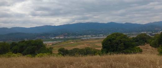
Deer Island Preserve, east of Novato in Marin County, doesn’t really look like an island, at least in the fact that it’s not surrounded by a body of water. The open space more closely resembles a hill covered in dry, golden grass with dots of oak and bay trees. Trails to the top of the preserve offer a view of what once was thousands of acres of wetlands by the San Pablo Bay.

“Deer Island was a really beautiful hill surrounded by tidal water with birds, fish and other wildlife,” says Marin County Flood Control District senior engineer Roger Leventhal. “What you see down here would have been subject to the daily tides.”

The former marsh below, its tributaries and the stream that historically fed it — Novato Creek — is mostly dried up now. But if you look hard you can still see a sliver of the creek.

The lower part of Novato Creek flows into the San Pablo Bay. (San Francisco Estuary Institute)

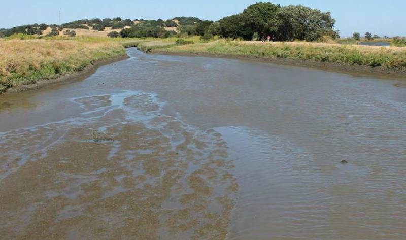
Leventhal says over time the creek has filled with sediment, which would have naturally flowed into the San Pablo Bay if farmers and ranchers hadn't built levees and drained the wetlands over 150 years ago.

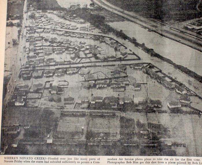
But since they did, this tidal basin has degraded and subsided. Now it’s subject to flooding for almost half the year, according to a Marin County Flood Control District report. Leventhal says vital infrastructure like the flood-prone Highway 37, the SMART rail line and parts of downtown Novato are at risk. In fact, Novato Creek has flooded the city more than a dozen times since the wetlands were drained.

Sponsored

“We are just a big storm or a big tide away from a lot of flooding, especially within city limits,” says Leventhal.

This aerial photo of downtown Novato shows the city flooded from the creek in December 1955. (Marin County History Museum)

Now with a $630,000 grant from Measure AA, the flood control district is coming up with a plan to return this area back to its historic tidal flows. The Deer Island Tidal Basin Restoration Project’s goal is to restore close to 200 acres of the basin by breaking levees along Novato Creek and allowing water to flow back in and out with the tides. Further down the road, the district hopes to restore up to 1,200 acres of wetlands in the Novato watershed.

Leventhal says this will increase the entire Bay Area's amount of healthy wetlands, which act as a sponge against sea level rise.

“We need to expand the bay in order to spread sea level rise out a little bit because if we wall the bay off, like we're going to have to do in some areas to protect people, we're going to exacerbate the rise in water surface and the impacts to everybody,” says Leventhal.

But it'll take some time before this choked wetland can return to its former glory. Leventhal says final plans for the restoration project are expected to be done by the end of 2020.

lower waypoint
next waypoint
Alameda County District Attorney Challenges Recall Signature CountCalifornia Homeowners Say Oakland Lender Scammed Them Out of $3M in Home ImprovementsSFSU Pro-Palestinian Encampment Established as Students Rally for DivestmentBillionaire-Backed Bid for New Solano County City Is Closer to November BallotWhat’s Next for Pro-Palestinian Campus ProtestsInside Mexico's Clandestine Drug Treatment CentersThe Politics and Policy Around Newsom’s Vatican Climate Summit TripCalifornia’s 2023 Snow Deluge Was a Freak Event, Study SaysFAFSA 2024: The May 2 Deadline for California Students is Almost HereCity Lights Chief Book Buyer Paul Yamazaki on a Half Century Spent “Reading the Room”