upper waypoint

SoCal Wildfire Maps in Real Time: Where the Blazes Are Burning Now

Save ArticleSave Article
Failed to save article

Please try again

Firefighters monitor a section of the Thomas Fire along the 101 freeway on Dec. 7, 2017, north of Ventura. The firefighters occasionally used a flare device to burn off brush close to the roadside. Strong Santa Ana winds are rapidly pushing multiple wildfires across the region, expanding across tens of thousands of acres and destroying hundreds of homes and structures.  (Mario Tama/Getty Images)

[http_redir]
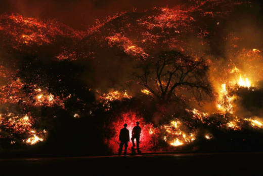
A series of large wildfires fanned by strong Santa Ana winds continued to ravage wide swaths of Southern California on Friday. The six active blazes burning in Ventura and San Diego counties have already destroyed hundreds of structures and forced more than 200,000 residents to evacuate.

Wildfires of this size are historically very rare in December. 2017 is now the deadliest, most destructive wildfire year on record in California. The blazes ignited less than two months after deadly Northern California fires wreaked havoc in Sonoma and Napa counties.

This is an automatically updated map of fire perimeters and reports from Cal Fire. Below that are closeups of the Thomas, Creek, Rye and Lilac fire perimeters and animated timelines of their spread this week.


Sponsored

lower waypoint
next waypoint
Why So Many Central Americans Are Seeking Asylum in the U.S.Real-Time Interactive Earthquake Map: Get to Know Your Local FaultsIt's Really Happening! This Is What KQED's Youth Takeover Looks LikeWhen Rivers Caught Fire: A Brief History of Earth Day (with Lesson Plan)A Look Inside the Youth Vaping CrazeIt's Almost Tax Day. This Is How the Government Spends Your Hard-Earned CashIs the Endangered Species Act at Risk of Extinction?March Madness and the Money: Should College Athletes Get Paid?How to Stop a Nuclear War: The Non-Proliferation Treaty, ExplainedMAP: What Does the U.S.-Mexico Border Really Look Like?