The proposed system, slated for completion in 2028, would connect the Los Angeles and San Francisco metro areas via the Central Valley; total estimated commute time: under 3 hours. Following on the heels of Europe, China and Japan, it would be the first bona fide high-speed rail system in the United States.
But in the six years since voters passed a $10 billion bond measure to jump-start the project, not a single track has been laid, the effort stalled by a steady steam of political opposition, fierce litigation and funding uncertainty. Critics argue the project is a boondoggle that will exhaust precious state funds and be sorely mismanaged, underused and antiquated by the time it's done.
On Tuesday, though, the project got a much needed boost, as Governor Jerry Brown, a staunch proponent, declared tentative victory. Flanked by dignitaries and workers in decorative hardhats, and within earshot of protestors, Brown presided over a ceremonial groundbreaking on the site of a planned Fresno station (although there didn't actually seem to be any literal breaking of ground).
"Everything big runs into opposition," Brown intoned at the event. "People do get pusillanimous. I wanted to use that word because that's the adjective I'm going to affix to all the critics. You can go look it up right now on your cell phone. Means weak of spirit." (Merriam-Webster actually defines it as "lacking courage and resolution," but close enough.)
He added: "There's no anti-texting rule on the trains. So that's another reason [to ride]. If there's no other reason, it's you can use your iPhone. And enjoy it. And you can have a martini or whatever you people drink."
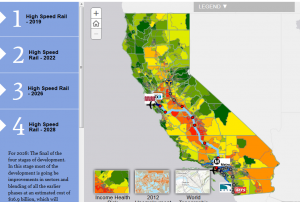
All of which begs the question: where exactly will the train take you while you're sipping that fancy cocktail? Plans have changed repeatedly since the original rail proposal was floated years ago. Fortunately, the folks at UC Davis' Information Center for the Environment created this interesting interactive "story map," in partnership with the California High Speed Rail Authority and Esri. The map, which suggests the designers support for the project, illustrates the different proposed phases as they currently stand, detailing the stations, fares and local transit lines along the way. It can also be viewed layered with farmland conversion data, as well as unemployment and environmental health figures, a nod to advocates who claim the project will be a major economic boon to some of California's poorest regions.
Map data is based on the High-Speed Rail Authority's 2014 business plan released in April. It includes the most recent plans for the controversial "blended system," wherein operations of the HSR system are shared with portions of other rail systems (including Caltrain and the Southern California Regional Rail Authority).
 Even the Golden Gate Bridge, that most hallowed of local landmarks, had its naysayers.